EP0310464B1 - Procédé d'archivage de cartes géographiques et procédé de lecture des cartes archivées - Google Patents
Procédé d'archivage de cartes géographiques et procédé de lecture des cartes archivées Download PDFInfo
- Publication number
- EP0310464B1 EP0310464B1 EP88402051A EP88402051A EP0310464B1 EP 0310464 B1 EP0310464 B1 EP 0310464B1 EP 88402051 A EP88402051 A EP 88402051A EP 88402051 A EP88402051 A EP 88402051A EP 0310464 B1 EP0310464 B1 EP 0310464B1
- Authority
- EP
- European Patent Office
- Prior art keywords
- map
- maps
- filing
- scale
- scale zone
- Prior art date
- Legal status (The legal status is an assumption and is not a legal conclusion. Google has not performed a legal analysis and makes no representation as to the accuracy of the status listed.)
- Expired - Lifetime
Links
Images


Classifications
-
- G—PHYSICS
- G06—COMPUTING OR CALCULATING; COUNTING
- G06T—IMAGE DATA PROCESSING OR GENERATION, IN GENERAL
- G06T17/00—Three dimensional [3D] modelling, e.g. data description of 3D objects
- G06T17/05—Geographic models
-
- H—ELECTRICITY
- H04—ELECTRIC COMMUNICATION TECHNIQUE
- H04N—PICTORIAL COMMUNICATION, e.g. TELEVISION
- H04N1/00—Scanning, transmission or reproduction of documents or the like, e.g. facsimile transmission; Details thereof
- H04N1/21—Intermediate information storage
- H04N1/2166—Intermediate information storage for mass storage, e.g. in document filing systems
-
- H—ELECTRICITY
- H04—ELECTRIC COMMUNICATION TECHNIQUE
- H04N—PICTORIAL COMMUNICATION, e.g. TELEVISION
- H04N1/00—Scanning, transmission or reproduction of documents or the like, e.g. facsimile transmission; Details thereof
- H04N1/387—Composing, repositioning or otherwise geometrically modifying originals
- H04N1/3876—Recombination of partial images to recreate the original image
-
- H—ELECTRICITY
- H04—ELECTRIC COMMUNICATION TECHNIQUE
- H04N—PICTORIAL COMMUNICATION, e.g. TELEVISION
- H04N2201/00—Indexing scheme relating to scanning, transmission or reproduction of documents or the like, and to details thereof
- H04N2201/04—Scanning arrangements
- H04N2201/0402—Arrangements not specific to a particular one of the scanning methods covered by groups H04N1/04 - H04N1/207
- H04N2201/0414—Scanning an image in a series of overlapping zones
Definitions
- the archiving of geographic maps implies having previously entered the numerous pieces of information - they are the ones to be archived - so that we can then re-read this information.
- Such archiving must be particularly useful, in particular in the field of navigation, air, sea or even land, for example at the time of the preparation of a mission, to quickly apprehend just as well a vast geographical sector as parts of it. sector.
- Archiving must also have the advantage of being able to "read" the information stored in combination with others, such as flight plans, trajectories to follow, objectives to achieve, superimposed on the first.
- archiving must have the advantage of being able to overcome a bulky card storage space.
- the means currently available for archiving cards are mainly photographic (film production) and mechanical (film unwinding).
- the present invention therefore aims to propose an appropriate archiving method.
- Each scale zone in fact covers a plurality of geographic maps, at a given scale.
- Each map of the type for example of those published by the National Geographic Institute, contains information inscribed in a curvilinear trapezoid with rectilinear lateral edges (the meridians) extreme but not parallel to the reference meridian of the scale zone, often the central meridian one of the cards. Juxtaposing these cards two by two by two of their respective lateral edges or meridians, that is to say superimposing these two edges or meridians, requires beforehand to have turned one of the two cards considered with respect to the 'other.
- ⁇ i + 1 being a possible digitization angle of the card i + 1.
- the information on a map is the colors of the pixels (picture elements) that make it up.
- To digitize a map is to form, by scanning with a scanner, the matrix of couples (pixel-color), each color, determined by its colorimetric coordinates in the coordinate system of the three primary colors, being one those, in limited number, of a color table previously composed by sampling with the participation of an operator.
- the maps making up a scale area contain unnecessary information and should therefore be eliminated or cut out, for example the white borders of legends. Digitizing a single box attached to a card thus eliminates everything outside the box.
- the present invention therefore relates to a method of archiving geographic maps covering at least one determined scale area, characterized in that, successively, the maps are ordered, by placing them next to each other, to constitute the scale area, and by numbering them, each card is rotated by a so-called digitization angle formed between a reference meridian of the scale zone and the central meridian of the considered card, we digitize the pixels of each map thus ordered and rotated, we cut out, from each card, the useless portions, in order to overcome the deformation of the surface of each map, the location of the map in question is identified, that is to say the determination of its deformation by establishing a correspondence between digital coordinates and geographic coordinates, the digitized, cut and marked cards are stored on a buffer support, and by juxtaposing their useful portions, and the information in the buffer medium is stored on an archiving medium.
- EP-A-0 141 508 taught a display of cards. However, it was more specifically aimed at a process for managing maps at different scales, with a graphical generator applying a scale factor to recover the maps. In fact, and above all, it did not present all of the steps of the process of the invention, namely the scheduling, numbering, rotation, digitization, cutting, identification, juxtaposition and storage of the cards. .
- the archiving medium is a digital optical disc with fast laser reading and of very large capacity.
- a map is stored and juxtaposed on the buffer support by superimposing a point on the map with determined geographic coordinates and a point in the portion of the scale area already stored with the same geographic coordinates and whose pixels have priority over those of said card to be stored, the portions of the card to be stored, already contained in the portion of the scale area already stored, thus being erased.
- the scale area is squared in blocks intended to cover the surface of a display screen, themselves squared in elementary numbered blocks.
- the invention also relates to the method for reading the archiving medium recorded in accordance with the archiving method of the invention, characterized in that the map containing a point of coordinates is determined by the geographic references of its contour determined to place in the center of a display screen.
- the archived scale zone having been gridded in elementary blocks after having determined the map containing said point, the elementary block of the archiving medium is determined, to be displayed in the center of the screen, and containing said point, we read the screen block in the center of which is said elementary block, and it is displayed on the display screen.
- a file of geographic maps to be archived elementary maps at the same determined scale, and covering, on this scale a particular area called scale area, for example France.
- Archiving these cards on a digital optical disk means recording them, or writing them, on the disk according to a process, the steps of which will be analyzed. As of now, it should be noted that the recording takes place zone scale by zone zone.
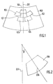
- the central map 101 in the geometric sense of the term, of the scale zone 100 and we state that its central meridian 201 will be the reference meridian of the scale zone which, at the time of the subsequent reading on screen, will be displayed in vertical position. In other words, the scanning angle of this central card 101 will be taken equal to zero.
- This central card 101 is assigned the sequence number 1.
- the map 102 adjacent to the map n ° 1 is assigned, to the east of it the number 2 ; card 103 adjacent to card no.
- card 1 to the west thereof receives the number 3; card 104 adjacent to the central card, north of it, receives the number 4, card 105 adjacent to the central card, south of it, number 5, and so on, from east to west and north to south of the central map n ° 1 towards the periphery of the scale area.
- card 105, 106 are adjacent to one another, on the same side, the numbering is carried out anticlockwise.
- the rotation of the cards precedes their digitization and therefore consists in determining their digitization angle ⁇ .
- the digitization angle ⁇ is the angle formed between the reference meridian 201 of the area scale and the central meridian of the maps, for example the meridian 206 of the map 106.
- the digitization angle ⁇ is the angle formed between the reference meridian 201 of the area scale and the central meridian of the maps, for example the meridian 206 of the map 106.
- Each card is placed on the system frame, flat or rotating, but inclined by its scanning angle and is lit by a light source.
- the read head scans the inclined map, pixel by pixel, and line of pixels by line of pixels, and analyzes the reflected light, which is broken down into the three primary colors, red, green, blue, by an optical device.
- the information collected is digitized and stored on any suitable medium, for example a magnetic tape.
- the cards can be digitized, for example using a scanner from the Hell Company, presented in No. 1150, of December 1984, of the journal L'Industrie Textile.
- the operator scans the portions of the color card respectively different (C1, C2, 7), in a determined order, which he wants to take into account, to determine the colorimetric parameters of these colors, here twelve in number, and thus form the table of these colors. This is the sampling operation mentioned above.
- the digital information of the storage tape is on the one hand, the color numbers of all the pixels analyzed and, on the other hand, for its further processing when reading the optical disc, the color table, with their parameters colorimetric.
- This step of the process is carried out by bringing out the digitized information from the scanner on a monitor and, using a cursor, following the contours of the portions to be cut on the monitor, to replace the color C o for the colors C1-C n associated with the pixels contained within these contours.
- the identification of an elementary card aims, in addition to defining the coordinates of the contours to be stored, to overcome the deformations of the paper of the card, due to temperature, pressure, humidity, etc., and establish a correspondence between the digital coordinates and the geographic coordinates.
- the location operation consists in determining the deformation, or the curling, of the paper of the card, by a factor known as deformation factor, to take it into account later at the time of the juxtaposition of the cards, and the reading of the archiving disc, while scanning and archiving the card in its deformed state.
- the cards have undergone a rectilinear deformation along a first axis and another rectilinear deformation along a second axis perpendicular to the first, the two deformations however not being correlated with each other.
- the digitized information is brought out from the scanning medium on a monitor to display the map to be located on the monitor screen.
- two particular geodetic points on the map are designated on the screen, of respective known latitudes and longitudes, L1, G1 and L2, G2.
- L1, G1 and L2, G2 two particular geodetic points on the map are designated on the screen, of respective known latitudes and longitudes, L1, G1 and L2, G2.
- These geographic coordinates correspond to two digitized pixels of the support of respective matrix coordinates x1, y1 and x2, y2 in the matrix of pixels XY associated with the map considered.
- the cards having been scanned, with their respective scanning angles, cut and marked, they are juxtaposed, or they are "glued" on a buffer support, which can be an optical disc.
- the upper edge 4 of the card 3 should extend along the lower edge portion 5 of the zone 2 and the inclined left edge 6 of the card 3 slightly below the inclined edge portion 7 of zone 2.
- the operator using a cursor, successively designates a point 8 of zone 2 and an origin point 9 of map 3, with the same geographical coordinates as point 8. It is then carried out calculating the differences in the matrix coordinates of the two points 8, 9 as they appear on the screen, before the map 3 is then moved to, and partly under zone 2.
- the portions of zone 2 have priority on those of card 3, so that card 3 comes next to each other add it perfectly to zone 2, the portions of the card 3 already contained in zone 2 being purely and simply erased.
- the maps are juxtaposed in the order of the numbering developed during the previous ordering step, the reference meridian of the scale area must always stand out in a vertical position on a display screen.
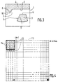
- the grid aims to accelerate the later reading of the archived information by bringing it out tile by tile, or paving stone by paving stone.
- a scale zone is therefore stored on the buffer medium in the form of a matrix of pixels represented, each by their color information, that is to say their color number, ie a number of bits depending on the number of retained colors (4 bits for 12 colors), to take into account the capacities of the screens of the visualization monitors, the matrix of the scale zone is cut up into elementary blocks, here of 256 lines and 256 columns of pixels, which we group together here again 16 by 16 in overall blocks formed, each, of 4 lines and 4 columns of elementary blocks, an overall block which can cover the surface of a display screen.
- the numbering of the first line of elementary blocks 12 is 1, 2, 3, 4, 4M + 1, 4M + 2, (N-4) M + 3, (N-4) M + 4, of the second line 5, 6, 7, 8, 4M + 5, 4M + 6, (N-4) M + 7, (N-4) M + 8, from the last line 4M-3, 4M-2, (N-4) M + 4M-1, (N-4) M + 4M is 4M-3, 4M-2, NM-1, NM .
- the second most frequent color C affecte is assigned, after C1, a second bit, of immediately greater weight, of value 1, and so on.
- the color C i of rank i is assigned the code composed of (i-1) bits of value 1 and a last least significant bit of value 0.
- the Huffman coding is however too degrading.
- the second most frequent color C2 is assigned, after C1, a second bit, of immediately greater weight, of value 1, and a third bit, of immediately lower weight, and therefore the lowest, of value x, x being equal to 1 if the next pixel is of the same color, as in RLC coding (run length coding).
- the archiving of two adjacent pixels requires only 3 bits, only if the other pixel is of color C1. Since the probability that two adjacent pixels are of the same color is greater than 0.5, statistically, it is therefore understandable that the coding of the invention, at the level of these two colors, is already more efficient.
- One pixel follows another in a scanning direction from left to right of each of the 64 lines of 256 pixels in each quarter of the elementary block.
- the least significant bits x of the colors C3-C9, as for C2, are equal to 1 if the next pixel is of the same color, to 0 otherwise.
- the coding of the invention is a combination of Huffman coding and RLC coding, but, moreover, adapted to the statistics of the colors of the image.
- the proportion of the pixels of color C1 is approximately 45%, pixels of color C2, of approximately 20%, pixels of colors C3, C4, C5, of approximately 8% each, pixels of color C6-C9, considered globally, of approximately 10%, the latter pixels being coded, according to the coding of the invention, with the same number of bits.
- the recording of the digital optical disc is therefore carried out quarter of elementary block by quarter of elementary block and elementary block by elementary block, in the order of numbering of the grid.
- the compression codes are not associated with the pixels of the elementary quarter-blocks on the archiving medium but that these codes are stored in the reading equipment.
- the optical disc As the optical disc is cut into a continuous series of tracks, it also contains a table of concordance of the tracks and the paving stones of the frames of the scale zones.
- the display consists in placing, in the center of the screen of a reading monitor, a point of latitude L and longitude G determined from an elementary map of an archived scale area, and which one wants to look at.
- the point to center on the screen being known in latitude and longitude, that is to say by its geographic coordinates, we deduce the mesh of the scale area in which it is located, and, therefore, the elementary maps being wholly or partly in the mesh considered.
- the geographic coordinates (L, G) of the point on the map correspond to its matrix coordinates (X, Y).
- all that remains is to display the sixteen elementary blocks of the screen block to be displayed, according to the order of their numbering established during the gridding of the scale zones of the recording process.
- the display can be performed on any device, it can therefore be a monitor screen, but also a mosaic of liquid crystals, and even a paper support.
- a computer 302 by example of the HP 1000-A900 type from the Hewlett Packard Company, determines in 303 the scanning angles ⁇ of the maps and the mesh. Using a scanner 304, the cards are scanned at 305. By returning, using the computer 302, the information from the scanner 304 on the screen of a monitor 306, the operator initiates in 307 the cutting of the unnecessary portions of the cards. Using a monitor 308 and a second algorithm, the computer 302 determines at 310 the deformation factors of the cards. Using a monitor 311 and the computer 302, the operator initiates in 313 the storage and the juxtaposition of the cards on a buffer disk.
- the procedure for determining the scale zone is first carried out in 401. Then, in 402, the mesh containing the point to be placed in the center of a display screen 408 is determined, before determining in 403 the cards contained in whole or in part in the mesh. The map containing this point is then determined in 404, by its outline, the elementary block containing this point is determined in 405, using a display preparation module, and in 406 the corresponding screen block. It is read using a module 407 for reading paving stones.
- Reading can be carried out using a computer, for example of the HP 1000 A900 type from the Hewlett Packard Company.
Landscapes
- Engineering & Computer Science (AREA)
- Physics & Mathematics (AREA)
- Software Systems (AREA)
- Signal Processing (AREA)
- Geometry (AREA)
- Multimedia (AREA)
- Remote Sensing (AREA)
- Computer Graphics (AREA)
- General Physics & Mathematics (AREA)
- Theoretical Computer Science (AREA)
- Processing Or Creating Images (AREA)
- Instructional Devices (AREA)
- Automatic Disk Changers (AREA)
- Navigation (AREA)
Priority Applications (1)
| Application Number | Priority Date | Filing Date | Title |
|---|---|---|---|
| AT8888402051T ATE105659T1 (de) | 1987-08-07 | 1988-08-05 | Verfahren zur speicherung von landkarten und verfahren zum lesen der gespeicherten karten. |
Applications Claiming Priority (2)
| Application Number | Priority Date | Filing Date | Title |
|---|---|---|---|
| FR8711267 | 1987-08-07 | ||
| FR8711267A FR2619239A1 (fr) | 1987-08-07 | 1987-08-07 | Procede d'archivage de cartes geographiques et procede de lecture des cartes archivees |
Publications (2)
| Publication Number | Publication Date |
|---|---|
| EP0310464A1 EP0310464A1 (fr) | 1989-04-05 |
| EP0310464B1 true EP0310464B1 (fr) | 1994-05-11 |
Family
ID=9354015
Family Applications (1)
| Application Number | Title | Priority Date | Filing Date |
|---|---|---|---|
| EP88402051A Expired - Lifetime EP0310464B1 (fr) | 1987-08-07 | 1988-08-05 | Procédé d'archivage de cartes géographiques et procédé de lecture des cartes archivées |
Country Status (7)
| Country | Link |
|---|---|
| US (1) | US4998212A (OSRAM) |
| EP (1) | EP0310464B1 (OSRAM) |
| AT (1) | ATE105659T1 (OSRAM) |
| CA (1) | CA1311050C (OSRAM) |
| DE (1) | DE3889513T2 (OSRAM) |
| ES (1) | ES2056116T3 (OSRAM) |
| FR (1) | FR2619239A1 (OSRAM) |
Families Citing this family (12)
| Publication number | Priority date | Publication date | Assignee | Title |
|---|---|---|---|---|
| US5473739A (en) * | 1989-09-21 | 1995-12-05 | Hsu; Shin-Yi | Method of preprocessing a map to produce simplified, digitally-stored data for subsequent processing and restoration of same |
| US5317680A (en) * | 1990-06-22 | 1994-05-31 | Broderbund Software, Inc. | Using regular graphic shapes to identify a pointer-selected graphic object |
| US5206660A (en) * | 1991-05-24 | 1993-04-27 | Summit World Trade Corporation | Airborne thermal printer |
| US5453764A (en) * | 1991-08-28 | 1995-09-26 | Matsushita Graphic Communication Systems, Inc. | Video editing apparatus |
| US5396583A (en) * | 1992-10-13 | 1995-03-07 | Apple Computer, Inc. | Cylindrical to planar image mapping using scanline coherence |
| US6757050B1 (en) * | 1992-12-28 | 2004-06-29 | Canon Kabushiki Kaisha | Exposure method and apparatus for detecting an exposure amount and for calculating a correction value based on the detected exposure amount |
| US5774826A (en) * | 1995-11-30 | 1998-06-30 | Trimble Navigation Limited | Optimization of survey coordinate transformations |
| AU721447B2 (en) * | 1996-06-20 | 2000-07-06 | Ames Research Laboratories | Method and apparatus for generating digital map images of a uniform format |
| US6721952B1 (en) | 1996-08-06 | 2004-04-13 | Roxio, Inc. | Method and system for encoding movies, panoramas and large images for on-line interactive viewing and gazing |
| US6199015B1 (en) | 1996-10-10 | 2001-03-06 | Ames Maps, L.L.C. | Map-based navigation system with overlays |
| US7248262B2 (en) * | 2001-02-28 | 2007-07-24 | Arcsoft, Inc. | Process and data structure for providing required resolution of data transmitted through a communications link of given bandwidth |
| US10365804B1 (en) * | 2014-02-20 | 2019-07-30 | Google Llc | Manipulation of maps as documents |
Family Cites Families (12)
| Publication number | Priority date | Publication date | Assignee | Title |
|---|---|---|---|---|
| US4485409A (en) * | 1982-03-29 | 1984-11-27 | Measuronics Corporation | Data acquisition system for large format video display |
| ATE190178T1 (de) * | 1982-10-08 | 2000-03-15 | Canon Kk | Bildverarbeitungsgerät |
| US4587633A (en) * | 1982-11-10 | 1986-05-06 | Wang Laboratories, Inc. | Management communication terminal system |
| JPS6031359A (ja) * | 1983-07-29 | 1985-02-18 | Dainippon Screen Mfg Co Ltd | 画像走査記録装置 |
| GB8324318D0 (en) * | 1983-09-12 | 1983-10-12 | British Telecomm | Video map display |
| US4742558A (en) * | 1984-02-14 | 1988-05-03 | Nippon Telegraph & Telephone Public Corporation | Image information retrieval/display apparatus |
| US4821212A (en) * | 1984-08-08 | 1989-04-11 | General Electric Company | Three dimensional texture generator for computed terrain images |
| US4715005A (en) * | 1984-08-08 | 1987-12-22 | General Electric Company | Terrain/seascape image generator with math model data base |
| US4694352A (en) * | 1984-09-21 | 1987-09-15 | Canon Kabushiki Kaisha | Image information processing system |
| US4631599A (en) * | 1984-10-05 | 1986-12-23 | Institute For Scientific Information, Inc. | Selective optoelectronic copier |
| JPS61208124A (ja) * | 1985-03-12 | 1986-09-16 | Oki Electric Ind Co Ltd | 分散デ−タベ−ス管理システムにおける結合演算処理方式 |
| US4805099A (en) * | 1987-04-17 | 1989-02-14 | Wang Laboratories, Inc. | Retrieval of related records from a relational database |
-
1987
- 1987-08-07 FR FR8711267A patent/FR2619239A1/fr active Granted
-
1988
- 1988-08-05 US US07/229,165 patent/US4998212A/en not_active Expired - Lifetime
- 1988-08-05 EP EP88402051A patent/EP0310464B1/fr not_active Expired - Lifetime
- 1988-08-05 DE DE3889513T patent/DE3889513T2/de not_active Expired - Fee Related
- 1988-08-05 AT AT8888402051T patent/ATE105659T1/de not_active IP Right Cessation
- 1988-08-05 ES ES88402051T patent/ES2056116T3/es not_active Expired - Lifetime
- 1988-08-08 CA CA000574138A patent/CA1311050C/fr not_active Expired - Lifetime
Also Published As
| Publication number | Publication date |
|---|---|
| FR2619239B1 (OSRAM) | 1994-12-09 |
| FR2619239A1 (fr) | 1989-02-10 |
| EP0310464A1 (fr) | 1989-04-05 |
| ATE105659T1 (de) | 1994-05-15 |
| US4998212A (en) | 1991-03-05 |
| DE3889513D1 (de) | 1994-06-16 |
| ES2056116T3 (es) | 1994-10-01 |
| CA1311050C (fr) | 1992-12-01 |
| DE3889513T2 (de) | 1994-11-24 |
Similar Documents
| Publication | Publication Date | Title |
|---|---|---|
| EP0310464B1 (fr) | Procédé d'archivage de cartes géographiques et procédé de lecture des cartes archivées | |
| US5844570A (en) | Method and apparatus for generating digital map images of a uniform format | |
| EP0282364B1 (fr) | Procédé de représentation de l'image en perspective d'un terrain et système pour sa mise en oeuvre | |
| Soille | Morphological image compositing | |
| US6246791B1 (en) | Compression/decompression algorithm for image documents having text, graphical and color content | |
| Pasqualini et al. | The use of airborne remote sensing for benthic cartography: advantages and reliability | |
| FR2827984A1 (fr) | Dispositif de capture d'image | |
| US20180108119A1 (en) | Method for sliced inpainting | |
| FR2461305A1 (fr) | Systeme indicateur cartographique destine plus particulierement a la navigation aerienne | |
| FR2806814A1 (fr) | Procede de reconnaissance et d'indexation de documents | |
| FR2644263A1 (fr) | Procede et dispositif d'acquisition et de stockage numerique de cartes geographiques en couleurs et de restitution de ces cartes | |
| EP4012579A1 (fr) | Appareil géomatique ayant une architecture de calculateur utilisant les utilitaires osmosis et gdal | |
| WO2003002940A1 (fr) | Procede de synthese d'une image cartographique | |
| Ablameyko et al. | Computer-aided cartographical system for map digitizing | |
| AU721447B2 (en) | Method and apparatus for generating digital map images of a uniform format | |
| EP0697678A1 (fr) | Procédé de codage de mémoire image | |
| JPH02501098A (ja) | 識別情報の記憶及び検索 | |
| CN114187525A (zh) | 一种基于卫星遥感影像的农田区域大数据分析方法 | |
| Nebiker | Spatial raster data management for geo-information systems: a database perspective | |
| Dewitt | The use of digital correlation to perform and assess image registration with SPOT 1 high-resolution visible (HRV) sensor data | |
| Raptis et al. | The use of data fusion for the classification of dense urban environments: The Mytilene case | |
| Roux et al. | Some more steps towards 3D reconstruction of urban areas from multiple views | |
| KR20000016778A (ko) | 균일 포맷의 디지탈 맵 이미지를 생성시키는 방법 및 장치 | |
| JP2001060262A (ja) | 大規模画像のディジタル画像情報データベースシステム | |
| Sadowski et al. | Early results of investigations of Landsat 4 Thematic Mapper and Multispectral Scanner applications |
Legal Events
| Date | Code | Title | Description |
|---|---|---|---|
| PUAI | Public reference made under article 153(3) epc to a published international application that has entered the european phase |
Free format text: ORIGINAL CODE: 0009012 |
|
| AK | Designated contracting states |
Kind code of ref document: A1 Designated state(s): AT BE CH DE ES FR GB GR IT LI LU NL SE |
|
| RBV | Designated contracting states (corrected) |
Designated state(s): AT BE CH DE ES FR GB GR IT LI NL |
|
| 17P | Request for examination filed |
Effective date: 19890929 |
|
| 17Q | First examination report despatched |
Effective date: 19920413 |
|
| GRAA | (expected) grant |
Free format text: ORIGINAL CODE: 0009210 |
|
| AK | Designated contracting states |
Kind code of ref document: B1 Designated state(s): AT BE CH DE ES FR GB GR IT LI NL |
|
| REF | Corresponds to: |
Ref document number: 105659 Country of ref document: AT Date of ref document: 19940515 Kind code of ref document: T |
|
| REF | Corresponds to: |
Ref document number: 3889513 Country of ref document: DE Date of ref document: 19940616 |
|
| ITF | It: translation for a ep patent filed | ||
| GBT | Gb: translation of ep patent filed (gb section 77(6)(a)/1977) |
Effective date: 19940817 |
|
| REG | Reference to a national code |
Ref country code: ES Ref legal event code: FG2A Ref document number: 2056116 Country of ref document: ES Kind code of ref document: T3 |
|
| REG | Reference to a national code |
Ref country code: GR Ref legal event code: FG4A Free format text: 3012803 |
|
| PLBE | No opposition filed within time limit |
Free format text: ORIGINAL CODE: 0009261 |
|
| STAA | Information on the status of an ep patent application or granted ep patent |
Free format text: STATUS: NO OPPOSITION FILED WITHIN TIME LIMIT |
|
| 26N | No opposition filed | ||
| REG | Reference to a national code |
Ref country code: GB Ref legal event code: IF02 |
|
| PGFP | Annual fee paid to national office [announced via postgrant information from national office to epo] |
Ref country code: NL Payment date: 20050714 Year of fee payment: 18 |
|
| PGFP | Annual fee paid to national office [announced via postgrant information from national office to epo] |
Ref country code: AT Payment date: 20050715 Year of fee payment: 18 Ref country code: GB Payment date: 20050715 Year of fee payment: 18 |
|
| PGFP | Annual fee paid to national office [announced via postgrant information from national office to epo] |
Ref country code: GR Payment date: 20050726 Year of fee payment: 18 |
|
| PGFP | Annual fee paid to national office [announced via postgrant information from national office to epo] |
Ref country code: DE Payment date: 20050805 Year of fee payment: 18 |
|
| PGFP | Annual fee paid to national office [announced via postgrant information from national office to epo] |
Ref country code: ES Payment date: 20050809 Year of fee payment: 18 Ref country code: CH Payment date: 20050809 Year of fee payment: 18 |
|
| PGFP | Annual fee paid to national office [announced via postgrant information from national office to epo] |
Ref country code: FR Payment date: 20050831 Year of fee payment: 18 |
|
| PGFP | Annual fee paid to national office [announced via postgrant information from national office to epo] |
Ref country code: BE Payment date: 20050913 Year of fee payment: 18 |
|
| PG25 | Lapsed in a contracting state [announced via postgrant information from national office to epo] |
Ref country code: AT Free format text: LAPSE BECAUSE OF NON-PAYMENT OF DUE FEES Effective date: 20060805 |
|
| PG25 | Lapsed in a contracting state [announced via postgrant information from national office to epo] |
Ref country code: LI Free format text: LAPSE BECAUSE OF NON-PAYMENT OF DUE FEES Effective date: 20060831 Ref country code: BE Free format text: LAPSE BECAUSE OF NON-PAYMENT OF DUE FEES Effective date: 20060831 Ref country code: CH Free format text: LAPSE BECAUSE OF NON-PAYMENT OF DUE FEES Effective date: 20060831 |
|
| PGFP | Annual fee paid to national office [announced via postgrant information from national office to epo] |
Ref country code: IT Payment date: 20060831 Year of fee payment: 19 |
|
| PG25 | Lapsed in a contracting state [announced via postgrant information from national office to epo] |
Ref country code: DE Free format text: LAPSE BECAUSE OF NON-PAYMENT OF DUE FEES Effective date: 20070301 Ref country code: NL Free format text: LAPSE BECAUSE OF NON-PAYMENT OF DUE FEES Effective date: 20070301 |
|
| REG | Reference to a national code |
Ref country code: CH Ref legal event code: PL |
|
| GBPC | Gb: european patent ceased through non-payment of renewal fee |
Effective date: 20060805 |
|
| NLV4 | Nl: lapsed or anulled due to non-payment of the annual fee |
Effective date: 20070301 |
|
| REG | Reference to a national code |
Ref country code: FR Ref legal event code: ST Effective date: 20070430 |
|
| REG | Reference to a national code |
Ref country code: ES Ref legal event code: FD2A Effective date: 20060807 |
|
| PG25 | Lapsed in a contracting state [announced via postgrant information from national office to epo] |
Ref country code: GB Free format text: LAPSE BECAUSE OF NON-PAYMENT OF DUE FEES Effective date: 20060805 |
|
| BERE | Be: lapsed |
Owner name: SOC. D'APPLICATIONS GENERALES D'ELECTRICITE ET DE Effective date: 20060831 |
|
| PG25 | Lapsed in a contracting state [announced via postgrant information from national office to epo] |
Ref country code: ES Free format text: LAPSE BECAUSE OF NON-PAYMENT OF DUE FEES Effective date: 20060807 |
|
| PG25 | Lapsed in a contracting state [announced via postgrant information from national office to epo] |
Ref country code: FR Free format text: LAPSE BECAUSE OF NON-PAYMENT OF DUE FEES Effective date: 20060831 |
|
| PG25 | Lapsed in a contracting state [announced via postgrant information from national office to epo] |
Ref country code: GR Free format text: LAPSE BECAUSE OF NON-PAYMENT OF DUE FEES Effective date: 20070302 |
|
| PG25 | Lapsed in a contracting state [announced via postgrant information from national office to epo] |
Ref country code: IT Free format text: LAPSE BECAUSE OF NON-PAYMENT OF DUE FEES Effective date: 20070805 |