CN113236366B - A low-field nuclear magnetic resonance stereo monitoring method for water damage risk - Google Patents
A low-field nuclear magnetic resonance stereo monitoring method for water damage risk Download PDFInfo
- Publication number
- CN113236366B CN113236366B CN202110711040.7A CN202110711040A CN113236366B CN 113236366 B CN113236366 B CN 113236366B CN 202110711040 A CN202110711040 A CN 202110711040A CN 113236366 B CN113236366 B CN 113236366B
- Authority
- CN
- China
- Prior art keywords
- monitoring
- nuclear magnetic
- water
- low
- magnetic resonance
- Prior art date
- Legal status (The legal status is an assumption and is not a legal conclusion. Google has not performed a legal analysis and makes no representation as to the accuracy of the status listed.)
- Active
Links
Images


Classifications
-
- E—FIXED CONSTRUCTIONS
- E21—EARTH OR ROCK DRILLING; MINING
- E21F—SAFETY DEVICES, TRANSPORT, FILLING-UP, RESCUE, VENTILATION, OR DRAINING IN OR OF MINES OR TUNNELS
- E21F17/00—Methods or devices for use in mines or tunnels, not covered elsewhere
- E21F17/18—Special adaptations of signalling or alarm devices
-
- E—FIXED CONSTRUCTIONS
- E21—EARTH OR ROCK DRILLING; MINING
- E21F—SAFETY DEVICES, TRANSPORT, FILLING-UP, RESCUE, VENTILATION, OR DRAINING IN OR OF MINES OR TUNNELS
- E21F17/00—Methods or devices for use in mines or tunnels, not covered elsewhere
-
- H—ELECTRICITY
- H04—ELECTRIC COMMUNICATION TECHNIQUE
- H04W—WIRELESS COMMUNICATION NETWORKS
- H04W4/00—Services specially adapted for wireless communication networks; Facilities therefor
- H04W4/80—Services using short range communication, e.g. near-field communication [NFC], radio-frequency identification [RFID] or low energy communication
-
- Y—GENERAL TAGGING OF NEW TECHNOLOGICAL DEVELOPMENTS; GENERAL TAGGING OF CROSS-SECTIONAL TECHNOLOGIES SPANNING OVER SEVERAL SECTIONS OF THE IPC; TECHNICAL SUBJECTS COVERED BY FORMER USPC CROSS-REFERENCE ART COLLECTIONS [XRACs] AND DIGESTS
- Y02—TECHNOLOGIES OR APPLICATIONS FOR MITIGATION OR ADAPTATION AGAINST CLIMATE CHANGE
- Y02A—TECHNOLOGIES FOR ADAPTATION TO CLIMATE CHANGE
- Y02A90/00—Technologies having an indirect contribution to adaptation to climate change
- Y02A90/30—Assessment of water resources
Landscapes
- Engineering & Computer Science (AREA)
- Mining & Mineral Resources (AREA)
- Life Sciences & Earth Sciences (AREA)
- General Life Sciences & Earth Sciences (AREA)
- Geochemistry & Mineralogy (AREA)
- Geology (AREA)
- Computer Networks & Wireless Communication (AREA)
- Signal Processing (AREA)
- Geophysics And Detection Of Objects (AREA)
Abstract
Description
技术领域technical field
本发明涉及一种水害风险低场核磁共振立体监测方法,尤其适用于城市地下空间或隧道内突水、突泥的超前预警及隧道运行时潜在风险的实时监测与预警,属水害风险监测技术领域。The invention relates to a low-field nuclear magnetic resonance three-dimensional monitoring method for water hazards risk, which is especially suitable for advance warning of water and mud inrush in urban underground spaces or tunnels, and real-time monitoring and early warning of potential risks during tunnel operation, and belongs to the technical field of water hazard risk monitoring .
背景技术Background technique
随着我国城市化进程的加快,我国基础建设中城市地下空间或隧道开发日益剧增。而在城市地下空间或隧道的建设中,因开采掘进扰动作用,地下空间或隧道周围存在一定区域的塑性破坏,诱发大量多尺度孔裂隙结构的发育,而地层水的区域性赋存可能会因安全水柱过窄造成应力集中,在压力水和地应力的双重作用下发生安全水柱断裂,地层水会沿着断裂裂隙渗流运移,从而导致地下空间或隧道内突水突泥事故的发生,造成严重的人员伤亡和经济损失。目前,对于突水突泥事故的防治,如传统渗漏探测方法难以实现整体式覆盖监测,易产生因漏检而存在安全隐患;电法和磁法探测设备庞大,操作较为复杂,工作量较大;示踪法需要进行钻孔投放示踪剂或钻孔测温,某些地区钻孔难度较大;流场法只能找到渗漏点,无法测定渗漏体在防渗体内部的分布情况;分布式光纤温度传感法所使用的光纤对应力较为敏感,在实际铺设中存在较大困难。同时,这些方法大多是采用抽检式进行探测,对于探测瞬时突水事故的超前预警缺乏时效性。With the acceleration of my country's urbanization process, the development of urban underground space or tunnels in my country's infrastructure construction is increasing rapidly. In the construction of urban underground spaces or tunnels, due to the disturbance of mining and excavation, there is plastic damage in a certain area around the underground space or tunnels, which induces the development of a large number of multi-scale pore and fissure structures, and the regional occurrence of formation water may be caused by The safety water column is too narrow to cause stress concentration. Under the dual action of pressure water and ground stress, the safety water column fractures, and the formation water will seepage and migrate along the fracture cracks, resulting in the occurrence of water and mud inrush accidents in underground spaces or tunnels. Serious casualties and economic losses. At present, for the prevention and control of water and mud inrush accidents, such as traditional leakage detection methods, it is difficult to achieve integrated coverage monitoring, and it is easy to cause potential safety hazards due to missed detection; electrical and magnetic detection equipment is large, the operation is relatively complex, and the workload is relatively high The tracer method requires tracer injection in the borehole or borehole temperature measurement, which is difficult to drill in some areas; the flow field method can only find the leakage point, but cannot determine the distribution of the leakage body inside the anti-seepage body The optical fiber used in the distributed optical fiber temperature sensing method is more sensitive to stress, and there are great difficulties in actual laying. At the same time, most of these methods use random inspection for detection, which lacks timeliness for the early warning of instantaneous water inrush accidents.
另一方面,城市地下空间或隧道投入使用后,依然存在渗漏水病害,会造成隧道结构开裂、内部结构装修腐蚀,导致隧道内附属设备使用寿命变短、列车运行效率与安全性降低,严重时还会造成人员伤亡及财产损失。On the other hand, after the urban underground space or tunnel is put into use, there are still water leakage diseases, which will cause the cracking of the tunnel structure and the corrosion of the internal structure decoration, which will shorten the service life of the auxiliary equipment in the tunnel and reduce the efficiency and safety of train operation. It will also cause casualties and property damage.
因此,需要开发一种水害风险低场核磁共振立体监测方法,对城市地下空间或隧道施工过程中进行超前探水,并对城市地下空间或隧道投入使用过程中围岩内水的空间分布、位移沉降及其他可见风险进行实时监测,保障隧道的安全运行。Therefore, it is necessary to develop a low-field nuclear magnetic resonance three-dimensional monitoring method for water hazard risk, which can conduct advanced water exploration in urban underground space or tunnel construction, and analyze the spatial distribution and displacement of water in surrounding rocks when urban underground space or tunnel is put into use. Subsidence and other visible risks are monitored in real time to ensure the safe operation of the tunnel.
发明内容SUMMARY OF THE INVENTION
技术问题:本发明的目的是克服现有技术所存在的不足之处,提供一种科学有效、探测精度高、操作简单的一种水害风险低场核磁共振立体监测方法。Technical problem: The purpose of the present invention is to overcome the shortcomings of the prior art and provide a low-field nuclear magnetic resonance three-dimensional monitoring method that is scientific and effective, has high detection accuracy and is simple to operate.
技术方案:本发明的一种水害风险低场核磁共振立体监测方法,包括如下步骤:Technical solution: a low-field nuclear magnetic resonance three-dimensional monitoring method of the present invention includes the following steps:
a.在城市地下空间或隧道支护成型后,在钻机向掌子面施工前进方向不同角度施工超前的上向监测钻孔、横向监测钻孔和下向监测钻孔,为核磁监测提供通道,同时分别对各孔不同深度位置钻取岩心;a. After the urban underground space or tunnel support is formed, the upward monitoring drilling holes, lateral monitoring drilling holes and downward monitoring drilling holes which are advanced at different angles in the forward direction of the drilling rig to the construction direction of the tunnel face are constructed to provide channels for nuclear magnetic monitoring. At the same time, cores are drilled at different depths of each hole;
b.根据各钻孔内获得的不同深度的岩心测量围岩强度、类型、含水率、孔隙度并判断前方构造带分布如富水断层破碎带和岩溶发育带;b. Measure the strength, type, water content, porosity of the surrounding rock according to the cores at different depths obtained in each borehole, and judge the distribution of the front structural belts such as the water-rich fault fractured zone and the karst development zone;
c.在上向监测钻孔、横向监测钻孔和下向监测钻孔内埋入装有低场核磁共振微缩传感器的无磁钢管,通过低场核磁共振微缩传感器在无磁钢管内前后滑动释放核磁信号磁场对各钻孔内每隔1米进行测量;c. Bury the non-magnetic steel pipe equipped with the low-field nuclear magnetic resonance microscopic sensor in the upward monitoring hole, the lateral monitoring hole and the downward monitoring hole, and slide it back and forth in the non-magnetic steel pipe through the low-field nuclear magnetic resonance microscopic sensor. The nuclear magnetic signal magnetic field is measured every 1 meter in each borehole;
d.在城市地下空间或隧道施工的过程中,利用三个不同角度钻孔内的低场核磁共振微缩传感器分别对三个钻孔位置周围岩层基质内的水信号进行监测,若核磁信号急剧增大或呈梯度增大时进行预警,并对该监测钻孔区域空间,集中实施“疏水-注浆-监测”三位一体技术手段,实现钻孔区域施工中潜在水缘性灾害的有效防治;d. In the process of urban underground space or tunnel construction, the low-field nuclear magnetic resonance microscopic sensors in three boreholes at different angles are used to monitor the water signal in the rock matrix around the three borehole positions. When it is large or increases in a gradient, it will give an early warning, and focus on the implementation of the three-in-one technical means of "hydrophobicity-grouting-monitoring" in the monitoring drilling area to achieve effective prevention and control of potential water-edge disasters in the construction of the drilling area;
e.城市地下空间或隧道施工完成后,利用钻机向城市地下空间或隧道内施工的缝隙钻进,间隔施工多组钻孔,每组钻孔为四个,上下左右分布,沿城市地下空间或隧道方向间隔均匀布置;e. After the urban underground space or tunnel construction is completed, use the drilling rig to drill into the urban underground space or the construction gap in the tunnel, and construct multiple sets of drilling holes at intervals, each set of four drilling holes, distributed up and down, left and right, along the urban underground space or The tunnel direction is evenly spaced;
f.在每组城市地下空间或隧道施工的钻孔内埋入装有低场核磁共振微缩传感器的无磁钢管,并在城市地下空间或隧道内的顶部吊轨上安装对隧道内可见风险进行识别的移动式监控摄像机,所有钻孔内的各低场核磁共振微缩传感器均通过数据传输线连接5G信号传输设备,利用5G信号传输设备采集地下空间或隧道四周的信息,并及时将采集到的信息数据反馈到监控中心,对城市地下空间或隧道运行过程中围岩内水的空间分布、位移沉降及其他可见风险进行实时监测,有效保障隧道全生命周期内的安全运行。f. Bury non-magnetic steel pipes equipped with low-field nuclear magnetic resonance microscopic sensors in the boreholes of each group of urban underground spaces or tunnel construction, and install them on the top hanging rails in urban underground spaces or tunnels. Recognized mobile surveillance cameras, all low-field NMR miniature sensors in all boreholes are connected to 5G signal transmission equipment through data transmission lines, and 5G signal transmission equipment is used to collect information about the underground space or around the tunnel, and the collected information will be collected in time. The data is fed back to the monitoring center to conduct real-time monitoring of the spatial distribution, displacement and settlement of water in the surrounding rock and other visible risks during the operation of the urban underground space or the tunnel, effectively ensuring the safe operation of the tunnel throughout its life cycle.
所述在上向监测钻孔、横向监测钻孔、下向监测钻孔内每隔1米分别钻取的岩心直径约为50mm,长度约为50mm,利用岩心取样器进行原位保压,且每一钻孔地层所采集的岩心数量不少于8个。The cores drilled at intervals of 1 meter in the upward monitoring borehole, the lateral monitoring borehole and the downward monitoring borehole are respectively about 50mm in diameter and about 50mm in length, and a core sampler is used for in-situ pressure maintenance, and The number of cores collected in each drilling formation shall not be less than 8.
所述的岩心取样器的材质为无机非金属材料PMMR,最大耐温为150℃,压力为70MPa。The material of the core sampler is inorganic non-metallic material PMMR, the maximum temperature resistance is 150°C, and the pressure is 70MPa.
所述的上向监测钻孔、横向监测钻孔和下向监测钻孔以掌子端面为基线所对应的倾角分别为45°、90°和135°,且钻孔深度均不小于15m。The inclination angles corresponding to the upward monitoring hole, the lateral monitoring hole and the downward monitoring hole are respectively 45°, 90° and 135° with the end face of the tunnel as the baseline, and the drilling depth is not less than 15m.
所述的低场核磁共振微缩传感器包括永磁体和线圈,最大承受温度为150℃、最大承受压力为80MPa。The low-field nuclear magnetic resonance miniature sensor includes a permanent magnet and a coil, and the maximum temperature is 150°C and the maximum pressure is 80MPa.
所述的无磁钢管内壁对称设有滑轨,无磁钢管的端口处设有滑轮支撑底座和固定在滑轮支撑底座上的电动滑轮。The inner wall of the non-magnetic steel pipe is symmetrically provided with sliding rails, and the port of the non-magnetic steel pipe is provided with a pulley support base and an electric pulley fixed on the pulley support base.
所述低场核磁共振微缩传感器包括依次固定的第一磁体、第二磁体和第三磁体,第一磁体和第三磁体的端部分别设有固定套环,两端固定套环连接有安装在无磁钢管内的固定滑索,固定滑索上标有刻度。The low-field nuclear magnetic resonance miniature sensor includes a first magnet, a second magnet and a third magnet that are fixed in sequence. The ends of the first magnet and the third magnet are respectively provided with fixed collars, and the fixed collars at both ends are connected to Fixed zip line in non-magnetic steel tube, with scale marked on the fixed zip line.
城市地下空间或隧道施工过程中及施工完成运行时,对所有测量钻孔内每隔1米所测得的第一次核磁信号进行反演,得到该测量钻孔不同深度围岩的初始含水率δ1、δ2、δ3…δn,其中,n代表钻孔由外向内n米处的取样点,观察初始含水率数据;In the process of urban underground space or tunnel construction and when the construction is completed, the first nuclear magnetic signal measured every 1 meter in all the measurement boreholes is inverted, and the initial water content of the surrounding rock at different depths of the measurement borehole is obtained. δ 1 , δ 2 , δ 3 …δ n , where n represents the sampling point at n meters from the outside to the inside of the borehole, and observe the initial water content data;
若随钻孔取样点距钻孔口深度急剧增大或呈梯度增大时进行预警,对该监测钻孔区域空间集中实施“疏水-注浆-监测”三位一体技术手段;If the early warning is given when the depth of the drilling sampling point increases sharply or increases in a gradient, the "hydrophobicity-grouting-monitoring" three-in-one technical means is implemented centrally in the monitoring drilling area;
若未出现预警,则每隔一段时间t1、t2、t3、…、tn,tn代表n秒,对各钻孔内每隔1米的固定取样点处进行核磁测量,利用计算机进行计算得到围岩各固定取样点同一位置处两次取样得到的含水率差值:△δt1、△δt2、△δt3、…、△δtn,若含水率差值△δt1=△δt2=△δt3=…=△δtn,表明岩石结构比较致密导致压力水锋线未向前运移;若含水率差值△δt1≠△δt2≠△δt3≠…≠△δtn, 表明岩石多尺度孔隙结构由压力水渗流填充,岩石基质内富含大量的水分,反映潜在水体内的压力水出现渗透现象;以△δt为纵坐标、时间t为横坐标的曲线,当多点处的曲线斜率:


所述的无磁钢管外壁上贴有能对周边岩体的沉降位移进行测量监测的光纤应变传感器。An optical fiber strain sensor capable of measuring and monitoring the settlement displacement of the surrounding rock mass is attached to the outer wall of the non-magnetic steel pipe.
有益效果:由于采用上述技术方案,本发明通过向钻孔内送入低场核磁共振微缩传感器进行测量,利用获得的核磁水信号及围岩岩性,构建诱发水害的预警阈值和安全评估准则。地下空间或隧道施工完成后,布置四周钻孔并预埋低场低场核磁共振微缩传感器,配合巡检摄像头及光纤应变传感器,利用5G信号对四周围岩内水的空间分布、位移沉降及可见风险进行实时监测。一方面能够通过低场核磁共振微缩传感器对施工过程中城市地下空间或隧道的前方岩层潜在水源位置进行多维时空性监测,得到钻孔不同深度处围岩的强度、类型、含水率、孔隙度并判断前方构造带分布如富水断层破碎带和岩溶发育带;另一方面,通过低场核磁共振微缩传感器、光纤应变传感器和智能监控设备,结合5G传输技术,实现对隧道运行过程中围岩内水的空间分布、位移沉降及其他可见风险进行实时监测,能够有效保障隧道全生命周期内的安全运行。城市地下空间或隧道投入使用后,隧道四周钻孔分别为隧道顶部、左右两侧及底部钻孔,各钻孔内埋入无磁钢管和低场核磁共振微缩传感器,无磁钢管外部贴上光纤应变传感器,城市地下空间或隧道顶部利用移动式监控摄像机沿吊轨对隧道内其他可见风险进行识别,各传感器数据通过数据传输线与5G信号传输设备连接,并将数据实时反馈回监控中心,有效保障隧道的安全运行。该方法有着较强的科学性,探测精度高,操作简单,效果好,在本技术领域内具有广泛的实用性。Beneficial effects: Due to the adoption of the above technical solutions, the present invention transmits a low-field nuclear magnetic resonance microscopic sensor into the borehole for measurement, and uses the obtained nuclear magnetic water signal and surrounding rock lithology to construct early warning thresholds and safety assessment criteria for induced water damage. After the construction of the underground space or tunnel is completed, the surrounding drilling holes are arranged and the low-field low-field MRI miniature sensor is pre-buried. With the inspection camera and optical fiber strain sensor, the spatial distribution, displacement and settlement and visible risks of water in the surrounding rock are analyzed by 5G signals. Perform real-time monitoring. On the one hand, the low-field nuclear magnetic resonance microscopic sensor can be used to monitor the potential water source position of the urban underground space or the rock formation in front of the tunnel during the construction process. Judging the distribution of front structural belts such as water-rich fault fracture belts and karst development belts; on the other hand, through low-field nuclear magnetic resonance microscopic sensors, optical fiber strain sensors and intelligent monitoring equipment, combined with 5G transmission technology, it is possible to realize the detection of the surrounding rocks during the operation of the tunnel. Real-time monitoring of the spatial distribution of water, displacement and settlement and other visible risks can effectively ensure the safe operation of the tunnel throughout its life cycle. After the urban underground space or tunnel is put into use, the holes around the tunnel are drilled at the top, left and right sides and bottom of the tunnel. Non-magnetic steel pipes and low-field NMR miniature sensors are embedded in each drill hole, and optical fibers are attached to the outside of the non-magnetic steel pipes. Strain sensors, urban underground space or the top of the tunnel use mobile surveillance cameras along the hanging rail to identify other visible risks in the tunnel, each sensor data is connected to the 5G signal transmission equipment through the data transmission line, and the data is fed back to the monitoring center in real time, effectively guaranteeing Safe operation of tunnels. The method has strong scientific nature, high detection accuracy, simple operation and good effect, and has wide practicability in the technical field.
附图说明Description of drawings
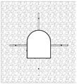
图1是本发明的城市地下空间或隧道施工阶段水害风险立体监测方法示意图。Fig. 1 is a schematic diagram of a three-dimensional monitoring method for water hazard risk in urban underground space or tunnel construction stage of the present invention.
图2是本发明图1中的掌子面正视图钻孔布置示意图。FIG. 2 is a schematic diagram of the drilling arrangement in the front view of the face of the palm of FIG. 1 of the present invention.
图3是本发明的城市地下空间或隧道运行阶段水害风险立体监测方法示意图。FIG. 3 is a schematic diagram of the three-dimensional monitoring method for water hazard risk in urban underground space or tunnel operation stage of the present invention.
图4是本发明图3中的四周钻孔空间结构布置示意图。FIG. 4 is a schematic diagram of the spatial structure arrangement of the surrounding drilling holes in FIG. 3 of the present invention.
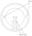
图5是本发明图3中的无磁钢管横剖截面结构示意图。Fig. 5 is a schematic cross-sectional structure diagram of the non-magnetic steel pipe in Fig. 3 of the present invention.
图6是本发明图3中的无磁钢管纵剖截面结构示意图。FIG. 6 is a schematic view of the longitudinal cross-sectional structure of the non-magnetic steel pipe in FIG. 3 of the present invention.
图中:1-城市地下空间或隧道;2-掌子面;3-上向监测钻孔;4-无磁钢管;4-1-滑轨;4-2- 电动滑轮;4-3-滑轮支撑底座;5-核磁信号磁场;6-低场低场核磁共振微缩传感器;6-1-固定滑索;6-2-固定套环;6-3-第一磁体;6-4-第二磁体;6-5-第三磁体;7-潜在水体;8- 横向监测钻孔;9-下向监测钻孔;10-隧道四周钻孔;11-吊轨;12-智能监控设备;13-数据传输线;14-5G信号传输设备。In the picture: 1- urban underground space or tunnel; 2- tunnel face; 3- upward monitoring drilling; 4- non-magnetic steel pipe; 4-1- slide rail; 4-2- electric pulley; 4-3- pulley Support base; 5-NMR signal magnetic field; 6-Low-field low-field NMR miniature sensor; 6-1-Fixed sliding cable; 6-2-Fixed collar; 6-3-First magnet; 6-4-Second Magnet; 6-5-Third magnet; 7-Potential water body; 8- Lateral monitoring drilling; 9- Downward monitoring drilling; 10-Drilling around the tunnel; 11-Hanging rail; 12-Intelligent monitoring equipment; 13- Data transmission line; 14-5G signal transmission equipment.
具体实施方法Specific implementation method
下面结合附图中的实施例对本发明作进一步的描述:The present invention will be further described below in conjunction with the embodiments in the accompanying drawings:
本发明的水害风险低场核磁共振立体监测方法,首先,城市地下空间或隧道1支护成型后,通过钻机向掌子面2前方不同角度打入超前上向监测钻孔3、横向监测钻孔8、下向监测钻孔9,为核磁监测提供通道;根据钻孔内获得的不同深度的岩心测量围岩强度、类型、含水率、孔隙度并判断前方构造带分布如富水断层破碎带和岩溶发育带信息;将低场核磁共振微缩传感器6的固定吊环6-2连接带刻度的固定滑索6-1和无磁钢管4边壁的滑轨4-1,送入上向监测钻孔3、横向监测钻孔8、下向监测钻孔9内进行测量;利用低场核磁共振微缩传感器6对不同钻孔位置周围岩层基质内的水信号进行监测,若核磁信号急剧增大或呈梯度增大时进行预警,并对该监测钻孔区域空间集中实施“疏水-注浆-监测”三位一体技术手段,实现潜在水缘性灾害的有效防治;具体步骤如下:In the low-field nuclear magnetic resonance three-dimensional monitoring method of the present invention, first, after the urban underground space or tunnel 1 is supported and formed, a drilling rig is used to drive forward and
a.施工城市地下空间或隧道1,当城市地下空间或隧道1支护成型后,在钻机向掌子面 2施工前进方向不同角度施工超前的上向监测钻孔3、横向监测钻孔8和下向监测钻孔9,为核磁监测提供通道,同时分别对各孔不同深度位置钻取岩心;所述在上向监测钻孔3、横向监测钻孔8、下向监测钻孔9内每隔1米分别钻取的岩心直径约为50mm,长度约为50mm,利用岩心取样器进行原位保压,且每一钻孔地层所采集的岩心数量不少于8个。所述的岩心取样器的材质为无机非金属材料PMMR,最大耐温为150℃,压力为70MPa。所述的上向监测钻孔3、横向监测钻孔8和下向监测钻孔9以掌子端面为基线所对应的倾角分别为45°、 90°和135°,且钻孔深度均不小于15m。a. When constructing the urban underground space or tunnel 1, after the support of the urban underground space or tunnel 1 is formed, the
b.根据各钻孔内获得的不同深度的岩心测量围岩强度、类型、含水率、孔隙度并判断前方构造带分布如富水断层破碎带和岩溶发育带;b. Measure the strength, type, water content, porosity of the surrounding rock according to the cores at different depths obtained in each borehole, and judge the distribution of the front structural belts such as the water-rich fault fractured zone and the karst development zone;
c.在上向监测钻孔3、横向监测钻孔8和下向监测钻孔9内埋入装有低场核磁共振微缩传感器6的无磁钢管4,所述的无磁钢管4外壁上贴有光纤应变传感器,能对周边岩体的沉降位移进行测量监测,配合岩体内水的空间监测数据进行分析,进而得到更为可靠的应急方案。通过低场核磁共振微缩传感器6在无磁钢管内前后滑动释放核磁信号磁场对各钻孔内每隔1米进行测量;所述的低场核磁共振微缩传感器6包括永磁体和线圈,最大承受温度为 150℃、最大承受压力为80MPa。所述的无磁钢管4内壁对称设有滑轨4-1,无磁钢管4的端口处设有滑轮支撑底座4-3和固定在滑轮支撑底座4-3上的电动滑轮4-2。所述低场核磁共振微缩传感器6包括依次固定的第一磁体6-3、第二磁体6-4和第三磁体6-5,第一磁体6-3和第三磁体6-5的端部分别设有固定套环6-2,两端固定套环6-2连接有安装在无磁钢管4内的固定滑索6-1,固定滑索6-1上标有刻度。c. The
d.在城市地下空间或隧道1施工的过程中,利用三个不同角度钻孔内的低场核磁共振微缩传感器6分别对三个钻孔位置周围岩层基质内的水信号进行监测,若核磁信号急剧增大或呈梯度增大时进行预警,并对该监测钻孔区域空间,集中实施“疏水-注浆-监测”三位一体技术手段,实现钻孔区域施工中潜在水缘性灾害的有效防治;d. During the construction of urban underground space or tunnel 1, the low-field nuclear magnetic resonance microscopic sensors 6 in three boreholes with different angles are used to monitor the water signals in the rock formation matrix around the three borehole positions. When there is a sharp increase or a gradient increase, an early warning will be issued, and the monitoring drilling area space will be intensively implemented by the three-in-one technical means of "hydrophobicity-grouting-monitoring" to achieve effective prevention and control of potential water-edge disasters in the construction of the drilling area;
e.当城市地下空间或隧道1施工完成后或已投入使用前,利用钻机向城市地下空间或隧道内施工的缝隙钻进,间隔施工多组钻孔10,每组钻孔为四个,上下左右分布,沿城市地下空间或隧道1方向间隔均匀布置;e. After the construction of the urban underground space or tunnel 1 is completed or before it is put into use, use the drilling rig to drill into the construction gap in the urban underground space or tunnel, and construct multiple sets of drilling holes 10 at intervals, each set of four drilling holes, up and down Distributed left and right, evenly spaced along the urban underground space or tunnel 1 direction;
f.在每组城市地下空间或隧道1施工的钻孔10内埋入装有低场核磁共振微缩传感器6 的无磁钢管4,所述的无磁钢管4外壁上贴有能对周边岩体的沉降位移进行测量监测的光纤应变传感器;在城市地下空间或隧道1内的顶部吊轨11上安装对隧道内可见风险进行识别的移动式监控摄像机12,所有钻孔10内的各低场核磁共振微缩传感器6均通过数据传输线13 连接5G信号传输设备14,利用5G信号传输设备14采集地下空间或隧道1四周的信息,并及时将采集到的信息数据反馈到监控中心,对城市地下空间或隧道1运行过程中围岩内水的空间分布、位移沉降及其他可见风险进行实时监测,有效保障隧道全生命周期内的安全运行。f. Bury
在城市地下空间或隧道1施工的过程中及施工完成运行时,对所有测量钻孔内每隔1米所测得的第一次核磁信号进行反演,得到该测量钻孔不同深度围岩的初始含水率δ1、δ2、δ3…δn,其中,n代表钻孔由外向内n米处的取样点,观察初始含水率数据;During the construction of the urban underground space or tunnel 1 and when the construction is completed, the first nuclear magnetic signal measured every 1 meter in all the measurement boreholes is inverted, and the surrounding rocks of different depths of the measurement borehole are obtained. Initial water content δ 1 , δ 2 , δ 3 …δ n , where n represents the sampling point at n meters from the outside to the inside of the borehole, observe the initial water content data;
若随钻孔取样点距钻孔口深度急剧增大或呈梯度增大时进行预警,对该监测钻孔区域空间集中实施“疏水-注浆-监测”三位一体的现有技术手段;If an early warning is given when the depth of the borehole sampling point increases sharply or increases in a gradient, the existing technical means of "hydrophobicity-grouting-monitoring" three-in-one are implemented centrally in the monitoring borehole area;
若未出现预警,则每隔一段时间t1、t2、t3、…、tn,tn代表n秒,对各钻孔内每隔1米的固定取样点处进行核磁测量,利用计算机进行计算得到围岩各固定取样点同一位置处两次取样得到的含水率差值:△δt1、△δt2、△δt3、…、△δtn,若含水率差值△δt1=△δt2=△δt3=…=△δtn,表明岩石结构比较致密导致压力水锋线未向前运移;若含水率差值△δt1≠△δt2≠△δt3≠…≠△δtn, 表明岩石多尺度孔隙结构由压力水渗流填充,岩石基质内富含大量的水分,反映潜在水体内的压力水出现渗透现象;以△δt为纵坐标、时间t为横坐标的曲线,当多点处的曲线斜率:


无磁钢管4外壁上贴有光纤应变传感器,能对周边岩体的沉降位移进行测量监测,配合岩体内水的空间监测数据进行分析,进而得到更为可靠的应急方案。The outer wall of the
Claims (8)


Priority Applications (1)
| Application Number | Priority Date | Filing Date | Title |
|---|---|---|---|
| CN202110711040.7A CN113236366B (en) | 2021-06-25 | 2021-06-25 | A low-field nuclear magnetic resonance stereo monitoring method for water damage risk |
Applications Claiming Priority (1)
| Application Number | Priority Date | Filing Date | Title |
|---|---|---|---|
| CN202110711040.7A CN113236366B (en) | 2021-06-25 | 2021-06-25 | A low-field nuclear magnetic resonance stereo monitoring method for water damage risk |
Publications (2)
| Publication Number | Publication Date |
|---|---|
| CN113236366A CN113236366A (en) | 2021-08-10 |
| CN113236366B true CN113236366B (en) | 2022-06-07 |
Family
ID=77140872
Family Applications (1)
| Application Number | Title | Priority Date | Filing Date |
|---|---|---|---|
| CN202110711040.7A Active CN113236366B (en) | 2021-06-25 | 2021-06-25 | A low-field nuclear magnetic resonance stereo monitoring method for water damage risk |
Country Status (1)
| Country | Link |
|---|---|
| CN (1) | CN113236366B (en) |
Families Citing this family (2)
| Publication number | Priority date | Publication date | Assignee | Title |
|---|---|---|---|---|
| CN114415260B (en) * | 2022-01-19 | 2023-02-21 | 中国矿业大学 | Detection and evaluation method for water inrush accident of reservoir above goaf |
| CN116577838B (en) * | 2023-05-17 | 2025-06-27 | 西安建筑科技大学 | A method for preventing mud and water inrush in tunnels and a temperature measuring device |
Family Cites Families (7)
| Publication number | Priority date | Publication date | Assignee | Title |
|---|---|---|---|---|
| US9074464B2 (en) * | 2011-05-20 | 2015-07-07 | Halliburton Energy Services, Inc. | Verification of swelling in a well |
| CN205477747U (en) * | 2015-12-31 | 2016-08-17 | 中国神华能源股份有限公司 | Han qu runs railway tunnel monitoring system |
| US11143782B2 (en) * | 2018-06-22 | 2021-10-12 | Baker Hughes, A Ge Company, Llc | Downhole NMR tool with receiver on sensor |
| CN109254138B (en) * | 2018-10-22 | 2021-10-22 | 陕西煤业化工技术研究院有限责任公司 | A water-rich evaluation method based on microscopic characteristics of sandstone |
| CN112049623B (en) * | 2019-06-05 | 2024-05-28 | 中国石油天然气股份有限公司 | A method and device for determining the release of bound water from intermediate-basic volcanic rocks |
| CN110513099B (en) * | 2019-08-20 | 2021-10-08 | 北京科技大学 | A multi-parameter advanced physical disaster real-time prediction system and method |
| CN112965136B (en) * | 2021-02-05 | 2024-04-02 | 云南楚大高速公路投资开发有限公司 | Multi-means advanced detection method for water-rich karst tunnel |
-
2021
- 2021-06-25 CN CN202110711040.7A patent/CN113236366B/en active Active
Also Published As
| Publication number | Publication date |
|---|---|
| CN113236366A (en) | 2021-08-10 |
Similar Documents
| Publication | Publication Date | Title |
|---|---|---|
| CN104315988B (en) | Distributive optical fiber detection method for mining overburden rock deformation | |
| WO2019233105A1 (en) | Device and method for measuring flow rate, flow direction, and geological parameter of deep-well cross-hole groundwater | |
| CN101914912B (en) | In-situ testing method for deep underground engineering during rockburst preparation and evolution process | |
| CN103410516B (en) | Minor diameter tunnel full face tunneling surrouding rock deformation early warning engineering method | |
| CN204479060U (en) | A kind of subgrade stability recording geometry | |
| CN102829728A (en) | Comprehensive monitoring system for side slope and landslip | |
| CN108518182A (en) | Method and device is put in the advanced region water body spy of the dendritic directional drilling of top plate multi-aquifer | |
| CN106088174A (en) | A kind of soft clay area diaphram wall seepage detection system | |
| CN112504336A (en) | Landslide area pipeline deformation monitoring system | |
| CN106092042B (en) | A kind of application method of the soft soil base sedimentation sensor based on fiber grating sensing technology | |
| CN102995615A (en) | Real-time monitoring method for displacement of underground deep-layer soil body | |
| CN113236366B (en) | A low-field nuclear magnetic resonance stereo monitoring method for water damage risk | |
| CN101581701A (en) | Method for detecting slip casting effect on ground surface | |
| CN103994846B (en) | Stress field of the surrounding rock distribution tester and method | |
| CN202869442U (en) | Side slope and landslide integrated monitoring system | |
| CN102878980B (en) | Indirect testing method for underground pipeline settlement induced by subway tunnel construction | |
| CN109870477A (en) | A kind of non-contact detection soil frost heave monomer and detection method thereof | |
| CN107631752A (en) | A kind of apparatus and method of middle wire type Tailings Dam monitoring | |
| CN113551637A (en) | Monitoring device and method for surrounding rock deformation in the whole process of tunnel construction based on TBM | |
| WO2023066409A1 (en) | Mine water hazard monitoring apparatus and method | |
| CN207036085U (en) | A kind of coal mine roof plate rock deformation monitoring device | |
| CN108241174A (en) | A kind of detection method of buried metal pipe line | |
| WO2021000342A1 (en) | Apparatus for continuously measuring soil parameters of large-scale soft soil site | |
| CN203259265U (en) | Freezing-hole longitudinal-temperature distributed optical-fiber detection system | |
| CN203021982U (en) | Underground deep soil displacement real-time monitor system |
Legal Events
| Date | Code | Title | Description |
|---|---|---|---|
| PB01 | Publication | ||
| PB01 | Publication | ||
| SE01 | Entry into force of request for substantive examination | ||
| SE01 | Entry into force of request for substantive examination | ||
| GR01 | Patent grant | ||
| GR01 | Patent grant |