Water damage risk low-field nuclear magnetic resonance three-dimensional monitoring method
Technical Field
The invention relates to a low-field nuclear magnetic resonance three-dimensional monitoring method for water damage risks, which is particularly suitable for advanced early warning of water inrush and mud inrush in urban underground spaces or tunnels and real-time monitoring and early warning of potential risks during tunnel operation and belongs to the technical field of water damage risk monitoring.
Background
With the acceleration of urbanization process in China, the development of urban underground spaces or tunnels in infrastructure in China is increased greatly. In the construction of urban underground spaces or tunnels, due to the mining and tunneling disturbance, plastic damage exists in a certain area around the underground space or the tunnel, the development of a large number of multi-scale pore fracture structures is induced, the local occurrence of formation water can cause stress concentration due to over-narrow safety water columns, the safety water columns are fractured under the dual effects of pressure water and ground stress, the formation water can migrate along fracture fractures by seepage, water-burst mud-burst accidents in the underground space or the tunnel are caused, and serious casualties and economic losses are caused. At present, for the prevention and treatment of water inrush and mud inrush accidents, if the traditional leakage detection method is difficult to realize integral coverage monitoring, potential safety hazards caused by missing detection are easy to generate; the electric method and the magnetic method have the disadvantages of huge detection equipment, complex operation and large workload; the tracer method needs to carry out drilling and putting tracer or drilling temperature measurement, and drilling difficulty is high in some areas; the flow field method can only find leakage points and cannot determine the distribution condition of the leakage bodies in the seepage-proofing bodies; the optical fiber used in the distributed optical fiber temperature sensing method is sensitive to stress, and has great difficulty in actual laying. Meanwhile, most of the methods adopt a spot-check mode for detection, and the early warning for detecting the instantaneous water inrush accident lacks timeliness.
On the other hand, after the urban underground space or the tunnel is put into use, water leakage and water damage still exist, the tunnel structure can crack, the internal structure can be decorated and corroded, the service life of accessory equipment in the tunnel is shortened, the running efficiency and the safety of the train are reduced, and casualties and property loss can be caused in serious cases.
Therefore, a water damage risk low-field nuclear magnetic resonance three-dimensional monitoring method needs to be developed, advanced water exploration is carried out in the construction process of the urban underground space or the tunnel, the spatial distribution, displacement settlement and other visible risks of water in surrounding rocks are monitored in real time in the using process of the urban underground space or the tunnel, and the safe operation of the tunnel is guaranteed.
Disclosure of Invention
The technical problem is as follows: the invention aims to overcome the defects in the prior art and provide a scientific and effective low-field nuclear magnetic resonance three-dimensional monitoring method with high detection precision and simple operation.
The technical scheme is as follows: the invention discloses a low-field nuclear magnetic resonance three-dimensional monitoring method for water damage risks, which comprises the following steps:
a. after the urban underground space or the tunnel is formed in a supporting mode, constructing forward upward monitoring drill holes, transverse monitoring drill holes and downward monitoring drill holes at different angles in the forward direction of the drilling machine to the tunnel face, providing a channel for nuclear magnetic monitoring, and simultaneously drilling coring at different depth positions of each hole;
b. measuring the strength, type, water content and porosity of the surrounding rock according to the rock cores of different depths obtained in all the drill holes, and judging the distribution of a front tectonic zone such as a water-rich fault fracture zone and a karst development zone;
c. embedding a non-magnetic steel pipe provided with a low-field nuclear magnetic resonance miniature sensor in the upward monitoring drill hole, the transverse monitoring drill hole and the downward monitoring drill hole, and measuring every 1 meter in each drill hole by sliding the low-field nuclear magnetic resonance miniature sensor back and forth in the non-magnetic steel pipe to release a nuclear magnetic signal magnetic field;
d. in the process of urban underground space or tunnel construction, low-field nuclear magnetic resonance miniature sensors in three different-angle drill holes are used for respectively monitoring water signals in rock stratum matrixes around three drill hole positions, early warning is carried out if the nuclear magnetic signals are increased rapidly or in a gradient manner, a three-in-one technical means of 'drainage-grouting-monitoring' is intensively implemented on the monitored drill hole area space, and effective prevention and control of potential water-margin disasters in the construction of the drill hole area are realized;
e. after the construction of the urban underground space or the tunnel is finished, drilling into a gap constructed in the urban underground space or the tunnel by using a drilling machine, constructing a plurality of groups of drilling holes at intervals, wherein each group of four drilling holes are distributed up and down, left and right and are uniformly distributed at intervals along the direction of the urban underground space or the tunnel;
f. the non-magnetic steel pipe with the low-field nuclear magnetic resonance miniature sensors is embedded in the drilled holes of each group of urban underground space or tunnel construction, the movable monitoring cameras for identifying visible risks in the tunnel are mounted on the overhead rails in the urban underground space or tunnel, the low-field nuclear magnetic resonance miniature sensors in all the drilled holes are connected with 5G signal transmission equipment through data transmission lines, the 5G signal transmission equipment is used for acquiring information around the underground space or tunnel and feeding the acquired information data back to a monitoring center in time, the spatial distribution, displacement settlement and other visible risks of water in surrounding rocks in the operation process of the urban underground space or tunnel are monitored in real time, and the safe operation of the tunnel in the whole life cycle is effectively guaranteed.
The diameter of the core drilled in the upward monitoring drilling hole, the transverse monitoring drilling hole and the downward monitoring drilling hole respectively every 1 m is about 50mm, the length of the core drilled in the downward monitoring drilling hole is about 50mm, in-situ pressure maintaining is carried out by using a core sampler, and the number of the cores collected in each drilling stratum is not less than 8.
The core sampler is made of an inorganic non-metallic material PMMR, and has the maximum temperature resistance of 150 ℃ and the pressure of 70 MPa.
The inclination angles corresponding to the upward monitoring drilling hole, the transverse monitoring drilling hole and the downward monitoring drilling hole by taking the end face of the palm as a base line are respectively 45 degrees, 90 degrees and 135 degrees, and the drilling depth is not less than 15 m.
The low-field nuclear magnetic resonance miniature sensor comprises a permanent magnet and a coil, and the maximum bearing temperature is 150 ℃ and the maximum bearing pressure is 80 MPa.
The inner wall of the non-magnetic steel pipe is symmetrically provided with sliding rails, and the port of the non-magnetic steel pipe is provided with a pulley supporting base and an electric pulley fixed on the pulley supporting base.
The low-field nuclear magnetic resonance miniature sensor comprises a first magnet, a second magnet and a third magnet which are fixed in sequence, the end parts of the first magnet and the third magnet are respectively provided with a fixed lantern ring, the fixed lantern rings at the two ends are connected with a fixed sliding rope arranged in a nonmagnetic steel pipe, and scales are marked on the fixed sliding rope.
During the construction process of the urban underground space or tunnel and when the construction is finished, inverting the first nuclear magnetic signals measured every 1 m in all the measuring drill holes to obtain the initial water content delta of the surrounding rocks at different depths of the measuring drill holes1、δ2、δ3…δnWherein n represents a sampling point n meters away from the outside to the inside of the drill hole, and observing initial water content data;
if the depth of the sampling point of the drilling hole from the drilling hole is increased sharply or in a gradient manner, early warning is carried out, and a three-in-one technical means of drainage, grouting and monitoring is intensively carried out on the space of the monitored drilling hole area;
if no early warning is generated, every other period of time t
1、t
2、t
3、…、t
n,t
nRepresenting n seconds, performing nuclear magnetic measurement on fixed sampling points of every 1 meter in each drill hole, and calculating by using a computer to obtain a water content difference value obtained by twice sampling at the same position of each fixed sampling point of the surrounding rock: delta delta
t1、△δ
t2、△δ
t3、…、△δ
tnIf the water content difference value delta
t1=△δ
t2=△δ
t3=…=△δ
tnThe result shows that the pressure water front is not moved forward due to the fact that the rock structure is compact; if the difference value of water content is delta
t1≠△δ
t2≠△δ
t3≠…≠△δ
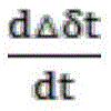
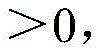
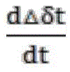
tnThe porous structure of the rock is filled by pressure water seepage, and the rock matrix is rich in a large amount of water, so that the phenomenon that the pressure water in the potential water body permeates is reflected; at a delta
tIs a vertical coordinate,Time t is plotted on the abscissa, when the slope of the plot at the multiple points:
the change rate of the water content difference value obtained by two times of sampling at the same sampling point along with the time is shown, early warning is carried out when the change rate is in gradient change along with the distance, and a 'hydrophobic-grouting-monitoring' three-in-one technical means is intensively implemented in the monitoring drilling area space.
And the outer wall of the nonmagnetic steel pipe is adhered with an optical fiber strain sensor which can measure and monitor the settlement displacement of the surrounding rock mass.
Has the advantages that: by adopting the technical scheme, the low-field nuclear magnetic resonance miniature sensor is sent into the drill hole for measurement, and the obtained nuclear magnetic water signal and the surrounding rock lithology are utilized to construct the early warning threshold value and the safety evaluation criterion for inducing water damage. After the underground space or tunnel construction is completed, the surrounding drill holes are arranged, the low-field nuclear magnetic resonance miniature sensors are embedded in advance, the inspection cameras and the optical fiber strain sensors are matched, and the 5G signals are utilized to monitor the spatial distribution, displacement settlement and visible risks of water in surrounding rocks in real time. On one hand, the potential water source position of the front rock stratum of the urban underground space or the tunnel in the construction process can be subjected to multi-dimensional space-time monitoring through a low-field nuclear magnetic resonance miniature sensor, so that the strength, type, water content and porosity of surrounding rocks at different depths of a drilled hole are obtained, and the distribution of a front tectonic zone such as a water-rich fault fracture zone and a karst development zone is judged; on the other hand, the low-field nuclear magnetic resonance miniature sensor, the optical fiber strain sensor and the intelligent monitoring equipment are combined with a 5G transmission technology, so that the spatial distribution, displacement settlement and other visible risks of water in surrounding rocks during the operation process of the tunnel are monitored in real time, and the safe operation in the whole life cycle of the tunnel can be effectively guaranteed. After the urban underground space or the tunnel is put into use, the holes drilled on the periphery of the tunnel are respectively drilled on the top, the left side, the right side and the bottom of the tunnel, nonmagnetic steel pipes and low-field nuclear magnetic resonance miniature sensors are embedded into the holes, optical fiber strain sensors are attached to the outsides of the nonmagnetic steel pipes, other visible risks in the tunnel are identified by the aid of a mobile monitoring camera along a hanging rail in the urban underground space or the top of the tunnel, data of the sensors are connected with 5G signal transmission equipment through data transmission lines, the data are fed back to a monitoring center in real time, and safe operation of the tunnel is effectively guaranteed. The method has the advantages of strong scientificity, high detection precision, simple operation, good effect and wide practicability in the technical field.
Drawings
FIG. 1 is a schematic view of a three-dimensional monitoring method for water damage risks in the construction stage of urban underground spaces or tunnels.
FIG. 2 is a schematic illustration of the face elevation drilling arrangement of FIG. 1 of the present invention.
Fig. 3 is a schematic diagram of the method for three-dimensionally monitoring the water damage risk in the operation stage of the urban underground space or tunnel.
Fig. 4 is a schematic diagram of the arrangement of the peripheral drilling space structure in fig. 3.
FIG. 5 is a cross-sectional structure of the nonmagnetic steel pipe shown in FIG. 3 according to the present invention.
FIG. 6 is a schematic longitudinal sectional view of the nonmagnetic steel pipe shown in FIG. 3 according to the present invention.
In the figure, 1-urban underground space or tunnel; 2-palm surface; 3-upward monitoring the borehole; 4-nonmagnetic steel pipes; 4-1-sliding rail; 4-2-electric pulley; 4-3-pulley support base; 5-magnetic field of nuclear magnetic signal; 6-low field nuclear magnetic resonance miniature sensor; 6-1-fixed strop; 6-2-a fixed collar; 6-3-a first magnet; 6-4-a second magnet; 6-5-third magnet; 7-potential water body; 8-lateral monitoring of the borehole; 9-monitoring the borehole downwards; 10, drilling holes on the periphery of the tunnel; 11-a hanger rail; 12-intelligent monitoring equipment; 13-a data transmission line; 14-5G signal transmission equipment.
Detailed description of the invention
The invention will be further described with reference to examples in the drawings to which:
firstly, after an urban underground space or a tunnel 1 is formed in a supporting mode, driving an advancing upward monitoring drill hole 3, a transverse monitoring drill hole 8 and a downward monitoring drill hole 9 into different angles in front of a tunnel face 2 through a drilling machine, and providing a channel for nuclear magnetic monitoring; measuring the strength, type, water content and porosity of the surrounding rock according to the rock cores at different depths obtained in the drill hole, and judging the distribution of a front tectonic zone such as a water-rich fault fracture zone and a karst development zone; sending a fixed hoisting ring 6-2 of a low-field nuclear magnetic resonance miniature sensor 6 into an upward monitoring drill hole 3, a transverse monitoring drill hole 8 and a downward monitoring drill hole 9 for measurement, wherein the fixed hoisting ring 6-2 is connected with a graduated fixed sliding cable 6-1 and a sliding rail 4-1 on the side wall of a nonmagnetic steel pipe 4; monitoring water signals in rock stratum matrixes around different drilling positions by using a low-field nuclear magnetic resonance miniature sensor 6, giving an early warning if the nuclear magnetic signals are increased rapidly or in a gradient manner, and intensively implementing a 'hydrophobic-grouting-monitoring' three-in-one technical means on the monitored drilling area space to realize effective prevention and control of potential water-borne disasters; the method comprises the following specific steps:
a. constructing an urban underground space or tunnel 1, after the urban underground space or tunnel 1 is formed in a supporting mode, constructing an upward monitoring borehole 3, a transverse monitoring borehole 8 and a downward monitoring borehole 9 which are ahead at different angles in the construction advancing direction of a drilling machine to a tunnel face 2, providing a channel for nuclear magnetic monitoring, and simultaneously drilling rock cores at different depth positions of each hole respectively; the diameter of the core drilled in the upward monitoring borehole 3, the transverse monitoring borehole 8 and the downward monitoring borehole 9 respectively at intervals of 1 meter is about 50mm, the length of the core drilled in the downward monitoring borehole is about 50mm, in-situ pressure maintaining is carried out by using a core sampler, and the number of the cores collected in each drilling stratum is not less than 8. The core sampler is made of an inorganic non-metallic material PMMR, and has the maximum temperature resistance of 150 ℃ and the pressure of 70 MPa. The inclination angles corresponding to the upward monitoring drill hole 3, the transverse monitoring drill hole 8 and the downward monitoring drill hole 9 by taking the end face of the palm as a base line are respectively 45 degrees, 90 degrees and 135 degrees, and the drilling depths are not less than 15 m.
b. Measuring the strength, type, water content and porosity of the surrounding rock according to the rock cores of different depths obtained in all the drill holes, and judging the distribution of a front tectonic zone such as a water-rich fault fracture zone and a karst development zone;
c. imbed the nonmagnetic steel pipe 4 that is equipped with low-field nuclear magnetic resonance miniature sensor 6 in upward monitoring drilling 3, horizontal monitoring drilling 8 and the downward monitoring drilling 9, nonmagnetic steel pipe 4 outer wall on paste and have optic fibre strain transducer, can measure the monitoring to the settlement displacement of peripheral rock mass, the space monitoring data of the interior water of cooperation rock mass carries out the analysis, and then obtains more reliable emergent scheme. Measuring every 1 m in each drill hole by using a low-field nuclear magnetic resonance miniature sensor 6 to slide back and forth in the non-magnetic steel pipe to release a nuclear magnetic signal magnetic field; the low-field nuclear magnetic resonance miniature sensor 6 comprises a permanent magnet and a coil, and the maximum bearing temperature is 150 ℃ and the maximum bearing pressure is 80 MPa. The inner wall of the non-magnetic steel pipe 4 is symmetrically provided with slide rails 4-1, and the port of the non-magnetic steel pipe 4 is provided with a pulley supporting base 4-3 and an electric pulley 4-2 fixed on the pulley supporting base 4-3. The low-field nuclear magnetic resonance miniature sensor 6 comprises a first magnet 6-3, a second magnet 6-4 and a third magnet 6-5 which are fixed in sequence, the end parts of the first magnet 6-3 and the third magnet 6-5 are respectively provided with a fixed lantern ring 6-2, the fixed lantern rings 6-2 at the two ends are connected with a fixed sliding rope 6-1 arranged in a nonmagnetic steel pipe 4, and scales are marked on the fixed sliding rope 6-1.
d. In the process of constructing an urban underground space or a tunnel 1, low-field nuclear magnetic resonance miniature sensors 6 in three different-angle drill holes are used for respectively monitoring water signals in rock stratum matrixes around three drill hole positions, early warning is carried out if the nuclear magnetic signals are increased rapidly or in a gradient manner, a three-in-one technical means of 'drainage-grouting-monitoring' is intensively implemented on the monitored drill hole area space, and effective prevention and control of potential water-related disasters in the construction of the drill hole area are realized;
e. after the construction of the urban underground space or the tunnel 1 is finished or before the construction is put into use, a drilling machine is used for drilling into a gap constructed in the urban underground space or the tunnel, a plurality of groups of drilling holes 10 are constructed at intervals, four drilling holes in each group are distributed up and down, left and right, and are uniformly distributed at intervals along the direction of the urban underground space or the tunnel 1;
f. embedding a non-magnetic steel pipe 4 provided with a low-field nuclear magnetic resonance miniature sensor 6 into a drill hole 10 constructed in each group of urban underground space or tunnel 1, wherein an optical fiber strain sensor capable of measuring and monitoring the settlement displacement of a peripheral rock mass is attached to the outer wall of the non-magnetic steel pipe 4; a movable monitoring camera 12 for identifying visible risks in a tunnel is mounted on a top hanging rail 11 in an urban underground space or the tunnel 1, all low-field nuclear magnetic resonance miniature sensors 6 in all drill holes 10 are connected with 5G signal transmission equipment 14 through data transmission lines 13, the 5G signal transmission equipment 14 is used for collecting information around the underground space or the tunnel 1 and feeding back the collected information data to a monitoring center in time, the spatial distribution, displacement settlement and other visible risks of water in surrounding rocks in the operation process of the urban underground space or the tunnel 1 are monitored in real time, and the safe operation in the whole life cycle of the tunnel is effectively guaranteed.
During the construction process of the urban underground space or tunnel 1 and when the construction is completed, inverting the first nuclear magnetic signals measured every 1 m in all the measuring drill holes to obtain the initial water content delta of the surrounding rocks at different depths of the measuring drill holes1、δ2、δ3…δnWherein n represents a sampling point n meters away from the outside to the inside of the drill hole, and observing initial water content data;
if the depth of a sampling point of a drilling hole from a drilling hole is increased sharply or in a gradient manner, early warning is carried out, and the three-in-one prior art means of drainage, grouting and monitoring is carried out in a centralized manner on the space of a monitored drilling hole area;
if no early warning is generated, every other period of time t
1、t
2、t
3、…、t
n,t
nRepresenting n seconds, performing nuclear magnetic measurement on fixed sampling points of every 1 meter in each drill hole, and calculating by using a computer to obtain a water content difference value obtained by twice sampling at the same position of each fixed sampling point of the surrounding rock: delta delta
t1、△δ
t2、△δ
t3、…、△δ
tnIf the water content difference value delta
t1=△δ
t2=△δ
t3=…=△δ
tnThe result shows that the pressure water front is not moved forward due to the fact that the rock structure is compact; if the difference value of water content is delta
t1≠△δ
t2≠△δ
t3≠…≠△δ
tnShowing that the multi-scale pore structure of the rock is infiltrated by pressure waterFilling by flow, wherein the rock matrix is rich in a large amount of water, and reflects the phenomenon that pressure water in a potential water body permeates; at a delta
tCurve with ordinate and time t abscissa, when the slope of the curve at multiple points:
the change rate of the water content difference value obtained by two times of sampling at the same sampling point along with the time is shown, early warning is carried out when the change rate is in gradient change along with the distance, and the three-in-one 'hydrophobic-grouting-monitoring' prior art means is intensively implemented in the monitoring drilling area space.
The optical fiber strain sensor is attached to the outer wall of the nonmagnetic steel pipe 4, the settlement displacement of the surrounding rock mass can be measured and monitored, and the space monitoring data of water in the rock mass is matched for analysis, so that a more reliable emergency scheme is obtained.