CN111133487B - Method and apparatus - Google Patents
Method and apparatus Download PDFInfo
- Publication number
- CN111133487B CN111133487B CN201880063122.1A CN201880063122A CN111133487B CN 111133487 B CN111133487 B CN 111133487B CN 201880063122 A CN201880063122 A CN 201880063122A CN 111133487 B CN111133487 B CN 111133487B
- Authority
- CN
- China
- Prior art keywords
- event
- vehicle
- data
- database
- processors
- Prior art date
- Legal status (The legal status is an assumption and is not a legal conclusion. Google has not performed a legal analysis and makes no representation as to the accuracy of the status listed.)
- Active
Links
Images

Classifications
-
- G—PHYSICS
- G08—SIGNALLING
- G08G—TRAFFIC CONTROL SYSTEMS
- G08G1/00—Traffic control systems for road vehicles
- G08G1/01—Detecting movement of traffic to be counted or controlled
- G08G1/0104—Measuring and analyzing of parameters relative to traffic conditions
- G08G1/0108—Measuring and analyzing of parameters relative to traffic conditions based on the source of data
- G08G1/0112—Measuring and analyzing of parameters relative to traffic conditions based on the source of data from the vehicle, e.g. floating car data [FCD]
-
- G—PHYSICS
- G01—MEASURING; TESTING
- G01C—MEASURING DISTANCES, LEVELS OR BEARINGS; SURVEYING; NAVIGATION; GYROSCOPIC INSTRUMENTS; PHOTOGRAMMETRY OR VIDEOGRAMMETRY
- G01C21/00—Navigation; Navigational instruments not provided for in groups G01C1/00 - G01C19/00
- G01C21/38—Electronic maps specially adapted for navigation; Updating thereof
- G01C21/3804—Creation or updating of map data
- G01C21/3833—Creation or updating of map data characterised by the source of data
- G01C21/3848—Data obtained from both position sensors and additional sensors
-
- G—PHYSICS
- G01—MEASURING; TESTING
- G01C—MEASURING DISTANCES, LEVELS OR BEARINGS; SURVEYING; NAVIGATION; GYROSCOPIC INSTRUMENTS; PHOTOGRAMMETRY OR VIDEOGRAMMETRY
- G01C21/00—Navigation; Navigational instruments not provided for in groups G01C1/00 - G01C19/00
- G01C21/38—Electronic maps specially adapted for navigation; Updating thereof
- G01C21/3804—Creation or updating of map data
- G01C21/3807—Creation or updating of map data characterised by the type of data
- G01C21/3815—Road data
-
- G—PHYSICS
- G06—COMPUTING; CALCULATING OR COUNTING
- G06F—ELECTRIC DIGITAL DATA PROCESSING
- G06F16/00—Information retrieval; Database structures therefor; File system structures therefor
- G06F16/50—Information retrieval; Database structures therefor; File system structures therefor of still image data
-
- G—PHYSICS
- G06—COMPUTING; CALCULATING OR COUNTING
- G06V—IMAGE OR VIDEO RECOGNITION OR UNDERSTANDING
- G06V20/00—Scenes; Scene-specific elements
- G06V20/50—Context or environment of the image
- G06V20/56—Context or environment of the image exterior to a vehicle by using sensors mounted on the vehicle
-
- G—PHYSICS
- G08—SIGNALLING
- G08G—TRAFFIC CONTROL SYSTEMS
- G08G1/00—Traffic control systems for road vehicles
- G08G1/01—Detecting movement of traffic to be counted or controlled
- G08G1/0104—Measuring and analyzing of parameters relative to traffic conditions
- G08G1/0125—Traffic data processing
- G08G1/0129—Traffic data processing for creating historical data or processing based on historical data
-
- G—PHYSICS
- G08—SIGNALLING
- G08G—TRAFFIC CONTROL SYSTEMS
- G08G1/00—Traffic control systems for road vehicles
- G08G1/01—Detecting movement of traffic to be counted or controlled
- G08G1/0104—Measuring and analyzing of parameters relative to traffic conditions
- G08G1/0137—Measuring and analyzing of parameters relative to traffic conditions for specific applications
- G08G1/0141—Measuring and analyzing of parameters relative to traffic conditions for specific applications for traffic information dissemination
-
- G—PHYSICS
- G08—SIGNALLING
- G08G—TRAFFIC CONTROL SYSTEMS
- G08G1/00—Traffic control systems for road vehicles
- G08G1/09—Arrangements for giving variable traffic instructions
- G08G1/091—Traffic information broadcasting
-
- G—PHYSICS
- G06—COMPUTING; CALCULATING OR COUNTING
- G06F—ELECTRIC DIGITAL DATA PROCESSING
- G06F7/00—Methods or arrangements for processing data by operating upon the order or content of the data handled
- G06F7/58—Random or pseudo-random number generators
- G06F7/588—Random number generators, i.e. based on natural stochastic processes
Abstract
The invention relates to a system for generating and/or updating a digital model of at least one subregion of a digital map, said system having, on the vehicle side: a vehicle database having vehicle-side map data that images at least one sub-area of a digital map; one or more sensors for collecting vehicle environmental data; one or more processors configured to generate at least one segment from vehicle environment data and determine update data for the sub-region of the digital map from the segment if there is an event in the form of a difference between an object in map data and an object in the segment; means for determining a spatial location of an event; a transmitting and receiving device configured to receive a message having a seed for a random number from a backend device; wherein the one or more processors are further configured to generate a random number based on the seed; wherein the transmitting and receiving device is configured to transmit the update data with the event and the associated spatial position to the backend device if the vehicle-side database is in the standard mode with respect to the spatial position of the event or if the random number exceeds a determined value.
Description
Technical Field
The present invention relates to the field of driving assistance systems. The invention relates in particular to the acquisition (Erfassen) of road data (fahrwegdanten) by sensors of the vehicle and to the transmission of the acquired road data to a database outside the vehicle.
Technical Field
In order to keep the data on the road characteristics (for example for autonomous driving or semi-autonomous driving) in the database of the backend device current, these data must be brought to the latest state periodically. The acquisition of the road characteristics can be performed by vehicles travelling on the road, which are equipped with suitable sensors and devices for acquiring the geographic Position (Geo-Position), respectively. The collected data can then be transmitted via a vehicle-to-X communication or a mobile radio connection to a database of the back-end device, where the data is merged into a data record, which can then be transmitted to a further vehicle, for example for route calculation or the like. When transmitting updated data from multiple vehicles to a backend device, the collected data may cause a very large amount of data from the vehicles to the backend device (Datenaufkommen). If statistically significant, updated, consolidated data records already exist in the back-end device, this represents a waste of communication resources, since a further improvement of the quality of the consolidated data records may not be achieved by further transmitting the data collected via the vehicle.
Disclosure of Invention
It is therefore the object of the present invention to provide a system for generating or updating a digital model of a digital map, which is reliable and safe to operate.
This object is achieved with a system according to the independent system claim. The dependent claims relate to particular embodiments.
One aspect relates to a system for generating and/or updating a digital model of at least one sub-area of a digital map, wherein a two-sided data processing is performed. Part of the data processing is performed in one or more vehicles. Another part of the data processing is performed in the back-end device. On the vehicle side, the system has a vehicle database with vehicle-side map data which image at least one sub-area of a digital map which is also stored in a server database in the back-end device. Furthermore, on the vehicle side, the system has one or more sensors for acquiring vehicle environment data and one or more processors configured to generate at least one segment (Snippet) from the vehicle environment data. The segment is a local model (Teilmodell) of the digital map, which contains object data of the vehicle environment objects. A CAD (computer aided design) model of a map section, for example 100m x 100m large, calculated for example from a series of camera images, may be involved. Furthermore, the one or more processors are configured to determine update data for a sub-region of the digital map from the segment if an event occurs in the form of a difference between an object in the map data and an object in the segment. The event may be, for example, a newly added vehicle environmental object, such as a road block or a temporarily erected road sign. Furthermore, on the vehicle side, means are present for determining the spatial position of the event, for example a GPS receiver for determining the vehicle position or additionally a radar sensor for determining the spatial position of the event relative to the vehicle. Further, a transmitting and receiving device configured to receive a Seed (Seed) from a backend device to generate a random number is provided on the vehicle side. The one or more processors are further configured to generate a random number based on the seed. The transmitting and receiving apparatus is further configured to: if the spatial position of the database on the vehicle side relative to the event is in the standard mode or if the random number exceeds a certain value, the update data with the event and the associated spatial position is transmitted to the backend device. The standard mode relates to the following states of the database on the vehicle side: in this state, with regard to the determined spatial position of the vehicle, the vehicle transmits update data to the vehicle database when an event is first detected by the vehicle. Therefore, in the standard mode of the vehicle database, the event does not exist in the Backend (Backend).
On the back end side, the system has a back end device. The back-end device includes a server database having map data of a back-end side of the digital model, and a transmitting/receiving device configured to receive update data from one or more vehicles. Further, one or more processors are provided in the backend apparatus, the one or more processors being configured to evaluate the update data in a statistical manner, and perform updating of the map data on the backend side according to the statistical evaluation, and generate a determined number of positive tokens (Token) and negative tokens according to the statistical evaluation. In this case, the number of positive tokens may be chosen such that: the event is verified by making a sufficiently high-order number of confirmations by further vehicles, so that only data with a correspondingly high degree of confidence is generated or updated in the server database. The transmitting and receiving device of the backend device is further configured to transmit the positive or negative token to the one or more vehicles.
The digital model stored in the server database can in particular have a high-resolution digital topographic map (Landkarte) with other environmental elements. The digital map is formed at least by a road model which describes the course of the road section and the driving lanes and contains information about the number and course of the lanes, the radius of the curve, the gradient, the intersection and similar features.
The digital model may comprise, inter alia, other static or dynamic environmental elements. Static environment elements relate to: information about the location and type of lane markings and road signs (e.g., stop lines, zebra stripes, center separators, lane edge markings, etc.); the presence of roadside structures, as well as their category and relative or absolute location; information about the location and type of traffic signs; or information about the type and status of the traffic light system or variable traffic signs. The dynamic environment elements relate in particular to the position and speed of the vehicle. For each parameter of the environment element, in particular the position and the attributes (for example the position of the traffic sign and the type of the traffic sign), statistical data (Statistik) are determined from the statistically significant number of measurements during the course of the training phase. The statistical data may reflect the distribution of the measured values around the mean.
Not only can a significant value (signifiankzwert) be assigned to the update data in the backend device with regard to the number of measurements (i.e. the number of transmissions by the vehicle), but also the update data can already be assigned on the vehicle side a confidence value or a statistical parameter depending on its quality, which can be derived, for example, from the quality of the vehicle environment data. Thus, the quality of the vehicle environment data may be lower in severe weather conditions such as fog and heavy rainfall than in good weather conditions, especially when the vehicle environment data is a series of camera images. The transmitting/receiving device of each vehicle may be configured to transmit, in addition to the update data, the statistical parameters or the confidence values determined on the vehicle side as additional data to the backend device.
The backend device may also evaluate the update data only statistically. The one or more processors of the backend device may be configured to statistically evaluate the update data as a function of the number of vehicles that have transmitted the update data and/or as a function of the number of transmissions, and assign a confidence value to the update data based on the number of vehicles and/or the number of transmissions.
In this case, the rear-end device may include the additional data determined on the vehicle side together in the determination of the confidence value. Depending on the number of vehicles that have transmitted the update data and/or the number of transmissions, and depending on the additional data, one or more processors of the backend device may evaluate the update data.
One aspect of the system involves generating positive and negative tokens in a back-end device. The one or more processors of the back-end device may be configured to generate positive and negative tokens if the update data has a statistical significance exceeding a minimum threshold, wherein the positive and negative tokens are assigned at least a spatial location of the associated event and an event ID of the associated event. The transmitting/receiving device of the backend device may be configured to transmit the positive and negative tokens to one or more vehicles, in particular via broadcast.
One aspect of the system relates to the handling of detection of an event abort. Whenever an event abort is to be rated as statistically significant, the event abort should result in: with regard to this event, all positive and negative tokens in all vehicles are deleted and the vehicle database is restored to the standard mode with regard to this event, i.e. in particular with regard to its spatial position.
The one or more vehicle-side processors are configured to detect an abort of the event with the determined spatial location and the assigned event ID if there is a negative difference between the object in the map data and the object in the segment. The vehicle-side transmission/reception device may be configured to: if a negative token is present in the vehicle-side memory, a discontinuation of the transmission of the event in the form of update data to the backend device. Thus, only the following vehicles report the cessation of the event: the vehicle database of the vehicle has a negative token with respect to the event.
The one or more processors of the back-end device may be configured to generate the following message if the update data has a statistical significance exceeding a minimum threshold: the message places the vehicle-side database in a standard mode with respect to the spatial location of the aborted event and the event ID. The transmitting/receiving device of the backend device may be configured to transmit a message to one or more vehicles. The one or more vehicle-side processors may then remove the positive or negative tokens for the spatial location and/or event ID from the vehicle-side memory and restore the vehicle database to the standard mode for the aborted event.
One aspect relates to spatially assigning positive and negative tokens to a vehicle. The transmitting and receiving device of the backend device may be configured to transmit positive or negative tokens to one or more of the following vehicles: the vehicle is only spatially near the event.
One aspect relates to assigning updated map data on the rear end side to a vehicle. To this end, the one or more back-end side processors may be configured to update the server database with the back-end side map data of the digital model with the update data if the update data has a confidence value that exceeds a minimum threshold. The transmitting/receiving device on the rear end side may be configured to transmit data concerning the event of at least the updated database to: the vehicle is spatially located near the event.
Drawings
In the following, the invention is described according to embodiments with reference to the drawings. In the drawings, there is shown in the drawings,
FIG. 1 shows a block circuit diagram of a system for generating a digital model; and
FIG. 2 shows a flow diagram of a method for the occurrence of an event; and
fig. 3 shows a flow chart of an alternative method for the occurrence of an event.
Detailed Description
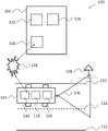
Fig. 1 shows a system 100 for generating and/or updating a digital model of a digital map, comprising a rear-end device 102 and a vehicle 104 with a sensor 106, which vehicle 104 moves on a traffic lane delimited by two lanes 110, 112, with a central separator 114. The vehicle 104 has a transmitting/receiving device 116 for data transmission to and from the backend device 102. The backend device 102 also has a sending and receiving device 126 for data transfer to and from the vehicle 104. An environmental sensor 106 mounted on the vehicle 104 may be configured as a camera and collects vehicle environment data in the form of a series of photographs of the vehicle environment, which contain traffic signs 108. The environment sensor may additionally be designed as a radar sensor and may be configured to scan the environment by means of radar. In this manner, radar sensor 106 may additionally determine the location of environmental elements (e.g., traffic signs 108) relative to the spatial location of the vehicle. Again, an absolute spatial location may be determined in conjunction with a GPS module (not shown). The vehicle further has a processor 120, which processor 120 is configured to generate the segments from the vehicle environment data. A segment is a portion of the digital model that is about 100 x 100m large and represents essentially object modeling. The vehicle 104 furthermore has a vehicle database 118 with vehicle-side map data, which images at least one sub-region of the digital map. The processor 120 is configured to compare the segment with corresponding vehicle-side map data from the vehicle database 118 in order to ascertain whether there is an event in the form of a difference between an object in the map data and an object in the segment. In this case, it is assumed that the traffic sign 108 is not yet present in the map data, for example because it was erected shortly before. Thus, the comparison yields the newly installed traffic sign 108 as the event. The backend device is currently not aware of this event because the event has not been communicated to the backend device via the communication network.
The vehicle 104 transmits the event in the form of update data to the back end device 102, whereby the back end device 102 can update its server database 122 with the server-side map data of the digital model. The digital model may consist of the following segments: the segments may originate from a plurality of vehicles. It may also relate to a parameterizable environmental model. The parameterization can be performed by a statistically significant number of vehicles in the course of the learning process. The parameterized environment model therefore represents the rear-end-side merged vehicle environment information. Each of the environment elements may have its own statistics in view of location, attributes and detection probability. The backend apparatus has a processor 124, and the processor 124 is configured to statistically evaluate the update data, and update the map data on the backend side in the server database 122 according to the statistical evaluation.
Assume that multiple vehicles pass by the traffic sign 108. Since each of these vehicles detects the newly installed traffic sign 108 as an event, if each vehicle would communicate the event to the back end device 102 in the form of updated data, a very large amount of data would be generated in the uplink to the back end device 102. Thus, a token-based protocol for communicating update data is described below with reference to fig. 2, 3, and 4.
Fig. 2 shows a flow diagram 200 of a protocol for the occurrence of an event. In the default mode, there is no event yet for a determined spatial region of the digital map. The vehicle-side database 202 contains a selection of the entire digital map of the server-side database 200 (Ausschnitt). The server-side database 200 contains environmental models, in particular high-resolution digital topographic maps with other environmental elements. The digital map is formed at least by a road model which describes the course of the road section and the driving lanes and contains information about the number and course of the lanes, the radius of the curve, the gradient, the intersection and similar features. The environment model may comprise, inter alia, other static environment elements. Static environment elements relate to: information about the location and type of lane markings and road signs (e.g., stop lines, zebra stripes, center separators, lane edge markings, etc.); the presence of roadside structures, as well as their category and relative or absolute location; information about the location and type of traffic signs; or information about the type and status of the traffic light system or variable traffic signs.
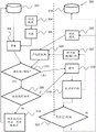
Vehicle-side sensors collect vehicle environmental data, see step 204. The segments are computed from the vehicle environment data by one or more vehicle-side processors 206. This segment contains a traffic sign 108, see fig. 1, which was erected shortly before. By comparison, i.e. by determining the difference between the object in the database 202 on the vehicle side and the object in the segment 206, the traffic sign 108 is recognized as an event. In step 210 it is determined: a random number is generated for whether a seed has been received for the event, i.e., for the spatial region in which the event has occurred. This is not the case for the spatial region in which the database 202 on the vehicle side for the corresponding spatial region is in the default mode, since the event has not yet been transmitted to the backend. In this case, the event 308 is transmitted to the backend device, and after receipt, the event 308 exists there as event 216. On the rear end side, depending on the number of times the event is transmitted from possibly different vehicles, a statistical evaluation for the event is made in step 218. Based on the statistical evaluation, a message with a seed for generating a random number is generated in step 222. The message with the seed is transmitted to the vehicle, where a random number is generated in a processor configured therefor in step 224. Again, within the scope of the statistical evaluation in step 218, a confidence value is determined that describes how trustworthy the event is, and in step 220, the confidence value is compared to a threshold. If the result of the comparison is that the confidence value exceeds the threshold, an update of the server-side database 224 is made. With the message transmitted with the seed, the vehicle-side database again enters from the default mode into the event mode, in which the transmission of the event takes place on the basis of the random number generated by means of the seed. If the event no longer exists within a predetermined time period after receipt of the message, a corresponding report is made to the backend. Thus, as the predetermined time period expires, the database on the vehicle side goes from the event mode to the default mode.
Fig. 3 shows a flowchart of a protocol in an alternative embodiment. Vehicle-side sensors collect vehicle environmental data, see step 304. Segments 306 are calculated from vehicle environment data by one or more vehicle-side processors. Segment 306 contains a traffic sign 108 that was erected shortly before, see fig. 1. By comparison, i.e. by determining the difference between the object in the database 302 on the vehicle side and the object in the segment 306, the traffic sign 108 is recognized as an event. In step 310 it is determined whether a seed has been received for the event, i.e. for the spatial region in which the event has occurred, to generate a random number. This is not the case for the spatial region in which the database 302 on the vehicle side for the corresponding spatial region is in the default mode, since the event has not yet been transmitted to the backend. In this case, the event 308 is transmitted to the backend device, and after receipt, the event 308 exists as event 316. On the rear end side, depending on the number of times the event is transmitted from possibly different vehicles, a statistical evaluation for the event is made in step 318. According to the statistical evaluation, a message with an expiration time is generated in step 322 with the following seed: the seed is used to generate random numbers. The message with the seed and expiration time is transmitted to the vehicle where a random number is generated in a processor configured for this purpose in step 324. The transmission may be by means of broadcasting. To this end, the spatial position of the event is mapped onto a radio cell and the message is transmitted to the corresponding radio cell.
Again, within the scope of the statistical evaluation in step 318, a confidence value is determined that describes how trustworthy the event is, and in step 320, the confidence value is compared to a threshold. If the result of the comparison is that the confidence value exceeds the threshold, an update of the server-side database 324 is made. As a message with a seed is transmitted, the vehicle-side database again enters an event mode from the default mode, in which the transmission of the event takes place on the basis of a random number generated by means of the seed. If the event still exists after the expiration of the expiration time, the event is treated as a new event in the default mode. Thus, the event is transmitted from all vehicles to the backend. For this purpose, it is checked in step 326 whether the expiration time has been exceeded. If this is the case, the event is transmitted to the backend regardless of whether the random number exceeds the threshold. Otherwise, only the database 302 on the vehicle side is updated.
Claims (10)
1. A system for generating and/or updating a digital model of at least one sub-area of a digital map, the system having on the vehicle side:
a vehicle database having vehicle-side map data that images at least one sub-area of the digital map,
one or more sensors for collecting vehicle environmental data;
one or more processors configured to: generating at least one segment from the vehicle environment data; and determining update data for the sub-area of the digital map from the segment if there is an event in the form of a difference between an object in the map data and an object in the segment;
means for determining a spatial location of the event;
a transmitting and receiving device configured to receive a message having a seed for a random number from a backend device;
wherein the one or more processors are further configured to generate a random number based on the seed;
wherein the transmitting and receiving device is configured to transmit the update data with the event and the associated spatial position to the back-end device if a database on the vehicle side is in a standard mode with respect to the spatial position of the event or if the random number exceeds a determined value; and
on the back end side, the system has a back end device having:
a server database having map data of a rear end side of the digital model;
a transmitting/receiving device configured to receive the update data from one or more vehicles;
one or more processors configured to statistically evaluate the update data and to generate the seed according to the statistical evaluation, and to perform the update of the map data on the back end side; and
wherein the transmitting and receiving device is further configured to transmit the seed to one or more vehicles.
2. The system of claim 1, wherein the one or more processors of the backend device are configured to statistically evaluate the update data as a function of a number of vehicles and/or a number of transmissions that have transmitted the update data, and to assign a confidence value to the update data based on the number of vehicles and/or the number of transmissions.
3. The system of claim 2, wherein the one or more backend side processors are configured to: updating the server database with the map data of the rear end side of the digital model with the update data if the update data has a confidence value that exceeds a minimum threshold value, and wherein the rear end side transmitting/receiving means are configured to transmit at least the seed and the following data of the updated database to the vehicle by means of broadcasting: the data relates to the event.
4. The system of claim 3, wherein the vehicle-side transmitting/receiving device is configured to transmit the update data with the event along with an associated timestamp, and wherein the rear-end side transmitting/receiving device is configured to transmit the following data of the updated database along with the timestamp of the event: the data relates to the event.
5. The system of claim 4, wherein one or more vehicle-side processors are configured to detect an abort of the event having the determined spatial location and the assigned event ID if there is a negative difference between an object in the map data and an object in the segment;
wherein the vehicle-side transmission/reception device is configured to transmit the suspension of the event to the backend device in the form of update data if the random number exceeds a value and a predetermined period of time has not been exceeded since the event occurred; and
wherein the one or more processors of the back-end device are configured to, if the update data has a confidence value that exceeds a minimum threshold, generate a message as follows: the message places the database on the vehicle side in the standard mode with respect to the spatial location and the event ID of the event that has been aborted; and wherein the transmitting/receiving device of the backend device is configured to transmit the message to one or more vehicles by means of a broadcast.
6. The system of claim 5, wherein the one or more vehicle-side processors are configured to restore the vehicle-side database to the standard mode with respect to the spatial location of the event if a predetermined period of time has passed since the event occurred.
7. A system according to claim 3, wherein the vehicle-side transmitting/receiving device is configured to transmit the update data with the event with an associated time stamp, and wherein the rear-end-side transmitting/receiving device is configured to transmit an expiration time with the following data of the updated database: the data relates to the event.
8. The system of claim 7, wherein the one or more vehicle-side processors are configured to: detecting an abort of the event with the determined spatial location and the assigned event ID if there is a negative difference between an object in the map data and an object in the segment;
wherein the vehicle-side transmission/reception device is configured to transmit the abort of the event to the backend device in the form of update data if the random number exceeds a value and the expiration time has not been exceeded; and
wherein the one or more processors of the back-end device are configured to generate the following message if the update data has a confidence value that exceeds a minimum threshold: the message places the database on the vehicle side in the standard mode with respect to the spatial location and the event ID of the event that has been aborted; and wherein the transmitting/receiving device of the backend device is configured to transmit the message to one or more vehicles by means of a broadcast.
9. The system of claim 8, wherein the one or more vehicle-side processors are configured to restore the vehicle-side database to the standard mode with respect to the spatial location of the event when the expiration time has elapsed.
10. The system of any of claims 3 to 9, wherein the broadcasting is via TMC or LTE.
Applications Claiming Priority (3)
| Application Number | Priority Date | Filing Date | Title |
|---|---|---|---|
| DE102017217299.1A DE102017217299A1 (en) | 2017-09-28 | 2017-09-28 | Method and device |
| DE102017217299.1 | 2017-09-28 | ||
| PCT/EP2018/076151 WO2019063630A1 (en) | 2017-09-28 | 2018-09-26 | Method and device |
Publications (2)
| Publication Number | Publication Date |
|---|---|
| CN111133487A CN111133487A (en) | 2020-05-08 |
| CN111133487B true CN111133487B (en) | 2022-01-25 |
Family
ID=63798954
Family Applications (1)
| Application Number | Title | Priority Date | Filing Date |
|---|---|---|---|
| CN201880063122.1A Active CN111133487B (en) | 2017-09-28 | 2018-09-26 | Method and apparatus |
Country Status (7)
| Country | Link |
|---|---|
| US (1) | US20200256682A1 (en) |
| EP (1) | EP3688737A1 (en) |
| JP (1) | JP6918141B2 (en) |
| KR (1) | KR102384443B1 (en) |
| CN (1) | CN111133487B (en) |
| DE (1) | DE102017217299A1 (en) |
| WO (1) | WO2019063630A1 (en) |
Families Citing this family (2)
| Publication number | Priority date | Publication date | Assignee | Title |
|---|---|---|---|---|
| DE102016216335B4 (en) * | 2016-08-30 | 2020-12-10 | Continental Automotive Gmbh | System and method for the analysis of driving trajectories for a route section |
| CN112579614A (en) | 2019-09-27 | 2021-03-30 | 北京百度网讯科技有限公司 | Map data acquisition method and device, electronic equipment and medium |
Family Cites Families (16)
| Publication number | Priority date | Publication date | Assignee | Title |
|---|---|---|---|---|
| DE19513640C2 (en) | 1994-11-28 | 1997-08-07 | Mannesmann Ag | Method for reducing the amount of data to be transmitted from the vehicles of a vehicle fleet |
| US6047234A (en) * | 1997-10-16 | 2000-04-04 | Navigation Technologies Corporation | System and method for updating, enhancing or refining a geographic database using feedback |
| US20080303693A1 (en) * | 2007-06-07 | 2008-12-11 | Link Ii Charles M | Methods and Systems for Automated Traffic Reporting |
| DE102008012661A1 (en) * | 2007-08-25 | 2009-02-26 | Continental Teves Ag & Co. Ohg | Update unit and method for updating a digital map |
| US9043138B2 (en) * | 2007-09-07 | 2015-05-26 | Green Driver, Inc. | System and method for automated updating of map information |
| US9304005B2 (en) * | 2009-12-04 | 2016-04-05 | GM Global Technology Operations LLC | Application programming interface (API) for navigation applications that merges incremental updates with existing map database |
| US8818725B2 (en) * | 2011-11-16 | 2014-08-26 | Flextronics Ap, Llc | Location information exchange between vehicle and device |
| DE102012208254A1 (en) * | 2012-05-16 | 2013-11-21 | Continental Teves Ag & Co. Ohg | Method and system for creating a current situation image |
| US9143897B2 (en) * | 2012-11-05 | 2015-09-22 | Nokia Technologies Oy | Method and apparatus for providing an application engine based on real-time commute activity |
| DE102013205392A1 (en) * | 2013-03-27 | 2014-10-02 | Bayerische Motoren Werke Aktiengesellschaft | Backend for driver assistance systems |
| DE102014217847A1 (en) * | 2014-09-08 | 2016-03-10 | Conti Temic Microelectronic Gmbh | Driver assistance system, traffic telematics system and method for updating a digital map |
| JP2016156973A (en) | 2015-02-25 | 2016-09-01 | パイオニア株式会社 | Map data storage device, control method, program and recording medium |
| JP5997797B2 (en) * | 2015-03-03 | 2016-09-28 | 富士重工業株式会社 | Vehicle map data processing device |
| DE102016205141A1 (en) * | 2015-11-04 | 2017-05-04 | Volkswagen Aktiengesellschaft | A method and vehicle communication system for determining a driving intention for a vehicle |
| DE102016205543A1 (en) * | 2015-11-05 | 2017-05-11 | Continental Teves Ag & Co. Ohg | Method and system for exchanging map data depending on a quality measure |
| US10223380B2 (en) * | 2016-03-23 | 2019-03-05 | Here Global B.V. | Map updates from a connected vehicle fleet |
-
2017
- 2017-09-28 DE DE102017217299.1A patent/DE102017217299A1/en active Pending
-
2018
- 2018-09-26 JP JP2019559848A patent/JP6918141B2/en active Active
- 2018-09-26 US US16/651,712 patent/US20200256682A1/en not_active Abandoned
- 2018-09-26 KR KR1020207012102A patent/KR102384443B1/en active IP Right Grant
- 2018-09-26 EP EP18783388.4A patent/EP3688737A1/en active Pending
- 2018-09-26 WO PCT/EP2018/076151 patent/WO2019063630A1/en unknown
- 2018-09-26 CN CN201880063122.1A patent/CN111133487B/en active Active
Also Published As
| Publication number | Publication date |
|---|---|
| KR102384443B1 (en) | 2022-04-08 |
| JP6918141B2 (en) | 2021-08-11 |
| DE102017217299A1 (en) | 2019-03-28 |
| EP3688737A1 (en) | 2020-08-05 |
| JP2020518811A (en) | 2020-06-25 |
| US20200256682A1 (en) | 2020-08-13 |
| CN111133487A (en) | 2020-05-08 |
| KR20200053610A (en) | 2020-05-18 |
| WO2019063630A1 (en) | 2019-04-04 |
Similar Documents
| Publication | Publication Date | Title |
|---|---|---|
| CN111108538B (en) | System for generating and/or updating digital models of digital maps | |
| CN105793669B (en) | Vehicle position estimation system, device, method, and camera device | |
| CN108986450B (en) | Vehicle environment sensing method, terminal and system | |
| CN110880236B (en) | Road condition information processing method, device and system | |
| JP2016095831A (en) | Driving support system and center | |
| CN111200796A (en) | System and method for evaluating operation of an environmental sensing system of a vehicle | |
| JPWO2017212639A1 (en) | INFORMATION PROCESSING APPARATUS, MEASUREMENT APPARATUS, AND CONTROL METHOD | |
| EP3895950A1 (en) | Methods and systems for automated driving system monitoring and management | |
| US20200286370A1 (en) | Transportation threat detection system | |
| CN113706737A (en) | Road surface inspection system and method based on automatic driving vehicle | |
| US20220057230A1 (en) | Method For Checking Detected Changes To An Environmental Model Of A Digital Area Map | |
| CN110880235A (en) | Road side equipment in road condition information processing system, processing method and device | |
| CN111133487B (en) | Method and apparatus | |
| CN111213032A (en) | Method for mapping a route section | |
| CN115470884A (en) | Platform for perception system development of an autopilot system | |
| JP2021043475A (en) | Transmitter, point-group data collecting system, and computer program | |
| US20200057772A1 (en) | Method, Device, and System for Determining a Weather Area | |
| CN114760330B (en) | Data transmission method, device, storage medium and system for Internet of vehicles | |
| US20210323577A1 (en) | Methods and systems for managing an automated driving system of a vehicle | |
| JP2021073547A (en) | Information processing device, measurement device, and control method | |
| CN114363308B (en) | Map data transmission method and device | |
| CN106063257B (en) | Method for managing traffic information and machine-readable medium | |
| WO2016072082A1 (en) | Driving assistance system and center | |
| WO2022156352A1 (en) | Method and apparatus for updating map, and computer-readable storage medium | |
| CN116311163A (en) | Vehicle information processing method, device and equipment |
Legal Events
| Date | Code | Title | Description |
|---|---|---|---|
| PB01 | Publication | ||
| PB01 | Publication | ||
| SE01 | Entry into force of request for substantive examination | ||
| SE01 | Entry into force of request for substantive examination | ||
| GR01 | Patent grant | ||
| GR01 | Patent grant | ||
| TR01 | Transfer of patent right |
Effective date of registration: 20230117 Address after: Hannover Patentee after: Continental Automotive Technology Co.,Ltd. Address before: Hannover Patentee before: CONTINENTAL AUTOMOTIVE GmbH |
|
| TR01 | Transfer of patent right |