CN110160552B - Navigation information determination method, device, equipment and storage medium - Google Patents
Navigation information determination method, device, equipment and storage medium Download PDFInfo
- Publication number
- CN110160552B CN110160552B CN201910456455.7A CN201910456455A CN110160552B CN 110160552 B CN110160552 B CN 110160552B CN 201910456455 A CN201910456455 A CN 201910456455A CN 110160552 B CN110160552 B CN 110160552B
- Authority
- CN
- China
- Prior art keywords
- lane
- lane change
- path
- precision
- determining
- Prior art date
- Legal status (The legal status is an assumption and is not a legal conclusion. Google has not performed a legal analysis and makes no representation as to the accuracy of the status listed.)
- Active
Links
- 238000000034 method Methods 0.000 title claims abstract description 59
- 230000008859 change Effects 0.000 claims abstract description 464
- 238000013507 mapping Methods 0.000 claims abstract description 49
- 241000274965 Cyrestis thyodamas Species 0.000 claims abstract description 34
- 230000001133 acceleration Effects 0.000 claims description 18
- 238000006243 chemical reaction Methods 0.000 claims description 10
- 238000000926 separation method Methods 0.000 claims description 10
- 238000004590 computer program Methods 0.000 claims description 6
- 230000006870 function Effects 0.000 claims description 6
- 238000004364 calculation method Methods 0.000 abstract description 9
- 238000010586 diagram Methods 0.000 description 15
- 230000008569 process Effects 0.000 description 8
- 230000004044 response Effects 0.000 description 8
- 230000003287 optical effect Effects 0.000 description 6
- 238000005516 engineering process Methods 0.000 description 5
- 239000013307 optical fiber Substances 0.000 description 2
- 230000002093 peripheral effect Effects 0.000 description 2
- 238000012545 processing Methods 0.000 description 2
- 230000000644 propagated effect Effects 0.000 description 2
- 230000035484 reaction time Effects 0.000 description 2
- 241001149900 Fusconaia subrotunda Species 0.000 description 1
- 238000003491 array Methods 0.000 description 1
- 238000004891 communication Methods 0.000 description 1
- 238000011161 development Methods 0.000 description 1
- 230000008447 perception Effects 0.000 description 1
- 230000008707 rearrangement Effects 0.000 description 1
- 239000004065 semiconductor Substances 0.000 description 1
- 238000006467 substitution reaction Methods 0.000 description 1
Images


Classifications
-
- G—PHYSICS
- G01—MEASURING; TESTING
- G01C—MEASURING DISTANCES, LEVELS OR BEARINGS; SURVEYING; NAVIGATION; GYROSCOPIC INSTRUMENTS; PHOTOGRAMMETRY OR VIDEOGRAMMETRY
- G01C21/00—Navigation; Navigational instruments not provided for in groups G01C1/00 - G01C19/00
- G01C21/26—Navigation; Navigational instruments not provided for in groups G01C1/00 - G01C19/00 specially adapted for navigation in a road network
- G01C21/34—Route searching; Route guidance
- G01C21/36—Input/output arrangements for on-board computers
- G01C21/3626—Details of the output of route guidance instructions
Landscapes
- Engineering & Computer Science (AREA)
- Radar, Positioning & Navigation (AREA)
- Remote Sensing (AREA)
- Automation & Control Theory (AREA)
- Physics & Mathematics (AREA)
- General Physics & Mathematics (AREA)
- Navigation (AREA)
- Traffic Control Systems (AREA)
Abstract
The embodiment of the invention discloses a navigation information determining method, a navigation information determining device, navigation information determining equipment and a storage medium. The method comprises the following steps: mapping a common navigation path generated on a common map by planning to a high-precision map to obtain a high-precision navigation path; determining lane change information according to the high-precision navigation path and the lane information of the high-precision navigation path; and generating vehicle lane change navigation information according to the current driving position of the vehicle and the lane change information. The embodiment of the invention provides the clear lane change information for the automatic driving vehicle instead of the simple path suggestive information, thereby realizing the high-precision lane-level navigation, saving the real-time calculation resource of the navigation information and improving the navigation precision, efficiency and accuracy.
Description
Technical Field
The embodiment of the invention relates to the technical field of automatic driving, in particular to a navigation information determining method, a navigation information determining device, navigation information determining equipment and a storage medium.
Background
With the rapid development of information and control technologies, the automatic driving technology is gradually accepted by automobile manufacturers and users. Automatic driving not only minimizes the risk of vehicle travel, but also reduces the burdensome driving tasks for the user. Map navigation during corresponding autonomous driving is particularly important.
At present, the automatic driving technology adopts a common map for navigation, and in the navigation process of the common map, the common map can plan a navigation path according to a starting point and an end point input by a user, and prompt path navigation is carried out on an automatic driving vehicle according to the planned navigation path, for example, in a scene that the automatic driving vehicle drives out or drives in at a high speed, the automatic driving technology prompts that the vehicle needs to drive out a ramp or drive into a high-speed main road.
Autonomous vehicles are traveling at high speeds and the autonomous system requires accurate information to complete the control of the vehicle. However, because the accuracy of the ordinary map is low, the existing navigation technology can only provide road-level prompt information, and the navigation accuracy is low, so that the requirement for lane change information in an automatic driving scene cannot be met.
Disclosure of Invention
The embodiment of the invention provides a navigation information determination method, a navigation information determination device, navigation information determination equipment and a storage medium, which can be used for lane-level navigation lane change information.
In a first aspect, an embodiment of the present invention provides a navigation information determining method, including:
mapping a common navigation path generated on a common map by planning to a high-precision map to obtain a high-precision navigation path;
determining lane change information according to the high-precision navigation path and the lane information of the high-precision navigation path;
and generating vehicle lane change navigation information according to the current driving position of the vehicle and the lane change information.
In a second aspect, an embodiment of the present invention provides a navigation information determining apparatus, including:
the route conversion module is used for mapping the common navigation route generated by planning on the common map to the high-precision map to obtain the high-precision navigation route;
the lane change information planning module is used for determining lane change information according to the high-precision navigation path and the lane information of the high-precision navigation path;
and the lane change navigation information generation module is used for generating lane change navigation information of the vehicle according to the current driving position of the vehicle and the lane change information.
In a third aspect, an embodiment of the present invention provides an apparatus, including:
one or more processors;
a memory for storing one or more programs;
when the one or more programs are executed by the one or more processors, the one or more processors implement the navigation information determining method according to any embodiment of the present invention.
In a fourth aspect, an embodiment of the present invention provides a computer-readable storage medium, on which a computer program is stored, where the computer program, when executed by a processor, implements the navigation information determining method according to any embodiment of the present invention.
The embodiment of the invention provides a lane-level navigation information interface in a high-precision map engine, maps the navigation path planned by a common map into the high-precision map, and simultaneously generates lane change information of lanes in each path connecting point and stores the lane change information in the corresponding lanes. Therefore, when the high-precision map engine is called by the automatic driving system, the lane where the vehicle is located and lane change information of the vehicle can be directly inquired according to the current position of the vehicle. The embodiment of the invention provides the clear lane change information for the automatic driving vehicle instead of the simple path suggestive information, thereby realizing the high-precision lane-level navigation, saving the real-time calculation resource of the navigation information and improving the navigation precision, efficiency and accuracy.
Drawings
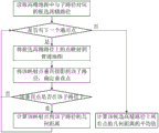
Fig. 1 is a flowchart of a navigation information determining method according to an embodiment of the present invention;
fig. 2 is a flowchart of a navigation information determining method according to a second embodiment of the present invention;
FIG. 3 is a flowchart of mapping a general navigation path to a high-precision map according to a second embodiment of the present invention;
FIG. 4 is a diagram illustrating a common navigation path mapped to a high-precision map according to a second embodiment of the present invention;
fig. 5 is a flowchart of a navigation information determining method according to a third embodiment of the present invention;
fig. 6 is a flowchart of navigation information determination in a scenario where a ramp enters a highway according to a fourth embodiment of the present invention;
fig. 7 is an exemplary diagram of a scenario in which a ramp enters a highway according to a fourth embodiment of the present invention;
fig. 8 is a flowchart of navigation information determination in a scene where a expressway enters a ramp according to a fifth embodiment of the present invention;
fig. 9 is an exemplary diagram of a scene of a highway entering a ramp according to a fifth embodiment of the present invention;
fig. 10 is a flowchart of navigation information determination in a lane merging scenario according to a sixth embodiment of the present invention;
fig. 11 is an exemplary diagram of a lane merging scenario provided in a sixth embodiment of the present invention;
fig. 12 is a flowchart of navigation information determination in a lane diversion scenario according to a seventh embodiment of the present invention;
fig. 13 is an exemplary diagram of a lane diversion scenario provided by a seventh embodiment of the present invention;
fig. 14 is a schematic structural diagram of a navigation information determining apparatus according to an eighth embodiment of the present invention;
fig. 15 is a schematic structural diagram of an apparatus according to a ninth embodiment of the present invention.
Detailed Description
The embodiments of the present invention will be described in further detail with reference to the drawings and examples. It is to be understood that the specific embodiments described herein are merely illustrative of the embodiments of the invention and that no limitation of the invention is intended. It should be further noted that, for convenience of description, only some structures, not all structures, relating to the embodiments of the present invention are shown in the drawings.
Example one
Fig. 1 is a flowchart of a navigation information determining method according to an embodiment of the present invention, which is applicable to a case where lane-level navigation information is provided during driving, especially in an automatic driving scenario, and the method can be executed by a navigation information determining apparatus, which can be implemented in software and/or hardware, and is preferably configured in an electronic navigation device, such as a car navigation device. The method specifically comprises the following steps:
and S110, mapping the common navigation path generated by planning on the common map to a high-precision map to obtain the high-precision navigation path.
In the embodiment of the present invention, the general map refers to a conventional navigation map, and a user of the general map is a user, which is used for navigation, search, and the like of the map. Such as an in-vehicle navigation map, is typically included in a vehicle with an in-vehicle infotainment system having a display screen. The common map only contains coarse-grained road information such as simple road lines, information points, administrative region boundaries and the like. The high-precision map is a map defined in a high-precision and fine manner, and a user of the high-precision map is a computer and is used for high-precision positioning, environment perception assistance, planning, decision making and the like. High-precision maps are generally in-vehicle safety systems, do not require a screen, and serve vehicles or users as high-precision engines. The high-precision map contains fine-grained road information, and can comprise lane models, road components, road attributes, other positioning layers and the like on all roads.
In this embodiment, the mapping relationship between the ordinary map and the high-precision map is stored in the vehicle-side system in advance, and is used for high-precision conversion of the navigation path. Specifically, in the process of lane-level navigation, a general navigation map, i.e., a common map, is first used to plan a navigation path according to a start point and an end point input by a user, so as to obtain a common navigation path generated by planning on the common map. The general navigation path may be composed of at least one sub-path, and the general navigation path only includes navigation information at a road level, and the navigation information is suggestive information, for example, prompting a user to drive along the road a, prompting the user to drive along three middle lanes of the road a, and the like. Therefore, the general navigation path generated based on the general map cannot provide the user or the vehicle end with information about each lane in the road, lane change navigation information on each lane, and the like.
In the embodiment, the starting points of the sub-paths in the common navigation path are mapped into the high-precision map according to the mapping relation between the common map and the high-precision map. The high-precision map has a precision far higher than that of the ordinary map, so that the ordinary map and the high-precision map may have a difference in path division, and the path in the ordinary map may correspond to multiple paths in the high-precision map or a part of the path in the high-precision map. Therefore, the embodiment can also determine a plurality of candidate high-precision paths closest to the starting point according to the geometric distance between the starting point of each sub-path in the common navigation path and the path in the high-precision map, and determine the path in the high-precision map most similar to the common navigation path according to the geometric distance between the point on the common path and the candidate high-precision path, so as to obtain the high-precision navigation path mapped by the common navigation path. Accordingly, the high-precision navigation path may be composed of one sub-path, and each sub-path may include at least one lane based on the path driving direction. Thus, the high-precision navigation path has higher precision and more detailed map information such as the number of lanes, the driving direction of the lanes, lane line information, steering information and the like on each path on the basis of the navigation planning of the common navigation path.
And S120, determining lane change information according to the high-precision navigation path and the lane information of the high-precision navigation path.
In an embodiment of the present invention, the lane information of the high-precision navigation path includes the number of lanes, the driving direction of the lanes, lane line information, steering information, and the like. On the basis of the high-precision navigation path, the physical impassability situation of each lane, such as the situation of lane merging and the like, is determined through the identification of the lane information of each lane in the high-precision navigation path, and the logical impassability situation of each lane based on the high-precision navigation path, such as the situation of driving into a ramp at high speed and the like, is determined. Therefore, in the physically impassable or logically impassable link, it is necessary to change to a physically passable and logically passable lane in advance, and lane change information such as a lane change point, a lane change direction, and the number of lane changes of each lane is determined based on the lane information of each lane in the high-precision navigation route.
Specifically, a lane change road section is determined according to a lane change condition in the high-precision navigation path and lane information of the high-precision navigation path; determining a target lane-changing lane and a drivable lane of the lane-changing road section according to the lane-changing scene and the lane information of the lane-changing road section; and determining lane change information of the drivable lane according to the driving speed of the vehicle and the position relation between the target lane change lane and the drivable lane. Therefore, when the navigation path is planned, lane change information which may exist on each lane in the path is generated, or the lane change information which may exist on each lane in the path is generated in real time in the process that the vehicle runs according to the navigation path, so that the lane change information is extracted when the vehicle runs in the corresponding lane.
And S130, generating vehicle lane change navigation information according to the current driving position of the vehicle and the lane change information.
In the embodiment of the invention, the lane change information refers to lane change information which may exist on each lane in a generated path when a navigation path is planned, or lane change information which may exist on each lane in a path generated in real time in the process that a vehicle runs according to the navigation path, so that the lane change information of the lane where the vehicle is located is provided for a user or a vehicle end system for reference in advance. The vehicle lane change navigation information is lane change navigation information related to an actual driving situation extracted from planned lane change information according to the actual driving situation of the vehicle, such as a driving lane, a driving speed and the like, during the actual driving of the vehicle, that is, after the navigation path and the lane change information are planned. That is, in this embodiment, the lane change information of all lanes may not be provided to the user or the vehicle end, but only the lane change information of the lane where the vehicle is currently running is extracted, and the effective navigation information may be provided to the user or the vehicle end. The vehicle lane change navigation information at least comprises lane change points, lane change directions, lane change times, and physical or logical impassability.
In this embodiment, it is considered that the different response times of lane change of the vehicle at different driving speeds are different, that is, the faster the vehicle is driven, the longer the lane change response time and the response distance are required. Therefore, lane change reaction distance information under different driving speeds can be determined in advance according to traffic regulation conditions on different paths, such as the highest and/or lowest speed limit and the like, so that different driving speeds under various paths are associated with the lane change reaction distance information, and in the actual driving process of the vehicle, the extracted lane change information is dynamically adjusted according to the driving speed of the vehicle, so as to generate vehicle lane change navigation information according with the current driving condition of the vehicle.
According to the technical scheme of the embodiment, a lane-level navigation information interface is provided in a high-precision map engine, a navigation path planned by a common map is mapped into the high-precision map, and lane change information of lanes in each path connection point is generated and stored in corresponding lanes. Therefore, when the high-precision map engine is called by the automatic driving system, the lane where the vehicle is located and lane change information of the vehicle can be directly inquired according to the current position of the vehicle. The embodiment of the invention provides the clear lane change information for the automatic driving vehicle instead of the simple path suggestive information, thereby realizing the high-precision lane-level navigation, saving the real-time calculation resource of the navigation information and improving the navigation precision, efficiency and accuracy.
Example two
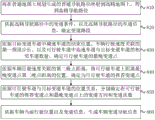
The present embodiment provides a preferred implementation of the navigation information determining method based on the first embodiment, and is capable of mapping a general navigation path into a high-precision map to obtain a corresponding high-precision navigation path. Fig. 2 is a flowchart of a navigation information determining method according to a second embodiment of the present invention, where step S110 may specifically include steps S210 to S240, and as shown in fig. 2, the method includes the following steps:
s210, according to the mapping relation between the ordinary map and the high-precision map, the starting point of the sub-path in the ordinary navigation path is mapped to the high-precision map.
In the specific embodiment of the present invention, the mapping relationship between the ordinary map and the high-precision map may include a mapping relationship between key points, a mapping relationship between key road sections, and the like. The present embodiment does not limit the specific content of the mapping relationship. The common navigation path may include at least one sub-path, and the common navigation path is connected end to end through each sub-path to form a complete common navigation path from a starting point to a destination end point. Wherein the starting point of each sub-path is the connection point of the adjacent sub-paths. Since one point in the map may connect multiple paths, and based on the accuracy of the map, the location range of the point is relatively fixed, and there may be differences in the mapping of the paths. Therefore, the starting point of the sub-path in the common navigation path is firstly mapped to the high-precision map on the basis of the starting point of each sub-path. For example, if the starting point of the first sub-route in the general navigation route is building a, the starting point mapped on the high-precision map is building a.
S220, determining at least one candidate high-precision path of the sub-path from the high-precision map according to the geometric distance between the starting point and the road in the high-precision map.
In the specific embodiment of the invention, the geometric distance between the starting point and the road in the high-precision map is obtained by making a vertical line from the starting point to each road in the high-precision map through the starting point of the sub-path obtained by mapping in the high-precision map. And sorting according to the geometric distance, and selecting at least one path closest to the starting point from the high-precision map as a candidate high-precision path. For example, if the geometric distance between the starting point and a road is zero, the starting point is located on the road, and the road is necessarily one of the candidate high-precision paths.
And S230, projecting the points on the candidate high-precision path into the sub-path, and determining the geometric distance between the points on the candidate high-precision path and the sub-path.
In the embodiment of the invention, in the candidate high-precision path, a plurality of points on the candidate high-precision path are sequentially acquired from the starting point of the candidate high-precision path based on the preset interval distance. And traversing each point in the candidate high-precision path in sequence, reversely mapping the point on the candidate high-precision path back to the common map, performing vertical projection on the point obtained by mapping in the common map by making a vertical line from the mapping point to the sub-path of the common navigation path, and calculating the distance between the mapping point and the vertical point if the obtained vertical point is on the sub-path to obtain the geometric distance between the mapping point and the sub-path of the common navigation path.
S240, determining a high-precision navigation path corresponding to the sub-path in the common navigation path from the candidate high-precision paths of the high-precision map according to the geometric distance between the point on the candidate high-precision path and the sub-path.
In the embodiment of the invention, when the traversal is completed, according to the geometric distance from the candidate high-precision path to each mapping point in the ordinary map and the sub-path of the ordinary navigation path, the average value of the geometric distances of all the points on the candidate high-precision path is calculated, and the average geometric distance from each candidate high-precision path to the sub-path of the ordinary navigation path is obtained. Wherein, the smaller the average geometric distance is, the greater the similarity between the candidate high-precision path and the sub-path of the common navigation path is. Therefore, the candidate high-precision path with the minimum average geometric distance is selected from the candidate high-precision paths of the high-precision map and used as the high-precision navigation path corresponding to the sub-path in the common navigation path, and the mapping of the navigation path is completed.
Illustratively, fig. 3 is a flowchart of mapping a general navigation path to a high-precision map, and fig. 4 is a schematic diagram of mapping a general navigation path to a high-precision map. In conjunction with fig. 3 and 4, for the sub-path 310 of the general navigation path in the general map, 3 candidate high- precision paths 321, 322, and 323 are determined in the high-precision map. For the candidate high-precision path 323, it is assumed that 6 points are determined to be compared, and the points are sequentially read in a traversal manner. When reading the point 3231, the point 3231 is mapped to a normal map, and a mapped point 3101 is obtained. The vertical point of the mapped point 3101 projected vertically onto sub-path 310 is determined. As can be seen from fig. 4, if the vertical point is on the extension line of the sub-path 310, i.e. the vertical point is not on the sub-path 310, the next point 3232 of the candidate high-precision path 323 is read, and the mapped point 3102 of the point 3232 on the ordinary map is obtained, and the sub-path 310 is vertically projected. As can be seen in fig. 4, the perpendicular point of mapping point 3102 to sub-path 310 is on sub-path 310, and the geometric distance of mapping point 3102 to sub-path 310 is calculated. And repeating the steps until all the points on the candidate high-precision path 323 are read, and calculating the average geometric distance of all the points to obtain the average geometric distance from the candidate high-precision path 323 to the sub-path 310. Finally, according to the average geometric distance from the candidate high- precision paths 321, 322, and 323 to the sub-path 310, the candidate high-precision path with the smallest average geometric distance may be selected as the high-precision navigation path of the sub-path 310.
It should be noted that the above examples are merely illustrative for clear description of the scheme, and the actual processing manner of the present embodiment is not limited thereto. For example, in an actual situation, a high-precision map may be represented only in the form of data and processed without an actual displayable map interface.
And S250, determining lane change information according to the high-precision navigation path and the lane information of the high-precision navigation path.
And S260, generating vehicle lane change navigation information according to the current driving position of the vehicle and the lane change information.
According to the technical scheme of the embodiment, the lane-level navigation information interface is provided in the high-precision map engine, the navigation path planned by the common map is mapped into the high-precision map, the corresponding high-precision navigation path is obtained, a basis is provided for generating lane-level lane change navigation information, and the accuracy of the path information is improved.
EXAMPLE III
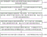
The present embodiment provides a preferred implementation of the navigation information determining method based on the first embodiment, and is capable of planning lane change information of each lane in a route according to a high-precision navigation path. Fig. 5 is a flowchart of a navigation information determining method according to a third embodiment of the present invention, where step S120 may specifically include steps S520 to S540, and as shown in fig. 5, the method includes the following steps:
and S510, mapping the common navigation path generated by planning on the common map to a high-precision map to obtain the high-precision navigation path.
S520, determining a lane change road section according to the lane change condition in the high-precision navigation path and the lane information of the high-precision navigation path.
In an embodiment of the present invention, the lane change condition in the high-precision navigation path refers to that the lane advance direction is physically inaccessible or that the lane advance direction determined based on the high-precision navigation path is logically inaccessible. For example, when the vehicle travels from the lane to be merged to the merging lane, there is no passable road ahead of the lane to be merged, and the lane to be merged belongs to physical impassability. For another example, when a vehicle travels from a highway to a ramp, a road is available in front of the highway itself, but based on a high-precision navigation path, the vehicle must travel out of the highway at the time, and the front of the highway is logically inaccessible at the time. The lane information of the high-precision navigation path includes the number of lanes, the driving direction of the lanes, lane line information, steering information, and the like.
The embodiment determines the physical impassable condition of each lane by distinguishing the lane information of each lane in the high-precision navigation path based on the lane change condition in the high-precision navigation path, and determines the logical impassable condition of each lane based on the high-precision navigation path. Thereby determining a physically impassable or logically impassable road segment as a lane change segment.
For example, when the vehicle travels from the lane to be merged to the merging lane, a link within a certain distance before a connection point of the lane to be merged and the merging lane is determined as a road change link in the scene. When the vehicle runs from the expressway to the ramp, a road section within a certain distance before the reference point is determined as a road changing section in the scene by taking the transverse position corresponding to the connection point of the expressway and the ramp as the reference.
S530, determining a target lane change lane and a drivable lane of the lane change road section according to the lane change scene and the lane information of the lane change road section.
In the specific embodiment of the present invention, the lane change scene refers to a specific road driving scene corresponding to a situation that is physically or logically impassable, and may include a scene such as a highway on-ramp, a ramp on-ramp, a lane merge, and a lane split. Correspondingly, the target lane-changing lane refers to a driving lane to be changed after lane changing in a lane-changing scene; a travelable lane refers to all lanes that can be traveled before a lane change.
Specifically, firstly, based on the lane information, lane change is performed on the basis of traffic regulations, for example, long solid lines cannot be crossed, and a target lane change lane and a drivable lane of the lane change link are determined according to a lane change field to which the lane change link belongs. For example, in a scenario where a ramp enters a highway, the ramp and an acceleration lane are determined as travelable lanes, and a highway, especially a highway adjacent to the acceleration lane, is determined as a target lane-changing lane. And under the scene that the expressway enters the ramp, determining all the expressway lanes as travelable lanes, and determining the deceleration lane and the ramp as target change lanes. And under the scene of lane merging, determining the lane to be merged as a travelable lane, and determining the lane adjacent to the lane to be merged, namely the lane communicated with the lane after merging, as a target change lane. And under the scene of lane diversion, determining the lane to be diverted as a travelable lane, and determining the diverted navigation path specified by the high-precision navigation path as a target change lane.
And S540, determining lane change information of the drivable lane according to the driving speed of the vehicle and the position relation between the target lane change lane and the drivable lane.
In the embodiment of the present invention, the lane change information at least includes information of a lane change point, a lane change direction, a lane change number, and the like. The lane change point is a position point used for indicating a user to change lanes, and the lane change point may include a recommended lane change point and a latest lane change point, that is, the recommended lane change point provides a preferable lane change point for the user or the vehicle based on the driving condition and the road condition of the vehicle, and the vehicle has sufficient reaction time and reaction distance from the recommended lane change point to change lanes. Since the lane change information is provided in advance, the user can perform the lane change before recommending the lane change point by identifying the navigation path. The latest lane change point is a position point which ensures that a user can change lanes quickly under the optimal condition, and when the latest lane change point is later than the latest lane change point, the situation that the lane change cannot be performed or the lane change fails can exist. It will be appreciated that there is a direction from the recommended lane change point to the latest lane change point that coincides with the direction of travel of the route. In the case of a special path, for example, a short path length, there may be a case where the recommended lane change point overlaps with the latest lane change point.
In this embodiment, it is considered that the different response times of lane change of the vehicle at different driving speeds are different, that is, the faster the vehicle is driven, the longer the lane change response time and the response distance are required. Therefore, different traveling speeds and associated distance information of the paths can be determined in advance according to traffic regulation conditions on the different paths, such as the highest and/or lowest speed limit and the like. In the course of planning lane change information, the distance information is used as an unknown variable, and the lane change information is planned on the drivable lanes so that the vehicle can change to the target lane change on any drivable lane.
Optionally, determining a lane change point of the travelable lane according to the distance information related to the vehicle traveling speed; and respectively determining the lane changing direction and the lane changing times on the recommended lane changing point and the latest lane changing point of the drivable lane according to the position relationship between the drivable lane and the target lane changing lane.
In this embodiment, in various lane change scenes, according to distance information associated with the vehicle running speed on the current navigation path, on the travelable lane of the lane change road section, the lane change point is advanced by a certain distance, and the lane change point of each travelable lane is determined. And respectively determining lane changing directions and lane changing times at recommended lane changing points and latest lane changing points of the travelable lanes according to the position relationship between each travelable lane and the target lane changing lane.
And S550, generating vehicle lane change navigation information according to the current driving position of the vehicle and the lane change information.
In the embodiment of the invention, the target driving lane where the current vehicle is located is determined according to the current driving position of the vehicle and the lane change information. And extracting lane change information of the target driving lane from the planned lane information. And determining distance information related to the vehicle running speed according to the current actual running speed of the vehicle, and dynamically adjusting the determination of lane changing points in the extracted lane changing information. For example, if the lane change points in the planned lane information are determined according to the unknown distance information, adding the determined distance information associated with the actual driving speed to the lane change information to generate accurate lane change points which are consistent with the driving condition of the vehicle; if the lane change point in the planned lane information is determined according to the distance information related to the vehicle running speed or the distance information related to the average running speed during planning, the lane change point position in the lane change information is dynamically adjusted according to the determined distance information related to the actual running speed. Therefore, in the navigation process of the lane level, the vehicle lane change navigation information which is consistent with the vehicle driving condition is generated.
According to the technical scheme of the embodiment, a lane-level navigation information interface is provided in a high-precision map engine, and a navigation path planned by a common map is mapped into the high-precision map; on the basis of the obtained high-precision navigation path, lane change information such as a lane change road section in the path, a drivable lane and a target lane change lane in the lane change road section, and lane change points, a lane change direction, lane change times and the like on the drivable lane are sequentially determined and stored on the corresponding lane. Therefore, when the high-precision map engine is called by the automatic driving system, the lane where the vehicle is located and lane change information of the vehicle can be directly inquired according to the current position of the vehicle, and the lane change information is dynamically adjusted according to the actual driving condition of the vehicle, so that the vehicle lane change navigation information which accords with the current driving state of the vehicle is generated. The embodiment of the invention provides the clear lane change information for the automatic driving vehicle instead of the simple path suggestive information, thereby realizing the high-precision lane-level navigation, saving the real-time calculation resource of the navigation information and improving the navigation precision, efficiency and accuracy.
Example four
On the basis of the third embodiment, the present embodiment provides a preferred implementation of the navigation information determining method, which is capable of performing lane change information planning on a lane change scene in which a ramp enters a highway. Fig. 6 is a flowchart of determining navigation information in a scenario where a ramp enters a highway, as shown in fig. 6, the method includes the following specific steps:
s610, mapping the common navigation path generated by planning on the common map to a high-precision map to obtain a high-precision navigation path.
And S620, determining a lane change road section according to the lane change condition in the high-precision navigation path and the lane information of the high-precision navigation path.
S630, if the lane change scene of the lane change road section is a scene that the ramp enters the expressway, determining a connection point of the ramp and the accelerating lane in the drivable lane as a recommended lane change point of the drivable lane.
In an embodiment of the present invention, fig. 7 is an exemplary diagram of a scenario in which a ramp enters a highway. As shown in fig. 7, in the ramp-in-expressway scene, the travelable lane includes a ramp 710 and an acceleration lane 720, and the target change lane is an expressway 730 adjacent to the acceleration lane 720. Open circles and filled circles represent connection points between lines. The present embodiment may start lane change when the vehicle travels to the boundary of the ramp 710, and thus a connection point of the ramp 710 and the acceleration lane 720 in the travelable lane may be determined as the recommended lane change point 740 of the travelable lane.
And S640, determining the position, in the travelable lane, of the first delay distance from the vanishing point of the acceleration lane to be the latest lane change point of the travelable lane according to the first delay distance related to the vehicle traveling speed.
In a particular embodiment of the invention, a first delay distance associated with the speed of travel of the vehicle is determined in order to ensure that the lane change will be successful when the vehicle travels to the latest lane change point. And determining the position of the travelable lane at the first later point distance from the vanishing point of the acceleration lane as the latest lane change point of the travelable lane. As shown in fig. 7, a position 750 of the acceleration lane 720, which is a first late distance from the vanishing point of the acceleration lane 720, is determined as the latest lane change point of the travelable lane. In the planning process of the lane change information, the first delay distance can be an unknown quantity, and is added according to the actual vehicle running speed when the vehicle lane change navigation information is generated; the specific distance value related to the actual running speed of the current vehicle can also be taken as the actual running speed; the actual vehicle running speed may be dynamically adjusted when the vehicle lane change guidance information is generated, for example, a specific distance value associated with the average running speed of the lane.
Optionally, if the length of the acceleration lane in the travelable lane is less than the first delay distance, it is determined that the latest lane change point of the travelable lane overlaps with the recommended lane change point.
S650, respectively determining lane changing directions and lane changing times at the recommended lane changing point and the latest lane changing point of the drivable lane according to the position relation between the drivable lane and the target lane changing lane.
In the embodiment of the present invention, as shown in fig. 7, the lane change direction from the drivable lane to the target lane change lane is a lane change to the left, and the number of lane changes is 1.
And S660, generating vehicle lane change navigation information according to the current driving position of the vehicle and the lane change information.
In the specific embodiment of the invention, if the latest lane change point of the travelable lane is overlapped with the recommended lane change point, when the vehicle lane change navigation information is generated, the user can be reminded that the travelable lane is short, so that the user can select to perform lane change operation when or before the lane change point exists, or the vehicle is forced to perform lane change immediately according to the road condition when the lane change point exists.
According to the technical scheme of the embodiment, a lane-level navigation information interface is provided in a high-precision map engine, and a navigation path planned by a common map is mapped into the high-precision map; on the basis of the obtained high-precision navigation path, the determination of a drivable lane and a target lane change lane and the planning of lane change information such as lane change points, lane change directions, lane change times and the like on the drivable lane are carried out on the road section of the ramp driving into the expressway, and the lane change information is stored on the corresponding lane. Therefore, when the high-precision map engine is called by the automatic driving system, the lane where the vehicle is located and lane change information of the vehicle can be directly inquired according to the current position of the vehicle, and the lane change information is dynamically adjusted according to the actual driving condition of the vehicle, so that the vehicle lane change navigation information which accords with the current driving state of the vehicle is generated. The embodiment of the invention provides the clear lane change information for the automatic driving vehicle instead of the simple path suggestive information, thereby realizing the high-precision lane-level navigation, saving the real-time calculation resource of the navigation information and improving the navigation precision, efficiency and accuracy.
EXAMPLE five
On the basis of the third embodiment, the present embodiment provides a preferred implementation of the navigation information determining method, which is capable of performing lane change information planning on a lane change scene of a highway entering a ramp. Fig. 8 is a flowchart of determining navigation information in a scene of a highway on-ramp in an embodiment of the present invention, and as shown in fig. 8, the method includes the following specific steps:
and S810, mapping the common navigation path generated by planning on the common map to a high-precision map to obtain the high-precision navigation path.
And S820, determining a lane change road section according to the lane change condition in the high-precision navigation path and the lane information of the high-precision navigation path.
And S830, determining the latest lane change point of the drivable lane according to the end position of the deceleration lane in the target lane change lane, the first preset step length related to the driving speed of the vehicle and the number of the adjacent lanes of the high-speed lane in the drivable lane and the target lane change lane.
In an embodiment of the invention, in order to ensure that the lane change can be successful when the vehicle runs to the latest lane change point, the latest lane change point of each travelable lane is determined first. Fig. 9 is an exemplary diagram of a scenario in which a highway enters a ramp. As shown in fig. 9, in the expressway on-ramp scene, the travelable lanes include an expressway 911, an expressway 912, and an expressway 913, and the target change lane includes a deceleration 920 and a ramp 930. Open circles and filled circles represent connection points between lines. Considering that the farther the expressway is from the deceleration lane 920, the longer the required lane-change reaction time and reaction distance are, the first preset step associated with the vehicle running speed is taken as an interval based on the end position of the deceleration lane 920, and a first preset step is pushed forward from the end position on the first expressway 913 adjacent to the deceleration lane 920 according to the number of lanes adjacent to the target lane-change lane, so as to obtain the latest lane-change point of the expressway 913. By analogy, on a second expressway 912 adjacent to the deceleration lane 920, a first preset step length is pushed forward from the latest lane change point of the expressway 913 to obtain the latest lane change point of the expressway 912; on a third expressway 911 adjacent to the deceleration roadway 920, a first preset step length is pushed forward from the latest lane change point of the expressway 912 to obtain the latest lane change point of the expressway 911.
Optionally, determining a first latest lane change distance of the drivable lane according to the first preset step length and the number of adjacent lanes of the high-speed lane and the target lane change lane in the drivable lane; and determining a position on the travelable lane, which is apart from the reference position by a first latest lane change distance, as a latest lane change point of the travelable lane, by using a position on the travelable lane, which corresponds to the end position of the deceleration lane in the lateral direction, as the reference position.
In this embodiment, the order of pushing the latest lane change point on each travelable lane is not limited, but the product of the number and the first preset step is determined as the distance information of each travelable lane according to the number of the lanes adjacent to the high-speed lane and the target lane change lane in the travelable lane, so that the latest lane change point on each travelable lane can be obtained by pushing forward the determined distance information on each travelable lane with the position laterally corresponding to the end position of the speed-reduction lane 920 as the reference position.
Optionally, if the length of any travelable lane is less than the product of the number of adjacent lanes of the travelable lane and the target lane-changing lane and the first preset step length, determining that the starting position of the travelable lane is the latest lane-changing point of the travelable lane.
And S840, determining the position on the travelable lane, which is the second delay distance away from the latest lane change point, as the recommended lane change point of the travelable lane according to the second delay distance related to the vehicle traveling speed.
In the embodiment of the invention, a second delay distance related to the running speed of the vehicle is determined, the second delay distance is pushed forward from the latest lane change point of each travelable lane on each travelable lane in turn, and the position is determined as the recommended lane change point of the travelable lane.
Optionally, if the distance between the latest lane change point and the starting position in any travelable lane is less than the second late distance associated with the vehicle travel speed, determining that the starting position of the travelable lane is the recommended lane change point of the travelable lane.
And S850, respectively determining lane changing directions and lane changing times at the recommended lane changing point and the latest lane changing point of the drivable lane according to the position relation between the drivable lane and the target lane changing lane.
And S860, generating vehicle lane change navigation information according to the current driving position of the vehicle and the lane change information.
According to the technical scheme of the embodiment, a lane-level navigation information interface is provided in a high-precision map engine, and a navigation path planned by a common map is mapped into the high-precision map; on the basis of the obtained high-precision navigation path, the determination of a drivable lane and a target lane change lane and the planning of lane change information such as lane change points, lane change directions, lane change times and the like on the drivable lane are carried out on the road section of the expressway driving ramp, and the lane change information is stored on the corresponding lane. Therefore, when the high-precision map engine is called by the automatic driving system, the lane where the vehicle is located and lane change information of the vehicle can be directly inquired according to the current position of the vehicle, and the lane change information is dynamically adjusted according to the actual driving condition of the vehicle, so that the vehicle lane change navigation information which accords with the current driving state of the vehicle is generated. The embodiment of the invention provides the clear lane change information for the automatic driving vehicle instead of the simple path suggestive information, thereby realizing the high-precision lane-level navigation, saving the real-time calculation resource of the navigation information and improving the navigation precision, efficiency and accuracy.
EXAMPLE six
On the basis of the third embodiment, the present embodiment provides a preferred implementation of the navigation information determining method, which is capable of performing lane change information planning on a lane merging and changing scene. Fig. 10 is a flowchart of navigation information determination in a lane merging scene according to a sixth embodiment of the present invention, and as shown in fig. 10, the method includes the following specific steps:
and S1010, mapping the common navigation path generated by planning on the common map to a high-precision map to obtain the high-precision navigation path.
And S1020, determining a lane change road section according to the lane change condition in the high-precision navigation path and the lane information of the high-precision navigation path.
And S1030, determining the position, which is the third rear distance away from the vanishing point of the travelable lane, on the lane to be merged in the travelable lanes as the latest lane change point of the travelable lane according to the third rear distance related to the vehicle traveling speed.
In an embodiment of the invention, in order to ensure that the lane change can be successful when the vehicle runs to the latest lane change point, the latest lane change point of each travelable lane is determined first. Fig. 11 is an exemplary diagram of a lane merging scenario. As shown in fig. 11, in the lane merging scenario, the travelable lane includes lane 1111, lane 1112, and lane 1113, and the target lane change lane includes at least lane 1112. Open circles and filled circles represent connection points between lines. In the lane merging scenario, lane 1111 and lane 1112 belong to the merged lane, and therefore, only the lane change information planning may be performed for lane change lane 1113 to be merged. Similarly, a third delay distance related to the vehicle running speed is determined based on the vanishing point of the lane 1113, and the position of the third delay distance from the vanishing point is determined as the latest lane change point of the lane 1113 to be merged.
And S1040, determining the position, away from the latest lane change point recommended distance, on the travelable lane as the recommended lane change point of the travelable lane according to the recommended distance related to the vehicle traveling speed.
In the embodiment of the invention, the recommended distance associated with the vehicle running speed in the current scene is determined, the latest lane change point of the lane 1113 is pushed forward, and the position of the recommended distance from the latest lane change point is determined to be the recommended lane change point of the lane 1113.
And S1050, respectively determining lane changing directions and lane changing times at the recommended lane changing point and the latest lane changing point of the travelable lane according to the position relation between the travelable lane and the target lane changing lane.
And S1060, generating vehicle lane change navigation information according to the current driving position of the vehicle and the lane change information.
According to the technical scheme of the embodiment, a lane-level navigation information interface is provided in a high-precision map engine, and a navigation path planned by a common map is mapped into the high-precision map; on the basis of the obtained high-precision navigation path, the determination of a drivable lane and a target lane change lane and the planning of lane change information such as lane change points, lane change directions, lane change times and the like on the drivable lane are carried out on the road section of the lane confluence, and the lane change information is stored on the corresponding lane. Therefore, when the high-precision map engine is called by the automatic driving system, the lane where the vehicle is located and lane change information of the vehicle can be directly inquired according to the current position of the vehicle, and the lane change information is dynamically adjusted according to the actual driving condition of the vehicle, so that the vehicle lane change navigation information which accords with the current driving state of the vehicle is generated. The embodiment of the invention provides the clear lane change information for the automatic driving vehicle instead of the simple path suggestive information, thereby realizing the high-precision lane-level navigation, saving the real-time calculation resource of the navigation information and improving the navigation precision, efficiency and accuracy.
EXAMPLE seven
On the basis of the third embodiment, the present embodiment provides a preferred implementation of the navigation information determining method, which is capable of performing lane change information planning on a lane diversion lane change scene. Fig. 12 is a flowchart of navigation information determination in a lane diversion scene according to a seventh embodiment of the present invention, and as shown in fig. 12, the method includes the following specific steps:
and S1210, mapping the common navigation path generated by planning on the common map to a high-precision map to obtain a high-precision navigation path.
And S1220, determining a lane change road section according to the lane change condition in the high-precision navigation path and the lane information of the high-precision navigation path.
And S1230, determining the latest lane change point of the drivable lane according to the lane separation point, the second preset step length related to the driving speed of the vehicle and the number of adjacent lanes of the to-be-shunted lane and the target lane change lane in the drivable lane.
In an embodiment of the invention, in order to ensure that the lane change can be successful when the vehicle runs to the latest lane change point, the latest lane change point of each travelable lane is determined first. Fig. 13 is an exemplary diagram of a lane diversion scenario. As shown in fig. 13, in the lane diversion scenario, the travelable lanes include lanes 1311, 1312, and 1313, and the target lane-change lane is a diverted navigation path 1320 designated for the high-precision navigation path. Open circles and filled circles represent connection points between lines. In the present lane merging scenario, considering that the farther the lane from the deceleration lane 1320 is, the longer the lane change response time and the longer the response distance are required, based on the lane separation point, the second preset step associated with the vehicle traveling speed is used as the interval, and the latest lane change point of the lane 1312 is obtained by pushing forward the separation point by the second preset step on the first lane 1312 adjacent to the target lane change lane 1320 according to the number of lanes adjacent to the travelable lane and the target lane change lane. By analogy, on a second lane 1311 adjacent to the target lane-change lane 1320, a second preset step is pushed forward from the latest lane-change point of the lane 1312 to obtain the latest lane-change point of the lane 1311.
Optionally, determining a second latest lane change distance of the drivable lane according to a second preset step length related to the driving speed of the vehicle and the number of adjacent lanes of the drivable lane and the target lane change lane; and determining the position on the travelable lane, which is away from the reference position by the second latest lane change distance, as the latest lane change point of the travelable lane by taking the position on the travelable lane, which is transversely corresponding to the lane separation point, as the reference position.
In the present embodiment, the order of pushing the latest lane change point on each travelable lane is not limited, but the product of the number and the second preset step length is determined as the distance information of each travelable lane according to the number of lanes adjacent to the target lane change lane and the lane in the travelable lane, so that the latest lane change point on each travelable lane can be obtained by pushing forward the determined distance information on each travelable lane with the position corresponding to the lane separation point in the lateral direction as the reference position.
And S1240, determining the position on the travelable lane, which is the fourth rear distance away from the latest lane change point, as the recommended lane change point of the travelable lane according to the fourth rear distance related to the vehicle traveling speed.
In the embodiment of the invention, a fourth later point distance related to the running speed of the vehicle is determined, the fourth later point distance is pushed forward from the latest lane change point of each travelable lane on the basis of the path running distance on each travelable lane in turn, and the position is determined as the recommended lane change point of the travelable lane.
S1250, respectively determining lane changing directions and lane changing times at the recommended lane changing point and the latest lane changing point of the drivable lane according to the position relation between the drivable lane and the target lane changing lane.
And S1260, generating the lane change navigation information of the vehicle according to the current driving position of the vehicle and the lane change information.
According to the technical scheme of the embodiment, a lane-level navigation information interface is provided in a high-precision map engine, and a navigation path planned by a common map is mapped into the high-precision map; on the basis of the obtained high-precision navigation path, the determination of a drivable lane and a target lane change lane and the planning of lane change information such as lane change points, lane change directions, lane change times and the like on the drivable lane are carried out on the road sections of the lane shunts, and the lane diversions are stored on the corresponding lanes. Therefore, when the high-precision map engine is called by the automatic driving system, the lane where the vehicle is located and lane change information of the vehicle can be directly inquired according to the current position of the vehicle, and the lane change information is dynamically adjusted according to the actual driving condition of the vehicle, so that the vehicle lane change navigation information which accords with the current driving state of the vehicle is generated. The embodiment of the invention provides the clear lane change information for the automatic driving vehicle instead of the simple path suggestive information, thereby realizing the high-precision lane-level navigation, saving the real-time calculation resource of the navigation information and improving the navigation precision, efficiency and accuracy.
Example eight
Fig. 14 is a schematic structural diagram of a navigation information determining apparatus according to an eighth embodiment of the present invention, which is applicable to a case where lane-level navigation information is provided during a driving process, especially in an automatic driving scenario, and the apparatus can implement the navigation information determining method according to any embodiment of the present invention. The device specifically includes:
the route conversion module 1410 is used for mapping the common navigation route generated by planning on the common map onto the high-precision map to obtain a high-precision navigation route;
the lane change information planning module 1420 is configured to determine lane change information according to the high-precision navigation path and lane information of the high-precision navigation path;
and the lane change navigation information generating module 1430 is configured to generate lane change navigation information of the vehicle according to the current driving position of the vehicle and the lane change information.
Optionally, the path conversion module 1410 is specifically configured to:
according to the mapping relation between the ordinary map and the high-precision map, mapping the starting point of the sub-path in the ordinary navigation path to the high-precision map;
determining at least one candidate path of the sub-path from the high-precision map according to the geometric distance between the starting point and the road in the high-precision map;
projecting the points on the candidate path into the sub-path, and determining the geometric distance between the points on the candidate path and the sub-path;
and determining a high-precision navigation path corresponding to the sub-path in the common navigation paths from the candidate paths of the high-precision map according to the geometric distance between the point on the candidate path and the sub-path.
Optionally, the lane change information planning module 1420 includes:
a lane change section determining unit 1421, configured to determine a lane change section according to a lane change condition in the high-precision navigation path and lane information of the high-precision navigation path;
a lane change lane determining unit 1422, configured to determine a target lane change lane and a drivable lane of the lane change road section according to the lane change scene to which the lane change road section belongs and the lane information;
a lane change information determining unit 1423 for determining lane change information of the drivable lane depending on the driving speed of the vehicle and the positional relationship between the target lane change lane and the drivable lane.
Optionally, the lane change information determining unit 1422 includes:
the lane change point planning subunit is used for determining lane change points of the travelable lane according to the distance information related to the vehicle traveling speed; wherein the change point comprises a recommended lane change point and a latest lane change point;
and the lane changing direction and frequency determining subunit is used for respectively determining the lane changing direction and the lane changing frequency on the recommended lane changing point and the latest lane changing point of the travelable lane according to the position relationship between the travelable lane and the target lane changing lane.
Optionally, the lane change information determining unit 1422 is specifically configured to:
if the lane change scene to which the lane change road section belongs is a scene that a ramp drives into a highway, determining a connection point of the ramp and an acceleration lane in a drivable lane as a recommended lane change point of the drivable lane;
and determining the position, in the travelable lane, of the first delay distance from the acceleration lane vanishing point as the latest lane change point of the travelable lane according to the first delay distance related to the vehicle traveling speed.
Optionally, the lane change information determining unit 1422 is specifically configured to:
after the connection point of the ramp and the acceleration lane in the travelable lane is determined as the recommended lane change point of the travelable lane, if the length of the acceleration lane in the travelable lane is less than the first delay distance, the latest lane change point of the travelable lane is determined to be overlapped with the recommended lane change point.
Optionally, the lane change information determining unit 1422 is specifically configured to:
if the lane change scene to which the lane change road section belongs is a high-speed lane entering ramp scene, determining the latest lane change point of the travelable lane according to the end position of a deceleration lane in the target lane change lane, a first preset step length related to the vehicle traveling speed and the number of lanes adjacent to the high-speed lane in the travelable lane and the target lane change lane;
and determining the position on the travelable lane, which is a second delay distance away from the latest lane change point, as the recommended lane change point of the travelable lane according to the second delay distance related to the vehicle traveling speed.
Optionally, the lane change information determining unit 1422 is specifically configured to:
determining a first latest lane change distance of the drivable lane according to the first preset step length and the number of adjacent lanes of a high-speed lane and the target lane change lane in the drivable lane;
and determining a position on the travelable lane, which is apart from the reference position by the first latest lane change distance, as a latest lane change point of the travelable lane, with a position on the travelable lane, which laterally corresponds to the end position of the deceleration lane, as a reference position.
Optionally, the lane change information determining unit 1422 is specifically configured to:
after determining the first latest lane change distance of the travelable lane according to the first preset step length and the number of the adjacent lanes of the high-speed lane and the target lane change lane in the travelable lane, if the length of any travelable lane is smaller than the first latest lane change distance of the travelable lane, determining the starting position of the travelable lane as the latest lane change point of the travelable lane.
Optionally, the lane change information determining unit 1422 is specifically configured to:
after the latest lane change point of the travelable lane is determined, if the distance between the latest lane change point and the starting position in any travelable lane is less than the second delay distance related to the vehicle traveling speed, determining that the starting position of the travelable lane is the recommended lane change point of the travelable lane.
Optionally, the lane change information determining unit 1422 is specifically configured to:
if the lane change scene to which the lane change road section belongs is a lane merging scene, determining a position on a lane to be merged in a travelable lane as a latest lane change point of the travelable lane by a third delay distance from a vanishing point of a travelable lane according to the third delay distance related to the vehicle traveling speed;
and determining the position on the travelable lane, which is far away from the latest lane change point by the recommended distance, as the recommended lane change point of the travelable lane according to the recommended distance related to the vehicle traveling speed.
Optionally, the lane change information determining unit 1422 is specifically configured to:
if the lane change scene to which the lane change road section belongs is a lane diversion scene, determining the latest lane change point of the travelable lane according to the lane separation point, a second preset step length related to the vehicle traveling speed and the number of adjacent lanes of the lane to be diverted and the target lane change lane in the travelable lane; the target lane-changing lane is a divided navigation path appointed by the high-precision navigation path;
and determining the position on the travelable lane, which is the fourth rear distance away from the latest lane change point, as the recommended lane change point of the travelable lane according to the fourth rear distance related to the vehicle traveling speed.
Optionally, the lane change information determining unit 1422 is specifically configured to:
determining a second latest lane change distance of the drivable lane according to a second preset step length related to the driving speed of the vehicle and the number of lanes adjacent to the drivable lane and the target lane change lane;
and determining a position on the travelable lane, which is apart from the reference position by the second latest lane change distance, as a latest lane change point of the travelable lane, with a position on the travelable lane, which corresponds to the lane separation point in the lateral direction, as a reference position.
Optionally, the lane change condition is that the lane advance direction is physically inaccessible or the lane advance direction determined based on the high-precision navigation path is logically inaccessible.
Optionally, the vehicle lane change navigation information at least includes lane change points, lane change directions, lane change times, and physical or logical impassability.
According to the technical scheme of the embodiment, through the mutual cooperation of all the functional modules, the functions of mapping acquisition of a high-precision navigation path, determination of a lane change road section, recognition of a lane change scene, determination of a lane, planning of a lane change point, determination of a lane change direction, determination of lane change times, generation of vehicle lane change navigation information and the like are achieved. The embodiment of the invention provides the clear lane change information for the automatic driving vehicle instead of the simple path suggestive information, thereby realizing the high-precision lane-level navigation, saving the real-time calculation resource of the navigation information and improving the navigation precision, efficiency and accuracy.
Example nine
Fig. 15 is a schematic structural diagram of an apparatus according to the ninth embodiment of the present invention, and fig. 15 shows a block diagram of an exemplary apparatus suitable for implementing the embodiment of the present invention. The device shown in fig. 15 is only an example, and should not bring any limitation to the function and the scope of use of the embodiment of the present invention.
The device 12 shown in fig. 15 is only an example and should not bring any limitation to the function and the scope of use of the embodiment of the present invention. The device 12 is preferably an in-vehicle electronic navigation device.
As shown in FIG. 15, device 12 is embodied in the form of a general purpose computing device. The components of device 12 may include, but are not limited to: one or more processors 16, a system memory 28, and a bus 18 that connects the various system components (including the system memory 28 and the processors 16).
The system memory 28 may include computer system readable media in the form of volatile memory, such as Random Access Memory (RAM)30 and/or cache memory 32. Device 12 may further include other removable/non-removable, volatile/nonvolatile computer system storage media. By way of example only, storage system 34 may be used to read from and write to non-removable, nonvolatile magnetic media (not shown in FIG. 15, commonly referred to as a "hard drive"). Although not shown in FIG. 15, a magnetic disk drive for reading from and writing to a removable, nonvolatile magnetic disk (e.g., a "floppy disk") and an optical disk drive for reading from or writing to a removable, nonvolatile optical disk (e.g., a CD-ROM, DVD-ROM, or other optical media) may be provided. In these cases, each drive may be connected to bus 18 by one or more data media interfaces. System memory 28 may include at least one program product having a set (e.g., at least one) of program modules that are configured to carry out the functions of embodiments of the invention.
A program/utility 40 having a set (at least one) of program modules 42 may be stored, for example, in system memory 28, such program modules 42 including, but not limited to, an operating system, one or more application programs, other program modules, and program data, each of which examples or some combination thereof may comprise an implementation of a network environment. Program modules 42 generally carry out the functions and/or methodologies of embodiments described herein.
The processor 16 executes various functional applications and data processing, such as implementing the navigation information determination method provided by the embodiments of the present invention, by executing programs stored in the system memory 28.
Example ten
An embodiment of the present invention further provides a computer-readable storage medium, on which a computer program (or referred to as computer-executable instructions) is stored, where the computer program is used for executing a navigation information determining method when executed by a processor, and the method includes:
mapping a common navigation path generated on a common map by planning to a high-precision map to obtain a high-precision navigation path;
determining lane change information according to the high-precision navigation path and the lane information of the high-precision navigation path;
and generating vehicle lane change navigation information according to the current driving position of the vehicle and the lane change information.
Computer storage media for embodiments of the invention may employ any combination of one or more computer-readable media. The computer readable medium may be a computer readable signal medium or a computer readable storage medium. A computer readable storage medium may be, for example, but not limited to, an electronic, magnetic, optical, electromagnetic, infrared, or semiconductor system, apparatus, or device, or any combination of the foregoing. More specific examples (a non-exhaustive list) of the computer readable storage medium would include the following: an electrical connection having one or more wires, a portable computer diskette, a hard disk, a Random Access Memory (RAM), a read-only memory (ROM), an erasable programmable read-only memory (EPROM or flash memory), an optical fiber, a portable compact disc read-only memory (CD-ROM), an optical storage device, a magnetic storage device, or any suitable combination of the foregoing. In the context of this document, a computer readable storage medium may be any tangible medium that can contain, or store a program for use by or in connection with an instruction execution system, apparatus, or device.
A computer readable signal medium may include a propagated data signal with computer readable program code embodied therein, for example, in baseband or as part of a carrier wave. Such a propagated data signal may take many forms, including, but not limited to, electro-magnetic, optical, or any suitable combination thereof. A computer readable signal medium may also be any computer readable medium that is not a computer readable storage medium and that can communicate, propagate, or transport a program for use by or in connection with an instruction execution system, apparatus, or device.
Program code embodied on a computer readable medium may be transmitted using any appropriate medium, including but not limited to wireless, wireline, optical fiber cable, RF, etc., or any suitable combination of the foregoing.
Computer program code for carrying out operations for embodiments of the present invention may be written in any combination of one or more programming languages, including an object oriented programming language such as Java, Smalltalk, C + + or the like and conventional procedural programming languages, such as the "C" programming language or similar programming languages. The program code may execute entirely on the user's computer, partly on the user's computer, as a stand-alone software package, partly on the user's computer and partly on a remote computer or entirely on the remote computer or device. In the case of a remote computer, the remote computer may be connected to the user's computer through any type of network, including a Local Area Network (LAN) or a Wide Area Network (WAN), or the connection may be made to an external computer (for example, through the Internet using an Internet service provider).
It is to be noted that the foregoing is only illustrative of the preferred embodiments of the present invention and the technical principles employed. It will be understood by those skilled in the art that the present invention is not limited to the particular embodiments described herein, but is capable of various obvious changes, rearrangements and substitutions as will now become apparent to those skilled in the art without departing from the scope of the invention. Therefore, although the embodiments of the present invention have been described in more detail through the above embodiments, the embodiments of the present invention are not limited to the above embodiments, and many other equivalent embodiments may be included without departing from the spirit of the present invention, and the scope of the present invention is determined by the scope of the appended claims.
Claims (21)
1. A navigation information determination method, comprising:
mapping a common navigation path generated on a common map by planning to a high-precision map to obtain a high-precision navigation path; determining at least one candidate high-precision path of each sub-path from the high-precision map according to the geometric distance between the starting point of each sub-path in the common navigation path and the path in the high-precision map, reversely mapping each point on the candidate high-precision path back to the common map to obtain each mapping point from the candidate high-precision path to the common map, determining the average geometric distance from the candidate high-precision path to the sub-path according to the geometric distance from each mapping point to the sub-path in the common navigation path, determining the path which is most similar to the common navigation path in the high-precision map according to the average geometric distance, and obtaining the high-precision navigation path after the common navigation path is mapped; wherein each point on the candidate high-precision path is determined on the candidate high-precision path from the starting point of the candidate high-precision path;
determining lane change information according to the high-precision navigation path and the lane information of the high-precision navigation path;
and generating vehicle lane change navigation information according to the current driving position of the vehicle and the lane change information.
2. The method according to claim 1, wherein the mapping the general navigation path generated by planning on the general map onto the high-precision map to obtain the high-precision navigation path comprises:
according to the mapping relation between the ordinary map and the high-precision map, mapping the starting point of the sub-path in the ordinary navigation path to the high-precision map;
determining at least one candidate high-precision path of the sub-path from the high-precision map according to the geometric distance between the starting point and the road in the high-precision map;
projecting the points on the candidate high-precision path into the sub-path, and determining the geometric distance between the points on the candidate high-precision path and the sub-path;
and determining a high-precision navigation path corresponding to the sub-path in the common navigation paths from the candidate high-precision paths of the high-precision map according to the geometric distance between the point on the candidate high-precision path and the sub-path.
3. The method of claim 1, wherein the determining lane change information according to the high-precision navigation path and the lane information of the high-precision navigation path comprises:
determining a lane change road section according to the lane change condition in the high-precision navigation path and the lane information of the high-precision navigation path;
determining a target lane change lane and a drivable lane of the lane change road section according to the lane change scene of the lane change road section and the lane information;
and determining lane change information of the drivable lane according to the driving speed of the vehicle and the position relation between the target lane change lane and the drivable lane.
4. The method according to claim 3, wherein the determining lane change information of the travelable lane according to the vehicle traveling speed and the positional relationship between the target lane change lane and the travelable lane includes:
determining lane change points of a drivable lane according to distance information related to the driving speed of the vehicle; the lane change points comprise recommended lane change points and latest lane change points;
and respectively determining the lane changing direction and the lane changing times on the recommended lane changing point and the latest lane changing point of the drivable lane according to the position relationship between the drivable lane and the target lane changing lane.
5. The method according to claim 4, wherein if the lane change scene to which the lane change road segment belongs is a ramp-in-expressway scene, the determining a lane change point of a drivable lane according to distance information associated with a driving speed of a vehicle comprises:
determining a connection point of a ramp and an acceleration lane in a travelable lane as a recommended lane change point of the travelable lane;
and determining the position, in the travelable lane, of the first delay distance from the acceleration lane vanishing point as the latest lane change point of the travelable lane according to the first delay distance related to the vehicle traveling speed.
6. The method of claim 5, further comprising, after determining a connection point of a ramp to an acceleration lane in a travelable lane as a recommended lane change point for the travelable lane:
and if the length of the acceleration lane in the travelable lane is less than the first delay distance, determining that the latest lane change point of the travelable lane is overlapped with the recommended lane change point.
7. The method according to claim 4, wherein if the lane change scene to which the lane change section belongs is a highway on-ramp scene, the determining a lane change point of the travelable lane according to the distance information related to the vehicle traveling speed comprises:
determining the latest lane change point of the drivable lane according to the end position of a deceleration lane in the target lane change lane, a first preset step length related to the driving speed of the vehicle and the number of adjacent lanes of the high-speed lane in the drivable lane and the target lane change lane;
and determining the position on the travelable lane, which is a second delay distance away from the latest lane change point, as the recommended lane change point of the travelable lane according to the second delay distance related to the vehicle traveling speed.
8. The method of claim 7, wherein determining a latest lane change point of a drivable lane as a function of an end position of a deceleration lane in a target lane change lane, a first preset step associated with a driving speed of a vehicle, and a number of lanes adjacent to the deceleration lane and the target lane change lane in the drivable lane comprises:
determining a first latest lane change distance of the drivable lane according to the first preset step length and the number of adjacent lanes of a high-speed lane and the target lane change lane in the drivable lane;
and determining a position on the travelable lane, which is apart from the reference position by the first latest lane change distance, as a latest lane change point of the travelable lane, with a position on the travelable lane, which laterally corresponds to the end position of the deceleration lane, as a reference position.
9. The method of claim 8, further comprising, after said determining a first latest lane-change distance of said drivable lane based on said first preset step size and a number of lanes adjacent to said target lane-change lane and a high-speed lane in said drivable lane:
and if the length of any drivable lane is less than the product of the number of the drivable lanes and the adjacent lanes of the target lane-changing lane and the first preset step length, determining the starting position of the drivable lane as the latest lane-changing point of the drivable lane.
10. The method of claim 7, further comprising, after said determining a latest lane change point of a drivable lane:
and if the distance between the latest lane change point and the initial position in any travelable lane is less than the second late point distance related to the vehicle traveling speed, determining that the initial position of the travelable lane is the recommended lane change point of the travelable lane.
11. The method according to claim 4, wherein if the lane change scene to which the lane change link belongs is a lane merging scene, the determining a lane change point of a drivable lane according to distance information associated with a driving speed of the vehicle comprises:
determining a position on a lane to be converged in the travelable lanes, which is a third distance from a travelable lane vanishing point, as a latest lane change point of the travelable lanes according to a third distance from the vehicle travel speed to the third distance;
and determining the position on the travelable lane, which is far away from the latest lane change point by the recommended distance, as the recommended lane change point of the travelable lane according to the recommended distance related to the vehicle traveling speed.
12. The method according to claim 4, wherein if the lane change scene to which the lane change road segment belongs is a lane diversion scene, the determining a lane change point of a drivable lane according to distance information associated with a driving speed of a vehicle comprises:
determining the latest lane change point of the lane which can be driven according to the lane separation point, a second preset step length related to the driving speed of the vehicle and the number of adjacent lanes of the lane to be shunted and the target lane change lane in the lane which can be driven; the target lane-changing lane is a divided navigation path appointed by the high-precision navigation path;
and determining the position on the travelable lane, which is the fourth rear distance away from the latest lane change point, as the recommended lane change point of the travelable lane according to the fourth rear distance related to the vehicle traveling speed.
13. The method of claim 12, wherein determining the latest lane change point of the drivable lane according to the lane separation point, a second preset step associated with the driving speed of the vehicle, and the number of lanes adjacent to the lane to be diverged and the target lane change lane in the drivable lane comprises:
determining a second latest lane change distance of the drivable lane according to a second preset step length related to the driving speed of the vehicle and the number of lanes adjacent to the drivable lane and the target lane change lane;
and determining a position on the travelable lane, which is apart from the reference position by the second latest lane change distance, as a latest lane change point of the travelable lane, with a position on the travelable lane, which corresponds to the lane separation point in the lateral direction, as a reference position.
14. The method of claim 3, wherein the lane change condition is a lane heading physical impassability or a lane heading logical impassability determined based on a high-precision navigation path.
15. The method of claim 1, wherein the vehicle lane change navigation information includes at least a lane change point, a lane change direction, and a number of lane changes, and is physically or logically inaccessible.
16. A navigation information determination apparatus characterized by comprising:
the route conversion module is used for mapping the common navigation route generated by planning on the common map to the high-precision map to obtain the high-precision navigation route; determining at least one candidate high-precision path of each sub-path from the high-precision map according to the geometric distance between the starting point of each sub-path in the common navigation path and the path in the high-precision map, reversely mapping each point on the candidate high-precision path back to the common map to obtain each mapping point from the candidate high-precision path to the common map, determining the average geometric distance from the candidate high-precision path to the sub-path according to the geometric distance from each mapping point to the sub-path in the common navigation path, determining the path which is most similar to the common navigation path in the high-precision map according to the average geometric distance, and obtaining the high-precision navigation path after the common navigation path is mapped; wherein each point on the candidate high-precision path is determined on the candidate high-precision path from the starting point of the candidate high-precision path;
the lane change information planning module is used for determining lane change information according to the high-precision navigation path and the lane information of the high-precision navigation path;
and the lane change navigation information generation module is used for generating lane change navigation information of the vehicle according to the current driving position of the vehicle and the lane change information.
17. The apparatus of claim 16, wherein the path conversion module is specifically configured to:
according to the mapping relation between the ordinary map and the high-precision map, mapping the starting point of the sub-path in the ordinary navigation path to the high-precision map;
determining at least one candidate high-precision path of the sub-path from the high-precision map according to the geometric distance between the starting point and the road in the high-precision map;
projecting the points on the candidate high-precision path into the sub-path, and determining the geometric distance between the points on the candidate high-precision path and the sub-path;
and determining a high-precision navigation path corresponding to the sub-path in the common navigation paths from the candidate high-precision paths of the high-precision map according to the geometric distance between the point on the candidate high-precision path and the sub-path.
18. The apparatus of claim 16, wherein the lane change information planning module comprises:
the lane change road section determining unit is used for determining a lane change road section according to the lane change condition in the high-precision navigation path and the lane information of the high-precision navigation path;
the lane change lane determining unit is used for determining a target lane change lane and a drivable lane of the lane change road section according to the lane change scene to which the lane change road section belongs and the lane information;
and a lane change information determination unit for determining lane change information of the travelable lane according to the vehicle running speed and the positional relationship between the target lane change lane and the travelable lane.
19. The apparatus of claim 18, wherein the lane change information determining unit comprises:
the lane change point planning subunit is used for determining lane change points of the travelable lane according to the distance information related to the vehicle traveling speed; the lane change points comprise recommended lane change points and latest lane change points;
and the lane changing direction and frequency determining subunit is used for respectively determining the lane changing direction and the lane changing frequency on the recommended lane changing point and the latest lane changing point of the travelable lane according to the position relationship between the travelable lane and the target lane changing lane.
20. An electronic device, comprising:
one or more processors;
a memory for storing one or more programs;
when executed by the one or more processors, cause the one or more processors to implement the navigation information determination method of any one of claims 1-15.
21. A computer-readable storage medium, on which a computer program is stored, which, when being executed by a processor, carries out the navigation information determination method according to any one of claims 1 to 15.
Priority Applications (1)
| Application Number | Priority Date | Filing Date | Title |
|---|---|---|---|
| CN201910456455.7A CN110160552B (en) | 2019-05-29 | 2019-05-29 | Navigation information determination method, device, equipment and storage medium |
Applications Claiming Priority (1)
| Application Number | Priority Date | Filing Date | Title |
|---|---|---|---|
| CN201910456455.7A CN110160552B (en) | 2019-05-29 | 2019-05-29 | Navigation information determination method, device, equipment and storage medium |
Publications (2)
| Publication Number | Publication Date |
|---|---|
| CN110160552A CN110160552A (en) | 2019-08-23 |
| CN110160552B true CN110160552B (en) | 2021-05-04 |
Family
ID=67629990
Family Applications (1)
| Application Number | Title | Priority Date | Filing Date |
|---|---|---|---|
| CN201910456455.7A Active CN110160552B (en) | 2019-05-29 | 2019-05-29 | Navigation information determination method, device, equipment and storage medium |
Country Status (1)
| Country | Link |
|---|---|
| CN (1) | CN110160552B (en) |
Families Citing this family (42)
| Publication number | Priority date | Publication date | Assignee | Title |
|---|---|---|---|---|
| CN113022573B (en) | 2019-12-06 | 2022-11-04 | 华为技术有限公司 | Road structure detection method and device |
| CN111192468A (en) * | 2019-12-31 | 2020-05-22 | 武汉中海庭数据技术有限公司 | Automatic driving method and system based on acceleration and deceleration in intersection, server and medium |
| CN113112842B (en) * | 2020-01-13 | 2022-07-22 | 北京地平线机器人技术研发有限公司 | Lane driving direction updating method and device, storage medium and electronic equipment |
| CN111207769A (en) * | 2020-01-15 | 2020-05-29 | 北京小马慧行科技有限公司 | Lane level navigation method and device, storage medium and processor |
| CN114537434B (en) * | 2020-03-20 | 2026-04-14 | 上海商汤临港智能科技有限公司 | Lane navigation path generation method and device, and driving control method and device |
| CN112543723B (en) * | 2020-03-26 | 2021-12-21 | 华为技术有限公司 | Driving control method and device |
| CN113538923A (en) * | 2020-04-20 | 2021-10-22 | 深圳富泰宏精密工业有限公司 | Warning method for vehicle lane change and vehicle-mounted device |
| CN112146671B (en) * | 2020-08-31 | 2022-10-28 | 华为技术有限公司 | Path planning method, related equipment and computer readable storage medium |
| CN112683293B (en) * | 2020-12-15 | 2024-06-21 | 东风汽车有限公司 | Vehicle navigation method, electronic equipment and storage medium |
| CN114646326B (en) * | 2020-12-18 | 2026-03-10 | 阿里巴巴集团控股有限公司 | Navigation method, device, computer storage medium and computer program product |
| CN114646324B (en) * | 2020-12-18 | 2026-03-31 | 阿里巴巴集团控股有限公司 | Navigation methods, devices, computer storage media, and computer program products |
| CN112747762A (en) * | 2020-12-28 | 2021-05-04 | 深兰人工智能(深圳)有限公司 | Local travelable path planning method and device, electronic equipment and storage medium |
| CN112732844B (en) * | 2021-01-26 | 2022-09-23 | 腾讯科技(深圳)有限公司 | Method, apparatus, device and medium for automatically associating road object with road |
| CN115235481B (en) * | 2021-04-23 | 2026-02-03 | 高德软件有限公司 | Method, device and system for generating road network prediction tree |
| CN113190768B (en) | 2021-04-29 | 2024-03-12 | 北京百度网讯科技有限公司 | Path processing method and device |
| CN113340318B (en) * | 2021-06-30 | 2026-03-06 | 腾讯科技(深圳)有限公司 | Vehicle navigation methods, devices, electronic equipment and storage media |
| CN113421451B (en) * | 2021-06-30 | 2024-04-09 | 腾讯科技(深圳)有限公司 | Navigation processing method, navigation processing device, electronic equipment and computer readable storage medium |
| CN113701774B (en) * | 2021-08-26 | 2024-02-06 | 苏州挚途科技有限公司 | Path planning method and device for recommending lane abrupt change |
| CN113720348B (en) * | 2021-11-01 | 2022-03-18 | 深圳市城市交通规划设计研究中心股份有限公司 | Vehicle lane level positioning method and electronic equipment under cooperative vehicle and road environment |
| CN114155319A (en) * | 2021-12-08 | 2022-03-08 | 武汉中海庭数据技术有限公司 | Method, system and device for generating auxiliary lane change information by high-precision map |
| CN114323041B (en) * | 2021-12-24 | 2024-09-20 | 深圳一清创新科技有限公司 | Key point diagram construction method and device and electronic equipment |
| CN114353811B (en) * | 2021-12-30 | 2024-08-09 | 广州小鹏自动驾驶科技有限公司 | High-precision map loading method and device, vehicle and storage medium |
| CN114590260B (en) * | 2022-03-28 | 2024-07-09 | 智己汽车科技有限公司 | Method and system for changing ramp up and down |
| CN114858176B (en) * | 2022-04-13 | 2024-06-18 | 合众新能源汽车股份有限公司 | Path navigation method and device based on automatic driving |
| CN114858168B (en) * | 2022-04-27 | 2025-06-03 | 亿咖通(湖北)技术有限公司 | Map section matching, map data sending method, electronic device and storage medium |
| CN115019531B (en) * | 2022-05-31 | 2024-03-22 | 东风汽车有限公司东风日产乘用车公司 | Vehicle control method and vehicle |
| CN114919601A (en) * | 2022-06-01 | 2022-08-19 | 驭势(上海)汽车科技有限公司 | Vehicle control method, device, equipment, medium and vehicle |
| CN115027495B (en) * | 2022-06-08 | 2024-07-09 | 智己汽车科技有限公司 | Trust enhancement method and equipment for intelligent driving system |
| CN115096322A (en) * | 2022-06-24 | 2022-09-23 | 阿波罗智联(北京)科技有限公司 | Information processing method and navigation method |
| CN115183791B (en) * | 2022-07-11 | 2025-07-22 | 高德软件有限公司 | Navigation method, navigation device and service providing method based on position |
| CN115265574B (en) * | 2022-07-29 | 2024-12-27 | 长城汽车股份有限公司 | Path planning method, system, electronic equipment, and vehicle |
| CN115171416B (en) * | 2022-08-24 | 2023-05-26 | 禾多科技(北京)有限公司 | Recommended driving information sending method, device, electronic equipment and medium |
| CN115855077A (en) * | 2022-11-21 | 2023-03-28 | 深圳元戎启行科技有限公司 | Site updating method of high-precision map, electronic equipment and storage medium |
| CN115876216A (en) * | 2023-01-04 | 2023-03-31 | 智道网联科技(北京)有限公司 | Lane-changing navigation path planning method and device, electronic equipment and storage medium |
| CN116147655A (en) * | 2023-01-10 | 2023-05-23 | 阿里巴巴(中国)有限公司 | Digital track data generation method and device, electronic equipment and program product |
| CN115880930A (en) * | 2023-01-19 | 2023-03-31 | 禾多科技(北京)有限公司 | Navigation route creation failure warning method, device, electronic device and medium |
| CN116202536A (en) * | 2023-02-02 | 2023-06-02 | 阿里巴巴(中国)有限公司 | Method, device, computer equipment and storage medium for generating lane change interval |
| CN116105763A (en) * | 2023-02-08 | 2023-05-12 | 阿里巴巴(中国)有限公司 | Navigation broadcasting method and device and electronic equipment |
| CN116758772A (en) * | 2023-03-08 | 2023-09-15 | 浙江吉利控股集团有限公司 | Vehicle lane change prompt method, device, vehicle and computer-readable storage medium |
| CN116542869A (en) * | 2023-03-30 | 2023-08-04 | 高德软件有限公司 | Lane line vector smoothing method, high-precision map drawing method, device and equipment |
| CN118794455A (en) * | 2023-04-12 | 2024-10-18 | 腾讯科技(深圳)有限公司 | Navigation method, device, electronic device and storage medium |
| CN116486621A (en) * | 2023-06-21 | 2023-07-25 | 联友智连科技有限公司 | A collision warning method and system for stationary or low-speed vehicles ahead |
Citations (10)
| Publication number | Priority date | Publication date | Assignee | Title |
|---|---|---|---|---|
| CN103026173A (en) * | 2010-07-23 | 2013-04-03 | 三菱电机株式会社 | Navigation device |
| CN105043403A (en) * | 2015-08-13 | 2015-11-11 | 武汉光庭信息技术有限公司 | High precision map path planning system and method |
| CN106323305A (en) * | 2015-06-29 | 2017-01-11 | 北京四维图新科技股份有限公司 | Navigation method and device |
| CN106461406A (en) * | 2014-06-10 | 2017-02-22 | 歌乐株式会社 | Lane selecting device, vehicle control system and lane selecting method |
| CN107953826A (en) * | 2017-12-08 | 2018-04-24 | 任珍珍 | With the navigator for turning to warning function |
| CN108106629A (en) * | 2017-12-07 | 2018-06-01 | 风度(常州)汽车研发院有限公司 | Evade the path guide method to knock into the back, device and Vehicular intelligent driving assistance system |
| CN108305477A (en) * | 2017-04-20 | 2018-07-20 | 腾讯科技(深圳)有限公司 | A kind of choosing lane method and terminal |
| CN108387242A (en) * | 2018-02-07 | 2018-08-10 | 西南交通大学 | Automatic Pilot lane-change prepares and executes integrated method for planning track |
| JP2019059262A (en) * | 2017-09-25 | 2019-04-18 | 日産自動車株式会社 | Method and device for vehicle traveling control |
| JP2019067057A (en) * | 2017-09-29 | 2019-04-25 | ダイムラー・アクチェンゲゼルシャフトDaimler AG | Convoy travel apparatus |
-
2019
- 2019-05-29 CN CN201910456455.7A patent/CN110160552B/en active Active
Patent Citations (10)
| Publication number | Priority date | Publication date | Assignee | Title |
|---|---|---|---|---|
| CN103026173A (en) * | 2010-07-23 | 2013-04-03 | 三菱电机株式会社 | Navigation device |
| CN106461406A (en) * | 2014-06-10 | 2017-02-22 | 歌乐株式会社 | Lane selecting device, vehicle control system and lane selecting method |
| CN106323305A (en) * | 2015-06-29 | 2017-01-11 | 北京四维图新科技股份有限公司 | Navigation method and device |
| CN105043403A (en) * | 2015-08-13 | 2015-11-11 | 武汉光庭信息技术有限公司 | High precision map path planning system and method |
| CN108305477A (en) * | 2017-04-20 | 2018-07-20 | 腾讯科技(深圳)有限公司 | A kind of choosing lane method and terminal |
| JP2019059262A (en) * | 2017-09-25 | 2019-04-18 | 日産自動車株式会社 | Method and device for vehicle traveling control |
| JP2019067057A (en) * | 2017-09-29 | 2019-04-25 | ダイムラー・アクチェンゲゼルシャフトDaimler AG | Convoy travel apparatus |
| CN108106629A (en) * | 2017-12-07 | 2018-06-01 | 风度(常州)汽车研发院有限公司 | Evade the path guide method to knock into the back, device and Vehicular intelligent driving assistance system |
| CN107953826A (en) * | 2017-12-08 | 2018-04-24 | 任珍珍 | With the navigator for turning to warning function |
| CN108387242A (en) * | 2018-02-07 | 2018-08-10 | 西南交通大学 | Automatic Pilot lane-change prepares and executes integrated method for planning track |
Also Published As
| Publication number | Publication date |
|---|---|
| CN110160552A (en) | 2019-08-23 |
Similar Documents
| Publication | Publication Date | Title |
|---|---|---|
| CN110160552B (en) | Navigation information determination method, device, equipment and storage medium | |
| US12038753B2 (en) | Speed planning method and apparatus, electronic device and storage medium | |
| US10137896B2 (en) | Method and system for operating autonomous driving vehicles using graph-based lane change guide | |
| US20230070760A1 (en) | Method for generating real-time relative map, intelligent driving device, and computer storage medium | |
| CN113340318A (en) | Vehicle navigation method, device, electronic equipment and storage medium | |
| CN111797780A (en) | Vehicle following track planning method, device, server and storage medium | |
| JP6289480B2 (en) | Driving information recording system, method and program | |
| CN114194217B (en) | Automatic driving method and device for vehicle, electronic equipment and storage medium | |
| CN116067387A (en) | Standard Definition to High Definition Navigation Route Determination | |
| CN112141110A (en) | Vehicle lane changing method, device, equipment and storage medium | |
| CN115042820A (en) | Automatic driving vehicle control method, device, device and storage medium | |
| JP2020052045A (en) | How to plan a vehicle trajectory | |
| CN114858176A (en) | Path navigation method and device based on automatic driving | |
| US20250207922A1 (en) | Navigation method and apparatus, electronic device, storage medium, and program product | |
| CN114608599A (en) | Navigation path generation method and device, electronic equipment and storage medium | |
| CN115657684B (en) | Vehicle path information generation method, device, equipment and computer readable medium | |
| CN117109612A (en) | Road reference line generation method, device, equipment and medium | |
| CN109270566A (en) | Air navigation aid, navigation effect test method, device, equipment and medium | |
| CN118089752A (en) | Route visualization method based on map matching, intelligent device and storage medium | |
| CN115031715A (en) | Navigation method and device | |
| CN115583254A (en) | Path planning method, device and equipment and automatic driving vehicle | |
| US12522244B2 (en) | Autonomous driving system in heterogeneous SD map and HD map environment and management method for the autonomous driving | |
| CN120024355B (en) | A vehicle control method, apparatus, vehicle, and readable storage medium | |
| CN116513228B (en) | Vehicle lane change warning method, device, electronic device and storage medium | |
| CN114646326B (en) | Navigation method, device, computer storage medium and computer program product |
Legal Events
| Date | Code | Title | Description |
|---|---|---|---|
| PB01 | Publication | ||
| PB01 | Publication | ||
| SE01 | Entry into force of request for substantive examination | ||
| SE01 | Entry into force of request for substantive examination | ||
| GR01 | Patent grant | ||
| GR01 | Patent grant |