JP2008209151A - Route guidance device - Google Patents
Route guidance device Download PDFInfo
- Publication number
- JP2008209151A JP2008209151A JP2007044317A JP2007044317A JP2008209151A JP 2008209151 A JP2008209151 A JP 2008209151A JP 2007044317 A JP2007044317 A JP 2007044317A JP 2007044317 A JP2007044317 A JP 2007044317A JP 2008209151 A JP2008209151 A JP 2008209151A
- Authority
- JP
- Japan
- Prior art keywords
- route
- designated
- guidance
- screen
- point
- Prior art date
- Legal status (The legal status is an assumption and is not a legal conclusion. Google has not performed a legal analysis and makes no representation as to the accuracy of the status listed.)
- Pending
Links
Images


Landscapes
- Instructional Devices (AREA)
- Navigation (AREA)
- Traffic Control Systems (AREA)
Abstract
Description
本発明は、経路案内装置に関するものである。 The present invention relates to a route guidance device.
従来、経路を案内する装置として、利用ユーザがあらかじめ経路イメージを持っている場合、その経路イメージに基づいて案内経路を探索する経路案内装置が知られている(例えば、特許文献1参照)。この装置は、タッチパネル等に表示された地図を利用ユーザが指でなぞることで経路イメージが入力され、案内経路を探索する。
このような装置においては、目的地を設定した後に経路指定を行う構成となっているため、画面操作に手間がかかる。例えば、目的地の駐車場付近では対向車線の交通量が多いことから、右折では無く左折で進入したい場合など、ある程度目的地及び経路がイメージできている場合においても、目的地を設定した後に経路を指定するという操作が必要となる。 Such an apparatus has a configuration in which a route is specified after setting a destination. For example, because there is a lot of traffic in the opposite lane near the parking lot at the destination, even if you want to enter the destination and the route to some extent, such as when you want to enter the vehicle by turning left instead of right, route after setting the destination The operation of specifying is required.
そこで、本発明はこのような技術課題を解決するためになされたものであって、操作手順が簡略化された経路案内装置を提供することを目的とする。 Accordingly, the present invention has been made to solve such a technical problem, and an object thereof is to provide a route guidance device in which an operation procedure is simplified.
すなわち、本発明に係る経路案内装置は、画面に表示された地図上において、指定開始された任意の地点を指定開始地点として入力する指定開始情報入力部と、指定開始地点から地図上を辿るように指定される経路であって、指定開始地点と指定終了される任意の地点とを結ぶ経路を指定経路として入力する指定経路情報入力部と、指定終了した任意の地点を指定終了地点として入力する指定終了情報入力部と、指定経路に基づいて案内経路を設定する案内経路設定部と、を備えて構成される。 In other words, the route guidance device according to the present invention follows a designation start information input unit for inputting an arbitrary designated start point as a designated start point on the map displayed on the screen, and follows the map from the designated start point. A specified route information input unit that inputs a route connecting a specified start point and an arbitrary point to be specified as a specified route, and an arbitrary point that has been specified is input as a specified end point. A designation end information input unit and a guidance route setting unit that sets a guidance route based on the designated route are provided.
このような構成によって、指定開始地点、指定終了地点、及び指定開始地点と指定終了地点とを結ぶ経路を、利用ユーザの一連の動作で設定することができる。例えば、指で画面に触れて指定開始地点を決定し、そのまま画面から指を離さずに指定開始地点から指定終了地点までの経路をなぞり、指定終了地点で画面から指を離すことで指定終了地点を決定することができる。これにより、操作手順を簡略化することができる。 With such a configuration, the designated start point, the designated end point, and the route connecting the designated start point and the designated end point can be set by a series of operations of the user. For example, touch the screen with your finger to determine the designated start point, trace the route from the designated start point to the designated end point without releasing your finger from the screen, and release the finger from the screen at the designated end point. Can be determined. Thereby, an operation procedure can be simplified.
ここで、指定開始地点は案内開始地点であり、指定終了地点は案内終了地点であることが好ましい。この場合、現在地や特定地点から目的地への経路をイメージしている利用ユーザに対して指定経路の入力作業負荷を軽減することができる。 Here, the designated start point is preferably a guidance start point, and the designated end point is preferably a guidance end point. In this case, it is possible to reduce the input work load of the designated route for the user who imagines the route from the current location or a specific point to the destination.
あるいは、指定開始地点は案内終了地点であり、指定終了地点は案内開始地点であっても良い。この場合、目的地を起点とした経路をイメージしている利用ユーザに対して指定経路の入力作業負荷を軽減することができる。 Alternatively, the designated start point may be a guidance end point, and the designated end point may be a guidance start point. In this case, it is possible to reduce the input work load of the designated route for a user who imagines a route starting from the destination.
また、経路案内装置において、案内経路設定部は、指定経路の画面上における長さを算出する指定長算出手段と、画面に表示されている地図の縮尺に応じて閾値を設定する閾値設定手段と、指定経路の画面上における長さと閾値とを比較する比較手段と、を有し、指定経路の画面上における長さが閾値以上の場合に案内経路を設定することが好適である。 In the route guidance device, the guidance route setting unit includes a designated length calculation unit that calculates the length of the designated route on the screen, and a threshold setting unit that sets a threshold according to the scale of the map displayed on the screen. And comparing means for comparing the length of the designated route on the screen with a threshold, and setting the guide route when the length of the designated route on the screen is equal to or greater than the threshold.
このような構成によって、表示される地図の縮尺が変化しても、地図の縮尺に応じて閾値を設定することで、指定された経路の画面上における長さが所定の長さ以上か否かを判断することができる。これにより、指定された経路が誤操作によって指定されたものであるか否かを判断できるため、利用ユーザの意図しない情報に基づいて案内経路を設定することを回避することができる。例えば、利用ユーザが目的地のみを設定したい時に、手ぶれ等によって意図せずに目的地と案内経路を指定する操作となった場合であっても、案内経路の設定を行うことを回避することができる。 With such a configuration, even if the scale of the displayed map changes, by setting a threshold according to the map scale, whether or not the length of the designated route on the screen is greater than or equal to a predetermined length Can be judged. Thereby, since it can be determined whether or not the designated route is designated by an erroneous operation, it is possible to avoid setting the guidance route based on information not intended by the user. For example, when the user wants to set only the destination, it is possible to avoid setting the guidance route even in the case of an operation for unintentionally specifying the destination and the guidance route due to camera shake or the like. it can.
また、経路案内装置において、案内経路設定部は、指定経路の入力時において特定地点の地図を拡大表示することが好ましい。このような構成によって、地図の縮尺が小さい場合に、案内が必要な地点を拡大して表示することができるため、画面の操作性が向上し、誤操作の発生を低減することができる。 In the route guidance device, it is preferable that the guidance route setting unit enlarges and displays the map of the specific point when inputting the designated route. With such a configuration, when the scale of the map is small, a point requiring guidance can be enlarged and displayed, so that the operability of the screen is improved and the occurrence of erroneous operations can be reduced.
本発明によれば、経路を案内する装置において、経路設定の操作手順を簡略化することができる。 ADVANTAGE OF THE INVENTION According to this invention, in the apparatus which guides a route, the operation procedure of route setting can be simplified.
以下、添付図面を参照して本発明の実施の形態を詳細に説明する。尚、図面の説明において同一の要素には同一の符号を付し、重複する説明を省略する。 Hereinafter, embodiments of the present invention will be described in detail with reference to the accompanying drawings. In the description of the drawings, the same elements are denoted by the same reference numerals, and redundant description is omitted.
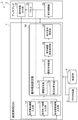
図1は本実施形態に係る経路案内ECU(経路案内装置)1を含むナビゲーションシステム2の構成概要図である。ここで、ECU(Electronic Control Unit)とは、電子制御する自動車デバイスのコンピュータであり、CPU(Central Processing Unit)、ROM(Read Only Memory)、RAM(Random Access Memory)、および入出力インターフェイスなどを備えて構成されている。
FIG. 1 is a schematic configuration diagram of a
図1に示す経路案内ECU1は、利用ユーザが目的地へ向かう際に経路を案内する装置であって、例えば、車のナビゲーションシステムに好適に用いられるものである。このような車のナビゲーションシステムは、例えば、図1に示すナビゲーションシステム2のように、経路案内ECU1の他に、ディスプレイ3、地図DB4およびGPS受信機5を備えて構成される。ここで、GPS(Global Positioning System)とは、衛星を用いた計測システムのことであり、自車両の現在位置の把握に好適に用いられるものである。
A route guidance ECU 1 shown in FIG. 1 is a device that guides a route when a user goes to a destination, and is suitably used in, for example, a car navigation system. Such a vehicle navigation system includes, for example, a
経路案内ECU1は、ディスプレイ3、地図DB4およびGPS受信機5に接続されており、例えば、地図DB4およびGPS受信機5から目的地情報や現在地の情報などを取得し、目的地までの経路を設定し、設定した経路をディスプレイ3へ出力する機能を備えている。
The route guidance ECU 1 is connected to the
ディスプレイ3は、視覚を通じて利用者に情報を提供する装置であり、表示制御部33、パネル(画面)32を備えている。表示制御部33は、入力信号に基づいて画像を表示する機能を有しており、パネル32に映し出す画像を制御している。パネル32は、好ましくは、画面上から直接情報入力ができる、いわゆるタッチパネルで構成される。タッチパネルは、画像表示機能と、表示された画面上に利用ユーザが触れることによって入力を感知する入力機能とを有しており、例えば利用ユーザが指によって画面上の表示を押えたり、なぞったりすることで入力がなされ、入力されたパネル位置に基づいて信号を出力するパネルのことである。このように、パネル32がタッチパネルで構成される場合、ディスプレイ3は操作情報出力部31を備えることが好適である。操作情報出力部31は、パネル32へ入力された情報を経路案内ECU1へ出力する機能を有している。
The
ナビゲーションシステム2に備わる地図DB4は、地図情報が格納されたデータベースであり、経路案内ECU1と接続されている。GPS受信機5は、衛星測位システムの情報端末機であって、現在位置を取得するために用いられるものであり、経路案内ECU1と接続されている。
The map DB 4 provided in the
このように構成されたナビゲーションシステム2は、利用ユーザによってディスプレイ3へ入力された目的地情報に基づいて目的地までの経路を設定し、設定した経路をディスプレイ3で表示し案内することで利用ユーザの運転支援を行う。目的地までの経路設定として、利用ユーザの経路指定が無い場合、候補経路を探索して表示する。この候補経路は、複数の候補経路の中から、例えば所要時間が最小となる経路が選択される。また、複数の候補経路を表示させて利用ユーザに選択させる機能を備えていてもよい。
The
ここで、本実施形態に係る経路案内ECU1は、指定開始情報入力部11、指定終了情報入力部12、指定経路情報入力部13及び案内経路設定部14を備えて構成されることを特徴とする。
Here, the route guidance ECU 1 according to the present embodiment includes a designation start
指定開始情報入力部11、指定終了情報入力部12及び指定経路情報入力部13は、利用ユーザが操作した情報を経路案内ECU1に入力するための入力部であり、それぞれディスプレイ3から利用ユーザの操作情報を入力する機能を備えている。例えば、指定開始情報入力部11は、利用ユーザがパネル32に指を触れた箇所(指定開始地点)の信号を、操作情報出力部31から入力する。指定終了情報入力部12は、利用ユーザがパネル32から指を離した箇所(指定終了地点)の信号を操作情報出力部31から入力する。指定経路情報入力部13は、利用ユーザがパネル32に指を触れ、パネル32から指を離さない状態でパネル32に表示された地図上の経路を辿るように指定し、指をパネル32から離すまでの経路(指定経路)を操作情報出力部31から入力する。
The designation start
案内経路設定部14は、案内経路、案内開始地点及び案内終了地点を設定する機能を有し、案内経路設定処理部18を備えて構成される。案内経路設定処理部18は、指定開始情報入力部11から得られた指定開始地点と、指定終了地点とを結ぶ指定経路を案内経路として設定する機能を備えている。この時、指定開始地点を案内開始地点とし指定終了地点を案内終了地点としてもよいし、指定開始地点を案内終了地点とし指定終了地点を案内開始地点としてもよい。この案内開始および案内終了の設定は、例えば、経路案内ECU1に備わるスイッチ等で利用ユーザが切り替えられる構成によって実現される。
The guide
また、案内経路設定部14は、好ましくは、閾値設定部(閾値設定手段)15、指定長算出部(指定長算出手段)16、誤操作判断部(比較手段)17、拡大表示設定部19を備えて構成される。
The guide
閾値設定部15は、利用ユーザが入力した情報が誤操作によって入力されたものであるか否かを判断する閾値を設定する機能を備えている。例えば、ディスプレイ3に備わる表示制御部33からパネル32に表示している地図情報の縮尺情報を入力し、入力した縮尺情報に基づいて、誤操作であるか否かを判定する閾値を設定する。また、閾値設定部15は、設定した閾値を誤操作判断部17へ出力する機能を備えている。
The threshold
指定長算出部16は、利用ユーザが入力した指定経路の画面上における長さを算出する機能を備えている。例えば、画面操作情報を指定経路情報入力部13から入力し、指定経路の画面上における長さを算出する機能を備えている。また、指定長算出部16は、算出した指定経路の画面上における長さを誤操作判断部17へ出力する機能を備えている。
The designated
誤操作判断部17は、利用ユーザが入力した情報が誤操作によって入力されたものであるか否かを判断する機能を備えている。例えば、閾値設定部15から閾値を入力し、指定長算出部16から指定経路の画面上における長さを入力し、入力された閾値と指定経路の画面上における長さとを比較して判断する。また、誤操作判断部17は、判断した結果を案内経路設定部18へ出力する機能を備えている。
The erroneous operation determination unit 17 has a function of determining whether information input by the user is input by an erroneous operation. For example, the threshold value is input from the threshold
また、拡大表示設定部19は、画面操作性を向上させるために、特定地点を拡大させる機能を備えている。例えば、案内経路設定部18から設定した案内経路を入力し、案内経路において、現在地地点や目的地付近など拡大が必要であると推定される地点を拡大表示とする。また、拡大表示命令をディスプレイ3の表示制御部33へ出力する機能を備えている。
The enlarged
次に、本実施形態に係る経路案内ECU1の動作について説明する。 Next, the operation of the route guidance ECU 1 according to this embodiment will be described.
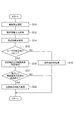
図2は本実施形態に係る経路案内ECU1の動作を示すフローチャートである。図2は、経路案内ECU1が開始信号を入力した時、例えば、画面上に経路設定開始ボタンおよび経路設定終了ボタンを備え、利用ユーザが経路設定開始ボタンを選択した時に開始され、終了信号を入力した時、例えば経路設定終了ボタンを選択するまで繰り返し実行される。 FIG. 2 is a flowchart showing the operation of the route guidance ECU 1 according to this embodiment. FIG. 2 shows that when the route guidance ECU 1 inputs a start signal, for example, when a route setting start button and a route setting end button are provided on the screen and the user selects the route setting start button, the end signal is input. In this case, for example, it is repeatedly executed until a route setting end button is selected.
図2に示すように、経路案内ECU1はS10の閾値設定処理から開始する。S10の処理は、閾値設定部15によって実行され、利用ユーザによってパネル32へ入力された情報が誤操作で入力されたものであるか否かを判断するために、閾値nを設定する処理である。閾値設定部15は、この閾値nをパネル32に表示されている地図の縮尺に応じて設定する。例えば、パネル32に表示されている地図上で200m以上の距離に該当するパネル32上の物理的長さを閾値nとして設定する。例えば、地図の縮尺が2万5千分の1の場合、地図上の200mはパネル32上の物理的長さで0.8cmとなり、地図の縮尺が1万分の1の場合では、地図上の200mはパネル32上の物理的長さで2cmとなる。よって、パネル32に表示されている地図の縮尺が2万5千分の1の場合では、閾値nを0.8と設定し、パネル32に表示されている地図の縮尺が1万分の1の場合では、閾値nを2と設定する。S10の閾値設定処理が終了すると、操作情報入力処理へ移行する(S12)。
As shown in FIG. 2, the route guidance ECU 1 starts from the threshold value setting process of S10. The process of S10 is a process of setting the threshold value n in order to determine whether the information input to the
S12の処理は、指定開始情報入力部11、指定終了情報入力部12、指定経路情報入力部13によって実行され、利用ユーザによってパネル32へ入力された情報を経路案内ECU1へ入力する処理である。指定開始情報入力部11は、例えば、利用ユーザがパネル32に指を触れた指定開始地点を操作情報出力部31から入力する。また、指定終了情報入力部12は、例えば、利用ユーザがパネル32から指を離した指定終了地点を操作情報出力部31から入力する。また、指定経路情報入力部13は、利用ユーザがパネル32に指を触れ、パネル32から指を離さない状態でパネル32に表示された地図上の経路を辿るように指定し、指をパネル32から離すまでの指定経路を操作情報出力部31から入力する。尚、以下の経路案内ECU1の動作では、説明理解の容易性を考慮して、指定開始地点を案内終了地点、例えば目的地とし、指定終了地点を案内開始地点として設定した例を説明する。S12の処理が終了すると、指定長算出処理へ移行する(S14)。
The process of S12 is a process which is executed by the designation start
S14の処理は、指定長算出部16によって実行され、S12で入力した指定経路の画面上における長さを算出する処理である。例えば、利用ユーザが指でなぞった指定経路に対応する信号を用いて、指定経路の画面上における長さを算出する。S14の処理が終了すると、誤操作判断処理へ移行する(S16)。
The process of S14 is a process executed by the designated
S16の処理は、誤操作判断部17によって実行され、利用ユーザによってパネル32へ入力された情報が、誤操作によって入力されたものであるか否かを判断する処理である。例えば、誤操作判断部17がS10で算出した閾値nとS14で算出した指定経路の画面上における長さとを比較して判断する。S16の処理において、指定経路の画面上における長さが閾値n以上の場合は、目的地、案内開始地点および案内経路の設定処理へ移行する(S18)。
The process of S16 is a process that is executed by the erroneous operation determination unit 17 and determines whether or not the information input to the
S18の処理は、案内経路設定処理部18によって実行され、目的地、案内開始地点および案内経路を設定する処理である。S12で入力した指定開始地点と、地図DB4の地図情報とに基づいて目的地を決定する。次に、S12で入力した指定経路と、地図DB4の地図情報とに基づいて案内経路を設定する。このとき、経路案内ECU1が備える機能であって、候補となる案内経路を複数表示する機能を併用する場合においては、目的地が設定された直後から候補となる案内経路の探索を開始する。このように、利用ユーザが経路入力をする間に候補となる案内経路の探索を行うことで、候補経路の表示を早めることかできる。次に、S12で入力した指定終了地点と、地図DB4の地図情報とに基づいて案内終了地点を設定する。S18の処理が終了すると、拡大表示判定処理へ移行する(S22)。
The process of S18 is executed by the guide route
S22の処理は、拡大表示設定部19によって実行され、S18で設定された案内経路の中で、さらに細かく経路を設定する必要があるか否かを判定する処理である。例えば、利用ユーザがさらに細かく経路を設定すると予想される地点を事前に情報として保有しておいて、利用ユーザが指定した経路が当該情報に一致する地点を含んでいるか否かを判定する。このような地点として、具体的には、現在地点、目的地、交通状況が変化する地点、道路形状が運転に影響する地点などが挙げられる。交通状況が変化する地点は、例えば、渋滞が頻発する地点や路上駐車が多い地点、信号が無い交差点が多い地点等である。道路形状が運転に影響する地点は、例えば、道路幅が狭い地点、急カーブ地点、急勾配地点等である。尚、交通状況は、例えば、VICS情報に基づいて判断すれば良い。ここで、VICS(Vehicle Information and Communication System)とは、道路交通情報をリアルタイムで提供する情報通信システムのことである。S22の処理において、さらに細かく経路を設定する必要がある場合は、拡大表示処理へ移行する(S24)。
The process of S22 is a process that is executed by the enlarged
S24の処理は、拡大表示設定部19によって実行され、拡大処理が必要な地点の拡大表示を行う。S24の処理が終了すると、図2に示す制御処理が終了する。
The process of S24 is executed by the enlarged
また、S16の処理において、指定経路の画面上における長さが閾値n未満の場合は、経路指定が誤操作であると判断する。すなわち、利用ユーザの画面入力は経路指定と目的地指定が同時に行われたものではなく、目的地指定のみ行われたと判断する。この場合、目的地設定処理へ移行する(S20)。 In the process of S16, when the length of the designated route on the screen is less than the threshold value n, it is determined that the route designation is an erroneous operation. That is, it is determined that the user's screen input is not a route designation and a destination designation, but a destination designation only. In this case, the process proceeds to the destination setting process (S20).
S20の処理は、案内経路設定処理部18によって実行され、目的地を設定する処理である。S12で入力した画面操作情報、例えば指定開始地点に基づいて目的地を決定する。S20の処理が終了すると、図2に示す制御処理が終了する。
The process of S20 is a process that is executed by the guide route
また、S22の処理において、さらに細かく経路を設定する必要がないと判断された場合は、図2に示す制御処理が終了する。 If it is determined in step S22 that it is not necessary to set a more detailed route, the control process shown in FIG. 2 ends.
以上で図2の制御処理が終了する。尚、説明理解の容易性から、指定開始地点を案内終了地点、指定終了地点を案内開始地点として説明したが、指定開始地点を案内開始地点とし、指定終了地点を案内終了地点とする場合は、S18,S20の処理において、指定開始地点を指定終了地点、指定終了地点を指定開始地点と読み替えればよい。 This is the end of the control process of FIG. For ease of understanding, the designated start point is described as the guidance end point, and the designated end point is described as the guidance start point. However, when the designated start point is defined as the guidance start point and the designated end point is defined as the guidance end point, In the processes of S18 and S20, the designated start point may be read as the designated end point, and the designated end point may be read as the designated start point.
次に、本実施形態に係る経路案内ECU1の効果を説明する。効果を説明する具体例として、目的地までの経路指定手順について説明する。図3および図4は、本実施形態に係る経路案内ECU1を用いた場合の経路指定手順であり、図9は、従来の経路案内装置を用いた場合の経路指定手順である。尚、パネル32はタッチパネルを採用し、指で操作することによって情報を入力できるものとして説明する。
Next, the effect of the route guidance ECU 1 according to the present embodiment will be described. As a specific example for explaining the effect, a route designation procedure to the destination will be explained. 3 and 4 are route designation procedures when the route guidance ECU 1 according to the present embodiment is used, and FIG. 9 is a route designation procedure when the conventional route guidance device is used. The
従来の経路指定手順では、図9に示すように、手順1として目的地Gが表示されている画面に指で触れることで目的地Gを指定し(矢印Y0)、次に手順2として現在地Sを指で触れ(矢印Y1)、現在地Sから目的地Gに向かって経路を指でなぞり(矢印Y2)、目的地Gで指を離す(矢印Y3)ことで指定経路Lを指定している。
In the conventional route designation procedure, as shown in FIG. 9, the destination G is designated by touching the screen on which the destination G is displayed as the procedure 1 (arrow Y0), and then the current location S as the
これに対し、本実施形態に係る経路案内ECU1の経路指定手順では、図3に示すように、目的地Gが表示されている画面に指で触れることで目的地Gを指定し(矢印Y1´)、画面から指を離さずに目的地Gから現在地Sに向かって経路を指でなぞり(矢印Y2´)、案内終了地点、例えば現在地Sで指を離すことで案内終了地点を指定する(矢印Y3´)と共に、指定経路Lを指定する。 In contrast, in the route designation procedure of the route guidance ECU 1 according to the present embodiment, as shown in FIG. 3, the destination G is designated by touching the screen on which the destination G is displayed (arrow Y1 ′). ) Trace the route from the destination G to the current location S without releasing your finger from the screen (arrow Y2 ′), and specify the guidance end point by releasing your finger at the current location S, for example, the current location S (arrow) A designated route L is designated together with Y3 ′).
また、図4に示すように、画面に指で触れることで案内開始地点、例えば現在地Sを指定し(矢印Y1´´)、画面から指を離さずに現在地Sから目的地Gに向かって経路を指でなぞり(矢印Y2´´)、案内終了地点、例えば目的地Gで指を離すことで案内終了地点を指定する(矢印Y3´´)と共に、指定経路Lを指定する。 In addition, as shown in FIG. 4, the guidance start point, for example, the current location S is specified by touching the screen with a finger (arrow Y1 ″), and the route from the current location S to the destination G without releasing the finger from the screen. Is traced with a finger (arrow Y2 ″), the guidance end point is designated by releasing the finger at the guidance end point, for example, the destination G (arrow Y3 ″), and the designated route L is designated.
以上のように、本実施形態に係る経路案内ECU1によれば、目的地G、案内終了地点、及び目的地Gと案内終了地点とを結ぶ経路Lを、利用ユーザの一連の動作で設定することができる。 As described above, according to the route guidance ECU 1 according to the present embodiment, the destination G, the guidance end point, and the route L connecting the destination G and the guidance end point are set by a series of operations of the user. Can do.
また、本実施形態に係る経路案内ECU1によれば、表示される地図の縮尺が変化しても、地図の縮尺に応じて閾値を設定することで、指定された経路Lの画面上における長さが所定の長さ以上か否かを判断することができる。これにより、指定された経路Lが誤操作によって指定されたものであるか否かを判断できるため、利用ユーザの意図しない情報に基づいて案内経路を設定することを回避することができる。例えば、利用ユーザが目的地Gのみを設定したい時に、手ぶれ等によって意図せずに目的地Gと経路Lを指定した場合であっても、案内経路の設定を行うことを回避することができる。 Further, according to the route guidance ECU 1 according to the present embodiment, even if the scale of the displayed map is changed, the length of the designated route L on the screen is set by setting a threshold according to the scale of the map. It can be determined whether or not is longer than a predetermined length. This makes it possible to determine whether or not the designated route L is designated by an erroneous operation, so that it is possible to avoid setting a guidance route based on information not intended by the user. For example, when the user wants to set only the destination G, even when the destination G and the route L are specified unintentionally due to camera shake or the like, it is possible to avoid setting the guidance route.
また、経路案内ECU1によれば、利用ユーザが指定を開始する地点が目的地Gであり、指定終了する地点が案内終了地点、例えば現在地Sであるので、目的地Gを起点とした経路をイメージしている利用ユーザに対して指定経路Lの入力作業負荷を軽減することができる。また、このように、目的地Gから先に指定することによって、現在地Sから目的地Gまでの候補経路の検索を即座に実施することが可能となる。これによって、利用ユーザが指定した経路以外にも候補経路を表示する機能を用いる場合、候補経路の表示を早くすることが可能となる。 Further, according to the route guidance ECU 1, since the point where the user starts specifying is the destination G and the point where the user ends is the guidance end point, for example, the current location S, the route starting from the destination G is imaged. It is possible to reduce the input work load of the designated route L for the user who is doing this. In addition, by specifying the destination G first in this way, it becomes possible to immediately search for a candidate route from the current location S to the destination G. This makes it possible to speed up the display of candidate routes when a function for displaying candidate routes other than the route designated by the user is used.
あるいは、利用ユーザが指定を開始する地点が案内開始地点であり、指定終了する地点が目的地Gとする場合であっても良く、この場合は、現在地Sや特定地点から目的地Gへの経路をイメージしている利用ユーザに対して指定経路の入力作業負荷を軽減することができる。また、このように、案内開始地点から先に指定することで、現在地Sから案内開始地点までの候補経路の検索を即座に実施することが可能となる。これによって、利用ユーザが指定した経路を必ず通る候補経路を表示する機能を用いる場合、候補経路の表示を早くすることが可能となる。 Alternatively, the point where the user starts designating may be the guidance start point, and the point where the designation ends may be the destination G. In this case, the route from the current location S or a specific point to the destination G It is possible to reduce the input work load of the designated route for the user who imagines. In addition, by specifying the guidance starting point first in this way, it becomes possible to immediately search for candidate routes from the current location S to the guidance starting point. This makes it possible to speed up the display of candidate routes when using a function that displays candidate routes that always pass the route specified by the user.
また、経路案内ECU1において、地図の縮尺が小さい場合に、案内が必要な地点を拡大して表示することができるため、画面の操作性が向上し、誤操作の発生を低減することができる。また、拡大機能を用いることで、例えば、指定経路全体を表示する時に地図の縮尺が小さくなり、画面から詳細な設定をすることが困難となることを回避することができる。 Further, in the route guidance ECU 1, when the scale of the map is small, a point where guidance is required can be enlarged and displayed, so that the operability of the screen is improved and the occurrence of an erroneous operation can be reduced. Further, by using the enlargement function, for example, it is possible to avoid the fact that the scale of the map becomes small when displaying the entire designated route, making it difficult to make detailed settings from the screen.
尚、上述した実施形態は本発明に係る経路案内装置の一例を示すものである。本発明に係る経路案内装置は、このようなものに限られるものではなく、各請求項に記載した要旨を変更しないように実施形態に係る経路案内装置を変形し、又は他のものに適用したものであってもよい。 In addition, embodiment mentioned above shows an example of the route guidance apparatus which concerns on this invention. The route guidance device according to the present invention is not limited to this, and the route guidance device according to the embodiment is modified so as not to change the gist described in each claim, or applied to other devices. It may be a thing.
例えば、実施形態において、パネル32はタッチパネルを採用することが好適であり、経路の指定を利用ユーザが指で行う例を示したが、情報入力手段がタッチパネルで無く、マウス等で情報入力する場合であっても、実施形態と同一の作用効果を得ることができる。この場合、利用ユーザは、カーソルを合わせて特定ボタンを押すことで指定開始地点を指定し、特定ボタンを押した状態でカーソル移動させて指定開始地点と指定終了地点とを結ぶ経路を入力し、カーソルを合わせて特定ボタンを離すことで指定終了地点を指定すれば良い。
For example, in the embodiment, it is preferable that the
また、実施形態において、誤操作の判断基準となる閾値nを地図の縮尺に応じて決定したが、閾値を一定値として経路指定を行ったか否かを判断してもよい。この場合、例えば、物理的な操作量として操作した長さが1cm以上である場合のみ経路指定を行う構成とすれば良い。 In the embodiment, the threshold value n serving as a criterion for erroneous operation is determined according to the scale of the map. However, it may be determined whether or not the route is specified with the threshold value set to a constant value. In this case, for example, the configuration may be such that routing is performed only when the length operated as a physical operation amount is 1 cm or more.
また、実施形態において、1回の経路指定操作によって全体の案内経路が設定され、その後、詳細な設定を行うために拡大表示とする例を示したが、1度の経路指定操作で全体の案内経路を指定せず、利用ユーザが終了操作を行うまで連続して経路指定が可能な構成として、利便性を向上させても良い。例えば、経路指定完了ボタンを画面に表示させて、指定経路の入力完了後に経路指定完了ボタンを選択させれば良い。 Further, in the embodiment, an example has been shown in which an entire guide route is set by a single route designation operation, and then enlarged display is performed in order to make detailed settings. However, the entire guide route is displayed by a single route designation operation. Convenience may be improved by adopting a configuration in which a route can be designated continuously until the user performs an ending operation without designating the route. For example, a route designation completion button may be displayed on the screen, and the route designation completion button may be selected after the input of the designated route is completed.
また、実施形態において、画面上の表示が所定の縮尺よりも小さい場合は、経路指定が困難になるため、このような場合は、目的地を指定した後に画面を拡大し、再度経路指定の有無を問うような構成にしても良い。 Also, in the embodiment, when the display on the screen is smaller than a predetermined scale, it becomes difficult to specify a route. In such a case, after specifying the destination, the screen is enlarged and whether or not the route is specified again. You may make it the structure which asks.
また、実施形態において、案内経路の特定地点を拡大して利用ユーザの操作性を向上する例を示したが、案内経路を指定する際、地図の縮尺が大きく利用ユーザが指定する経路が表示範囲内に収まりきらない場合においては、縮尺を小さくして表示してもよい。これによって、利用ユーザが経路指定するために画面スクロール等をする必要がなくなるため、操作性が向上する。このように、縮小機能を用いても利用ユーザの操作性を向上することができる。 In the embodiment, the specific point of the guide route is enlarged to improve the user's operability. However, when the guide route is specified, the map scale is large and the route specified by the user is displayed in the display range. When it does not fit within the screen, the scale may be reduced. This eliminates the need for screen scrolling and the like for the user to specify the route, improving operability. As described above, the operability of the user can be improved even when the reduction function is used.
また、実施形態において、現在地点から案内開始地点までの経路について案内が不要な場合は、経路案内を省略する構成にしても良い。例えば、案内開始地点不要ボタンを画面上に表示し、当該ボタンを選択した場合に、案内開始地点までの案内を省略する構成にすればよい。または、目的地付近に到着した場合や、案内開始地点を通過せずに案内経路内に途中から進入した場合や、案内開始地点からみて、目的地と反対側に車両が進入した場合などは、利用ユーザの操作が無くても経路案内を省略する構成にしても良い。このように構成することで、余計な経路案内を省くことができる。 In the embodiment, when guidance is not required for the route from the current location to the guidance start location, the route guidance may be omitted. For example, when a guidance start point unnecessary button is displayed on the screen and the button is selected, guidance to the guidance start point may be omitted. Or if you arrive near the destination, if you enter the guidance route without passing through the guidance start point, or if the vehicle enters the opposite side of the destination from the guidance start point, The route guidance may be omitted even if there is no user operation. By configuring in this way, unnecessary route guidance can be omitted.
また、実施形態において、指定開始地点が案内開始地点となるか案内終了地点となるかを利用ユーザが選択する構成を説明したが、利用ユーザの入力操作によって自動で切り替える構成にしてもよい。例えば、指定開始地点を案内開始地点とする場合は、指で画面に触れて指定開始地点を決定し、そのまま画面から指を離さずに指定開始地点を円で囲み、そのまま画面から指を離さずに指定終了地点までの経路をなぞり、指定終了地点で画面から指を離すことで案内終了地点を決定してもよい。 In the embodiment, the configuration in which the user selects whether the designated start point is the guidance start point or the guidance end point has been described. However, a configuration may be adopted in which switching is automatically performed by an input operation of the user. For example, when the designated start point is set as the guidance start point, the designated start point is determined by touching the screen with a finger, the designated start point is circled without releasing the finger from the screen, and the finger is not released from the screen as it is. The guidance end point may be determined by tracing the route to the specified end point and releasing the finger from the screen at the specified end point.
さらに、実施形態においては、指定開始地点を例えば目的地、指定終了地点を例えば現在地として説明したが、指定開始地点および指定終了地点は目的地や現在地でなくても良い。例えば、一方が目的地で他方が通過希望地点であっても良いし、双方共に通過希望地点であっても良い。 Furthermore, in the embodiment, the designated start point is described as the destination, for example, and the designated end point is defined as the current location. However, the designated start point and the designated end point may not be the destination or the current location. For example, one may be a destination and the other may be a desired passage point, or both may be desired passage points.
以下では、指定開始地点および指定終了地点が通過希望地点である場合の例を図5〜8を用いて説明する。図5〜8は、パネル32の操作手順を示す模式図である。ここで、利用ユーザは、図5の画面A´に示す現在地Sに居るとし、目的地Gへ移動するために、案内経路を設定するものとする。
Below, the example in case a designation | designated start point and a designation | designated end point are desired passage points is demonstrated using FIGS. 5 to 8 are schematic diagrams illustrating an operation procedure of the
まず、図5に示すように、画面を画面A´から画面Aへ切り替えて目的地Gを設定する。この設定方法は、図2のS20の処理、すなわち経路指定を行わない方法で設定するものであって、例えば目的地Gが表示されている画面Aに指で触れることで設定する。このような設定方法は、現在地を表示している表示画面に目的地が表示されていない場合等で好適に用いられる。 First, as shown in FIG. 5, the screen is switched from the screen A ′ to the screen A, and the destination G is set. This setting method is set by the process of S20 in FIG. 2, that is, a method that does not specify a route. For example, the setting is performed by touching the screen A on which the destination G is displayed with a finger. Such a setting method is suitably used when the destination is not displayed on the display screen displaying the current location.
次に、図6に示すように、経路案内ECU1によって推奨経路L´が表示される。この推奨経路L´は、例えば候補経路のうち最短経路が検索されて表示される。検索された推奨経路L´は、画面内に収まるように表示され、図5の画面Aから、画面Aより縮尺が小さい図6の画面Bへと画面が切り替わる。 Next, as shown in FIG. 6, the recommended route L ′ is displayed by the route guidance ECU 1. The recommended route L ′ is displayed by searching for the shortest route among candidate routes, for example. The retrieved recommended route L ′ is displayed so as to be within the screen, and the screen is switched from the screen A in FIG. 5 to the screen B in FIG.
この時、図2のS22,S24の処理、すなわち、拡大して経路を設定する必要がある地点があれば拡大表示する処理が実行される。これによって、例えば目的地周辺が自動で拡大され、画面Bの中に画面Dが表示される。また、例えば交通状況が変化する地点周辺が自動で拡大され、画面Bの中に画面Cが表示される。 At this time, the process of S22 and S24 in FIG. 2, that is, the process of enlarging and displaying if there is a point where it is necessary to enlarge and set the route is executed. Thereby, for example, the periphery of the destination is automatically enlarged, and the screen D is displayed in the screen B. Further, for example, the area around a point where the traffic situation changes is automatically enlarged, and the screen C is displayed in the screen B.
そして、利用ユーザは画面Cに表示された拡大地図情報を参照し、希望する経路を再指定する。再指定は、経路変更地点を指で触れ、画面Cに指を触れたまま再指定する経路をなぞり、経路変更完了地点で画面Cから指を離すという手順で実施できる(矢印Y4)。また、画面Dについても同様に設定できる。このように、自動拡大した画面に触れることで、推奨経路L´を容易に変更することが可能となる。そして、このように指定された指定開始地点及び指定終了地点が通過希望地点となる。また、このように案内経路を変更した場合、推奨経路L´から大きく外れた経路変更となることも考えられる。よって、経路変更がされたあとに、変更経路以外の経路については、変更経路の開始地点までの経路を再度検索して候補経路を設定する。また、利用ユーザが経路設定した際の指でなぞる向きを指定経路の進行方向として入力して再度設定してもよい。 Then, the user refers to the enlarged map information displayed on the screen C and re-designates the desired route. The redesignation can be performed by a procedure of touching the route change point with a finger, tracing the route to be redesignated while touching the screen C, and releasing the finger from the screen C at the route change completion point (arrow Y4). The screen D can be set in the same manner. In this way, the recommended route L ′ can be easily changed by touching the automatically enlarged screen. And the designation | designated start point and designation | designated end point designated in this way become a passage desired point. In addition, when the guide route is changed in this way, it may be considered that the route is greatly changed from the recommended route L ′. Therefore, after the route is changed, for routes other than the changed route, the route to the starting point of the changed route is searched again and a candidate route is set. Alternatively, the direction in which the user traces with the finger when the route is set may be input as the traveling direction of the designated route and set again.
次に、自動拡大されない箇所を経路変更する方法について説明する。まず、経路変更する箇所を指定する。例えば、図6に示すように、経路拡大を希望する箇所を囲むように指で円を描く(矢印Y6)ことで指定できる。このような動きをすることで、図7に示すように、画面Bの中に新たに画面Eが表示され、円を囲むようにして指定した箇所が拡大表示される。 Next, a method for changing the route of a portion that is not automatically enlarged will be described. First, the location to change the route is specified. For example, as shown in FIG. 6, it can be specified by drawing a circle with a finger (arrow Y6) so as to surround a place where a path expansion is desired. By making such a movement, as shown in FIG. 7, the screen E is newly displayed in the screen B, and the portion designated so as to surround the circle is enlarged and displayed.
次に、拡大表示された画面Eを用いて経路変更を行う。経路変更は、画面C、Dで行った経路変更と同様の手順で実施される(矢印Y7)。 Next, the route is changed using the enlarged screen E. The route change is performed in the same procedure as the route change performed on screens C and D (arrow Y7).
図5,6,7の操作によって、図8に示すように推奨経路L´が経路Lに変更される。画面C,D,Eによって変更された箇所は、それぞれC´,D´,E´で示した箇所となる。尚、自動拡大されない箇所を経路変更する他の方法として、通常の表示のままで指定することにしても良いし、経路全体を縮尺変更する構成にしても良い。 5, 6 and 7, the recommended route L ′ is changed to the route L as shown in FIG. 8. The locations changed by the screens C, D, and E are locations indicated by C ′, D ′, and E ′, respectively. In addition, as another method for changing the route of a portion that is not automatically enlarged, it may be specified with a normal display, or the entire route may be changed in scale.
以上のように、利用ユーザが指定開始した地点と指定終了した地点が双方共に通過希望地点である場合であっても本発明を利用して経路変更が行える。尚、指定経路以外の経路は、経路案内ECU1が自動設定するが、例えば、案内開始地点までは案内しない設定をすることで、必要な複数の区間のみ経路案内を行うことが可能となる。 As described above, the route can be changed using the present invention even when the point where the user starts specifying and the point where the specification ends are both desired passing points. Note that routes other than the designated route are automatically set by the route guidance ECU 1, but it is possible to perform route guidance only for a plurality of necessary sections by setting not to guide to the guidance start point, for example.
1…経路案内ECU(経路案内装置)、2…ナビゲーションシステム、3…ディスプレイ、4…地図DB、11…指定開始情報入力部、12…指定終了情報入力部、13…指定経路情報入力部、14…案内経路設定部、15…閾値設定部(閾値設定手段)、16…指定長算出部(指定長算出手段)、17…誤操作判断部(比較手段)、18…案内経路設定処理部、19…拡大表示部、31…操作情報出力部、32…パネル、33…表示制御部。 DESCRIPTION OF SYMBOLS 1 ... Route guidance ECU (route guidance apparatus), 2 ... Navigation system, 3 ... Display, 4 ... Map DB, 11 ... Designation start information input part, 12 ... Designation end information input part, 13 ... Designation route information input part, 14 ... guide route setting unit, 15 ... threshold setting unit (threshold setting unit), 16 ... designated length calculating unit (designated length calculating unit), 17 ... misoperation determining unit (comparing unit), 18 ... guide route setting processing unit, 19 ... Enlarged display unit, 31 ... operation information output unit, 32 ... panel, 33 ... display control unit.
Claims (5)
前記指定開始地点から前記地図上を辿るように指定される経路であって、前記指定開始地点と指定終了される任意の地点とを結ぶ経路を指定経路として入力する指定経路情報入力部と、
前記指定終了した任意の地点を指定終了地点として入力する指定終了情報入力部と、
前記指定経路に基づいて案内経路を設定する案内経路設定部と、
を備える経路案内装置。 On the map displayed on the screen, a designated start information input unit for inputting any designated start point as a designated start point;
A designated route information input unit that inputs a route that is designated to follow the map from the designated start point and connects the designated start point and an arbitrary point to be designated as a designated route;
A designated end information input unit for inputting the designated end point as a designated end point;
A guide route setting unit for setting a guide route based on the designated route;
A route guidance device comprising:
前記指定終了地点は、案内終了地点であること、
を特徴とする請求項1に記載の経路案内装置。 The designated start point is a guidance start point,
The designated end point is a guidance end point;
The route guidance device according to claim 1.
前記指定終了地点は、案内開始地点であること、
を特徴とする請求項1に記載の経路案内装置。 The designated start point is a guidance end point,
The designated end point is a guidance start point;
The route guidance device according to claim 1.
前記指定経路の画面上における長さを算出する指定長算出手段と、
前記画面に表示されている地図の縮尺に応じて閾値を設定する閾値設定手段と、
前記指定経路の画面上における長さと前記閾値とを比較する比較手段と、
を有し、
前記指定経路の画面上における長さが前記閾値以上の場合に案内経路を設定すること、
を特徴とする請求項1〜3の何れか一項に記載の経路案内装置。 The guide route setting unit
Designated length calculation means for calculating the length of the designated route on the screen;
Threshold setting means for setting a threshold according to the scale of the map displayed on the screen;
A comparison means for comparing the length of the designated route on the screen with the threshold value;
Have
Setting a guide route when the length of the designated route on the screen is equal to or greater than the threshold;
The route guidance device according to any one of claims 1 to 3, wherein
Priority Applications (1)
| Application Number | Priority Date | Filing Date | Title |
|---|---|---|---|
| JP2007044317A JP2008209151A (en) | 2007-02-23 | 2007-02-23 | Route guidance device |
Applications Claiming Priority (1)
| Application Number | Priority Date | Filing Date | Title |
|---|---|---|---|
| JP2007044317A JP2008209151A (en) | 2007-02-23 | 2007-02-23 | Route guidance device |
Publications (1)
| Publication Number | Publication Date |
|---|---|
| JP2008209151A true JP2008209151A (en) | 2008-09-11 |
Family
ID=39785588
Family Applications (1)
| Application Number | Title | Priority Date | Filing Date |
|---|---|---|---|
| JP2007044317A Pending JP2008209151A (en) | 2007-02-23 | 2007-02-23 | Route guidance device |
Country Status (1)
| Country | Link |
|---|---|
| JP (1) | JP2008209151A (en) |
Cited By (6)
| Publication number | Priority date | Publication date | Assignee | Title |
|---|---|---|---|---|
| JP2013524221A (en) * | 2010-04-09 | 2013-06-17 | トムトム インターナショナル ベスローテン フエンノートシャップ | Navigation or mapping apparatus and method |
| JP2013172165A (en) * | 2012-02-17 | 2013-09-02 | Honda Access Corp | Cooperation system for on-vehicle device and portable information terminal |
| JP2014190788A (en) * | 2013-03-27 | 2014-10-06 | Zenrin Datacom Co Ltd | Point registration device, point registration method, and point registration program |
| JP2015219185A (en) * | 2014-05-20 | 2015-12-07 | 株式会社Nttドコモ | Path output device and path output method |
| WO2017199997A1 (en) * | 2016-05-19 | 2017-11-23 | アイシン・エィ・ダブリュ株式会社 | Map display system and map display program |
| JP2022002114A (en) * | 2017-12-14 | 2022-01-06 | パナソニックIpマネジメント株式会社 | Cleaning information provision device |
-
2007
- 2007-02-23 JP JP2007044317A patent/JP2008209151A/en active Pending
Cited By (13)
| Publication number | Priority date | Publication date | Assignee | Title |
|---|---|---|---|---|
| JP2013524221A (en) * | 2010-04-09 | 2013-06-17 | トムトム インターナショナル ベスローテン フエンノートシャップ | Navigation or mapping apparatus and method |
| US9157758B2 (en) | 2010-04-09 | 2015-10-13 | Tomtom International B.V. | Navigation or mapping apparatus and method |
| US9671246B2 (en) | 2010-04-09 | 2017-06-06 | Tomtom Navigation B.V. | Navigation or mapping apparatus and method |
| JP2013172165A (en) * | 2012-02-17 | 2013-09-02 | Honda Access Corp | Cooperation system for on-vehicle device and portable information terminal |
| JP2014190788A (en) * | 2013-03-27 | 2014-10-06 | Zenrin Datacom Co Ltd | Point registration device, point registration method, and point registration program |
| JP2015219185A (en) * | 2014-05-20 | 2015-12-07 | 株式会社Nttドコモ | Path output device and path output method |
| WO2017199997A1 (en) * | 2016-05-19 | 2017-11-23 | アイシン・エィ・ダブリュ株式会社 | Map display system and map display program |
| JP2017207652A (en) * | 2016-05-19 | 2017-11-24 | アイシン・エィ・ダブリュ株式会社 | Map display system and map display program |
| CN109154512A (en) * | 2016-05-19 | 2019-01-04 | 爱信艾达株式会社 | Map display system and map display program |
| US20190107412A1 (en) * | 2016-05-19 | 2019-04-11 | Aisin Aw Co., Ltd. | Map display system and map display program |
| US10663317B2 (en) | 2016-05-19 | 2020-05-26 | Aisin Aw Co., Ltd. | Map display system and map display program |
| JP2022002114A (en) * | 2017-12-14 | 2022-01-06 | パナソニックIpマネジメント株式会社 | Cleaning information provision device |
| JP7122573B2 (en) | 2017-12-14 | 2022-08-22 | パナソニックIpマネジメント株式会社 | Cleaning information providing device |
Similar Documents
| Publication | Publication Date | Title |
|---|---|---|
| US7788028B2 (en) | Navigation system | |
| JP4728685B2 (en) | Navigation device | |
| JP2006284218A (en) | Navigation device | |
| JP2007132677A (en) | Navigation device | |
| JP2009257939A (en) | Navigation device | |
| JP2007003328A (en) | Car navigation system | |
| JP2008146201A (en) | On-vehicle display device | |
| JP4783075B2 (en) | Navigation device | |
| JP2008209151A (en) | Route guidance device | |
| JP2007145106A (en) | On-vehicle information terminal | |
| US20080027638A1 (en) | Navigation System | |
| JP6400179B2 (en) | Map display control apparatus and map automatic scroll method | |
| JP6463457B2 (en) | Map display control apparatus and map scroll operation feeling control method | |
| JP2008185452A (en) | Navigation device | |
| JP2007017331A (en) | Navigation device | |
| JP2008128928A (en) | Vehicle-mounted map display apparatus and navigation apparatus | |
| JP2008145169A (en) | Navigation apparatus | |
| JP2008145170A (en) | On-vehicle display apparatus | |
| JP4897342B2 (en) | In-vehicle map display device | |
| JP2007232568A (en) | Vehicle-mounted navigation system and root editing method | |
| JP2006322781A (en) | Navigation system | |
| JP5326678B2 (en) | Navigation device | |
| JP4917410B2 (en) | Map display device and scale changing method thereof | |
| JP2009204591A (en) | Navigation system | |
| JP6433347B2 (en) | Map display control apparatus and map automatic scroll method |