EP1288673A2 - Mobile navigation device for a cellular radio network - Google Patents
Mobile navigation device for a cellular radio network Download PDFInfo
- Publication number
- EP1288673A2 EP1288673A2 EP02019018A EP02019018A EP1288673A2 EP 1288673 A2 EP1288673 A2 EP 1288673A2 EP 02019018 A EP02019018 A EP 02019018A EP 02019018 A EP02019018 A EP 02019018A EP 1288673 A2 EP1288673 A2 EP 1288673A2
- Authority
- EP
- European Patent Office
- Prior art keywords
- navigation device
- base station
- mobile navigation
- building
- radio
- Prior art date
- Legal status (The legal status is an assumption and is not a legal conclusion. Google has not performed a legal analysis and makes no representation as to the accuracy of the status listed.)
- Granted
Links
Images
Classifications
-
- H—ELECTRICITY
- H04—ELECTRIC COMMUNICATION TECHNIQUE
- H04W—WIRELESS COMMUNICATION NETWORKS
- H04W64/00—Locating users or terminals or network equipment for network management purposes, e.g. mobility management
-
- G—PHYSICS
- G01—MEASURING; TESTING
- G01S—RADIO DIRECTION-FINDING; RADIO NAVIGATION; DETERMINING DISTANCE OR VELOCITY BY USE OF RADIO WAVES; LOCATING OR PRESENCE-DETECTING BY USE OF THE REFLECTION OR RERADIATION OF RADIO WAVES; ANALOGOUS ARRANGEMENTS USING OTHER WAVES
- G01S5/00—Position-fixing by co-ordinating two or more direction or position line determinations; Position-fixing by co-ordinating two or more distance determinations
- G01S5/02—Position-fixing by co-ordinating two or more direction or position line determinations; Position-fixing by co-ordinating two or more distance determinations using radio waves
- G01S5/0252—Radio frequency fingerprinting
- G01S5/02521—Radio frequency fingerprinting using a radio-map
-
- G—PHYSICS
- G01—MEASURING; TESTING
- G01C—MEASURING DISTANCES, LEVELS OR BEARINGS; SURVEYING; NAVIGATION; GYROSCOPIC INSTRUMENTS; PHOTOGRAMMETRY OR VIDEOGRAMMETRY
- G01C21/00—Navigation; Navigational instruments not provided for in groups G01C1/00 - G01C19/00
- G01C21/20—Instruments for performing navigational calculations
- G01C21/206—Instruments for performing navigational calculations specially adapted for indoor navigation
-
- G—PHYSICS
- G01—MEASURING; TESTING
- G01S—RADIO DIRECTION-FINDING; RADIO NAVIGATION; DETERMINING DISTANCE OR VELOCITY BY USE OF RADIO WAVES; LOCATING OR PRESENCE-DETECTING BY USE OF THE REFLECTION OR RERADIATION OF RADIO WAVES; ANALOGOUS ARRANGEMENTS USING OTHER WAVES
- G01S5/00—Position-fixing by co-ordinating two or more direction or position line determinations; Position-fixing by co-ordinating two or more distance determinations
- G01S5/02—Position-fixing by co-ordinating two or more direction or position line determinations; Position-fixing by co-ordinating two or more distance determinations using radio waves
- G01S5/14—Determining absolute distances from a plurality of spaced points of known location
Landscapes
- Engineering & Computer Science (AREA)
- Radar, Positioning & Navigation (AREA)
- Remote Sensing (AREA)
- Physics & Mathematics (AREA)
- General Physics & Mathematics (AREA)
- Automation & Control Theory (AREA)
- Computer Networks & Wireless Communication (AREA)
- Signal Processing (AREA)
- Mobile Radio Communication Systems (AREA)
- Position Fixing By Use Of Radio Waves (AREA)
- Fittings On The Vehicle Exterior For Carrying Loads, And Devices For Holding Or Mounting Articles (AREA)
- Telephone Function (AREA)
Abstract
Description
Die vorliegende Erfindung bezieht sich auf Zubehörsysteme für zellulare Funknetze und insbesondere auf eine mobile Navigationsvorrichtung für ein zellulares Funknetz.The present invention relates to accessory systems for cellular radio networks and especially on a mobile one Navigation device for a cellular radio network.
Aktuell stehen zur Navigation in Gebäuden, die auch als sogenannte Indoor-Environments bezeichnet werden, mit tragbaren Endgeräten, wie z. B. PDAs (PDA = Personal Digital Assistant) Mobiltelephone oder Uhren, nur rudimentäre Konzepte zur Verfügung. Die Navigation in Gebäuden umfaßt die Unterstützung eines mobilen Teilnehmers, wie z. B. eines Roboters, einer Person, eines Fahrzeugs etc., bezüglich der Orientierung, Wegfindung und anderer lokalisierungsbasierender Handlungen in einem Gebäude.Currently available for navigation in buildings, which are also known as Indoor environments are referred to as portable Terminals, such as B. PDAs (PDA = Personal Digital Assistant) Cell phones or watches, just rudimentary concepts to disposal. The navigation in buildings includes support a mobile subscriber, such as B. a robot, a person, a vehicle, etc. regarding the Orientation, pathfinding and other localization-based Actions in a building.
Um diese Unterstützung sinnvoll durchführen zu können, ist es nötig, daß der Teilnehmer möglichst zu jedem Zeitpunkt bzw. an jedem Ort des Gebäudes, also flächendeckend, in der Lage ist, seine Position im Gebäude abzufragen.In order to be able to carry out this support effectively, it is necessary that the participant whenever possible or at any location in the building, i.e. across the board, in the It is able to query its position in the building.
Zur Navigation existiert eine Vielzahl von Systemen, von denen das wohl bekannteste das GPS-System sein dürfte. Bekanntermaßen wird bei GPS eine Triangulation über Laufzeitmessungen durchgeführt, um die Position eines Empfängers zu ermitteln. In einem zellularen Funknetz mit fest angeordneten Basisstationen kann eine grobe Orientierung auch dadurch erreicht werden, daß ein Empfänger über die Basisstationsidentifikation der Basisstation, mit der er kommuniziert, feststellt, in welcher Funkzelle er sich befindet.A variety of systems exist for navigation, from the probably the best known of which is the GPS system. As is known, is a triangulation with GPS over runtime measurements performed to the position of a recipient determine. In a cellular radio network with permanently arranged Base stations can also provide a rough orientation be achieved that a recipient via the base station identification the base station with which it communicates, determines in which radio cell it is located.
In WLAN-Systemen wird ferner eine, Off-Line funktionierende einfache Auswertung von Feldstärke-Werten, die auch als RSSI-Werte (RSSI = Radio Signal Strength Indicator) bezeichnet werden, durchgeführt. Eine solche Technik ist in "Geolocation in a PicoRadio Environment", Diploma Thesis, ETH Zürich, Jan Beutel, beschrieben.In WLAN systems, one that works off-line is also used simple evaluation of field strength values, also as RSSI values (RSSI = Radio Signal Strength Indicator) are carried out. Such a technique is in "Geolocation in a PicoRadio Environment", Diploma Thesis, ETH Zurich, Jan Beutel.
Nachteilig an diesen Systemen ist die Tatsache, daß insbesondere bei der Feldstärkemessung die gesamte Problematik des Übertragungskanals, der Mehrfachreflexionen, insbesondere in Gebäuden etc. vorhanden ist, so daß eine genaue Positionsbestimmung nur unter idealisierten Bedingungen mit ausreichender Genauigkeit möglich ist. In realen Szenarien, wie z. B. einem größeren Gebäude, einem Flughafen etc., ist die Positionierung daher sehr ungenau, insbesondere wenn eine Vielzahl von Basisstationen und anderen Funkteilnehmern vorhanden ist.A disadvantage of these systems is the fact that in particular the entire problem in the field strength measurement the transmission channel, the multiple reflections, in particular is present in buildings etc., so that an exact position can be determined only under idealized conditions sufficient accuracy is possible. In real scenarios, such as B. a larger building, an airport, etc. the positioning is therefore very imprecise, especially if a variety of base stations and other radio subscribers is available.
Das U.S.-Patent Nr. 5,208,756 offenbart ein Fahrzeugpositionierungs- und Navigationssystem, das in Verbindung mit einem zellularen Telefonnetz arbeitet. Ein kleines verstecktes Gerät ist in einem Fahrzeug angeordnet und wird durch ein spezielles Signal von einer Telefonstation aktiviert. Nach der Aktivierung bestimmt das Gerät die Leistung, mit der normal übertragene Steuerkanäle von mehreren Basisstationen des Netzes empfangen werden. Dann berechnet das Gerät den Abstand zwischen dem Fahrzeug und mehreren Basisstationen, um dann unter Verwendung von Triangulationsverfahren oder Arkulationsverfahren die Position des Fahrzeugs zu bestimmen und zurück zu der Telefonstation zu übermitteln, von der das Aktivierungssignal empfangen worden ist.U.S. Patent No. 5,208,756 discloses a vehicle positioning and navigation system that in conjunction with a cellular telephone network works. A little hidden one Device is placed in a vehicle and is by activated a special signal from a telephone station. After activation, the device determines the power with the normally transmitted control channels from several base stations of the network can be received. Then the device calculates the distance between the vehicle and several base stations, to then use triangulation techniques or arculation method the position of the vehicle to be determined and transmitted back to the telephone station, from which the activation signal was received.
Die DE 197 03 916 A1 offenbart ein Verfahren zur Prädiktion der Gebäudedämpfung bei Funksignalen, wobei unter Kenntnis der Breite und der Stockwerkhöhe des Gebäudes praktisch für jeden Ort verschiedener Stockwerke die Gebäudedämpfung ermittelbar ist. Bei der Prädiktion der Funkfelddämpfung innerhalb des Gebäudes wird zunächst die Gebäudedämpfung im Erdgeschoß des Gebäudes ermittelt. Dann kann unter Kenntnis der Art der elektromagnetischen Wellenausbreitung und des Geschoßgewinns die jeweilige Funkfelddämpfung an jedem Ort eines beliebigen Stockwerkes des Gebäudes ermittelt werden.DE 197 03 916 A1 discloses a method for prediction the building attenuation with radio signals, with knowledge the width and floor height of the building practical for the damping of the building can be determined at any location on different floors is. When predicting radio field attenuation within of the building is initially the building attenuation in Ground floor of the building determined. Then be aware the type of electromagnetic wave propagation and The respective radio field attenuation at each location of any floor of the building can be determined.
Das U.S.-Patent Nr. 5,657,487 offenbart eine Navigationsassistenz für eine Anrufhandhabung in Mobiltelefonsystemen. Unter Verwendung von Informationen, die von Basisstationen erhalten werden, ist es der Mobilstation möglich, ihren Abstand von jeder Basisstation basierend auf einer mittleren Signalstärke zu approximieren, um damit eine Grobsektorposition zu bestimmen. Informationen von der Basisstation werden von der Mobilstation ferner dazu verwendet, den Ausbreitungsverlust für eine Übertragung zu der Basisstation und den geeigneten Leistungspegel und die geeignete zeitliche Steuerung für Übertragungen zur Basisstation zu bestimmen.U.S. Patent No. 5,657,487 discloses a navigation assistant for handling calls in mobile phone systems. Using information from base stations can be obtained, the mobile station is able to change its distance from each base station based on a middle one Approximate signal strength to give a rough sector position to determine. Information from the base station are also used by the mobile station to reduce the propagation loss for transmission to the base station and the appropriate power level and timing Determine control for transmissions to the base station.
Die Aufgabe der vorliegenden Erfindung besteht darin, eine mobile Navigationsvorrichtung für ein zellulares Funknetz zu schaffen, die einfach in das zellulare Funknetz integrierbar ist und eine genaue Positionsbestimmung ermöglicht.The object of the present invention is a mobile navigation device for a cellular radio network to create that can be easily integrated into the cellular radio network is and enables an exact position determination.
Diese Aufgabe wird durch eine mobile Navigationsvorrichtung
gemäß Patentanspruch 1 sowie durch ein Verfahren zum Liefern
von Navigationsdaten gemäß Patentanspruch 19 gelöst.This task is accomplished through a mobile navigation device
according to
Der vorliegenden Erfindung liegt die Erkenntnis zugrunde, daß sich das Konzept der Feldstärkemessung im Gegensatz zur Laufzeitbestimmung wie bei GPS insbesondere in Gebäuden aufgrund einer prinzipiell erreichbaren höheren Genauigkeit gut eignet. Zur Behebung der Probleme der innerhalb eines Gebäudes vorhandenen Übertragungsstreckenkomplexität umfaßt eine erfindungsgemäße mobile Navigationsvorrichtung eine Einrichtung zum Berechnen eines Abstands der mobilen Navigationsvorrichtung von einer oder mehrerer Basisstationen, wobei die Einrichtung zum Berechnen des Abstandes angeordnet ist, um sowohl eine Funkcharakteristik einer Basisstation als auch ein Kanalmodell zu berücksichtigen, das Übertragungseigenschaften für das Funksignal in einer Umgebung der Basisstation beschreibt. In zellularen Funksystemen existieren nicht nur Informationen über die Position einer Basisstation, sondern existieren auch Informationen über die Umgebung der Basisstation, die für die Übertragungseigenschaften relevant sind. Solche Informationen werden erfindungsgemäß in einem Kanalmodell berücksichtigt und umfassen beispielsweise die Stärke einer in der Umgebung der Basisstation angeordneten Wand oder Decke des Gebäudes, Abstände der Basisstation zu Decken, Wänden oder Fußböden, Ausbreitungsparameter der verwendeten Materialien für das Funksignal, etc. Erfindungsgemäß wird ferner die Funkcharakteristik der Basisstation berücksichtigt, wobei diese Funkcharakteristik beispielsweise ein Antennendiagramm der Basisstation sowie die Sendefeldstärke der Basisstation berücksichtigt. Aufgrund der Feldstärkemessung, der Sende-Feldstärke und der Antennencharakteristik der Sendeantenne der Basisstation und der durch die mobile Navigationsvorrichtung gemessenen Empfangsfeldstärke kann dann mit hoher Genauigkeit der Abstand der mobilen Navigationsvorrichtung zur sendenden Basisstation ermittelt werden.The present invention is based on the finding that that the concept of field strength measurement in contrast to Runtime determination as with GPS especially in buildings due to the higher accuracy that can be achieved in principle well suited. To fix the problems within one Building existing transmission link complexity includes a mobile navigation device according to the invention Device for calculating a distance of the mobile navigation device one or more base stations, wherein the means for calculating the distance is arranged is both a radio characteristic of a base station as well as a channel model to take into account the transmission properties for the radio signal in an environment the base station describes. In cellular radio systems exist not just information about a position Base station, but information also exists about the environment of the base station, which is responsible for the transmission properties are relevant. Such information is according to the invention considered and included in a channel model for example the strength of one in the vicinity of the Base station arranged wall or ceiling of the building, distances the base station to ceilings, walls or floors, Propagation parameters of the materials used for the Radio signal, etc. According to the invention, the radio characteristic is also the base station takes into account, this Radio characteristics, for example an antenna diagram of the Base station and the transmission field strength of the base station are taken into account. Due to the field strength measurement, the transmit field strength and the antenna characteristics of the transmitting antenna the base station and that through the mobile navigation device measured reception field strength can then with high Accuracy of the distance of the mobile navigation device to the sending base station.
Erfindungsgemäß werden daher nicht nur Positionsinformationen einer Basisstation, die ohne weiteres über die Basisstation-Identifikation ermittelt werden können, ausgenutzt, sondern beliebig viele andere Informationen über die Übertragungseigenschaften von Funksignalen in dem Gebäude, in dem Navigationsinformationen ermittelt werden sollen. Diese Informationen können ermittelt werden und der mobilen Navigationsvorrichtung vor einer Positionsbestimmungsaktion bereitgestellt werden.According to the invention, therefore, not only position information a base station that is easily identified using the base station can be determined, exploited, but any amount of other information about the transmission properties of radio signals in the building in which navigation information should be determined. This Information can be determined and the mobile navigation device provided before a positioning action become.
Ein Vorteil der erfindungsgemäßen mobilen Navigationsvorrichtung besteht darin, daß sie rein passiv arbeiten kann, was bedeutet, daß sie lediglich normale Betriebssignale der Basisstationen eines zellularen Funknetzes empfangen muß, jedoch zur Positionsbestimmung keine eigenen Sendesignale aussenden muß. Dies erzeugt eine leichte Integrierbarkeit in ohnehin an vielen Stellen bereits vorhandenen zellularen Funknetzen, da keinerlei Modifikationen an dem bestehenden zellularen Funknetz an sich durchgeführt werden müssen. Das zellulare Funknetz muß nicht über das Vorhandensein einer Navigationsvorrichtung informiert werden. Diese Eigenschaft führt dazu, daß die mobile Navigationsvorrichtung sehr flexibel einsetzbar ist und ohne Registratur, Anmeldung etc. an Benutzer verteilt werden kann.An advantage of the mobile navigation device according to the invention is that it can work purely passively, which means that they are only normal operating signals of the Must receive base stations of a cellular radio network, however, no own transmission signals for position determination must send out. This creates an easy integration in cellular already existing in many places Radio networks, since no modifications to the existing one cellular radio network itself must be carried out. The cellular radio network need not have the presence of a Navigation device to be informed. This attribute leads to the fact that the mobile navigation device is very flexible can be used and without registration, registration etc. can be distributed to users.
Ein weiterer Vorteil der erfindungsgemäßen mobilen Navigationsvorrichtung besteht darin, daß sie ohne Laufzeitmessungen auskommt und auf der Basis der Empfangsfeldstärke unter Verwendung der zur Verfügung gestellten Umgebungsinformationen hinsichtlich der Charakteristika des Funkkanals und der Charakteristika des Senders, d. h. einer Basisstation, eine genaue Positionsbestimmung ermöglicht.Another advantage of the mobile navigation device according to the invention is that they have no runtime measurements gets along and on the basis of the reception field strength using the environmental information provided regarding the characteristics of the radio channel and the characteristics of the transmitter, d. H. a base station, enables precise position determination.
Bevorzugte Ausführungsbeispiele der vorliegenden Erfindung werden nachfolgend Bezug nehmend auf die beiliegenden Zeichnungen detailliert erläutert. Es zeigen:
- Fig. 1
- ein Gebäudeszenario, in dem die mobile Navigationsvorrichtung gemäß der vorliegenden Erfindung einsetzbar ist; und
- Fig. 2
- ein Blockdiagramm einer erfindungsgemäßen mobilen Navigationsvorrichtung.
- Fig. 1
- a building scenario in which the mobile navigation device according to the present invention can be used; and
- Fig. 2
- a block diagram of a mobile navigation device according to the invention.
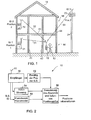
Fig. 1 zeigt ein Gebäudeszenario, in dem eine erfindungsgemäße
mobile Navigationsvorrichtung 10, die von einem Benutzer
12 gehalten wird, eingesetzt werden kann. Schematisch
ist ein Gebäude 14 mit einem Erdgeschoß 16 und einem ersten
Stockwerk 18 dargestellt. In dem Gebäude und dessen Umgebung
ist ein zellulares Funknetz installiert, das eine erste
Basisstation (BS1) 21, eine zweite Basisstation (BS2) 22
und eine dritte Basisstation (BS3) 23 umfaßt. Die erste Basisstation
21 ist im Erdgeschoß 16 des Gebäudes angeordnet.
Die zweite Basisstation 22 ist im ersten Stock des Gebäudes
angeordnet, während die dritte Basisstation 23 außerhalb
des Gebäudes 14, z. B. auf einem Sendemasten 24, plaziert
ist. Die Position jeder Basisstation ist fest vorgegeben.
Jede Basisstation umfaßt ferner eine eigene Basisstations-Identifikation
(ID1, ID2 bzw. ID3). Zwischen der mobilen
Navigationsvorrichtung 10 und der Sendeantenne jeder Basisstation
befindet sich ein Übertragungskanal 31, 32 bzw. 33,
der in Fig. 1 gestrichelt eingezeichnet ist.Fig. 1 shows a building scenario in which an inventive
Die Übertragungskanäle 31, 32 und 33 unterscheiden sich
aufgrund der Gebäudebeschaffenheit und insbesondere des
Grundrisses des Gebäudes 14 folgendermaßen. Der Übertragungskanal
31 von der ersten Basisstation 21 zur mobilen
Navigationsvorrichtung umfaßt zwei Innenwände 41, 42 des
Gebäudes 14. Der Übertragungskanal 32 von der zweiten Basisstation
22 zur mobilen Navigationsvorrichtung 10 umfaßt
dagegen zusätzlich zu den zwei Innenwänden ferner die Decke
43 zwischen dem Obergeschoß 18 und dem Erdgeschoß 16 des
Gebäudes. Der Übertragungskanal 33 von der dritten Basisstation
23 zur mobilen Navigationsvorrichtung erstreckt
sich dagegen durch die Decke 43 und zusätzlich durch eine
Außenwand 44 des Gebäudes. Typischerweise sind die Decke,
Innenwände und Außenwände aus unterschiedlichen Materialien
konstruiert, welche unterschiedliche Dämpfungseigenschaften
für Funksignale haben. Meistens werden Außenwände und Decken
aus Stahlbeton gefertigt sein, welcher eine hohe Dämpfung
für elektromagnetische Wellen liefert, während Innenwände
insbesondere bei Bürobauten zumeist aus Trockenbaumaterialien
bestehen, welche lediglich eine geringe Dämpfung
für elektromagnetische Wellen aufweisen.The
Je nach Anwendungsfall können unterschiedliche Basisstationen
unterschiedliche Richtcharakteristika und Sendefeldstärken
haben. So könnten die Basisstationen 1 und 2 insbesondere
dafür ausgelegt sein, hauptsächlich das jeweilige
Stockwerk zu versorgen, weshalb die Sendeantennen der Basisstationen
21 und 22 eine starke Richtwirkung haben dürften,
während die Basisstation 3 dafür vorgesehen ist, einen
das Gebäude 14 umgebenden Freiraum möglichst gleichmäßig zu
"überstreichen", so daß diese Antenne eine schwache Richtcharakteristik
haben dürfte und eher dafür vorgesehen ist,
ein möglichst rundes Strahlungsdiagramm zu haben. Um hier
entsprechende Reichweiten zu erreichen, dürfte die Basisstation
3 mit einer höheren Sendefeldstärke ausgerüstet
sein. Erfindungsgemäß werden diese Informationen zur Positionsbestimmung
verwendet, wie es nachfolgend erläutert
wird.Depending on the application, different base stations can be used
different directional characteristics and transmission field strengths
to have. So could
Fig. 2 zeigt ein Blockdiagramm einer erfindungsgemäßen mobilen
Navigationsvorrichtung. Die mobile Navigationsvorrichtung
umfaßt einen Empfänger 50 zum Empfangen eines über
eine Antenne 51 erhaltenen Funksignals. Das Funksignal
stammt von einer Basisstation und enthält typischerweise
die Basisstations-Identifikationsnummer, welche dieser Basisstation
fest zugeordnet ist. Die Basisstations-Identifikation
wird von einer Einrichtung 52 zur Ermittlung
der vorgegebenen Position der Basisstation verwendet. Die
Einrichtung 52 könnte beispielsweise eine gespeicherte Tabelle
haben, in der jeder grundsätzlich zu erwartenden Basisstation
Ortskoordinaten bzw. Informationen über die Position
der Basisstation, wie z. B. Zimmer 7 im zweiten
Stock, an der Außenwand befestigt, umfassen können. Durch
einfachen Tabellenzugriff kann die Einrichtung 52 in diesem
Fall die Position der Basisstation ermitteln.2 shows a block diagram of a mobile device according to the invention
Navigation device. The mobile navigation device
includes a
Die erfindungsgemäße mobile Navigationsvorrichtung 10 umfaßt
ferner eine Einrichtung 54 zur Messung der elektrischen
Feldstärke des von der Antenne 51 empfangenen Funksignals.
Die Feldstärkewerte des Funksignals sowie die Position
der Basisstation werden einer Einrichtung 56 zum Berechnen
eines Abstandes der mobilen Navigationsvorrichtung
von der Basisstation zugeführt, damit dieselbe unter Verwendung
der Position der Basisstation Informationen über
die Position der mobilen Navigationsvorrichtung liefern
kann. Hierzu hat die Einrichtung 56 Zugriff auf vorzugsweise
in einem Speicher 58 gespeicherte Informationen über eine
Funkcharakteristik einer betreffenden Basisstation sowie
auf Informationen für ein Kanalmodell, das Übertragungseigenschaften
für das Funksignal in einer Umgebung der Basisstation
beschreibt.The
Existiert lediglich eine einzige aktive Basisstation in dem
zellularen Funknetz, so ist die mobile Navigationsvorrichtung
bereits in der Lage, eine grobe Näherung der Position
dahingehend zu erreichen, daß lediglich ein bestimmter Sektor
existiert, in dem überhaupt Funksignale von der Basisstation
empfangen werden können. Dies geschieht dabei aufgrund
der Basisstations-Identifikation (ID) und der damit
verbundenen Position der Basisstation. Durch Auswertung der
Feldstärkeinformationen unter Verwendung der Sendefeldstärke,
der Richtcharakteristik, also der Funkcharakteristik
der Basisstation, und des Übertragungskanals, kann die erfindungsgemäße
mobile Navigationsvorrichtung bereits einen
groben Abstand berechnen. Die erfindungsgemäße Navigationsvorrichtung
kann dann unter Verwendung z. B. zweier verschiedener
Kanalmodelle, die z. B. berücksichtigen, daß
entweder eine einzige Innenwand oder zwei Innenwände zwischen
dem Empfänger 10 und dem Sender 21 sind, bestimmen,
in welchem Zimmer des Erdgeschosses die mobile Navigationsvorrichtung
angeordnet ist. Dieses "Durchspielen" verschiedener
parametrisierter Kanalmodelle, wobei der Parameter
hier beispielsweise die Anzahl und/oder das Material der
Innenwände ist, verbunden mit einer Plausibilitätsüberprüfung
und unter Umständen bereits vorliegender Historienwerte
ermöglicht daher bereits mit einer einzigen Basisstation
eine relativ genaue Positionsbestimmung oder zumindest eine
Positionsbereichsangabe bezüglich der Basisstation.There is only one active base station in the
cellular radio network, that is the mobile navigation device
already able to roughly approximate the position
to achieve that only a certain sector
exists in which radio signals from the base station exist
can be received. This happens because of
the base station identification (ID) and thus
connected position of the base station. By evaluating the
Field strength information using the transmission field strength,
the directional characteristic, i.e. the radio characteristic
the base station, and the transmission channel, the invention
mobile navigation device already one
calculate rough distance. The navigation device according to the invention
can then z. B. two different
Channel models that e.g. B. take into account that
either a single inner wall or two inner walls between
the
Empfängt der mobile Empfänger Signale von mehreren Basisstationen, deren Position und Charakteristika sowie deren verschiedene Kanalmodelle 31-33 (Fig. 1) der mobilen Navigationsvorrichtung bekannt sind, ist eine noch genauere Positionsbestimmung möglich. Unter Verwendung der Funkcharakteristika von z. B. drei Basisstationen und unter Verwendung verschiedener Kanalmodelle wieder mit der Anzahl der Innenwände bzw. einer Decke oder Außenwand als Parameter in Verbindung mit einer Plausibilitätsprüfung kann die Position der mobilen Navigationsvorrichtung bereits wesentlich genauer bestimmt werden.If the mobile receiver receives signals from several base stations, their position and characteristics as well as their different channel models 31-33 (Fig. 1) of the mobile navigation device are known is an even more precise position determination possible. Using the radio characteristics from Z. B. three base stations and using different channel models again with the number of Inner walls or a ceiling or outer wall as parameters in The position can be linked to a plausibility check the mobile navigation device is already essential can be determined more precisely.
Dies wird anhand des nachfolgenden Beispiels näher erläutert.
Empfängt der Empfänger 10 von Fig. 1 Funksignale der
Basisstationen 21-23, so wird er zunächst die Basisstations-Identifikationen
ermitteln und dann, auf der Basis der
Basisstations-Identifikationen die Funkcharakteristika der
drei Basisstationen, von denen er Funksignale empfängt, herausfinden.
Der Empfänger könnte dann beispielsweise für
die Basisstation ein Kanalmodell zugrunde legen, das lediglich
eine Innenwand umfaßt. Für die Basisstation 2 könnte
er ein Kanalmodell zugrunde legen, das lediglich eine Innenwand
und eine Decke umfaßt. Dies würde bedeuten, daß
sich die mobile Navigationsvorrichtung im mittleren Raum
des Erdgeschosses 16 des Gebäudes 14 von Fig. 1 befinden
würde. Obgleich das empfangene Signal der Basisstation 2 im
Vergleich zum Signal der Basisstation 1 als zu schwach identifiziert
werden würde, sei aus Darstellungsgründen angenommen,
daß dieser Unterschied noch nicht an der Plausibilitätsgrenze
scheitert. Bei der Auswertung des Signals
von der Basisstation 3 wird die Navigationsvorrichtung jedoch
feststellen, daß die empfangene Feldstärke für ein Modell
einer Außenwand, einer Innenwand und einer Decke, das
zutreffen würde, wenn sich die mobile Navigationsvorrichtung
im mittleren Raum des Erdgeschosses befinden würde, zu
stark ist. Eine Plausibilitätsüberprüfung wird daher zu dem
Ergebnis kommen, daß sich die mobile Navigationsvorrichtung
nicht im mittleren Raum des Erdgeschosses befinden kann.
Unter Verwendung der Grundrißinformationen des Gebäudes
wird daher als nächster Schritt eine Kanalmodell-Situation
berücksichtigt, bei der sich der Benutzer, wie in Fig. 1
gezeichnet, im rechten Raum des Erdgeschosses 16 befindet.
Hier wird die mobile Navigationsvorrichtung eine sinnvolle
plausible Übereinstimmung der drei Empfangssignale von den
drei Basisstationen feststellen, so daß eine Abstands-Auswertung
und anschließende Positionsbestimmung beispielsweise
durch Triangulationsverfahren, durchgeführt werden
kann.This is explained in more detail using the example below.
1 receives radio signals from
Base stations 21-23, so it first becomes the base station identifications
determine and then, based on the
Base station identifications the radio characteristics of the
find out three base stations from which it receives radio signals.
The recipient could then, for example, for
the base station is based on a channel model that only
includes an inner wall. For
Das oben beschriebene Beispiel macht deutlich, daß das Vorliegen
parametrisierter Kanalmodelle in Verbindung mit einer
schrittweisen Plausibilitätsüberprüfung auf der Basis
von Gebäude-Grundrißdaten zunächst eine Groborientierung
des Benutzers 12 ermöglicht, um dann auf der Basis der Groborientierung
eine Fein-Lokalisation in dem mittels der
Groborientierung herausgefundenen Raum zu erreichen. Eine
abschließende Plausibilitätskontrolle kann schließlich sicherstellen,
daß kein nicht-möglicher Wert berechnet worden
ist. Der Benutzer 12 kann sicher nicht außerhalb des rechten
oder linken Raums des Obergeschosses 18 stehen, sondern
er kann, falls er außerhalb des Gebäudes 14 angeordnet ist,
nur am Erdboden sein, jedoch nicht in der "Luft" stehen.The example described above makes it clear that the existence
parameterized channel models in connection with a
step-by-step plausibility check on the basis
a rough orientation of building floor plan data
of the
Bei einem bevorzugten Ausführungsbeispiel der vorliegenden
Erfindung umfaßt die mobile Navigationsvorrichtung neben
dem Empfängersystem 50 zur Erfassung der Basisstations-Identifikation
und zur RSSI-Datenerfassung, um alle zu einem
Zeitpunkt empfangbaren Signale von einzelnen Basisstationen
zu umfassen, auch eine sogenannte RSSI-Smoothing-Einheit
in der Einrichtung 56, welche die gemessenen RSSI-Werte
algorithmisch unter Verwendung der Basisstationsparameter,
mathematischer Kanalmodelle, Grundrißdaten des Gebäudes
und durch die Auswertung parametrisierter Umgebungsdaten
des Gebäudes korrigiert.In a preferred embodiment of the present
Invention includes the mobile navigation device in addition
the
Die mobile Navigationsvorrichtung ist vorzugsweise in einem tragbaren Endgerät, d. h. einem PDA, einem Mobiltelephon, einem Notebook, einer Uhr etc. angeordnet, um die Positionierungsalgorithmen, die Navigationsfunktionalität und vorzugsweise eine Ausgabe in Form von Sprache oder Graphik der Ergebnisse und Hilfestellungen für einen Benutzer zu liefern, wobei die mobile Navigationsvorrichtung ferner eine Eingabeschnittstelle aufweist, damit der Benutzer spezielle Fragen an die mobile Navigationsvorrichtung richten kann.The mobile navigation device is preferably in one portable terminal, d. H. a PDA, a cell phone, a notebook, a clock, etc. to position the positioning algorithms, the navigation functionality and preferably an output in the form of speech or graphics of the Provide results and help for a user the mobile navigation device further comprising a Has input interface so the user special Can direct questions to the mobile navigation device.
Die Einrichtung 56 zum Berechnen umfaßt ferner ein Modul, um die Distanzen aus den vorzugsweise optimierten RSSI-Meßwerten zu berechnen.The means 56 for calculating further comprises a module, the distances from the preferably optimized RSSI measured values to calculate.
Die mobile Navigationsvorrichtung umfaßt ferner vorzugsweise ein Positionierungsmodul, welches durch Verwendung angepaßter rekursiver und heuristischer Verfahren, wie z. B. unter Verwendung eines Kalman-Filters, kontinuierlich eine Positionsberechnung durchführt.The mobile navigation device preferably further comprises a positioning module, which is adapted by using recursive and heuristic procedures, such as B. using a Kalman filter, one continuously Carries out position calculation.
Ein Optimierungsmodul, welches auf der Basis logischer Auswertungen der Grundrißdaten und daraus resultierenden Plausibilitätsprüfungen des Gebäudes arbeitet, trägt zu einer weiteren Optimierung der im Positionierungsmodul ermittelten Position bei. Schließlich kann erfindungsgemäß ein weiteres Modul vorgesehen sein, welches durch Verwendung der optimierten Position des Benutzers die von einem Benutzer angeforderten Hilfestellung erzeugt und an den Benutzer in Sprache, graphisch etc. ausgibt.An optimization module, which is based on logical evaluations the floor plan data and the resulting plausibility checks of the building works, contributes to one further optimization of those determined in the positioning module Position at. Finally, according to the invention, another Be provided module, which by using the optimized position of the user by a user requested assistance is generated and sent to the user in Outputs language, graphic etc.
Die erfindungsgemäße mobile Navigationsvorrichtung kann dadurch ergänzt werden, daß für die benötigten Umgebungsdaten hinsichtlich der Kanalmodelle eine eigene Infrastruktur von Referenzsendern, Sensorik und anderen externen Informationsquellen bereitgestellt wird. Diese zusätzliche Infrastruktur kann dazu verwendet werden, die mobile Navigationsvorrichtung ständig zu aktualisieren, um einen adaptiven Betrieb der Navigationsvorrichtung in verschiedenen Umgebungen zu ermöglichen. Die Adaptivität ist einerseits dann sinnvoll, wenn Veränderungen an einem Gebäude stattfinden. Die Adaptivität ist jedoch dann von wesentlicher Bedeutung, wenn die mobile Navigationsvorrichtung universell für verschiedenen Umgebungen benutzt werden soll. So wird es irgendwann an Speicherressourcen mangeln, wenn Umgebungsdaten bzw. Kanalmodelle für nicht nur einen einzigen Flughafen, sondern für mehrere Flughäfen bzw. Hotels eingespeist werden sollen. In diesem Fall wird es bevorzugt, einen eigenen Referenzsender bereitzustellen, der ständig Kanalparameter erzeugt und überträgt, damit eine mobile Navigationsvorrichtung, die in den Bereich des Senders kommt, diese übertragenen Daten abspeichern kann, um für eine neue Umgebung mit Umgebungsdaten gerüstet zu sein.The mobile navigation device according to the invention can thereby be added that for the required environmental data own infrastructure of Reference transmitters, sensors and other external information sources provided. This additional infrastructure can be used the mobile navigation device constantly update to an adaptive Operation of the navigation device in different environments to enable. The adaptivity is then on the one hand useful when changes are made to a building. However, adaptivity is essential when the mobile navigation device is universal for different Environments should be used. It will be like this at some point lack memory resources when environmental data or channel models for not just a single airport, but are fed in for several airports or hotels should. In this case, it is preferred to own one Provide reference transmitter that constantly channel parameters generated and transmitted so that a mobile navigation device, that comes in the area of the transmitter, these transmitted Data can be saved in order for a new environment to be equipped with environmental data.
Die adaptive Funktionalität ermöglicht ferner, wenn sie in ein und demselben System angewendet wird, eine noch genauere Ermittlung der Distanz der mobilen Navigationsvorrichtung von verschiedenen Basisstationen und führt damit zu einer Erhöhung der Stabilität des Systems und der Positionsgenauigkeit.The adaptive functionality also allows when in one and the same system is used, an even more precise one Determining the distance of the mobile navigation device from different base stations and thus leads to an increase in the stability of the system and the positional accuracy.
Eine zusätzliche Durchführung statistischer Auswertungen der ermittelten RSSI-Daten führt ebenfalls zu einer Erhöhung der Genauigkeit.An additional implementation of statistical evaluations the RSSI data determined also leads to an increase of accuracy.
Ferner wird es bevorzugt, zumindest zwei Antennen an der mobilen Navigationsvorrichtung anzubringen, um durch das erreichte Antennen-Diversity gegenüber Mehrwegeausbreitungen bzw. konstruktiven und destruktiven Interferenzen unempfindlicher zu sein, was ebenfalls in einer genaueren und zuverlässigeren Bestimmung der RSSI-Werte resultieren wird.It is also preferred to have at least two antennas on the mobile navigation device to install through the achieved antenna diversity compared to multipath propagation or constructive and destructive interference less sensitive to be what is also in a more precise and more reliable determination of the RSSI values result becomes.
Die mobile Navigationsvorrichtung kann ferner um einen Kompaß ergänzt werden, um die räumliche Orientierung des Benutzers zu verbessern.The mobile navigation device can also be a compass to be supplemented by the spatial orientation of the user to improve.
Wird in der mobilen Kommunikationsvorrichtung ferner ein zusätzliches inertiales Sensor-System beispielsweise mit Geschwindigkeits- oder Beschleunigungssensoren, eingesetzt, die auf spezielle Applikationen, wie z. B. Laufen, Fahren, etc., angepaßt sind, so ermöglicht dies eine ebenfalls optimierte Positions- und Orientierungsbestimmung. Insbesondere muß dann eine Grob-Positionierung, wie sie vorstehend beschrieben worden ist, seltener durchgeführt werden, da ausgehend von einer ersten Positionsbestimmung, unter Verwendung der Beschleunigungssensoren der weitere Weg der mobilen Navigationsvorrichtung gewissermaßen ohne Hilfe des zellularen Funknetzes bestimmt wird, und nur ab und an zur Verifikation der Daten wieder Basisstations-Funksignale empfangen und ausgewertet werden. Das "bordeigene" Sensorsystem leistet auch eine Navigationsmöglichkeit, wenn in einem Gebäude keine ausreichende Funkfeldstärke vorhanden ist, beispielsweise aufgrund von destruktiven Interferenzen. In einem solchen Fall kann das eigene Navigationssystem verwendet werden. Es muß also nicht in jedem Fall auf die Navigation mittels Telefonsignal vertraut werden. Damit kann insgesamt die Genauigkeit des Systems verbessert werden.Also becomes a in the mobile communication device additional inertial sensor system, for example with Speed or acceleration sensors, used, which are based on special applications, e.g. B. running, driving, etc., are adapted, so this also enables an optimized Determination of position and orientation. In particular must then be roughly positioned as above has been described, can be performed less frequently because starting from a first position determination, using acceleration sensors the further way of mobile Navigation device to a certain extent without the help of cellular radio network is determined, and only once in a while Verification of the data again base station radio signals be received and evaluated. The "on-board" sensor system also provides navigation when in there is insufficient radio field strength in a building due to, for example, destructive interference. In such a case, your own navigation system be used. So it doesn't have to be in every case navigation by means of a telephone signal. In order to the overall accuracy of the system can be improved.
Um die Vielseitigkeit und Flexibilität zu verbessern, wird es ferner bevorzugt, nicht nur einem Empfänger für ein zellulares Funksystem, wie z. B. das DECT-System oder ein DECT-Derivat bereitzustellen, sondern auch für andere Systeme, wie z. B. WLAN, Bluetooth. Damit kann die Flächendeckung des Navigationssystems und die Genauigkeit der Positionsbestimmung verbessert werden. Diese Funktionalität ermöglicht es einem Benutzer ferner, seine mobile Navigationsvorrichtung nicht nur in einem DECT-System zu verwenden, sondern auch in beliebigen anderen Systemen, was besonders für Reisende von Vorteil sein dürfte.To improve versatility and flexibility it further prefers not just a receiver for a cellular Radio system, such as B. the DECT system or a To provide DECT derivative, but also for other systems, such as B. WLAN, Bluetooth. This can cover the area of the navigation system and the accuracy of the position determination be improved. This functionality enables it further a user, his mobile navigation device not only to be used in a DECT system, but also in any other systems, which is special should be advantageous for travelers.
Ein wesentlicher Vorteil des erfindungsgemäßen Konzepts besteht darin, daß eine rein passive Realisierung ermöglicht und bevorzugt wird. Es wird also keine Subskription, Anmeldung etc. am Netzwerk notwendig. Dadurch lassen sich insbesondere vorhandene Systeme, wie z. B. DECT-Telephonanlagen in Bürogebäuden, Flughäfen etc., ohne technische Erweiterung verwenden. Mobile Systeme mit Positionsbestimmung lassen sich daher einfach ohne Administrationsaufwand der Telephonanlage in das System einbringen und betreiben. Durch das passive Verhalten entstehen ferner keine störenden Einflüsse auf die Funktionalität und Verfügbarkeit der Funktelephonanlage.There is a major advantage of the concept according to the invention in that a purely passive realization enables and is preferred. So there is no subscription, registration etc. necessary on the network. This allows in particular existing systems, such as B. DECT telephone systems in office buildings, airports etc., without technical expansion use. Leave mobile systems with position determination therefore simply without administration of the telephone system introduce and operate in the system. By the passive behavior also has no disruptive influences on the functionality and availability of the radio telephone system.
Das erfindungsgemäße Konzept zeichnet sich ferner durch seine Parametrisierbarkeit unter Verwendung von Kanalmodellen, Basisstationsinformationen bzw. Umgebungsinformationen als Parameter, aus und ist an unterschiedliche Umgebungen adaptierbar bzw. dynamisch vor Ort nachladbar.The concept according to the invention is also characterized by its parameterizability using channel models, Base station information or environment information as a parameter, from and is to different environments adaptable or dynamically reloadable on site.
Besonders günstig kann das erfindungsgemäße Konzept in synchronen Netzwerken, wie z. B. einem zellulären DECT-Netzwerk eingesetzt werden, da RSSI-Werte zu verschiedenen Basisstationen nahezu simultan gemessen werden können, da ein DECT-Frame lediglich 10 ms umfaßt, wobei in diesem 10 ms-Frame sämtliche Basisstationen senden. Eine genaue Positionsbestimmung ist in einem solchen synchronen Netzwerk daher auch für eine sich relativ zügig bewegende mobile Navigationsvorrichtung möglich. Die zeitliche Auflösung der mobilen Navigationsvorrichtung ist in synchronen Netzwerken daher besonders gut, da die feste Beziehung der Sendeeigenschaften des Basisstationen zueinander ausgenutzt werden kann.The concept according to the invention can be particularly favorable in synchronism Networks such as B. a cellular DECT network can be used as RSSI values differ Base stations can be measured almost simultaneously because a DECT frame comprises only 10 ms, in which 10 Send all base stations to ms-Frame. An exact position determination is in such a synchronous network therefore also for a mobile navigation device moving relatively quickly possible. The temporal resolution of the mobile navigation device is in synchronous networks therefore particularly good since the fixed relationship of the transmission properties of the base stations can be used to each other can.
Die mobile Navigationsvorrichtung kann z. B. in einem PDA untergebracht werden. Dieser wird mit einer DECT-PCMCIA-Einsteckkarte erweitert. Damit können durch das DECT-Modul die Basisstationen und die dazugehörigen RSSI-Werte ermittelt werden. Eine Treiber-Software kann dann sämtliche weiteren Einrichtungen, die in Fig. 2 gezeigt sind, in Verbindung mit dem Prozessor des PDA realisieren, und kann ferner eine Visualisierungsoberfläche liefern, auf der auf Anfrage Positionsdaten zur Verfügung gestellt werden können. Als Eingabeparameter verwendet die Treiber-Software Informationen über die Basisstationen, die Umgebung und weitere Konfigurationsdaten. Damit existiert ein Führungs- oder Informationssystem, das die mobile Kommunikationsvorrichtung gemäß der vorliegenden Erfindung umfaßt, welches preisgünstig ist, flexibel einsetzbar ist und genaue Informationen liefert.The mobile navigation device can e.g. B. in a PDA be accommodated. This comes with a DECT-PCMCIA plug-in card extended. This allows the DECT module the base stations and the associated RSSI values determined become. A driver software can then all other Devices shown in Fig. 2 in connection realize with the processor of the PDA, and can also provide a visualization interface on which on request Position data can be made available. As The driver software uses input parameters for information about the base stations, the environment and other configuration data. So there is a management or information system that the mobile communication device according to of the present invention, which is inexpensive is flexible in use and provides precise information.
Claims (19)
wobei die Einrichtung (56) zum Berechnen des Abstandes ferner ausgebildet ist, um unter Verwendung eines ersten Kanalmodells der Mehrzahl von Kanalmodellen eine erste Position bezüglich des Gebäudes zu bestimmen, um unter Verwendung eines zweiten Kanalmodells der Mehrzahl von Kanalmodellen eine zweite Position bezüglich des Gebäudes zu bestimmen, und um aufgrund einer Plausibilitätsüberprüfung der ersten und der zweiten Position einen Raum bezüglich der Grundrisses des Gebäudes zu bestimmen, in dem sich die mobile Navigationsvorrichtung befindet.Mobile navigation device for a cellular radio network, which is arranged in and / or around a building (14) and has at least one base station (21, 22, 23) with a base station identification (ID1, ID2, ID3), the base station being on is arranged in a predetermined position, with the following features:
the means (56) for calculating the distance being further configured to determine a first position with respect to the building using a first channel model of the plurality of channel models, and to determine a second position with respect to the building using a second channel model of the plurality of channel models determine, and in order to determine, based on a plausibility check of the first and the second position, a space with respect to the floor plan of the building in which the mobile navigation device is located.
wobei die mobile Navigationsvorrichtung ferner einen Speicher aufweist, in dem die vorgegebene Position der Basisstation in Zuordnung zu der Basisstations-Identifikation jeder Basisstation gespeichert ist, und bei der die Einrichtung (56) zum Berechnen angeordnet ist, um unter Verwendung von Funksignalen der Mehrzahl von Basisstationen Ortskoordinaten der Navigationsvorrichtung zu berechnen.A mobile navigation device according to claim 1 or 2, wherein the cellular radio network has a plurality of base stations (21, 22, 23), each base station being arranged at a predetermined position and having its own base station identification, and
the mobile navigation device further comprising a memory in which the predetermined position of the base station is stored in association with the base station identification of each base station and in which the means (56) is arranged to calculate using radio signals of the plurality of base stations To calculate location coordinates of the navigation device.
bei der die Funkcharakteristik (58) ein Antennendiagramm und eine Sendefeldstärke der Basisstation aufweist.Mobile navigation device according to one of the preceding claims,
in which the radio characteristic (58) has an antenna diagram and a transmission field strength of the base station.
bei der das zellulare Funknetz ein synchrones Funknetz ist, bei dem vorhandene Basisstationen in einer festen Beziehung hinsichtlich der Zeit und/oder der Frequenz zueinander stehen, und
bei der der Empfänger (50) angeordnet ist, um in Kenntnis der festen Beziehung Funksignale der Basisstationen zu empfangen.Mobile navigation device according to one of the preceding claims,
in which the cellular radio network is a synchronous radio network in which existing base stations have a fixed relationship with respect to time and / or frequency, and
in which the receiver (50) is arranged to receive radio signals of the base stations knowing the fixed relationship.
bei der die Mehrzahl von Kanalmodellen parametrisiert sind, wobei ein Parameter eine Anzahl und/oder ein Material von Innenwänden des Gebäudes ist.Mobile navigation device according to one of claims 2 to 6,
in which the plurality of channel models are parameterized, one parameter being a number and / or a material of inner walls of the building.
die ferner ein Positionierungsmodul aufweist, das unter Verwendung von rekursiven und/oder heuristischen Verfahren eine kontinuierliche Positionsberechnung durchführt.Mobile navigation device according to one of the preceding claims,
which furthermore has a positioning module which carries out a continuous position calculation using recursive and / or heuristic methods.
bei der der Empfänger (50) eine Mehrzahl von Antennen aufweist, und
bei der die Einrichtung (56) zum Berechnen des Abstandes angeordnet ist, um über die Mehrzahl von Antennen empfangene Funksignale derselben Basisstation zu verwenden.Mobile navigation device according to one of the preceding claims,
in which the receiver (50) has a plurality of antennas, and
wherein the distance calculating means (56) is arranged to use radio signals received from the plurality of antennas of the same base station.
bei der das zellulare Funknetz angeordnet ist, um über zumindest einen Referenzsender der mobilen Navigationsvorrichtung Informationen über eine Funkstrecke von einer Basisstation zu der Navigationsvorrichtung zur Verfügung zu stellen, und
bei der der Empfänger (50) angeordnet ist, um die Informationen zu empfangen, und
bei der die Einrichtung (56) zum Berechnen die Informationen berücksichtigt.Mobile navigation device according to one of the preceding claims,
in which the cellular radio network is arranged to provide information about a radio link from a base station to the navigation device via at least one reference transmitter of the mobile navigation device, and
at which the receiver (50) is arranged to receive the information, and
in which the computing means (56) takes into account the information.
bei der die Einrichtung zum Berechnen (56) angeordnet ist, um bei den Informationen über die Position ein Ausgangssignal des Beschleunigungssensors zu berücksichtigen.Mobile navigation device according to one of the preceding claims, further comprising an acceleration sensor, and
in which the device for calculating (56) is arranged to take into account an output signal of the acceleration sensor in the information about the position.
die ferner einen Kompaß aufweist.Mobile navigation device according to one of the preceding claims,
which also has a compass.
bei der der Empfänger (50) angeordnet ist, um Funksignale von zumindest zwei zellularen Funknetzen, die nach einer unterschiedlichen Spezifikation arbeiten, zu empfangen.Mobile navigation device according to one of the preceding claims,
in which the receiver (50) is arranged to receive radio signals from at least two cellular radio networks which operate according to a different specification.
wobei im Schritt des Berechnens unter Verwendung eines ersten Kanalmodells der Mehrzahl von Kanalmodellen eine erste Position bezüglich des Gebäudes bestimmt wird, wobei unter Verwendung eines zweiten Kanalmodells der Mehrzahl von Kanalmodellen eine zweite Position bezüglich des Gebäudes bestimmt wird, und wobei aufgrund einer Plausibilitätsüberprüfung der ersten und der zweiten Position ein Raum bezüglich der Grundrisses des Gebäudes bestimmt wird, in dem sich die mobile Navigationsvorrichtung befindet.Method for providing navigation information in a cellular radio network which is arranged in and / or around a building (14) and which has at least one base station (21, 22, 23) with a base station identification (ID1, ID2, ID3), the base station being arranged at a predetermined position, with the following steps:
wherein in the step of calculating using a first channel model of the plurality of channel models, a first position with respect to the building is determined, using a second channel model of the plurality of channel models with determining a second position with respect to the building, and wherein based on a plausibility check of the first and in the second position, a space is determined with respect to the floor plan of the building in which the mobile navigation device is located.
Applications Claiming Priority (2)
| Application Number | Priority Date | Filing Date | Title |
|---|---|---|---|
| DE10142156A DE10142156B4 (en) | 2001-08-29 | 2001-08-29 | Mobile navigation apparatus for a cellular radio network and method for providing navigation information |
| DE10142156 | 2001-08-29 |
Publications (3)
| Publication Number | Publication Date |
|---|---|
| EP1288673A2 true EP1288673A2 (en) | 2003-03-05 |
| EP1288673A3 EP1288673A3 (en) | 2005-08-03 |
| EP1288673B1 EP1288673B1 (en) | 2007-03-21 |
Family
ID=7696879
Family Applications (1)
| Application Number | Title | Priority Date | Filing Date |
|---|---|---|---|
| EP02019018A Expired - Lifetime EP1288673B1 (en) | 2001-08-29 | 2002-08-26 | Mobile navigation device for a cellular radio network |
Country Status (6)
| Country | Link |
|---|---|
| EP (1) | EP1288673B1 (en) |
| AT (1) | ATE357672T1 (en) |
| DE (2) | DE10142156B4 (en) |
| DK (1) | DK1288673T3 (en) |
| ES (1) | ES2281481T3 (en) |
| PT (1) | PT1288673E (en) |
Cited By (3)
| Publication number | Priority date | Publication date | Assignee | Title |
|---|---|---|---|---|
| WO2004098941A1 (en) * | 2003-05-07 | 2004-11-18 | Dawson, Nicole | Accelerator pedal signal controller |
| FR2866774A1 (en) * | 2004-02-23 | 2005-08-26 | France Telecom | Terminal locating method for use in e.g. room of building, involves comparing radiation power received from terminals with power values stored in database, where values correspond to position of terminal with respect to terminals |
| EP1762113A1 (en) * | 2004-06-30 | 2007-03-14 | SK Telecom. Co., Ltd. | Method of providing alarm service upon movement out of safety zone |
Families Citing this family (3)
| Publication number | Priority date | Publication date | Assignee | Title |
|---|---|---|---|---|
| DE102005026788A1 (en) * | 2005-06-10 | 2006-12-21 | Deutsche Telekom Ag | Method and system for locating a mobile WLAN client |
| DE102011011528B4 (en) | 2011-02-17 | 2018-04-26 | Johannes Feuchter | System and method for determining at least one altitude position within a building |
| DE102016200010A1 (en) * | 2016-01-04 | 2017-07-06 | Siemens Schweiz Ag | Calibration of the position of mobile objects in buildings |
Citations (2)
| Publication number | Priority date | Publication date | Assignee | Title |
|---|---|---|---|---|
| GB2329801A (en) * | 1996-03-22 | 1999-03-31 | Matsushita Electric Ind Co Ltd | System for the detection of the position of a radio mobile station |
| EP1109031A1 (en) * | 1999-12-10 | 2001-06-20 | Ascom Systec AG | Method and apparatus to localise a mobile terminal |
Family Cites Families (5)
| Publication number | Priority date | Publication date | Assignee | Title |
|---|---|---|---|---|
| US5208756A (en) * | 1991-01-28 | 1993-05-04 | Song Han L | Vehicle locating and navigating system |
| US5404376A (en) * | 1993-09-09 | 1995-04-04 | Ericsson-Ge Mobile Communications Inc. | Navigation assistance for call handling in mobile telephone systems |
| US5613205A (en) * | 1995-03-31 | 1997-03-18 | Telefonaktiebolaget Lm Ericsson | System and method of locating a mobile terminal within the service area of a cellular telecommunication system |
| US5657487A (en) * | 1995-06-05 | 1997-08-12 | Airnet Communications Corporation | Mobile telephone location process making use of handoff data |
| DE19703916C2 (en) * | 1997-02-03 | 2001-05-23 | Deutsche Telekom Mobil | Method for predicting the building attenuation for radio signals |
-
2001
- 2001-08-29 DE DE10142156A patent/DE10142156B4/en not_active Expired - Fee Related
-
2002
- 2002-08-26 EP EP02019018A patent/EP1288673B1/en not_active Expired - Lifetime
- 2002-08-26 DE DE50209751T patent/DE50209751D1/en not_active Expired - Lifetime
- 2002-08-26 AT AT02019018T patent/ATE357672T1/en active
- 2002-08-26 DK DK02019018T patent/DK1288673T3/en active
- 2002-08-26 PT PT02019018T patent/PT1288673E/en unknown
- 2002-08-26 ES ES02019018T patent/ES2281481T3/en not_active Expired - Lifetime
Patent Citations (2)
| Publication number | Priority date | Publication date | Assignee | Title |
|---|---|---|---|---|
| GB2329801A (en) * | 1996-03-22 | 1999-03-31 | Matsushita Electric Ind Co Ltd | System for the detection of the position of a radio mobile station |
| EP1109031A1 (en) * | 1999-12-10 | 2001-06-20 | Ascom Systec AG | Method and apparatus to localise a mobile terminal |
Non-Patent Citations (1)
| Title |
|---|
| BAHL P ET AL: "RADAR: an in-building RF-based user location and tracking system" INFOCOM 2000. NINETEENTH ANNUAL JOINT CONFERENCE OF THE IEEE COMPUTER AND COMMUNICATIONS SOCIETIES. PROCEEDINGS. IEEE TEL AVIV, ISRAEL 26-30 MARCH 2000, PISCATAWAY, NJ, USA,IEEE, US, Bd. 2, 26. M{rz 2000 (2000-03-26), Seiten 775-784, XP010376167 ISBN: 0-7803-5880-5 * |
Cited By (5)
| Publication number | Priority date | Publication date | Assignee | Title |
|---|---|---|---|---|
| WO2004098941A1 (en) * | 2003-05-07 | 2004-11-18 | Dawson, Nicole | Accelerator pedal signal controller |
| FR2866774A1 (en) * | 2004-02-23 | 2005-08-26 | France Telecom | Terminal locating method for use in e.g. room of building, involves comparing radiation power received from terminals with power values stored in database, where values correspond to position of terminal with respect to terminals |
| EP1575328A1 (en) * | 2004-02-23 | 2005-09-14 | France Telecom | Method and device for the localisation of a terminal in a wireless LAN |
| EP1762113A1 (en) * | 2004-06-30 | 2007-03-14 | SK Telecom. Co., Ltd. | Method of providing alarm service upon movement out of safety zone |
| EP1762113A4 (en) * | 2004-06-30 | 2012-09-05 | Sk Planet Co Ltd | Method of providing alarm service upon movement out of safety zone |
Also Published As
| Publication number | Publication date |
|---|---|
| DE50209751D1 (en) | 2007-05-03 |
| PT1288673E (en) | 2007-04-30 |
| EP1288673A3 (en) | 2005-08-03 |
| DE10142156A1 (en) | 2003-04-03 |
| ATE357672T1 (en) | 2007-04-15 |
| DK1288673T3 (en) | 2007-06-25 |
| DE10142156B4 (en) | 2006-01-19 |
| EP1288673B1 (en) | 2007-03-21 |
| ES2281481T3 (en) | 2007-10-01 |
Similar Documents
| Publication | Publication Date | Title |
|---|---|---|
| EP1769261B1 (en) | Device and method for determining the current position of a mobile device | |
| EP2999973B1 (en) | Mobile portable device and position determination | |
| EP2335442B1 (en) | Apparatus and method for estimating an orientation of a mobile terminal | |
| DE60319571T2 (en) | DISTANCE DETERMINATION AND POSITIONING METHOD AND DEVICE | |
| DE102013104727A1 (en) | Method and apparatus for determining the position of a mobile communication device | |
| WO2017097905A1 (en) | Method and device for high-precision position determining of a mobile device and method for locating or positioning stationary devices | |
| WO2012130811A1 (en) | Location-dependent selection of a radio-based localization method for a mobile terminal | |
| EP1109031A1 (en) | Method and apparatus to localise a mobile terminal | |
| DE10142156B4 (en) | Mobile navigation apparatus for a cellular radio network and method for providing navigation information | |
| DE112015005451T5 (en) | Wireless positioning system, wireless positioning terminal and point information transmitter | |
| DE10393398T5 (en) | A system and method for assisting position determination in a position determination system | |
| EP1153314B1 (en) | Method and device for determining a position | |
| EP3959483A1 (en) | Access control system and method for operating an access control system | |
| WO2020074360A1 (en) | System and method for position determination in a building | |
| DE102014101296A1 (en) | Determining the position of a user terminal by means of sound waves | |
| EP1482323B1 (en) | Method and system for identification and location of objects | |
| DE102015209755A1 (en) | ID transmitter based determination of particular body dimensions for a particular seat adjustment in a motor vehicle | |
| DE102012214190A1 (en) | Method for determining position of moving object i.e. persons, in inner area environment e.g. tunnel, involves assigning signal sources to distribution assemblies, and deriving position of object from combination of values and signal | |
| DE102009039879B4 (en) | Method for controlling the release of a device or a service, a transceiver device designed as a master and a system having such a device | |
| EP1555845A1 (en) | Method for location determination of subscriber stations of a radio communications system | |
| DE10221649A1 (en) | Position finding method e.g. for mobile RF systems, requires taking average errors of reference positions into account | |
| WO2019063132A1 (en) | Device for supporting the mobility of visually impaired people in road traffic | |
| EP3141922B1 (en) | Method and apparatus for improved positioning | |
| EP3816650A1 (en) | Method and assembly for determining the position of a mobile communication terminal | |
| DE102014204365A1 (en) | Method for locating a mobile station |
Legal Events
| Date | Code | Title | Description |
|---|---|---|---|
| PUAI | Public reference made under article 153(3) epc to a published international application that has entered the european phase |
Free format text: ORIGINAL CODE: 0009012 |
|
| AK | Designated contracting states |
Kind code of ref document: A2 Designated state(s): AT BE BG CH CY CZ DE DK EE ES FI FR GB GR IE IT LI LU MC NL PT SE SK TR |
|
| AX | Request for extension of the european patent |
Extension state: AL LT LV MK RO SI |
|
| RAP1 | Party data changed (applicant data changed or rights of an application transferred) |
Owner name: FRAUNHOFER-GESELLSCHAFT ZUR FOERDERUNG DERANGEWAND |
|
| PUAL | Search report despatched |
Free format text: ORIGINAL CODE: 0009013 |
|
| AK | Designated contracting states |
Kind code of ref document: A3 Designated state(s): AT BE BG CH CY CZ DE DK EE ES FI FR GB GR IE IT LI LU MC NL PT SE SK TR |
|
| AX | Request for extension of the european patent |
Extension state: AL LT LV MK RO SI |
|
| 17P | Request for examination filed |
Effective date: 20060124 |
|
| AKX | Designation fees paid |
Designated state(s): AT BE BG CH CY CZ DE DK EE ES FI FR GB GR IE IT LI LU MC NL PT SE SK TR |
|
| GRAP | Despatch of communication of intention to grant a patent |
Free format text: ORIGINAL CODE: EPIDOSNIGR1 |
|
| RAP1 | Party data changed (applicant data changed or rights of an application transferred) |
Owner name: FRAUNHOFER-GESELLSCHAFT ZUR FOERDERUNG DER ANGEWAN |
|
| GRAS | Grant fee paid |
Free format text: ORIGINAL CODE: EPIDOSNIGR3 |
|
| GRAA | (expected) grant |
Free format text: ORIGINAL CODE: 0009210 |
|
| AK | Designated contracting states |
Kind code of ref document: B1 Designated state(s): AT BE BG CH CY CZ DE DK EE ES FI FR GB GR IE IT LI LU MC NL PT SE SK TR |
|
| REG | Reference to a national code |
Ref country code: GB Ref legal event code: FG4D Free format text: NOT ENGLISH |
|
| REG | Reference to a national code |
Ref country code: CH Ref legal event code: EP |
|
| REG | Reference to a national code |
Ref country code: PT Ref legal event code: SC4A Free format text: AVAILABILITY OF NATIONAL TRANSLATION Effective date: 20070409 |
|
| REF | Corresponds to: |
Ref document number: 50209751 Country of ref document: DE Date of ref document: 20070503 Kind code of ref document: P |
|
| REG | Reference to a national code |
Ref country code: IE Ref legal event code: FG4D Free format text: LANGUAGE OF EP DOCUMENT: GERMAN |
|
| REG | Reference to a national code |
Ref country code: SE Ref legal event code: TRGR |
|
| REG | Reference to a national code |
Ref country code: GR Ref legal event code: EP Ref document number: 20070401481 Country of ref document: GR |
|
| REG | Reference to a national code |
Ref country code: DK Ref legal event code: T3 |
|
| GBT | Gb: translation of ep patent filed (gb section 77(6)(a)/1977) |
Effective date: 20070608 |
|
| ET | Fr: translation filed | ||
| REG | Reference to a national code |
Ref country code: ES Ref legal event code: FG2A Ref document number: 2281481 Country of ref document: ES Kind code of ref document: T3 |
|
| PG25 | Lapsed in a contracting state [announced via postgrant information from national office to epo] |
Ref country code: SK Free format text: LAPSE BECAUSE OF FAILURE TO SUBMIT A TRANSLATION OF THE DESCRIPTION OR TO PAY THE FEE WITHIN THE PRESCRIBED TIME-LIMIT Effective date: 20070321 |
|
| PG25 | Lapsed in a contracting state [announced via postgrant information from national office to epo] |
Ref country code: CZ Free format text: LAPSE BECAUSE OF FAILURE TO SUBMIT A TRANSLATION OF THE DESCRIPTION OR TO PAY THE FEE WITHIN THE PRESCRIBED TIME-LIMIT Effective date: 20070321 |
|
| PLBE | No opposition filed within time limit |
Free format text: ORIGINAL CODE: 0009261 |
|
| STAA | Information on the status of an ep patent application or granted ep patent |
Free format text: STATUS: NO OPPOSITION FILED WITHIN TIME LIMIT |
|
| 26N | No opposition filed |
Effective date: 20071227 |
|
| PG25 | Lapsed in a contracting state [announced via postgrant information from national office to epo] |
Ref country code: MC Free format text: LAPSE BECAUSE OF NON-PAYMENT OF DUE FEES Effective date: 20070831 |
|
| PG25 | Lapsed in a contracting state [announced via postgrant information from national office to epo] |
Ref country code: EE Free format text: LAPSE BECAUSE OF FAILURE TO SUBMIT A TRANSLATION OF THE DESCRIPTION OR TO PAY THE FEE WITHIN THE PRESCRIBED TIME-LIMIT Effective date: 20070321 |
|
| PG25 | Lapsed in a contracting state [announced via postgrant information from national office to epo] |
Ref country code: CY Free format text: LAPSE BECAUSE OF FAILURE TO SUBMIT A TRANSLATION OF THE DESCRIPTION OR TO PAY THE FEE WITHIN THE PRESCRIBED TIME-LIMIT Effective date: 20070321 |
|
| PG25 | Lapsed in a contracting state [announced via postgrant information from national office to epo] |
Ref country code: BG Free format text: LAPSE BECAUSE OF FAILURE TO SUBMIT A TRANSLATION OF THE DESCRIPTION OR TO PAY THE FEE WITHIN THE PRESCRIBED TIME-LIMIT Effective date: 20070621 |
|
| PG25 | Lapsed in a contracting state [announced via postgrant information from national office to epo] |
Ref country code: TR Free format text: LAPSE BECAUSE OF FAILURE TO SUBMIT A TRANSLATION OF THE DESCRIPTION OR TO PAY THE FEE WITHIN THE PRESCRIBED TIME-LIMIT Effective date: 20070321 |
|
| REG | Reference to a national code |
Ref country code: FR Ref legal event code: PLFP Year of fee payment: 15 |
|
| PGFP | Annual fee paid to national office [announced via postgrant information from national office to epo] |
Ref country code: NL Payment date: 20160824 Year of fee payment: 15 Ref country code: LU Payment date: 20160830 Year of fee payment: 15 |
|
| PGFP | Annual fee paid to national office [announced via postgrant information from national office to epo] |
Ref country code: IE Payment date: 20160822 Year of fee payment: 15 Ref country code: CH Payment date: 20160824 Year of fee payment: 15 Ref country code: DK Payment date: 20160824 Year of fee payment: 15 Ref country code: DE Payment date: 20160823 Year of fee payment: 15 Ref country code: FI Payment date: 20160822 Year of fee payment: 15 Ref country code: GB Payment date: 20160824 Year of fee payment: 15 Ref country code: IT Payment date: 20160823 Year of fee payment: 15 |
|
| PGFP | Annual fee paid to national office [announced via postgrant information from national office to epo] |
Ref country code: GR Payment date: 20160822 Year of fee payment: 15 Ref country code: SE Payment date: 20160823 Year of fee payment: 15 Ref country code: PT Payment date: 20160824 Year of fee payment: 15 Ref country code: AT Payment date: 20160822 Year of fee payment: 15 Ref country code: FR Payment date: 20160825 Year of fee payment: 15 |
|
| PGFP | Annual fee paid to national office [announced via postgrant information from national office to epo] |
Ref country code: ES Payment date: 20160829 Year of fee payment: 15 Ref country code: BE Payment date: 20160824 Year of fee payment: 15 |
|
| REG | Reference to a national code |
Ref country code: DE Ref legal event code: R119 Ref document number: 50209751 Country of ref document: DE |
|
| REG | Reference to a national code |
Ref country code: DK Ref legal event code: EBP Effective date: 20170831 |
|
| REG | Reference to a national code |
Ref country code: CH Ref legal event code: PL |
|
| REG | Reference to a national code |
Ref country code: NL Ref legal event code: MM Effective date: 20170901 |
|
| REG | Reference to a national code |
Ref country code: AT Ref legal event code: MM01 Ref document number: 357672 Country of ref document: AT Kind code of ref document: T Effective date: 20170826 |
|
| GBPC | Gb: european patent ceased through non-payment of renewal fee |
Effective date: 20170826 |
|
| PG25 | Lapsed in a contracting state [announced via postgrant information from national office to epo] |
Ref country code: SE Free format text: LAPSE BECAUSE OF NON-PAYMENT OF DUE FEES Effective date: 20170827 Ref country code: LI Free format text: LAPSE BECAUSE OF NON-PAYMENT OF DUE FEES Effective date: 20170831 Ref country code: FI Free format text: LAPSE BECAUSE OF NON-PAYMENT OF DUE FEES Effective date: 20170826 Ref country code: CH Free format text: LAPSE BECAUSE OF NON-PAYMENT OF DUE FEES Effective date: 20170831 |
|
| REG | Reference to a national code |
Ref country code: FR Ref legal event code: ST Effective date: 20180430 |
|
| REG | Reference to a national code |
Ref country code: IE Ref legal event code: MM4A |
|
| PG25 | Lapsed in a contracting state [announced via postgrant information from national office to epo] |
Ref country code: GR Free format text: LAPSE BECAUSE OF NON-PAYMENT OF DUE FEES Effective date: 20180305 Ref country code: PT Free format text: LAPSE BECAUSE OF NON-PAYMENT OF DUE FEES Effective date: 20180226 Ref country code: AT Free format text: LAPSE BECAUSE OF NON-PAYMENT OF DUE FEES Effective date: 20170826 |
|
| REG | Reference to a national code |
Ref country code: BE Ref legal event code: MM Effective date: 20170831 |
|
| PG25 | Lapsed in a contracting state [announced via postgrant information from national office to epo] |
Ref country code: NL Free format text: LAPSE BECAUSE OF NON-PAYMENT OF DUE FEES Effective date: 20170901 Ref country code: LU Free format text: LAPSE BECAUSE OF NON-PAYMENT OF DUE FEES Effective date: 20170826 |
|
| PG25 | Lapsed in a contracting state [announced via postgrant information from national office to epo] |
Ref country code: GB Free format text: LAPSE BECAUSE OF NON-PAYMENT OF DUE FEES Effective date: 20170826 Ref country code: DE Free format text: LAPSE BECAUSE OF NON-PAYMENT OF DUE FEES Effective date: 20180301 Ref country code: DK Free format text: LAPSE BECAUSE OF NON-PAYMENT OF DUE FEES Effective date: 20170831 Ref country code: IE Free format text: LAPSE BECAUSE OF NON-PAYMENT OF DUE FEES Effective date: 20170826 |
|
| PG25 | Lapsed in a contracting state [announced via postgrant information from national office to epo] |
Ref country code: FR Free format text: LAPSE BECAUSE OF NON-PAYMENT OF DUE FEES Effective date: 20170831 Ref country code: BE Free format text: LAPSE BECAUSE OF NON-PAYMENT OF DUE FEES Effective date: 20170831 Ref country code: IT Free format text: LAPSE BECAUSE OF NON-PAYMENT OF DUE FEES Effective date: 20170826 |
|
| REG | Reference to a national code |
Ref country code: ES Ref legal event code: FD2A Effective date: 20181025 |
|
| PG25 | Lapsed in a contracting state [announced via postgrant information from national office to epo] |
Ref country code: ES Free format text: LAPSE BECAUSE OF NON-PAYMENT OF DUE FEES Effective date: 20170827 |