WO2024190804A1 - 情報処理装置、情報処理方法、及びプログラム - Google Patents
情報処理装置、情報処理方法、及びプログラム Download PDFInfo
- Publication number
- WO2024190804A1 WO2024190804A1 PCT/JP2024/009667 JP2024009667W WO2024190804A1 WO 2024190804 A1 WO2024190804 A1 WO 2024190804A1 JP 2024009667 W JP2024009667 W JP 2024009667W WO 2024190804 A1 WO2024190804 A1 WO 2024190804A1
- Authority
- WO
- WIPO (PCT)
- Prior art keywords
- information
- field
- area
- unit
- processing device
- Prior art date
- Legal status (The legal status is an assumption and is not a legal conclusion. Google has not performed a legal analysis and makes no representation as to the accuracy of the status listed.)
- Ceased
Links
Images


Classifications
-
- A—HUMAN NECESSITIES
- A01—AGRICULTURE; FORESTRY; ANIMAL HUSBANDRY; HUNTING; TRAPPING; FISHING
- A01G—HORTICULTURE; CULTIVATION OF VEGETABLES, FLOWERS, RICE, FRUIT, VINES, HOPS OR SEAWEED; FORESTRY; WATERING
- A01G7/00—Botany in general
Definitions
- the present invention relates to an information processing device, an information processing method, and a program.
- Patent Document 1 discloses a technology in which the normalized difference vegetation index (NDVI) of a crop is input into a drone management terminal, the optimal amount of spraying agent is estimated according to a learning model, and spraying information that defines the amount of spraying agent to be applied to the target field is output, causing a spraying drone to spray the spraying agent according to the spraying information.
- NDVI normalized difference vegetation index
- Patent Document 1 there are known attempts to generate NDVI maps for fields and use them in smart agriculture.
- agricultural work involves a variety of tasks, such as sowing seeds, flower thinning, pollination, fruit thinning, fertilization, and disease prevention, and the timing and extent of these tasks cannot be determined by a single index map such as an NDVI map.
- the parts of the crops that should be looked at differ depending on the agricultural work, such as whether or not the field is suitable for pollination and whether or not fertilization is required.
- the present invention was made in consideration of the above problems, and aims to provide a technology that can capture a farm field with the desired resolution.
- An information processing device includes: an adjustment unit that adjusts an area from which information about the farm field is to be acquired; an acquisition unit that acquires information about the field in the target area; A generation unit generates information about the entire field or a portion of the field based on information about the field in one or more of the regions.
- the present invention provides technology that can capture a field with the desired resolution.
- FIG. 2 is a diagram illustrating an example of a configuration of a server according to the present embodiment.
- FIG. 2 is a diagram showing an example of basic farm work data.
- FIG. 2 is a diagram illustrating an example of farm field data.
- FIG. 4 is a diagram showing an example of agricultural product data.
- FIG. 2 is a diagram showing an example of information relating to a plot of a farm field.
- FIG. 13 is a diagram showing a processing flowchart.
- FIG. 13 is a diagram showing a processing sequence. 1 shows an example of a screen displayed on a display device. 11 shows an example of a screen after the area of the region has been adjusted. An example of the screen when the area is adjusted to a farm field unit is shown. 13 shows an example of region adjustment.
- the present embodiment an embodiment of the present invention (hereinafter referred to as "the present embodiment") will be described in detail with reference to the drawings as necessary, but the present invention is not limited to this, and various modifications are possible without departing from the gist of the invention.
- the same elements are given the same reference numerals, and duplicated explanations will be omitted.
- positional relationships such as up, down, left, and right will be based on the positional relationships shown in the drawings.
- the dimensional ratios of the drawings are not limited to those shown in the drawings.
- System Fig. 1 is a schematic diagram showing a smart agriculture system of the present embodiment.
- an example of the smart agriculture system of the present embodiment includes a system that outputs requested information at a desired resolution in response to a user's operation from a database that records information about the field in the field, and may also include a system that measures the field at a desired resolution and builds the database.
- the area in the field from which information about the field is to be obtained is adjusted in response to user operation, information about the field in the targeted area is obtained from a database, and information about the field in the entire field or part of the field is generated based on the information about the field in one or more areas.
- the database may be one in which information about the field within the field has been recorded in advance. This makes it possible to capture the field at the desired resolution.
- resolution refers to the granularity or level of detail of information when it is subdivided or aggregated.
- the soil moisture content may be divided into 10 m2 units and output in 1 m2 units, or the soil moisture content may be aggregated and output in 10 m2 units.
- the soil moisture content of a certain area may be divided into daily units and output in one week units, or the soil moisture content may be aggregated and output in one day units.
- two-dimensional image data may be output as an image of a certain area, and divided into three-dimensional image data and output in one week units, or environmental information such as humidity and temperature may be added to the two-dimensional image data, and the multidimensional data may be divided and output in one week units.
- capturing a field at the desired resolution also includes adjusting the detection target and comparison target according to the user's purpose from among the vast amount of observation data of the field, and outputting the desired information.
- multiple pieces of field-related information acquired about partial areas of the field may be integrated to generate information about the entire field or a portion of the field.
- the area units of each area within the field that is the target may be adjusted before acquiring the field information, and the information may be further subdivided or aggregated from other perspectives, such as the time unit for aggregation as described above and other environmental information. This makes it possible to provide a technology that can capture information about the entire field or a portion of the field at the resolution required for the desired agricultural work, field management plan, etc.
- the self-propelled working implement 400 it is necessary to specifically identify whether the ground conditions of the field are suitable for the working implement 400 to travel on.
- the area from which information about the field is acquired is set narrowly, and a determination is made as to whether travel is possible in each narrowly set area. This information is then output from the database and integrated to generate information about the ground conditions in the entire field or in part of it.
- the scope of the area from which information about the field is acquired can change based on information about the purpose of the agricultural work to be performed. In other words, the resolution of the field can change.
- each process such as collecting various types of data, recording the collected data, analyzing the collected data, and providing the analysis results, may be realized by a measuring device or a server installed in the field, or a combination of these, as shown in Figure 1.
- FIG. 1 shows a conceptual diagram illustrating the relationship between terminals and sensors used in a field and a cloud server (hereinafter also simply referred to as a "server") in the smart agriculture system of this embodiment.
- the smart agriculture system 1 of this embodiment may include a server 200, a user terminal 100, a measurement device 300, and an operation device 400.
- the user terminal 100, the server 200, the measurement device 300, and the operation device 400 may be connected via a network N.
- N the information processing device of this embodiment is the server 200.
- the server 200 may transmit the adjusted area to each measuring device 300 and acquire information about the field from the measuring device 300.
- the server 200 may be a single server that performs the process of measuring the inside of the farm field at the desired resolution and constructing the database, and the process of outputting the requested information at the desired resolution in response to user operations, or these processes may be divided and performed by multiple servers.
- the server 200 may be a cloud server or an edge server.
- the edge server may be installed in or near the field and perform data processing and analysis. This makes it possible to process data on the edge server side without sending it to a cloud server, which reduces communication delays and distributes the processing load.
- the server 200 may also be a terminal with the same functions as an edge server.
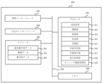
- the server 200 includes, for example, a processor 210, a communication interface 220, an input/output interface 230, a memory 240, a storage 250, and one or more communication buses 260 for interconnecting these components.
- the server 200 may be, for example, a desktop, laptop, or other computer.
- the server 200 may also be a general-purpose computer and may be configured as a single computer, or may be configured as multiple computers distributed over a network N.
- Processor 210 executes processes, functions, or methods implemented by code or instructions included in a program stored in storage 250.
- Processor 210 may include, by way of example and not limitation, one or more central processing units (CPUs), MPUs (Micro Processing Units), GPUs (Graphics Processing Units), microprocessors, processor cores, multiprocessors, ASICs (Application-Specific Integrated Circuits), FPGAs (Field Programmable Gate Arrays), etc., and may implement the processes, functions, or methods disclosed in each embodiment by logic circuits (hardware) or dedicated circuits formed in integrated circuits (IC (Integrated Circuit) chips, LSIs (Large Scale Integration)), etc.
- CPUs central processing units
- MPUs Micro Processing Units
- GPUs Graphics Processing Units
- microprocessors processor cores
- multiprocessors multiprocessors
- ASICs Application-Specific Integrated Circuits
- FPGAs Field Programmable Gate Arrays
- the processor 210 executes processes, functions, or methods that are realized by code or instructions included in a program stored in the storage 250. As shown in FIG. 2A, the processor 210 of this embodiment may be configured to function as a transmission/reception unit 211, an adjustment unit 212, an acquisition unit 213, a generation unit 214, an evaluation unit 215, a work decision unit 216, a work instruction unit 217, a display control unit 218, and a sensing device management unit 219.
- the communication interface 220 transmits and receives various data to and from other devices via the network N.
- the communication may be performed either wired or wirelessly, and any communication protocol may be used as long as the devices can communicate with each other.
- the communication interface 220 is implemented as hardware such as a network adapter, various types of communication software, or a combination of these.
- the network N may be, by way of example and not limitation, an ad hoc network, an intranet, an extranet, a virtual private network (VPN), a local area network (LAN), a wireless LAN (WLAN), a wide area network (WAN), a wireless WAN (WWAN), a metropolitan area network (MAN), a portion of the Internet, a portion of the public switched telephone network (PSTN), a mobile telephone network, Integrated Service Digital Networks (ISDNs), wireless LANs, Long Term Evolution (LTE), Code Division Multiple Access (CDMA), Bluetooth (registered trademark), satellite communications, or any combination thereof.
- a network may include one or more networks.
- the input/output interface 230 includes an input device for inputting various operations to the server 200, and an output device for outputting the results of processing performed by the server 200.
- the input/output interface 230 includes information input devices such as a keyboard, mouse, and touch panel, and information output devices such as a display.
- the server 200 may accept a specified input and execute a specified output by connecting an external input/output interface 230.
- Memory 240 temporarily stores programs loaded from storage 250 and provides a working area for processor 210. Memory 240 also temporarily stores various data generated while processor 210 is executing a program. Memory 240 may be, for example, a high-speed random access memory such as DRAM, SRAM, DDR RAM, or other random access solid-state storage device, or a combination of these.
- Storage 250 stores programs, each functional unit, and various data.
- Storage 250 may be, for example, one or more magnetic disk storage devices, optical disk storage devices, flash memory devices, or non-volatile memories such as other non-volatile solid-state storage devices, or may be a combination of these.
- Another example of storage 250 is one or more storage devices installed remotely from processor 210.
- the transmission/reception unit 211 may function as a transmission unit that transmits various information to other devices such as the user terminal 100 and the measurement device 300 via the communication interface 220 and the network N, or as a reception unit that receives various information from other devices such as the user terminal 100 and the measurement device 300.
- the transmission/reception unit 211 may receive information for adjusting the area in the field from which information about the field is to be acquired, in response to an operation performed by the user on the terminal 100.
- the transmission/reception unit 211 may also transmit information about the entire field or a part of the field generated by the generation unit to the terminal 100, and the terminal 100 may control the display of this information.
- the transmitting/receiving unit 211 may transmit information about the area adjusted by the adjusting unit 212 to the measuring device, and the acquiring unit 213 may acquire information about the field in the target area from the measuring device 300 via the transmitting/receiving unit 211.
- the adjustment unit 212 adjusts the area in the field from which information about the field is to be acquired. Specifically, in response to a user's operation on the terminal 100, the adjustment unit 212 may receive information for adjusting the area in the field from which information about the field is to be acquired via the transmission/reception unit 211, and adjust the area in the field accordingly. In addition, when constructing a database, the field may be measured at a desired resolution using the measuring device 300 or the like, and the data collected to construct the database.
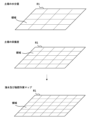
- the area adjusted by the adjustment unit 212 may be defined by a section of the field of approximately equal area, or may be defined by crop.
- Defining an area by divisions means, for example, regarding the field as a unit of area as shown in FIG. 1, dividing the field into approximately equal areas, and using the divided divisions as the subject for acquiring information about the field.
- the adjustment unit 212 can adjust the size of the area of each divided division, for example, dividing the field into 25, 36, or 49 divisions.
- Defining an area by crops means, for example, regarding a field in crop units rather than area units, and regarding one or more crops, the subject of acquiring information about the field.
- one crop means, for example, a plant plant unit.
- the part where one crop is located may be the subject of acquiring information about the field.
- FIG. 4A shows an example of screen D1 displayed by the display control unit 218 (described later) on the display device of the user terminal 100 when adjusting the area of the field.
- the display area R1 in FIG. 4A is a map display area, and the map shows the field and areas into which the field is divided into arbitrary sizes.
- the moisture content of the soil in each area is represented by different shades of color, like a heat map, but the display form of screen D1 is not limited to this.
- the user can adjust the area in the field from which information about the field is to be obtained by selecting a specific area in the display area R1 as the target area.
- a specific area in the display area R1 As the example of FIG. 4A, four areas are selected as the target areas.
- information about the field in the target area selected by the user is displayed in the display area R2.
- the current soil moisture content in the target area may be displayed, and further, the required work may be displayed by displaying the desired soil moisture content in the target area.
- the soil moisture content in the entire field may also be displayed in the display area R2.
- the information about the target area displayed in display area R2 may also change accordingly.
- screen D1 may have a button O1 for adjusting the area to the range of the farm worker's unit work, a button O2 for arbitrarily changing the area size, and a switch button O3 for changing the information about the crops displayed from the soil moisture content to the hours of sunlight or the topography.
- FIG. 4B shows an example of the screen after the area of the region has been adjusted by operating button O1 or O2.
- each region is displayed larger by pressing button O2, which changes the region size as desired.
- the information about the target region displayed in display region R2 may also be changed accordingly.
- the adjustment unit 212 may adjust the area based on information related to one or more purposes of the agricultural work to be performed. In doing so, the adjustment unit 212 may refer to basic agricultural work data 251 that records basic agricultural work methods for each agricultural crop. By referring to such basic agricultural work methods for each agricultural crop, the adjustment unit 212 may estimate the purpose of the agricultural work and, accordingly, information related to the field that should be acquired by the acquisition unit 213, and adjust the appropriate area according to the information related to the field that should be acquired.
- the adjustment unit 212 may also adjust the size of the target area according to the information about the field to be displayed. For example, when the information about the field to be displayed is the hours of sunshine, it is important to look at the field broadly and identify areas with long and short hours of sunshine, whereas when the information about the field to be displayed is the moisture content of the soil, a perspective is required to specifically identify the crops to be irrigated.
- the adjustment unit 212 adjusts the size of the target area relatively broadly by operating the switch button O3, whereas when the information about the crops to be displayed is the moisture content of the soil, the adjustment unit 212 may adjust the size of the target area relatively narrowly, on a plant body basis.
- the adjustment unit 212 may adjust the area based on information about multiple objectives of the agricultural work to be performed, based on the smallest unit for the multiple objectives. For example, consider a case where information about a field is obtained from a soil sensor to determine whether the agricultural work "fertilization" or "irrigation" is required for the field. In this case, for example, it is determined that fertilization is required when the electrical conductivity (EC) of the soil is low, and that irrigation is required when the moisture content of the soil is low. In such a case, the area is adjusted to the extent necessary to determine whether fertilization is required, and is also adjusted to the extent necessary to determine whether irrigation is required.
- EC electrical conductivity
- the adjustment unit 212 may adjust the area based on the smallest unit for the multiple objectives of fertilization and irrigation. Specifically, of the area necessary for determining whether fertilization is required and the area necessary for determining whether irrigation is required, the adjustment unit 212 may adjust the narrower area that is the least common multiple of both areas as the area from which information about the field is obtained.
- the current soil moisture content in the target area may be displayed in the display area R2, and further, the desired soil moisture content in the target area may be displayed to indicate the necessary work.
- the above example of soil moisture content also applies to the nutritional level of the soil, etc.
- FIG. 4C shows an example of screen D2 displayed by the display control unit 218 (described later) on the display device of the user terminal 100 when the area is adjusted to field units.
- Reservation information is displayed in a list in the display area R3 of screen D2.
- the fields displayed on screen D2 may have the same owner or different owners. This makes it possible to grasp the progress of agricultural work between fields and sales forecasts.
- material and human resources that can be provided or material and human resources that are required may be displayed as "resources". This enables efficient sharing of resources between fields.
- the adjustment unit 212 may adjust the time interval when the acquisition unit 213 acquires information about the field from the database or from the measuring device 300, and the frequency of such acquisition. Such a time axis may also be included as one of the elements that configure the resolution of the field.
- the adjustment unit 212 may set the minimum time interval to the unit of days when sensing is performed, or may set the period interval by setting a start date and an end date arbitrarily by the user, or may set it in units of weeks, months, quarters, half years, or one year.
- screen D1 may have a slider O4 that sets the time of information output by adjustment unit 212.
- the current soil moisture information displayed in display area R1 or R2 can be changed to past soil moisture information, such as one day ago or one week ago.
- future soil moisture information can be output based on past and current soil moisture information using an arbitrary model, it may be possible to control the display of future soil moisture information by operating slider O4.
- the model is not particularly limited, but can be created, for example, by machine learning using information regarding the time course of soil moisture and climate data in each area over the past few years as training data. This makes it possible to predict future soil moisture based on information such as the past soil moisture and climate data for this year.
- the above learning may also include other environmental data.
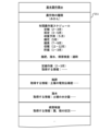
- FIG. 2B shows an example of basic farm work data 251.
- the "basic farm work ID" is an ID for uniquely identifying information on basic farm work methods for each farm crop.
- the basic farm work data 251 may also include the type of farm crop, an annual farm work schedule, detailed information on each farm work, and the like.
- the basic farm work data 251 may also be information created in advance by the farmer.
- the annual farm work schedule may record the procedures for farm work throughout the year. This allows you to refer to the dates to understand what farm work needs to be done now and what farm work needs to be done in the future.
- the record of the procedures for farm work throughout the year is also called the cultivation history.
- the detailed information for each agricultural task may include details on how to perform each agricultural task. Furthermore, in addition to the method of performing each agricultural task, information that would be good to obtain when performing that agricultural task may also be recorded.
- the information acquired here may include, for example, information that specifies the qualitative aspect of fertilization work, such as using electrical conductivity as one of the factors in determining fertilization work, as well as information that specifies the quantitative aspect, such as the range of electrical conductivity for which fertilization is recommended. Furthermore, since the type of fertilization required for agricultural crops may differ between spring fertilization and summer fertilization, such qualitative and quantitative information may change depending on the season.
- information may be included that specifies the qualitative aspect of using the soil moisture content as one of the judgment factors, as well as information that specifies the quantitative aspect, such as the range of moisture content for which irrigation is recommended.
- the qualitative and quantitative information regarding irrigation may change depending on the season.
- the adjustment unit 212 may estimate the purpose of the agricultural task and the information about the field that should be obtained according to that purpose, and adjust the appropriate area accordingly.
- the adjustment unit 212 may adjust the area according to a user operation, or, if there is no user operation, may refer to field data 252 that defines in advance how one or more areas are determined. By referring to the field data 252, it may be possible to quickly identify divisions, such as when dividing the field into 25, 36, or 49 divisions. Such divisions may be used as the initial values of the area shown in the display area R1, etc.
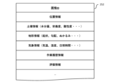
- FIG. 2C shows an example of field data 252.
- the "field ID" is an ID for uniquely identifying the field information.
- the acquisition unit 213 acquires information about the field of each area from the database accordingly, or instructs the measurement device 300 to acquire information about the field of each area by measurement.
- the information about the field corresponds to the location information.
- instructing the measurement device 300 to acquire information by measurement it is desirable to specify from which area the information was acquired.
- the measurement data such as image data acquired by the measurement device 300 may be recorded in the database in association with the coordinates of the plot in the field and the coordinates of the image in the plot.
- the coordinates of the soil moisture content in the image may be recorded by further image processing. This allows information identifying each area to be identified according to the adjusted area, and the acquisition unit 213 can quickly perform the information acquisition work.
- the field data 252 may store various data acquired within the field.
- the various data acquired within the field may be data acquired by the acquisition unit for each area, or data acquired regardless of area (for example, environmental data such as temperature).
- Information recorded regarding the field may include location information within the field, information regarding the soil such as soil condition, information regarding the topography such as undulations, gradients, and mud, meteorological information such as temperature, humidity, weather, and hours of sunshine, work history information regarding the crops in the field, evaluation information, disease information, and the like.
- the acquisition unit 213 identifies location information corresponding to the targeted area and acquires information about the farm field corresponding to the location information from a database such as the one described above. Then, the generation unit 214, which will be described later, may generate information about the entire farm field or a part of the farm field based on the information about the agricultural crop.
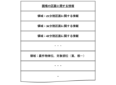
- Storage 250 may include information regarding the field partitions.
- FIG. 2E shows an example of the information regarding the field partitions.
- the information regarding the field partitions may include the allocation of partitions when the field is divided into 25, 36, or 49 partitions, recorded in advance.
- the information regarding the 25-part partitions may also include information for identifying each partition when the field is divided into 25 partitions, such as "25-1", "25-2", etc.
- the field data 252 may be information created in advance by a farmer.
- the acquisition unit 213 may acquire information about the field in the target area in response to a user's operation from a database or the like that records information about the field in the field, or may acquire information obtained by measuring the field by the measuring device 300. Specifically, the acquisition unit 213 may acquire information about the field in the area adjusted by the adjustment unit 212 from a database or the like in response to an operation on the user terminal 100, or may transmit information about the area defined by the adjustment unit 212 to one or more measuring devices 300 via the transmission/reception unit 211, and may receive information about the field in the area from one or more measuring devices 300 via the transmission/reception unit 211.
- the acquisition unit 213 may refer to the database to acquire information regarding the field in the area.
- the database here may be an external database in which weather data and the like are recorded, or it may be the field data 252 or the crop data 253 described below.
- the database may also be data constructed by collecting data on the environment of the field and data on the field, and may be data capable of constructing a current or past digital twin of the field.
- the acquisition unit 213 may execute both a method of acquiring information about the farm field from the measuring device 300 and a method of acquiring information about the farm field in the area by referring to a database. For example, when performing irrigation work, the acquisition unit 213 may acquire information about the moisture content of the soil from the measuring device 300 and acquire environmental information such as the amount of precipitation to date from the database.
- Information about the field is not particularly limited, but examples include information about the soil, climate, and moisture content.
- the measuring device 300 is a device that measures the periphery of the crops 520 and the plot 530 in the area 510 of the field 500, and acquires information about the field during cultivation.
- the measuring device 300 may be, for example, a device equipped with various sensors mounted at any position in the field, a drone equipped with various sensors and flying within the field, an unmanned aerial vehicle that propels itself within the field, a smartphone equipped with various sensors, a handheld computing device, a wearable terminal, or other terminal operated by a person.
- the acquisition unit 213 may record the acquired information about the field in the field data 252. In addition, when the acquisition unit 213 acquires information about the field, the acquisition unit 213 may record the information in the crop data 252.
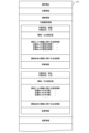
- FIG. 2D shows an example of crop data 253.
- crop ID is an ID for uniquely identifying information about the crop.
- information about the crop may include location information within the field, imaging information related to the plant or plant body, work history information about the crop in the field, disease information, and the like.
- Information recorded in the database such as information about the number and quality of flowers, buds, fruits, and the like, may be obtained based on imaging information. Specifically, the information may be obtained by counting the fruits captured in the imaging information or calculating their size.
- FIG. 2D shows an example of work history information.
- work history information may be recorded for each task.
- fertilization may be recorded as the task purpose, and the date and time when the task was performed (May), the area (36 divided plots) adjusted by the adjustment unit 212, information about the field obtained for each area (electrical conductivity of the soil in plots No. 01 to 36), etc. may be recorded.
- the details of the fertilization task and the electrical conductivity of the soil in plots No. 01 to 36 after the fertilization task may be recorded.
- Information about the field may be recorded in the field data 252, or may be recorded in the crop data 253 in association with the farm work as described above, or may be recorded in both.
- the field data 252 and the crop data 253 may be one data set, and information about the field may be recorded in that data.
- the acquisition unit 213 may determine the correspondence between the ranges and numbers (section No. 01 to 36) of each of the 36 divided sections adjusted by the adjustment unit 212 by referring to the field data 252. In addition, the acquisition unit 213 may determine the information related to the field to be acquired for each area by referring to the basic farm work data 251.
- the crop data 253 may record generation information and evaluation information relating to the entire field or a portion thereof.
- the generation information relating to the entire field or a portion thereof may be information relating to the entire field or a portion thereof generated by the generation unit 214 described below based on information relating to the field in one or more regions.
- the evaluation information may be information on the field that is evaluated by the evaluation unit 215 described below based on either information on the field in one or more areas, or information on the entire field or part of the field.
- the acquisition unit 213 may acquire information about the farm field using a sensor, or may acquire information input by another person.
- the information acquired by the acquisition unit 213 using a sensor also includes information acquired by the acquisition unit 213 by referring to a database in which information acquired by the sensor in advance is stored.
- the sensor may be one of an image sensor, a component sensor, an inertial sensor, and an environmental sensor.
- the image sensor is not particularly limited as long as it is a sensor capable of capturing still or video images.
- the image sensor may be a sensor mounted on a drone, a fixed camera installed in a field, a camera on a terminal such as a wearable device, or a camera installed on a self-propelled measuring device 300.
- component sensor there are no particular limitations on the component sensor, but examples include sensors that are configured to perform specific analyses such as fluorescent analysis and spectroscopic analysis.
- the environmental sensor is a sensor for measuring environmental information in the field of the crops 520.
- Examples of environmental sensors include, but are not limited to, weather sensors, soil sensors, and gas sensors.
- the soil sensor may be a sensor that acquires information about the soil, such as the soil moisture content, nutrients, acidity, and underground temperature.
- the weather sensor may be a sensor that acquires information about the weather, such as temperature, humidity, amount of sunlight, intensity of sunlight, hours of sunlight, amount of rainfall, and weather.
- the environmental sensor is not limited to soil sensors and weather sensors, and any sensor that can measure various types of environmental information in the field may be used.
- the generator 214 generates information on the entire field or a part of the field based on information on the field in one or more regions. For example, the generator 214 may generate information on the entire field or a part of the field based on information on the field in one or more regions, as shown in the display area R1 of FIG. 4A. At this time, the information on the field in the acquired section No. may be mapped based on information on the section recorded in the field data 252 as an initial value or the like. In addition, when a user performs an operation on O1 to O4, etc., information on the entire field or a part of the field may be generated according to the area adjusted by the operation, as shown in FIG. 4B.
- the acquired information on the crop such as the growth phase, quantity, size, disease, etc.
- the generation unit 214 may generate information between farm fields in response to a user operation, as shown in FIG. 4C.
- the generating unit 214 may generate information about the field in the target area selected by the user according to the adjusted area, as shown in the display area R2.
- the generating unit 214 may generate information about the target field in the target area in addition to information about the crops in the target area.
- the information shown in the display area R2 may include, in addition to the above, information about the actual field, such as the moisture content and nutritional level of the soil, information about the state of the target field, such as appropriate moisture content and nutritional level of the soil, and information about the necessary work in the area, such as fertilization and watering, based on the difference between the information about the state of the target field created by the work determination unit 216 described below and the information about the actual field.
- the generating unit 214 may generate information about the entire field or a part of the field using information acquired by the acquiring unit 213, information evaluated by the evaluating unit 215, information determined by the work determining unit 216, etc.
- the information generated by the generating unit 214 is transmitted to the user terminal 100 by the display control unit 218 (described later) via the transmitting/receiving unit 211. As a result, screens such as those shown in Figures 4A to 4C are displayed on the display device of the user terminal 100.
- the generation unit 214 may supplement the information about the farm field in that area by estimation.
- the acidity at a third point can be estimated by extrapolating or interpolating the acidity at the two points to supplement the information.
- the method of supplementation is not limited to this.
- the evaluation unit 215 performs an evaluation of the field based on one of the information on the field in one or more regions and the information on the field in the entire field or a part of the field.
- the evaluation unit 215 may perform an evaluation of the field based on the information on the field, may perform an evaluation of the field based on the information on the field and the information on the crop, or may perform an evaluation of the field and an evaluation of the crop based on the information on the crop and the information on the field.
- the evaluation unit 215 may evaluate the moisture content and nutritional content of the soil appropriate for certain location information based on the hours of sunshine and climate data associated with that location information. This evaluated information may be recorded in a database as one of the data constituting the digital twin.
- the evaluation of the field may include the difference between the information about the actual field and the information about the target field.
- the work determination unit 216 which will be described later, may determine information about the necessary work in that area, such as irrigation and fertilization, from the difference between the information about the state of the target field evaluated by the evaluation unit 215 and the information about the actual field.
- the evaluation unit 215 may evaluate the field according to a learning model or algorithm.
- the evaluation unit 215 may perform a yield prediction as an evaluation of the field based on either information about the field in multiple areas or information about the field in the entire field. Furthermore, when performing the yield prediction, the yield prediction may be performed based on information about the field in the past area or the entire field, in addition to information about the field in the current area or the entire field.
- the acquisition unit 213 acquires environmental data (humidity, carbon dioxide concentration, amount of light, amount of water) around a certain plot (a single tree) at multiple times and accumulates the data in the field data 252.
- the evaluation unit 215 may then refer to the basic farm work data 251 or data that associates information about the field with yields to predict the yield.
- the data associating information about the field with the yield may be data associating information about the field with the yield from the previous year, or data associating information about another field with the yield.
- the evaluation unit 215 can evaluate the yield prediction according to the time of prediction. For example, a relatively high yield was predicted based on the climate and soil data in the first half of the cultivation, but the yield is predicted to be lower when the climate and soil data in the second half of the cultivation is taken into account. The user can then select the most appropriate farm work in light of past progress.
- the model is not particularly limited, but can be created, for example, by machine learning using training data that corresponds to the input and output. Any estimation model can be constructed.
- the evaluation unit 215 may record the evaluation of the field or the evaluation of the field in the crop data 253.
- the work determination unit 216 determines the content of the farm work based on the evaluation of the field. At this time, the work determination unit 216 may refer to the basic farm work data 251 and determine the content of the farm work based on the evaluation of the field.
- the work determination unit 216 may also calculate the difference between the information regarding the state of the target field and the information regarding the actual field, as shown in the display area R2 in FIG. 4A. This difference can be said to indicate the amount of agricultural work required. Therefore, the work determination unit 216 may further output a work plan for the area based on this difference.
- the work plan may be a work plan that includes not only the personnel and work time required for work in that area, but also the order of work and the allocation of personnel not only for that area but also for the entire field.
- the work instruction unit 217 transmits information on the determined content of the agricultural work to the working device 400.
- the working device 400 is not particularly limited, but may be any device having a mechanism capable of performing agricultural work such as pruning, flower thinning, fruit thinning, pesticide spraying, and pollen spraying.
- the working device 400 may be the same machine as the measuring device 300, or may be a different machine.
- the work instruction unit 217 may transmit information regarding the content of the determined agricultural work to a user terminal 100 or the like possessed by the worker.
- the display control unit 218 transmits each piece of information generated by the generation unit 214, the evaluation unit 215, the work determination unit 216, and the work instruction unit 217 to the user terminal 100 via the transmission/reception unit 211, and controls the display on the display device of the user terminal as shown in FIGS. 4A to 4C.
- the display control unit 218 may control the display on an input/output interface 230 such as a display of any of the information about the field in each targeted area acquired by the acquisition unit 213, the information about the entire field or part of the field generated by the generation unit 214, and the evaluation of the field by the evaluation unit 215.
- the sensing device management unit 219 manages the state of the measuring device 300 so that data can be collected normally, and may perform correction or calibration as necessary. For example, the sensing device management unit 219 may manage whether sensing devices such as the measuring device 300 are operating normally, or manage the operating time of the measuring device 300. At this time, if an abnormality is detected, such as a communication error or an alarm being sounded, the sensing device management unit 219 may display this on the display unit of the input/output interface 230.
- Fig. 3A shows a flowchart of a process of outputting requested information at a desired resolution from a database that records information about the field in the field in response to a user's operation by the smart agriculture system of this embodiment
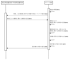
- Fig. 3B shows a sequence diagram showing an example of a process of measuring the inside of the field at a desired resolution and constructing a database by the smart agriculture system of this embodiment.
- step A01 in response to a user's operation on the terminal 100, the adjustment unit 212 of the server 200 adjusts the area in the field from which information about the field is to be acquired. At this time, the adjustment unit 212 adjusts the area based on the purpose of the farm work selected by the user and the basic farm work data 251, and may also specify the specific content of the information about the field to be acquired.
- the acquisition unit 213 of the server 200 acquires information about the fields in the target area.
- the acquisition unit 213 may acquire information about the fields in the target area from a database that can configure a digital twin.
- step A03 the generation unit 214 of the server 200 generates information about the entire field or a portion of the field based on the information about the field in one or more areas. Specifically, based on the information about the field in the target area acquired by the acquisition unit 213, various information about the target area may be generated, or a map of the entire field may be generated.
- the adjustment unit 212 adjusts the area based on the basic farm work data 251, and the generation unit 214 may display a map including an area of the adjusted size in the display area R1 based on information about the farm field in one or more areas.
- the adjustment unit 212 may change the size of the initial area by tapping the button O3. Specifically, when the user taps the "soil moisture content” button O3, the adjustment unit 212 may adjust the area with a resolution suitable for displaying the soil moisture content, and a map or the like may be displayed in the display area R1 with this as initial information. Also, when the user taps the "soil nutritional level” button O3, the adjustment unit 212 may adjust the area with a resolution suitable for displaying the soil nutritional level, and a map or the like may be displayed in the display area R1 with this as initial information. At this time, the size of the initial area may differ depending on the information about the crop, such as "soil moisture content” or "soil nutritional level” selected by the button O3.
- the user may drag the R1 map to specify the target area, or tap the O2 button or O1 button to expand or narrow the area of the target area or each area to be displayed, and at that time, the adjustment unit 212 may obtain information on the area specified by the user.
- the adjustment unit 212 adjusts the target area for acquiring information about the field in response to the user's operation
- the acquisition unit 213 acquires information about the field in the target area from a database that can construct a digital twin
- the generation unit 214 generates and displays information about the field in the selected target area in the display area R2 based on the information about the field in one or more areas.
- step B01 the adjustment unit 212 of the server 200 adjusts the area from which information about the farm field is to be acquired. At this time, the adjustment unit 212 adjusts the area based on the purpose of the farm work and the basic farm work data 251, and may also specify the specific content of the information about the farm field to be acquired.
- the transmitting/receiving unit 211 of the server 200 may transmit to the measuring device 300 information about the area adjusted by the adjusting unit 212 and information about the field acquired by the sensor.
- the information transmitted to the measuring device 300 instructs the measuring device 300 on the area to be measured and information about the field to be measured in that area using a sensor or the like. Based on this instruction information, the measuring device 300 may acquire information about the field in the area to be measured.
- the transmitting/receiving unit 211 of the server 200 receives the information about the field acquired for each area from the measuring device 300.
- step B04 the acquisition unit 213 of the server 200 may record the acquired information in the crop ID.
- step B05 the generation unit 214 of the server 200 generates information about the entire field or a portion of the field
- step B06 the evaluation unit 215 of the server 200 performs an evaluation of the field based on either the information about the field in one or more regions or the information about the entire field or a portion of the field.
- step B07 the work determination unit 216 of the server 200 determines the work content
- step B08 the work instruction unit 217 of the server 200 transmits information regarding the determined content of the agricultural work to the work device 400.
- ground conditions of the field are suitable for traveling with the work implement 400.
- the larger the area of the field the more difficult it is for the human eye to grasp the ground conditions of the entire field or part of it, so it is desirable to automate this process.
- the adjustment unit 212 may adjust the area in relatively small sections from the perspective of determining whether travel is possible, and the acquisition unit 213 may acquire "ridges" and "ridges" in the target area using an image sensor, LiDAR or other sensor, and record this information in association with location information (GPS, SLAM, etc.).
- the generation unit 214 may then generate information on ground conditions as information on the entire field or part of the field based on information on the field in the area.
- the acquisition unit 213 may detect whether there are obstacles or weeds on the ridges, and the evaluation unit 215 may evaluate the road surface condition from the number of detection points.
- the acquisition unit 213 may also measure the amount of relative change from inertial sensors such as acceleration and angular velocity, and the evaluation unit 215 may measure the unevenness or muddiness of the ground from these values. If the unevenness or muddiness is severe, the inertial sensor values will vary greatly, making it possible to measure the unevenness or muddiness of the ground.
- the evaluation unit 215 may classify objects reflected in image data acquired by the image sensor into crops, obstacles, weeds, etc. by object recognition.
- the adjustment unit 212 may adjust the area in relatively large sections in terms of performing fertilization work, irrigation work, etc.
- the acquisition unit 213 may acquire soil conditions such as soil moisture content, soil temperature, electrical conductivity, component content (nitrogen, phosphorus, potassium, etc.), and pH in the target area using a soil sensor or the like, and record the information linked to location information (GPS, SLAM, etc.).
- GPS Global System
- SLAM Location information
- each of the above information may be recorded linked to the time of acquisition of the information.
- the generation unit 214 may generate information on the soil condition as information on the entire field or part of the field based on the information on the field in the area.
- a specific wavelength band camera, a thermal camera, etc. may be used as a sensor for acquiring the soil temperature.
- an information processing device executes the steps of: adjusting a target area from which information about a farm field is to be acquired; acquiring information about the farm field in the target area; and generating information about the farm field in the entirety or a part of the farm field based on information about the farm field in one or more of the areas.
- Program The program of the present embodiment causes an information processing device to execute the steps of: adjusting a target area from which information about a farm field is to be acquired; acquiring information about the farm field in the target area; and generating information about the farm field in the entirety or a part of the farm field based on information about the farm field in one or more of the areas.
- the program may be recorded on a readable recording medium. Note that the specific aspects of the processing executed by the program of this embodiment are described above in the operational processing, so a detailed description will be omitted here.
- This invention has industrial applicability as a core technology that can be used in smart agriculture systems.
Landscapes
- Life Sciences & Earth Sciences (AREA)
- Biodiversity & Conservation Biology (AREA)
- Botany (AREA)
- Ecology (AREA)
- Forests & Forestry (AREA)
- Environmental Sciences (AREA)
- Management, Administration, Business Operations System, And Electronic Commerce (AREA)
Abstract
Description
前記圃場に関する情報を取得する対象とする領域を調整する調整部と、
対象とした前記領域における前記圃場に関する情報を取得する取得部と、
一又は複数の前記領域における前記圃場に関する情報に基づいて、前記圃場全体又は一部における圃場に関する情報を生成する生成部と、を備える。
図1は、本実施形態のスマート農業システムを示す概略図である。図1に示すように、本実施形態のスマート農業システムの一例では、圃場内の圃場に関する情報を記録するデータベースから、ユーザの操作に応じて、所望の分解能で要求される情報を出力するシステムが含まれ、このほかに、所望の分解能で圃場内を測定し当該データベースを構築するシステムが含まれてもよい。
図1に示すサーバ200は、所望の分解能で圃場内を測定しデータベースを構築するほか、ユーザの操作に応じて、圃場において圃場に関する情報を取得する対象とする領域を調整し、対象とした領域における圃場に関する情報をデータベースから取得し、得られた一又は複数の領域における圃場に関する情報に基づいて、圃場全体又は一部における圃場に関する情報を生成する。データベースを構築する際、サーバ200は、調整した領域を各測定用装置300に送信し、測定用装置300から、圃場に関する情報を取得してもよい。
送受信部211は、例えば、通信インターフェース220とネットワークNを介して、ユーザ端末100や測定用装置300等の他の装置に各種情報を送信する送信部、又はユーザ端末100や測定用装置300等の他の装置から各種情報を受信する受信部として機能してもよい。
調整部212は、圃場に関する情報を取得する対象とする、圃場における領域を調整する。具体的には、端末100に対して行ったユーザの操作に応じて、送受信部211を介して、圃場において圃場に関する情報を取得する対象とする領域を調整するための情報を受信し、調整部212は、それに応じて、圃場における領域を調整してもよい。また、データベースを構築する際には、測定用装置300等を使用して所望の分解能で圃場内を測定し、それを収集することで、データベースを構築してもよい。
取得部213は、圃場内の圃場に関する情報を記録するデータベース等から、ユーザの操作に応じて対象とした領域における圃場に関する情報を取得したり、測定用装置300が圃場内を測定して得た情報を取得したりしてもよい。具体的には、取得部213は、ユーザ端末100に対する操作に応じて調整部212が調整した領域における圃場に関する情報をデータベースなどから取得したり、調整部212が規定した領域に関する情報を、送受信部211を介して、一又は複数の測定用装置300に送信し、一又は複数の測定用装置300から、送受信部211を介して、領域における圃場に関する情報を受信したりしてもよい。
生成部214は、一又は複数の領域における圃場に関する情報に基づいて、圃場全体又は一部における圃場に関する情報を生成する。例えば、生成部214は、図4Aの表示領域R1に記載のように、一又は複数の領域における圃場に関する情報に基づいて、圃場全体又は一部における圃場に関する情報を生成してもよい。この際に、初期値などとして、取得した区画No.における圃場に関する情報を、圃場データ252に記録された区画に関する情報に基づいてマッピングしてもよい。また、ユーザのO1~O4等に対する操作があった場合には、図4Bに示すように当該操作により調整された領域に応じて、圃場全体又は一部における圃場に関する情報を生成してもよい。具体的には、「区画No1-1は蕾が100個、花が59個、病害あり」などのように、生育フェーズ、数量、サイズ、病害などの取得した農作物の情報を圃場の位置にプロットしてもよい。さらに、生成部214は、図4Cに示すように、ユーザの操作に応じて圃場間の情報を生成してもよい。
評価部215は、一又は複数の領域における圃場に関する情報、及び、圃場全体又は一部における圃場に関する情報の一方に基づいて、圃場に関する評価を行う。評価部215は、圃場に関する情報に基づいて、圃場に関する評価を行ってもよいし、圃場に関する情報と農作物に関する情報に基づいて、圃場に関する評価を行ってもよいし、農作物に関する情報と圃場に関する情報に基づいて、圃場に関する評価と農作物に関する評価を行ってもよい。
作業決定部216は、圃場に関する評価に基づいて、農作業の内容を決定する。この際、作業決定部216は、基本農作業データ251を参照して、圃場に関する評価に基づいて、農作業の内容を決定してもよい。
作業指示部217は、作業用装置400に対して、決定された農作業の内容に関する情報を送信する。作業用装置400としては、特に限定されないが、例えば、剪定、摘花、摘果、農薬散布、花粉散布などの農作業を実行可能な機構を有するものであれば、特に限定されない。作業用装置400は、測定用装置300と同じ機体であってもよいし、異なる機体であってもよい。
表示制御部218は、生成部214、評価部215、作業決定部216、作業指示部217が生成した各情報を、送受信部211を介してユーザ端末100に送信し、図4A~図4Cに示すように、ユーザ端末の表示装置に表示制御させる。
センシング機器管理部219は、正常にデータが収集できるように、測定用装置300の状態を管理し、必要に応じて、補正や校正などを行ってもよい。例えば、センシング機器管理部219は、測定用装置300等のセンシング機器が正常に動いているか否かの管理や、又は、測定用装置300等の稼働時間の管理を行ってもよい。この際、通信エラーが生じたり、機器のアラームがなったりするなど異常を検知した場合には、センシング機器管理部219は、入出力インターフェース230の表示部にその以上の旨を示してもよい。
次に、スマート農業システムの動作について説明する。図3Aは本実施形態のスマート農業システムによる、圃場内の圃場に関する情報を記録するデータベースから、ユーザの操作に応じて、所望の分解能で要求される情報を出力する処理のフローチャートを示し、図3Bは、本実施形態のスマート農業システムによる、所望の分解能で圃場内を測定しデータベースを構築する処理の一例を示すシーケンス図を示す。
以下、具体的な実施例を挙げてさらに、スマート農業システムについて説明する。
自走式の作業用装置400が適切に作業を実行するためには、圃場の地面状態が作業用装置400の走行に適した状態であるか否かわかっていることが好ましい。特に圃場の面積が大きいほど、人の目で圃場全体又は一部の地面状態を把握することは困難であるため、オートメーション化が図られることが望ましい。
農作物への施肥作業や潅水作業などを適切に行う点から、土壌状態を検知して評価することが好ましい。
本実施形態の情報処理方法は、情報処理装置が、圃場に関する情報を取得する対象とする領域を調整するステップと、対象とした前記領域における圃場に関する情報を取得するステップと、一又は複数の前記領域における前記圃場に関する情報に基づいて、前記圃場全体又は一部における圃場に関する情報を生成するステップと、を実行する。
本実施形態のプログラムは、情報処理装置に、圃場に関する情報を取得する対象とする領域を調整するステップと、対象とした前記領域における圃場に関する情報を取得するステップと、一又は複数の前記領域における前記圃場に関する情報に基づいて、前記圃場全体又は一部における圃場に関する情報を生成するステップと、を実行させる。
Claims (14)
- 圃場に関する情報を取得する対象とする領域を調整する調整部と、
対象とした前記領域における前記圃場に関する情報を取得する取得部と、
一又は複数の前記領域における前記圃場に関する情報に基づいて、前記圃場全体又は一部における前記圃場に関する情報を生成する生成部と、を備える、
情報処理装置。 - 前記生成部が、対象とした前記領域における前記圃場に関する情報に加え、当該領域における目的とする圃場に関する情報を生成する、
請求項1に記載の情報処理装置。 - 前記一又は複数の領域における前記圃場に関する情報、及び、前記圃場全体又は一部における前記圃場に関する情報の一方に基づいて、前記圃場に関する評価を行う評価部をさらに備える、
請求項1に記載の情報処理装置。 - 前記圃場に関する評価が、実際の圃場に関する情報と目的とする圃場に関する情報の差を含む、
請求項3に記載の情報処理装置。 - 前記調整部は、実行する農作業の、一又は複数の目的に関する情報に基づいて、前記領域を調整する、
請求項1に係る情報処理装置。 - 前記圃場に関する情報が、土壌に関する情報を含む、
請求項1に係る情報処理装置。 - 前記領域が、前記圃場の略均等な面積の区画で規定され、
前記調整部が、前記領域として、前記区画の面積を調整する、
請求項1に係る情報処理装置。 - 前記取得部は、センサにより前記圃場に関する情報を取得し、
前記センサは、画像センサ、成分センサ、慣性センサ、又は環境センサである、
請求項1に係る情報処理装置。 - 前記調整部により調整された前記領域に関する情報を、測定用装置に送信する送受信部をさらに備え、
前記取得部は、対象とした前記領域における前記圃場に関する情報を、前記測定用装置から取得する、
請求項1に係る情報処理装置。 - 前記圃場全体又は一部における圃場に関する情報を表示制御する表示制御部をさらに備える、
請求項1に係る情報処理装置。 - 前記圃場に関する評価に基づいて、農作業の内容を決定する作業決定部を有する、
請求項1に記載の情報処理装置。 - 作業用装置に対して、前記決定された前記農作業の内容に関する情報を送信する作業指示部を有する、
請求項8に記載の情報処理装置。 - 情報処理装置が、
圃場に関する情報を取得する対象とする領域を調整するステップと、
対象とした前記領域における前記圃場に関する情報を取得するステップと、
一又は複数の前記領域における前記圃場に関する情報に基づいて、前記圃場全体又は一部における前記圃場に関する情報を生成するステップと、を実行する、
情報処理方法。 - 情報処理装置に、
圃場に関する情報を取得する対象とする領域を調整するステップと、
対象とした前記領域における前記圃場に関する情報を取得するステップと、
一又は複数の前記領域における前記圃場に関する情報に基づいて、前記圃場全体又は一部における前記圃場に関する情報を生成するステップと、を実行させる、
プログラム。
Priority Applications (1)
| Application Number | Priority Date | Filing Date | Title |
|---|---|---|---|
| JP2025506886A JPWO2024190804A1 (ja) | 2023-03-15 | 2024-03-13 |
Applications Claiming Priority (2)
| Application Number | Priority Date | Filing Date | Title |
|---|---|---|---|
| JP2023040281 | 2023-03-15 | ||
| JP2023-040281 | 2023-03-15 |
Publications (1)
| Publication Number | Publication Date |
|---|---|
| WO2024190804A1 true WO2024190804A1 (ja) | 2024-09-19 |
Family
ID=92755197
Family Applications (1)
| Application Number | Title | Priority Date | Filing Date |
|---|---|---|---|
| PCT/JP2024/009667 Ceased WO2024190804A1 (ja) | 2023-03-15 | 2024-03-13 | 情報処理装置、情報処理方法、及びプログラム |
Country Status (2)
| Country | Link |
|---|---|
| JP (1) | JPWO2024190804A1 (ja) |
| WO (1) | WO2024190804A1 (ja) |
Citations (3)
| Publication number | Priority date | Publication date | Assignee | Title |
|---|---|---|---|---|
| JP2019128741A (ja) * | 2018-01-23 | 2019-08-01 | 株式会社クボタ | 営農システム |
| JP2022030856A (ja) * | 2020-08-07 | 2022-02-18 | ヤンマーホールディングス株式会社 | 作業管理システム、作業管理方法及び作業管理プログラム |
| JP2022045102A (ja) * | 2020-09-08 | 2022-03-18 | 株式会社クボタ | 農業支援システム |
-
2024
- 2024-03-13 JP JP2025506886A patent/JPWO2024190804A1/ja active Pending
- 2024-03-13 WO PCT/JP2024/009667 patent/WO2024190804A1/ja not_active Ceased
Patent Citations (3)
| Publication number | Priority date | Publication date | Assignee | Title |
|---|---|---|---|---|
| JP2019128741A (ja) * | 2018-01-23 | 2019-08-01 | 株式会社クボタ | 営農システム |
| JP2022030856A (ja) * | 2020-08-07 | 2022-02-18 | ヤンマーホールディングス株式会社 | 作業管理システム、作業管理方法及び作業管理プログラム |
| JP2022045102A (ja) * | 2020-09-08 | 2022-03-18 | 株式会社クボタ | 農業支援システム |
Also Published As
| Publication number | Publication date |
|---|---|
| JPWO2024190804A1 (ja) | 2024-09-19 |
Similar Documents
| Publication | Publication Date | Title |
|---|---|---|
| AU2021218100B2 (en) | Systems and methods for image capture and analysis of agricultural fields | |
| CN114466587B (zh) | 用于作物地面导航的混合视觉系统 | |
| JP7423631B2 (ja) | デジタル画像および機械学習モデルを使用した圃場異常の地図作成 | |
| CN113614769B (zh) | 在装备上使用天气感测的实时农业建议 | |
| CN113228055B (zh) | 配置和利用卷积神经网络以识别植物病害的方法和介质 | |
| AU2017316292B2 (en) | Optimizing split fertilizer application | |
| ES3056226T3 (en) | Delineating management zones based on historical yield maps | |
| CN113226009B (zh) | 针对大豆的预测性的种子脚本处理 | |
| US20200334518A1 (en) | Crop yield estimation using agronomic neural network | |
| US20220019795A1 (en) | Predicting horticultural yield for a field location using multi-band aerial imagery | |
| MX2015002372A (es) | Sistema de recomendaciones especificas para la agricultura. | |
| JP2022505741A (ja) | 改良された機械学習による植物病害の感染検出 | |
| US11805321B2 (en) | System and method for automatic control of exposure time in an imaging instrument | |
| US12159207B2 (en) | Machine learning methods and systems for characterizing corn growth efficiency | |
| Kaivosoja | Role of spatial data uncertainty in executions of precision farming operations | |
| WO2024190803A1 (ja) | 情報処理装置、情報処理方法、及びプログラム |
Legal Events
| Date | Code | Title | Description |
|---|---|---|---|
| 121 | Ep: the epo has been informed by wipo that ep was designated in this application |
Ref document number: 24770909 Country of ref document: EP Kind code of ref document: A1 |
|
| ENP | Entry into the national phase |
Ref document number: 2025506886 Country of ref document: JP Kind code of ref document: A |
|
| WWE | Wipo information: entry into national phase |
Ref document number: 2025506886 Country of ref document: JP |
|
| NENP | Non-entry into the national phase |
Ref country code: DE |
|
| 122 | Ep: pct application non-entry in european phase |
Ref document number: 24770909 Country of ref document: EP Kind code of ref document: A1 |