WO2023170997A1 - 地図情報処理装置 - Google Patents
地図情報処理装置 Download PDFInfo
- Publication number
- WO2023170997A1 WO2023170997A1 PCT/JP2022/030806 JP2022030806W WO2023170997A1 WO 2023170997 A1 WO2023170997 A1 WO 2023170997A1 JP 2022030806 W JP2022030806 W JP 2022030806W WO 2023170997 A1 WO2023170997 A1 WO 2023170997A1
- Authority
- WO
- WIPO (PCT)
- Prior art keywords
- road
- information
- lane
- unit
- map information
- Prior art date
- Legal status (The legal status is an assumption and is not a legal conclusion. Google has not performed a legal analysis and makes no representation as to the accuracy of the status listed.)
- Ceased
Links
Images


Classifications
-
- G—PHYSICS
- G01—MEASURING; TESTING
- G01C—MEASURING DISTANCES, LEVELS OR BEARINGS; SURVEYING; NAVIGATION; GYROSCOPIC INSTRUMENTS; PHOTOGRAMMETRY OR VIDEOGRAMMETRY
- G01C21/00—Navigation; Navigational instruments not provided for in groups G01C1/00 - G01C19/00
- G01C21/38—Electronic maps specially adapted for navigation; Updating thereof
- G01C21/3804—Creation or updating of map data
- G01C21/3807—Creation or updating of map data characterised by the type of data
- G01C21/3815—Road data
- G01C21/3822—Road feature data, e.g. slope data
-
- G—PHYSICS
- G06—COMPUTING OR CALCULATING; COUNTING
- G06T—IMAGE DATA PROCESSING OR GENERATION, IN GENERAL
- G06T7/00—Image analysis
-
- G—PHYSICS
- G09—EDUCATION; CRYPTOGRAPHY; DISPLAY; ADVERTISING; SEALS
- G09B—EDUCATIONAL OR DEMONSTRATION APPLIANCES; APPLIANCES FOR TEACHING, OR COMMUNICATING WITH, THE BLIND, DEAF OR MUTE; MODELS; PLANETARIA; GLOBES; MAPS; DIAGRAMS
- G09B29/00—Maps; Plans; Charts; Diagrams, e.g. route diagram
Definitions
- the present invention relates to a map information processing device that processes map information for automatic driving and advanced safe driving systems.
- Use vehicle location information information obtained from imaging devices installed in general vehicles, and use navigation map information to collect road information by manual or automated processes for use in autonomous driving and driver assistance.
- methods are known for creating high-definition maps containing road and lane information in the form of a network.
- This method requires significant human resources and can only create maps from a limited number of roads, such as highways, reducing the scope of the map information created and making it useful for autonomous driving and driver assistance.
- the range of maps that can be provided will be narrower. Expanding the range of the high-definition map created by the above method requires verification of the created high-definition map, which increases maintenance costs.
- the road area corresponding to the road is extracted from an aerial image (for example, a photograph of the ground taken from an aircraft or a satellite), and based on the extraction result, lane-level road information ( It is known how to create road information by generating road networks (also called “road networks” or “lane networks”).
- Patent Document 1 extracts line segment information indicating lane segments from an aerial image of a road, and based on the line segment information, the line segments are continuous in a preset direction corresponding to the direction in which the road extends.
- a method for automatically generating a lane network (information indicating connections between lanes included in a road) by detecting continuity and generating lane information indicating the lane based on the detected continuity. do.
- aerial images may include areas where roads are not visible where the image is taken due to obstacles such as high-rise intersections, tall buildings, or bridges.
- obstacles such as high-rise intersections, tall buildings, or bridges.
- the automatically generated road information may not be completed if the occluded area is not included in the road information generation.
- proving that the road is continuous may include incorrect information in the road information created for the purpose of verification, which may reduce the reliability of the verification. .
- the purpose of the present invention is to extract road areas corresponding to roads and marking lines corresponding to lanes from aerial images (e.g. photographs of the ground taken from an aircraft or satellite) and to extract objects/structures that may cover the road. It also estimates the location of the object (occlusion), uses the estimated location of the occlusion and the lot line information to determine whether the lot lines near the occlusion form a continuous line, and then determines whether the lot lines near the occlusion form a continuous line.
- aerial images e.g. photographs of the ground taken from an aircraft or satellite
- occlusion uses the estimated location of the occlusion and the lot line information to determine whether the lot lines near the occlusion form a continuous line, and then determines whether the lot lines near the occlusion form a continuous line.
- a map information processing device includes: a road information extraction unit that extracts road information from an image of a road; a lane marking information extraction unit that extracts lane marking information from the image; an occlusion estimation section that estimates a occlusion area in which a road is occluded based on the road information extraction section and a map information conversion section that estimates a road area from map information; a road continuity determination unit that determines continuity; a lane information generation unit that generates lane information based on the road information extraction unit and the road continuity determination unit; and a comparison with the lane information generated by the lane information generation unit.
- the present invention includes a verification unit that verifies the lane network stored in the map information storage unit.
- the present invention utilizes lane information (lane-level road information) constructed from road areas corresponding to roads extracted from aerial images, and detects areas where the road may not be visible due to obstacles. By ensuring that the lane information can be generated correctly even in some cases, reliable verification of high-precision maps can be performed.
- lane information lane-level road information
- FIG. 1 is a schematic configuration diagram of a map information processing device according to an embodiment of the present invention.
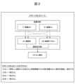
- FIG. 3 is a diagram illustrating road continuity determination cases supported by the current device configuration.
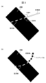
- FIG. 6 is a diagram illustrating an example in which the partition line is extended near the shielding area, where (a) the partition line is a straight line and (b) the partition line is a curved line.
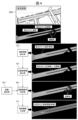
- FIG. 3 is a diagram illustrating an example of processing until lane information is generated.
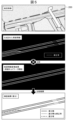
- FIG. 6 is a diagram illustrating an example of verification processing by a verification unit.
- FIG. 3 is a diagram illustrating road continuity determination cases supported by the current device configuration.
- FIG. 6 is a diagram illustrating an example in which the partition line is extended near the shielding area, where (a) the partition line is a straight line and (b) the partition line is a curved line.
- FIG. 3 is a diagram illustrating an example of processing until lane information is generated.
- FIG. 6 is a diagram illustrating an example of verification
- FIG. 3 is a diagram illustrating an example of output processing of the output unit, in which (a) shows data generated by the lane information generation unit 171, (b) shows data generated by the map information conversion unit 141, (c) shows verification results by the verification unit 181, (d) is a diagram showing remaining data of the data generated by the map information processing device 110.
- map information processing device of the present invention will be described in terms of configuration and performance with reference to FIGS. 1 to 6.
- the image acquired by the image acquisition unit 111 refers to one or more images of an aerial image type corresponding to a photograph of the ground taken from an aircraft or a satellite.
- This image is an image of a road including lanes and/or lane markings.
- FIG. 1 is a block diagram showing the configuration of a map information processing device according to this embodiment.
- the map information processing device 110 has a configuration in which a CPU, RAM, ROM, etc. are connected via a communication line, and the CPU executes various programs stored in the ROM, thereby controlling the entire system. Control behavior.
- the map information processing device 110 includes a map information storage section 101, an image acquisition section 111, a road information extraction section 121, a lane marking information extraction section 131, a map information conversion section 141, an occlusion estimation section 151, and a road continuity determination section. section 161 , lane information generation section 171 , verification section 181 , and output section 191 .
- the map information storage unit 101 is responsible for storing the information of the map processed and verified by the device in the form of (but not limited to) lane network information.
- the form of a lane network in a map that can be used for navigation purposes can be the form of nodes and links, as well as the link shapes and attributes that define the road for each lane.
- the image acquisition unit 111 can acquire one or more aerial images from storage (memory/hard drive) and/or a network and adjust image characteristics for further processing. This process involves image resolution adjustments that can downscale or upscale the input image and thus change the resulting image size, cropping (cropping) specific areas of the input image from the original input image for further processing. Images can include, but are not limited to, region of interest selection, and image color and brightness adjustments.
- the road information extraction unit 121 receives as input the image acquired by the image acquisition unit 111 (the image of the road), and estimates the road area.
- the term "road” will be used to refer to a single lane or a group of lanes.
- the road area can be estimated as an attribute assigned to each pixel of the image.
- the road region can also be extracted in the form of a network represented by nodes and links.
- Machine learning-based approaches can be used to estimate the road area for each pixel in an image.
- pre-trained models such as neural networks pre-trained by machine learning, can be used for estimation by applying methods such as semantic segmentation.
- a lane area estimator and a lane boundary estimator that divides the road area into lanes along lane boundaries can be included.
- a road boundary estimator may be included to estimate boundaries between roads and other road regions, or between roads and non-road regions.
- the lane marking information extraction unit 131 takes as input the image acquired by the image acquisition unit 111 (the image of the road), and estimates the area of the line (road paint) serving as the boundary between lanes.
- Said line refers to a road sign in the form of a line along a road (e.g., white lane markings), and depending on the region and standards, the colors may include, but are not limited to, white and yellow.
- the partition line area can be estimated as an attribute assigned to each pixel of the image by adopting a machine learning-based approach. For example, pre-trained models, such as neural networks pre-trained by machine learning, can be used for estimation by applying methods such as semantic segmentation.
- the map information conversion unit 141 takes as input the map information (part or all) stored in the map information storage unit 101, generates an image of the estimated road area based on the above-mentioned map information, and estimates the road area. . Similar to the road information extraction unit 121, in order to estimate more detailed information, a lane area estimator, a lane boundary estimator that divides the lane area into lanes along lane boundaries, and a road and another road area, Alternatively, a road boundary estimator that estimates boundaries between roads and non-road areas may also be included.
- the road area can be obtained by expanding the range by half of the pixels corresponding to the lane width while taking into account the number of lanes. If the network information given from the map indicates the center of the lane, the road area can be obtained by expanding the range by half the pixels corresponding to the lane width.
- the actual number of pixels to be expanded is determined, for example, by the resolution of the distance per pixel of the image acquired by the image acquisition unit 111. Additionally, when a road or lane is expanded, pixels that overlap with other roads or lanes may be treated as road boundaries or lane boundaries.
- the occlusion estimation unit 151 receives the output of the map information conversion unit 141 and the output of the road information extraction unit 121 as input, and estimates an area where the road is blocked and is not visible in the image acquired by the image acquisition unit 111. .
- the occluded area is determined using an approach based on a comparison between the output of the map information converter 141 and the output of the road information extractor 121 (if both images are in the same format), a machine learning-based approach, or a combination of both approaches. It can be estimated by either.
- the comparison approach takes the output image of the map information converter 141 and uses it as a base to compare it with the output image of the road information extractor 121 to determine whether road information is available in the output image of the map information converter 141. However, areas that are not usable in the output image of the road information extraction unit 121 are marked. The marked areas mentioned above are considered as occluded areas.
- the occluded region can be estimated as an attribute assigned to each pixel of the image.
- pre-trained models such as neural networks pre-trained by machine learning, can be used for estimation by applying methods such as semantic segmentation.
- the pre-trained model with the current equipment configuration is trained to identify buildings, skyscrapers, bridges, and pedestrian bridges, but the model's target occlusion type can be changed or increased as needed. can.
- the occluded area adjacent to the road information on the output image of the road information extraction unit 121 is marked.
- the aforementioned marked area is then considered as the occluded area.
- the road continuity determination unit 161 extracts the output of the lane marking information extraction unit 131 (in the form of an image or network), the output of the road information extraction unit 121 (in the form of an image or network), and the output of the occlusion estimation unit 151 (in the form of an image or network). (in the form of location information about the image) and determine the continuity of the road in the occluded area.
- the output of the lot line information extraction unit 131 is used to check a given lot line end point, and based on the distance measurement, check whether it is adjacent to the occluded area from the output of the occluded estimator 151.
- Distance can be measured in pixels, and the distance threshold for determining adjacency can be adjusted based on the resolution of the image acquired by image acquisition unit 111 and the distance per pixel.
- the separation and continuity check process (described below) is performed; otherwise, the status of that particular lot line endpoint is unchanged at this stage.
- the line to which the endpoint belongs is extended based on the shape of the line near the occluded area and thus across the occluded area until they intersect. For example, as shown in FIG. 3(a), if the lines are straight, they will be extended in the same way according to the direction given by the angle of the lines with respect to the occluded area at the point where they intersect. If the line is a curve, use a polynomial function obtained by fitting at least four points belonging to the parcel line near the occluded area until they intersect, as shown in Fig. 3(b). The line is extended.
- the location of the end of the extension line (out of occlusion) is then used to calculate the distance to other lot lines near the occluded area, and the most Select nearby connection point candidates.
- the maximum range threshold can be adjusted based on the resolution and distance per pixel of the image captured by the image capture unit 111.
- connection candidate After selecting a connection candidate, compare the shape of the extension line and the line that matched it to check their similarity. For example, based on the connection candidate, an additional extension line can be calculated, and both extension lines can be compared, and a difference/error value can be obtained from both lines.
- a difference is a comparison based on pixel differences
- an error is a comparison based on a mathematical function that fits the points to a straight line or curve.
- the distance between the end point of the extension line and the end point of the connection candidate (the lot line separation amount) and the difference between the extension line and the line from the connection candidate (the lot line continuity) are within predefined thresholds If so, the continuity of that particular lot line is registered.
- the registered data is used in the output of the road information extraction unit 121 to provide a means for describing the continuity of the road to which the marking line belongs.
- the road continuity determination unit 161 determines, for at least two lane markings that exist through the shielding area, whether the lane line is on an extension line estimated from the distance between the lane marking lines and the shape of one lane marking.
- the continuity of the road in the shielded area is determined based on the lane marking continuity indicating whether the road is connected to the other lane marking.
- the lane information generation unit 171 takes the output of the road information extraction unit 121, the output of the marking line information extraction unit 131, and the output of the road continuity determination unit 161, and converts it into an image format or by nodes and links for verification purposes. Generate lane information in one of the formats of the represented network.
- the marking line information extraction unit 131 includes a lane area estimator and a lane boundary estimator that divides the road area into lanes along the lane boundaries. Use the output (lines) as a reference to divide the road into lanes.
- the output information of the road continuity determination unit 161 is then used to connect consecutive roads and lanes that are not connected by the output of the road information extraction unit 121, and if necessary, the missing information is added to the image (road/lane and line pixels).
- the road area can be adjusted by first placing the connecting line in the middle of the connected lanes and then expanding the range by half the pixels corresponding to the lane width. can be completed.
- pixels that overlap other roads or lanes may be treated as road boundaries or lane boundaries.
- the actual number of pixels to be expanded is determined, for example, by the per-pixel distance resolution of the image acquired by the image acquisition unit 111 or by the size of the connected lane.
- the lane information generation unit 171 detects when the occlusion estimation unit 151 extracts the occlusion area and the road continuity determination unit 161 determines that there is road continuity in the occlusion area.
- the lane information is generated by modifying the output of the road information extraction unit 121 (connecting unconnected consecutive roads and lanes).
- FIG. 4 shows the process of extracting (detecting) road information by the road information extraction unit 121 and the process of extracting (detecting) road information by the lane marking information extraction unit 131 for the image (aerial image of a road) 200 acquired by the image acquisition unit 111.
- Processing for extracting (detecting) processing for determining road continuity in the occlusion area estimated by the occlusion estimation unit 151 and road continuity determination unit 161 , and processing for generating lane information by the lane information generation unit 171 . It shows.
- the verification unit 181 verifies the lane network information stored in the map information storage unit 101 by comparing the information generated by the map information conversion unit 141 and the lane information generation unit 171 (see FIG. 5).
- Verification in this device configuration is performed by extracting the difference between the image or network data corresponding to the output of the map information converter 141 and the output of the lane information generator 171.
- the images may be shifted from each other due to distortion of the aerial images used or shifts in the map network registered in the map information storage unit 101.
- the map information conversion unit 141 can refer to the original network information, adjust it, and regenerate the image.
- the difference is estimated using the following process: lane presence/absence determination and lane width comparison.
- the lane width comparison process if there is lane information corresponding to both images, the lane widths in the images are compared, and the width difference is calculated and output.
- the differential output is processed taking into account the conversion error of the input data on both sides, and the output unit can be the number of pixels, the number of equivalent lanes, or other relevant measurements.
- the output unit 191 prepares the data generated by the verification unit 181, the map information conversion unit 141, the lane information generation unit 171, the occlusion estimation unit 151, and the road continuity determination unit 161, and outputs the data to the map information processing device 110 or other Output as a set for further processing by any external device.
- data generated by the lane information generation unit 171 using the data is shown in FIG. It can be explicitly displayed as follows. Further, the data generated by the map information conversion unit 141 can be displayed as shown in FIG. 6(b) (verified using the method described above). Further, the results of the verification unit 181 can be explicitly displayed as shown in FIG. 6(c) (where the difference and the data have been corrected are shown for reference).
- the remaining data generated by the map information processing device 110 can also be part of the output set and other Applications and display methods can be added as well.
- the output unit 191 that can output the verification results etc. in the verification unit 181 allows the lane information generation unit 171 to modify the output of the road information extraction unit 121 based on the road continuity determination unit 161 (such as unconnected continuous roads and When the lane information is generated by connecting lanes), the lane information before correction and the lane information after correction can be output (see especially FIG. 6(a)).
- the map information processing device 110 a road information extraction unit 121 that extracts road information from an image of a road; a marking line information extraction unit 131 that extracts marking line information from the image; The road information extraction unit 121 and the map information (by generating image information of the estimated road area based on the map information stored in the map information storage unit 101, that is, by converting the map information into image information of the road area) an occlusion estimation unit 151 that estimates an occlusion area where a road is occluded (in the image) based on a map information conversion unit 141 that estimates a road area; a road continuity determination unit 161 that determines road continuity in the shielding area based on the marking line information; a lane information generation unit 171 that generates lane information based on the road information extraction unit 121 and the road continuity determination unit 161 (by correcting the output of the road information extraction unit 121); By comparing with the lane information generated by the lane information generation section 171 (by extracting the
- the map information processing device 110 generates lane information that can generate appropriate lane information even in areas where road information cannot be extracted due to occlusion, using satellite images or aerial photographs for map information verification. do.
- the map information processing device 110 uses lane information (lane-level road information) constructed from road areas corresponding to roads extracted from aerial images, and uses lane information (lane-level road information) to eliminate the possibility that roads may not be visible due to obstacles. By ensuring that the lane information can be generated appropriately even if there is a possibility of a certain area, reliable verification of high precision maps can be performed.
- the present invention is not limited to the above-described embodiments, and includes various modifications.
- the above-described embodiments have been described in detail to explain the present invention in an easy-to-understand manner, and the present invention is not necessarily limited to having all the configurations described.
- each of the above-mentioned configurations, functions, processing units, processing means, etc. may be partially or entirely realized by hardware, for example, by designing an integrated circuit.
- each of the above configurations, functions, etc. may be realized by software by a processor interpreting and executing a program for realizing each function.
- Information such as programs, tables, files, etc. that realize each function can be stored in a memory, a storage device such as a hard disk, an SSD (Solid State Drive), or a recording medium such as an IC card, SD card, or DVD.
- control lines and information lines are shown that are considered necessary for explanation, and not all control lines and information lines are necessarily shown in the product. In reality, almost all components may be considered to be interconnected.
- Map information processing device 101 Map information storage unit 111 Image acquisition unit 121 Road information extraction unit 131 Marking line information extraction unit 141 Map information conversion unit 151 Occlusion estimation unit 161 Road continuity determination unit 171 Lane information generation unit 181 Verification unit 191 Output Department
Landscapes
- Engineering & Computer Science (AREA)
- Radar, Positioning & Navigation (AREA)
- Remote Sensing (AREA)
- Physics & Mathematics (AREA)
- General Physics & Mathematics (AREA)
- Automation & Control Theory (AREA)
- Theoretical Computer Science (AREA)
- Mathematical Physics (AREA)
- Computer Vision & Pattern Recognition (AREA)
- Business, Economics & Management (AREA)
- Educational Administration (AREA)
- Educational Technology (AREA)
- Processing Or Creating Images (AREA)
- Instructional Devices (AREA)
- Image Analysis (AREA)
- Traffic Control Systems (AREA)
Abstract
Description
地図情報記憶部101は、車線ネットワーク情報の形で(ただしこれに限定されない)当該装置によって処理および検証される地図の情報を記憶する責任がある。ナビゲーションの目的で使用できる地図内の車線ネットワークの形式は、ノードおよびリンクの形式、ならびにリンク形状および各車線の道路を定義する属性である可能性がある。
画像取得部111は、ストレージ(メモリ/ハードドライブ)および/またはネットワークから1つまたは複数の航空画像を取得し、さらなる処理のために画像特性を調整することができる。このプロセスは、入力画像をダウンスケールまたはアップスケールし、したがって結果として得られる画像サイズを変更できる画像解像度調整、さらなる処理のために入力画像の特定の領域を元の入力画像から切り取る(切り抜く)ことができる画像関心領域選択、および画像の色と明るさの調整を含むが、これらに限定されない。
道路情報抽出部121は、画像取得部111によって取得された画像(道路を撮像した画像)を入力として取り、道路領域を推定する。
区画線情報抽出部131は、画像取得部111によって取得された画像(道路を撮像した画像)を入力として取り、車線間の境界となる線(道路ペイント)の領域を推定する。前述の線は、道路に沿った線の形の道路標識(例えば、白い車線のマーキング)を指し、地域および基準によって、色に白色と黄色が含まれる場合があるが、これらに限定されない。区画線領域は、機械学習ベースのアプローチを採用することによって、画像の各ピクセルに割り当てられた属性として推定できる。例えば、機械学習によって事前トレーニングされたニューラルネットワークなどの事前トレーニングされたモデルは、セマンティックセグメンテーションなどの方法を適用することで、推定に使用できる。
地図情報変換部141は、地図情報記憶部101に格納された地図情報(一部または全部)を入力として取り、前述の地図情報に基づいて推定道路領域の画像を生成して道路領域を推定する。道路情報抽出部121と同様に、より詳細な情報を推定するために、車線領域推定器、および車線領域を車線境界に沿って車線に分割する車線境界推定器、ならびに道路と別の道路領域、または道路と非道路領域との間の境界を推定する道路境界推定器も含めることができる。
遮蔽推定部151は、地図情報変換部141の出力と道路情報抽出部121の出力を入力として取り、道路が遮蔽されていて、画像取得部111によって取得された画像には見えない領域を推定する。遮蔽領域は、地図情報変換部141の出力と道路情報抽出部121の出力(両方の画像が同じ形式である場合)との比較ベースのアプローチ、または機械学習ベースのアプローチ、あるいは両方のアプローチの組み合わせのいずれかによって推定できる。
道路連続性判定部161は、区画線情報抽出部131の出力(画像またはネットワークの形で)および道路情報抽出部121の出力(画像またはネットワークの形で)および遮蔽推定部151の出力(画像または画像に関する位置情報の形で)を受け取り、遮蔽領域における道路の連続性を判断する。
車線情報生成部171は、道路情報抽出部121の出力および区画線情報抽出部131の出力、ならびに道路連続性判定部161の出力を取り、画像の形式、または、検証の目的でノードおよびリンクによって表わされるネットワークの形式のいずれかで車線情報を生成する。
検証部181は、地図情報変換部141および車線情報生成部171で生成された情報を比較することによって、地図情報記憶部101で記憶された車線ネットワーク情報を検証する(図5参照)。
出力部191は、検証部181、地図情報変換部141、車線情報生成部171、遮蔽推定部151、および道路連続性判定部161によって生成されたデータを準備し、地図情報処理装置110または他の外部装置のいずれかによるさらなる処理のために、セットとして出力する。
道路を撮像した画像から道路情報を抽出する道路情報抽出部121と、
前記画像から区画線情報を抽出する区画線情報抽出部131と、
前記道路情報抽出部121と(地図情報記憶部101に記憶された地図情報に基づいて推定道路領域の画像情報を生成する、つまり地図情報を道路領域の画像情報に変換することによって)地図情報から道路領域を推定する地図情報変換部141に基づいて、(前記画像において)道路が遮蔽される遮蔽領域を推定する遮蔽推定部151と、
前記区画線情報に基づき、前記遮蔽領域における道路の連続性を判定する道路連続性判定部161と、
前記道路情報抽出部121および前記道路連続性判定部161に基づき(前記道路情報抽出部121の出力を修正して)車線情報を生成する車線情報生成部171と、
前記車線情報生成部171により生成された車線情報と比較することで(地図情報変換部141と車線情報生成部171により生成された車線情報(道路情報修正部分)の差分を抽出することで、あるいは、地図情報変換部141で推定された道路領域と車線情報生成部171により生成された車線情報の差分を抽出することで)、地図情報記憶部101に記憶された車線ネットワークを検証する検証部181と、を備える。
101 地図情報記憶部
111 画像取得部
121 道路情報抽出部
131 区画線情報抽出部
141 地図情報変換部
151 遮蔽推定部
161 道路連続性判定部
171 車線情報生成部
181 検証部
191 出力部
Claims (6)
- 道路を撮像した画像から道路情報を抽出する道路情報抽出部と、
前記画像から区画線情報を抽出する区画線情報抽出部と、
前記道路情報抽出部と地図情報から道路領域を推定する地図情報変換部に基づいて、道路が遮蔽される遮蔽領域を推定する遮蔽推定部と、
前記区画線情報に基づき、前記遮蔽領域における道路の連続性を判定する道路連続性判定部と、
前記道路情報抽出部および前記道路連続性判定部に基づき車線情報を生成する車線情報生成部と、
前記車線情報生成部により生成された車線情報と比較することで、地図情報記憶部に記憶された車線ネットワークを検証する検証部と、を備える、地図情報処理装置。 - 請求項1に記載の地図情報処理装置であって、
前記検証部における検証結果を出力する出力部を備え、
前記出力部は、前記車線情報生成部が前記道路連続性判定部に基づき前記道路情報抽出部の出力を修正して前記車線情報を生成したとき、修正前における車線情報および修正後における車線情報を出力する、地図情報処理装置。 - 請求項1に記載の地図情報処理装置であって、
前記車線情報生成部は、前記遮蔽推定部により前記遮蔽領域が抽出され、前記道路連続性判定部により前記遮蔽領域における道路の連続性が有りと判定されたとき、前記道路情報抽出部の出力を修正して前記車線情報を生成する、地図情報処理装置。 - 請求項1に記載の地図情報処理装置であって、
前記道路連続性判定部は、前記遮蔽領域を介して存在する少なくとも二つの区画線について、互いに離れている距離を示す区画線分離量と、一方の区画線の形状から推測される延長線上に他方の区画線に繋がるかを示す区画線連続性と、に基づいて連続性を判定する、地図情報処理装置。 - 請求項1に記載の地図情報処理装置であって、
前記検証部は、前記地図情報変換部で推定された道路領域と前記車線情報生成部により生成された車線情報の差分を抽出することで、前記地図情報記憶部に記憶された車線ネットワークを検証する、地図情報処理装置。 - 請求項5に記載の地図情報処理装置であって、
前記差分は、車線の有無情報または車線の幅情報の少なくとも一つを含む、地図情報処理装置。
Priority Applications (2)
| Application Number | Priority Date | Filing Date | Title |
|---|---|---|---|
| CN202280090966.1A CN118661206A (zh) | 2022-03-11 | 2022-08-12 | 地图信息处理装置 |
| US18/835,532 US20250130063A1 (en) | 2022-03-11 | 2022-08-12 | Map information processing device |
Applications Claiming Priority (2)
| Application Number | Priority Date | Filing Date | Title |
|---|---|---|---|
| JP2022-038416 | 2022-03-11 | ||
| JP2022038416A JP7763125B2 (ja) | 2022-03-11 | 2022-03-11 | 地図情報処理装置 |
Publications (1)
| Publication Number | Publication Date |
|---|---|
| WO2023170997A1 true WO2023170997A1 (ja) | 2023-09-14 |
Family
ID=87936416
Family Applications (1)
| Application Number | Title | Priority Date | Filing Date |
|---|---|---|---|
| PCT/JP2022/030806 Ceased WO2023170997A1 (ja) | 2022-03-11 | 2022-08-12 | 地図情報処理装置 |
Country Status (4)
| Country | Link |
|---|---|
| US (1) | US20250130063A1 (ja) |
| JP (1) | JP7763125B2 (ja) |
| CN (1) | CN118661206A (ja) |
| WO (1) | WO2023170997A1 (ja) |
Families Citing this family (1)
| Publication number | Priority date | Publication date | Assignee | Title |
|---|---|---|---|---|
| KR20240023908A (ko) * | 2022-08-16 | 2024-02-23 | (주)뷰런테크놀로지 | 이동체의 이동 경로를 이용한 차선 검출 방법 및 장치 |
Citations (5)
| Publication number | Priority date | Publication date | Assignee | Title |
|---|---|---|---|---|
| JP2004020292A (ja) * | 2002-06-14 | 2004-01-22 | Kenwood Corp | 地図情報更新システム |
| JP2009211150A (ja) * | 2008-02-29 | 2009-09-17 | Hitachi Software Eng Co Ltd | 道路ネットワークの抽出装置 |
| JP2009230518A (ja) * | 2008-03-24 | 2009-10-08 | Hitachi Software Eng Co Ltd | 道路地図データ作成システム |
| JP2018173762A (ja) * | 2017-03-31 | 2018-11-08 | パイオニア株式会社 | 車線情報生成装置及び車線情報生成方法並びに車線情報生成用プログラム |
| JP2020520493A (ja) * | 2017-09-19 | 2020-07-09 | ベイジン センスタイム テクノロジー デベロップメント カンパニー, リミテッド | 道路地図生成方法、装置、電子機器およびコンピュータ記憶媒体 |
Family Cites Families (2)
| Publication number | Priority date | Publication date | Assignee | Title |
|---|---|---|---|---|
| KR102611927B1 (ko) * | 2018-07-11 | 2023-12-08 | 르노 에스.아.에스. | 주행 환경 정보의 생성 방법, 운전 제어 방법, 주행 환경 정보 생성 장치 |
| US11119192B2 (en) * | 2018-12-07 | 2021-09-14 | Here Global B.V. | Automatic detection of overhead obstructions |
-
2022
- 2022-03-11 JP JP2022038416A patent/JP7763125B2/ja active Active
- 2022-08-12 WO PCT/JP2022/030806 patent/WO2023170997A1/ja not_active Ceased
- 2022-08-12 CN CN202280090966.1A patent/CN118661206A/zh active Pending
- 2022-08-12 US US18/835,532 patent/US20250130063A1/en active Pending
Patent Citations (5)
| Publication number | Priority date | Publication date | Assignee | Title |
|---|---|---|---|---|
| JP2004020292A (ja) * | 2002-06-14 | 2004-01-22 | Kenwood Corp | 地図情報更新システム |
| JP2009211150A (ja) * | 2008-02-29 | 2009-09-17 | Hitachi Software Eng Co Ltd | 道路ネットワークの抽出装置 |
| JP2009230518A (ja) * | 2008-03-24 | 2009-10-08 | Hitachi Software Eng Co Ltd | 道路地図データ作成システム |
| JP2018173762A (ja) * | 2017-03-31 | 2018-11-08 | パイオニア株式会社 | 車線情報生成装置及び車線情報生成方法並びに車線情報生成用プログラム |
| JP2020520493A (ja) * | 2017-09-19 | 2020-07-09 | ベイジン センスタイム テクノロジー デベロップメント カンパニー, リミテッド | 道路地図生成方法、装置、電子機器およびコンピュータ記憶媒体 |
Non-Patent Citations (1)
| Title |
|---|
| SHINMURA FUMITO, YOKOI AKIRA, SAJI HITOSHI: "Classification of Road Congestion Status Using Satellite Images and a Three-Dimensional Map", THE JOURNAL OF THE INSTITUTE OF IMAGE ELECTRONICS ENGINEERS OF JAPAN, vol. 42, no. 1, 1 January 2013 (2013-01-01), pages 15 - 24, XP093089259 * |
Also Published As
| Publication number | Publication date |
|---|---|
| US20250130063A1 (en) | 2025-04-24 |
| CN118661206A (zh) | 2024-09-17 |
| JP7763125B2 (ja) | 2025-10-31 |
| JP2023132855A (ja) | 2023-09-22 |
Similar Documents
| Publication | Publication Date | Title |
|---|---|---|
| CN112154445B (zh) | 高精度地图中车道线的确定方法和装置 | |
| KR102541559B1 (ko) | 관심 객체를 검출하는 방법 및 장치 | |
| KR102089343B1 (ko) | 어라운드 뷰 모니터링 시스템 및 카메라 공차 보정 방법 | |
| KR20200045693A (ko) | 캘리브레이션 방법 및 장치 | |
| WO2018225446A1 (ja) | 地図変化点検出装置 | |
| US20150367781A1 (en) | Lane boundary estimation device and lane boundary estimation method | |
| JP6560355B2 (ja) | ランドマーク認識装置及び認識方法 | |
| CN111448601A (zh) | 车道网络数据生成装置、车道网络数据生成程序以及存储介质 | |
| JP6838285B2 (ja) | レーンマーカ認識装置、自車両位置推定装置 | |
| CN103098111A (zh) | 行驶道路推定装置及程序 | |
| JP6822427B2 (ja) | 地図変化点検出装置 | |
| CN110341621B (zh) | 一种障碍物检测方法及装置 | |
| JP6620175B2 (ja) | 距離算出装置及び車両制御装置 | |
| KR20200095379A (ko) | 자체적으로 생성된 정보 및 다른 개체에 의해 생성된 정보를 선택적으로 사용하여 카메라의 오정렬을 보정하는 방법 및 이를 이용한 장치 | |
| CN117382675A (zh) | 道路的可行驶区域生成方法、装置、车辆及存储介质 | |
| KR20190134303A (ko) | 영상 인식 장치 및 그 방법 | |
| CN114118188A (zh) | 针对待检测图像中移动对象的处理系统、方法和存储介质 | |
| CN117292358B (zh) | 目标识别方法、装置、电子设备及计算机可读存储介质 | |
| JP7763125B2 (ja) | 地図情報処理装置 | |
| CN113887294A (zh) | 车轮接地点的检测方法、装置、电子设备与存储介质 | |
| US11222216B2 (en) | Crosswalk detection device, method and program | |
| KR101721655B1 (ko) | 객체 검출 시스템 및 방법 | |
| JP7404173B2 (ja) | 画像処理装置 | |
| CN104573618A (zh) | 使用拍摄单元的车道检测方法和系统 | |
| KR102119678B1 (ko) | 차선 검출 방법 및 그 방법을 수행하는 전자 장치 |
Legal Events
| Date | Code | Title | Description |
|---|---|---|---|
| 121 | Ep: the epo has been informed by wipo that ep was designated in this application |
Ref document number: 22930974 Country of ref document: EP Kind code of ref document: A1 |
|
| WWE | Wipo information: entry into national phase |
Ref document number: 18835532 Country of ref document: US |
|
| WWE | Wipo information: entry into national phase |
Ref document number: 202280090966.1 Country of ref document: CN |
|
| NENP | Non-entry into the national phase |
Ref country code: DE |
|
| 122 | Ep: pct application non-entry in european phase |
Ref document number: 22930974 Country of ref document: EP Kind code of ref document: A1 |
|
| WWP | Wipo information: published in national office |
Ref document number: 18835532 Country of ref document: US |