WO2023135749A1 - Deterioration estimation system, deterioration estimation method, and recording medium - Google Patents
Deterioration estimation system, deterioration estimation method, and recording medium Download PDFInfo
- Publication number
- WO2023135749A1 WO2023135749A1 PCT/JP2022/001143 JP2022001143W WO2023135749A1 WO 2023135749 A1 WO2023135749 A1 WO 2023135749A1 JP 2022001143 W JP2022001143 W JP 2022001143W WO 2023135749 A1 WO2023135749 A1 WO 2023135749A1
- Authority
- WO
- WIPO (PCT)
- Prior art keywords
- road surface
- deterioration
- degree
- area
- surface image
- Prior art date
Links
Images


Classifications
-
- G—PHYSICS
- G08—SIGNALLING
- G08G—TRAFFIC CONTROL SYSTEMS
- G08G1/00—Traffic control systems for road vehicles
Landscapes
- Physics & Mathematics (AREA)
- General Physics & Mathematics (AREA)
- Traffic Control Systems (AREA)
Abstract
A deterioration estimation system according to the present disclosure comprises: a detection means that detects road surface deterioration from a first road surface image obtained by photographing a road surface; a determination means that determines, within the first road surface image, a first region for which detection of the road surface deterioration is possible and a second region for which detection of the road surface deterioration is difficult; a first calculation means that calculates the degree of deterioration in the first region on the basis of the detection results from the first road surface image; an estimation means that estimates the degree of deterioration in the second region on the basis of the degree of road surface deterioration detected from a second road surface image obtained by photographing the road surface ahead of the first road surface image; and a second calculation means that calculates the degree of deterioration of the road surface on the basis of the calculated degree of deterioration in the first region and the estimated degree of deterioration in the second region.
Description
本開示は、劣化推定システム等に関する。
This disclosure relates to a deterioration estimation system and the like.
路面には年月の経過により路面劣化が発生する。路面の適切な管理と補修のために、路面の劣化度が計測される。劣化度の計測方法は様々ある。特許文献1は、一例として、カメラで撮影された画像を解析して、劣化度を計測する方法を開示している。
The road surface deteriorates over time. The degree of deterioration of the road surface is measured for proper management and repair of the road surface. There are various methods for measuring the degree of deterioration. As an example, Patent Literature 1 discloses a method of analyzing an image captured by a camera and measuring the degree of deterioration.
また、将来の劣化度を予測することも行われる。特許文献2は、測定期間における路面性状の時間経過に伴う変化を近似する回帰線を分析する道路管理システムを開示している。特許文献2において、交通量や気象状況を元に、測定期間経過後における近未来の回帰線が予測される。
It is also possible to predict the degree of future deterioration. Patent Literature 2 discloses a road management system that analyzes a regression line that approximates changes in road surface properties over time during a measurement period. In Patent Literature 2, a regression line in the near future after the measurement period has elapsed is predicted based on traffic volume and weather conditions.
条件によっては、画像から路面劣化が正確に計測されない場合がある。例えば、降水や降雪によって路面が水や雪で覆われると、路面劣化の検出が困難となる。
Depending on the conditions, road surface deterioration may not be accurately measured from the image. For example, when the road surface is covered with water or snow due to rain or snow, it becomes difficult to detect deterioration of the road surface.
本開示は、路面を撮影した路面画像に路面劣化の検出が困難な領域があっても、路面の劣化度を推定できる、劣化推定システム等を提供することを目的とする。
The purpose of the present disclosure is to provide a deterioration estimation system and the like that can estimate the degree of deterioration of a road surface even if road surface images obtained by photographing the road surface include areas in which it is difficult to detect road surface deterioration.
本開示に係る劣化推定システムは、路面を撮影した第1の路面画像から路面劣化を検出する検出手段と、前記第1の路面画像のうち、路面劣化の検出が可能な第1領域と、路面劣化の検出が困難な第2領域とを決定する決定手段と、前記第1の路面画像からの検出結果に基づいて、前記第1領域の劣化度を計算する第1計算手段と、前記第1の路面画像より前に前記路面を撮影した第2の路面画像から検出された路面劣化の劣化度に基づいて、前記第2領域の劣化度を推定する推定手段と、計算された前記第1領域の劣化度と、推定された前記第2領域の劣化度と、に基づいて、前記路面の劣化度を計算する第2計算手段を備える。
A deterioration estimation system according to the present disclosure includes detection means for detecting road surface deterioration from a first road surface image obtained by photographing a road surface; determining means for determining a second area where detection of deterioration is difficult; first calculating means for calculating the degree of deterioration of the first area based on the detection result from the first road surface image; an estimating means for estimating the degree of deterioration of the second area based on the degree of deterioration of road surface deterioration detected from a second road surface image obtained by photographing the road surface before the road surface image of; second calculation means for calculating the degree of deterioration of the road surface based on the degree of deterioration of the road surface and the estimated degree of deterioration of the second area.
本開示に係る劣化推定方法は、路面を撮影した第1の路面画像から路面劣化を検出し、前記第1の路面画像のうち、路面劣化の検出が可能な第1領域と、路面劣化の検出が困難な第2領域とを決定し、前記第1の路面画像からの検出結果に基づいて、前記第1領域の劣化度を計算し、前記第1の路面画像より前に前記路面を撮影した第2の路面画像から検出された路面劣化の劣化度に基づいて、前記第2領域の劣化度を推定し、計算された前記第1領域の劣化度と、推定された前記第2領域の劣化度と、に基づいて、前記路面の劣化度を計算する。
A deterioration estimation method according to the present disclosure detects road surface deterioration from a first road surface image obtained by photographing a road surface, and includes a first area where road surface deterioration can be detected in the first road surface image, determining a second area where it is difficult to obtain a road surface image, calculating the degree of deterioration of the first area based on the detection result from the first road surface image, and photographing the road surface before the first road surface image; estimating the degree of deterioration of the second region based on the degree of deterioration of the road surface deterioration detected from the second road surface image; and the degree of deterioration of the road surface is calculated.
本開示に係るプログラムは、路面を撮影した第1の路面画像から路面劣化を検出し、前記第1の路面画像のうち、路面劣化の検出が可能な第1領域と、路面劣化の検出が困難な第2領域とを決定し、前記第1の路面画像からの検出結果に基づいて、前記第1領域の劣化度を計算し、前記第1の路面画像より前に前記路面を撮影した第2の路面画像から検出された路面劣化の劣化度に基づいて、前記第2領域の劣化度を推定し、計算された前記第1領域の劣化度と、推定された前記第2領域の劣化度と、に基づいて、前記路面の劣化度を計算する処理をコンピュータに実行させる。プログラムは、コンピュータが読み取り可能な非一時的な記録媒体に記憶されていてもよい。
A program according to the present disclosure detects road surface deterioration from a first road surface image obtained by photographing a road surface. A second area is determined, the degree of deterioration of the first area is calculated based on the detection result from the first road surface image, and a second road surface image is captured before the first road surface image. estimating the degree of deterioration of the second region based on the degree of deterioration of the road surface deterioration detected from the road surface image of the above, and calculating the calculated degree of deterioration of the first region and the estimated degree of deterioration of the second region; A computer is caused to execute a process of calculating the degree of deterioration of the road surface based on . The program may be stored in a non-temporary computer-readable recording medium.
本開示によれば、路面を撮影した路面画像に路面劣化の検出が困難な領域があっても、路面の劣化度を推定できる。
According to the present disclosure, it is possible to estimate the degree of deterioration of the road surface even if there is an area in which it is difficult to detect the deterioration of the road surface in the image of the road surface.
以下に図面を参照して、本開示に係る劣化推定システム、劣化推定方法、およびプログラム、プログラムを記録する非一時的な記録媒体の実施の形態を詳細に説明する。本実施の形態は、開示の技術を限定するものではない。
Embodiments of a deterioration estimation system, a deterioration estimation method, a program, and a non-temporary recording medium for recording the program according to the present disclosure will be described in detail below with reference to the drawings. The present embodiment does not limit the technology disclosed.
[第1の実施形態]
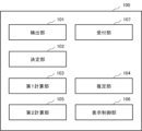
図1は、第1の実施形態に係る劣化推定システム100の構成例を示すブロック図である。第1の実施形態に係る劣化推定システム100は、検出部101、決定部102、第1計算部103、推定部104、及び、第2計算部105を備える。第1の実施形態において、図1は、劣化推定システム100がさらに表示制御部106を備える場合を示す。ただし、劣化推定システム100は、表示制御部106を備えなくてもよい。 [First Embodiment]
FIG. 1 is a block diagram showing a configuration example of adegradation estimation system 100 according to the first embodiment. A deterioration estimation system 100 according to the first embodiment includes a detection unit 101 , a determination unit 102 , a first calculation unit 103 , an estimation unit 104 and a second calculation unit 105 . In the first embodiment, FIG. 1 shows a case where deterioration estimation system 100 further includes display control section 106 . However, the deterioration estimation system 100 does not have to include the display control unit 106 .
図1は、第1の実施形態に係る劣化推定システム100の構成例を示すブロック図である。第1の実施形態に係る劣化推定システム100は、検出部101、決定部102、第1計算部103、推定部104、及び、第2計算部105を備える。第1の実施形態において、図1は、劣化推定システム100がさらに表示制御部106を備える場合を示す。ただし、劣化推定システム100は、表示制御部106を備えなくてもよい。 [First Embodiment]
FIG. 1 is a block diagram showing a configuration example of a
本実施形態において、劣化推定システム100は、路面画像を用いた路面劣化の管理に用いられる。路面劣化は、例えば、ひび割れ、ポットホール、わだち掘れ、及び、平坦性異常を含む。ひび割れは、形状によって、直線ひび、及び、亀甲ひびの異なる種類に分類されてもよい。直線ひびとは、単独の線状のひびである。亀甲ひびとは、例えば、縦横の直線ひびが繋がった場合等に生じる亀甲状のひびである。ひび割れは、直線ひびから、亀甲ひび、ポットホールへと進行する。
In this embodiment, the deterioration estimation system 100 is used for managing road surface deterioration using road surface images. Road surface deterioration includes, for example, cracks, potholes, rutting, and flatness anomalies. Cracks may be classified into different types, linear cracks and tortoiseshell cracks, depending on their shape. A straight crack is a single linear crack. A tortoiseshell crack is a tortoiseshell-shaped crack that occurs, for example, when vertical and horizontal straight cracks are connected. Cracks progress from linear cracks to tortoiseshell cracks and potholes.
路面劣化の程度を表す指標として、様々な指標が用いられている。本開示において、路面劣化の程度は、劣化度により表される。劣化度を表す値は、路面劣化が進行するほど、大きくなるよう設定されうる。劣化度は、ひび割れ度、ポットホールの数、ポットホールの大きさ、わだち掘れ量、または、平坦性を含む指標のいずれかであってもよい。
Various indicators are used as indicators to express the degree of road surface deterioration. In the present disclosure, the degree of road surface deterioration is represented by the degree of deterioration. The value representing the degree of deterioration can be set to increase as road surface deterioration progresses. The degree of deterioration may be any index including degree of cracking, number of potholes, size of potholes, amount of rutting, or flatness.
ひび割れ度は、ひび割れの形状、長さ、幅、面積、本数のいずれか、または、これらの組み合わせによって表される。ひび割れ率はひび割れ度の一例である。ひび割れ率は、例えば、100×(ひび割れの面積/道路区間の面積)によって表される。この場合、劣化度の値は、0%から100%の範囲となる。ひび割れの面積は任意の方法で計算される。なおひび割れ率の計算方法は特に限定されず、上記の他に既知の計算方法が適用可能である。
The degree of cracking is represented by the shape, length, width, area, number of cracks, or a combination thereof. Crack rate is an example of crack degree. The crack ratio is represented by, for example, 100×(crack area/road section area). In this case, the value of the degree of deterioration ranges from 0% to 100%. The crack area is calculated by any method. The method for calculating the crack rate is not particularly limited, and known calculation methods other than those described above can be applied.
ポットホールの大きさは、例えば、ポットホールの面積、幅、長さ、深さのいずれか、または、これらの組み合わせによって表される。わだち掘れ量とは、車両の荷重やタイヤとの摩擦により、車両の走行軌跡が他の路面よりも低くなったわだち掘れの深さである。
The size of a pothole is represented by, for example, the area, width, length, or depth of the pothole, or a combination of these. The amount of rutting is the depth of the rut where the running track of the vehicle is lower than other road surfaces due to the load of the vehicle and the friction with the tires.
また、劣化度は、路面劣化の程度を表す複数の指標の組み合わせに基づいて定められてもよい。例えば、劣化度は、維持管理指数(MCI,Maintenance Control Index)であってもよい。MCIの値は、ひび割れ率、わだち掘れ量、及び平坦性を用いる4つの定義式を計算した結果の最小値である。道路の劣化に伴いMCIは低下する。
Also, the degree of deterioration may be determined based on a combination of a plurality of indicators representing the degree of road surface deterioration. For example, the degree of deterioration may be a maintenance control index (MCI). The value of MCI is the minimum result of calculating four defining equations using crack rate, rut depth, and flatness. MCI decreases as the road deteriorates.
なお、劣化推定システム100が対象とする路面は、車両や人が通行する一般的な道路に限られず、車両のテストコース、及び、空港の滑走路や誘導路なども含まれる。すなわち、劣化推定システム100は、舗装された路面を広く対象としうる。
It should be noted that the road surface targeted by the deterioration estimation system 100 is not limited to general roads on which vehicles and people pass, but also includes vehicle test courses, airport runways and taxiways. That is, the deterioration estimation system 100 can widely target paved road surfaces.
検出部101は、路面を撮影した路面画像から路面劣化を検出する。路面画像は、路面を撮影したものであれば、空、道路標識、建物など、路面以外を含んでもよい。あるいは、路面画像は、路面のみを撮影した画像であってもよい。
The detection unit 101 detects road surface deterioration from a road surface image obtained by photographing the road surface. The road surface image may include images other than the road surface, such as the sky, road signs, and buildings, as long as the road surface is photographed. Alternatively, the road surface image may be an image obtained by photographing only the road surface.
図2は、車が走る道路を撮影した路面画像の例を示す図である。図2の路面画像には路面劣化の一例として、ひび割れが含まれる。
Fig. 2 is a diagram showing an example of a road surface image of a road on which a car is running. The road surface image of FIG. 2 includes cracks as an example of road surface deterioration.
路面画像は、ドライブレコーダ等の車載カメラで撮影される。ただし、カメラの種類はこれには限られず、様々な種類のカメラが用いられてもよい。例えば、路面画像は、自転車やドローン等の他の移動体に搭載されたカメラ、人が持って歩くカメラ、または、道路に設置された固定カメラで撮影されてもよい。路面画像は、人によって撮影されてもよく、自動で撮影されてもよい。
The road surface image is captured by an in-vehicle camera such as a drive recorder. However, the type of camera is not limited to this, and various types of cameras may be used. For example, the road surface image may be captured by a camera mounted on another mobile object such as a bicycle or drone, a camera carried by a person, or a fixed camera installed on the road. The road surface image may be taken by a person or automatically.
図3は、劣化推定システム100と通信ネットワーク30を介して有線または無線により通信可能に接続される装置の例を示す図である。
FIG. 3 is a diagram showing an example of a device that is communicably connected to the deterioration estimation system 100 via a communication network 30 by wire or wirelessly.
ディスプレイ20は、コンピュータに接続されたディスプレイやタブレットなどである。ディスプレイ20には、マウスやキーボードなどの入力装置が接続されてもよい。また、ディスプレイ20がタッチパネルディスプレイである場合は、ディスプレイ20が入力装置として構成されてもよい。劣化推定システム100が備える表示制御部106は、ディスプレイ20に様々な情報を表示させる。表示制御部106が表示させる情報については後述される。
The display 20 is a display, tablet, or the like connected to a computer. An input device such as a mouse or keyboard may be connected to the display 20 . Moreover, when the display 20 is a touch panel display, the display 20 may be configured as an input device. The display control unit 106 included in the deterioration estimation system 100 causes the display 20 to display various information. Information displayed by the display control unit 106 will be described later.
車両10に搭載されたカメラによって撮影された路面画像は、劣化推定システム100に送信される。送信された路面画像は、データベース40に記憶されてもよい。このとき検出部101は、データベース40から路面画像を取得してもよい。あるいは、劣化推定システム100が任意のカメラと通信可能に接続している場合、検出部101は、カメラから路面画像を取得してもよい。
A road surface image captured by a camera mounted on the vehicle 10 is transmitted to the deterioration estimation system 100. The transmitted road surface image may be stored in the database 40 . At this time, the detection unit 101 may acquire the road surface image from the database 40 . Alternatively, when deterioration estimation system 100 is communicably connected to an arbitrary camera, detection unit 101 may acquire a road surface image from the camera.
検出部101は、路面画像と共に路面画像が撮影された地点の位置情報を取得してもよい。位置情報は、例えば、緯度と経度、GNSS(Global Navigation Satellite System)、GPS(Global Positioning System)による位置情報、または、マップ上の位置、を含む。
The detection unit 101 may acquire the position information of the point where the road surface image was captured together with the road surface image. The location information includes, for example, latitude and longitude, GNSS (Global Navigation Satellite System), GPS (Global Positioning System) location information, or a location on a map.
位置の取得方法は特に限られない。GNSSの衛星から電波を受信する装置は、カメラまたは車などの移動体に設けられてもよい。また、検出部101は、例えば、位置情報と対応付けられてデータベースに記憶された路面画像と、新たに撮影された路面画像とを比較することで、新たに撮影された路面画像の位置情報を取得してもよい。
The method of acquiring the position is not particularly limited. A device for receiving radio waves from GNSS satellites may be provided in a mobile object such as a camera or a car. In addition, the detection unit 101, for example, compares the road surface image stored in the database in association with the position information and the newly captured road surface image, thereby obtaining the position information of the newly captured road surface image. may be obtained.
さらに、検出部101は、路面画像と共に、路面画像が撮影された日時を取得してもよい。
Furthermore, the detection unit 101 may acquire the date and time when the road surface image was captured together with the road surface image.
例えば、検出部101は、路面画像に対して既知の画像認識技術を用いて路面劣化を検出する。検出部101は、機械学習されたモデルを用いて路面劣化を検出してもよい。検出部101は、路面画像のピクセルごとに路面劣化であるか否かを判定してもよい。
For example, the detection unit 101 detects road surface deterioration using a known image recognition technique for the road surface image. The detection unit 101 may detect road surface deterioration using a machine-learned model. The detection unit 101 may determine whether the road surface is deteriorated for each pixel of the road surface image.
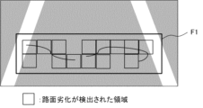
図4は、路面劣化の検出結果の一例を示す図である。検出部101は、例えば、路面画像内の検出領域F1に含まれる路面劣化を検出してもよい。検出領域F1は、路面劣化の検出対象となる領域である。例えば、路面画像のうち、路面の領域が検出領域F1に設定される。ただし、路面画像が路面のみを含む場合、路面画像の全体が検出領域F1と設定されてもよい。プライバシー保護のために、路面以外の領域は、検出領域F1から除外されてもよい。また、遠くの路面は路面劣化の検出が困難となるから、近くの路面を検出領域F1として、遠くの路面は検出領域F1から除外されてもよい。これらの検出領域F1の範囲は一例であり、範囲は適宜設定される。
FIG. 4 is a diagram showing an example of road surface deterioration detection results. For example, the detection unit 101 may detect road surface deterioration included in the detection area F1 in the road surface image. The detection area F1 is an area to be detected for road surface deterioration. For example, the area of the road surface in the road surface image is set as the detection area F1. However, when the road surface image includes only the road surface, the entire road surface image may be set as the detection area F1. Areas other than the road surface may be excluded from the detection area F1 for privacy protection. Further, since it is difficult to detect road surface deterioration on a distant road surface, a nearby road surface may be set as the detection area F1, and the distant road surface may be excluded from the detection area F1. The range of these detection areas F1 is an example, and the range is set as appropriate.
車両に固定されたドライブレコーダで撮影された路面画像内の検出領域F1の位置は、固定であることが想定される。したがって、例えば、路面画像の予め定められた位置が検出領域F1と設定される。
It is assumed that the position of the detection area F1 in the road surface image captured by the drive recorder fixed to the vehicle is fixed. Therefore, for example, a predetermined position on the road surface image is set as the detection area F1.
あるいは、検出領域F1は、ユーザによって設定されてもよい。また、検出部101は、路面を認識し、認識した路面の領域を検出領域F1と設定してもよい。
Alternatively, the detection area F1 may be set by the user. Further, the detection unit 101 may recognize the road surface and set the recognized area of the road surface as the detection area F1.
検出部101は、例えば、路面画像を所定の単位で区切る。そして、検出部101は、区切られた単位ごとに路面劣化の検出をしてもよい。検出部101は、路面画像のうち、路面劣化の検出が行われる検出領域を所定の単位で区切ってもよい。
For example, the detection unit 101 divides the road surface image into predetermined units. Then, the detection unit 101 may detect road surface deterioration for each divided unit. The detection unit 101 may divide the detection area in which the road surface deterioration is detected in the road surface image into predetermined units.
決定部102は、路面画像のうち、第1領域と第2領域を決定する。第1領域は、路面画像から路面劣化の検出が可能な領域である。第2領域は、路面画像からの路面劣化の検出が困難な領域である。ここで、第1領域と第2領域とが決定される路面画像を、第1の路面画像とも記載する。
The determination unit 102 determines the first area and the second area in the road surface image. The first area is an area where road surface deterioration can be detected from the road surface image. The second area is an area where it is difficult to detect road surface deterioration from the road surface image. Here, the road surface image from which the first area and the second area are determined is also referred to as the first road surface image.
決定部102は、第1の路面画像において、第2領域に該当する領域が存在しないことを決定してもよい。
The determining unit 102 may determine that there is no region corresponding to the second region in the first road surface image.
決定部102は、区切られた単位ごとに、第1領域であるか、第2領域であるかを決定してもよい。決定部102は、例えば、検出部101によって区切られた単位ごとに、第1領域と第2領域を決定してもよい。あるいは、検出部101が路面画像を区切るか否かによらず、検出部101とは別に、決定部102は、路面画像を所定の単位で区切ってもよい。決定部102は、検出部101によって区切られた単位とは異なる単位で、第1領域と第2領域を決定してもよい。
The determining unit 102 may determine whether each divided unit is the first area or the second area. The determination unit 102 may determine the first region and the second region for each unit partitioned by the detection unit 101, for example. Alternatively, independently of the detection unit 101, the determination unit 102 may divide the road surface image into predetermined units regardless of whether the detection unit 101 divides the road surface image. The determination unit 102 may determine the first region and the second region in a unit different from the unit divided by the detection unit 101 .
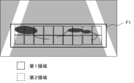
図5は、決定された第1領域と第2領域の一例を示す図である。図5において、第1領域は実線の枠で示され、第2領域は点線の枠で示されている。
FIG. 5 is a diagram showing an example of the determined first area and second area. In FIG. 5, the first area is indicated by a solid line frame, and the second area is indicated by a dotted line frame.
以下に、決定部102が、検出部101の検出結果に基づいて、第1領域と第2領域を決定する場合について説明する。決定部102は、例えば、検出部101によって路面劣化が検出された領域を、第1領域と決定する。決定部102は、さらに、検出部101によって路面劣化がないと確定された領域も、第1領域と決定してもよい。例えば、露出している路面は、第1領域と決定されうる。
A case where the determination unit 102 determines the first region and the second region based on the detection result of the detection unit 101 will be described below. The determination unit 102 determines, for example, the area where the road surface deterioration is detected by the detection unit 101 as the first area. The determining unit 102 may further determine, as the first area, an area determined by the detecting unit 101 to have no road surface deterioration. For example, an exposed road surface can be determined as the first area.
決定部102は、路面劣化が検出されなかった領域のうち、路面劣化の検出が困難な領域を第2領域と決定してもよい。路面劣化の検出が困難な領域には、路面劣化が存在する可能性がある。決定部102は、路面劣化の検出が困難な領域を機械学習したモデルを用いて、第2領域を決定してもよい。なお、路面劣化を検出するモデルと、路面劣化の検出が困難な領域を決定するモデルは同一であってもよい。すなわち、路面劣化の検出と、第2領域の決定は同じ処理により実行されてもよい。
The determining unit 102 may determine, as the second area, an area in which road surface deterioration is difficult to detect, among areas in which road surface deterioration has not been detected. Road surface deterioration may exist in areas where it is difficult to detect road surface deterioration. The determining unit 102 may determine the second area using a machine-learned model of an area where road surface deterioration is difficult to detect. It should be noted that the model for detecting road surface deterioration and the model for determining areas in which it is difficult to detect road surface deterioration may be the same. That is, the detection of road surface deterioration and the determination of the second area may be performed by the same process.
例えば、路面に水たまりのある領域は、水たまりの下の路面劣化の検出は困難となる。したがって、決定部102は、画像認識技術により、水たまりを認識してもよい。そして、決定部102は、水たまりのある領域を第2領域と決定する。
For example, in areas with puddles on the road surface, it is difficult to detect road surface deterioration under the puddles. Therefore, the determination unit 102 may recognize the puddle by image recognition technology. Then, the determination unit 102 determines the region with the puddle as the second region.
第2領域は、水たまりのある領域に限られない。決定部102は、路面を遮蔽するその他の遮蔽物を認識した領域を第2領域と決定してもよい。例えば、第2領域は、雪の積もっている領域、落ち葉で覆われている領域、他の車で隠れている領域、及び、ゴミの落ちている領域であってもよい。決定部102は、水たまりと同様に、積雪、または、落ち葉がある領域を、第2領域と決定してもよい。
The second area is not limited to areas with puddles. The determining unit 102 may determine the second area to be an area in which other obstacles that shield the road surface are recognized. For example, the second area may be an area covered with snow, an area covered with fallen leaves, an area hidden by other vehicles, and an area with litter. The determining unit 102 may determine, as the second area, an area with accumulated snow or fallen leaves in the same manner as the puddle.
第2領域は、遮蔽物のある領域に限られない。例えば、路面に遮蔽物がなくても、悪天候や日没により路面劣化の検出が困難となる場合がある。また、木や建物などの影がかかった路面は暗くなり、路面劣化の検出が困難となる場合がある。したがって、決定部102は、影のある領域を第2領域と決定してもよい。このとき、光が当たっていて、遮蔽物の落ちていない路面は、第1領域と決定されうる。
The second area is not limited to areas with shields. For example, even if there is no obstruction on the road surface, it may be difficult to detect deterioration of the road surface due to bad weather or sunset. In addition, road surfaces that are shaded by trees, buildings, and the like become dark, making it difficult to detect deterioration of the road surface. Therefore, the determining unit 102 may determine the shaded area as the second area. At this time, the road surface on which the light is shining and the obstruction does not fall may be determined as the first area.
また、決定部102は、路面画像から路面劣化が検出されなかった領域のうち、該路面画像より前に撮影された路面画像において、路面劣化を検出した領域を、第2領域としてもよい。ここで、後に撮影された路面画像を第1の路面画像として、第1の路面画像より前に撮影された路面画像を第2の路面画像とも記載する。第2の路面画像として、路面劣化の検出が容易な画像が選択されてもよい。例えば、第2の路面画像として、路面劣化の検出が困難な領域が含まれない画像が選択されてもよい。また、第2の路面画像として、晴れた日に撮影された画像が選択されてもよい。
Further, the determining unit 102 may set, as the second area, an area in which road surface deterioration is detected in a road surface image captured before the road surface image, among the areas in which road surface deterioration is not detected from the road surface image. Here, the road surface image captured later is also referred to as the first road surface image, and the road surface image captured before the first road surface image is also referred to as the second road surface image. As the second road surface image, an image from which road deterioration can be easily detected may be selected. For example, an image that does not include an area in which it is difficult to detect road surface deterioration may be selected as the second road surface image. Alternatively, an image taken on a sunny day may be selected as the second road surface image.
決定部102は、例えば、データベース40を参照する。そして、決定部102は、第1の路面画像と同じ地点で撮影された第2の路面画像を取得する。その後、決定部102は、第1の路面画像から検出された路面劣化と、第2の路面画像から検出された路面劣化を比較する。決定部102は、第1の路面画像から路面劣化が検出されなかった領域のうち、第2の路面画像から路面劣化が検出された領域を、第2領域と決定する。
The determining unit 102 refers to the database 40, for example. Then, the determination unit 102 acquires a second road surface image captured at the same point as the first road surface image. After that, the determining unit 102 compares the road surface deterioration detected from the first road surface image and the road surface deterioration detected from the second road surface image. The determining unit 102 determines, as a second area, an area in which road surface deterioration is detected in the second road surface image, among the areas in which road surface deterioration is not detected in the first road surface image.
第2の路面画像はユーザにより選択されてもよい。例えば、決定部102は、データベース40から、路面劣化の検出が容易な複数の画像を取得し、表示制御部106に受け渡す。そして、表示制御部106は、取得した複数の画像をユーザに表示させる。決定部102は、表示された画像のうち、ユーザにより選択された画像を、第2の路面画像として取得してもよい。
The second road surface image may be selected by the user. For example, the determination unit 102 acquires a plurality of images from the database 40 in which road surface deterioration can be easily detected, and transfers the images to the display control unit 106 . Then, the display control unit 106 causes the user to display the plurality of acquired images. The determining unit 102 may acquire an image selected by the user from among the displayed images as the second road surface image.
以上、決定部102が、検出部101の検出結果に基づいて、第1領域と第2領域を決定する場合について説明した。ただし、検出部101による路面劣化の検出の前に、決定部102が、第1領域と第2領域を決定する場合もある。この場合、決定部102は、路面画像から路面劣化の検出が可能な領域と、路面画像からの路面劣化の検出が困難な領域と、を機械学習したモデルを用いて、第1領域と第2領域を決定してもよい。あるいは、決定部102は、前述の第1の路面画像と第2の路面画像とを比較し、既存の画像処理技術を用いて、一致度が所定の閾値以上の領域を第1領域と決定し、一致度が該閾値より低い領域を第2領域と決定してもよい。そして、検出部101は、第1領域と決定された領域について、路面劣化を検出する。
The case where the determination unit 102 determines the first region and the second region based on the detection result of the detection unit 101 has been described above. However, the determination unit 102 may determine the first area and the second area before the detection unit 101 detects road surface deterioration. In this case, the determination unit 102 uses a machine-learned model to determine a region in which road surface deterioration can be detected from the road surface image and a region in which road surface deterioration is difficult to detect from the road surface image. A region may be determined. Alternatively, the determination unit 102 compares the first road surface image and the second road surface image, and uses an existing image processing technique to determine an area with a degree of matching equal to or greater than a predetermined threshold as the first area. , a region having a degree of matching lower than the threshold may be determined as the second region. Then, the detection unit 101 detects road surface deterioration in the area determined as the first area.
第1計算部103は、第1の路面画像からの検出結果に基づいて、第1領域の劣化度を計算する。第1計算部103は、例えば、検出部101によって区切られた領域ごとに、劣化度を計算する。一例として、検出部101がひび割れを検出する場合、第1計算部103は、区切られた領域ごとに、ひび割れ率を計算する。第1計算部103は、領域ごとの劣化度を併合して、第1の路面画像に含まれる第1領域の全体の劣化度を計算してもよい。劣化度の併合の例として、第1計算部103は、各領域の劣化度の平均を計算してもよい。
The first calculation unit 103 calculates the degree of deterioration of the first area based on the detection result from the first road surface image. The first calculation unit 103 calculates the degree of deterioration for each region partitioned by the detection unit 101, for example. As an example, when the detection unit 101 detects cracks, the first calculation unit 103 calculates the crack rate for each partitioned region. The first calculation unit 103 may combine the degrees of deterioration for each area to calculate the degree of deterioration of the entire first area included in the first road surface image. As an example of merging deterioration degrees, the first calculation unit 103 may calculate an average deterioration degree of each region.
推定部104は、過去の劣化度に基づいて、第2領域の劣化度を推定する。過去の劣化度は、第1の路面画像より前に路面を撮影した第2の路面画像から検出された路面劣化の劣化度である。ここで第2の路面画像として、例えば、第2領域の決定に用いられる上記第2の路面画像が、劣化度の推定に用いられる。ただし、劣化度の推定に用いられる第2の路面画像は、第2領域の決定に用いられる画像と別であってもよい。
The estimation unit 104 estimates the degree of deterioration of the second area based on the degree of deterioration in the past. The past deterioration degree is the degree of road surface deterioration detected from the second road surface image captured before the first road surface image. Here, as the second road surface image, for example, the second road surface image used for determining the second area is used for estimating the degree of deterioration. However, the second road surface image used for estimating the degree of deterioration may be different from the image used for determining the second area.
推定部104は、例えば、検出部101によって区切られた領域ごとに、劣化度を推定する。一例として、検出部101がひび割れを検出する場合、推定部104は、区切られた領域ごとに、ひび割れ率を推定する。推定部104は、領域ごとの劣化度を併合して、第1の路面画像に含まれる第2領域の全体の劣化度を推定してもよい。劣化度の併合の例として、推定部104は、各領域の推定された劣化度の平均を計算してもよい。
For example, the estimation unit 104 estimates the degree of deterioration for each region partitioned by the detection unit 101 . As an example, when the detection unit 101 detects cracks, the estimation unit 104 estimates the crack rate for each partitioned region. The estimation unit 104 may combine the degrees of deterioration for each area to estimate the degree of deterioration of the entire second area included in the first road surface image. As an example of merging deterioration degrees, the estimation unit 104 may calculate an average of the estimated deterioration degrees of each region.
推定部104は、第2の路面画像に関して取得した劣化度を、第1の路面画像の第2領域の劣化度と推定してもよい。あるいは、推定部104は、取得した劣化度をパラメータにより補正することで、第2領域の劣化度を推定してもよい。推定部104が、第2の路面画像に関して取得した劣化度を補正する場合については、後述される。
The estimation unit 104 may estimate the degree of deterioration acquired for the second road surface image as the degree of deterioration of the second region of the first road surface image. Alternatively, the estimation unit 104 may estimate the degree of deterioration of the second region by correcting the obtained degree of deterioration using a parameter. A case in which the estimation unit 104 corrects the degree of deterioration acquired with respect to the second road surface image will be described later.
推定部104は、例えば、データベースから過去の劣化度を取得する。データベースには、路面画像から検出された路面劣化について計算された、過去の劣化度が記憶される。さらに、データベースには、路面画像の撮影地点と、撮影日が劣化度に関連付けて記憶される。そして、推定部104は、データベースから第1の路面画像と同じ地点の過去の劣化度を取得する。データベースに複数の劣化度が記憶されている場合、推定部104は、最新の第2の路面画像から計算された劣化度を参照してもよい。
The estimation unit 104, for example, acquires past deterioration degrees from a database. The database stores past deterioration degrees calculated for road surface deterioration detected from road surface images. Furthermore, in the database, the photographing location of the road surface image and the photographing date are stored in association with the degree of deterioration. Then, the estimation unit 104 acquires the past deterioration degree of the same point as the first road surface image from the database. When a plurality of deterioration levels are stored in the database, the estimation unit 104 may refer to the deterioration level calculated from the latest second road surface image.
過去の劣化度を取得するために、推定部104は、第2の路面画像を取得してもよい。この場合、データベースには、過去の路面画像が記憶される。例えば、推定部104は、第2の路面画像から劣化度を計算してもよい。ただし、上記において、推定部104がデータベースから劣化度を取得する場合、推定部104が第2の路面画像から劣化度を計算する処理を低減できる。
In order to obtain the past degree of deterioration, the estimation unit 104 may obtain a second road surface image. In this case, the database stores past road surface images. For example, the estimation unit 104 may calculate the degree of deterioration from the second road surface image. However, in the above, when the estimating unit 104 acquires the degree of deterioration from the database, the process of calculating the degree of deterioration from the second road surface image by the estimating unit 104 can be reduced.
推定部104は、第2の路面画像における、第1の路面画像の第2領域に対応する領域を特定してもよい。この場合、推定部104は、第2の路面画像から特定された領域の劣化度を取得する。ただし、推定部104は、第1の路面画像の第2領域に対応する領域の劣化度を取得しなくてもよい。推定部104は、第2の路面画像の全体、もしくは、第2の路面画像の検出領域の全体から計算される劣化度を取得してもよい。
The estimation unit 104 may identify a region in the second road surface image corresponding to the second region of the first road surface image. In this case, the estimation unit 104 acquires the degree of deterioration of the area identified from the second road surface image. However, the estimation unit 104 does not have to acquire the degree of deterioration of the area corresponding to the second area of the first road surface image. The estimation unit 104 may acquire the degree of deterioration calculated from the entire second road surface image or the entire detection area of the second road surface image.
推定部104は、第2の路面画像に関して以上のように取得した劣化度を、第1の路面画像の第2領域の劣化度と推定してもよい。
The estimation unit 104 may estimate the degree of deterioration obtained as described above for the second road surface image as the degree of deterioration of the second region of the first road surface image.
次に、推定部104が、第2の路面画像に関して取得した劣化度を、パラメータにより補正する例について説明する。各パラメータは、第1の路面画像の路面劣化が、第2の路面画像の撮影時点の劣化度からどれほど進行しているかに影響する。
Next, an example in which the estimation unit 104 corrects the degree of deterioration acquired for the second road surface image using parameters will be described. Each parameter affects how the road surface deterioration of the first road surface image progresses from the degree of deterioration at the time when the second road surface image was captured.
推定部104は、例えば、第2の路面画像に関して取得した劣化度と、任意のパラメータに重みを付けて得られる値とを足すことで、第2領域の劣化度を推定する。推定部104は、複数のパラメータにそれぞれ重みを付けて得られる複数の値を、それぞれ第2の路面画像に関して取得した劣化度に足すことで、第2領域の劣化度を推定してもよい。パラメータに付けられる重みは、各パラメータが路面劣化の進行に与える影響度を表す。
The estimating unit 104 estimates the degree of deterioration of the second region, for example, by adding the degree of deterioration acquired for the second road surface image and a value obtained by weighting an arbitrary parameter. The estimating unit 104 may estimate the degree of deterioration of the second region by adding a plurality of values obtained by weighting the respective parameters to the degree of deterioration obtained for the second road surface image. The weights assigned to the parameters represent the degree of influence each parameter has on the progression of road surface deterioration.
第1領域については、第1の路面画像から検出された劣化度が用いられ、第2領域ついては、第2の路面画像から検出された劣化度をパラメータにより補正した値を用いることで、より正確に路面の劣化度が推定される。
For the first region, the degree of deterioration detected from the first road surface image is used, and for the second region, a value obtained by correcting the degree of deterioration detected from the second road surface image with a parameter is used. The degree of deterioration of the road surface is estimated in
パラメータの種類は特に限られず、例えば、パラメータは降水量、水たまりの有無、平坦性、及び、交通量の少なくともいずれかであってもよい。例えば、第2領域の劣化度は、次の式によって表される。
The type of parameter is not particularly limited. For example, the parameter may be at least one of precipitation, presence or absence of puddles, flatness, and traffic volume. For example, the degree of deterioration of the second area is represented by the following formula.
第2領域の劣化度=第2の路面画像から検出された劣化度+(降水量×W1+水たまり×W2+平坦性×W3+期間×W4+・・・)
上記式において、降水量、水たまり、平坦性、及び、期間はそれぞれ、パラメータを表す。また、W1、W2、W3、W4は、各パラメータの重みを表す。 Degree of deterioration of second area=degree of deterioration detected from second road surface image+(precipitation amount×W1+puddle×W2+flatness×W3+period×W4+ . . . )
In the above formula, precipitation, puddles, flatness, and duration each represent parameters. W1, W2, W3, and W4 represent the weight of each parameter.
推定部104は、パラメータの値を自動で取得してもよい。推定部104が、ユーザから入力を受け付けたパラメータを取得する場合については、第2の実施形態において後述される。以下に、各パラメータについて説明する。
The estimation unit 104 may automatically acquire parameter values. A case where the estimating unit 104 acquires parameters input by the user will be described later in a second embodiment. Each parameter will be described below.
推定部104は、パラメータの一例として、第2の路面画像の撮影時期から第1の路面画像の撮影時期までの降水量の合計に基づいて、第2領域の劣化度を推定してもよい。降水量の合計が多いほど、路面劣化は進行することが予測される。したがって、推定部104は、降水量の合計が多いほど、大きな値を、第2の路面画像に関して取得された劣化度に足す。
As an example of parameters, the estimation unit 104 may estimate the degree of deterioration of the second region based on the total amount of rainfall from the time when the second road surface image was captured to the time when the first road surface image was captured. It is predicted that road surface deterioration progresses as the total amount of rainfall increases. Therefore, the estimation unit 104 adds a larger value to the degree of deterioration acquired for the second road surface image as the total amount of rainfall increases.
推定部104は、例えば、降水量を記憶するデータベースを参照する。データベースには、実際に観測された降水量のデータなどが記憶されうる。あるいは、記憶される降水量は、実際に観測された降水量でなくとも、平年の所定期間ごとの平均的な降水量であってもよい。推定部104は、例えば、月ごとの平均的な降水量を参照する。
The estimation unit 104, for example, refers to a database that stores precipitation. The database can store actually observed precipitation data and the like. Alternatively, the amount of precipitation to be stored may not be the amount of precipitation actually observed, but may be the average amount of precipitation for each predetermined period of a normal year. The estimation unit 104, for example, refers to monthly average precipitation.
そして、推定部104は、第2の路面画像の撮影時期から第1の路面画像の撮影時期までの降水量の合計を取得する。取得される降水量は、正確な降水量でなくてもよい。推定部104は、2つの路面画像の撮影時点の間の降水量の合計を取得してもよいが、取得される降水量はこれには限られない。例えば、推定部104は、路面画像の撮影時点の前後数時間、または、前後数日の降水量も含む降水量の合計を取得してもよい。
Then, the estimating unit 104 acquires the total amount of rainfall from the time when the second road surface image was captured to the time when the first road surface image was captured. The amount of precipitation that is obtained does not have to be an accurate amount of precipitation. The estimating unit 104 may acquire the total amount of rainfall between the times when the two road surface images were captured, but the acquired amount of rainfall is not limited to this. For example, the estimating unit 104 may acquire the total amount of precipitation including the amount of precipitation for several hours before and after the time of photographing the road surface image, or for several days before and after the time of photographing the road surface image.
また、推定部104は、パラメータの一例として、第1の路面画像に水たまりが撮影されているか否かに基づいて、第2領域の劣化度を推定してもよい。例えば、水たまりがある場合のパラメータは「1」、水たまりがない場合のパラメータは「0」と設定されうる。このパラメータは、各第2領域に水たまりがあるか否かによらず、水たまりが撮影された路面画像に含まれる第2領域に関して適用されてもよい。水たまりのある路面は、水はけが悪い可能性があり、路面劣化が進行しやすいことが予測される。したがって、推定部104は、路面に水たまりがあれば、第2領域の劣化度の推定に関して、所定の値を第2の路面画像に関して取得された劣化度に足す。
Also, the estimation unit 104 may estimate the degree of deterioration of the second area based on whether or not a puddle is captured in the first road surface image, as an example of the parameter. For example, the parameter may be set to '1' when there is a puddle, and set to '0' when there is no puddle. This parameter may be applied to the second area included in the road surface image in which the puddle is captured, regardless of whether or not there is a puddle in each second area. A road surface with puddles may have poor drainage, and it is predicted that road surface deterioration will progress easily. Therefore, if there is a puddle on the road surface, the estimating unit 104 adds a predetermined value to the degree of deterioration acquired for the second road surface image for estimating the degree of deterioration of the second area.
あるいは、推定部104は、パラメータの一例として、第2領域に水たまりがあるか否かに基づいて、第2領域の劣化度を推定してもよい。例えば、水たまりのある第2領域にはパラメータ「1」が、水たまりのない第2領域にはパラメータ「0」が設定される。水たまりがある路面は、他の路面に比べて凹んでいる可能性がある。したがって、路面劣化の一例である平坦性異常が存在すると予測される。また、凹んでいる路面にたまった水が路面劣化を進行させるとも予測される。推定部104は、第2領域に水たまりがあれば、所定の値を第2の路面画像に関して取得された劣化度に足す。
Alternatively, the estimation unit 104 may estimate the degree of deterioration of the second area based on whether there is a puddle in the second area, as an example of the parameter. For example, a parameter "1" is set for a second region with puddles, and a parameter "0" is set for a second region without puddles. A road surface with puddles may be more depressed than other road surfaces. Therefore, it is predicted that a flatness anomaly, which is an example of road surface deterioration, exists. In addition, it is predicted that the water accumulated on the dented road surface will accelerate the deterioration of the road surface. If there is a puddle in the second area, the estimating unit 104 adds a predetermined value to the degree of deterioration acquired for the second road surface image.
推定部104は、パラメータの一例として、第1の路面画像の撮影時点の路面の平坦性に基づいて、第2領域の劣化度を推定してもよい。平坦性は、路面画像からの路面劣化の検出が困難であっても、測定できる場合がある。例えば、平坦性は、雨の日でも、路面に水たまりがあっても、画像認識以外の方法で測定できる。
The estimation unit 104 may estimate the degree of deterioration of the second area based on the flatness of the road surface at the time when the first road surface image was captured, as an example of parameters. Flatness can sometimes be measured even if it is difficult to detect road surface deterioration from a road surface image. For example, flatness can be measured by methods other than image recognition, even on rainy days and even when there are puddles on the road surface.
平坦性は、国際ラフネス指数(International Roughness Index(IRI))によって表されてもよい。IRIとは、路面と運転手の乗り心地を関連付けた指数であり、凸凹の程度を数値として表現したものである。IRIは、センサで道路表面を測定した測定データに基づいて計算されてもよい。あるいは、IRIは、車両に取り付けられた走行中の加速度センサの値に基づいて計算されてもよい。具体的には、例えば、IRIは、検出位置において取得された加速度に含まれる上下方向の加速度の値に基づいて計算される。なおIRIの計算方法は、上記に限られず、既知の計算方法を採用することが可能である。
Flatness may be represented by the International Roughness Index (IRI). The IRI is an index that associates the road surface with the ride comfort of the driver, and expresses the degree of unevenness as a numerical value. The IRI may be calculated based on measurement data obtained by measuring the road surface with sensors. Alternatively, the IRI may be calculated based on the value of an acceleration sensor attached to the vehicle while the vehicle is running. Specifically, for example, the IRI is calculated based on the vertical acceleration value included in the acceleration acquired at the detection position. Note that the calculation method of the IRI is not limited to the above, and a known calculation method can be adopted.
推定部104は、例えば、第1の路面画像を撮影しながら平坦性を測定する車両から、平坦性を表す値を取得する。平坦性が低く、凸凹のある路面は、路面画像から検出される路面劣化の劣化度も高いと予測される。したがって、推定部104は、平坦性が低いほど、大きな値を、第2の路面画像に関して取得された劣化度に足す。
For example, the estimation unit 104 acquires a value representing flatness from a vehicle that measures flatness while capturing the first road surface image. A road surface with low flatness and unevenness is predicted to have a high degree of deterioration of the road surface detected from the road surface image. Therefore, the estimation unit 104 adds a larger value to the degree of deterioration acquired for the second road surface image as the flatness is lower.
また、推定部104は、パラメータの一例として、第2の路面画像の撮影時期から第1の路面画像の撮影時期までの期間の長さに基づいて、第2領域の劣化度を推定してもよい。期間が長いほど、路面劣化は進行することが予測される。期間は、例えば、年数、月数、日数、または、時間数のいずれにより表されてもよい。推定部104は、例えば、第1の路面画像と第2の路面画像の撮影日時を取得し、期間の長さを計算する。ただし、推定に用いられる期間の長さは、正確な値でなくてもよい。
In addition, the estimation unit 104 may estimate the degree of deterioration of the second region based on the length of the period from when the second road surface image was captured to when the first road surface image was captured, as an example of a parameter. good. It is predicted that the longer the period, the more the road surface deterioration progresses. A period of time may be represented, for example, by any number of years, months, days, or hours. The estimating unit 104 acquires, for example, the date and time when the first road surface image and the second road surface image were captured, and calculates the length of the period. However, the length of the period used for estimation does not have to be an exact value.
あるいは、推定部104は、パラメータの一例として、交通量に基づいて、第2領域の劣化度を推定してもよい。例えば、推定部104は、第2の路面画像の撮影時期から第1の路面画像の撮影時期までの交通量の合計に基づいて、第2領域の劣化度を推定してもよい。交通量の合計が多いほど、路面劣化は進行することが予測される。交通量は、例えば、路面上を通行した車両の数を表す。
Alternatively, the estimation unit 104 may estimate the degree of deterioration of the second area based on the traffic volume as an example of the parameter. For example, the estimation unit 104 may estimate the degree of deterioration of the second area based on the total traffic volume from the time when the second road surface image was captured to the time when the first road surface image was captured. It is predicted that road surface deterioration progresses as the total traffic volume increases. Traffic volume represents, for example, the number of vehicles passing on the road surface.
推定部104は、例えば、交通量を記憶するデータベースを参照する。データベースには、年間の交通量のデータ、または、1週間の交通量のデータなどが記憶されうる。あるいは、記憶される交通量は、実際に計数された交通量でなくとも、路面画像が撮影された地点または地域に関する平均的な交通量であってもよい。
The estimation unit 104, for example, refers to a database that stores traffic volume. The database may store annual traffic volume data, weekly traffic volume data, or the like. Alternatively, the traffic volume that is stored may be the average traffic volume for the point or region where the road surface image was taken, rather than the actual counted traffic volume.
そして、推定部104は、第2の路面画像の撮影時期から第1の路面画像の撮影時期までの交通量の合計を取得する。取得される交通量は、正確な交通量でなくてもよい。推定部104は、2つの路面画像の撮影時点の間の交通量の合計を取得してもよいが、取得される交通量はこれには限られない。例えば、推定部104は、路面画像の撮影時点の前後数時間、または、前後数日の交通量も含む交通量の合計を取得してもよい。
Then, the estimation unit 104 acquires the total traffic volume from the time when the second road surface image was captured to the time when the first road surface image was captured. The traffic volume obtained does not have to be an accurate traffic volume. The estimating unit 104 may acquire the total traffic volume between the times when the two road surface images were captured, but the acquired traffic volume is not limited to this. For example, the estimating unit 104 may acquire the total traffic volume including the traffic volume for several hours before and after the time of photographing the road surface image, or for several days before and after the time of photographing the road surface image.
推定部104は、取得した交通量の合計が大きいほど、大きな値を、第2の路面画像に関して取得された劣化度に足す。
The estimation unit 104 adds a larger value to the degree of deterioration acquired for the second road surface image as the total traffic volume acquired increases.
以上の各種パラメータについて取得された値は、表示制御部106によって表示されてもよい。値が表示されることによって、ユーザはどのようなパラメータに基づいて、第2領域の劣化度が推定されたか把握することができる。
The values obtained for the above various parameters may be displayed by the display control unit 106. By displaying the values, the user can understand on what parameters the degree of deterioration of the second area is estimated.
推定部104は、各パラメータに付けられる重みを、任意の方法で設定してもよい。例えば、重みは、機械学習されたモデルにより設定されてもよい。また、各パラメータを使うか否かも、該モデルにより設定されてもよい。
The estimation unit 104 may use any method to set the weight assigned to each parameter. For example, weights may be set by a machine-learned model. Also, whether or not to use each parameter may be set by the model.
交通量が多い地域は、交通量に関するパラメータの重みが他のパラメータより大きく設定されてもよい。すなわち、交通量の多い地域において、交通量が路面劣化に与える影響度が大きくなるよう重みが設定されてもよい。推定部104は、例えば、路面画像が撮影された地点の所定の期間の交通量を取得する。そして、推定部104は、取得した交通量に応じて、第2の路面画像の撮影時期から第1の路面画像の撮影時期までの交通量の合計であるパラメータの重みを変更する。推定部104が、交通量に応じてパラメータの重みを変更することは、交通量に基づいて、第2領域の劣化度を推定することの一例である。
For areas with heavy traffic, the weight of parameters related to traffic may be set higher than other parameters. In other words, the weight may be set so that the degree of influence of traffic on road surface deterioration increases in areas with heavy traffic. The estimating unit 104 acquires, for example, the traffic volume for a predetermined period at the point where the road surface image was captured. Then, the estimating unit 104 changes the weight of the parameter, which is the total traffic volume from the time when the second road surface image was captured to the time when the first road surface image was captured, according to the acquired traffic volume. The estimation unit 104 changing the weight of the parameter according to the traffic volume is an example of estimating the degree of deterioration of the second region based on the traffic volume.
また、推定部104は、第1の路面画像の撮影時期の降水量に基づいて、第2領域の劣化度を推定してもよい。例えば、推定部104は、雨季や積雪時期は、降水量に関するパラメータの重みを他のパラメータより大きく設定してもよい。すなわち、降水量の多い時期において、降水量が路面劣化に与える影響度が大きくなるよう重みが設定されてもよい。
Also, the estimation unit 104 may estimate the degree of deterioration of the second area based on the amount of precipitation at the time when the first road surface image was captured. For example, the estimating unit 104 may set the weight of the parameter relating to the amount of precipitation to be greater than that of the other parameters during the rainy season or the snowy season. That is, the weight may be set so that the degree of influence of the amount of rain on the road surface deterioration is greater in the period of heavy rainfall.
推定部104は、第1の路面画像の撮影日の降水量、または、撮影日前後の日を含む降水量を取得してもよい。あるいは、推定部104は、第1の路面画像の撮影日における平年の同時期の降水量を取得してもよい。推定部104は、取得した降水量に基づいて、例えば、第2の路面画像の撮影時期から第1の路面画像の撮影時期までの降水量の合計であるパラメータに重みを付ける。
The estimating unit 104 may acquire the amount of rainfall on the day the first road surface image was captured, or the amount of rainfall including the days before and after the day when the first road surface image was captured. Alternatively, the estimating unit 104 may acquire the amount of rainfall during the same period of a normal year on the date when the first road surface image was captured. The estimating unit 104 weights, for example, a parameter that is the total amount of rainfall from the time when the second road surface image was captured to the time when the first road surface image was captured, based on the acquired rainfall amount.
以上のように、パラメータに重みが付けられることで、より正確に路面の劣化度が推定される。
As described above, by weighting the parameters, the degree of deterioration of the road surface can be estimated more accurately.
第2計算部105は、計算された第1領域の劣化度と、推定された第2領域の劣化度と、に基づいて、撮影された路面の劣化度を計算する。ここで、第2計算部105が計算する劣化度は、第1の路面画像の撮影時点における、路面の劣化度と推定される。
The second calculation unit 105 calculates the degree of deterioration of the photographed road surface based on the calculated degree of deterioration of the first area and the estimated degree of deterioration of the second area. Here, the degree of deterioration calculated by the second calculation unit 105 is estimated as the degree of deterioration of the road surface at the time of capturing the first road surface image.
第2計算部105は、例えば、第1領域と第2領域の劣化度を、それぞれ、第1領域と第2領域の面積によって重みをつけて合算することで、撮影された路面の劣化度を計算する。
For example, the second calculation unit 105 weights the deterioration degrees of the first region and the second region by the areas of the first region and the second region, respectively, and sums them up, thereby calculating the deterioration degree of the photographed road surface. calculate.
第2計算部105によって推定された劣化度は、第1の路面画像の撮影時点における路面のデータとして、データベースに記憶されてもよい。推定された劣化度がデータベースに記憶されることで、後日、同じ地点の他の劣化度のデータと共に参照することが可能になる。また、データベースには、検出部101による検出結果、第1計算部103による計算結果、及び、推定部104による推定結果も、劣化度に対応付けて記憶されてもよい。
The degree of deterioration estimated by the second calculation unit 105 may be stored in the database as road surface data at the time when the first road surface image was captured. By storing the estimated degree of deterioration in the database, it becomes possible to refer to it together with data of other degrees of deterioration at the same point at a later date. The database may also store the detection result by the detection unit 101, the calculation result by the first calculation unit 103, and the estimation result by the estimation unit 104 in association with the degree of deterioration.
表示制御部106は、第2計算部105によって計算された、路面の劣化度を表示させる。劣化度は、劣化度の高さの範囲に応じて異なる色で表示されてもよい。例えば、高い劣化度は赤色、低い劣化度は緑色、中間の劣化度は黄色で表示されてもよい。
The display control unit 106 displays the road surface deterioration degree calculated by the second calculation unit 105 . The degree of deterioration may be displayed in different colors depending on the range of heights of the degree of deterioration. For example, a high degree of deterioration may be displayed in red, a low degree of deterioration in green, and an intermediate degree of deterioration in yellow.
表示制御部106は、さらに、第1の路面画像を表示させてもよい。表示制御部106は、第1領域と第2領域とを、それぞれ異なる態様により路面画像上に示してもよい。例えば、第1領域と第2領域はそれぞれ異なる色の枠で示されてもよい。あるいは、第1領域が実線の枠で示され、第2領域が点線の枠で示されてもよい。
The display control unit 106 may further display the first road surface image. The display control unit 106 may display the first area and the second area on the road surface image in different modes. For example, the first area and the second area may be indicated by different colored frames. Alternatively, the first area may be indicated by a solid line frame and the second area may be indicated by a dotted line frame.
また、表示制御部106は、路面画像上に検出領域を示してもよい。例えば、ディスプレイには、第1領域と第2領域とは異なる色の枠、または、異なる太さの枠により、検出領域を示す枠が表示される。プライバシー保護のために、表示制御部106は、検出領域以外の領域の解像度を下げて、路面画像を表示させてもよい。
Also, the display control unit 106 may indicate the detection area on the road surface image. For example, on the display, a frame indicating the detection region is displayed with a frame of a different color or a different thickness from the first region and the second region. For privacy protection, the display control unit 106 may display the road surface image by lowering the resolution of the area other than the detection area.
表示制御部106は、路面の劣化度を表す地図に、計算された劣化度を反映してもよい。例えば、地図上の路面は所定の範囲で区切られる。そして区切られた領域ごとに、劣化度の高さの範囲に応じた色が付されてもよい。また、所定の範囲で区切られた道路の領域ごとに、車両の進行方向を表す矢印が表示される場合、矢印が劣化度の高さの範囲に応じた色で表示されてもよい。
The display control unit 106 may reflect the calculated degree of deterioration on the map representing the degree of deterioration of the road surface. For example, the road surface on the map is divided into predetermined ranges. Each partitioned area may be given a color according to the range of the degree of deterioration. Further, when an arrow indicating the traveling direction of the vehicle is displayed for each road area divided by a predetermined range, the arrow may be displayed in a color corresponding to the range of the degree of deterioration.
図6は、第1の実施形態に係る劣化推定システム100の動作例を示すフローチャートである。
FIG. 6 is a flowchart showing an operation example of the deterioration estimation system 100 according to the first embodiment.
検出部101は、路面を撮影した第1の路面画像から路面劣化を検出する(ステップS1)。検出部101は、第1計算部103に検出した路面劣化を受け渡す。次に、決定部102は、第1の路面画像のうち、路面劣化の検出が可能な第1領域と路面劣化の検出が困難な第2領域とを決定する(ステップS2)。ステップS2は、ステップS1の前に実行されてもよい。
The detection unit 101 detects road surface deterioration from the first road surface image (step S1). The detection unit 101 transfers the detected road surface deterioration to the first calculation unit 103 . Next, the determination unit 102 determines a first area where road surface deterioration can be detected and a second area where road surface deterioration is difficult to detect in the first road surface image (step S2). Step S2 may be performed before step S1.
第1計算部103は、第1の路面画像からの検出結果に基づいて、第1領域の劣化度を計算する(ステップS3)。第1計算部103は、計算した劣化度を第2計算部105に受け渡す。推定部104は、第1の路面画像より前に路面を撮影した第2の路面画像から検出された路面劣化の劣化度に基づいて、第2領域の劣化度を推定する(ステップS4)。推定部104は、推定した劣化度を第2計算部105に受け渡す。
The first calculation unit 103 calculates the degree of deterioration of the first area based on the detection result from the first road surface image (step S3). The first calculator 103 transfers the calculated degree of deterioration to the second calculator 105 . The estimating unit 104 estimates the degree of deterioration of the second area based on the degree of deterioration of the road surface detected from the second road surface image captured before the first road surface image (step S4). The estimation unit 104 transfers the estimated degree of deterioration to the second calculation unit 105 .
第2計算部105は、計算された第1領域の劣化度と、推定された第2領域の劣化度と、に基づいて、撮影された路面の劣化度を計算する(ステップS5)。ステップS5の後、表示制御部106は、計算された劣化度をディスプレイに表示させてもよい。
The second calculation unit 105 calculates the degree of deterioration of the photographed road surface based on the calculated degree of deterioration of the first area and the estimated degree of deterioration of the second area (step S5). After step S5, the display control unit 106 may display the calculated degree of deterioration on the display.
以上、第1の実施形態において、劣化推定システム100は、路面画像から路面劣化度を検出する。そして、劣化推定システム100は、路面劣化が検出可能な領域について計算された劣化度と、路面劣化の検出が困難な領域について推定された劣化度とに基づいて、路面の劣化度を計算する。したがって、ユーザは、路面を撮影した路面画像に路面劣化の検出が困難な領域があっても、該路面の劣化度を推定できる。
As described above, in the first embodiment, the deterioration estimation system 100 detects the road surface deterioration degree from the road surface image. Then, the deterioration estimation system 100 calculates the degree of deterioration of the road surface based on the degree of deterioration calculated for the area where road surface deterioration is detectable and the degree of deterioration estimated for the area where road surface deterioration is difficult to detect. Therefore, the user can estimate the degree of deterioration of the road surface even if there is an area in which it is difficult to detect the deterioration of the road surface in the image of the road surface.
雨の日や雪の日に撮影した路面画像では、路面の状態を鮮明に撮影することが難しいため、劣化を正確に計測することが難しい。したがって、画像を用いて路面劣化の計測が行われる場合に、雨の日や雪の日には、計測が中止されることもある。そして、雨や雪などの悪天候が続く場合には、長い間、路面劣化の計測が行えない。第1の実施形態によれば、雨の日や雪の日に撮影された画像について、路面劣化の検出が困難な領域があっても、劣化度の計測が可能となる。
It is difficult to accurately measure the deterioration of road surfaces in images taken on rainy or snowy days because it is difficult to clearly capture the condition of the road surface. Therefore, when road surface deterioration is measured using images, the measurement may be stopped on rainy days or snowy days. In addition, when bad weather such as rain or snow continues, road surface deterioration cannot be measured for a long time. According to the first embodiment, it is possible to measure the degree of deterioration of an image captured on a rainy day or a snowy day even if there is an area in which it is difficult to detect road surface deterioration.
[第2の実施形態]
図7は、第2の実施形態に係る劣化推定システム100の構成例を示す図である。第2の実施形態に係る劣化推定システム100は、受付部107を備える点で、第1の実施形態に係る劣化推定システム100と相違する。第2の実施形態の構成について、第1の実施形態と同様の構成については、説明を一部省略する。 [Second embodiment]
FIG. 7 is a diagram showing a configuration example of adegradation estimation system 100 according to the second embodiment. A degradation estimation system 100 according to the second embodiment differs from the degradation estimation system 100 according to the first embodiment in that a reception unit 107 is provided. About the structure of 2nd Embodiment, description is partially abbreviate|omitted about the same structure as 1st Embodiment.
図7は、第2の実施形態に係る劣化推定システム100の構成例を示す図である。第2の実施形態に係る劣化推定システム100は、受付部107を備える点で、第1の実施形態に係る劣化推定システム100と相違する。第2の実施形態の構成について、第1の実施形態と同様の構成については、説明を一部省略する。 [Second embodiment]
FIG. 7 is a diagram showing a configuration example of a
第2の実施形態において、表示制御部106は、第1の路面画像を表示させる。第1の路面画像とは、第1の実施形態と同様に、路面劣化の検出と劣化度の推定が行われる画像である。
In the second embodiment, the display control unit 106 displays the first road surface image. The first road surface image is an image for which detection of road surface deterioration and estimation of the degree of deterioration are performed, as in the first embodiment.
受付部107は、第1の路面画像に路面劣化の検出が困難な領域が含まれることを受け付ける。例えば、受付部107は、ユーザから、路面劣化の検出が困難な領域が含まれることを受け付ける。受付部107は、ユーザによるボタンの押下を受け付ける。該ボタンは、例えば、表示制御部106によってディスプレイに表示される。
The reception unit 107 receives that the first road surface image includes an area where it is difficult to detect road surface deterioration. For example, the receiving unit 107 receives from the user that an area in which it is difficult to detect road surface deterioration is included. The accepting unit 107 accepts button presses by the user. The button is displayed on the display by the display control unit 106, for example.
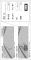
図8は、表示制御部106がディスプレイに表示させる第1の画面の一例を示す画像である。第1の画面は、路面劣化の検出が困難な領域が含まれることを受け付けるボタンを含む。図8において、第1の画面は、第1の路面画像と、検出部101による路面劣化の検出結果とを含む。
FIG. 8 is an image showing an example of the first screen that the display control unit 106 displays on the display. The first screen includes a button for accepting that an area where it is difficult to detect road surface deterioration is included. In FIG. 8 , the first screen includes the first road surface image and the road surface deterioration detection result by the detection unit 101 .
表示制御部106は、第1の路面画像から検出された路面劣化を表示させてもよい。例えば、表示制御部106は、図8に示すように、路面劣化が検出された領域を囲う枠を路面画像に重畳して表示させる。あるいは、表示制御部106は、検出された路面劣化に色を付した路面画像を表示させてもよい。
The display control unit 106 may display the road surface deterioration detected from the first road surface image. For example, as shown in FIG. 8, the display control unit 106 superimposes a frame surrounding an area where road surface deterioration is detected on the road surface image and displays the road surface image. Alternatively, the display control unit 106 may display a road surface image in which the detected road surface deterioration is colored.
表示制御部106は、第1の路面画像から検出された路面劣化について計算される劣化度を表示させてもよい。この劣化度は、第1計算部103によって計算されうる。図8において、劣化度の一例としてひび割れ率が表示されている。さらに、表示制御部106は、同じ地点において、過去に計測された劣化度を表示させてもよい。図8において、過去の劣化度と、第1の路面画像から計測された劣化度は、グラフにプロットされている。
The display control unit 106 may display the degree of deterioration calculated for the road surface deterioration detected from the first road surface image. This degree of deterioration can be calculated by the first calculator 103 . In FIG. 8, the crack rate is displayed as an example of the degree of deterioration. Furthermore, the display control unit 106 may display the degree of deterioration measured in the past at the same point. In FIG. 8, the past deterioration degree and the deterioration degree measured from the first road surface image are plotted on a graph.
図8には、路面劣化の検出が困難な領域が含まれることを受け付けるボタンの一例として、「雨天時推定」ボタンが表示されている。ただし、本実施形態の形態は、雨天時の利用には限られない。ボタンの表示態様は種々変更可能である。
In FIG. 8, an "estimate when it rains" button is displayed as an example of a button that accepts that an area where it is difficult to detect road surface deterioration is included. However, the form of this embodiment is not limited to use in rainy weather. The button display mode can be changed in various ways.
ユーザは、例えば表示された路面画像に水たまりが含まれること、または、路面画像が雨天に撮影されたものであることを確認する。あるいは、ユーザは、路面劣化の検出されていない領域のうち、路面劣化が存在する可能性のある領域が含まれることを確認してもよい。確認に応じて、ユーザは「雨天時推定」ボタンなどのボタンを押下する。
The user confirms, for example, that the displayed road surface image includes puddles, or that the road surface image was taken in rainy weather. Alternatively, the user may confirm that the area where road surface deterioration is not detected includes an area where road surface deterioration may exist. In response to the confirmation, the user presses a button such as an "estimation in rainy weather" button.
決定部102は、受付部107による受付に応じて、例えば、第1の実施形態と同様に、第2領域を決定する。あるいは、決定部102は、ユーザが指定する領域を第2領域と決定してもよい。この場合、受付部107は、ユーザから領域の指定を受け付け、指定された領域を第2領域とする入力を受け付けてもよい。
The determination unit 102 determines the second area in response to the reception by the reception unit 107, for example, similarly to the first embodiment. Alternatively, the determining unit 102 may determine the area specified by the user as the second area. In this case, the receiving unit 107 may receive the designation of the area from the user and receive the input to set the designated area as the second area.
第2領域が決定されると、推定部104は、第1の実施形態における処理と同様に、第2領域の劣化度を推定する。さらに、第2計算部105は、第1の実施形態における処理と同様に、第1領域の劣化度と、第2領域の劣化度に基づいて、第1の路面画像に撮影された路面の劣化度を計算する。
After the second region is determined, the estimation unit 104 estimates the degree of deterioration of the second region, similar to the processing in the first embodiment. Further, the second calculation unit 105 calculates the deterioration of the road surface photographed in the first road surface image based on the degree of deterioration of the first area and the degree of deterioration of the second area, similarly to the processing in the first embodiment. Calculate degrees.
第2の路面画像に関して取得した劣化度と、任意のパラメータに重みを付けた値とに基づいて劣化度が推定される場合、受付部107は、さらに、ユーザによるパラメータの入力を受け付けてもよい。このとき表示制御部106は、パラメータの入力を受け付ける第2の画面を表示させる。
If the degree of deterioration is estimated based on the degree of deterioration acquired for the second road surface image and a weighted value of an arbitrary parameter, the accepting unit 107 may further accept input of the parameter by the user. . At this time, the display control unit 106 displays the second screen for receiving input of parameters.
図9は、表示制御部106がディスプレイに表示させる第2の画面の一例を示す画像である。表示制御部106は、第1の画面において、「雨天時推定」ボタンが押下されたことに応じて、第1の画面を第2の画面に切り替えて表示させてもよい。
FIG. 9 is an image showing an example of the second screen that the display control unit 106 causes the display to display. The display control unit 106 may switch the first screen to the second screen in response to pressing of the "rainy weather estimation" button on the first screen.
図9の第2の画面は、降水量、水たまりの有無、平坦性、及び、期間の長さを含むパラメータの入力を受け付けるフィールドを含む。だたし、入力されるパラメータはこれらには限られない。
The second screen in FIG. 9 includes fields for accepting input of parameters including precipitation, presence or absence of puddles, flatness, and length of period. However, parameters to be input are not limited to these.
降水量は、例えば、第2の路面画像の撮影時期から第1の路面画像の撮影時期までの降水量の合計であってもよい。水たまりの有無は、第1の路面画像に水たまりが撮影されているか否かであってもよい。平坦性は、車両に取り付けられた走行中の加速度センサの値に基づいて計算されたIRIであってもよい。期間の長さは、例えば、第2の路面画像の撮影時期から第1の路面画像の撮影時期までの期間の長さである。
The amount of precipitation may be, for example, the total amount of precipitation from the time when the second road surface image was captured to the time when the first road surface image was captured. The presence or absence of a puddle may be whether or not a puddle is captured in the first road surface image. Flatness may be an IRI calculated based on the values of a running acceleration sensor attached to the vehicle. The length of the period is, for example, the length of the period from when the second road surface image is captured to when the first road surface image is captured.
第2の画面は、例えば、雨天に撮影された画像である場合に押下されるラジオボタンを含んでもよい。ラジオボタンの入力に応じて、該ボタン以下のフィールドへの入力が可能となってもよい。
The second screen may include, for example, a radio button that is pressed when the image is taken in rainy weather. Depending on the input of the radio button, it may be possible to input to the fields below the button.
一部または、全部のパラメータは、自動で入力されてもよい。例えば、表示制御部106は、推定部104によって取得されたパラメータを表示させる。自動で入力されたパラメータは、受付部107を介して、ユーザにより修正されてもよい。
Some or all of the parameters may be entered automatically. For example, the display control unit 106 causes the parameters acquired by the estimation unit 104 to be displayed. The automatically input parameters may be modified by the user via the reception unit 107 .
図9に示すように、第2の画面には、「今回撮影した画像」として、第1の路面画像が表示されてもよい。第1の路面画像上には、決定部102によって決定された第1領域と第2領域が示されてもよい。また、第2の路面画像として、「前回撮影した路面画像」が第2の画面に表示されてもよい。
As shown in FIG. 9, the first road surface image may be displayed on the second screen as the "currently captured image". The first area and the second area determined by the determining unit 102 may be shown on the first road surface image. Also, as the second road surface image, the “previous road surface image” may be displayed on the second screen.
第2の画面の表示は省略されてもよい。例えば、劣化度の推定に、各種パラメータに重みを付けた値の加算が行われない場合、第2の画面の表示は省略されてもよい。
The display of the second screen may be omitted. For example, if the estimation of the degree of deterioration does not involve addition of weighted values of various parameters, the display of the second screen may be omitted.
第2計算部105が劣化度を計算した後、表示制御部106は、第3の画面を表示させる。第3の画面は、第2計算部105による第1の路面画像の撮影時点における劣化度の計算結果を表示する。
After the second calculation unit 105 calculates the degree of deterioration, the display control unit 106 displays the third screen. The third screen displays the calculation result of the degree of deterioration at the time when the first road surface image is captured by the second calculation unit 105 .
図10は、表示制御部106がディスプレイに表示させる第3の画面の一例を示す画像である。表示制御部106は、第2の画面における「推定」ボタンが押下されたことに応じて、第2の画面を第3の画面に切り替えて表示させてもよい。あるいは、第2の画面の表示が省略される場合、表示制御部106は、第1の画面における「雨天時推定」ボタンなどのボタンが押下されたことに応じて、第1の画面を第3の画面に切り替えて表示させてもよい。
FIG. 10 is an image showing an example of the third screen that the display control unit 106 causes the display to display. The display control unit 106 may switch the second screen to the third screen and display it in response to pressing of the "estimate" button on the second screen. Alternatively, when the display of the second screen is omitted, the display control unit 106 changes the first screen to the third screen in response to pressing of a button such as the "rainy weather estimation" button on the first screen. screen may be displayed.
第3の画面は、第2計算部105によって計算された劣化度を表示させる。第2計算部105によって計算された劣化度の一例として、図10には「推定ひび割れ率」が表示されている。図10において、第2計算部によって計算された劣化度はグラフにプロットされている。第1の路面画像から計測された劣化度と、推定された劣化度は、異なる態様で表示されてもよい。
The third screen displays the degree of deterioration calculated by the second calculation unit 105. As an example of the degree of deterioration calculated by the second calculator 105, "estimated crack rate" is displayed in FIG. In FIG. 10, the degree of deterioration calculated by the second calculator is plotted on a graph. The degree of deterioration measured from the first road surface image and the degree of deterioration estimated may be displayed in different manners.
図11は、第2の実施形態に係る劣化推定システム100の動作例を示すフローチャートである。
FIG. 11 is a flowchart showing an operation example of the deterioration estimation system 100 according to the second embodiment.
検出部101は、路面を撮影した第1の路面画像から路面劣化を検出する(ステップS21)。検出部101は、第1計算部103、及び、表示制御部106に、検出した路面劣化を受け渡す。ステップS21の後、表示制御部106は検出された路面劣化を表示させてもよい。例えば、表示制御部106は、図8の第1の画面を表示させる。
The detection unit 101 detects road surface deterioration from the first road surface image of the road surface (step S21). The detection unit 101 transfers the detected road surface deterioration to the first calculation unit 103 and the display control unit 106 . After step S21, the display control unit 106 may display the detected road surface deterioration. For example, the display control unit 106 causes the first screen in FIG. 8 to be displayed.
次に、受付部107は、第1の路面画像に路面劣化の検出が困難な領域が含まれることを受け付ける(ステップS22)。例えば、受付部107は、図8における「雨天時推定」ボタンの押下をユーザから受け付ける。
Next, the receiving unit 107 receives that the first road surface image includes an area where it is difficult to detect road surface deterioration (step S22). For example, the reception unit 107 receives from the user the pressing of the “rainy weather estimation” button in FIG. 8 .
決定部102は、受付部107による受け付けに応じて、第1の路面画像のうち、路面劣化の検出が困難な第2領域を決定する(ステップS23)。決定部102は、決定した第2領域を推定部104に受け渡す。
The determination unit 102 determines the second area in the first road surface image in which it is difficult to detect road surface deterioration in response to the reception by the reception unit 107 (step S23). The determining unit 102 passes the determined second region to the estimating unit 104 .
さらに、決定部102は、路面劣化の検出が可能な第1領域を決定する(ステップS24)。決定部102は、決定した第1領域を第1計算部103に受け渡す。第1領域の決定は、ステップS23の第2領域の決定と同じ処理により実行されてもよい。あるいは、第1領域の決定は、ステップS21の前からステップS25の前の間のいずれのタイミングで実行されてもよい。
Further, the determination unit 102 determines the first area in which road surface deterioration can be detected (step S24). The determination unit 102 transfers the determined first area to the first calculation unit 103 . The determination of the first area may be performed by the same processing as the determination of the second area in step S23. Alternatively, the determination of the first region may be performed at any timing between before step S21 and before step S25.
第1計算部103は、第1の路面画像からの検出結果に基づいて、第1領域の劣化度を計算する(ステップS25)。第1計算部103は、計算した劣化度を第2計算部105に受け渡す。ステップS25は、路面劣化が検出され、第1領域が決定された後、任意のタイミングで実行されればよい。
The first calculation unit 103 calculates the degree of deterioration of the first area based on the detection result from the first road surface image (step S25). The first calculator 103 transfers the calculated degree of deterioration to the second calculator 105 . Step S25 may be executed at any timing after road surface deterioration is detected and the first area is determined.
推定部104は、過去の劣化度に基づいて、第2領域の劣化度を推定する(ステップS26)。過去の劣化度は、第1の路面画像より前に路面を撮影した第2の路面画像から検出された路面劣化の劣化度である。推定部104は、例えば、ステップS26において、データベースから第2の路面画像に関する劣化度を取得する。推定部104は、推定した劣化度を第2計算部105に受け渡す。
The estimation unit 104 estimates the degree of deterioration of the second area based on the degree of deterioration in the past (step S26). The past deterioration degree is the degree of road surface deterioration detected from the second road surface image captured before the first road surface image. For example, in step S26, the estimation unit 104 acquires the degree of deterioration of the second road surface image from the database. The estimation unit 104 transfers the estimated degree of deterioration to the second calculation unit 105 .
第2計算部105は、計算された第1領域の劣化度と、推定された第2領域の劣化度と、に基づいて、撮影された路面の劣化度を計算する(ステップS27)。ステップS27の後、表示制御部106は、計算された劣化度をディスプレイに表示させてもよい。
The second calculation unit 105 calculates the degree of deterioration of the photographed road surface based on the calculated degree of deterioration of the first area and the estimated degree of deterioration of the second area (step S27). After step S27, the display control unit 106 may display the calculated degree of deterioration on the display.
以上、第2の実施形態において、劣化推定システム100は、第1の路面画像に路面劣化の検出が困難な領域が含まれることの受け付けに応じて、第2領域を決定し、第2領域の劣化度を推定する。したがって、必要な場合にだけ、第2領域の決定が実行できる。また、路面を撮影した路面画像に路面劣化の検出が困難な領域があっても、路面の劣化度を推定できる。
As described above, in the second embodiment, the deterioration estimation system 100 determines the second area in response to the fact that the first road surface image includes an area in which road surface deterioration is difficult to detect, and determines the second area. Estimate the degree of deterioration. Therefore, determination of the second region can be performed only when necessary. In addition, even if a road surface image obtained by photographing the road surface includes an area where it is difficult to detect road surface deterioration, the degree of deterioration of the road surface can be estimated.
[変形例]
第2の実施形態に係る変形例について説明する。第2の実施形態に係る劣化推定システム100は、判定部をさらに備えてもよい。判定部は、第1の路面画像が撮影された時期の気象情報に基づいて、路面劣化の検出が困難な領域が含まれる可能性があるか否か判定する。判定部は、路面画像が撮影された地点または、地域の気象情報を取得する。 [Modification]
A modification according to the second embodiment will be described. Thedegradation estimation system 100 according to the second embodiment may further include a determination section. The determination unit determines whether or not there is a possibility that an area in which it is difficult to detect road surface deterioration is included based on the weather information at the time when the first road surface image was captured. The determination unit acquires the weather information of the location where the road surface image was captured or of the area.
第2の実施形態に係る変形例について説明する。第2の実施形態に係る劣化推定システム100は、判定部をさらに備えてもよい。判定部は、第1の路面画像が撮影された時期の気象情報に基づいて、路面劣化の検出が困難な領域が含まれる可能性があるか否か判定する。判定部は、路面画像が撮影された地点または、地域の気象情報を取得する。 [Modification]
A modification according to the second embodiment will be described. The
気象情報は、例えば、天気、降水量、または、積雪量に関する情報である。天気に関する情報は、例えば、晴れ、曇り、雨、雪、霧などの様々な天気のいずれかを示す。気象情報には、風速、日出時間、または、日没時間などが含まれてもよい。
Weather information is, for example, information about weather, amount of precipitation, or amount of snow. Weather information indicates any of a variety of weather conditions, such as sunny, cloudy, rainy, snowy, and foggy. Weather information may include wind speed, sunrise time, sunset time, and the like.
例えば、判定部は、路面画像の撮影日、または、撮影時点の気象情報を取得する。あるいは、判定部は路面画像が撮影された日の前後所定範囲内の気象情報を取得してもよい。気象情報が雨である場合には、路面には水たまりが発生し得る。したがって、判定部は、路面劣化の検出が困難な領域が含まれる可能性があると判定する。
For example, the determination unit acquires the date when the road surface image was taken or the weather information at the time of shooting. Alternatively, the determination unit may acquire weather information within a predetermined range before and after the day when the road surface image was captured. If the weather information indicates rain, puddles may form on the road surface. Therefore, the determination unit determines that there is a possibility that an area in which it is difficult to detect road surface deterioration is included.
判定の方法は以上には限られず、種々変更が可能である。例えば、風速が強いと葉っぱが路面に落ちる可能性がある。したがって、判定部は風速が強い日、または、風速の強い日の翌日に撮影された路面画像には、路面劣化の検出が困難な領域が含まれる可能性があると判定してもよい。また、判定部は、日没時間の前後所定の範囲内に撮影された路面画像には、影により路面劣化の検出が困難な領域が含まれる可能性があると判定してもよい。
The judgment method is not limited to the above, and various changes are possible. For example, high wind speeds can cause leaves to fall to the road surface. Therefore, the determination unit may determine that there is a possibility that a road surface image captured on a day with high wind speed or the day after a day with high wind speed includes an area where it is difficult to detect road surface deterioration. Further, the determination unit may determine that road surface images captured within a predetermined range before and after sunset may include an area in which it is difficult to detect deterioration of the road surface due to shadows.
受付部107は、判定部から路面劣化の検出が困難な領域が含まれることを受け付ける。
The reception unit 107 receives from the determination unit that an area where it is difficult to detect road surface deterioration is included.
第2の実施形態において説明したように、決定部102は、受付部107による受け付けに応じて、第2領域を決定する。すなわち、決定部102は、第1の路面画像が撮影された時期の気象情報に基づく、路面劣化の検出が困難な領域が含まれる可能性があることの判定に応じて、第2領域を決定してもよい。
As described in the second embodiment, the determination unit 102 determines the second area in response to the reception by the reception unit 107. That is, the determining unit 102 determines the second area based on the weather information at the time when the first road surface image was captured, and determines that the road surface deterioration may be difficult to detect. You may
[ハードウェア構成]
上述した各実施形態において、劣化推定システム100の各構成要素は、機能単位のブロックを示している。劣化推定システム100の各構成要素の一部又は全部は、コンピュータ500とプログラムとの任意の組み合わせにより実現されてもよい。 [Hardware configuration]
In each embodiment described above, each component of thedegradation estimation system 100 represents a functional unit block. A part or all of each component of degradation estimation system 100 may be realized by any combination of computer 500 and a program.
上述した各実施形態において、劣化推定システム100の各構成要素は、機能単位のブロックを示している。劣化推定システム100の各構成要素の一部又は全部は、コンピュータ500とプログラムとの任意の組み合わせにより実現されてもよい。 [Hardware configuration]
In each embodiment described above, each component of the
図12は、コンピュータ500のハードウェア構成の例を示すブロック図である。図12を参照すると、コンピュータ500は、例えば、CPU(Central Processing Unit)501、ROM(Read Only Memory)502、RAM(Random Access Memory)503、プログラム504、記憶装置505、ドライブ装置507、通信インタフェース508、入力装置509、入出力インタフェース511、及び、バス512を含む。
FIG. 12 is a block diagram showing an example of the hardware configuration of computer 500. As shown in FIG. Referring to FIG. 12, computer 500 includes, for example, CPU (Central Processing Unit) 501, ROM (Read Only Memory) 502, RAM (Random Access Memory) 503, program 504, storage device 505, drive device 507, communication interface 508 , an input device 509 , an input/output interface 511 and a bus 512 .
プログラム504は、劣化推定システム100の各機能を実現するための命令(instruction)を含む。プログラム504は、予め、ROM502やRAM503、記憶装置505に格納される。CPU501は、プログラム504に含まれる命令を実行することにより、劣化推定システム100の各機能を実現する。例えば、劣化推定システム100のCPU501がプログラム504に含まれる命令を実行することにより、劣化推定システム100の機能を実現する。また、RAM503は、劣化推定システム100の各機能において処理されるデータを記憶してもよい。例えば、コンピュータ500のRAM503に、路面画像を記憶してもよい。
The program 504 includes instructions for realizing each function of the deterioration estimation system 100. The program 504 is stored in advance in the ROM 502 , RAM 503 and storage device 505 . CPU 501 realizes each function of deterioration estimation system 100 by executing instructions included in program 504 . For example, the CPU 501 of the deterioration estimation system 100 executes instructions included in the program 504 to implement the functions of the deterioration estimation system 100 . Also, the RAM 503 may store data processed in each function of the deterioration estimation system 100 . For example, the road surface image may be stored in the RAM 503 of the computer 500 .
ドライブ装置507は、記録媒体506の読み書きを行う。通信インタフェース508は、通信ネットワークとのインタフェースを提供する。入力装置509は、例えば、マウスやキーボード等であり、ユーザからの情報の入力を受け付ける。出力装置510は、例えば、ディスプレイであり、ユーザへ情報を出力(表示)する。入出力インタフェース511は、周辺機器とのインタフェースを提供する。バス512は、これらハードウェアの各構成要素を接続する。なお、プログラム504は、通信ネットワークを介してCPU501に供給されてもよいし、予め、記録媒体506に格納され、ドライブ装置507により読み出され、CPU501に供給されてもよい。
The drive device 507 reads from and writes to the recording medium 506 . Communication interface 508 provides an interface with a communication network. The input device 509 is, for example, a mouse or a keyboard, and receives information input from the user. The output device 510 is, for example, a display, and outputs (displays) information to the user. The input/output interface 511 provides an interface with peripheral devices. A bus 512 connects each of these hardware components. The program 504 may be supplied to the CPU 501 via a communication network, or may be stored in the recording medium 506 in advance, read by the drive device 507 and supplied to the CPU 501 .
なお、図12に示されているハードウェア構成は例示であり、これら以外の構成要素が追加されていてもよく、一部の構成要素を含まなくてもよい。
Note that the hardware configuration shown in FIG. 12 is an example, and components other than these may be added, and some components may not be included.
劣化推定システム100の実現方法には、様々な変形例がある。例えば、劣化推定システム100は、構成要素毎にそれぞれ異なるコンピュータとプログラムとの任意の組み合わせにより実現されてもよい。また、劣化推定システム100が備える複数の構成要素が、一つのコンピュータとプログラムとの任意の組み合わせにより実現されてもよい。
There are various modifications of the method for realizing the deterioration estimation system 100. For example, the deterioration estimation system 100 may be implemented by any combination of computers and programs that differ for each component. Moreover, a plurality of components included in degradation estimation system 100 may be realized by any combination of a single computer and a program.
また、劣化推定システム100の各構成要素の一部又は全部は、1つまたは複数のプロセッサによって実現されてもよい。プロセッサは、単一のチップによって構成されてもよいし、バスを介して接続される複数のチップによって構成されてもよい。劣化推定システム100の各構成要素の一部又は全部は、上述したプロセッサとプログラムとの組み合わせによって実現されてもよい。
Also, part or all of each component of the degradation estimation system 100 may be realized by one or more processors. The processor may be composed of a single chip, or may be composed of multiple chips connected via a bus. A part or all of each component of the deterioration estimation system 100 may be realized by a combination of the processor and the program described above.
また、劣化推定システム100の各構成要素の一部又は全部が複数のコンピュータや回路等により実現される場合、複数のコンピュータや回路等は、集中配置されてもよいし、分散配置されてもよい。
Further, when some or all of the components of the deterioration estimation system 100 are implemented by a plurality of computers, circuits, etc., the plurality of computers, circuits, etc. may be centrally arranged or distributed. .
また、劣化推定システム100の少なくとも一部がSaaS(Software as a Service)形式で提供されてよい。すなわち、劣化推定システム100を実現するための機能の少なくとも一部が、ネットワーク経由で実行されるソフトウェアによって実行されてよい。
Also, at least part of the degradation estimation system 100 may be provided in SaaS (Software as a Service) format. That is, at least part of the functions for realizing deterioration estimation system 100 may be executed by software executed via a network.
以上、実施形態を参照して本開示を説明したが、本開示は上記実施形態に限定されるものではない。本開示の構成や詳細には、本開示のスコープ内で当業者が理解し得る様々な変更をすることができる。また、各実施形態における構成は、本開示のスコープを逸脱しない限りにおいて、互いに組み合わせることが可能である。
Although the present disclosure has been described above with reference to the embodiments, the present disclosure is not limited to the above embodiments. Various changes that can be understood by those skilled in the art can be made to the configuration and details of the present disclosure within the scope of the present disclosure. Also, the configurations in each embodiment can be combined with each other without departing from the scope of the present disclosure.
上記実施形態の一部または全部は、以下の付記のように記載され得るが、以下には限られない。
A part or all of the above embodiments can be described as the following additional notes, but are not limited to the following.
[付記1]
路面を撮影した第1の路面画像から路面劣化を検出する検出手段と、
前記第1の路面画像のうち、路面劣化の検出が可能な第1領域と、路面劣化の検出が困難な第2領域とを決定する決定手段と、
前記第1の路面画像からの検出結果に基づいて、前記第1領域の劣化度を計算する第1計算手段と、
前記第1の路面画像より前に前記路面を撮影した第2の路面画像から検出された路面劣化の劣化度に基づいて、前記第2領域の劣化度を推定する推定手段と、
計算された前記第1領域の劣化度と、推定された前記第2領域の劣化度と、に基づいて、前記路面の劣化度を計算する第2計算手段
を備える劣化推定システム。 [Appendix 1]
a detection means for detecting road surface deterioration from a first road surface image obtained by photographing the road surface;
Determination means for determining a first area in which road surface deterioration can be detected and a second area in which road surface deterioration is difficult to detect in the first road surface image;
a first calculation means for calculating the degree of deterioration of the first area based on the detection result from the first road surface image;
estimation means for estimating the degree of deterioration of the second area based on the degree of deterioration of road surface deterioration detected from a second road surface image obtained by photographing the road surface before the first road surface image;
A deterioration estimation system comprising: second calculation means for calculating the degree of deterioration of the road surface based on the calculated degree of deterioration of the first area and the estimated degree of deterioration of the second area.
[付記2]
前記決定手段は、前記第1の路面画像のうち、水たまり、積雪、落ち葉、または、影の少なくともいずれかのある領域を前記第2領域と決定する
付記1に記載の劣化推定システム。 [Appendix 2]
The deterioration estimation system according to supplementary note 1, wherein the determining means determines, in the first road surface image, an area having at least one of puddles, snow, fallen leaves, and shadows as the second area.
[付記3]
前記推定手段は、前記第2の路面画像から検出された劣化度をパラメータにより補正することで、前記第2領域の劣化度を推定する
付記1または2に記載の劣化推定システム。 [Appendix 3]
3. The deterioration estimation system according to appendix 1 or 2, wherein the estimating means estimates the degree of deterioration of the second area by correcting the degree of deterioration detected from the second road surface image with a parameter.
[付記4]
前記推定手段は、前記パラメータとして、前記第2の路面画像の撮影時期から前記第1の路面画像の撮影時期までの降水量の合計を用いて、前記第2領域の劣化度を推定する
付記3に記載の劣化推定システム。 [Appendix 4]
The estimating means estimates the degree of deterioration of the second region using, as the parameter, the total amount of rainfall from the time when the second road surface image was captured to the time when the first road surface image was captured. The degradation estimation system described in .
[付記5]
前記推定手段は、さらに、前記パラメータとして、前記第1の路面画像に水たまりが撮影されているか否かを用いて、前記第2領域の劣化度を推定する
付記4に記載の劣化推定システム。 [Appendix 5]
The deterioration estimation system according to appendix 4, wherein the estimation means further estimates the degree of deterioration of the second area using, as the parameter, whether or not a puddle is captured in the first road surface image.
[付記6]
前記推定手段は、さらに、前記パラメータとして、前記第2領域に水たまりがあるか否かを用いて、前記第2領域の劣化度を推定する
付記4または5に記載の劣化推定システム。 [Appendix 6]
6. The deterioration estimation system according to appendix 4 or 5, wherein the estimating means further estimates the degree of deterioration of the second area using whether or not there is a puddle in the second area as the parameter.
[付記7]
前記推定手段は、さらに、前記パラメータとして、前記第1の路面画像の撮影時点の前記路面の平坦性を用いて、前記第2領域の劣化度を推定する
付記4乃至6のいずれか1つに記載の劣化推定システム。 [Appendix 7]
The estimating means further uses, as the parameter, the flatness of the road surface at the time when the first road surface image was captured, to estimate the degree of deterioration of the second area. The degradation estimation system described.
[付記8]
前記推定手段は、さらに、前記パラメータとして、前記第2の路面画像の撮影時期から前記第1の路面画像の撮影時期までの期間の長さを用いて、前記第2領域の劣化度を推定する
付記4乃至7のいずれか1つに記載の劣化推定システム。 [Appendix 8]
The estimating means further estimates the degree of deterioration of the second area by using, as the parameter, the length of the period from when the second road surface image was captured to when the first road surface image was captured. The deterioration estimation system according to any one of Appendices 4 to 7.
[付記9]
前記推定手段は、さらに、前記パラメータとして、前記第2の路面画像の撮影時期から前記第1の路面画像の撮影時期までの交通量の合計を用いて、前記第2領域の劣化度を推定する
付記4乃至8のいずれか1つに記載の劣化推定システム。 [Appendix 9]
The estimating means further estimates the degree of deterioration of the second area by using, as the parameter, the total traffic volume from the time when the second road surface image was captured to the time when the first road surface image was captured. The deterioration estimation system according to any one of appendices 4 to 8.
[付記10]
前記推定手段は、複数の前記パラメータのうち、前記交通量の合計の重みを、前記路面を含む地域の交通量に応じて変更して、前記第2領域の劣化度を推定する
付記9に記載の劣化推定システム。 [Appendix 10]
According to Supplementary Note 9, the estimation means estimates the degree of deterioration of the second region by changing, among the plurality of parameters, the weight of the sum of the traffic volumes according to the traffic volume of the area including the road surface. degradation estimation system.
[付記11]
前記推定手段は、複数の前記パラメータのうち、前記降水量の合計の重みを、前記第1の路面画像の撮影時期の降水量に応じて変更して、前記第2領域の劣化度を推定する
付記4乃至10のいずれか1つに記載の劣化推定システム。 [Appendix 11]
The estimating means estimates the degree of deterioration of the second region by changing a weight of the sum of the rainfall amounts among the plurality of parameters according to the rainfall amount at the time when the first road surface image is captured. The deterioration estimation system according to any one of Appendices 4 to 10.
[付記12]
前記推定手段は、ユーザによって入力された前記パラメータに基づいて、前記第2領域の劣化度を推定する
付記3乃至10のいずれか1つに記載の劣化推定システム。 [Appendix 12]
11. The deterioration estimation system according to any one of appendices 3 to 10, wherein the estimating means estimates the degree of deterioration of the second area based on the parameter input by the user.
[付記13]
前記推定手段は、前記第2の路面画像から検出された路面劣化の劣化度を、前記第2領域の劣化度と推定する
付記1または2に記載の劣化推定システム。 [Appendix 13]
3. The deterioration estimation system according to appendix 1 or 2, wherein the estimation means estimates the degree of road surface deterioration detected from the second road surface image as the degree of deterioration of the second area.
[付記14]
前記第1の路面画像に路面劣化の検出が困難な領域が含まれることを受け付ける受付手段と、を備え、
前記決定手段は、前記受け付けに応じて、前記第2領域を決定する、
付記1乃至13のいずれか1つに記載の劣化推定システム。 [Appendix 14]
receiving means for receiving that the first road surface image includes an area where it is difficult to detect road surface deterioration;
The determining means determines the second area in response to the acceptance.
14. The deterioration estimation system according to any one of appendices 1 to 13.
[付記15]
前記決定手段は、前記第1の路面画像が撮影された時期の気象情報に基づく、路面劣化の検出が困難な領域が含まれる可能性があることの判定に応じて、前記第2領域を決定する
付記1乃至14のいずれか1つに記載の劣化推定システム。 [Appendix 15]
The determining means determines the second area in accordance with a determination that there is a possibility that an area in which deterioration of the road surface is difficult to detect is included, based on weather information at a time when the first road surface image was captured. The deterioration estimation system according to any one of appendices 1 to 14.
[付記16]
路面を撮影した第1の路面画像から路面劣化を検出し、
前記第1の路面画像のうち、路面劣化の検出が可能な第1領域と、路面劣化の検出が困難な第2領域とを決定し、
前記第1の路面画像からの検出結果に基づいて、前記第1領域の劣化度を計算し、
前記第1の路面画像より前に前記路面を撮影した第2の路面画像から検出された路面劣化の劣化度に基づいて、前記第2領域の劣化度を推定し、
計算された前記第1領域の劣化度と、推定された前記第2領域の劣化度と、に基づいて、前記路面の劣化度を計算する
劣化推定方法。 [Appendix 16]
Detecting road surface deterioration from the first road surface image of the road surface,
Determining a first area where road surface deterioration can be detected and a second area where road surface deterioration is difficult to detect in the first road surface image,
calculating the degree of deterioration of the first area based on the detection result from the first road surface image;
estimating the degree of deterioration of the second region based on the degree of deterioration of road surface deterioration detected from a second road surface image obtained by photographing the road surface before the first road surface image;
A deterioration estimation method, wherein the degree of deterioration of the road surface is calculated based on the calculated degree of deterioration of the first area and the estimated degree of deterioration of the second area.
[付記17]
路面を撮影した第1の路面画像から路面劣化を検出し、
前記第1の路面画像のうち、路面劣化の検出が可能な第1領域と、路面劣化の検出が困難な第2領域とを決定し、
前記第1の路面画像からの検出結果に基づいて、前記第1領域の劣化度を計算し、
前記第1の路面画像より前に前記路面を撮影した第2の路面画像から検出された路面劣化の劣化度に基づいて、前記第2領域の劣化度を推定し、
計算された前記第1領域の劣化度と、推定された前記第2領域の劣化度と、に基づいて、前記路面の劣化度を計算する
処理をコンピュータに実行させるプログラムを非一時的に記録する記録媒体。 [Appendix 17]
Detecting road surface deterioration from the first road surface image of the road surface,
Determining a first area where road surface deterioration can be detected and a second area where road surface deterioration is difficult to detect in the first road surface image,
calculating the degree of deterioration of the first area based on the detection result from the first road surface image;
estimating the degree of deterioration of the second region based on the degree of deterioration of road surface deterioration detected from a second road surface image obtained by photographing the road surface before the first road surface image;
calculating the degree of deterioration of the road surface based on the calculated degree of deterioration of the first area and the estimated degree of deterioration of the second area; non-temporarily recording a program for causing a computer to execute the process recoding media.
100 劣化推定システム
101 検出部
102 決定部
103 第1計算部
104 推定部
105 第2計算部
106 表示制御部
107 受付部
10 車両
20 ディスプレイ
30 通信ネットワーク
40 データベース REFERENCE SIGNSLIST 100 deterioration estimation system 101 detection unit 102 determination unit 103 first calculation unit 104 estimation unit 105 second calculation unit 106 display control unit 107 reception unit 10 vehicle 20 display 30 communication network 40 database
101 検出部
102 決定部
103 第1計算部
104 推定部
105 第2計算部
106 表示制御部
107 受付部
10 車両
20 ディスプレイ
30 通信ネットワーク
40 データベース REFERENCE SIGNS
Claims (17)
- 路面を撮影した第1の路面画像から路面劣化を検出する検出手段と、
前記第1の路面画像のうち、路面劣化の検出が可能な第1領域と、路面劣化の検出が困難な第2領域とを決定する決定手段と、
前記第1の路面画像からの検出結果に基づいて、前記第1領域の劣化度を計算する第1計算手段と、
前記第1の路面画像より前に前記路面を撮影した第2の路面画像から検出された路面劣化の劣化度に基づいて、前記第2領域の劣化度を推定する推定手段と、
計算された前記第1領域の劣化度と、推定された前記第2領域の劣化度と、に基づいて、前記路面の劣化度を計算する第2計算手段
を備える劣化推定システム。 a detection means for detecting road surface deterioration from a first road surface image obtained by photographing the road surface;
Determination means for determining a first area in which road surface deterioration can be detected and a second area in which road surface deterioration is difficult to detect in the first road surface image;
a first calculation means for calculating the degree of deterioration of the first area based on the detection result from the first road surface image;
estimation means for estimating the degree of deterioration of the second area based on the degree of deterioration of road surface deterioration detected from a second road surface image obtained by photographing the road surface before the first road surface image;
A deterioration estimation system comprising: second calculation means for calculating the degree of deterioration of the road surface based on the calculated degree of deterioration of the first area and the estimated degree of deterioration of the second area. - 前記決定手段は、前記第1の路面画像のうち、水たまり、積雪、落ち葉、または、影の少なくともいずれかのある領域を前記第2領域と決定する
請求項1に記載の劣化推定システム。 2. The deterioration estimation system according to claim 1, wherein said determining means determines, in said first road surface image, an area having at least one of puddles, snow cover, fallen leaves, and shadows as said second area. - 前記推定手段は、前記第2の路面画像から検出された劣化度をパラメータにより補正することで、前記第2領域の劣化度を推定する
請求項1または2に記載の劣化推定システム。 3. The deterioration estimation system according to claim 1, wherein the estimating means estimates the degree of deterioration of the second area by correcting the degree of deterioration detected from the second road surface image with a parameter. - 前記推定手段は、前記パラメータとして、前記第2の路面画像の撮影時期から前記第1の路面画像の撮影時期までの降水量の合計を用いて、前記第2領域の劣化度を推定する
請求項3に記載の劣化推定システム。 The estimation means estimates the degree of deterioration of the second area using, as the parameter, the total amount of precipitation from the time when the second road surface image was captured to the time when the first road surface image was captured. 3. The deterioration estimation system according to 3. - 前記推定手段は、さらに、前記パラメータとして、前記第1の路面画像に水たまりが撮影されているか否かを用いて、前記第2領域の劣化度を推定する
請求項4に記載の劣化推定システム。 5. The deterioration estimation system according to claim 4, wherein the estimation means further estimates the degree of deterioration of the second area by using whether or not a puddle is captured in the first road surface image as the parameter. - 前記推定手段は、さらに、前記パラメータとして、前記第2領域に水たまりがあるか否かを用いて、前記第2領域の劣化度を推定する
請求項4または5に記載の劣化推定システム。 6. The deterioration estimation system according to claim 4, wherein the estimation means further estimates the degree of deterioration of the second area using whether or not there is a puddle in the second area as the parameter. - 前記推定手段は、さらに、前記パラメータとして、前記第1の路面画像の撮影時点の前記路面の平坦性を用いて、前記第2領域の劣化度を推定する
請求項4乃至6のいずれか1項に記載の劣化推定システム。 7. The estimating means further estimates the degree of deterioration of the second area by using the flatness of the road surface at the time when the first road surface image is captured as the parameter. The degradation estimation system described in . - 前記推定手段は、さらに、前記パラメータとして、前記第2の路面画像の撮影時期から前記第1の路面画像の撮影時期までの期間の長さを用いて、前記第2領域の劣化度を推定する
請求項4乃至7のいずれか1項に記載の劣化推定システム。 The estimating means further estimates the degree of deterioration of the second area by using, as the parameter, the length of the period from when the second road surface image was captured to when the first road surface image was captured. A degradation estimation system according to any one of claims 4 to 7. - 前記推定手段は、さらに、前記パラメータとして、前記第2の路面画像の撮影時期から前記第1の路面画像の撮影時期までの交通量の合計を用いて、前記第2領域の劣化度を推定する
請求項4乃至8のいずれか1項に記載の劣化推定システム。 The estimating means further estimates the degree of deterioration of the second area by using, as the parameter, the total traffic volume from the time when the second road surface image was captured to the time when the first road surface image was captured. A degradation estimation system according to any one of claims 4 to 8. - 前記推定手段は、複数の前記パラメータのうち、前記交通量の合計の重みを、前記路面を含む地域の所定の期間の交通量に応じて変更して、前記第2領域の劣化度を推定する
請求項9に記載の劣化推定システム。 The estimating means estimates the degree of deterioration of the second area by changing the weight of the total traffic volume among the plurality of parameters according to the traffic volume of the area including the road surface during a predetermined period. The degradation estimation system according to claim 9. - 前記推定手段は、複数の前記パラメータのうち、前記降水量の合計の重みを、前記第1の路面画像の撮影時期の降水量に応じて変更して、前記第2領域の劣化度を推定する
請求項4乃至10のいずれか1項に記載の劣化推定システム。 The estimating means estimates the degree of deterioration of the second area by changing a weight of the total amount of rainfall among the plurality of parameters according to the amount of rainfall at the time when the first road surface image is captured. A deterioration estimation system according to any one of claims 4 to 10. - 前記推定手段は、ユーザによって入力された前記パラメータに基づいて、前記第2領域の劣化度を推定する
請求項3乃至10のいずれか1項に記載の劣化推定システム。 The deterioration estimation system according to any one of claims 3 to 10, wherein the estimation means estimates the degree of deterioration of the second area based on the parameter input by the user. - 前記推定手段は、前記第2の路面画像から検出された路面劣化の劣化度を、前記第2領域の劣化度と推定する
請求項1または2に記載の劣化推定システム。 3. The deterioration estimation system according to claim 1, wherein the estimation means estimates the degree of road surface deterioration detected from the second road surface image as the degree of deterioration of the second area. - 前記第1の路面画像に路面劣化の検出が困難な領域が含まれることを受け付ける受付手段と、を備え、
前記決定手段は、前記受け付けに応じて、前記第2領域を決定する、
請求項1乃至13のいずれか1項に記載の劣化推定システム。 receiving means for receiving that the first road surface image includes an area where it is difficult to detect road surface deterioration;
The determining means determines the second area in response to the acceptance.
A deterioration estimation system according to any one of claims 1 to 13. - 前記決定手段は、前記第1の路面画像が撮影された時期の気象情報に基づく、路面劣化の検出が困難な領域が含まれる可能性があることの判定に応じて、前記第2領域を決定する
請求項1乃至14のいずれか1項に記載の劣化推定システム。 The determining means determines the second area in accordance with a determination that there is a possibility that an area in which deterioration of the road surface is difficult to detect is included, based on weather information at a time when the first road surface image was captured. The degradation estimation system according to any one of claims 1 to 14. - 路面を撮影した第1の路面画像から路面劣化を検出し、
前記第1の路面画像のうち、路面劣化の検出が可能な第1領域と、路面劣化の検出が困難な第2領域とを決定し、
前記第1の路面画像からの検出結果に基づいて、前記第1領域の劣化度を計算し、
前記第1の路面画像より前に前記路面を撮影した第2の路面画像から検出された路面劣化の劣化度に基づいて、前記第2領域の劣化度を推定し、
計算された前記第1領域の劣化度と、推定された前記第2領域の劣化度と、に基づいて、前記路面の劣化度を計算する
劣化推定方法。 Detecting road surface deterioration from the first road surface image of the road surface,
Determining a first area where road surface deterioration can be detected and a second area where road surface deterioration is difficult to detect in the first road surface image,
calculating the degree of deterioration of the first region based on the detection result from the first road surface image;
estimating the degree of deterioration of the second region based on the degree of deterioration of road surface deterioration detected from a second road surface image obtained by photographing the road surface before the first road surface image;
A deterioration estimation method, wherein the degree of deterioration of the road surface is calculated based on the calculated degree of deterioration of the first area and the estimated degree of deterioration of the second area. - 路面を撮影した第1の路面画像から路面劣化を検出し、
前記第1の路面画像のうち、路面劣化の検出が可能な第1領域と、路面劣化の検出が困難な第2領域とを決定し、
前記第1の路面画像からの検出結果に基づいて、前記第1領域の劣化度を計算し、
前記第1の路面画像より前に前記路面を撮影した第2の路面画像から検出された路面劣化の劣化度に基づいて、前記第2領域の劣化度を推定し、
計算された前記第1領域の劣化度と、推定された前記第2領域の劣化度と、に基づいて、前記路面の劣化度を計算する
処理をコンピュータに実行させるプログラムを非一時的に記録する記録媒体。 Detecting road surface deterioration from the first road surface image of the road surface,
Determining a first area where road surface deterioration can be detected and a second area where road surface deterioration is difficult to detect in the first road surface image,
calculating the degree of deterioration of the first area based on the detection result from the first road surface image;
estimating the degree of deterioration of the second region based on the degree of deterioration of road surface deterioration detected from a second road surface image obtained by photographing the road surface before the first road surface image;
calculating the degree of deterioration of the road surface based on the calculated degree of deterioration of the first area and the estimated degree of deterioration of the second area; non-temporarily recording a program for causing a computer to execute the process recoding media.
Priority Applications (1)
| Application Number | Priority Date | Filing Date | Title |
|---|---|---|---|
| PCT/JP2022/001143 WO2023135749A1 (en) | 2022-01-14 | 2022-01-14 | Deterioration estimation system, deterioration estimation method, and recording medium |
Applications Claiming Priority (1)
| Application Number | Priority Date | Filing Date | Title |
|---|---|---|---|
| PCT/JP2022/001143 WO2023135749A1 (en) | 2022-01-14 | 2022-01-14 | Deterioration estimation system, deterioration estimation method, and recording medium |
Publications (1)
| Publication Number | Publication Date |
|---|---|
| WO2023135749A1 true WO2023135749A1 (en) | 2023-07-20 |
Family
ID=87278604
Family Applications (1)
| Application Number | Title | Priority Date | Filing Date |
|---|---|---|---|
| PCT/JP2022/001143 WO2023135749A1 (en) | 2022-01-14 | 2022-01-14 | Deterioration estimation system, deterioration estimation method, and recording medium |
Country Status (1)
| Country | Link |
|---|---|
| WO (1) | WO2023135749A1 (en) |
Citations (6)
| Publication number | Priority date | Publication date | Assignee | Title |
|---|---|---|---|---|
| JP2013140448A (en) * | 2011-12-28 | 2013-07-18 | Fujitsu Ltd | Road surface inspection program and road surface inspection device |
| JP2019114495A (en) * | 2017-12-26 | 2019-07-11 | 岩崎電気株式会社 | Road light luminaire |
| JP2019185443A (en) * | 2018-04-11 | 2019-10-24 | 株式会社村田製作所 | Road management system, road management method, and road management program |
| JP2021060656A (en) * | 2019-10-03 | 2021-04-15 | エヌ・ティ・ティ・コムウェア株式会社 | Road damage determination device, road damage determination method, and road damage determination program |
| WO2021193148A1 (en) * | 2020-03-27 | 2021-09-30 | 日本電気株式会社 | Road deterioration diagnostic device, road deterioration diagnostic system, road deterioration diagnostic method, and recording medium |
| JP2021162868A (en) * | 2020-03-31 | 2021-10-11 | 日本電気株式会社 | Deterioration display system, deterioration display method, and program |
-
2022
- 2022-01-14 WO PCT/JP2022/001143 patent/WO2023135749A1/en unknown
Patent Citations (6)
| Publication number | Priority date | Publication date | Assignee | Title |
|---|---|---|---|---|
| JP2013140448A (en) * | 2011-12-28 | 2013-07-18 | Fujitsu Ltd | Road surface inspection program and road surface inspection device |
| JP2019114495A (en) * | 2017-12-26 | 2019-07-11 | 岩崎電気株式会社 | Road light luminaire |
| JP2019185443A (en) * | 2018-04-11 | 2019-10-24 | 株式会社村田製作所 | Road management system, road management method, and road management program |
| JP2021060656A (en) * | 2019-10-03 | 2021-04-15 | エヌ・ティ・ティ・コムウェア株式会社 | Road damage determination device, road damage determination method, and road damage determination program |
| WO2021193148A1 (en) * | 2020-03-27 | 2021-09-30 | 日本電気株式会社 | Road deterioration diagnostic device, road deterioration diagnostic system, road deterioration diagnostic method, and recording medium |
| JP2021162868A (en) * | 2020-03-31 | 2021-10-11 | 日本電気株式会社 | Deterioration display system, deterioration display method, and program |
Similar Documents
| Publication | Publication Date | Title |
|---|---|---|
| CN109311478B (en) | Automatic driving vehicle speed control method based on comfort level | |
| JP7195021B2 (en) | Data collection device, road condition evaluation support device, and program | |
| US10967869B2 (en) | Road surface condition estimation apparatus and road surface condition estimation method | |
| JP6454109B2 (en) | Road surface state management device and road surface state management program | |
| CN103985250B (en) | The holographic road traffic state vision inspection apparatus of lightweight | |
| JP7172619B2 (en) | Road surface condition estimation device and road surface condition estimation method | |
| CN107085944B (en) | Traffic data processing system and method | |
| JP2019196680A (en) | Pavement information gathering inspection system, pavement information gathering inspection method, and program | |
| WO2021199915A1 (en) | Degradation display system, degradation display method, and storage medium | |
| JP6490003B2 (en) | Road management system and method, road information collection device and program, and road information management device and program | |
| JP7314693B2 (en) | Road surface condition investigation system, road surface condition investigation method, and road surface condition investigation program | |
| JP6678267B1 (en) | Road defect detecting device, road defect detecting method, and road defect detecting program | |
| JP6647171B2 (en) | Information processing apparatus, information processing method, and program | |
| CN110851948A (en) | Driving environment situation assessment method and device under unstructured road condition | |
| Luo et al. | Estimation of water film depth for rutting pavement using IMU and 3D laser imaging data | |
| WO2022190204A1 (en) | Occurrence risk calculation device, occurrence risk display system, occurrence risk calculation method, and non-transitory computer-readable medium having occurrence risk calculation program stored thereon | |
| WO2023135749A1 (en) | Deterioration estimation system, deterioration estimation method, and recording medium | |
| JP6965536B2 (en) | Information processing system, evaluation system, information processing method and program | |
| US20230135343A1 (en) | Degradation display system, degradation display method, and recording medium | |
| US20230081098A1 (en) | Deterioration diagnosis device, deterioration diagnosis method, and recording medium | |
| JP2012203722A (en) | Feature selection system, feature selection program, and feature selection method | |
| KR20220055309A (en) | System for predicting degree of road risk depending on rain fall information | |
| WO2023100309A1 (en) | State determination device, condition determination method, and recording medium | |
| WO2024089849A1 (en) | Road surface diagnosis system, road surface diagnosis method, and recording medium on which program is recorded in non-transitory manner | |
| WO2023242897A1 (en) | Pothole prediction system, pothole prediction method, and recording medium |
Legal Events
| Date | Code | Title | Description |
|---|---|---|---|
| 121 | Ep: the epo has been informed by wipo that ep was designated in this application |
Ref document number: 22920274 Country of ref document: EP Kind code of ref document: A1 |