WO2022269754A1 - 画像解析装置および画像解析方法 - Google Patents
画像解析装置および画像解析方法 Download PDFInfo
- Publication number
- WO2022269754A1 WO2022269754A1 PCT/JP2021/023597 JP2021023597W WO2022269754A1 WO 2022269754 A1 WO2022269754 A1 WO 2022269754A1 JP 2021023597 W JP2021023597 W JP 2021023597W WO 2022269754 A1 WO2022269754 A1 WO 2022269754A1
- Authority
- WO
- WIPO (PCT)
- Prior art keywords
- phase
- image
- model
- phase gradient
- reflection
- Prior art date
- Legal status (The legal status is an assumption and is not a legal conclusion. Google has not performed a legal analysis and makes no representation as to the accuracy of the status listed.)
- Ceased
Links
Images




Classifications
-
- G—PHYSICS
- G01—MEASURING; TESTING
- G01S—RADIO DIRECTION-FINDING; RADIO NAVIGATION; DETERMINING DISTANCE OR VELOCITY BY USE OF RADIO WAVES; LOCATING OR PRESENCE-DETECTING BY USE OF THE REFLECTION OR RERADIATION OF RADIO WAVES; ANALOGOUS ARRANGEMENTS USING OTHER WAVES
- G01S13/00—Systems using the reflection or reradiation of radio waves, e.g. radar systems; Analogous systems using reflection or reradiation of waves whose nature or wavelength is irrelevant or unspecified
- G01S13/88—Radar or analogous systems specially adapted for specific applications
- G01S13/89—Radar or analogous systems specially adapted for specific applications for mapping or imaging
- G01S13/90—Radar or analogous systems specially adapted for specific applications for mapping or imaging using synthetic aperture techniques, e.g. synthetic aperture radar [SAR] techniques
- G01S13/9021—SAR image post-processing techniques
-
- G—PHYSICS
- G01—MEASURING; TESTING
- G01S—RADIO DIRECTION-FINDING; RADIO NAVIGATION; DETERMINING DISTANCE OR VELOCITY BY USE OF RADIO WAVES; LOCATING OR PRESENCE-DETECTING BY USE OF THE REFLECTION OR RERADIATION OF RADIO WAVES; ANALOGOUS ARRANGEMENTS USING OTHER WAVES
- G01S13/00—Systems using the reflection or reradiation of radio waves, e.g. radar systems; Analogous systems using reflection or reradiation of waves whose nature or wavelength is irrelevant or unspecified
- G01S13/88—Radar or analogous systems specially adapted for specific applications
- G01S13/89—Radar or analogous systems specially adapted for specific applications for mapping or imaging
-
- G—PHYSICS
- G01—MEASURING; TESTING
- G01S—RADIO DIRECTION-FINDING; RADIO NAVIGATION; DETERMINING DISTANCE OR VELOCITY BY USE OF RADIO WAVES; LOCATING OR PRESENCE-DETECTING BY USE OF THE REFLECTION OR RERADIATION OF RADIO WAVES; ANALOGOUS ARRANGEMENTS USING OTHER WAVES
- G01S13/00—Systems using the reflection or reradiation of radio waves, e.g. radar systems; Analogous systems using reflection or reradiation of waves whose nature or wavelength is irrelevant or unspecified
- G01S13/88—Radar or analogous systems specially adapted for specific applications
- G01S13/89—Radar or analogous systems specially adapted for specific applications for mapping or imaging
- G01S13/90—Radar or analogous systems specially adapted for specific applications for mapping or imaging using synthetic aperture techniques, e.g. synthetic aperture radar [SAR] techniques
Definitions
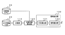
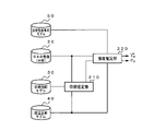
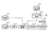
- the image analysis apparatus inputs a plurality of radar images in which the same area is recorded and a phase gradient model representing the phase difference between a plurality of adjacent pixels on the surface of the analysis target that may exist in the radar image, and phase A signal separating means is provided for extracting a component from the radar image that matches the phase difference represented by the gradient model.
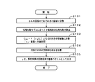
- the image analysis program inputs a plurality of radar images in which the same area is recorded into a computer, and a phase gradient model representing the phase difference between a plurality of adjacent pixels on the surface to be analyzed that may exist in the radar image. Then, a process of extracting a component that matches the phase difference represented by the phase gradient model from the radar image is executed.
- the signal separation unit may evaluate the analysis target using the following equation (3).
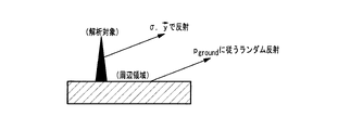
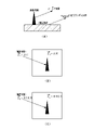
- FIG. 8 is an explanatory diagram for explaining the layover area continuity model.
- FIG. 8A shows the same contents as in FIG.
- Z ⁇ p is a variable that is 1 only on the side of the corresponding class and 0 on the other side.
- the final one hot vector Z ⁇ p corresponds to the estimated layover area.
Landscapes
- Engineering & Computer Science (AREA)
- Remote Sensing (AREA)
- Radar, Positioning & Navigation (AREA)
- Physics & Mathematics (AREA)
- Electromagnetism (AREA)
- Computer Networks & Wireless Communication (AREA)
- General Physics & Mathematics (AREA)
- Radar Systems Or Details Thereof (AREA)
Priority Applications (3)
| Application Number | Priority Date | Filing Date | Title |
|---|---|---|---|
| US18/569,738 US20240280689A1 (en) | 2021-06-22 | 2021-06-22 | Image analysis device and image analysis method |
| PCT/JP2021/023597 WO2022269754A1 (ja) | 2021-06-22 | 2021-06-22 | 画像解析装置および画像解析方法 |
| JP2023529274A JP7722453B2 (ja) | 2021-06-22 | 2021-06-22 | 画像解析装置および画像解析方法 |
Applications Claiming Priority (1)
| Application Number | Priority Date | Filing Date | Title |
|---|---|---|---|
| PCT/JP2021/023597 WO2022269754A1 (ja) | 2021-06-22 | 2021-06-22 | 画像解析装置および画像解析方法 |
Publications (1)
| Publication Number | Publication Date |
|---|---|
| WO2022269754A1 true WO2022269754A1 (ja) | 2022-12-29 |
Family
ID=84545312
Family Applications (1)
| Application Number | Title | Priority Date | Filing Date |
|---|---|---|---|
| PCT/JP2021/023597 Ceased WO2022269754A1 (ja) | 2021-06-22 | 2021-06-22 | 画像解析装置および画像解析方法 |
Country Status (3)
| Country | Link |
|---|---|
| US (1) | US20240280689A1 (cg-RX-API-DMAC7.html) |
| JP (1) | JP7722453B2 (cg-RX-API-DMAC7.html) |
| WO (1) | WO2022269754A1 (cg-RX-API-DMAC7.html) |
Cited By (1)
| Publication number | Priority date | Publication date | Assignee | Title |
|---|---|---|---|---|
| JPWO2024150737A1 (cg-RX-API-DMAC7.html) * | 2023-01-10 | 2024-07-18 |
Families Citing this family (1)
| Publication number | Priority date | Publication date | Assignee | Title |
|---|---|---|---|---|
| EP4481430A1 (en) * | 2023-06-23 | 2024-12-25 | Tata Consultancy Services Limited | Non-contact method and system for inspection and detection of water saturated regions in rockmass |
Citations (4)
| Publication number | Priority date | Publication date | Assignee | Title |
|---|---|---|---|---|
| JP2003500658A (ja) * | 1999-05-25 | 2003-01-07 | ポリテクニコ ディ ミラノ | 市街地領域及び地滑り地帯の運動に関するレーダー測定のための手順 |
| WO2017032977A1 (en) * | 2015-08-24 | 2017-03-02 | Thales Holdings Uk Plc | Video-assisted inverse synthetic aperture radar (vaisar) |
| WO2017126547A1 (ja) * | 2016-01-22 | 2017-07-27 | 日本電気株式会社 | 画像処理装置、画像処理方法および画像処理プログラム |
| WO2021024336A1 (ja) * | 2019-08-05 | 2021-02-11 | 日本電気株式会社 | 位相アンラップ装置及び位相アンラップ方法 |
Family Cites Families (1)
| Publication number | Priority date | Publication date | Assignee | Title |
|---|---|---|---|---|
| CN106093939B (zh) | 2016-05-27 | 2018-08-03 | 山东科技大学 | 一种基于相位差统计模型的InSAR图像相位解缠方法 |
-
2021
- 2021-06-22 WO PCT/JP2021/023597 patent/WO2022269754A1/ja not_active Ceased
- 2021-06-22 US US18/569,738 patent/US20240280689A1/en active Pending
- 2021-06-22 JP JP2023529274A patent/JP7722453B2/ja active Active
Patent Citations (4)
| Publication number | Priority date | Publication date | Assignee | Title |
|---|---|---|---|---|
| JP2003500658A (ja) * | 1999-05-25 | 2003-01-07 | ポリテクニコ ディ ミラノ | 市街地領域及び地滑り地帯の運動に関するレーダー測定のための手順 |
| WO2017032977A1 (en) * | 2015-08-24 | 2017-03-02 | Thales Holdings Uk Plc | Video-assisted inverse synthetic aperture radar (vaisar) |
| WO2017126547A1 (ja) * | 2016-01-22 | 2017-07-27 | 日本電気株式会社 | 画像処理装置、画像処理方法および画像処理プログラム |
| WO2021024336A1 (ja) * | 2019-08-05 | 2021-02-11 | 日本電気株式会社 | 位相アンラップ装置及び位相アンラップ方法 |
Cited By (3)
| Publication number | Priority date | Publication date | Assignee | Title |
|---|---|---|---|---|
| JPWO2024150737A1 (cg-RX-API-DMAC7.html) * | 2023-01-10 | 2024-07-18 | ||
| WO2024150737A1 (ja) * | 2023-01-10 | 2024-07-18 | 日本電気株式会社 | 信号処理装置、信号処理方法及び記録媒体 |
| JP7871904B2 (ja) | 2023-01-10 | 2026-06-09 | 日本電気株式会社 | 信号処理装置、信号処理方法及びプログラム |
Also Published As
| Publication number | Publication date |
|---|---|
| JPWO2022269754A1 (cg-RX-API-DMAC7.html) | 2022-12-29 |
| JP7722453B2 (ja) | 2025-08-13 |
| US20240280689A1 (en) | 2024-08-22 |
Similar Documents
| Publication | Publication Date | Title |
|---|---|---|
| RU2518903C2 (ru) | Идентификация и анализ устойчивых рассеивателей в последовательности изображений, полученных с помощью sar | |
| DK2452205T3 (en) | A process for the filtration of the interferograms obtained by SAR images recorded on the same area | |
| Liu et al. | Extraction of tsunami-flooded areas and damaged buildings in the 2011 Tohoku-oki earthquake from TerraSAR-X intensity images | |
| US11841422B2 (en) | Synthetic aperture radar signal processing device and signal processing method | |
| JP6452586B2 (ja) | 画像処理装置および画像処理方法 | |
| CN109165622B (zh) | 基于InSAR技术的区域滑坡早期动态识别监测有效区域确定方法 | |
| CN115060208A (zh) | 基于多源卫星融合的输变电线路地质灾害监测方法及系统 | |
| CN106204539B (zh) | 一种基于形态学梯度的反演城区建筑物沉降的方法 | |
| US20210132214A1 (en) | Synthetic aperture radar image analysis system, synthetic aperture radar image analysis method, and synthetic aperture radar image analysis program | |
| EP2601538A1 (en) | Alignment of synthetic aperture images | |
| Rambour et al. | Urban surface reconstruction in SAR tomography by graph-cuts | |
| JP7722453B2 (ja) | 画像解析装置および画像解析方法 | |
| JP5334606B2 (ja) | レーダ画像信号処理装置 | |
| JP7255690B2 (ja) | 位相アンラップ装置及び位相アンラップ方法 | |
| CN113446989A (zh) | 基于dic与合成孔径雷达的周围土体变形变位的空间检测方法 | |
| Niu et al. | Accelerometer-assisted computer vision data fusion framework for structural dynamic displacement reconstruction | |
| JP7582444B2 (ja) | 変化検知装置および変化検知方法 | |
| CN120747575A (zh) | 一种输电线路地质灾害识别方法、系统、设备及介质 | |
| Kim et al. | Digital surface model generation for drifting Arctic sea ice with low-textured surfaces based on drone images | |
| US11835619B2 (en) | Synthetic aperture radar signal analysis device, synthetic aperture radar signal analysis method, and synthetic aperture radar signal analysis program | |
| Lemmens et al. | Sensitivity of automated attitude determination form ISAR radar mappings | |
| Noh et al. | Applications of high-resolution, cross-track, pushbroom satellite images with the SETSM algorithm | |
| US20250341632A1 (en) | Signal processing device and signal processing method | |
| JP7501637B2 (ja) | 画像処理装置および画像処理方法 | |
| EP2182384A1 (en) | Method for processing sar images |
Legal Events
| Date | Code | Title | Description |
|---|---|---|---|
| 121 | Ep: the epo has been informed by wipo that ep was designated in this application |
Ref document number: 21947041 Country of ref document: EP Kind code of ref document: A1 |
|
| WWE | Wipo information: entry into national phase |
Ref document number: 2023529274 Country of ref document: JP |
|
| WWE | Wipo information: entry into national phase |
Ref document number: 18569738 Country of ref document: US |
|
| NENP | Non-entry into the national phase |
Ref country code: DE |
|
| 122 | Ep: pct application non-entry in european phase |
Ref document number: 21947041 Country of ref document: EP Kind code of ref document: A1 |