WO2020189608A1 - 情報処理装置 - Google Patents
情報処理装置 Download PDFInfo
- Publication number
- WO2020189608A1 WO2020189608A1 PCT/JP2020/011355 JP2020011355W WO2020189608A1 WO 2020189608 A1 WO2020189608 A1 WO 2020189608A1 JP 2020011355 W JP2020011355 W JP 2020011355W WO 2020189608 A1 WO2020189608 A1 WO 2020189608A1
- Authority
- WO
- WIPO (PCT)
- Prior art keywords
- equipment
- information
- related information
- required skill
- skill
- Prior art date
- Legal status (The legal status is an assumption and is not a legal conclusion. Google has not performed a legal analysis and makes no representation as to the accuracy of the status listed.)
- Ceased
Links
Images











Classifications
-
- G—PHYSICS
- G06—COMPUTING OR CALCULATING; COUNTING
- G06Q—INFORMATION AND COMMUNICATION TECHNOLOGY [ICT] SPECIALLY ADAPTED FOR ADMINISTRATIVE, COMMERCIAL, FINANCIAL, MANAGERIAL OR SUPERVISORY PURPOSES; SYSTEMS OR METHODS SPECIALLY ADAPTED FOR ADMINISTRATIVE, COMMERCIAL, FINANCIAL, MANAGERIAL OR SUPERVISORY PURPOSES, NOT OTHERWISE PROVIDED FOR
- G06Q10/00—Administration; Management
- G06Q10/06—Resources, workflows, human or project management; Enterprise or organisation planning; Enterprise or organisation modelling
- G06Q10/063—Operations research, analysis or management
- G06Q10/0631—Resource planning, allocation, distributing or scheduling for enterprises or organisations
- G06Q10/06311—Scheduling, planning or task assignment for a person or group
- G06Q10/063112—Skill-based matching of a person or a group to a task
-
- B—PERFORMING OPERATIONS; TRANSPORTING
- B64—AIRCRAFT; AVIATION; COSMONAUTICS
- B64U—UNMANNED AERIAL VEHICLES [UAV]; EQUIPMENT THEREFOR
- B64U10/00—Type of UAV
- B64U10/10—Rotorcrafts
- B64U10/13—Flying platforms
-
- G—PHYSICS
- G06—COMPUTING OR CALCULATING; COUNTING
- G06Q—INFORMATION AND COMMUNICATION TECHNOLOGY [ICT] SPECIALLY ADAPTED FOR ADMINISTRATIVE, COMMERCIAL, FINANCIAL, MANAGERIAL OR SUPERVISORY PURPOSES; SYSTEMS OR METHODS SPECIALLY ADAPTED FOR ADMINISTRATIVE, COMMERCIAL, FINANCIAL, MANAGERIAL OR SUPERVISORY PURPOSES, NOT OTHERWISE PROVIDED FOR
- G06Q10/00—Administration; Management
- G06Q10/10—Office automation; Time management
-
- G—PHYSICS
- G08—SIGNALLING
- G08G—TRAFFIC CONTROL SYSTEMS
- G08G5/00—Traffic control systems for aircraft
- G08G5/20—Arrangements for acquiring, generating, sharing or displaying traffic information
- G08G5/26—Transmission of traffic-related information between aircraft and ground stations
-
- G—PHYSICS
- G08—SIGNALLING
- G08G—TRAFFIC CONTROL SYSTEMS
- G08G5/00—Traffic control systems for aircraft
- G08G5/30—Flight plan management
- G08G5/32—Flight plan management for flight plan preparation
-
- G—PHYSICS
- G08—SIGNALLING
- G08G—TRAFFIC CONTROL SYSTEMS
- G08G5/00—Traffic control systems for aircraft
- G08G5/50—Navigation or guidance aids
- G08G5/55—Navigation or guidance aids for a single aircraft
-
- G—PHYSICS
- G08—SIGNALLING
- G08G—TRAFFIC CONTROL SYSTEMS
- G08G5/00—Traffic control systems for aircraft
- G08G5/70—Arrangements for monitoring traffic-related situations or conditions
- G08G5/76—Arrangements for monitoring traffic-related situations or conditions for monitoring atmospheric conditions
-
- G—PHYSICS
- G09—EDUCATION; CRYPTOGRAPHY; DISPLAY; ADVERTISING; SEALS
- G09B—EDUCATIONAL OR DEMONSTRATION APPLIANCES; APPLIANCES FOR TEACHING, OR COMMUNICATING WITH, THE BLIND, DEAF OR MUTE; MODELS; PLANETARIA; GLOBES; MAPS; DIAGRAMS
- G09B19/00—Teaching not covered by other main groups of this subclass
- G09B19/16—Control of vehicles or other craft
- G09B19/165—Control of aircraft
-
- B—PERFORMING OPERATIONS; TRANSPORTING
- B64—AIRCRAFT; AVIATION; COSMONAUTICS
- B64U—UNMANNED AERIAL VEHICLES [UAV]; EQUIPMENT THEREFOR
- B64U2101/00—UAVs specially adapted for particular uses or applications
- B64U2101/25—UAVs specially adapted for particular uses or applications for manufacturing or servicing
- B64U2101/26—UAVs specially adapted for particular uses or applications for manufacturing or servicing for manufacturing, inspections or repairs
-
- B—PERFORMING OPERATIONS; TRANSPORTING
- B64—AIRCRAFT; AVIATION; COSMONAUTICS
- B64U—UNMANNED AERIAL VEHICLES [UAV]; EQUIPMENT THEREFOR
- B64U2101/00—UAVs specially adapted for particular uses or applications
- B64U2101/30—UAVs specially adapted for particular uses or applications for imaging, photography or videography
-
- B—PERFORMING OPERATIONS; TRANSPORTING
- B64—AIRCRAFT; AVIATION; COSMONAUTICS
- B64U—UNMANNED AERIAL VEHICLES [UAV]; EQUIPMENT THEREFOR
- B64U2201/00—UAVs characterised by their flight controls
-
- G—PHYSICS
- G05—CONTROLLING; REGULATING
- G05D—SYSTEMS FOR CONTROLLING OR REGULATING NON-ELECTRIC VARIABLES
- G05D1/00—Control of position, course, altitude or attitude of land, water, air or space vehicles, e.g. using automatic pilots
- G05D1/0011—Control of position, course, altitude or attitude of land, water, air or space vehicles, e.g. using automatic pilots associated with a remote control arrangement
-
- G—PHYSICS
- G08—SIGNALLING
- G08G—TRAFFIC CONTROL SYSTEMS
- G08G5/00—Traffic control systems for aircraft
- G08G5/50—Navigation or guidance aids
- G08G5/57—Navigation or guidance aids for unmanned aircraft
-
- G—PHYSICS
- G08—SIGNALLING
- G08G—TRAFFIC CONTROL SYSTEMS
- G08G5/00—Traffic control systems for aircraft
- G08G5/80—Anti-collision systems
Definitions
- the present invention relates to a technique for supporting the operation of an air vehicle.
- Patent Document 1 states that patent document 1 acquires rotation information indicating the orientation of the nacelle and the phase of the blade in the wind turbine to be inspected, and acquires inspection data based on the rotation information.
- a technique for generating data on the flight route (inspection route) of an aircraft is disclosed.
- an object of the present invention is to support the allocation of operators who can smoothly acquire inspection data of each facility.
- the present invention has an acquisition unit that acquires related information related to the equipment to be inspected, and the acquisition unit that flies an air vehicle around the equipment to acquire inspection data of the equipment.
- an information processing device including a determination unit that determines the skill required for operating an air vehicle based on the acquired related information.
- the figure which shows an example of the operation procedure of each apparatus in a generation process Diagram showing an example of the required skill table of the modified example Diagram showing an example of the required skill table of the modified example Diagram showing an example of the required skill table of the modified example Diagram showing an example of the required skill table of the modified example Diagram showing an example of the required skill table of the modified example Diagram showing an example of the required skill table of the modified example Diagram showing an example of the required
- FIG. 1 shows an example of the overall configuration of the equipment inspection system 1 according to the embodiment.
- the equipment inspection system 1 is a system that supports inspection using an air vehicle having an inspection function capable of acquiring inspection data even from a remote position around the inspection target.
- the inspection target is equipment that is regularly inspected to check the degree of deterioration, damage, etc., for example, bridges, buildings, tunnels, and the like.
- a mobile communication base station particularly an antenna
- Inspection data is data used to determine the presence or absence of equipment damage (corrosion, peeling, falling off, breakage, cracking, discoloration due to deformation and deterioration, etc.) and the necessity of repair.
- equipment damage corrosion, peeling, falling off, breakage, cracking, discoloration due to deformation and deterioration, etc.
- the inspection data for example, imaging data of the imaging means, measurement data of the infrared sensor, measurement data of the ultrasonic sensor, measurement data of the millimeter wave sensor, and the like are used. In this embodiment, the imaging data is used as inspection data.
- the presence or absence of damage and the necessity of repair based on the inspection data are mainly determined by the person in charge of inspection.
- the person in charge of inspection may judge the presence or absence of damage by looking at the displayed inspection data, or make the computer perform a process (image processing, etc.) to further analyze the inspection data and then judge the presence or absence of damage. You may go. Further, if AI (Artificial Intelligence) develops, the computer may be made to judge whether or not there is damage. In other words, it is not necessary to limit the subject of judgment based on inspection data to people.
- AI Artificial Intelligence
- the equipment inspection system 1 includes a network 2, a server device 10, a drone 20, a radio 30, and a base terminal 40.
- the network 2 is a communication system including a mobile communication network, the Internet, and the like, and relays data exchange between devices accessing the own system.
- the server device 10 and the base terminal 40 access the network 2 by wired communication (may be wireless communication), and the drone 20 and the radio 30 access by wireless communication.
- the drone 20 is a rotorcraft-type flying object that flies by rotating one or more rotors, and has a photographing function for taking a picture as the above-mentioned inspection function.
- the drone 20 flies according to the operation of the operator and acquires inspection data (photographed data of equipment).
- the drone 20 is deployed at a base such as a sales office of an inspection company.
- the radio 30 (transmitter) is a device that performs proportional control (proportional control), and is used by the operator to operate the drone 20.
- the operation of the drone 20 includes an operation of flying the drone 20 and an operation of acquiring inspection data of equipment (for example, an operation of adjusting a shooting range, an operation of focusing, and an operation of pressing a shooting button).
- the drone 20 may automatically acquire the inspection data.
- Some of the equipment to be inspected is easy to operate, for example, simply raising the drone 20 straight up and then lowering it, while it is difficult to operate, such as changing the flight direction many times. There are also things.
- the server device 10 is an operation plan of the drone 20 in which a process of determining the skill of the operator required to acquire inspection data in each facility and an operator of the determined skill operate the drone 20 to take a picture of the facility. Performs processing and the like to generate.
- the server device 10 is an example of the "information processing device" of the present invention.
- the base terminal 40 is installed at, for example, a base where the drone 20 is deployed, and transmits the generated operation plan to the persons concerned.
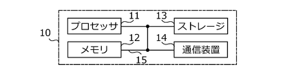
- FIG. 2 shows an example of the hardware configuration of the server device 10.
- the server device 10 may be physically configured as a computer device including a processor 11, a memory 12, a storage 13, a communication device 14, a bus 15, and the like.
- the word "device” can be read as a circuit, a device, a unit, or the like.
- each device may be included one or more, or some devices may not be included.
- the processor 11 operates, for example, an operating system to control the entire computer.
- the processor 11 may be configured by a central processing unit (CPU: Central Processing Unit) including an interface with peripheral devices, a control device, an arithmetic unit, a register, and the like.
- CPU Central Processing Unit
- the baseband signal processing unit and the like may be realized by the processor 11. Further, the processor 11 reads a program (program code), a software module, data, and the like from at least one of the storage 13 and the communication device 14 into the memory 12, and executes various processes according to the read program and the like.
- a program program code
- the program a program that causes a computer to execute at least a part of the operations described in the above-described embodiment is used.
- the various processes described above are executed by one processor 11, they may be executed simultaneously or sequentially by two or more processors 11.
- the processor 11 may be implemented by one or more chips.
- the program may be transmitted from the network via a telecommunication line.
- the memory 12 is a computer-readable recording medium.
- the memory 12 may be composed of at least one such as a ROM (ReadOnlyMemory), an EPROM (ErasableProgrammableROM), an EPROM (ElectricallyErasableProgrammableROM), and a RAM (RandomAccessMemory).
- the memory 12 may be called a register, a cache, a main memory (main storage device), or the like.
- the memory 12 can store a program (program code), a software module, or the like that can be executed to implement the wireless communication method according to the embodiment of the present disclosure.
- the storage 13 is a computer-readable recording medium, and is, for example, an optical disk such as a CD-ROM (Compact Disc ROM), a hard disk drive, a flexible disk, or a magneto-optical disk (for example, a compact disk, a digital versatile disk, or a Blu-ray). It may consist of at least one (registered trademark) disk), smart card, flash memory (eg, card, stick, key drive), floppy (registered trademark) disk, magnetic strip, and the like.
- an optical disk such as a CD-ROM (Compact Disc ROM), a hard disk drive, a flexible disk, or a magneto-optical disk (for example, a compact disk, a digital versatile disk, or a Blu-ray). It may consist of at least one (registered trademark) disk), smart card, flash memory (eg, card, stick, key drive), floppy (registered trademark) disk, magnetic strip, and the like.
- the storage 13 may be called an auxiliary storage device.
- the storage medium described above may be, for example, a database, server or other suitable medium containing at least one of the memory 12 and the storage 13.
- the communication device 14 is hardware (transmission / reception device) for communicating between computers via at least one of a wired network and a wireless network.
- the communication device 14 is also referred to as, for example, a network device, a network controller, a network card, a communication module, or the like.
- the above-mentioned transmission / reception antenna, amplifier unit, transmission / reception unit, transmission line interface, and the like may be realized by the communication device 14.
- the transmission / reception unit may be physically or logically separated from each other in the transmission unit and the reception unit.
- each device such as the processor 11 and the memory 12 is connected by a bus 15 for communicating information.
- the bus 15 may be configured by using a single bus, or may be configured by using a different bus for each device.
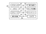
- FIG. 3 shows an example of the hardware configuration of the drone 20.
- the drone 20 is physically a computer including a processor 21, a memory 22, a storage 23, a communication device 24, a flight device 25, a sensor device 26, a battery 27, a camera 28, a bus 29, and the like. It may be configured as a device.
- the hardware of the same name shown in FIG. 2 such as the processor 21 is the same type of hardware as in FIG. 2, although there are differences in performance and specifications.
- the communication device 24 has a function of communicating with the radio 30 (for example, a wireless communication function using radio waves in the 2.4 GHz band) in addition to the communication with the network 2.
- the flight device 25 includes a motor, a rotor, and the like, and is a device for flying its own aircraft. The flight device 25 can move its own aircraft in all directions and make its own aircraft stationary (hovering) in the air.
- the sensor device 26 is a device having a sensor group for acquiring information necessary for flight control.
- the sensor device 26 has, for example, a position sensor that measures the position (latitude and longitude) of the own machine and a direction in which the own machine is facing (the front direction of the own machine is determined by the drone, and the determined front direction). It is equipped with a direction sensor that measures the direction in which the aircraft is facing) and an altitude sensor that measures the altitude of the aircraft.
- the sensor device 26 includes a speed sensor for measuring the speed of the own machine and an inertial measurement sensor (IMU (Inertial Measurement Unit)) for measuring the angular speed of three axes and the acceleration in three directions.
- the battery 27 is a device that stores electric power and supplies electric power to each part of the drone 20.
- the camera 28 includes an image sensor, optical system parts, and the like, and photographs an object in the direction in which the lens is facing.
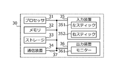
- FIG. 4 shows an example of the hardware configuration of the radio 30.
- the radio 30 may be physically configured as a computer device including a processor 31, a memory 32, a storage 33, a communication device 34, an input device 35, an output device 36, a bus 37, and the like.
- the hardware of the same name shown in FIG. 2 such as the processor 31 is the same type of hardware as in FIG. 2, although there are differences in performance and specifications.
- the input device 35 is an input device (for example, a switch, a button, a sensor, etc.) that receives an input from the outside.
- the input device 35 includes a left stick 351 and a right stick 352, and accepts an operation on each stick as a movement operation in the front-back direction, the up-down direction, the left-right direction, and the rotation direction of the drone 20.
- the output device 36 is an output device (for example, a monitor 361, a speaker, an LED (Light Emitting Diode) lamp, etc.) that outputs to the outside.
- the input device 35 and the output device 36 may have an integrated configuration (for example, the monitor 361 is a touch screen).
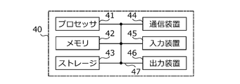
- FIG. 5 shows an example of the hardware configuration of the base terminal 40.
- the base terminal 40 may be physically configured as a computer device including a processor 41, a memory 42, a storage 43, a communication device 44, an input device 45, an output device 46, a bus 47, and the like. ..
- the input device 45 may be, for example, a keyboard, a mouse, a microphone, or the like.
- each of the above devices includes hardware such as a microprocessor, a digital signal processor (DSP: Digital Signal Processor), an ASIC (Application Specific Integrated Circuit), a PLD (Programmable Logic Device), and an FPGA (Field Programmable Gate Array). It may be composed of. Further, in each of the above devices, a part or all of each functional block may be realized by the hardware. For example, the processor 11 may be implemented using at least one of the hardware.
- Each function in each device included in the equipment inspection system 1 is performed by the processor by loading predetermined software (program) on the hardware such as each processor and memory, and the communication by each communication device is controlled. It is achieved by controlling at least one of reading and writing of data in memory and storage.
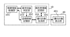
- FIG. 6 shows the functional configuration realized by each device.
- the server device 10 includes a related information acquisition unit 101, an equipment information storage unit 102, a required skill determination unit 103, an operation plan generation unit 104, and an operator information storage unit 105.
- the base terminal 40 includes an operation plan display unit 401.
- the related information acquisition unit 101 acquires related information related to the equipment to be inspected.
- the related information acquisition unit 101 is an example of the “acquisition unit” of the present invention.
- Related information includes not only information about the equipment itself, but also information about the surroundings of the equipment and information about the measures to be taken for the equipment (acquisition of inspection data, etc.).
- the related information acquisition unit 101 acquires shape information indicating the shape of the equipment as related information.
- the related information acquisition unit 101 acquires the shape information of the equipment from the equipment information storage unit 102.
- the equipment information storage unit 102 is a function of storing equipment information which is information about the equipment to be inspected, and in this embodiment, the information about the base station is stored as equipment information.
- the equipment information storage unit 102 includes, for example, information such as the position of the antenna equipment installed in the base station, the direction to be photographed, the height from the ground, the equipment ID for identifying the equipment, and the shape information (antenna equipment) described above.
- Equipment information including at least (information indicating the shape of the antenna) is stored.
- the shape information is, for example, image information representing a photograph of the appearance of the antenna equipment, image information representing a design drawing, and the like.
- the shape information is registered in the equipment inspection system 1 by the business operator who installed the equipment, the business operator who owns the equipment, or a business operator entrusted to the business operator, and is stored in the equipment information storage unit 102.
- the related information acquisition unit 101 acquires the equipment ID and related information of each equipment, and supplies the acquired equipment ID and the like to the required skill determination unit 103.
- the required skill determination unit 103 determines the skill required for the operation of the drone 20 when the drone 20 is flown around the equipment and the inspection data of the equipment is acquired.
- the required skill determination unit 103 is an example of the "determination unit" of the present invention.
- the required skill determination unit 103 determines the skill required in the equipment from which the related information has been acquired, based on the related information of the equipment acquired by the related information acquisition unit 101.
- the skill of the operator is represented by, for example, the operation time, which is the cumulative time of operating the drone in the past. Specifically, the skill is expressed as “low” when the operation time is up to 50 hours, the skill is “medium” from 50 hours to 100 hours, and “high” when the operation time is 100 hours or more.
- the operation time includes the time when the operation for simply flying the drone (operation time for flight only) and the time for the operation for acquiring inspection data while flying the drone (operation time with inspection). In some cases, both may be included, or only the inspected operation time may be included.
- the operation time with inspection is weighted and the operation time for flight only.
- the total time may be used as the operation time.
- the skill of the operator may be expressed not by the operation time but by the type of license (certified for each operation skill) certified by each organization for the drone.
- the required skill determination unit 103 determines that the more complicated the flight route along the shape of the equipment represented by the acquired related information, the higher the required skill.
- the required skill determination unit 103 extracts, for example, the contour of the antenna equipment from the shape information (the above image information) acquired as related information. It is desirable that the contour to be extracted is the contour of the side surface of the antenna equipment taken by the drone 20.
- the required skill determination unit 103 extracts the contour in a state where the Y-axis direction of the X-axis direction (horizontal direction) and the Y-axis direction (vertical direction) of the image is aligned with the vertical direction of the antenna equipment, for example.
- Each pixel representing the extracted contour is represented by the coordinates (x, y).
- the required skill determination unit 103 further extracts the pixel having the maximum x-coordinate from the pixel group having the common y-coordinate from the extracted contours.
- the contour represented by the extracted pixels represents the contour of the side surface of the equipment.
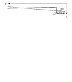
- FIG. 7A and 7B show an example of extracted pixels.
- FIG. 7A shows the antenna equipment 3 and the side contour A3
- FIG. 7B shows the antenna equipment 4 and the side contour A4.
- the antenna equipment 4 has a larger number of antennas than the antenna equipment 3, and the antenna portion protrudes in the horizontal direction due to the large number of antennas. Therefore, the side contour A4 changes more horizontally than the side contour A3.
- the required skill determination unit 103 calculates, for example, the regression line and the variance in the contours A3 and A4.
- the variance may be calculated by a well-known method such as the least squares method.
- FIG. 8A and 8B show an example of the calculated regression line.
- FIG. 8A shows the regression line B3 of the contour A3
- FIG. 8B shows the regression line B4 of the contour A4.
- the dispersion of the contour A3 is smaller than that of the contour A4. The larger the variance value calculated in this way, the more complicated the flight route along the shape of the equipment is considered.
- the required skill determination unit 103 calculates the variance using only the contours when the antenna equipments 3 and 4 are viewed from one direction, but the variance is calculated from a plurality of directions.
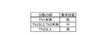
- the variance may be calculated using the contours of the cases (preferably the contours of the sides taken by the drone 20), and the average value of the calculated variances may be calculated as the variance value. Since the required skill determination unit 103 determines that the more complicated the flight route is, the higher the required skill is, the required skill determination unit 103 makes a determination using the required skill table in which the calculated variance value and the required skill are associated with each other.
- FIG. 9 shows an example of the required skill table.
- the variance values of “less than Th1”, “Th1 or more and less than Th2”, and “Th2 or more” are associated with the skills of “low”, “medium”, and “high”. For example, if the variance of the contour A3 is "less than Th1", the required skill determination unit 103 determines that the operation skill of the drone 20 required to acquire the inspection data of the antenna equipment 3 is "low”.
- the required skill determination unit 103 states that if the variance of the contour A4 is "Th1 or more and less than Th2", the operation skill of the drone 20 required to acquire the inspection data of the antenna equipment 4 is "medium”. judge.
- the required skill determination unit 103 supplies the determined skill (required skill) to the equipment information storage unit 102.
- the equipment information storage unit 102 stores the supplied required skill as equipment information.
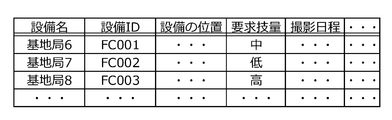
- FIG. 10 shows an example of equipment information.
- the equipment information storage unit 102 stores the equipment name, equipment ID, equipment position, required skill, shooting schedule (scheduled shooting schedule), and the like as equipment information.
- the required skill of the base station 6 is “medium”
- the required skill of the base station 7 is “low”
- the required skill of the base station 8 is “high”.
- the operation plan generation unit 104 generates an operation plan for flying the drone 20 around equipment having a common skill level determined by the required skill determination unit 103.
- the operation plan generation unit 104 is an example of the "generation unit" of the present invention.
- the operation plan generation unit 104 creates an operation plan using the equipment information stored in the equipment information storage unit 102 and the operator information stored in the operator information storage unit 105.
- the operator information storage unit 105 stores information (operator information) about the operator registered in the equipment inspection system 1.
- the operator information is registered and updated using, for example, the base terminal 40.
- FIG. 11 shows an example of operator information.
- the operator information storage unit 105 provides operator information that associates the operator name ( ⁇ , ⁇ , ⁇ ), the operator ID, the operation time, and the shooting schedule / target equipment. I remember as.
- Operators ⁇ , ⁇ , and ⁇ are all working at the bases where the drone 20 is deployed, and it is assumed that the drone 20 can be carried by car to go around each base station.
- the operator information storage unit 105 updates to a new operation time including the input operation time.
- the operation plan generation unit 104 determines that the skill of the operator is, for example, "low” if the operation time is less than 50 hours, “medium” if the operation time is 50 hours or more and less than 200 hours, and "high” if the operation time is 200 hours or more.
- the shooting schedule / target equipment reflects the schedule for the operator to operate the drone 20 to shoot the equipment according to the operation plan generated by the operation plan generation unit 104, and the equipment to be photographed.
- the operation plan generation unit 104 selects, for example, one base station whose shooting schedule is not determined in the equipment information. When, for example, the base station 6 is selected, the operation plan generation unit 104 extracts the base stations having the same required skill as the base station 6 and are “medium”.
- the operation plan generation unit 104 is a base station capable of arriving at the base station by a predetermined time after going around the base station 6 starting from the base of the drone 20. Identify the combination. As a premise when specifying the combination, the operation plan generation unit 104 determines that, for example, it travels 30 km in 1 hour and shoots one place in 2 hours. The premise described here is an example, and may be determined according to the actual situation.
- the operation plan generation unit 104 determines that the combination of base stations whose required skill is "medium” specified in this way is, for example, “medium” (that is, the operation time is 50 hours or more and less than 200 hours). Specify as the target equipment. When the operation plan generation unit 104 determines the shooting date, it is reflected in the "shooting schedule" of the equipment information of the base station specified as the shooting target, and also reflected in the "shooting schedule / target equipment" of the operator information of the operator ⁇ . To do.
- the operation plan generation unit 104 selects another base station whose shooting schedule has not been determined, determines the shooting schedule, the base station to shoot on the same day, and the photographer in charge of shooting in the same manner as above, and provides equipment information. And reflect in the operator information.
- the operation plan generation unit 104 repeats the above processing to determine a shooting schedule and an operator in charge of shooting at a predetermined period or a predetermined base station.
- the predetermined period may be one year, one month, one week or one day.
- the predetermined base station may be all base stations or some base stations.
- the operation plan generation unit 104 generates an operation plan indicating the determined shooting schedule, the equipment to be photographed, and the operator in charge of shooting, and transmits the generated operation plan to, for example, the base terminal 40.
- the operation plan display unit 401 of the base terminal 40 displays the operation plan transmitted from the server device 10. The display of the operation plan is performed, for example, by the operation of the person in charge of operation management of the base.
- FIG. 12 shows an example of the displayed operation plan.
- the operation plan display unit 401 displays a list in which the shooting date, the operator, and the target equipment are associated with each other.
- the operator ⁇ whose skill is determined to be “medium” is associated with the target equipment including the base station 6 whose required skill is “medium”.
- the operator ⁇ whose skill is judged to be “low” is associated with the target equipment including the base station 7 whose required skill is “low”, and the operator ⁇ whose skill is judged to be “high” has the required skill. It is associated with the target equipment including the "high" base station 8.
- Each device included in the equipment inspection system 1 performs a determination process for determining a required skill for each facility and a generation process for generating an operation plan based on the determined required skill based on the above configuration.
- FIG. 13 shows an example of the operation procedure of each device in the determination process. The operation procedure of FIG. 13 is started, for example, periodically or when new equipment is installed.
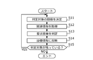
- the server device 10 determines the equipment to be determined (step S11), and acquires the related information (shape information in this embodiment) in the determined equipment (step S12).
- the server device 10 (required skill determination unit 103) determines the required skill in the equipment to be determined (step S13).
- the server device 10 (equipment information storage unit 102) reflects the determined required skill in the equipment information (step S14).
- the server device 10 determines whether or not the equipment to be determined remains (step S15). If it is determined that the server device 10 remains (YES), the server device 10 returns to step S11 and operates, and if it determines that the server device 10 does not remain (NO), the operation procedure of FIG.
- FIG. 14 shows an example of the operation procedure of each device in the generation process.
- the operation procedure of FIG. 14 is started, for example, when a person in charge of operation management of the base performs an operation of displaying an operation plan on the base terminal 40.
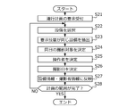
- the server device 10 receives the request for the operation plan (step S21)
- the server device 10 selects the equipment for determining the shooting date and the like (step S22).
- the server device 10 extracts equipment having the same required skill as the selected equipment (step S23), and determines an object to be photographed on the same day based on the position of each equipment (step S24). ). Subsequently, the server device 10 (operation plan generation unit 104) determines an operator having the required skill of the selected equipment as a person in charge of shooting the equipment determined as the shooting target (step S25), and determines the shooting date. (Step S26).
- the server device 10 (operation plan generation unit 104) reflects the determined equipment to be photographed, the photographer, and the shooting date in the equipment information and the photographer information (step S27). Then, the server device 10 (operation plan generation unit 104) determines whether or not the range of the operation plan to be generated is completed (step S28). If it is determined that the server device 10 is not completed (NO), the server device 10 returns to step S22 to perform an operation, and if it is determined that the server device 10 is completed (YES), the operation procedure of FIG. 14 is terminated.
- the required skill is determined based on the shape information of the equipment. Since the shape information of the equipment is information that can be obtained from the time the equipment is installed (in some cases, before the installation), it can be determined in advance, and the processing load at the time of generating the operation plan can be lightened. it can.
- an operation plan is generated on the same day to go around the facilities with the same high required skill.
- it is sufficient to assign an operator who satisfies the required skill, so it is not necessary to limit the visit to the equipment having the same required skill on the same day.
- sharing the required skill level as described above it becomes easier for one operator to go around the equipment on the same day as compared with the case where the required skill level is not shared. It can make it easier to make a personnel plan.
- a modification example in which different parameters are used to obtain a common index may be combined, and a common index may be obtained by using each parameter together. Further, one index may be obtained by integrating the individually obtained indexes according to some rules. Further, when obtaining a common index, different weighting may be performed for each parameter used.
- the related information related to the equipment to be inspected is not limited to the shape information described in the examples.
- the related information acquisition unit 101 acquires information (weather information) indicating the weather around the equipment to be inspected as related information.
- the weather information is information indicating meteorological factors such as wind speed and precipitation that are likely to affect the flight of the drone 20.
- the related information acquisition unit 101 acquires weather forecast information in the area including the location of the equipment to be inspected from the system of the provider of the weather forecast service, etc., and acquires the wind speed and precipitation included in the weather forecast as weather information. To do.
- the required skill determination unit 103 determines that the greater the degree to which the flight is hindered by the weather indicated by the related information (weather information) of the equipment acquired by the related information acquisition unit 101, the higher the required skill in the equipment.
- the required skill determination unit 103 makes a determination using a required skill table in which the wind speed or precipitation amount and the required skill are associated with each other.
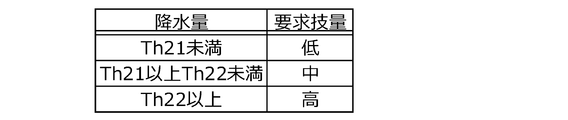
- FIGS. 15A and 15B show an example of the required skill table of this modified example.
- the required skills of "low”, “medium” and “high” are associated with the wind speeds of “less than Th11", “Th11 or more and less than Th12" and “Th12 or more”.
- the required skills of "low”, “medium” and “high” are associated with the precipitation amounts of "less than Th21", “more than Th21 and less than Th22" and "more than Th22".
- the required skill determination unit 103 determines that the required skill is “medium”. Further, the required skill determination unit 103 determines that the required skill is "high” if the amount of precipitation included in the weather forecast is "Th22 or more”. When both the wind speed and the amount of precipitation are used, the required skill determination unit 103 may determine, for example, the higher required skill associated with the required skill table as the required skill in the equipment.
- the related information acquisition unit 101 may acquire weather information by analyzing, for example, an image of a surveillance camera installed at or near the site.
- the weather information is not limited to wind speed and precipitation, for example, the presence or absence of fog (a situation in which the difficulty of operation increases due to deterioration of visibility) and the amount of snowfall (a situation in which the difficulty of operation improves due to deterioration of visibility and adhesion of snow).
- Extremely low temperature and extremely high temperature (a situation in which the difficulty of operation is improved due to deterioration of the aircraft performance) and the like.
- the required skill is determined reflecting the fact that the weather conditions make it difficult to operate the drone 20. Therefore, according to this modification, it is possible to make it less likely that the drone will be dropped due to insufficient skill in bad weather, as compared with the case where the weather information is not taken into consideration.
- the related information acquisition unit 101 further acquires the specification information about the drone 20.
- the specification information is, for example, information such as the size of the flying object, the number of channels, the motor output, the attitude maintaining function, and the hovering function.
- the posture maintenance function is a function of maintaining the front-rear direction and the left-right direction of the drone 20 in a state along the horizontal direction (that is, preventing the aircraft from tilting).
- the hovering function is a function of maintaining a hovering state at a specific position in the air.
- the related information acquisition unit 101 acquires the specification information from, for example, an external device (for example, the base terminal 40) that stores the specification information of the drone 20.
- the required skill determination unit 103 reads the specification information in addition to the related information from the related information acquisition unit 101.
- the required skill determination unit 103 determines the required skill based on each read information, that is, the related information of the equipment acquired by the related information acquisition unit 101 and the specification information also acquired.
- the required skill determination unit 103 makes a determination in this modification using the required skill table prepared for each specification of the drone 20.
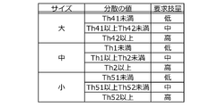
- 16A and 16B show an example of the required skill table of this modification.
- the variance value and the required skill are associated with each of the “yes” and “no” posture maintenance functions.
- the posture maintenance function is "none"
- the variance values of "less than Th1", “more than Th1 and less than Th2", and “more than Th2" and “low”, “medium”, and “high” are the same as in the example of FIG.
- the required skill is associated with it. If the posture maintenance function is "Yes”, the required skills of "Low”, “Medium”, and “High” are added to the variance values of "Th31 or more”, “Th31 or more and less than Th32", and “Th32 or more”. It is associated. In the example of FIG. 16A, it is assumed that the magnitude relation of each threshold value is Th31> Th1 and Th32> Th2.
- the required skill is "medium” if the posture maintenance function is “none”, and the required skill is “low” if the posture maintenance function is "yes”.
- the required skill determination unit 103 indicates that the acquired specification information has the posture maintenance function, and the acquired specification information maintains the posture. Judgment is made so that the required skill is lower than that in the case of indicating that the function is not provided.
- the required skill determination unit 103 determines that the required skill when the posture maintaining function is provided is lower than the required skill when the posture maintaining function is not provided. Further, when the specification information indicates the presence or absence of the hovering function, the required skill determination unit 103 similarly makes the required skill when the hovering function is provided lower than the required skill when the hovering function is not provided. Judgment is made.
- the variance value and the required skill are associated with each of the drone sizes “large”, “medium”, and “small”.
- the size is “medium”
- the same variance value and required skill as in the example of “none” in FIG. 16A are associated with each other.
- the required skills of "low”, “medium”, and “high” are associated with the variance values of "less than Th41", “Th41 or more and less than Th42", and “Th42 or more”. Has been done.
- the required skill is “medium” if the drone size is “medium”, and the required skill is “high” if the drone size is “large”.
- the required skill determination unit 103 makes a determination so that the larger the size of the drone indicated by the acquired specification information, the higher the required skill.
- the larger the size of the drone the heavier the weight, so the impact when dropped becomes larger and it becomes easier to break. Also, the larger the size, the higher the price of replacement parts in general. Therefore, by making a judgment considering the size of the drone as described above, it is possible to reduce the risk (risk of damage and cost) when the drone falls as compared with the case where the size of the drone is not considered. it can.
- the required skill determination unit 103 makes a determination so that the larger the number of drone channels indicated by the acquired specification information, the higher the required skill. Further, when the specification information indicates the motor output of the drone, the required skill determination unit 103 makes a determination so that the larger the motor output of the drone indicated by the acquired specification information, the higher the required skill.
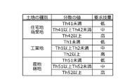
- the related information acquisition unit 101 acquires information indicating the type of land around the equipment to be inspected as related information.
- the type of land is, for example, a type of land classified according to use, such as residential area, commercial area, industrial area, farmland, and forest area.
- the related information acquisition unit 101 stores, for example, a map of the area including the equipment to be inspected and map data representing the type of land in the area in advance.
- the classification of land types for example, the registered grounds may be utilized, or the color coding (color coding of houses, stores, factories, etc.) made on commercially available maps may be utilized.
- the related information acquisition unit 101 identifies the position of the equipment to be inspected on the map, and acquires it from the map data that stores the type of land around the specified position.
- the required skill determination unit 103 determines that the greater the influence of the drone 20 when falling on the type of land indicated by the related information acquired by the related information acquisition unit 101, the higher the required skill.
- the impact of the drone 20 falling is greater in areas with more people (because it is more likely to hit people and injure them). Judging that the greater the impact of a fall is, the higher the required skill is, which means that the area has a large number of people and the required skill is high.
- the required skill determination unit 103 makes a determination using the required skill table in which the type of land and the required skill are associated with each other.
- FIG. 17 shows an example of the required skill table of this modified example. In the example of FIG. 17, the dispersion value and the required skill are associated with each of the land types of “residential area, commercial area”, “industrial area”, and “farmland, forest area”.
- the required skill determination unit 103 determines that the required skill becomes higher as the type of land indicated by the acquired related information indicates a place with more people.
- the higher the skill of the operator the higher the possibility of avoiding a fall in the event of any problem (such as a gust or failure) during flight.
- the required skill is judged to be higher for equipment that is more likely to injure a person if the drone should fall, so a limited number of highly skilled operators are at risk when the drone falls. Can be properly assigned to expensive equipment.
- Obstacles There may be obstacles around the equipment that interfere with the flight of the drone. Obstacles include, for example, immovable objects such as buildings and trees, as well as moving objects such as birds and other drones. The level of skill required varies between equipment with obstacles and equipment without obstacles. Therefore, in this modification, the related information acquisition unit 101 acquires information (obstacle information) indicating obstacles existing in the vicinity of the equipment to be inspected as related information.
- information obstacle information
- the related information acquisition unit 101 acquires information indicating the position, shape, and size of buildings and trees around the facility as obstacle information from a service that provides three-dimensional map information called, for example, a 3D map.
- the related information acquisition unit 101 provides information indicating the location of the bird (where the bird becomes an obstacle) from a service that provides information on the location and observable time of the wild bird for a bird watcher, for example, as obstacle information. Get as.
- the related information acquisition unit 101 is a public place (a place that is not privately owned) that is not a no-fly zone of the drone, that is, an area where the drone can be flown according to a set flight rule (flyable area: another drone). Acquires information indicating (where is an obstacle) as obstacle information.
- the required skill determination unit 103 determines that the required skill is so high that it is difficult to avoid the obstacle indicated by the related information acquired by the related information acquisition unit 101.
- the required skill determination unit 103 determines that the required skill is high because the shorter the distance between the obstacle and the equipment indicated by the acquired related information, the more difficult it is to avoid.
- FIG. 18 shows an example of the required skill table of this modification.
- the variance value and the required skill are associated with each of the distances from the equipment to the obstacle, such as "less than 5 m", “5 m or more and less than 10 m", and "10 m or more" (each distance is an example). And may be at different distances).
- the required skill is “medium” if the above-mentioned distance is "5 m or more and less than 10 m”, and the required skill is “medium” if the above-mentioned distance is “less than 5 m”. Become "high”.
- the required skill determination unit 103 makes a determination so that the required skill becomes higher as the distance from the equipment to the obstacle becomes shorter, even if the variance value is the same.
- the required skill determination unit 103 has the same distance to the obstacle as compared with the case where the obstacle information indicates a building and a tree. However, the determination may be made so that the required skill is high.
- the required skill determination unit 103 uses a required skill table that differs depending on the type of obstacle.
- the required skill determination unit 103 uses, for example, the required skill table shown in FIG. 18 when the obstacle information indicates a building and a tree, and FIG. 18 when the obstacle information indicates the location of a bird and the flightable area of the drone.
- a required skill table is used, in which the required skill tends to be higher than when the required skill table is used (the threshold value of the variance value is made smaller as a whole).
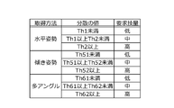
- the related information acquisition unit 101 acquires information indicating the inspection data acquisition method as the related information.
- the inspection data acquisition method includes, for example, pressing the acquisition button (shooting button in the example) at regular flight distance intervals, and the acquisition button with the drone 20 tilted (with elevation or depression angle). There are a method of pressing and a method of acquiring a plurality of inspection data by changing the angle of the drone 20 with respect to the same place.
- the method of acquiring the inspection data is determined in advance for each facility, and the information indicating the acquisition method for each facility is stored in the base terminal 40, the server device 10, or the like.
- the related information acquisition unit 101 acquires information indicating an acquisition method of inspection data stored in the external device or the own device as related information.
- the required skill determination unit 103 has a higher required skill so that it is difficult to operate to realize at least one of the inclination or the position of the drone 20 when acquiring the inspection data by the acquisition method indicated by the related information acquired by the related information acquisition unit 101. Is determined.
- the drone 20 When the drone 20 is raised in the vertical direction, it is usually in a horizontal posture with no inclination (horizontal posture), so it is relatively easy to acquire inspection data in the horizontal posture.
- horizontal posture horizontal posture
- the drone 20 when the drone 20 is tilted (tilted posture) to give a depression angle or an elevation angle, the drone 20 moves in the tilted direction. Therefore, the more the drone 20 is tilted with respect to the horizontal direction, the more the drone 20 moves to the intended position. It is difficult to obtain inspection data while you are there.
- the drone 20 in the multi-angle acquisition method for acquiring inspection data of the same location from different angles, the drone 20 must be flown to a plurality of positions where the same location can be aimed and the drone 20 must be flown at an inclination suitable for each position. That is, since the position and inclination of the drone 20 are often adjusted to the position and inclination required for acquiring inspection data, it is more difficult than the acquisition method using a single angle.
- the required skill determination unit 103 makes a determination using the required skill table in which the inspection data acquisition method and the required skill are associated with each other. ..
- FIG. 19 shows an example of the required skill table of this modification.
- the variance value and the required skill are associated with each of the inspection data acquisition methods of "horizontal posture", “tilt posture", and "multi-angle".
- the “horizontal posture” is associated with the same variance value and required skill as the size “medium” shown in FIG. 16B
- the “tilted posture” is associated with the same variance value as the size “small” shown in FIG. 16B.
- the variance values of "less than Th61”, “Th61 or more and less than Th62”, and “Th62 or more” are associated with the required skills of "low”, “medium”, and “high”. ing.
- the magnitude relation of each threshold value is Th1> Th51> Th61 and Th2> Th52> Th62.
- the required skill is "low” if the inspection data acquisition method is "horizontal posture", and the required skill is required if the inspection data acquisition method is "tilt posture”. Become “medium”. That is, in the example of FIG. 19, the required skill determination unit 103 determines that the larger the inclination (with respect to the horizontal direction) of the drone 20, the higher the required skill.
- the required skill is "medium” if the inspection data acquisition method is "tilt posture", and the required skill is required if the inspection data acquisition method is "multi-angle". Becomes "high”.
- the acquisition method in the "tilted posture” is a method of acquiring inspection data from a single angle. That is, in the example of FIG. 19, the required skill determination unit 103 determines that the required skill is higher as the number of times the position and inclination of the drone 20 are adjusted to the position and inclination required for acquiring inspection data is larger.
- the required skill determination unit 103 determines that the required skill becomes higher as it is difficult to realize at least one of the inclination or the position of the drone 20 when acquiring the inspection data even if the variance value is the same. Do. If the inspection data is acquired by the operation of an operator who lacks skill, the accuracy of the inspection data deteriorates (for example, in the case of a photograph, it is likely that the target location is not taken at the target angle), and the presence or absence of damage and It is easy to make mistakes in determining the necessity of repairs.
- the required skill is determined to be higher when the inspection data acquisition method is used, which is more difficult to operate to realize at least one of the inclination or the position of the drone 20 when acquiring the inspection data as described above. Therefore, compared to the case where the difficulty of operation is not taken into consideration, it is necessary to appropriately assign highly skilled operators who have a limited number of people so that mistakes in determining the presence or absence of damage and the necessity of repair are less likely to occur. Can be done.
- Drone Visibility Distance The worse the visibility of the drone 20, the more difficult it is to operate the drone 20. For example, the farther the drone 20 is from the operator, the smaller it looks, and it becomes difficult to grasp the attitude and flight direction, so that it becomes difficult to fly the drone as intended. Even when acquiring equipment inspection data, the level of skill required varies depending on whether the drone 20 must be operated from a long distance or from a short distance.
- the related information acquisition unit 101 acquires information indicating a place where the operator of the drone 20 operates as related information.
- the related information acquisition unit 101 stores in advance information (hereinafter referred to as “operation location information”) indicating a location (hereinafter referred to as “operation location”) in which the operator operates in each base station.
- operation location is, for example, the foot of the antenna equipment of the base station, the roof of a building inside the base station, or a hill outside the site of the base station.
- the operation location information is information that represents the operation location in, for example, three-dimensional coordinates (latitude, longitude and altitude).
- the related information acquisition unit 101 supplies the acquired operation location information as related information to the required skill determination unit 103.
- the required skill determination unit 103 determines that the larger the distance between the operation location indicated by the related information acquired by the related information acquisition unit 101 and the flight route of the drone 20 (hereinafter referred to as “flight route distance”), the higher the required skill. To do.
- FIG. 20 shows an example of the required skill table of this modified example.
- the variance value and the required skill are associated with each of the distances between the drone 20 and the operator, which are "less than 25 m", “25 m or more and less than 50 m", and “50 m or more” (each distance is an example). The distance may be different from the example in FIG. 20).
- "Less than 25 m” is the same as the "horizontal posture” shown in FIG. 19
- "25 m or more and less than 50 m” is the same as the "tilted posture” shown in FIG. 19
- “50 m or more” is the same as the "multi-angle” shown in FIG.
- the same variance value and required skill are associated with.
- the required skill determination unit 103 calculates, for example, the distance (that is, the longest distance) between the operation location and the farthest part of the flight route from the operation location as the flight route distance. For example, when the equipment to be inspected is the antenna equipment of the base station, the flight route near the apex of the antenna equipment is the farthest point from the operation location. Therefore, the required skill determination unit 103 calculates the distance between the operation location indicated by the operation location information and the apex of the antenna equipment as the flight route distance.
- the required skill determination unit 103 calculates the distance between the operation location indicated by the operation location information and the base of the antenna equipment as the flight route distance. To do. Further, the required skill determination unit 103 may calculate the average distance between a plurality of points on the flight route from the vicinity of the base of the antenna equipment to the vicinity of the apex and the operation location as the flight route distance instead of the longest distance (and). It is desirable to use different required skill tables for the longest distance and the average distance).
- the required skill determination unit 103 determines the required skill associated with the calculated flight route distance in the required skill table as the required skill at the base station where the flight route distance is calculated. For example, in the case of equipment whose variance value is less than Th1 and Th51 or more, if the distance between the drone 20 and the operator is "less than 25 m", the required skill is “low”, and the distance between the drone 20 and the operator is "25 m or more and 50 m”. If it is "less than”, the required skill is "medium”.
- the required skill determination unit 103 makes a determination so that the required skill increases as the flight route distance increases even if the variance value is the same.
- the required skill is determined according to the flight route distance as described above, so that the operation at a long distance can be performed as compared with the case where the required skill is determined without considering the flight route distance. The risk of the drone 20 falling due to an error can be reduced.
- Drone Visibility Obstruction
- the visibility of the drone 20 is degraded not only by the distance from the operator, but also by, for example, the obstruction that obstructs the operator's view. Although non-visual flight is prohibited in principle, the drone 20 may be temporarily invisible when returning through the back side of a shield, for example.
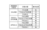
- the related information acquisition unit 101 acquires the above-mentioned operation location information as related information. Then, the required skill determination unit 103 determines that the wider the range in which the flight route of the drone 20 cannot be seen from the operation location indicated by the related information acquired by the related information acquisition unit 101, the higher the required skill.
- the range in which the flight route cannot be seen is the range in which a shield exists between the installation location and the flight route, and is hereinafter referred to as the "shielded range".
- the shield is, for example, the inspection object itself, a building or a tree existing in the vicinity of the inspection object, or the like.
- the required skill determination unit 103 uses a required skill table in which the ratio of the shielding range, the variance value, and the required skill are associated with each other.
- the ratio of the shield range means the ratio of the direction in which the shield exists when viewed in all directions from the operation location.
- FIG. 21 shows an example of the required skill table of this modification.
- the variance value and the required skill are associated with each of the ratios of the shielding range of “less than 5%”, “5% or more and less than 10%”, and “10% or more”.
- “Less than 5%” is the same as the “horizontal posture” shown in FIG. 19, “5% or more and less than 10%” is the same as the “tilted posture” shown in FIG. 19, and “10% or more” is shown in FIG.
- the same variance value and required skill as "multi-angle" are associated with each other. For example, in the case of equipment with a dispersion value of Th51 or more and less than Th1, if the ratio of the shielding range is "less than 10%", the required skill is "low”, and if the ratio of the shielding range is "10% or more and less than 30%”. The required skill becomes “medium”.
- the required skill determination unit 103 makes a determination so that the required skill becomes higher as the range in which the flight route cannot be seen is wider, even if the variance value is the same.
- an operator with high skill is assigned to equipment with a larger ratio of shielding range than other equipment, so when the required skill is determined without considering the range where the flight route becomes invisible. In comparison, the risk of the drone 20 falling due to an operation error when the drone 20 is temporarily invisible due to a shield can be reduced.
- inspection data of places that cannot be seen directly by the operator may be acquired.
- the part facing the invisible direction from the roof is an invisible part.
- the operator When acquiring the inspection data of the invisible part, the operator must fly while estimating the positional relationship between the invisible part and the drone 20.
- the related information acquisition unit 101 acquires information indicating the ratio of the portion (invisible portion) that cannot be directly seen by the operator among the equipment to be inspected as the related information.
- the related information acquisition unit 101 acquires, for example, information indicating the type of facility (laying facility) in which the antenna equipment is laid and information indicating the laying position in the laying facility as related information.
- the antenna equipment is installed in the facility reserved for the base station, the operator can change the position in any direction, so the ratio of invisible parts is 0%.
- the antenna equipment may not be visible from the direction of the adjacent building, so the ratio of the angle occupied by the adjacent building in all directions is the ratio of the invisible part. Become.
- the ratio of invisible parts is 0% if the laying position is in the middle of the roof, but invisible parts occur if the position hits the rooftop side (
- the ratio of invisible parts is, for example, about 25%, and the number of invisible parts is further increased at the position corresponding to the corner of the roof (the ratio of invisible parts is, for example, about 50%).
- the required skill determination unit 103 determines that the larger the ratio of the invisible portion indicated by the related information acquired by the related information acquisition unit 101, the higher the required skill.
- FIG. 22 shows an example of the required skill table of this modified example.
- the variance value and the required skill are associated with each of the invisible portion ratios of "less than 10%”, “10% or more and less than 30%", and “30% or more” (each ratio is It is an example and may have different proportions).
- “Less than 10%” is the same as the “horizontal posture” shown in FIG. 19
- “10% or more and less than 30%” is the same as the “tilted posture” shown in FIG. 19
- “30% or more” is shown in FIG.
- the same variance value and required skill as "multi-angle" are associated with each other.
- the required skill determination unit 103 makes a determination so that the required skill increases as the proportion of invisible portions increases, even if the variance value is the same.
- the larger the proportion of invisible parts the more difficult the operation becomes, and higher skill is required to acquire highly accurate inspection data.
- a highly skilled operator is assigned to equipment with a larger proportion of invisible parts than other equipment, so the accuracy of invisible parts is higher than when the ratio of invisible parts is not taken into consideration. Inspection data can be acquired.
- the related information acquisition unit 101 acquires information indicating the degree of deterioration of the equipment to be inspected (deterioration degree information) as related information.
- the related information acquisition unit 101 acquires, for example, information indicating the date when the antenna equipment was laid and the date when the antenna equipment was repaired as related information (deterioration degree information). The longer the antenna equipment has been laid and the longer it has been repaired, the more deteriorated it is.
- the required skill determination unit 103 determines that the higher the degree of deterioration of the equipment indicated by the related information acquired by the related information acquisition unit 101, the higher the required skill.
- FIG. 23 shows an example of the required skill table of this modified example.
- the variance value and the required skill are associated with each of the elapsed years of “less than 5 years”, “5 years or more and less than 10 years”, and “10 years or more”. If there is no repair, the elapsed years are the years that have passed since the laying, and if there are repairs, for example, the period before the repair is halved and totaled (the parts that have not been repaired). (Because it is deteriorating).
- each elapsed date is an example, and an elapsed date different from that in FIG. 23 may be used.
- "less than 5 years” is the same as the "horizontal posture” shown in FIG. 19, and “5 years or more and less than 10 years” is the same as the "tilting posture” shown in FIG. 19, "10 years or more”. Is associated with the same variance value and required skill as the “multi-angle” shown in FIG.
- the required skill is “low” if the elapsed time is "less than 5 years", and the required skill is required if the elapsed time is "5 years or more and less than 10 years". Becomes “medium”.
- the required skill is “medium” if the elapsed time is "5 years or more and less than 10 years", and required if the elapsed time is "10 years or more”. Skill becomes “high”.
- the required skill determination unit 103 makes a determination so that the required skill becomes higher as the elapsed time is longer and the degree of deterioration is higher, even if the variance value is the same.
- a rotary-wing aircraft type air vehicle was used as the air vehicle for autonomous flight, but the present invention is not limited to this.
- the flying object that performs autonomous flight may be, for example, an airplane type flying object or a helicopter type flying object. In short, any flying object that can fly by the operation of the operator and has a function of acquiring inspection data may be used.
- the devices for realizing each function shown in FIG. 6 are not limited to the above-mentioned devices.
- the radio 30 or the base terminal 40 may realize the functions realized by the server device 10.
- the radio 30 or the base terminal 40 is an example of the "information processing device" of the present invention.
- it is sufficient that each function shown in FIG. 6 is realized in the entire equipment inspection system 1.
- the present invention provides an information processing system (equipment inspection system 1 is an example) including each information processing device and an air vehicle such as a drone 20 in addition to the information processing device such as the server device 10 described above. Can also be captured. Further, the present invention can be regarded as an information processing method for realizing the processing performed by each information processing device, and also as a program for operating a computer that controls each information processing device.
- the program regarded as the present invention may be provided in the form of a recording medium such as an optical disk in which the program is stored, or may be downloaded to a computer via a network such as the Internet, and the downloaded program may be installed and used. It may be provided in the form of
- each functional block may be realized by using one physically or logically connected device, or directly or indirectly (for example, two or more physically or logically separated devices). , Wired, wireless, etc.) and may be realized using these plurality of devices.
- the functional block may be realized by combining the software with the one device or the plurality of devices.
- Functions include judgment, decision, judgment, calculation, calculation, processing, derivation, investigation, search, confirmation, reception, transmission, output, access, solution, selection, selection, establishment, comparison, assumption, expectation, and assumption.
- broadcasting notifying, communicating, forwarding, configuring, reconfiguring, allocating, mapping, assigning, etc., but only these. I can't.
- a functional block (constituent unit) for functioning transmission is called a transmitting unit or a transmitter.
- the method of realizing each of them is not particularly limited.
- the input / output information, etc. may be stored in a specific location (for example, memory) or may be managed using a management table. Input / output information and the like can be overwritten, updated, or added. The output information and the like may be deleted. The input information or the like may be transmitted to another device.
- Judgment method Judgment may be performed by a value represented by 1 bit (0 or 1), by a boolean value (Boolean: true or false), or by comparing numerical values. (For example, comparison with a predetermined value) may be performed.
- Input / output information, etc. may be stored in a specific location (for example, memory) or managed by a management table. Input / output information and the like can be overwritten, updated, or added. The output information and the like may be deleted. The input information or the like may be transmitted to another device.
- Software Software whether referred to as software, firmware, middleware, microcode, hardware description language, or by any other name, is an instruction, instruction set, code, code segment, program code, program, sub. It should be broadly interpreted to mean programs, software modules, applications, software applications, software packages, routines, subroutines, objects, executable files, execution threads, procedures, features, and so on.
- software, instructions, information, etc. may be transmitted and received via a transmission medium.
- a transmission medium For example, a website that uses at least one of wired technology (coaxial cable, fiber optic cable, twisted pair, digital subscriber line (DSL), etc.) and wireless technology (infrared, microwave, etc.) When transmitted from a server, or other remote source, at least one of these wired and wireless technologies is included within the definition of transmission medium.
- wired technology coaxial cable, fiber optic cable, twisted pair, digital subscriber line (DSL), etc.
- wireless technology infrared, microwave, etc.
- Information, Signals, etc. may be represented using any of a variety of different techniques.
- data, instructions, commands, information, signals, bits, symbols, chips, etc. may be voltage, current, electromagnetic waves, magnetic fields or magnetic particles, light fields or photons, or any of these. It may be represented by a combination of.
- “Judgment”, “Decision” The terms “determining” and “determining” used in this disclosure may include a wide variety of actions. “Judgment” and “decision” are, for example, judgment, calculation, computing, processing, deriving, investigating, looking up, search, inquiry. It may include (eg, searching in a table, database or another data structure), ascertaining as “judgment” or “decision”.
- judgment and “decision” are receiving (for example, receiving information), transmitting (for example, transmitting information), input (input), output (output), and access.
- Accessing for example, accessing data in memory
- judgment and “decision” mean that "resolving”, “selecting”, “choosing”, “establishing”, “comparing”, etc. are regarded as “judgment” and “decision”.
- judgment and “decision” may include that some action is regarded as “judgment” and “decision”.
- judgment (decision)” may be read as “assuming", “expecting”, “considering” and the like.
- the notification of predetermined information is not limited to the explicit notification, but is performed implicitly (for example, the notification of the predetermined information is not performed). May be good.
- 1 ... Equipment inspection system, 2 ... Network, 3, 4 ... Antenna equipment, 6, 7, 8 ... Base station, 10 ... Server device, 20 ... One drone, 30 ... Propo, 40 ... Base terminal, 101 ... Acquisition of related information Unit, 102 ... Equipment information storage unit, 103 ... Required skill determination unit, 104 ... Operation plan generation unit, 105 ... Operator information storage unit, 401 ... Operation plan display unit.
Landscapes
- Engineering & Computer Science (AREA)
- Business, Economics & Management (AREA)
- Human Resources & Organizations (AREA)
- Physics & Mathematics (AREA)
- General Physics & Mathematics (AREA)
- Entrepreneurship & Innovation (AREA)
- Aviation & Aerospace Engineering (AREA)
- Educational Administration (AREA)
- Strategic Management (AREA)
- Theoretical Computer Science (AREA)
- Economics (AREA)
- Quality & Reliability (AREA)
- Marketing (AREA)
- Operations Research (AREA)
- Tourism & Hospitality (AREA)
- General Business, Economics & Management (AREA)
- Development Economics (AREA)
- Game Theory and Decision Science (AREA)
- Educational Technology (AREA)
- Remote Sensing (AREA)
- Mechanical Engineering (AREA)
- Data Mining & Analysis (AREA)
- Control Of Position, Course, Altitude, Or Attitude Of Moving Bodies (AREA)
- Management, Administration, Business Operations System, And Electronic Commerce (AREA)
Abstract
関連情報取得部(101)は、検査対象の設備に関連する関連情報を取得する。関連情報取得部(101)は、設備の形状を示す形状情報を関連情報として取得する。要求技量判定部(103)は、設備の周囲にドローン(20)を飛行させてその設備の検査データを取得する際のドローン(20)の操作に要求される技量を判定する。要求技量判定部(103)は、取得された設備の関連情報に基づいて、設備において要求される技量を判定する。要求技量判定部(103)は、取得された関連情報が表す設備の形状に沿った飛行ルートが複雑であるほど要求される技量が高いと判定する。運行計画生成部(104)は、判定された技量の高さが共通する設備を回ってドローン(20)を飛行させる運行計画を生成する。
Description
本発明は、飛行体の運用を支援する技術に関する。
飛行体の運用を支援する技術として、特許文献1には、点検対象の風車におけるナセルの向き及びブレードの位相を示す回転情報を取得し、回転情報に基づいて、点検用のデータを取得する無人機の飛行ルート(点検ルート)のデータを生成する技術が開示されている。
特許文献1の技術のように飛行体を設備の周囲において飛行させて検査データ(設備の映像等)を取得する際に、飛行体の操作を人が行う場合がある。設備によっては検査データを取得するために難しい操作が求められる場合もあるので、常に高い技量を持つ操作者を割り当てるのが望ましいが、技量が高い操作者の数は限られている。
そこで、本発明は、各設備の検査データの取得が円滑に可能な操作者の割り当てを支援することを目的とする。
そこで、本発明は、各設備の検査データの取得が円滑に可能な操作者の割り当てを支援することを目的とする。
上記目的を達成するために、本発明は、検査対象の設備に関連する関連情報を取得する取得部と、前記設備の周囲に飛行体を飛行させて当該設備の検査データを取得する際の当該飛行体の操作に要求される技量を、取得された前記関連情報に基づいて判定する判定部とを備える情報処理装置を提供する。
本発明によれば、各設備の検査データの取得が円滑に可能な操作者の割り当てを支援することができる。
1 実施例
図1は実施例に係る設備検査システム1の全体構成の一例を表す。設備検査システム1は、検査対象の周囲の離れた位置からでも検査データを取得することが可能な検査機能を備える飛行体を用いた検査を支援するシステムである。検査対象は、劣化及び破損等の程度を調べるために定期的な検査が行われる設備であり、例えば、橋梁、建物及びトンネル等である。本実施例では、移動体通信の基地局(特にアンテナ)が検査対象である場合を説明する。
図1は実施例に係る設備検査システム1の全体構成の一例を表す。設備検査システム1は、検査対象の周囲の離れた位置からでも検査データを取得することが可能な検査機能を備える飛行体を用いた検査を支援するシステムである。検査対象は、劣化及び破損等の程度を調べるために定期的な検査が行われる設備であり、例えば、橋梁、建物及びトンネル等である。本実施例では、移動体通信の基地局(特にアンテナ)が検査対象である場合を説明する。
検査データとは、設備の損傷(腐食、剥離、脱落、破断、ひび割れ、変形及び劣化による変色等)の有無及び修繕の要否を判断するために用いられるデータである。検査データとしては、例えば、撮影手段の撮影データ、赤外線センサの測定データ、超音波センサの測定データ及びミリ波センサの測定データ等が用いられる。本実施例では、撮影データが検査データとして用いられる。
検査データに基づく損傷の有無及び修繕の要否の判断は、主に検査担当者によって行われる。検査担当者は、表示された検査データを見て損傷有無等の判断を行ってもよいし、検査データをさらに分析する処理(画像処理等)をコンピュータに行わせてから損傷有無等の判断を行ってもよい。また、AI(Artificial Intelligence)が発展すれば、損傷有無等の判断もコンピュータに行わせてもよい。つまり、検査データに基づく判断の主体を人に限定する必要はない。
設備検査システム1は、ネットワーク2と、サーバ装置10と、ドローン20と、プロポ30と、拠点端末40とを備える。ネットワーク2は、移動体通信網及びインターネット等を含む通信システムであり、自システムにアクセスする装置同士のデータのやり取りを中継する。ネットワーク2には、サーバ装置10及び拠点端末40が有線通信で(無線通信でもよい)、ドローン20及びプロポ30が無線通信でアクセスしている。
ドローン20は、本実施例では、1以上の回転翼を回転させて飛行する回転翼機型の飛行体であり、写真を撮影する撮影機能を上述した検査機能として備えている。ドローン20は、操作者の操作に従って飛行し、検査データ(設備の撮影データ)を取得する。ドローン20は、検査会社の営業所等の拠点に配備されている。プロポ30(送信機)は、プロポーショナル式の制御(比例制御)を行う装置であり、操作者がドローン20の操作に用いる。
ドローン20の操作には、ドローン20を飛行させる操作及び設備の検査データを取得する操作(例えば撮影範囲を調整する操作、焦点を合わせる操作及び撮影ボタンを押す操作等)が含まれる。なお、検査データの取得はドローン20が自動的に行ってもよい。検査対象の設備の中には、例えば単純にドローン20を真上に上昇させてから下降させるだけの操作が簡単なものもあれば、飛行する方向を何度も変化させるというように操作が難しいものもある。
サーバ装置10は、各設備において検査データを取得するために必要な操作者の技量を判定する処理及び判定した技量の操作者がドローン20を操作して設備の撮影を行うというドローン20の運行計画を生成する処理等を行う。サーバ装置10は本発明の「情報処理装置」の一例である。拠点端末40は、例えばドローン20が配備されている拠点に設置され、生成された運行計画を関係者に伝達する。
図2はサーバ装置10のハードウェア構成の一例を表す。サーバ装置10は、物理的には、プロセッサ11と、メモリ12と、ストレージ13と、通信装置14と、バス15などを含むコンピュータ装置として構成されてもよい。なお、以下の説明では、「装置」という文言は、回路、デバイス、ユニットなどに読み替えることができる。
また、各装置は、1つ又は複数含まれていてもよいし、一部の装置が含まれていなくてもよい。プロセッサ11は、例えば、オペレーティングシステムを動作させてコンピュータ全体を制御する。プロセッサ11は、周辺装置とのインターフェース、制御装置、演算装置、レジスタなどを含む中央処理装置(CPU:Central Processing Unit)によって構成されてもよい。
例えば、ベースバンド信号処理部等は、プロセッサ11によって実現されてもよい。また、プロセッサ11は、プログラム(プログラムコード)、ソフトウェアモジュール、データなどを、ストレージ13及び通信装置14の少なくとも一方からメモリ12に読み出し、読み出したプログラム等に従って各種の処理を実行する。プログラムとしては、上述の実施の形態において説明した動作の少なくとも一部をコンピュータに実行させるプログラムが用いられる。
上述の各種処理は、1つのプロセッサ11によって実行される旨を説明してきたが、2以上のプロセッサ11により同時又は逐次に実行されてもよい。プロセッサ11は、1以上のチップによって実装されてもよい。なお、プログラムは、電気通信回線を介してネットワークから送信されても良い。メモリ12は、コンピュータ読み取り可能な記録媒体である。
メモリ12は、例えば、ROM(Read Only Memory)、EPROM(Erasable Programmable ROM)、EEPROM(Electrically Erasable Programmable ROM)、RAM(Random Access Memory)などの少なくとも1つによって構成されてもよい。メモリ12は、レジスタ、キャッシュ、メインメモリ(主記憶装置)などと呼ばれてもよい。メモリ12は、本開示の一実施の形態に係る無線通信方法を実施するために実行可能なプログラム(プログラムコード)、ソフトウェアモジュールなどを保存することができる。
ストレージ13は、コンピュータ読み取り可能な記録媒体であり、例えば、CD-ROM(Compact Disc ROM)などの光ディスク、ハードディスクドライブ、フレキシブルディスク、光磁気ディスク(例えば、コンパクトディスク、デジタル多用途ディスク、Blu-ray(登録商標)ディスク)、スマートカード、フラッシュメモリ(例えば、カード、スティック、キードライブ)、フロッピー(登録商標)ディスク、磁気ストリップなどの少なくとも1つによって構成されてもよい。
ストレージ13は、補助記憶装置と呼ばれてもよい。上述の記憶媒体は、例えば、メモリ12及びストレージ13の少なくとも一方を含むデータベース、サーバその他の適切な媒体であってもよい。通信装置14は、有線ネットワーク及び無線ネットワークの少なくとも一方を介してコンピュータ間の通信を行うためのハードウェア(送受信デバイス)である。通信装置14は、例えばネットワークデバイス、ネットワークコントローラ、ネットワークカード、通信モジュールなどともいう。
例えば、上述の送受信アンテナ、アンプ部、送受信部、伝送路インターフェースなどは、通信装置14によって実現されてもよい。送受信部は、送信部と受信部とで、物理的に、または論理的に分離された実装がなされてもよい。また、プロセッサ11、メモリ12などの各装置は、情報を通信するためのバス15によって接続される。バス15は、単一のバスを用いて構成されてもよいし、装置間ごとに異なるバスを用いて構成されてもよい。
図3はドローン20のハードウェア構成の一例を表す。ドローン20は、物理的には、プロセッサ21と、メモリ22と、ストレージ23と、通信装置24と、飛行装置25と、センサ装置26と、バッテリー27と、カメラ28と、バス29などを含むコンピュータ装置として構成されてもよい。プロセッサ21等の図2に同名のハードウェアが表されているものは、性能及び仕様等の違いはあるが図2と同種のハードウェアである。
通信装置24は、ネットワーク2との通信に加え、プロポ30との通信を行う機能(例えば2.4GHz帯の電波による無線通信機能)を有する。飛行装置25は、モータ及びローター等を備え、自機を飛行させる装置である。飛行装置25は、空中において、あらゆる方向に自機を移動させたり、自機を静止(ホバリング)させたりすることができる。
センサ装置26は、飛行制御に必要な情報を取得するセンサ群を有する装置である。センサ装置26は、例えば、自機の位置(緯度及び経度)を測定する位置センサと、自機が向いている方向(ドローンには自機の正面方向が定められており、定められた正面方向が向いている方向)を測定する方向センサと、自機の高度を測定する高度センサとを備える。
また、センサ装置26は、自機の速度を測定する速度センサと、3軸の角速度及び3方向の加速度を測定する慣性計測センサ(IMU(Inertial Measurement Unit))とを備える。バッテリー27は、電力を蓄積し、ドローン20の各部に電力を供給する装置である。カメラ28は、イメージセンサ及び光学系の部品等を備え、レンズが向いている方向にある物体を撮影する。
図4はプロポ30のハードウェア構成の一例を表す。プロポ30は、物理的には、プロセッサ31と、メモリ32と、ストレージ33と、通信装置34と、入力装置35と、出力装置36と、バス37などを含むコンピュータ装置として構成されてもよい。プロセッサ31等の図2に同名のハードウェアが表されているものは、性能及び仕様等の違いはあるが図2と同種のハードウェアである。
入力装置35は、外部からの入力を受け付ける入力デバイス(例えばスイッチ、ボタン及びセンサ等)である。特に、入力装置35は、左スティック351及び右スティック352を備え、各スティックへの操作をドローン20の前後方向、上下方向、左右方向、回転方向への移動操作として受け付ける。出力装置36は、外部への出力を実施する出力デバイス(例えばモニター361、スピーカー及びLED(Light Emitting Diode)ランプ等)である。なお、入力装置35及び出力装置36は、一体となった構成(例えばモニター361がタッチスクリーン)であってもよい。
図5は拠点端末40のハードウェア構成の一例を表す。拠点端末40は、物理的には、プロセッサ41と、メモリ42と、ストレージ43と、通信装置44と、入力装置45と、出力装置46と、バス47などを含むコンピュータ装置として構成されてもよい。プロセッサ41等の図2又は図4に同名のハードウェアが表されているものは、性能及び仕様等の違いはあるが図2又は図4と同種のハードウェアである。なお、入力装置45は、上記の入力デバイス以外にも、例えばキーボード、マウス及びマイクロフォン等であってもよい。
また、上記の各装置は、マイクロプロセッサ、デジタル信号プロセッサ(DSP:Digital Signal Processor)、ASIC(Application Specific Integrated Circuit)、PLD(Programmable Logic Device)、FPGA(Field Programmable Gate Array)などのハードウェアを含んで構成されてもよい。また、上記の各装置は、当該ハードウェアにより、各機能ブロックの一部又は全てが実現されてもよい。例えば、プロセッサ11は、当該ハードウェアの少なくとも1つを用いて実装されてもよい。
設備検査システム1が備える各装置における各機能は、各々のプロセッサ、メモリなどのハードウェア上に所定のソフトウェア(プログラム)を読み込ませることによって、プロセッサが演算を行い、各々の通信装置による通信を制御したり、メモリ及びストレージにおけるデータの読み出し及び書き込みの少なくとも一方を制御したりすることによって実現される。
図6は各装置が実現する機能構成を表す。サーバ装置10は、関連情報取得部101と、設備情報記憶部102と、要求技量判定部103と、運行計画生成部104と、操作者情報記憶部105とを備える。拠点端末40は、運行計画表示部401を備える。関連情報取得部101は、検査対象の設備に関連する関連情報を取得する。関連情報取得部101は本発明の「取得部」の一例である。
関連情報には、設備そのものに関する情報はもちろん、設備の周辺に関する情報及び設備に対して行われる処置(検査データの取得等)に関する情報等が含まれる。関連情報取得部101は、本実施例では、設備の形状を示す形状情報を関連情報として取得する。関連情報取得部101は、本実施例では設備情報記憶部102から設備の形状情報を取得する。
設備情報記憶部102は、検査対象である設備に関する情報である設備情報を記憶する機能であり、本実施例では、基地局に関する情報を設備情報として記憶する。設備情報記憶部102は、例えば、基地局に設置されたアンテナ設備の位置、撮影すべき方位及び地上からの高さ等の情報と、設備を識別する設備IDと、前述した形状情報(アンテナ設備の形状を示す情報)とを少なくとも含む設備情報を記憶する。
形状情報とは、例えば、アンテナ設備の外観を撮影した写真を表す画像情報及び設計図を表す画像情報等である。形状情報は、設備を設置した事業者、設備を所有する事業者又は事業者に委託された事業者等によって設備検査システム1に登録され、設備情報記憶部102に記憶される。関連情報取得部101は、各設備の設備ID及び関連情報を取得し、取得した設備ID等を要求技量判定部103に供給する。
要求技量判定部103は、設備の周囲にドローン20を飛行させてその設備の検査データを取得する際のドローン20の操作に要求される技量を判定する。要求技量判定部103は本発明の「判定部」の一例である。要求技量判定部103は、関連情報取得部101により取得された設備の関連情報に基づいて、関連情報が取得された設備において要求される技量を判定する。
操作者の技量は、例えば過去にドローンを操作した累計の時間である操作時間によって表される。具体的には、操作時間が50時間までは技量が「低」、50時間から100時間までは技量が「中」、100時間以上は「高」というように表される。なお、操作時間は、単にドローンを飛行させる操作を行った時間(飛行のみの操作時間)と、ドローンを飛行させながら検査データを取得する操作を行った時間(検査付きの操作時間)とがある場合に、両方を含めてもよいし、検査付きの操作時間だけを含めてもよい。
また、飛行操作だけでなく検査データを取得する操作も行われた方が必要な技量の高さを判定する際の参考になるので、検査付きの操作時間に重みを付けて飛行のみの操作時間と合計した時間を操作時間としてもよい。また、操作時間ではなく、ドローンについて各団体から認定されるライセンスの種別(操作の技量毎に認定されるもの)によって操作者の技量が表されてもよい。
要求技量判定部103は、本実施例では、取得された関連情報が表す設備の形状に沿った飛行ルートが複雑であるほど要求される技量が高いと判定する。要求技量判定部103は、例えば、関連情報として取得された形状情報(上記の画像情報)からアンテナ設備の輪郭を抽出する。抽出される輪郭は、アンテナ設備のうちドローン20が撮影する側面の輪郭であることが望ましい。
要求技量判定部103は、例えば、画像のX軸方向(左右方向)及びY軸方向(上下方向)のうちY軸方向をアンテナ設備の鉛直方向に合わせた状態で輪郭を抽出する。抽出された輪郭を表す各画素は、それぞれ(x、y)という座標で表される。要求技量判定部103は、抽出した輪郭のうち、y座標が共通する画素群からx座標が最大となる画素をさらに抽出する。抽出された画素により表される輪郭は、設備の側面の輪郭を表している。
図7A及び7Bは抽出された画素の一例を表す。図7Aではアンテナ設備3及び側面の輪郭A3が表され、図7Bではアンテナ設備4及び側面の輪郭A4が表されている。アンテナ設備4は、アンテナ設備3よりもアンテナ数が多く、アンテナ数が多い分アンテナ部分が水平方向に出っ張っている。従って、側面の輪郭A4は、側面の輪郭A3よりも水平方向に大きく変化している。要求技量判定部103は、例えば、輪郭A3及びA4における回帰直線及び分散を算出する。分散の計算は、最小二乗法等の周知の方法で行われればよい。
図8A及び8Bは算出された回帰直線の一例を表す。図8Aでは輪郭A3の回帰直線B3が表され、図8Bでは輪郭A4の回帰直線B4が表されている。図に表されるとおり、輪郭A3の方が輪郭A4よりも直線に近い形をしているので、分散も輪郭A3の方が輪郭A4よりも小さい。こうして算出される分散の値が大きいほど、設備の形状に沿った飛行ルートが複雑であると考えられる。
なお、要求技量判定部103は、図7A及び7Bの例では、アンテナ設備3及び4を1つの方向から見た場合の輪郭だけを用いて分散を算出しているが、複数の方向から見た場合の輪郭(いずれもドローン20が撮影する側面の輪郭であることが望ましい)を用いてそれぞれ分散を算出し、算出した分散の平均値を分散の値として算出してもよい。要求技量判定部103は、飛行ルートが複雑であるほど要求される技量が高いと判定するので、算出した分散の値と要求技量とを対応付けた要求技量テーブルを用いて判定を行う。
図9は要求技量テーブルの一例を表す。図9の例では、「Th1未満」、「Th1以上Th2未満」及び「Th2以上」という分散の値に、「低」、「中」及び「高」という技量が対応付けられている。要求技量判定部103は、例えば輪郭A3の分散が「Th1未満」であれば、アンテナ設備3の検査データを取得するのに要求されるドローン20の操作の技量が「低」だと判定する。
また、要求技量判定部103は、輪郭A4の分散が「Th1以上Th2未満」であれば、アンテナ設備4の検査データを取得するのに要求されるドローン20の操作の技量が「中」だと判定する。要求技量判定部103は、判定した技量(要求技量)を設備情報記憶部102に供給する。設備情報記憶部102は、供給された要求技量を設備情報として記憶する。
図10は設備情報の一例を表す。図10の例では、設備情報記憶部102は、設備名、設備ID、設備の位置、要求技量及び撮影日程(撮影される予定の日程)等を設備情報として記憶している。図10の例では、基地局6の要求技量が「中」、基地局7の要求技量が「低」、基地局8の要求技量が「高」となっている。
運行計画生成部104は、要求技量判定部103により判定された技量の高さが共通する設備を回ってドローン20を飛行させる運行計画を生成する。運行計画生成部104は本発明の「生成部」の一例である。運行計画生成部104は、設備情報記憶部102に記憶されている設備情報と、操作者情報記憶部105に記憶されている操作者情報とを用いて運行計画を作成する。
操作者情報記憶部105は、設備検査システム1において登録されている操作者に関する情報(操作者情報)を記憶する。操作者情報の登録及び更新は、例えば拠点端末40を用いて行われる。
図11は操作者情報の一例を表す。図11の例では、操作者情報記憶部105は、操作者名(α、β、γ)と、操作者IDと、操作時間と、撮影日程・対象設備とを対応付けた情報を操作者情報として記憶している。
図11は操作者情報の一例を表す。図11の例では、操作者情報記憶部105は、操作者名(α、β、γ)と、操作者IDと、操作時間と、撮影日程・対象設備とを対応付けた情報を操作者情報として記憶している。
操作者α、β、γは、いずれもドローン20が配備されている拠点に勤めており、ドローン20を車で持ち運んで各基地局を回れるものとする。各操作者がドローン20を操作した後に例えば拠点端末40に操作時間を入力することで、操作者情報記憶部105が入力された操作時間を加えた新たな操作時間に更新する。運行計画生成部104は、操作者の技量を、例えば操作時間が50時間未満なら「低」、50時間以上200時間未満なら「中」、200時間以上なら「高」と判断する。
撮影日程・対象設備には、運行計画生成部104が生成した運行計画により操作者がドローン20を操作して設備を撮影する日程及び撮影対象の設備が反映される。運行計画生成部104は、例えば、設備情報において撮影日程が決まっていない基地局を1つ選ぶ。運行計画生成部104は、例えば基地局6を選んだ場合、基地局6と要求技量が同じ「中」である基地局を抽出する。
運行計画生成部104は、抽出した各基地局の位置に基づいて、ドローン20の拠点を出発地点として、基地局6を回った上で所定の時刻までに拠点への到着が可能な基地局の組み合わせを特定する。運行計画生成部104は、組み合わせを特定する際の前提として、例えば30kmを1時間で移動し、1か所を2時間で撮影するものとして判断する。なお、ここで述べた前提は一例であり、実態に応じて定められればよい。
運行計画生成部104は、こうして特定した要求技量が「中」の基地局の組み合わせを、例えば技量を「中」と判断する(つまり操作時間が50時間以上200時間未満の)操作者γの撮影対象の設備として特定する。運行計画生成部104は、撮影日を決めると、撮影対象として特定した基地局の設備情報の「撮影日程」に反映し、操作者γの操作者情報の「撮影日程・対象設備」にも反映する。
運行計画生成部104は、撮影日程が決まっていない別の基地局を1つ選んで、上記と同様にして撮影日程、同日に撮影する基地局、撮影を担当する撮影者を決定して設備情報及び操作者情報に反映する。運行計画生成部104は、以上の処理を繰り返し行い、所定の期間又は所定の基地局における撮影日程及び撮影担当の操作者を決定する。所定の期間は、1年間でもよいし、1か月、1週間又は1日であってもよい。
また、所定の基地局は、全基地局でもよいし、一部の基地局であってもよい。運行計画生成部104は、決定した撮影日程、撮影対象の設備及び撮影担当の操作者を示す運行計画を生成し、生成した運行計画を例えば拠点端末40に送信する。拠点端末40の運行計画表示部401は、サーバ装置10から送信されてきた運行計画を表示する。運行計画の表示は、例えば拠点の運行管理の担当者の操作により行われる。
図12は表示された運行計画の一例を表す。図12の例では、運行計画表示部401は、撮影日と、操作者と、対象設備とを対応付けた一覧を表示している。また、図12の例では、技量が「中」と判断される操作者γは要求技量が「中」の基地局6を含む対象設備に対応付けられている。また、技量が「低」と判断される操作者αは要求技量が「低」の基地局7を含む対象設備に対応付けられ、技量が「高」と判断される操作者βは要求技量が「高」の基地局8を含む対象設備に対応付けられている。
設備検査システム1が備える各装置は、上記の構成に基づいて、各設備について要求技量を判定する判定処理と、判定された要求技量に基づいて運行計画を生成する生成処理を行う。
図13は判定処理における各装置の動作手順の一例を表す。図13の動作手順は、例えば、定期的に又は新たな設備が設置されたことを契機に開始される。
図13は判定処理における各装置の動作手順の一例を表す。図13の動作手順は、例えば、定期的に又は新たな設備が設置されたことを契機に開始される。
まず、サーバ装置10(関連情報取得部101)は、判定対象の設備を決定し(ステップS11)、決定した設備における関連情報(本実施例では形状情報)を取得する(ステップS12)。次に、サーバ装置10(要求技量判定部103)は、判定対象の設備における要求技量を判定する(ステップS13)。続いて、サーバ装置10(設備情報記憶部102)は、判定された要求技量を設備情報に反映する(ステップS14)。
そして、サーバ装置10は、判定対象となる設備が残っているか否かを判断する(ステップS15)。サーバ装置10は、残っている(YES)と判断した場合はステップS11に戻って動作を行い、残っていない(NO)と判断した場合は図13の動作手順を終了する。
図14は生成処理における各装置の動作手順の一例を表す。図14の動作手順は、例えば、拠点の運行管理の担当者が拠点端末40に対して運行計画を表示させる操作を行うことを契機に開始される。まず、サーバ装置10(運行計画生成部104)は、運行計画の要求を受け付けると(ステップS21)、撮影日等を決定する設備を選択する(ステップS22)。
次に、サーバ装置10(運行計画生成部104)は、選択した設備と要求技量が同じ設備を抽出し(ステップS23)、各設備の位置に基づいて同日に撮影する対象を決定する(ステップS24)。続いて、サーバ装置10(運行計画生成部104)は、選択した設備の要求技量を有する操作者を、撮影対象として決定した設備の撮影担当者として決定し(ステップS25)、撮影日を決定する(ステップS26)。
次に、サーバ装置10(運行計画生成部104)は、決定した撮影対象の設備、撮影者及び撮影日を設備情報及び撮影者情報に反映する(ステップS27)。そして、サーバ装置10(運行計画生成部104)は、生成すべき運行計画の範囲が完了したか否かを判断する(ステップS28)。サーバ装置10は、完了していない(NO)と判断した場合はステップS22に戻って動作を行い、完了した(YES)と判断した場合は図14の動作手順を終了する。
以上のとおり、本実施例では、設備の関連情報に基づいて判定された要求技量を有する操作者、すなわち、各設備の検査データの取得が円滑に可能な操作者の割り当てを支援することができる。また、本実施例では、設備の形状情報に基づいて要求技量が判定される。設備の形状情報は、設備が設置されたときから(場合によっては設置前から)入手可能な情報なので、予め判定しておくことができ、運行計画の生成時の処理の負荷を軽くすることができる。
また、本実施例では、同日においては要求技量の高さが共通する設備を回る運行計画が生成される。検査データの取得を円滑にするためには、要求技量を満たす操作者が割り当てられればよいので、同日に同じ要求技量の設備を回ることに限定する必要はない。しかし、上記のとおり要求技量の高さを共通にすることで、要求技量の高さを共通にしない場合に比べて、同日に設備を回る操作者を一人で済ますことが容易になり、操作者の要員計画を立てやすくすることができる。
2 変形例
上述した実施例は本発明の実施の一例に過ぎず、以下のように変形させてもよい。また、実施例及び各変形例は必要に応じてそれぞれ組み合わせてもよい。実施例及び各変形例を組み合わせる際は、各変形例について優先順位を付けて(各変形例を実施すると競合する事象が生じる場合にどちらを優先するかを決める順位付けをして)実施してもよい。
上述した実施例は本発明の実施の一例に過ぎず、以下のように変形させてもよい。また、実施例及び各変形例は必要に応じてそれぞれ組み合わせてもよい。実施例及び各変形例を組み合わせる際は、各変形例について優先順位を付けて(各変形例を実施すると競合する事象が生じる場合にどちらを優先するかを決める順位付けをして)実施してもよい。
また、具体的な組み合わせ方法として、例えば共通する指標(例えば要求技量)を求めるために異なるパラメータを用いる変形例を組み合わせて、各パラメータを共に用いて共通する指標を求めてもよい。また、個別に求めた指標を何らかの規則に従い統合して1つの指標を求めてもよい。また、共通する指標を求める際に、用いられるパラメータ毎に異なる重み付けをしてもよい。
2-1 天気情報
検査対象の設備に関連する関連情報は、実施例で述べた形状情報に限らない。本変形例では、関連情報取得部101は、検査対象の設備の周囲の天気を示す情報(天気情報)を関連情報として取得する。天気情報とは、例えば、風速及び降水量等のドローン20の飛行に影響しやすい気象要素を示す情報である。
検査対象の設備に関連する関連情報は、実施例で述べた形状情報に限らない。本変形例では、関連情報取得部101は、検査対象の設備の周囲の天気を示す情報(天気情報)を関連情報として取得する。天気情報とは、例えば、風速及び降水量等のドローン20の飛行に影響しやすい気象要素を示す情報である。
関連情報取得部101は、検査対象の設備の位置を含む地域における天気予報の情報を天気予報サービス等の提供事業者のシステムから取得し、天気予報に含まれる風速及び降水量を天気情報として取得する。要求技量判定部103は、関連情報取得部101により取得された設備の関連情報(天気情報)が示す天気により飛行が阻害される度合いが大きいほど、その設備における要求技量が高いと判定する。
例えば天気情報が示す風速が大きいほど、又は、天気情報が示す降水量が多いほど、飛行が阻害される度合いが大きいことを表す。阻害度が大きいほど要求技量が高いと判定するということは、風速が大きいこと又は降水量が多いことと、要求技量の高さとが対応することになる。そこで、要求技量判定部103は、風速又は降水量と要求技量とを対応付けた要求技量テーブルを用いて判定を行う。
図15A及び15Bは本変形例の要求技量テーブルの一例を表す。図15Aの例では、「Th11未満」、「Th11以上Th12未満」及び「Th12以上」という風速に、「低」、「中」及び「高」という要求技量が対応付けられている。図15Bの例では、「Th21未満」、「Th21以上Th22未満」及び「Th22以上」という降水量に、「低」、「中」及び「高」という要求技量が対応付けられている。
要求技量判定部103は、例えば天気予報に含まれる風速が「Th11以上Th12未満」であれば、要求技量が「中」だと判定する。また、要求技量判定部103は、天気予報に含まれる降水量が「Th22以上」であれば、要求技量が「高」だと判定する。なお、要求技量判定部103は、風速及び降水量の両方を用いる場合、例えば要求技量テーブルにおいて対応付けられる要求技量が高い方を設備における要求技量と判定してもよい。
なお、関連情報取得部101は、上記方法以外にも、例えば現地又は現地の付近に設置された監視カメラの映像を分析して天気情報を取得してもよい。また、天気情報は、風速及び降水量に限らず、例えば、霧の有無(視界悪化により操作難易度が向上する状況)、降雪量(視界悪化及び雪の付着により操作難易度が向上する状況)、極端な低温及び極端な高温(機体性能の劣化により操作難易度が向上する状況)等であってもよい。
以上のとおり、本変形例においては、ドローン20の操作を難しくする天気状況であることを反映して要求技量が判定される。従って、本変形例によれば、天気情報を考慮しない場合に比べて、悪天候の際に技量不足でドローンを落下させるという事態を生じにくくすることができる。
2-2 飛行体の仕様
ドローン20の仕様によっては、技量不足を補ってくれる場合があるし、反対に、より高い技量が求められる場合がある。また、ドローン20の仕様が異なると、万が一落下した場合における故障のしやすさ又は修理費用の額に違いが生じる場合がある。そこで、本変形例では、ドローン20の仕様を考慮して要求技量が決められる。
ドローン20の仕様によっては、技量不足を補ってくれる場合があるし、反対に、より高い技量が求められる場合がある。また、ドローン20の仕様が異なると、万が一落下した場合における故障のしやすさ又は修理費用の額に違いが生じる場合がある。そこで、本変形例では、ドローン20の仕様を考慮して要求技量が決められる。
本変形例では、関連情報取得部101は、ドローン20についての仕様情報をさらに取得する。仕様情報とは、例えば、飛行体のサイズ、チャンネル数、モータ出力、姿勢維持機能、ホバリング機能等の情報である。姿勢維持機能とは、ドローン20の前後方向及び左右方向を水平方向に沿った状態に維持する(つまり機体が傾かないようにする)機能である。また、ホバリング機能とは、空中の特定の位置でホバリングする状態を維持する機能である。
関連情報取得部101は、例えば、ドローン20の仕様情報を記憶する外部装置(例えば拠点端末40)から仕様情報を取得する。要求技量判定部103は、要求技量を判定する際に、関連情報取得部101から関連情報に加えて仕様情報を読み出す。要求技量判定部103は、読み出した各情報、すなわち、関連情報取得部101により取得された設備の関連情報及び同じく取得された仕様情報に基づいて要求技量を判定する。
要求技量判定部103は、本変形例における判定を、ドローン20の仕様毎に用意された要求技量テーブルを用いて行う。
図16A及び16Bは本変形例の要求技量テーブルの一例を表す。図16Aの例では、姿勢維持機能の「有り」及び「無し」のそれぞれに分散の値及び要求技量が対応付けられている。
図16A及び16Bは本変形例の要求技量テーブルの一例を表す。図16Aの例では、姿勢維持機能の「有り」及び「無し」のそれぞれに分散の値及び要求技量が対応付けられている。
例えば姿勢維持機能が「無し」であれば、図9の例と同じ「Th1未満」、「Th1以上Th2未満」及び「Th2以上」という分散の値及び「低」、「中」及び「高」という要求技量が対応付けられている。また、姿勢維持機能が「有り」であれば、「Th31未満」、「Th31以上Th32未満」及び「Th32以上」という分散の値に、「低」、「中」及び「高」という要求技量が対応付けられている。図16Aの例では、各閾値の大小関係が、Th31>Th1であり、Th32>Th2であるものとする。
例えば分散の値がTh1以上でTh31未満である設備の場合、姿勢維持機能が「無し」なら要求技量が「中」となり、姿勢維持機能が「有り」なら要求技量が「低」になる。以上のとおり、姿勢維持機能の有無を示す仕様情報が取得されると、要求技量判定部103は、取得された仕様情報が姿勢維持機能を有することを示す場合、取得された仕様情報が姿勢維持機能を有しないことを示す場合に比べて要求技量が低くなるように判定を行う。
言い換えると、要求技量判定部103は、姿勢維持機能を有する場合の要求技量の方が、姿勢維持機能を有しない場合の要求技量に比べて低くなるように判定を行う。また、要求技量判定部103は、仕様情報がホバリング機能の有無を示す場合も同様に、ホバリング機能を有する場合の要求技量の方が、ホバリング機能を有しない場合の要求技量に比べて低くなるように判定を行う。
本変形例においては、以上のとおりドローン20の仕様を考慮した判定方法を用いることで、仕様を考慮せずに判定が行われる場合に比べて、操作者の技量不足を補う機能(姿勢維持機能及びホバリング機能等)を有するドローンが用いられる場合に要求技量が低くなるので、割り当て可能な操作者が多くなり、操作者の要員計画を立てやすくすることができる。
また、図16Bの例では、ドローンのサイズの「大」、「中」及び「小」のそれぞれに分散の値及び要求技量が対応付けられている。例えばサイズが「中」の場合は図16Aの「無し」の例と同じ分散の値及び要求技量がそれぞれ対応付けられている。また、サイズが「大」の場合は、「Th41未満」、「Th41以上Th42未満」及び「Th42以上」という分散の値に、「低」、「中」及び「高」という要求技量が対応付けられている。
また、サイズが「小」の場合は、「Th51未満」、「Th51以上Th52未満」及び「Th52以上」という分散の値に、「低」、「中」及び「高」という要求技量が対応付けられている。図16Bの例では、各閾値の大小関係が、Th51>Th1>Th41であり、Th52>Th2>Th42であるものとする。従って、例えば分散の値がTh1以上でTh51未満である設備の場合、ドローンのサイズが「中」なら要求技量が「中」となり、ドローンのサイズが「小」なら要求技量が「低」になる。
また、分散の値がTh42以上でTh2未満である設備の場合、ドローンのサイズが「中」なら要求技量が「中」となり、ドローンのサイズが「大」なら要求技量が「高」になる。以上のとおり、ドローンのサイズを示す仕様情報が取得されると、要求技量判定部103は、取得された仕様情報が示すドローンのサイズが大きいほど要求技量が高くなるように判定を行う。
ドローンのサイズが大きいほど重量が増すので、落下時の衝撃が大きくなって破損しやすくなる。また、サイズが大きいほど交換部品の価格も一般的に高くなる。そこで、上記のとおりドローンの大きさを考慮した判定を行うことで、ドローンの大きさを考慮しない場合に比べて、ドローンの落下時のリスク(破損のリスク及びコスト的なリスク)を減らすことができる。
要求技量判定部103は、仕様情報がドローンのチャンネル数を示す場合は、取得された仕様情報が示すドローンのチャンネル数が多いほど要求技量が高くなるように判定を行う。また、要求技量判定部103は、仕様情報がドローンのモータ出力を示す場合は、取得された仕様情報が示すドローンのモータ出力が大きいほど要求技量が高くなるように判定を行う。
ドローンのチャンネル数が多いほど自在な飛行が可能になり、また、ドローンのモータ出力が大きいほど高速でドローンを飛行させることができる。一方で、自在な飛行及び高速での飛行はいずれもドローンの操作を難しくすることにも繋がる。そこで、上記のとおりドローンのチャンネル数を考慮した判定を行うことで、ドローンのチャンネル数を考慮しない場合に比べて、ドローンの操作に必要な技量を正確に判定することができる。
2-3 落下時のリスク
ドローンの落下時のリスクは、上述したドローン自体の破損以上に、落下した場所に何があるかによって大きく異なる。そこで、本変形例では、関連情報取得部101が、検査対象の設備の周囲の土地の種別を示す情報を関連情報として取得する。土地の種別とは、例えば、住宅地、商業地、工業地、農地及び林地等の、土地を用途別に区分する種類である。
ドローンの落下時のリスクは、上述したドローン自体の破損以上に、落下した場所に何があるかによって大きく異なる。そこで、本変形例では、関連情報取得部101が、検査対象の設備の周囲の土地の種別を示す情報を関連情報として取得する。土地の種別とは、例えば、住宅地、商業地、工業地、農地及び林地等の、土地を用途別に区分する種類である。
関連情報取得部101は、例えば、検査対象の設備を含む地域の地図とその地域における土地の種別とを表す地図データを予め記憶しておく。土地の種別の区分けとしては、例えば登記されている地目を活用したり、市販の地図においてなされている色分け(住居、店舗及び工場の色分け等)を活用したりすればよい。関連情報取得部101は、検査対象の設備の地図上の位置を特定し、特定された位置の周囲の土地の種別を記憶した地図データから取得する。
要求技量判定部103は、関連情報取得部101により取得された関連情報が示す種別の土地におけるドローン20の落下時の影響が大きいほど要求技量が高いと判定する。ドローン20の落下時の影響は、人が多い地域ほど大きい(人に当たって怪我をさせる可能性が高まるため)。落下時の影響が大きいほど要求技量が高いと判定するということは、人が多い地域であることと、要求技量の高さとが対応することになる。
また、土地の種別はそこにいる人の多さの傾向を表す(住宅地は人が多く、農地は人が少ない等)。そこで、要求技量判定部103は、土地の種別と要求技量とを対応付けた要求技量テーブルを用いて判定を行う。
図17は本変形例の要求技量テーブルの一例を表す。図17の例では、「住宅地、商業地」、「工業地」及び「農地、林地」という土地の種別のそれぞれに分散の値及び要求技量が対応付けられている。
図17は本変形例の要求技量テーブルの一例を表す。図17の例では、「住宅地、商業地」、「工業地」及び「農地、林地」という土地の種別のそれぞれに分散の値及び要求技量が対応付けられている。
「住宅地、商業地」には図16Bに表すサイズ「大」と同じ、「工業地」には図16Bに表すサイズ「中」と同じ、「農地、林地」には図16Bに表すサイズ「小」と同じ分散の値及び要求技量が対応付けられている。従って、例えば分散の値がTh1以上でTh51未満である設備の場合、周囲の土地の種別が「工業地」なら要求技量が「中」になり、周囲の土地の種別が「農地、林地」なら要求技量が「低」になる。
また、分散の値がTh2未満でTh42以上である設備の場合、周囲の土地の種別が「工業地」なら要求技量が「中」になり、周囲の土地の種別が「住宅地、商業地」なら要求技量が「高」になる。「農地、林地」に比べて「工業地」の方が人が多く、「工業地」に比べて「住宅地、商業地」の方が人が多い。従って、万が一ドローン20が落下した場合において、人に怪我をさせる危険は「農地、林地」に比べて「工業地」の方が高く、「住宅地、商業地」の方がさらに高い。
上記のとおり、要求技量判定部103は、取得された関連情報が示す土地の種別が、人が多い場所を示す種別であるほど要求技量が高くなるように判定を行う。操作者の技量が高いほど、飛行中に何らかの問題(突風及び故障等)が生じた場合に落下を回避する可能性も高くなる。本変形例では、ドローンが万が一落下した場合に人を怪我させる可能性が高い設備ほど要求技量が高く判定されるので、数が限られている技量の高い操作者を、ドローンの落下時のリスクが高い設備に適切に割り当てることができる。
2-4 障害物
設備の周辺には、ドローンの飛行を邪魔する障害物が存在する場合がある。障害物には、例えば、建物及び樹木等の動かない物の他に、鳥及び他のドローン等の動く物が含まれる。障害物がある設備とない設備とでは、必要とされる技量の高さも変わってくる。そこで、本変形例では、関連情報取得部101が、検査対象の設備の周辺に存在する障害物を示す情報(障害物情報)を関連情報として取得する。
設備の周辺には、ドローンの飛行を邪魔する障害物が存在する場合がある。障害物には、例えば、建物及び樹木等の動かない物の他に、鳥及び他のドローン等の動く物が含まれる。障害物がある設備とない設備とでは、必要とされる技量の高さも変わってくる。そこで、本変形例では、関連情報取得部101が、検査対象の設備の周辺に存在する障害物を示す情報(障害物情報)を関連情報として取得する。
関連情報取得部101は、例えば、3D地図と呼ばれる立体的な地図情報を提供するサービスから設備の周辺の建物及び樹木の位置、形状及びサイズを示す情報を障害物情報として取得する。また、関連情報取得部101は、例えばバードウォッチャーのために野鳥の所在地及び観察可能な時期についての情報を提供するサービスから鳥の所在地(鳥が障害物となる場所)を示す情報を障害物情報として取得する。
また、関連情報取得部101は、ドローンの飛行禁止区域になっていない公共の場所(私有地でない場所)、すなわち定められた飛行ルールに従いドローンを飛行させることができる領域(飛行可能領域:他のドローンが障害物になる場所)を示す情報を障害物情報として取得する。要求技量判定部103は、関連情報取得部101により取得された関連情報が示す障害物の回避が困難であるほど要求技量が高いと判定する。
要求技量判定部103は、例えば、取得された関連情報が示す障害物と設備との距離が短いほど回避が困難であるとして要求技量が高いと判定する。
図18は本変形例の要求技量テーブルの一例を表す。図18の例では、「5m未満」、「5m以上10m未満」及び「10m以上」という設備から障害物までの距離のそれぞれに分散の値及び要求技量が対応付けられている(各距離は一例であり異なる距離であってもよい)。
図18は本変形例の要求技量テーブルの一例を表す。図18の例では、「5m未満」、「5m以上10m未満」及び「10m以上」という設備から障害物までの距離のそれぞれに分散の値及び要求技量が対応付けられている(各距離は一例であり異なる距離であってもよい)。
「5m未満」には図16Bに表すサイズ「大」と同じ、「5m以上10m未満」には図16Bに表すサイズ「中」と同じ、「10m以上」には図16Bに表すサイズ「小」と同じ分散の値及び要求技量が対応付けられている。従って、例えば分散の値がTh1以上でTh51未満である設備の場合、設備から障害物までの距離が「10m以上」なら要求技量が「低」になり、設備から障害物までの距離が「5m以上10m未満」なら要求技量が「中」になる。
また、分散の値がTh2未満でTh42以上である設備の場合、前述の距離が「5m以上10m未満」なら要求技量が「中」になり、前述の距離が「5m未満」なら要求技量が「高」になる。以上のとおり、要求技量判定部103は、分散の値が同じでも、設備から障害物までの距離が短いほど要求技量が高くなるように判定を行う。また、要求技量判定部103は、障害物情報が鳥の所在地及びドローンの飛行可能領域を示す場合は、障害物情報が建物及び樹木を示す場合に比べて、障害物までの距離が同じであっても要求技量が高くなるように判定を行ってもよい。
上記判定を行う場合、要求技量判定部103は、障害物の種類によって異なる要求技量テーブルを用いる。要求技量判定部103は、例えば障害物情報が建物及び樹木を示す場合は図18に表す要求技量テーブルを用いて、障害物情報が鳥の所在地及びドローンの飛行可能領域を示す場合は図18に表す要求技量テーブルを用いる場合よりも要求技量が高くなりやすい(分散の値の閾値を全体的に小さくした)要求技量テーブルを用いる。
設備から障害物までの距離が短いほど、撮影飛行時に障害物に接触しやすくなるので、より高い技量が必要になる。本変形例では、障害物情報を考慮した判定を行うことで、障害物情報を考慮しない場合に比べて、他の設備よりも障害物が近い設備については技量が高い操作者が割り当てられるので、障害物に接触することによるドローン20の落下の危険を減らすことができる。
2-5 検査データの取得操作
ドローン20がプロポ30等を用いた遠隔操作に基づき検査データを取得する場合、検査データの取得方法によっては、操作者の高い技量が必要な場合がある。そこで、本変形例では、関連情報取得部101が、検査データの取得方法を示す情報を関連情報として取得する。
ドローン20がプロポ30等を用いた遠隔操作に基づき検査データを取得する場合、検査データの取得方法によっては、操作者の高い技量が必要な場合がある。そこで、本変形例では、関連情報取得部101が、検査データの取得方法を示す情報を関連情報として取得する。
検査データの取得方法には、例えば、一定の飛行距離の間隔で取得ボタン(実施例であれば撮影ボタン)を押す方法、ドローン20を傾けた状態(仰角又は俯角を付けた状態)で取得ボタンを押す方法、及び、同じ箇所に対するドローン20のアングルを変えて複数の検査データを取得する方法等がある。検査データの取得方法は、設備毎に予め決められており、設備毎の取得方法を示す情報は拠点端末40又はサーバ装置10等に記憶されているものとする。
関連情報取得部101は、外部装置又は自装置に記憶されている検査データの取得方法を示す情報を関連情報として取得する。要求技量判定部103は、関連情報取得部101により取得された関連情報が示す取得方法で検査データを取得する際のドローン20の傾き又は位置の少なくとも一方を実現する操作が難しいほど要求技量が高いと判定する。
ドローン20を鉛直方向に上昇させる場合、通常は傾きのない水平方向に沿った姿勢(水平姿勢)となるので、水平姿勢のまま検査データを取得するのは比較的容易である。しかし、例えば俯角又は仰角を付けるためにドローン20を傾けた姿勢(傾き姿勢)になると傾けた方向に移動してしまうので、ドローン20を水平方向に対して傾けるほど、意図した位置にドローン20がいる状態で検査データを取得するのは難しい。
また、同じ箇所の検査データを異なるアングルで取得する多アングルでの取得方法も、同じ箇所に狙いを付けられる複数の位置にドローン20を飛行させ且つ各位置に合った傾きで飛行させなければならない、すなわち、ドローン20の位置及び傾きを検査データの取得に必要な位置及び傾きに合わせる回数が多いため、単一アングルでの取得方法に比べて難しい。
以上のとおり、検査データの取得方法と操作の難易度は対応しているから、要求技量判定部103は、検査データの取得方法と要求技量とを対応付けた要求技量テーブルを用いて判定を行う。
図19は本変形例の要求技量テーブルの一例を表す。図19の例では、「水平姿勢」、「傾き姿勢」及び「多アングル」という検査データの取得方法のそれぞれに分散の値及び要求技量が対応付けられている。
図19は本変形例の要求技量テーブルの一例を表す。図19の例では、「水平姿勢」、「傾き姿勢」及び「多アングル」という検査データの取得方法のそれぞれに分散の値及び要求技量が対応付けられている。
「水平姿勢」には図16Bに表すサイズ「中」と同じ、「傾き姿勢」には図16Bに表すサイズ「小」と同じ分散の値及び要求技量が対応付けられている。また、「多アングル」には、「Th61未満」、「Th61以上Th62未満」及び「Th62以上」という分散の値と、「低」、「中」及び「高」という要求技量とが対応付けられている。図19の例では、各閾値の大小関係が、Th1>Th51>Th61であり、Th2>Th52>Th62であるものとする。
例えば分散の値がTh1未満でTh51以上である設備の場合、検査データの取得方法が「水平姿勢」なら要求技量が「低」になり、検査データの取得方法が「傾き姿勢」なら要求技量が「中」になる。つまり、要求技量判定部103は、図19の例では、ドローン20の(水平方向に対する)傾きが大きいほど要求技量が高いと判定する。
また、分散の値がTh52未満でTh62以上である設備の場合、検査データの取得方法が「傾き姿勢」なら要求技量が「中」になり、検査データの取得方法が「多アングル」なら要求技量が「高」になる。「傾き姿勢」での取得方法は、単一アングルで検査データを取得する方法である。つまり、要求技量判定部103は、図19の例では、ドローン20の位置及び傾きを検査データの取得に必要な位置及び傾きに合わせる回数が多いほど要求技量が高いと判定する。
以上のとおり、要求技量判定部103は、分散の値が同じでも、検査データを取得する際のドローン20の傾き又は位置の少なくとも一方を実現する操作が難しいほど要求技量が高くなるように判定を行う。技量が不足する操作者の操作により検査データを取得すると、検査データの精度が悪くなり(例えば写真であれば狙った箇所が狙った角度で撮れていないということが起こりやすい)、損傷の有無及び修繕の要否の判断に間違いが起こりやすい。
本変形例では、上記のとおり検査データを取得する際のドローン20の傾き又は位置の少なくとも一方を実現する操作の難易度が高い検査データの取得方法が用いられる場合ほど、要求技量が高く判定されるため、操作の難易度が考慮されない場合に比べて、人数が限られている技量の高い操作者を適切に割り当て、損傷の有無及び修繕の要否の判断の間違いが起こりにくいようにすることができる。
2-6 ドローンの視認性:距離
ドローン20の視認性が悪くなるほどドローン20の操作は難しくなる。例えばドローン20が操作者から離れるほど小さく見えるようになり、姿勢や飛行方向が把握しにくくなるため、意図したとおりに飛行させる操作が難しくなる。設備の検査データを取得する際にも、ドローン20の操作を遠距離からしなければならない場合と近距離からできる場合とで、必要とされる技量の高さも変わってくる。
ドローン20の視認性が悪くなるほどドローン20の操作は難しくなる。例えばドローン20が操作者から離れるほど小さく見えるようになり、姿勢や飛行方向が把握しにくくなるため、意図したとおりに飛行させる操作が難しくなる。設備の検査データを取得する際にも、ドローン20の操作を遠距離からしなければならない場合と近距離からできる場合とで、必要とされる技量の高さも変わってくる。
そこで、本変形例では、ドローン20の視認性に応じて要求技量が判定される。関連情報取得部101は、ドローン20の操作者が操作を行う場所を示す情報を関連情報として取得する。関連情報取得部101は、例えば、各基地局において操作者が操作を行う場所(以下「操作場所」と言う)を示す情報(以下「操作場所情報」と言う)を予め記憶しておく。操作場所は、例えば、基地局のアンテナ設備のふもと、基地局内の建物の屋上又は基地局の敷地外の高台等である。
操作場所情報は、操作場所を例えば3次元座標(緯度、経度及び高度)で表した情報である。関連情報取得部101は、取得した操作場所情報を関連情報として要求技量判定部103に供給する。要求技量判定部103は、関連情報取得部101により取得された関連情報が示す操作場所とドローン20の飛行ルートとの距離(以下「飛行ルート距離」と言う)が大きいほど要求技量が高いと判定する。
図20は本変形例の要求技量テーブルの一例を表す。図20の例では、「25m未満」、「25m以上50m未満」及び「50m以上」というドローン20と操作者の距離のそれぞれに分散の値及び要求技量が対応付けられている(各距離は一例であり、図20の例とは異なる距離であってもよい)。「25m未満」には図19に表す「水平姿勢」と同じ、「25m以上50m未満」には図19に表す「傾き姿勢」と同じ、「50m以上」には図19に表す「多アングル」と同じ分散の値及び要求技量が対応付けられている。
要求技量判定部103は、例えば飛行ルートのうち操作場所から最も離れた箇所と操作場所との距離(つまり最長距離)を飛行ルート距離として算出する。例えば検査対象の設備が基地局のアンテナ設備である場合、アンテナ設備の頂点付近の飛行ルートが操作場所から最も離れた箇所になる。そこで、要求技量判定部103は、操作場所情報が示す操作場所とアンテナ設備の頂点との距離を飛行ルート距離として算出する。
なお、アンテナ設備の頂点付近よりも土台付近の方が離れている操作場所の場合、要求技量判定部103は、操作場所情報が示す操作場所とアンテナ設備の土台との距離を飛行ルート距離として算出する。また、要求技量判定部103は、最長距離ではなく、アンテナ設備の土台付近から頂点付近までの飛行ルート上の複数の箇所と操作場所との平均距離を飛行ルート距離として算出してもよい(そして最長距離と平均距離とでは異なる要求技量テーブルを用いることが望ましい)。
要求技量判定部103は、算出した飛行ルート距離に要求技量テーブルで対応付けられている要求技量を、飛行ルート距離が算出された基地局における要求技量として判定する。例えば分散の値がTh1未満でTh51以上である設備の場合、ドローン20と操作者の距離が「25m未満」なら要求技量が「低」になり、ドローン20と操作者の距離が「25m以上50m未満」なら要求技量が「中」になる。
また、分散の値がTh52未満でTh62以上である設備の場合、ドローン20と操作者の距離が「25m以上50m未満」なら要求技量が「中」になり、ドローン20と操作者の距離が「50m以上」なら要求技量が「高」になる。以上のとおり、要求技量判定部103は、分散の値が同じでも、飛行ルート距離が大きいほど要求技量が高くなるように判定を行う。
上述したように、ドローン20と操作者の距離が長いほど視認性が悪くなるため操作が難しくなり、より高い技量が必要になる。本変形例によれば、上記のとおり飛行ルート距離に応じて要求技量が判定されることで、飛行ルート距離を考慮せずに要求技量が判定される場合に比べて、遠距離での操作の誤りによりドローン20が落下する危険を減らすことができる。
2-7 ドローンの視認性:遮蔽物
ドローン20の視認性は、操作者からの距離だけでなく、例えば操作者の視界を遮る遮蔽物によっても悪化する。なお、目視外飛行は原則禁止されているが、例えば遮蔽物の後ろ側を通って戻ってくるような場合に一時的にドローン20が見えなくなることは生じ得る。
ドローン20の視認性は、操作者からの距離だけでなく、例えば操作者の視界を遮る遮蔽物によっても悪化する。なお、目視外飛行は原則禁止されているが、例えば遮蔽物の後ろ側を通って戻ってくるような場合に一時的にドローン20が見えなくなることは生じ得る。
本変形例では、関連情報取得部101は、上述した操作場所情報を関連情報として取得する。そして、要求技量判定部103は、関連情報取得部101により取得された関連情報が示す操作場所から見てドローン20の飛行ルートが見えなくなる範囲が広いほど要求技量が高いと判定する。飛行ルートが見えなくなる範囲とは、設置場所と飛行ルートとの間に遮蔽物が存在する範囲であり、以下では「遮蔽範囲」と言う。遮蔽物は、例えば、検査対象物そのもの、検査対象物の付近に存在する建物又は樹木等である。
要求技量判定部103は、本変形例では、遮蔽範囲の割合と分散の値及び要求技量とが対応付けられた要求技量テーブルを用いる。遮蔽範囲の割合とは、操作場所から全方向を見た場合に遮蔽物が存在する方向の割合を意味する。
図21は本変形例の要求技量テーブルの一例を表す。図21の例では、「5%未満」、「5%以上10%未満」及び「10%以上」という遮蔽範囲の割合のそれぞれに分散の値及び要求技量が対応付けられている。
図21は本変形例の要求技量テーブルの一例を表す。図21の例では、「5%未満」、「5%以上10%未満」及び「10%以上」という遮蔽範囲の割合のそれぞれに分散の値及び要求技量が対応付けられている。
「5%未満」には図19に表す「水平姿勢」と同じ、「5%以上10%未満」には図19に表す「傾き姿勢」と同じ、「10%以上」には図19に表す「多アングル」と同じ分散の値及び要求技量が対応付けられている。例えば分散の値がTh51以上でTh1未満である設備の場合、遮蔽範囲の割合が「10%未満」なら要求技量が「低」になり、遮蔽範囲の割合が「10%以上30%未満」なら要求技量が「中」になる。
また、分散の値がTh52未満でTh62以上である設備の場合、遮蔽範囲の割合が「10%以上30%未満」なら要求技量が「中」になり、前述の距離が「30%以上」なら要求技量が「高」になる。以上のとおり、本変形例では、要求技量判定部103は、分散の値が同じでも、飛行ルートが見えなくなる範囲が広いほど要求技量が高くなるように判定を行う。
上述したように、遮蔽範囲の割合が大きいほど操作が難しくなるため、より高い技量が必要になる。本変形例によれば、遮蔽範囲の割合が他の設備よりも大きい設備については技量が高い操作者が割り当てられるので、飛行ルートが見えなくなる範囲を考慮せずに要求技量が判定される場合に比べて、遮蔽物で一時的にドローン20が見えなくなったときの操作の誤りによりドローン20が落下する危険を減らすことができる。
2-8 操作者から見えない箇所
検査対象の設備によっては、操作者から直接見えない箇所(以下「不可視箇所」と言う)の検査データを取得する場合がある。例えば建物の屋上の端に敷設されたアンテナ設備の場合、屋上側から見えない方向を向いた箇所は不可視箇所となる。不可視箇所の検査データを取得する場合、操作者は、不可視箇所とドローン20との位置関係を推測しながら飛行させなければならない。
検査対象の設備によっては、操作者から直接見えない箇所(以下「不可視箇所」と言う)の検査データを取得する場合がある。例えば建物の屋上の端に敷設されたアンテナ設備の場合、屋上側から見えない方向を向いた箇所は不可視箇所となる。不可視箇所の検査データを取得する場合、操作者は、不可視箇所とドローン20との位置関係を推測しながら飛行させなければならない。
従って、見える箇所の検査データの取得に比べて操作が難しく、精度の高い検査データ(例えば意図した箇所の意図したアングル及びサイズの写真)を取得することが難しい。そこで、本変形例では、関連情報取得部101が、検査対象の設備のうち操作者から直接見えない箇所(不可視箇所)の割合を示す情報を関連情報として取得する。関連情報取得部101は、例えば、アンテナ設備が敷設されている施設(敷設施設)の種類を示す情報と、敷設施設における敷設位置を示す情報とを関連情報として取得する。
例えば、基地局用に確保された施設にアンテナ設備が敷設されている場合はどの方向にも操作者が位置を変えられるので不可視箇所の割合が0%となる。ただし、アンテナ設備に隣接する建物がある場合、隣接する建物がある方向からはアンテナ設備を見ることができないときがあるので、全方向のうち隣接する建物が占める角度の割合が不可視箇所の割合となる。
また、建物の屋上にアンテナ設備が敷設されている場合は、敷設位置が屋上の真ん中であれば不可視箇所の割合が0%となるが、屋上の辺に当たる位置であれば不可視箇所が発生し(不可視箇所の割合は例えば25%程度)、屋上の角に当たる位置であれば不可視箇所がさらに増える(不可視箇所の割合は例えば50%程度)。要求技量判定部103は、関連情報取得部101により取得された関連情報が示す不可視箇所の割合が大きいほど要求技量が高いと判定する。
図22は本変形例の要求技量テーブルの一例を表す。図22の例では、「10%未満」、「10%以上30%未満」及び「30%以上」という不可視箇所の割合のそれぞれに分散の値及び要求技量が対応付けられている(各割合は一例であり異なる割合であってもよい)。「10%未満」には図19に表す「水平姿勢」と同じ、「10%以上30%未満」には図19に表す「傾き姿勢」と同じ、「30%以上」には図19に表す「多アングル」と同じ分散の値及び要求技量が対応付けられている。
例えば分散の値がTh51以上でTh1未満である設備の場合、不可視箇所の割合が「10%未満」なら要求技量が「低」になり、不可視箇所の割合が「10%以上30%未満」なら要求技量が「中」になる。また、分散の値がTh52未満でTh62以上である設備の場合、不可視箇所の割合が「10%以上30%未満」なら要求技量が「中」になり、前述の距離が「30%以上」なら要求技量が「高」になる。
以上のとおり、要求技量判定部103は、分散の値が同じでも、不可視箇所の割合が大きいほど要求技量が高くなるように判定を行う。上述したように、不可視箇所の割合が大きいほど操作が難しくなり、精度の高い検査データを取得するために、より高い技量が必要になる。本変形例によれば、不可視箇所の割合が他の設備よりも大きい設備については技量が高い操作者が割り当てられるので、不可視箇所の割合を考慮しない場合に比べて、不可視箇所についてより精度の高い検査データを取得することができる。
2-9 設備の劣化度
検査対象の設備の劣化が進んでいくほど修繕の必要性が高まるため、損傷を見逃さないようにするためにより精度の高い検査データが必要になる。そこで、本変形例では、関連情報取得部101が、検査対象の設備の劣化度を示す情報(劣化度情報)を関連情報として取得する。
検査対象の設備の劣化が進んでいくほど修繕の必要性が高まるため、損傷を見逃さないようにするためにより精度の高い検査データが必要になる。そこで、本変形例では、関連情報取得部101が、検査対象の設備の劣化度を示す情報(劣化度情報)を関連情報として取得する。
関連情報取得部101は、例えば、アンテナ設備が敷設された年月日と、アンテナ設備に修繕が施された年月日とを示す情報を関連情報(劣化度情報)として取得する。アンテナ設備は、敷設されてから経過した年月及び修繕から経過した年月が長いほど劣化が進んでいることが表される。要求技量判定部103は、関連情報取得部101により取得された関連情報が示す設備の劣化度が高いほど要求技量が高いと判定する。
図23は本変形例の要求技量テーブルの一例を表す。図23の例では、「5年未満」、「5年以上10年未満」及び「10年以上」という経過年月のそれぞれに分散の値及び要求技量が対応付けられている。経過年月とは、修繕がない場合は敷設されてから経過した年月そのものであり、修繕がある場合は例えば修繕前の期間を半分にして合計した年月である(修繕していない箇所は劣化が進んでいるため)。
なお、修繕がある場合は修繕から経過した年月を用いてもよいし、修繕を考慮せずに敷設から経過した年月を用いてもよい。また、各経過年月は一例であり、図23とは異なる経過年月日が用いられてもよい。図23の例では、「5年未満」には図19に表す「水平姿勢」と同じ、「5年以上10年未満」には図19に表す「傾き姿勢」と同じ、「10年以上」には図19に表す「多アングル」と同じ分散の値及び要求技量が対応付けられている。
例えば分散の値がTh51以上でTh1未満である設備の場合、経過年月が「5年未満」なら要求技量が「低」になり、経過年月が「5年以上10年未満」なら要求技量が「中」になる。また、分散の値がTh52未満でTh62以上である設備の場合、経過年月が「5年以上10年未満」なら要求技量が「中」になり、経過年月が「10年以上」なら要求技量が「高」になる。以上のとおり、要求技量判定部103は、分散の値が同じでも、経過年月が長く劣化度が高いほど要求技量が高くなるように判定を行う。
上述したように、検査対象の設備の劣化度が高いほど、精度の高い検査データを取得するために、より高い技量が必要になる。本変形例によれば、劣化度が他の設備よりも高い設備については技量が高い操作者が割り当てられるので、他の設備に比べて劣化度が高く修繕の必要性が高い設備について、設備の劣化度を考慮しない場合に比べてより精度の高い検査データを取得することができる。
2-10 飛行体
実施例では、自律飛行を行う飛行体として回転翼機型の飛行体が用いられたが、これに限らない。自律飛行を行う飛行体は、例えば飛行機型の飛行体であってもよいし、ヘリコプター型の飛行体であってもよい。要するに、操作者の操作により飛行することが可能であり、且つ、検査データを取得する機能を有する飛行体であればよい。
実施例では、自律飛行を行う飛行体として回転翼機型の飛行体が用いられたが、これに限らない。自律飛行を行う飛行体は、例えば飛行機型の飛行体であってもよいし、ヘリコプター型の飛行体であってもよい。要するに、操作者の操作により飛行することが可能であり、且つ、検査データを取得する機能を有する飛行体であればよい。
2-11 各機能を実現する装置
図6に表す各機能を実現する装置は、上述した装置に限らない。例えば、サーバ装置10が実現する機能をプロポ30又は拠点端末40が実現してもよい。その場合はプロポ30又は拠点端末40が本発明の「情報処理装置」の一例となる。要するに、設備検査システム1の全体で図6に表す各機能が実現されていればよい。
図6に表す各機能を実現する装置は、上述した装置に限らない。例えば、サーバ装置10が実現する機能をプロポ30又は拠点端末40が実現してもよい。その場合はプロポ30又は拠点端末40が本発明の「情報処理装置」の一例となる。要するに、設備検査システム1の全体で図6に表す各機能が実現されていればよい。
2-12 発明のカテゴリ
本発明は、上述したサーバ装置10等の情報処理装置の他、各情報処理装置及びドローン20のような飛行体を備える情報処理システム(設備検査システム1はその一例)としても捉えられる。また、本発明は、各情報処理装置が実施する処理を実現するための情報処理方法としても捉えられるし、各情報処理装置を制御するコンピュータを機能させるためのプログラムとしても捉えられる。本発明として捉えられるプログラムは、プログラムを記憶させた光ディスク等の記録媒体の形態で提供されてもよいし、インターネット等のネットワークを介してコンピュータにダウンロードさせ、ダウンロードしたプログラムをインストールして利用可能にするなどの形態で提供されてもよい。
本発明は、上述したサーバ装置10等の情報処理装置の他、各情報処理装置及びドローン20のような飛行体を備える情報処理システム(設備検査システム1はその一例)としても捉えられる。また、本発明は、各情報処理装置が実施する処理を実現するための情報処理方法としても捉えられるし、各情報処理装置を制御するコンピュータを機能させるためのプログラムとしても捉えられる。本発明として捉えられるプログラムは、プログラムを記憶させた光ディスク等の記録媒体の形態で提供されてもよいし、インターネット等のネットワークを介してコンピュータにダウンロードさせ、ダウンロードしたプログラムをインストールして利用可能にするなどの形態で提供されてもよい。
2-13 機能ブロック
なお、上記実施例の説明に用いたブロック図は、機能単位のブロックを示している。これらの機能ブロック(構成部)は、ハードウェア及びソフトウェアの少なくとも一方の任意の組み合わせによって実現される。また、各機能ブロックの実現方法は特に限定されない。
なお、上記実施例の説明に用いたブロック図は、機能単位のブロックを示している。これらの機能ブロック(構成部)は、ハードウェア及びソフトウェアの少なくとも一方の任意の組み合わせによって実現される。また、各機能ブロックの実現方法は特に限定されない。
すなわち、各機能ブロックは、物理的又は論理的に結合した1つの装置を用いて実現されてもよいし、物理的又は論理的に分離した2つ以上の装置を直接的又は間接的に(例えば、有線、無線などを用いて)接続し、これら複数の装置を用いて実現されてもよい。機能ブロックは、上記1つの装置又は上記複数の装置にソフトウェアを組み合わせて実現されてもよい。
機能には、判断、決定、判定、計算、算出、処理、導出、調査、探索、確認、受信、送信、出力、アクセス、解決、選択、選定、確立、比較、想定、期待、見做し、報知(broadcasting)、通知(notifying)、通信(communicating)、転送(forwarding)、構成(configuring)、再構成(reconfiguring)、割り当て(allocating、mapping)、割り振り(assigning)などがあるが、これらに限られない。たとえば、送信を機能させる機能ブロック(構成部)は、送信部(transmitting unit)や送信機(transmitter)と呼称される。いずれも、上述したとおり、実現方法は特に限定されない。
2-14 入出力された情報等の扱い
入出力された情報等は特定の場所(例えば、メモリ)に保存されてもよいし、管理テーブルを用いて管理してもよい。入出力される情報等は、上書き、更新、又は追記され得る。出力された情報等は削除されてもよい。入力された情報等は他の装置へ送信されてもよい。
入出力された情報等は特定の場所(例えば、メモリ)に保存されてもよいし、管理テーブルを用いて管理してもよい。入出力される情報等は、上書き、更新、又は追記され得る。出力された情報等は削除されてもよい。入力された情報等は他の装置へ送信されてもよい。
2-15 判定方法
判定は、1ビットで表される値(0か1か)によって行われてもよいし、真偽値(Boolean:true又はfalse)によって行われてもよいし、数値の比較(例えば、所定の値との比較)によって行われてもよい。
判定は、1ビットで表される値(0か1か)によって行われてもよいし、真偽値(Boolean:true又はfalse)によって行われてもよいし、数値の比較(例えば、所定の値との比較)によって行われてもよい。
2-16 処理手順等
本開示において説明した各態様/実施例の処理手順、シーケンス、フローチャートなどは、矛盾の無い限り、順序を入れ替えてもよい。例えば、本開示において説明した方法については、例示的な順序を用いて様々なステップの要素を提示しており、提示した特定の順序に限定されない。
本開示において説明した各態様/実施例の処理手順、シーケンス、フローチャートなどは、矛盾の無い限り、順序を入れ替えてもよい。例えば、本開示において説明した方法については、例示的な順序を用いて様々なステップの要素を提示しており、提示した特定の順序に限定されない。
2-17 入出力された情報等の扱い
入出力された情報等は特定の場所(例えばメモリ)に保存されてもよいし、管理テーブルで管理してもよい。入出力される情報等は、上書き、更新、又は追記され得る。出力された情報等は削除されてもよい。入力された情報等は他の装置へ送信されてもよい。
入出力された情報等は特定の場所(例えばメモリ)に保存されてもよいし、管理テーブルで管理してもよい。入出力される情報等は、上書き、更新、又は追記され得る。出力された情報等は削除されてもよい。入力された情報等は他の装置へ送信されてもよい。
2-18 ソフトウェア
ソフトウェアは、ソフトウェア、ファームウェア、ミドルウェア、マイクロコード、ハードウェア記述言語と呼ばれるか、他の名称で呼ばれるかを問わず、命令、命令セット、コード、コードセグメント、プログラムコード、プログラム、サブプログラム、ソフトウェアモジュール、アプリケーション、ソフトウェアアプリケーション、ソフトウェアパッケージ、ルーチン、サブルーチン、オブジェクト、実行可能ファイル、実行スレッド、手順、機能などを意味するよう広く解釈されるべきである。
ソフトウェアは、ソフトウェア、ファームウェア、ミドルウェア、マイクロコード、ハードウェア記述言語と呼ばれるか、他の名称で呼ばれるかを問わず、命令、命令セット、コード、コードセグメント、プログラムコード、プログラム、サブプログラム、ソフトウェアモジュール、アプリケーション、ソフトウェアアプリケーション、ソフトウェアパッケージ、ルーチン、サブルーチン、オブジェクト、実行可能ファイル、実行スレッド、手順、機能などを意味するよう広く解釈されるべきである。
また、ソフトウェア、命令、情報などは、伝送媒体を介して送受信されてもよい。例えば、ソフトウェアが、有線技術(同軸ケーブル、光ファイバケーブル、ツイストペア、デジタル加入者回線(DSL:Digital Subscriber Line)など)及び無線技術(赤外線、マイクロ波など)の少なくとも一方を使用してウェブサイト、サーバ、又は他のリモートソースから送信される場合、これらの有線技術及び無線技術の少なくとも一方は、伝送媒体の定義内に含まれる。
2-19 情報、信号
本開示において説明した情報、信号などは、様々な異なる技術のいずれかを使用して表されてもよい。例えば、上記の説明全体に渡って言及され得るデータ、命令、コマンド、情報、信号、ビット、シンボル、チップなどは、電圧、電流、電磁波、磁界若しくは磁性粒子、光場若しくは光子、又はこれらの任意の組み合わせによって表されてもよい。
本開示において説明した情報、信号などは、様々な異なる技術のいずれかを使用して表されてもよい。例えば、上記の説明全体に渡って言及され得るデータ、命令、コマンド、情報、信号、ビット、シンボル、チップなどは、電圧、電流、電磁波、磁界若しくは磁性粒子、光場若しくは光子、又はこれらの任意の組み合わせによって表されてもよい。
2-20 「判断」、「決定」
本開示で使用する「判断(determining)」、「決定(determining)」という用語は、多種多様な動作を包含する場合がある。「判断」、「決定」は、例えば、判定(judging)、計算(calculating)、算出(computing)、処理(processing)、導出(deriving)、調査(investigating)、探索(looking up、search、inquiry)(例えば、テーブル、データベース又は別のデータ構造での探索)、確認(ascertaining)した事を「判断」「決定」したとみなす事などを含み得る。
本開示で使用する「判断(determining)」、「決定(determining)」という用語は、多種多様な動作を包含する場合がある。「判断」、「決定」は、例えば、判定(judging)、計算(calculating)、算出(computing)、処理(processing)、導出(deriving)、調査(investigating)、探索(looking up、search、inquiry)(例えば、テーブル、データベース又は別のデータ構造での探索)、確認(ascertaining)した事を「判断」「決定」したとみなす事などを含み得る。
また、「判断」、「決定」は、受信(receiving)(例えば、情報を受信すること)、送信(transmitting)(例えば、情報を送信すること)、入力(input)、出力(output)、アクセス(accessing)(例えば、メモリ中のデータにアクセスすること)した事を「判断」「決定」したとみなす事などを含み得る。また、「判断」、「決定」は、解決(resolving)、選択(selecting)、選定(choosing)、確立(establishing)、比較(comparing)などした事を「判断」「決定」したとみなす事を含み得る。つまり、「判断」「決定」は、何らかの動作を「判断」「決定」したとみなす事を含み得る。また、「判断(決定)」は、「想定する(assuming)」、「期待する(expecting)」、「みなす(considering)」などで読み替えられてもよい。
2-21 「に基づいて」の意味
本開示において使用する「に基づいて」という記載は、別段に明記されていない限り、「のみに基づいて」を意味しない。言い換えれば、「に基づいて」という記載は、「のみに基づいて」と「に少なくとも基づいて」の両方を意味する。
本開示において使用する「に基づいて」という記載は、別段に明記されていない限り、「のみに基づいて」を意味しない。言い換えれば、「に基づいて」という記載は、「のみに基づいて」と「に少なくとも基づいて」の両方を意味する。
2-22 「異なる」
本開示において、「AとBが異なる」という用語は、「AとBが互いに異なる」ことを意味してもよい。なお、当該用語は、「AとBがそれぞれCと異なる」ことを意味してもよい。「離れる」、「結合される」などの用語も、「異なる」と同様に解釈されてもよい。
本開示において、「AとBが異なる」という用語は、「AとBが互いに異なる」ことを意味してもよい。なお、当該用語は、「AとBがそれぞれCと異なる」ことを意味してもよい。「離れる」、「結合される」などの用語も、「異なる」と同様に解釈されてもよい。
2-23 「及び」、「又は」
本開示において、「A及びB」でも「A又はB」でも実施可能な構成については、一方の表現で記載された構成を、他方の表現で記載された構成として用いてもよい。例えば「A及びB」と記載されている場合、他の記載との不整合が生じず実施可能であれば、「A又はB」として用いてもよい。
本開示において、「A及びB」でも「A又はB」でも実施可能な構成については、一方の表現で記載された構成を、他方の表現で記載された構成として用いてもよい。例えば「A及びB」と記載されている場合、他の記載との不整合が生じず実施可能であれば、「A又はB」として用いてもよい。
2-24 態様のバリエーション等
本開示において説明した各態様/実施形態は単独で用いてもよいし、組み合わせて用いてもよいし、実行に伴って切り替えて用いてもよい。また、所定の情報の通知(例えば、「Xであること」の通知)は、明示的に行うものに限られず、暗黙的(例えば、当該所定の情報の通知を行わない)ことによって行われてもよい。
本開示において説明した各態様/実施形態は単独で用いてもよいし、組み合わせて用いてもよいし、実行に伴って切り替えて用いてもよい。また、所定の情報の通知(例えば、「Xであること」の通知)は、明示的に行うものに限られず、暗黙的(例えば、当該所定の情報の通知を行わない)ことによって行われてもよい。
以上、本開示について詳細に説明したが、当業者にとっては、本開示が本開示中に説明した実施形態に限定されるものではないということは明らかである。本開示は、請求の範囲の記載により定まる本開示の趣旨及び範囲を逸脱することなく修正及び変更態様として実施することができる。したがって、本開示の記載は、例示説明を目的とするものであり、本開示に対して何ら制限的な意味を有するものではない。
1…設備検査システム、2…ネットワーク、3、4…アンテナ設備、6、7、8…基地局、10…サーバ装置、20…一ドローン、30…プロポ、40…拠点端末、101…関連情報取得部、102…設備情報記憶部、103…要求技量判定部、104…運行計画生成部、105…操作者情報記憶部、401…運行計画表示部。
Claims (10)
- 検査対象の設備に関連する関連情報を取得する取得部と、
前記設備の周囲に飛行体を飛行させて当該設備の検査データを取得する際の当該飛行体の操作に要求される技量を、取得された前記関連情報に基づいて判定する判定部と
を備える情報処理装置。 - 前記取得部は、前記設備の形状を示す情報を前記関連情報として取得し、
前記判定部は、取得された前記関連情報が表す形状に沿った飛行ルートが複雑であるほど前記要求される技量が高いと判定する
請求項1に記載の情報処理装置。 - 前記取得部は、前記設備の周囲の天気を示す情報を前記関連情報として取得し、
前記判定部は、取得された前記関連情報が示す天気により飛行が阻害される度合いが大きいほど前記要求される技量が高いと判定する
請求項1又は2に記載の情報処理装置。 - 前記取得部は、前記飛行体についての仕様情報をさらに取得し、
前記判定部は、取得された前記関連情報及び前記仕様情報に基づいて前記技量を判定する
請求項1から3のいずれか1項に記載の情報処理装置。 - 前記取得部は、前記設備の周囲の土地の種別を示す情報を前記関連情報として取得し、
前記判定部は、取得された前記関連情報が示す種別の土地における前記飛行体の落下時の影響が大きいほど前記要求される技量が高いと判定する
請求項1から4のいずれか1項に記載の情報処理装置。 - 前記取得部は、前記設備の周辺に存在する障害物を示す情報を前記関連情報として取得し、
前記判定部は、取得された前記関連情報が示す障害物の回避が困難であるほど前記要求される技量が高いと判定する
請求項1から5のいずれか1項に記載の情報処理装置。 - 前記飛行体は、遠隔操作に基づき前記検査データを取得し、
前記取得部は、前記検査データの取得方法を示す情報を前記関連情報として取得し、
前記判定部は、取得された前記関連情報が示す前記取得方法で前記検査データを取得する際の前記飛行体の傾きが大きいほど、又は、前記飛行体の位置及び傾きを前記検査データの取得に必要な位置及び傾きに合わせる回数が多いほど、前記要求される技量が高いと判定する
請求項1から6のいずれか1項に記載の情報処理装置。 - 前記取得部は、前記飛行体の操作者が操作を行う場所を示す情報を前記関連情報として取得し、
前記判定部は、取得された前記関連情報が示す場所と前記飛行体の飛行ルートとの距離が大きいほど又は当該場所から見て前記飛行体の飛行ルートが見えなくなる範囲が広いほど前記要求される技量が高いと判定する
請求項1から7のいずれか1項に記載の情報処理装置。 - 前記取得部は、前記設備の劣化度を示す情報を前記関連情報として取得し、
前記判定部は、取得された前記関連情報が示す劣化度が高いほど前記要求される技量が高いと判定する
請求項1から8のいずれか1項に記載の情報処理装置。 - 判定された前記技量の高さが共通する前記設備を回って前記飛行体を飛行させる運行計画を生成する生成部を備える
請求項1から9のいずれか1項に記載の情報処理装置。
Priority Applications (2)
| Application Number | Priority Date | Filing Date | Title |
|---|---|---|---|
| US17/438,043 US20220147901A1 (en) | 2019-03-18 | 2020-03-16 | Information processing apparatus |
| JP2021507334A JP7239677B2 (ja) | 2019-03-18 | 2020-03-16 | 情報処理装置 |
Applications Claiming Priority (2)
| Application Number | Priority Date | Filing Date | Title |
|---|---|---|---|
| JP2019049805 | 2019-03-18 | ||
| JP2019-049805 | 2019-03-18 |
Publications (1)
| Publication Number | Publication Date |
|---|---|
| WO2020189608A1 true WO2020189608A1 (ja) | 2020-09-24 |
Family
ID=72520893
Family Applications (1)
| Application Number | Title | Priority Date | Filing Date |
|---|---|---|---|
| PCT/JP2020/011355 Ceased WO2020189608A1 (ja) | 2019-03-18 | 2020-03-16 | 情報処理装置 |
Country Status (3)
| Country | Link |
|---|---|
| US (1) | US20220147901A1 (ja) |
| JP (1) | JP7239677B2 (ja) |
| WO (1) | WO2020189608A1 (ja) |
Cited By (2)
| Publication number | Priority date | Publication date | Assignee | Title |
|---|---|---|---|---|
| JP2023060700A (ja) * | 2021-10-18 | 2023-04-28 | トヨタ自動車株式会社 | 制御装置、プログラム、飛行体、システム、及びシステムの動作方法 |
| JP7558312B2 (ja) | 2022-07-21 | 2024-09-30 | Kddi株式会社 | 飛行管理装置及び飛行管理方法 |
Citations (3)
| Publication number | Priority date | Publication date | Assignee | Title |
|---|---|---|---|---|
| JP2018077652A (ja) * | 2016-11-09 | 2018-05-17 | 株式会社野村総合研究所 | 車両運転支援システムおよび集合住宅 |
| JP2018116507A (ja) * | 2017-01-18 | 2018-07-26 | 富士通株式会社 | 作業編成装置、作業編成方法及び作業編成プログラム |
| JP2019009919A (ja) * | 2017-06-26 | 2019-01-17 | 株式会社東芝 | 巡視点検支援システム及び巡視点検支援制御プログラム |
Family Cites Families (4)
| Publication number | Priority date | Publication date | Assignee | Title |
|---|---|---|---|---|
| JP2005070883A (ja) | 2003-08-28 | 2005-03-17 | Toshiba Corp | 作業者割付けプログラム |
| JP2015184832A (ja) | 2014-03-20 | 2015-10-22 | 株式会社東芝 | エネルギー管理システム |
| US10417755B1 (en) * | 2016-11-18 | 2019-09-17 | Talon Aerolytics (Holding), Inc. | Drone-based inspection of wireless communication towers and corresponding methods, systems, and apparatuses |
| WO2022145111A1 (ja) * | 2020-12-28 | 2022-07-07 | 日本電気株式会社 | 情報処理装置、情報処理方法、及びコンピュータ読み取り可能な記憶媒体 |
-
2020
- 2020-03-16 JP JP2021507334A patent/JP7239677B2/ja active Active
- 2020-03-16 US US17/438,043 patent/US20220147901A1/en not_active Abandoned
- 2020-03-16 WO PCT/JP2020/011355 patent/WO2020189608A1/ja not_active Ceased
Patent Citations (3)
| Publication number | Priority date | Publication date | Assignee | Title |
|---|---|---|---|---|
| JP2018077652A (ja) * | 2016-11-09 | 2018-05-17 | 株式会社野村総合研究所 | 車両運転支援システムおよび集合住宅 |
| JP2018116507A (ja) * | 2017-01-18 | 2018-07-26 | 富士通株式会社 | 作業編成装置、作業編成方法及び作業編成プログラム |
| JP2019009919A (ja) * | 2017-06-26 | 2019-01-17 | 株式会社東芝 | 巡視点検支援システム及び巡視点検支援制御プログラム |
Cited By (3)
| Publication number | Priority date | Publication date | Assignee | Title |
|---|---|---|---|---|
| JP2023060700A (ja) * | 2021-10-18 | 2023-04-28 | トヨタ自動車株式会社 | 制御装置、プログラム、飛行体、システム、及びシステムの動作方法 |
| JP7632224B2 (ja) | 2021-10-18 | 2025-02-19 | トヨタ自動車株式会社 | 制御装置、プログラム、飛行体、システム、及びシステムの動作方法 |
| JP7558312B2 (ja) | 2022-07-21 | 2024-09-30 | Kddi株式会社 | 飛行管理装置及び飛行管理方法 |
Also Published As
| Publication number | Publication date |
|---|---|
| JP7239677B2 (ja) | 2023-03-14 |
| JPWO2020189608A1 (ja) | 2021-12-09 |
| US20220147901A1 (en) | 2022-05-12 |
Similar Documents
| Publication | Publication Date | Title |
|---|---|---|
| US12235643B2 (en) | Flight path determination | |
| US20200026720A1 (en) | Construction and update of elevation maps | |
| CN114020002B (zh) | 无人机巡检风机叶片的方法、装置、设备、无人机及介质 | |
| JP6968911B2 (ja) | 情報処理装置及び情報処理方法 | |
| US20240248477A1 (en) | Multi-drone beyond visual line of sight (bvlos) operation | |
| JP7071544B2 (ja) | 情報処理装置 | |
| US11455771B2 (en) | Venue survey using unmanned aerial vehicle | |
| US12244394B2 (en) | Information processing device, program, information processing system, and information processing method | |
| US20220254262A1 (en) | Information processing device and information processing method | |
| CN117519253A (zh) | 一种无人机巡检任务动态规划和执行方法和系统 | |
| WO2020189492A1 (ja) | 情報処理装置及び情報処理方法 | |
| CN116185054A (zh) | 基于微型激光雷达的无人机输电线路巡检方法及系统 | |
| WO2020189608A1 (ja) | 情報処理装置 | |
| US12094351B2 (en) | Systems and methods for providing obstacle information to aircraft operator displays | |
| CN112731971B (zh) | 控制无人机降落的方法、装置、可读存储介质及电子设备 | |
| JP7260631B2 (ja) | 情報処理装置 | |
| US20230196930A1 (en) | Landing information determination apparatus, landing information determination system, landing information determination method, and computer-readable medium | |
| JPWO2020153170A1 (ja) | 情報処理装置 | |
| CN113574487A (zh) | 无人机控制方法、装置及无人机 | |
| JP7165278B2 (ja) | 管理装置、管理方法及びプログラム | |
| JP7319244B2 (ja) | 制御装置、プログラム、システム、及び方法 | |
| EP4141841A1 (en) | Systems and methods for providing obstacle information to aircraft operator displays | |
| JP2025172285A (ja) | 情報共有装置、情報共有方法、およびプログラム | |
| JP2026005394A (ja) | 情報制御システム、情報制御方法およびプログラム | |
| CN120871944A (zh) | 一种基于深度学习的配网无人机自主巡检方法 |
Legal Events
| Date | Code | Title | Description |
|---|---|---|---|
| 121 | Ep: the epo has been informed by wipo that ep was designated in this application |
Ref document number: 20774158 Country of ref document: EP Kind code of ref document: A1 |
|
| ENP | Entry into the national phase |
Ref document number: 2021507334 Country of ref document: JP Kind code of ref document: A |
|
| NENP | Non-entry into the national phase |
Ref country code: DE |
|
| 122 | Ep: pct application non-entry in european phase |
Ref document number: 20774158 Country of ref document: EP Kind code of ref document: A1 |