WO2020048031A1 - 一种基于社交应用的ar导航方法、存储介质及移动终端 - Google Patents
一种基于社交应用的ar导航方法、存储介质及移动终端 Download PDFInfo
- Publication number
- WO2020048031A1 WO2020048031A1 PCT/CN2018/119651 CN2018119651W WO2020048031A1 WO 2020048031 A1 WO2020048031 A1 WO 2020048031A1 CN 2018119651 W CN2018119651 W CN 2018119651W WO 2020048031 A1 WO2020048031 A1 WO 2020048031A1
- Authority
- WO
- WIPO (PCT)
- Prior art keywords
- navigation
- mobile terminal
- social application
- dimensional rotation
- camera
- Prior art date
- Legal status (The legal status is an assumption and is not a legal conclusion. Google has not performed a legal analysis and makes no representation as to the accuracy of the status listed.)
- Ceased
Links
Images


Classifications
-
- G—PHYSICS
- G01—MEASURING; TESTING
- G01C—MEASURING DISTANCES, LEVELS OR BEARINGS; SURVEYING; NAVIGATION; GYROSCOPIC INSTRUMENTS; PHOTOGRAMMETRY OR VIDEOGRAMMETRY
- G01C21/00—Navigation; Navigational instruments not provided for in groups G01C1/00 - G01C19/00
- G01C21/005—Navigation; Navigational instruments not provided for in groups G01C1/00 - G01C19/00 with correlation of navigation data from several sources, e.g. map or contour matching
Definitions
- the present invention relates to the field of navigation technology, and in particular, to an AR navigation method, a storage medium, and a mobile terminal based on social applications.
- social software is more and more widely used in people's daily life. Basically, every user's mobile terminal has social software installed, and some users even install more than one social software.
- the social software in the prior art basically does not have an augmented reality navigation function, so that users cannot directly perform AR navigation in social applications.
- users cannot intuitively understand the relative position between the current position and the target position, the navigation effect is not good, and it is difficult to meet the user's needs.
- the augmented reality applications in the prior art are basically implemented based on Unity, and are developed based on the native Android development environment. It is inconvenient to program when implementing complex functions.
- the technical problem to be solved by the present invention is to provide an AR navigation method, a storage medium, and a mobile terminal based on the social application in view of the above-mentioned shortcomings of the prior art, which aims to solve the problem that the AR application does not have AR navigation, etc. problem.
- a social application-based AR navigation method wherein the method includes:
- the mobile terminal receives the user's operation instruction, starts the augmented reality navigation function preset in the social application, and performs navigation trip planning;
- the generated three-dimensional rotation instruction model is superimposed on the background of the camera, and the three-dimensional rotation instruction model is used to rotate the direction angle between the current position and the target position of the mobile terminal to implement AR navigation.
- the social application-based AR navigation method wherein before starting the augmented reality navigation function preset in the social application and performing navigation trip planning, the method includes:
- a travel plan option is added to the chat function in the social application in advance, and the travel plan option is used to start an augmented reality navigation function.
- the AR navigation method based on a social application, wherein the azimuth and elevation angles of the current position of the mobile terminal are acquired, and the orientation angle and distance between the current position of the mobile terminal and the target position are acquired in combination with GPS positioning to generate a three-dimensional
- the rotation instruction model includes:
- the attitude matrix is input into an API interface provided by Android, and a quaternion is used to operate the attitude matrix to generate a three-dimensional rotation instruction model.
- the AR navigation method based on a social application, wherein the generated three-dimensional rotation instruction model is superimposed on a camera background, and the three-dimensional rotation instruction model is used to rotate a direction angle between a current position of a mobile terminal and a target position.
- the implementation of AR navigation includes:
- the mobile terminal starts a path planning function and combines graphics to generate a three-dimensional instruction rotation model and target position information superimposed on the background of the camera;
- the AR navigation method based on a social application, wherein the generated three-dimensional rotation instruction model is superimposed on a camera background, and the three-dimensional rotation instruction model is used to rotate a direction angle between a current position of a mobile terminal and a target position.
- Realizing AR navigation also includes:
- the mobile terminal generates a radar chart, which is used to display the current position of the mobile terminal and the distribution of the surrounding POIs.
- the AR navigation method based on a social application, wherein the generated three-dimensional rotation instruction model is superimposed on a camera background, and the three-dimensional rotation instruction model is used to rotate a direction angle between a current position of a mobile terminal and a target position.
- Realizing AR navigation also includes:
- the mobile terminal When navigating, the mobile terminal starts a preset intelligent voice broadcast function in a social application to implement voice navigation;
- the intelligent voice broadcast function further includes voice recognition, cache, and translation functions.
- the social application-based AR navigation method wherein the method further includes:
- the mobile terminal will also periodically obtain the destination information of the user's search and navigation, and upload it to the big data cluster of the background server;
- the background server trains a machine learning algorithm model according to a user's preference selection and user information, periodically updates the big data cluster, and performs content recommendation based on the user's preference selection.
- the AR navigation method based on a social application, wherein the content recommendation is presented in the form of a sliding interest card or in the form of a scroll view.
- a storage medium stores a plurality of instructions, wherein the instructions are adapted to be loaded and executed by a processor to implement the steps of the AR navigation method based on a social application according to any one of the foregoing.
- a mobile terminal includes: a processor and a storage medium communicatively connected to the processor, the storage medium is adapted to store a plurality of instructions; the processor is adapted to call the instructions in the storage medium to perform implementation The steps of the AR navigation method based on a social application according to any one of the above.
- the present invention incorporates augmented reality navigation technology in a social application, and integrates social and navigation, so that the social application has an augmented reality navigation function, can effectively improve the navigation effect, and provides users with the use of Convenient.
- the design of the augmented reality application layer in the present invention is simpler.
- FIG. 1 is a flowchart of a preferred embodiment of an AR navigation method based on a social application of the present invention.
- FIG. 2 is a relationship diagram between sensor coordinates and Opengl ES coordinates in the present invention.
- FIG. 3 is a schematic diagram of navigation in an AR navigation method based on a social application in the present invention.
- FIG. 4 is a schematic diagram of content recommendation in an AR navigation method based on a social application in the present invention.
- FIG. 5 is a functional block diagram of a mobile terminal according to the present invention.
- the navigation application software implemented on the market uses some "old-fashioned" map application software, and such old-fashioned map software is slow in the wave of application of augmented reality (AR).
- AR augmented reality
- social software has a very high usage rate among users, but the existing social software does not have AR navigation functions, which makes users have to use additional navigation software instead of traditional rails.
- the navigation effect of travel software is not ideal, which undoubtedly brings inconvenience to users.
- the augmented reality applications in the prior art are basically implemented based on Unity, and are developed based on the native Android development environment. It is inconvenient to program when implementing complex functions.
- the present invention provides a method for AR navigation based on social applications, which is specifically shown in FIG. 1, and the method includes the following steps:
- the invention provides a social application, and an augmented reality navigation function is added to the social application, so that the social function and the augmented reality navigation function are integrated together, so that the user can directly start the AR navigation function in the social software, which is convenient for the user use.
- augmented reality applications are basically implemented based on Unity and developed based on the native Android development environment.
- the augmented reality navigation model is implemented on the Android development environment, although the model cannot be intuitive when there is a programming stage Disadvantages shown.
- its programming is simple and complex logic control can be performed.
- the third-party map SDK does not provide the Unity SDK. It needs to be mixed programming, and the model's rotation control logic is also based on this. More difficult.
- the social application in the present invention is a social app based on the self-developed AR navigation technology on the Android side, using the independently developed core AR navigation module, and using Rongyun
- the IM communication library is used to build a social system, and supplements the functions with a multi-party SDK platform. Users can use this app to achieve navigation needs when traveling, and can also initiate or find friends who have common interests to travel together.
- Spark is a general-purpose engine, which can be used to complete a variety of operations, including SQL (Structured Query Language, Structured Query Language) query, text processing, machine learning, etc.) big data background to meet
- SQL Structured Query Language
- machine learning etc.
- big data background to meet
- the growing demand for data analysis can push different ads to users with different preferences.
- the style of the social application of the present invention has absorbed the characteristics of many App, so the user does not feel strange when operating.
- the social system of the social application of the present invention is built based on a third-party IM basic service, the communication ability comes from the IMlib library provided by the third party, and its own background server system is built to store the application
- User information and records are designed for system security and confidentiality, instead of storing user information on the servers of third parties to avoid leakage of user information caused by user information stored in third-party organizations.
- the social system of the social application includes functions such as single chat, group chat, blacklist, public account, push, and share.In addition, some user behavior data is used for training in the big data cluster of the big data platform, such as for recommendation. System and push ads to help users get better results.
- the travel plan option is used to start the augmented reality navigation function, so the user can directly start the augmented reality navigation function in the social application. .
- the preset augmented reality navigation function preset in the social application is directly started to start the navigation trip planning.
- the login method in the social system of the present invention adopts a third-party user login authentication method, and the account often used by users on other platforms to log in to the social application can eliminate the registration process. And it can also share the existing user relationship of the original platform account, eliminating the trouble of entering the account password, and can directly obtain the user's nickname, avatar and other information, which is convenient for users to log in.
- the social application of the present invention also includes a public account service and a push service. Users can choose to use the corresponding service according to their needs, and can also manage it, such as closing the service function or starting the service function.
- step S200 a picture taken by the camera of the mobile terminal is acquired in real time and used as a background of the camera.
- the augmented reality navigation function of the present invention is implemented based on OpenEL 3.0 technology in combination with quaternion.
- the mobile terminal implements capturing a picture taken by a camera as a background, and the background is now Picture information of the location where the mobile terminal is located.
- step S300 the directional angle between the current position and the target position of the mobile terminal is obtained, and an operation is performed by using an OpenGL coordinate system combined with a quaternion to generate a three-dimensional rotation instruction model.
- the navigation system in the social application of the present invention includes two parts, one is a traditional two-dimensional map navigation module, and the other is an augmented reality navigation module.
- the advantage of the traditional map navigation interface is that it can display the relative positions and distances of the surrounding points of interest from a third perspective, so that users can know the surrounding terrain and road conditions in advance, but the disadvantage is that it is obscure, sometimes Will make the user unable to find North, the navigation effect is not good.
- the advantage of augmented reality navigation is that it can directly display the relative position between the current position and the interest point of the target position to increase the navigation effect.
- the navigation system of the present invention not only retains traditional navigation but also adds augmented reality navigation, so that the two coexist and complement each other, further increasing the navigation effect.
- the user can independently select the required navigation function according to the needs, and can choose the traditional navigation function or the augmented reality navigation function. When the navigation function is selected, the mobile terminal will automatically switch out the corresponding map for the user. use.
- the Android applications are basically two-dimensional instruction models.
- the rotation of the attitude matrix data obtained from OpenGL and the hardware layer is not used for transformation. Easy to understand and calculate. Therefore, in the process of implementing AR navigation of the present invention, it is necessary to obtain the orientation angle between the current position of the mobile terminal and the target position, and use the Open GL coordinate system combined with the quaternion to perform operations to generate a three-dimensional rotation instruction model.
- the instruction model can rotate the direction angle between the position of the current mobile terminal and the target position, thereby implementing AR navigation.
- the use of quaternions is relatively convenient for operations, and it can directly interface with the business application layer (such as the enhanced display application layer), thereby better implementing AR navigation.
- the attitude matrix of the mobile terminal needs to be constructed and calculated.
- the built-in sensors of the mobile terminal including any one of the acceleration sensor, the gravity sensor, and the gyro sensor
- the magnetic field sensor are used to obtain the coordinate data of each sensor, and are represented by a three-dimensional vector.
- the acceleration value is a gravity vector
- the direction is vertically downward, and it points to the earth
- the value of the magnetometer indicates the local magnetic field
- the magnetic field direction is considered to be north-south direction without considering the environmental impact and magnetic declination.
- OpenGL defines a specification of a cross-programming language and cross-platform programming interface, which is used for three-dimensional images.
- the coordinate system is operated to obtain the attitude matrix of the mobile terminal, The orientation angle between the current position of the mobile terminal and the target position can be obtained from the attitude matrix.
- FIG. 2 is a subset of the OpenGL three-dimensional graphics API according to the sensor coordinates (sensor x and sensor y respectively represent an acceleration sensor and a magnetic field sensor) and Opengl ES (OpenGL for Embedded Systems, Designed for embedded devices such as mobile phones, PDAs, and game consoles.) Coordinate relationship diagram.
- the coordinate system inside the mobile terminal is the OpenGL coordinate system, and its origin is located at the center of the mobile terminal screen in the initial state, and the acceleration sensor and magnetic field sensor are consistent with the OpenGL coordinate system, as shown in the periphery of Figure 2. Show.
- the vector A represents the value of the acceleration sensor, A x , A y , and A z represent their values on the three coordinate axes, the vector E represents the value of the magnetic field sensor, and E x , E y , and E z represent the magnetic field sensor at three Values on the axis:
- the attitude matrix R is input into an API (Application Program Interface) interface provided by Android, and the attitude matrix can be calculated by using a quaternion, and a three-dimensional rotation instruction model is generated.
- the present invention uses a quaternion to perform an operation on the pose matrix, which can penetrate from the macroscopic display to the description of the data, which is incomparable with traditional Unity model development.
- the use of Unity model rotation can support a manual rotation on the display, but for some complex businesses, a specific attitude transformation under complex logic cannot be achieved.
- the quaternion deepens the attitude transformation into the data layer, and analyzes the business logic to perform business data modeling, so as to achieve the model's attitude transformation and real-time transformation of the business logic.
- step S400 the generated three-dimensional rotation instruction model is superimposed on the background of the camera, and the three-dimensional rotation instruction model is used to rotate the direction angle between the current position and the target position of the mobile terminal to implement AR navigation.
- the mobile terminal starts a path planning function and combines graphics to superimpose the generated three-dimensional model on the background of the camera, and superimpose the generated three-dimensional model and target position information on the background of the camera.
- the generated three-dimensional rotation instruction model is superimposed on the background of the camera, and the three-dimensional rotation instruction model is used to rotate the direction angle between the current position and the target position of the mobile terminal to implement AR navigation. Display the time required to reach the target location and the estimated time of arrival on the display interface of the mobile terminal, and perform real-world navigation to achieve AR navigation. The details are shown in FIG. 3.
- a radar chart is generated, and the radar chart is used to display the current position of the mobile terminal and the distribution of the surrounding POIs (points of interest).
- a circular view is set at the upper right of the display interface of the mobile terminal. The upper part of the view indicates the current orientation of the mobile terminal, the center of the view indicates the current position, and the view will rotate as the orientation of the mobile terminal changes. There is a solid inside the circular view. Small dots indicate points of interest around.
- This view consists of three parts.
- One part is a circular transparent background image that dynamically rotates, and will be rotated correspondingly with the direction of the mobile terminal.
- the second part is a static transparent fan-shaped map.
- the points of interest in the fan-shaped map represent the current direction within a certain distance. Points of interest.
- the third part is a round solid dot. Each round dot represents a point of interest.
- the data of the point from the circle indicates the distance of the point of interest from the current position. When the point is red, it indicates that the point of interest is selected.
- the circular point of interest is rotated as well as the circular background frame.
- defining a view is a drawing view. In this embodiment, the rotating and stationary parts are drawn separately.
- the color is set to be translucent in this embodiment, which also conforms to the concept of AR, and does not obstruct the display of real things on the interface.
- the target points of interest are covered by subsequent points of interest due to the order of drawing. Although they are red, they cannot be seen. Therefore, make a corresponding judgment on whether the point of interest is selected when redrawing. If it is selected, save the number and do not draw, but draw the next point, and then draw the target point of interest after all other points have been drawn.
- the red target POI will be displayed normally. Since the rotation is based on the compass data, the compass data does not change continuously.
- the AR navigation function in the present invention further includes a peripheral search function.
- the acquired points of interest POI are displayed on the mobile device, and the necessary information of the POI point can be obtained, including Name, distance, category.
- the necessary information of the POI point can be obtained, including Name, distance, category.
- users when users move or turn around, they need to pan the displayed view so that the point of interest in front of the user is always displayed in the center of the user ’s mobile terminal screen.
- the implementation of this part is similar to The realization of the radar chart also needs to perform low-pass filtering on the position data to remove the abrupt data points, so as to smooth the change in relative position and achieve smooth displacement.
- the social application in the present invention also has an intelligent voice broadcast function.
- the mobile terminal activates a smart voice broadcast function preset in a social application to implement voice navigation; the smart voice broadcast function further includes voice recognition, cache, and translation functions.
- the user can wake up the intelligent voice broadcast function through the voice, enter the dialogue interface, and can ask questions about daily life, such as weather, date, etc., as well as travel information, such as ticket query. Including information about the destination, etc., you can then choose to jump to the corresponding navigation interface. Of course, you can also wake up in the navigation interface and broadcast the voice site.
- the intelligent voice broadcast function in the present invention can convert audio into text and text, and is divided into online recognition and offline recognition. Offline recognition requires pre-loaded recognition function packages.
- the semantic recognition system is invoked to perform word segmentation analysis on the text to obtain semantic information categories and core keywords, such as navigation or date, so that different logical jumps can be performed according to the keywords.
- the present invention can enable users to free their hands during travel, without having to rely on handwriting input. Especially in some crowded and busy places, such as crossing the road, voice input and voice broadcast can liberate our Eye sight, do not need to stare at the screen of the mobile terminal for a long time, greatly simplify the operation and improve the safety when traveling.
- the intelligent voice broadcast function in the present invention also integrates multiple languages, including English, Mandarin, Cantonese and other multilingual and sublingual, and is suitable for users of different age groups and different regions.
- the mobile terminal has a content recommendation system, that is, to periodically obtain the destination information of the user's search navigation and upload it to the big data cluster of the background server; the background server performs the machine according to the user's preference selection and user information Learning the training of the algorithm model, regularly updating the big data cluster, and making content recommendation based on the user's preference selection.
- a content recommendation system that is, to periodically obtain the destination information of the user's search navigation and upload it to the big data cluster of the background server; the background server performs the machine according to the user's preference selection and user information Learning the training of the algorithm model, regularly updating the big data cluster, and making content recommendation based on the user's preference selection.
- the recommendation system of the background server of the present invention uses a traditional Hadoop (a distributed system infrastructure) platform, and uses its cluster and HDFS (Hadoop Distributed File System) file system to build a Spark distributed computing platform.
- Hive + Hbase database was used for database selection.
- Zookeeper a distributed, open source distributed application coordination service
- the recommendation system obtains the information uploaded by the user, it can train the user information and preferences on a machine learning algorithm model or a neural network model.
- a collaborative filtering algorithm and a random forest method are used. Training tasks are allocated in a big data back-end cluster, synchronously integrate the newly added information every day, and then train the algorithm model at a specific time period to cluster the cluster. Update.
- the content recommendation is presented in the form of a sliding interest card or in the form of a scroll view.
- the recommendation method is a sliding interest card
- the card content contains real-life pictures of the point of interest, distance, and other related information. Click the card to view the detailed information of the point of interest. Slide the card to the left to indicate that it is not interested in the point of interest. Slip indicates interest in the point of interest, after which you can choose whether to use the point of interest as a travel location or temporarily store it first.
- the recommendation method is a scroll view under a real-world interface, the recommended multiple points of interest are displayed on the screen of the mobile terminal as a block diagram, which is one of the ways to implement augmented reality on the mobile terminal. Shown in 4.
- the block diagram will follow the rotation of the mobile terminal to perform a display displacement.
- the block diagram contains the names of points of interest, distance information, and category information.
- the block diagram is in the center of the mobile terminal, the interest point is in front of the user. If the block diagram is in the left part of the screen of the mobile terminal, the interest point is on the left side of the user, and the right side is the same.
- the advantage of this recommendation method is that the user can know an approximate location information of the destination, which conforms to the concept of augmented reality, improves the navigation effect, and provides convenience to the user.
- the above recommended method can also be set independently according to the needs of the user.
- the present invention also discloses a mobile terminal.
- the mobile terminal includes a processor 10 and a storage medium 20 connected to the processor 10.
- the processor 10 For invoking program instructions in the storage medium 20 to execute the method provided by the foregoing embodiment, for example, executing:
- the mobile terminal receives the user's operation instruction, activates the augmented reality navigation function preset in the social application, and performs navigation trip planning;
- the generated three-dimensional rotation instruction model is superimposed on the background of the camera, and the three-dimensional rotation instruction model is used to rotate the direction angle between the current position and the target position of the mobile terminal to implement AR navigation.
- An embodiment of the present invention also provides a storage medium.
- Computer instructions are stored on the storage medium, and the computer instructions cause a computer to execute the methods provided by the foregoing embodiments.
- the present invention discloses an AR navigation method, a storage medium, and a mobile terminal based on a social application.
- the method includes: the mobile terminal receives a user's operation instruction, starts a preset augmented reality navigation function preset in the social application, and performs navigation. Travel planning; Real-time acquisition of pictures taken by the mobile terminal camera and use it as the background of the camera; Obtain the orientation angle between the current position of the mobile terminal and the target position, and use the quaternion combined Open GL coordinate system to calculate and generate A three-dimensional rotation instruction model; superimposing the generated three-dimensional rotation instruction model on the background of the camera, and using the three-dimensional rotation instruction model to rotate the directional angle between the current position and the target position of the mobile terminal to implement AR navigation.
- the present invention integrates social navigation with navigation by carrying augmented reality navigation technology in a social application, so that the social application has an augmented reality navigation function, which can effectively improve the navigation effect and provide convenience for users.
Landscapes
- Engineering & Computer Science (AREA)
- Radar, Positioning & Navigation (AREA)
- Remote Sensing (AREA)
- Automation & Control Theory (AREA)
- Physics & Mathematics (AREA)
- General Physics & Mathematics (AREA)
- Navigation (AREA)
- User Interface Of Digital Computer (AREA)
Abstract
一种基于社交应用的AR导航方法、存储介质及移动终端,基于社交应用的AR导航方法包括:移动终端接收用户的操作指令,启动社交应用中的增强现实导航功能,进行导航出行规划(S100);实时获取移动终端摄像头拍摄的图片,并将其作为摄像头的背景(S200);获取移动终端的当前位置与目标位置之间的方向角,并利用四元数结合的Open GL坐标系进行运算,生成三维旋转指示模型(S300);将生成的三维旋转指示模型叠加到摄像头的背景上,旋转移动终端的当前位置与目标位置之间的方向角,实现AR导航(S400)。通过在社交应用中搭载增强现实导航技术,将社交与导航融合,以使社交应用中具有增强现实导航功能,能够有效提高导航效果,给用户的使用提供了方便。
Description
本发明涉及导航技术领域,尤其涉及的是一种基于社交应用的AR导航方法、存储介质及移动终端。
近年来,移动终端APP的应用开发都掀起了一股AR(Augmented Reality,增强现实)化的浪潮,各个公司趋之若鹜,纷纷在应用里面加入增强现实的因素,但是这些软件由于其局限性,未能落实到现实生活中,或者并没有便捷于生活。时至今日,AR在导航领域里的革命依旧不愠不火,虽然也诞生过许多小功能的AR导航软件,但其功能并不完善,导航效果并不理想。
现如今,社交软件在人们的日常生活中的应用越来越广泛,基本每个用户的移动终端中都有安装社交软件,有的用户甚至安装不止一款社交软件。但是,现有技术中的社交软件基本不具备增强现实导航功能,使得用户无法在社交应用中直接进行AR导航。并且传统的导航出行软件中用户无法直观的了解到当前位置与目标位置的相对位置,导航效果不佳,难以满足用户的需求。并且现有技术中的增强现实应用基本都是基于Unity进行实现,基于原生Android开发环境进行开发,当要实现复杂功能时编程不便。
因此,现有技术还有待于改进和发展。
发明内容
本发明要解决的技术问题在于,针对现有技术的上述缺陷,提供一种基于社交应用的AR导航方法、存储介质及移动终端,旨在解决现有技术中的社交应用中不具备AR导航等问题。
本发明解决技术问题所采用的技术方案如下:
一种基于社交应用的AR导航方法,其中,所述方法包括:
移动终端接收用户的操作指令,启动社交应用中预设的增强现实导航功能, 进行导航出行规划;
实时获取移动终端摄像头拍摄的图片,并将其作为摄像头的背景;
获取移动终端的当前位置与目标位置之间的方向角,并利用四元数结合的Open GL坐标系进行运算,生成三维旋转指示模型;
将生成的三维旋转指示模型叠加到摄像头的背景上,通过所述三维旋转指示模型旋转移动终端的当前位置与目标位置之间的方向角,实现AR导航。
所述的基于社交应用的AR导航方法,其中,所述启动社交应用中预设的增强现实导航功能,进行导航出行规划之前包括:
预先在所述社交应用中的聊天功能中增加出行计划选项,所述出行计划选项用于启动增强现实导航功能。
所述的基于社交应用的AR导航方法,其中,所述获取移动终端当前位置的方位角以及俯仰角,并结合GPS定位获取移动终端的当前位置与目标位置之间的方向角以及距离,生成三维旋转指示模型具体包括:
利用移动终端内置的传感器以及磁场传感器获取各个传感器的坐标数据,并将所述坐标数据用三维的向量表示;
将所述各个传感器坐标数据结合移动终端中的OpenGL坐标系进行运算,得到移动终端的姿态矩阵,获取移动终端的当前位置与目标位置之间的方向角;
将所述姿态矩阵输入至Android提供的API接口中,并利用四元数对所述姿态矩阵进行运算,生成三维旋转指示模型。
所述的基于社交应用的AR导航方法,其中,所述将生成的三维旋转指示模型叠加到摄像头的背景上,通过所述三维旋转指示模型旋转移动终端的当前位置与目标位置之间的方向角,实现AR导航具体包括:
移动终端启动路径规划功能,并结合图形学,在所述摄像头的背景下叠加生成三维指示旋转模型以及目标位置信息;
通过所述三维旋转指示模型旋转移动终端的当前位置与目标位置之间的方向角;
在所述移动终端的显示界面中显示距离目标位置所需要的时间以及预计到达的时间,并进行实景导航,从而实现AR导航。
所述的基于社交应用的AR导航方法,其中,所述将生成的三维旋转指示模 型叠加到摄像头的背景上,通过所述三维旋转指示模型旋转移动终端的当前位置与目标位置之间的方向角,实现AR导航还包括:
移动终端生成雷达图,所述雷达图用于显示移动终端当前的位置点以及周边POI的分布。
所述的基于社交应用的AR导航方法,其中,所述将生成的三维旋转指示模型叠加到摄像头的背景上,通过所述三维旋转指示模型旋转移动终端的当前位置与目标位置之间的方向角,实现AR导航还包括:
当进行导航时,所述移动终端启动社交应用中预设的智能语音播报功能,实现语音导航;
所述智能语音播报功能还包括语音识别、缓存以及翻译功能。
所述的基于社交应用的AR导航方法,其中,所述方法还包括:
移动终端还会定期获取用户搜索导航的目的地信息,并将其上传至后台服务器的大数据集群中;
所述后台服务器根据用户的偏好选择以及用户信息进行机器学习算法模型的训练,定期更新所述大数据集群,并针对用户的偏好选择进行内容推荐。
所述的基于社交应用的AR导航方法,其中,所述内容推荐以滑动式的兴趣卡片的形式卡或者以滚动视图的形式呈现。
一种存储介质,其上存储有多条指令,其中,所述指令适于由处理器加载并执行,以实现上述任一项所述的基于社交应用的AR导航方法的步骤。
一种移动终端,其中,包括:处理器、与处理器通信连接的存储介质,所述存储介质适于存储多条指令;所述处理器适于调用所述存储介质中的指令,以执行实现上述任一项所述的基于社交应用的AR导航方法的步骤。
本发明的有益效果:本发明通过在社交应用中搭载增强现实导航技术,将社交与导航融合,以使所述社交应用中具有增强现实导航功能,能够有效提高导航效果,给用户的使用提供了方便,此外,本发明中的增强现实应用层设计更为简单。
图1是本发明的基于社交应用的AR导航方法的较佳实施例的流程图。
图2为本发明中传感器坐标与Opengl ES坐标的关系图。
图3为本发明中基于社交应用的AR导航方法中的导航示意图。
图4为本发明中基于社交应用的AR导航方法中的内容推荐示意图。
图5为本发明的移动终端的功能原理框图。
为使本发明的目的、技术方案及优点更加清楚、明确,以下参照附图并举实施例对本发明进一步详细说明。应当理解,此处所描述的具体实施例仅仅用以解释本发明,并不用于限定本发明。
随着最近几年的AR热,很多公司都趋之若鹜,试图将应用AR化。目前市场上实现的导航出行应用软件都是使用一些“老牌”的地图应用软件,而此类老牌地图软件在应用增强现实(AR)化的浪潮中步伐缓慢。虽然也有一些小众的软件应用融入了AR导航技术,但是增强现实的效果并不出众。并且从目前的用户的使用需求来看,社交软件在用户的使用率非常高,但是现有的社交软件并不具有AR导航功能,这使得用户必须额外使用另外的导航出行软件,而传统的导轨出行软件的导航效果不理想,无疑给用户带来了不便。并且现有技术中的增强现实应用基本都是基于Unity进行实现,基于原生Android开发环境进行开发,当要实现复杂功能时编程不便。
因此,为了解决现有技术中的社交应用中缺乏AR导航出行功能的问题,本发明提供了一种基于社交应用的AR导航方法,具体如图1中所示,所述方法包括以下步骤:
S100、启动社交应用中预设的增强现实导航功能,进行导航出行规划。
本发明提供一种社交应用,并在该社交应用中加入增强现实导航的功能,以使来社交功能以及增强现实导航功能融合在一起,以便用户直接可以在社交软件中启动AR导航功能,方便用户使用。由于现有技术中增强现实应用基本都是基本基于Unity进行实现,基于原生Android开发环境进行开发,而在Android开发环境上进行增强现实的导航模型实现的时候,虽然存在着编程阶段时模型无法直观显示的缺点。但是其编程简便,可以进行复杂的逻辑控制,尤其在进行增强现实导航开发时,第三方的地图SDK并没有提供Unity的SDK,需要进行混合 编程,并且在这个基础上编写模型的旋转控制逻辑也是难上加难。因此,为了使得增强显示应用层的设计更简单,且更易实现,本发明中的社交应用是一款基于Android端的自主研制AR导航技术的社交App,使用自主研发的核心AR导航模块,使用融云IM通讯库进行社交系统搭建,并结合多方SDK平台进行功能补充。用户可以使用此App来实现出行时的导航需要,并且还可以应用里面发起或者寻找有共同兴趣爱好的朋友共同出行。并搭建了Spark(Spark是一个通用引擎,可用它来完成各种各样的运算,包括SQL(Structured Query Language,结构化查询语言)查询、文本处理、机器学习等)大数据后台,用于满足日益增长的数据分析的需要,可以对不同偏好的用户进行不同的广告推送。本发明的社交应用的风格吸取了众多App的特点,所以用户操作起来并不会感到陌生感。
具体实施时,本发明的社交应用的社交系统是基于第三方的IM基础服务进行搭建的,通讯能力来自于第三方提供的IMlib库,并搭建了自己的后台服务器系统,用于存储该应用的用户信息与记录,进行系统安全保密设计,而不是将用户信息存储于第三方的服务器上,避免用户信息存储于第三方机构而引起的用户信息泄漏。该社交应用的社交系统包含了单聊、群聊、黑名单、公众号、推送以及分享等功能,此外还将用户的一些行为数据用于大数据平台的大数据集群进行训练,比如用于推荐系统、推送广告,以此来帮助用户获得更好的使用效果。
较佳地,由于本发明中预先在所述社交应用中的聊天功能中增加出行计划选项,所述出行计划选项用于启动增强现实导航功能,因此用户可以在社交应用中直接启动增强现实导航功能。或者还可以在群聊功能里面邀请朋友一起出行,并进行出行规划,以便对朋友的出行技术进行管理,给用户的使用带来了方便。例如,当用户需要进行导航出行时,直接启动社交应用中预设的增强现实导航功能,开始进行导航出行规划。
为了增强社交系统的安全性,本发明的社交系统中的用登录方式采用第三方用户登录验证的方式,利用用户在其他平台经常使用的账号来进行该社交应用的登录,可以免除注册的流程,并且还可以共享原先平台账号已有的用户关系,免去输入账号密码的麻烦,同时可以直接获取用户昵称、头像等信息,方便用户登录。此外,本发明的社交应用中还包括公众号服务以及推送服务,用户可以根据需求选择使用相应的服务,并且还可以对其进行管理,例如关闭该服务功能或者 启动该服务功能。
进一步地,步骤S200、实时获取移动终端摄像头拍摄的图片,并将其作为摄像头的背景。
具体实施时,本发明的增强现实导航功能是基于OpenEL3.0技术结合四元数实现的,当用户启动增强现实导航功能之后,移动终端实施捕获摄像头拍摄的图片作为背景,该背景就为此时移动终端所处的位置的图片信息。
进一步地,步骤S300、获取移动终端的当前位置与目标位置之间的方向角,并利用四元数结合的Open GL坐标系进行运算,生成三维旋转指示模型。
本发明的社交应用中的导航系统中包含两个部分,一部分为传统的二维地图导航模块,另一部分为增强现实导航模块。传统的地图导航界面的优点在于能够以一个第三视角来将周边各个兴趣点之间的相对位置和距离表现出来,让用户能够预先知道周边的地形路况,而不足之处在于晦涩难懂,有时会让用户找不到北,导航效果欠佳。而增强现实导航的优点在于,能够直接的将当前位置与目标位置的兴趣点之间的相对位置表示出来,以增加导航效果。本发明的导航系统里面既保留传统导航,又增加增强现实导航,使两者共存,相辅相成,进一步增加导航效果。为了方便用户使用,用户可以根据需求自主选择所需要的导航功能,可以选择传统的导航功能或者增强现实导航功能,当选择了导航功能之后,移动终端就会自动切换出对应的地图,以供用户使用。
由于现有技术中的增强显示应用基本使用原生的Android开发环境进行Android端增强现实导航应用的开发,Android应用基本为二维指示模型,在OpenGL与硬件层得来的姿态矩阵数据做旋转变换不容易理解和计算。因此本发明在实现AR导航的过程中,需要获取移动终端的当前位置与目标位置之间的方向角,并利用四元数结合的Open GL坐标系进行运算,生成三维旋转指示模型,该三维旋转指示模型就可以对当前移动终终端的的位置与目标位置之间的方向角进行旋转,从而实现AR导航。利用四元数进行运算比较便捷,能直接跟业务应用层(例如增强显示应用层)进行对接,从而更好的实现AR导航。
对于上述的方位角以及俯仰角需要构建移动终端的姿态矩阵进行计算得到。首先利用移动终端内置的传感器(包括加速度传感器、重力传感器以及陀螺仪传感器中的任意一种)以及磁场传感器获取各个传感器的坐标数据,并用三维的向 量表示。例如,当移动终端水平放置时,加速度的数值为重力向量,方向垂直向下,指向大地;磁力计的数值表示本地磁场,不考虑环境影响及磁偏角的话,认为磁场方向是南北朝向的。然后将所述各个传感器坐标数据结合移动终端中的OpenGL(OpenGL定义了一个跨编程语言、跨平台的编程接口的规格,它用于三维图像。)坐标系进行运算,得到移动终端的姿态矩阵,从所述姿态矩阵中即可获取移动终端的当前位置与目标位置之间的方向角。
具体地,如图2中所示,图2为本发明中传感器坐标(传感器x和传感器y分别代表加速度传感器与磁场传感器)与Opengl ES(OpenGL for Embedded Systems,是OpenGL三维图形API的子集,针对手机、PDA和游戏主机等嵌入式设备而设计。)坐标的关系图。图2中,位于移动终端内部的坐标系为OpenGL坐标系,它的原点在初始状态下位于移动终端屏幕的中心,而加速度传感器和磁场传感器与OpenGL坐标系是一致的,如图2中外围所示。其中向量A代表加速度传感器数值,A
x,A
y,A
z分别代表它们在三个坐标轴上的数值,向量E代表磁场传感器数值,E
x,E
y,E
z分别代表磁场传感器在三个坐标轴上的数值:
A=(A
x,A
y,A
z);E=(E
x,E
y,E
z)
加速度传感器和磁场传感器两个向量的叉乘积,得到向量H。
H=E×A;


之后对向量A和H同时做求逆运算,得到向量a和h,
a=(a
x,a
y,a
z)=(A
xinvA,A
yinvA,A
zinvA);
h=(h
x,h
y,h
z)=(H
xinvH,H
yinvH,H
zinvH);
再对向量a和h进行叉乘运算得到向量M,
M=a×h;
M=(M
x,M
y,M
z)=(a
yh
z-a
zh
y,a
zh
x-a
xh
z,a
xh
y-a
yh
x);
便得到姿态矩阵R,
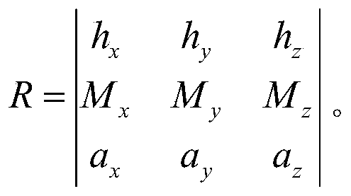
有了姿态矩阵R,将所述姿态矩阵R输入至Android提供的API(Application Program Interface,应用程序接口)接口中,就可以利用四元数对所述姿态矩阵计算,并生成三维旋转指示模型。本发明利用四元数对姿态矩阵进行运算,能够从宏观的显示深入到数据的描述,这是传统利用Unity模型开发不能所比拟的。使用Unity模型旋转在显示上能够支持手动的一个旋转,但是对于一些复杂的业务,不能够做到复杂逻辑下的一个特定的姿态变换。而四元数将姿态变换深入到数据层,通过对业务逻辑的一个分析,进行业务进行数据建模,从而达到模型的姿态变换与业务逻辑的实时变换。
进一步地,步骤S400、将生成的三维旋转指示模型叠加到摄像头的背景上,通过所述三维旋转指示模型旋转移动终端的当前位置与目标位置之间的方向角,实现AR导航。
具体实施时,移动终端启动路径规划功能,并结合图形学,将生成的三维模型叠加到摄像头的背景下,并且在所述摄像头的背景下叠加生成的三维模型以及目标位置信息。将生成的三维旋转指示模型叠加到摄像头的背景上,通过所述三维旋转指示模型旋转移动终端的当前位置与目标位置之间的方向角,实现AR导航。在所述移动终端的显示界面中显示距离目标位置所需要的时间以及预计到达的时间,并进行实景导航,从而实现AR导航。具体如图3中所显示的。
较佳地,移动终端在进行导航时,会生成雷达图,所述雷达图用于显示移动终端当前的位置点以及周边POI(兴趣点)的分布。例如在移动终端的显示界面右上方设置一个圆形视图,视图的上方表示当前移动终端的朝向,视图中心表示当前的位置,视图会跟随移动终端的朝向变化而进行转动,圆形视图内有实心小点,表示周边的兴趣点。在构建圆形视图时,需要自定义一个view,需要构造一个继承view类的子类(navigaton.view.shopping.Mytestview),然后重载其onDraw(Canvas canvas),这个view由三部分构成,第一部分为动态旋转的圆形透明的背景图,会跟随移动终端的转向进行相应的转动,第二部分为静止的朝向扇 形透明图,该扇形图里面的兴趣点表示的是当前朝向一定距离内的兴趣点,第三部分为圆形实心小点,每个圆形小点表示一个兴趣点,点距离圆形的数据表示兴趣点距离当前位置的远近,当点为红色时表示该兴趣点被选择为目标兴趣点,圆形兴趣点同圆形背景框一样也会进行旋转。具体地,定义view即为绘制视图。本实施例中将会旋转与静止的两部分分开绘制。先保存当前画布的状态,然后旋转一定的度数,该度数则由移动终端当前的指南针数据一致。再进行圆形框背景的制作。之后画布回到保存前的状态即为一个正向的初始状态。再进行扇形背景图的绘制。最后再进行动态的圆形实心小点的绘制,根据每个点跟当前位置的方位角以及距离在圆上进行绘图。步骤与动态的圆形背景图的绘制相似。在绘制每个点之前需要保存当前的画布状态,之后旋转画布,旋转的度数即为方位角,再根据该兴趣点有无被选择选择红色或白色进行绘制。最后再将画布的状态恢复为旋转前的状态再进行下一个实现小点的绘制。
优选地,由于后绘制的视图会覆盖先前的视图,故本实施例中将颜色设置为半透明,这也符合了AR的理念,不会遮挡到现实的事物在界面上的显示。当周边兴趣点数量多的时候,目标兴趣点由于绘制的顺序问题,被后面的兴趣点覆盖了,虽然为红色,但仍不能被看到。因此再绘制时对兴趣点是否被选择进行相应的判断,若被选择则保存下编号并不绘制,而是绘制下一个点,待到其他点都绘制完成后再进行目标兴趣点的绘制,这样就能正常显示红色的目标兴趣点的了。由于旋转的时候是根据指南针的数据进行旋转的,但是指南针的数据并不是连续变化的,有时不稳定会出现值跳跃的问题,对应到我们的视图上就会出现图形界面闪来闪去的情况,影响动画的流畅度,因此本实施例需要对两个指南针之间的数据进行插值,需要用到Value Animator动画类,给初值和结束值以及时间自动生成插值区间,根据需要选择不同的插值器,使得在自定义雷达视图在指南针数据不稳定的情况下也能进行平滑的转动,达到一个动画的效果,保证导航的最佳效果。
进一步较佳地,本发明中的AR导航功能还包括周边搜索功能,将获取到的周边的兴趣点POI将这些兴趣点进行显示在手机设备上,同时又能够获得这个POI点的必要信息,包括名称,距离,类别。并且为了方便用户使用,用户在进行移动或者转身时,需要对显示的视图进行平移运动,使位于用户正前方的兴趣 点始终显示在用户的移动终端屏幕的正中央,这部分的实现有点类似于雷达图的实现,也需要对位置数据在进行低通滤波除去突变的数据点之后进行差值,使相对位置的变化变得平滑,实现平滑的位移。
进一步较佳地,本发明中的社交应用中还具有智能语音播报功能。当进行导航时,所述移动终端启动社交应用中预设的智能语音播报功能,实现语音导航;所述智能语音播报功能还包括语音识别、缓存以及翻译功能。具体地,用户可以通过语音唤醒智能语音播报功能,进入对话界面,可以询问日常生活问题,例如天气,日期等,也可以询问出行信息,例如车票查询。包括目的地的相关信息等,之后便可以选择跳转到对应的导航界面。当然也可以在导航界面中唤醒,进行语音站点播报。本发明中的智能语音播报功能可以将音频转化为文本文字,分为在线识别与离线识别。离线识别需要预先加载识别的功能包,若音频识别成功,调用语义识别系统对文本进行切词分析,得到语义信息类别和核心关键词,例如导航还是日期等,从而根据关键词完成不同的逻辑跳转,实现对应的功能。本发明通过设置智能语言播报功能,能够使用户在出行的过程中解放双手,不必依赖于手写输入,特别在一些比较拥挤繁忙的场合,例如过马路等场合,语音输入与语音播报可以解放我们的眼睛视线,不用长时间注视于移动终端的屏幕,大大简便的操作的同时也提高了出行时候的安全性。此外,本发明中的智能语音播报功能还融合多种语言,包括英语,普通话,粤语等多种语种及亚语种,适用于不同年龄段和不同区域的用户。
进一步较佳地,移动终端具有内容推荐系统,即定期获取用户搜索导航的目的地信息,并将其上传至后台服务器的大数据集群中;所述后台服务器根据用户的偏好选择以及用户信息进行机器学习算法模型的训练,定期更新所述大数据集群,并针对用户的偏好选择进行内容推荐。
具体地,本发明的后台服务器的推荐系统搭建使用了传统的Hadoop(一种分布式系统基础架构)平台,利用其集群和HDFS(Hadoop分布式文件系统)文件系统,再搭建Spark分布式计算平台,数据库的选择上使用了Hive+Hbase数据库,此外使用Zookeeper(一个分布式的,开放源码的分布式应用程序协调服务)进行大数据集群的协调管理。推荐系统获取到用户上传的信息之后,便可以将用户信息与偏好选择进行一个机器学习算法模型的训练,或者是神经网络模型的训 练。本实施例中使用的是协同过滤算法以及随机森林方法,在大数据后台集群中分配训练任务,对每天新增的信息进行同步整合,然后在特定的时间段进行算法模型的训练,从而对集群进行更新。
所述内容推荐以滑动式的兴趣卡片的形式卡或者以滚动视图的形式呈现。当推荐方式为滑动式的兴趣卡片,卡片内容包含兴趣点的实景图片,距离以及其他等等相关信息,点击卡片可以查看该兴趣点的详细信息,左滑卡片表示对该兴趣点不感兴趣,右滑表示对该兴趣点表示兴趣,之后便可以选择是否将兴趣点作为出行地点还是先暂时收藏起来。当推荐方式为一个实景界面下的一个滚动视图,将推荐的多个兴趣点以一个框图的形式展示在移动终端的屏幕上,也就是增强现实在移动终端上的实现方式之一,具体如图4中所示。框图会随之移动终端的转动翻转移动而进行显示上的位移,框图包含兴趣点名称,距离信息还有类别信息。当用户正面手持移动终端,若框图处于移动终端正中央,说明该兴趣点处于用户的正前方,若框图处于移动终端屏幕左侧部分,说明该兴趣点处于用户左侧朝向,右侧同理。该推荐方式的优点在于用户可以知道目的地的一个大概位置信息,符合增强现实的概念,提高了导航的效果,给用户的使用提供了方便。当然上述推荐方式也可以根据用户的需求进行自主设置。
基于上述实施例,本发明还公开了一种移动终端,如图5所示,包括:处理器(processor)10、与处理器10连接的存储介质(memory)20;其中,所述处理器10用于调用所述存储介质20中的程序指令,以执行上述实施例所提供的方法,例如执行:
移动终端接收用户的操作指令,启动社交应用中预设的增强现实导航功能,进行导航出行规划;
实时获取移动终端摄像头拍摄的图片,并将其作为摄像头的背景;
获取移动终端的当前位置与目标位置之间的方向角,并利用四元数结合的Open GL坐标系进行运算,生成三维旋转指示模型;
将生成的三维旋转指示模型叠加到摄像头的背景上,通过所述三维旋转指示模型旋转移动终端的当前位置与目标位置之间的方向角,实现AR导航。
本发明实施例还提供一种存储介质,所述存储介质上存储计算机指令,所述计算机指令使计算机执行上述各实施例所提供的方法。
综上所述,本发明公开了基于社交应用的AR导航方法、存储介质及移动终端,所述方法包括:移动终端接收用户的操作指令,启动社交应用中预设的增强现实导航功能,进行导航出行规划;实时获取移动终端摄像头拍摄的图片,并将其作为摄像头的背景;获取移动终端的当前位置与目标位置之间的方向角,并利用四元数结合的Open GL坐标系进行运算,生成三维旋转指示模型;将生成的三维旋转指示模型叠加到摄像头的背景上,通过所述三维旋转指示模型旋转移动终端的当前位置与目标位置之间的方向角,实现AR导航。本发明通过在社交应用中搭载增强现实导航技术,将社交与导航融合,以使所述社交应用中具有增强现实导航功能,能够有效提高导航效果,给用户的使用提供了方便。
应当理解的是,本发明的应用不限于上述的举例,对本领域普通技术人员来说,可以根据上述说明加以改进或变换,所有这些改进和变换都应属于本发明所附权利要求的保护范围。
Claims (10)
- 一种基于社交应用的AR导航方法,其特征在于,所述方法包括:移动终端接收用户的操作指令,启动社交应用中预设的增强现实导航功能,进行导航出行规划;实时获取移动终端摄像头拍摄的图片,并将其作为摄像头的背景;获取移动终端的当前位置与目标位置之间的方向角,并利用四元数结合的Open GL坐标系进行运算,生成三维旋转指示模型;将生成的三维旋转指示模型叠加到摄像头的背景上,通过所述三维旋转指示模型旋转移动终端的当前位置与目标位置之间的方向角,实现AR导航。
- 根据权利要求1所述的基于社交应用的AR导航方法,其特征在于,所述移动终端接收用户的操作指令,启动社交应用中预设的增强现实导航功能,进行导航出行规划之前包括:预先在所述社交应用中的聊天功能中增加出行计划选项,所述出行计划选项用于启动增强现实导航功能。
- 根据权利要求1所述的基于社交应用的AR导航方法,其特征在于,所述获取移动终端的当前位置与目标位置之间的方向角,并利用四元数结合的Open GL坐标系进行运算,生成三维旋转指示模型具体包括:利用移动终端内置的传感器以及磁场传感器获取各个传感器的坐标数据,并将所述坐标数据用三维的向量表示;将所述各个传感器坐标数据结合移动终端中的OpenGL坐标系进行运算,得到移动终端的姿态矩阵,获取移动终端的当前位置与目标位置之间的方向角;将所述姿态矩阵输入至Android提供的API接口中,并利用四元数对所述姿态矩阵进行运算,生成三维旋转指示模型。
- 根据权利要求1所述的基于社交应用的AR导航方法,其特征在于,所述将生成的三维旋转指示模型叠加到摄像头的背景上,通过所述三维旋转指示模型旋转移动终端的当前位置与目标位置之间的方向角,实现AR导航具体包括:移动终端启动路径规划功能,并结合图形学,在所述摄像头的背景下叠加生成三维指示旋转模型以及目标位置信息;通过所述三维旋转指示模型旋转移动终端的当前位置与目标位置之间的方向角;在所述移动终端的显示界面中显示距离目标位置所需要的时间以及预计到达的时间,并进行实景导航,从而实现AR导航。
- 根据权利要求4所述的基于社交应用的AR导航方法,其特征在于,所述将生成的三维旋转指示模型叠加到摄像头的背景上,通过所述三维旋转指示模型旋转移动终端的当前位置与目标位置之间的方向角,实现AR导航还包括:移动终端生成雷达图,所述雷达图用于显示移动终端当前的位置点以及周边POI的分布。
- 根据权利要求5所述的基于社交应用的AR导航方法,其特征在于,所述将生成的三维旋转指示模型叠加到摄像头的背景上,通过所述三维旋转指示模型旋转移动终端的当前位置与目标位置之间的方向角,实现AR导航还包括:当进行导航时,所述移动终端启动社交应用中预设的智能语音播报功能,实现语音导航;所述智能语音播报功能还包括语音识别、缓存以及翻译功能。
- 根据权利要求1所述的基于社交应用的AR导航方法,其特征在于,所述方法还包括:移动终端还会定期获取用户搜索导航的目的地信息,并将其上传至后台服务器的大数据集群中;所述后台服务器根据用户的偏好选择以及用户信息进行机器学习算法模型的训练,定期更新所述大数据集群,并针对用户的偏好选择进行内容推荐。
- 根据权利要求7所述的基于社交应用的AR导航方法,其特征在于,所述内容推荐以滑动式的兴趣卡片的形式卡或者以滚动视图的形式呈现。
- 一种存储介质,其上存储有多条指令,其特征在于,所述指令适于由处理器加载并执行,以实现上述权利要求1-8任一项所述的基于社交应用的AR导航方法的步骤。
- 一种移动终端,其特征在于,包括:处理器、与处理器通信连接的存储介质,所述存储介质适于存储多条指令;所述处理器适于调用所述存储介质中的指令,以执行实现上述权利要求1-8任一项所述的基于社交应用的AR导航方法的步骤。
Applications Claiming Priority (2)
| Application Number | Priority Date | Filing Date | Title |
|---|---|---|---|
| CN201811035638.3A CN109059901B (zh) | 2018-09-06 | 2018-09-06 | 一种基于社交应用的ar导航方法、存储介质及移动终端 |
| CN201811035638.3 | 2018-09-06 |
Publications (1)
| Publication Number | Publication Date |
|---|---|
| WO2020048031A1 true WO2020048031A1 (zh) | 2020-03-12 |
Family
ID=64760666
Family Applications (1)
| Application Number | Title | Priority Date | Filing Date |
|---|---|---|---|
| PCT/CN2018/119651 Ceased WO2020048031A1 (zh) | 2018-09-06 | 2018-12-07 | 一种基于社交应用的ar导航方法、存储介质及移动终端 |
Country Status (2)
| Country | Link |
|---|---|
| CN (1) | CN109059901B (zh) |
| WO (1) | WO2020048031A1 (zh) |
Cited By (1)
| Publication number | Priority date | Publication date | Assignee | Title |
|---|---|---|---|---|
| CN114167985A (zh) * | 2021-11-29 | 2022-03-11 | 中国科学院计算机网络信息中心 | 一种基于5g的应急任务增强现实应用方法及系统 |
Families Citing this family (6)
| Publication number | Priority date | Publication date | Assignee | Title |
|---|---|---|---|---|
| CN110440815A (zh) * | 2019-08-16 | 2019-11-12 | 南京邮电大学 | 一种基于增强现实的导航方法 |
| CN111176338B (zh) * | 2019-12-31 | 2024-03-22 | 维沃移动通信有限公司 | 导航方法、电子设备及存储介质 |
| CN114077300A (zh) * | 2020-08-18 | 2022-02-22 | 胡倩隆 | 虚拟现实中的三维动态导航 |
| CN112116500B (zh) * | 2020-09-21 | 2024-05-17 | 博泰车联网(南京)有限公司 | 旅游路书的生成方法、系统、介质及智能终端 |
| CN113188545B (zh) * | 2021-04-29 | 2023-07-11 | 武汉依迅北斗时空技术股份有限公司 | 一种离线移动端ar室内导航方法及系统 |
| CN113838200B (zh) * | 2021-09-23 | 2023-10-20 | 北京百度网讯科技有限公司 | 模型适配方法、装置、电子设备及可读存储介质 |
Citations (7)
| Publication number | Priority date | Publication date | Assignee | Title |
|---|---|---|---|---|
| JP2012242202A (ja) * | 2011-05-18 | 2012-12-10 | Alpine Electronics Inc | 車載システム |
| CN104748740A (zh) * | 2014-05-14 | 2015-07-01 | 深圳视景文化科技有限公司 | 一种基于增强现实技术的导航方法、导航终端及导航系统 |
| US20160140868A1 (en) * | 2014-11-13 | 2016-05-19 | Netapp, Inc. | Techniques for using augmented reality for computer systems maintenance |
| CN106598256A (zh) * | 2016-12-23 | 2017-04-26 | 携程旅游网络技术(上海)有限公司 | 基于ar的app客户端及应用方法 |
| KR20170117633A (ko) * | 2016-04-14 | 2017-10-24 | 이지운 | 비콘을 이용한 실내 ips를 통한 증강현실 지도/길 안내 서비스 |
| CN107677263A (zh) * | 2017-09-29 | 2018-02-09 | 北京金山安全软件有限公司 | 基于ar的导航方法、装置、电子设备及介质 |
| CN108362279A (zh) * | 2018-01-08 | 2018-08-03 | 北京小米移动软件有限公司 | 基于增强现实技术ar的购物导航方法、装置及系统 |
Family Cites Families (7)
| Publication number | Priority date | Publication date | Assignee | Title |
|---|---|---|---|---|
| CN102123194B (zh) * | 2010-10-15 | 2013-12-18 | 张哲颖 | 利用增强实景技术优化移动导航和人机交互功能的方法 |
| US20120209826A1 (en) * | 2011-02-10 | 2012-08-16 | Nokia Corporation | Method and apparatus for providing location based information |
| US20140278053A1 (en) * | 2013-03-14 | 2014-09-18 | Samsung Electronics Co., Ltd. | Navigation system with dynamic update mechanism and method of operation thereof |
| EP3195631A1 (en) * | 2014-09-15 | 2017-07-26 | LDR Pte. Ltd. | Geographical location based application |
| CN104501797B (zh) * | 2014-12-18 | 2017-12-01 | 深圳先进技术研究院 | 一种基于增强现实ip地图的导航方法 |
| US11310294B2 (en) * | 2016-10-31 | 2022-04-19 | Microsoft Technology Licensing, Llc | Companion devices for real-time collaboration in communication sessions |
| CN107015654A (zh) * | 2017-04-10 | 2017-08-04 | 深圳大学 | 基于增强现实的导航方法及装置 |
-
2018
- 2018-09-06 CN CN201811035638.3A patent/CN109059901B/zh not_active Expired - Fee Related
- 2018-12-07 WO PCT/CN2018/119651 patent/WO2020048031A1/zh not_active Ceased
Patent Citations (7)
| Publication number | Priority date | Publication date | Assignee | Title |
|---|---|---|---|---|
| JP2012242202A (ja) * | 2011-05-18 | 2012-12-10 | Alpine Electronics Inc | 車載システム |
| CN104748740A (zh) * | 2014-05-14 | 2015-07-01 | 深圳视景文化科技有限公司 | 一种基于增强现实技术的导航方法、导航终端及导航系统 |
| US20160140868A1 (en) * | 2014-11-13 | 2016-05-19 | Netapp, Inc. | Techniques for using augmented reality for computer systems maintenance |
| KR20170117633A (ko) * | 2016-04-14 | 2017-10-24 | 이지운 | 비콘을 이용한 실내 ips를 통한 증강현실 지도/길 안내 서비스 |
| CN106598256A (zh) * | 2016-12-23 | 2017-04-26 | 携程旅游网络技术(上海)有限公司 | 基于ar的app客户端及应用方法 |
| CN107677263A (zh) * | 2017-09-29 | 2018-02-09 | 北京金山安全软件有限公司 | 基于ar的导航方法、装置、电子设备及介质 |
| CN108362279A (zh) * | 2018-01-08 | 2018-08-03 | 北京小米移动软件有限公司 | 基于增强现实技术ar的购物导航方法、装置及系统 |
Cited By (2)
| Publication number | Priority date | Publication date | Assignee | Title |
|---|---|---|---|---|
| CN114167985A (zh) * | 2021-11-29 | 2022-03-11 | 中国科学院计算机网络信息中心 | 一种基于5g的应急任务增强现实应用方法及系统 |
| CN114167985B (zh) * | 2021-11-29 | 2022-08-12 | 中国科学院计算机网络信息中心 | 一种基于5g的应急任务增强现实应用方法及系统 |
Also Published As
| Publication number | Publication date |
|---|---|
| CN109059901A (zh) | 2018-12-21 |
| CN109059901B (zh) | 2020-02-11 |
Similar Documents
| Publication | Publication Date | Title |
|---|---|---|
| CN109059901B (zh) | 一种基于社交应用的ar导航方法、存储介质及移动终端 | |
| US20250029343A1 (en) | Assisted drawing and writing in extended reality | |
| US11368557B2 (en) | Platform for constructing and consuming realm and object feature clouds | |
| US11546277B2 (en) | Third-party resource coordination | |
| CA2782277C (en) | Method and apparatus for transforming three-dimensional map objects to present navigation information | |
| US11741294B2 (en) | Decoupling website service from presentation layer | |
| CN104769393B (zh) | 用于从局部地图视图转变到增强现实视图的方法和装置 | |
| WO2023179346A1 (zh) | 特效图像处理方法、装置、电子设备及存储介质 | |
| Roth et al. | Making maps & visualizations for mobile devices: A research agenda for mobile-first and responsive cartographic design | |
| US11550435B2 (en) | Trackpad on back portion of a device | |
| KR20240090542A (ko) | 거울 기반 증강 현실 경험 | |
| CN111530073A (zh) | 游戏地图的显示控制方法、存储介质、电子设备 | |
| CN109074376A (zh) | 绘图接口中的上下文墨迹标注 | |
| EP4479934A1 (en) | Interactively defining an object segmentation | |
| DE112013002803T5 (de) | Verfahren, System und Einrichtung zum Liefern einer dreidimensionalen Übergangsanimation für eine Änderung einer Kartenansicht | |
| WO2024055004A1 (en) | Gestures to enable menus using augmented reality content in a messaging system | |
| WO2024054999A1 (en) | Virtual object manipulation with gestures in a messaging system | |
| US20250232506A1 (en) | Scene-aware synthetic human motion generation using neural networks | |
| EP4272173A1 (en) | Flow-guided motion retargeting | |
| WO2024055001A1 (en) | Sculpting augmented reality content using gestures in a messaging system | |
| WO2023220163A1 (en) | Multi-modal human interaction controlled augmented reality | |
| Rakshit et al. | Augmented reality for education based on markerless dynamic rendering | |
| US12541968B2 (en) | Controlled image manipulations using semantic labels | |
| WO2023158375A2 (zh) | 表情包生成方法及设备 | |
| US20250191312A1 (en) | Persisting augmented reality experiences |
Legal Events
| Date | Code | Title | Description |
|---|---|---|---|
| 121 | Ep: the epo has been informed by wipo that ep was designated in this application |
Ref document number: 18932914 Country of ref document: EP Kind code of ref document: A1 |
|
| NENP | Non-entry into the national phase |
Ref country code: DE |
|
| 32PN | Ep: public notification in the ep bulletin as address of the adressee cannot be established |
Free format text: NOTING OF LOSS OF RIGHTS PURSUANT TO RULE 112(1) EPC - FORM 1205A (09.06.21) |
|
| 122 | Ep: pct application non-entry in european phase |
Ref document number: 18932914 Country of ref document: EP Kind code of ref document: A1 |