WO2019093432A1 - Navigation system and navigation method - Google Patents
Navigation system and navigation method Download PDFInfo
- Publication number
- WO2019093432A1 WO2019093432A1 PCT/JP2018/041534 JP2018041534W WO2019093432A1 WO 2019093432 A1 WO2019093432 A1 WO 2019093432A1 JP 2018041534 W JP2018041534 W JP 2018041534W WO 2019093432 A1 WO2019093432 A1 WO 2019093432A1
- Authority
- WO
- WIPO (PCT)
- Prior art keywords
- information
- analysis
- priority
- map
- application
- Prior art date
Links
Images


Classifications
-
- G—PHYSICS
- G01—MEASURING; TESTING
- G01C—MEASURING DISTANCES, LEVELS OR BEARINGS; SURVEYING; NAVIGATION; GYROSCOPIC INSTRUMENTS; PHOTOGRAMMETRY OR VIDEOGRAMMETRY
- G01C21/00—Navigation; Navigational instruments not provided for in groups G01C1/00 - G01C19/00
- G01C21/26—Navigation; Navigational instruments not provided for in groups G01C1/00 - G01C19/00 specially adapted for navigation in a road network
- G01C21/34—Route searching; Route guidance
- G01C21/3407—Route searching; Route guidance specially adapted for specific applications
- G01C21/3415—Dynamic re-routing, e.g. recalculating the route when the user deviates from calculated route or after detecting real-time traffic data or accidents
-
- G—PHYSICS
- G01—MEASURING; TESTING
- G01C—MEASURING DISTANCES, LEVELS OR BEARINGS; SURVEYING; NAVIGATION; GYROSCOPIC INSTRUMENTS; PHOTOGRAMMETRY OR VIDEOGRAMMETRY
- G01C21/00—Navigation; Navigational instruments not provided for in groups G01C1/00 - G01C19/00
- G01C21/26—Navigation; Navigational instruments not provided for in groups G01C1/00 - G01C19/00 specially adapted for navigation in a road network
- G01C21/34—Route searching; Route guidance
- G01C21/36—Input/output arrangements for on-board computers
- G01C21/3679—Retrieval, searching and output of POI information, e.g. hotels, restaurants, shops, filling stations, parking facilities
-
- G—PHYSICS
- G01—MEASURING; TESTING
- G01C—MEASURING DISTANCES, LEVELS OR BEARINGS; SURVEYING; NAVIGATION; GYROSCOPIC INSTRUMENTS; PHOTOGRAMMETRY OR VIDEOGRAMMETRY
- G01C21/00—Navigation; Navigational instruments not provided for in groups G01C1/00 - G01C19/00
- G01C21/26—Navigation; Navigational instruments not provided for in groups G01C1/00 - G01C19/00 specially adapted for navigation in a road network
- G01C21/34—Route searching; Route guidance
- G01C21/3453—Special cost functions, i.e. other than distance or default speed limit of road segments
- G01C21/3492—Special cost functions, i.e. other than distance or default speed limit of road segments employing speed data or traffic data, e.g. real-time or historical
-
- G—PHYSICS
- G01—MEASURING; TESTING
- G01C—MEASURING DISTANCES, LEVELS OR BEARINGS; SURVEYING; NAVIGATION; GYROSCOPIC INSTRUMENTS; PHOTOGRAMMETRY OR VIDEOGRAMMETRY
- G01C21/00—Navigation; Navigational instruments not provided for in groups G01C1/00 - G01C19/00
- G01C21/26—Navigation; Navigational instruments not provided for in groups G01C1/00 - G01C19/00 specially adapted for navigation in a road network
- G01C21/34—Route searching; Route guidance
- G01C21/36—Input/output arrangements for on-board computers
- G01C21/3667—Display of a road map
- G01C21/367—Details, e.g. road map scale, orientation, zooming, illumination, level of detail, scrolling of road map or positioning of current position marker
-
- G—PHYSICS
- G01—MEASURING; TESTING
- G01C—MEASURING DISTANCES, LEVELS OR BEARINGS; SURVEYING; NAVIGATION; GYROSCOPIC INSTRUMENTS; PHOTOGRAMMETRY OR VIDEOGRAMMETRY
- G01C21/00—Navigation; Navigational instruments not provided for in groups G01C1/00 - G01C19/00
- G01C21/38—Electronic maps specially adapted for navigation; Updating thereof
- G01C21/3863—Structures of map data
-
- G—PHYSICS
- G01—MEASURING; TESTING
- G01C—MEASURING DISTANCES, LEVELS OR BEARINGS; SURVEYING; NAVIGATION; GYROSCOPIC INSTRUMENTS; PHOTOGRAMMETRY OR VIDEOGRAMMETRY
- G01C21/00—Navigation; Navigational instruments not provided for in groups G01C1/00 - G01C19/00
- G01C21/38—Electronic maps specially adapted for navigation; Updating thereof
- G01C21/3885—Transmission of map data to client devices; Reception of map data by client devices
- G01C21/3889—Transmission of selected map data, e.g. depending on route
-
- G—PHYSICS
- G08—SIGNALLING
- G08G—TRAFFIC CONTROL SYSTEMS
- G08G1/00—Traffic control systems for road vehicles
- G08G1/09—Arrangements for giving variable traffic instructions
- G08G1/0962—Arrangements for giving variable traffic instructions having an indicator mounted inside the vehicle, e.g. giving voice messages
- G08G1/0968—Systems involving transmission of navigation instructions to the vehicle
- G08G1/096833—Systems involving transmission of navigation instructions to the vehicle where different aspects are considered when computing the route
- G08G1/096838—Systems involving transmission of navigation instructions to the vehicle where different aspects are considered when computing the route where the user preferences are taken into account or the user selects one route out of a plurality
-
- G—PHYSICS
- G08—SIGNALLING
- G08G—TRAFFIC CONTROL SYSTEMS
- G08G1/00—Traffic control systems for road vehicles
- G08G1/09—Arrangements for giving variable traffic instructions
- G08G1/0962—Arrangements for giving variable traffic instructions having an indicator mounted inside the vehicle, e.g. giving voice messages
- G08G1/0968—Systems involving transmission of navigation instructions to the vehicle
- G08G1/0969—Systems involving transmission of navigation instructions to the vehicle having a display in the form of a map
-
- G—PHYSICS
- G09—EDUCATION; CRYPTOGRAPHY; DISPLAY; ADVERTISING; SEALS
- G09B—EDUCATIONAL OR DEMONSTRATION APPLIANCES; APPLIANCES FOR TEACHING, OR COMMUNICATING WITH, THE BLIND, DEAF OR MUTE; MODELS; PLANETARIA; GLOBES; MAPS; DIAGRAMS
- G09B29/00—Maps; Plans; Charts; Diagrams, e.g. route diagram
- G09B29/003—Maps
- G09B29/006—Representation of non-cartographic information on maps, e.g. population distribution, wind direction, radiation levels, air and sea routes
- G09B29/007—Representation of non-cartographic information on maps, e.g. population distribution, wind direction, radiation levels, air and sea routes using computer methods
Definitions
- the present invention relates to a navigation system and a navigation method.
- a navigation system is widely used which presents a map using map data and provides guidance of a movement route. Such a navigation system is required to draw the map at high speed when the map is scrolled or scaled.
- Patent Document 1 discloses a map display device provided with a map database, an operation receiving means, a map data acquisition means, a map data cache means and a map drawing means.
- the map data acquisition means is map data capable of drawing a map in a wider range than the map currently displayed among the map data stored in the map database when the scroll operation of the map is accepted by the operation accepting means. Then, the map data having the same scale as the map data used for drawing the currently displayed map is acquired.
- the scroll operation of the map is not accepted by the operation accepting means, it is map data capable of drawing a map in the same range as the map currently displayed among map data stored in the map database. A plurality of map data different in scale from the map data used for drawing the currently displayed map is acquired.
- the map data cache means stores the map data acquired by the map data acquisition means in the internal memory.
- the map drawing means draws a map using map data stored in the internal memory.
- Navigation systems generally use map data for purposes other than drawing maps. Therefore, the performance of the navigation system can be improved by referring to map data at high speed.
- the map drawing is speeded up by determining the range of the map data to be acquired according to the state of the scroll operation, targeting only the data related to the drawing of the map among the map data. There is. Therefore, with regard to map data that is not related to map drawing, high speed reference to map data has not been considered.
- map data for route search is used in the method for performing map drawing at high speed. It did not contribute to the speeding up of the route search because it was not considered to perform the reference at high speed.
- An object of the present invention is to speed up reference to map data not limited to a specific map data type.
- a navigation system performs a navigation operation for guiding a mobile using map data composed of a plurality of types of map information, and operation information corresponding to the user's operation is input.
- Control for generating a plurality of types of application information based on the operation input unit, a temporary storage unit capable of temporarily storing information, and the map data, and performing processing related to the navigation operation using the application information
- the control unit sets an analysis priority for analysis processing performed for each type of the map information based on at least one of the operation information and the state of the navigation operation.
- a generation priority is set for each type of the application information, and at least one type of map information among a plurality of types of map information is analyzed.
- a navigation method performs a navigation operation for guiding a mobile using map data composed of a plurality of types of map information, and according to an operation of a user who receives the provision of the navigation operation.
- the generation priority is set for each type of application information used for the analysis, and at least one type of map information among the plurality of types of map information is analyzed, and the computer performs the analysis processing in the order according to the analysis priority.
- the computer Based on the result, the computer generates the application information in the order according to the generation priority, temporarily stores the generated application information, and uses the temporarily stored information for application Then, the computer executes processing relating to the navigation operation.
- FIG. 2 is a diagram showing a functional configuration of a control unit. The figure which shows an example of the relationship between the analysis result of map information, and the information for applications.
- a generation priority table showing an example of setting the generation priority.
- Analysis priority table showing an example of setting analysis priority.
- the priority setting range table which shows the example of the setting range of analysis priority and generation priority.
- the flowchart which shows the setting procedure of analysis priority and generation priority.
- a cache data management table showing an example in which the generation priority is set for each mesh.
- An analysis data management table showing an example in which analysis priority is set for each mesh.
- FIG. 5 is a flowchart showing a generation procedure of analysis data and cache data according to the first embodiment of the present invention.
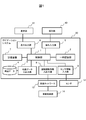
- FIG. 1 is a block diagram of a navigation system according to a first embodiment of the present invention.
- the navigation system 20 shown in FIG. 1 is mounted and used in a vehicle which is a moving body, and performs a navigation operation for guiding the vehicle toward a destination.
- a vehicle on which the navigation system 20 is mounted is referred to as "own vehicle”.
- the navigation system 20 includes a control unit 1, a temporary storage unit 2, a map data input / output unit 3, a map data 4, an operation input unit 5, a display output unit 6, a storage unit 7, a driving assistance information input / output unit 8, and sensor information
- An input unit 9 is provided, and is connected to the operation unit 10, the display unit 11, the sensor 12, and the vehicle network 13.
- the control unit 1 is a microcomputer that executes various programs stored in the storage device 7 to execute processing related to the navigation operation and controls each part of the navigation system 20.
- the control unit 1 is configured using, for example, a processor such as a CPU.
- the temporary storage unit 2 is an area capable of storing digital information that can be read and written at high speed, and is used as a work area when the control unit 1 performs processing.
- the temporary storage unit 2 is configured using, for example, a memory such as a RAM.
- the map data input / output unit 3 reads and acquires necessary data from the map data 4 under the control of the control unit 1 and outputs the data to the control unit 1.
- the map data 4 is composed of a plurality of types of map information, such as terrain information, road information, etc., and is recorded in a non-volatile memory such as a flash memory, a hard disk, a memory card or the like. That is, the map data input / output unit 3 is an interface device that reads and writes non-volatile memory.
- a plurality of types of map information stored in the map data 4 is a data set of rectangular mesh units finely divided at predetermined distance intervals in the latitude direction and the longitude direction, and a data sequence using an address and coordinates as keys And each one.
- the number of divisions of the mesh differs according to the scale.
- the operation unit 10 detects an operation performed by an occupant of the own vehicle who is a user of the navigation system 20, and outputs operation information according to the content of the operation to the navigation system 20.
- the operation unit 10 includes, for example, a touch panel, a button, a mouse, a keyboard, and the like.
- the operation information output from the operation unit 10 is input to the operation input unit 5 in the navigation system 20 and transmitted to the control unit 1. That is, the operation input unit 5 is an interface that inputs and outputs information between the control unit 1 and the operation unit 10.
- the operation unit 10 is a touch panel
- the touch panel detects the operation of the user's finger and outputs the detected signal as an electric signal.
- the circuit that receives the electrical signal corresponds to the operation input unit 5.
- the display unit 11 receives the video signal output from the display output unit 6 and displays it on the screen to present information necessary for the navigation operation such as a map image to the user of the navigation system 20, for example.
- the display unit 11 is configured of, for example, a liquid crystal display.
- the display output unit 6 generates a video signal based on the video information output from the control unit 1 and outputs the video signal to the display unit 11. That is, the display output unit 6 is an interface that inputs and outputs information between the control unit 1 and the display unit 11, and corresponds to a circuit for generating a video signal.
- the display unit 11 and the operation unit 10 may be integrated by using the display unit 11 as a touch panel.
- the storage device 7 is a non-volatile storage medium that records a program that implements processing related to a navigation operation by being executed by the control unit 1 and various data used when the program is executed.
- the storage device 7 is configured using, for example, a non-volatile memory such as a flash memory, a hard disk, or a memory card.
- the vehicle control unit 14 performs travel control of the host vehicle based on the driver's driving operation and detection information of various sensors.
- the vehicle control unit 14 is connected to the navigation system 20 via a vehicle network 13 provided in the host vehicle.
- the driving assistance information input / output unit 8 transmits / receives information related to driving to the vehicle control unit 14 via the vehicle network 13. That is, the driving assistance information input / output unit 8 is an interface for inputting / outputting information between the control unit 1 and the vehicle control unit 14.
- the driving assistance information input / output unit 8 is acquired from position information of the host vehicle or the map data 4
- the output road information and the like are output to the vehicle control unit 14.
- the driving assistance information input / output unit 8 It is received from the vehicle control unit 14 via the link control unit 14 and is output to the control unit 1.
- the driving assistance information input / output unit 8 may be realized as a function of the same processor as the control unit 1 or, in the case of outputting important information related to the driving of the own vehicle, secure fault tolerance.
- the processor may be realized as a processor independent of the control unit 1.
- the sensor 12 detects various sensor information required for the navigation operation and provides the navigation system 20 with the sensor information.
- the sensor 12 is configured of, for example, a position sensor realized using a reception antenna of a global positioning satellite system or the like, an acceleration sensor, a gyro sensor, an obstacle sensor, or the like.
- the sensor information output from the sensor 12 is input to the sensor information input unit 9 in the navigation system 20 and transmitted to the control unit 1. That is, the sensor information input unit 9 is an interface that inputs and outputs sensor information between the control unit 1 and the sensor 12.
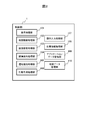
- FIG. 2 is a diagram showing an example of a functional configuration of the control unit 1.
- the control unit 1 has a display processing unit 101, a map drawing processing unit 102, a route search processing unit 103, a guidance guidance processing unit 104, a driving assistance processing unit 105, and an action prediction processing unit 106 as its functions.
- Each of these functions is realized as a module of software executed by the control unit 1 (hereinafter referred to as an application or an application).
- Each application may be realized as a combination of applications in which a plurality of functions are integrated depending on the realization method.
- the configuration method of an application is not restrict
- the display processing unit 101 generates video information with reference to processing results of other applications, and performs processing of sending the generated video information to the display output unit 6.
- the map drawing processing unit 102 draws a map based on the map data sent from the map data input / output unit 3 and performs processing of sending the map to the display processing unit 101.
- the route search processing unit 103 performs processing for calculating a route for the host vehicle to reach the designated destination with reference to the map data sent from the map data input / output unit 3.
- the guidance processing unit 104 guides the vehicle to the destination along the route based on the information of the route calculated by the route search processing unit 103 and the current position information of the vehicle managed by the position information management unit 108. It performs processing to create guidance guidance information.
- the guidance information processing unit 104 is, for example, map data sent from the map data input / output unit 3 and managed by the application data management unit 109, prediction information of the traveling direction of the own vehicle held by the action prediction processing unit 106, etc. Using the above information, information for conveying to a driver a road, a building, a traffic condition, and the like in which the host vehicle is traveling is created as guidance information.
- the guidance information created by the guidance processing unit 104 is sent to the display processing unit 101.
- the driving assistance processing unit 105 refers to the information of the route calculated by the route search processing unit 103 and the map data sent from the map data input / output unit 3 and managed by the application data management unit 109 to control the vehicle control unit.
- the driving assistance information necessary for the operation of 14 is generated.
- the driving assistance information generated by the driving assistance processing unit 105 is sent to the driving assistance information input / output unit 8.
- the action prediction processing unit 106 performs processing of predicting the traveling direction, the destination, and the like of the host vehicle using the driver's past driving history information.
- the operation input processing unit 107 analyzes the operation information received by the operation input unit 5 to determine the operation content of the user, and according to the operation content, starts or stops processing of another application. Do.
- the position information management unit 108 calculates the current position, the traveling direction, the traveling speed, and the like of the own vehicle based on the information acquired by the sensor information input unit 9.
- the application data management unit 109 performs processing for managing information required by each of the other applications.
- the map data management unit 110 performs processing for managing the map data sent from the map data input / output unit 3.
- the map data management unit 110 analyzes various types of map information included in the map data sent from the map data input / output unit 3, and based on the analysis result, the application information to be used for the processing of each application Generate Then, the application data management unit 109 manages the application information generated by the map data management unit 110, and provides the information to each application as needed. The details of this process will be described below.
- FIG. 3 is a diagram showing an example of the relationship between the analysis result of the map information and the application information.
- the control unit 1 analyzes the map data 4 by the processing of the map data management unit 110, and generates analysis data 40 according to the analysis result.
- application information is generated by extracting information required by each application from the analysis data 40, and is stored as the cache data 50 in the temporary storage unit 2, and the application data management unit 109 manages the application information.
- the map data 4 includes map information of terrain information 31, road information 32, icon information 33, point information 34, and high accuracy map information 35.
- the terrain information 31 is coordinate point data indicating the shape of a building or the shape of the terrain.
- the road information 32 is information on features such as the topology of the road, the shape of the road, and the length of the road.
- the icon information 33 is information indicating an icon related to a target such as a building, and is stored using coordinate information as a key.
- the point information 34 is information on an address or feature related to a building or a place, and is stored using coordinate information as a key. This includes, for example, toll booth information and the like.
- the high accuracy map information 35 is information representing the shape of the road with higher accuracy than the road information 32. These pieces of map information are stored in the map data 4 in mesh units.
- the map data 4 may include other map information.
- the analysis data 40 includes analysis results of the topography information analysis result 42, the road information analysis result 43, the icon information analysis result 44, the point information analysis result 45, and the high accuracy map information analysis result 46. These analysis results respectively correspond to the terrain information 31 of the map data 4, the road information 32, the icon information 33, the point information 34 and the high precision map information 35, and the temporary storage unit 2 can be referred to at high speed. It is stored.
- the topography information analysis result 42 is information indicating the result of analysis of the topography information 31 by the control unit 1 by the map data management unit 19.
- the road information analysis result 43 is information indicating the result of analysis of the road information 32 by the control unit 1 by the map data management unit 19.
- the icon information analysis result 44 is information indicating the result of the analysis of the icon information 33 by the control unit 1 by the map data management unit 19.
- the point information analysis result 45 is information indicating the result of the point data 34 analyzed by the control unit 1 by the map data management unit 19.
- the high accuracy map information analysis result 46 is information indicating the result of the control unit 1 analyzing the high accuracy map information 35 by the map data management unit 19. Analysis priorities 41 are set in these analysis results.
- the analysis data 40 may include another analysis result corresponding to the map information.
- an analysis process for creating the analysis data 40 is, for example, a process of simply copying data necessary for the map data 4 and the like. That's it.
- the map data 4 is not in a format suitable for use in an application, it is necessary to create the analysis data 40 so that the control unit 1 can refer to the contents, so that it takes time for analysis processing. In addition, it may be necessary to take measures such as caching and reusing the analysis data 40.
- the analysis priority 41 is set for the analysis processing performed for each type of map information, and An analysis process of map information is performed to obtain an analysis result.
- the setting method of the analysis priority 41 and the specific procedure at the time of performing an analysis process in order according to the analysis priority 41 are demonstrated later.
- the cache data 50 includes application information of application drawing information 52, application road information 53, application point information 54, application guidance information 55, and application driving support information 56.
- the application information is stored in the temporary storage unit 2 in a state where it can be referred to at high speed separately from the analysis results of the analysis data 40.
- the application drawing information 52 is application information required for the map drawing processing performed by the map drawing processing unit 102, and, for example, coordinate point data indicating the shape of a building or the shape of terrain, data indicating the shape of a road, etc. including.
- the drawing information 52 for application is configured by combining the topography information analysis result 42 and the road information analysis result 43.
- the application road information 53 is application information necessary for the route search processing performed by the route search processing unit 103, and, for example, information indicating the topology of the road and the length of the road Includes information on road characteristics such as one-way traffic, speed restrictions and time restrictions.
- the application road information 53 is configured based on the road information analysis result 43.
- the application point information 54 is application information necessary for displaying various facility icons in the map drawing processing performed by the map drawing processing unit 102 and for searching for a destination in the route search processing performed by the route search processing unit 103. There are, for example, detailed information such as addresses and features about buildings and places in various places, and information indicating icons of various facilities.
- the application spot information 54 is configured by combining the icon information analysis result 44 and the spot information analysis result 45. In addition, when processing becomes complicated if all the information contained in these analysis results is utilized by application, the control part 1 may thin out unnecessary information and may produce
- the application guidance information 55 is information for application required for guidance guidance of the vehicle performed by the guidance guidance processing unit 104, and, for example, an icon of a facility serving as a mark on the route, a toll booth where the route passes, etc. Contains information on The application guidance information 55 is configured by combining the road information analysis result 43, the icon information analysis result 44, and the point information analysis result 45.
- the control unit 1 refers to the road information analysis result 43 when generating the application guidance information 55, and relates to the ID of the target road and the icon information analysis result 44 and the point information analysis result 45. Integration suitable for processing of the application may be performed, such as making it possible to cross-reference icons and point information.
- the application driving support information 56 is application information necessary for generation of driving assistance information performed by the driving assistance processing unit 105, and includes, for example, information indicating the shape of a road on which the host vehicle is traveling.
- the application driving support information 56 is configured by combining the road information analysis result 43 and the high precision map information analysis result 46.
- the control unit 1 When the control unit 1 generates the application driving support information 56, the control unit 1 refers to the road information analysis result 43, and in the ID of the target road, the road information analysis result 43 or the high accuracy map information analysis result 46. Integration suitable for processing of the application may be performed, such as making cross-referenceable information with related road shape information.
- a generation priority 51 is set for each of the above-described application information included in the cache data 50.
- the application information included in the cache data 50 is not limited to the above-described one, and other application information may be included in the cache data 50.
- Information for each application making up the cache data 50 is configured in an appropriate format for use by the application. That is, each application information is formatted and designed with priority given to ease of processing in the application. Therefore, it is difficult to generate each application information using the analysis data 40 as it is. In addition, in order to create information necessary for each application information, it may be necessary to refer to a plurality of analysis results in the analysis data 40. Therefore, it takes time to generate application information.
- the generation priority 51 is set for each application information, and each application information is generated in the order according to the generation priority 51. It is like that.
- generation priority 51 are demonstrated later.
- the map drawing processing unit 102 draws a map with reference to the drawing information for application 52 and the point information for application 54. At that time, the map drawing processing unit 102 draws an icon to be superimposed and displayed on the map, using the application point information 54. In addition, when drawing a map, it is preferable to draw preferentially the information of a road or topography. In that case, the icon may be displayed late while the map is scrolling.
- the route search processing unit 103 searches for a route to a destination with reference to the application road information 53 and the application point information 54. At this time, the route search processing unit 103 refers to the application point information 54 and presents information on the destination to the user of the navigation system 20, thereby causing the user to specify the destination, and the designated destination The route search to the route may be performed using the application road information 53.
- the guidance information processing unit 104 performs guidance guidance to a destination according to the route with reference to the application road information 53, the application point information 54, and the application guidance information 55. At that time, the guidance information processing unit 104 uses the information of the current position of the vehicle acquired by the sensor information input unit 9 and the ID of the road targeted for guidance information as keys.
- the guidance information is generated with reference to the information indicated by the feature information, the application spot information 54 and the application guidance 55, and the like. Note that the generation of the guidance information needs at least the guidance information 55 for application, and the application road information 53 and the application point information 54 are not essential. Therefore, acquisition delay may be permitted for these application information.
- the driving assistance processing unit 105 generates driving assistance information to be used in the vehicle control unit 14 with reference to the application road information 53 and the application driving assistance information 56. At that time, the driving assistance processing unit 105 uses the ID of the road targeted for driving assistance as a key, and uses the road feature information in the application road information 53, the information on the high accuracy road in the application driving support information 56, etc. And combine them to generate driving assistance information.
- the control unit 1 performs analysis processing on each piece of map information constituting the map data 4 to obtain the topography information analysis result 42, the road information analysis result 43, the icon information analysis result 44, and the point.
- Analysis data 40 consisting of analysis results of the information analysis result 45 and the high precision map information analysis result 46 is acquired.
- each application information of application drawing information 52, application road information 53, application point information 54, application guidance information 55, and application driving support information 56 is generated,
- the cache data 50 is stored in the temporary storage unit 2.
- the map data management unit 110 performs the process related to the generation of the cache data 50. In this way, using the information for each application stored in the temporary storage unit 2, the processing related to the navigation operation is executed.
- the control unit 1 Based on the operation information input from the operation unit 10 to the operation input unit 5 and the state of the navigation operation in the navigation system 20, the control unit 1 gives analysis priority 41 to analysis processing performed for each type of map information. Is set, and the generation priority 51 is set for each application information of the cache data 50.
- the map data management unit 110 in the control unit 1 performs processing for setting the analysis priority 41 and the generation priority 51.
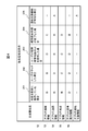
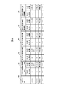
- FIG. 4 is a generation priority table showing an example of setting the generation priority 51.
- the generation priority table of FIG. 4 shows a setting example of the generation priority 51 of the application information for each of the setting conditions 201 to 205, and the application drawing information 52 and application road information 53 shown in FIG.
- the values of the generation priority 51 are expressed in four stages of A, B, C, and D for each application information of the application spot information 54, the application guidance information 55, and the application driving support information 56.
- the priority of generation of the application information is high in the order of A, B, C, and D. That is, the application information in which the value of the generation priority 51 is A has the highest generation priority.
- the value of the generation priority 51 is expressed in four levels in FIG.
- the value is not limited to four levels. Further, the item expressed as “—” in the generation priority table of FIG. 4 indicates that the generation priority 51 is excluded from the setting target. At this time, when the value of the generation priority 51 has already been set by another setting condition, the value of the generation priority 51 may be maintained without being overwritten and may be used continuously.
- the control unit 1 determines which of the setting conditions 201 to 205 in FIG. 4 the control information corresponds to the current navigation operation state input from the operation unit 10 to the operation input unit 5. For example, when the operation unit 10 is configured of a touch panel, and the operation information indicating that the user has touched the touch panel is input, the control unit 1 determines that the setting condition 202 is satisfied and the information for each application
- the generation priority 51 corresponding to the setting condition 202 is set as follows.
- the control unit 1 sets the generation priority 51 for the drawing information for application 52 under the setting condition 202 to “B”. That is, in this case, it is considered that the user is performing a touch operation in an attempt to scroll the map screen displayed on the touch panel. Therefore, “B”, which is a higher priority, is set as the value of the generation priority 51 for the application drawing information 52 necessary for the map drawing processing unit 102 to perform the map drawing process.
- control unit 1 sets the generation priority 51 for the application spot information 54 under the setting condition 202 to “C”. That is, when the map screen is scrolled, the icon superimposed on the map may be displayed later. Therefore, for the application spot information 54 necessary for the map drawing processing unit 102 to draw the icon, the value “C”, which is a lower priority than the application drawing information 52, has a value of the generation priority 51 Set as.
- control unit 1 sets the generation priority 51 for the application road information 53 and the application guidance information 55 under the setting condition 202 to “D”. That is, the route search performed by the route search processing unit 103 and the route guidance to the destination performed by the route guidance processing unit 104 are not directly related to the scroll of the map screen, but may be executed after the scroll. Therefore, for application road information 53 and application guidance information 55 necessary for these processes, "D", which has a lower priority than application drawing information 52 and application point information 54, is generated. Set as a value of 51.
- control unit 1 excludes the generation priority 51 for the application driving support information 56 under the setting condition 202 from the setting target. That is, the generation of the driving assistance information performed by the driving assistance processing unit 105 has nothing to do with the scrolling of the map screen. Therefore, the application driving support information 56 used for generating the driving assistance information is excluded from the setting target of the generation priority 51.
- the control unit 1 Determines that the setting condition 205 is satisfied, and sets generation priority 51 corresponding to the setting condition 205 as follows for each application information.
- the control unit 1 sets the generation priority 51 for the application road information 53 and the application driving support information 56 under the setting condition 205 to “A”. That is, in this case, the travel control of the host vehicle by the vehicle control unit 14 relates to safety, and is considered to be more important than the other processing. Therefore, for the application road information 53 and the application driving assistance information 56 used by the driving assistance processing unit 105 to generate the driving assistance information necessary in the vehicle control unit 14, the highest priority “A Are set as the values of the generation priority 51, respectively.
- control unit 1 excludes the generation priority 51 for the drawing information 52 for application, the point information for application 54, and the guidance information for application 55 under the setting condition 205 from the setting targets. That is, the processing performed using these application information has nothing to do with the operation of the vehicle control unit 14. Therefore, the application information is excluded from the setting target of the generation priority 51.
- the values of the generation priority 51 shown in the generation priority table of FIG. 4 are an example, and the values of the generation priority 51 set for each application information of the cache data 50 are not limited to this.
- the value of the generation priority 51 is set high for the minimum required application information to complete the process of the application directly related to the setting condition.
- the value of the generation priority 51 is set to a relatively low value for application information which is necessary to complete the processing of the latest application but which is presumed to be not immediately necessary.
- the value of generation priority 51 is set low.
- the application information related to functions not derived from the setting condition is excluded from the setting target of the generation priority 51, and the value of the existing generation priority 51 is not particularly manipulated.
- the value of the generation priority 51 to be set for each application information can be determined.
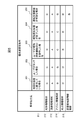
- FIG. 5 is an analysis priority table showing an example of setting of the analysis priority 41.
- the analysis priority table of FIG. 5 shows a setting example of the analysis priority 41 for each of the setting conditions 201 to 205, and the terrain information analysis 211, the road information analysis 212, the icon information analysis 213, the point information analysis 214, the high In each analysis process of the accuracy map information analysis 215, the value of the analysis priority 41 is expressed in four stages of A, B, C, and D as in the generation priority table of FIG.
- each analysis process of the terrain information analysis 211, the road information analysis 212, the icon information analysis 213, the point information analysis 214, and the high accuracy map information analysis 215 is each map information shown in FIG.
- the information 32, the icon information 33, the point information 34, and the high accuracy map information 35 are analyzed in mesh units respectively, and the topography information analysis result 42, the road information analysis result 43, the icon information analysis result 44, the point information analysis result 45, the height This is processing for acquiring the accuracy map information analysis results 46 respectively.
- the item expressed as “—” in the analysis priority table of FIG. 5 indicates that the analysis priority 41 is excluded from the setting target.
- the setting conditions 201 to 205 are the same as those of the generation priority table of FIG.
- the value of the analysis priority 41 is expressed in four levels in FIG. 5, the value is not limited to four levels. Further, the fineness of the values of the analysis priority 41 and the generation priority 51 does not have to be the same, and can be set in any number of stages.
- the control unit 1 sets the analysis priority 41 for the road information analysis 212 to “A”. That is, since the road information analysis result 43 is used in generation of various application information, it is frequently referred to. Also, when the setting condition 205 is met, the driving control of the own vehicle relating to safety is a process of high importance, and the application road information 53 and the application driving used when the vehicle control unit 14 performs this. The road information analysis result 43 is required to generate the support information 56. Therefore, for the road information analysis 212 corresponding to the road information analysis result 43, the highest priority “A” is set as the value of the analysis priority 41.
- the control unit 1 excludes the analysis priority 41 for the high accuracy map information analysis 215 except for the setting condition 205 from the setting target. That is, the high accuracy map information analysis result 46 is required only in the case of the setting condition 205 in which the driving support function is effective in the navigation system 20, and is unnecessary in other cases. Therefore, for the high accuracy map information analysis 215 corresponding to the high accuracy map information analysis result 46, in the case of the setting condition 205, "B" which is high priority is set as the value of the analysis priority 41, and other than that In this case, the analysis priority 41 is excluded from the setting target.
- the values of the analysis priority 41 shown in the analysis priority table of FIG. 5 are an example, and the values of the analysis priority 41 set for each analysis process corresponding to each analysis result of the analysis data 40 are given here. It is not limited.
- the value of the analysis priority 41 is set high for an analysis process for obtaining an analysis result that is likely to be commonly referenced from many applications.
- the value of the analysis priority 41 in the setting condition is set high.
- the value of the analysis priority 41 to be set for each analysis process can be determined.
- each map information is analyzed in mesh units. Specifically, based on the operation information input from the operation unit 10 to the operation input unit 5 and the state of the navigation operation in the navigation system 20, the control unit 1 sets the map range to be an analysis processing target in mesh units. decide.
- FIG. 6 is a priority setting range table showing an example of setting ranges of the analysis priority 41 and the generation priority 51.
- the priority setting range table of FIG. 6 shows, as range conditions 401 to 405, examples of setting ranges of the analysis priority 41 and the generation priority 51 for the setting conditions 201 to 205, respectively.
- the range conditions 401 to 405 indicate which mesh the analysis priority 41 and the generation priority 51 are set, and analysis processing is performed according to these values to generate application information.
- the setting conditions 201 to 205 are the same as those of the generation priority table of FIG. 4 and the analysis priority table of FIG.
- the setting range of analysis priority 41 and generation priority 51 shown in the priority setting range table of FIG. 6 is an example, and which mesh is to be set as analysis priority 41 and generation priority 51 for each setting condition. It is not limited to this.
- the setting range may be determined not in accordance with the mesh unit but in accordance with another reference unit, for example, a reference unit such as distance, terrain, administrative division, and the like.
- FIG. 7 is a flowchart showing a setting procedure of the analysis priority 41 and the generation priority 51.
- the control unit 1 When performing processing related to a navigation operation using the map data 4, the control unit 1 repeatedly executes the processing shown in the flowchart of FIG. 7 in parallel with other processing.
- the processing cycle of FIG. 7 may be constant or may be variable according to the processing load of the control unit 1 or the like.
- step 601 the control unit 1 selects any one of the unchecked priority setting conditions as a subsequent processing target.
- the setting conditions 201 to 205 shown in FIGS. 4 to 6 are sequentially selected as targets.
- step 602 the control unit 1 determines whether or not the current state of the navigation system 20 corresponds to the priority setting condition selected in step 601.
- the control unit 1 determines whether or not the setting condition selected among the setting conditions 201 to 205 is satisfied. Do.
- the process proceeds to step 603, and when it is determined that the setting condition is not satisfied, the process proceeds to step 608.
- step 603 the control unit 1 determines whether there is an unchecked mesh in the map data 4. As a result, if there is an unchecked mesh, the process proceeds to step 604; otherwise, the process proceeds to step 608 if all meshes have been checked. It is not practical to check all the meshes for which map information is set in the map data 4 because the processing is enormous. Therefore, the mesh to be checked may be limited to a certain range, for example, within a predetermined distance from the current position of the vehicle.
- step 604 the control unit 1 selects one of the meshes determined to be unchecked in step 603.
- meshes are selected in order from the mesh close to the current position of the vehicle.
- step 605 the control unit 1 determines whether the mesh selected in step 604 is within the range corresponding to the priority setting condition selected in step 601.
- the setting range corresponding to the setting condition selected in step 601 is specified, and whether or not the mesh selected in step 604 is within the setting range Determine if As a result, if within the setting range, the process proceeds to step 606, and if outside the setting range, the process returns to step 603.
- step 606 the control unit 1 sets generation priority according to the priority setting condition selected in step 601 for each application information.
- the value of the generation priority 51 of the application information under the setting condition selected among the setting conditions 201 to 205 is specified, and the value is Set for application information. Then, the value of the set generation priority 51 is stored in the temporary storage unit 2.
- step 607 the control unit 1 sets, for each analysis process, analysis priority according to the priority setting condition selected in step 601.
- the value of the analysis priority 41 of each analysis process under the setting condition selected among the setting conditions 201 to 205 is specified, and the value is analyzed Set for processing.
- the value of the set analysis priority 41 is stored in the temporary storage unit 2.
- step 608 the control unit 1 determines whether or not there is an unchecked priority setting condition. As a result, if there is an unchecked priority setting condition, the process returns to step 601. If there is no priority setting condition, that is, all the priority setting conditions have been checked, the process shown in the flowchart of FIG. Do.
- the control unit 1 sets the analysis priority 41 and the generation priority 51 based on the operation information input from the operation unit 10 to the operation input unit 5 and the state of the navigation operation in the navigation system 20 by the processing described above.
- the mesh of the map range to be determined can be determined, and the analysis priority 41 and the generation priority 51 can be set for the mesh.
- FIGS. 8 and 9 are management tables showing an example in which the generation priority 51 and the analysis priority 41 are set for each mesh according to the procedure of FIG.
- the cache data management table of FIG. 8 shows setting values and setting states of the generation priority 51 for each application information of the cache data 50.
- the analysis data management table of FIG. 9 shows the set values of the analysis priority 41 and the analysis state for each analysis result of the analysis data 40. These management tables are stored, for example, in the temporary storage unit 2.
- the analysis data management table of FIG. 9 for each of the meshes identified by the mesh ID 700, the terrain information analysis result 42, the road information analysis result 43, the icon information analysis result 44, the point information analysis result 45, the high precision map information
- the value of the analysis priority 41 set for each analysis result of the analysis result 46 and the analysis state 702 of each analysis result are shown.
- the value of the analysis priority 41 of each analysis result in FIG. 9 corresponds to the value of the analysis priority 41 of each analysis process under the setting condition 202 in the analysis priority table shown in FIG. That is, in the analysis data management table of FIG. 9, the operation unit 10 is configured of a touch panel, and the value of the analysis priority 41 set when operation information indicating that the user has touched the touch panel is input. Represents
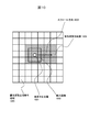
- FIG. 10 is a diagram showing an example of a map range in which the generation priority 51 and the analysis priority 41 are set in accordance with the procedure of FIG.
- FIG. 10 shows a mesh in the vicinity of the display center position 1001 among meshes divided in a grid shape at predetermined distance intervals in the latitude direction and the longitude direction in the map data 4.
- the upper, lower, left, and right directions correspond to the north, south, west, and east of the map, respectively.
- a display range 1002 indicated by a rectangular frame represents the display range of the map that the control unit 1 controls the display output unit 6 to display on the display unit 11.
- the center of the display range 1002 is the display center position 1001, which corresponds to, for example, the current position of the vehicle.
- the operation unit 10 is configured of a touch panel, and the user touches a position on the touch panel that is east of the display center position 1001, and instructs an eastward scroll.
- the control unit 1 determines from the relationship between the display center position 1001 and the touch position that the scroll direction 1003 is directed east, and starts scrolling of the map screen.
- the setting condition 202 is met, and the setting condition 202 is handled with reference to the priority setting range table shown in FIG.
- the range condition 402 is specified.
- each mesh not hatched in FIG. 10 corresponds to the priority setting non-target area 1005 in which the setting of the generation priority 51 and the analysis priority 41 is not performed.
- the control unit 1 sets each mesh of the priority setting range 1004 for each type of application information by referring to the cache data management table of FIG. 8 asynchronously to the operation performed by the user of the navigation system 20. Check the value of the generated generation priority 51. As a result, when the application information having a high value of the generation priority 51 is not generated, the application information generation process is performed. For example, in the example of the cache data management table of FIG. 8, the value of the generation priority 51 set for the application drawing information 52 is “B”, and the value of the generation priority 51 of other application information Is "C" or "D". Therefore, the drawing information for application 52 is generated with priority.
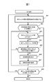
- FIG. 11 is a flowchart showing a generation procedure of analysis data 40 and cache data 50 according to the first embodiment of the present invention.
- the control unit 1 when performing the processing related to the navigation operation using the map data 4, the control unit 1 repeatedly executes the processing shown in the flowchart of FIG. 11 in parallel with the other processing. This process is performed on each mesh of the priority setting range 1004 illustrated in FIG. 10, that is, each mesh for which the analysis priority 41 and the generation priority 51 are set in the procedure illustrated in the flowchart of FIG. .
- the processing cycle of FIG. 11 may be constant or may be variable according to the processing load of the control unit 1 or the like.
- step 801 the control unit 1 selects any one of the unchecked generation priorities as the subsequent processing targets.
- the values of the generation priority 51 are selected in the descending order of priority from the unselected generation priorities as processing targets, that is, in the order of A, B, C, and D.
- step 801 when step 801 is executed first, “A” which is the value of the highest generation priority 51 is selected as a processing target. Thereafter, when the processing of step 802 and subsequent steps is executed for the generation priority “A”, “B” which is the value of the next highest generation priority 51 is selected as the processing target.
- the value of the generation priority to be selected as the processing target is lowered.
- step S802 the control unit 1 determines whether or not ungenerated application information corresponding to the generation priority selected in step S801 remains.
- the control unit 1 determines whether or not ungenerated application information corresponding to the generation priority selected in step S801 remains.
- the process proceeds to step 803. If there is not, the information for all applications corresponding to the selected generation priority has been generated. If yes, the process proceeds to step 806.
- step 803 the control unit 1 selects an analysis processing group linked to the ungenerated application information determined in step 802.
- one or more analysis results used to generate the application information are selected in the analysis data 40, and the analysis result
- One or more analysis processes corresponding to are selected as an analysis process group interlocked with ungenerated application information. For example, if it is determined in step 802 that the application drawing information 52 is not yet generated application information, then in step 803, the topography information analysis 211 and the road information analysis 212 are used as an analysis processing group linked to the application drawing information 52. select.
- step 804 the control unit 1 executes each analysis process included in the analysis process group selected in step 803 in descending order of analysis priority.
- analysis processing is performed in order from the one with the highest analysis priority 41 value.
- priority is given to analysis of the topographical information analysis result 42 corresponding to the topographical information analysis 211.
- the value of degree 41 is "C”
- the value of analysis priority 41 of road information analysis result 43 corresponding to road information analysis 212 is "A". Therefore, the road information analysis 212 is performed first, and then the topography information analysis 211 is performed.
- step 805 the control unit 1 generates, on the basis of each analysis result obtained by the analysis processing in step 804, the application information determined as ungenerated in step 802.
- the generated application information is stored as the cache data 50 in the temporary storage unit 2, and in the cache data management table of FIG. Rewrite to "generated".
- the analysis data 40 which has become unnecessary may be deleted from the temporary storage unit 2.
- step 806 the control unit 1 determines whether or not an unchecked generation priority remains. As a result, if there is an unchecked generation priority, the process returns to step 801, and if there is no check, that is, if all generation priorities have been checked, the process shown in the flowchart of FIG.
- the control unit 1 performs analysis processing in the order according to the value of the analysis priority 41 set in FIG. 7 as at least one type of map information and analysis target by the processing described above, and the obtained analysis result is obtained. Based on the application information, the application information is generated in the order according to the value of the generation priority 51 set in FIG. 7. Then, the generated application information is stored in the temporary storage unit 2 so that the processing related to the navigation operation can be performed using this.
- the value of the generation priority for the application spot information 54 in the setting condition 202 is set to be lower than the application drawing information 52. Therefore, when the setting condition 202 is satisfied, the application drawing information 52 can be generated more quickly by delaying the generation of the application point information 54. As a result, when the map screen is scrolled, the map drawing processing unit 102 can complete the drawing processing other than the icon first using the generated application drawing information 52. Therefore, it is possible to quickly present the map image of the scroll destination.
- the value of the generation priority for the application point information 54 in the setting condition 202 is set higher than the application road information 53 and the application guidance information 55. Therefore, when the setting condition 202 is satisfied, the application spot information 54 can be generated earlier than the application road information 53 and the application guidance information 55. As a result, when the map screen is scrolled, generation is performed after the drawing processing other than the icon is completed by the map drawing processing unit 102 prior to the operations of the route search processing unit 103 and the guidance guidance processing unit 104. The drawing process of the icon can be completed using the application point information 54 thus processed.
- FIG. 12 shows an example of a map screen displayed on the display unit 11 using the analysis data 40 and the cache data 50 generated by the generation procedure described in FIG.
- FIG. 12 shows map screens 900 and 910 as an example of the map screen in the case where the setting condition 202 is satisfied.
- the map screen 900 represents a map screen displayed immediately after the scroll
- the map screen 910 represents a map screen displayed after a certain amount of time has elapsed after the scroll.
- icons 911, 912 and 913 respectively indicating specific points on the map and point information 914 regarding the point indicated by the icon 911 are further displayed in comparison with the map screen 900.
- the point information 914 indicates the name and business hours of the store existing at the point indicated by the icon 911.
- these pieces of information are not displayed, and only the road shape and topography drawn using the application drawing information 52 generated preferentially are displayed.
- FIG. 12 shows the difference in display timing between the road shape and the terrain, point information, and icons when the map screen is scrolled
- the generation of the analysis data 40 and the cache data 50 described in FIG. The effect obtained by the procedure is not limited to this.
- the generation procedure of FIG. 11 according to various setting conditions set in advance, information with high priority can be provided first, and then information with relatively low priority can be provided. As a result, it is possible to reduce the time for making the user wait.
- the control unit 1 detects this based on the operation information from the operation input unit 5 and determines that the setting condition 203 is satisfied. Do. In this case, the control unit 1 uses the process of the action prediction processing unit 106 to calculate a mesh that matches the route searched in the past and a mesh that matches the route with high searchability. Then, for each mesh in the calculated range, the generation priority 51 and the analysis priority 41 are set by the processing of FIG. 7, and application information is generated according to the generation procedure of FIG. 11.
- the value of the generation priority 51 set for the setting condition 203 is information for application required at least for the route search processing unit 103 to perform a route search.
- the application road information 53 is the highest, and the application point information 54, which is application information highly likely to be required for route search, has the second highest priority.
- the control unit 1 determines that the setting condition 204 is satisfied at that time. Then, with reference to the calculated path information, generation priority 51 and analysis priority 41 are set for each mesh corresponding to the path by the processing of FIG. 7, and application information is set according to the generation procedure of FIG. Generate
- the value of the generation priority 51 set for the setting condition 204 is an application that is application information necessary for the guidance guidance processing unit 104 to perform guidance guidance
- the highest road information 53 and application guidance information 55 is the highest.
- generation priority is set for each of the application road information 53 and the application guidance information 55 as the mesh is closer to the position of the host vehicle.
- the value 51 may be set higher. In this way, it is also possible to generate necessary application information with priority given to meshes with earlier travel times of the host vehicle.
- the control unit 1 applies the setting condition 201 to a mesh having a radius of 1 or less from the display center according to the priority setting range table of FIG.
- the priority 51 and the analysis priority 41 are set, and the generation condition 51 and the analysis priority 41 are set by applying the setting condition 205 to the mesh connected to the road where the vehicle position is present. . Therefore, in the mesh that simultaneously satisfies these conditions, the setting condition 201 and the setting condition 205 are applied redundantly.
- the higher one of the set values of the generation priority 51 and the analysis priority 41 defined respectively for two setting conditions is set as the generation priority for the application information of the mesh.
- the value of degree 51 may be set as the value of analysis priority 41 for each analysis process.
- the setting value of the generation priority 51 for the drawing information for application 52 is “B” for the setting condition 201 and “ ⁇ ” (out of setting object) for the setting condition 205 And each is defined. Therefore, the higher value “B” can be set as the value of the generation priority 51 for the drawing information for application 52.
- “A” is for application road information 53
- "B” is for application spot information 54
- "D” is for application guidance information 55
- "A” is for application driving assistance information 56.
- And can be set as the value of each generation priority 51.
- the setting values of the analysis priority 41 for the topography information analysis 211 are respectively defined as “C” in the setting condition 201 and “C” in the setting condition 205. Therefore, “C” can be set as the value of the analysis priority 41 for the topography information analysis 211.
- the values of the generation priority 51 and the analysis priority 41 may be changed dynamically.
- the control unit 1 does not wait for the linking with the road ID of the road information 32, and some information held by the high accuracy map information 35.
- the road information 32 is analyzed to obtain the road information analysis result 43.
- the value of the analysis priority 41 for the road information analysis 212 and the high accuracy map information 35 are analyzed to obtain high accuracy map information
- the value of the analysis priority 41 for the high accuracy map information analysis 215 for obtaining the analysis result 46 is set according to the analysis priority table of FIG. 5. That is, since the road information analysis result 43 is normally highly available under the setting condition 205, the value of the analysis priority 41 for the road information analysis 212 is "A", and the analysis priority 41 for the high accuracy map information analysis 215 is The value is lower than that "B".
- the control unit 1 dynamically changes the value of the analysis priority 41, for example, the analysis priority for the road information analysis 212
- the value of degree 41 is "B”
- the value of analysis priority 41 for high precision map information analysis 215 is "A”.
- the value of the analysis priority 41 is dynamically changed.
- the value of the generation priority 51 may be dynamically changed.
- the type of application information or map information for dynamically changing the values of the generation priority 51 and the analysis priority 41 is not limited to a specific type, and can be arbitrarily applied.
- the navigation system 20 performs a navigation operation for guiding the vehicle, which is a moving object, using the map data 4 configured by a plurality of types of map information.
- the navigation system 20 includes an operation input unit 5 into which operation information according to the user's operation is input, a temporary storage unit 2 capable of temporarily storing information, and a plurality of types of application information based on map data 4.
- a control unit 1 that executes processing related to the navigation operation using the application information.
- the control unit 1 sets the analysis priority 41 for the analysis processing performed for each type of map information based on at least one of the operation information and the state of the navigation operation, and generates for each type of application information Priorities 51 are set (steps 602, 606, and 607 in FIG.
- the control unit 1 determines the map range in which the analysis priority 41 and the generation priority 51 are set based on at least one of the operation information and the state of the navigation operation (steps 602 and 605 in FIG. 7). Since it did in this way, the analysis priority 41 and the production
- the navigation system 20 further includes the map data input / output unit 3 for acquiring the map data 4.
- the map data input / output unit 3 acquires the map data 4 stored in the navigation system 20 as map data used for generating application information. Since it did in this way, required map data can be acquired in control part 1 certainly.
- Second Embodiment A second embodiment of the present invention will be described.
- the analysis target is selected according to the values of the generation priority 51 and the analysis priority 41 after the change.
- An example of a navigation system for changing the type of map information to be taken and the order of analysis processing will be described.
- the configuration of the navigation system according to the present embodiment is the same as that of the navigation system 20 of FIG. 1 described in the first embodiment. Further, the functional configuration of the control unit of the navigation system according to the present embodiment is also the same as the functional configuration of the control unit 1 of FIG. 2 described in the first embodiment. Furthermore, the method of setting the analysis priority 41 and the generation priority 51, and the method of determining the map range for setting the analysis priority 41 and the generation priority 51 are the same as in the first embodiment. Therefore, in the following, these descriptions will be omitted, and differences from the first embodiment will be mainly described.
- FIG. 13 is a flowchart showing a generation procedure of analysis data 40 and cache data 50 according to the second embodiment of the present invention. Also in the present embodiment, as described in the first embodiment, when the processing related to the navigation operation is performed using the map data 4, the control unit 1 performs the processing shown in FIG. The process shown in the flowchart of FIG. The processing cycle of FIG. 13 may be constant or may be variable according to the processing load of the control unit 1 or the like.
- Steps 1101 to 1103 perform the same processing as steps 801 to 803 in FIG. That is, in step 1101, the control unit 1 selects one of the unchecked generation priorities in order from the one with the highest generation priority as the subsequent processing target. In step 1102, the control unit 1 determines whether or not there is any ungenerated application information corresponding to the generation priority selected in step 1101. If there is the corresponding application information, the process proceeds to step 1103. If it does not exist, the process proceeds to step 1109. In step 1103, the control unit 1 selects an analysis processing group linked to the ungenerated application information determined in step 1102. For example, if it is determined in step 1102 that the application drawing information 52 is not yet generated application information, then in step 1103 the topography information analysis 211 and the road information analysis 212 are used as analysis processing groups linked to the application drawing information 52. select.
- the control unit 1 selects an unanalyzed analysis process having the highest analysis priority value among the analysis processes included in the analysis process group selected in step 1103.
- the one with the highest value of the analysis priority 41 is selected.
- the analysis priority of the topographic information analysis result 42 corresponding to the topographic information analysis 211 is given.
- the value of degree 41 is "C”
- the value of analysis priority 41 of road information analysis result 43 corresponding to road information analysis 212 is "A”. Therefore, if the road information analysis 212 has not been performed, the control unit 1 selects this first.
- control unit 1 performs the analysis process selected at step 1104.
- the analysis result is stored as the analysis data 40 in the temporary storage unit 2
- the analysis state 702 in the analysis process is rewritten from “unsolved” to “solved”, and the process proceeds to step 1106. Advance.
- step 1106 the control unit 1 determines whether at least one of the analysis priority 41 and the generation priority 51 has been updated.
- at least one of the generation priority 51 and the analysis priority 41 is updated after the process of FIG. 13 is started. It is determined whether or not it is.
- the process shown in the flowchart of FIG. 13 is temporarily ended, and the setting values of the analysis priority 41 and the generation priority 51 after the update are used to start from step 1101.
- step 1107 the control unit 1 determines whether all analysis processes included in the analysis process group selected in step 1103 have been completed. If there is an unexecuted analysis process, the process returns to step 1104 to continue the analysis process, and when all the analysis processes have been executed, the process proceeds to step 1108.
- step 1108 the control unit 1 generates the application information determined as ungenerated in step 1102 based on each analysis result obtained by the analysis processing in step 1105.
- the generated application information is stored as the cache data 50 in the temporary storage unit 2, and in the cache data management table of FIG. Rewrite to "generated".
- the analysis data 40 which has become unnecessary may be deleted from the temporary storage unit 2.
- step 1109 the control unit 1 determines whether or not there is an unchecked generation priority. As a result, if there is an unchecked generation priority, the process returns to step 1101. If not, ie, if all generation priorities have been checked, the process shown in the flowchart of FIG. 13 is ended.
- the control unit 1 performs the analysis processing in the order according to the value of the analysis priority 41 set in FIG. 7 as at least one type of map information and the analysis target, as in the first embodiment, by the processing described above.
- the application information is generated in the order according to the value of the generation priority 51 set in FIG. 7 based on the analysis result obtained. Then, the generated application information is stored in the temporary storage unit 2 so that the processing related to the navigation operation can be performed using this. Also, when the values of the generation priority 51 and the analysis priority 41 are changed during generation of the application information, the map to be analyzed according to the values of the generation priority 51 and the analysis priority 41 after the change. Change the type of information and the order of analysis processing, and redo the generation of application information.
- the setting condition 205 is applied and the values of the generation priority 51 and the analysis priority 41 are applied.
- the application information to be generated for the application drawing information 52 based on the value of the generation priority 51 set according to the generation priority table of FIG. Selected as Then, in order to generate the drawing information for application 52, the road information analysis 212 is preferentially executed based on the value of the analysis priority 41 set in accordance with the analysis priority table of FIG.
- the setting condition 205 is applied and the values of the generation priority 51 and the analysis priority 41 are changed while the road information analysis 212 is completed and the road information analysis result 43 is obtained.
- the set values of the generation priority 51 for the application road information 53 and the application driving support information 56 are changed to “A” according to the generation priority table of FIG. 4.
- the set value of analysis priority 41 for road information analysis 212 is “A”
- the set value of analysis priority 41 for icon information analysis 213 and high precision map information analysis 215 is “ "B” is changed respectively.
- the application road information 53 is selected as the application information to be generated, and the road information analysis 212 is first It is selected as an analysis process to be performed.
- the road information analysis 212 has already been executed under the setting condition 201 before the change, and the road information analysis result 43 has already been obtained, so the road information analysis 212 is skipped without being executed, Icon information analysis 213 and high precision map information analysis 215 can be started. Therefore, the processing can be speeded up.
- the control unit 1 responds to the changed generation priority.
- the type of map information to be analyzed is changed (steps 1101 and 1103).
- the order of analysis processing is changed according to the changed analysis priority (steps 1104 and 1105). Since this is done, even while the application information is being generated, the application information to be preferentially generated can be dynamically changed according to the situation.
- the type of the application information to be generated is changed, the result of the analysis processing already performed can be used, so that the reference time of the map data 4 can be reduced to speed up the processing.
- FIG. 14 is a block diagram of a navigation system according to a third embodiment of the present invention.
- the navigation system 22 shown in FIG. 14 does not have the map data 4 built-in, and instead the map management information 15 and the communication unit 16 Have.
- the map management information 15 and the communication unit 16 are connected to the map data input / output unit 3 respectively.
- differences from the navigation system 20 of FIG. 1 will be mainly described.
- the map data input / output unit 3 has a function of controlling the communication unit 16 to acquire map data from the map data server 23 which is an external information device.
- the map management information 15 is information necessary for acquiring map data from the map data server 23, and is, for example, address information on the network of the map data server 23. In addition, it is also possible to hold
- the communication unit 16 has a communication function with the network 17.
- the communication unit 16 can communicate with the map data server 23 via the network 17 to acquire map data.
- the network 17 is a network in which various information devices including the navigation system 22 and the map data server 23 can communicate with each other.
- the network 17 is, for example, the Internet.
- the map data server 23 includes a server communication unit 18, a map data management unit 19, and server map data 21. Similar to the communication unit 16, the server communication unit 18 has a communication function with the network 17, and is configured using, for example, a communication adapter device or the like.
- the map data management unit 19 manages the operation of the map data server 23, and is configured using, for example, a CPU controlled by software.
- the server map data 21 is map data including various map information necessary for the navigation operation performed by the navigation system 22, and corresponds to the map data 4 in FIG.
- the server map data 21 is preferably designed on the premise that it is distributed to one or more navigation systems 22. For example, fixed map data may always be held as the server map data 21 or the contents of the server map data 21 may be updated as needed based on the latest road information, traffic information and the like.
- the control unit 1 of the navigation system 22 instructs the map data input / output unit 3 to provide map information to be analyzed.
- necessary map information may be designated in mesh units, or may be individually designated using information such as coordinates serving as a key.
- the map data input / output unit 3 refers to the map management information 15 to acquire the address of the map data server 23, controls the communication unit 16, and is instructed The map data server 23 is requested to provide map information via the network 17.
- the map data server 23 receives a request for providing map information transmitted from the navigation system 22 by the server communication unit 18 and transmits the request to the map data management unit 19.
- the map data management unit 19 having received this acquires map data including map information corresponding to the contents of the request from the server map data 21. Then, as a response to the navigation system 22, the acquired map data is returned from the server communication unit 18 to the navigation system 22 via the network 17.
- the response from the map data server 23 is received by the communication unit 16 in the navigation system 22.
- the map data input / output unit 3 returns map data of a response received by the communication unit 16 as map data in response to a provision request from the control unit 1.
- the control unit 1 of the navigation system 22 does not have to be aware of whether the map data is local or on the server when acquiring necessary map data. Therefore, the application information can be generated according to the same procedure as described in the first embodiment and the second embodiment.
- the navigation system 22 includes the map data input / output unit 3 that acquires map data.
- the map data input / output unit 3 acquires server map data 21 stored in the map data server 23 connected to the navigation system 22 via the network 17 as map data used to generate application information. Since it did in this way, while being able to acquire necessary map data certainly in control part 1, server map data 21 is updated as needed, and a navigation function using the latest map data is provided to a user by navigation system 22. It will be possible to
Abstract
This navigation system comprises: an operation input unit to which operation information corresponding to an operation of a user is inputted; a temporary storage unit that can store information temporarily; and a control unit that generates a plurality of types of application information on the basis of map data, and uses the application information to perform processing relating to a navigation action, wherein on the basis of the operation information and/or the state of the navigation action, the control unit sets an analysis priority level for analysis processing that is performed for each type of map information and sets a generation priority level for each type of application information, targets for analysis at least one type of map information among a plurality of types of map information, performs the analysis processing in an order corresponding to the analysis priority levels, generates the application information in an order corresponding to the generation priority levels and on the basis of the analysis processing results obtained for each item of map information that was targeted for analysis, saves the generated application information in the temporary storage unit, and uses the application information saved in the temporary storage unit to perform processing relating the navigation action.
Description
本発明は、ナビゲーションシステムおよびナビゲーション方法に関する。
The present invention relates to a navigation system and a navigation method.
地図データを用いて地図を提示し、移動経路の案内を行うナビゲーションシステムが広く利用されている。こうしたナビゲーションシステムでは、地図のスクロール操作や縮尺変更操作などの際に、地図の描画を高速に行うことが求められる。
A navigation system is widely used which presents a map using map data and provides guidance of a movement route. Such a navigation system is required to draw the map at high speed when the map is scrolled or scaled.
地図描画の高速化に関して、特許文献1に記載の技術が知られている。特許文献1には、地図データベース、操作受付手段、地図データ取得手段、地図データキャッシュ手段および地図描画手段を備えた地図表示装置が開示されている。地図データ取得手段は、操作受付手段により地図のスクロール操作が受け付けられた場合、地図データベースにより記憶されている地図データの中から、現在表示中の地図より広範囲の地図の描画が可能な地図データであって、現在表示中の地図の描画に用いられている地図データと縮尺が同一の地図データを取得する。一方、操作受付手段により地図のスクロール操作が受け付けられていない場合、地図データベースにより記憶されている地図データの中から、現在表示中の地図と同一範囲の地図の描画が可能な地図データであって、現在表示中の地図の描画に用いられている地図データと縮尺が異なる複数の地図データを取得する。地図データキャッシュ手段は、地図データ取得手段により取得された地図データを内部メモリに格納する。地図描画手段は、内部メモリに格納されている地図データを用いて、地図を描画する。
The technology described in Patent Document 1 is known for speeding up map drawing. Patent Document 1 discloses a map display device provided with a map database, an operation receiving means, a map data acquisition means, a map data cache means and a map drawing means. The map data acquisition means is map data capable of drawing a map in a wider range than the map currently displayed among the map data stored in the map database when the scroll operation of the map is accepted by the operation accepting means. Then, the map data having the same scale as the map data used for drawing the currently displayed map is acquired. On the other hand, when the scroll operation of the map is not accepted by the operation accepting means, it is map data capable of drawing a map in the same range as the map currently displayed among map data stored in the map database. A plurality of map data different in scale from the map data used for drawing the currently displayed map is acquired. The map data cache means stores the map data acquired by the map data acquisition means in the internal memory. The map drawing means draws a map using map data stored in the internal memory.
一般にナビゲーションシステムは、地図データを地図の描画以外の目的にも利用している。そのため、地図データの参照を高速に行うことでナビゲーションシステムの性能を向上させることができる。しかしながら、特許文献1に記載の技術では、地図データのうち地図の描画に関するデータのみを対象として、取得する地図データの範囲をスクロール操作の状態に応じて決定することで、地図描画を高速化している。したがって、地図の描画に関しない地図データについては、地図データの参照を高速に行うことが考慮されていなかった。経路探索用のためには地図の描画に関係しない道路のリンクデータのような地図データの参照も多く行う必要があるが、地図描画を高速に行うための手法では、経路探索用の地図データの参照を高速に行うことが考慮されていないため、経路探索の高速化には寄与しなかった。本発明では特定の地図データ種別に限らない地図データの参照の高速化を課題とする。
Navigation systems generally use map data for purposes other than drawing maps. Therefore, the performance of the navigation system can be improved by referring to map data at high speed. However, in the technology described in Patent Document 1, the map drawing is speeded up by determining the range of the map data to be acquired according to the state of the scroll operation, targeting only the data related to the drawing of the map among the map data. There is. Therefore, with regard to map data that is not related to map drawing, high speed reference to map data has not been considered. Although it is necessary to refer to map data such as road link data not related to map drawing in many ways for route search, in the method for performing map drawing at high speed, map data for route search is used. It did not contribute to the speeding up of the route search because it was not considered to perform the reference at high speed. An object of the present invention is to speed up reference to map data not limited to a specific map data type.
本発明によるナビゲーションシステムは、複数種類の地図情報により構成される地図データを用いて移動体を案内するためのナビゲーション動作を行うものであって、使用者の操作に応じた操作情報が入力される操作入力部と、情報を一時的に記憶可能な一時記憶部と、前記地図データに基づいて複数種類のアプリ用情報を生成し、前記アプリ用情報を用いて前記ナビゲーション動作に関する処理を実行する制御部と、を備え、前記制御部は、前記操作情報および前記ナビゲーション動作の状態の少なくとも一つに基づいて、前記地図情報の種類ごとに行われる解析処理に対して解析優先度を設定すると共に、前記アプリ用情報の種類ごとに生成優先度を設定し、複数種類の前記地図情報のうち少なくとも一種類の地図情報を解析対象として、前記解析優先度に応じた順番で前記解析処理を行い、前記解析対象の地図情報に対してそれぞれ得られた前記解析処理の結果に基づいて、前記生成優先度に応じた順番で前記アプリ用情報を生成し、生成した前記アプリ用情報を前記一時記憶部に保存し、前記一時記憶部に保存された前記アプリ用情報を用いて前記ナビゲーション動作に関する処理を実行する。
本発明によるナビゲーション方法は、複数種類の地図情報により構成される地図データを用いて移動体を案内するためのナビゲーション動作を行うものであって、前記ナビゲーション動作の提供を受ける使用者の操作に応じた操作情報および前記ナビゲーション動作の状態の少なくとも一つに基づいて、前記地図情報の種類ごとにコンピュータが行う解析処理に対して解析優先度を設定すると共に、前記コンピュータが前記ナビゲーション動作に関する処理の実行に用いるアプリ用情報の種類ごとに生成優先度を設定し、複数種類の前記地図情報のうち少なくとも一種類の地図情報を解析対象として、前記コンピュータが前記解析優先度に応じた順番で前記解析処理を行い、前記解析対象の地図情報に対してそれぞれ得られた前記解析処理の結果に基づいて、前記コンピュータが前記生成優先度に応じた順番で前記アプリ用情報を生成し、生成した前記アプリ用情報を一時的に保存し、一時的に保存された前記アプリ用情報を用いて、前記コンピュータが前記ナビゲーション動作に関する処理を実行する。 A navigation system according to the present invention performs a navigation operation for guiding a mobile using map data composed of a plurality of types of map information, and operation information corresponding to the user's operation is input. Control for generating a plurality of types of application information based on the operation input unit, a temporary storage unit capable of temporarily storing information, and the map data, and performing processing related to the navigation operation using the application information The control unit sets an analysis priority for analysis processing performed for each type of the map information based on at least one of the operation information and the state of the navigation operation. A generation priority is set for each type of the application information, and at least one type of map information among a plurality of types of map information is analyzed. The analysis processing is performed in the order according to the analysis priority, and the application information in the order according to the generation priority based on the result of the analysis obtained for each of the analysis target map information Are generated in the temporary storage unit, and the process related to the navigation operation is executed using the application information stored in the temporary storage unit.
A navigation method according to the present invention performs a navigation operation for guiding a mobile using map data composed of a plurality of types of map information, and according to an operation of a user who receives the provision of the navigation operation. Analysis priority set for analysis processing performed by the computer for each type of map information based on at least one of the operation information and the state of the navigation operation, and the computer executes the processing relating to the navigation operation The generation priority is set for each type of application information used for the analysis, and at least one type of map information among the plurality of types of map information is analyzed, and the computer performs the analysis processing in the order according to the analysis priority. Of the analysis process obtained for each piece of map information to be analyzed. Based on the result, the computer generates the application information in the order according to the generation priority, temporarily stores the generated application information, and uses the temporarily stored information for application Then, the computer executes processing relating to the navigation operation.
本発明によれば、ナビゲーションシステムにおいて地図データの参照を高速に行うことが可能になる。
上記以外の課題、構成および効果は、以下の実施形態の説明により明らかにされる。 According to the present invention, it is possible to refer map data at high speed in a navigation system.
Problems, configurations, and effects other than the above are clarified by the following description of the embodiments.
上記以外の課題、構成および効果は、以下の実施形態の説明により明らかにされる。 According to the present invention, it is possible to refer map data at high speed in a navigation system.
Problems, configurations, and effects other than the above are clarified by the following description of the embodiments.
以下、本発明の実施形態を図面を用いて説明する。
Hereinafter, embodiments of the present invention will be described with reference to the drawings.
(第1の実施形態)
図1は、本発明の第1の実施形態に係るナビゲーションシステムの構成図である。図1に示すナビゲーションシステム20は、移動体である車両に搭載されて使用され、当該車両を目的地に向けて案内するためのナビゲーション動作を行うものである。なお、以下の説明では、ナビゲーションシステム20が搭載されている車両を「自車両」と称する。ナビゲーションシステム20は、制御部1、一時記憶部2、地図データ入出力部3、地図データ4、操作入力部5、表示出力部6、記憶装置7、運転補助情報入出力部8、およびセンサ情報入力部9を備えており、操作部10、表示部11、センサ12および車両ネットワーク13と接続されている。 First Embodiment
FIG. 1 is a block diagram of a navigation system according to a first embodiment of the present invention. Thenavigation system 20 shown in FIG. 1 is mounted and used in a vehicle which is a moving body, and performs a navigation operation for guiding the vehicle toward a destination. In the following description, a vehicle on which the navigation system 20 is mounted is referred to as "own vehicle". The navigation system 20 includes a control unit 1, a temporary storage unit 2, a map data input / output unit 3, a map data 4, an operation input unit 5, a display output unit 6, a storage unit 7, a driving assistance information input / output unit 8, and sensor information An input unit 9 is provided, and is connected to the operation unit 10, the display unit 11, the sensor 12, and the vehicle network 13.
図1は、本発明の第1の実施形態に係るナビゲーションシステムの構成図である。図1に示すナビゲーションシステム20は、移動体である車両に搭載されて使用され、当該車両を目的地に向けて案内するためのナビゲーション動作を行うものである。なお、以下の説明では、ナビゲーションシステム20が搭載されている車両を「自車両」と称する。ナビゲーションシステム20は、制御部1、一時記憶部2、地図データ入出力部3、地図データ4、操作入力部5、表示出力部6、記憶装置7、運転補助情報入出力部8、およびセンサ情報入力部9を備えており、操作部10、表示部11、センサ12および車両ネットワーク13と接続されている。 First Embodiment
FIG. 1 is a block diagram of a navigation system according to a first embodiment of the present invention. The
制御部1は、記憶装置7に記憶されている各種プログラムを実行することで、ナビゲーション動作に関する処理を実行すると共に、ナビゲーションシステム20の各部分の制御を行うマイクロコンピュータである。制御部1は、例えばCPUなどのプロセッサを用いて構成される。
The control unit 1 is a microcomputer that executes various programs stored in the storage device 7 to execute processing related to the navigation operation and controls each part of the navigation system 20. The control unit 1 is configured using, for example, a processor such as a CPU.
一時記憶部2は、高速に読み書きが可能なデジタル情報を保存可能な領域であり、制御部1が処理を行う際の作業領域として利用される。一時記憶部2は、例えばRAMなどのメモリを用いて構成される。
The temporary storage unit 2 is an area capable of storing digital information that can be read and written at high speed, and is used as a work area when the control unit 1 performs processing. The temporary storage unit 2 is configured using, for example, a memory such as a RAM.
地図データ入出力部3は、制御部1の制御により、地図データ4から必要な分のデータを読み込んで取得し、制御部1に出力する。地図データ4は、複数種類の地図情報、例えば地形情報や道路情報等によって構成されており、フラッシュメモリ、ハードディスク、メモリカード等の不揮発性メモリに記録されている。すなわち、地図データ入出力部3は、不揮発性メモリの読み書きを行うインタフェース装置である。
The map data input / output unit 3 reads and acquires necessary data from the map data 4 under the control of the control unit 1 and outputs the data to the control unit 1. The map data 4 is composed of a plurality of types of map information, such as terrain information, road information, etc., and is recorded in a non-volatile memory such as a flash memory, a hard disk, a memory card or the like. That is, the map data input / output unit 3 is an interface device that reads and writes non-volatile memory.
なお、地図データ4に格納される複数種類の地図情報は、緯度方向および経度方向で所定の距離間隔ごとに細かく分割された矩形のメッシュ単位のデータ集合と、住所や座標をキーにしたデータ列とによってそれぞれ構成される。地図の縮尺に応じて異なる情報を表現するために、メッシュの分割数は縮尺に応じて異なっている。
A plurality of types of map information stored in the map data 4 is a data set of rectangular mesh units finely divided at predetermined distance intervals in the latitude direction and the longitude direction, and a data sequence using an address and coordinates as keys And each one. In order to express different information according to the scale of the map, the number of divisions of the mesh differs according to the scale.
操作部10は、ナビゲーションシステム20の使用者である自車両の乗員が行った操作を検知し、その操作内容に応じた操作情報をナビゲーションシステム20に出力する。操作部10は、例えばタッチパネル、ボタン、マウス、キーボード等により構成される。操作部10から出力された操作情報は、ナビゲーションシステム20において操作入力部5に入力され、制御部1に伝達される。すなわち、操作入力部5は、制御部1と操作部10の間で情報の入出力を行うインタフェースである。例えば操作部10がタッチパネルである場合、使用者の指の動作をタッチパネルが検知し、電気信号として出力する。この電気信号を受信する回路が操作入力部5に相当する。
The operation unit 10 detects an operation performed by an occupant of the own vehicle who is a user of the navigation system 20, and outputs operation information according to the content of the operation to the navigation system 20. The operation unit 10 includes, for example, a touch panel, a button, a mouse, a keyboard, and the like. The operation information output from the operation unit 10 is input to the operation input unit 5 in the navigation system 20 and transmitted to the control unit 1. That is, the operation input unit 5 is an interface that inputs and outputs information between the control unit 1 and the operation unit 10. For example, when the operation unit 10 is a touch panel, the touch panel detects the operation of the user's finger and outputs the detected signal as an electric signal. The circuit that receives the electrical signal corresponds to the operation input unit 5.
表示部11は、表示出力部6から出力された映像信号を受信して画面表示することで、ナビゲーションシステム20の使用者に対して、例えば地図画像などのナビゲーション動作に必要な情報提示を行う。表示部11は、例えば液晶ディスプレイにより構成される。表示出力部6は、制御部1から出力された映像情報に基づいて映像信号を生成し、表示部11に出力する。すなわち、表示出力部6は、制御部1と表示部11の間で情報の入出力を行うインタフェースであり、映像信号生成のための回路に相当する。なお、表示部11をタッチパネルとすることで、表示部11と操作部10を一体化してもよい。
The display unit 11 receives the video signal output from the display output unit 6 and displays it on the screen to present information necessary for the navigation operation such as a map image to the user of the navigation system 20, for example. The display unit 11 is configured of, for example, a liquid crystal display. The display output unit 6 generates a video signal based on the video information output from the control unit 1 and outputs the video signal to the display unit 11. That is, the display output unit 6 is an interface that inputs and outputs information between the control unit 1 and the display unit 11, and corresponds to a circuit for generating a video signal. The display unit 11 and the operation unit 10 may be integrated by using the display unit 11 as a touch panel.
記憶装置7は、制御部1において実行されることでナビゲーション動作に関する処理を実現するプログラムや、そのプログラムの実行時に用いられる各種データを記録する不揮発性の記憶媒体である。記憶装置7は、例えばフラッシュメモリ、ハードディスク、メモリカードなどの不揮発メモリを用いて構成される。
The storage device 7 is a non-volatile storage medium that records a program that implements processing related to a navigation operation by being executed by the control unit 1 and various data used when the program is executed. The storage device 7 is configured using, for example, a non-volatile memory such as a flash memory, a hard disk, or a memory card.
車両制御部14は、運転者の運転操作や各種センサの検出情報に基づいて、自車両の走行制御を行う。車両制御部14は、自車両内に設けられた車両ネットワーク13を介してナビゲーションシステム20と接続されている。運転補助情報入出力部8は、制御部1の制御により、車両制御部14に対して、車両ネットワーク13を介して運転に関わる情報を送受信する。すなわち、運転補助情報入出力部8は、制御部1と車両制御部14の間で情報の入出力を行うインタフェースである。例えば、車両制御部14がステアリング操作、アクセル操作、ブレーキ操作等を補助するための制御や自動運転制御を行う場合、運転補助情報入出力部8は、自車両の位置情報や地図データ4から取得した道路情報などを車両制御部14に出力する。また、例えば車両制御部14から車速情報、車内の空調装置の動作情報、車外カメラで取得した映像情報などが提供される場合、運転補助情報入出力部8は、これらの情報を車両ネットワーク13を介して車両制御部14から受信し、制御部1に出力する。なお、運転補助情報入出力部8は、制御部1と同一のプロセッサの機能として実現されてもよいし、あるいは、自車両の運転に関する重要な情報を出力する場合などは、耐故障性を担保するために、制御部1から独立したプロセッサとして実現されてもよい。
The vehicle control unit 14 performs travel control of the host vehicle based on the driver's driving operation and detection information of various sensors. The vehicle control unit 14 is connected to the navigation system 20 via a vehicle network 13 provided in the host vehicle. Under the control of the control unit 1, the driving assistance information input / output unit 8 transmits / receives information related to driving to the vehicle control unit 14 via the vehicle network 13. That is, the driving assistance information input / output unit 8 is an interface for inputting / outputting information between the control unit 1 and the vehicle control unit 14. For example, when the vehicle control unit 14 performs control for assisting a steering operation, an accelerator operation, a brake operation, or the like or automatic driving control, the driving assistance information input / output unit 8 is acquired from position information of the host vehicle or the map data 4 The output road information and the like are output to the vehicle control unit 14. Further, for example, when the vehicle control unit 14 provides the vehicle speed information, the operation information of the air conditioner in the vehicle, the video information acquired by the camera outside the vehicle, etc., the driving assistance information input / output unit 8 It is received from the vehicle control unit 14 via the link control unit 14 and is output to the control unit 1. In addition, the driving assistance information input / output unit 8 may be realized as a function of the same processor as the control unit 1 or, in the case of outputting important information related to the driving of the own vehicle, secure fault tolerance. For this purpose, the processor may be realized as a processor independent of the control unit 1.
センサ12は、ナビゲーション動作に必要な各種のセンサ情報を検出し、ナビゲーションシステム20に提供する。センサ12は、例えば全球測位衛星システムの受信アンテナ等を用いて実現される位置センサや、加速度センサ、ジャイロセンサ、障害物センサなどにより構成される。センサ12から出力されたセンサ情報は、ナビゲーションシステム20においてセンサ情報入力部9に入力され、制御部1に伝達される。すなわち、センサ情報入力部9は、制御部1とセンサ12の間でセンサ情報の入出力を行うインタフェースである。
The sensor 12 detects various sensor information required for the navigation operation and provides the navigation system 20 with the sensor information. The sensor 12 is configured of, for example, a position sensor realized using a reception antenna of a global positioning satellite system or the like, an acceleration sensor, a gyro sensor, an obstacle sensor, or the like. The sensor information output from the sensor 12 is input to the sensor information input unit 9 in the navigation system 20 and transmitted to the control unit 1. That is, the sensor information input unit 9 is an interface that inputs and outputs sensor information between the control unit 1 and the sensor 12.
図2は、制御部1の機能構成の例を示す図である。図2に示すように、制御部1は、その機能として、表示処理部101、地図描画処理部102、経路探索処理部103、誘導案内処理部104、運転補助処理部105、行動予測処理部106、操作入力処理部107、位置情報管理部108、アプリケーションデータ管理部109、および地図データ管理部110の各部を有する。これらの各機能は、制御部1が実行するソフトウェアのモジュール(以降では、アプリケーションまたはアプリと呼称する)として実現される。
各アプリは実現方法によっては複数の機能が統合されたアプリの組み合わせとして実現されてもよい。以降の説明において制御部1が機能の実現のために内部で利用しているアプリを例示しているが、アプリの構成方法を制約するものではない。 FIG. 2 is a diagram showing an example of a functional configuration of thecontrol unit 1. As shown in FIG. 2, the control unit 1 has a display processing unit 101, a map drawing processing unit 102, a route search processing unit 103, a guidance guidance processing unit 104, a driving assistance processing unit 105, and an action prediction processing unit 106 as its functions. And an operation input processing unit 107, a position information management unit 108, an application data management unit 109, and a map data management unit 110. Each of these functions is realized as a module of software executed by the control unit 1 (hereinafter referred to as an application or an application).
Each application may be realized as a combination of applications in which a plurality of functions are integrated depending on the realization method. Although the application which thecontrol part 1 uses internally for implementation of a function is illustrated in subsequent description, the configuration method of an application is not restrict | limited.
各アプリは実現方法によっては複数の機能が統合されたアプリの組み合わせとして実現されてもよい。以降の説明において制御部1が機能の実現のために内部で利用しているアプリを例示しているが、アプリの構成方法を制約するものではない。 FIG. 2 is a diagram showing an example of a functional configuration of the
Each application may be realized as a combination of applications in which a plurality of functions are integrated depending on the realization method. Although the application which the
表示処理部101は、他のアプリの処理結果を参照して映像情報を生成し、生成した映像情報を表示出力部6へ送る処理を行う。
The display processing unit 101 generates video information with reference to processing results of other applications, and performs processing of sending the generated video information to the display output unit 6.
地図描画処理部102は、地図データ入出力部3から送られた地図データに基づいて地図を描画し、表示処理部101へ送る処理を行う。
The map drawing processing unit 102 draws a map based on the map data sent from the map data input / output unit 3 and performs processing of sending the map to the display processing unit 101.
経路探索処理部103は、地図データ入出力部3から送られた地図データを参照して、自車両が指定された目的地へ到達するための経路を算出する処理を行う。
The route search processing unit 103 performs processing for calculating a route for the host vehicle to reach the designated destination with reference to the map data sent from the map data input / output unit 3.
誘導案内処理部104は、経路探索処理部103で算出した経路の情報や、位置情報管理部108で管理している自車両の現在位置情報に基づいて、自車両を経路に従って目的地まで案内するための誘導案内情報を作成する処理を行う。誘導案内処理部104は、例えば、地図データ入出力部3から送られてアプリケーションデータ管理部109で管理されている地図データや、行動予測処理部106が保持する自車両の進行方向の予測情報などを利用して、自車両の走行先にある道路、建物、交通状態などを運転者に伝えるための情報を、誘導案内情報として作成する。誘導案内処理部104が作成した誘導案内情報は、表示処理部101へ送られる。
The guidance processing unit 104 guides the vehicle to the destination along the route based on the information of the route calculated by the route search processing unit 103 and the current position information of the vehicle managed by the position information management unit 108. It performs processing to create guidance guidance information. The guidance information processing unit 104 is, for example, map data sent from the map data input / output unit 3 and managed by the application data management unit 109, prediction information of the traveling direction of the own vehicle held by the action prediction processing unit 106, etc. Using the above information, information for conveying to a driver a road, a building, a traffic condition, and the like in which the host vehicle is traveling is created as guidance information. The guidance information created by the guidance processing unit 104 is sent to the display processing unit 101.
運転補助処理部105は、経路探索処理部103が算出した経路の情報や、地図データ入出力部3から送られてアプリケーションデータ管理部109で管理されている地図データを参照して、車両制御部14の動作に必要な運転補助情報を生成する。運転補助処理部105が生成した運転補助情報は、運転補助情報入出力部8へ送られる。
The driving assistance processing unit 105 refers to the information of the route calculated by the route search processing unit 103 and the map data sent from the map data input / output unit 3 and managed by the application data management unit 109 to control the vehicle control unit. The driving assistance information necessary for the operation of 14 is generated. The driving assistance information generated by the driving assistance processing unit 105 is sent to the driving assistance information input / output unit 8.
行動予測処理部106は、運転者の過去の運転履歴情報を利用して、自車両の進行方向や目的地などを予測する処理を行う。
The action prediction processing unit 106 performs processing of predicting the traveling direction, the destination, and the like of the host vehicle using the driver's past driving history information.
操作入力処理部107は、操作入力部5で受信した操作情報を解析することで、使用者の操作内容を判断し、その操作内容に応じて、他のアプリの処理を開始または停止する処理を行う。
The operation input processing unit 107 analyzes the operation information received by the operation input unit 5 to determine the operation content of the user, and according to the operation content, starts or stops processing of another application. Do.
位置情報管理部108は、センサ情報入力部9で取得した情報を元に、自車両の現在位置、進行方向、走行速度などを算出する。
The position information management unit 108 calculates the current position, the traveling direction, the traveling speed, and the like of the own vehicle based on the information acquired by the sensor information input unit 9.
アプリケーションデータ管理部109は、他の各アプリが必要とする情報を管理するための処理を行う。
The application data management unit 109 performs processing for managing information required by each of the other applications.
地図データ管理部110は、地図データ入出力部3から送られた地図データを管理するための処理を行う。
The map data management unit 110 performs processing for managing the map data sent from the map data input / output unit 3.
なお、地図データ管理部110は、地図データ入出力部3から送られた地図データに含まれる各種の地図情報を解析し、その解析結果に基づいて、各アプリの処理に用いられるアプリ用情報を生成する。そして、アプリケーションデータ管理部109は、地図データ管理部110が生成したアプリ用情報を管理し、必要に応じて各アプリに提供する。以下では、この処理の詳細について説明する。
The map data management unit 110 analyzes various types of map information included in the map data sent from the map data input / output unit 3, and based on the analysis result, the application information to be used for the processing of each application Generate Then, the application data management unit 109 manages the application information generated by the map data management unit 110, and provides the information to each application as needed. The details of this process will be described below.
図3は、地図情報の解析結果とアプリ用情報との関係の一例を示す図である。図3に示すように、制御部1は、地図データ管理部110の処理により、地図データ4の解析を行い、その解析結果に応じた解析データ40を生成する。そして、解析データ40から各アプリが必要とする情報を抽出することでアプリ用情報を生成し、キャッシュデータ50として一時記憶部2に保存し、アプリケーションデータ管理部109がアプリ用情報を管理する。
FIG. 3 is a diagram showing an example of the relationship between the analysis result of the map information and the application information. As shown in FIG. 3, the control unit 1 analyzes the map data 4 by the processing of the map data management unit 110, and generates analysis data 40 according to the analysis result. Then, application information is generated by extracting information required by each application from the analysis data 40, and is stored as the cache data 50 in the temporary storage unit 2, and the application data management unit 109 manages the application information.
地図データ4は、地形情報31、道路情報32、アイコン情報33、地点情報34、および高精度地図情報35の各地図情報を含む。地形情報31は、建物の形状や地形の形状を示す座標点データである。道路情報32は、道路のトポロジー、道路の形状、道路の長さなどの特徴に関する情報である。アイコン情報33は、建物などの目標物に関するアイコンを示す情報であり、座標情報をキーとして格納されている。地点情報34は、建物や場所に関する住所や特徴に関する情報であり、座標情報をキーとして格納されている。これには、例えば料金所の情報なども含まれる。高精度地図情報35は、道路情報32よりも精度の高い道路の形状を表す情報である。これらの地図情報は、地図データ4においてメッシュ単位でそれぞれ格納されている。なお、他の地図情報を地図データ4が含んでいてもよい。
The map data 4 includes map information of terrain information 31, road information 32, icon information 33, point information 34, and high accuracy map information 35. The terrain information 31 is coordinate point data indicating the shape of a building or the shape of the terrain. The road information 32 is information on features such as the topology of the road, the shape of the road, and the length of the road. The icon information 33 is information indicating an icon related to a target such as a building, and is stored using coordinate information as a key. The point information 34 is information on an address or feature related to a building or a place, and is stored using coordinate information as a key. This includes, for example, toll booth information and the like. The high accuracy map information 35 is information representing the shape of the road with higher accuracy than the road information 32. These pieces of map information are stored in the map data 4 in mesh units. The map data 4 may include other map information.
解析データ40は、地形情報解析結果42、道路情報解析結果43、アイコン情報解析結果44、地点情報解析結果45、および高精度地図情報解析結果46の各解析結果を含む。これらの解析結果は、地図データ4の地形情報31、道路情報32、アイコン情報33、地点情報34および高精度地図情報35にそれぞれ対応しており、高速に参照可能な状態で一時記憶部2に格納されている。
The analysis data 40 includes analysis results of the topography information analysis result 42, the road information analysis result 43, the icon information analysis result 44, the point information analysis result 45, and the high accuracy map information analysis result 46. These analysis results respectively correspond to the terrain information 31 of the map data 4, the road information 32, the icon information 33, the point information 34 and the high precision map information 35, and the temporary storage unit 2 can be referred to at high speed. It is stored.
地形情報解析結果42は、地形情報31を制御部1が地図データ管理部19によって解析した結果を示す情報である。道路情報解析結果43は、道路情報32を制御部1が地図データ管理部19によって解析した結果を示す情報である。アイコン情報解析結果44は、アイコン情報33を制御部1が地図データ管理部19によって解析した結果を示す情報である。地点情報解析結果45は、地点情報34を制御部1が地図データ管理部19によって解析した結果を示す情報である。高精度地図情報解析結果46は、高精度地図情報35を制御部1が地図データ管理部19によって解析した結果を示す情報である。これらの解析結果には、解析優先度41がそれぞれ設定されている。なお、地図データ4が他の地図情報を含む場合には、その地図情報に対応して、他の解析結果を解析データ40が含んでいてもよい。
The topography information analysis result 42 is information indicating the result of analysis of the topography information 31 by the control unit 1 by the map data management unit 19. The road information analysis result 43 is information indicating the result of analysis of the road information 32 by the control unit 1 by the map data management unit 19. The icon information analysis result 44 is information indicating the result of the analysis of the icon information 33 by the control unit 1 by the map data management unit 19. The point information analysis result 45 is information indicating the result of the point data 34 analyzed by the control unit 1 by the map data management unit 19. The high accuracy map information analysis result 46 is information indicating the result of the control unit 1 analyzing the high accuracy map information 35 by the map data management unit 19. Analysis priorities 41 are set in these analysis results. When the map data 4 includes other map information, the analysis data 40 may include another analysis result corresponding to the map information.
地図データ4が保持するデータのフォーマットには多様な方式があるため、各アプリケーションが利用するのに最適な形式になっているとは限らない。地図データ4がアプリケーションでの利用に適した形式である場合、解析データ40を作成する解析処理は、例えば地図データ4から必要な分のデータを単にコピーする処理などであり、無視できる程度の時間で済む。しかしながら、地図データ4がアプリケーションでの利用に適した形式ではない場合には、制御部1が内容を参照できるように解析データ40を作成する必要があるため、解析処理に時間を要する。また、解析データ40をキャッシュして再利用するなどの対策が必要な場合もある。
There are various formats of data stored in the map data 4 and therefore, the format is not necessarily optimal for each application. When the map data 4 is in a format suitable for use in an application, an analysis process for creating the analysis data 40 is, for example, a process of simply copying data necessary for the map data 4 and the like. That's it. However, if the map data 4 is not in a format suitable for use in an application, it is necessary to create the analysis data 40 so that the control unit 1 can refer to the contents, so that it takes time for analysis processing. In addition, it may be necessary to take measures such as caching and reusing the analysis data 40.
そこで本実施形態では、上記のような問題点を解決するために、地図情報の種類ごとに行われる解析処理に対して解析優先度41を設定し、この解析優先度41に応じた順番で各地図情報の解析処理を行って解析結果を得るようにしている。なお、解析優先度41の設定方法や、解析優先度41に応じた順番で解析処理を行う際の具体的な手順については、後で説明する。
Therefore, in the present embodiment, in order to solve the problems as described above, the analysis priority 41 is set for the analysis processing performed for each type of map information, and An analysis process of map information is performed to obtain an analysis result. In addition, the setting method of the analysis priority 41 and the specific procedure at the time of performing an analysis process in order according to the analysis priority 41 are demonstrated later.
キャッシュデータ50は、アプリ用描画情報52、アプリ用道路情報53、アプリ用地点情報54、アプリ用誘導案内情報55、およびアプリ用運転支援情報56の各アプリ用情報を含む。これらのアプリ用情報は、解析データ40の各解析結果とは別に、高速に参照可能な状態で一時記憶部2に格納されている。
The cache data 50 includes application information of application drawing information 52, application road information 53, application point information 54, application guidance information 55, and application driving support information 56. The application information is stored in the temporary storage unit 2 in a state where it can be referred to at high speed separately from the analysis results of the analysis data 40.
アプリ用描画情報52は、地図描画処理部102が行う地図の描画処理などに必要なアプリ用情報であり、例えば、建物の形状や地形の形状を示す座標点データ、道路の形状を示すデータなどを含む。アプリ用描画情報52は、地形情報解析結果42と道路情報解析結果43を組み合わせて構成される。
The application drawing information 52 is application information required for the map drawing processing performed by the map drawing processing unit 102, and, for example, coordinate point data indicating the shape of a building or the shape of terrain, data indicating the shape of a road, etc. including. The drawing information 52 for application is configured by combining the topography information analysis result 42 and the road information analysis result 43.
アプリ用道路情報53は、経路探索処理部103が行う経路の探索処理などに必要なアプリ用情報であり、例えば、道路がどのようなトポロジーで接続しているのかを示す情報や、道路の長さ、一方通行、速度規制や時間帯規制など、道路の特徴に関する情報を含む。アプリ用道路情報53は、道路情報解析結果43に基づいて構成される。
The application road information 53 is application information necessary for the route search processing performed by the route search processing unit 103, and, for example, information indicating the topology of the road and the length of the road Includes information on road characteristics such as one-way traffic, speed restrictions and time restrictions. The application road information 53 is configured based on the road information analysis result 43.
アプリ用地点情報54は、地図描画処理部102が行う地図の描画処理における各種施設アイコンの表示や、経路探索処理部103が行う経路の探索処理における目的地の検索などに必要なアプリ用情報であり、例えば、各地の建物や場所に関する住所や特徴などの詳細な情報や、各種施設のアイコンを示す情報などを含む。アプリ用地点情報54は、アイコン情報解析結果44と地点情報解析結果45を組み合わせて構成される。なお、これらの解析結果に含まれる情報を全てアプリケーションで利用すると処理が煩雑になる場合、制御部1は、不要な情報を間引いてアプリ用地点情報54を生成してもよい。
The application point information 54 is application information necessary for displaying various facility icons in the map drawing processing performed by the map drawing processing unit 102 and for searching for a destination in the route search processing performed by the route search processing unit 103. There are, for example, detailed information such as addresses and features about buildings and places in various places, and information indicating icons of various facilities. The application spot information 54 is configured by combining the icon information analysis result 44 and the spot information analysis result 45. In addition, when processing becomes complicated if all the information contained in these analysis results is utilized by application, the control part 1 may thin out unnecessary information and may produce | generate the application point information 54. FIG.
アプリ用誘導案内情報55は、誘導案内処理部104が行う自車両の誘導案内などに必要なアプリ用情報であり、例えば、経路上で目印となる施設のアイコンや、経路が通過する料金所などの情報を含む。アプリ用誘導案内情報55は、道路情報解析結果43とアイコン情報解析結果44と地点情報解析結果45を組み合わせて構成される。なお、制御部1はアプリ用誘導案内情報55を生成する際に、道路情報解析結果43を参照して、対象とする道路のIDと、アイコン情報解析結果44や地点情報解析結果45において関連するアイコンや地点の情報とを相互参照可能な形にするなど、アプリの処理に適した統合を行ってもよい。
The application guidance information 55 is information for application required for guidance guidance of the vehicle performed by the guidance guidance processing unit 104, and, for example, an icon of a facility serving as a mark on the route, a toll booth where the route passes, etc. Contains information on The application guidance information 55 is configured by combining the road information analysis result 43, the icon information analysis result 44, and the point information analysis result 45. The control unit 1 refers to the road information analysis result 43 when generating the application guidance information 55, and relates to the ID of the target road and the icon information analysis result 44 and the point information analysis result 45. Integration suitable for processing of the application may be performed, such as making it possible to cross-reference icons and point information.
アプリ用運転支援情報56は、運転補助処理部105が行う運転補助情報の生成などに必要なアプリ用情報であり、例えば、自車両が走行中の道路の形状を示す情報などを含む。アプリ用運転支援情報56は、道路情報解析結果43と高精度地図情報解析結果46を組み合わせて構成される。なお、制御部1はアプリ用運転支援情報56を生成する際に、道路情報解析結果43を参照して、対象とする道路のIDと、道路情報解析結果43や高精度地図情報解析結果46において関連する道路形状の情報とを相互参照可能な形にするなど、アプリの処理に適した統合を行ってもよい。
The application driving support information 56 is application information necessary for generation of driving assistance information performed by the driving assistance processing unit 105, and includes, for example, information indicating the shape of a road on which the host vehicle is traveling. The application driving support information 56 is configured by combining the road information analysis result 43 and the high precision map information analysis result 46. When the control unit 1 generates the application driving support information 56, the control unit 1 refers to the road information analysis result 43, and in the ID of the target road, the road information analysis result 43 or the high accuracy map information analysis result 46. Integration suitable for processing of the application may be performed, such as making cross-referenceable information with related road shape information.
キャッシュデータ50に含まれる上記の各アプリ用情報には、生成優先度51がそれぞれ設定されている。なお、キャッシュデータ50に含まれるアプリ用情報は上述のものに限らず、他のアプリ用情報をキャッシュデータ50が含んでいてもよい。
A generation priority 51 is set for each of the above-described application information included in the cache data 50. The application information included in the cache data 50 is not limited to the above-described one, and other application information may be included in the cache data 50.
キャッシュデータ50を構成する各アプリ用情報は、アプリケーションが利用するために適切な形式で情報が構成されている。すなわち、各アプリ用情報は、アプリケーションでの処理の容易さを優先してフォーマット設計されている。そのため、解析データ40をそのまま用いて各アプリ用情報を生成することは難しい。また、各アプリ用情報において必要な情報を作成するためには、解析データ40において複数の解析結果を参照する必要がある場合もある。したがって、アプリ用情報の生成には時間を要する。
Information for each application making up the cache data 50 is configured in an appropriate format for use by the application. That is, each application information is formatted and designed with priority given to ease of processing in the application. Therefore, it is difficult to generate each application information using the analysis data 40 as it is. In addition, in order to create information necessary for each application information, it may be necessary to refer to a plurality of analysis results in the analysis data 40. Therefore, it takes time to generate application information.
そこで本実施形態では、上記のような問題点を解決するために、各アプリ用情報に対して生成優先度51を設定し、この生成優先度51に応じた順番で各アプリ用情報を生成するようにしている。なお、生成優先度51の設定方法や、生成優先度51に応じた順番でアプリ用情報を生成する際の具体的な手順については、後で説明する。
Therefore, in the present embodiment, in order to solve the above problems, the generation priority 51 is set for each application information, and each application information is generated in the order according to the generation priority 51. It is like that. In addition, the setting method of the production | generation priority 51 and the specific procedure at the time of producing | generating application information in order according to the production | generation priority 51 are demonstrated later.
ここで、制御部1において実行される図2の各アプリのうち、キャッシュデータ50に含まれるアプリ用情報を参照するものについて、アプリとアプリ用情報との関係性の一例を以下に説明する。
Here, among the applications of FIG. 2 executed by the control unit 1, one that refers to the application information included in the cache data 50 will be described below as an example of the relationship between the application and the application information.
地図描画処理部102は、アプリ用描画情報52およびアプリ用地点情報54を参照して、地図の描画を行う。その際、地図描画処理部102は、アプリ用地点情報54を用いて、地図に重畳して表示するアイコンを描画する。なお、地図を描画する際には、道路や地形の情報を優先して描画することが好ましい。その場合、地図のスクロール中にはアイコンが遅れて表示されることがある。
The map drawing processing unit 102 draws a map with reference to the drawing information for application 52 and the point information for application 54. At that time, the map drawing processing unit 102 draws an icon to be superimposed and displayed on the map, using the application point information 54. In addition, when drawing a map, it is preferable to draw preferentially the information of a road or topography. In that case, the icon may be displayed late while the map is scrolling.
経路探索処理部103は、アプリ用道路情報53およびアプリ用地点情報54を参照して、目的地までの経路を探索する。その際、経路探索処理部103は、アプリ用地点情報54を参照して目的地の情報をナビゲーションシステム20の使用者に提示することで、使用者に目的地を指定させ、指定された目的地への経路探索はアプリ用道路情報53を用いて行ってもよい。
The route search processing unit 103 searches for a route to a destination with reference to the application road information 53 and the application point information 54. At this time, the route search processing unit 103 refers to the application point information 54 and presents information on the destination to the user of the navigation system 20, thereby causing the user to specify the destination, and the designated destination The route search to the route may be performed using the application road information 53.
誘導案内処理部104は、アプリ用道路情報53、アプリ用地点情報54およびアプリ用誘導案内情報55を参照して、経路に従った目的地への誘導案内を行う。その際、誘導案内処理部104は、センサ情報入力部9で取得した自車両の現在位置の情報と、誘導案内の対象とする道路のIDとをキーにして、アプリ用道路情報53における道路の特徴情報や、アプリ用地点情報54およびアプリ用誘導案内情報55がそれぞれ示す情報などを参照して、誘導案内情報を生成する。なお、誘導案内情報の生成には、少なくともアプリ用誘導案内情報55が必要であり、アプリ用道路情報53やアプリ用地点情報54は必須ではない。そのため、これらのアプリ用情報については取得遅延を認めるものとしてもよい。
The guidance information processing unit 104 performs guidance guidance to a destination according to the route with reference to the application road information 53, the application point information 54, and the application guidance information 55. At that time, the guidance information processing unit 104 uses the information of the current position of the vehicle acquired by the sensor information input unit 9 and the ID of the road targeted for guidance information as keys. The guidance information is generated with reference to the information indicated by the feature information, the application spot information 54 and the application guidance 55, and the like. Note that the generation of the guidance information needs at least the guidance information 55 for application, and the application road information 53 and the application point information 54 are not essential. Therefore, acquisition delay may be permitted for these application information.
運転補助処理部105は、アプリ用道路情報53およびアプリ用運転支援情報56を参照して、車両制御部14において用いられる運転補助情報を生成する。その際、運転補助処理部105は、運転支援の対象とする道路のIDをキーにして、アプリ用道路情報53における道路の特徴情報や、アプリ用運転支援情報56における高精度の道路の情報などを参照し、これらを組み合わせて運転補助情報を生成する。
The driving assistance processing unit 105 generates driving assistance information to be used in the vehicle control unit 14 with reference to the application road information 53 and the application driving assistance information 56. At that time, the driving assistance processing unit 105 uses the ID of the road targeted for driving assistance as a key, and uses the road feature information in the application road information 53, the information on the high accuracy road in the application driving support information 56, etc. And combine them to generate driving assistance information.
なお、以上説明したアプリとアプリ用情報との関係性は一例であるため、これに限定されない。どのアプリがどのアプリ用情報を利用するかは、各アプリの処理内容や各アプリ用情報の内容に応じて任意に定めることができる。
In addition, since the relationship between the application demonstrated above and the information for applications is an example, it is not limited to this. Which application uses which application information can be determined arbitrarily according to the processing content of each application and the content of each application information.
以上説明したように、制御部1は、地図データ4を構成する各地図情報に対して解析処理をそれぞれ行うことで、地形情報解析結果42、道路情報解析結果43、アイコン情報解析結果44、地点情報解析結果45、高精度地図情報解析結果46の各解析結果からなる解析データ40を取得する。そして、これらの解析結果に基づいて、アプリ用描画情報52、アプリ用道路情報53、アプリ用地点情報54、アプリ用誘導案内情報55、アプリ用運転支援情報56の各アプリ用情報を生成し、キャッシュデータ50として一時記憶部2に保存する。キャッシュデータ50の生成に関する処理は地図データ管理部110が行う。こうして一時記憶部2に保存された各アプリ用情報を用いて、ナビゲーション動作に関する処理を実行する。
As described above, the control unit 1 performs analysis processing on each piece of map information constituting the map data 4 to obtain the topography information analysis result 42, the road information analysis result 43, the icon information analysis result 44, and the point. Analysis data 40 consisting of analysis results of the information analysis result 45 and the high precision map information analysis result 46 is acquired. Then, based on these analysis results, each application information of application drawing information 52, application road information 53, application point information 54, application guidance information 55, and application driving support information 56 is generated, The cache data 50 is stored in the temporary storage unit 2. The map data management unit 110 performs the process related to the generation of the cache data 50. In this way, using the information for each application stored in the temporary storage unit 2, the processing related to the navigation operation is executed.
次に、解析優先度41および生成優先度51の設定方法について説明する。制御部1は、操作部10から操作入力部5に入力された操作情報や、ナビゲーションシステム20におけるナビゲーション動作の状態に基づいて、地図情報の種類ごとに行われる解析処理に対して解析優先度41を設定すると共に、キャッシュデータ50の各アプリ用情報に対して生成優先度51を設定する。解析優先度41および生成優先度51の設定処理は、制御部1内の地図データ管理部110が処理を行う。
Next, a method of setting the analysis priority 41 and the generation priority 51 will be described. Based on the operation information input from the operation unit 10 to the operation input unit 5 and the state of the navigation operation in the navigation system 20, the control unit 1 gives analysis priority 41 to analysis processing performed for each type of map information. Is set, and the generation priority 51 is set for each application information of the cache data 50. The map data management unit 110 in the control unit 1 performs processing for setting the analysis priority 41 and the generation priority 51.
図4は、生成優先度51の設定例を示す生成優先度テーブルである。図4の生成優先度テーブルは、設定条件201~205のそれぞれに対する各アプリ用情報の生成優先度51の設定例を示しており、図3に示したアプリ用描画情報52、アプリ用道路情報53、アプリ用地点情報54、アプリ用誘導案内情報55、アプリ用運転支援情報56の各アプリ用情報について、A、B、C、Dの4段階で生成優先度51の値を表現している。ここでは、A、B、C、Dの順番で当該アプリ用情報の生成の優先度が高いとする。すなわち、生成優先度51の値がAであるアプリ用情報は、最も生成の優先度が高い。なお、図4では生成優先度51の値を4段階で表現したが、4段階には限定されない。また、図4の生成優先度テーブルにおいて”―”と表現されている項目は、生成優先度51の設定対象から除外することを表している。このとき、別の設定条件により既に生成優先度51の値が設定済みの場合は、その生成優先度51の値を上書きせずに維持し、引き続き用いるようにしてもよい。
FIG. 4 is a generation priority table showing an example of setting the generation priority 51. As shown in FIG. The generation priority table of FIG. 4 shows a setting example of the generation priority 51 of the application information for each of the setting conditions 201 to 205, and the application drawing information 52 and application road information 53 shown in FIG. The values of the generation priority 51 are expressed in four stages of A, B, C, and D for each application information of the application spot information 54, the application guidance information 55, and the application driving support information 56. Here, it is assumed that the priority of generation of the application information is high in the order of A, B, C, and D. That is, the application information in which the value of the generation priority 51 is A has the highest generation priority. Although the value of the generation priority 51 is expressed in four levels in FIG. 4, the value is not limited to four levels. Further, the item expressed as “—” in the generation priority table of FIG. 4 indicates that the generation priority 51 is excluded from the setting target. At this time, when the value of the generation priority 51 has already been set by another setting condition, the value of the generation priority 51 may be maintained without being overwritten and may be used continuously.
制御部1は、操作部10から操作入力部5に入力された操作情報や、現在のナビゲーション動作の状態に基づいて、図4の設定条件201~205のいずれに該当するかを判断する。例えば、操作部10がタッチパネルで構成されており、使用者がそのタッチパネルをタッチしたことを示す操作情報が入力された場合、制御部1は、設定条件202に該当すると判断し、各アプリ用情報に対して、設定条件202に対応する生成優先度51を以下のように設定する。
The control unit 1 determines which of the setting conditions 201 to 205 in FIG. 4 the control information corresponds to the current navigation operation state input from the operation unit 10 to the operation input unit 5. For example, when the operation unit 10 is configured of a touch panel, and the operation information indicating that the user has touched the touch panel is input, the control unit 1 determines that the setting condition 202 is satisfied and the information for each application The generation priority 51 corresponding to the setting condition 202 is set as follows.
制御部1は、設定条件202でのアプリ用描画情報52に対する生成優先度51を「B」に設定する。すなわち、この場合には、使用者がタッチパネルに表示されている地図画面をスクロールさせようとしてタッチ操作を行っていると考えられる。そのため、地図描画処理部102が地図の描画処理を行うのに必要なアプリ用描画情報52に対しては、高めの優先度である「B」を生成優先度51の値として設定する。
The control unit 1 sets the generation priority 51 for the drawing information for application 52 under the setting condition 202 to “B”. That is, in this case, it is considered that the user is performing a touch operation in an attempt to scroll the map screen displayed on the touch panel. Therefore, “B”, which is a higher priority, is set as the value of the generation priority 51 for the application drawing information 52 necessary for the map drawing processing unit 102 to perform the map drawing process.
一方、制御部1は、設定条件202でのアプリ用地点情報54に対する生成優先度51を「C」に設定する。すなわち、地図画面のスクロール時には地図に重畳されるアイコンを遅れて表示してもよい。そのため、地図描画処理部102がアイコンの描画処理を行うのに必要なアプリ用地点情報54に対しては、アプリ用描画情報52よりも低い優先度である「C」を生成優先度51の値として設定する。
On the other hand, the control unit 1 sets the generation priority 51 for the application spot information 54 under the setting condition 202 to “C”. That is, when the map screen is scrolled, the icon superimposed on the map may be displayed later. Therefore, for the application spot information 54 necessary for the map drawing processing unit 102 to draw the icon, the value “C”, which is a lower priority than the application drawing information 52, has a value of the generation priority 51 Set as.
また、制御部1は、設定条件202でのアプリ用道路情報53およびアプリ用誘導案内情報55に対する生成優先度51をそれぞれ「D」に設定する。すなわち、経路探索処理部103が行う経路探索や、誘導案内処理部104が行う目的地への誘導案内は、地図画面のスクロールに直接は関係しないが、スクロール後に実行される可能性がある。そのため、これらの処理に必要なアプリ用道路情報53およびアプリ用誘導案内情報55に対しては、アプリ用描画情報52やアプリ用地点情報54よりも低い優先度である「D」を生成優先度51の値として設定する。
Further, the control unit 1 sets the generation priority 51 for the application road information 53 and the application guidance information 55 under the setting condition 202 to “D”. That is, the route search performed by the route search processing unit 103 and the route guidance to the destination performed by the route guidance processing unit 104 are not directly related to the scroll of the map screen, but may be executed after the scroll. Therefore, for application road information 53 and application guidance information 55 necessary for these processes, "D", which has a lower priority than application drawing information 52 and application point information 54, is generated. Set as a value of 51.
さらに、制御部1は、設定条件202でのアプリ用運転支援情報56に対する生成優先度51を設定対象から除外する。すなわち、運転補助処理部105が行う運転補助情報の生成は、地図画面のスクロールと関係がない。そのため、運転補助情報の生成に用いられるアプリ用運転支援情報56については、生成優先度51の設定対象から除外する。
Furthermore, the control unit 1 excludes the generation priority 51 for the application driving support information 56 under the setting condition 202 from the setting target. That is, the generation of the driving assistance information performed by the driving assistance processing unit 105 has nothing to do with the scrolling of the map screen. Therefore, the application driving support information 56 used for generating the driving assistance information is excluded from the setting target of the generation priority 51.
また、例えば、ナビゲーションシステム20において運転支援機能が有効であり、運転補助処理部105により生成された運転補助情報を用いて車両制御部14が自車両の走行制御を行っている場合、制御部1は、設定条件205に該当すると判断し、各アプリ用情報に対して、設定条件205に対応する生成優先度51を以下のように設定する。
Further, for example, when the driving support function is effective in the navigation system 20 and the vehicle control unit 14 performs travel control of the own vehicle using the driving assistance information generated by the driving assistance processing unit 105, the control unit 1 Determines that the setting condition 205 is satisfied, and sets generation priority 51 corresponding to the setting condition 205 as follows for each application information.
制御部1は、設定条件205でのアプリ用道路情報53およびアプリ用運転支援情報56に対する生成優先度51を「A」に設定する。すなわち、この場合には、車両制御部14による自車両の走行制御は安全性に関わるものであり、それ以外の処理よりも重要度が高いと考えられる。そのため、車両制御部14において必要な運転補助情報を運転補助処理部105が生成するのに用いられるアプリ用道路情報53およびアプリ用運転支援情報56に対しては、最も高い優先度である「A」を生成優先度51の値としてそれぞれ設定する。
The control unit 1 sets the generation priority 51 for the application road information 53 and the application driving support information 56 under the setting condition 205 to “A”. That is, in this case, the travel control of the host vehicle by the vehicle control unit 14 relates to safety, and is considered to be more important than the other processing. Therefore, for the application road information 53 and the application driving assistance information 56 used by the driving assistance processing unit 105 to generate the driving assistance information necessary in the vehicle control unit 14, the highest priority “A Are set as the values of the generation priority 51, respectively.
一方、制御部1は、設定条件205でのアプリ用描画情報52、アプリ用地点情報54およびアプリ用誘導案内情報55に対する生成優先度51を設定対象から除外する。すなわち、これらのアプリ用情報を用いて行われる処理は、車両制御部14の動作と関係がない。そのため、これらのアプリ用情報については、生成優先度51の設定対象から除外する。
On the other hand, the control unit 1 excludes the generation priority 51 for the drawing information 52 for application, the point information for application 54, and the guidance information for application 55 under the setting condition 205 from the setting targets. That is, the processing performed using these application information has nothing to do with the operation of the vehicle control unit 14. Therefore, the application information is excluded from the setting target of the generation priority 51.
なお、図4の生成優先度テーブルで示した生成優先度51の値は一例であり、キャッシュデータ50の各アプリ用情報に対して設定する生成優先度51の値はこれに限定されない。例えば、ある設定条件が満たされたときに、その設定条件に直接関連するアプリの処理を完了させるのに最低限必要なアプリ用情報に対しては、生成優先度51の値を高く設定する。一方、直近のアプリの処理を完了させるのに必要であるが、即座に必要ではないと推測されるアプリ用情報に対しては、生成優先度51の値を比較的低く設定する。また、当該設定条件には直接関連しないが、使用者の操作内容やナビゲーション動作の状態によっては今後必要になる可能性があるアプリ用情報に対しては、生成優先度51の値を低く設定する。さらに、当該設定条件から派生しない機能に関するアプリ用情報に対しては、生成優先度51の設定対象から除外し、既存の生成優先度51の値を特に操作しないようにする。このようにして、各アプリ用情報に対して設定する生成優先度51の値を決定することができる。
The values of the generation priority 51 shown in the generation priority table of FIG. 4 are an example, and the values of the generation priority 51 set for each application information of the cache data 50 are not limited to this. For example, when a certain setting condition is satisfied, the value of the generation priority 51 is set high for the minimum required application information to complete the process of the application directly related to the setting condition. On the other hand, the value of the generation priority 51 is set to a relatively low value for application information which is necessary to complete the processing of the latest application but which is presumed to be not immediately necessary. In addition, for application information that may not be directly related to the setting conditions but may be required depending on the user's operation content or the state of the navigation operation, the value of generation priority 51 is set low. . Furthermore, the application information related to functions not derived from the setting condition is excluded from the setting target of the generation priority 51, and the value of the existing generation priority 51 is not particularly manipulated. Thus, the value of the generation priority 51 to be set for each application information can be determined.
図5は、解析優先度41の設定例を示す解析優先度テーブルである。図5の解析優先度テーブルは、設定条件201~205のそれぞれに対する解析優先度41の設定例を示しており、地形情報解析211、道路情報解析212、アイコン情報解析213、地点情報解析214、高精度地図情報解析215の各解析処理について、図4の生成優先度テーブルと同様に、A、B、C、Dの4段階で解析優先度41の値を表現している。ここで、地形情報解析211、道路情報解析212、アイコン情報解析213、地点情報解析214、高精度地図情報解析215の各解析処理は、図3に示した各地図情報、すなわち地形情報31、道路情報32、アイコン情報33、地点情報34、高精度地図情報35をそれぞれメッシュ単位で解析して、地形情報解析結果42、道路情報解析結果43、アイコン情報解析結果44、地点情報解析結果45、高精度地図情報解析結果46をそれぞれ取得する処理である。また、図5の解析優先度テーブルにおいて”―”と表現されている項目は、解析優先度41の設定対象から除外することを表している。さらに、設定条件201~205は、図4の生成優先度テーブルのものと同一である。なお、図5では解析優先度41の値を4段階で表現したが、4段階には限定されない。また、解析優先度41と生成優先度51の値の細かさは同一である必要はなく、それぞれ任意の段階数で設定可能である。
FIG. 5 is an analysis priority table showing an example of setting of the analysis priority 41. The analysis priority table of FIG. 5 shows a setting example of the analysis priority 41 for each of the setting conditions 201 to 205, and the terrain information analysis 211, the road information analysis 212, the icon information analysis 213, the point information analysis 214, the high In each analysis process of the accuracy map information analysis 215, the value of the analysis priority 41 is expressed in four stages of A, B, C, and D as in the generation priority table of FIG. Here, each analysis process of the terrain information analysis 211, the road information analysis 212, the icon information analysis 213, the point information analysis 214, and the high accuracy map information analysis 215 is each map information shown in FIG. The information 32, the icon information 33, the point information 34, and the high accuracy map information 35 are analyzed in mesh units respectively, and the topography information analysis result 42, the road information analysis result 43, the icon information analysis result 44, the point information analysis result 45, the height This is processing for acquiring the accuracy map information analysis results 46 respectively. Further, the item expressed as “—” in the analysis priority table of FIG. 5 indicates that the analysis priority 41 is excluded from the setting target. Furthermore, the setting conditions 201 to 205 are the same as those of the generation priority table of FIG. Although the value of the analysis priority 41 is expressed in four levels in FIG. 5, the value is not limited to four levels. Further, the fineness of the values of the analysis priority 41 and the generation priority 51 does not have to be the same, and can be set in any number of stages.
例えば、いずれの設定条件の場合でも、制御部1は、道路情報解析212に対する解析優先度41を「A」にそれぞれ設定する。すなわち、道路情報解析結果43は様々なアプリ用情報の生成において用いられるものであるため、参照される頻度が高い。また、設定条件205に該当する場合は、安全性に関わる自車両の走行制御が重要度の高い処理であり、これを車両制御部14が行う際に用いられるアプリ用道路情報53およびアプリ用運転支援情報56の生成には、道路情報解析結果43が必要となる。そのため、道路情報解析結果43に対応する道路情報解析212に対しては、最も高い優先度である「A」を解析優先度41の値として設定する。
For example, in any of the setting conditions, the control unit 1 sets the analysis priority 41 for the road information analysis 212 to “A”. That is, since the road information analysis result 43 is used in generation of various application information, it is frequently referred to. Also, when the setting condition 205 is met, the driving control of the own vehicle relating to safety is a process of high importance, and the application road information 53 and the application driving used when the vehicle control unit 14 performs this. The road information analysis result 43 is required to generate the support information 56. Therefore, for the road information analysis 212 corresponding to the road information analysis result 43, the highest priority “A” is set as the value of the analysis priority 41.
一方、制御部1は、設定条件205以外での高精度地図情報解析215に対する解析優先度41を設定対象から除外する。すなわち、高精度地図情報解析結果46が必要となるのは、ナビゲーションシステム20において運転支援機能が有効である設定条件205の場合のみであり、それ以外の場合には不要である。そのため、高精度地図情報解析結果46に対応する高精度地図情報解析215については、設定条件205の場合には高い優先度である「B」を解析優先度41の値として設定し、それ以外の場合には解析優先度41の設定対象から除外する。
On the other hand, the control unit 1 excludes the analysis priority 41 for the high accuracy map information analysis 215 except for the setting condition 205 from the setting target. That is, the high accuracy map information analysis result 46 is required only in the case of the setting condition 205 in which the driving support function is effective in the navigation system 20, and is unnecessary in other cases. Therefore, for the high accuracy map information analysis 215 corresponding to the high accuracy map information analysis result 46, in the case of the setting condition 205, "B" which is high priority is set as the value of the analysis priority 41, and other than that In this case, the analysis priority 41 is excluded from the setting target.
なお、図5の解析優先度テーブルで示した解析優先度41の値は一例であり、解析データ40の各解析結果に対応する各解析処理に対して設定する解析優先度41の値はこれに限定されない。例えば、多くのアプリから共通して参照される可能性の高い解析結果を得るための解析処理に対しては、解析優先度41の値を高く設定する。また、ある設定条件で特に重要度の高いアプリから参照される解析結果を得るための解析処理に対しては、その設定条件における解析優先度41の値を高く設定する。このようにして、各解析処理に対して設定する解析優先度41の値を決定することができる。
The values of the analysis priority 41 shown in the analysis priority table of FIG. 5 are an example, and the values of the analysis priority 41 set for each analysis process corresponding to each analysis result of the analysis data 40 are given here. It is not limited. For example, the value of the analysis priority 41 is set high for an analysis process for obtaining an analysis result that is likely to be commonly referenced from many applications. In addition, with respect to analysis processing for obtaining an analysis result referred to by an application having a high degree of importance under a certain setting condition, the value of the analysis priority 41 in the setting condition is set high. Thus, the value of the analysis priority 41 to be set for each analysis process can be determined.
次に、解析優先度41および生成優先度51を設定する地図範囲の決定方法について説明する。前述のように、地形情報解析211、道路情報解析212、アイコン情報解析213、地点情報解析214、高精度地図情報解析215の各解析処理では、各地図情報をメッシュ単位で解析する。具体的には、制御部1は、操作部10から操作入力部5に入力された操作情報や、ナビゲーションシステム20におけるナビゲーション動作の状態に基づいて、解析処理の対象とする地図範囲をメッシュ単位で決定する。そして、当該メッシュに対応する各地図情報を解析することで、当該メッシュに対する地形情報解析結果42、道路情報解析結果43、アイコン情報解析結果44、地点情報解析結果45、高精度地図情報解析結果46の各解析結果を取得する。さらに、取得した各解析結果に基づいて、当該メッシュに対するアプリ用描画情報52、アプリ用道路情報53、アプリ用地点情報54、アプリ用誘導案内情報55、アプリ用運転支援情報56の各アプリ用情報を生成する。そのため、解析優先度41および生成優先度51の設定範囲についても、解析処理の対象とする地図範囲に合わせてメッシュ単位で設定される。
Next, a method of determining the map range in which the analysis priority 41 and the generation priority 51 are set will be described. As described above, in each analysis process of the topography information analysis 211, the road information analysis 212, the icon information analysis 213, the point information analysis 214, and the high accuracy map information analysis 215, each map information is analyzed in mesh units. Specifically, based on the operation information input from the operation unit 10 to the operation input unit 5 and the state of the navigation operation in the navigation system 20, the control unit 1 sets the map range to be an analysis processing target in mesh units. decide. Then, by analyzing each map information corresponding to the mesh, the terrain information analysis result 42, the road information analysis result 43, the icon information analysis result 44, the point information analysis result 45, the high accuracy map information analysis result 46 for the mesh Get each analysis result of. Furthermore, each application information of application drawing information 52, application road information 53, application point information 54, application guidance information 55, and application driving support information 56 based on each acquired analysis result Generate Therefore, the setting ranges of the analysis priority 41 and the generation priority 51 are also set in mesh units in accordance with the map range to be an analysis processing target.
図6は、解析優先度41および生成優先度51の設定範囲の例を示す優先度設定範囲テーブルである。図6の優先度設定範囲テーブルは、設定条件201~205のそれぞれに対する解析優先度41および生成優先度51の設定範囲の例を、範囲条件401~405として示している。範囲条件401~405では、どのメッシュを対象として解析優先度41および生成優先度51の値を設定し、これらの値に応じて解析処理を行ってアプリ用情報を生成するかを示している。なお、設定条件201~205は、図4の生成優先度テーブルおよび図5の解析優先度テーブルのものと同一である。
FIG. 6 is a priority setting range table showing an example of setting ranges of the analysis priority 41 and the generation priority 51. The priority setting range table of FIG. 6 shows, as range conditions 401 to 405, examples of setting ranges of the analysis priority 41 and the generation priority 51 for the setting conditions 201 to 205, respectively. The range conditions 401 to 405 indicate which mesh the analysis priority 41 and the generation priority 51 are set, and analysis processing is performed according to these values to generate application information. The setting conditions 201 to 205 are the same as those of the generation priority table of FIG. 4 and the analysis priority table of FIG.
なお、図6の優先度設定範囲テーブルで示した解析優先度41および生成優先度51の設定範囲は一例であり、設定条件ごとにどのメッシュを解析優先度41および生成優先度51の設定対象とするかはこれに限定されない。また、設定範囲をメッシュ単位ではなく他の基準単位、例えば距離、地形、行政区画などの基準単位に応じて定めてもよい。
The setting range of analysis priority 41 and generation priority 51 shown in the priority setting range table of FIG. 6 is an example, and which mesh is to be set as analysis priority 41 and generation priority 51 for each setting condition. It is not limited to this. In addition, the setting range may be determined not in accordance with the mesh unit but in accordance with another reference unit, for example, a reference unit such as distance, terrain, administrative division, and the like.
次に、解析優先度41および生成優先度51の設定手順を説明する。図7は、解析優先度41および生成優先度51の設定手順を示すフローチャートである。制御部1は、地図データ4を利用してナビゲーション動作に関する処理を行う際に、他の処理と並行して、図7のフローチャートに示す処理を繰り返し実行する。なお、図7の処理周期は一定であってもよいし、制御部1の処理負荷などに応じて可変としてもよい。
Next, the setting procedure of the analysis priority 41 and the generation priority 51 will be described. FIG. 7 is a flowchart showing a setting procedure of the analysis priority 41 and the generation priority 51. When performing processing related to a navigation operation using the map data 4, the control unit 1 repeatedly executes the processing shown in the flowchart of FIG. 7 in parallel with other processing. The processing cycle of FIG. 7 may be constant or may be variable according to the processing load of the control unit 1 or the like.
ステップ601において、制御部1は、未チェックの優先度設定条件のいずれかを以降の処理対象に選択する。ここでは、図4~6に示した設定条件201~205を順に対象として選択する。
In step 601, the control unit 1 selects any one of the unchecked priority setting conditions as a subsequent processing target. Here, the setting conditions 201 to 205 shown in FIGS. 4 to 6 are sequentially selected as targets.
ステップ602において、制御部1は、現在のナビゲーションシステム20の状態がステップ601で選択した優先度設定条件に該当する状態であるか否かを判定する。ここでは、操作部10から操作入力部5に入力された操作情報や、ナビゲーションシステム20におけるナビゲーション動作の状態に基づいて、設定条件201~205のうちで選択した設定条件を満たすか否かを判定する。その結果、当該設定条件を満たすと判定した場合は処理をステップ603に進め、満たさないと判定した場合は処理をステップ608に進める。
In step 602, the control unit 1 determines whether or not the current state of the navigation system 20 corresponds to the priority setting condition selected in step 601. Here, based on the operation information input from the operation unit 10 to the operation input unit 5 and the state of the navigation operation in the navigation system 20, it is determined whether or not the setting condition selected among the setting conditions 201 to 205 is satisfied. Do. As a result, when it is determined that the setting condition is satisfied, the process proceeds to step 603, and when it is determined that the setting condition is not satisfied, the process proceeds to step 608.
ステップ603において、制御部1は、地図データ4において未チェックのメッシュが存在するか否かを判定する。その結果、未チェックのメッシュが存在する場合は処理をステップ604に進め、存在しない場合、すなわち全てのメッシュをチェック済みである場合は処理をステップ608に進める。なお、地図データ4において地図情報が設定されている全てのメッシュをチェックするのは、処理が膨大となり現実的ではない。そのため、例えば自車両の現在位置から所定距離以内など、チェック対象とするメッシュを一定範囲に制限してもよい。
In step 603, the control unit 1 determines whether there is an unchecked mesh in the map data 4. As a result, if there is an unchecked mesh, the process proceeds to step 604; otherwise, the process proceeds to step 608 if all meshes have been checked. It is not practical to check all the meshes for which map information is set in the map data 4 because the processing is enormous. Therefore, the mesh to be checked may be limited to a certain range, for example, within a predetermined distance from the current position of the vehicle.
ステップ604において、制御部1は、ステップ603で未チェックと判定したメッシュのうちいずれかのメッシュを選択する。ここでは、例えば自車両の現在位置に近いメッシュから順番に選択していく。
In step 604, the control unit 1 selects one of the meshes determined to be unchecked in step 603. Here, for example, meshes are selected in order from the mesh close to the current position of the vehicle.
ステップ605において、制御部1は、ステップ604で選択したメッシュが、ステップ601で選択した優先度設定条件に対応する範囲内であるか否かを判定する。ここでは、例えば図6に示した優先度設定範囲テーブルを参照して、ステップ601で選択した設定条件に対応する設定範囲を特定し、ステップ604で選択したメッシュがその設定範囲内であるか否かを判定する。その結果、設定範囲内であれば処理をステップ606に進め、設定範囲外であれば処理をステップ603に戻す。
In step 605, the control unit 1 determines whether the mesh selected in step 604 is within the range corresponding to the priority setting condition selected in step 601. Here, for example, referring to the priority setting range table shown in FIG. 6, the setting range corresponding to the setting condition selected in step 601 is specified, and whether or not the mesh selected in step 604 is within the setting range Determine if As a result, if within the setting range, the process proceeds to step 606, and if outside the setting range, the process returns to step 603.
ステップ606において、制御部1は、ステップ601で選択した優先度設定条件に応じた生成優先度を各アプリ用情報に対して設定する。ここでは、例えば図4に示した生成優先度テーブルを参照して、設定条件201~205のうちで選択した設定条件における各アプリ用情報の生成優先度51の値を特定し、その値を各アプリ用情報に対して設定する。そして、設定した生成優先度51の値を一時記憶部2に格納する。
In step 606, the control unit 1 sets generation priority according to the priority setting condition selected in step 601 for each application information. Here, for example, with reference to the generation priority table shown in FIG. 4, the value of the generation priority 51 of the application information under the setting condition selected among the setting conditions 201 to 205 is specified, and the value is Set for application information. Then, the value of the set generation priority 51 is stored in the temporary storage unit 2.
ステップ607において、制御部1は、ステップ601で選択した優先度設定条件に応じた解析優先度を各解析処理に対して設定する。ここでは、例えば図5に示した解析優先度テーブルを参照して、設定条件201~205のうちで選択した設定条件における各解析処理の解析優先度41の値を特定し、その値を各解析処理に対して設定する。そして、設定した解析優先度41の値を一時記憶部2に格納する。ステップ607を実行したら、処理をステップ603に戻す。
In step 607, the control unit 1 sets, for each analysis process, analysis priority according to the priority setting condition selected in step 601. Here, for example, with reference to the analysis priority table shown in FIG. 5, the value of the analysis priority 41 of each analysis process under the setting condition selected among the setting conditions 201 to 205 is specified, and the value is analyzed Set for processing. Then, the value of the set analysis priority 41 is stored in the temporary storage unit 2. After executing step 607, the process returns to step 603.
ステップ608において、制御部1は、未チェックの優先度設定条件が残っているか否かを判定する。その結果、未チェックの優先度設定条件が存在する場合は処理をステップ601に戻し、存在しない場合、すなわち全ての優先度設定条件をチェック済みである場合は、図7のフローチャートに示す処理を終了する。
In step 608, the control unit 1 determines whether or not there is an unchecked priority setting condition. As a result, if there is an unchecked priority setting condition, the process returns to step 601. If there is no priority setting condition, that is, all the priority setting conditions have been checked, the process shown in the flowchart of FIG. Do.
制御部1は、以上説明した処理により、操作部10から操作入力部5に入力された操作情報や、ナビゲーションシステム20におけるナビゲーション動作の状態に基づいて、解析優先度41および生成優先度51を設定する地図範囲のメッシュを決定し、そのメッシュを対象に、解析優先度41および生成優先度51の設定を行うことができる。
The control unit 1 sets the analysis priority 41 and the generation priority 51 based on the operation information input from the operation unit 10 to the operation input unit 5 and the state of the navigation operation in the navigation system 20 by the processing described above. The mesh of the map range to be determined can be determined, and the analysis priority 41 and the generation priority 51 can be set for the mesh.
図8、図9は、図7の手順に従って生成優先度51と解析優先度41をメッシュごとにそれぞれ設定した例を示す管理テーブルである。図8のキャッシュデータ管理テーブルは、キャッシュデータ50の各アプリ用情報に対する生成優先度51の設定値と設定状態を示している。図9の解析データ管理テーブルは、解析データ40の各解析結果に対する解析優先度41の設定値と解析状態を示している。これらの管理テーブルは、例えば一時記憶部2に格納されている。
FIGS. 8 and 9 are management tables showing an example in which the generation priority 51 and the analysis priority 41 are set for each mesh according to the procedure of FIG. The cache data management table of FIG. 8 shows setting values and setting states of the generation priority 51 for each application information of the cache data 50. The analysis data management table of FIG. 9 shows the set values of the analysis priority 41 and the analysis state for each analysis result of the analysis data 40. These management tables are stored, for example, in the temporary storage unit 2.
図8のキャッシュデータ管理テーブルでは、メッシュID700で識別されるメッシュのそれぞれに対して、アプリ用描画情報52、アプリ用道路情報53、アプリ用地点情報54、アプリ用誘導案内情報55、アプリ用運転支援情報56の各アプリ用情報に設定された生成優先度51の値と、各アプリ用情報の生成状態701とが表されている。なお、図8における各アプリ用情報の生成優先度51の値は、図4に示した生成優先度テーブルにおける設定条件202での各アプリ用情報の生成優先度51の値に対応している。すなわち、図8のキャッシュデータ管理テーブルは、操作部10がタッチパネルで構成されており、使用者がそのタッチパネルをタッチしたことを示す操作情報が入力された場合に設定される生成優先度51の値を表している。
In the cache data management table of FIG. 8, for each of the meshes identified by the mesh ID 700, application drawing information 52, application road information 53, application point information 54, application guidance information 55, application driving The value of the generation priority 51 set for each application information of the support information 56 and the generation state 701 of each application information are shown. The value of the generation priority 51 of each application information in FIG. 8 corresponds to the value of the generation priority 51 of each application information in the setting condition 202 in the generation priority table shown in FIG. 4. That is, in the cache data management table of FIG. 8, the operation unit 10 is configured of a touch panel, and the value of the generation priority 51 set when operation information indicating that the user has touched the touch panel is input. Represents
図9の解析データ管理テーブルでは、メッシュID700で識別されるメッシュのそれぞれに対して、地形情報解析結果42、道路情報解析結果43、アイコン情報解析結果44、地点情報解析結果45、高精度地図情報解析結果46の各解析結果に対して設定された解析優先度41の値と、各解析結果の解析状態702とが表されている。なお、図9における各解析結果の解析優先度41の値は、図5に示した解析優先度テーブルにおける設定条件202での各解析処理の解析優先度41の値に対応している。すなわち、図9の解析データ管理テーブルは、操作部10がタッチパネルで構成されており、使用者がそのタッチパネルをタッチしたことを示す操作情報が入力された場合に設定される解析優先度41の値を表している。
In the analysis data management table of FIG. 9, for each of the meshes identified by the mesh ID 700, the terrain information analysis result 42, the road information analysis result 43, the icon information analysis result 44, the point information analysis result 45, the high precision map information The value of the analysis priority 41 set for each analysis result of the analysis result 46 and the analysis state 702 of each analysis result are shown. The value of the analysis priority 41 of each analysis result in FIG. 9 corresponds to the value of the analysis priority 41 of each analysis process under the setting condition 202 in the analysis priority table shown in FIG. That is, in the analysis data management table of FIG. 9, the operation unit 10 is configured of a touch panel, and the value of the analysis priority 41 set when operation information indicating that the user has touched the touch panel is input. Represents
図10は、図7の手順に従って生成優先度51と解析優先度41を設定する地図範囲の例を示す図である。図10では、地図データ4において緯度方向および経度方向に所定の距離間隔ごとに格子状に区切られたメッシュのうち、表示中心位置1001付近のメッシュを表している。なお、図10において上下左右の各方向は地図の北、南、西、東にそれぞれ対応している。
FIG. 10 is a diagram showing an example of a map range in which the generation priority 51 and the analysis priority 41 are set in accordance with the procedure of FIG. FIG. 10 shows a mesh in the vicinity of the display center position 1001 among meshes divided in a grid shape at predetermined distance intervals in the latitude direction and the longitude direction in the map data 4. In FIG. 10, the upper, lower, left, and right directions correspond to the north, south, west, and east of the map, respectively.
図10において、矩形枠で示した表示範囲1002は、制御部1が表示出力部6を制御して表示部11に表示している地図の表示範囲を表している。この表示範囲1002の中心が表示中心位置1001であり、例えば自車両の現在位置に相当する。
In FIG. 10, a display range 1002 indicated by a rectangular frame represents the display range of the map that the control unit 1 controls the display output unit 6 to display on the display unit 11. The center of the display range 1002 is the display center position 1001, which corresponds to, for example, the current position of the vehicle.
操作部10がタッチパネルで構成されており、使用者がそのタッチパネルにおいて表示中心位置1001に対して東にあたる位置をタッチして、東向きのスクロールを指示したとする。この場合、制御部1は、図10において矢印で示したように、表示中心位置1001とタッチ位置との関係からスクロール方向1003が東向きであると判断し、地図画面のスクロールを開始する。その際、操作部10から操作入力部5に入力された操作情報に基づいて、設定条件202に該当すると判断し、図6に示した優先度設定範囲テーブルを参照して、設定条件202に対応する範囲条件402を特定する。そして、範囲条件402で示された地図範囲として、図10においてハッチングで示した優先度設定範囲1004を定め、この優先度設定範囲1004に対応する各メッシュに対して、生成優先度51および解析優先度41を設定する。これにより、地図画面のスクロール方向を検知した段階で、その方向にあるメッシュを地図範囲に決定し、実際に表示範囲1002が移動している間の時間を利用して、必要なアプリ用情報の生成をより早く完了させることができる。なお、図10においてハッチングしていない各メッシュは、生成優先度51および解析優先度41の設定が行われない優先度設定対象外領域1005に相当する。
It is assumed that the operation unit 10 is configured of a touch panel, and the user touches a position on the touch panel that is east of the display center position 1001, and instructs an eastward scroll. In this case, as indicated by the arrow in FIG. 10, the control unit 1 determines from the relationship between the display center position 1001 and the touch position that the scroll direction 1003 is directed east, and starts scrolling of the map screen. At that time, based on the operation information input from the operation unit 10 to the operation input unit 5, it is determined that the setting condition 202 is met, and the setting condition 202 is handled with reference to the priority setting range table shown in FIG. The range condition 402 is specified. Then, the priority setting range 1004 hatched in FIG. 10 is defined as the map range indicated by the range condition 402, and the generation priority 51 and the analysis priority for each mesh corresponding to the priority setting range 1004. Set the degree 41. As a result, when the scroll direction of the map screen is detected, the mesh in that direction is determined as the map range, and the time during which the display range 1002 is actually moving is used to obtain the necessary application information Generation can be completed more quickly. Each mesh not hatched in FIG. 10 corresponds to the priority setting non-target area 1005 in which the setting of the generation priority 51 and the analysis priority 41 is not performed.
制御部1は、ナビゲーションシステム20の使用者が行った操作とは非同期に図8のキャッシュデータ管理テーブルを参照することで、優先度設定範囲1004の各メッシュについて、アプリ用情報の種類ごとに設定された生成優先度51の値をチェックする。その結果、生成優先度51の値が高いアプリ用情報が未生成の場合に、アプリ用情報の生成処理を行う。例えば、図8のキャッシュデータ管理テーブルの例では、アプリ用描画情報52に対して設定された生成優先度51の値が「B」であり、それ以外のアプリ用情報の生成優先度51の値は「C」または「D」である。そのため、アプリ用描画情報52が優先して生成される。
The control unit 1 sets each mesh of the priority setting range 1004 for each type of application information by referring to the cache data management table of FIG. 8 asynchronously to the operation performed by the user of the navigation system 20. Check the value of the generated generation priority 51. As a result, when the application information having a high value of the generation priority 51 is not generated, the application information generation process is performed. For example, in the example of the cache data management table of FIG. 8, the value of the generation priority 51 set for the application drawing information 52 is “B”, and the value of the generation priority 51 of other application information Is "C" or "D". Therefore, the drawing information for application 52 is generated with priority.
次に、解析データ40およびキャッシュデータ50の生成手順を説明する。図11は、本発明の第1の実施形態に係る解析データ40およびキャッシュデータ50の生成手順を示すフローチャートである。本実施形態において、制御部1は、地図データ4を利用してナビゲーション動作に関する処理を行う際に、他の処理と並行して、図11のフローチャートに示す処理を繰り返し実行する。この処理は、図10に例示した優先度設定範囲1004の各メッシュ、すなわち、図7のフローチャートに示した手順で解析優先度41および生成優先度51の設定を行った各メッシュを対象として行われる。なお、図11の処理周期は一定であってもよいし、制御部1の処理負荷などに応じて可変としてもよい。
Next, the generation procedure of the analysis data 40 and the cache data 50 will be described. FIG. 11 is a flowchart showing a generation procedure of analysis data 40 and cache data 50 according to the first embodiment of the present invention. In the present embodiment, when performing the processing related to the navigation operation using the map data 4, the control unit 1 repeatedly executes the processing shown in the flowchart of FIG. 11 in parallel with the other processing. This process is performed on each mesh of the priority setting range 1004 illustrated in FIG. 10, that is, each mesh for which the analysis priority 41 and the generation priority 51 are set in the procedure illustrated in the flowchart of FIG. . The processing cycle of FIG. 11 may be constant or may be variable according to the processing load of the control unit 1 or the like.
ステップ801において、制御部1は、未チェックの生成優先度のいずれかを以降の処理対象に選択する。ここでは、処理対象として未選択の生成優先度の中から、その優先度の高い順に、すなわちA、B、C、Dの順に、生成優先度51の値を選択する。具体的には、最初にステップ801を実行する場合は、最も高い生成優先度51の値である「A」を処理対象に選択する。その後、生成優先度「A」についてステップ802以降の処理を実行したら、次に高い生成優先度51の値である「B」を処理対象に選択する。このようにして、ステップ801が実行される度に、処理対象に選択する生成優先度の値を引き下げていく。
In step 801, the control unit 1 selects any one of the unchecked generation priorities as the subsequent processing targets. Here, the values of the generation priority 51 are selected in the descending order of priority from the unselected generation priorities as processing targets, that is, in the order of A, B, C, and D. Specifically, when step 801 is executed first, “A” which is the value of the highest generation priority 51 is selected as a processing target. Thereafter, when the processing of step 802 and subsequent steps is executed for the generation priority “A”, “B” which is the value of the next highest generation priority 51 is selected as the processing target. Thus, each time step 801 is executed, the value of the generation priority to be selected as the processing target is lowered.
ステップ802において、制御部1は、ステップ801で選択した生成優先度に対応する未生成のアプリ用情報が残っているか否かを判定する。ここでは、図8のキャッシュデータ管理テーブルを参照して、生成優先度51の値がステップ801で選択した生成優先度以上であり、かつ生成状態701が「未生成」であるアプリ用情報が存在するか否かを判定する。その結果、選択した生成優先度に対応する未生成のアプリ用情報が存在する場合は処理をステップ803に進め、存在しない場合、すなわち選択した生成優先度に対応する全てのアプリ用情報を生成済みである場合は、処理をステップ806に進める。
In step S802, the control unit 1 determines whether or not ungenerated application information corresponding to the generation priority selected in step S801 remains. Here, with reference to the cache data management table of FIG. 8, there is application information for which the value of the generation priority 51 is equal to or higher than the generation priority selected in step 801 and the generation state 701 is "not generated". It is determined whether to do. As a result, if there is ungenerated application information corresponding to the selected generation priority, the process proceeds to step 803. If there is not, the information for all applications corresponding to the selected generation priority has been generated. If yes, the process proceeds to step 806.
ステップ803において、制御部1は、ステップ802で判定した未生成のアプリ用情報に連動する解析処理群を選択する。ここでは、図3に示した地図情報の解析結果とアプリ用情報との関係に基づいて、当該アプリ用情報の生成に用いられる一つ以上の解析結果を解析データ40において選択し、その解析結果に対応する一つ以上の解析処理を、未生成のアプリ用情報に連動する解析処理群として選択する。例えば、ステップ802でアプリ用描画情報52が未生成のアプリ用情報と判断された場合、ステップ803では、アプリ用描画情報52に連動する解析処理群として、地形情報解析211および道路情報解析212を選択する。
In step 803, the control unit 1 selects an analysis processing group linked to the ungenerated application information determined in step 802. Here, based on the relationship between the analysis result of the map information and the application information shown in FIG. 3, one or more analysis results used to generate the application information are selected in the analysis data 40, and the analysis result One or more analysis processes corresponding to are selected as an analysis process group interlocked with ungenerated application information. For example, if it is determined in step 802 that the application drawing information 52 is not yet generated application information, then in step 803, the topography information analysis 211 and the road information analysis 212 are used as an analysis processing group linked to the application drawing information 52. select.
ステップ804において、制御部1は、ステップ803で選択した解析処理群に含まれる各解析処理を、解析優先度の高い順に実施する。ここでは、図9の解析データ管理テーブルを参照して、解析優先度41の値が高いものから順番に解析処理を行う。例えば、アプリ用描画情報52に連動する解析処理群として地形情報解析211および道路情報解析212をステップ803で選択した場合、図9において、地形情報解析211に対応する地形情報解析結果42の解析優先度41の値は「C」であり、道路情報解析212に対応する道路情報解析結果43の解析優先度41の値は「A」である。そのため、道路情報解析212を先に行い、その後で地形情報解析211を実施する。このとき、解析状態702が「解析済み」であった場合は、当該解析処理に対する解析結果が既に得られているため、当該解析処理を省略する。解析処理が終了したら、その解析結果を解析データ40として一時記憶部2に記憶し、解析状態702を「未解決」から「解決済み」に書き換える。こうして選択した解析処理群における全ての解析処理を完了したら、処理をステップ805に進める。
In step 804, the control unit 1 executes each analysis process included in the analysis process group selected in step 803 in descending order of analysis priority. Here, with reference to the analysis data management table of FIG. 9, analysis processing is performed in order from the one with the highest analysis priority 41 value. For example, when the topographical information analysis 211 and the road information analysis 212 are selected in step 803 as analysis processing groups linked to the drawing information 52 for application, in FIG. 9, priority is given to analysis of the topographical information analysis result 42 corresponding to the topographical information analysis 211. The value of degree 41 is "C", and the value of analysis priority 41 of road information analysis result 43 corresponding to road information analysis 212 is "A". Therefore, the road information analysis 212 is performed first, and then the topography information analysis 211 is performed. At this time, when the analysis state 702 is “analyzed”, the analysis result for the analysis process is already obtained, and thus the analysis process is omitted. When the analysis processing is completed, the analysis result is stored in the temporary storage unit 2 as analysis data 40, and the analysis state 702 is rewritten from "unsolved" to "solved". When all analysis processes in the analysis process group thus selected are completed, the process proceeds to step 805.
ステップ805において、制御部1は、ステップ804の解析処理によって得られた各解析結果に基づいて、ステップ802で未生成と判定したアプリ用情報を生成する。アプリ用情報を生成できたら、生成したアプリ用情報をキャッシュデータ50として一時記憶部2に記憶し、図8のキャッシュデータ管理テーブルにおいて、当該アプリ用情報の生成状態701を「未生成」から「生成済み」に書き換える。このとき、不要になった解析データ40を一時記憶部2から削除してもよい。ステップ805を実行したら、処理をステップ802に戻す。
In step 805, the control unit 1 generates, on the basis of each analysis result obtained by the analysis processing in step 804, the application information determined as ungenerated in step 802. When the application information can be generated, the generated application information is stored as the cache data 50 in the temporary storage unit 2, and in the cache data management table of FIG. Rewrite to "generated". At this time, the analysis data 40 which has become unnecessary may be deleted from the temporary storage unit 2. After executing step 805, the process returns to step 802.
ステップ806において、制御部1は、未チェックの生成優先度が残っているか否かを判定する。その結果、未チェックの生成優先度が存在する場合は処理をステップ801に戻し、存在しない場合、すなわち全ての生成優先度をチェック済みである場合は、図11のフローチャートに示す処理を終了する。
In step 806, the control unit 1 determines whether or not an unchecked generation priority remains. As a result, if there is an unchecked generation priority, the process returns to step 801, and if there is no check, that is, if all generation priorities have been checked, the process shown in the flowchart of FIG.
制御部1は、以上説明した処理により、少なくとも一種類の地図情報と解析対象として、図7で設定された解析優先度41の値に応じた順番で解析処理を行い、得られた解析結果に基づいて、図7で設定された生成優先度51の値に応じた順番でアプリ用情報を生成する。そして、生成したアプリ用情報を一時記憶部2に保存することで、これを用いてナビゲーション動作に関する処理を実行できるようにする。
The control unit 1 performs analysis processing in the order according to the value of the analysis priority 41 set in FIG. 7 as at least one type of map information and analysis target by the processing described above, and the obtained analysis result is obtained. Based on the application information, the application information is generated in the order according to the value of the generation priority 51 set in FIG. 7. Then, the generated application information is stored in the temporary storage unit 2 so that the processing related to the navigation operation can be performed using this.
例えば、図4の生成優先度テーブルでは、設定条件202におけるアプリ用地点情報54に対する生成優先度の値が、アプリ用描画情報52よりも低く設定されている。そのため、設定条件202を満たす場合には、アプリ用地点情報54の生成を後回しにして、アプリ用描画情報52をより早く生成することができる。その結果、地図画面のスクロールを行う際には、地図描画処理部102により、生成されたアプリ用描画情報52を用いてアイコン以外の描画処理を先に完了させることができる。したがって、スクロール先の地図画像を素早く提示することが可能になる。
For example, in the generation priority table of FIG. 4, the value of the generation priority for the application spot information 54 in the setting condition 202 is set to be lower than the application drawing information 52. Therefore, when the setting condition 202 is satisfied, the application drawing information 52 can be generated more quickly by delaying the generation of the application point information 54. As a result, when the map screen is scrolled, the map drawing processing unit 102 can complete the drawing processing other than the icon first using the generated application drawing information 52. Therefore, it is possible to quickly present the map image of the scroll destination.
また、図4の生成優先度テーブルでは、設定条件202におけるアプリ用地点情報54に対する生成優先度の値が、アプリ用道路情報53およびアプリ用誘導案内情報55よりも高く設定されている。そのため、設定条件202を満たす場合には、アプリ用道路情報53やアプリ用誘導案内情報55よりも先にアプリ用地点情報54を生成することができる。その結果、地図画面のスクロールを行う際には、経路探索処理部103や誘導案内処理部104の動作よりも優先して、地図描画処理部102により、アイコン以外の描画処理を完了した後に、生成されたアプリ用地点情報54を用いてアイコンの描画処理を完了させることができる。
Further, in the generation priority table of FIG. 4, the value of the generation priority for the application point information 54 in the setting condition 202 is set higher than the application road information 53 and the application guidance information 55. Therefore, when the setting condition 202 is satisfied, the application spot information 54 can be generated earlier than the application road information 53 and the application guidance information 55. As a result, when the map screen is scrolled, generation is performed after the drawing processing other than the icon is completed by the map drawing processing unit 102 prior to the operations of the route search processing unit 103 and the guidance guidance processing unit 104. The drawing process of the icon can be completed using the application point information 54 thus processed.
図12は、図11で説明した生成手順により生成された解析データ40およびキャッシュデータ50を用いて表示部11に表示される地図画面の例を示している。図12では、設定条件202に該当する場合の地図画面の例として、地図画面900、910を示している。地図画面900は、スクロール直後に表示される地図画面を表しており、地図画面910は、スクロール後にある程度の時間が経過してから表示される地図画面を表している。
FIG. 12 shows an example of a map screen displayed on the display unit 11 using the analysis data 40 and the cache data 50 generated by the generation procedure described in FIG. FIG. 12 shows map screens 900 and 910 as an example of the map screen in the case where the setting condition 202 is satisfied. The map screen 900 represents a map screen displayed immediately after the scroll, and the map screen 910 represents a map screen displayed after a certain amount of time has elapsed after the scroll.
地図画面910では、地図画面900と比較して、地図上にある特定の地点をそれぞれ示すアイコン911、912および913と、アイコン911が示す地点に関する地点情報914とがさらに表示されている。地点情報914は、アイコン911が示す地点に存在する店舗の名称と営業時間を表している。一方、地図画面900ではこれらの情報が表示されておらず、優先的に生成されたアプリ用描画情報52を用いて描画された道路形状や地形のみが表示されている。
On the map screen 910, icons 911, 912 and 913 respectively indicating specific points on the map and point information 914 regarding the point indicated by the icon 911 are further displayed in comparison with the map screen 900. The point information 914 indicates the name and business hours of the store existing at the point indicated by the icon 911. On the other hand, on the map screen 900, these pieces of information are not displayed, and only the road shape and topography drawn using the application drawing information 52 generated preferentially are displayed.
なお、図12の例では、地図画面をスクロールした際の道路形状や地形と地点情報やアイコンとの表示タイミングの違いを示しているが、図11で説明した解析データ40およびキャッシュデータ50の生成手順によって得られる効果はこれに限らない。図11の生成手順によれば、予め設定された様々な設定条件に応じて、優先度の高い情報を先に提供し、その後に比較的優先度の低い情報を提供することができる。その結果、ユーザを待たせる時間を削減することができる。
Although the example of FIG. 12 shows the difference in display timing between the road shape and the terrain, point information, and icons when the map screen is scrolled, the generation of the analysis data 40 and the cache data 50 described in FIG. The effect obtained by the procedure is not limited to this. According to the generation procedure of FIG. 11, according to various setting conditions set in advance, information with high priority can be provided first, and then information with relatively low priority can be provided. As a result, it is possible to reduce the time for making the user wait.
例えば、ユーザが経路探索機能のユーザインタフェースを操作してメニュー画面などを開いた場合、制御部1は、操作入力部5からの操作情報に基づいてこれを検知し、設定条件203に該当すると判断する。この場合、制御部1は、行動予測処理部106の処理により、過去に検索した経路に合致するメッシュと、検索可能性が高い経路に合致するメッシュとを算出する。そして、算出した範囲の各メッシュに対して、図7の処理により生成優先度51と解析優先度41を設定し、図11の生成手順に従ってアプリ用情報を生成する。ここで、図4の生成優先度テーブルにおいて、設定条件203に対して設定されている生成優先度51の値は、経路探索処理部103が経路探索を行うのに最低限必要なアプリ用情報であるアプリ用道路情報53のものが最も高く、経路探索に必要となる可能性が高いアプリ用情報であるアプリ用地点情報54の優先度がその次に高い。このようにして生成優先度51の値を設定することで、ユーザが検索する可能性の高い経路に関して経路探索処理部103が必要とする情報を、実際に経路の検索が開始される前に準備しておくことができる。
For example, when the user operates the user interface of the route search function to open a menu screen or the like, the control unit 1 detects this based on the operation information from the operation input unit 5 and determines that the setting condition 203 is satisfied. Do. In this case, the control unit 1 uses the process of the action prediction processing unit 106 to calculate a mesh that matches the route searched in the past and a mesh that matches the route with high searchability. Then, for each mesh in the calculated range, the generation priority 51 and the analysis priority 41 are set by the processing of FIG. 7, and application information is generated according to the generation procedure of FIG. 11. Here, in the generation priority table of FIG. 4, the value of the generation priority 51 set for the setting condition 203 is information for application required at least for the route search processing unit 103 to perform a route search. The application road information 53 is the highest, and the application point information 54, which is application information highly likely to be required for route search, has the second highest priority. By setting the value of the generation priority 51 in this manner, information required by the route search processing unit 103 regarding a route with a high possibility of the user searching is prepared before the route search is actually started. It can be done.
また、経路探索処理部103の処理が完了すると、制御部1は、その時点で設定条件204に該当すると判断する。そして、算出された経路情報を参照し、その経路に該当する各メッシュに対して、図7の処理により生成優先度51と解析優先度41を設定し、図11の生成手順に従ってアプリ用情報を生成する。ここで、図4の生成優先度テーブルにおいて、設定条件204に対して設定されている生成優先度51の値は、誘導案内処理部104が誘導案内を行うのに必要なアプリ用情報であるアプリ用道路情報53およびアプリ用誘導案内情報55のものが最も高い。このようにして生成優先度51の値を設定することで、経路探索処理の後に動作する誘導案内処理部104が必要とする情報を、実際にその処理が開始される前に生成しておくことができる。なお、位置情報管理部108により管理されている情報を参照することで、自車両の位置に近いメッシュほど、アプリ用道路情報53とアプリ用誘導案内情報55に対してそれぞれ設定される生成優先度51の値をより高く設定してもよい。このようにすれば、自車両が移動して到達する時間が早いメッシュほど優先して、必要なアプリ用情報を生成することも可能である。
Further, when the processing of the route search processing unit 103 is completed, the control unit 1 determines that the setting condition 204 is satisfied at that time. Then, with reference to the calculated path information, generation priority 51 and analysis priority 41 are set for each mesh corresponding to the path by the processing of FIG. 7, and application information is set according to the generation procedure of FIG. Generate Here, in the generation priority table of FIG. 4, the value of the generation priority 51 set for the setting condition 204 is an application that is application information necessary for the guidance guidance processing unit 104 to perform guidance guidance The highest road information 53 and application guidance information 55 is the highest. By setting the value of the generation priority 51 in this manner, the information required by the guidance and guidance processing unit 104 that operates after the route search processing is generated before the processing is actually started. Can. In addition, by referring to the information managed by the position information management unit 108, generation priority is set for each of the application road information 53 and the application guidance information 55 as the mesh is closer to the position of the host vehicle. The value 51 may be set higher. In this way, it is also possible to generate necessary application information with priority given to meshes with earlier travel times of the host vehicle.
なお、同一のメッシュに対して複数の設定条件を同時に設定し、それぞれの設定条件に応じて生成優先度51および解析優先度41の設定を行うことも可能である。例えば、設定条件201と設定条件205を同時に満たす場合、制御部1は図6の優先度設定範囲テーブルに従って、表示中心から半径1枚以内のメッシュに対しては、設定条件201を適用して生成優先度51および解析優先度41を設定すると共に、自車位置が存在する道路が接続しているメッシュに対しては、設定条件205を適用して生成優先度51および解析優先度41を設定する。そのため、これらの条件を同時に満たすメッシュでは、設定条件201と設定条件205が重複して適用されることになる。このような場合、例えば、二つの設定条件に対してそれぞれ定められた生成優先度51および解析優先度41の設定値のうちでより高い方の値を、当該メッシュの各アプリ用情報に対する生成優先度51の値と、各解析処理に対する解析優先度41の値として設定すればよい。
It is also possible to simultaneously set a plurality of setting conditions for the same mesh, and to set the generation priority 51 and the analysis priority 41 according to the setting conditions. For example, when the setting condition 201 and the setting condition 205 are satisfied at the same time, the control unit 1 applies the setting condition 201 to a mesh having a radius of 1 or less from the display center according to the priority setting range table of FIG. The priority 51 and the analysis priority 41 are set, and the generation condition 51 and the analysis priority 41 are set by applying the setting condition 205 to the mesh connected to the road where the vehicle position is present. . Therefore, in the mesh that simultaneously satisfies these conditions, the setting condition 201 and the setting condition 205 are applied redundantly. In such a case, for example, the higher one of the set values of the generation priority 51 and the analysis priority 41 defined respectively for two setting conditions is set as the generation priority for the application information of the mesh. The value of degree 51 may be set as the value of analysis priority 41 for each analysis process.
具体的には、図4の生成優先度テーブルにおいて、例えばアプリ用描画情報52に対する生成優先度51の設定値は、設定条件201では「B」、設定条件205では「―」(設定対象外)とそれぞれ定められている。そのため、より高い値の「B」をアプリ用描画情報52に対する生成優先度51の値として設定することができる。同様にして、アプリ用道路情報53には「A」、アプリ用地点情報54には「B」、アプリ用誘導案内情報55には「D」、アプリ用運転支援情報56には「A」を、それぞれの生成優先度51の値として設定することができる。
Specifically, in the generation priority table of FIG. 4, for example, the setting value of the generation priority 51 for the drawing information for application 52 is “B” for the setting condition 201 and “−” (out of setting object) for the setting condition 205 And each is defined. Therefore, the higher value “B” can be set as the value of the generation priority 51 for the drawing information for application 52. Similarly, "A" is for application road information 53, "B" is for application spot information 54, "D" is for application guidance information 55, and "A" is for application driving assistance information 56. , And can be set as the value of each generation priority 51.
また、図5の解析優先度テーブルにおいて、例えば地形情報解析211に対する解析優先度41の設定値は、設定条件201では「C」、設定条件205では「C」とそれぞれ定められている。そのため、「C」を地形情報解析211に対する解析優先度41の値として設定することができる。同様にして、道路情報解析212には「A」、アイコン情報解析213には「B」、地点情報解析214には「D」、高精度地図情報解析215には「B」を、それぞれの解析優先度41の値として設定することができる。
Further, in the analysis priority table of FIG. 5, for example, the setting values of the analysis priority 41 for the topography information analysis 211 are respectively defined as “C” in the setting condition 201 and “C” in the setting condition 205. Therefore, “C” can be set as the value of the analysis priority 41 for the topography information analysis 211. Similarly, “A” for road information analysis 212, “B” for icon information analysis 213, “D” for point information analysis 214, and “B” for high accuracy map information analysis 215, respectively. It can be set as a priority 41 value.
このようにして生成優先度51および解析優先度41の値をそれぞれ設定することで、地図の表示よりも運転補助処理部105による運転補助情報の生成を優先して行うことが必要な場合に、運転補助情報の生成に必要なアプリ用情報であるアプリ用道路情報53およびアプリ用運転支援情報56の生成を、他のアプリ用情報の生成よりも優先して行うことが可能となる。そのため、自車両の走行に対する安全性を保障できる。
By setting the values of the generation priority 51 and the analysis priority 41 in this manner, it is necessary to give priority to the generation of the driving assistance information by the driving assistance processing unit 105 over the display of the map. It becomes possible to generate the application road information 53 and the application driving support information 56, which are the application information necessary for the generation of the driving assistance information, prior to the generation of the other application information. Therefore, it is possible to guarantee the safety of the host vehicle in traveling.
また、生成優先度51や解析優先度41の値を動的に変化させてもよい。例えば、設定条件205において、制御部1が運転補助処理部105の処理の過程で、道路情報32の道路IDとの紐付けを待たずに、高精度地図情報35が保持する一部の情報の参照が必要になった場合について説明する。この場合、通常であれば、道路情報32を解析して道路情報解析結果43を得るための道路情報解析212に対する解析優先度41の値と、高精度地図情報35を解析して高精度地図情報解析結果46を得るための高精度地図情報解析215に対する解析優先度41の値とは、図5の解析優先度テーブルに従って設定されている。すなわち、設定条件205では通常、道路情報解析結果43の利用可能性が高いので、道路情報解析212に対する解析優先度41の値を「A」とし、高精度地図情報解析215に対する解析優先度41の値をそれより低い「B」としている。
Also, the values of the generation priority 51 and the analysis priority 41 may be changed dynamically. For example, in the setting condition 205, in the process of the driving assistance processing unit 105, the control unit 1 does not wait for the linking with the road ID of the road information 32, and some information held by the high accuracy map information 35. The case where reference is required will be described. In this case, normally, the road information 32 is analyzed to obtain the road information analysis result 43. The value of the analysis priority 41 for the road information analysis 212 and the high accuracy map information 35 are analyzed to obtain high accuracy map information The value of the analysis priority 41 for the high accuracy map information analysis 215 for obtaining the analysis result 46 is set according to the analysis priority table of FIG. 5. That is, since the road information analysis result 43 is normally highly available under the setting condition 205, the value of the analysis priority 41 for the road information analysis 212 is "A", and the analysis priority 41 for the high accuracy map information analysis 215 is The value is lower than that "B".
このような状態において、上記のように高精度地図情報35の参照が必要になった場合、制御部1は解析優先度41の値を動的に変化させ、例えば、道路情報解析212に対する解析優先度41の値を「B」とし、高精度地図情報解析215に対する解析優先度41の値を「A」とする。その結果、道路情報解析結果43よりも優先して、高精度地図情報解析結果46を得ることができる。したがって、ナビゲーション動作の状況変化などにも柔軟に対応することが可能となる。
In such a state, when it is necessary to refer to the high accuracy map information 35 as described above, the control unit 1 dynamically changes the value of the analysis priority 41, for example, the analysis priority for the road information analysis 212 The value of degree 41 is "B", and the value of analysis priority 41 for high precision map information analysis 215 is "A". As a result, the high accuracy map information analysis result 46 can be obtained with priority over the road information analysis result 43. Therefore, it is possible to flexibly cope with the situation change of the navigation operation and the like.
なお、上記の例では解析優先度41の値を動的に変化させる場合を説明したが、同様に生成優先度51の値を動的に変化させてもよい。また、上記の例では高精度地図情報35の参照が必要になった場合を説明したが、これ以外の状況でも適用可能である。その場合、生成優先度51や解析優先度41の値を動的に変化させるアプリ用情報や地図情報の種別は特定のものに限定されず、任意に適用可能である。
In the above example, the value of the analysis priority 41 is dynamically changed. However, the value of the generation priority 51 may be dynamically changed. Moreover, although the case where the reference of the high precision map information 35 became required was demonstrated in said example, it is applicable also in the condition of other than this. In that case, the type of application information or map information for dynamically changing the values of the generation priority 51 and the analysis priority 41 is not limited to a specific type, and can be arbitrarily applied.
以上説明した本発明の第1の実施形態によれば、以下の作用効果を奏する。
According to the first embodiment of the present invention described above, the following effects can be obtained.
(1)ナビゲーションシステム20は、複数種類の地図情報により構成される地図データ4を用いて、移動体である自車両を案内するためのナビゲーション動作を行う。ナビゲーションシステム20は、使用者の操作に応じた操作情報が入力される操作入力部5と、情報を一時的に記憶可能な一時記憶部2と、地図データ4に基づいて複数種類のアプリ用情報を生成し、これらのアプリ用情報を用いてナビゲーション動作に関する処理を実行する制御部1とを備える。制御部1は、操作情報およびナビゲーション動作の状態の少なくとも一つに基づいて、地図情報の種類ごとに行われる解析処理に対して解析優先度41を設定すると共に、アプリ用情報の種類ごとに生成優先度51を設定し(図7ステップ602、606、607)、複数種類の地図情報のうち少なくとも一種類の地図情報を解析対象として、解析優先度41に応じた順番で解析処理を行う(図11ステップ804)。そして、解析対象の地図情報に対してそれぞれ得られた解析処理の結果に基づいて、生成優先度51に応じた順番でアプリ用情報を生成し(図11ステップ801、805)、生成したアプリ用情報を一時記憶部2に保存する。こうして一時記憶部2に保存されたアプリ用情報を用いて、制御部1はナビゲーション動作に関する処理を実行する。このようにしたので、ナビゲーションシステム20において、地図データ4の参照を高速に行うことが可能になる。
(1) The navigation system 20 performs a navigation operation for guiding the vehicle, which is a moving object, using the map data 4 configured by a plurality of types of map information. The navigation system 20 includes an operation input unit 5 into which operation information according to the user's operation is input, a temporary storage unit 2 capable of temporarily storing information, and a plurality of types of application information based on map data 4. And a control unit 1 that executes processing related to the navigation operation using the application information. The control unit 1 sets the analysis priority 41 for the analysis processing performed for each type of map information based on at least one of the operation information and the state of the navigation operation, and generates for each type of application information Priorities 51 are set ( steps 602, 606, and 607 in FIG. 7), and at least one type of map information among a plurality of types of map information is analyzed and analysis processing is performed in the order according to the analysis priority 41 (see FIG. 11 step 804). Then, based on the analysis processing results obtained for the map information to be analyzed, application information is generated in the order according to the generation priority 51 (FIG. 11, steps 801 and 805), and for generated applications The information is stored in the temporary storage unit 2. In this way, using the application information stored in the temporary storage unit 2, the control unit 1 executes a process related to the navigation operation. Since it did in this way, in the navigation system 20, it becomes possible to perform reference of map data 4 at high speed.
(2)制御部1は、操作情報およびナビゲーション動作の状態の少なくとも一つに基づいて、解析優先度41および生成優先度51を設定する地図範囲を決定する(図7ステップ602、605)。このようにしたので、解析優先度41および生成優先度51を設定してアプリ用情報の生成を行う地図範囲を適切に決定することができる。
(2) The control unit 1 determines the map range in which the analysis priority 41 and the generation priority 51 are set based on at least one of the operation information and the state of the navigation operation ( steps 602 and 605 in FIG. 7). Since it did in this way, the analysis priority 41 and the production | generation priority 51 can be set, and the map range which produces | generates the information for applications can be determined appropriately.
(3)ナビゲーションシステム20は、地図データ4を取得する地図データ入出力部3をさらに備える。地図データ入出力部3は、ナビゲーションシステム20内に記憶された地図データ4を、アプリ用情報の生成に用いる地図データとして取得する。このようにしたので、制御部1において必要な地図データを確実に取得できる。
(3) The navigation system 20 further includes the map data input / output unit 3 for acquiring the map data 4. The map data input / output unit 3 acquires the map data 4 stored in the navigation system 20 as map data used for generating application information. Since it did in this way, required map data can be acquired in control part 1 certainly.
(第2の実施形態)
本発明の第2の実施形態について説明する。本実施形態では、アプリ用情報の生成途中で生成優先度51や解析優先度41の値が変更された場合に、変更後の生成優先度51や解析優先度41の値に応じて、解析対象とする地図情報の種類や解析処理の順番を変更するナビゲーションシステムの例を説明する。 Second Embodiment
A second embodiment of the present invention will be described. In the present embodiment, when the values of thegeneration priority 51 and the analysis priority 41 are changed during generation of the application information, the analysis target is selected according to the values of the generation priority 51 and the analysis priority 41 after the change. An example of a navigation system for changing the type of map information to be taken and the order of analysis processing will be described.
本発明の第2の実施形態について説明する。本実施形態では、アプリ用情報の生成途中で生成優先度51や解析優先度41の値が変更された場合に、変更後の生成優先度51や解析優先度41の値に応じて、解析対象とする地図情報の種類や解析処理の順番を変更するナビゲーションシステムの例を説明する。 Second Embodiment
A second embodiment of the present invention will be described. In the present embodiment, when the values of the
なお、本実施形態に係るナビゲーションシステムの構成は、第1の実施形態で説明した図1のナビゲーションシステム20と同様である。また、本実施形態に係るナビゲーションシステムの制御部の機能構成も、第1の実施形態で説明した図2の制御部1の機能構成と同様である。さらに、解析優先度41および生成優先度51の設定方法や、解析優先度41および生成優先度51を設定する地図範囲の決定方法についても、第1の実施形態と同様である。したがって、以下ではこれらの説明を省略し、主に第1の実施形態との相違点について説明する。
The configuration of the navigation system according to the present embodiment is the same as that of the navigation system 20 of FIG. 1 described in the first embodiment. Further, the functional configuration of the control unit of the navigation system according to the present embodiment is also the same as the functional configuration of the control unit 1 of FIG. 2 described in the first embodiment. Furthermore, the method of setting the analysis priority 41 and the generation priority 51, and the method of determining the map range for setting the analysis priority 41 and the generation priority 51 are the same as in the first embodiment. Therefore, in the following, these descriptions will be omitted, and differences from the first embodiment will be mainly described.
図13は、本発明の第2の実施形態に係る解析データ40およびキャッシュデータ50の生成手順を示すフローチャートである。本実施形態においても、第1の実施形態で説明したのと同様に、制御部1は、地図データ4を利用してナビゲーション動作に関する処理を行う際に、他の処理と並行して、図13のフローチャートに示す処理を繰り返し実行する。なお、図13の処理周期は一定であってもよいし、制御部1の処理負荷などに応じて可変としてもよい。
FIG. 13 is a flowchart showing a generation procedure of analysis data 40 and cache data 50 according to the second embodiment of the present invention. Also in the present embodiment, as described in the first embodiment, when the processing related to the navigation operation is performed using the map data 4, the control unit 1 performs the processing shown in FIG. The process shown in the flowchart of FIG. The processing cycle of FIG. 13 may be constant or may be variable according to the processing load of the control unit 1 or the like.
ステップ1101~1103では、図11のステップ801~803とそれぞれ同様の処理を行う。すなわち、ステップ1101において、制御部1は、未チェックの生成優先度のいずれかを高いものから順に以降の処理対象として選択する。ステップ1102において、制御部1は、ステップ1101で選択した生成優先度に対応する未生成のアプリ用情報が残っているか否かを判定し、該当するアプリ用情報が存在する場合は処理をステップ1103に進め、存在しない場合は処理をステップ1109に進める。ステップ1103において、制御部1は、ステップ1102で判定した未生成のアプリ用情報に連動する解析処理群を選択する。例えば、ステップ1102でアプリ用描画情報52が未生成のアプリ用情報と判断された場合、ステップ1103では、アプリ用描画情報52に連動する解析処理群として、地形情報解析211および道路情報解析212を選択する。
Steps 1101 to 1103 perform the same processing as steps 801 to 803 in FIG. That is, in step 1101, the control unit 1 selects one of the unchecked generation priorities in order from the one with the highest generation priority as the subsequent processing target. In step 1102, the control unit 1 determines whether or not there is any ungenerated application information corresponding to the generation priority selected in step 1101. If there is the corresponding application information, the process proceeds to step 1103. If it does not exist, the process proceeds to step 1109. In step 1103, the control unit 1 selects an analysis processing group linked to the ungenerated application information determined in step 1102. For example, if it is determined in step 1102 that the application drawing information 52 is not yet generated application information, then in step 1103 the topography information analysis 211 and the road information analysis 212 are used as analysis processing groups linked to the application drawing information 52. select.
ステップ1104において、制御部1は、ステップ1103で選択した解析処理群に含まれる各解析処理の中で、解析優先度の値が最も高い未解析の解析処理を選択する。ここでは、図9の解析データ管理テーブルを参照して、解析状態702が「未解析」である解析処理の中で解析優先度41の値が最も高いものを選択する。例えば、アプリ用描画情報52に連動する解析処理群として地形情報解析211および道路情報解析212をステップ1103で選択した場合、図9において、地形情報解析211に対応する地形情報解析結果42の解析優先度41の値は「C」であり、道路情報解析212に対応する道路情報解析結果43の解析優先度41の値は「A」である。そのため、制御部1は、道路情報解析212が未実施であればこれを先に選択する。
In step 1104, the control unit 1 selects an unanalyzed analysis process having the highest analysis priority value among the analysis processes included in the analysis process group selected in step 1103. Here, with reference to the analysis data management table of FIG. 9, among the analysis processes in which the analysis state 702 is “unanalyzed”, the one with the highest value of the analysis priority 41 is selected. For example, when the topographic information analysis 211 and the road information analysis 212 are selected in step 1103 as the analysis processing group interlocked with the drawing information 52 for application, in FIG. 9, the analysis priority of the topographic information analysis result 42 corresponding to the topographic information analysis 211 is given. The value of degree 41 is "C", and the value of analysis priority 41 of road information analysis result 43 corresponding to road information analysis 212 is "A". Therefore, if the road information analysis 212 has not been performed, the control unit 1 selects this first.
ステップ1105において、制御部1は、ステップ1104で選択した解析処理を行う。選択した解析処理が終了したら、その解析結果を解析データ40として一時記憶部2に記憶し、当該解析処理における解析状態702を「未解決」から「解決済み」に書き換えて、処理をステップ1106に進める。
At step 1105, the control unit 1 performs the analysis process selected at step 1104. When the selected analysis process is completed, the analysis result is stored as the analysis data 40 in the temporary storage unit 2, the analysis state 702 in the analysis process is rewritten from “unsolved” to “solved”, and the process proceeds to step 1106. Advance.
ステップ1106において、制御部1は、解析優先度41および生成優先度51のいずれか少なくとも一方の設定値が更新されたか否かを判定する。ここでは、図8のキャッシュデータ管理テーブルと図9の解析データ管理テーブルを参照して、図13の処理を開始した後に生成優先度51と解析優先度41のいずれか少なくとも一方の値が更新されたか否かを判定する。その結果、いずれか少なくとも一方の値に更新がある場合は、図13のフローチャートに示す処理を一旦終了し、更新後の解析優先度41および生成優先度51の設定値を用いて、ステップ1101から処理を再開する。これにより、アプリ用情報の生成が完了する前に生成優先度51の設定が変更された場合は、変更後の生成優先度51に応じて、ステップ1103で解析処理群の選択を行う対象のアプリ用情報を変更し、その後のステップ1105で行う解析処理に用いる地図情報の種類を変更する。また、アプリ用情報の生成が完了する前に解析優先度41の設定が変更された場合は、変更後の解析優先度41に応じて、ステップ1104で選択する解析処理の順番を変更する。一方、解析優先度41または生成優先度51のいずれも更新されていない場合は、処理をステップ1107に進める。
In step 1106, the control unit 1 determines whether at least one of the analysis priority 41 and the generation priority 51 has been updated. Here, referring to the cache data management table of FIG. 8 and the analysis data management table of FIG. 9, at least one of the generation priority 51 and the analysis priority 41 is updated after the process of FIG. 13 is started. It is determined whether or not it is. As a result, when at least one of the values is updated, the process shown in the flowchart of FIG. 13 is temporarily ended, and the setting values of the analysis priority 41 and the generation priority 51 after the update are used to start from step 1101. Resume processing As a result, when the setting of the generation priority 51 is changed before the generation of the application information is completed, the application of which the analysis processing group is to be selected in step 1103 according to the generation priority 51 after the change. The information for use is changed, and the type of map information used in the analysis processing performed in the subsequent step 1105 is changed. When the setting of the analysis priority 41 is changed before the generation of the application information is completed, the order of analysis processing selected in step 1104 is changed according to the changed analysis priority 41. On the other hand, if neither the analysis priority 41 nor the generation priority 51 has been updated, the process proceeds to step 1107.
ステップ1107において、制御部1は、ステップ1103で選択した解析処理群に含まれる全ての解析処理が完了したか否かを判定する。未実施の解析処理があればステップ1104に戻って解析処理を続け、全ての解析処理を実行済みであれば処理をステップ1108に進める。
In step 1107, the control unit 1 determines whether all analysis processes included in the analysis process group selected in step 1103 have been completed. If there is an unexecuted analysis process, the process returns to step 1104 to continue the analysis process, and when all the analysis processes have been executed, the process proceeds to step 1108.
ステップ1108において、制御部1は、ステップ1105の解析処理によって得られた各解析結果に基づいて、ステップ1102で未生成と判定したアプリ用情報を生成する。アプリ用情報を生成できたら、生成したアプリ用情報をキャッシュデータ50として一時記憶部2に記憶し、図8のキャッシュデータ管理テーブルにおいて、当該アプリ用情報の生成状態701を「未生成」から「生成済み」に書き換える。このとき、不要になった解析データ40を一時記憶部2から削除してもよい。ステップ1108を実行したら、処理をステップ1102に戻す。
In step 1108, the control unit 1 generates the application information determined as ungenerated in step 1102 based on each analysis result obtained by the analysis processing in step 1105. When the application information can be generated, the generated application information is stored as the cache data 50 in the temporary storage unit 2, and in the cache data management table of FIG. Rewrite to "generated". At this time, the analysis data 40 which has become unnecessary may be deleted from the temporary storage unit 2. After executing step 1108, the process returns to step 1102.
ステップ1109において、制御部1は、未チェックの生成優先度が残っているか否かを判定する。その結果、未チェックの生成優先度が存在する場合は処理をステップ1101に戻し、存在しない場合、すなわち全ての生成優先度をチェック済みである場合は、図13のフローチャートに示す処理を終了する。
In step 1109, the control unit 1 determines whether or not there is an unchecked generation priority. As a result, if there is an unchecked generation priority, the process returns to step 1101. If not, ie, if all generation priorities have been checked, the process shown in the flowchart of FIG. 13 is ended.
制御部1は、以上説明した処理により、第1の実施形態と同様に、少なくとも一種類の地図情報と解析対象として、図7で設定された解析優先度41の値に応じた順番で解析処理を行い、得られた解析結果に基づいて、図7で設定された生成優先度51の値に応じた順番でアプリ用情報を生成する。そして、生成したアプリ用情報を一時記憶部2に保存することで、これを用いてナビゲーション動作に関する処理を実行できるようにする。また、アプリ用情報の生成途中で生成優先度51や解析優先度41の値が変更された場合は、変更後の生成優先度51や解析優先度41の値に応じて、解析対象とする地図情報の種類や解析処理の順番を変更し、アプリ用情報の生成をやり直す。
The control unit 1 performs the analysis processing in the order according to the value of the analysis priority 41 set in FIG. 7 as at least one type of map information and the analysis target, as in the first embodiment, by the processing described above. The application information is generated in the order according to the value of the generation priority 51 set in FIG. 7 based on the analysis result obtained. Then, the generated application information is stored in the temporary storage unit 2 so that the processing related to the navigation operation can be performed using this. Also, when the values of the generation priority 51 and the analysis priority 41 are changed during generation of the application information, the map to be analyzed according to the values of the generation priority 51 and the analysis priority 41 after the change. Change the type of information and the order of analysis processing, and redo the generation of application information.
例えば、設定条件201に従って設定された生成優先度51および解析優先度41に応じてアプリ用情報が生成されている途中で、設定条件205を適用して生成優先度51および解析優先度41の値が変更された場合について考える。この場合、変更前の設定条件201によるアプリ情報の生成では、図4の生成優先度テーブルに従って設定された生成優先度51の値に基づいて、例えばアプリ用描画情報52が生成対象のアプリ用情報として選択される。そして、アプリ用描画情報52を生成するために、図5の解析優先度テーブルに従って設定された解析優先度41の値に基づいて、道路情報解析212が優先的に実行される。
For example, while the application information is being generated according to the generation priority 51 and the analysis priority 41 set according to the setting condition 201, the setting condition 205 is applied and the values of the generation priority 51 and the analysis priority 41 are applied. Consider the case where is changed. In this case, in the generation of the application information based on the setting condition 201 before the change, for example, the application information to be generated for the application drawing information 52 based on the value of the generation priority 51 set according to the generation priority table of FIG. Selected as Then, in order to generate the drawing information for application 52, the road information analysis 212 is preferentially executed based on the value of the analysis priority 41 set in accordance with the analysis priority table of FIG.
ここで、道路情報解析212が完了して道路情報解析結果43が得られている状態で、設定条件205が適用されて生成優先度51および解析優先度41の値が変更されたとする。このとき、図4の生成優先度テーブルに従って、アプリ用道路情報53およびアプリ用運転支援情報56に対する生成優先度51の設定値がそれぞれ「A」に変更される。また、図5の解析優先度テーブルに従って、道路情報解析212に対する解析優先度41の設定値が「A」に、アイコン情報解析213および高精度地図情報解析215に対する解析優先度41の設定値が「B」にそれぞれ変更される。
Here, it is assumed that the setting condition 205 is applied and the values of the generation priority 51 and the analysis priority 41 are changed while the road information analysis 212 is completed and the road information analysis result 43 is obtained. At this time, the set values of the generation priority 51 for the application road information 53 and the application driving support information 56 are changed to “A” according to the generation priority table of FIG. 4. Also, according to the analysis priority table of FIG. 5, the set value of analysis priority 41 for road information analysis 212 is “A”, and the set value of analysis priority 41 for icon information analysis 213 and high precision map information analysis 215 is “ "B" is changed respectively.
こうして変更された生成優先度51および解析優先度41の値に応じて図13の処理を再開すると、例えばアプリ用道路情報53が生成対象のアプリ用情報として選択され、道路情報解析212が最初に実行すべき解析処理として選択される。しかし、前述のように変更前の設定条件201で道路情報解析212を実行済みであり、それによって道路情報解析結果43が既に得られているため、道路情報解析212を実行せずにスキップし、アイコン情報解析213や高精度地図情報解析215を開始することができる。そのため、処理の高速化を図ることができる。
When the processing of FIG. 13 is resumed according to the values of the generation priority 51 and the analysis priority 41 thus changed, for example, the application road information 53 is selected as the application information to be generated, and the road information analysis 212 is first It is selected as an analysis process to be performed. However, as described above, the road information analysis 212 has already been executed under the setting condition 201 before the change, and the road information analysis result 43 has already been obtained, so the road information analysis 212 is skipped without being executed, Icon information analysis 213 and high precision map information analysis 215 can be started. Therefore, the processing can be speeded up.
以上説明した本発明の第2の実施形態によれば、制御部1は、アプリ用情報の生成が完了する前に生成優先度の設定が変更された場合、変更後の生成優先度に応じて解析対象とする地図情報の種類を変更する(ステップ1101、1103)。また、アプリ用情報の生成が完了する前に解析優先度の設定が変更された場合、変更後の解析優先度に応じて解析処理の順番を変更する(ステップ1104、1105)。このようにしたので、アプリ用情報の生成中であっても、状況に応じて優先的に生成するアプリ用情報を動的に変更できる。また、生成するアプリ用情報の種類を変更した際には、実施済みの解析処理の結果を利用できるため、地図データ4の参照時間を減らして処理の高速化が可能である。
According to the second embodiment of the present invention described above, when the setting of the generation priority is changed before the generation of the application information is completed, the control unit 1 responds to the changed generation priority. The type of map information to be analyzed is changed (steps 1101 and 1103). When the setting of analysis priority is changed before the generation of application information is completed, the order of analysis processing is changed according to the changed analysis priority (steps 1104 and 1105). Since this is done, even while the application information is being generated, the application information to be preferentially generated can be dynamically changed according to the situation. In addition, when the type of the application information to be generated is changed, the result of the analysis processing already performed can be used, so that the reference time of the map data 4 can be reduced to speed up the processing.
(第3の実施形態)
本発明の第3の実施形態について説明する。本実施形態では、地図データ4を外部の情報機器から取得するナビゲーションシステムの例を説明する。 Third Embodiment
A third embodiment of the present invention will be described. In this embodiment, an example of a navigation system for acquiringmap data 4 from an external information device will be described.
本発明の第3の実施形態について説明する。本実施形態では、地図データ4を外部の情報機器から取得するナビゲーションシステムの例を説明する。 Third Embodiment
A third embodiment of the present invention will be described. In this embodiment, an example of a navigation system for acquiring
図14は、本発明の第3の実施形態に係るナビゲーションシステムの構成図である。図14に示すナビゲーションシステム22は、第1の実施形態で説明した図1のナビゲーションシステム20と比較して、地図データ4が内蔵されておらず、その代わりに地図管理情報15および通信部16を有している。地図管理情報15および通信部16は、地図データ入出力部3にそれぞれ接続されている。以下では、図1のナビゲーションシステム20との違いを中心に説明する。
FIG. 14 is a block diagram of a navigation system according to a third embodiment of the present invention. As compared with the navigation system 20 of FIG. 1 described in the first embodiment, the navigation system 22 shown in FIG. 14 does not have the map data 4 built-in, and instead the map management information 15 and the communication unit 16 Have. The map management information 15 and the communication unit 16 are connected to the map data input / output unit 3 respectively. Hereinafter, differences from the navigation system 20 of FIG. 1 will be mainly described.
本実施形態において、地図データ入出力部3は、通信部16を制御して、外部の情報機器である地図データサーバ23から地図データを取得する機能を備える。
In the present embodiment, the map data input / output unit 3 has a function of controlling the communication unit 16 to acquire map data from the map data server 23 which is an external information device.
地図管理情報15は、地図データを地図データサーバ23から取得するために必要な情報であり、例えば地図データサーバ23のネットワーク上のアドレス情報である。なお、例えば地点情報34などの地図データの一部を地図管理情報15として保持することも可能である。
The map management information 15 is information necessary for acquiring map data from the map data server 23, and is, for example, address information on the network of the map data server 23. In addition, it is also possible to hold | maintain a part of map data, such as point information 34, as map management information 15, for example.
通信部16は、ネットワーク17との通信機能を備えている。通信部16は、ネットワーク17を介して地図データサーバ23と通信を行い、地図データを取得することができる。ネットワーク17は、ナビゲーションシステム22や地図データサーバ23を含む各種の情報機器が相互に通信可能なネットワークである。ネットワーク17は、例えばインターネットである。
The communication unit 16 has a communication function with the network 17. The communication unit 16 can communicate with the map data server 23 via the network 17 to acquire map data. The network 17 is a network in which various information devices including the navigation system 22 and the map data server 23 can communicate with each other. The network 17 is, for example, the Internet.
地図データサーバ23は、サーバ通信部18、地図データ管理部19およびサーバ地図データ21を備えている。サーバ通信部18は、通信部16と同様に、ネットワーク17との通信機能を備えたものであり、例えば通信アダプタ装置などを用いて構成される。地図データ管理部19は、地図データサーバ23の動作管理を行うものであり、例えばソフトウェアによって制御されるCPUなどを用いて構成される。サーバ地図データ21は、ナビゲーションシステム22が行うナビゲーション動作において必要な各種の地図情報を含む地図データであり、図1の地図データ4に相当する。なお、サーバ地図データ21は、一つまたは複数のナビゲーションシステム22に対して配信されることを前提に設計されていることが好ましい。例えば、サーバ地図データ21として常に一定の地図データを保持してもよいし、あるいは、最新の道路情報や交通情報などに基づいてサーバ地図データ21の内容が随時更新されていてもよい。
The map data server 23 includes a server communication unit 18, a map data management unit 19, and server map data 21. Similar to the communication unit 16, the server communication unit 18 has a communication function with the network 17, and is configured using, for example, a communication adapter device or the like. The map data management unit 19 manages the operation of the map data server 23, and is configured using, for example, a CPU controlled by software. The server map data 21 is map data including various map information necessary for the navigation operation performed by the navigation system 22, and corresponds to the map data 4 in FIG. The server map data 21 is preferably designed on the premise that it is distributed to one or more navigation systems 22. For example, fixed map data may always be held as the server map data 21 or the contents of the server map data 21 may be updated as needed based on the latest road information, traffic information and the like.
本実施形態においてナビゲーションシステム22がアプリ用情報を生成する際に用いる地図データの取得手順について、以下に説明する。
An acquisition procedure of map data used when the navigation system 22 generates the application information in the present embodiment will be described below.
ナビゲーションシステム22の制御部1は、図11または図13の手順に従ってアプリ用情報を生成する際に、地図データ入出力部3に対して、解析対象とする地図情報の提供を指示する。このとき、必要な地図情報をメッシュ単位で指定してもよいし、キーとなる座標などの情報を用いて個別に指定してもよい。制御部1から地図情報の提供指示を受けると、地図データ入出力部3は、地図管理情報15を参照して地図データサーバ23のアドレスを取得し、通信部16を制御して、指示された地図情報の提供を地図データサーバ23にネットワーク17を介して依頼する。
When generating the application information according to the procedure of FIG. 11 or 13, the control unit 1 of the navigation system 22 instructs the map data input / output unit 3 to provide map information to be analyzed. At this time, necessary map information may be designated in mesh units, or may be individually designated using information such as coordinates serving as a key. When receiving an instruction to provide map information from the control unit 1, the map data input / output unit 3 refers to the map management information 15 to acquire the address of the map data server 23, controls the communication unit 16, and is instructed The map data server 23 is requested to provide map information via the network 17.
ナビゲーションシステム22から送信された地図情報の提供依頼は、地図データサーバ23においてサーバ通信部18により受信され、地図データ管理部19に伝えられる。これを受けた地図データ管理部19は、依頼内容に応じた地図情報を含む地図データをサーバ地図データ21から取得する。そして、ナビゲーションシステム22に対する応答として、取得した地図データをサーバ通信部18からネットワーク17を介してナビゲーションシステム22へ返信する。
The map data server 23 receives a request for providing map information transmitted from the navigation system 22 by the server communication unit 18 and transmits the request to the map data management unit 19. The map data management unit 19 having received this acquires map data including map information corresponding to the contents of the request from the server map data 21. Then, as a response to the navigation system 22, the acquired map data is returned from the server communication unit 18 to the navigation system 22 via the network 17.
地図データサーバ23からの応答は、ナビゲーションシステム22において通信部16により受信される。地図データ入出力部3は、通信部16で受信した応答の地図データを制御部1からの提供依頼に対する地図データとして返す。
The response from the map data server 23 is received by the communication unit 16 in the navigation system 22. The map data input / output unit 3 returns map data of a response received by the communication unit 16 as map data in response to a provision request from the control unit 1.
このような手順に従うことで、ナビゲーションシステム22の制御部1は、必要な地図データを取得する際に、その地図データがローカルにあるのか、それともサーバ上にあるのかを意識する必要がない。そのため、第1の実施形態や第2の実施形態で説明したのと同様の手順によりアプリ用情報の生成を行うことができる。
By following such a procedure, the control unit 1 of the navigation system 22 does not have to be aware of whether the map data is local or on the server when acquiring necessary map data. Therefore, the application information can be generated according to the same procedure as described in the first embodiment and the second embodiment.
以上説明した本発明の第3の実施形態によれば、ナビゲーションシステム22は、地図データを取得する地図データ入出力部3を備える。地図データ入出力部3は、ナビゲーションシステム22とネットワーク17を介して接続された地図データサーバ23内に記憶されたサーバ地図データ21を、アプリ用情報の生成に用いる地図データとして取得する。このようにしたので、制御部1において必要な地図データを確実に取得できると共に、サーバ地図データ21が随時更新されることで、最新の地図データを利用したナビゲーション機能をナビゲーションシステム22によりユーザに提供することが可能になる。
According to the third embodiment of the present invention described above, the navigation system 22 includes the map data input / output unit 3 that acquires map data. The map data input / output unit 3 acquires server map data 21 stored in the map data server 23 connected to the navigation system 22 via the network 17 as map data used to generate application information. Since it did in this way, while being able to acquire necessary map data certainly in control part 1, server map data 21 is updated as needed, and a navigation function using the latest map data is provided to a user by navigation system 22. It will be possible to
なお、以上説明した各実施形態や各種変形例はあくまで一例であり、発明の特徴が損なわれない限り、本発明はこれらの内容に限定されるものではない。また、上記では種々の実施形態や変形例を説明したが、本発明はこれらの内容に限定されるものではない。本発明の要旨を逸脱しない範囲における変更があっても、本発明の技術的思想の範囲内で考えられるものであれば本発明の範囲内に含まれる。
The embodiments and various modifications described above are merely examples, and the present invention is not limited to these contents as long as the features of the invention are not impaired. In addition, although various embodiments and modifications have been described above, the present invention is not limited to these contents. Even if it is a change in the range which does not deviate from the summary of this invention, if it is considered in the range of the technical idea of this invention, it is contained in the scope of the present invention.
次の優先権基礎出願の開示内容は引用文としてここに組み込まれる。
日本国特許出願2017-217084(2017年11月10日出願) The disclosure content of the following priority basic application is incorporated herein by reference.
Japanese patent application 2017-217084 (filed on November 10, 2017)
日本国特許出願2017-217084(2017年11月10日出願) The disclosure content of the following priority basic application is incorporated herein by reference.
Japanese patent application 2017-217084 (filed on November 10, 2017)
1…制御部、2…一時記憶部、3…地図データ入出力部、4…地図データ、5…操作入力部、6…表示出力部、7…記憶装置、8…運転補助情報入出力部、9…センサ情報入力部、41…解析優先度、51…生成優先度
DESCRIPTION OF SYMBOLS 1 ... Control part, 2 ... Temporary storage part, 3 ... Map data input / output part, 4 ... Map data, 5 ... Operation input part, 6 ... Display output part, 7 ... Storage device, 8 ... Driving auxiliary information input / output part, 9 ... sensor information input unit, 41 ... analysis priority, 51 ... generation priority
Claims (8)
- 複数種類の地図情報により構成される地図データを用いて移動体を案内するためのナビゲーション動作を行うナビゲーションシステムであって、
使用者の操作に応じた操作情報が入力される操作入力部と、
情報を一時的に記憶可能な一時記憶部と、
前記地図データに基づいて複数種類のアプリ用情報を生成し、前記アプリ用情報を用いて前記ナビゲーション動作に関する処理を実行する制御部と、を備え、
前記制御部は、
前記操作情報および前記ナビゲーション動作の状態の少なくとも一つに基づいて、前記地図情報の種類ごとに行われる解析処理に対して解析優先度を設定すると共に、前記アプリ用情報の種類ごとに生成優先度を設定し、
複数種類の前記地図情報のうち少なくとも一種類の地図情報を解析対象として、前記解析優先度に応じた順番で前記解析処理を行い、
前記解析対象の地図情報に対してそれぞれ得られた前記解析処理の結果に基づいて、前記生成優先度に応じた順番で前記アプリ用情報を生成し、
生成した前記アプリ用情報を前記一時記憶部に保存し、
前記一時記憶部に保存された前記アプリ用情報を用いて前記ナビゲーション動作に関する処理を実行する、ナビゲーションシステム。 A navigation system for performing a navigation operation for guiding a mobile using map data composed of a plurality of types of map information, comprising:
An operation input unit to which operation information according to the user's operation is input;
A temporary storage unit capable of temporarily storing information;
A control unit that generates a plurality of types of application information based on the map data, and executes a process related to the navigation operation using the application information;
The control unit
An analysis priority is set for analysis processing performed for each type of map information based on at least one of the operation information and the state of the navigation operation, and generation priority for each type of application information Set
Performing at least one type of map information among the plurality of types of map information as an analysis target, performing the analysis processing in an order according to the analysis priority;
The application information is generated in the order according to the generation priority based on the analysis processing result obtained for each of the analysis target map information,
Storing the generated application information in the temporary storage unit;
A navigation system, which executes processing relating to the navigation operation using the application information stored in the temporary storage unit. - 請求項1に記載のナビゲーションシステムにおいて、
前記制御部は、前記操作情報および前記ナビゲーション動作の状態の少なくとも一つに基づいて、前記解析優先度および前記生成優先度を設定する地図範囲を決定するナビゲーションシステム。 In the navigation system according to claim 1,
The said control part is a navigation system which determines the map range which sets the said analysis priority and the said production | generation priority based on at least one of the said operation information and the state of the said navigation operation | movement. - 請求項1または請求項2に記載のナビゲーションシステムにおいて、
前記制御部は、
前記アプリ用情報の生成が完了する前に前記生成優先度の設定が変更された場合、変更後の前記生成優先度に応じて前記解析対象とする前記地図情報の種類を変更し、
前記アプリ用情報の生成が完了する前に前記解析優先度の設定が変更された場合、変更後の前記解析優先度に応じて前記解析処理の順番を変更するナビゲーションシステム。 In the navigation system according to claim 1 or 2,
The control unit
If the setting of the generation priority is changed before the generation of the application information is completed, the type of the map information to be analyzed is changed according to the changed generation priority,
The navigation system which changes the order of the said analysis process according to the said analysis priority after a change, when the setting of the said analysis priority is changed before the production | generation of the said information for applications is completed. - 請求項1から請求項3までのいずれか一項に記載のナビゲーションシステムにおいて、
前記地図データを取得する地図データ入出力部をさらに備え、
前記地図データ入出力部は、前記ナビゲーションシステム内に記憶された地図データ、または、前記ナビゲーションシステムとネットワークを介して接続された情報機器内に記憶された地図データを、前記地図データとして取得するナビゲーションシステム。 The navigation system according to any one of claims 1 to 3.
And a map data input / output unit for acquiring the map data,
The navigation that acquires the map data stored in the navigation system or the map data stored in an information device connected to the navigation system via a network as the map data. system. - 複数種類の地図情報により構成される地図データを用いて移動体を案内するためのナビゲーション動作を行うナビゲーション方法であって、
前記ナビゲーション動作の提供を受ける使用者の操作に応じた操作情報および前記ナビゲーション動作の状態の少なくとも一つに基づいて、前記地図情報の種類ごとにコンピュータが行う解析処理に対して解析優先度を設定すると共に、前記コンピュータが前記ナビゲーション動作に関する処理の実行に用いるアプリ用情報の種類ごとに生成優先度を設定し、
複数種類の前記地図情報のうち少なくとも一種類の地図情報を解析対象として、前記コンピュータが前記解析優先度に応じた順番で前記解析処理を行い、
前記解析対象の地図情報に対してそれぞれ得られた前記解析処理の結果に基づいて、前記コンピュータが前記生成優先度に応じた順番で前記アプリ用情報を生成し、
生成した前記アプリ用情報を一時的に保存し、
一時的に保存された前記アプリ用情報を用いて、前記コンピュータが前記ナビゲーション動作に関する処理を実行する、ナビゲーション方法。 A navigation method for performing a navigation operation for guiding a mobile using map data composed of a plurality of types of map information,
Based on at least one of the operation information according to the user's operation receiving the provision of the navigation operation and the state of the navigation operation, the analysis priority is set for the analysis process performed by the computer for each type of the map information And setting the generation priority for each type of application information used by the computer to execute the process related to the navigation operation,
The computer performs the analysis processing in an order according to the analysis priority, with at least one type of map information among a plurality of types of map information being an analysis target,
The computer generates the application information in the order according to the generation priority, based on the analysis processing results obtained for the analysis target map information.
Temporarily save the generated application information,
A navigation method, wherein the computer executes a process related to the navigation operation using the temporarily stored information for an application. - 請求項5に記載のナビゲーション方法において、
前記操作情報および前記ナビゲーション動作の状態の少なくとも一つに基づいて、前記解析優先度および前記生成優先度を設定する地図範囲を決定するナビゲーション方法。 In the navigation method according to claim 5,
A navigation method for determining a map range for setting the analysis priority and the generation priority based on at least one of the operation information and the state of the navigation operation. - 請求項5または請求項6に記載のナビゲーション方法において、
前記アプリ用情報の生成が完了する前に前記生成優先度の設定が変更された場合、変更後の前記生成優先度に応じて前記解析対象とする前記地図情報の種類を変更し、
前記アプリ用情報の生成が完了する前に前記解析優先度の設定が変更された場合、変更後の前記解析優先度に応じて前記解析処理の順番を変更するナビゲーション方法。 In the navigation method according to claim 5 or 6,
If the setting of the generation priority is changed before the generation of the application information is completed, the type of the map information to be analyzed is changed according to the changed generation priority,
The navigation method which changes the order of the said analysis process according to the said analysis priority after a change, when the setting of the said analysis priority is changed before the production | generation of the said information for applications is completed. - 請求項5から請求項7までのいずれか一項に記載のナビゲーション方法において、
前記コンピュータはナビゲーションシステム内に設けられており、
前記ナビゲーションシステム内に記憶された地図データ、または、前記ナビゲーションシステムとネットワークを介して接続された情報機器内に記憶された地図データを、前記地図データとして取得するナビゲーション方法。 In the navigation method according to any one of claims 5 to 7,
The computer is provided in a navigation system,
A navigation method for acquiring map data stored in the navigation system or map data stored in an information device connected to the navigation system via a network as the map data.
Priority Applications (3)
| Application Number | Priority Date | Filing Date | Title |
|---|---|---|---|
| US16/762,854 US11441911B2 (en) | 2017-11-10 | 2018-11-08 | Navigation system and navigation method |
| CN201880072774.1A CN111316067B (en) | 2017-11-10 | 2018-11-08 | Navigation system and navigation method |
| EP18876687.7A EP3708958A4 (en) | 2017-11-10 | 2018-11-08 | Navigation system and navigation method |
Applications Claiming Priority (2)
| Application Number | Priority Date | Filing Date | Title |
|---|---|---|---|
| JP2017-217084 | 2017-11-10 | ||
| JP2017217084A JP6905454B2 (en) | 2017-11-10 | 2017-11-10 | Navigation system, navigation method |
Publications (1)
| Publication Number | Publication Date |
|---|---|
| WO2019093432A1 true WO2019093432A1 (en) | 2019-05-16 |
Family
ID=66438885
Family Applications (1)
| Application Number | Title | Priority Date | Filing Date |
|---|---|---|---|
| PCT/JP2018/041534 WO2019093432A1 (en) | 2017-11-10 | 2018-11-08 | Navigation system and navigation method |
Country Status (5)
| Country | Link |
|---|---|
| US (1) | US11441911B2 (en) |
| EP (1) | EP3708958A4 (en) |
| JP (1) | JP6905454B2 (en) |
| CN (1) | CN111316067B (en) |
| WO (1) | WO2019093432A1 (en) |
Families Citing this family (2)
| Publication number | Priority date | Publication date | Assignee | Title |
|---|---|---|---|---|
| JP6956139B2 (en) | 2019-04-26 | 2021-10-27 | 株式会社Soken | Exhaust gas purification filter |
| US20220390248A1 (en) * | 2021-06-07 | 2022-12-08 | Apple Inc. | User interfaces for maps and navigation |
Citations (6)
| Publication number | Priority date | Publication date | Assignee | Title |
|---|---|---|---|---|
| JP2007026094A (en) * | 2005-07-15 | 2007-02-01 | Matsushita Electric Ind Co Ltd | Execution device and application program |
| JP2010175815A (en) * | 2009-01-29 | 2010-08-12 | Navitime Japan Co Ltd | Map display system, map display apparatus, and map display method |
| WO2011101895A1 (en) | 2010-02-17 | 2011-08-25 | 三菱電機株式会社 | Map display device and map display method |
| US8510510B1 (en) * | 2011-01-31 | 2013-08-13 | Symantec Corporation | File cache optimization using element prioritization |
| JP2013161013A (en) * | 2012-02-08 | 2013-08-19 | Clarion Co Ltd | Map display device |
| JP2017217084A (en) | 2016-06-03 | 2017-12-14 | 株式会社バンダイナムコエンターテインメント | Program, terminal, and server |
Family Cites Families (11)
| Publication number | Priority date | Publication date | Assignee | Title |
|---|---|---|---|---|
| JP3475142B2 (en) * | 2000-03-01 | 2003-12-08 | 三菱電機株式会社 | Map data transmission device, map data transmission method, and computer-readable recording medium recording a program for causing a computer to execute the map data transmission method |
| JP2005326347A (en) * | 2004-05-17 | 2005-11-24 | Nissan Motor Co Ltd | Vehicle processor |
| JP4533201B2 (en) * | 2005-03-22 | 2010-09-01 | 日立オートモティブシステムズ株式会社 | Navigation device, navigation method, navigation program, server device, and navigation information distribution system |
| JP5280617B2 (en) * | 2006-09-01 | 2013-09-04 | アイシン・エィ・ダブリュ株式会社 | Map update system and map update method |
| JP5339731B2 (en) * | 2008-01-22 | 2013-11-13 | 日立オートモティブシステムズ株式会社 | Update information providing server, update information providing system, and navigation apparatus |
| JP5452125B2 (en) * | 2009-08-11 | 2014-03-26 | クラリオン株式会社 | Data processing apparatus and data processing method |
| CN103403497B (en) * | 2011-03-29 | 2016-11-23 | 三菱电机株式会社 | Guider |
| JP6080634B2 (en) * | 2013-03-19 | 2017-02-15 | 三菱電機株式会社 | Information processing apparatus, information processing method, and program |
| JP5988920B2 (en) * | 2013-06-07 | 2016-09-07 | 三菱電機株式会社 | Navigation device |
| JP6261264B2 (en) * | 2013-10-01 | 2018-01-17 | クラリオン株式会社 | Information processing linkage system, information processing terminal and program |
| JP2015082045A (en) * | 2013-10-23 | 2015-04-27 | 株式会社デンソー | Map data delivery system, server, and navigation device |
-
2017
- 2017-11-10 JP JP2017217084A patent/JP6905454B2/en active Active
-
2018
- 2018-11-08 WO PCT/JP2018/041534 patent/WO2019093432A1/en unknown
- 2018-11-08 CN CN201880072774.1A patent/CN111316067B/en active Active
- 2018-11-08 US US16/762,854 patent/US11441911B2/en active Active
- 2018-11-08 EP EP18876687.7A patent/EP3708958A4/en not_active Withdrawn
Patent Citations (6)
| Publication number | Priority date | Publication date | Assignee | Title |
|---|---|---|---|---|
| JP2007026094A (en) * | 2005-07-15 | 2007-02-01 | Matsushita Electric Ind Co Ltd | Execution device and application program |
| JP2010175815A (en) * | 2009-01-29 | 2010-08-12 | Navitime Japan Co Ltd | Map display system, map display apparatus, and map display method |
| WO2011101895A1 (en) | 2010-02-17 | 2011-08-25 | 三菱電機株式会社 | Map display device and map display method |
| US8510510B1 (en) * | 2011-01-31 | 2013-08-13 | Symantec Corporation | File cache optimization using element prioritization |
| JP2013161013A (en) * | 2012-02-08 | 2013-08-19 | Clarion Co Ltd | Map display device |
| JP2017217084A (en) | 2016-06-03 | 2017-12-14 | 株式会社バンダイナムコエンターテインメント | Program, terminal, and server |
Also Published As
| Publication number | Publication date |
|---|---|
| US11441911B2 (en) | 2022-09-13 |
| JP6905454B2 (en) | 2021-07-21 |
| EP3708958A4 (en) | 2021-08-18 |
| JP2019086488A (en) | 2019-06-06 |
| CN111316067A (en) | 2020-06-19 |
| EP3708958A1 (en) | 2020-09-16 |
| CN111316067B (en) | 2023-10-27 |
| US20200284595A1 (en) | 2020-09-10 |
Similar Documents
| Publication | Publication Date | Title |
|---|---|---|
| US10551200B2 (en) | System and method for acquiring map portions based on expected signal strength of route segments | |
| US10109082B2 (en) | System and method for generating signal coverage information from client metrics | |
| US7542846B2 (en) | Navigation system utilizing XML/SVG map data converted from geographic map data and layered structure of XML/SVG map data based on administrative regions | |
| US9182233B2 (en) | System and method for autocompletion and alignment of user gestures | |
| US20160061617A1 (en) | Providing in-navigation search results that reduce route disruption | |
| US20130050131A1 (en) | Hover based navigation user interface control | |
| US20080301263A1 (en) | Method of Delivering Difference Map Data | |
| EP2306155B1 (en) | Navigation device with multitouch icon selection | |
| CN113465610B (en) | Information processing device, route guidance device, information processing method, and computer-readable storage medium | |
| WO2019093432A1 (en) | Navigation system and navigation method | |
| EP3109593A2 (en) | E-car trip planner | |
| US10422656B2 (en) | Map display control device and automatic map scrolling method | |
| US20060052935A1 (en) | Navigation device, information input/output device, navigation system, navigation display method, and navigation display program | |
| JP2015082045A (en) | Map data delivery system, server, and navigation device | |
| WO2010007689A1 (en) | Map data updating device, update map data creation device, map data updating method, update map data creation method, map data updating program, update map data creation program, and recording medium | |
| JP7386634B2 (en) | Navigation device, navigation method and program | |
| WO2010116513A1 (en) | Map data processing device, map data processing method, map data processing program, and recording medium | |
| JP2012037354A (en) | Navigation device, method and program | |
| JP2014006708A (en) | Apparatus for controlling scroll of display information | |
| JP5232662B2 (en) | Navigation device and point data update program | |
| JP2013152500A (en) | Navigation system, information processing apparatus, information processing server, navigation method and navigation program | |
| JP5430363B2 (en) | MAP INFORMATION DISPLAY DEVICE, MAP INFORMATION DISPLAY METHOD, AND PROGRAM | |
| JP2019106150A (en) | On-vehicle device, information presentation method | |
| JP2018084611A (en) | Guide system and guide program | |
| JP2006146561A (en) | Information processing system, its method and program and recording medium recording the program |
Legal Events
| Date | Code | Title | Description |
|---|---|---|---|
| 121 | Ep: the epo has been informed by wipo that ep was designated in this application |
Ref document number: 18876687 Country of ref document: EP Kind code of ref document: A1 |
|
| NENP | Non-entry into the national phase |
Ref country code: DE |
|
| ENP | Entry into the national phase |
Ref document number: 2018876687 Country of ref document: EP Effective date: 20200610 |