WO2014034327A1 - 経路探索システム、経路探索装置、経路探索方法及びコンピュータプログラム - Google Patents
経路探索システム、経路探索装置、経路探索方法及びコンピュータプログラム Download PDFInfo
- Publication number
- WO2014034327A1 WO2014034327A1 PCT/JP2013/069878 JP2013069878W WO2014034327A1 WO 2014034327 A1 WO2014034327 A1 WO 2014034327A1 JP 2013069878 W JP2013069878 W JP 2013069878W WO 2014034327 A1 WO2014034327 A1 WO 2014034327A1
- Authority
- WO
- WIPO (PCT)
- Prior art keywords
- search
- cost
- route
- calculation
- condition
- Prior art date
- Legal status (The legal status is an assumption and is not a legal conclusion. Google has not performed a legal analysis and makes no representation as to the accuracy of the status listed.)
- Ceased
Links
Images





Classifications
-
- G—PHYSICS
- G01—MEASURING; TESTING
- G01C—MEASURING DISTANCES, LEVELS OR BEARINGS; SURVEYING; NAVIGATION; GYROSCOPIC INSTRUMENTS; PHOTOGRAMMETRY OR VIDEOGRAMMETRY
- G01C21/00—Navigation; Navigational instruments not provided for in groups G01C1/00 - G01C19/00
- G01C21/26—Navigation; Navigational instruments not provided for in groups G01C1/00 - G01C19/00 specially adapted for navigation in a road network
- G01C21/34—Route searching; Route guidance
- G01C21/3453—Special cost functions, i.e. other than distance or default speed limit of road segments
- G01C21/3461—Preferred or disfavoured areas, e.g. dangerous zones, toll or emission zones, intersections, manoeuvre types or segments such as motorways, toll roads or ferries
Definitions
- the present invention relates to a route search system, a route search device, a route search method, and a computer program for searching for a route from a departure place to a destination.
- the navigation device detects the current position of the vehicle by a GPS receiver or the like, acquires map data corresponding to the current position through a recording medium such as a DVD-ROM or HDD or a network, and displays it on a liquid crystal monitor. It is a device that can do. Further, the navigation device has a route search function for searching for an optimum route from the vehicle position to the destination when a desired destination is input, and sets the searched optimum route as a guide route, and displays it. A guide route is displayed on the screen, and when the user approaches an intersection, the user is surely guided to a desired destination by voice guidance. In recent years, some mobile phones, smartphones, PDAs (Personal Digital Assistants), personal computers, and the like have functions similar to those of the navigation device.
- the Dijkstra method is generally used as a route search method for searching for a route from the departure place to the destination.
- a search cost (link cost, intersection cost) is calculated for each node corresponding to each link or intersection included in the route, and an optimum value is calculated based on the added value of the calculated search costs. Identify the route.
- search cost calculation conditions for each region. For example, Japanese Patent Laid-Open No. 2006-292373 describes changing the calculation conditions so that the link cost of a local road is lower than that of a national road in an area where the local road is more developed than the national road. Yes.
- Patent Document 1 Although it is possible to change the search cost calculation conditions in consideration of the regionality of road conditions, no consideration is given to the search conditions.
- searching for a route from the departure point to the destination it is not possible to search for only one optimal route, but to search for a route that matches each search condition based on a plurality of search conditions. Has been done.
- the search conditions include, for example, “priority road priority” that prioritizes traveling on toll roads and “general priority” that prioritizes traveling on ordinary roads. Since they are different, it is necessary to change the search cost calculation condition for each search condition. For example, in “toll road priority”, a search cost calculation condition is defined so that a toll road search cost is smaller than other search conditions so that a toll road can be easily selected.
- a route is specified for each search condition, it is important to specify a search cost calculation condition in consideration of regional characteristics for each search condition.
- the present invention has been made to solve the above-described conventional problems, and when specifying a route that matches the search condition for each of a plurality of search conditions, the locality (road conditions, traffic conditions) with respect to the search conditions is determined.
- Route search system, route search device, and route search method that enable a user to search for a more appropriate route by setting search cost calculation conditions for each region in consideration of And to provide a computer program.
- a route search system (1), a route search device (1), a route search method, and a computer program according to the present invention provide a plurality of searches by the following means as routes from a departure point to a destination.
- a region specifying means (13) for specifying a region including a calculation target for which a search cost is to be calculated, a factor that affects the search cost for each of the plurality of search conditions and for each region, and A calculation condition acquisition unit (13) that acquires a calculation condition of a search cost for the calculation target including the element, and a region specified by the region specifying unit and the region specified in association with the region Route specifying means (13) for specifying, for each search condition, the suitable route from the departure place to the destination using the search cost calculated based on the local cost calculation condition. It is characterized by that.
- route search system when specifying a route that matches the search condition for each of a plurality of search conditions, Since the search cost calculation conditions are set for each area in consideration of road conditions, traffic conditions, inhabitants, etc., it is possible to search for a more appropriate route for the user according to the search conditions and the regional characteristics. Become.
- FIG. 1 is a block diagram showing a configuration of a navigation device according to the present embodiment.
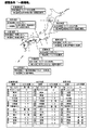
- FIG. 2 is a diagram showing an example of the cost coefficient setting criterion and the actually set cost coefficient under the “recommended” search condition.
- FIG. 3 is a diagram showing an example of the cost coefficient setting criteria and the actually set cost coefficient in the search condition of “general priority”.
- FIG. 4 is a diagram showing an example of a cost coefficient setting criterion and an actually set cost coefficient in the search condition of “distance priority”.
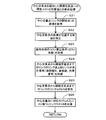
- FIG. 5 is a flowchart of the route search processing program according to the present embodiment.
- FIG. 6 is a diagram showing candidates for suitable routes from the departure point intersection to the destination intersection.
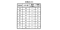
- FIG. 7 is a diagram showing an example of the intersection list.
- FIG. 8 is a diagram for explaining a specific example of the matching route specifying process based on the intersection list.
- FIG. 9 is a flowchart of a sub-processing program for cost calculation processing.
- FIG. 1 is a block diagram showing a navigation device 1 according to this embodiment.
- the navigation device 1 includes a current position detection unit 11 that detects a current position of a vehicle on which the navigation device 1 is mounted, a data recording unit 12 that records various data, Based on the input information, the navigation ECU 13 that performs various arithmetic processes, the operation unit 14 that receives operations from the user, and the route related to the route searched by the map around the vehicle and the route search process described later for the user
- a liquid crystal display 15 for displaying information and the like, a speaker 16 for outputting voice guidance regarding route guidance, a DVD drive 17 for reading a DVD as a storage medium, a probe center, a VICS (registered trademark: Vehicle Information and Communication System) center, and the like
- Communication module 18 for communicating with other information centers.
- the current position detection unit 11 includes a GPS 21, a vehicle speed sensor 22, a steering sensor 23, a gyro sensor 24, and the like, and can detect the current vehicle position, direction, vehicle traveling speed, current time, and the like.
- the vehicle speed sensor 22 is a sensor for detecting a moving distance and a vehicle speed of the vehicle, generates a pulse according to the rotation of the driving wheel of the vehicle, and outputs a pulse signal to the navigation ECU 13.
- navigation ECU13 calculates the rotational speed and moving distance of a driving wheel by counting the generated pulse.
- the navigation device 1 does not have to include all the four types of sensors, and the navigation device 1 may include only one or more types of sensors.
- the data recording unit 12 is also a hard disk (not shown) as an external storage device and a recording medium, and a driver for reading the map information DB 31 and a predetermined program recorded on the hard disk and writing predetermined data on the hard disk And a recording head (not shown).
- the data recording unit 12 may be configured by a memory card, an optical disk such as a CD or a DVD, instead of the hard disk.
- the map information DB 31 is, for example, link data 33 relating to roads (links), node data 34 relating to node points, search data 35 used for route search processing, facility data relating to facilities, and map display data for displaying a map.
- the storage means stores intersection data relating to each intersection, search data for searching for points, and the like.
- the link data 33 includes the width of the road to which the link belongs, the gradient, the cant, the bank, the road surface state, the number of lanes on the road, the number of lanes decreasing, The data representing the narrowing point, railroad crossing, etc., the corner, the radius of curvature, the intersection, the T-junction, the corner entrance and the exit, etc.
- data representing toll roads such as national highways, urban highways, general toll roads, and toll bridges are recorded.
- the node data 34 includes actual road branch points (including intersections, T-junctions, etc.) and the coordinates (positions) of node points set for each road according to the radius of curvature, etc.
- Data relating to the node number list, the height (altitude) of each node point, and the like are recorded.
- the search data 35 various data used for route search processing for searching for a route from a departure place (for example, the current position of the vehicle) to a set destination as described later are recorded. Specifically, the cost of quantifying the appropriate degree as a route to an intersection (hereinafter referred to as an intersection cost), the cost of quantifying the appropriate degree as a route to a link constituting a road (hereinafter referred to as a link cost), etc. Cost calculation data used for calculating the search cost is stored.
- intersection cost is set for each node corresponding to the intersection included in the route for which the search cost is to be calculated.
- the value is calculated according to the type of
- the link cost is set for each link included in the route for which the search cost is to be calculated, and is calculated based on the link length, taking into account the road attributes, road type, road width, number of lanes, etc. Is done.
- a route that matches the search condition (hereinafter referred to as a “matched route”) is specified for each search condition based on a plurality of search conditions, and specified by each search condition.
- One route desired by the user is finally set as a guide route from a plurality of compatible routes.
- priority should be given to shortening the required time to the destination and “recommendation” considering the ease of driving and the cost of driving, etc., and driving the toll road to the destination
- search conditions “priority toll road priority”, "general priority” that prioritizes traveling on general roads to the destination, and “distance priority” that prioritizes shorter travel distances to the destination Consists of.
- the link cost and intersection cost calculation conditions (hereinafter referred to as cost calculation conditions) are different for each search condition and for each region.
- the cost calculation conditions for the link cost and the intersection cost will be described below. In the following description, the link cost will be described as an example.
- the link cost is a coefficient set for each of various factors that affect the search cost such as the number of lanes included in the link, the road type, and the degree of traffic congestion for the link length of the link to be calculated (hereinafter referred to as cost coefficient).
- the cost calculation condition of the link cost is a condition that determines how the cost coefficient is set for each element.
- the cost coefficient is set for each search condition and for each region in consideration of search conditions and regional characteristics (more specifically, road conditions, traffic conditions, inhabitants, etc.). For example, “Recommended” is based on link length, considering factors that affect travel time, such as the number of lanes, road type, and congestion level, and the cost coefficient is set so that links with shorter travel time have lower costs. Set.
- FIG. 2 is a diagram showing an example of the cost coefficient setting standard and the actually set cost coefficient (regional cost calculation condition) in “recommendation” which is one of the search conditions.
- regions (Japan in the present embodiment) included in the map data are divided into eight regions by so-called eight regions.
- a cost coefficient setting standard is set for each of the eight areas in consideration of regional characteristics (more specifically, road conditions, traffic conditions, inhabitants, etc.), and the cost coefficient is set based on the standards.
- regional characteristics more specifically, road conditions, traffic conditions, inhabitants, etc.
- the cost coefficient of toll roads is set higher than in other areas.
- the cost coefficient for slow roads is set higher than other areas.
- the cost coefficient of the toll road (especially a short section of less than 30 km) is set lower than other areas. Furthermore, in the Tohoku area, many users prefer large roads with many lanes, so the cost coefficient for roads with many lanes is set lower than other areas, and the cost coefficient for roads with few lanes is other. Set higher than the region. In the Kanto area, general roads are very crowded and difficult to run, and users tend to travel favorably on toll roads, so the cost coefficient of toll roads is set lower than in other areas. Furthermore, in the Kanto area, the amount of traffic congestion that occurs is large, and there are many users who avoid traffic jams. The cost coefficient is set higher than other regions. Similarly, cost coefficients are set for other districts based on the cost coefficient setting criteria shown in FIG.
- FIG. 3 is a diagram showing an example of the cost coefficient setting standard and the actually set cost coefficient (regional cost calculation condition) in “general priority” which is one of the search conditions.
- the regions (Japan in the present embodiment) included in the map data are divided into eight regions by so-called eight regional divisions. Then, a cost coefficient setting standard is set for each of the eight areas in consideration of regional characteristics (more specifically, road conditions, traffic conditions, inhabitants, etc.), and the cost coefficient is set based on the standards. For example, in the Hokkaido area, if you do not travel on a toll road, you may not be able to reach the destination when you are on a remote island or Honshu, so a cost factor is set only for the route that uses the ferry. Furthermore, in the Hokkaido area, there are many users who prefer to travel on roads with fast legal speeds (for example, 50 km / h or more).
- the cost coefficient for slow roads is set higher than other areas. Also, in the Tohoku area, if it is assumed that the vehicle does not travel on the toll road, the destination may not be reached when the destination is Hokkaido or the like, so a cost coefficient is set only for the route using the ferry. Furthermore, in the Tohoku area, many users prefer large roads with many lanes, so the cost coefficient for roads with many lanes is set lower than other areas, and the cost coefficient for roads with few lanes is other. Set higher than the region. In the Kanto area, it is possible to arrive at a destination without using a ferry, so a cost coefficient is set so that no toll road including the ferry is used. Furthermore, in the Kanto area, the amount of traffic congestion that occurs is large, and there are many users who avoid traffic jams. The cost coefficient is set higher than other regions. Similarly, cost coefficients are set for other districts based on the cost coefficient setting criteria shown in FIG.
- FIG. 4 is a diagram showing an example of the cost coefficient setting criteria and the actually set cost coefficient (regional cost calculation condition) in “distance priority” which is one of the search conditions.
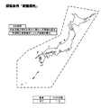
- the cost calculation condition defines the same condition in all regions included in the map data. Specifically, regardless of the elements included in the link, the cost coefficient is set to “1”, and the link cost is calculated based only on the link length.
- the search condition for “toll road priority” is similarly set for the cost coefficient in consideration of regional characteristics (more specifically, road conditions, traffic conditions, resident characteristics, etc.) for each region.
- the cost coefficient is set based on the standard.
- the navigation ECU 13 performs a route search using the Dijkstra method based on a search cost such as a link cost or an intersection cost calculated based on a cost coefficient (regional cost calculation condition) set for each search condition and for each region. Do. Details of the route search processing by the Dijkstra method will be described later.
- the regions included in the map data are divided into 8 regions.
- the units may be divided into prefectures, municipalities, and meshes. good.
- the criteria for classification for each search condition may be changed (for example, “Recommendation” is classified by 8 regional divisions, and “General priority” is classified by prefecture).
- the search data 35 may be stored on a program of a route search processing program described later instead of a part of the map data.
- the navigation ECU (Electronic Control Unit) 13 is an electronic control unit that controls the entire navigation device 1.
- the CPU 41 as an arithmetic device and a control device, and a working memory when the CPU 41 performs various arithmetic processes.
- ROM 43 in which a route search process program (see FIG. 5) and the like are recorded in addition to a RAM 42 for storing route data when a route is searched, a list of intersections, and a control program are stored.
- An internal storage device such as a flash memory 44 for storing a program read from the ROM 43 is provided.
- the navigation ECU 13 constitutes various means as processing algorithms.
- the area specifying unit specifies an area including a calculation target (link or intersection) that is a search cost calculation target.
- the calculation condition acquisition unit acquires, for each of a plurality of search conditions and for each region, a region cost calculation condition in which an element that affects the search cost is associated with a search cost calculation condition for a calculation target including the element.
- the route specifying unit uses the search cost calculated based on the region specified by the region specifying unit and the region cost calculation condition associated with the region to search for a suitable route from the departure point to the destination. Identify every time.
- the operation unit 14 is operated when inputting a starting point as a travel start point and a destination as a travel end point, and includes a plurality of operation switches (not shown) such as various keys and buttons. Then, the navigation ECU 13 performs control to execute various corresponding operations based on switch signals output by pressing the switches.
- the operation unit 14 can also be configured by a touch panel provided on the front surface of the liquid crystal display 15. Moreover, it can also be comprised with a microphone and a speech recognition apparatus.
- the liquid crystal display 15 includes a map image including a road, traffic information, operation guidance, operation menu, key guidance, guidance route from the departure point to the destination, guidance information along the guidance route, news, weather forecast, Time, mail, TV program, etc. are displayed. Moreover, when navigation ECU13 performs the route search process mentioned later, it displays about the suitable route specified for every some search condition based on the search result. In addition, when the compatible route travels on a toll road such as an expressway, the fee required for traveling is also displayed. Then, the user selects a route to be a guide route from among the plurality of displayed compatible routes.
- the speaker 16 outputs voice guidance for guiding traveling along the guidance route and traffic information guidance based on an instruction from the navigation ECU 13.
- the DVD drive 17 is a drive that can read data recorded on a recording medium such as a DVD or a CD. Based on the read data, music and video are reproduced, the map information DB 31 is updated, and the like.
- the communication module 18 is a communication device for receiving traffic information composed of information such as traffic jam information, regulation information, and traffic accident information transmitted from a traffic information center, for example, a VICS center or a probe center.
- a traffic information center for example, a VICS center or a probe center.
- a mobile phone or DCM is applicable.
- FIG. 5 is a flowchart of the route search processing program according to the present embodiment.
- the route search processing program is executed when a predetermined operation (for example, a destination setting operation) for performing a route search is received in the navigation device 1, and a compatible route from the departure point to the destination is determined by Dijkstra.
- a predetermined operation for example, a destination setting operation
- the route search processing program is repeatedly executed for each search condition, and one suitable route is specified for each search condition.
- the route search is performed under four types of search conditions of “recommended”, “toll road priority”, “general priority”, and “distance priority”, and therefore, the route search is executed a total of four times.
- the link cost is considered as the search cost for the sake of simplification, and the intersection cost and other costs are not considered.
- the programs shown in the flowcharts of FIGS. 5 and 9 below are stored in the RAM 42 and the ROM 43 provided in the navigation device 1 and are executed by the CPU 41.
- step (hereinafter abbreviated as S) 1 in the route search processing program the CPU 41 creates and creates an intersection list based on the departure point intersection, the destination intersection, and the map information stored in the map information DB 31.
- the intersection list thus recorded is stored in a storage medium such as the RAM 42. Further, initialization of the created intersection list is also performed.
- the departure point intersection is an intersection corresponding to the departure point (for example, the current position of the vehicle) (for example, the intersection closest to the departure point), and the destination intersection is the intersection corresponding to the set destination (for example, the destination) (The intersection closest to the ground).
- intersection list is a list of intersections (including the departure point intersection and the destination intersection) that connect candidates for suitable routes from the departure point intersection to the destination intersection.
- the intersection list includes, for each listed intersection, a cost value T indicating a minimum added value of the search cost from the departure point intersection to the intersection, and an intersection that passes immediately before the cost value T is realized.
- a certain previous intersection is associated with a candidate flag indicating a setting candidate for the central intersection.
- the cost value T associated with all the intersections listed as shown in FIG. 7 is set to infinity, the immediately preceding intersection is not associated,
- the candidate flag is set to “OFF (0)”.
- the CPU 41 performs an initialization process for the departure point intersection. Specifically, the cost value T associated with the departure point intersection A in the intersection list is set to 0, and the candidate flag is set to “ON (1)”.
- the CPU 41 sets a central intersection. Specifically, among the intersections whose candidate flags are set to “ON (1)”, the intersection associated with the minimum cost value T is set as the central intersection.
- the candidate flag is set to “ON (1)” only at the departure point intersection, so that the departure point intersection is always the center intersection. Will be set.
- the process of S3 is performed after the next time, if the adjacent intersection adjacent to the intersection set as the central intersection (if the associated candidate flag is “ON (1)”, past adjacent intersections will also be displayed.
- An intersection associated with the minimum cost value T is set as the central intersection.
- the CPU 41 determines whether or not the intersection newly set as the central intersection in S3 is a destination intersection.
- the CPU 41 sets the candidate flag associated with the intersection newly set as the central intersection in S3 to “OFF (0)”.
- the CPU 41 reads the cost value T currently associated with the adjacent intersection in the intersection list.
- the CPU 41 executes a cost calculation process (FIG. 9) described later.
- a cost calculation process an added value C of the search cost of the route from the departure point intersection to the adjacent intersection via the central intersection is set as the cost calculation condition set for each search condition and for each region (FIGS. 2 to 4). This is a process of calculating based on the above. Specifically, a value obtained by adding the search cost from the central intersection to the adjacent intersection to the cost value T associated with the central intersection is the added value C.
- the CPU 41 determines that the added value C of the search cost for the route from the departure point intersection to the adjacent intersection through the central intersection calculated in S7 is the cost value currently associated with the adjacent intersection. It is determined whether or not it is smaller than T.
- the added value C of the search cost of the route from the departure point intersection to the adjacent intersection through the central intersection calculated in S7 is smaller than the cost value T currently associated with the adjacent intersection. If it is determined (S8: YES), it is estimated that the optimum route to the adjacent intersection is a route via the current center intersection. Thereafter, the process proceeds to S9. On the other hand, the addition value C of the search cost for the route from the departure point intersection to the adjacent intersection via the central intersection calculated in S7 is the same as the cost value T currently associated with the adjacent intersection. Or when it determines with it being larger than the cost value T (S8: NO), it estimates that the optimal path
- the CPU 41 updates the cost value T currently associated with the adjacent intersection to the addition value C calculated in S7.
- the CPU 41 updates the immediately preceding intersection associated with the adjacent intersection to the current center intersection.
- the CPU 41 sets the candidate flag associated with the adjacent intersection to “ON (1)”. That is, the adjacent intersection becomes a new center intersection candidate.
- the adaptation route specified in S12 is guided to the user via the liquid crystal display 15 or the like for each search condition. Then, one suitable route selected based on the subsequent user operation is set as the guide route of the navigation device 1, and travel guidance based on the set guide route is performed.
- FIG. 9 is a flowchart of a sub-processing program for cost calculation processing.
- the CPU 41 acquires the coordinates of the central intersection based on the map data stored in the map information DB 31.
- the coordinates of the central intersection are the start points of the links from the central intersection to the adjacent intersections (the points where a vehicle or the like starting from the departure point starts traveling on the link).
- the CPU 41 specifies an area including the coordinates of the central intersection based on the coordinates of the central intersection acquired in S21. Specifically, it is specified based on the coordinates of the center intersection and the background polygon of the map image divided for each region. Note that the area to be identified differs depending on the setting category of the cost calculation conditions. For example, as shown in FIGS. 2 and 3, when the cost calculation conditions are set for each of the eight regional divisions, (For example, Hokkaido area, Kanto area, etc.)
- the area specified in S22 also corresponds to an area including a link from the central intersection to the adjacent intersection. However, when the link extends over a plurality of regions, the region including the start point of the link is specified.
- the CPU 41 acquires the cost calculation conditions for the area specified in S22.
- the same cost calculation condition is defined as the cost calculation condition in the region divided into the same category.
- the cost calculation condition of the link cost is a condition that determines how the cost coefficient is set for each element such as the number of lanes, the road type, and the degree of congestion (see FIGS. 2 to 4).
- the CPU 41 determines the link length of the link from the central intersection to the adjacent intersection based on the link data 33 stored in the map information DB 31, traffic information (eg, VICS information) received from the external center, and the like.
- traffic information eg, VICS information
- the elements number of lanes, road type, traffic congestion level, etc. included in are acquired.
- the CPU 41 is adjacent from the central intersection based on the cost calculation condition acquired in S23, the link length of the link from the central intersection to the adjacent intersection acquired in S24, and the elements included in the link.
- the link cost N of the link to the intersection is calculated. Specifically, the link cost N is calculated by multiplying the link length of the link by a cost coefficient set for each element included in the link. For example, when searching for a route under the “recommended” search condition, the central intersection is in the Kanto area, and the link from the central intersection to the adjacent intersection is a “20” link length on a 3-lane national road. When a legal speed of 60 km / h is specified and the degree of congestion is “empty”, based on the cost calculation condition shown in FIG.
- the CPU 41 adds the link cost N calculated in S25 to the cost value T associated with the central intersection.
- the value calculated as a result is the added value C of the search cost of the route from the departure point intersection to the adjacent intersection via the central intersection. Thereafter, the process proceeds to S8.
- the route search method by the navigation device 1 and the computer program executed by the navigation device 1 the search cost is reduced in the route search processing executed for each search condition.
- the area including the link or intersection to be calculated is identified (S22), and the search cost and the calculation condition of the search cost for the link or intersection including the element are associated with each search condition and for each area.
- the attached region cost calculation condition is acquired (S23), and the search cost calculated based on the specified region and the region cost calculation condition associated with the region is used to match from the departure point to the destination Since a route is specified for each search condition (S1 to S12), a route that matches the search condition is determined for each of a plurality of search conditions.
- the region with respect to the search condition (road conditions, traffic conditions, residents, etc.) in consideration of it is possible to set the condition for calculating the search cost for each region. Therefore, it is possible to search for a more appropriate route for the user according to the search condition and the regionality.
- the cost factor used when calculating the link cost for each region taking into account the regional characteristics (road conditions, traffic conditions, inhabitants, etc.) for the search conditions, so the road type, number of lanes, and congestion included in the link It is possible to calculate an appropriate link cost based on factors such as degree.
- the link for which the search cost is to be calculated spans a plurality of areas
- the area including the start point of the link is specified as the area including the link, so the link for which the search cost is to be calculated It is possible to appropriately identify the most influential areas.
- the area that contains the link or intersection for which the search cost is to be calculated Therefore, it is possible to accurately specify an area including a link or an intersection based on a map image and coordinate points without performing complicated processing.
- the areas included in the map data are classified according to different criteria for each of the search conditions, and the same search cost calculation conditions are defined within the areas classified into the same categories.
- the same search cost calculation conditions are defined in all regions included in the map data. In this search condition, it is possible to specify an adapted route that takes into account regional characteristics and considers only the travel distance from the departure point to the destination.
- the configuration is such that a suitable route is specified for each of four types of search conditions.
- a configuration in which a compatible route is specified for each of two types, three types, or five or more types of search conditions may be used. In this case, it is necessary to create the regional cost calculation conditions corresponding to the number of search conditions.
- the cost calculation condition of the link cost has been described as an example with reference to FIGS. 2 to 4, but the cost calculation condition for the intersection cost as well as the link cost for each search condition and for each region. Is set. For example, in the Kanto and Kinki areas where there are many traffic lights, the intersection cost of intersections with traffic lights is lower than in other areas, and in the Kanto and Kinki areas where traffic is heavy, the intersection cost of right-turn intersections is higher than in other areas.
- the cost calculation conditions are set so that Then, the CPU 41 identifies an area including the cost calculation target intersection, and calculates the intersection cost of the intersection using the cost calculation condition of the identified area.
- the cost calculation condition for the intersection cost may be the same condition (that is, a condition that differs only in each region) regardless of the search condition. Moreover, it is good also as a structure which changes only the cost calculation conditions of any one of a link cost and an intersection cost for every area.
- the cost calculation condition may be set based on the area where the user resides instead of the area where the link or node is located. Furthermore, it is good also as a structure which applies both the cost calculation conditions based on the area where a link or a node is located, and the cost calculation conditions based on the area where a user lives. In that case, regional characteristics based on road conditions and local characteristics based on inhabitants will be considered. For example, when residents in the Hokkaido region travel to the Kanto region, the cost factor of the Kanto region is adopted as the degree of congestion (factors due to road conditions), and the cost factor of the Hokkaido region is adopted for toll roads (resistance to tolls is resistant) Some people think about it).
- the search cost addition value C is calculated in consideration of only the link cost necessary for traveling on the link. However, the intersection cost and other costs necessary for passing through the intersection are calculated. It is good also as a structure which calculates the addition value C of search cost in consideration of.
- the region including the start point of the link is specified as the region including the link.
- a region including the end point may be specified as a region including the link.
- the ratio of the length in which a link is included in each area may be compared, and an area with a high ratio may be specified as an area including the link.
- the present invention can be applied to a device having a route search function.
- the present invention can be applied to a mobile terminal such as a mobile phone or a smartphone, a personal computer (hereinafter referred to as a mobile terminal).
- the present invention can be applied to a system including a server and a mobile terminal.
- each step of the above-described route search processing program (FIGS. 5 and 9) may be configured to be implemented by either a server or a mobile terminal.
- the present invention when the present invention is applied to a mobile terminal or the like, the present invention can also be applied to a search for a route for a moving body other than a vehicle, for example, a user such as a mobile terminal or a two-wheeled vehicle.
- the route search system can also have the following configuration, and in this case, the following effects can be obtained.
- the first configuration is as follows.
- the calculation object is a node corresponding to a link or an intersection.
- the route search system having the above configuration, it is possible to set calculation conditions for link costs and intersection costs for each region in consideration of regional characteristics (road conditions, traffic conditions, inhabitants, etc.) with respect to the search conditions. .
- the second configuration is as follows.
- the calculation target is a link
- the search cost for the link is calculated by multiplying the link length of the link by a coefficient based on the element included in the link
- the search cost calculation condition is the value of the coefficient for each element. It is characterized by prescribing.
- the coefficient used when calculating the link cost for each region is set in consideration of the regional characteristics (road conditions, traffic conditions, resident characteristics, etc.) with respect to the search conditions.
- An appropriate link cost can be calculated based on factors such as the road type, the number of lanes, and the degree of traffic congestion.
- the third configuration is as follows.
- the calculation target is a link
- the area specifying unit specifies the area including the start point of the link as the area including the link when the link for which the search cost is calculated extends over a plurality of areas. It is characterized by doing.
- the “link start point” is a point where the link travel starts when a vehicle or the like departs from the departure location travels on the link.
- the region including the start point of the link is specified as the region including the link.
- the fourth configuration is as follows.
- the area specifying means determines whether the calculation object to be calculated for the search cost is based on the coordinates for specifying the position of the calculation object to be calculated for the search cost and the background polygon of the map image divided for each area. It is characterized by specifying the included area.
- the search cost calculation target is based on the coordinates that specify the position of the calculation target for which the search cost is to be calculated and the background polygon of the map image divided for each region. Therefore, the area including the calculation target can be accurately specified based on the map image and the coordinate points without performing complicated processing.
- the fifth configuration is as follows.
- the regional cost calculation condition is characterized in that the regions included in the map data are classified according to different criteria for each of the plurality of search conditions, and the same search cost calculation conditions are defined in the regions classified into the same category.
- the areas included in the map data are classified according to different criteria for each of a plurality of search conditions, and the same search cost calculation conditions are defined in the areas classified into the same classification. Therefore, it is possible to classify regions where the same search cost calculation conditions are set according to appropriate criteria for each search condition. Therefore, it is possible to calculate a more appropriate search cost in consideration of regional characteristics.
- the sixth configuration is as follows.
- the plurality of search conditions include a distance-priority search condition that prioritizes a reduction in the travel distance from the departure place to the destination, and the regional cost calculation conditions associated with the distance priority include all the search conditions included in the map data.
- the same search cost calculation condition is defined in each region. According to the route search system having the above-described configuration, the same search cost is calculated in all the regions included in the map data with respect to the distance-priority search condition that prioritizes that the travel distance from the departure point to the destination is shortened. Since the conditions are defined, it is possible to specify an adapted route that considers only the travel distance from the departure point to the destination while considering regionality in other search conditions.
- Navigation device 1 Navigation device 13 Navigation ECU 41 CPU 42 RAM 43 ROM
Landscapes
- Engineering & Computer Science (AREA)
- Radar, Positioning & Navigation (AREA)
- Remote Sensing (AREA)
- Automation & Control Theory (AREA)
- Physics & Mathematics (AREA)
- General Physics & Mathematics (AREA)
- Navigation (AREA)
Description
本発明は、出発地から目的地へと至る経路を探索する経路探索システム、経路探索装置、経路探索方法及びコンピュータプログラムに関する。
近年、車両の走行案内を行い、運転者が所望の目的地に容易に到着できるようにしたナビゲーション装置が車両に搭載されていることが多い。ここで、ナビゲーション装置とは、GPS受信機などにより自車の現在位置を検出し、その現在位置に対応する地図データをDVD-ROMやHDDなどの記録媒体またはネットワークを通じて取得して液晶モニタに表示することが可能な装置である。更に、かかるナビゲーション装置には、所望する目的地を入力すると、自車位置から目的地までの最適経路を探索する経路探索機能を備えており、探索された最適経路を案内経路として設定し、ディスプレイ画面に案内経路を表示するとともに、交差点に接近した場合等には音声による案内をすることによって、ユーザを所望の目的地まで確実に案内するようになっている。また、近年は携帯電話機、スマートフォン、PDA(Personal Digital Assistant)、パーソナルコンピュータ等においても上記ナビゲーション装置と同様の機能を有するものがある。
また、上記経路探索機能では、出発地から目的地までの経路を探索する経路探索方法として一般的にダイクストラ法が用いられる。ここで、ダイクストラ法では、経路に含まれる各リンクや交差点に対応する各ノードに対してそれぞれ探索コスト(リンクコスト、交差点コスト)を算出し、算出された探索コストの加算値に基づいて最適な経路を特定する。更に、近年では探索コストの算出条件を地域毎に変えることについて提案されている。例えば、特開2006-292373号公報には、国道よりも地方道の方が整備されている地域では、国道よりも地方道のリンクコストが低くなるように算出条件を変更することについて記載されている。
しかし、上記特許文献1に記載された技術では、道路事情の地域性を考慮して探索コストの算出条件を変えることは可能であるが、探索条件については何ら考慮されていなかった。ここで、出発地から目的地までの経路を探索する場合には、最適な一の経路のみを探索するのではなく、複数の探索条件に基づいて探索条件毎に適合する経路を探索することが行われている。
上記探索条件としては、例えば有料道路を走行することを優先した『有料道路優先』や、一般道路を走行することを優先した『一般優先』等の条件があり、探索条件毎に優先する事項が異なるので、探索条件毎に探索コストの算出条件を変更する必要が生じる。例えば、『有料道路優先』では、有料道路が選ばれ易くなるように他の探索条件よりも有料道路の探索コストが小さくなるように探索コストの算出条件が規定される。ここで、上記探索条件毎に経路を特定する場合には、特に探索条件毎に地域性を考慮した探索コストの算出条件を規定することが重要である。例えば、『有料道路優先』において一律に有料道路が選ばれ易くなる探索コストの算出条件を規定すると、有料道路が非常に混雑する等の有料道路の使用がユーザにとって好ましくないエリアにおいて、適切な経路が探索できない虞がある。
本発明は前記従来における問題点を解消するためになされたものであり、複数の探索条件毎に該探索条件に適合する経路をそれぞれ特定する際に、探索条件に対する地域性(道路事情、交通事情、住民性等)を考慮して地域毎に探索コストの算出条件を設定することにより、ユーザに対してより適切な経路を探索することを可能とした経路探索システム、経路探索装置、経路探索方法及びコンピュータプログラムを提供することを目的とする。
前記目的を達成するため本発明に係る経路探索システム(1)、経路探索装置(1)、経路探索方法及びコンピュータプログラムは、出発地から目的地まで至る経路として、以下の各手段により複数の探索条件毎に該探索条件に適合する適合経路をそれぞれ特定するシステム、装置、並びに該システムや装置を用いて経路の特定を行う経路探索方法、更に該装置に対して以下を実現させるコンピュータプログラムである。具体的には、探索コストの算出対象となる算出対象物が含まれる地域を特定する地域特定手段(13)と、前記複数の探索条件毎且つ地域毎に、探索コストに影響を与える要素と該要素を含む前記算出対象物に対する探索コストの算出条件とを対応付けた地域コスト算出条件を取得する算出条件取得手段(13)と、前記地域特定手段によって特定された地域と該地域に対応付けられた前記地域コスト算出条件とに基づいて算出された前記探索コストを用いて、前記出発地から前記目的地までの前記適合経路を前記探索条件毎に特定する経路特定手段(13)と、を有することを特徴とする。
前記構成を有する本発明に係る経路探索システム、経路探索装置、経路探索方法及びコンピュータプログラムでは、複数の探索条件毎に該探索条件に適合する経路をそれぞれ特定する際に、探索条件に対する地域性(道路事情、交通事情、住民性等)を考慮して地域毎に探索コストの算出条件を設定するので、探索条件及び地域性に沿ったユーザに対してより適切な経路を探索することが可能となる。
以下、本発明に係る経路探索システム及び経路探索装置をナビゲーション装置に具体化した一実施形態に基づき図面を参照しつつ詳細に説明する。先ず、本実施形態に係るナビゲーション装置1の概略構成について図1を用いて説明する。図1は本実施形態に係るナビゲーション装置1を示したブロック図である。
図1に示すように本実施形態に係るナビゲーション装置1は、ナビゲーション装置1が搭載された車両の現在位置を検出する現在位置検出部11と、各種のデータが記録されたデータ記録部12と、入力された情報に基づいて、各種の演算処理を行うナビゲーションECU13と、ユーザからの操作を受け付ける操作部14と、ユーザに対して車両周辺の地図や後述の経路探索処理によって探索された経路に関する経路情報等を表示する液晶ディスプレイ15と、経路案内に関する音声ガイダンスを出力するスピーカ16と、記憶媒体であるDVDを読み取るDVDドライブ17と、プローブセンタやVICS(登録商標:Vehicle Information and Communication System)センタ等の情報センタとの間で通信を行う通信モジュール18と、から構成されている。
以下に、ナビゲーション装置1を構成する各構成要素について順に説明する。
現在位置検出部11は、GPS21、車速センサ22、ステアリングセンサ23、ジャイロセンサ24等からなり、現在の車両の位置、方位、車両の走行速度、現在時刻等を検出することが可能となっている。ここで、特に車速センサ22は、車両の移動距離や車速を検出する為のセンサであり、車両の駆動輪の回転に応じてパルスを発生させ、パルス信号をナビゲーションECU13に出力する。そして、ナビゲーションECU13は発生するパルスを計数することにより駆動輪の回転速度や移動距離を算出する。尚、上記4種類のセンサをナビゲーション装置1が全て備える必要はなく、これらの内の1又は複数種類のセンサのみをナビゲーション装置1が備える構成としても良い。
現在位置検出部11は、GPS21、車速センサ22、ステアリングセンサ23、ジャイロセンサ24等からなり、現在の車両の位置、方位、車両の走行速度、現在時刻等を検出することが可能となっている。ここで、特に車速センサ22は、車両の移動距離や車速を検出する為のセンサであり、車両の駆動輪の回転に応じてパルスを発生させ、パルス信号をナビゲーションECU13に出力する。そして、ナビゲーションECU13は発生するパルスを計数することにより駆動輪の回転速度や移動距離を算出する。尚、上記4種類のセンサをナビゲーション装置1が全て備える必要はなく、これらの内の1又は複数種類のセンサのみをナビゲーション装置1が備える構成としても良い。
また、データ記録部12は、外部記憶装置及び記録媒体としてのハードディスク(図示せず)と、ハードディスクに記録された地図情報DB31や所定のプログラム等を読み出すとともにハードディスクに所定のデータを書き込む為のドライバである記録ヘッド(図示せず)とを備えている。尚、データ記録部12をハードディスクの代わりにメモリーカードやCDやDVD等の光ディスクにより構成しても良い。
ここで、地図情報DB31は、例えば、道路(リンク)に関するリンクデータ33、ノード点に関するノードデータ34、経路探索処理に用いられる探索データ35、施設に関する施設データ、地図を表示するための地図表示データ、各交差点に関する交差点データ、地点を検索するための検索データ等が記憶された記憶手段である。
また、リンクデータ33としては、道路を構成する各リンクに関してリンクの属する道路の幅員、勾(こう)配、カント、バンク、路面の状態、道路の車線数、車線数の減少する箇所、幅員の狭くなる箇所、踏切り等を表すデータが、コーナに関して、曲率半径、交差点、T字路、コーナの入口及び出口等を表すデータが、道路属性に関して、降坂路、登坂路等を表すデータが、道路種別に関して、国道、県道、細街路等の一般道のほか、高速自動車国道、都市高速道路、一般有料道路、有料橋等の有料道路を表すデータがそれぞれ記録される。
また、ノードデータ34としては、実際の道路の分岐点(交差点、T字路等も含む)や各道路に曲率半径等に応じて所定の距離毎に設定されたノード点の座標(位置)、ノードが交差点に対応するノードであるか等を表すノード属性、ノードに接続するリンクのリンク番号のリストである接続リンク番号リスト、ノードにリンクを介して隣接するノードのノード番号のリストである隣接ノード番号リスト、各ノード点の高さ(高度)等に関するデータ等が記録される。
また、探索データ35としては、後述のように出発地(例えば車両の現在位置)から設定された目的地までの経路を探索する経路探索処理に使用される各種データについて記録されている。具体的には、交差点に対する経路として適正の程度を数値化したコスト(以下、交差点コストという)や道路を構成するリンクに対する経路として適正の程度を数値化したコスト(以下、リンクコストという)等の探索コストを算出する為に使用するコスト算出データが記憶されている。
ここで、交差点コストは、探索コストの算出対象となる経路に含まれる交差点に対応するノード毎に設定され、信号機の有無、交差点を通過する際の自車の走行経路(即ち直進、右折及び左折の種類)等によってその値が算出される。
また、リンクコストは、探索コストの算出対象となる経路に含まれるリンク毎に設定され、リンク長を基本にして、該リンクの道路属性や道路種別、道路幅、車線数等を考慮して算出される。
また、リンクコストは、探索コストの算出対象となる経路に含まれるリンク毎に設定され、リンク長を基本にして、該リンクの道路属性や道路種別、道路幅、車線数等を考慮して算出される。
ここで、本実施形態に係るナビゲーション装置1では、複数の探索条件に基づいて探索条件毎に該探索条件に適合する経路(以下、適合経路という)をそれぞれ特定し、各探索条件で特定された複数本の適合経路から利用者の希望する一の経路を最終的に案内経路として設定する構成を有する。具体的な探索条件としては、目的地までの所要時間が短くなることを優先するとともに走行し易さや走行に係る費用等についても考慮した『推奨』と、目的地まで有料道路を走行することを優先する『有料道路優先』と、目的地まで一般道路を走行することを優先する『一般優先』と、目的地までの走行距離が短くなることを優先した『距離優先』の4種類の探索条件からなる。
また、探索条件毎且つ地域毎に上記リンクコスト及び交差点コストの算出条件(以下、コスト算出条件という)は異なっている。以下にリンクコスト及び交差点コストのコスト算出条件について説明する。尚、以下の説明では、特にリンクコストを例に挙げて説明することとする。
リンクコストは、算出対象となるリンクのリンク長に対して、該リンクが含む車線数、道路種別、渋滞度等の探索コストに影響を与える様々な要素毎に設定された係数(以下、コスト係数という)を乗じることによって算出される。従って、リンクコストのコスト算出条件は、要素毎にどのようにコスト係数を設定するかを定める条件となる。そして、このコスト係数は、探索条件や地域性(より具体的には道路事情、交通事情、住民性等)を考慮して、探索条件毎且つ地域毎に設定される。例えば、『推奨』ではリンク長を基本として、車線数、道路種別、渋滞度等の旅行時間に影響を与える要素を考慮し、より旅行時間が短くなるリンクが低いコストとなるようにコスト係数を設定する。更に、走行に係る費用や走行し易さ等についても考慮する。但し、地域によっては、費用が生じても有料道路を一般道路より優先した方が良い地域もあるし、車線数の数を考慮しない方が良い地域もある。ここで、図2は探索条件の一つである『推奨』におけるコスト係数の設定基準と実際に設定されるコスト係数(地域コスト算出条件)の一例を示した図である。
図2に示すように、探索条件『推奨』では、地図データに含まれる地域(本実施形態では日本)を所謂8地方区分により8つの地域に区分している。そして、8つの地域毎に地域性(より具体的には道路事情、交通事情、住民性等)を考慮してコスト係数の設定基準を設定し、その基準に基づきコスト係数を設定している。
例えば、北海道地区では、一般道が比較的空いていて走り易く、ユーザは一般道を好んで走行する傾向が高いので、有料道路のコスト係数は他の地域より高めに設定される。更に、北海道地区では、法定速度の速い(例えば50km/h以上)の道路を好んで走行するユーザが多いので、法定速度が速い道路のコスト係数は他の地域より低めに設定し、法定速度が遅い道路のコスト係数は他の地域より高めに設定する。
また、東北地区では、短い区間であっても有料道路を利用しやすい環境にあることから、有料道路(特に30km未満の短い区間)のコスト係数は他の地域より低めに設定される。更に、東北地区では、車線数の多い大型道路を好んで走行するユーザが多いので、車線数の多い道路のコスト係数は他の地域より低めに設定し、車線数の少ない道路のコスト係数は他の地域より高めに設定する。
また、関東地区では、一般道が非常に混雑して走り難く、ユーザは有料道路を好んで走行する傾向が高いので、有料道路のコスト係数は他の地域より低めに設定される。更に、関東地区では、発生する渋滞の規模が大きく、渋滞を回避して走行するユーザが多いので、渋滞度が低い道路のコスト係数は他の地域より低めに設定し、渋滞度が高い道路のコスト係数は他の地域より高めに設定する。
尚、他の地区についても同様に、図2に示すコスト係数の設定基準に基づいてコスト係数が設定されている。
例えば、北海道地区では、一般道が比較的空いていて走り易く、ユーザは一般道を好んで走行する傾向が高いので、有料道路のコスト係数は他の地域より高めに設定される。更に、北海道地区では、法定速度の速い(例えば50km/h以上)の道路を好んで走行するユーザが多いので、法定速度が速い道路のコスト係数は他の地域より低めに設定し、法定速度が遅い道路のコスト係数は他の地域より高めに設定する。
また、東北地区では、短い区間であっても有料道路を利用しやすい環境にあることから、有料道路(特に30km未満の短い区間)のコスト係数は他の地域より低めに設定される。更に、東北地区では、車線数の多い大型道路を好んで走行するユーザが多いので、車線数の多い道路のコスト係数は他の地域より低めに設定し、車線数の少ない道路のコスト係数は他の地域より高めに設定する。
また、関東地区では、一般道が非常に混雑して走り難く、ユーザは有料道路を好んで走行する傾向が高いので、有料道路のコスト係数は他の地域より低めに設定される。更に、関東地区では、発生する渋滞の規模が大きく、渋滞を回避して走行するユーザが多いので、渋滞度が低い道路のコスト係数は他の地域より低めに設定し、渋滞度が高い道路のコスト係数は他の地域より高めに設定する。
尚、他の地区についても同様に、図2に示すコスト係数の設定基準に基づいてコスト係数が設定されている。
また、『一般優先』では上記『推奨』の算出方法に加えて有料道路の道路種別であるリンクのリンクコストを高くなるようにコスト係数を設定する。但し、地域によっては、有料道路を一切走行しない条件とすると目的地までの経路が探索できない地域もある。ここで、図3は探索条件の一つである『一般優先』におけるコスト係数の設定基準と実際に設定されるコスト係数(地域コスト算出条件)の一例を示した図である。
図3に示すように、探索条件『一般優先』では、地図データに含まれる地域(本実施形態では日本)を所謂8地方区分により8つの地域に区分している。そして、8つの地域毎に地域性(より具体的には道路事情、交通事情、住民性等)を考慮してコスト係数の設定基準を設定し、その基準に基づきコスト係数を設定している。
例えば、北海道地区では、有料道路を走行しないこととすると、離島や本州などを目的地とした場合に目的地に到達できない場合があるので、フェリーを利用する経路のみはコスト係数を設定する。更に、北海道地区では、法定速度の速い(例えば50km/h以上)の道路を好んで走行するユーザが多いので、法定速度が速い道路のコスト係数は他の地域より低めに設定し、法定速度が遅い道路のコスト係数は他の地域より高めに設定する。
また、東北地区では、同じく有料道路を走行しないこととすると、北海道などを目的地とした場合に目的地に到達できない場合があるので、フェリーを利用する経路のみはコスト係数を設定する。更に、東北地区では、車線数の多い大型道路を好んで走行するユーザが多いので、車線数の多い道路のコスト係数は他の地域より低めに設定し、車線数の少ない道路のコスト係数は他の地域より高めに設定する。
また、関東地区では、フェリーを利用しなくでも目的地に到着することが可能であるので、フェリーを含めた有料道路は一切利用しないようにコスト係数が設定される。更に、関東地区では、発生する渋滞の規模が大きく、渋滞を回避して走行するユーザが多いので、渋滞度が低い道路のコスト係数は他の地域より低めに設定し、渋滞度が高い道路のコスト係数は他の地域より高めに設定する。
尚、他の地区についても同様に、図3に示すコスト係数の設定基準に基づいてコスト係数が設定されている。
例えば、北海道地区では、有料道路を走行しないこととすると、離島や本州などを目的地とした場合に目的地に到達できない場合があるので、フェリーを利用する経路のみはコスト係数を設定する。更に、北海道地区では、法定速度の速い(例えば50km/h以上)の道路を好んで走行するユーザが多いので、法定速度が速い道路のコスト係数は他の地域より低めに設定し、法定速度が遅い道路のコスト係数は他の地域より高めに設定する。
また、東北地区では、同じく有料道路を走行しないこととすると、北海道などを目的地とした場合に目的地に到達できない場合があるので、フェリーを利用する経路のみはコスト係数を設定する。更に、東北地区では、車線数の多い大型道路を好んで走行するユーザが多いので、車線数の多い道路のコスト係数は他の地域より低めに設定し、車線数の少ない道路のコスト係数は他の地域より高めに設定する。
また、関東地区では、フェリーを利用しなくでも目的地に到着することが可能であるので、フェリーを含めた有料道路は一切利用しないようにコスト係数が設定される。更に、関東地区では、発生する渋滞の規模が大きく、渋滞を回避して走行するユーザが多いので、渋滞度が低い道路のコスト係数は他の地域より低めに設定し、渋滞度が高い道路のコスト係数は他の地域より高めに設定する。
尚、他の地区についても同様に、図3に示すコスト係数の設定基準に基づいてコスト係数が設定されている。
更に、図4は探索条件の一つである『距離優先』におけるコスト係数の設定基準と実際に設定されるコスト係数(地域コスト算出条件)の一例を示した図である。
図4に示すように、探索条件『距離優先』では、地図データに含まれる地域(本実施形態では日本)を1の地域に区分している。即ち、『距離優先』では道路種別や有料か無料かに関わらず、目的地までの距離が最も短くなる経路を探索する必要があるので、地域毎の地域性(より具体的には道路事情、交通事情、住民性等)の違いを考慮する必要が無い。従って、コスト算出条件は、地図データに含まれる全ての地域で同一の条件を規定する。具体的には、リンクに含まれる要素に関わらず、コスト係数を“1”とし、リンク長のみに基づいてリンクコストが算出される。
尚、説明は省略するが『有料道路優先』の探索条件についても同様に、地域毎に地域性(より具体的には道路事情、交通事情、住民性等)を考慮してコスト係数の設定基準を設定し、その基準に基づきコスト係数を設定している。
そして、ナビゲーションECU13は、探索条件毎且つ地域毎に設定されたコスト係数(地域コスト算出条件)に基づいて算出されたリンクコストや交差点コスト等の探索コストに基づき、ダイクストラ法を用いて経路探索を行う。尚、ダイクストラ法による経路探索処理の詳細については後述する。
尚、本実施形態では地図データに含まれる地域(本実施形態では日本)を8地方区分により区分しているが、その区分単位は都道府県単位や市区町村単位やメッシュ単位で区分しても良い。また、探索条件毎に区分する基準を変更しても良い(例えば、『推奨』では8地方区分により区分し、『一般優先』では都道府県単位で区分する)。また、探索データ35は、地図データの一部ではなく後述の経路探索処理プログラムのプログラム上で記憶させる構成としても良い。
一方、ナビゲーションECU(エレクトロニック・コントロール・ユニット)13は、ナビゲーション装置1の全体の制御を行う電子制御ユニットであり、演算装置及び制御装置としてのCPU41、並びにCPU41が各種の演算処理を行うにあたってワーキングメモリとして使用されるとともに、経路が探索されたときの経路データ、交差点リスト等が記憶されるRAM42、制御用のプログラムのほか、後述の経路探索処理プログラム(図5参照)等が記録されたROM43、ROM43から読み出したプログラムを記憶するフラッシュメモリ44等の内部記憶装置を備えている。尚、ナビゲーションECU13は、処理アルゴリズムとしての各種手段を構成する。例えば、地域特定手段は、探索コストの算出対象となる算出対象物(リンクや交差点)が含まれる地域を特定する。算出条件取得手段は、複数の探索条件毎且つ地域毎に、探索コストに影響を与える要素と該要素を含む算出対象物に対する探索コストの算出条件とを対応付けた地域コスト算出条件を取得する。経路特定手段は、地域特定手段によって特定された地域と該地域に対応付けられた地域コスト算出条件とに基づいて算出された探索コストを用いて、出発地から目的地までの適合経路を探索条件毎に特定する。
操作部14は、走行開始地点としての出発地、走行終了地点としての目的地を入力する際等に操作され、各種のキー、ボタン等の複数の操作スイッチ(図示せず)から構成される。そして、ナビゲーションECU13は、各スイッチの押下等により出力されるスイッチ信号に基づき、対応する各種の動作を実行すべく制御を行う。尚、操作部14は液晶ディスプレイ15の前面に設けたタッチパネルによって構成することもできる。また、マイクと音声認識装置によって構成することもできる。
また、液晶ディスプレイ15には、道路を含む地図画像、交通情報、操作案内、操作メニュー、キーの案内、出発地から目的地までの案内経路、案内経路に沿った案内情報、ニュース、天気予報、時刻、メール、テレビ番組等が表示される。
また、ナビゲーションECU13が後述の経路探索処理を行った場合には、探索結果に基づいて複数の探索条件毎に特定された適合経路について表示される。また、適合経路が高速道路などの有料道路を走行する場合には、走行に必要となる料金についても併せて表示される。そして、ユーザは表示された複数の適合経路の内から、案内経路とする経路を選択する。
また、ナビゲーションECU13が後述の経路探索処理を行った場合には、探索結果に基づいて複数の探索条件毎に特定された適合経路について表示される。また、適合経路が高速道路などの有料道路を走行する場合には、走行に必要となる料金についても併せて表示される。そして、ユーザは表示された複数の適合経路の内から、案内経路とする経路を選択する。
また、スピーカ16は、ナビゲーションECU13からの指示に基づいて案内経路に沿った走行を案内する音声ガイダンスや、交通情報の案内を出力する。
また、DVDドライブ17は、DVDやCD等の記録媒体に記録されたデータを読み取り可能なドライブである。そして、読み取ったデータに基づいて音楽や映像の再生、地図情報DB31の更新等が行われる。
また、通信モジュール18は、交通情報センタ、例えば、VICSセンタやプローブセンタ等から送信された渋滞情報、規制情報、交通事故情報等の各情報から成る交通情報を受信する為の通信装置であり、例えば携帯電話機やDCMが該当する。
続いて、上記構成を有する本実施形態に係るナビゲーション装置1においてCPU41が実行する経路探索処理プログラムについて図5に基づき説明する。図5は本実施形態に係る経路探索処理プログラムのフローチャートである。ここで、経路探索処理プログラムはナビゲーション装置1において経路探索を行う為の所定の操作(例えば、目的地の設定操作)を受け付けた際に実行され、出発地から目的地までの適合経路を、ダイクストラ法を用いて探索するプログラムである。また、経路探索処理プログラムは探索条件毎に繰り返し実行され、探索条件毎に一の適合経路が特定される。即ち、本実施形態では『推奨』と『有料道路優先』と『一般優先』と『距離優先』の4種類の探索条件により経路探索を行うので、計4回実行されることとなる。また、以下の実施例の説明では、説明の簡略化の為に探索コストとしてリンクコストのみを考慮することとし、交差点コストやその他のコストについては考慮しないこととする。尚、以下の図5及び図9にフローチャートで示されるプログラムは、ナビゲーション装置1が備えているRAM42やROM43に記憶されており、CPU41により実行される。
先ず、経路探索処理プログラムではステップ(以下、Sと略記する)1において、CPU41は、出発地交差点、目的地交差点及び地図情報DB31に記憶された地図情報に基づいて、交差点リストを作成し、作成された交差点リストをRAM42等の記憶媒体に記憶する。更に、作成された交差点リストの初期化についても行う。尚、出発地交差点は出発地(例えば車両の現在位置)に対応する交差点(例えば出発地から最も近い位置にある交差点)であり、目的地交差点は設定された目的地に対応する交差点(例えば目的地から最も近い位置にある交差点)である。
ここで、交差点リストは、出発地交差点から目的地交差点まで至る適合経路の候補を接続する交差点(出発地交差点と目的地交差点を含む)のリストである。また、交差点リストには、リストアップされた交差点毎に、出発地交差点から該交差点までの探索コストの最小加算値を示すコスト値Tと、コスト値Tを実現する場合に直前に通過する交差点である直前交差点と、中心交差点の設定候補を示す候補フラグとが対応付けられている。
以下の説明では、図6に示す出発地交差点Aから目的地交差点Iまでの経路探索処理を行う場合を具体例に挙げて説明することとする。図6に示す出発地交差点Aから目的地交差点Iまでの経路探索処理を行う場合には、出発地交差点Aから目的地交差点Iまでの適合経路を構成し得る各リンクを接続する9つの交差点A~Iがリストアップされた交差点リストが作成される(図7参照)。
また、前記S1で実行される交差点リストの初期化処理では、図7に示すようにリストアップされた全交差点に対応付けられたコスト値Tが無限大に設定され、直前交差点は対応付けず、候補フラグは“OFF(0)”に設定される。
次に、S2においてCPU41は、出発地交差点に対する初期化処理を行う。具体的には、交差点リストの出発地交差点Aに対応付けられたコスト値Tを0に設定し、候補フラグを“ON(1)”に設定する。
続いて、S3においてCPU41は、中心交差点を設定する。具体的には、候補フラグが“ON(1)”に設定された交差点の内で、最小のコスト値Tが対応付けられた交差点が中心交差点に設定される。尚、経路探索処理プログラムの開始後に最初にS3の処理が実行される際には、出発地交差点のみ候補フラグが“ON(1)”に設定されているので、必ず出発地交差点が中心交差点に設定されることとなる。一方、次回以降にS3の処理が実行された際には、中心交差点に設定された交差点と隣接する隣接交差点(対応付けられた候補フラグが“ON(1)”であれば過去の隣接交差点も含む場合がある)の内、最小のコスト値Tが対応付けられた交差点が中心交差点に設定される。
その後、S4においてCPU41は、前記S3で新たに中心交差点に設定された交差点が目的地交差点であるか否か判定する。
そして、前記S3で新たに中心交差点に設定された交差点が目的地交差点であると判定された場合(S4:YES)には、S12へと移行する。それに対して、前記S3で新たに中心交差点に設定された交差点が目的地交差点でないと判定された場合(S4:NO)には、S5へと移行する。
その後、S5においてCPU41は、前記S3で新たに中心交差点に設定された交差点に対応付けられた候補フラグを“OFF(0)”に設定する。
以降のS6~S11の処理は、交差点リストにリストアップされた交差点の内、前記S3で中心交差点に設定された交差点に隣接する交差点(以下、隣接交差点という)毎に繰り返し実施される。
先ず、S6においてCPU41は、交差点リストにおいて隣接交差点に現時点で対応づけられているコスト値Tを読み出す。
次に、S7においてCPU41は、後述のコスト算出処理(図9)を実行する。コスト算出処理は、出発地交差点から中心交差点を経由して隣接交差点へと至る経路の探索コストの加算値Cを、探索条件毎且つ地域毎に設定されたコスト算出条件(図2~図4)に基づいて算出する処理である。具体的には、中心交差点に対応付けられたコスト値Tに、中心交差点から隣接交差点までの探索コストを加算した値が加算値Cとなる。
その後、S8においてCPU41は、前記S7で算出された出発地交差点から中心交差点を経由して隣接交差点へと至る経路の探索コストの加算値Cが、隣接交差点に現時点で対応づけられているコスト値Tよりも小さいか否か判定する。
そして、前記S7で算出された出発地交差点から中心交差点を経由して隣接交差点へと至る経路の探索コストの加算値Cが、隣接交差点に現時点で対応づけられているコスト値Tよりも小さいと判定された場合(S8:YES)には、該隣接交差点への最適経路は現在の中心交差点を経由した経路であると推定する。その後、S9へと移行する。それに対して、前記S7で算出された出発地交差点から中心交差点を経由して隣接交差点へと至る経路の探索コストの加算値Cが、隣接交差点に現時点で対応づけられているコスト値Tと同じ又はコスト値Tより大きいと判定された場合(S8:NO)には、該隣接交差点への最適経路は現在の中心交差点を経由した経路では無いと推定する。そして、該隣接交差点に対応付けられたコスト値T等を更新することなく、他の隣接交差点に対する処理へと移行する。
S9においてCPU41は、隣接交差点に現時点で対応づけられているコスト値Tを、前記S7で算出された加算値Cへと更新する。
また、S10においてCPU41は、隣接交差点に対応づけられている直前交差点を、現在の中心交差点へと更新する。
更に、S11においてCPU41は、隣接交差点に対応づけられている候補フラグを“ON(1)”に設定する。即ち、該隣接交差点は、新たな中心交差点の候補となる。
そして、交差点リストにリストアップされた交差点の内、中心交差点に隣接する全ての隣接交差点に対して、前記S6~S11の処理が行われた後には、S3へと戻る。
そして、前記S4の判定処理において前記S3で新たに中心交差点に設定された交差点が目的地交差点であると判定された場合に実行されるS12では、CPU41は、最終的な交差点リストに基づいて、目的地交差点から出発地交差点まで直前交差点を結んだ経路を適合経路に特定する。その結果、出発地交差点から目的地交差点までの探索コストの加算値が最小となる経路が適合経路として特定されることとなる。例えば、図8に示す交差点リストが最終的に得られた場合には、交差点A→交差点B→交差点E→交差点G→交差点Iを結んだ経路が特定される。
尚、前記S12で特定された適合経路は、探索条件毎に液晶ディスプレイ15等を介してユーザに案内される。そして、その後のユーザの操作に基づいて選択された一の適合経路がナビゲーション装置1の案内経路として設定され、設定された案内経路に基づく走行案内が行われる。
次に、前記S7において実行されるコスト算出処理のサブ処理について図9に基づき説明する。図9はコスト算出処理のサブ処理プログラムのフローチャートである。
先ず、S21においてCPU41は、地図情報DB31に記憶された地図データに基づいて、中心交差点の座標を取得する。尚、中心交差点の座標は、中心交差点から隣接交差点までのリンクの開始点(出発地から出発した車両等がリンクの走行を開始する地点)となる。
次に、S22においてCPU41は、前記S21で取得した中心交差点の座標に基づいて、中心交差点の座標が含まれる地域を特定する。具体的には、中心交差点の座標と、地域毎に区分された地図画像の背景ポリゴンとに基づいて特定する。尚、特定する地域はコスト算出条件の設定区分によって異なり、例えば図2及び図3に示すようにコスト算出条件を8地方区分毎に設定している場合には、8地方区分により区分された地域(例えば北海道地区や関東地区等)によって特定される。また、前記S22で特定される地域は、中心交差点から隣接交差点までのリンクが含まれる地域にも相当する。但し、該リンクが複数の地域に跨る場合には、該リンクの開始点が含まれる地域が特定されることとなる。
続いて、前記S23においてCPU41は、前記S22で特定された地域のコスト算出条件を取得する。前記したように、コスト算出条件は、同一区分に区分された地域内では、同一のコスト算出条件が規定されている。また、特にリンクコストのコスト算出条件は、車線数、道路種別、渋滞度等の要素毎にどのようにコスト係数を設定するかを定める条件となる(図2~図4参照)。
その後、S24においてCPU41は、地図情報DB31に記憶されたリンクデータ33や外部センタから受信した交通情報(例えばVICS情報)等に基づいて、中心交差点から隣接交差点までのリンクのリンク長と、該リンクが含む要素(車線数、道路種別、渋滞度等)を取得する。
次に、S25においてCPU41は、前記S23で取得したコスト算出条件と、前記S24で取得した中心交差点から隣接交差点までのリンクのリンク長と、該リンクが含む要素とに基づいて、中心交差点から隣接交差点までのリンクのリンクコストNを算出する。具体的にリンクコストNは、リンクのリンク長に対して、該リンクが含む要素毎に設定されたコスト係数を乗じることによって算出される。例えば、『推奨』の探索条件により経路探索を行う場合であって、中心交差点が関東地区にあり、中心交差点から隣接交差点までのリンクが、リンク長が“20”で、3車線の国道で、60km/hの法制速度が規定され、渋滞度が“空き”であった場合には、図2に示すコスト算出条件に基づいて、以下の式(1)により中心交差点から隣接交差点までのリンクのリンクコストNを算出する。
N=20(リンク長)×1.0(国道)×0.7(3車線)×0.8(法定速度“速い”)×0.5(渋滞度“空き”)=5.6・・・・(1)
N=20(リンク長)×1.0(国道)×0.7(3車線)×0.8(法定速度“速い”)×0.5(渋滞度“空き”)=5.6・・・・(1)
続いて、S26においてCPU41は、中心交差点に対応付けられたコスト値Tに、前記S25で算出されたリンクコストNを加算する。その結果算出された値が、出発地交差点から中心交差点を経由して隣接交差点へと至る経路の探索コストの加算値Cとなる。その後、S8の判定処理へと移行する。
以上詳細に説明した通り、本実施形態に係るナビゲーション装置1、ナビゲーション装置1による経路探索方法及びナビゲーション装置1で実行されるコンピュータプログラムでは、探索条件毎に実施される経路探索処理において、探索コストの算出対象となるリンクや交差点が含まれる地域を特定し(S22)、探索条件毎且つ地域毎に、探索コストに影響を与える要素と該要素を含むリンクや交差点に対する探索コストの算出条件とを対応付けた地域コスト算出条件を取得し(S23)、特定された地域と該地域に対応付けられた地域コスト算出条件とに基づいて算出された探索コストを用いて、出発地から目的地までの適合経路を探索条件毎に特定する(S1~S12)ので、複数の探索条件毎に該探索条件に適合する経路をそれぞれ特定する際に、探索条件に対する地域性(道路事情、交通事情、住民性等)を考慮して地域毎に探索コストの算出条件を設定することができる。従って、探索条件及び地域性に沿ったユーザに対してより適切な経路を探索することが可能となる。
また、探索条件に対する地域性(道路事情、交通事情、住民性等)を考慮して地域毎にリンクコストを算出する際に用いるコスト係数を設定するので、リンクが含む道路種別、車線数、渋滞度等の要素に基づいて適切なリンクコストを算出することが可能となる。
また、探索コストの算出対象となるリンクが複数の地域に跨る場合には、該リンクの開始点が含まれる地域を、該リンクが含まれる地域として特定するので、探索コストの算出対象となるリンクに対して最も影響のある地域を適切に特定することが可能となる。
また、探索コストの算出対象となるリンクや交差点の位置を特定する座標と、地域毎に区分された地図画像の背景ポリゴンとに基づいて、探索コストの算出対象となるリンクや交差点が含まれる地域を特定するので、複雑な処理を行うことなく、地図画像と座標点に基づいてリンクや交差点の含まれる地域を正確に特定することが可能となる。
また、複数の探索条件毎に地図データに含まれる地域を異なる基準で区分し、同一区分に区分された地域内では、同一の探索コストの算出条件を規定するので、探索条件毎に適切な基準で同一の探索コストの算出条件を設定する地域を区分することが可能となる。従って、地域性を考慮したより適切な探索コストを算出することが可能となる。
また、出発地から目的地までの走行距離が短くなることを優先する『距離優先』の探索条件については、地図データに含まれる全ての地域で同一の探索コストの算出条件を規定するので、他の探索条件では地域性を考慮しつつ、出発地から目的地までの走行距離のみを考慮した適合経路についても併せて特定することが可能となる。
また、探索条件に対する地域性(道路事情、交通事情、住民性等)を考慮して地域毎にリンクコストを算出する際に用いるコスト係数を設定するので、リンクが含む道路種別、車線数、渋滞度等の要素に基づいて適切なリンクコストを算出することが可能となる。
また、探索コストの算出対象となるリンクが複数の地域に跨る場合には、該リンクの開始点が含まれる地域を、該リンクが含まれる地域として特定するので、探索コストの算出対象となるリンクに対して最も影響のある地域を適切に特定することが可能となる。
また、探索コストの算出対象となるリンクや交差点の位置を特定する座標と、地域毎に区分された地図画像の背景ポリゴンとに基づいて、探索コストの算出対象となるリンクや交差点が含まれる地域を特定するので、複雑な処理を行うことなく、地図画像と座標点に基づいてリンクや交差点の含まれる地域を正確に特定することが可能となる。
また、複数の探索条件毎に地図データに含まれる地域を異なる基準で区分し、同一区分に区分された地域内では、同一の探索コストの算出条件を規定するので、探索条件毎に適切な基準で同一の探索コストの算出条件を設定する地域を区分することが可能となる。従って、地域性を考慮したより適切な探索コストを算出することが可能となる。
また、出発地から目的地までの走行距離が短くなることを優先する『距離優先』の探索条件については、地図データに含まれる全ての地域で同一の探索コストの算出条件を規定するので、他の探索条件では地域性を考慮しつつ、出発地から目的地までの走行距離のみを考慮した適合経路についても併せて特定することが可能となる。
尚、本発明は前記実施形態に限定されるものではなく、本発明の要旨を逸脱しない範囲内で種々の改良、変形が可能であることは勿論である。
例えば、本実施形態では、4種類の探索条件毎に適合経路を特定する構成としているが、2種類、3種類又は5種類以上の探索条件毎に適合経路を特定する構成としても良い。尚、その場合には地域コスト算出条件を探索条件の数に対応させて作成する必要がある。
例えば、本実施形態では、4種類の探索条件毎に適合経路を特定する構成としているが、2種類、3種類又は5種類以上の探索条件毎に適合経路を特定する構成としても良い。尚、その場合には地域コスト算出条件を探索条件の数に対応させて作成する必要がある。
また、本実施形態では、図2~図4を用いて特にリンクコストのコスト算出条件を例に挙げて説明したが、交差点コストについてもリンクコストと同様に探索条件毎且つ地域毎にコスト算出条件が設定される。例えば、信号機の多い関東地区や近畿地区では信号機の設置された交差点の交差点コストを他の地区より小さくしたり、交通量の多い関東地区や近畿地区では右折交差点の交差点コストを他の地区より大きくするようにコスト算出条件を設定する。そして、CPU41は、コスト算出対象の交差点の含まれる地域を特定し、特定した地域のコスト算出条件を用いて該交差点の交差点コストを算出する。
また、交差点コストのコスト算出条件は、探索条件に関わらず同じ条件(即ち地域毎のみで異なる条件)としても良い。また、リンクコストと交差点コストのいずれか一方のコスト算出条件のみを地域毎に変更する構成としても良い。
また、リンクやノードが位置する地域では無く、ユーザの居住する地域に基づいてコスト算出条件を設定しても良い。更に、リンクやノードが位置する地域に基づくコストの算出条件と、ユーザの居住する地域に基づくコスト算出条件の両方を適用する構成としても良い。その際には、道路事情に基づく地域性と住民性に基づく地域性を考慮することとする。例えば、北海道地区の住民が関東へ旅行した場合には、渋滞度は関東地区のコスト係数を採用し(道路事情による要因)、有料道路は北海道地区のコスト係数を採用する(通行料金に抵抗があるなど住民性の思考)。
また、本実施形態では、リンクを走行するのに必要なリンクコストのみを考慮して探索コストの加算値Cを算出する構成としているが、交差点を通過するのに必要な交差点コストやその他のコストについても考慮して探索コストの加算値Cを算出する構成としても良い。
また、本実施形態では、探索コストの算出対象となるリンクが複数の地域に跨る場合には、該リンクの開始点が含まれる地域を、該リンクが含まれる地域として特定するが、該リンクの終了点が含まれる地域を、該リンクが含まれる地域として特定しても良い。また、リンクが各地域に含まれる長さの割合を比較し、割合が高い地域を該リンクが含まれる地域として特定しても良い。
また、本発明はナビゲーション装置以外に、経路探索機能を有する装置に対して適用することが可能である。例えば、携帯電話機やスマートフォン等の携帯端末、パーソナルコンピュータ等(以下、携帯端末等という)に適用することも可能である。また、サーバと携帯端末等から構成されるシステムに対しても適用することが可能となる。その場合には、上述した経路探索処理プログラム(図5、図9)の各ステップは、サーバと携帯端末等のいずれが実施する構成としても良い。また、本発明を携帯端末等に適用する場合には、車両以外の移動体、例えば、携帯端末等のユーザや2輪車等に対する経路の探索にも本願発明を適用することが可能である。
また、本発明に係る経路探索システムを具体化した実施例について上記に説明したが、経路探索システムは以下の構成を有することも可能であり、その場合には以下の効果を奏する。
例えば、第1の構成は以下のとおりである。
算出対象物は、リンク又は交差点に対応するノードであることを特徴とする。
上記構成を有する経路探索システムによれば、探索条件に対する地域性(道路事情、交通事情、住民性等)を考慮して地域毎にリンクコスト及び交差点コストの算出条件を設定することが可能となる。
算出対象物は、リンク又は交差点に対応するノードであることを特徴とする。
上記構成を有する経路探索システムによれば、探索条件に対する地域性(道路事情、交通事情、住民性等)を考慮して地域毎にリンクコスト及び交差点コストの算出条件を設定することが可能となる。
また、第2の構成は以下のとおりである。
算出対象物はリンクであり、リンクに対する探索コストは、該リンクのリンク長に該リンクの含む要素に基づいた係数を乗じることによって算出され、探索コストの算出条件は、要素毎の係数の値を規定することを特徴とする。
上記構成を有する経路探索システムによれば、探索条件に対する地域性(道路事情、交通事情、住民性等)を考慮して地域毎にリンクコストを算出する際に用いる係数を設定するので、リンクが含む道路種別、車線数、渋滞度等の要素に基づいて適切なリンクコストを算出することが可能となる。
算出対象物はリンクであり、リンクに対する探索コストは、該リンクのリンク長に該リンクの含む要素に基づいた係数を乗じることによって算出され、探索コストの算出条件は、要素毎の係数の値を規定することを特徴とする。
上記構成を有する経路探索システムによれば、探索条件に対する地域性(道路事情、交通事情、住民性等)を考慮して地域毎にリンクコストを算出する際に用いる係数を設定するので、リンクが含む道路種別、車線数、渋滞度等の要素に基づいて適切なリンクコストを算出することが可能となる。
また、第3の構成は以下のとおりである。
算出対象物はリンクであり、地域特定手段は、探索コストの算出対象となるリンクが複数の地域に跨る場合には、該リンクの開始点が含まれる地域を、該リンクが含まれる地域として特定することを特徴とする。
尚、「リンクの開始点」とは、出発地から出発した車両等が該リンクを走行する場合に、リンクの走行を開始する地点となる。
上記構成を有する経路探索システムによれば、探索コストの算出対象となるリンクが複数の地域に跨る場合には、該リンクの開始点が含まれる地域を、該リンクが含まれる地域として特定するので、探索コストの算出対象となるリンクに対して最も影響のある地域を適切に特定することが可能となる。
算出対象物はリンクであり、地域特定手段は、探索コストの算出対象となるリンクが複数の地域に跨る場合には、該リンクの開始点が含まれる地域を、該リンクが含まれる地域として特定することを特徴とする。
尚、「リンクの開始点」とは、出発地から出発した車両等が該リンクを走行する場合に、リンクの走行を開始する地点となる。
上記構成を有する経路探索システムによれば、探索コストの算出対象となるリンクが複数の地域に跨る場合には、該リンクの開始点が含まれる地域を、該リンクが含まれる地域として特定するので、探索コストの算出対象となるリンクに対して最も影響のある地域を適切に特定することが可能となる。
また、第4の構成は以下のとおりである。
地域特定手段は、探索コストの算出対象となる算出対象物の位置を特定する座標と、地域毎に区分された地図画像の背景ポリゴンとに基づいて、探索コストの算出対象となる算出対象物が含まれる地域を特定することを特徴とする。
上記構成を有する経路探索システムによれば、探索コストの算出対象となる算出対象物の位置を特定する座標と、地域毎に区分された地図画像の背景ポリゴンとに基づいて、探索コストの算出対象となる算出対象物が含まれる地域を特定するので、複雑な処理を行うことなく、地図画像と座標点に基づいて算出対象物の含まれる地域を正確に特定することが可能となる。
地域特定手段は、探索コストの算出対象となる算出対象物の位置を特定する座標と、地域毎に区分された地図画像の背景ポリゴンとに基づいて、探索コストの算出対象となる算出対象物が含まれる地域を特定することを特徴とする。
上記構成を有する経路探索システムによれば、探索コストの算出対象となる算出対象物の位置を特定する座標と、地域毎に区分された地図画像の背景ポリゴンとに基づいて、探索コストの算出対象となる算出対象物が含まれる地域を特定するので、複雑な処理を行うことなく、地図画像と座標点に基づいて算出対象物の含まれる地域を正確に特定することが可能となる。
また、第5の構成は以下のとおりである。
地域コスト算出条件は、複数の探索条件毎に地図データに含まれる地域を異なる基準で区分し、同一区分に区分された地域内では、同一の前記探索コストの算出条件を規定することを特徴とする。
上記構成を有する経路探索システムによれば、複数の探索条件毎に地図データに含まれる地域を異なる基準で区分し、同一区分に区分された地域内では、同一の探索コストの算出条件を規定するので、探索条件毎に適切な基準で同一の探索コストの算出条件を設定する地域を区分することが可能となる。従って、地域性を考慮したより適切な探索コストを算出することが可能となる。
地域コスト算出条件は、複数の探索条件毎に地図データに含まれる地域を異なる基準で区分し、同一区分に区分された地域内では、同一の前記探索コストの算出条件を規定することを特徴とする。
上記構成を有する経路探索システムによれば、複数の探索条件毎に地図データに含まれる地域を異なる基準で区分し、同一区分に区分された地域内では、同一の探索コストの算出条件を規定するので、探索条件毎に適切な基準で同一の探索コストの算出条件を設定する地域を区分することが可能となる。従って、地域性を考慮したより適切な探索コストを算出することが可能となる。
また、第6の構成は以下のとおりである。
複数の探索条件は、出発地から目的地までの走行距離が短くなることを優先する距離優先の探索条件を含み、距離優先に対応付けられた地域コスト算出条件は、地図データに含まれる全ての地域で同一の前記探索コストの算出条件を規定することを特徴とする。
上記構成を有する経路探索システムによれば、出発地から目的地までの走行距離が短くなることを優先する距離優先の探索条件については、地図データに含まれる全ての地域で同一の探索コストの算出条件を規定するので、他の探索条件では地域性を考慮しつつ、出発地から目的地までの走行距離のみを考慮した適合経路についても併せて特定することが可能となる。
複数の探索条件は、出発地から目的地までの走行距離が短くなることを優先する距離優先の探索条件を含み、距離優先に対応付けられた地域コスト算出条件は、地図データに含まれる全ての地域で同一の前記探索コストの算出条件を規定することを特徴とする。
上記構成を有する経路探索システムによれば、出発地から目的地までの走行距離が短くなることを優先する距離優先の探索条件については、地図データに含まれる全ての地域で同一の探索コストの算出条件を規定するので、他の探索条件では地域性を考慮しつつ、出発地から目的地までの走行距離のみを考慮した適合経路についても併せて特定することが可能となる。
1 ナビゲーション装置
13 ナビゲーションECU
41 CPU
42 RAM
43 ROM
13 ナビゲーションECU
41 CPU
42 RAM
43 ROM
Claims (10)
- 出発地から目的地まで至る経路として、複数の探索条件毎に該探索条件に適合する適合経路をそれぞれ特定する経路探索システムであって、
探索コストの算出対象となる算出対象物が含まれる地域を特定する地域特定手段と、
前記複数の探索条件毎且つ地域毎に、探索コストに影響を与える要素と該要素を含む前記算出対象物に対する探索コストの算出条件とを対応付けた地域コスト算出条件を取得する算出条件取得手段と、
前記地域特定手段によって特定された地域と該地域に対応付けられた前記地域コスト算出条件とに基づいて算出された前記探索コストを用いて、前記出発地から前記目的地までの前記適合経路を前記探索条件毎に特定する経路特定手段と、を有することを特徴とする経路探索システム。 - 前記算出対象物は、リンク又は交差点に対応するノードであることを特徴とする請求項1に記載の経路探索システム。
- 前記算出対象物はリンクであり、
前記リンクに対する前記探索コストは、該リンクのリンク長に該リンクの含む要素に基づいた係数を乗じることによって算出され、
前記探索コストの算出条件は、要素毎の前記係数の値を規定することを特徴とする請求項1又は請求項2に記載の経路探索システム。 - 前記算出対象物はリンクであり、
前記地域特定手段は、前記探索コストの算出対象となるリンクが複数の地域に跨る場合には、該リンクの開始点が含まれる地域を、該リンクが含まれる地域として特定することを特徴とする請求項1乃至請求項3のいずれかに記載の経路探索システム。 - 前記地域特定手段は、前記探索コストの算出対象となる前記算出対象物の位置を特定する座標と、地域毎に区分された地図画像の背景ポリゴンとに基づいて、前記探索コストの算出対象となる前記算出対象物が含まれる地域を特定することを特徴とする請求項1乃至請求項4のいずれかに記載の経路探索システム。
- 前記地域コスト算出条件は、
前記複数の探索条件毎に地図データに含まれる地域を異なる基準で区分し、
同一区分に区分された前記地域内では、同一の前記探索コストの算出条件を規定することを特徴とする請求項1乃至請求項5のいずれかに記載の経路探索システム。 - 前記複数の探索条件は、前記出発地から前記目的地までの走行距離が短くなることを優先する距離優先の探索条件を含み、
前記距離優先に対応付けられた前記地域コスト算出条件は、地図データに含まれる全ての地域で同一の前記探索コストの算出条件を規定することを特徴とする請求項6に記載の経路探索システム。 - 出発地から目的地まで至る経路として、複数の探索条件毎に該探索条件に適合する適合経路をそれぞれ特定する経路探索装置であって、
探索コストの算出対象となる算出対象物が含まれる地域を特定する地域特定手段と、
前記複数の探索条件毎且つ地域毎に、探索コストに影響を与える要素と該要素を含む前記算出対象物に対する探索コストの算出条件とを対応付けた地域コスト算出条件を取得する算出条件取得手段と、
前記地域特定手段によって特定された地域と該地域に対応付けられた前記地域コスト算出条件とに基づいて算出された前記探索コストを用いて、前記出発地から前記目的地までの前記適合経路を前記探索条件毎に特定する経路特定手段と、を有することを特徴とする経路探索装置。 - 出発地から目的地まで至る経路として、複数の探索条件毎に該探索条件に適合する適合経路をそれぞれ特定する経路探索方法であって、
探索コストの算出対象となる算出対象物が含まれる地域を特定する地域特定ステップと、
前記複数の探索条件毎且つ地域毎に、探索コストに影響を与える要素と該要素を含む前記算出対象物に対する探索コストの算出条件とを対応付けた地域コスト算出条件を取得する算出条件取得ステップと、
前記地域特定ステップによって特定された地域と該地域に対応付けられた前記地域コスト算出条件とに基づいて算出された前記探索コストを用いて、前記出発地から前記目的地までの前記適合経路を前記探索条件毎に特定する経路特定ステップと、を有することを特徴とする経路探索方法。 - コンピュータに、
出発地から目的地まで至る経路として、複数の探索条件毎に該探索条件に適合する適合経路をそれぞれ特定させるコンピュータプログラムであって、
探索コストの算出対象となる算出対象物が含まれる地域を特定する地域特定機能と、
前記複数の探索条件毎且つ地域毎に、探索コストに影響を与える要素と該要素を含む前記算出対象物に対する探索コストの算出条件とを対応付けた地域コスト算出条件を取得する算出条件取得機能と、
前記地域特定機能によって特定された地域と該地域に対応付けられた前記地域コスト算出条件とに基づいて算出された前記探索コストを用いて、前記出発地から前記目的地までの前記適合経路を前記探索条件毎に特定する経路特定機能と、
を実行させることを特徴とするコンピュータプログラム。
Priority Applications (2)
| Application Number | Priority Date | Filing Date | Title |
|---|---|---|---|
| US14/417,891 US20150177014A1 (en) | 2012-08-29 | 2013-07-23 | Route calculation system, route calculation device, route calculation method, and computer program |
| CN201380039740.XA CN104508429A (zh) | 2012-08-29 | 2013-07-23 | 路径搜索系统、路径搜索装置、路径搜索方法以及计算机程序 |
Applications Claiming Priority (2)
| Application Number | Priority Date | Filing Date | Title |
|---|---|---|---|
| JP2012-188251 | 2012-08-29 | ||
| JP2012188251A JP5892004B2 (ja) | 2012-08-29 | 2012-08-29 | 経路探索システム、経路探索装置、経路探索方法及びコンピュータプログラム |
Publications (1)
| Publication Number | Publication Date |
|---|---|
| WO2014034327A1 true WO2014034327A1 (ja) | 2014-03-06 |
Family
ID=50183147
Family Applications (1)
| Application Number | Title | Priority Date | Filing Date |
|---|---|---|---|
| PCT/JP2013/069878 Ceased WO2014034327A1 (ja) | 2012-08-29 | 2013-07-23 | 経路探索システム、経路探索装置、経路探索方法及びコンピュータプログラム |
Country Status (4)
| Country | Link |
|---|---|
| US (1) | US20150177014A1 (ja) |
| JP (1) | JP5892004B2 (ja) |
| CN (1) | CN104508429A (ja) |
| WO (1) | WO2014034327A1 (ja) |
Families Citing this family (10)
| Publication number | Priority date | Publication date | Assignee | Title |
|---|---|---|---|---|
| US9109915B2 (en) * | 2012-06-29 | 2015-08-18 | Navteq B.V. | Method and apparatus for route selection based on recorded and calculated routes |
| US10712164B2 (en) * | 2014-09-25 | 2020-07-14 | International Business Machines Corporation | Travel routes based on communication channel availability |
| JP6613563B2 (ja) * | 2014-12-24 | 2019-12-04 | アイシン・エィ・ダブリュ株式会社 | 経路探索システム、方法およびプログラム |
| JP6361498B2 (ja) * | 2014-12-24 | 2018-07-25 | アイシン・エィ・ダブリュ株式会社 | 経路探索システム、方法およびプログラム |
| WO2017015882A1 (en) * | 2015-07-29 | 2017-02-02 | Bayerische Motoren Werke Aktiengesellschaft | Navigation device and navigation method |
| JP6823512B2 (ja) * | 2017-03-16 | 2021-02-03 | 本田技研工業株式会社 | 経路決定装置、車両制御装置、経路決定方法、およびプログラム |
| EP3792597B1 (en) * | 2018-05-09 | 2024-11-20 | Kikuhiro Yorozuya | Search system comprising portable terminals |
| CN110657805A (zh) * | 2018-09-30 | 2020-01-07 | 北京奇虎科技有限公司 | 一种基于道路场景查找移动目标的方法及装置 |
| CN109631928B (zh) * | 2019-01-31 | 2022-08-26 | 南京林业大学 | 一种综合舒适度和出行距离的非机动车导航方法 |
| US12163795B2 (en) * | 2021-07-07 | 2024-12-10 | Oracle International Corporation | Vehicle routing with dynamic selection of turns across opposing traffic |
Citations (3)
| Publication number | Priority date | Publication date | Assignee | Title |
|---|---|---|---|---|
| JP2005227049A (ja) * | 2004-02-10 | 2005-08-25 | Alpine Electronics Inc | ナビゲーション装置、経路探索方法およびプログラム |
| JP2005257586A (ja) * | 2004-03-15 | 2005-09-22 | Zenrin Co Ltd | 経路案内装置 |
| JP2012063306A (ja) * | 2010-09-17 | 2012-03-29 | Hitachi Automotive Systems Ltd | 経路探索装置、ナビゲーション装置、および経路探索システム |
Family Cites Families (5)
| Publication number | Priority date | Publication date | Assignee | Title |
|---|---|---|---|---|
| US5878368A (en) * | 1996-09-13 | 1999-03-02 | Magellan Dis, Inc. | Navigation system with user definable cost values |
| GB2335492B (en) * | 1998-03-18 | 2002-02-27 | Nokia Mobile Phones Ltd | Local navigation alternatives |
| US8180502B2 (en) * | 2007-07-31 | 2012-05-15 | Denso Corporation | Apparatus and program for navigation |
| EP2372303A1 (en) * | 2008-12-25 | 2011-10-05 | Sanyo Electric Co., Ltd. | In-vehicle electronic equipment |
| WO2012089279A1 (en) * | 2010-12-31 | 2012-07-05 | Tomtom International B.V. | Non-uniform weighting factor as route algorithm input |
-
2012
- 2012-08-29 JP JP2012188251A patent/JP5892004B2/ja not_active Expired - Fee Related
-
2013
- 2013-07-23 US US14/417,891 patent/US20150177014A1/en not_active Abandoned
- 2013-07-23 WO PCT/JP2013/069878 patent/WO2014034327A1/ja not_active Ceased
- 2013-07-23 CN CN201380039740.XA patent/CN104508429A/zh active Pending
Patent Citations (3)
| Publication number | Priority date | Publication date | Assignee | Title |
|---|---|---|---|---|
| JP2005227049A (ja) * | 2004-02-10 | 2005-08-25 | Alpine Electronics Inc | ナビゲーション装置、経路探索方法およびプログラム |
| JP2005257586A (ja) * | 2004-03-15 | 2005-09-22 | Zenrin Co Ltd | 経路案内装置 |
| JP2012063306A (ja) * | 2010-09-17 | 2012-03-29 | Hitachi Automotive Systems Ltd | 経路探索装置、ナビゲーション装置、および経路探索システム |
Also Published As
| Publication number | Publication date |
|---|---|
| JP2014044182A (ja) | 2014-03-13 |
| US20150177014A1 (en) | 2015-06-25 |
| JP5892004B2 (ja) | 2016-03-23 |
| CN104508429A (zh) | 2015-04-08 |
Similar Documents
| Publication | Publication Date | Title |
|---|---|---|
| JP5892004B2 (ja) | 経路探索システム、経路探索装置、経路探索方法及びコンピュータプログラム | |
| JP6172283B2 (ja) | 経路探索システム、経路探索方法及びコンピュータプログラム | |
| EP2453207B1 (en) | Travel guidance device, travel guidance method, and computer program | |
| US10126743B2 (en) | Vehicle navigation route search system, method, and program | |
| CN102460072B (zh) | 路径搜索装置和路径搜索方法 | |
| JP6679740B2 (ja) | 経路探索装置、経路探索システム及びコンピュータプログラム | |
| EP3553472A1 (en) | Driving support device and computer program | |
| JP5673445B2 (ja) | 投稿文提供システム、投稿文提供装置、投稿文提供方法及びコンピュータプログラム | |
| JP6597265B2 (ja) | 移動案内システム、移動案内方法及びコンピュータプログラム | |
| JP2017032654A (ja) | 情報案内システム、情報案内方法及びコンピュータプログラム | |
| JP2017134251A (ja) | 地図情報更新システム、地図情報更新装置及びコンピュータプログラム | |
| US11656085B2 (en) | Route searching device and computer program | |
| JP2018036134A (ja) | 走行案内装置及びコンピュータプログラム | |
| JP2018063658A (ja) | 走行計画生成装置及びコンピュータプログラム | |
| JP5949328B2 (ja) | 経路探索システム、経路探索装置、経路探索方法及びコンピュータプログラム | |
| JP2017078775A (ja) | 地図情報更新システム、地図情報更新方法及びコンピュータプログラム | |
| JP2016048227A (ja) | 経路探索システム、経路探索方法及びコンピュータプログラム | |
| JP2014071063A (ja) | 経路探索システム、経路探索装置、経路探索方法及びコンピュータプログラム | |
| JP2016121879A (ja) | 情報提供システム、情報提供方法及びコンピュータプログラム | |
| JP2008070204A (ja) | 経路計算装置 | |
| JP2018025404A (ja) | 交通情報案内装置及びコンピュータプログラム | |
| JP2007155462A (ja) | ナビゲーション装置 | |
| JP2007113940A (ja) | 車両用経路探索装置 | |
| JP2017142193A (ja) | 経路探索装置及びコンピュータプログラム | |
| JP2015197322A (ja) | 移動案内システム、移動案内方法及びコンピュータプログラム |
Legal Events
| Date | Code | Title | Description |
|---|---|---|---|
| 121 | Ep: the epo has been informed by wipo that ep was designated in this application |
Ref document number: 13832750 Country of ref document: EP Kind code of ref document: A1 |
|
| WWE | Wipo information: entry into national phase |
Ref document number: 14417891 Country of ref document: US |
|
| NENP | Non-entry into the national phase |
Ref country code: DE |
|
| 122 | Ep: pct application non-entry in european phase |
Ref document number: 13832750 Country of ref document: EP Kind code of ref document: A1 |