US8044858B2 - Regional navigation satellite supplementary system - Google Patents
Regional navigation satellite supplementary system Download PDFInfo
- Publication number
- US8044858B2 US8044858B2 US12/203,589 US20358908A US8044858B2 US 8044858 B2 US8044858 B2 US 8044858B2 US 20358908 A US20358908 A US 20358908A US 8044858 B2 US8044858 B2 US 8044858B2
- Authority
- US
- United States
- Prior art keywords
- navigation
- signals
- satellite
- traffic obstructions
- changes
- Prior art date
- Legal status (The legal status is an assumption and is not a legal conclusion. Google has not performed a legal analysis and makes no representation as to the accuracy of the status listed.)
- Expired - Fee Related, expires
Links
Images


Classifications
-
- G—PHYSICS
- G01—MEASURING; TESTING
- G01S—RADIO DIRECTION-FINDING; RADIO NAVIGATION; DETERMINING DISTANCE OR VELOCITY BY USE OF RADIO WAVES; LOCATING OR PRESENCE-DETECTING BY USE OF THE REFLECTION OR RERADIATION OF RADIO WAVES; ANALOGOUS ARRANGEMENTS USING OTHER WAVES
- G01S19/00—Satellite radio beacon positioning systems; Determining position, velocity or attitude using signals transmitted by such systems
- G01S19/01—Satellite radio beacon positioning systems transmitting time-stamped messages, e.g. GPS [Global Positioning System], GLONASS [Global Orbiting Navigation Satellite System] or GALILEO
- G01S19/03—Cooperating elements; Interaction or communication between different cooperating elements or between cooperating elements and receivers
- G01S19/05—Cooperating elements; Interaction or communication between different cooperating elements or between cooperating elements and receivers providing aiding data
Definitions
- the invention relates to a regional navigation satellite supplementary system.
- a navigation system must not only allow positioning of the user with the required precision, continuity, and availability, but also provide the other information necessary for navigation.
- This other information is typically provided on paper via a map, on a storage media, via traffic radio messages, which are also distributed in digital form.
- the street grid maps used in the navigation systems are usually fixed and typically require user interaction to obtain regular updates.
- information about current or future traffic obstructions is available only on the local or regional level (if at all), and interregional information (which is also significant for planning longer trips) is typically not easily available. Accordingly, conventional systems do not necessarily provide selective detour recommendation that account for new traffic obstructions that could arise due to bypass recommendations.
- Exemplary embodiments of the present invention provide devices and methods which allow traffic obstructions to be bypassed. This allows the street infrastructure to be used significantly more effectively because traffic obstructions may be bypassed. Moreover, the present invention significantly reduces the effort that a user must expend to have current planning documents for his trips.
- the navigation satellites of the navigation satellite supplementary system which are located over an area in which a service is to be provided are located close to the zenith and transmit a relatively strong navigation signal into the service area.
- these satellites may fly on suitable geosynchronous orbits, on geosynchronous orbits in or near the equatorial level, or also on so-called Molniya orbits.
- satellites are then implemented as controllable using a (vertically) oriented antenna, to achieve the highest possible signal strength in the service area with the least possible power consumption, the signal strength being dimensioned in such a way that the signals of other satellite navigation systems may still be received. This is achieved, inter alia, by a suitable selection of the coding of the signals.
- the signals transmit navigation-relevant information at a data rate which is significantly above the data rate of the commercial service of Galileo.
- This information contains, inter alia, current and expected traffic obstructions in the service area, recommendations for how specific user groups having various travel directions and travel destinations (which may be regionally combined) are to drive around these traffic obstructions, changes of the street grid in the service area, and also comprise expected traffic obstructions due to environmental influences, chronologically recent changes being repeated relatively frequently and chronologically earlier changes being repeated relatively rarely (which may be no repetition at all).
- the invention also discloses arbitrary combinations of the above-mentioned navigation-relevant information.
- Exemplary embodiments of the present invention include a method for transmitting a navigation signal that involves generating navigation signals, wherein the signal strength of the navigation signals is dimensioned in such a way that it is still possible to receive signals of other satellite navigation systems, and wherein the signals transmit navigation-relevant information at a data rate which is significantly above the data rate of the Galileo satellite system; and transmitting the generated navigation signals.
- FIG. 1 is a block diagram of an exemplary system in accordance with the present invention
- FIG. 2 is a block diagram of an exemplary device of a satellite positioning supplementary system in accordance with the present invention.
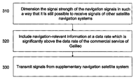
- FIG. 3 is a flow diagram of an exemplary method in accordance with the present invention.
- FIG. 1 is a block diagram of an exemplary system in accordance with the present invention.
- the system includes a satellite positioning system that comprises a plurality of satellites 122 - 126 and a supplementary satellite positioning system comprising one or more satellites 128 .
- a navigation receiver 110 can determine its position using signals received from satellites 122 - 128 , and can also receive navigation-relevant information from satellite 128 as described in more detail herein.
- FIG. 1 illustrates a particular number of satellites for the positioning system and the supplementary system, the present invention can include more satellites than those illustrated.
- FIG. 2 is a block diagram of an exemplary device of a satellite positioning supplementary system in accordance with the present invention.
- the device includes memory 210 coupled to processor 220 .
- Processor 220 includes power dimensioning logic 225 , additional information transmission logic 230 and transmission control logic 235 , which will be described in more detail in connection with FIG. 3 .
- Processor 220 can be any type of processor including a field programmable gate array (FPGA), application specific integrated circuit (ASIC) and/or a microprocessor.
- FPGA field programmable gate array
- ASIC application specific integrated circuit
- microprocessor When processor 220 is a microprocessor, logic 225 - 235 can be processor-executable instructions loaded from memory 210 .
- FIG. 3 is a flow diagram of an exemplary method in accordance with the present invention.
- logic 225 dimensions the signal strength of the navigation signals in such a way that it is still possible to receive signals of other satellite navigation systems. This can be performed using any of the techniques disclosed in U.S. Patent Application Ser. No. 12/203,588 entitled Regional Navigation Satellite Supplementary System, the entire disclosure of which is herein expressly incorporated by reference.
- logic 230 includes navigation-relevant information at a data rate which is significantly above the data rate of the commercial service of Galileo.
- the navigation-relevant information can include current and expected traffic obstructions in a service area, recommendations for how specific user groups having various travel directions and travel destinations, which may be regionally combined, are to drive around these traffic obstructions, changes of the street grid in the service area, and expected traffic obstructions due to environmental influences.
- logic 235 transmits signals from supplementary navigation satellite system.
Landscapes
- Engineering & Computer Science (AREA)
- Radar, Positioning & Navigation (AREA)
- Remote Sensing (AREA)
- Computer Networks & Wireless Communication (AREA)
- Physics & Mathematics (AREA)
- General Physics & Mathematics (AREA)
- Position Fixing By Use Of Radio Waves (AREA)
Applications Claiming Priority (3)
| Application Number | Priority Date | Filing Date | Title |
|---|---|---|---|
| DE102007041773 | 2007-09-04 | ||
| DE102007041773A DE102007041773A1 (de) | 2007-09-04 | 2007-09-04 | Regionales Navigationssatelitenergänzungssystem |
| DE102007041773.1-35 | 2007-09-04 |
Publications (2)
| Publication Number | Publication Date |
|---|---|
| US20090058721A1 US20090058721A1 (en) | 2009-03-05 |
| US8044858B2 true US8044858B2 (en) | 2011-10-25 |
Family
ID=39865061
Family Applications (1)
| Application Number | Title | Priority Date | Filing Date |
|---|---|---|---|
| US12/203,589 Expired - Fee Related US8044858B2 (en) | 2007-09-04 | 2008-09-03 | Regional navigation satellite supplementary system |
Country Status (3)
| Country | Link |
|---|---|
| US (1) | US8044858B2 (de) |
| EP (1) | EP2034327A1 (de) |
| DE (1) | DE102007041773A1 (de) |
Families Citing this family (1)
| Publication number | Priority date | Publication date | Assignee | Title |
|---|---|---|---|---|
| CN115790569B (zh) * | 2022-11-14 | 2026-02-03 | 歌尔科技有限公司 | 一种辅助导航的头戴显示设备和导航方法 |
Citations (7)
| Publication number | Priority date | Publication date | Assignee | Title |
|---|---|---|---|---|
| WO1999018677A1 (en) | 1997-10-02 | 1999-04-15 | Airsys Atm, Inc. | Gps augmentation system |
| US20020101374A1 (en) * | 2001-01-29 | 2002-08-01 | Katsuhiko Mutoh | Navigation system, GPS terminal and navigation method using supplementary data in broadcast radio wave signal |
| US20040145517A1 (en) | 1995-10-24 | 2004-07-29 | Inmarsat, Ltd. | Method and apparatus for a satellite payload and radiodetermination |
| US20050090265A1 (en) | 2003-10-23 | 2005-04-28 | Charles Abraham | Method and apparatus for distributing information in an assisted-SPS system |
| DE10356580A1 (de) | 2003-12-04 | 2005-07-07 | Eads Deutschland Gmbh | Verfahren und Anordnung für einen alternativen Signalpfad in einem Navigationssender |
| US20070109186A1 (en) * | 2004-07-09 | 2007-05-17 | Vodafone K.K. | Position measuring method and mobile communication terminal |
| US20090013210A1 (en) * | 2007-06-19 | 2009-01-08 | Mcintosh P Stuckey | Systems, devices, agents and methods for monitoring and automatic reboot and restoration of computers, local area networks, wireless access points, modems and other hardware |
-
2007
- 2007-09-04 DE DE102007041773A patent/DE102007041773A1/de not_active Withdrawn
-
2008
- 2008-09-03 EP EP08015563A patent/EP2034327A1/de not_active Withdrawn
- 2008-09-03 US US12/203,589 patent/US8044858B2/en not_active Expired - Fee Related
Patent Citations (8)
| Publication number | Priority date | Publication date | Assignee | Title |
|---|---|---|---|---|
| US20040145517A1 (en) | 1995-10-24 | 2004-07-29 | Inmarsat, Ltd. | Method and apparatus for a satellite payload and radiodetermination |
| WO1999018677A1 (en) | 1997-10-02 | 1999-04-15 | Airsys Atm, Inc. | Gps augmentation system |
| US20020101374A1 (en) * | 2001-01-29 | 2002-08-01 | Katsuhiko Mutoh | Navigation system, GPS terminal and navigation method using supplementary data in broadcast radio wave signal |
| US20050090265A1 (en) | 2003-10-23 | 2005-04-28 | Charles Abraham | Method and apparatus for distributing information in an assisted-SPS system |
| DE10356580A1 (de) | 2003-12-04 | 2005-07-07 | Eads Deutschland Gmbh | Verfahren und Anordnung für einen alternativen Signalpfad in einem Navigationssender |
| US20050157672A1 (en) | 2003-12-04 | 2005-07-21 | Eads Deutschland Gmbh | Method and arrangement for an alternative signal path in a navigation transmitter |
| US20070109186A1 (en) * | 2004-07-09 | 2007-05-17 | Vodafone K.K. | Position measuring method and mobile communication terminal |
| US20090013210A1 (en) * | 2007-06-19 | 2009-01-08 | Mcintosh P Stuckey | Systems, devices, agents and methods for monitoring and automatic reboot and restoration of computers, local area networks, wireless access points, modems and other hardware |
Non-Patent Citations (5)
| Title |
|---|
| Esa, "Galileo: Mission High Level Definition", (Internet Article), Sep. 23, 2002, pp. 1-48, European Commission, XP-002501418. |
| Esa, "Galileo: Road Applications", (Internet Article), The European Programme for Global Navigation Services, Oct. 2002, pp. 1-2, European Commission, XP-002501351. |
| European Search Report dated Nov. 6, 2008 with partial English translation (Nine (9) pages). |
| German Office Action dated Jun. 2, 2008 including English translation of the relevant portion (Five (5) pages). |
| Steciw, A. et al., "A European Satellite Navigation Programme", IEE Colloquium on Implementation of GNSS, 1995, London. |
Also Published As
| Publication number | Publication date |
|---|---|
| DE102007041773A1 (de) | 2009-03-05 |
| US20090058721A1 (en) | 2009-03-05 |
| EP2034327A1 (de) | 2009-03-11 |
Similar Documents
| Publication | Publication Date | Title |
|---|---|---|
| US5510798A (en) | Multiple-accuracy GPS system | |
| US9939286B2 (en) | Method and system for integrated assistance services | |
| US10077109B2 (en) | First-person viewer for unmanned vehicles | |
| CN101650418B (zh) | 信号处理方法和系统 | |
| US20090219976A1 (en) | Transmission of Information to a GPS Device | |
| US20100228480A1 (en) | Space satellite tracking and identification | |
| US20110240792A1 (en) | Transmission of information to a system utilizing a gps device | |
| US8310375B2 (en) | System and method for providing vehicle parking information using navigation satellite | |
| US9784847B1 (en) | Multiple GNSS constellation tracking for a blended navigation solution | |
| US8044858B2 (en) | Regional navigation satellite supplementary system | |
| CN110890915A (zh) | 用于与多个航天器进行并发通信的地基天线 | |
| KR102006065B1 (ko) | 위성기반보강 메시지를 이용하여 위치 측정 성능을 향상하는 장치 및 방법 | |
| US8473210B2 (en) | Method for the transmission of additional data along with navigation messages in a satellite navigation system | |
| JP6015030B2 (ja) | 航空路管理装置および航空路管理方法 | |
| US8294611B2 (en) | Method for the transmission of additional data along with navigation messages in a satellite navigation system | |
| US20030045285A1 (en) | System and method for controlling data traffic flow to mobile platforms | |
| US7460828B2 (en) | Method and arrangement for an alternative signal path in a navigation transmitter | |
| KR20150145039A (ko) | 위치 보정 정보를 제공하기 위한 장치, 위치 보정 정보를 이용하여 위치 정보를 제공하기 위한 장치 및 이를 위한 방법 | |
| KR960019029A (ko) | 글로벌 위치설정 시스템과 주파수공용 통신시스템을 이용한 해상의 선박위치확인 및 정보서비스 시스템과 그 처리방법 | |
| JP2005265552A (ja) | Gpsアシストデータ提供方法、gpsアシストデータ提供機器及びgpsアシストデータ要求機器 | |
| Lucas et al. | GALILEO: system requirements and architectures | |
| US20090058722A1 (en) | Regional satellite positioning supplementary system | |
| US20090011703A1 (en) | Global Information and Hazard Warning System Using Satellite Navigation Systems and User Terminals | |
| JP2000078069A (ja) | 無線システム | |
| KR101967530B1 (ko) | 이종채널을 통하여 수신된 위성기반보강 메시지들을 처리하는 장치 및 방법 |
Legal Events
| Date | Code | Title | Description |
|---|---|---|---|
| AS | Assignment |
Owner name: ASTRIUM GMBH, GERMANY Free format text: ASSIGNMENT OF ASSIGNORS INTEREST;ASSIGNORS:TRAUTENBERG, HANS L.;WEBER, THOMAS;REEL/FRAME:021733/0436;SIGNING DATES FROM 20080912 TO 20080916 Owner name: ASTRIUM GMBH, GERMANY Free format text: ASSIGNMENT OF ASSIGNORS INTEREST;ASSIGNORS:TRAUTENBERG, HANS L.;WEBER, THOMAS;SIGNING DATES FROM 20080912 TO 20080916;REEL/FRAME:021733/0436 |
|
| FEPP | Fee payment procedure |
Free format text: PAYOR NUMBER ASSIGNED (ORIGINAL EVENT CODE: ASPN); ENTITY STATUS OF PATENT OWNER: LARGE ENTITY |
|
| REMI | Maintenance fee reminder mailed | ||
| LAPS | Lapse for failure to pay maintenance fees | ||
| STCH | Information on status: patent discontinuation |
Free format text: PATENT EXPIRED DUE TO NONPAYMENT OF MAINTENANCE FEES UNDER 37 CFR 1.362 |
|
| STCH | Information on status: patent discontinuation |
Free format text: PATENT EXPIRED DUE TO NONPAYMENT OF MAINTENANCE FEES UNDER 37 CFR 1.362 |
|
| FP | Lapsed due to failure to pay maintenance fee |
Effective date: 20151025 |