US11838346B2 - Apparatus for light weighted setting spatial data of 3D modeling data and video monitoring - Google Patents
Apparatus for light weighted setting spatial data of 3D modeling data and video monitoring Download PDFInfo
- Publication number
- US11838346B2 US11838346B2 US17/565,943 US202117565943A US11838346B2 US 11838346 B2 US11838346 B2 US 11838346B2 US 202117565943 A US202117565943 A US 202117565943A US 11838346 B2 US11838346 B2 US 11838346B2
- Authority
- US
- United States
- Prior art keywords
- video
- data
- space
- spatial information
- objects
- Prior art date
- Legal status (The legal status is an assumption and is not a legal conclusion. Google has not performed a legal analysis and makes no representation as to the accuracy of the status listed.)
- Active
Links
Images


Classifications
-
- G—PHYSICS
- G06—COMPUTING OR CALCULATING; COUNTING
- G06T—IMAGE DATA PROCESSING OR GENERATION, IN GENERAL
- G06T19/00—Manipulating 3D models or images for computer graphics
- G06T19/20—Editing of 3D images, e.g. changing shapes or colours, aligning objects or positioning parts
-
- H—ELECTRICITY
- H04—ELECTRIC COMMUNICATION TECHNIQUE
- H04L—TRANSMISSION OF DIGITAL INFORMATION, e.g. TELEGRAPHIC COMMUNICATION
- H04L65/00—Network arrangements, protocols or services for supporting real-time applications in data packet communication
- H04L65/1066—Session management
- H04L65/1069—Session establishment or de-establishment
-
- H—ELECTRICITY
- H04—ELECTRIC COMMUNICATION TECHNIQUE
- H04L—TRANSMISSION OF DIGITAL INFORMATION, e.g. TELEGRAPHIC COMMUNICATION
- H04L65/00—Network arrangements, protocols or services for supporting real-time applications in data packet communication
- H04L65/60—Network streaming of media packets
- H04L65/65—Network streaming protocols, e.g. real-time transport protocol [RTP] or real-time control protocol [RTCP]
-
- G—PHYSICS
- G06—COMPUTING OR CALCULATING; COUNTING
- G06F—ELECTRIC DIGITAL DATA PROCESSING
- G06F30/00—Computer-aided design [CAD]
- G06F30/10—Geometric CAD
- G06F30/13—Architectural design, e.g. computer-aided architectural design [CAAD] related to design of buildings, bridges, landscapes, production plants or roads
-
- G—PHYSICS
- G06—COMPUTING OR CALCULATING; COUNTING
- G06T—IMAGE DATA PROCESSING OR GENERATION, IN GENERAL
- G06T17/00—Three dimensional [3D] modelling, e.g. data description of 3D objects
- G06T17/10—Constructive solid geometry [CSG] using solid primitives, e.g. cylinders, cubes
-
- G—PHYSICS
- G06—COMPUTING OR CALCULATING; COUNTING
- G06T—IMAGE DATA PROCESSING OR GENERATION, IN GENERAL
- G06T17/00—Three dimensional [3D] modelling, e.g. data description of 3D objects
- G06T17/20—Finite element generation, e.g. wire-frame surface description, tesselation
-
- H—ELECTRICITY
- H04—ELECTRIC COMMUNICATION TECHNIQUE
- H04L—TRANSMISSION OF DIGITAL INFORMATION, e.g. TELEGRAPHIC COMMUNICATION
- H04L65/00—Network arrangements, protocols or services for supporting real-time applications in data packet communication
- H04L65/60—Network streaming of media packets
- H04L65/75—Media network packet handling
- H04L65/762—Media network packet handling at the source
-
- H—ELECTRICITY
- H04—ELECTRIC COMMUNICATION TECHNIQUE
- H04L—TRANSMISSION OF DIGITAL INFORMATION, e.g. TELEGRAPHIC COMMUNICATION
- H04L67/00—Network arrangements or protocols for supporting network services or applications
- H04L67/01—Protocols
- H04L67/02—Protocols based on web technology, e.g. hypertext transfer protocol [HTTP]
-
- H—ELECTRICITY
- H04—ELECTRIC COMMUNICATION TECHNIQUE
- H04N—PICTORIAL COMMUNICATION, e.g. TELEVISION
- H04N21/00—Selective content distribution, e.g. interactive television or video on demand [VOD]
- H04N21/40—Client devices specifically adapted for the reception of or interaction with content, e.g. set-top-box [STB]; Operations thereof
- H04N21/43—Processing of content or additional data, e.g. demultiplexing additional data from a digital video stream; Elementary client operations, e.g. monitoring of home network or synchronising decoder's clock; Client middleware
- H04N21/442—Monitoring of processes or resources, e.g. detecting the failure of a recording device, monitoring the downstream bandwidth, the number of times a movie has been viewed, the storage space available from the internal hard disk
- H04N21/44204—Monitoring of content usage, e.g. the number of times a movie has been viewed, copied or the amount which has been watched
-
- H—ELECTRICITY
- H04—ELECTRIC COMMUNICATION TECHNIQUE
- H04N—PICTORIAL COMMUNICATION, e.g. TELEVISION
- H04N21/00—Selective content distribution, e.g. interactive television or video on demand [VOD]
- H04N21/60—Network structure or processes for video distribution between server and client or between remote clients; Control signalling between clients, server and network components; Transmission of management data between server and client, e.g. sending from server to client commands for recording incoming content stream; Communication details between server and client
- H04N21/63—Control signaling related to video distribution between client, server and network components; Network processes for video distribution between server and clients or between remote clients, e.g. transmitting basic layer and enhancement layers over different transmission paths, setting up a peer-to-peer communication via Internet between remote STB's; Communication protocols; Addressing
- H04N21/643—Communication protocols
- H04N21/6437—Real-time Transport Protocol [RTP]
-
- H—ELECTRICITY
- H04—ELECTRIC COMMUNICATION TECHNIQUE
- H04N—PICTORIAL COMMUNICATION, e.g. TELEVISION
- H04N7/00—Television systems
- H04N7/18—Closed-circuit television [CCTV] systems, i.e. systems in which the video signal is not broadcast
Definitions
- the present disclosure relates to a technique for implementing 3-dimensional spatial information and a video monitoring system for a CCTV installed in a space on the web, and more particularly, to a technique for defining a method of setting spatial information capable of defining a space in the shape of dimensional data or property information including relationship information between objects installed in the space, and linking a video monitoring apparatus to the defined method, such that, based on the same, a video captured by a video monitoring apparatus provided in a space may be efficiently output on the web.
- spatial information is defined in a very easy way to precisely determine property information regarding 3-dimensional data, and various video monitoring system may be established by utilizing the same.
- a video monitoring system is a technology widely used in smart cities and the like nowadays, and is widely used especially for purposes like indoor and outdoor safety management and accident response.
- a video monitoring system is a system including a video monitoring apparatus like a CCTV that is installed in a certain space on a site and captures a video, a monitoring server that manages videos captured by the video monitoring apparatus, and a terminal that obtains and utilizes videos from the monitoring server.
- a new method of defining spatial information for processing a specific space into 3-dimensional data by using a digital twin provides a technique for efficiently linking a video monitoring apparatus to the method to be universally applicable to conventional video monitoring apparatuses using various protocols (e.g., CCTVs).
- the present disclosure provides a technique that enables universal monitoring of videos of an indoor space without establishing a separate dedicated system therefor by using the video monitoring apparatuses with light-weighted data on the web.
- the present disclosure also provides a technique for using a video monitoring system on the web to perform various functions.
- an apparatus for setting spatial information and monitoring a video for light-weighted 3-dimensional modeling data implemented by a computing apparatus including one or more processors and one or more memories storing instructions executable on the one or more processors, the apparatus includes a spatial information setting unit configured to use, as data input from the outside, modeling data regarding objects and spaces obtained through 3-dimensionally modeling of the objects included in the spaces, relationship information regarding connection relationship between the objects, and property information regarding the objects to perform a function of setting spatial information for modeling data regarding the spaces and the objects included in the spaces by setting shapes of the spaces formed by the objects, property information regarding the spaces, and connection information between the spaces; a video monitoring requesting unit configured to, when a selection for one piece of spatial information is received from a user terminal as a request for connection between spatial information and a video monitoring apparatus, select a video object corresponding to the video monitoring apparatus from among objects set to a key value identical to a key assigned to the one piece of spatial information and transmit a video streaming start requesting signal to a selected video object
- the video playback unit may use different video connection methods according to a protocol of connection equipment connecting between the video monitoring apparatus corresponding to the video object and the video playback unit, when the protocol is HTTP, received video data may be directly output to a user interface executed on the web, and, when the protocol is a protocol set for each video monitoring apparatus other than HTTP, a first intermediate player, which is installed between the video playback unit and the video object and a playback program dedicated for video data is executed thereon, may be further provided, and the video playback unit may perform a first method of transmitting video streaming data, which is operational on a user interface and generated as the first intermediate player plays back video data, to the user terminal to output the video streaming data on a user interface executed on the user terminal, and a second intermediate player, which is installed between the video playback unit and the video object and converts RTSP streaming to the form of a web socket, may be further provided, and the video playback unit may perform a second method of transmitting a video by opening a web socket port to the user terminal that attempts to connect through
- the spatial information setting unit may include a first spatial information setting unit configured to, when modeling data, which is data input from the outside for defining an outer shape of an object through 3-dimensional modeling of the object, is received, define first spatial information, which defines a shape of a space formed by at least one object, based on a shape of modeling; a connection information setting unit configured to set node data corresponding to a center point of each space by using the first spatial information and setting connection information including link data, which represents connection relationships between node data, by using input data, which is received from the outside and is related to connection relationships between node data; a second spatial information setting unit configured to set second spatial information that defines property information regarding a space formed by objects by using property information for the objects input from the outside; and a spatial information setting completing unit configured to link the first spatial information, the second spatial information, and the connection information for each space, thereby setting spatial information regarding modeling data of each space and each object included in each space.
- a first spatial information setting unit configured to, when modeling data, which is data input from the outside for
- the first spatial information may include at least one of first detailed data that defines the shape of each space in the form of light-weighted data, second detailed data for distinguishing whether each space relates to an outdoor space or an indoor space, and third detailed data for distinguishing the type of a space formed by objects based on the modeling shape of each object.
- the first spatial information setting unit may generate light-weighted frame data capable of defining an outer shape of each space based on the modeling data, sets regions of a space by using geometry drawn on a floor surface of the space formed by objects for each frame data, and, when the space formed by the objects is an indoor space, define a height of the space by using modeling data regarding the objects.
- the second spatial information may include at least one of a name of a space, a purpose of the space, a type of the space, the geometry constituting the space, information for distinguishing whether the space is an indoor space or an outdoor space, drawing data regarding the space, and detailed architectural information regarding the space.
- the spatial information setting completing unit may automatically set spatial information including the key value regarding the video object as spatial information for a space to which the video object belongs.
- the video playback unit may extract spatial information having a key value identical to the key value of the video object and output the spatial information to a user interface and, when there is a history of a change of a video object that generated video data output to the user interface, may output information regarding a change of history of spatial information, which is generated as the video object is changed, to the user interface.
- a center point of a space formed by objects may be defined as node data regarding the space formed by the objects and the objects when the objects are objects constituting an outer shape and an internal space of a building, centers of objects may be defined as node data regarding the objects when the objects are objects interconnecting spaces, and points of intersection of link data interconnecting the node data may be defined as node data regarding a path space interconnecting the spaces.
- the spatial information setting unit may set spatial information by including connection information regarding a video monitoring apparatus corresponding to the video object from among information included in the property information regarding video monitoring apparatuses, which is input from the outside, in the spatial information regarding the video object as information for selecting the video object and requesting the selected video object to transmit video data when the video monitoring requesting unit selects any one key value.
- FIG. 1 is a block diagram showing the configuration of an apparatus for setting spatial information and monitoring video for light-weighted 3-dimensional modeling data according to an embodiment of the present disclosure.
- FIG. 2 is a diagram showing an example of a flow in which video data is processed according to the implementation of an embodiment of the present disclosure.
- FIG. 3 is a diagram showing the configuration of a spatial information setting unit according to an embodiment of the present disclosure in detail.
- FIG. 4 is a diagram for describing an example in which spatial information is generated according to the implementation of an embodiment of the present disclosure.
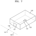
- FIGS. 5 to 7 are diagrams for describing examples in which spaces, nodes, and link data are set according to the implementation of an embodiment of the present disclosure.
- FIG. 8 is a diagram showing an example of a user interface screen image displayed on a user terminal according to the implementation of an embodiment of the present disclosure.
- FIG. 9 is an example of an internal configuration of a computing apparatus according to an embodiment of the present disclosure.
- a video monitoring system may be implemented only when a specialized monitoring server is established due to the characteristics that video data is processed according to protocols different from one video monitoring apparatus to another and problems like network traffic due to streaming of video data.
- Korean Patent Laid-Open Publication No. 10-2020-0086561 discloses a technique for linking a 3-dimensional monitoring system and videos from a camera like a CCTV in a subway station space.
- a plurality of cameras installed in a subway station are mapped to their locations and stored, and videos of the corresponding cameras may be streamed or, when an event like a fire is detected, a notification of the corresponding event may be provided.
- a video monitoring system using previous CCTVs is implemented by a system that maps locations of CCTVs on a specific 3-dimensional drawing and simply outputs videos of mapped CCTVs.
- a video monitoring system is not adaptive to various protocols for video data, and network traffic for streaming video data and a cost for establishing a dedicated network are excessive.
- first may be referred to as a second element
- second element may also be referred to as a first element.
- the term “and/or” includes a combination of a plurality of related listed items or any of a plurality of related listed items.
- FIG. 1 is a block diagram showing the configuration of an apparatus for setting spatial information and monitoring video for light-weighted 3-dimensional modeling data according to an embodiment of the present disclosure
- FIG. 2 is a diagram showing an example of a flow in which video data is processed according to the implementation of an embodiment of the present disclosure
- FIG. 3 is a diagram showing the configuration of a spatial information setting unit according to an embodiment of the present disclosure in detail
- FIG. 4 is a diagram for describing an example in which spatial information is generated according to the implementation of an embodiment of the present disclosure
- FIGS. 5 to 7 are diagrams for describing examples in which spaces, nodes, and link data are set according to the implementation of an embodiment of the present disclosure
- FIG. 8 is a diagram showing an example of a user interface screen image displayed on a user terminal according to the implementation of an embodiment of the present disclosure.
- the above-described drawings will be selectively referred to for describing embodiments of the present disclosure and the functional implementations of components.
- an apparatus 10 for setting spatial information and monitoring video for light-weighted 3-dimensional modeling data is implemented to be included in a computing apparatus shown in FIG. 9 or implemented to include a plurality of computing apparatuses according to components and functions thereof.
- the computing apparatus may be understood as a concept including all terminals capable of processing, storing, managing, outputting, and inputting data, e.g., personal computers, server terminals, database management terminals, portable computers, laptop computers, smart pads, smart phones, etc.
- the computing apparatus may refer to a functional apparatus equivalent to or included in a plurality of terminals capable of using the functions of setting spatial information and monitoring video for light-weighted 3-dimensional modeling data in conjunction with the apparatus 10 of the present disclosure.
- the apparatus 10 of the present disclosure includes a spatial information setting unit (or a spatial information setting processor) 11 , a video monitoring requesting unit (or a video monitoring requesting processor) 12 , and a video playback unit (or a video playback processor) 13 . Additionally, the apparatus 10 of the present disclosure may further include at least one of a first intermediate player 41 and a second intermediate player 42 installed between the video playback unit 13 and a video monitoring apparatus 30 .
- the spatial information setting unit 11 uses, as data input from the outside, modeling data regarding objects and spaces obtained through 3-dimensionally modeling of the objects included in the spaces, relationship information regarding connection relationship between the objects, and property data regarding the objects to perform the function of setting spatial information for modeling data regarding the spaces and the objects included in the spaces by setting shapes of the spaces formed by the objects, property data regarding the spaces, and connection information between the spaces.
- data input from the outside means data input from all terminals that generate and provide specific data including a user terminal 20 and other terminals.
- the user terminal 20 may be a manager terminal regarding 3D modeling data that generates modeling data, and the manager terminal may include not only the user terminal 20 , but also a terminal used by an external subject of performing 3-dimensional modeling.
- all terminals including the user terminal 20 are used by a subject which manages all data for setting spatial information, such as relationship information regarding connection relationships between objects and property data.
- corresponding data is input from all terminals including the user terminal 20 .
- the spatial information setting unit 11 performs the function of easily and light-weightedly managing spatial information for 3-dimensional modeling data based on objects constituting spaces, connection relationships between the objects, connection relationships between the spaces, and light-weighted property data regarding the spaces and is a component functioning to perform the overall function of the apparatus 10 of the present disclosure. A detailed example thereof is shown in FIG. 3 .
- the spatial information setting unit 11 includes a first spatial information setting unit 1101 that, when modeling data, which is data input from the outside and is capable of defining the outer appearance of an object through 3-dimensional modeling on the object, is received, sets first spatial information, which defines the shape of a space formed by at least one object based on a modeling shape, to the modeling data.
- data being input from the outside means that, as described above, data for performing the function of the present disclosure is input from external terminals which are connected to a terminal for generating and/or managing 3-dimensional modeling data (e.g., a manager (user) terminal including the user terminal 20 via a network or a hardware connection and is capable of transmitting and receiving data through a wired/wireless network line.
- a terminal for generating and/or managing 3-dimensional modeling data e.g., a manager (user) terminal including the user terminal 20 via a network or a hardware connection and is capable of transmitting and receiving data through a wired/wireless network line.
- an object refers to a unit constituting an indoor/outdoor space.
- an object may include units constituting a certain space, such as an indoor wall, a ceiling, a door, a window, an outdoor building wall, an establishment, etc.
- 3-dimensional modeling data for an object is data generated by a computing apparatus based on a drawing of the object or numerical values and/or visual data (e.g., a photographed image, a video, etc.) obtained through actual measurement of the object and may include, for example, polygon data that 3-dimensionally representing the object.
- targets including the object for which 3-dimensional spatial information is set refers to all spaces that may be 3-dimensionally implemented, and there is limit on space targets as long as things that may be created through modeling techniques are not limited.
- 3-dimensional spatial information may be created through a 3D modeling tool based on the design (drawing data used for architectural design including a plan view, an elevation view, a sectional view, etc.) of a target (space) that actually exists.
- additional data may be collected through on-site inspections.
- modeling data may be created based on drawings.
- the data may be corrected and used to create modeling data.
- the first spatial information setting unit 1101 When the first spatial information setting unit 1101 receives the above-stated modeling data, the first spatial information setting unit 1101 defines first spatial information, which defines the shape of a space formed by at least one object, for the space or objects included in the space based on the shape of modeling that may be determined from the modeling data and sets the first spatial information to the modeling data.
- the first spatial information may include at least one of first detailed data that defines the shape of each space in the form of light-weighted data, second detailed data for distinguishing whether each space relates to an outdoor space or an indoor space, and third detailed data for distinguishing the type of a space formed by objects based on the modeling shape of each object.
- the shape of a space may be defined 3-dimensionally or 2-dimensionally by using only the outer boundary of a space that is defined as an object constitutes the space instead of detailed modeling data of the object.
- the first detailed data may be defined as, for example, data regarding the boundary of a space formed by objects as the outer shape of the space is limited by the objects.
- the second detailed data may be defined as follows. Defining the second detailed data may be easily misunderstood as a method of authoring only indoor spatial information, but it is not only for indoor/outdoor-based modeling data, but the modeling shape is used as described above. Therefore, the method may be used regardless of indoor/outdoor as long as the second detailed data has a concept attribute for distinguishing indoor and outdoor.
- the second detailed data may be set based on a drawing or an input from the outside.
- the third detailed data refers to data for identifying the type of a space formed by objects based on a modeling shape, e.g., a room, a bathroom, an elevator, a door, and a passage.
- a door may be identified as a door based on the shape thereof, a portion having a shape close to a square or other shapes and surrounded by walls may be identified as a room, and a portion connected to a plurality of doors and having a long shape or a branched shape may be identified as a passage.
- the shape of a space is extracted based on a floor through an object in which a wall, a story, a floor, and a ceiling may be identified through modeling data.
- the shape may be recognized as an indoor space like a room and may express the interior of a building.
- the first to third detailed data for identifying spatial information for each space or defining the spatial information as light-weighted data may be defined, for example, according to particular processes as described below.
- the first spatial information setting unit 1101 when the first spatial information setting unit 1101 receives modeling data, the first spatial information setting unit 1101 generates light-weighted frame data that may define the outer shape of each space based on the modeling data.
- first spatial information is set by editing the content of the modeling data.
- frame data including objects 121 , 122 , and 123 , outer shapes 111 and 112 of a space, and a boundary line 114 defining the outer shape 111 and 112 of spaces may be defined.
- the first spatial information setting unit 1101 sets regions of spaces by using geometry drawn by using floor surfaces of the spaces formed by objects.
- a floor surface of each space may be set as the bottommost boundary of each space. Therefore, based on a drawing, when detailed geometry of spatial information are needed for setting regions of a space in frame data, the space may be expressed by using a drawing method. Otherwise, a space may be defined as a conceptual space using very simple and light-weighted data like rectangles and circles.
- regions of a space are set based on a drawing
- the regions of the space may be determined according to geometry drawn on the floor surface. Referring to FIG. 6 , inside the boundary line 114 indicating each building space, spaces 113 and 116 that indicate non-room spaces for a specific purpose (e.g., a lobby, a common space, etc.) and are defined as circles, a room space 115 that indicate a room and defined as a rectangle, and a space 102 indicating a passage are set as regions of a space.
- the height of the space is defined by using modeling data of the objects. For example, by applying a shape that protrudes from the floor surface to the ceiling based on the height of an indoor story, the height of a 3-dimensional space is determined.
- an outdoor space when only the concept of a space is needed (e.g., a garden), it is not necessary to determine the height of the outdoor space, but the height may be designated.
- a connection information setting unit 1102 uses defined first spatial information to establish a node data corresponding to a center point for each space and performs the function of setting connection information including link data, which represents connection relationships between node data, by using input data, which is related to connection relationships between the node data and received from the outside.
- node data is data for representing the center of each space or objects constituting the space (to be precise, objects that need to be defined separately from a space from among objects), and link data may be understood as data for representing connection relationships between node data.
- the node data and the link data are data for expressing spaces and influences and connections between the spaces by using very light-weighted data.
- node data 131 of the space formed by the objects and objects is defined as node data 131 of the space formed by the objects and objects.
- each object is defined as node data of the object, and an intersection point 131 of link data 130 and 130 - 1 interconnecting the respective node data are defined as node data for path spaces interconnecting the respective spaces.
- connection points between nodes and links may be found based on a door or an entrance element that may be passed through on modeling.
- the center point of a space constructed in this way may be created as a reference point of nodes, and, through the center of a room and the center of a door, nodes of spaces and important objects may be configured.
- a relationship between spaces may be conveniently checked through node data and link data.
- correlation and topological relationships may be determined only when nodes are arranged in a space, and information regarding a space where nodes are not arranged needs to be independently determined.
- data information may be managed, such that node data connected to link data may be searched for through the link data.
- a second spatial information setting unit 1103 defines more detailed property information for each space.
- the second spatial information setting unit 1103 performs the function of setting second spatial information that defines property information of a space formed by objects by using property information regarding the objects input from the outside.
- the second spatial information is a concept that defines specific properties of a space and may include, for example, at least one of the name of a space, the purpose of the space, the type of the space, the geometry constituting the space, information for distinguishing whether the space is an indoor space or an outdoor space, drawing data regarding the space, and detailed architectural information regarding the space.
- modeling information corresponding to a space and detailed architectural information like building information modeling (BIM) may be used.
- BIM building information modeling
- the BIM may be very large and complex, and the characteristics of the BIM are incompatible with the purpose of the present disclosure. Therefore, it may be configured, such that all or a part of information included in a BIM or the like may be selectively used when the information is input from the outside.
- a spatial information setting completing unit 1104 links spatial information including the first spatial information, the connection information, the second spatial information, etc. collected by the above-described function to one another for each space, thereby performing the function of setting spatial information for modeling data of spaces and objects included in the spaces.
- spatial information 110 for respective spaces and spatial information 120 for specific objects are set by, for example, deriving first spatial information and connection information from 3-dimensional modeling data 100 through modeling data 101 for objects and setting second spatial information through data 200 input from user terminals 20 .
- spatial information for all indoor/outdoor spaces may be defined by defining node data designating respective spaces and link data defining connection relationships between the respective spaces, based on property information for identifying spaces formed by objects.
- spatial information may be very easily and precisely set based on data defined by property information of spaces formed by objects, nodes, and links, and thus light-weighted spatial information may be very easily set as compared to the previous techniques.
- separate spatial information 120 is set for a specific object.
- a specific object is defined as a specific object like a point of interest (POI).
- POI point of interest
- the spatial information setting completing unit 1104 automatically sets spatial information regarding a space corresponding to the specific object data as spatial information for the specific object data.
- Such a specific object corresponds to an object denoted by 123 in FIGS. 5 to 6 , which may be used as independently usable positional information even when the specific object does not belong to a space.
- a POI provided in a space is considered as a POI influencing the space.
- the POI is a specific object that shows a connection position and property of a sensor or equipment indicating an event and belongs to a specific space.
- the POI is a concept including the video monitoring apparatus 30 , which is a core component of the present disclosure, to be described later. It may be configured that, when a space is related to another space by a node or a link, other spaces related to a POI may be searched for through the POI, and POIs of other spaces may be searched for.
- spatial information, node data, and link data may be set to have unique identification information (ID) not overlapping one another for management thereof.
- ID unique identification information
- a room is configured in the form of modeling and the room is divided into several spaces, the ID of the room may not be duplicated and the spaces need to be identified independently.
- the spatial information setting unit 11 may also perform the function of generating event prediction data, which is data predicting an effect at the time of an event that influences a space, by using the spatial information according to a request from the outside.
- generated event prediction data may include, for example, objects that are in a space at the time of an event and influenced by the event when the event occurs, the range of the influence between the objects, a path of dispersion of a possible situation when the event occurs based on a phase relationship between the objects, and quantitative values regarding the influence of the event to each space based on property information regarding objects included in the corresponding space, etc.
- modeling data and spatial information may be utilized for general-purpose utilization of spatial information for energy management, city monitoring, fire and disaster responses, etc.
- the video monitoring requesting unit 12 selects a video object corresponding to the video monitoring apparatus 30 from among objects set to the same key value as the key assigned to the one piece of spatial information and performs the function of transmitting a video streaming start requesting signal to the selected video object.
- the video monitoring apparatus 30 are managed as specific objects or POIs, which are referred to as video objects to be distinguished from other specific objects.
- the spatial information setting unit 11 may set a key value to each spatial information for identification, and a key value corresponding to spatial information may be assigned to each video object.
- a key value for linking with each spatial information may be set to each video monitoring apparatus 30 .
- the spatial information setting unit 11 when the spatial information setting unit 11 sets spatial information for the video object, the spatial information setting unit 11 performs the function of setting spatial information by including connection information regarding the video monitoring apparatus 30 corresponding to the video object from among information included in the property information regarding video monitoring apparatuses 30 , which is input from the outside, in the spatial information regarding the video object as information for selecting the video object and requesting the selected video object to transmit video data when the video monitoring requesting unit 12 selects any one key value.
- property information regarding the video monitoring apparatus 30 is, for example, connection information regarding the video monitoring apparatus 30 and may include an IP address, a port, an ID, a password, a real time streaming protocol (RTSP) url information, etc.
- a web server in which the apparatus 10 of the present disclosure including the video playback unit 13 is implemented and the video monitoring apparatus 30 to be linked exist on the same network accessible by both, and it may be assumed that spatial information regarding respective spaces and connection information regarding video objects are established by the performance of the function of the spatial information setting unit 11 .
- the video monitoring requesting unit 12 may transmit a connection for accessing a video object based on information established in a DB.
- a video streaming start requesting signal for a user to confirm a 3-dimensional space and select a POI, an object, or a node point represented as 3-dimensional spatial information through an input like a click or a touch for playback of a video of a corresponding point on a user interface described later is transmitted to a corresponding video object.
- the video playback unit 13 When video data is received from a video object to which a video streaming start requesting signal is transmitted by the video monitoring requesting unit 12 , the video playback unit 13 performs the function of processing the video data to be matched to a video playback protocol in a user interface of the user terminal 20 executing a video streaming and transmitting processed video data to the user terminal 20 to visualize a video in the user interface.
- the function as shown in FIG. 2 and additional components may be provided to visualize a video regardless of the video monitoring apparatus 30 installed in advance.
- the video playback unit 13 may use different video connection methods according to the protocol of connection equipment connecting between the video monitoring apparatus 30 corresponding to a video object and the video playback unit 13 .
- the protocol is a protocol set for each video monitoring apparatus 30 other than HTTP
- an additional component for visualizing the video data may be included.
- the protocol is the above-described RTSP protocol or the SDK protocol for each particular video monitoring apparatus 30
- the above-stated protocols are not usable on the web
- the first intermediate player 41 or the second intermediate player 42 is further included as an additional component between the video playback unit 13 and the video monitoring apparatus 30 (i.e., a video object) to enable video playback.
- the first intermediate player 41 is a component installed between the video playback unit 13 and a video object and a playback program dedicated for video data is executed thereon.
- the video playback unit 13 may perform a first method of transmitting video streaming data, which may be operated on a user interface and generated as the first intermediate player 41 plays back video data, to the user terminal 20 to output the video streaming data on a user interface executed on the user terminal 20 .
- the second intermediate player 42 is installed between the video playback unit 13 and the video object and performs the function of converting RTSP streaming to the form of a web socket. Therefore, the video playback unit 13 may perform a second method of transmitting a video by opening a web socket port to the user terminal 20 that attempts to connect through a user interface on the second intermediate player 42 .
- the video playback unit 13 selectively uses the first method or the second method described above, thereby visualizing a video on a user interface.
- the video playback unit 13 may transmit a signal to an agent for video connection on a web browser by using a Rest-api method, and the agent that received the signal may play back a video by invoking a particular player for video streaming of the video monitoring apparatus 30 corresponding to a corresponding space or may receive a video through an url in the HTTP format and visualize the video on a user interface through a tag of the web browser.
- various video monitoring functions may be performed without separately establishing a complex video monitoring system.
- users may check spatial information 310 and easily determine which space a currently played video 330 corresponds to.
- the video playback unit 13 may manage history data 320 .
- a time at which a corresponding video is captured or confirmed and the spatial information may be accurately matched to each other and managed by determining conjunctional information only.
- the video playback unit 13 extracts spatial information having the same key value as a key value of the video object and outputs the spatial information on a user interface.
- the video playback unit 13 may display information regarding a change of spatial information generated according to the change of the video object on the user interface.
- previous data 322 including positions P 3 and P 4 monitored at previous times T 2 and T 3 may be output. Furthermore, various functions may be performed by using the same.
- the video monitoring apparatus 30 may support playback to display the previous data 322 or track the path of an object to be tracked through link information.
- information regarding whether an accident has occurred and whether the accident has been properly handled may be confirmed, and an accident dispersion path prediction and accident path tracking may be performed through link information between spatial information regarding the accident. Therefore, a monitoring personnel may check positions regarding an actual space point through spatial information and utilize the positions (the spatial information?) for patrol and situational response.
- FIG. 9 shows an example of the internal configuration of a computing apparatus according to an embodiment of the present disclosure.
- descriptions below descriptions of unnecessary embodiments identical to those given above with reference to FIGS. 1 to 8 will be omitted.
- a computing apparatus 10000 includes at least one processor 11100 , a memory 11200 , a peripheral interface 11300 , and input/output (I/O) subsystem 11400 , a power circuit 11500 , and a communication circuit 11600 , at least.
- the computing apparatus 10000 may correspond to a user terminal A connected to a tactile interface device or the above-stated computing apparatus B.
- the memory 11200 may include, for example, a high-speed random-access memory, a magnetic disk, an SRAM, a DRAM, a ROM, a flash memory, or a non-volatile memory.
- the memory 11200 may include a software module, an instruction set, or other various data needed for the operation of the computing apparatus 10000 .
- accesses to the memory 11200 from other components, such as the processor 11100 or the peripheral interface 11300 may be controlled by the processor 11100 .
- the peripheral interface 11300 may couple an input peripheral and/or an output peripheral of the computing apparatus 10000 to the processor 11100 and the memory 11200 .
- the processor 11100 may execute a software module or an instruction set stored in the memory 11200 to perform various functions for the computing apparatus 10000 and process data.
- the I/O subsystem 11400 may couple various input/output peripherals to the peripheral interface 11300 .
- the I/O subsystem 11400 may include a controller for coupling a peripheral device such as a monitor, a keyboard, a mouse, and a printer or, as needed, a peripheral like a touch screen or a sensor to the peripheral interface 11300 .
- input/output peripherals may be coupled to peripheral interface 11300 without interposing the I/O subsystem 11400 therebetween.
- the power circuit 11500 may supply power to all or some of the components of a terminal.
- the power circuit* 11500 may include a power management system, one or more power sources such as a battery or an alternating current (AC), a charging system, a power failure detection circuit, a power converter or an inverter, a power status indicator, or any other components for generating, managing, and distributing power.
- AC alternating current
- the power circuit* 11500 may include a power management system, one or more power sources such as a battery or an alternating current (AC), a charging system, a power failure detection circuit, a power converter or an inverter, a power status indicator, or any other components for generating, managing, and distributing power.
- the communication circuit 11600 may enable communication with another computing apparatus by using at least one external port.
- the communication circuit 11600 may include an RF circuit to transmit and receive RF signals, which are also known as electromagnetic signals, to enable communication with another computing apparatus.
- FIG. 9 is only an example of the computing apparatus 10000 , and the computing apparatus 11000 may have configurations in which some components shown in FIG. 9 are omitted, additional components not shown in FIG. 9 are further provided, or two or more of the components are combined with each other.
- a computing apparatus for a communication terminal in a mobile environment may further include a touch screen or a sensor in addition to the components shown in FIG. 9 , and circuits for RF communications in various communication methods (e.g., WiFi, 3G, LTE, NFC, Zigbee, etc.) may be included in the communication circuit 11600 .
- Components that may be included in the computing apparatus 10000 may each be implemented as hardware, software, or a combination of both hardware and software including one or more integrated circuits dedicated for signal processing or an application.
- spatial information may be very easily and clearly set for a space and objects constituting or installed in the space through data defined as property information regarding the space to which the objects belong, nodes, and links, and video monitoring apparatuses are managed in conjunction with set spatial information. Therefore, a method of managing very easy and light-weighted spatial information and a video monitoring system using the same may be established.
- video data may be checked on the web regardless of a protocol of a video monitoring apparatus, thereby enabling general-purpose monitoring of indoor/outdoor videos on the web without establishing a separate system.
- the methods according to embodiments of the present disclosure may be implemented in the form of program instructions that may be executed through various computing apparatuses and recorded on a computer-readable recording medium.
- a program according to the present embodiment may be configured as a PC-based program or an application dedicated to a mobile terminal.
- An application to which the present disclosure is applied may be installed on a user terminal through a file provided by a file distribution system.
- the file distribution system may include a file transmission unit (not shown) that transmits the file in response to a request from the user terminal.
- the apparatus described above may be implemented as a hardware component, a software component, and/or a combination of a hardware component and a software component.
- apparatuses and components described in the embodiments may be implemented by using one or more general-purpose computers or special-purpose computers, e.g., a processor, a controller, an arithmetic logic unit (ALU), a digital signal processor, a microcomputer, a field programmable gate array (FPGA), a programmable logic unit (PLU), a microprocessor, or any other device capable of executing and responding to instructions.
- a processing apparatus may execute an operating system (OS) and one or more software applications running on the OS. Also, the processing device may access, store, manipulate, process, and generate data in response to execution of software.
- OS operating system
- the processing device may access, store, manipulate, process, and generate data in response to execution of software.
- processing apparatus may include a plurality of processing elements and/or a plurality of types of processing elements.
- a processing apparatus may include a plurality of processors or one processor and one controller.
- other processing configurations like parallel processors may also be implemented.
- the software may include a computer program, code, instructions, or a combination of one or more of the foregoing, to configure the processing device to operate as demanded or to command the processing device independently or collectively.
- Software and/or data may be permanently or temporarily embodied on a certain type of machine, a component, physical equipment, virtual equipment, a computer storage medium, or an apparatus to be interpreted by a processing apparatus or to provide instructions or data to the processing apparatus.
- Software may be distributed over computing apparatuses connected to one another via a network and stored or executed in a distributed manner.
- the software and data may be stored on one or more computer-readable recording media.
- Methods according to embodiments may be implemented in the form of program instructions that may be executed through various computer means and recorded on a computer-readable recording medium.
- the computer-readable recording medium may include program instructions, data files, data structures, etc. alone or in combination.
- the program commands recorded on the medium may be specially designed and configured for example embodiments or may be published and available to one of ordinary skill in computer software.
- Examples of the computer-readable recording medium include a hardware device specially configured to store and perform program instructions, for example, a magnetic medium, such as a hard disk, a floppy disk, and a magnetic tape, an optical recording medium, such as a CD-ROM, a DVD, and the like, a magneto-optical medium, such as a floptical disc, ROM, RAM, a flash memory, and the like.
- Examples of program commands include machine language code such as code generated by a compiler, as well as high-level language code that may be executed by a computer using an interpreter or the like.
- the hardware apparatus described above may be configured to operate as one or more software modules to perform the operations of the embodiments, and vice versa.
Landscapes
- Engineering & Computer Science (AREA)
- Multimedia (AREA)
- Physics & Mathematics (AREA)
- Signal Processing (AREA)
- Geometry (AREA)
- Computer Networks & Wireless Communication (AREA)
- General Physics & Mathematics (AREA)
- Theoretical Computer Science (AREA)
- Computer Hardware Design (AREA)
- Software Systems (AREA)
- Computer Graphics (AREA)
- General Engineering & Computer Science (AREA)
- Databases & Information Systems (AREA)
- Architecture (AREA)
- Pure & Applied Mathematics (AREA)
- Structural Engineering (AREA)
- Computational Mathematics (AREA)
- Mathematical Analysis (AREA)
- Mathematical Optimization (AREA)
- Civil Engineering (AREA)
- Evolutionary Computation (AREA)
- Business, Economics & Management (AREA)
- General Business, Economics & Management (AREA)
- Closed-Circuit Television Systems (AREA)
- Processing Or Creating Images (AREA)
- Ultra Sonic Daignosis Equipment (AREA)
- Image Generation (AREA)
Abstract
Description
Claims (10)
Applications Claiming Priority (2)
| Application Number | Priority Date | Filing Date | Title |
|---|---|---|---|
| KR10-2021-0024822 | 2021-02-24 | ||
| KR1020210024822A KR102640497B1 (en) | 2021-02-24 | 2021-02-24 | Apparatus for light weighted setting spatial data of 3d modeling data and video monitoring |
Publications (2)
| Publication Number | Publication Date |
|---|---|
| US20220272137A1 US20220272137A1 (en) | 2022-08-25 |
| US11838346B2 true US11838346B2 (en) | 2023-12-05 |
Family
ID=82901165
Family Applications (1)
| Application Number | Title | Priority Date | Filing Date |
|---|---|---|---|
| US17/565,943 Active US11838346B2 (en) | 2021-02-24 | 2021-12-30 | Apparatus for light weighted setting spatial data of 3D modeling data and video monitoring |
Country Status (2)
| Country | Link |
|---|---|
| US (1) | US11838346B2 (en) |
| KR (1) | KR102640497B1 (en) |
Families Citing this family (1)
| Publication number | Priority date | Publication date | Assignee | Title |
|---|---|---|---|---|
| CN115659452B (en) * | 2022-09-21 | 2024-04-12 | 联通数字科技有限公司 | Intelligent patrol method, intelligent patrol system and computer readable storage medium |
Citations (3)
| Publication number | Priority date | Publication date | Assignee | Title |
|---|---|---|---|---|
| US20150161818A1 (en) * | 2012-07-30 | 2015-06-11 | Zinemath Zrt. | System And Method For Generating A Dynamic Three-Dimensional Model |
| US20170201563A1 (en) * | 2014-06-11 | 2017-07-13 | Zte Corporation | Video data providing method, video playback method, device, and system |
| KR20200086561A (en) | 2019-01-09 | 2020-07-17 | 주식회사 열림정보기술 | System and method to be connected video data of CCTV camera system with 3D control system of subway station |
Family Cites Families (2)
| Publication number | Priority date | Publication date | Assignee | Title |
|---|---|---|---|---|
| US8773532B2 (en) * | 2011-06-13 | 2014-07-08 | Alcatel Lucent | Video surveillance system integrating real and logical video streams |
| KR102152251B1 (en) * | 2019-11-28 | 2020-09-04 | 주식회사 케이티 | Apparatus and method for converting BIM data into disaster-safe spatial data |
-
2021
- 2021-02-24 KR KR1020210024822A patent/KR102640497B1/en active Active
- 2021-12-30 US US17/565,943 patent/US11838346B2/en active Active
Patent Citations (3)
| Publication number | Priority date | Publication date | Assignee | Title |
|---|---|---|---|---|
| US20150161818A1 (en) * | 2012-07-30 | 2015-06-11 | Zinemath Zrt. | System And Method For Generating A Dynamic Three-Dimensional Model |
| US20170201563A1 (en) * | 2014-06-11 | 2017-07-13 | Zte Corporation | Video data providing method, video playback method, device, and system |
| KR20200086561A (en) | 2019-01-09 | 2020-07-17 | 주식회사 열림정보기술 | System and method to be connected video data of CCTV camera system with 3D control system of subway station |
Also Published As
| Publication number | Publication date |
|---|---|
| US20220272137A1 (en) | 2022-08-25 |
| KR102640497B1 (en) | 2024-02-28 |
| KR20220121277A (en) | 2022-09-01 |
Similar Documents
| Publication | Publication Date | Title |
|---|---|---|
| KR102357429B1 (en) | Spatial information setting and utilization method of 3D modeling data, apparatus and computer-readable recording medium | |
| Natarajan et al. | Multi-camera coordination and control in surveillance systems: A survey | |
| KR101856488B1 (en) | Method, apparatus and computer-readable medium for object tracking using the three-dimensional mapping | |
| Yang et al. | Automatic detection of falling hazard from surveillance videos based on computer vision and building information modeling | |
| WO2021073046A1 (en) | Parallel smart emergency collaboration method and system, and electronic device | |
| WO2019052266A1 (en) | Intelligent internet of things management system and method, and server | |
| US20160210790A1 (en) | Systems and methods for presenting building information | |
| JP2018195312A (en) | Media selection for providing information in response to voice requests | |
| KR102046072B1 (en) | Method, apparatus and computer-readable medium for diagonostic assessment of old building | |
| US11838346B2 (en) | Apparatus for light weighted setting spatial data of 3D modeling data and video monitoring | |
| CN115578685A (en) | A method, system, device and storage medium for regional monitoring based on three-dimensional model | |
| CN111429583A (en) | A spatiotemporal situational awareness method and system based on 3D geographic information | |
| KR20230072855A (en) | Server and method for providing user interaction metaverse based housing integration space platform | |
| US20200379425A1 (en) | Systems, Device And Method Of Managing A Building Automation Environment | |
| JP6558452B1 (en) | Quality check device, quality check method and program | |
| Rajawat et al. | Iot based theft detection using raspberry pi | |
| US20250123913A1 (en) | Cloud-based digital twin and virtual device system for efficient audio, video, and control system and device management and testing | |
| Kang et al. | Automated parking lot management system using embedded robot type smart car based on wireless sensors | |
| US20240036889A1 (en) | Method for providing object-oriented application execution interface, service server for performing same, and computer-readable medium thereof | |
| CN115499327B (en) | Method, device, medium and program product for three-dimensional visualization data center management | |
| Gu et al. | Research on application of digital twin in railway construction | |
| KR20230075050A (en) | Devices for creating vr exhibition spaces | |
| KR102909535B1 (en) | Deep learning-based image analysis method and system for high-speed processing of multiple control messages | |
| KR102740566B1 (en) | Method, device and system for controlling output by visualizing safety information on train platform using sensor detection information | |
| KR102899143B1 (en) | Apparatus for automatic controlling error free information infra platform |
Legal Events
| Date | Code | Title | Description |
|---|---|---|---|
| FEPP | Fee payment procedure |
Free format text: ENTITY STATUS SET TO UNDISCOUNTED (ORIGINAL EVENT CODE: BIG.); ENTITY STATUS OF PATENT OWNER: SMALL ENTITY |
|
| AS | Assignment |
Owner name: PLUXITY CO. LTD., KOREA, REPUBLIC OF Free format text: ASSIGNMENT OF ASSIGNORS INTEREST;ASSIGNORS:YOON, JAE MIN;KIM, SUN WOO;REEL/FRAME:058610/0751 Effective date: 20211224 |
|
| FEPP | Fee payment procedure |
Free format text: ENTITY STATUS SET TO SMALL (ORIGINAL EVENT CODE: SMAL); ENTITY STATUS OF PATENT OWNER: SMALL ENTITY |
|
| STPP | Information on status: patent application and granting procedure in general |
Free format text: DOCKETED NEW CASE - READY FOR EXAMINATION |
|
| STPP | Information on status: patent application and granting procedure in general |
Free format text: RESPONSE TO NON-FINAL OFFICE ACTION ENTERED AND FORWARDED TO EXAMINER |
|
| STPP | Information on status: patent application and granting procedure in general |
Free format text: NOTICE OF ALLOWANCE MAILED -- APPLICATION RECEIVED IN OFFICE OF PUBLICATIONS |
|
| STPP | Information on status: patent application and granting procedure in general |
Free format text: PUBLICATIONS -- ISSUE FEE PAYMENT RECEIVED |
|
| STPP | Information on status: patent application and granting procedure in general |
Free format text: PUBLICATIONS -- ISSUE FEE PAYMENT VERIFIED |
|
| STCF | Information on status: patent grant |
Free format text: PATENTED CASE |