RU2197780C2 - Global positioning system receiver with limited code-shift spatial search for cellular telephone system - Google Patents
Global positioning system receiver with limited code-shift spatial search for cellular telephone system Download PDFInfo
- Publication number
- RU2197780C2 RU2197780C2 RU2000112026/09A RU2000112026A RU2197780C2 RU 2197780 C2 RU2197780 C2 RU 2197780C2 RU 2000112026/09 A RU2000112026/09 A RU 2000112026/09A RU 2000112026 A RU2000112026 A RU 2000112026A RU 2197780 C2 RU2197780 C2 RU 2197780C2
- Authority
- RU
- Russia
- Prior art keywords
- code shift
- cellular telephone
- global positioning
- receiver
- location
- Prior art date
Links
Images

Classifications
-
- G—PHYSICS
- G01—MEASURING; TESTING
- G01S—RADIO DIRECTION-FINDING; RADIO NAVIGATION; DETERMINING DISTANCE OR VELOCITY BY USE OF RADIO WAVES; LOCATING OR PRESENCE-DETECTING BY USE OF THE REFLECTION OR RERADIATION OF RADIO WAVES; ANALOGOUS ARRANGEMENTS USING OTHER WAVES
- G01S19/00—Satellite radio beacon positioning systems; Determining position, velocity or attitude using signals transmitted by such systems
- G01S19/01—Satellite radio beacon positioning systems transmitting time-stamped messages, e.g. GPS [Global Positioning System], GLONASS [Global Orbiting Navigation Satellite System] or GALILEO
- G01S19/13—Receivers
- G01S19/24—Acquisition or tracking or demodulation of signals transmitted by the system
- G01S19/25—Acquisition or tracking or demodulation of signals transmitted by the system involving aiding data received from a cooperating element, e.g. assisted GPS
-
- G—PHYSICS
- G01—MEASURING; TESTING
- G01S—RADIO DIRECTION-FINDING; RADIO NAVIGATION; DETERMINING DISTANCE OR VELOCITY BY USE OF RADIO WAVES; LOCATING OR PRESENCE-DETECTING BY USE OF THE REFLECTION OR RERADIATION OF RADIO WAVES; ANALOGOUS ARRANGEMENTS USING OTHER WAVES
- G01S19/00—Satellite radio beacon positioning systems; Determining position, velocity or attitude using signals transmitted by such systems
- G01S19/01—Satellite radio beacon positioning systems transmitting time-stamped messages, e.g. GPS [Global Positioning System], GLONASS [Global Orbiting Navigation Satellite System] or GALILEO
- G01S19/03—Cooperating elements; Interaction or communication between different cooperating elements or between cooperating elements and receivers
- G01S19/05—Cooperating elements; Interaction or communication between different cooperating elements or between cooperating elements and receivers providing aiding data
- G01S19/06—Cooperating elements; Interaction or communication between different cooperating elements or between cooperating elements and receivers providing aiding data employing an initial estimate of the location of the receiver as aiding data or in generating aiding data
-
- G—PHYSICS
- G01—MEASURING; TESTING
- G01S—RADIO DIRECTION-FINDING; RADIO NAVIGATION; DETERMINING DISTANCE OR VELOCITY BY USE OF RADIO WAVES; LOCATING OR PRESENCE-DETECTING BY USE OF THE REFLECTION OR RERADIATION OF RADIO WAVES; ANALOGOUS ARRANGEMENTS USING OTHER WAVES
- G01S5/00—Position-fixing by co-ordinating two or more direction or position line determinations; Position-fixing by co-ordinating two or more distance determinations
- G01S5/0009—Transmission of position information to remote stations
- G01S5/0018—Transmission from mobile station to base station
- G01S5/0027—Transmission from mobile station to base station of actual mobile position, i.e. position determined on mobile
-
- G—PHYSICS
- G01—MEASURING; TESTING
- G01S—RADIO DIRECTION-FINDING; RADIO NAVIGATION; DETERMINING DISTANCE OR VELOCITY BY USE OF RADIO WAVES; LOCATING OR PRESENCE-DETECTING BY USE OF THE REFLECTION OR RERADIATION OF RADIO WAVES; ANALOGOUS ARRANGEMENTS USING OTHER WAVES
- G01S5/00—Position-fixing by co-ordinating two or more direction or position line determinations; Position-fixing by co-ordinating two or more distance determinations
- G01S5/0009—Transmission of position information to remote stations
- G01S5/0018—Transmission from mobile station to base station
- G01S5/0036—Transmission from mobile station to base station of measured values, i.e. measurement on mobile and position calculation on base station
-
- G—PHYSICS
- G01—MEASURING; TESTING
- G01S—RADIO DIRECTION-FINDING; RADIO NAVIGATION; DETERMINING DISTANCE OR VELOCITY BY USE OF RADIO WAVES; LOCATING OR PRESENCE-DETECTING BY USE OF THE REFLECTION OR RERADIATION OF RADIO WAVES; ANALOGOUS ARRANGEMENTS USING OTHER WAVES
- G01S2205/00—Position-fixing by co-ordinating two or more direction or position line determinations; Position-fixing by co-ordinating two or more distance determinations
- G01S2205/001—Transmission of position information to remote stations
- G01S2205/008—Transmission of position information to remote stations using a mobile telephone network
-
- H—ELECTRICITY
- H04—ELECTRIC COMMUNICATION TECHNIQUE
- H04W—WIRELESS COMMUNICATION NETWORKS
- H04W64/00—Locating users or terminals or network equipment for network management purposes, e.g. mobility management
Abstract
Description
Область техники
Изобретение относится к способу и устройству для уменьшения пространства поиска кодового сдвига в приемнике Глобальной системы позиционирования и, более конкретно, к уменьшению пространства поиска кодового сдвига в приемнике Глобальной системы позиционирования, поддерживающем соединение с сотовой мобильной станцией, работающей в сотовой телефонной системе.Technical field
The invention relates to a method and apparatus for reducing a code shift search space in a receiver of a Global Positioning System, and more specifically, to reducing a code shift search space in a receiver of a Global Positioning System that is connected to a cellular mobile station operating in a cellular telephone system.
Предшествующий уровень техники
В настоящее время желательно, а в ближайшем будущем, вероятно, будет обязательным требование оснащения сотовых телефонных систем устройством для определения географического местоположения сотовых телефонов, работающих в сотовой телефонной системе. Для выполнения этого требования предлагалось для определения местоположения сотового телефона снабдить сотовые телефоны приемниками Глобальной системы позиционирования (ГСП (GPS)). Однако, приемники ГСП являются дорогостоящими, увеличивают габариты сотового телефона и потребляют ограниченную мощность батареи питания, используемой в сотовом телефоне. Кроме того, приемники ГСП не достаточно хорошо работают внутри зданий или в других зонах, где спутниковые передачи ГСП испытывают ослабление из-за препятствий, замирания, отражения или подобных явлений.State of the art
Currently, it is desirable, and in the near future, it will probably be mandatory to equip cellular telephone systems with a device for determining the geographic location of cellular telephones operating in a cellular telephone system. To fulfill this requirement, it was proposed to equip cell phones with Global Positioning System (GPS) receivers to determine the location of a cell phone. However, GPS receivers are expensive, increase the size of a cell phone and consume the limited power of the battery used in the cell phone. In addition, GPS receivers do not work well enough inside buildings or in other areas where GPS satellite transmissions experience attenuation due to obstructions, fading, reflection or similar phenomena.
Общеизвестно, что приемники ГСП можно выполнить с меньшими габаритами, более экономичными и эффективными с точки зрения потребления энергии за счет исключения некоторых функциональных возможностей приемника ГСП, используемых для получения вспомогательной информации, путем демодуляции сигналов, принимаемых со спутника ГСП. Вместо демодуляции сигналов спутника ГСП используют альтернативное средство для обеспечения приемника ГСП необходимой вспомогательной информацией. Эта вспомогательная информация включает в себя список спутников ГСП, находящихся в текущий момент времени в поле зрения приемника ГСП, доплеровские сдвиги для перечисленных спутников ГСП и эфемеридные данные для спутников ГСП из упомянутого списка. За счет исключения необходимости демодуляции в приемнике ГСП сигналов спутника ГСП для приемника ГСП обеспечивается возможность интегрирования сигналов спутника ГСП в течение более продолжительного периода времени, что позволяет принимать сигналы, ослабленные ввиду наличия различных препятствий. It is well known that GPS receivers can be implemented with smaller dimensions, more economical and efficient from the point of view of energy consumption by eliminating some of the functionality of the GPS receiver used to obtain auxiliary information by demodulating the signals received from the GPS satellite. Instead of demodulating the GPS satellite signals, an alternative means is used to provide the GPS receiver with the necessary auxiliary information. This supporting information includes a list of GPS satellites currently in the field of view of the GPS receiver, Doppler shifts for the listed GPS satellites and ephemeris data for the GPS satellites from the list. By eliminating the need for demodulation in the GPS receiver of the GPS satellite signals for the GPS receiver, it is possible to integrate the GPS satellite signals over a longer period of time, which makes it possible to receive signals attenuated due to various obstacles.
Однако для вычисления вспомогательной информации для приемника ГСП необходимо знать приблизительное местоположение приемника ГСП. Кроме того, чем ближе фактическое местоположение приемника ГСП к местоположению, используемому при вычислении вспомогательной информации, тем в меньшей степени требуется поиск местоположения, который должен выполняться приемником ГСП. Например, известно, что если приемнику ГСП предоставляется вспомогательная информация, вычисленная для местоположения в пределах радиуса 160 км (ста миль) от действительного местоположения приемника ГСП, то приемнику ГСП не требуется измерять действительную дальность до спутников ГСП, а вместо этого необходимо измерять только временные интервалы длительностью в доли миллисекунды для каждой дальности. Это значительно упрощает необходимые измерения дальности, сводя их к определению относительных положений кодового сдвига для кодового цикла длительностью одна миллисекунда. Однако для выполнения этого приемник ГСП по-прежнему должен осуществлять поиск всех 1023 положений кодового сдвига для всех спутников ГСП, которые будут использовать при определении местоположения. However, to calculate the auxiliary information for the GPS receiver, you need to know the approximate location of the GPS receiver. In addition, the closer the actual location of the GPS receiver to the location used in calculating the auxiliary information, the less search is required for the location to be performed by the GPS receiver. For example, it is known that if the GPS receiver is provided with auxiliary information calculated for a location within a radius of 160 km (one hundred miles) from the actual location of the GPS receiver, then the GPS receiver does not need to measure the actual distance to the GPS satellites, but instead only measure time intervals fractions of a millisecond for each range. This greatly simplifies the necessary range measurements, reducing them to determining the relative positions of the code shift for a one millisecond code cycle. However, to accomplish this, the GPS receiver must still search for all 1023 code shift positions for all GPS satellites that will be used in positioning.
Поиск кодового сдвига можно выполнить посредством комбинации коррелятора быстрого преобразования Фурье и обратного быстрого преобразования Фурье с одновременным поиском всех положений кодового сдвига. Этот метод нахождения положения кодового сдвига циклической последовательности описан, например, в книге "Digital Signal Processing", Oppenheim & Shafer. Хотя такой подход более эффективен с точки зрения объема вычислений, чем прямое определение корреляции, тем не менее, характеризуется большим объемом вычислений, требуя дополнительных функциональных средств и приводя к расходу ограниченных ресурсов батареи питания. Кроме того, при наличии возможности передачи информации в мобильное устройство для поддержки в нем процедуры поиска значений дальности до спутников ГСП, этот способ в дальнейшем становится не эффективным с точки зрения вычислений, так как он требует поиска циклов вычисления для множества положений кодового сдвига, что по существу невозможно. The code shift search can be performed by combining the fast Fourier transform correlator and the inverse fast Fourier transform with a simultaneous search for all code shift positions. This method of finding the position of the code shift of the cyclic sequence is described, for example, in the book "Digital Signal Processing", Oppenheim & Shafer. Although this approach is more efficient in terms of the amount of computation than directly determining the correlation, it is nevertheless characterized by a large amount of computation, requiring additional functionality and leading to the consumption of limited battery power resources. In addition, if it is possible to transmit information to a mobile device to support the search procedure for range values to GPS satellites, this method subsequently becomes not efficient from the point of view of calculations, since it requires the search of calculation cycles for a plurality of code shift positions, which essentially impossible.
Другим решением для поиска по всем 1023 положениям сдвига кода является создание особых аппаратных средств для одновременного поиска по множеству положений кодового сдвига. Однако вплоть до настоящего времени решения для аппаратных средств не позволяют одновременно проводить поиск более чем по части положений кодового сдвига, таким образом требуя множества процедур поиска и продолжительных по времени задержек. Another solution for searching all 1023 code shift positions is to create special hardware for simultaneously searching across a plurality of code shift positions. However, until now, hardware solutions do not allow simultaneous searches for more than part of the code shift positions, thus requiring many search procedures and time-consuming delays.
Поэтому существует потребность в способе и устройстве, которые позволили бы уменьшить пространство поиска кодового сдвига, необходимое для выполнения поиска приемником ГСП, и таким образом ограничить функциональные средства и время, необходимые приемнику ГСП для определения своего местоположения. Кроме того, существует потребность в создании способа и устройства для приемника ГСП, которые позволили бы получить вспомогательную информацию для определения его местоположения. Therefore, there is a need for a method and apparatus that would reduce the code shift search space required for a GPS receiver to search, and thus limit the functionality and time required by a GPS receiver to determine its location. In addition, there is a need for a method and apparatus for a GPS receiver that would provide supporting information to determine its location.
Сущность изобретения
Настоящее изобретение относится к приемнику Глобальной системы позиционирования (ГСП) с полным набором функциональных возможностей, находящемуся в базовой станции или в удаленном местоположении при соединении с базовой станцией посредством линии связи. Приемник ГСП с полным набором функциональных возможностей получает эфемеридные данные ГСП и информацию о синхронизации и передает эту информацию в сервер. С другой стороны, сервер может получить эфемеридные данные от средств обслуживания данных через сотовую телефонную сеть, устраняя при этом необходимость размещения приемника ГСП в базовой станции. Затем сервер обрабатывает информацию для вычисления вспомогательной информации, предназначенной для использования мобильным приемником ГСП с ограниченными функциональными возможностями, находящимся в сотовом телефоне и соединенным с сотовым телефоном, работающим в зоне обслуживания базовой станции. Базовая станция передает вспомогательную информацию к приемнику ГСП сотового телефона либо по требованию удаленного устройства, либо периодически в виде сообщения широковещательной передачи. Приемник ГСП, находящийся в сотовом телефоне, затем использует вспомогательную информацию для поиска положений кодового сдвига для всех соответствующих кодов в сигналах, приходящих от спутников ГСП. Значения псевдодальности, показывающие географическое местоположение сотового телефона, вычисляются из измеренных таким образом положений кодового сдвига. Сотовый телефон затем передает значения псевдодальности в сотовую телефонную сеть, и сотовая телефонная сеть вычисляет географическое местоположение сотового телефона. Сотовый телефон может определять свое географическое местоположение с использованием информации о местоположении спутников ГСП, полученной из эфемеридных данных, передаваемых к нему, и передает координаты географического местоположения в сотовую телефонную сеть.SUMMARY OF THE INVENTION
The present invention relates to a Global Positioning System (GPS) receiver with a full set of functionality located in a base station or at a remote location when connected to a base station via a communication line. A GPS receiver with full functionality receives the GPS ephemeris data and synchronization information and transmits this information to the server. On the other hand, the server can receive ephemeris data from data services via a cellular telephone network, eliminating the need to place a GPS receiver in a base station. The server then processes the information for calculating the auxiliary information intended for use by the mobile GPS receiver with limited functionality located in the cellular telephone and connected to the cellular telephone operating in the coverage area of the base station. The base station transmits auxiliary information to the GPS receiver of the cell phone, either at the request of the remote device, or periodically in the form of a broadcast message. The GPS receiver located in the cellular telephone then uses the auxiliary information to search for code shift positions for all corresponding codes in the signals coming from the GPS satellites. The pseudo-range values showing the geographical location of the cell phone are calculated from the code shift positions thus measured. The cellular telephone then transmits the pseudorange values to the cellular telephone network, and the cellular telephone network calculates the geographical location of the cellular telephone. The cell phone can determine its geographic location using GPS satellite position information obtained from the ephemeris data transmitted to it, and transmits the geographic location coordinates to the cellular telephone network.
Краткое описание чертежей
Сущность изобретения поясняется в последующем детальном описании, иллюстрируемом чертежами, на которых представлено следующее:
фиг. 1 - функциональная блок-схема предпочтительного варианта осуществления изобретения;
фиг. 2 - множество спутников ГСП с известным и неизвестным местоположением в качестве примера операции прогнозирования положений кодового сдвига;
фиг.3 - иллюстрация переноса опорного времени в приемнике ГСП с ограниченными функциональными возможностями, находящемся в сотовом телефоне; и
фиг. 4 - блок-схема последовательности операций предпочтительного варианта осуществления способа, соответствующего настоящему изобретению.Brief Description of the Drawings
The invention is illustrated in the following detailed description, illustrated by drawings, which represent the following:
FIG. 1 is a functional block diagram of a preferred embodiment of the invention;
FIG. 2 illustrates a plurality of GPS satellites with known and unknown locations as an example of a code shift position prediction operation;
figure 3 is an illustration of the transfer of the reference time in the receiver GPS with limited functionality located in a cell phone; and
FIG. 4 is a flowchart of a preferred embodiment of a method according to the present invention.
Подробное описание вариантов осуществления
На фиг.1 изображена функциональная блок-схема предпочтительного варианта осуществления настоящего изобретения. Базовая станция 100 сотового телефона, расположенная в сотовой ячейке 120 сотовой телефонной сети 110, обслуживает сотовый телефон 140. Сотовая ячейка 120 разделена на первый сектор 130, второй сектор 132 и третий сектор 134, причем сотовый телефон 140, изображенный на фиг.1, располагается внутри первого сектора 130. Сотовый телефон 140 также включает в себя приемник 150 ГСП с ограниченными функциональными возможностями, который принимает спутниковые передачи ГСП от множества спутников ГСП 160. Приемник 150 ГСП с ограниченными функциональными возможностями не содержит функциональных средств для демодуляции сигналов спутника 160 ГСП и определения вспомогательной информации. Вместо этого вспомогательная информация, необходимая для определения местоположения и позволяющая сократить диапазон доплеровских сдвигов, в котором необходимо осуществлять поиск, подается в приемник 150 ГСП с ограниченными функциональными возможностями из другого источника. Настоящее изобретение позволяет дополнить вспомогательную информацию данными об известном местоположении в зоне, перекрываемой диаграммой направленности антенны, которые при использовании совместно с местоположениями спутника 160 ГСП в моменты времени, соответствующие определяемым положениям кодового сдвига, сокращают диапазон положений кодовых сдвигов, в котором производится поиск, от 1023 до положений до некоторой доли из 1023. Эта доля пропорциональна расстоянию между фактическим местоположением сотового телефона 140 и известным местоположением и имеет порядок расстояния от известного местоположения до сотового телефона 140 в километрах, деленного на 299 км, причем расстояние 299 км равно расстоянию прохождения сигналов спутника 160 ГСП за 1 мс. Эта доля дополнительно определяется точностью опорного времени.Detailed Description of Embodiments
1 is a functional block diagram of a preferred embodiment of the present invention. A cell
В предпочтительном варианте осуществления известным местоположением является местоположение базовой станции 100 или, с другой стороны, центра 200 сектора 130, в котором располагается сотовый телефон. Если опорное время также передается с помощью базовой станции 100, то количество значений кодового сдвига для поиска уменьшается до доли от числа 1023. Если, с другой стороны, опорное время не передается с помощью базовой станции 100, то осуществляется поиск по всем 1023 возможным положениям кодового сдвига для первого спутника 160 ГСП, и по части от 1023 значений положений кодового сдвига для остальных спутников 160 ГСП. In a preferred embodiment, the known location is the location of the
Как указано выше, известное местоположение в пределах зоны действия базовой станции 100 используется для вычисления вспомогательной информации. Местоположение можно определить с помощью любого способа, включая использование приемника 180 ГСП, находящегося в базовой станции 100 или на сервере 170, который вычисляет вспомогательную информацию. Базовая станция 100 получает и периодически обновляет эфемеридную информацию ГСП, которая относится к текущему состоянию спутников 160 ГСП. В предпочтительном варианте осуществления эфемеридную информацию ГСП получают с помощью базовой станции 100 от средств обслуживания 190 данных через сотовую телефонную сеть 110. С другой стороны, информацию можно получить непосредственно из передач спутника 160 ГСП, принятых с помощью приемника 180 ГСП, находящегося в базовой станции 100 или на сервере 170. В ближайшем будущем, когда начнет работать вспомогательная ГСП, которая относится к системе, известной под названием "Глобальная система с расширением" (ГСР (WAAS)), приемник 180 ГСП, находящийся в базовой станции 100 или на сервере 170, также сможет получать информацию дифференциальной коррекции, которая позволяет приемникам ГСП вычислять их местоположение с более высокой степенью точности. As indicated above, a known location within the coverage area of the
Сервер 170, расположенный в базовой станции 100 или в удаленном местоположении, использует информацию, полученную из приемника 180 ГСП или средств обслуживания 190 данных, для вычисления вспомогательной информации, которая затем передается в базовую станцию 100 и в приемник 150 ГСП с ограниченными функциональными возможностями, находящийся в сотовом телефоне 140. Вспомогательная информация включает в себя список спутников 160 ГСП, находящихся в поле зрения базовой станции 100, доплеровские поправки для каждого из перечисленных спутников 160 ГСП и положения кодового сдвига для каждого из спутников 160 ГСП в списке, полученные на основе универсального координированного времени для местоположения базовой станции 100. A
Если сотовая ячейка 120 разделена на множество секторов и базовая станция 100 может определить сектор, в котором работает сотовый телефон 140, в этом примере первый сектор 130, то сервер 170 вычисляет вспомогательную информацию на основе центрального местоположения 200 сектора 130. Вычисление вспомогательной информации на основе центрального местоположения 200 увеличивает точность вспомогательной информации, поскольку существует более высокая вероятность того, что сотовый телефон 140 расположен ближе к центральному местоположению 200, чем базовая станция 100. Географические координаты для центрального местоположения 200 не обязательно должны соответствовать фактическому центру сектора 130, а, напротив, могут соответствовать местоположению, где сотовые телефоны должны находиться с большей вероятностью, например, в торговом центре, в административном комплексе, аэропорте или спортивном комплексе, расположенном в секторе. Однако, если сотовая ячейка 120 не разделена на множество секторов или если базовая станция 100 не может определить сектор, в котором действует сотовый телефон 140, вспомогательная информация вычисляется на основе географического местоположения базовой станции 100. If the cell 120 is divided into many sectors and the
В альтернативном варианте осуществления географическое центральное местоположение "зоны финансовых сделок" или "городской зоны обслуживания" используется вместо географического местоположения базовой станции 100. Каждая зона обслуживания сотового телефона идентифицирована идентификатором системы (СИД (SID)), который считывается сотовым телефоном 140. Сотовый телефон 140 может сохранять вспомогательную информацию, относящуюся к этим местоположениям и обращаться к информации, связанной с текущим идентификатором системы, или вспомогательная информация хранится в сервере 170, и сотовый телефон выдает идентификатор системы серверу 170, который обеспечивает вспомогательной информацией. In an alternative embodiment, the geographic central location of the “financial transaction zone” or “urban service area” is used instead of the geographic location of the
После того как сервер 170 вычислит вспомогательную информацию, базовая станция 100 передает вспомогательную информацию приемнику 150 ГСП с ограниченными функциональными возможностями, находящемуся в сотовом телефоне 140. Вспомогательная информация может передаваться в приемник 150 ГСП с ограниченными функциональными возможностями различными путями. Например, в сотовой телефонной сети, использующей Глобальную систему протокола мобильной связи (ГСМС (GSM)), информация может передаваться посредством сообщения службы коротких сообщений, сообщения пакетных данных, пересылаемого по каналу графика, или широковещательного сообщения по каналу управления. Вспомогательная информация передается между сотовой телефонной сетью 110 и сотовым телефоном 140 способом, широко известным в технике передачи информации. Приемопередатчик 141 в сотовом телефоне 140 принимает передачи от базовой станции 100, а контроллер 142, находящийся в сотовом телефоне 140, идентифицирует информацию в качестве вспомогательной информации и обеспечивает приемник 150 ГСП с ограниченными функциональными возможностями вспомогательной информацией. Кроме того, вспомогательная информация может передаваться по требованию на конкретный сотовый телефон или к множеству сотовых телефонов по широковещательному каналу. After the
Для обеспечения значительного уменьшения пространства поиска кодовых сдвигов желательно, чтобы точность сигнала координации синхронизации находилась в пределах 50 мкс или менее универсального координированного времени, используемого системой ГСП. Поэтому информация синхронизации передается в приемник 150 ГСП с ограниченными функциональными возможностями через сотовый телефон 140 различными путями в зависимости от протокола сотовой телефонной сети 110. Например, в системе цифрового протокола, такой как ГСПС (GSM) или IS-136 (цифровая усовершенствованная система мобильной радиосвязи (УСМР (AMPS)), информация синхронизации передается посредством сообщения, которое устанавливает в определенный момент времени появится или появилось конкретное число кадровой синхронизации. В аналоговой усовершенствованной системе мобильной радиосвязи (УСМР) можно использовать метку времени, образуемую коротким импульсом с крутым фронтом, для обозначения опорного времени для определения положений кодового сдвига для каждого спутника 160 ГСП. To significantly reduce the search space for code shifts, it is desirable that the accuracy of the synchronization coordination signal be within 50 μs or less of the universal coordinated time used by the GPS system. Therefore, the synchronization information is transmitted to the
Приемник 150 ГСП с ограниченными функциональными возможностями, находящийся в сотовом телефоне 140, использует вспомогательную информацию для измерения положений кодового сдвига для каждого спутника 160 ГСП. В течение продолжительного времени интегрирования, например в течение 1 секунды, действительные положения кодового сдвига изменяются в течение периода вплоть до 3 элементов кода в секунду. Это изменение компенсируется за счет проскальзывания синхронизации кода корреляции для остановки изменения перед использованием значения положения кодового сдвига в решении задачи определения местоположений. Положения кодовых сдвигов преобразуют в дельта-дальности, измеренные, например, в метрах, для каждого спутника 160 ГСП. Дельта-дальности вычисляют путем вычитания значений положения кодового сдвига, измеренных из положений кодовых сдвигов, вычисленных для каждого местоположения спутника 150 ГСП, полученного из эфемеридных данных в известном местоположении. Вектор этих дельта-дальностей, умноженный на обратную матрицу косинусов единичного вектора из известного местоположения к каждому спутнику 160 ГСП, позволяет в итоге получить дельта х, дельта у и дельта z из известного местоположения. The limited
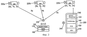
На фиг.2 изображено множество спутников 220а-n ГСП, известное местоположение 230 и неизвестное местоположение 240, в качестве примера прогнозирования положений кодового сдвига. Вычисления, описанные ниже, выполняются на сервере 170, и прогнозируемые положения кодового сдвига передаются в приемник 150 ГСП с ограниченными функциональными возможностями как часть вспомогательной информации. С другой стороны, вычисление можно выполнить с помощью приемника 150 ГСП с ограниченными функциональными возможностями. Каждый из спутников 220a-n ГСП, перечисленный во вспомогательной информации, имеет набор трехмерных координат (Xa-n, Ya-n, Za-n). Известное местоположение 230 также имеет набор трехмерных координат (X, Y, Z). Дальность Ra-n до каждого спутника 220a-n ГСП от известного местоположения 230 представлена выражением
![]()
Время Тa-n распространения сигнала от каждого спутника 220a-n ГСП представлено выражением:
Тa-n=Ra-n / (скорость света)
Прогнозируемое положение Сa-n кодового сдвига для каждого из спутников 220a-n представлено выражением:
Сa-n=дробная составляющая
[(Тa-n/1000)]•1023,
где Тa-n делится на 1000 для получения времени распространения сигнала в миллисекундах, а дробная составляющая
(Тa-n/1000)
используется для того, чтобы прогнозируемые положения кодового сдвига попали в интервал от 0 до 1023, который является возможным диапазоном положений кодового сдвига.2 depicts a plurality of GPS satellites 220 a-n , a known
![]()
The propagation time T an from each satellite 220 an GPS is represented by the expression:
T an = R an / (speed of light)
The predicted code shift position C an for each of the satellites 220 an is represented by the expression:
With an = fractional component
[(T an / 1000)] • 1023,
where T an is divided by 1000 to obtain the propagation time of the signal in milliseconds, and the fractional component
(T an / 1000)
is used so that the predicted code shift positions fall in the range from 0 to 1023, which is a possible range of code shift positions.
Из-за неопределенностей как в опорном времени, так и того факта, что неизвестное местоположение 240, соответствующее местоположению сотового телефона 140, находится на некотором расстоянии от известного местоположения 230, пространство поиска вокруг прогнозируемых положений кодового сдвига расширяется до Сa-n плюс/минус некоторое число смещения для создания пространства поиска кодового сдвига. Смещение основывается на размере зоны обслуживания и неопределенности в опорном времени, при этом большие по размеру зоны обслуживания и повышенная неопределенность приводят в результате к большим смещениям, причем неопределенность в опорном времени является преобладающим фактором.Due to uncertainties in both the reference time and the fact that the
Приемник 150 ГСП с ограниченными функциональными возможностями осуществляет поиск в пространстве поиска кодового сдвига для первого спутника 220а, чтобы определить действительное положение С'a кодового сдвига для первого спутника 220а. Так как ошибка характеризуется в основном точностью опорного времени, а не расстоянием между неизвестным местоположением 240 и известным местоположением 230, разность между прогнозируемым положением Сa кодового сдвига и измеренным положением C'a кодового сдвига суммируется с оставшимися прогнозируемыми положениями Сb-n кодового сдвига. Это приводит в результате к более точному прогнозу и, следовательно, меньшему пространству поиска кодового сдвига. Если полученные в результате прогнозируемые местоположения Сb-n кодового сдвига после добавления смещения превысили 1023, то 1023 вычитается из полученных в результате прогнозируемых местоположений Сb-n кодового сдвига для того, чтобы прогнозируемые положения кодового сдвига попали в интервал от 0 до 1023, который является возможным диапазоном положений кодового сдвига.The
Если опорное время не доступно, начальный поиск кодового сдвига для первого спутника 220a ГСП требует поиска по всем 1023 возможным положениям кодового сдвига. Однако после начального поиска процесс поиска кодового сдвига для оставшихся спутников 220b-n ГСП является идентичным процессу для случая, когда опорное время доступно. Таким образом, разность между прогнозируемым положением Сa кодового сдвига и измеренным положением С'a кодового сдвига добавляют к оставшимся прогнозируемым положениям Сb-n кодового сдвига, что приводит к более точному прогнозу и, следовательно, к уменьшению пространства поиска кодового сдвига. Если полученных в результате прогнозируемых положений Сb-n кодового сдвига после добавления смещения больше, чем 1023, то 1023 вычитается из полученных в результате прогнозируемых положений Сb-n кодового сдвига, чтобы прогнозируемые положения кодового сдвига попали в интервал от 0 до 1023 возможного диапазона положений кодового сдвига.If the reference time is not available, the initial code shift search for the first GPS satellite 220 a requires a search of all 1023 possible code shift positions. However, after the initial search, the code shift search process for the remaining GPS satellites 220 bn is identical to the process for the case where the reference time is available. Thus, the difference between the predicted code shift position C a and the measured code shift position C ' a is added to the remaining predicted code shift positions C bn , which leads to a more accurate prediction and, consequently, to a decrease in the code shift search space. If the resulting code shift positions C bn after adding the offset are greater than 1023, then 1023 is subtracted from the resulting code shift predicted positions C bn so that the predicted code shift positions fall within the range from 0 to 1023 of the possible range of code shift positions.
Вектор CD формируется из разностей между измеренными положениями C'a-n кодового сдвига и прогнозируемыми положениями Сa-n кодового сдвига. Эти значения часто выражаются в метрах путем умножения на скорость света в метрах в секунду. При умножении вектора CD на обратную матрицу косинусов единичных векторов из известного местоположения 230 к каждому из местоположений спутников ГСП в момент измерения получают поправки для X, Y и Z вектора коррекции, которые добавляются к известному местоположению 230 для определения неизвестного местоположения 240.The vector CD is formed from the differences between the measured code shift positions C ' an and the predicted code shift positions C an . These values are often expressed in meters by multiplying by the speed of light in meters per second. When multiplying the CD vector by the inverse matrix of cosines of unit vectors from a known
Вместо вычисления прогнозируемых положений Сa-n кодового сдвига, как описано выше, приемник 180 ГСП, расположенный в известном положении 230, можно использовать для прямого измерения значений. Однако использование приемников ГСП требует, чтобы приемники ГСП были расположены в каждой базовой станции.Instead of calculating the predicted code shift positions C an , as described above, the
На фиг. 3 изображен перенос опорного времени в приемник 150 ГСП с ограниченными функциональными возможностями, который находится в сотовом телефоне 140. Расстояние Ra от первого спутника 220a ГСП до известного местоположения 230 в момент измерения вычисляют способом, описанным со ссылками на фиг.2, и прогнозируемое положение Сa кодового сдвига вычисляют также способом, описанным со ссылками на фиг.2. То же самое положение Сa кодового сдвига получают в корреляторе только в случае, если основная синхронизация генератора кодов коррелятора надлежащим образом синхронизирована с системой ГСП. Для получения синхронизации основную синхронизацию приемника 180 ГСП, расположенного в базовой станции 100, устанавливают так, чтобы получить прогнозируемое положение Сa кодового сдвига. Опорную точку Тp в генераторе основной синхронизации выбирают и сравнивают со временем события Тx кадровой синхронизации базовой станции 100. Разность во времени между Тp и Тx передают в базовую станцию 100, которая передает эту разность в приемник 150 ГСП с ограниченными функциональными возможностями через сотовый телефон 140. Приемник 150 ГСП с ограниченными функциональными возможностями использует разность для установки смещения своего внутреннего генератора основной синхронизации на соответствующую величину относительно момента приема события кадровой синхронизации.In FIG. 3 shows the transfer of the reference time to a limited-
При использовании любого из ряда известных способов операцию корреляции выполняют с использованием аппаратных или программных средств. Так как сотовый телефон 140 обычно располагается в пределах шестнадцати километров (десяти миль) или менее от обслуживающей базовой станции 100 и ближе к центральному местоположению 200, положение кодового сдвига, передаваемое в приемник 150 ГСП с ограниченными функциональными возможностями во вспомогательной информации, находится очень близко к действительному положению кодового сдвига для местоположения сотового телефона 140. Поэтому пространство поиска кодового сдвига, в котором приемник 150 ГСП с ограниченными функциональными возможностями должен осуществлять поиск, значительно уменьшается. When using any of a number of known methods, the correlation operation is performed using hardware or software. Since
При использовании стандартных аппаратных средств ГСП с процессорами одновременного поиска (корреляторами) приемник 150 ГСП с ограниченными функциональными возможностями осуществляет поиск положения кодового сдвига первого спутника 160 ГСП, указанного во вспомогательной информации. Поскольку интенсивность сигнала первого спутника 160 ГСП, поиск которого осуществляется, может быть очень слабой, используется продолжительное время корреляции для получения выигрыша от процесса обработки. Например, корреляция в течение одной секунды приводит к выигрышу от обработки в двадцать децибел. Даже при очень слабом уровне интенсивности сигнала, использование коррелятора на аппаратных средствах, одновременно производящего поиск по 250 положениям кодовых сдвигов с точностью опорного времени в пределах 50 мкс, позволяет реализовать параллельную корреляцию длительностью 1 с для 150 положений кодового сдвига с любой стороны от прогнозируемого положения кодового сдвига, что является достаточным для нахождения точного положения кодового сдвига для спутника 160 ГСП. When using standard GPS hardware with simultaneous search processors (correlators), the
Если опорное время не предусмотрено в приемнике 150 ГСП с ограниченными функциональными возможностями, то выполняется поиск по всем 1023 возможным положениям кодового сдвига для первого спутника 220 ГСП, и сразу после определения действительного положения кодового сдвига вычисляют внутреннее опорное время на основе прогнозируемого положения кодового сдвига для первого спутника 220 ГСП. If the reference time is not provided in the
Таким образом, последующий поиск положений кодового сдвига для остальных спутников 220b-n ГСП соответственно уменьшается.Thus, the subsequent search for code shift positions for the remaining GPS satellites 220 bn is accordingly reduced.
После идентификации всех положений кодового сдвига приемник 150 ГСП с ограниченными функциональными возможностями передает полученные в результате псевдодальности в сотовую телефонную сеть 110 через сотовый телефон 140 и базовую станцию 100, после чего сервер 170 определяет географическое местоположение сотового телефона 140. Приемник 150 ГСП с ограниченными функциональными возможностями может вычислить географическое местоположение с использованием значений псевдодальности и передать географические координаты обратно в сотовую телефонную систему 110 через сотовый телефон 140 и базовую станцию 100. After identifying all positions of the code shift, the limited-
Псевдодальности или географические координаты можно передать в сотовую телефонную сеть 110 различными способами. Например, в сотовой телефонной сети, использующей Глобальную систему протокола мобильной связи, информацию можно передать через службу коротких сообщений. Информация передается между сотовым телефоном 140 и сотовой телефонной сетью 110 способом, широко известным в области передачи информации. Контроллер 142 идентифицирует информацию в качестве псевдодальностей или географических координат и обеспечивает поступление информации в приемопередатчик 141 для передачи в базовую станцию 100. Pseudoranges or geographic coordinates can be transmitted to the cellular telephone network 110 in various ways. For example, in a cellular telephone network using the Global System for Mobile Protocol, information can be transmitted through a short message service. Information is transmitted between the
Во втором варианте осуществления сотовый телефон 140 дополнительно оборудован системой 210 автоматической подстройки частоты для синхронизации тактовой частоты сотового телефона 140 с несущей частотой базовой станции 100. Это позволяет осуществить доплеровскую коррекцию с достаточной точностью, например необходимо только несколько попыток доплеровской коррекции для выполнения корреляционной обработки сигналов спутника 160 ГСП. In the second embodiment, the
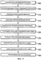
На фиг.4 изображена последовательность операций предпочтительного варианта осуществления способа, соответствующего настоящему изобретению. Определяют местоположение базовой станции сотовой телефонной сети (этап 300). Сервер, расположенный в базовой станции, получает эфемеридные данные ГСП и, если доступно, информацию о синхронизации (этап 305). Сервер получает эфемеридную информацию ГСП либо от средств обслуживания данных, либо от приемника ГСП, расположенного в базовой станции. Figure 4 shows the sequence of operations of a preferred embodiment of the method corresponding to the present invention. The location of the base station of the cellular telephone network is determined (step 300). A server located at the base station receives GPS ephemeris data and, if available, synchronization information (step 305). The server receives the GPS ephemeris information from either the data service facilities or from the GPS receiver located at the base station.
Сервер вычисляет вспомогательную информацию (этап 310) и осуществляет калибровку синхронизации базовой станции (этап 315). Сервер передает вспомогательную информацию и информацию синхронизации (этап 320) отдельному сотовому телефону или производит широковещательную передачу информации всем сотовым телефонам через широковещательный канал. Сотовый телефон затем передает информацию в приемник ГСП с ограниченными функциональными возможностями, находящийся в сотовом телефоне. The server calculates the supporting information (block 310) and calibrates the synchronization of the base station (block 315). The server transmits auxiliary information and synchronization information (step 320) to a separate cellular telephone or broadcasts information to all cellular telephones through a broadcast channel. The cell phone then transmits the information to a limited functionality GPS receiver located in the cell phone.
При использовании переданных данных приемник ГСП, находящийся в сотовом телефоне, осуществляет поиск в пространстве поиска кодового сдвига для первого спутника ГСП (этап 330), чтобы определить действительное положение кодового сдвига. После определения первого положения кодового сдвига приемник ГСП производит повторную калибровку своей синхронизации (этап 335) и корректирует ошибки в прогнозируемых положениях кодового сдвига для остальных спутников ГСП (этап 340). Приемник ГСП затем осуществляет поиск оставшихся положений (этап 350) кодового сдвига и передает информацию (этап 360) о местоположении в сотовую телефонную сеть через сотовый телефон и базовую станцию. When using the transmitted data, the GPS receiver located in the cell phone searches the code shift search space for the first GPS satellite (step 330) to determine the actual position of the code shift. After determining the first position of the code shift, the GPS receiver recalibrates its synchronization (step 335) and corrects errors in the predicted code shift positions for the remaining GPS satellites (step 340). The GPS receiver then searches for the remaining positions (step 350) of the code shift and transmits location information (step 360) to the cellular telephone network via the cellular telephone and base station.
Хотя варианты осуществления способа и устройства согласно настоящему изобретению показаны на чертежах и описаны выше в подробном описании, следует иметь в виду, что изобретение не ограничено раскрытыми вариантами осуществления и допускает возможность различных перестановок, модификаций и замен без отклонения от сущности и объема изобретения, как это определено формулой изобретения. Although embodiments of the method and device according to the present invention are shown in the drawings and described in the detailed description above, it should be borne in mind that the invention is not limited to the disclosed embodiments and allows for the possibility of various permutations, modifications and substitutions without deviating from the essence and scope of the invention, as defined by the claims.
Claims (16)
Applications Claiming Priority (2)
| Application Number | Priority Date | Filing Date | Title |
|---|---|---|---|
| US08/950,690 | 1997-10-15 | ||
| US08/950,690 US6070078A (en) | 1997-10-15 | 1997-10-15 | Reduced global positioning system receiver code shift search space for a cellular telephone system |
Publications (2)
| Publication Number | Publication Date |
|---|---|
| RU2000112026A RU2000112026A (en) | 2002-04-10 |
| RU2197780C2 true RU2197780C2 (en) | 2003-01-27 |
Family
ID=25490758
Family Applications (1)
| Application Number | Title | Priority Date | Filing Date |
|---|---|---|---|
| RU2000112026/09A RU2197780C2 (en) | 1997-10-15 | 1998-10-14 | Global positioning system receiver with limited code-shift spatial search for cellular telephone system |
Country Status (18)
| Country | Link |
|---|---|
| US (1) | US6070078A (en) |
| EP (1) | EP1023612B1 (en) |
| JP (1) | JP4023652B2 (en) |
| KR (1) | KR100616247B1 (en) |
| CN (1) | CN1316261C (en) |
| AR (1) | AR013688A1 (en) |
| AU (1) | AU758183B2 (en) |
| BR (1) | BR9813061B1 (en) |
| CA (1) | CA2306380C (en) |
| CO (1) | CO4810270A1 (en) |
| DE (1) | DE69810335T2 (en) |
| EE (1) | EE200000238A (en) |
| HK (1) | HK1033181A1 (en) |
| IL (1) | IL135613A (en) |
| MY (1) | MY115614A (en) |
| NO (1) | NO20001960L (en) |
| RU (1) | RU2197780C2 (en) |
| WO (1) | WO1999019743A1 (en) |
Cited By (10)
| Publication number | Priority date | Publication date | Assignee | Title |
|---|---|---|---|---|
| RU2445645C2 (en) * | 2006-11-10 | 2012-03-20 | Квэлкомм Инкорпорейтед | Method and apparatus for position determination with extended satellite positioning system orbit information |
| RU2447622C2 (en) * | 2007-06-07 | 2012-04-10 | Сони Корпорейшн | System of position evaluation, radio communication device, program, methods of position evaluation and information server |
| RU2464589C2 (en) * | 2007-09-11 | 2012-10-20 | Квэлкомм Инкорпорейтед | Dynamic measurement position request processing in mobile radio network |
| US8319684B2 (en) | 2006-11-10 | 2012-11-27 | Qualcomm Incorporated | Method and apparatus for position determination with extended SPS orbit information |
| RU2474083C2 (en) * | 2007-11-09 | 2013-01-27 | Квэлкомм Инкорпорейтед | Access point configuration based on received access point signals |
| US8838096B2 (en) | 2009-05-29 | 2014-09-16 | Qualcomm Incorporated | Non-macro cell search integrated with macro-cellular RF carrier monitoring |
| US8923892B2 (en) | 2010-05-14 | 2014-12-30 | Qualcomm Incorporated | Method and apparatus for updating femtocell proximity information |
| US9137745B2 (en) | 2007-10-12 | 2015-09-15 | Qualcomm Incorporated | System and method to locate femto cells with passive assistance from a macro cellular wireless network |
| US9148866B2 (en) | 2005-08-10 | 2015-09-29 | Qualcomm Incorporated | Method and apparatus for creating a fingerprint for a wireless network |
| US9366763B2 (en) | 2009-02-04 | 2016-06-14 | Qualcomm Incorporated | Method and apparatus for position determination with hybrid SPS orbit data |
Families Citing this family (101)
| Publication number | Priority date | Publication date | Assignee | Title |
|---|---|---|---|---|
| US6133874A (en) * | 1996-03-08 | 2000-10-17 | Snaptrack, Inc. | Method and apparatus for acquiring satellite positioning system signals |
| US6185427B1 (en) * | 1996-09-06 | 2001-02-06 | Snaptrack, Inc. | Distributed satellite position system processing and application network |
| US6353412B1 (en) * | 1998-03-17 | 2002-03-05 | Qualcomm, Incorporated | Method and apparatus for determining position location using reduced number of GPS satellites and synchronized and unsynchronized base stations |
| JP3039525B2 (en) * | 1998-07-16 | 2000-05-08 | 日本電気株式会社 | Spreading code allocating apparatus and method |
| US6188351B1 (en) * | 1998-08-13 | 2001-02-13 | Ericsson Inc. | Method for improving signal acquistion in a global positioning system receiver |
| JP4035235B2 (en) * | 1998-08-24 | 2008-01-16 | キヤノン株式会社 | Electronics |
| US6222483B1 (en) | 1998-09-29 | 2001-04-24 | Nokia Mobile Phones Limited | GPS location for mobile phones using the internet |
| US6415154B1 (en) * | 1998-10-06 | 2002-07-02 | Ericsson Inc. | Method and apparatus for communicating auxilliary information and location information between a cellular telephone network and a global positioning system receiver for reducing code shift search time of the receiver |
| US6266533B1 (en) * | 1998-12-11 | 2001-07-24 | Ericsson Inc. | GPS assistance data for positioning of mobiles with built-in GPS |
| US7215967B1 (en) * | 1998-12-22 | 2007-05-08 | Telefonaktiebolaget Lm Ericsson (Publ) | System and method for fast cold start of a GPS receiver in a telecommunications environment |
| US7053824B2 (en) | 2001-11-06 | 2006-05-30 | Global Locate, Inc. | Method and apparatus for receiving a global positioning system signal using a cellular acquisition signal |
| US6411892B1 (en) | 2000-07-13 | 2002-06-25 | Global Locate, Inc. | Method and apparatus for locating mobile receivers using a wide area reference network for propagating ephemeris |
| US9020756B2 (en) * | 1999-04-23 | 2015-04-28 | Global Locate, Inc. | Method and apparatus for processing satellite positioning system signals |
| US6523064B1 (en) * | 1999-04-29 | 2003-02-18 | Mitsubishi Electric Research Laboratories, Inc | Network gateway for collecting geographic data information |
| US6397074B1 (en) | 1999-05-07 | 2002-05-28 | Nokia Mobile Phones Limited | GPS assistance data delivery method and system |
| US6323803B1 (en) * | 1999-08-10 | 2001-11-27 | Ericsson Inc. | System and method for incremental broadcast of GPS navigation data in a cellular network |
| EP1208707B1 (en) * | 1999-08-12 | 2014-06-25 | Elad Barkan | Add-on base station for cellular network expansion |
| US6459405B1 (en) * | 1999-09-07 | 2002-10-01 | Lucent Technologies Inc. | Satellite-based location system employing knowledge-based sequential signal search strategy |
| US7142878B1 (en) * | 1999-11-12 | 2006-11-28 | Lucent Technologies Inc. | Method of timing calibration |
| CA2326292A1 (en) * | 1999-12-03 | 2001-06-03 | Lucent Technologies Inc. | Method of timing calibration |
| FI108895B (en) * | 2000-01-04 | 2002-04-15 | Nokia Corp | Method for performing location and electronic device determination |
| US6295023B1 (en) * | 2000-01-21 | 2001-09-25 | Ericsson Inc. | Methods, mobile stations and systems for acquiring global positioning system timing information |
| US6603977B1 (en) | 2000-02-04 | 2003-08-05 | Sbc Properties, Lp | Location information system for a wireless communication device and method therefor |
| US6662014B1 (en) * | 2000-02-04 | 2003-12-09 | Sbc Properties, L.P. | Location privacy manager for a wireless communication device and method therefor |
| US7043265B2 (en) * | 2000-03-30 | 2006-05-09 | Cellguide Ltd. | Providing time sychronization to a GPS locator |
| ATE337688T1 (en) * | 2000-04-03 | 2006-09-15 | Cellguide Ltd | DISTRIBUTED LOCATION SYSTEM |
| JP3467226B2 (en) * | 2000-04-20 | 2003-11-17 | 埼玉日本電気株式会社 | Mobile phone system |
| US6922546B1 (en) | 2000-05-03 | 2005-07-26 | Lucent Technologies Inc. | GPS signal acquisition based on frequency-domain and time-domain processing |
| GB0013148D0 (en) | 2000-05-31 | 2000-07-19 | Koninkl Philips Electronics Nv | A method of despreading GPS stread spectrum signals |
| US7126527B1 (en) | 2000-06-23 | 2006-10-24 | Intel Corporation | Method and apparatus for mobile device location via a network based local area augmentation system |
| US7369599B2 (en) * | 2000-12-18 | 2008-05-06 | Qualcomm Incorporated | Method and apparatus for reducing code phase search space |
| WO2002006847A2 (en) * | 2000-07-19 | 2002-01-24 | Qualcomm Incorporated | Method and apparatus for reducing code phase search space |
| US6583756B2 (en) * | 2000-08-25 | 2003-06-24 | Qualcomm Incorporated | Method and apparatus for using satellite status information in satellite positioning systems |
| US8050686B1 (en) * | 2000-08-29 | 2011-11-01 | Motorola Mobility, Inc. | Method of enabling low tier location applications |
| US7009948B1 (en) * | 2000-10-05 | 2006-03-07 | Ericsson Inc. | Systems and methods for providing GPS time and assistance in a communications network |
| US7254402B2 (en) * | 2000-10-12 | 2007-08-07 | Qualcomm Incorporated | GPS satellite signal acquisition assistance system and method in a wireless communications network |
| US20070200752A1 (en) | 2001-06-06 | 2007-08-30 | Global Locate, Inc. | Method and apparatus for maintaining integrity of long-term orbits in a remote receiver |
| US7196660B2 (en) | 2000-11-17 | 2007-03-27 | Global Locate, Inc | Method and system for determining time in a satellite positioning system |
| US6937187B2 (en) | 2000-11-17 | 2005-08-30 | Global Locate, Inc. | Method and apparatus for forming a dynamic model to locate position of a satellite receiver |
| US7443340B2 (en) | 2001-06-06 | 2008-10-28 | Global Locate, Inc. | Method and apparatus for generating and distributing satellite tracking information |
| US6973317B2 (en) * | 2000-12-18 | 2005-12-06 | Telefonaktiebolaget Lm Ericsson (Publ) | Call completion based on movement of mobile station |
| US20040072576A1 (en) * | 2000-12-21 | 2004-04-15 | Pan Nuutinen | Method and system for transferring gps data in mobile network |
| WO2002058425A2 (en) * | 2001-01-17 | 2002-07-25 | Siemens Aktiengesellschaft | Radio communications system and method for determining the position of at least one user device |
| US7149534B2 (en) | 2001-01-23 | 2006-12-12 | Ericsson Inc. | Peer to peer information exchange for mobile communications devices |
| DE10103272A1 (en) * | 2001-01-25 | 2002-08-01 | Gap Ag Gsm Applikationen Und P | Mobile location device has hybrid radio module that can transmit radio signals according to at least two different transmission standards acceptable to a mobile radio fixed system |
| US7747257B2 (en) | 2001-02-16 | 2010-06-29 | Motorola, Inc. | GPS assistance messages in cellular communications networks and methods therefor |
| US20020115444A1 (en) * | 2001-02-16 | 2002-08-22 | Yu Philip S. | Systems and methods wherein a base device facilitates a determination of a location associated with an occurrence of an event |
| US6473030B1 (en) * | 2001-02-28 | 2002-10-29 | Seiko Epson Corporation | Infrastructure-aiding for satellite navigation receiver and method |
| US7373175B2 (en) * | 2001-03-09 | 2008-05-13 | Qualcomm Incorporated | Method and apparatus for timebase synchronization for use with cellular base stations |
| CN1330975C (en) * | 2001-03-15 | 2007-08-08 | 高通股份有限公司 | Time acquisition in a wireless position determination system |
| JP3839680B2 (en) * | 2001-03-29 | 2006-11-01 | 株式会社エヌ・ティ・ティ・ドコモ | Position measurement method, mobile communication terminal, program, and recording medium |
| DE10118795A1 (en) * | 2001-04-05 | 2002-10-17 | Deutsche Telekom Ag | System for position data determination has service platform forming external independent server application linked into network infrastructure or internal component of network |
| US7076256B1 (en) | 2001-04-16 | 2006-07-11 | Sirf Technology, Inc. | Method and apparatus for transmitting position data using control channels in wireless networks |
| GB2380343A (en) * | 2001-05-16 | 2003-04-02 | Portelli Charalambous | Locating system having a GPS receiver combined with a mobile phone |
| US7769076B2 (en) * | 2001-05-18 | 2010-08-03 | Broadcom Corporation | Method and apparatus for performing frequency synchronization |
| US7006556B2 (en) * | 2001-05-18 | 2006-02-28 | Global Locate, Inc. | Method and apparatus for performing signal correlation at multiple resolutions to mitigate multipath interference |
| JP4453796B2 (en) * | 2001-05-29 | 2010-04-21 | 日本電気株式会社 | Map display method and system for position information display terminal |
| US8358245B2 (en) | 2001-06-06 | 2013-01-22 | Broadcom Corporation | Method and system for extending the usability period of long term orbit (LTO) |
| US7548816B2 (en) | 2001-06-06 | 2009-06-16 | Global Locate, Inc. | Method and apparatus for generating and securely distributing long-term satellite tracking information |
| US8212719B2 (en) | 2001-06-06 | 2012-07-03 | Global Locate, Inc. | Method and apparatus for background decoding of a satellite navigation message to maintain integrity of long term orbit information in a remote receiver |
| US6651000B2 (en) | 2001-07-25 | 2003-11-18 | Global Locate, Inc. | Method and apparatus for generating and distributing satellite tracking information in a compact format |
| US7069019B2 (en) * | 2001-09-08 | 2006-06-27 | Sirf Technology, Inc. | System and method to estimate the location of a receiver |
| GB0122228D0 (en) * | 2001-09-13 | 2001-11-07 | Koninl Philips Electronics Nv | GPS receiver and related method |
| US7656350B2 (en) | 2001-11-06 | 2010-02-02 | Global Locate | Method and apparatus for processing a satellite positioning system signal using a cellular acquisition signal |
| JP3491631B2 (en) * | 2001-11-28 | 2004-01-26 | 株式会社デンソー | Wireless communication terminal |
| US20030165015A1 (en) * | 2001-12-05 | 2003-09-04 | Ocular Sciences, Inc. | Coated contact lenses and methods for making same |
| CN1685244A (en) * | 2002-05-22 | 2005-10-19 | SiRF技术公司 | Aiding in a satellite positioning system |
| US7200414B2 (en) * | 2002-08-07 | 2007-04-03 | Seiko Epson Corporation | Client-aiding with cellphones in a 150-KM radius area |
| US7363044B2 (en) * | 2002-09-30 | 2008-04-22 | Motorola, Inc. | System and method for aiding a location determination in a positioning system |
| US7233798B2 (en) * | 2002-09-30 | 2007-06-19 | Motorola, Inc. | Method and apparatus for determining location of a remote unit using GPS |
| US7595752B2 (en) | 2002-10-02 | 2009-09-29 | Global Locate, Inc. | Method and apparatus for enhanced autonomous GPS |
| US6873910B2 (en) * | 2002-10-22 | 2005-03-29 | Qualcomm Incorporated | Procedure for searching for position determination signals using a plurality of search modes |
| US20040080454A1 (en) * | 2002-10-23 | 2004-04-29 | Camp William O. | Methods and systems for determining the position of a mobile terminal using digital television signals |
| WO2004038945A1 (en) * | 2002-10-24 | 2004-05-06 | Nokia Corporation | Determination of the code phase between a code modulated signal and a replica code sequence |
| US7505757B2 (en) * | 2003-01-31 | 2009-03-17 | Qualcomm Incorporated | Location based service (LBS) system, method and apparatus for triggering of mobile station LBS applications |
| US7359716B2 (en) * | 2003-01-31 | 2008-04-15 | Douglas Rowitch | Location based service (LBS) system, method and apparatus for authorization of mobile station LBS applications |
| US7672404B2 (en) * | 2003-05-19 | 2010-03-02 | Broadcom Corporation | Method and apparatus for reducing the time required to acquire a GPS signal |
| FR2858510B1 (en) * | 2003-08-01 | 2005-12-09 | Cit Alcatel | DETERMINATION OF POSITIONS OF MOBILE TERMINALS USING ASSISTANCE DATA TRANSMITTED ON REQUEST |
| US7321776B2 (en) * | 2003-09-25 | 2008-01-22 | Sony Ericsson Mobile Communications Ab | Estimating GPS time at cellular terminals based on timing of information from base stations and satellites |
| US20050090265A1 (en) | 2003-10-23 | 2005-04-28 | Charles Abraham | Method and apparatus for distributing information in an assisted-SPS system |
| US6861980B1 (en) * | 2004-05-26 | 2005-03-01 | Qualcomm Incorporated | Data messaging efficiency for an assisted wireless position determination system |
| US7358897B2 (en) * | 2004-08-16 | 2008-04-15 | Sony Ericsson Mobile Communicatios Ab | Apparatus, methods and computer program products for GPS signal acquisition using an adaptive search engine |
| JP4609095B2 (en) * | 2005-02-04 | 2011-01-12 | セイコーエプソン株式会社 | Positioning system |
| US20060208943A1 (en) * | 2005-03-21 | 2006-09-21 | Sirf Technology, Inc. | Location tagging using post-processing |
| US8026847B2 (en) * | 2006-09-14 | 2011-09-27 | Qualcomm Incorporated | System and/or method for acquisition of GNSS signals |
| US7956805B2 (en) * | 2008-04-11 | 2011-06-07 | Qualcomm Incorporated | System and/or method for obtaining a time reference for a received SPS signal |
| JP2009002958A (en) * | 2008-08-05 | 2009-01-08 | Seiko Epson Corp | Terminal device, terminal device control method, and terminal device control program |
| EP2382485B1 (en) * | 2008-11-04 | 2017-03-15 | Sensewhere Limited | Improvements to assisted positioning systems |
| JP2011030211A (en) * | 2009-06-22 | 2011-02-10 | Kddi Corp | Assist information distribution system, radio base station, and gps positioning device |
| US8712440B2 (en) * | 2009-09-10 | 2014-04-29 | Qualcomm Incorporated | Sparse network almanac |
| WO2012055026A1 (en) | 2010-10-26 | 2012-05-03 | Rx Networks Inc. | Method and apparatus for determining a position of a gnss receiver |
| KR20120048953A (en) * | 2010-11-08 | 2012-05-16 | 한국전자통신연구원 | Apparatus, system and method for determining position of mobile terminal using access point including gnss receiver |
| US8466835B2 (en) | 2011-05-13 | 2013-06-18 | The Charles Stark Draper Laboratory, Inc. | Systems and methods for clock correction |
| KR101964241B1 (en) * | 2012-03-29 | 2019-04-02 | 패솜 시스템즈 아이엔씨. | Method and apparatus for determining a position of a gnss receiver |
| US10588107B2 (en) * | 2012-10-26 | 2020-03-10 | Telefonaktiebolaget Lm Ericsson (Publ) | Methods of positioning in a system comprising measuring nodes with multiple receiving points |
| DE102017204376A1 (en) | 2017-03-16 | 2018-09-20 | Robert Bosch Gmbh | Energy-saving positioning for objects on construction sites |
| US11330549B2 (en) | 2017-08-01 | 2022-05-10 | Samsung Electronics Co., Ltd. | Positioning method and device for user equipment, and user equipment |
| CN109842934B (en) * | 2017-11-24 | 2023-04-07 | 北京三星通信技术研究有限公司 | Positioning method and positioning device of User Equipment (UE) and UE |
| EP3636018B1 (en) * | 2017-08-01 | 2023-11-08 | Samsung Electronics Co., Ltd. | Positioning method and device for user equipment, and user equipment |
| US11624839B2 (en) * | 2019-12-19 | 2023-04-11 | Star Ally International Limited | Method and apparatus for generating and distributing orbital elements for estimations of doppler, elevation, and pseudo-range |
| CN112612038A (en) * | 2020-12-31 | 2021-04-06 | 杭州飞舸科技有限公司 | Low-power consumption GPS positioning method and system |
Family Cites Families (9)
| Publication number | Priority date | Publication date | Assignee | Title |
|---|---|---|---|---|
| US4445118A (en) * | 1981-05-22 | 1984-04-24 | The United States Of America As Represented By The Administrator Of The National Aeronautics And Space Administration | Navigation system and method |
| JPH05232210A (en) * | 1992-02-20 | 1993-09-07 | Kokusai Denshin Denwa Co Ltd <Kdd> | Positioning method and control method of moving body utilizing gas satellite |
| US5490073A (en) * | 1993-04-05 | 1996-02-06 | Caterpillar Inc. | Differential system and method for a satellite based navigation |
| US5418538A (en) * | 1993-05-21 | 1995-05-23 | Trimble Navigation Limited | Rapid satellite signal acquisition in a satellite positioning system |
| GB9417600D0 (en) * | 1994-09-01 | 1994-10-19 | British Telecomm | Navigation information system |
| US5913170A (en) * | 1994-11-16 | 1999-06-15 | Highwaymaster Communications, Inc. | Locating system and method using a mobile communications network |
| US5638077A (en) * | 1995-05-04 | 1997-06-10 | Rockwell International Corporation | Differential GPS for fleet base stations with vector processing mechanization |
| US5841396A (en) * | 1996-03-08 | 1998-11-24 | Snaptrack, Inc. | GPS receiver utilizing a communication link |
| GB9524754D0 (en) * | 1995-12-04 | 1996-04-24 | Symmetricom Inc | Mobile position determination |
-
1997
- 1997-10-15 US US08/950,690 patent/US6070078A/en not_active Expired - Lifetime
-
1998
- 1998-10-07 CO CO98058320A patent/CO4810270A1/en unknown
- 1998-10-10 MY MYPI98004637A patent/MY115614A/en unknown
- 1998-10-14 AU AU10864/99A patent/AU758183B2/en not_active Expired
- 1998-10-14 KR KR1020007003956A patent/KR100616247B1/en not_active IP Right Cessation
- 1998-10-14 EE EEP200000238A patent/EE200000238A/en unknown
- 1998-10-14 EP EP98953512A patent/EP1023612B1/en not_active Expired - Lifetime
- 1998-10-14 WO PCT/US1998/021709 patent/WO1999019743A1/en not_active Application Discontinuation
- 1998-10-14 IL IL13561398A patent/IL135613A/en not_active IP Right Cessation
- 1998-10-14 DE DE69810335T patent/DE69810335T2/en not_active Expired - Lifetime
- 1998-10-14 BR BRPI9813061-7B1A patent/BR9813061B1/en active IP Right Grant
- 1998-10-14 AR ARP980105117A patent/AR013688A1/en active IP Right Grant
- 1998-10-14 CA CA002306380A patent/CA2306380C/en not_active Expired - Lifetime
- 1998-10-14 JP JP2000516241A patent/JP4023652B2/en not_active Expired - Lifetime
- 1998-10-14 RU RU2000112026/09A patent/RU2197780C2/en active
- 1998-10-14 CN CNB988102447A patent/CN1316261C/en not_active Expired - Lifetime
-
2000
- 2000-04-14 NO NO20001960A patent/NO20001960L/en not_active Application Discontinuation
-
2001
- 2001-06-04 HK HK01103852A patent/HK1033181A1/en not_active IP Right Cessation
Cited By (19)
| Publication number | Priority date | Publication date | Assignee | Title |
|---|---|---|---|---|
| US9148866B2 (en) | 2005-08-10 | 2015-09-29 | Qualcomm Incorporated | Method and apparatus for creating a fingerprint for a wireless network |
| US8319684B2 (en) | 2006-11-10 | 2012-11-27 | Qualcomm Incorporated | Method and apparatus for position determination with extended SPS orbit information |
| RU2445645C2 (en) * | 2006-11-10 | 2012-03-20 | Квэлкомм Инкорпорейтед | Method and apparatus for position determination with extended satellite positioning system orbit information |
| US8493267B2 (en) | 2006-11-10 | 2013-07-23 | Qualcomm Incorporated | Method and apparatus for position determination with extended SPS orbit information |
| US10534088B2 (en) | 2006-11-10 | 2020-01-14 | Qualcomm Incorporated | Method and apparatus for position determination with extended SPS orbit information |
| US9019157B2 (en) | 2006-11-10 | 2015-04-28 | Qualcomm Incorporated | Method and apparatus for position determination with extended SPS orbit information |
| RU2447622C2 (en) * | 2007-06-07 | 2012-04-10 | Сони Корпорейшн | System of position evaluation, radio communication device, program, methods of position evaluation and information server |
| RU2464589C2 (en) * | 2007-09-11 | 2012-10-20 | Квэлкомм Инкорпорейтед | Dynamic measurement position request processing in mobile radio network |
| US9448308B2 (en) | 2007-09-11 | 2016-09-20 | Qualcomm Incorporated | GPS yield for emergency calls in a mobile radio network |
| US8948778B2 (en) | 2007-09-11 | 2015-02-03 | Qualcomm Incorporated | Delayed radio resource signaling in a mobile radio network |
| US9140801B2 (en) | 2007-09-11 | 2015-09-22 | Qualcomm Incorporated | Delayed radio resource signaling in a mobile radio network |
| US9137745B2 (en) | 2007-10-12 | 2015-09-15 | Qualcomm Incorporated | System and method to locate femto cells with passive assistance from a macro cellular wireless network |
| RU2474083C2 (en) * | 2007-11-09 | 2013-01-27 | Квэлкомм Инкорпорейтед | Access point configuration based on received access point signals |
| RU2548041C2 (en) * | 2007-11-09 | 2015-04-10 | Квэлкомм Инкорпорейтед | Access point configuration based on received access point signals |
| US9253653B2 (en) | 2007-11-09 | 2016-02-02 | Qualcomm Incorporated | Access point configuration based on received access point signals |
| RU2499366C2 (en) * | 2007-11-09 | 2013-11-20 | Квэлкомм Инкорпорейтед | Access point configuration based on received access point signals |
| US9366763B2 (en) | 2009-02-04 | 2016-06-14 | Qualcomm Incorporated | Method and apparatus for position determination with hybrid SPS orbit data |
| US8838096B2 (en) | 2009-05-29 | 2014-09-16 | Qualcomm Incorporated | Non-macro cell search integrated with macro-cellular RF carrier monitoring |
| US8923892B2 (en) | 2010-05-14 | 2014-12-30 | Qualcomm Incorporated | Method and apparatus for updating femtocell proximity information |
Also Published As
| Publication number | Publication date |
|---|---|
| CN1316261C (en) | 2007-05-16 |
| DE69810335T2 (en) | 2003-08-28 |
| MY115614A (en) | 2003-07-31 |
| DE69810335D1 (en) | 2003-01-30 |
| JP2001520388A (en) | 2001-10-30 |
| CN1276875A (en) | 2000-12-13 |
| CA2306380A1 (en) | 1999-04-22 |
| NO20001960L (en) | 2000-06-15 |
| EP1023612A1 (en) | 2000-08-02 |
| BR9813061B1 (en) | 2013-06-25 |
| BR9813061A (en) | 2000-08-22 |
| AU1086499A (en) | 1999-05-03 |
| IL135613A (en) | 2004-06-01 |
| AR013688A1 (en) | 2001-01-10 |
| KR20010031090A (en) | 2001-04-16 |
| EP1023612B1 (en) | 2002-12-18 |
| WO1999019743A1 (en) | 1999-04-22 |
| KR100616247B1 (en) | 2006-08-28 |
| JP4023652B2 (en) | 2007-12-19 |
| NO20001960D0 (en) | 2000-04-14 |
| US6070078A (en) | 2000-05-30 |
| CO4810270A1 (en) | 1999-06-30 |
| IL135613A0 (en) | 2001-05-20 |
| AU758183B2 (en) | 2003-03-20 |
| CA2306380C (en) | 2005-03-29 |
| EE200000238A (en) | 2001-06-15 |
| HK1033181A1 (en) | 2001-08-17 |
Similar Documents
| Publication | Publication Date | Title |
|---|---|---|
| RU2197780C2 (en) | Global positioning system receiver with limited code-shift spatial search for cellular telephone system | |
| US7089112B2 (en) | Method of determining the position of a mobile unit | |
| KR100583010B1 (en) | Method for determining the location of a gps receiver using an estimated reference time | |
| EP1330662B1 (en) | Gps satellite signal acquisition assistance system and method in a wireless communications network | |
| RU2488134C2 (en) | System and method of acquiring data for assisting signal detection | |
| US7463979B2 (en) | Method and apparatus for initializing an approximate position in a GPS receiver | |
| US6658258B1 (en) | Method and apparatus for estimating the location of a mobile terminal | |
| US6570529B2 (en) | Autonomous calibration of a wireless-global positioning system | |
| KR20010041950A (en) | System and method for determining the position of a wireless cdma transceiver | |
| AU2002215342A1 (en) | GPS satellite signal acquisition assistance system and method in a wireless communications network | |
| EP1513366A1 (en) | Method and system for locating a mobile subscriber in a CDMA communication system | |
| KR100448574B1 (en) | GPS Receiver and Method for Determining Position of a Wireless Terminal |