KR20170093092A - Construction planning system - Google Patents
Construction planning system Download PDFInfo
- Publication number
- KR20170093092A KR20170093092A KR1020170097183A KR20170097183A KR20170093092A KR 20170093092 A KR20170093092 A KR 20170093092A KR 1020170097183 A KR1020170097183 A KR 1020170097183A KR 20170097183 A KR20170097183 A KR 20170097183A KR 20170093092 A KR20170093092 A KR 20170093092A
- Authority
- KR
- South Korea
- Prior art keywords
- data
- construction
- unit
- acquiring
- construction plan
- Prior art date
Links
Images


Classifications
-
- E—FIXED CONSTRUCTIONS
- E04—BUILDING
- E04G—SCAFFOLDING; FORMS; SHUTTERING; BUILDING IMPLEMENTS OR AIDS, OR THEIR USE; HANDLING BUILDING MATERIALS ON THE SITE; REPAIRING, BREAKING-UP OR OTHER WORK ON EXISTING BUILDINGS
- E04G21/00—Preparing, conveying, or working-up building materials or building elements in situ; Other devices or measures for constructional work
-
- G—PHYSICS
- G06—COMPUTING; CALCULATING OR COUNTING
- G06Q—INFORMATION AND COMMUNICATION TECHNOLOGY [ICT] SPECIALLY ADAPTED FOR ADMINISTRATIVE, COMMERCIAL, FINANCIAL, MANAGERIAL OR SUPERVISORY PURPOSES; SYSTEMS OR METHODS SPECIALLY ADAPTED FOR ADMINISTRATIVE, COMMERCIAL, FINANCIAL, MANAGERIAL OR SUPERVISORY PURPOSES, NOT OTHERWISE PROVIDED FOR
- G06Q10/00—Administration; Management
- G06Q10/06—Resources, workflows, human or project management; Enterprise or organisation planning; Enterprise or organisation modelling
- G06Q10/063—Operations research, analysis or management
- G06Q10/0631—Resource planning, allocation, distributing or scheduling for enterprises or organisations
- G06Q10/06313—Resource planning in a project environment
-
- G—PHYSICS
- G06—COMPUTING; CALCULATING OR COUNTING
- G06Q—INFORMATION AND COMMUNICATION TECHNOLOGY [ICT] SPECIALLY ADAPTED FOR ADMINISTRATIVE, COMMERCIAL, FINANCIAL, MANAGERIAL OR SUPERVISORY PURPOSES; SYSTEMS OR METHODS SPECIALLY ADAPTED FOR ADMINISTRATIVE, COMMERCIAL, FINANCIAL, MANAGERIAL OR SUPERVISORY PURPOSES, NOT OTHERWISE PROVIDED FOR
- G06Q50/00—Systems or methods specially adapted for specific business sectors, e.g. utilities or tourism
- G06Q50/08—Construction
Abstract
Description
본 발명은 시공 계획 시스템에 관한 것이다.The present invention relates to a construction planning system.
시공 현장의 시공 계획이 컴퓨터 시스템에 의해 실시되는 경우가 있다 (특허문헌 1 참조). 또, 최근, 건설 공사에 있어서 정보화 시공의 도입이 진행되고 있다. 정보화 시공이란, 건설 공사의 조사, 설계, 시공, 감독, 검사, 및 유지 관리를 포함하는 건설 생산 공정 중 「시공」에 주목하여, ICT (Information and Communication Technology) 의 활용에 의해 각 공정으로부터 얻어지는 전자 정보를 활용하여 고효율 및 고정밀한 시공을 실현하고, 또한 시공에서 얻어지는 전자 정보를 다른 공정에 활용함으로써, 건설 생산 공정 전체에 있어서의 생산성 향상 및 품질 확보를 도모하는 것을 목적으로 한 시스템이다. 정보화 시공을 가능하게 하는 기기를 탑재한 건설 기계에 의하면, 자동적으로 작업기의 움직임을 제어하여, 원하는 지형으로 시공하는 것이 가능하다.The construction plan of the construction site may be implemented by a computer system (see Patent Document 1). Recently, the introduction of computerization construction is proceeding in construction. Informatization construction refers to "construction" in the construction production process including investigation, design, construction, supervision, inspection, and maintenance of construction work, and focuses on "construction" through the use of ICT (Information and Communication Technology) It is a system aimed at improving productivity and quality in the entire construction and production process by realizing high efficiency and high precision construction by utilizing information and utilizing electronic information obtained from construction in other processes. According to the construction machine equipped with the device enabling the construction of informatization, it is possible to automatically control the movement of the working machine and construct the desired terrain.
시공 현장의 작업자의 고령화 및 건설 업계에 대한 젊은층의 취업 경원 등에 의해, 건설 업계에 있어서의 노동력 부족이 예상되고 있다. 최적의 시공 솔루션 서비스를 제공할 수 있다면, 시공 현장의 생산성을 향상시킬 수 있어, 건설 업계가 안고 있는 노동력 부족의 문제를 해결할 수 있다.Labor shortage in the construction industry is expected by the aging of the worker at the construction site and the employment of young people for the construction industry. Providing optimal construction solution services can improve the productivity of the construction site and solve the labor shortage problem of the construction industry.
본 발명의 양태는, 시공 현장의 생산성의 향상을 도모할 수 있는 시공 계획 시스템을 제공하는 것을 목적으로 한다.An aspect of the present invention is to provide a construction planning system that can improve the productivity of a construction site.
본 발명의 제 1 양태에 따르면, 시공 현장의 현황 지형을 나타내는 현황 지형 데이터를 취득하는 현황 지형 데이터 취득부와, 시공 현장의 설계 지형을 나타내는 설계 지형 데이터를 취득하는 설계 지형 데이터 취득부와, 시공 현장을 시공하는 작업 기계의 조건을 나타내는 원 (原) 단위 데이터를 취득하는 원 단위 데이터 취득부와, 현황 지형 데이터와 설계 지형 데이터와 원 단위 데이터에 기초하여, 시공 현장의 시공 계획을 나타내는 시공 계획 데이터를 산출하는 시공 계획 데이터 산출부와, 시공 계획 데이터를 출력하는 시공 계획 데이터 출력부를 구비하는 시공 계획 시스템이 제공된다.According to a first aspect of the present invention, there is provided a method of designing a construction site, comprising: a current terrain data acquisition unit for acquiring current terrain data representing a current terrain of a construction site; a design terrain data acquisition unit for acquiring design terrain data indicating a design terrain of a construction site; An original unit data acquiring unit for acquiring original unit data representing a condition of a work machine for constructing a site; and a construction unit for designating a construction plan of the construction site on the basis of the current terrain data, designing terrain data, There is provided a construction planning system including a construction plan data calculation unit for calculating data and a construction plan data output unit for outputting construction plan data.
본 발명의 제 2 양태에 따르면, 비행체에 설치된 카메라를 포함하여 시공 현장의 현황 지형을 비접촉으로 검출하는 검출 장치와, 현황 지형을 나타내는 현황 지형 데이터를 검출 장치로부터 취득하는 현황 지형 데이터 취득부와, 시공 현장의 설계 지형을 나타내는 설계 지형 데이터를 취득하는 설계 지형 데이터 취득부와, 시공 현장을 시공하는 작업 기계의 조건을 나타내는 원 단위 데이터를 취득하는 원 단위 데이터 취득부와, 현황 지형 데이터와 설계 지형 데이터와 원 단위 데이터에 기초하여, 시공 현장의 시공 계획을 나타내는 시공 계획 데이터를 산출하는 시공 계획 데이터 산출부와, 시공 계획 데이터를 출력하는 시공 계획 데이터 출력부와, 시공 계획 데이터 출력부로부터 송신된 시공 계획 데이터를 출력 가능하고, 현황 지형 데이터 및 설계 지형 데이터를 3 차원 표시 가능한 출력 장치를 구비하는 시공 계획 시스템이 제공된다.According to a second aspect of the present invention, there is provided a navigation system comprising: a detection device for detecting a current topography of a construction site in a non-contact manner including a camera installed in a flight body; An original unit data acquiring unit for acquiring original unit data indicating a condition of a work machine for constructing a construction site; A construction plan data output unit for outputting the construction plan data, and a construction plan data output unit for outputting the construction plan data output from the construction plan data output unit, based on the data and the circle unit data, It is possible to output the construction plan data, the current terrain data and design There is provided a construction planning system including an output device capable of three-dimensionally displaying terrain data.
본 발명의 양태에 의하면, 시공 현장의 생산성의 향상을 도모할 수 있는 시공 계획 시스템이 제공된다.According to an aspect of the present invention, there is provided a construction planning system capable of improving the productivity of a construction site.
도 1 은, 본 실시형태에 관련된 시공 계획 시스템을 모식적으로 나타내는 도면이다.
도 2 는, 본 실시형태에 관련된 불도저를 모식적으로 나타내는 도면이다.
도 3 은, 본 실시형태에 관련된 유압 셔블을 모식적으로 나타내는 도면이다.
도 4 는, 본 실시형태에 관련된 유압 셔블을 모식적으로 나타내는 도면이다.
도 5 는, 본 실시형태에 관련된 정보화 시공을 모식적으로 나타내는 도면이다.
도 6 은, 본 실시형태에 관련된 정보화 시공을 모식적으로 나타내는 도면이다.
도 7 은, 본 실시형태에 관련된 불도저에 형성된 출력 장치를 모식적으로 나타내는 도면이다.
도 8 은, 본 실시형태에 관련된 유압 셔블에 형성된 출력 장치를 모식적으로 나타내는 도면이다.
도 9 는, 본 실시형태에 관련된 드론을 모식적으로 나타내는 도면이다.
도 10 은, 본 실시형태에 관련된 시공 계획 시스템의 하드웨어 구성을 나타내는 도면이다.
도 11 은, 본 실시형태에 관련된 시공 계획 시스템을 나타내는 기능 블록도이다.
도 12 는, 본 실시형태에 관련된 시공 계획 방법을 나타내는 플로 차트이다.
도 13 은, 본 실시형태에 관련된 출력 장치의 출력예를 나타내는 도면이다.
도 14 는, 본 실시형태에 관련된 출력 장치의 출력예를 나타내는 도면이다.
도 15 는, 본 실시형태에 관련된 출력 장치의 출력예를 나타내는 도면이다.
도 16 은, 본 실시형태에 관련된 출력 장치의 출력예를 나타내는 도면이다.
도 17 은, 본 실시형태에 관련된 출력 장치의 출력예를 나타내는 도면이다.
도 18 은, 본 실시형태에 관련된 출력 장치의 출력예를 나타내는 도면이다.
도 19 는, 본 실시형태에 관련된 출력 장치의 출력예를 나타내는 도면이다.
도 20 은, 본 실시형태에 관련된 출력 장치의 출력예를 나타내는 도면이다.
도 21 은, 본 실시형태에 관련된 출력 장치의 출력예를 나타내는 도면이다.1 is a diagram schematically showing a construction planning system according to the present embodiment.
2 is a diagram schematically showing a bulldozer according to the embodiment.
3 is a diagram schematically showing a hydraulic excavator according to the present embodiment.
4 is a diagram schematically showing a hydraulic excavator according to the present embodiment.
Fig. 5 is a diagram schematically showing an information construction according to the present embodiment.
Fig. 6 is a diagram schematically showing an information construction according to the present embodiment.
7 is a diagram schematically showing an output device formed in the bulldozer according to the embodiment.
8 is a diagram schematically showing an output device formed on the hydraulic excavator according to the present embodiment.
9 is a diagram schematically showing the drones according to the present embodiment.
10 is a diagram showing the hardware configuration of the construction planning system according to the present embodiment.
11 is a functional block diagram showing a construction planning system according to the present embodiment.
12 is a flow chart showing a construction planning method according to the present embodiment.
13 is a diagram showing an output example of the output apparatus according to the present embodiment.
14 is a diagram showing an output example of the output apparatus according to the present embodiment.
15 is a diagram showing an output example of the output apparatus according to the present embodiment.
16 is a diagram showing an output example of the output apparatus according to the present embodiment.
17 is a diagram showing an output example of the output apparatus according to the present embodiment.
18 is a diagram showing an output example of the output apparatus according to the present embodiment.
19 is a diagram showing an output example of the output apparatus according to the present embodiment.
20 is a diagram showing an output example of the output apparatus according to the present embodiment.
21 is a diagram showing an output example of the output apparatus according to the present embodiment.
이하, 본 발명에 관련된 실시형태에 대해 도면을 참조하면서 설명하지만, 본 발명은 이것에 한정되지 않는다. 이하에서 설명하는 각 실시형태의 구성 요소는 적절히 조합할 수 있다. 또, 일부의 구성 요소를 이용하지 않는 경우도 있다.Hereinafter, embodiments of the present invention will be described with reference to the drawings, but the present invention is not limited thereto. The constituent elements of the embodiments described below can be appropriately combined. In addition, some components may not be used.
[시공 계획 시스템의 개요] [Overview of Construction Planning System]
도 1 은, 본 실시형태에 관련된 시공 계획 시스템 (1) 을 모식적으로 나타내는 도면이다. 시공 계획 시스템 (1) 은, 컴퓨터 시스템 (2) 을 포함하고, 토목의 시공 현장 (3) 의 시공 계획 및 시공 관리를 실시한다. 시공 현장 (3) 에 있어서, 작업 기계가 가동한다. 작업 기계는, 예를 들어, 시공 현장 (3) 을 굴삭하거나 정지 (整地) 하거나 하는 것이 가능한 건설 기계 (4) 와, 토사를 운반 가능한 운반 차량 (5) 을 포함한다.Fig. 1 is a diagram schematically showing a
본 실시형태에 있어서, 건설 기계 (4) 는, 예를 들어, 정보화 시공을 실시 가능한 ICT (Information and Communication Technology) 건설 기계이다. 건설 기계 (4) 는, 작업 부재를 갖는 불도저 (4A) 와 유압 셔블 (4B) 을 포함한다. 작업 부재란, 날끝을 갖고, 시공 현장 (3) 의 현황 지형을 굴삭하거나 정지하거나 하는 것이 가능한 부재를 말한다. 본 실시형태에 있어서, 작업 부재는, 불도저 (4A) 에 형성된 블레이드 및 유압 셔블 (4B) 에 형성된 버킷이다. 시공 현장 (3) 에 있어서, 불도저 (4A) 는, 토사의 굴삭, 압토, 성토, 및 정지를 실시한다. 유압 셔블 (4B) 은, 토사의 굴삭, 절토, 성토, 및 정지를 실시한다.In the present embodiment, the
운반 차량 (5) 은, 베셀을 갖는 덤프 트럭을 포함한다. 유압 셔블 (4B) 에 의해, 운반 차량 (5) 에 토사가 적입된다. 운반 차량 (5) 은, 예를 들어, 시공 현장 (3) 으로부터 시공 현장 (3) 밖으로 토사를 운반하고, 시공 현장 (3) 의 밖으로부터 시공 현장 (3) 으로 토사를 운반한다.The
또, 시공 현장 (3) 에 있어서, 작업자 (Ma) 가 작업을 실시한다. 작업자 (Ma) 는, 휴대 단말 (7) 을 소지한다. 휴대 단말 (7) 은, 스마트 폰 또는 태블릿형 퍼스널 컴퓨터와 같은 휴대형 컴퓨터를 포함한다. 또, 시공 현장 (3) 에는, 현장 사무소 (9) 가 설치된다. 퍼스널 컴퓨터와 같은 정보 단말 (8) 이 현장 사무소 (9) 에 설치된다. 작업자 (Ma) 는, 휴대 단말 (7) 또는 정보 단말 (8) 을 사용하여 작업을 실시한다. 또한, 작업자 (Ma) 는, 건설 기계 (4) 의 오퍼레이터 및 시공 현장 (3) 에서 보조 작업 등을 실시하는 작업원을 포함한다.In addition, in the
또, 시공 현장 (3) 에 있어서, 시공 현장 (3) 의 현황 지형을 검출하기 위한 드론 (10) 이 가동된다. 드론 (10) 은, 무인으로 비행하는 비행체로, 무선에 의해 원격 조작되는 비행체, 및 자동적으로 부상하여 미리 설정된 비행 루트에 따라 비행하여 소정의 위치에 강하하는 비행체를 포함한다. 드론 (10) 은, 카메라 (11) 를 갖는다. 드론 (10) 은, 카메라 (11) 를 탑재한 상태에서, 시공 현장 (3) 의 상공을 비행한다. 카메라 (11) 는, 시공 현장 (3) 의 현황 지형을 비접촉으로 검출 가능한 제 1 검출 장치이다. 드론 (10) 에 형성된 카메라 (11) 는, 시공 현장 (3) 을 공중에서 촬영하여, 현황 지형을 비접촉으로 검출한다.Further, in the
컴퓨터 시스템 (2) 은, 시공 회사 (12) 와 데이터 통신 가능하다. 시공 회사 (12) 에 있어서, 시공 현장 (3) 의 설계 지형이 작성된다. 설계 지형은, 시공 현장 (3) 에 있어서의 지면의 목표 형상이다. 퍼스널 컴퓨터와 같은 정보 단말 (13) 이 시공 회사 (12) 에 설치된다. 시공 회사 (12) 의 작업자 (Mb) 는, 정보 단말 (13) 을 사용하여, 2 차원 또는 3 차원의 설계 지형 데이터를 작성한다.The
또, 시공 계획 시스템 (1) 은, 시공 현장 (3) 을 서포트하는 서포트 센터 (14) 를 갖는다. 컴퓨터 시스템 (2) 은, 서포트 센터 (14) 와 데이터 통신 가능하다. 또한, 컴퓨터 시스템 (2) 을 서포트 센터 (14) 에 장착하여, 후술하는 컴퓨터 시스템 (2) 에서 실행되는 처리가 서포트 센터 (14) 에서 실행되어도 된다. 서포트 센터 (14) 는, 시공 현장 (3) 으로부터 요망된 설계 지형의 변경 또는 3 차원 화상 데이터의 생성 등을 실행한다. 퍼스널 컴퓨터와 같은 정보 단말 (15) 이 서포트 센터 (14) 에 설치된다. 서포트 센터 (14) 의 작업자 (Mc) 는, 정보 단말 (15) 을 사용하여 작업을 실시한다.The
[건설 기계] [Construction Machinery]
다음으로, 건설 기계 (4) 에 대해 설명한다. GPS 위성 (6) 을 포함하는 GPS (Global Positioning System:전지구 측위 시스템) 에 의해, 글로벌 좌표계 (XgYgZg 좌표계) 에 있어서의 건설 기계 (4) 의 차량 본체의 위치를 나타내는 절대 위치가 검출된다. 건설 기계 (4) 에 형성된 검출 장치에 의해, 로컬 좌표계 (XYZ 좌표계) 에 있어서의 건설 기계 (4) 의 차량 본체에 대한 작업 부재의 날끝의 위치를 나타내는 상대 위치가 검출된다. 차량 본체의 절대 위치와, 차량 본체와 작업 부재의 날끝의 상대 위치에 기초하여, 작업 부재의 날끝의 절대 위치가 산출된다.Next, the
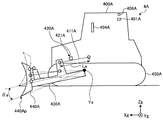
도 2 는, 불도저 (4A) 를 모식적으로 나타내는 도면이다. 불도저 (4A) 는, 차량 차체 (400A) 와, 차량 본체 (400A) 의 절대 위치를 검출하는 GPS 수신기 (406A) 와, 차량 본체 (400A) 에 대한 블레이드 (440A) 의 날끝 (440Ap) 의 상대 위치를 검출하는 검출 장치 (420A) 와, 블레이드 (440A) 의 날끝 (440Ap) 의 위치를 제어하는 블레이드 제어 장치 (401A) 를 갖는다.Fig. 2 is a diagram schematically showing the
또, 불도저 (4A) 는, 유압 실린더인 리프트 실린더 (411A) 와, 리프트 실린더 (411A) 의 작동량을 검출하는 리프트 실린더 센서 (421A) 와, 블레이드 (440A) 를 지지하는 리프트 프레임 (430A) 과, 차량 본체 (400A) 를 지지하는 주행 장치 (450A) 를 갖는다.The
차량 본체 (400A) 는, 운전자가 착석하는 운전석이 형성된 운전실을 갖는다. 운전실에는, 각종 조작 장치 및 화상 데이터를 표시하는 출력 장치 (404A) 가 배치된다.The
주행 장치 (450A) 는, 크롤러를 갖는다. 리프트 프레임 (430A) 은, 차폭 방향으로 평행한 축선 (Ya) 을 중심으로 상하 방향으로 동작 가능하게 차량 본체 (400A) 에 지지된다. 블레이드 (440A) 는, 리프트 프레임 (430A) 을 통하여 차량 본체 (400A) 에 지지된다. 리프트 실린더 (411A) 는, 차량 본체 (400A) 와 리프트 프레임 (430A) 을 연결하도록 형성된다. 리프트 실린더 (411A) 는, 리프트 프레임 (430A) 을 이동시켜, 블레이드 (440A) 를 상하 방향으로 이동시킨다. 날끝 (440Ap) 은, 블레이드 (440A) 의 하단부에 배치된다. 정지 작업 및 굴삭 작업에 있어서, 날끝 (440Ap) 이 시공 현장 (3) 의 지면에 접촉한다. The traveling
GPS 수신기 (406A) 는, 차량 본체 (400A) 에 형성된다. 차량 본체 (400A) 에 GPS 용 안테나가 형성된다. GPS 용 안테나는, GPS 위성 (6) 으로부터 수신된 전파에 대응하는 신호를 GPS 수신기 (406A) 에 출력한다. GPS 수신기 (406A) 는, 자차의 절대 위치를 나타내는 절대 위치 데이터를 취득한다. GPS 수신기 (406A) 가 자차의 절대 위치를 취득함으로써, 차량 본체 (400A) 의 절대 위치를 나타내는 절대 위치 데이터가 취득된다.The
검출 장치 (420A) 는, 리프트 실린더 센서 (421A) 를 포함한다. 리프트 실린더 센서 (421A) 는, 리프트 실린더 (411A) 의 스트로크 길이를 나타내는 리프트 실린더 길이 데이터 (La) 를 검출한다. 블레이드 제어 장치 (401A) 는, 리프트 실린더 길이 데이터 (La) 에 기초하여, 블레이드 (404A) 의 리프트각 (θa) 을 산출한다. 리프트각 (θa) 은, 블레이드 (440A) 의 원점 위치로부터의 하강 각도, 즉, 날끝 (440Ap) 의 지중 (地中) 으로의 관입 깊이 또는 지상으로부터의 높이에 대응한다. 도 2 에 있어서, 리프트 프레임 (430A) 및 블레이드 (440A) 의 원점 위치가 2 점 쇄선으로 나타나 있다. 리프트 프레임 (430A) 및 블레이드 (440A) 가 원점 위치에 위치하는 경우, 블레이드 (440A) 의 날끝 (440Ap) 은 지면에 접촉한다. 블레이드 (440A) 를 원점 위치로부터 하강시킨 상태에서 불도저 (4A) 가 전진함으로써, 불도저 (4A) 에 의한 정지 작업 및 굴삭 작업이 실시된다.The detecting
또, 도시되지 않지만, 불도저 (4A) 는, 블레이드 (440A) 를 회전 방향 (앵글 방향) 으로 이동 가능한 앵글 실린더와, 블레이드 (440A) 를 회전 방향 (틸트 방향) 으로 이동 가능한 틸트 실린더와, 앵글 실린더의 스트로크 길이를 나타내는 앵글 실린더 길이 데이터를 검출하는 앵글 실린더 센서와, 틸트 실린더의 스트로크 길이를 나타내는 틸트 실린더 길이 데이터를 검출하는 틸트 실린더 센서를 가져도 된다.Although not shown, the
검출 장치 (420A) 는, 리프트 실린더 센서 (421A) 에 더하여, 앵글 실린더 센서 및 틸트 실린더 센서도 포함한다. 리프트 실린더 센서 (421A) 에 의해 검출된 리프트 실린더 길이 데이터, 앵글 실린더 센서에 의해 검출된 앵글 실린더 길이 데이터, 및 틸트 실린더 센서에 의해 검출된 틸트 실린더 길이 데이터는, 블레이드 제어 장치 (401A) 에 출력된다. 블레이드 제어 장치 (401A) 는, 리프트 실린더 길이 데이터, 앵글 실린더 길이 데이터, 및 틸트 실린더 길이 데이터에 기초하여, 차량 본체 (400A) 에 대한 블레이드 (440A) 의 날끝 (440Ap) 의 상대 위치를 산출한다. 블레이드 제어 장치 (401A) 는, 산출한 차량 본체 (400A) 에 대한 블레이드 (440A) 의 날끝 (440Ap) 의 상대 위치와, GPS 수신기 (406A) 에서 취득된 차량 본체 (400A) 의 절대 위치에 기초하여, 블레이드 (440A) 의 날끝 (440Ap) 의 절대 위치를 산출한다.The
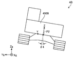
도 3 및 도 4 는, 유압 셔블 (4B) 을 모식적으로 나타내는 도면이다. 유압 셔블 (4B) 은, 차량 차체 (400B) 와, 차량 본체 (400B) 의 절대 위치를 검출하는 GPS 수신기 (406B) 와, 차량 본체 (400B) 에 대한 버킷 (440B) 의 날끝 (440Bp) 의 상대 위치를 검출하는 검출 장치 (420B) 와, 버킷 (440B) 의 날끝 (440Bp) 의 위치를 제어하는 버킷 제어 장치 (401B) 를 갖는다.Fig. 3 and Fig. 4 are diagrams schematically showing the
또, 유압 셔블 (4B) 은, 붐 핀 (433B) 을 개재하여 차량 본체 (400B) 에 접속되는 붐 (431B) 과, 아암 핀 (434B) 을 개재하여 붐 (431B) 에 접속되는 아암 (432B) 을 갖는다. 버킷 (440B) 은, 버킷 핀 (435B) 을 개재하여 아암 (432B) 에 접속된다.The
또, 유압 셔블 (4B) 은, 붐 (431B) 을 구동하는 붐 실린더 (411B) 와, 아암 (432B) 을 구동하는 아암 실린더 (412B) 와, 버킷 (440B) 을 구동하는 버킷 실린더 (413B) 와, 붐 실린더 (411B) 의 작동량을 검출하는 붐 실린더 스트로크 센서 (421B) 와, 아암 실린더 (412B) 의 작동량을 검출하는 아암 실린더 스트로크 센서 (422B) 와, 버킷 실린더 (413B) 의 작동량을 검출하는 버킷 실린더 스트로크 센서 (423B) 를 갖는다. 붐 실린더 (411B), 아암 실린더 (412B), 및 버킷 실린더 (413B) 는 유압 실린더이다.The
또, 유압 셔블 (4B) 은, 차량 본체 (400B) 를 지지하는 주행 장치 (450B) 와, IMU (Inertial Measurement Unit) (460B) 를 갖는다. 차량 본체 (400B) 는, 주행 장치 (450B) 에 지지된다. 차량 본체 (400B) 는, 선회축 (AX) 을 중심으로 선회 가능한 상부 선회체이다. 또한, 도 3 및 도 4 에 나타내는 점 (P2) 은, 선회축 (AX) 상의 점으로서, 로컬 좌표계 (XYZ 좌표계) 의 원점을 나타낸다.The
차량 본체 (400B) 는, 운전자가 착석하는 운전석이 형성된 운전실을 갖는다. 운전실에는, 각종 조작 장치 및 화상 데이터를 표시하는 출력 장치 (404B) 가 배치된다.The
주행 장치 (450B) 는 크롤러를 갖는다. 날끝 (440Bp) 은, 버킷 (440B) 의 선단부에 배치된다. 정지 작업 및 굴삭 작업에 있어서, 날끝 (440Bp) 이 시공 현장 (3) 의 지면에 접촉한다.The traveling
GPS 수신기 (406B) 는, 차량 본체 (400B) 에 형성된다. 차량 본체 (400B) 에 GPS 용 안테나가 형성된다. GPS 용 안테나는, GPS 위성 (6) 으로부터 수신된 전파에 대응하는 신호를 GPS 수신기 (406B) 에 출력한다. GPS 수신기 (406B) 는, 자차의 절대 위치를 나타내는 절대 위치 데이터를 취득한다. GPS 수신기 (406B) 가 자차의 절대 위치를 취득함으로써, 차량 본체 (400B) 의 절대 위치를 나타내는 절대 위치 데이터가 취득된다.The
검출 장치 (420B) 는, 붐 실린더 스트로크 센서 (421B), 아암 실린더 스트로크 센서 (422B), 및 버킷 실린더 스트로크 센서 (423B) 를 포함한다. 붐 실린더 스트로크 센서 (421B) 는, 붐 실린더 (411B) 의 스트로크 길이를 나타내는 붐 실린더 길이 데이터를 검출한다. 아암 실린더 스트로크 센서 (422B) 는, 아암 실린더 (412B) 의 스트로크 길이를 나타내는 아암 실린더 길이 데이터를 검출한다. 버킷 실린더 스트로크 센서 (423B) 는, 버킷 실린더 (413B) 의 스트로크 길이를 나타내는 버킷 실린더 길이 데이터를 검출한다.The
버킷 제어 장치 (401B) 는, 붐 실린더 길이 데이터에 기초하여, 차량 본체 (400B) 의 수직 방향에 대한 붐 (431B) 의 경사각 (θ1) 을 산출한다. 버킷 제어 장치 (401B) 는, 아암 실린더 길이 데이터에 기초하여, 붐 (431B) 에 대한 아암 (432B) 의 경사각 (θ2) 을 산출한다. 버킷 제어 장치 (401B) 는, 버킷 실린더 길이 데이터에 기초하여, 아암 (432B) 에 대한 버킷 (440B) 의 날끝 (440Bp) 의 경사각 (θ3) 을 산출한다. 버킷 제어 장치 (401B) 는, 경사각 (θ1), 경사각 (θ2), 경사각 (θ3), 붐 (431B) 의 길이 (L1), 아암 (432B) 의 길이 (L2), 및 버킷 (440B) 의 길이 (L3) 에 기초하여, 차량 본체 (400B) 에 대한 버킷 (440B) 의 날끝 (440Bp) 의 상대 위치를 산출한다. 또한, 붐 (431B) 의 길이 (L1) 는, 붐 핀 (433B) 과 아암 핀 (434B) 의 거리이다. 아암 (432B) 의 길이 (L2) 는, 아암 핀 (434B) 과 버킷 핀 (435B) 의 거리이다. 버킷 (440) 의 길이 (L3) 은, 버킷 핀 (435B) 과 버킷 (440B) 의 날끝 (440Bp) 의 거리이다.The
IMU (460B) 는, 차량 본체 (400B) 에 형성된다. IMU (460B) 는, 차량 본체 (400B) 의 좌우 방향에 대한 경사각 (θ4) 과 차량 본체 (400B) 의 전후 방향에 대한 경사각 (θ5) 을 검출한다.The
버킷 제어 장치 (401B) 는, 산출한 차량 본체 (400B) 에 대한 버킷 (440B) 의 날끝 (440Bp) 의 상대 위치와, GPS 수신기 (406B) 및 IMU (460B) 에서 취득된 차량 본체 (400B) 의 절대 위치에 기초하여, 버킷 (440B) 의 날끝 (440Bp) 의 절대 위치를 산출한다.The
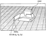
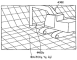
건설 기계 (4) 는, 시공 현장 (3) 의 지면의 현재의 지형을 나타내는 현황 지형 데이터를 취득할 수 있다. 도 5 는, 불도저 (4A) 가 현황 지형 데이터를 취득하고 있는 상태를 나타내는 모식도이고, 도 6 은, 유압 셔블 (4B) 이 현황 지형 데이터를 취득하고 있는 상태를 나타내는 모식도이다. 도 5 에 나타내는 바와 같이, 시공 현장 (3) 의 지면의 현재의 지형에 메시가 설정된다. 불도저 (4A) 는, 날끝 (440Ap) 의 절대 위치 (Xg 축 방향의 위치, Yg 축 방향의 위치, 및 Zg 축 방향의 위치) 를 검출 가능하다. 불도저 (4A) 는, 메시의 교점을 나타내는 메시점에 날끝 (440Ap) 을 접촉시킴으로써, 복수의 메시점 각각의 위치 데이터를 취득할 수 있다. 마찬가지로, 도 6 에 나타내는 바와 같이, 유압 셔블 (4B) 은, 메시의 교점을 나타내는 메시점에 날끝 (440Bp) 을 접촉시킴으로써, 복수의 메시점 각각의 위치 데이터를 취득할 수 있다. 복수의 메시점의 위치 데이터, 즉 날끝 (440p) (날끝 (440Ap), 날끝 (440Bp)) 의 궤적이 취득됨으로써, 시공 현장 (3) 의 현황 지형 데이터가 취득된다. 또한, 불도저 (4A) 또는 유압 셔블 (4B) 이, 주행 장치 (450 (450A, 450B)) 에 포함되는 캐터필러를 구동시켜 주행했을 경우, 차체의 치수 정보와 GPS 수신기 (406 (406A, 406B)) 에 의한 자차의 절대 위치를 나타내는 절대 위치 데이터에 기초하여, 주행 중에 캐터필러가 지면과 접촉한 위치의 궤적 (캐터필러의 주행 궤적) 을 구하고, 캐터필러의 주행 궤적을 시공 현장 (3) 의 현황 지형 데이터로서 취득해도 된다.The
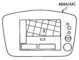
도 7 은, 불도저 (4A) 의 운전실에 형성되어 있는 출력 장치 (404A) 의 일례를 나타내는 도면이고, 도 8 은, 유압 셔블 (4B) 의 운전실에 형성되어 있는 출력 장치 (404B) 의 일례를 나타내는 도면이다. 도 7 및 도 8 에 나타내는 바와 같이, 건설 기계 (4) (불도저 (4A), 유압 셔블 (4B)) 의 출력 장치 (404) (출력 장치 (404A), 출력 장치 (404B)) 는, 화상 데이터를 표시 가능한 표시 장치를 포함한다. 설계 지형 데이터 및 건설 기계 (4) 가 출력 장치 (404) 에 표시된다. 건설 기계 (4) 의 운전자는, 출력 장치 (404) 에 표시되는 화상 데이터를 보면서, 정지 작업 또는 굴삭 작업을 실시할 수 있다.7 is a view showing an example of the
이와 같이, 건설 기계 (4) (불도저 (4A), 유압 셔블 (4B)) 의 차량 본체 (400) (차량 본체 (400A), 차량 본체 (400B)) 의 절대 위치가, 차량 본체 (400) 에 탑재된 GPS 수신기 (406 (406A, 406B)) 및 GPS 위성 (6) 을 포함하는 GPS 에 의해 검출된다. 또, 건설 기계 (4) 는, 차량 본체 (400) 에 대한 작업 부재 (440) (블레이드 (440A), 버킷 (440B)) 의 날끝 (440p) (날끝 (440Ap), 날끝 (440Bp)) 의 상대 위치를 검출 가능한 검출 장치 (420) (검출 장치 (420A), 검출 장치 (420B)) 를 갖는다. 건설 기계 (4) 는, 차량 본체 (400) 의 절대 위치와, 차량 본체 (400) 에 대한 작업 부재 (440) 의 상대 위치에 기초하여, 작업 부재 (440) 의 절대 위치를 구할 수 있다. 건설 기계 (4) 는, 컴퓨터 시스템 (2) 과 데이터 통신 가능하다. 설계 지형 데이터는, 컴퓨터 시스템 (2) 으로부터 건설 기계 (4) 에 송신된다. 건설 기계 (4) 는, 굴삭 대상의 목표 형상인 설계 지형 데이터에 기초하여, 작업 부재 (440) 의 날끝 (440p) 이 설계 지형을 따라 이동하도록, 작업 부재 (440) 를 제어한다.As described above, the absolute positions of the vehicle body 400 (the
또, 건설 기계 (4) 는, 날끝 (440p) 을 사용하여, 시공 현장 (3) 의 현황 지형 데이터를 취득할 수 있다. 또, 건설 기계 (4) 는, 작업 중인 작업 부재 (440) 의 날끝 (440p) 의 절대 위치에 기초하여, 시공 실적 데이터를 취득할 수 있다. 건설 기계 (4) 에 의해 취득된 현황 지형 데이터 또는 시공 실적 데이터는, 컴퓨터 시스템 (2) 에 송신된다.In addition, the
[드론] [drone]
도 9 는, 드론 (10) 을 모식적으로 나타내는 도면이다. 드론 (10) 은, 프로펠러 (10P) 를 갖는 무인 헬리콥터로, 시공 현장 (3) 의 상공을 비행 가능한 무인 항공기이다. 드론 (10) 에 의해, 시공 현장 (3) 의 측량이 실시된다. 드론 (10) 은, 프레임 부재 (10F) 와, 프레임 부재 (10F) 에 지지된 카메라 (11) 와, 프레임 부재 (10F) 에 형성된 프로펠러 (10P) 를 갖는다. 프로펠러 (10P) 가 회전함으로써, 드론 (10) 은 비행한다. 드론 (10) 의 카메라 (11) 는, 시공 현장 (3) 의 현황 지형을 공중에서 촬영하여 화상 데이터를, 후술하는 기억 장치 (102) 에 기억시킨다. 그 후, 화상 데이터는, 무선 또는 유선에 의해, 기억 장치 (102) 로부터, 예를 들어, 지상의 컴퓨터에 다운로드된다. 컴퓨터에 다운로드된 화상 데이터는, 컴퓨터에 장착된 변환 소프트웨어에 의해 시공 현장 (3) 의 3 차원 현황 지형 데이터로 변환된다. 이로써, 3 차원 현황 지형 데이터가 취득된다. 또한, 드론 (10) 의 기억 장치 (102) 에 변환 소프트웨어를 기억시켜, 드론 (10) 이 갖는 프로세서 (101) 에 의해 3 차원 현황 지형 데이터가 생성되어도 된다.Fig. 9 is a diagram schematically showing the
[하드웨어 구성] [Hardware configuration]
도 10 은, 시공 계획 시스템 (1) 의 하드웨어 구성을 나타내는 도면이다. 컴퓨터 시스템 (2) 은, CPU (Central Processing Unit) 와 같은 프로세서 (201) 와, ROM (Read Only Memory) 또는 RAM (Random Access Memory) 과 같은 내부 메모리 및 하드 디스크 장치와 같은 외부 메모리를 포함하는 기억 장치 (202) 와, 키보드, 마우스, 및 터치 패널과 같은 입력 디바이스를 포함하는 입력 장치 (203) 와, 플랫 패널 디스플레이 장치와 같은 표시 장치 및 잉크젯 프린터와 같은 인쇄 장치를 포함하는 출력 장치 (204) 와, 유선 통신 기기 또는 무선 통신 기기를 포함하는 입출력 인터페이스 회로 (205) 를 갖는다.Fig. 10 is a diagram showing a hardware configuration of the
시공 회사 (12) 에 설치되는 정보 단말 (13) 은, 프로세서 (131) 와, 기억 장치 (132) 와, 입력 장치 (133) 와, 출력 장치 (134) 와, 유선 통신 기기 또는 무선 통신 기기를 포함하는 입출력 인터페이스 회로 (135) 를 갖는다.The
시공 현장 (3) 에서 가동하는 건설 기계 (4) 는, 프로세서 (401) 와, 기억 장치 (402) 와, 입력 장치 (403) 와, 출력 장치 (404) 와, GPS 수신기 (406) 와, 검출 장치 (420) 와, 유선 통신 기기 또는 무선 통신 기기를 포함하는 입출력 인터페이스 회로 (405) 를 갖는다.The
시공 현장 (3) 에서 가동하는 드론 (10) 은, 프로세서 (101) 와, 기억 장치 (102) 와, 카메라 (11) 의 촬상 소자 (106) 와, 유선 통신 기기 또는 무선 통신 기기를 포함하는 입출력 인터페이스 회로 (105) 를 갖는다.The
시공 현장 (3) 에서 사용되는 휴대 단말 (7) 은, 프로세서 (701) 와, 기억 장치 (702) 와, 입력 장치 (703) 와, 출력 장치 (704) 와, 유선 통신 기기 또는 무선 통신 기기를 포함하는 입출력 인터페이스 회로 (705) 를 갖는다.The
시공 현장 (3) 에 설치되는 정보 단말 (8) 은, 프로세서 (801) 와, 기억 장치 (802) 와, 입력 장치 (803) 와, 출력 장치 (804) 와, 유선 통신 기기 또는 무선 통신 기기를 포함하는 입출력 인터페이스 회로 (805) 를 갖는다.The
서비스 센터 (14) 에 설치되는 정보 단말 (15) 은, 프로세서 (151) 와, 기억 장치 (152) 와, 입력 장치 (153) 와, 출력 장치 (154) 와, 유선 통신 기기 또는 무선 통신 기기를 포함하는 입출력 인터페이스 회로 (155) 를 갖는다.The
컴퓨터 시스템 (2) 은, 시공 현장 (3) 의 건설 기계 (4), 운반 차량 (5), 휴대 단말 (7), 정보 단말 (8), 및 드론 (10) 과 데이터 통신 가능하다. 휴대 단말 (7) 및 정보 단말 (8) 은, 인터넷을 통하여, 컴퓨터 시스템 (2) 과 데이터 통신한다. 건설 기계 (4), 운반 차량 (5), 및 드론 (10) 은, 통신 위성 회선 또는 휴대 전화 회선을 통하여, 컴퓨터 시스템 (2) 과 무선으로 데이터 통신한다. 또한, 건설 기계 (4), 운반 차량 (5), 및 드론 (10) 은, Wi-Fi 와 같은 무선 LAN 등, 다른 통신 형태를 이용하여 컴퓨터 시스템 (2) 과 무선으로 데이터 통신해도 된다.The
또, 컴퓨터 시스템 (2) 은, 시공 회사 (12) 의 정보 단말 (13) 과 인터넷을 통하여 데이터 통신한다. 컴퓨터 시스템 (2) 은, 서포트 센터 (14) 의 정보 단말 (15) 과 인터넷을 통하여 데이터 통신한다.The
[컴퓨터 시스템] [Computer System]
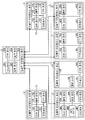
도 11 은, 시공 계획 시스템 (1) 을 나타내는 기능 블록도이다. 컴퓨터 시스템 (2) 은, 시공 계획 데이터 산출부 (20) 와, 시공 실적 데이터 취득부 (21) 와, 현황 지형 데이터 취득부 (22) 와, 모드 데이터 취득부 (23) 와, 설계 지형 데이터 취득부 (24) 와, 원 단위 데이터 취득부 (25) 와, 시공 조건 데이터 취득부 (26) 와, 변동 요인 데이터 취득부 (27) 와, 시공 계획 데이터 출력부 (28) 와, 원격 제어부 (29) 를 갖는다.Fig. 11 is a functional block diagram showing the
또, 컴퓨터 시스템 (2) 은, 원 단위 데이터베이스 (31) 와, 시공 조건 데이터베이스 (32) 와, 변동 요인 데이터베이스 (33) 와, 결과 데이터베이스 (34) 를 갖는다.The
프로세서 (201) 는, 시공 계획 데이터 산출부 (20), 시공 실적 데이터 취득부 (21), 현황 지형 데이터 취득부 (22), 모드 데이터 취득부 (23), 설계 지형 데이터 취득부 (24), 원 단위 데이터 취득부 (25), 시공 조건 데이터 취득부 (26), 변동 요인 데이터 취득부 (27), 시공 계획 데이터 출력부 (28), 및 원격 제어부 (29) 를 포함한다. 기억 장치 (202) 는, 원 단위 데이터베이스 (31), 시공 조건 데이터베이스 (32), 변동 요인 데이터베이스 (33), 및 결과 데이터베이스 (34) 를 포함한다.The
<현황 지형 데이터 취득부><Current terrain data acquisition unit>
현황 지형 데이터 취득부 (22) 는, 시공 현장 (3) 의 현황 지형을 나타내는 현황 지형 데이터를 취득한다. 현황 지형 데이터는, 드론 (10) 에 형성된 카메라 (11) 에 의해 검출된다. 현황 지형 데이터 취득부 (22) 는, 현황 지형 데이터를 드론 (10) 의 카메라 (11) 로부터, 예를 들어 무선으로 취득한다.The current terrain
<설계 지형 데이터 취득부><Design Terrain Data Acquisition Unit>
설계 지형 데이터 취득부 (24) 는, 시공 현장 (3) 의 설계 지형을 나타내는 설계 지형 데이터를 취득한다. 설계 지형은, 시공 회사 (12) 에 있어서 작성된다. 설계 지형 데이터 취득부 (24) 는, 설계 지형 데이터를 시공 회사 (12) 의 정보 단말 (13) 로부터 인터넷을 통하여 취득한다.The design terrain
<원 단위 데이터 취득부><Unit data acquisition unit>
원 단위 데이터 취득부 (25) 는, 시공 현장 (3) 을 시공하는 작업 기계의 조건을 나타내는 원 단위 데이터를 취득한다. 원 단위 데이터는, 원 단위 데이터베이스 (31) 에 기억되어 있다. 원 단위 데이터 취득부 (25) 는, 원 단위 데이터를 원 단위 데이터베이스 (31) 로부터 취득한다.The unit-unit-
원 단위 데이터의 작업 기계의 조건은, 시공 현장 (3) 에 대해 조달 가능한 작업 기계의 종류, 차격, 및 작업 기계의 대수의 적어도 하나를 포함한다. 또, 작업 기계의 조건은, 조달 가능한 작업 기계의 관리 상태를 포함한다.The condition of the work machine of the unit data includes at least one of the type of work machine that can be procured for the
또, 원 단위 데이터의 작업 기계의 조건은, 단위 시간당 실시 가능한 작업 기계의 작업량을 포함한다. 단위 시간당 실시 가능한 작업 기계의 작업량이란, 작업 기계의 작업 능력을 나타내는 지표로, 단위 시간당 작업 기계가 운반할 수 있는 토사의 양을 말한다. 단위 시간당 실시 가능한 작업 기계의 작업량은, 건기 작업 원 단위라고도 불린다. 작업 기계가 불도저 (4A) 인 경우, 불도저 (4A) 의 작업량은, 단위 시간당 불도저 (4A) 가 실시 가능한 압토량 (누를 수 있는 토사의 양), 및 성토량 (쌓을 수 있는 토사의 양) 을 말한다. 작업 기계가 유압 셔블 (4B) 인 경우, 유압 셔블 (4B) 의 작업량은, 단위 시간당 유압 셔블 (4B) 이 실시 가능한 적입량 (운반 차량 (5) 에 적입할 수 있는 양), 절토량 (굴삭 가능한 양), 및 성토량 (쌓을 수 있는 토사의 양) 을 말한다. 작업 기계가 운반 차량 (5) 인 경우, 운반 차량 (5) 의 작업량은, 단위 시간당 운반 차량 (5) 이 운반 가능한 토사의 양을 말한다.In addition, the condition of the work machine of the unit data includes the work amount of the work machine that can be performed per unit time. The workload of the work machine is the index of the work capacity of the work machine and the amount of the gravel that the work machine can carry per unit time. The workload of the work machine that can be carried out per unit time is also called the dry worker unit. In the case where the working machine is the
단위 시간당 실시 가능한 건설 기계 (4) 의 작업량은, 작업 부재 (440) 의 사이즈에 의존한다. 작업 부재 (440) 의 사이즈가 크면, 작업량은 많아지고, 작업 부재 (440) 의 사이즈가 작으면, 작업량은 적어진다. 따라서, 작업 기계 (4) 의 작업량은, 작업 부재 (440) 의 사이즈를 포함한다. 불도저 (4A) 의 작업량은, 블레이드 (440A) 의 사이즈를 포함하고, 유압 셔블 (4B) 의 작업량은, 버킷 (440B) 의 사이즈 (버킷 용량) 를 포함한다.The amount of work of the
또, 원 단위 데이터는, 시공 현장 (3) 의 작업자 (Ma) 의 조건을 추가로 포함한다. 작업자 (Ma) 의 조건은, 시공 현장 (3) 에 대해 조달 가능한 작업자 (Ma) 의 인원 수를 포함한다. 또, 작업자의 조건은, 조달 가능한 작업자 (Ma) 의 기량을 포함한다.In addition, the circle unit data further includes the condition of the worker Ma of the
즉, 원 단위 데이터는, 작업 기계의 조건 및 작업자의 조건과 같은, 시공에 필요한 리소스를 나타내는 데이터이다. 원 단위 데이터는, 시공 전에 취득 가능한 이미 알려진 데이터이고, 원 단위 데이터베이스 (31) 에 유지된다.That is, the circle-unit data is data representing resources necessary for construction, such as conditions of a working machine and conditions of an operator. The circle unit data is already known data that can be acquired before construction and is held in the
<시공 조건 데이터 취득부><Construction condition data acquisition unit>
시공 조건 데이터 취득부 (26) 는, 시공 현장 (3) 의 시공 조건을 나타내는 시공 조건 데이터를 취득한다. 시공 조건은, 시공 회사 (12) 에 있어서 설정된 사항을 포함한다. 시공 조건 데이터는, 시공 조건 데이터베이스 (32) 에 기억되어 있다. 시공 조건 데이터 취득부 (26) 는, 시공 조건 데이터를 시공 조건 데이터베이스 (32) 로부터 취득한다. The construction condition
시공 조건 데이터는, 시공에 관련된 예산, 공사 기간, 작업 내용, 작업 순서, 작업 시간, 및 현장 환경의 적어도 하나를 포함한다. 현장 환경은, 시공 현장 (3) 의 지형, 및 시공 현장 (3) 의 크기의 적어도 하나를 포함한다. 시공 조건 데이터는, 시공 전에 설정되는 이미 알려진 데이터로, 시공 조건 데이터베이스 (32) 에 유지된다.The construction condition data includes at least one of a budget related to construction, a construction period, a work content, a work order, a work time, and a site environment. The site environment includes at least one of the topography of the construction site (3) and the size of the construction site (3). The construction condition data is already known data set before construction and is held in the
<변동 요인 데이터 취득부><Variable Factor Data Acquisition Unit>
변동 요인 데이터 취득부 (27) 는, 시공 현장 (3) 의 변동 요인을 나타내는 변동 요인 데이터를 취득한다. 변동 요인 데이터는, 시공 현장 (3) 의 자연 환경과 같은 변동 요인을 포함하고, 시공의 작업 효율에 영향을 준다. 변동 요인 데이터는, 변동 요인 데이터베이스 (33) 에 기억되어 있다. 변동 요인 데이터 취득부 (27) 는, 변동 요인 데이터를 변동 요인 데이터베이스 (33) 로부터 취득한다.The variation factor
변동 요인 데이터는, 시공 현장 (3) 의 토사의 종류 및 상태를 나타내는 토질 데이터를 포함한다. 또, 변동 요인 데이터는, 시공 현장 (3) 의 지하의 매립물을 나타내는 매립물 데이터를 포함한다. 또, 변동 요인 데이터는, 시공 현장 (3) 의 기상 데이터를 포함한다. 토질 데이터 및 매립물 데이터는, 시공 전에 실시되는 사전 조사로부터 취득된다. 사전 조사로서 볼링 조사가 예시된다. 기상 데이터는, 기상청 또는 기상 회사로부터 취득된다. 시공 전에 취득된 변동 요인 데이터는, 변동 요인 데이터베이스 (33) 에 유지된다.The fluctuation factor data includes soil quality data indicating the type and condition of the gravel-like material on the construction site (3). The fluctuation factor data includes the landfill data indicating the landfill in the underground of the
<시공 실적 데이터 취득부>≪ Construction results data acquisition section >
시공 실적 데이터 취득부 (21) 는, 시공 현장 (3) 의 시공 실적을 나타내는 시공 실적 데이터를 취득한다. 시공 실적 데이터는, 건설 기계 (4) 가 실시한 시공 실적을 나타내는 데이터이다. 건설 기계 (4) 는, 자기의 시공 실적 데이터를 취득한다. 건설 기계 (4) 는, 현황 지형에 접촉하는 작업 부재 (440) 의 날끝 (440p) 의 절대 위치의 궤적 또는 캐터필러의 주행 궤적에 기초하여, 현황 지형을 검출 가능하다. 건설 기계 (4) 는, 날끝 (440p) 의 절대 위치로부터 검출되는 현황 지형과, 목표 형상인 설계 지형을 비교하여, 설계 지형에 대해 어느 정도 작업 (토사의 굴삭 또는 보전 (補塡)) 이 진행되었는지를 나타내는 시공 실적 데이터를 취득할 수 있다. 여기서, 예를 들어, 컴퓨터 시스템 (2) 이, 건설 기계 (4) 로부터 현황 지형의 정보를 취득함과 함께, 목표 형상인 설계 지형을 비교함으로써 시공 실적 데이터를 취득하도록 해도 된다. 시공 실적 데이터 취득부 (21) 는, 시공 실적 데이터를 건설 기계 (4) 로부터 예를 들어 무선으로 취득한다.The construction result
<모드 데이터 취득부><Mode Data Acquisition Unit>
모드 데이터 취득부 (23) 는, 시공의 우선 항목을 나타내는 모드 데이터를 취득한다. 모드 데이터의 상세한 것은 후술한다. 시공의 우선 항목은, 시공 현장 (3) 의 작업자 (Ma) 또는 시공 회사 (12) 의 작업자 (Mb) 에 의해 선택된다. 작업자 (Ma) 는, 휴대 단말 (7) 의 입력 장치 (703) 또는 정보 단말 (8) 의 입력 장치 (803) 를 조작하여, 시공의 우선 항목을 입력한다. 작업자 (Mb) 는, 정보 단말 (13) 의 입력 장치 (133) 를 조작하여, 시공의 우선 항목을 입력한다. 모드 데이터 취득부 (23) 는, 시공의 우선 항목을 나타내는 모드 데이터를, 휴대 단말 (7), 정보 단말 (8), 및 정보 단말 (13) 의 적어도 하나로부터, 예를 들어 인터넷을 통하여 취득한다.The mode
모드 데이터는, 시공 기간을 우선하는 공사 기간 우선 모드 데이터, 및 시공 비용을 우선하는 비용 우선 모드 데이터의 적어도 일방을 포함한다. 시공을 조기에 종료시키고자 하는 경우, 작업자 (Ma) 또는 작업자 (Mb) 는, 시공의 우선 항목으로서 공사 기간을 선택하고, 입력 장치 (703), 입력 장치 (803), 또는 입력 장치 (133) 를 조작한다. 입력 장치가 조작됨으로써, 시공 기간을 우선하는 공사 기간 우선 모드 데이터가 모드 데이터 취득부 (23) 에 취득된다. 한편, 시공을 적은 비용으로 실시하고자 하는 경우, 작업자 (Ma) 또는 작업자 (Mb) 는, 시공의 우선 항목으로서 비용을 선택하여, 입력 장치를 조작한다. 입력 장치가 조작됨으로써, 시공 비용을 우선하는 비용 우선 모드 데이터가 모드 데이터 취득부 (23) 에 취득된다.The mode data includes at least one of construction period priority mode data giving priority to a construction period and cost priority mode data giving priority to a construction cost. The worker Ma or the worker Mb selects the construction period as the priority item of the construction and inputs the construction period to the input device 703, the input device 803, or the
<시공 계획 데이터 산출부><Construction Planning Data Calculation Unit>
시공 계획 데이터 산출부 (20) 는, 현황 지형 데이터 취득부 (22) 에서 취득된 현황 지형 데이터와, 설계 지형 데이터 취득부 (24) 에서 취득된 설계 지형 데이터와, 원 단위 데이터 취득부 (25) 에서 취득된 원 단위 데이터에 기초하여, 시공 현장 (3) 의 시공 계획을 나타내는 시공 계획 데이터 (20) 를 산출한다.The construction plan
시공 계획 데이터 산출부 (20) 는, 현황 지형 데이터와 설계 지형 데이터를 대조하여, 시공 현장 (2) 의 시공 범위를 나타내는 시공 범위 데이터와, 그 시공 범위에 있어서의 토사의 굴삭량 또는 보전량을 나타내는 토량 데이터를 산출한다. 시공 계획 데이터 산출부 (20) 는, 산출한 시공 범위 데이터 및 토량 데이터와 원 단위 데이터에 기초하여, 시공 계획 데이터를 산출한다.The construction plan
시공 계획 데이터 산출부 (20) 는, 시공 조건 데이터 취득부 (26) 에 의해 시공 조건 데이터가 취득된 경우, 현황 지형 데이터와 설계 지형 데이터와 원 단위 데이터와 시공 조건 데이터에 기초하여, 시공 계획 데이터를 산출한다. When the construction condition data is acquired by the construction condition
시공 계획 데이터 산출부 (20) 는, 변동 요인 데이터 취득부 (27) 에 의해 변동 요인 데이터가 취득된 경우, 현황 지형 데이터와 설계 지형 데이터와 원 단위 데이터와 변동 요인 데이터에 기초하여, 시공 계획 데이터를 산출한다.When the variation factor data is acquired by the variation factor
시공 계획 데이터 산출부 (20) 는, 모드 데이터 취득부 (23) 에 의해 모드 데이터가 취득된 경우, 현황 지형 데이터와 설계 지형 데이터와 원 단위 데이터와 모드 데이터에 기초하여, 시공 계획 데이터를 산출한다.When the mode data is acquired by the mode
시공 계획 데이터 산출부 (20) 는, 시공 실적 데이터 취득부 (21) 에 의해 시공 실적 데이터가 취득된 경우, 시공 실적 데이터에 기초하여, 시공 계획 데이터를 재산출한다.When the construction result data is acquired by the construction result
시공 계획 데이터는, 시공 현장 (3) 에서 사용하는 작업 기계의 종류, 차격, 및 대수를 나타내는 작업 기계 데이터, 작업 기계를 사용한 시공의 공정표를 나타내는 공정표 데이터, 및 시공에 필요로 하는 비용을 나타내는 비용 데이터의 적어도 하나를 포함한다. 공정표 데이터는, 시공의 작업 순서를 나타내는 플로 데이터, 시공의 작업마다의 작업 시간을 나타내는 작업 시간 데이터, 및 시공이 완료될 때까지의 기간을 나타내는 공사 기간 데이터의 적어도 하나를 포함한다.The construction plan data includes work machine data indicating the type, height, and number of work machines used in the construction site (3), process table data showing a process table of the construction using the working machine, and cost And at least one of the data. The process schedule data includes at least one of flow data indicating a work sequence of construction, work time data indicating a work time for each work of construction, and construction period data indicating a period until completion of construction.
<시공 계획 데이터 출력부>≪ Construction plan data output section >
시공 계획 데이터 출력부 (28) 는, 시공 계획 데이터 산출부 (20) 에 의해 산출된 시공 계획 데이터를 출력한다. 시공 계획 데이터 출력부 (28) 는, 결과 데이터베이스 (34) 에 시공 계획 데이터를 출력한다.The construction plan
또, 시공 계획 데이터 출력부 (28) 는, 시공 계획 데이터 산출부 (20) 에 의해 산출된 시공 계획 데이터를, 휴대 단말 (7), 시공 현장 (3) 에 형성되어 있는 정보 단말 (8), 및 시공 회사 (12) 에 형성되어 있는 정보 단말 (13) 의 적어도 하나에 인터넷을 통하여 송신한다. 휴대 단말 (7) 의 출력 장치 (704) 및 정보 단말 (8) 의 출력 장치 (804) 는, 시공 계획 데이터를 출력 가능한 제 1 출력 장치로서 기능한다. 휴대 단말 (7) 의 출력 장치 (704) 및 정보 단말 (8) 의 출력 장치 (704) 는, 화상 데이터를 표시 가능한 표시 장치를 포함한다. 출력 장치 (704) 및 출력 장치 (804) 는, 예를 들어 액정 디스플레이와 같은 플랫 패널 디스플레이를 포함한다. 휴대 단말 (7) 및 정보 단말 (8) 은, 시공 계획 데이터를 화상 데이터로 변환하여, 출력 장치 (704) 및 출력 장치 (804) 에 표시한다.The construction plan
드론 (10) 의 카메라 (11) 에 의해 취득된 현황 지형 데이터, 및 시공 회사 (12) 에 있어서 작성된 설계 지형 데이터는, 시공 계획 데이터 산출부 (20) 및 시공 계획 데이터 출력부 (28) 를 통하여, 휴대 단말 (7) 및 정보 단말 (8) 에 송신된다. 시공 계획 데이터 산출부 (20) 는, 취득한 현황 지형 데이터 및 설계 지형 데이터를 3 차원 화상 데이터로 가공한다. 즉, 시공 계획 데이터 산출부 (20) 는, 카메라 (11) 에 의해 취득된 현황 지형의 화상 데이터를 3 차원 화상 데이터로 변환한다. 또, 시공 계획 데이터 산출부 (20) 는, 시공 회사 (12) 에 있어서 작성된 설계 도면인 2 차원 설계 지형 데이터 또는 3 차원 설계 지형 데이터를 3 차원 화상 데이터로 변환한다. 시공 계획 데이터 산출부 (20) 는, 현황 지형 데이터 및 설계 지형 데이터의 3 차원 화상 데이터를 시공 계획 데이터 출력부 (28) 를 통하여, 휴대 단말 (7) 및 정보 단말 (8) 에 송신한다. 휴대 단말 (7) 의 출력 장치 (704) 및 정보 단말 (8) 의 출력 장치 (804) 는, 현황 지형 데이터 및 설계 지형 데이터를 3 차원 표시한다.The current terrain data acquired by the
또, 건설 기계 (4) 에 의해 취득된 시공 실적 데이터는, 시공 계획 데이터 산출부 (20) 및 시공 계획 데이터 출력부 (28) 를 통하여, 휴대 단말 (7) 및 정보 단말 (8) 에 송신된다. 휴대 단말 (7) 및 정보 단말 (8) 은, 시공 실적 데이터를 출력 가능한 제 2 출력 장치로서 기능한다. 시공 계획 데이터 산출부 (20) 는, 건설 기계 (4) 로부터 취득한 시공 실적 데이터를 3 차원 화상 데이터로 가공한다. 즉, 시공 계획 데이터 산출부 (20) 는, 건설 기계 (4) 에 의해 취득된 복수의 메시점 각각의 위치 데이터를 3 차원 화상 데이터로 변환한다. 시공 계획 데이터 산출부 (20) 는, 시공 실적 데이터를 시공 계획 데이터 출력부 (28) 를 통하여, 휴대 단말 (7) 및 정보 단말 (8) 에 송신한다. 휴대 단말 (7) 의 출력 장치 (704) 및 정보 단말 (8) 의 출력 장치 (804) 는 시공 실적 데이터를 3 차원 표시한다.The construction result data acquired by the
[서포트 센터] [Support Center]
서포트 센터 (14) 는, 전술한 바와 같이 컴퓨터 시스템 (2) 의 시공 계획 데이터 산출부 (20) 가 실시하기로 한 3 차원 화상 데이터의 생성을 실시할 수도 있다. 요컨대, 시공 계획 데이터 산출부 (20) 대신에, 서포트 센터 (14) 의 프로세서 (151) 는, 건설 기계 (4) 로부터 취득한 시공 실적 데이터를 3 차원 화상 데이터로 가공하거나, 시공 회사 (12) 에 있어서 작성된 설계 도면인 2 차원 설계 지형 데이터 또는 3 차원 설계 지형 데이터를 3 차원 화상 데이터로 변환하거나 한다. 생성된 3 차원 화상 데이터는, 출력 장치 (154) 및 컴퓨터 시스템 (2) 을 통하여, 휴대 단말 (7) 및 정보 단말 (8) 에 송신된다.The
또, 서포트 센터 (14) 는, 시공 현장 (3) 으로부터 요망된 설계 지형의 변경을 접수한다. 서포트 센터 (14) 에 있어서, 정보 단말 (15) 을 사용하여, 변경 후의 설계 지형을 나타내는 설계 지형 데이터가 산출된다. 정보 단말 (15) 은, 변경 후의 설계 지형 데이터를, 예를 들어, 인터넷을 통하여, 컴퓨터 시스템 (2) 에 송신한다. 컴퓨터 시스템 (2) 의 설계 지형 데이터 취득부 (24) 는, 서포트 센터 (14) 로부터 출력된 변경 후의 설계 지형 데이터를 취득한다. 시공 계획 데이터 산출부 (20) 는, 변경 후의 설계 지형 데이터에 기초하여, 시공 계획 데이터를 재산출한다.In addition, the
변경 후의 설계 지형 데이터는, 건설 기계 (4) 에 송신된다. 변경 후의 설계 지형 데이터에 기초하여, 작업 부재 (440) 가 제어된다. The changed design terrain data is transmitted to the
<원격 제어부><Remote control unit>
또, 컴퓨터 시스템 (2) 은, 설계 지형 데이터에 기초하여, 건설 기계 (4) 를 원격 조작하기 위한 제어 신호를 출력하는 원격 제어부 (29) 를 가져도 된다. 원격 제어부 (29) 는, 건설 기계 (4) 를 리모트 콘트롤한다. 시공 현장 (3) 으로부터의 요망에 의해 설계 지형이 변경된 경우, 원격 제어부 (29) 는, 변경 후의 설계 지형 데이터에 기초하여, 건설 기계 (4) 를 원격 조작하기 위한 제어 신호를 출력할 수 있다.The
[시공 계획 방법] [Construction planning method]
다음으로, 시공 계획 시스템 (1) 을 사용하는 시공 계획 방법에 대해 설명한다. 도 12 는, 시공 계획 방법을 나타내는 플로 차트이다.Next, a construction planning method using the
드론 (10) 을 사용하여 시공 현장 (3) 의 측량이 실시된다. 드론 (10) 의 카메라 (11) 는, 시공 현장 (3) 의 3 차원 현황 지형 데이터를 취득한다. 현황 지형 데이터 취득부 (22) 는, 카메라 (11) 로부터 현황 지형 데이터를 취득한다 (스텝 S10).Surveying of the
또, 설계 지형 데이터가 설계 지형 데이터 취득부 (24) 에 취득된다 (스텝 S20).The design terrain data is acquired by the design terrain data acquisition unit 24 (step S20).
시공 계획 데이터 산출부 (20) 는, 현황 지형 데이터의 3 차원 화상 데이터, 및 설계 지형 데이터의 3 차원 화상 데이터를 생성한다 (스텝 S30).The construction plan
현황 지형 데이터의 3 차원 화상 데이터 및 설계 지형 데이터의 3 차원 화상 데이터가, 휴대 단말 (7) 및 정보 단말 (8) 에 송신된다. 휴대 단말 (7) 의 출력 장치 (704) 및 정보 단말 (8) 의 출력 장치 (804) 에, 현황 지형 데이터의 3 차원 화상 데이터 및 설계 지형 데이터의 3 차원 화상 데이터가 표시된다 (스텝 S40).The three-dimensional image data of the current terrain data and the three-dimensional image data of the design terrain data are transmitted to the
도 13 은, 출력 장치 (704) 및 출력 장치 (804) 에 의한, 현황 지형 데이터의 3 차원 화상 데이터 및 설계 지형 데이터의 3 차원 화상 데이터의 표시예를 나타내는 도면이다.13 is a diagram showing an example of display of three-dimensional image data of the current terrain data and three-dimensional image data of the design terrain data by the
시공 계획 데이터 산출부 (20) 는, 현황 지형 데이터와 설계 지형 데이터를 대조하여, 시공 현장의 시공 범위를 나타내는 시공 범위 데이터와, 시공 범위에 있어서 굴삭된 토사의 양 (굴삭량 또는 절토량), 혹은 시공 현장에 투입된 토사의 보전량 (성토량) 을 나타내는 토량 데이터를 산출한다 (스텝 S50).The construction plan
시공 계획 데이터 산출부 (20) 는, 시공 범위 데이터 및 토량 데이터의 3 차원 화상 데이터를 산출하고, 시공 계획 데이터 출력부 (28) 를 통하여, 휴대 단말 (7) 및 정보 단말 (8) 에 송신한다. 휴대 단말 (7) 의 출력 장치 (704) 및 정보 단말 (8) 의 출력 장치 (804) 는, 시공 범위 데이터 및 토량 데이터의 3 차원 화상 데이터를 표시한다 (스텝 S60).The construction plan
도 14 는, 출력 장치 (704) 및 출력 장치 (804) 에 의한, 시공 범위 데이터 및 토량 데이터에 관한 3 차원 화상 데이터의 표시예를 나타낸다. 도 14 에 나타내는 바와 같이, 3 차원 화상 데이터와 함께 수치 데이터가 표시되어도 된다.Fig. 14 shows an example of display of three-dimensional image data concerning the construction range data and the soil amount data by the
3 차원 화상 데이터에 있어서 현황 지형 데이터와 설계 지형 데이터의 차가 색 분류 또는 모양 분류되어 시각화됨으로써, 작업자 또는 관리자는, 시공 전에, 시공해야 할 범위, 및 시공 도중 또는 시공 후의 형태 등을 파악할 수 있다. 예를 들어, 3 차원 지형 데이터에 있어서, 시공 완료의 범위가 청색으로 표시되고, 시공 미완료의 범위가 황색으로 표시되어도 된다. 수치 데이터에 의해, 작업자 또는 관리자는, 지금까지의 절토량, 필요한 절토량, 투입된 성토량, 필요한 운토량, 시공 미완료된 법면 면적의 크기, 및 시공이 완료된 법면 면적의 크기 등을 정확하게 파악할 수 있다.The difference between the current terrain data and the design terrain data in the three-dimensional image data is visualized by color classification or shape classification so that the operator or the manager can grasp the scope of construction before construction, and the form during construction or after construction. For example, in the three-dimensional terrain data, the range of completion of construction may be displayed in blue, and the range of unfinished construction may be displayed in yellow. The numerical data allows the operator or the manager to accurately grasp the amount of the cutting force so far, the amount of the required cutting force, the amount of the inserted clay, the amount of the required amount of crushed stone, the size of the unfinished surface area, and the size of the completed surface area.
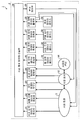
원 단위 데이터가 원 단위 데이터 취득부 (25) 에 취득된다 (스텝 S70). 원 단위 데이터를 취득한 시공 계획 데이터 산출부 (20) 는, 원 단위 데이터의 화상 데이터를 생성하고, 휴대 단말 (7) 의 출력 장치 (704) 및 정보 단말 (8) 의 출력 장치 (804) 에, 원 단위 데이터의 화상 데이터를 표시시킨다.The unit-unit data is acquired in the unit-unit-data acquiring unit 25 (step S70). The construction plan
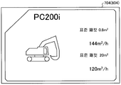
도 15 는, 불도저 (4A) 의 원 단위 데이터의 표시예를 나타낸다. 불도저 (4A) 의 원 단위 데이터로서, 불도저 (4A) 의 종류나 차격 (형식명), 블레이드 사이즈, 단위 시간당 실시 가능한 압토량 또는 성토량 등이 표시된다. 도 16 은, 유압 셔블 (4B) 의 원 단위 데이터의 표시예를 나타낸다. 유압 셔블 (4B) 의 원 단위 데이터로서, 유압 셔블 (4B) 의 종류, 차격 (형식명), 버킷 용량, 및 단위 시간당 실시 가능한 굴삭량 (적입량, 절토량, 및 성토량) 등이 표시된다.Fig. 15 shows an example of display of the circle unit data of the
시공 조건 데이터가 시공 조건 데이터 취득부 (26) 에 취득된다 (스텝 S80). 또, 변동 요인 데이터가 변동 요인 데이터 취득부 (27) 에 취득된다 (스텝 S90).The construction condition data is acquired in the construction condition data acquisition section 26 (step S80). The variation factor data is acquired in the variation factor data acquisition section 27 (step S90).
시공 계획 데이터 산출부 (20) 는, 현황 지형 데이터와 설계 지형 데이터와 원 단위 데이터와 시공 조건 데이터와 변동 요인 데이터에 기초하여, 시공 계획 데이터를 산출하는 (스텝 S100) 시공 계획 데이터 산출부 (20) 는, 현황 지형 데이터와 설계 지형 데이터와 원 단위 데이터와 시공 조건 데이터와 변동 요인 데이터에 기초하여, 시공을 시뮬레이션하여, 최적의 시공 계획 데이터를 책정한다.The construction plan
원 단위 데이터는, 작업 부재 (440) 의 사이즈를 포함하므로, 원 단위 데이터에 기초하여, 예를 들어, 1 회의 굴삭 동작으로 버킷 (440B) 을 굴삭할 수 있는 토량이 구해진다. 현황 지형 데이터와 설계 지형 데이터의 차분에 의해, 현황 지형을 설계 지형으로 마무리하기 위해서 필요한 버킷 (440B) 의 굴삭 동작의 횟수가 구해진다. 또, 단위 시간당 실시 가능한 유압 셔블 (4B) 의 굴삭 동작의 횟수 (유압 셔블 (4B) 의 작업 능력) 도, 이미 알려진 데이터인 원 단위 데이터로부터 구해진다. 따라서, 어느 유압 셔블 (4B) 을 몇 대 사용하면, 목표 공사 기간 내에 시공을 완료시킬 수 있는지를 산출할 수 있다. 또, 시공 조건 데이터가 나타내는 제약 조건에 기초하여, 어느 작업 기계를 몇 대 사용하면 되는지, 혹은 어느 작업자를 몇 사람 작업 현장에 투입하면 되는지를 구할 수 있다.Since the circle unit data includes the size of the work member 440, a soil amount that can excavate the
또, 성토를 하기 위해서 시공 현장 (3) 의 밖으로부터 운반 차량 (5) 을 사용하여 시공 현장 (3) 에 토사를 운반하는 경우에 있어서, 운반 차량 (5) 이 일반 도로를 주행하는 경우, 주행 루트, 주행 속도, 및 교통 사정 (정체의 유무 등) 등에 의해, 운반 차량 (3) 이 시공 현장 (3) 에 토사를 운반하는 타이밍 또는 단위 시간당 운반 가능한 토사의 양이 변화될 가능성이 있다. 예를 들어, 목표 타이밍보다 늦게 운반 차량 (5) 이 시공 현장 (3) 에 도착하는 경우, 운반 차량 (5) 이 시공 현장 (3) 에 도착할 때까지 동안, 건설 기계 (4) 또는 작업자 (Ma) 의 작업을 중단해야만 하는 상황이 발생할 가능성이 있다. 그 때문에, 운반 차량 (5) 의 주행 루트, 시공 현장 (3) 에 대한 도착 예상 시점 등을 포함한 운반 차량 (5) 에 관련된 원 단위 데이터에 기초하여, 양호한 효율로 작업이 실시되도록, 시공 계획 데이터를 책정할 수 있다.In the case of transporting the gravel to the
또, 시공 현장 (3) 의 굴삭을 진행시켜 가면, 토질이 변화될 가능성이 있다. 토질에 의해, 동일한 작업 능력의 작업 기계를 사용했다고 해도, 작업 스피드가 변화된다. 예를 들어, 점토질의 지면을 굴삭하는 경우와 모래질의 지면과 굴삭하는 경우에서는, 동일한 작업 능력의 작업 기계를 사용했다고 해도, 점토질의 지면을 굴삭하는 경우 쪽이, 모래질의 지면을 굴삭하는 경우에 비해, 작업 스피드가 저하되어, 작업 시간이 장기화된다. 토질은, 볼링 조사와 같은 사전 조사에 의해 미리 구할 수 있는 이미 알려진 데이터이다. 또, 토질에 따른 작업 기계의 작업 스피드도, 미리 구해 둘 수 있다. 따라서, 토질 데이터를 포함한 변동 요인 데이터를 고려함으로써, 어느 작업 기계를 사용한 경우의 작업 시간을 시뮬레이션할 수 있다.Further, if digging of the
또, 강우시와 맑게 갠 날일 때에는, 시공하기 어려운 정도 (트래픽 어빌리티) 가 변화된다. 작업 기계의 주행에 견딜 수 있는 지면의 능력 (주행 가능한 정도) 을 트래픽 어빌리티라고 한다. 예를 들어, 강우시에는, 맑게 갠 날일 때에 비해, 운반 차량 (5) 의 주행 가능 최고 속도가 느려지거나, 건설 기계 (4) (예를 들어 불도저 (4A)) 의 작업 스피드가 느려지거나 할 가능성이 있다. 기상에 따른 작업 기계의 작업 스피드 또는 운반 차량 (5) 의 주행 가능 최고 속도도, 미리 구해 둘 수 있다. 따라서, 기상 데이터를 포함한 변동 요인 데이터를 고려함으로써, 어느 작업 기계를 사용한 경우의 작업 시간을 시뮬레이션할 수 있다. 또, 기상 데이터에 기초하여, 강우 또는 강설에 대응한 사양의 건설 기계 (4) 를 시공 현장 (3) 에 투입한다는 시공 계획을 책정할 수도 있다. 강우에 대응한 사양의 건설 기계 (4) 란, 예를 들어, 질퍽거리는 노면을 주행 가능하도록 폭이 넓은 캐터필러를 구비한 불도저 (4A) 또는 강설에 대응한 타이어를 구비한 운반 차량 (5) 등이다.In addition, when rainfall and clear-cut blades are present, the degree of difficulty (traffic capability) changes. The ability of the ground capable of withstanding the running of the working machine (the extent to which it can travel) is called traffic capability. For example, at the time of rainfall, it is possible that the maximum traveling speed of the
또, 시공 현장 (3) 의 감사 또는 노동 규약에 의해, 시공을 실시할 수 있는 작업 가능 기간 및 시공을 실시할 수 없는 작업 불가능 기간이 결정되어 있는 경우가 있다. 그것들 작업 가능 시간 및 작업 불가능 시간을 나타내는 스케줄 데이터는, 사전에 알고 있는 이미 알려진 데이터로, 시공 조건 데이터로서 시공 조건 데이터베이스에 기억되어 있다. 시공 조건 데이터가 취득된 경우, 시공 계획 데이터 산출부 (20) 는, 스케줄 데이터를 포함하는 시공 조건 데이터에 기초하여, 시공 계획 데이터를 산출한다.In addition, depending on the inspection or labor contract of the construction site (3), there is a possibility that the workable period during which construction can be carried out and the period during which work can not be carried out are determined. The schedule data indicating the workable time and the workable time are stored in the construction condition database as the construction condition data, which is already known data known in advance. When the construction condition data is acquired, the construction plan
또, 시공에 있어서 실시해야 할 작업 내용 및 작업 순서를 나타내는 공정 설계 데이터는 사전에 결정되어 있어, 시공 조건 데이터로서 시공 조건 데이터베이스에 기억되어 있다. 시공 계획 데이터 산출부 (20) 는, 공정 설계 데이터를 포함한 시공 조건 데이터에 기초하여, 시공 계획 데이터를 산출한다.Also, the process design data indicating the contents of the work to be carried out in the construction and the work order are determined in advance and stored in the construction condition database as the construction condition data. The construction plan
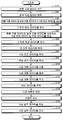
시공 계획 데이터 출력부 (28) 는, 산출된 시공 계획 데이터를 휴대 단말 (7) 및 정보 단말 (8) 에 출력한다 (스텝 S110). 휴대 단말 (7) 의 출력 장치 (704) 및 정보 단말 (8) 의 출력 장치 (804) 는, 시공 계획 데이터를 표시한다 (스텝 S120).The construction plan
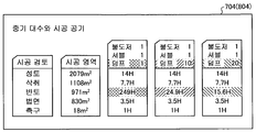
도 17, 도 18, 및 도 19 는, 출력 장치 (704) 및 출력 장치 (804) 에 의한 시공 계획 데이터의 표시예를 나타낸다. 도 17 및 도 18 에 나타내는 바와 같이, 시공 계획 데이터로서 시공 현장 (3) 에서 사용하는 작업 기계의 종류 및 대수를 나타내는 작업 기계 데이터가 표시된다. 또, 도 17 및 도 19 에 나타내는 바와 같이, 시공 계획 데이터로서 작업 기계를 사용한 시공의 공정표를 나타내는 공정표 데이터가 표시된다. 도 19 에 나타내는 바와 같이, 공정표 데이터로서, 시공의 작업 순서를 나타내는 플로 데이터가 표시된다. 도 17 및 도 19 에 나타내는 바와 같이, 공정표 데이터로서 시공의 작업마다의 작업 시간을 나타내는 작업 시간 데이터가 표시된다. 또, 도 18 에 나타내는 바와 같이, 공정표 데이터로서, 시공이 완료될 때까지의 기간을 나타내는 공사 기간 데이터가 표시된다.Figs. 17, 18, and 19 show examples of display of construction plan data by the
또, 도 18 및 도 19 에 나타내는 바와 같이, 시공 계획 데이터로서, 시공에 필요로 하는 비용을 나타내는 비용 데이터가 표시된다. 본 실시형태에 있어서, 비용 데이터는, 사용되는 작업 기계의 종류, 차격, 및 대수이다.As shown in Figs. 18 and 19, cost data indicating cost required for construction is displayed as construction plan data. In the present embodiment, the cost data is the type, the stroke, and the number of the working machines to be used.
또, 도 18 에 나타내는 바와 같이, 모드 데이터에 대응한 시공 계획 데이터가 표시된다. 도 18 의 가로축은, 시공 개시부터의 경과 예상 시간이며, 세로축은, 시공의 진척율이다. 시공 계획 데이터 산출부 (20) 는, 시공 기간을 우선하는 공사 기간 우선 모드, 시공 비용을 우선하는 비용 우선 모드, 및 공사 기간과 비용의 양립을 도모하는 중간 모드의 각각에 대해, 사용되는 작업 기계의 종류, 차격, 및 대수로 나타내는 비용 데이터, 및 시공 개시부터 시공 종료까지의 예상 시간 데이터를 시뮬레이션하여 표시한다. 도 18 에 나타내는 「A」는, 공사 기간 우선 모드가 선택된 경우의 비용 데이터 및 예상 시간 데이터를 나타낸다. 「A」는, 유압 셔블 (4B) 이 6 대 사용되고, 불도저 (4A) 가 3 대 사용되고, 운반 차량 (20) 이 20 대 사용된 경우, 공사 기간을 줄이는 것을 나타내고 있다. 도 18 에 나타내는「C」는, 비용 우선 모드가 선택된 경우의 비용 데이터 및 예상 시간 데이터를 나타낸다. 「C」는, 유압 셔블 (4B) 이 3 대 사용되고, 불도저 (4A) 가 1 대 사용되고, 운반 차량 (20) 이 10 대 사용된 경우, 비용을 억제할 수 있지만 공사 기간이 길어지는 것을 나타내고 있다. 도 18 에 나타내는 「B」는, 중간 모드가 선택된 경우의 비용 데이터 및 예상 시간 데이터를 나타낸다. 「B」는, 유압 셔블 (4B) 이 5 대 사용되고, 불도저 (4A) 가 2 대 사용되고, 운반 차량 (20) 이 16 대 사용된 경우, 비용 및 공사 기간을, 공사 기간 우선 모드와 비용 우선 모드 사이의 값으로 할 수 있는 것을 나타내고 있다. 이와 같이, 시공 계획 데이터 산출부 (100) 는, 복수 패턴의 시공 계획 데이터를 산출하여, 작업자나 관리자에게 제안할 수 있다.Also, as shown in Fig. 18, the construction plan data corresponding to the mode data is displayed. The horizontal axis in Fig. 18 is the expected elapsed time from the start of construction, and the vertical axis is the progress rate of construction. The construction plan
모드 데이터가 모드 데이터 취득부 (23) 에 취득된다 (스텝 S130). 즉, 작업자 (Ma) 는, 휴대 단말 (7) 의 입력 장치 (703) 또는 정보 단말 (8) 의 입력 장치 (803) 를 조작하여, 시공 계획 시스템 (1) 에 의해 제안된, 도 18 에 나타낸 「A」 「B」 「C」의 3 패턴의 시공 계획 데이터 중에서, 임의의 시공 계획 데이터를 선택한다. 입력 장치 (703) 또는 입력 장치 (803) 가 조작됨으로써, 시공의 우선 항목을 나타내는 모드 데이터가, 예를 들어, 인터넷을 통하여 모드 데이터 취득부 (23) 에 취득된다.The mode data is acquired by the mode data acquisition section 23 (step S130). That is, the worker Ma operates the input device 703 of the
모드 데이터가 선택됨으로써, 시공 계획이 결정된다 (스텝 S140). 시공 계획 시스템 (1) 은, 선택된 시공 계획에 기초하여, 공정표 데이터를 산출하고, 작업 기계를 보유하는 관리 회사, 작업 기계의 오퍼레이터, 또는 작업 기계의 렌탈 회사 등에 대해 작업 기계의 준비를 자동으로 실시할 수 있다. 이로써, 시공 현장은, 조기에 시공을 개시할 수 있다.By selecting the mode data, a construction plan is determined (step S140). The construction planning system (1) calculates the process schedule data based on the selected construction plan, automatically arranges the working machine for the management company having the working machine, the operator of the working machine, or the rental company of the working machine can do. As a result, the construction site can start construction early.
도 19 에 나타낸 공정표 데이터에 대해 설명한다. 예를 들어, 굴삭의 공정에 대해, 제 1 일째부터 제 6 일째까지의 기간에, 운반 차량 (5) 이 3 대, 유압 셔블 (4B) 이 2 대, 시공 현장에 투입될 계획이 나타나 있다. 또, 성토의 공정에 대해, 제 4 일째부터 제 8 일째까지의 기간에, 유압 셔블 (4B) 이 2 대, 시공 현장에 투입될 계획이 나타나 있다. 이와 같이, 공정표 데이터에 의하면, 어느 공정에 대해, 어느 기간에 건설 기계 (4) 또는 운반 차량 (5) 이 몇 대 필요한지를 시각적으로 용이하게 파악할 수 있다.The process table data shown in Fig. 19 will be described. For example, in the period from the first day to the sixth day, a plan is shown in which three
시공 현장 (3) 에서는, 결정된 시공 계획에 기초하여, 시공이 개시된다 (스텝 S150). 시공 계획 데이터 출력부 (28) 로부터, 건설 기계 (4) 에, 설계 지형 데이터 및 시공 계획 데이터가 송신된다. 건설 기계 (4) 는, 설계 지형 데이터에 기초하여, 작업 부재 (440) 를 제어하면서, 시공 현장 (3) 의 시공을 실시한다. 이로써, 경험이 부족한 운전자에 의해 조작되는 건설 기계 (4) 에서도, 설계 도면대로의 고정밀도의 시공이 가능해진다. 또, 숙련된 운전자에 의해 조작되는 건설 기계 (4) 에 있어서는, 생산성의 비약적인 향상을 가져온다. In the
작업을 실시하는 건설 기계 (4) 로부터, 예를 들어, 실시간으로 시공 실적 데이터가 컴퓨터 시스템 (2) 에 송신된다. 시공 실적 데이터는, 예를 들어 하루 중 정해진 시각 또는 주기적으로 건설 기계 (4) 로부터 컴퓨터 시스템 (2) 에 송신되도록 해도 된다. 시공 실적 데이터 취득부 (21) 는, 건설 기계 (4) 의 작업 실적 데이터를 취득한다 (스텝 S160). The construction result data is transmitted to the
도 5 및 도 6 을 참조하여 설명한 바와 같이, 건설 기계 (4) 는, 현황 지형에 접촉하는 날끝 (440p) 의 절대 위치를 검출 가능하다. 건설 기계 (4) 는, 날끝 (400p) 의 절대 위치에 기초하여, 각 메시점의 Xg 축 방향의 절대 위치, Yg 축 방향의 절대 위치, 및 Zg 축 방향의 절대 위치를 나타내는 위치 데이터를 취득하여, 현황 지형을 검출한다. As described with reference to Figs. 5 and 6, the
각 메시점의 위치 데이터는, 시공 실적 데이터 취득부 (21) 에 출력된다. 휴대 단말 (7) 의 출력 장치 (704) 및 정보 단말 (8) 의 출력 장치 (804) 는, 시공 실적 데이터를 표시한다 (스텝 S170). 도 20 은, 시공 실적 데이터의 표시예로서, 2 차원 표시된 예를 나타낸다. 도 21 은, 3 차원 표시된 예를 나타낸다. 이와 같이, 작업자는, 그 날의 시공 실적 (청부 대금) 을 실시간으로, 시각을 통해서 확인할 수 있다. 즉, 시공 계획 시스템 (1) 은, 매일 매일의 시공 계획 및 시공 실적을 항상 「시각화」할 수 있다.The position data at each time point is output to the construction result
도 20 에 나타난 시공 실적 데이터의 예에 대해 설명한다. 어느 시공 현장에 있어서의 어느 시점 (예를 들어, 2015년 4월 16일) 에서의 공사 진척 상황이 2 차원 표시되어 있다. 이 시공 현장에서는, 성토가 실시된다. 노상 (路床) 에 복수 회 (복수 층) 에 걸쳐서 성토가 실시된 상황이, 색 분류 또는 모양 분류되어 시각화되어 있다. 또, 성토의 누적량이 수치 (도 20 중, 예를 들어 462.0 ㎥) 로서 표시되어 있다. 또한, 「시공 전」이라는 버튼을 선택하면, 시공 전 상태의 색 분류 또는 모양 분류가 표시되고, 「시공 계획」이라는 버튼을 선택하면, 시공 계획 상태의 색 분류 또는 모양 분류가 표시된다. 이와 같은 2 차원 표시에 의해, 시공의 진척을 시각에 의해 용이하게 파악할 수 있다.An example of the construction result data shown in Fig. 20 will be described. The progress of the construction at a certain point in a construction site (for example, April 16, 2015) is displayed in two dimensions. In this construction site, embankment is carried out. The situation in which the embankment has been applied over a plurality of roads (multiple floors) on the road floor is visualized by color classification or shape classification. In addition, the cumulative amount of embankment is indicated as numerical value (for example, 462.0
도 21 에 나타난 시공 실적 데이터의 예에 대해 설명한다. 어느 시공 현장에 있어서의 어느 시점 (예를 들어, 2015년 4월 16일) 에서의 공사 진척 상황이 3 차원 표시되어 있다. 현황 지형이, 명암을 부여하여 3 차원 표시되어 있다. 컴퓨터 시스템 (2) 이, 건설 기계 (4) 에 형성된 GPS 수신기 (406B) 에 의한 자차의 절대 위치를 나타내는 절대 위치 데이터를 각 건설 기계 (4) 로부터 취득하고, 시공 현장에 있어서의 건설 기계 (4) 의 위치를 시각적으로 표시하고 있다. 또, 지금까지의 작업 결과로서, 목표로 하는 절토량 (예를 들어, 22,240 ㎥) 이나 목표로 하는 성토량 (예를 들어, 26,980 ㎥) 이 수치로서 표시되고, 각각의 누적량 (누계) 및 목표에 대한 잔량이 수치나 바 그래프에 의해 표시되어 있다. 이와 같은 3 차원 표시에 의해, 시공의 진척을 시각에 의해 용이하게 파악할 수 있다.An example of the construction result data shown in Fig. 21 will be described. The construction progress at a certain point in a construction site (for example, April 16, 2015) is displayed in three dimensions. The current terrain is displayed in three dimensions with light and shade. The
시공 계획 및 시공 실적이 「시각화」됨으로써, 시공 전의 시공 계획, 시공중의 시공 실시, 및 시공의 시공 평가를 포함한 일련의 작업을 신속히 실시할 수 있는, 소위, PCDA (Plan Do Check Action) 를 고속으로 회전시킬 수 있다.The so-called Plan Do Check Action (PCDA), which can quickly carry out a series of tasks including construction planning before construction, construction execution during construction, and construction evaluation of construction by making visualization of construction plan and construction results, .
또, 시공 현장 (3) 에서 설계 지형의 변경의 요망이 있는 경우, 서포트 센터 (14) 에 의한 서포트가 실시된다. 서포트 센터 (14) 에 있어서, 설계 지형 데이터 수정되어 공정 관리에 반영된다.When there is a need to change the design terrain at the
또, 설계 계획 데이터 및 시공 실적 데이터는, 결과 데이터베이스 (34) 에 축적된다. 또한, 현황 지형 데이터, 설계 지형 데이터, 원 단위 데이터, 시공 조건 데이터, 변동 요인 데이터, 및 모드 데이터가, 결과 데이터베이스 (34) 에 축적되어도 된다. 이들 결과 데이터베이스 (34) 에 축적된 데이터를 활용하여, 시공 완료 후도, 정비·수선이나 장래의 유지 보수, 자연 재해를 받은 지역의 복구 작업 등에 활용할 수 있고, 대폭적인 공수 삭감에 유용하게 쓸 수 있다.In addition, the design plan data and construction result data are accumulated in the
[효과] [effect]
이상 설명한 바와 같이, 본 실시형태에 의하면, 시공 계획 시스템 (1) 은, 현황 지형 데이터 취득부 (22) 와 설계 지형 데이터 취득부 (24) 와 원 단위 데이터 취득부 (25) 와 시공 계획 데이터 산출부 (20) 를 가지므로, 시공 계획 데이터 산출부 (20) 는, 현황 지형 데이터와 설계 지형 데이터에 기초하여, 시공해야 할 시공 범위 및 시공량을 도출할 수 있다. 시공 계획 시스템 (1) 은, 도출된 시공 범위 및 시공량과 원 단위 데이터에 기초하여, 컴퓨터 시스템 (2) 의 시공 계획 데이터 산출부 (20) 를 사용하여, 최적의 시공 계획을 책정할 수 있다. 이로써, 시공 현장의 생산성을 향상시킬 수 있어, 건설 업계가 안고 있는 노동력 부족의 문제를 해결할 수 있다.As described above, according to the present embodiment, the
본 실시형태에 있어서는, (1) 시공 전 및 시공 중에 있어서 정확한 시공 계획을 만들 수 있고, (2) 계획과 실적 (완성 부분·청부 대금) 의 차분을 실시간으로 파악할 수 있으며, (3) 최적의 시공 순서 및 절차를 제안할 수 있고, (4) 변동 요인의 발생 가능성도 예측하면서 시공 계획을 산출할 수 있다. 이로써, 시공 현장 (3) 의 생산성을 대폭 향상시킬 수 있다.In this embodiment, it is possible to (1) make an accurate construction plan before and during construction, (2) to grasp the difference between plan and actual results (finished part and contract price) in real time, (4) It is possible to calculate the construction plan while predicting the possibility of the fluctuation factor. Thus, the productivity of the
또, 본 실시형태 따르면, 시공 계획 시스템 (1) 은, 시공 회사 (12) 및 시공 현장 (3) 의 시공에 관련된 작업을, 시공 전·시공 중·시공 후·유지 관리까지 모두를 서포트할 수 있다.According to the present embodiment, the
또, 본 실시형태에 의하면, 시공 계획 데이터 출력부 (28) 로부터, 제 1 출력 장치로서 기능하는 휴대 단말 (7) 및 정보 단말 (8) 에 시공 계획 데이터가 송신된다. 이로써, 휴대 단말 (7) 및 정보 단말 (8) 은, 시공 계획 데이터를 표시할 수 있다. 따라서, 시공 현장 (3) 의 작업자 (Ma) 는, 시각을 통해서 시공 계획을 충분히 파악할 수 있다.According to the present embodiment, the construction plan data is transmitted from the construction plan
또, 본 실시형태에 의하면, 휴대 단말 (7) 및 정보 단말 (8) 은, 현황 지형 데이터 및 설계 지형 데이터를 3 차원 표시한다. 이로써, 작업자 (Ma) 는, 현황 지형과 설계 지형의 차분을 직감적으로 파악할 수 있다.According to the present embodiment, the
또, 본 실시형태에 의하면, 제 1 검출 장치로서 기능하는 카메라 (11) 는, 현황 지형을 비접촉으로 검출하여, 현황 지형 데이터를 컴퓨터 시스템 (2) 의 현황 지형 데이터 취득부 (22) 에 무선으로 송신한다. 이로써, 현황 지형의 측량 및 측량 결과의 송신을 신속히 실시할 수 있다.According to the present embodiment, the
또, 본 실시형태에 의하면, 카메라 (11) 는, 무인 비행체인 드론 (10) 에 탑재되어, 공중에서 촬영에 의해 현황 지형을 측량한다. 이로써, 측량을 단시간에 종료시킬 수 있다.According to the present embodiment, the
또, 본 실시형태에 의하면, 원 단위 데이터가 나타내는 작업 기계의 조건은, 작업 기계의 종류나 차격, 작업 기계의 대수, 및 작업 기계의 관리 상태의 적어도 하나를 포함한다. 이로써, 원 단위 데이터에 기초하여, 시공의 시뮬레이션 정밀도가 향상되어, 최적의 시공 계획을 책정할 수 있다.Further, according to the present embodiment, the condition of the work machine represented by the circle unit data includes at least one of the type of the work machine, the number of the work machines, and the management state of the work machine. Thus, the simulation accuracy of the construction is improved based on the unit data, and an optimum construction plan can be set.
또, 본 실시형태에 의하면, 원 단위 데이터가 나타내는 작업 기계의 조건은, 단위 시간당 실시 가능한 작업 기계의 작업량을 포함한다. 이로써, 단위 시간마다, 혹은 공정마다, 시공의 시뮬레이션을 고정밀도로 실시할 수 있다.Further, according to the present embodiment, the condition of the work machine represented by the circle unit data includes the work amount of the work machine that can be performed per unit time. As a result, the simulation of the construction can be performed with high precision every unit time or every process.
또, 본 실시형태에 의하면, 작업 기계는, 현황 지형을 변화시키는 것이 가능한 작업 부재를 갖고, 작업량은, 작업 부재의 사이즈를 포함한다. 작업 부재의 사이즈는 사전에 알 수 있는 불변 데이터이기 때문에, 작업량의 산출의 부담이 경감된다.According to the present embodiment, the working machine has a working member capable of changing the current topography, and the working amount includes the size of the working member. Since the size of the work member is constant data that can be known in advance, the burden of calculation of the work amount is alleviated.
또, 본 실시형태에 의하면, 작업 기계는, 시공 현장에 토사를 운반하는 운반 차량을 포함하고, 작업량은, 단위 시간당 운반 가능한 토사의 양을 포함한다. 단위 시간당 운반 가능한 토사의 양은, 일반 도로를 주행하는 운반 차량 (5) 의 주행 조건 (주행 경로, 주행 거리, 및 주행 속도), 교통 사정, 및 베셀의 사이즈 등에 따라 변화된다. 운반 차량 (5) 의 주행 조건, 교통 사정, 및 베셀의 사이즈 등을 고려함으로써, 시공의 시뮬레이션 정밀도가 향상되어, 최적의 시공 계획 데이터가 산출된다. 예를 들어, 시공 현장 (3) 에 있어서 토사의 보전이 필요한 경우, 교통 사정에 의해, 토사를 쌓은 운반 차량 (5) 이 시공 현장 (3) 에 좀처럼 도착하지 않는 경우, 시공이 스톱되어 버릴 가능성이 있다. 이와 같은 상황이 발생하지 않도록, 운반 차량 (5) 의 조건에 기초하여, 시공 계획 데이터가 산출됨으로써, 시공 현장 (3) 의 생산성이 향상된다.According to the present embodiment, the working machine includes a transportation vehicle for transporting the soil to the construction site, and the amount of work includes the amount of the soil that can be carried per unit time. The amount of the soil that can be transported per unit time varies depending on the traveling conditions (traveling route, traveling distance, and traveling speed) of the
또, 본 실시형태에 의하면, 원 단위 데이터는, 시공 현장의 작업자의 조건을 추가로 포함한다. 시공 현장 (3) 의 생산성은, 작업 기계뿐만 아니라, 작업자에게도 의존한다. 그 때문에, 작업자의 조건도 고려하여 시공 계획이 산출됨으로써, 시공 현장 (3) 의 생산성이 향상된다.Further, according to the present embodiment, the circle unit data further includes conditions of the worker at the construction site. The productivity of the construction site (3) depends not only on the work machine but also on the worker. Therefore, the productivity of the
또, 본 실시형태에 의하면, 작업자의 조건은, 작업자의 인원 수, 및 작업자의 기량의 적어도 일방을 포함한다. 이로써, 시공의 시뮬레이션 정밀도가 향상되어, 최적의 시공 계획이 책정된다.According to the present embodiment, the condition of the operator includes at least one of the number of persons of the worker and the skill of the worker. As a result, the simulation accuracy of the construction is improved, and an optimum construction plan is established.
또, 본 실시형태에 의하면, 시공 계획 데이터 산출부 (20) 는, 현황 지형 데이터와 설계 지형 데이터를 대조하여, 시공 현장의 시공 범위를 나타내는 시공 범위 데이터 및 시공 범위에 있어서 필요한 토사의 굴삭량 또는 보전량을 나타내는 토량 데이터를 산출하고, 시공 범위 데이터 및 토량 데이터와 원 단위 데이터에 기초하여, 시공 계획 데이터를 산출한다. 이로써, 최적의 시공 계획 데이터를 산출할 수 있어, 시공 현장 (3) 의 생산성을 향상시킬 수 있다.According to the present embodiment, the construction plan
또, 본 실시형태에 의하면, 시공 계획 데이터는, 시공 현장에서 사용하는 작업 기계의 종류나 차격 및 대수를 나타내는 작업 기계 데이터, 작업 기계를 사용한 시공의 공정표를 나타내는 공정표 데이터, 및 시공에 필요로 하는 비용을 나타내는 비용 데이터의 적어도 하나를 포함한다. 작업 기계 데이터, 공정표 데이터, 및 비용 데이터가 산출됨으로써, 실제의 시공이 원활히 실시되어, 생산성이 향상된다.According to the present embodiment, the construction plan data includes work machine data indicating the type of work machine used in the construction site, the number of work machines and the number of work machines, the process table data showing the process table of the construction using the working machine, And cost data indicating cost. By calculating the working machine data, the process schedule data, and the cost data, the actual construction is smoothly carried out and the productivity is improved.
또, 본 실시형태에 의하면, 공정표 데이터는, 시공의 작업 순서를 나타내는 플로 데이터, 시공의 작업마다의 작업 시간을 나타내는 작업 시간 데이터, 및 시공이 완료될 때까지의 기간을 나타내는 공사 기간 데이터의 적어도 하나를 포함한다. 이로써, 작업자 (Ma) 는, 이들 데이터에 따라, 작업을 원활히 실시할 수 있다.According to the present embodiment, the process schedule data includes at least the flow data indicating the work sequence of the construction, the work time data indicating the work time for each work of the construction, and the construction period data indicating the period until completion of the construction One. Thus, the worker Ma can smoothly carry out the work according to these data.
또, 본 실시형태에 의하면, 시공 현장의 시공 조건을 나타내는 시공 조건 데이터를 취득하는 시공 조건 데이터 취득부 (26) 를 구비하고, 시공 계획 데이터 산출부 (20) 는, 시공 조건 데이터에 기초하여, 시공 계획 데이터를 산출한다. 초기 조건 또는 제약 조건인 시공 조건이 확정됨으로써, 시공의 시뮬레이션에 있어서 해 (解) 가 신속하고 확실하게 얻어져, 적절한 시공 계획 데이터를 산출할 수 있다.According to the present embodiment, a construction condition
또, 본 실시형태에 의하면, 시공 조건 데이터는, 시공에 관련된 예산, 공사 기간, 작업 내용, 작업 순서, 작업 시간, 및 현장 환경의 적어도 하나를 포함한다. 예산 및 공사 기간이 규정된 상태에서, 시공의 시뮬레이션이 실시됨으로써, 예산 및 공사 기간의 범위 내에서, 복수의 시공 계획을 적절히 제안할 수 있다. 또, 작업 내용, 작업 순서, 및 작업 시간이 미리 규정됨으로써, 적절한 노동 환경하에서 적절한 시공 계획 데이터를 산출할 수 있어, 목표 그대로의 시공 결과를 얻을 수 있다.According to the present embodiment, the construction condition data includes at least one of a budget related to construction, a construction period, a work content, a work order, a work time, and a site environment. With the budget and the construction period specified, simulation of the construction is carried out, so that a plurality of construction plans can be appropriately proposed within the budget and construction period. In addition, since the contents of the work, the work order, and the work time are prescribed in advance, it is possible to calculate the appropriate work plan data under the appropriate working environment, and the work results as intended can be obtained.
또, 본 실시형태에 의하면, 현장 환경은, 시공 현장의 지형, 및 시공 현장의 크기의 적어도 일방을 포함한다. 시공 현장의 지형 및 크기에 따라, 작업에 필요로 하는 시간은 변화된다. 그 때문에, 시공 현장의 지형 및 크기가 설정됨으로써, 시공의 시뮬레이션 정밀도가 향상된다.According to the present embodiment, the site environment includes at least one of the topography of the construction site and the size of the construction site. Depending on the topography and size of the construction site, the time required for the operation will vary. Therefore, by setting the topography and size of the construction site, the simulation accuracy of the construction is improved.
또, 본 실시형태에 의하면, 시공 현장의 변동 요인을 나타내는 변동 요인 데이터를 취득하는 변동 요인 데이터 취득부 (27) 를 구비하고, 시공 계획 데이터 산출부 (20) 는, 변동 요인 데이터에 기초하여, 시공 계획 데이터를 산출한다. 변동 요인 데이터는, 시공 현장의 토사의 종류 및 상태를 나타내는 토질 데이터, 시공 현장 (3) 의 지하에 매설하는 매설물을 나타내는 매설물 데이터, 및 시공 현장 (3) 의 기상 데이터의 적어도 하나를 포함한다. 시공 현장의 토질에 따라, 작업에 필요로 하는 시간은 변화된다. 예를 들어, 무거운 흙인 경우, 가벼운 흙인 경우, 점토질의 흙인 경우, 모래질의 흙인 경우에서는, 건설 기계 (4) 에 의한 굴삭 작업, 압토 작업, 성토 작업, 절토 작업, 정지 작업, 및 적입 작업 등, 각종 작업에 필요로 하는 시간이 변화된다. 또, 토질에 따라, 운반 차량 (5) 의 주행 용이함 (트래픽 어빌리티) 이 변화되어, 운반 차량 (5) 의 운반에 필요로 하는 시간도 변화된다. 또, 맑게 갠 경우와 우천인 경우에는, 작업 기계에 의한 작업에 필요로 하는 시간이 변화된다. 이들 자연 현상에서 기인하는 변동 요인이 고려됨으로써, 시공의 시뮬레이션 정밀도는 보다 향상되어, 적절한 시공 계획 데이터를 산출할 수 있다.According to the present embodiment, there is provided a variation factor
또, 본 실시형태에 의하면, 설계 지형의 변경을 접수하는 서포트 센터 (14) 가 형성되고, 설계 지형 데이터 취득부 (24) 는, 서포트 센터 (14) 로부터 출력된 변경 후의 설계 지형 데이터를 취득하고, 시공 계획 데이터 산출부 (20) 는, 변경 후의 설계 지형 데이터에 기초하여, 시공 계획 데이터를 재산출한다. 서포트 센터 (14) 에 의해, 시공 현장 (3) 의 부담을 경감시키면서, 시공 현장 (3) 의 판단이 시공에 정확하게 반영된다.According to the present embodiment, the
또, 본 실시형태에 나타낸 바와 같이, 변경 후의 설계 지형 데이터에 기초하여, 작업 기계를 원격 조작하기 위한 제어 신호를 출력하는 원격 제어부 (29) 가 형성되어도 된다. 이로써, 작업 기계의 운전자의 부담이 경감되어, 변경 후의 설계 지형 데이터에 준거하여 정보화 시공을 실시할 수 있다.Further, as shown in this embodiment, a
또, 본 실시형태에 의하면, 시공 현장 (3) 의 시공 실적을 나타내는 시공 실적 데이터를 취득하는 시공 실적 데이터 취득부 (21) 를 구비하고, 시공 계획 데이터 산출부 (20) 는, 시공 실적 데이터에 기초하여, 시공 계획 데이터를 재산출한다. 이로써, 시공의 진척 상황에 따라, 최적의 시공 계획을 그때마다 책정할 수 있다.According to the present embodiment, there is provided a construction result
또, 본 실시형태에 의하면, 제 2 출력 장치로서 기능하는 휴대 단말 (7) 및 정보 단말 (8) 에 시공 실적 데이터가 표시된다. 이로써, 작업자는, 매일 매일의 시공의 진척 상황을 파악할 수 있다.According to the present embodiment, the construction result data is displayed in the
또, 본 실시형태에 의하면, 작업 기계는, 시공 실적 데이터를 취득하고, 시공 실적 데이터 취득부 (21) 는, 시공 실적 데이터 (21) 를 작업 기계로부터 무선으로 취득한다. 이로써, 시공 실적을 실시간으로 신속히 파악할 수 있다.According to the present embodiment, the work machine acquires the construction result data, and the construction result
또, 본 실시형태에 의하면, 시공의 우선 항목을 나타내는 모드 데이터를 취득하는 모드 데이터 취득부 (23) 를 구비하고, 시공 계획 데이터 산출부 (20) 는, 모드 데이터에 기초하여, 시공 계획 데이터를 산출한다. 이로써, 시공 계획 데이터 산출부 (20) 에서 복수 패턴의 시공 계획이 제안된 경우, 작업자 또는 관리자는, 입력 장치를 조작하여, 모드 데이터를 모드 데이터 취득부 (23) 에 송신하는 것만으로, 우선 항목에 준거한 시공 계획을 취득할 수 있다.According to the present embodiment, a mode
또, 본 실시형태에 의하면, 모드 데이터는, 시공 기간을 우선하는 공사 기간 우선 모드 데이터, 및 시공 비용을 우선하는 비용 우선 모드 데이터의 적어도 일방을 포함한다. 우선 항목으로서, 공사 기간 및 비용이 설정됨으로써, 예산 및 목표 공사 기간에 따른 시공 계획을 선택할 수 있다.According to the present embodiment, the mode data includes at least one of construction period priority mode data that prioritizes the construction period and cost priority mode data that prioritizes the construction cost. As the priority item, the construction period and the cost are set, so that the construction plan according to the budget and the target construction period can be selected.
또한, 본 실시형태에 있어서는, 비행체로서, 동력원을 갖는 드론 (10) 을 사용하여 현황 지형 데이터를 취득하는 것으로 하였다. 비행체로서, 모형 비행기가 사용되어도 되고, 동력원을 갖지 않는 기구 (氣球) 가 사용되어도 된다. 기구에 탑재된 카메라에 의해, 현황 지형이 검출되어도 된다.Further, in the present embodiment, the current terrain data is acquired using the
[현황 지형 데이터의 취득의 변형예] [Modification example of acquisition of the current terrain data]
도 2 내지 도 6 을 참조하여 설명한 바와 같이, 건설 기계 (4) 는, 차량 본체 (400) 와 차량 본체 (400) 에 대해 상대 이동하는 작업 부재 (440) 를 갖는다. 작업 부재 (440) 는, 현황 지형에 접촉하는 날끝 (400p) 을 갖는다. 건설 기계 (4) 는, 날끝 (440p) 의 절대 위치에 기초하여, 현황 지형을 검출하는 프로세서 (401) (블레이드 제어 장치 (401A), 버킷 제어 장치 (401B)) 를 갖는다. 차량 본체 (400) 의 절대 위치는, GPS 수신기 (406) 에 의해 검출된다. 건설 기계 (4) 는, 차량 본체 (400) 에 대한 날끝 (440p) 의 상대 위치를 검출하는 검출 장치 (420 (420A, 420B)) 를 구비하고 있다. 차량 본체 (400) 의 절대 위치와 검출 위치 (420) 의 검출 결과에 기초하여, 날끝 (440p) 의 절대 위치가 구해진다. 날끝 (440p) 에 의해 시공 현장 (3) 이 시공되고, 현황 지형이 형성된다. 즉, 날끝 (440p) 의 절대 위치를 알 수 있음으로써, 현황 지형의 표면의 어느 메시점의 절대 위치를 알 수 있다. 따라서, 프로세서 (401) 는, 날끝 (440p) 의 절대 위치를 검출함으로써, 현황 지형을 검출할 수 있다.As described with reference to Figs. 2 to 6, the
건설 기계 (4) 의 프로세서 (401) 는, 현황 지형 데이터를 무선으로 컴퓨터 시스템 (2) 에 송신한다. 컴퓨터 시스템 (2) 의 현황 지형 데이터 취득부 (22) 는, 현황 지형 데이터를 건설 기계 (4) 로부터 무선으로 취득한다.The
이와 같이, 현황 지형 데이터의 취득은, 드론 (10) 과 같은 비행체에 한정되지 않고, 건설 기계 (4) 를 사용하여 취득되어도 된다. 예를 들어, 시공 현장 (3) 에 수목과 같은 장애물이 존재하고, 드론 (10) 을 날리는 것이 곤란한 상황인 경우, 건설 기계 (4) 를 사용함으로써, 현황 지형 데이터를 원활히 취득할 수 있다.As described above, the acquisition of the current terrain data is not limited to the flying object such as the
또한, 건설 기계 (4) 에 탑재된 스테레오 카메라에 의해, 3 차원 현황 지형 데이터가 검출되어도 된다. 건설 기계 (4) 에 탑재된 스테레오 카메라에 의하면, 건설 기계 (4) 자신이 시공한 결과인 현황 지형 데이터를 확실하게 취득할 수 있고, 또, 전술한 바와 같이 드론 (10) 을 날리는 것이 곤란한 상황이나 드론 (10) 에 의해 현황 지형 데이터를 취득할 수 없었던 영역에 대해서도, 확실하게 현황 지형 데이터를 취득할 수 있다. 이와 같이, 현황 지형 데이터의 취득은, 드론 (10) 과 스테레오 카메라를 병용하여 실시되어도 된다. 또한, 스테레오 카메라는, 시공 현장에 설치되어 이동 가능한 것이어도 된다. In addition, the three-dimensional current terrain data may be detected by the stereo camera mounted on the
혹은, 3 차원 현황 지형 데이터의 취득에, 현황 지형의 표면에 검출광인 레이저 광을 조사하여 현황 지형 데이터를 광학적으로 취득하는 3 차원 레이저 스캐너 장치가 사용되어도 된다. 또, 3 차원 현황 지형 데이터의 취득에, 삼각 측량 기기가 사용되어도 된다.Alternatively, a three-dimensional laser scanner device may be used in which three-dimensional current terrain data is acquired by optically acquiring the current terrain data by irradiating the surface of the current terrain with laser light, which is detection light. The triangulation device may be used to acquire the three-dimensional current terrain data.
또한, 상기 서술한 실시형태에 있어서는, 출력 장치 (704) 및 출력 장치 (804) 가 표시 장치인 예에 대해 주로 설명하였다. 출력 장치 (704) 및 출력 장치 (804) 가 인쇄 장치여도 된다. 즉, 도 13 내지 도 21 에 나타낸 화상 데이터가 인쇄물로서 출력되어도 된다.In the above-described embodiment, an example in which the
또한, 상기 서술한 실시형태에 있어서는, 건설 기계 (4) 가 ICT 건설 기계인 예에 대해 설명하였다. 현황 지형 데이터를 그 때마다, 드론, 스테레오 카메라, 및 3 차원 레이저 스캐너 장치와 같은 제 1 검출 장치에 의해 취득하는 것이라면, ICT 건설 기계가 아니라, 정보화 시공을 가능하게 하는 기기를 탑재하고 있지 않은 통상의 건설 기계를 사용한 시공 계획 시스템에 의해, 관리자 또는 작업자에게 시공 계획 (시공 계획 데이터) 을 제시할 수 있다.In the above-described embodiment, an example in which the
1 : 시공 계획 시스템
2 : 컴퓨터 시스템
3 : 시공 현장
4 : 건설 기계
4A : 유압 셔블
4B : 불도저
5 : 운반 차량
6 : GPS 위성
7 : 휴대 단말
8 : 퍼스널 컴퓨터
9 : 현장 사무소
10 : 드론
11 : 카메라
12 : 시공 회사
13 : 퍼스널 컴퓨터
14 : 서포트 센터
15 : 퍼스널 컴퓨터
20 : 시공 계획 데이터 산출부
21 : 시공 실적 데이터 취득부
22 : 현황 지형 데이터 취득부
23 : 모드 데이터 취득부
24 : 설계 지형 데이터 취득부
25 : 원 단위 데이터 취득부
26 : 시공 조건 데이터 취득부
27 : 변동 요인 데이터 취득부
28 : 시공 계획 데이터 출력부
29 : 원격 제어부
31 : 원 단위 데이터베이스
32 : 시공 조건 데이터베이스
33 : 변동 요인 데이터베이스
34 : 결과 데이터베이스
Ma : 작업자
Mb : 작업자
Mc : 작업자1: Construction planning system
2: Computer system
3: Construction site
4: Construction machinery
4A: Hydraulic shovel
4B: Bulldozer
5: Transport vehicle
6: GPS satellite
7: Portable terminal
8: Personal computer
9: Field office
10: Drones
11: Camera
12: Construction company
13: Personal computer
14: Support Center
15: Personal computer
20: Construction Planning Data Calculation Unit
21: Construction result data acquisition unit
22: Current terrain data acquisition unit
23: Mode data acquisition unit
24: Design terrain data acquisition unit
25: a unit data acquisition unit
26: Construction condition data acquisition unit
27: Variable factor data acquisition unit
28: Construction plan data output section
29:
31: Database in the circle
32: Construction condition database
33: Variable Factor Database
34: Results database
Ma: Worker
Mb: Worker
Mc: Worker
Claims (15)
상기 시공 현장의 설계 지형을 나타내는 설계 지형 데이터를 취득하는 설계 지형 데이터 취득부와,
상기 시공 현장을 시공하는 작업 기계의 조건을 나타내는 원 단위 데이터를 취득하는 원 단위 데이터 취득부와,
상기 현황 지형 데이터와 상기 설계 지형 데이터와 상기 원 단위 데이터에 기초하여, 상기 시공 현장의 시공 계획을 나타내는 시공 계획 데이터를 산출하는 시공 계획 데이터 산출부와,
상기 시공 계획 데이터를 출력하는 시공 계획 데이터 출력부를 구비하고,
상기 시공 계획 데이터 산출부는, 상기 현황 지형 데이터와 상기 설계 지형 데이터를 대조하여, 상기 시공 현장의 시공 범위를 나타내는 시공 범위 데이터 및 상기 시공 범위에 있어서의 토사의 굴삭량 또는 보전량을 나타내는 토량 데이터를 산출하고, 상기 시공 범위 데이터 및 상기 토량 데이터와 상기 원 단위 데이터에 기초하여, 상기 시공 계획 데이터를 산출하는 시공 계획 시스템.A current terrain data acquisition unit for acquiring current terrain data indicating a current terrain of a construction site;
A design terrain data acquisition unit for acquiring design terrain data indicating a design terrain of the construction site;
A circle unit data acquiring unit for acquiring circle unit data representing a condition of a work machine for constructing the construction site;
A construction plan data calculation unit for calculating construction plan data indicating a construction plan of the construction site based on the current terrain data, the design terrain data and the original unit data,
And a construction plan data output unit for outputting the construction plan data,
Wherein the construction plan data calculation unit compares the current terrain data with the design terrain data to calculate the construction range data indicating the construction range of the construction site and the soil amount data indicating the amount of excavation or the amount of preservation of the gravel in the construction range And calculates the construction plan data based on the construction range data, the soil amount data and the circle unit data.
상기 시공 현장의 설계 지형을 나타내는 설계 지형 데이터를 취득하는 설계 지형 데이터 취득부와,
상기 시공 현장을 시공하는 작업 기계의 조건을 나타내는 원 단위 데이터를 취득하는 원 단위 데이터 취득부와,
상기 현황 지형 데이터와 상기 설계 지형 데이터와 상기 원 단위 데이터에 기초하여, 상기 시공 현장의 시공 계획을 나타내는 시공 계획 데이터를 산출하는 시공 계획 데이터 산출부와,
상기 시공 계획 데이터를 출력하는 시공 계획 데이터 출력부를 구비하고,
상기 작업 기계의 조건은, 상기 작업 기계의 종류, 상기 작업 기계의 대수, 및 상기 작업 기계의 차격의 적어도 하나를 포함하는 시공 계획 시스템.A current terrain data acquisition unit for acquiring current terrain data indicating a current terrain of a construction site;
A design terrain data acquisition unit for acquiring design terrain data indicating a design terrain of the construction site;
A circle unit data acquiring unit for acquiring circle unit data representing a condition of a work machine for constructing the construction site;
A construction plan data calculation unit for calculating construction plan data indicating a construction plan of the construction site based on the current terrain data, the design terrain data and the original unit data,
And a construction plan data output unit for outputting the construction plan data,
Wherein the condition of the working machine includes at least one of a type of the working machine, a number of the working machines, and a level of the working machine.
상기 시공 현장의 설계 지형을 나타내는 설계 지형 데이터를 취득하는 설계 지형 데이터 취득부와,
상기 시공 현장을 시공하는 작업 기계의 조건을 나타내는 원 단위 데이터를 취득하는 원 단위 데이터 취득부와,
상기 현황 지형 데이터와 상기 설계 지형 데이터와 상기 원 단위 데이터에 기초하여, 상기 시공 현장의 시공 계획을 나타내는 시공 계획 데이터를 산출하는 시공 계획 데이터 산출부와,
상기 시공 계획 데이터를 출력하는 시공 계획 데이터 출력부를 구비하고,
상기 작업 기계의 조건은, 단위 시간당 실시 가능한 상기 작업 기계의 작업량을 포함하는 시공 계획 시스템.A current terrain data acquisition unit for acquiring current terrain data indicating a current terrain of a construction site;
A design terrain data acquisition unit for acquiring design terrain data indicating a design terrain of the construction site;
A circle unit data acquiring unit for acquiring circle unit data representing a condition of a work machine for constructing the construction site;
A construction plan data calculation unit for calculating construction plan data indicating a construction plan of the construction site based on the current terrain data, the design terrain data and the original unit data,
And a construction plan data output unit for outputting the construction plan data,
Wherein the condition of the working machine includes an amount of work of the working machine that is executable per unit time.
상기 시공 현장의 설계 지형을 나타내는 설계 지형 데이터를 취득하는 설계 지형 데이터 취득부와,
상기 시공 현장을 시공하는 작업 기계의 조건을 나타내는 원 단위 데이터를 취득하는 원 단위 데이터 취득부와,
상기 현황 지형 데이터와 상기 설계 지형 데이터와 상기 원 단위 데이터에 기초하여, 상기 시공 현장의 시공 계획을 나타내는 시공 계획 데이터를 산출하는 시공 계획 데이터 산출부와,
상기 시공 계획 데이터를 출력하는 시공 계획 데이터 출력부를 구비하고,
상기 시공 계획 데이터는, 상기 시공 현장에서 사용하는 상기 작업 기계의 종류 및 대수를 나타내는 작업 기계 데이터, 및 상기 작업 기계를 사용한 상기 시공의 공정표를 나타내는 공정표 데이터를 포함하는 시공 계획 시스템.A current terrain data acquisition unit for acquiring current terrain data indicating a current terrain of a construction site;
A design terrain data acquisition unit for acquiring design terrain data indicating a design terrain of the construction site;
A circle unit data acquiring unit for acquiring circle unit data representing a condition of a work machine for constructing the construction site;
A construction plan data calculation unit for calculating construction plan data indicating a construction plan of the construction site based on the current terrain data, the design terrain data and the original unit data,
And a construction plan data output unit for outputting the construction plan data,
Wherein the construction plan data includes work machine data indicating the type and the number of the work machines used in the construction site and process table data indicating a process table of the construction using the work machine.
상기 시공 현장의 설계 지형을 나타내는 설계 지형 데이터를 취득하는 설계 지형 데이터 취득부와,
상기 시공 현장을 시공하는 작업 기계의 조건을 나타내는 원 단위 데이터를 취득하는 원 단위 데이터 취득부와,
상기 현황 지형 데이터와 상기 설계 지형 데이터와 상기 원 단위 데이터에 기초하여, 상기 시공 현장의 시공 계획을 나타내는 시공 계획 데이터를 산출하는 시공 계획 데이터 산출부와,
상기 시공 계획 데이터를 출력하는 시공 계획 데이터 출력부와,
상기 시공 현장의 변동 요인을 나타내는 변동 요인 데이터를 취득하는 변동 요인 데이터 취득부를 구비하고,
상기 시공 계획 데이터 산출부는, 상기 변동 요인 데이터에 기초하여, 상기 시공 계획 데이터를 산출하고,
상기 변동 요인 데이터는, 상기 시공 현장의 토사의 종류 및 상태를 나타내는 토질 데이터를 포함하는 시공 계획 시스템.A current terrain data acquisition unit for acquiring current terrain data indicating a current terrain of a construction site;
A design terrain data acquisition unit for acquiring design terrain data indicating a design terrain of the construction site;
A circle unit data acquiring unit for acquiring circle unit data representing a condition of a work machine for constructing the construction site;
A construction plan data calculation unit for calculating construction plan data indicating a construction plan of the construction site based on the current terrain data, the design terrain data and the original unit data,
A construction plan data output unit for outputting the construction plan data;
And a variation factor data acquiring section for acquiring variation factor data indicating variation factors of the construction site,
Wherein the construction plan data calculation section calculates the construction plan data based on the variation factor data,
Wherein the fluctuation factor data includes soil quality data indicating the type and condition of the gravel-like material at the construction site.
상기 시공 현장의 설계 지형을 나타내는 설계 지형 데이터를 취득하는 설계 지형 데이터 취득부와,
상기 시공 현장을 시공하는 작업 기계의 조건을 나타내는 원 단위 데이터를 취득하는 원 단위 데이터 취득부와,
상기 현황 지형 데이터와 상기 설계 지형 데이터와 상기 원 단위 데이터에 기초하여, 상기 시공 현장의 시공 계획을 나타내는 시공 계획 데이터를 산출하는 시공 계획 데이터 산출부와,
상기 시공 계획 데이터를 출력하는 시공 계획 데이터 출력부와,
상기 시공 현장의 시공 실적을 나타내는 시공 실적 데이터를 취득하는 시공 실적 데이터 취득부를 구비하고,
상기 시공 계획 데이터 산출부는, 상기 시공 실적 데이터에 기초하여, 상기 시공 계획 데이터를 재산출하는 시공 계획 시스템.A current terrain data acquisition unit for acquiring current terrain data indicating a current terrain of a construction site;
A design terrain data acquisition unit for acquiring design terrain data indicating a design terrain of the construction site;
A circle unit data acquiring unit for acquiring circle unit data representing a condition of a work machine for constructing the construction site;
A construction plan data calculation unit for calculating construction plan data indicating a construction plan of the construction site based on the current terrain data, the design terrain data and the original unit data,
A construction plan data output unit for outputting the construction plan data;
And a construction result data acquisition unit for acquiring construction result data indicating the construction results of the construction site,
Wherein the construction plan data calculating section releases the construction plan data based on the construction result data.
상기 시공 현장의 설계 지형을 나타내는 설계 지형 데이터를 취득하는 설계 지형 데이터 취득부와,
상기 시공 현장을 시공하는 작업 기계의 조건을 나타내는 원 단위 데이터를 취득하는 원 단위 데이터 취득부와,
상기 현황 지형 데이터와 상기 설계 지형 데이터와 상기 원 단위 데이터에 기초하여, 상기 시공 현장의 시공 계획을 나타내는 시공 계획 데이터를 산출하는 시공 계획 데이터 산출부와,
상기 시공 계획 데이터를 출력하는 시공 계획 데이터 출력부와,
상기 시공의 우선 항목을 나타내는 모드 데이터를 취득하는 모드 데이터 취득부를 구비하고,
상기 시공 계획 데이터 산출부는, 상기 모드 데이터에 기초하여, 상기 시공 계획 데이터를 산출하고,
상기 모드 데이터는, 시공 기간을 우선하는 공사 기간 우선 모드 데이터, 및 시공 비용을 우선하는 비용 우선 모드 데이터를 포함하는 시공 계획 시스템.A current terrain data acquisition unit for acquiring current terrain data indicating a current terrain of a construction site;
A design terrain data acquisition unit for acquiring design terrain data indicating a design terrain of the construction site;
A circle unit data acquiring unit for acquiring circle unit data representing a condition of a work machine for constructing the construction site;
A construction plan data calculation unit for calculating construction plan data indicating a construction plan of the construction site based on the current terrain data, the design terrain data and the original unit data,
A construction plan data output unit for outputting the construction plan data;
And a mode data acquiring unit for acquiring mode data representing a priority item of the construction,
Wherein the construction plan data calculation unit calculates the construction plan data based on the mode data,
Wherein the mode data includes construction period priority mode data that prioritizes a construction period and cost priority mode data that prioritizes construction costs.
상기 시공 계획 데이터를 출력 가능한 출력 장치를 구비하고,
상기 시공 계획 데이터 출력부는, 상기 시공 계획 데이터를 상기 출력 장치에 송신하는 시공 계획 시스템.8. The method according to any one of claims 1 to 7,
And an output device capable of outputting the construction plan data,
And the construction plan data outputting section transmits the construction plan data to the output apparatus.
상기 시공 계획 데이터를 출력 가능한 출력 장치를 구비하고,
상기 시공 계획 데이터 출력부는, 상기 시공 계획 데이터를 상기 출력 장치에 송신하고,
상기 출력 장치는, 상기 현황 지형 데이터 및 상기 설계 지형 데이터를 3 차원 표시하는 시공 계획 시스템.8. The method according to any one of claims 1 to 7,
And an output device capable of outputting the construction plan data,
Wherein the construction plan data output section transmits the construction plan data to the output apparatus,
Wherein the output device displays the current terrain data and the design terrain data three-dimensionally.
상기 현황 지형을 비접촉으로 검출하는 제 1 검출 장치를 구비하고,
상기 현황 지형 데이터 취득부는, 상기 현황 지형 데이터를 상기 제 1 검출 장치로부터 취득하는 시공 계획 시스템.8. The method according to any one of claims 1 to 7,
And a first detecting device for detecting the current terrain in a noncontact manner,
And the current terrain data acquisition unit acquires the current terrain data from the first detection device.
상기 현황 지형을 비접촉으로 검출하는 제 1 검출 장치를 구비하고,
상기 현황 지형 데이터 취득부는, 상기 현황 지형 데이터를 상기 제 1 검출 장치로부터 취득하고,
상기 제 1 검출 장치는, 비행체에 설치된 카메라를 포함하는 시공 계획 시스템.8. The method according to any one of claims 1 to 7,
And a first detecting device for detecting the current terrain in a noncontact manner,
Wherein the current terrain data acquisition unit acquires the current terrain data from the first detection device,
Wherein the first detection device includes a camera installed in a flight vehicle.
상기 작업 기계는, 상기 현황 지형에 접촉하는 날끝과, 상기 날끝의 절대 위치에 기초하여 상기 현황 지형을 검출하는 제 2 검출 장치를 갖고,
상기 현황 지형 데이터 취득부는, 상기 현황 지형 데이터를 상기 작업 기계로부터 취득하는 시공 계획 시스템.8. The method according to any one of claims 1 to 7,
Wherein said working machine has a second detecting device for detecting said current terrain based on an edge of said edge contacting said current terrain and an absolute position of said edge,
And the current terrain data acquisition unit acquires the current terrain data from the working machine.
상기 공정표 데이터는, 상기 시공의 작업 순서를 나타내는 플로 데이터, 상기 시공의 작업마다의 작업 시간을 나타내는 작업 시간 데이터, 및 상기 시공이 완료될 때까지의 기간을 나타내는 공사 기간 데이터의 적어도 하나를 포함하는 시공 계획 시스템.5. The method of claim 4,
Wherein the process schedule data includes at least one of flow data indicating a work procedure of the construction, work time data indicating a work time for each work of the construction, and construction period data indicating a period until completion of the construction Construction planning system.
상기 시공 현장의 시공 조건을 나타내는 시공 조건 데이터를 취득하는 시공 조건 데이터 취득부를 구비하고,
상기 시공 계획 데이터 산출부는, 상기 시공 조건 데이터에 기초하여, 상기 시공 계획 데이터를 산출하는 시공 계획 시스템.8. The method according to any one of claims 1 to 7,
And a construction condition data acquisition unit for acquiring construction condition data indicating a construction condition of the construction site,
Wherein the construction plan data calculation unit calculates the construction plan data based on the construction condition data.
상기 현황 지형을 나타내는 현황 지형 데이터를 상기 검출 장치로부터 취득하는 현황 지형 데이터 취득부와,
상기 시공 현장의 설계 지형을 나타내는 설계 지형 데이터를 취득하는 설계 지형 데이터 취득부와,
상기 시공 현장을 시공하는 작업 기계의 조건을 나타내는 원 단위 데이터를 취득하는 원 단위 데이터 취득부와,
상기 현황 지형 데이터와 상기 설계 지형 데이터와 상기 원 단위 데이터에 기초하여, 상기 시공 현장의 시공 계획을 나타내는 시공 계획 데이터를 산출하는 시공 계획 데이터 산출부와,
상기 시공 계획 데이터를 출력하는 시공 계획 데이터 출력부와,
상기 시공 계획 데이터 출력부로부터 송신된 상기 시공 계획 데이터를 출력 가능하고, 상기 현황 지형 데이터 및 상기 설계 지형 데이터를 3 차원 표시 가능한 출력 장치를 구비하고,
상기 시공 계획 데이터 산출부는, 상기 현황 지형 데이터와 상기 설계 지형 데이터를 대조하여, 상기 시공 현장의 시공 범위를 나타내는 시공 범위 데이터 및 상기 시공 범위에 있어서의 토사의 굴삭량 또는 보전량을 나타내는 토량 데이터를 산출하고, 상기 시공 범위 데이터 및 상기 토량 데이터와 상기 원 단위 데이터에 기초하여, 상기 시공 계획 데이터를 산출하는 시공 계획 시스템.A detection device for non-contact detection of the current topography of a construction site including a camera installed in a flight,
A current terrain data acquisition unit that acquires the current terrain data indicating the current terrain from the detection device;
A design terrain data acquisition unit for acquiring design terrain data indicating a design terrain of the construction site;
A circle unit data acquiring unit for acquiring circle unit data representing a condition of a work machine for constructing the construction site;
A construction plan data calculation unit for calculating construction plan data indicating a construction plan of the construction site based on the current terrain data, the design terrain data and the original unit data,
A construction plan data output unit for outputting the construction plan data;
And an output device capable of outputting the construction plan data transmitted from the construction plan data output unit and capable of three-dimensionally displaying the current terrain data and the design terrain data,
Wherein the construction plan data calculation unit compares the current terrain data with the design terrain data to calculate the construction range data indicating the construction range of the construction site and the soil amount data indicating the amount of excavation or the amount of preservation of the gypsum in the construction range And calculates the construction plan data based on the construction range data, the soil amount data and the circle unit data.
Applications Claiming Priority (2)
| Application Number | Priority Date | Filing Date | Title |
|---|---|---|---|
| JPJP-P-2015-092395 | 2015-04-28 | ||
| JP2015092395A JP6496182B2 (en) | 2015-04-28 | 2015-04-28 | Construction planning system |
Related Parent Applications (1)
| Application Number | Title | Priority Date | Filing Date |
|---|---|---|---|
| KR1020150150823A Division KR20160128189A (en) | 2015-04-28 | 2015-10-29 | Construction planning system |
Publications (1)
| Publication Number | Publication Date |
|---|---|
| KR20170093092A true KR20170093092A (en) | 2017-08-14 |
Family
ID=57204158
Family Applications (2)
| Application Number | Title | Priority Date | Filing Date |
|---|---|---|---|
| KR1020150150823A KR20160128189A (en) | 2015-04-28 | 2015-10-29 | Construction planning system |
| KR1020170097183A KR20170093092A (en) | 2015-04-28 | 2017-07-31 | Construction planning system |
Family Applications Before (1)
| Application Number | Title | Priority Date | Filing Date |
|---|---|---|---|
| KR1020150150823A KR20160128189A (en) | 2015-04-28 | 2015-10-29 | Construction planning system |
Country Status (3)
| Country | Link |
|---|---|
| US (1) | US10275843B2 (en) |
| JP (1) | JP6496182B2 (en) |
| KR (2) | KR20160128189A (en) |
Families Citing this family (39)
| Publication number | Priority date | Publication date | Assignee | Title |
|---|---|---|---|---|
| WO2015194601A1 (en) * | 2014-06-20 | 2015-12-23 | 住友重機械工業株式会社 | Shovel and method for controlling same |
| US9845164B2 (en) * | 2015-03-25 | 2017-12-19 | Yokogawa Electric Corporation | System and method of monitoring an industrial plant |
| AU2016283735A1 (en) * | 2015-06-23 | 2017-12-21 | Komatsu Ltd. | Construction management system and construction management method |
| JP6567940B2 (en) * | 2015-10-05 | 2019-08-28 | 株式会社小松製作所 | Construction management system |
| DE102016000353A1 (en) * | 2016-01-14 | 2017-07-20 | Liebherr-Components Biberach Gmbh | Crane, construction machine or industrial truck simulator |
| US11367153B2 (en) * | 2016-03-02 | 2022-06-21 | Husqvarna Ab | Device for scouting a construction site for construction device deployment |
| WO2017170968A1 (en) * | 2016-03-30 | 2017-10-05 | 株式会社小松製作所 | Simulation system and simulation method |
| WO2017170651A1 (en) * | 2016-03-31 | 2017-10-05 | 住友重機械工業株式会社 | Work management system for construction machine, and construction machine |
| DE102016004382A1 (en) * | 2016-04-08 | 2017-10-12 | Liebherr-Werk Biberach Gmbh | Method and device for planning and / or controlling and / or simulating the operation of a construction machine |
| US9822509B1 (en) | 2016-05-02 | 2017-11-21 | Caterpillar Inc. | Method of controlling machines at a worksite |
| JP2018021345A (en) * | 2016-08-02 | 2018-02-08 | 株式会社小松製作所 | Work vehicle control system, control method, and work vehicle |
| JP6887229B2 (en) * | 2016-08-05 | 2021-06-16 | 株式会社小松製作所 | Construction management system |
| JP6815834B2 (en) * | 2016-11-01 | 2021-01-20 | 株式会社小松製作所 | Work vehicle control system, control method, and work vehicle |
| WO2017115879A1 (en) * | 2017-01-13 | 2017-07-06 | 株式会社小松製作所 | Work machine control system and work machine control method |
| JP6934514B2 (en) * | 2017-04-27 | 2021-09-15 | 株式会社小松製作所 | Work vehicle control systems, methods, and work vehicles |
| JP6878138B2 (en) * | 2017-05-23 | 2021-05-26 | 株式会社小松製作所 | Work vehicle control systems, methods, and work vehicles |
| KR101876899B1 (en) * | 2017-06-07 | 2018-07-10 | (주)에이스개발 | GPS based construction process management system and method thereof |
| DE112018001447T5 (en) * | 2017-07-14 | 2019-12-12 | Komatsu Ltd. | TOPOGRAPHIC INFORMATION TRANSFER DEVICE, BUILDING MANAGEMENT SYSTEM AND TOPOGRAPHICAL INFORMATION TRANSFER METHOD |
| JP6263821B1 (en) | 2017-08-01 | 2018-01-24 | J Think株式会社 | Working machine operation system |
| US10684137B2 (en) * | 2017-11-29 | 2020-06-16 | Deere & Company | Work site monitoring system and method |
| JP7232437B2 (en) * | 2018-02-19 | 2023-03-03 | 国立大学法人 東京大学 | WORK VEHICLE DISPLAY SYSTEM AND GENERATION METHOD |
| JP7040304B2 (en) * | 2018-06-12 | 2022-03-23 | コベルコ建機株式会社 | Construction management system |
| KR101988040B1 (en) | 2018-07-20 | 2019-06-10 | (주)해인엔지니어링 건축사 사무소 | Method for managing water feed pipelines, computer readable medium for performing the method |
| KR101969488B1 (en) * | 2018-08-03 | 2019-04-16 | 주식회사 제이원 | Method for calculating construction amounts and method for evaluating construction efficiency |
| KR102046147B1 (en) * | 2018-12-28 | 2019-11-18 | 플랜트에셋 주식회사 | The consistency examination method of engineering data of 3D CAD model for plant engineering |
| JP2020125595A (en) * | 2019-02-01 | 2020-08-20 | 株式会社小松製作所 | Control system of construction machine, construction machine, and control method of construction machine |
| JP7165599B2 (en) * | 2019-02-26 | 2022-11-04 | 株式会社小松製作所 | Construction management device, construction management system, working machine, construction management method and program |
| KR102020745B1 (en) * | 2019-03-22 | 2019-09-10 | 유하상 | Method and device of providing construction schedule of ocean construction |
| JP7334052B2 (en) * | 2019-04-09 | 2023-08-28 | 株式会社小松製作所 | Information processing device, information processing method, trained model generation method, and system |
| DE102019207165A1 (en) * | 2019-05-16 | 2020-11-19 | Robert Bosch Gmbh | Method for calculating an excavation volume |
| JP7277256B2 (en) * | 2019-05-24 | 2023-05-18 | コニカミノルタ株式会社 | Work analysis system, work analysis device, and work analysis program |
| KR20210001689A (en) * | 2019-06-28 | 2021-01-06 | 두산인프라코어 주식회사 | Soil distribution planning system considering useful soil and spoil bank information |
| JP7165638B2 (en) * | 2019-09-25 | 2022-11-04 | 日立建機株式会社 | working machine |
| US11828904B2 (en) | 2019-10-21 | 2023-11-28 | Deere & Company | Mobile work machine control system with weather-based model |
| JP7328157B2 (en) * | 2020-01-23 | 2023-08-16 | 五洋建設株式会社 | Construction management method and construction method |
| DE112022001534T5 (en) * | 2021-03-16 | 2024-02-15 | Sumitomo Heavy Industries, Ltd. | SUPPORT SYSTEM, INFORMATION PROCESSING APPARATUS AND PROGRAM |
| US20220366334A1 (en) | 2021-05-17 | 2022-11-17 | Caterpillar Inc. | Methods and systems for effective utilization of autonomous machines |
| CN113761264B (en) * | 2021-08-02 | 2023-06-06 | 深圳大学 | Infrastructure construction mobile intelligent patrol equipment and intelligent management method |
| JP7195663B1 (en) | 2021-10-15 | 2022-12-26 | Totalmasters株式会社 | Construction machine display method, construction machine display control system, and construction machine display control program |
Family Cites Families (24)
| Publication number | Priority date | Publication date | Assignee | Title |
|---|---|---|---|---|
| US5918219A (en) * | 1994-12-14 | 1999-06-29 | Isherwood; John Philip | System and method for estimating construction project costs and schedules based on historical data |
| JPH09177321A (en) | 1995-12-27 | 1997-07-08 | Hazama Gumi Ltd | Construction planning/control support device |
| JP3720972B2 (en) * | 1998-01-22 | 2005-11-30 | 株式会社小松製作所 | Terrain shape measuring device |
| JP2002121775A (en) * | 2001-04-26 | 2002-04-26 | Komatsu Ltd | Display unit for work machine |
| DE10109541A1 (en) * | 2001-02-28 | 2002-09-12 | Siemens Ag | Computer-aided configuration tool |
| JP4671317B2 (en) * | 2001-05-02 | 2011-04-13 | 株式会社小松製作所 | Terrain shape measuring device and guidance device |
| US8635100B2 (en) * | 2003-12-22 | 2014-01-21 | Craig N. Janssen | System and method for generating multi-phase construction plans |
| US8041647B2 (en) * | 2004-12-30 | 2011-10-18 | Computer Aid Inc. | System and method for an automated project office and automatic risk assessment and reporting |
| US20060185275A1 (en) * | 2005-02-07 | 2006-08-24 | Yatt Barry D | Method and system for building, designing with and managing elements of construction |
| US20070100760A1 (en) | 2005-10-31 | 2007-05-03 | Caterpillar Inc. | System and method for selling work machine projects |
| WO2007084826A2 (en) * | 2006-01-11 | 2007-07-26 | The Gannon Technologies Group | Program managed design for complex construction projects |
| US8010396B2 (en) * | 2006-08-10 | 2011-08-30 | International Business Machines Corporation | Method and system for validating tasks |
| JP2008186145A (en) * | 2007-01-29 | 2008-08-14 | Mitsubishi Electric Corp | Aerial image processing apparatus and aerial image processing method |
| GB2458067B (en) * | 2007-02-06 | 2011-10-05 | World Properties Inc | Conductive polymer foams, method of manufacture, and uses thereof |
| US20090006147A1 (en) * | 2007-06-27 | 2009-01-01 | Harirajan Padmanabhan | Method and system for defining and managing information technology projects based on conceptual models |
| KR100928836B1 (en) | 2007-08-08 | 2009-11-27 | 성균관대학교산학협력단 | Excavator Excavation System and Excavation Method by Excavator |
| JP4672028B2 (en) | 2008-01-18 | 2011-04-20 | 日立Geニュークリア・エナジー株式会社 | Work simulation system for plant construction |
| US8195682B2 (en) * | 2008-08-29 | 2012-06-05 | Empire Technology Development Llc. | Topographical analysis system |
| KR20110110648A (en) | 2010-04-01 | 2011-10-07 | 한양대학교 산학협력단 | Apparatus and method for providing graphic user interface for earthworking |
| KR20120004132A (en) | 2010-07-06 | 2012-01-12 | 전자부품연구원 | Automatic excavating system |
| US9406039B2 (en) * | 2013-03-15 | 2016-08-02 | Autodesk, Inc. | Systems and methods for collaborative construction planning |
| US9957692B2 (en) * | 2013-03-15 | 2018-05-01 | Hexagon Technology Center Gmbh | System and method for heavy equipment navigation and working edge positioning using an image acquisition device that provides distance information |
| JP5789279B2 (en) | 2013-04-10 | 2015-10-07 | 株式会社小松製作所 | Excavation machine construction management device, hydraulic excavator construction management device, excavation machine and construction management system |
| US9458598B2 (en) | 2014-04-24 | 2016-10-04 | Komatsu Ltd. | Work vehicle |
-
2015
- 2015-04-28 JP JP2015092395A patent/JP6496182B2/en active Active
- 2015-10-29 KR KR1020150150823A patent/KR20160128189A/en active Search and Examination
- 2015-11-03 US US14/930,980 patent/US10275843B2/en active Active
-
2017
- 2017-07-31 KR KR1020170097183A patent/KR20170093092A/en not_active Application Discontinuation
Also Published As
| Publication number | Publication date |
|---|---|
| US10275843B2 (en) | 2019-04-30 |
| JP2016212469A (en) | 2016-12-15 |
| US20160321763A1 (en) | 2016-11-03 |
| KR20160128189A (en) | 2016-11-07 |
| JP6496182B2 (en) | 2019-04-03 |
Similar Documents
| Publication | Publication Date | Title |
|---|---|---|
| KR20170093092A (en) | Construction planning system | |
| JP6839078B2 (en) | Construction management system and construction management method | |
| JP6567940B2 (en) | Construction management system | |
| JP6578366B2 (en) | Construction management system | |
| US9322148B2 (en) | System and method for terrain mapping | |
| AU2017239878B2 (en) | Simulation system and simulation method | |
| US20230205221A1 (en) | Worksite plan execution | |
| AU2016201912B2 (en) | Automated material tagging system | |
| JP6782270B2 (en) | Construction management system and work machine | |
| Kim et al. | Development of bulldozer sensor system for estimating the position of blade cutting edge | |
| ES2962994T3 (en) | System and method to validate the availability of a machine on a construction site | |
| JP2022550761A (en) | Determining integrated production metrics | |
| CN114391060A (en) | Positioning of mobile equipment in an underground worksite | |
| CN115398066A (en) | Construction method and construction system |
Legal Events
| Date | Code | Title | Description |
|---|---|---|---|
| A107 | Divisional application of patent | ||
| WITB | Written withdrawal of application |