KR20160040674A - Method and apparatus for position estimation using trajectory - Google Patents
Method and apparatus for position estimation using trajectory Download PDFInfo
- Publication number
- KR20160040674A KR20160040674A KR1020167005799A KR20167005799A KR20160040674A KR 20160040674 A KR20160040674 A KR 20160040674A KR 1020167005799 A KR1020167005799 A KR 1020167005799A KR 20167005799 A KR20167005799 A KR 20167005799A KR 20160040674 A KR20160040674 A KR 20160040674A
- Authority
- KR
- South Korea
- Prior art keywords
- graph
- locus
- trajectory
- mobile device
- routing
- Prior art date
Links
Images


Classifications
-
- G—PHYSICS
- G01—MEASURING; TESTING
- G01S—RADIO DIRECTION-FINDING; RADIO NAVIGATION; DETERMINING DISTANCE OR VELOCITY BY USE OF RADIO WAVES; LOCATING OR PRESENCE-DETECTING BY USE OF THE REFLECTION OR RERADIATION OF RADIO WAVES; ANALOGOUS ARRANGEMENTS USING OTHER WAVES
- G01S5/00—Position-fixing by co-ordinating two or more direction or position line determinations; Position-fixing by co-ordinating two or more distance determinations
- G01S5/02—Position-fixing by co-ordinating two or more direction or position line determinations; Position-fixing by co-ordinating two or more distance determinations using radio waves
- G01S5/0294—Trajectory determination or predictive filtering, e.g. target tracking or Kalman filtering
-
- G—PHYSICS
- G01—MEASURING; TESTING
- G01C—MEASURING DISTANCES, LEVELS OR BEARINGS; SURVEYING; NAVIGATION; GYROSCOPIC INSTRUMENTS; PHOTOGRAMMETRY OR VIDEOGRAMMETRY
- G01C21/00—Navigation; Navigational instruments not provided for in groups G01C1/00 - G01C19/00
- G01C21/20—Instruments for performing navigational calculations
- G01C21/206—Instruments for performing navigational calculations specially adapted for indoor navigation
-
- G—PHYSICS
- G01—MEASURING; TESTING
- G01C—MEASURING DISTANCES, LEVELS OR BEARINGS; SURVEYING; NAVIGATION; GYROSCOPIC INSTRUMENTS; PHOTOGRAMMETRY OR VIDEOGRAMMETRY
- G01C21/00—Navigation; Navigational instruments not provided for in groups G01C1/00 - G01C19/00
- G01C21/26—Navigation; Navigational instruments not provided for in groups G01C1/00 - G01C19/00 specially adapted for navigation in a road network
- G01C21/28—Navigation; Navigational instruments not provided for in groups G01C1/00 - G01C19/00 specially adapted for navigation in a road network with correlation of data from several navigational instruments
- G01C21/30—Map- or contour-matching
-
- G—PHYSICS
- G01—MEASURING; TESTING
- G01S—RADIO DIRECTION-FINDING; RADIO NAVIGATION; DETERMINING DISTANCE OR VELOCITY BY USE OF RADIO WAVES; LOCATING OR PRESENCE-DETECTING BY USE OF THE REFLECTION OR RERADIATION OF RADIO WAVES; ANALOGOUS ARRANGEMENTS USING OTHER WAVES
- G01S19/00—Satellite radio beacon positioning systems; Determining position, velocity or attitude using signals transmitted by such systems
- G01S19/38—Determining a navigation solution using signals transmitted by a satellite radio beacon positioning system
- G01S19/39—Determining a navigation solution using signals transmitted by a satellite radio beacon positioning system the satellite radio beacon positioning system transmitting time-stamped messages, e.g. GPS [Global Positioning System], GLONASS [Global Orbiting Navigation Satellite System] or GALILEO
- G01S19/42—Determining position
- G01S19/50—Determining position whereby the position solution is constrained to lie upon a particular curve or surface, e.g. for locomotives on railway tracks
-
- G—PHYSICS
- G01—MEASURING; TESTING
- G01S—RADIO DIRECTION-FINDING; RADIO NAVIGATION; DETERMINING DISTANCE OR VELOCITY BY USE OF RADIO WAVES; LOCATING OR PRESENCE-DETECTING BY USE OF THE REFLECTION OR RERADIATION OF RADIO WAVES; ANALOGOUS ARRANGEMENTS USING OTHER WAVES
- G01S5/00—Position-fixing by co-ordinating two or more direction or position line determinations; Position-fixing by co-ordinating two or more distance determinations
- G01S5/02—Position-fixing by co-ordinating two or more direction or position line determinations; Position-fixing by co-ordinating two or more distance determinations using radio waves
- G01S5/0278—Position-fixing by co-ordinating two or more direction or position line determinations; Position-fixing by co-ordinating two or more distance determinations using radio waves involving statistical or probabilistic considerations
-
- H—ELECTRICITY
- H04—ELECTRIC COMMUNICATION TECHNIQUE
- H04W—WIRELESS COMMUNICATION NETWORKS
- H04W24/00—Supervisory, monitoring or testing arrangements
-
- G—PHYSICS
- G01—MEASURING; TESTING
- G01S—RADIO DIRECTION-FINDING; RADIO NAVIGATION; DETERMINING DISTANCE OR VELOCITY BY USE OF RADIO WAVES; LOCATING OR PRESENCE-DETECTING BY USE OF THE REFLECTION OR RERADIATION OF RADIO WAVES; ANALOGOUS ARRANGEMENTS USING OTHER WAVES
- G01S5/00—Position-fixing by co-ordinating two or more direction or position line determinations; Position-fixing by co-ordinating two or more distance determinations
- G01S5/02—Position-fixing by co-ordinating two or more direction or position line determinations; Position-fixing by co-ordinating two or more distance determinations using radio waves
- G01S5/0257—Hybrid positioning
- G01S5/0263—Hybrid positioning by combining or switching between positions derived from two or more separate positioning systems
Abstract
예를 들어, 궤적을 이용한 모바일 통신 디바이스의 포지션 추정을 위한 기술이 본원에 기술된다. 본원에 설명된 모바일 디바이스의 포지션을 추정하기 위한 방법은 영역에 대응하는 라우팅 그래프를 획득하는 단계 ―라우팅 그래프는 영역을 통과하여 이동가능한 경로들을 나타냄―; 영역에 걸친 모바일 디바이스의 움직임에 대응하는 궤적 정보를 수집하는 단계; 궤적 정보로부터 궤적 그래프를 형성하는 단계; 라우팅 그래프의 적어도 하나의 매칭 서브셋을 결정하기 위해서 궤적 그래프를 라우팅 그래프의 적어도 하나의 서브셋과 비교하는 단계; 및 라우팅 그래프의 적어도 하나의 매칭 서브셋에 적어도 부분적으로 기초하여 모바일 디바이스의 포지션을 추정하는 단계를 포함한다.For example, a technique for position estimation of a mobile communication device using a locus is described herein. A method for estimating a position of a mobile device as described herein includes obtaining a routing graph corresponding to an area, the routing graph representing paths that are movable through an area; Collecting locus information corresponding to movement of the mobile device over the area; Forming a locus graph from the locus information; Comparing a locus graph with at least one subset of the routing graph to determine at least one matching subset of the routing graph; And estimating a position of the mobile device based at least in part on at least one matching subset of the routing graph.
Description
[0001]무선 통신 기술의 발전들은 오늘날의 무선 통신 디바이스들의 다목적성을 크게 증가시켰다. 이러한 발전들은 무선 통신 디바이스들로 하여금 단순한 모바일 전화기들과 페이저들에서 멀티미디어 레코딩 및 재생, 이벤트 스케줄링, 워드 프로세싱, e-커머스 등과 같은 매우 다양한 기능이 가능한 섬세한 컴퓨팅 디바이스들로 전개될 수 있게 했다. 그 결과, 오늘날 무선 통신 디바이스들의 사용자들은, 통상적으로 다수의 디바이스들 또는 더 대형의, 비휴대성 장비를 필요로 했던 광범위한 작업들을 하나의 휴대용 디바이스로부터 수행하는 것이 가능하다.[0001] Advances in wireless communication technology have greatly increased the versatility of today's wireless communication devices. These developments have allowed wireless communication devices to evolve into delicate computing devices capable of a wide variety of functions, such as multimedia recording and playback, event scheduling, word processing, e-commerce and the like, in simple mobile telephones and pagers. As a result, users of today's wireless communication devices are able to perform a wide range of tasks from a single portable device that typically required multiple devices or larger, non-portable equipment.
[0002]다양한 애플리케이션들이 무선 통신 디바이스의 포지션을 획득하기 위해 사용되고 그 포지션의 위치결정을 위해 사용된다. 예를 들어, LBS(location based service)들은 디바이스 상에서 실행 중인 하나 이상의 애플리케이션들에 제어들을 제공하기 위해 연관 디바이스의 위치를 레버리지한다. 무선 통신 디바이스들에 대하여 구현된 LBS 기능의 애플리케이션들은 다른 것들 중에서도 개인 네비게이션, 소셜 네트워킹, 콘텐츠의 타겟팅(예를 들어, 광고들, 탐색 결과들 등)을 포함한다.[0002] Various applications are used to obtain the position of the wireless communication device and are used for positioning the position. For example, location based services (LBS) leverage the location of an associated device to provide controls to one or more applications running on the device. Applications of LBS functionality implemented for wireless communication devices include personal navigation, social networking, targeting of content (e.g., advertisements, search results, etc.) among others.
[0003]모바일 디바이스의 포지션을 추정하기 위한 방법이 본원에 설명된다. 방법은, 영역에 대응하는 라우팅 그래프를 획득하는 단계 ―라우팅 그래프는 영역 에 걸친 이동가능한 경로들을 나타냄―; 영역에 걸친 모바일 디바이스의 움직임에 대응하는 궤적 정보를 수집하는 단계; 궤적 정보로부터 궤적 그래프를 형성하는 단계; 라우팅 그래프의 적어도 하나의 매칭 서브셋을 결정하기 위해서 궤적 그래프를 라우팅 그래프의 적어도 하나의 서브셋과 비교하는 단계; 및 라우팅 그래프의 적어도 하나의 매칭 서브셋에 적어도 부분적으로 기초하여 모바일 디바이스의 포지션을 추정하는 단계를 포함한다.[0003] A method for estimating the position of a mobile device is described herein. The method includes obtaining a routing graph corresponding to an area, the routing graph representing movable paths across the area; Collecting locus information corresponding to movement of the mobile device over the area; Forming a locus graph from the locus information; Comparing a locus graph with at least one subset of the routing graph to determine at least one matching subset of the routing graph; And estimating a position of the mobile device based at least in part on at least one matching subset of the routing graph.
[0004]포지션 추정을 용이하게 하는 모바일 디바이스가 본원에 설명된다. 모바일 디바이스는, 영역에 걸친 모바일 디바이스의 움직임에 대응하는 궤적 정보를 수집하도록 구성된 궤적 모니터링 모듈; 궤적 모니터링 모듈에 통신가능하게 결합되고 궤적 정보로부터 궤적 그래프를 형성하도록 구성된 궤적 그래핑 모듈; 궤적 그래핑 모듈에 통신가능하게 결합되고, 영역에 대응하는 라우팅 그래프를 획득하고 ―라우팅 그래프는 영역에 걸친 이동가능한 경로들을 나타냄―, 그리고 라우팅 그래프의 적어도 하나의 매칭 서브셋을 결정하기 위해서 궤적 그래프를 라우팅 그래프의 적어도 하나의 서브셋과 비교하도록 구성된 그래프 매칭 모듈; 및 그래프 매칭 모듈에 통신가능하게 결합되고 라우팅 그래프의 적어도 하나의 매칭 서브셋에 적어도 부분적으로 기초하여 모바일 디바이스의 포지션을 추정하도록 구성된 포지션 추정 모듈을 포함한다.[0004] A mobile device that facilitates position estimation is described herein. The mobile device comprising: a locus monitoring module configured to collect locus information corresponding to the movement of the mobile device over the region; A trajectory graphing module communicatively coupled to the trajectory monitoring module and configured to form a trajectory graph from the trajectory information; The routing graph communicatively coupled to the locus graphing module to obtain a routing graph corresponding to the area, the routing graph representing the movable paths over the domain, and the locus graph to determine at least one matching subset of the routing graph A graph matching module configured to compare at least one subset of the routing graph; And a position estimation module communicatively coupled to the graph matching module and configured to estimate a position of the mobile device based at least in part on at least one matching subset of the routing graph.
[0005]본원에 설명된 바와 같은 포지션 추정을 용이하게 하는 다른 모바일 디바이스는, 영역에 걸친 모바일 디바이스의 움직임에 대응하는 궤적 정보를 수집하기 위한 수단; 궤적 정보로부터 궤적 그래프를 형성하기 위한 수단; 영역에 대응하는 라우팅 그래프를 획득하기 위한 수단 ―라우팅 그래프는 영역에 걸친 이동가능한 경로들을 나타냄―; 라우팅 그래프의 적어도 하나의 매칭 서브셋을 결정하도록 궤적 그래프를 라우팅 그래프의 적어도 하나의 서브셋과 비교하기 위한 수단; 및 라우팅 그래프의 적어도 하나의 매칭 서브셋에 적어도 부분적으로 기초하여 모바일 디바이스의 포지션을 추정하기 위한 수단을 포함한다.[0006] Another mobile device that facilitates position estimation as described herein includes: means for collecting locus information corresponding to movement of a mobile device across a region; Means for forming a locus graph from the locus information; Means for obtaining a routing graph corresponding to a region, the routing graph representing movable paths across the region; Means for comparing a locus graph with at least one subset of the routing graph to determine at least one matching subset of the routing graph; And means for estimating a position of the mobile device based at least in part on at least one matching subset of the routing graph.
[0006]본원에 설명된 바와 같은 프로세서-판독가능 저장 매체는, 프로세서로 하여금, 영역에 걸친 모바일 디바이스의 움직임에 대응하는 궤적 정보를 수집하게 하고; 궤적 정보로부터 궤적 그래프를 생성하게 하고; 영역에 대응하는 라우팅 그래프를 획득하는 것을 획득하게 하고 ―라우팅 그래프는 영역에 걸친 이동가능한 경로들 나타냄―; 라우팅 그래프의 적어도 하나의 매칭 서브셋을 결정하기 위해서 궤적 그래프를 라우팅 그래프의 적어도 하나의 서브셋과 비교하게 하고; 그리고 라우팅 그래프의 적어도 하나의 매칭 서브셋에 적어도 부분적으로 기초하여 모바일 디바이스의 포지션을 추정하게 하도록 구성되는 프로세서 실행가능 명령들을 포함한다.[0006] A processor-readable storage medium as described herein allows a processor to collect locus information corresponding to movement of a mobile device across an area; Generate a locus graph from the locus information; To obtain a routing graph corresponding to the region, the routing graph indicating the possible paths across the region; Compare the locus graph with at least one subset of the routing graph to determine at least one matching subset of the routing graph; And to determine a position of the mobile device based at least in part on at least one matching subset of the routing graph.
[0007]본원에 설명된 바와 같은 다른 모바일 디바이스는, 영역에 대응하는 라우팅 그래프와 관련된 데이터를 저장하도록 구성된 메모리 ―라우팅 그래프는 영역에 걸친 이동가능한 경로들 나타냄―; 및 메모리에 통신가능하게 결합되고 그리고 영역에 걸친 모바일 디바이스의 움직임에 대응하는 궤적 정보를 수집하고, 궤적 정보로부터 궤적 그래프를 형성하고, 라우팅 그래프의 적어도 하나의 매칭 서브셋을 결정하기 위해서 궤적 그래프를 라우팅 그래프의 적어도 하나의 서브셋과 비교하고 그리고 라우팅 그래프의 적어도 하나의 매칭 서브셋에 적어도 부분적으로 기초하여 모바일 디바이스의 포지션을 추정하도록 구성된 프로세서를 포함한다.[0007] Another mobile device as described herein is a memory-routing graph configured to store data associated with a routing graph corresponding to an area, the mobile graph indicating moveable paths across the area; And trajectory graphs that are communicatively coupled to the memory and collect trajectory information corresponding to the movement of the mobile device over the region, form a trajectory graph from the trajectory information, and route the trajectory graph to determine at least one matching subset of the routing graph And a processor configured to compare the at least one subset of graphs and to estimate a position of the mobile device based at least in part on at least one matching subset of the routing graph.
[0008]본원에 설명된 아이템들 및/또는 기술들은 다음 능력들뿐만 아니라 언급되지 않은 다른 능력들 중 하나 이상의 것을 제공할 수 있다. 포지션과 모션 궤적 간의 관계들은 위치확인 효율과 정확도를 향상시키기 위해 레버리지된다. 영역에 대한 모바일 디바이스의 포지션은, 위치확인 능력이 결여된 디바이스들에 대한 또는 위성- 또는 네트워크-기반 위치확인 서비스들이 이용가능하지 않은 영역들에서 위치확인을 가능하게 하는, 영역에 대한 모션 궤적 정보와 맵 데이터에만 기초하여 추정될 수 있다. 다른 능력들이 제공될 수 있고 본 개시물에 따른 모든 구현이 반드시, 논의되는 능력들 모두는 고사하고 임의의 특정 능력을 제공해야 하는 것은 아니다. 추가로, 상기 언급된 효과가 언급된 수단이 아닌 수단에 의해 달성되는 것이 가능할 수 있고, 언급된 아이템/기술이 반드시 언급된 효과를 산출할 수 있는 것은 아닐 수 있다.[0008] The items and / or techniques described herein may provide one or more of the following capabilities, as well as other capabilities not mentioned. The relationships between position and motion trajectories are leveraged to improve positioning efficiency and accuracy. The position of the mobile device with respect to the region may be determined based on motion trajectory information for the region, which enables positioning in areas that are not available for devices lacking location capability or satellite- or network- And map data only. It is to be understood that other capabilities may be provided and that all implementations consistent with this disclosure need not necessarily provide any specific capabilities, other than all of the capabilities discussed. In addition, it may be possible that the above-mentioned effect is achieved by means other than the means mentioned, and the mentioned item / technique may not necessarily produce the effect mentioned.
[0009]도 1은 실내 지역과 연관된 무선 통신 환경의 개략도이다.
[0010]도 2는 도 1에 도시된 모바일 스테이션의 일 실시예의 컴포넌트들의 블록도이다.
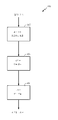
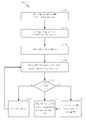
[0011]도 3은 디바이스의 궤적에 기초하여 모바일 디바이스의 포지션을 추정하기 위한 시스템의 블록도이다.
[0012]도 4는 영역을 나타내는 맵 데이터로부터 라우팅 그래프를 구축하기 위한 시스템의 블록도이다.
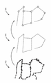
[0013]도 5는 도 4에 도시된 시스템에 의해 수행된 기능들을 구축하는 그래프의 예시적인 도이다.
[0014]도 6은 도 3에 도시된 궤적 모니터링 모듈의 일 실시예의 컴포넌트들의 블록도이다.
[0015]도 7은 도 3에 도시된 궤적 그래핑 모듈에 의해 수행된 그래프 구축 기능들의 예시적인 도이다.
[0016]도 8은 도 3에 도시된 그래프 매칭 모듈에 의해 수행된 매칭 기능들의 예시적인 도이다.
[0017]도 9는 다중-가설 추적을 이용하여 모바일 디바이스의 포지션을 추정하기 위한 시스템의 블록도이다.
[0018]도 10은 도 9에 도시된 다중-가설 추적 시스템과 함께 사용될 수 있는 디스플레이의 예시적인 도이다.
[0019]도 11 및 도 12는 궤적 정보를 이용하여 모바일 디바이스의 포지션을 추정하는 개별 프로세스들의 블록 흐름도이다.[0009] FIG. 1 is a schematic diagram of a wireless communication environment associated with an indoor area.
[0010] FIG. 2 is a block diagram of components of an embodiment of the mobile station shown in FIG. 1.
[0011] FIG. 3 is a block diagram of a system for estimating a position of a mobile device based on a trajectory of a device.
[0012] FIG. 4 is a block diagram of a system for building a routing graph from map data representing an area.
[0013] FIG. 5 is an exemplary diagram of a graph constructing functions performed by the system shown in FIG.
[0014] FIG. 6 is a block diagram of components of an embodiment of the trajectory monitoring module shown in FIG. 3.
[0015] FIG. 7 is an exemplary diagram of graph building functions performed by the trajectory graphing module shown in FIG. 3.
[0016] FIG. 8 is an exemplary diagram of matching functions performed by the graph matching module shown in FIG. 3.
[0017] FIG. 9 is a block diagram of a system for estimating a position of a mobile device using multi-hypothesis tracking.
[0018] FIG. 10 is an exemplary diagram of a display that may be used with the multi-hypothetical tracking system shown in FIG.
[0019] FIGS. 11 and 12 are block flow diagrams of individual processes for estimating a position of a mobile device using locus information.
[0020]모바일 디바이스의 모션 궤적을 추적하고 모바일 디바이스의 포지션을 추정하기 위해 추적된 궤적을 이용하기 위한 시스템들 및 방법들이 본원에 설명된다. 다양한 실시예들이 실내 위치확인 시스템의 맥락에서 설명되지만, 본원에 설명된 시스템들 및 방법들은, 모바일 디바이스의 궤적이 모니터링되고 모바일 디바이스의 포지션이 바람직하게 추정되는 임의의 시나리오로 더욱 일반적으로 확장될 수 있다. 일반적으로, 디바이스 위치는 실내에 있거나 실외에 있을 수 있다. 일부 실시예들에서, 본원에 설명된 바와 같이 궤적-기반 기술들을 통해 추정된 포지션은 위성 위치확인 시스템에 기초하여 획득된 포지션 추정치들, 네트워크 측정들 등과 결합하여 사용될 수 있다. 궤적-기반 포지션 추정은 다른 수단에 의해 획득된 포지션 추정치들 대신에 그리고/또는 포지션 추정치들을 향상시키기 위해서 그러한 실시예들에서 사용될 수 있으며, 또는 그 반대의 경우도 가능하다.[0020] Systems and methods for using the tracked trajectory to track the motion trajectory of the mobile device and to estimate the position of the mobile device are described herein. While various embodiments are described in the context of an indoor location system, the systems and methods described herein may be more generally extended to any scenario where the trajectory of the mobile device is monitored and the position of the mobile device is preferably estimated have. In general, the device location may be indoors or outdoors. In some embodiments, the position estimated via the locus-based techniques as described herein may be used in conjunction with position estimates, network measurements, etc. obtained based on the satellite positioning system. The trajectory-based position estimation may be used in such embodiments instead of the position estimates obtained by other means and / or to improve position estimates, or vice versa.
[0021]본원에 설명된 시스템들 및 방법들은 무선 통신 시스템에서 동작하는 하나 이상의 모바일 디바이스들을 통해 동작한다. 도 1을 참조하면, 무선 통신 시스템(10)은 하나 또는 그 초과의 BTS(base transceiver station)들(여기서는 하나의 BTS(14)), 및 무선 AP(access point)들(16)을 포함한다. BTS(14) 및 AP들(16)은 본 명세서에서 모바일 디바이스들(12)로 지칭되는 다양한 무선 통신 디바이스들에 통신 서비스를 제공한다. BTS(14) 및/또는 AP(16)에 의해 서빙되는 무선 통신 디바이스들은, 현존하든, 또는 미래에 개발되든, PDA(personal digital assistant)들, 스마트폰들, 컴퓨팅 디바이스들, 이를테면, 랩탑들, 데스크탑들 또는 태블릿 컴퓨터들, 자동차 컴퓨팅 시스템들 등을 포함할 수 있지만, 이에 제한되는 것은 아니다.[0021] The systems and methods described herein operate through one or more mobile devices operating in a wireless communication system. Referring to FIG. 1, a wireless communication system 10 includes one or more base transceiver stations (here, one BTS 14), and
[0022]시스템(10)은 다수의 캐리어들(서로 다른 주파수들의 파형 신호들) 상에서의 동작을 지원할 수 있다. 다중-캐리어 송신기들은 다수의 캐리어들 상에서 변조된 신호들을 동시에 송신할 수 있다. 각각의 변조된 신호는 CDMA(Code Division Multiple Access) 신호, TDMA(Time Division Multiple Access) 신호, OFDMA(Orthogonal Frequency Division Multiple Access) 신호, SC-FDMA(Single-Carrier Frequency Division Multiple Access) 신호 등일 수 있다. 각각의 변조된 신호는 서로 다른 캐리어 상에서 전송될 수 있고, 파일럿, 오버헤드 정보, 데이터 등을 전달할 수 있다.[0022] The system 10 may support operation on multiple carriers (waveform signals of different frequencies). Multi-carrier transmitters can simultaneously transmit modulated signals on multiple carriers. Each modulated signal may be a Code Division Multiple Access (CDMA) signal, a Time Division Multiple Access (TDMA) signal, an Orthogonal Frequency Division Multiple Access (OFDMA) signal, a Single-Carrier Frequency Division Multiple Access . Each modulated signal may be transmitted on a different carrier and may convey pilot, overhead information, data, and so on.
[0023]BTS(14) 및 AP들(16)은 안테나들을 통해 시스템(10) 내의 모바일 디바이스들(12)과 무선으로 통신할 수 있다. BTS(14)는 또한, 기지국, Node B, eNB(evolved Node B) 등으로 지칭될 수 있다. AP들(16)은 또한, AN(access node)들, 핫스팟(hotspot)들 등으로 지칭될 수 있다. BTS(14)는 다수의 캐리어들을 통해 모바일 디바이스들(12)과 통신하도록 구성된다. BTS(14)는 셀과 같은 각각의 지리적 영역에 대한 통신 커버리지를 제공할 수 있다. BTS(14)의 셀은 기지국 안테나들의 함수로써 다수의 섹터들로 파티셔닝될 수 있다.[0023] The BTS 14 and the
[0024]시스템(10)은 단지 매크로 기지국들(14)만을 포함할 수 있거나 또는 시스템(10)은 서로 다른 타입들의 기지국들(14), 예를 들어, 매크로, 피코, 및/또는 펨토 기지국들 등을 가질 수 있다. 매크로 기지국은 비교적 큰 지리적 영역(예를 들어, 수 킬로미터 반경)을 커버할 수 있으며, 서비스 가입이 된 단말들에 의한 비제한적 액세스를 허용할 수 있다. 피코 기지국은 비교적 작은 지리적 영역(예를 들어, 피코 셀)을 커버할 수 있으며, 서비스 가입이 된 단말들에 의한 비제한적 액세스를 허용할 수 있다. 펨토 또는 홈 기지국은 비교적 작은 지리적 영역(예를 들어, 펨토 셀)을 커버할 수 있으며, 펨토 셀과의 연관성을 가지는 단말들(예를 들어, 가정에서 사용자들에 대한 단말들)에 의한 제한적 액세스를 허용할 수 있다.The system 10 may comprise only
[0025]BTS(14) 및 AP들(16) 둘 모두가 시스템(10)에 도시되지만, 무선 통신 환경은 BTS들(14) 및 AP들(16) 둘 모두를 포함할 필요가 없고, BTS들(14) 및 AP들(16), 또는 둘 모두를 임의의 수나 구성으로 포함할 수 있다. 일반적으로, BTS(14)는 하나 이상의 셀룰러 라디오 액세스 기술들, 이를 테면, GSM(Global System for Mobile Communication), UMTS(Universal Mobile Telecommunications System), LTE(Long Term Evolution) 및/또는 3GPP(Third Generation Partrnership Project)에 의해 개발된 다른 기술들, CDMA2000 및/또는 3GPP2에 의해 개발된 다른 기술들 등을 통해 통신을 지원한다. AP(16)는 일반적으로, IEEE(Institute of Electrical and Electronics Engineers) 802.11 사양들(예를 들어, Wi-Fi) 등에 기초하여 하나 이상의 기술들을 통해 통신을 지원한다. 그러나, BTS들(14) 및 AP들(16)은 이러한 기술들로 제한되지 않으며 추가적인 또는 대안적인 기능을 사용할 수 있다. 추가로, 하나의 디바이스가 BTS들(14) 및 AP들(16) 둘 모두의 일부 또는 전체 기능을 포함할 수 있다.Although both BTS 14 and
[0026]시스템(10)에 추가로 도시된 바와 같이, 모바일 디바이스(12)는, 장소(영역, 지역)(110), 이를테면, 쇼핑 몰, 학교 또는 다른 실내 영역 또는 실외(outdoor) 영역 내에 포지셔닝된다. 여기서, AP들(16)이 장소(110) 내에 포지셔닝되며, 장소(110)의 각각의 영역들(방들, 상점들 등)에 대한 통신 커버리지를 제공한다. 시스템(10) 내의 AP(16)로의 액세스는 개방될 수 있거나, 대안적으로, 액세스는 패스워드(password), 암호화 키(encryption key) 또는 다른 인증서(credential)들을 이용하여 보안될 수 있다.[0026] As further shown in system 10,
[0027]모바일 디바이스들(12)은 시스템(10) 전역에 분산될 수 있다. 모바일 디바이스들(12)은 단말들, AT(access terminal)들, 이동국들, UE(user equipment), 가입자 유닛들 등으로 지칭될 수 있다. 모바일 디바이스들(12)은 위에서 나열된 바와 같은 다양한 디바이스들 및/또는 임의의 다른 디바이스들을 포함할 수 있다.[0027] The
[0028]도 1에 추가로 도시된 바와 같이, 모바일 디바이스(12)는, 예를 들어, SPS(satellite positioning system) 위성들(120)을 통해, SPS로부터 네비게이션 신호들을 수신할 수 있다. SPS 위성들(120)은 단일의 다중 GNSS(global navigation satellite system) 또는 다수의 이러한 시스템들과 연관될 수 있다. 위성들(120)과 연관된 GNSS는 GPS(Global Positioning System), Galileo, Glonass, Beidou(Compass) 등을 포함할 수 있지만, 이에 제한되는 것이 아니다. SPS 위성들(120)은 또한, 위성들, SV(space vehicle)들 등으로 지칭된다.[0028] As further shown in FIG. 1, the
[0029]모바일 디바이스(12)는 모바일 디바이스(12)에 이용가능한 정보 및/또는 뷰(view) 내의 다른 통신 엔티티들에 기초하여, 다양한 기술들을 이용하여 시스템(10) 내에서의 자신의 현재 포지션의 부분 또는 완전한 추정치를 획득하도록 구성될 수 있다. 예를 들어, 모바일 디바이스(12)는 하나 또는 그 초과의 무선 LAN(local area network)들과 연관된 AP들(16), Bluetooth 또는 ZigBee 등과 같은 네트워킹 기술을 이용하는 PAN(personal area network)들, SPS 위성들(120)로부터 획득된 정보 및/또는 맵 서버(124)로부터 획득된 맵 제약 데이터를 이용하여 자신의 포지션을 추정할 수 있다.[0029] The
[0030]추가적으로 또는 대안으로, 본원에 설명된 기술들은 모바일 디바이스(12)의 포지션이 디바이스(12)의 모션 궤적에 기초하여 추정될 수 있게 한다. 일반적으로, 디바이스(12)의 모션 궤적은, 디바이스(12)의 사용자 확장에 의해 모바일 디바이스의 상대적인 움직임을 추적함으로써 획득된다. 디바이스 모션을 추적하기 위해 다양한 기술들이 적용될 수 있다. 이들은, 시각적 주행거리기록계 구현들, 관성 센서-기반 접근들 등을 포함하지만, 이것으로 제한되지 않는다. 시각적 주행거리기록계에 대하여, 디바이스(12)의 궤적은, 디바이스(12)의 카메라 및/또는 다른 이미지 센서에 의해 미리결정된 시간 이내에 캡쳐된 이미지들(예를 들어, 규칙적 또는 불규칙적 인터벌들로 캡쳐된 스틸 이미지들, 캡쳐된 비디오 내의 인접한 또는 주기적 이미지 프레임들 등) 내에서의 시각적 피처들을 매칭시킴으로써 획득된다. 센서-기반 주행거리기록계의 경우, 디바이스(12)의 궤적이 가속도계, 자이로스코프, 자력계, 또는 다른 배향 센서들에 의해 획득된 측정들을 통해 획득된다. 일부 구현들에서, 본 기술에 일반적으로 알려진 바와 같은 다양한 메커니즘들이 배향 센서들의 정확도에 영향을 미치는 드리프팅 및/또는 다른 인자들을 보상하기 위해 적용될 수 있다. 시각적 및 센서-기반 주행거리기록계 접근법들의 결합 및/또는 현재 존재하거나 또는 장래에 존재할 임의의 다른 궤적 추적 메커니즘들과 같은 다른 기술들이 또한 가능하다.[0030] Additionally or alternatively, the techniques described herein allow the position of the
[0031]일부 예들에서, 주어진 디바이스(12)의 궤적과 포지션 간의 관계가 명확하지 않을 수 있다. 예를 들어, 디바이스(12)의 모션 궤적은 종종, 절대 포지션 정보에 관한 지식없이 획득될 수 있다. 그 결과, 디바이스(12)의 절대 포지션은, 디바이스(12)의 궤적이 알려진 경우들에서 조차도 알려지지 않을 수 있다. 본원에 설명된 기술들은 맵 데이터 및/또는 다른 보충 데이터를 이용하여 모션 궤적과 절대 포지션 간의 관계를 명확하게 함으로써, 사용자 포지션이 모션 궤적으로부터 추정될 수 있게 한다.[0031] In some instances, the relationship between the trajectory and the position of a given
[0032]다음 도 2를 참고하면, 모바일 디바이스(12)는 프로세서(20), 소프트웨어(24)를 포함한 메모리(22), 디스플레이(26), 안테나(28), SPS 수신기(30), 배향 센서들(32), 및 이미지 센서들(34)을 포함한 컴퓨터 시스템을 포함한다. 안테나들(28)은 양방향 통신 기능을, 하나 이상의 연관된 무선 통신 네트워크들, 예를 들어, 도 1에 도시된 바와 같이, 셀룰러 네트워크와 연관된 BTS(14), 로컬화된 통신 네트워크와 연관된 AP들(16) 등에서 다른 엔티티들로 제공한다. 안테나들(28)은 수신기, 송신기 또는 트랜시버(미도시)와 무관하게, 또는 수신기, 송신기 또는 트랜시버의 지원으로 동작할 수 있다. 일부 구현들에서, 안테나들(28) 중 상이한 안테나들이 상이한 통신 시스템들을 위해 사용될 수 있다. 여기서, 안테나들(28)은 BTS(14)와 통신하기 위한 안테나 및 AP들(19)과 통신하기 위한 안테나를 포함한다. 다른 구현들에서, 주어진 통신 시스템과의 통신을 위해 사용된 안테나들(28)은 선택적으로, 송신(Tx) 안테나들과 수신(Rx) 안테나들로 추가로 분리될 수 있다. 대안으로, 안테나들(28) 중 개별적인 안테나들이 할당된 시스템 또는 시스템들의 조합을 위해 송신과 수신 둘 모두를 위해 사용될 수 있다. 디바이스(12)는 SPS 수신기(30)가 아닌 것 또는 제한된 기능을 가진 SPS 수신기를 이용하여 본원에 설명된 기술들을 수행하도록 동작가능할 수 있다는 것이 본원에 설명되었지만, 도 2에 도시된 디바이스(12)는, 하나 이상의 연관된 SPS 안테나들(미도시)을 통해 SPS 신호들을 수신하기 위한 SPS 수신기(30)를 또한 포함한다.2, the
[0033]프로세서(20)는 바람직하게는, 지능적인 하드웨어 디바이스, 예를 들어, ARM®, Intel® 코포레이션 또는 AMD®에 의해 제조된 것과 같은 중앙 프로세싱 유닛(CPU), 마이크로컨트롤러, ASIC(application specific integrated circuit) 등이다. 프로세서(20)는 모바일 디바이스(12)에서 분배될 수 있는 다수의 별개의 물리적인 엔티티들을 포함할 수 있다. 메모리(22)는 랜덤 액세스 메모리(RAM)와 판독 전용 메모리(ROM)를 포함한다. 메모리(22)는, 실행될 경우, 프로세서(20)로 하여금 본원에 설명된 다양한 기능들을 수행하게 하도록 구성되는 프로세서 판독가능 명령들을 포함하는, 프로세서 판독가능, 프로세서 실행가능 소프트웨어 코드인 소프트웨어(24)를 저장하는 비일시적 프로세서 판독가능 저장 매체이다(그러나, 본 설명은 기능들을 수행하는 프로세서(20)만을 지칭할 수 있다). 대안으로, 소프트웨어(24)는, 프로세서(20)에 의해 직접 실행가능하지 않을 수 있지만, 예를 들어, 컴파일링되고 실행될 경우 프로세서(20)로 하여금 기능들을 수행하게 하도록 구성된다. 메모리(22)를 구성할 수 있는 미디어는 RAM, ROM, FLASH, 디스크 드라이브들 등을 포함하지만, 이것으로 제한되지 않는다.The
[0034]디스플레이(26)는 디바이스(12)의 사용자가 보기 위한 정보를 렌더링하기 위한 수단 및/또는 메커니즘들을 포함한다. 디스플레이(26)는, 정보가 표시되는 스크린과 같은 물리적 표면, 및/또는 프로젝터 또는 정보를 디바이스(12)와 연관되지 않은 표면 상으로 프로젝팅하기 위한 다른 수단을 포함할 수 있다. 디스플레이(12)는 디바이스(12)에 물리적으로 통합될 수 있거나 또는 예를 들어, 디스플레이 모니터 등의 경우에, 디바이스(12) 외부에 있으면서 디바이스(12)에 통신가능하게 결합될 수 있다. 추가로, 디스플레이(26)는 터치스크린일 수 있고 그리고/또는 디바이스(12)의 입력 기능 및/또는 다른 기능들에 다른 방식으로 통합될 수 있다.[0034]
[0035]배향 센서들(32)은 주어진 기준 배향에 대하여 디바이스(12)의 상대적인 배향과 관련되는 측정들을 수행하고 이 정보를 추가 프로세싱을 위해 프로세서(20) 및/또는 디바이스(12)의 다른 엘리먼트들로 전달한다. 배향 센서들(32)은, 선형 가속도계, 자이로스코프, 자력계(콤파스) 등을 포함할 수 있지만, 이것으로 제한되지 않는다. 일반적으로, 선형 가속도계는 중력과 관련하여 선형 가속도를 측정하고, 자이로스코프는 각도/회전 가속도를 측정하고, 그리고 자력계는 자북과 관련하여 디바이스(12)의 배향을 측정한다. 선형 가속도계들 및/또는 자이로스코프들은 다중 축들(예를 들어, x-y-z 또는 선형 가속도계의 경우 지구에 대하여 북-동-하(north-east-down) 축들, 자이로스코프에 대하여 롤-피치-요(roll-pitch-yaw) 축들 등)에 따라 가속도를 측정하도록 구성된 다중-축 가속도계들일 수 있거나, 또는 대안으로 하나 이상의 단일 축 가속도계들이 사용될 수 있다. 추가로, 자력계에 의해 이루어진 측정들은 자북과 진북 간의 차를 고려하기 위해 자기 편차 및/또는 다른 정정 인자들에 의해 (예를 들어, 자력계 그 자체에 의해 그리고/또는 연관된 프로세서(20)에 의해) 조정될 수 있다.[0035] The
[0036]이미지 센서들(34)은 디바이스(12)에서 볼 때 영역의 이미지들을 캡쳐하고 프로세싱하기 위한 카메라들 및/또는 다른 디바이스들을 포함한다. 일반적으로, 카메라는, 이미지들이 캡쳐되는 카메라의 시야를 총괄적으로 정의하는 하나 이상의 렌즈들을 포함하는 광학 시스템을 포함한다. 광학 시스템의 렌즈들 및/또는 다른 컴포넌트들이 디바이스(12) 내부에 하우징될 수 있거나 또는 예를 들어, 렌즈 부가 장치 등으로서 디바이스(12) 외부에 있을 수 있다. 광학 시스템은, CMOS(complementary metal-oxide-semiconductor), CCD(charge-coupled device) 및/또는 광학 이미지들을, 프로세서(20)와 같은 디바이스(12)의 하나 이상의 프로세싱 엔티티들로 전달되는 전기 정보로 변환하기 위한 다른 기술을 포함하는 이미지 캡쳐 유닛과 통신가능하게 결합된다. 이미지 센서들(34)은, 하나의 카메라 또는 다수의 카메라들, 이를 테면, 디바이스(12)의 전면을 따라 배치된 전면 카메라 및 디바이스(12)의 이면을 따라 배치된 이면 카메라를 포함할 수 있다. 다수의 카메라들이 디바이스(12)에 존재하는 경우, 카메라들은 서로 의존하여 또는 서로 무관하게 동작할 수 있다.[0036] The
[0037]배향 센서들(32) 및/또는 이미지 센서들(34)은, 센서 측정치들, 캡쳐된 이미지들 또는 비디오 등과 연관된 메타데이터를 생성하거나 그렇지 않으면 이러한 메타데이터를 획득하기 위해서 프로세서(20) 및/또는 메모리(22)와 통신할 수 있다. 이미지와 연관된 또는 이미지에 링크된 메타데이터는 이미지의 다양한 특징들에 관한 정보를 포함한다. 예를 들어, 메타데이터는, 이미지가 캡쳐되는 시간, 날짜 및/또는 위치, 이미지 차원들 또는 리졸루션, 카메라 및/또는 이미지를 캡쳐하기 위해 사용되는 모바일 디바이스의 아이덴티티 등을 포함한다. 카메라에 의해 사용되는 메타데이터가 생성되고 그리고/또는 EXIF(exchangeable image file format) 태그들 등과 같은 적절한 포맷으로 저장된다. 배향 센서들(32) 및/또는 이미지 센서들(34)은 또한, 연관된 통신 네트워크 내의 하나 이상의 다른 엔티티들로 센서들(32, 34)에 의해 획득된 정보의 송신을 가능하게 하는 안테나들(28)을 사용할 수 있다.[0037] The
[0038]여기서, 배향 센서들(32) 및/또는 이미지 센서들(34)이, 모바일 디바이스의 포지션을 (예를 들어, 영역 또는 지역에 대하여) 추정하기 위해 본원에서 기재된 바와 같이 추후 사용되는 디바이스(12)의 모션 궤적에 관한 데이터를 획득하기 위해서 사용된다. 예를 들어, 배향 센서들(32)이 상술된 바와 같이 센서-기반 주행거리기록계를 구현하기 위해서 사용될 수 있고, 이미지 센서들(34)이 상술된 바와 같이 시각적 주행거리기록계를 구현하기 위해서 사용될 수 있다. 본원에 설명될 바와 같이, 다른 구현들이 또한 가능하다.Here, it is assumed that the
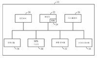
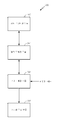
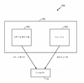
[0039]다음으로 도 3을 참고하면, 디바이스(12)의 궤적에 기초하여 모바일 디바이스(12)의 포지션을 추정하기 위한 시스템(300)은 궤적 모니터링 모듈(302), 궤적 그래핑 모듈(304), 그래프 매칭 모듈(306), 및 포지션 추정 모듈(308)을 포함한다. 궤적 모니터링 모듈(302)은 영역에 걸친 디바이스(12)의 움직임에 대응하는 궤적 정보를 수집한다. 이 궤적 정보가 궤적 정보로부터 궤적 그래프를 형성하는 궤적 그래핑 모듈(304)로 제공된다. 궤적 그래프는, 그래프 매칭 모듈(306)에 의해 디바이스(12)가 위치되는 영역에 대응하는 라우팅 그래프와 비교된다. 본원에 설명된 기술들을 활용함으로써, 그래프 매칭 모듈(308)은 궤적 그래핑 모듈(304)에 의해 생성된 궤적 그래프를 라우팅 그래프의 적어도 하나의 서브셋과 매칭시킨다. 이 매칭 서브셋은 이후, 모바일 디바이스(12)의 포지션을 추정하는 포지션 추정 모듈(308)에 의해 사용된다. 포지션 추정 모듈(308)에 의해 수행된 프로세싱의 결과로서, 모바일 디바이스(12)의 과거 궤적과 그의 사용자 그리고 모바일 디바이스(12)의 현재 위치와 사용자가, 디바이스(12)가 위치되는 영역의 맵에 대하여 식별된다.3, the
[0040]도 3에 도시된 시스템(300)의 동작 이전에, 영역 또는 지역에 대응하는 라우팅 그래프가 그 영역에 대한 맵 데이터에 기초하여 구성된다. 라우팅 그래프의 구성을 위한 시스템(400)이 도 4에 도시된다. 시스템(400)은 맵 데이터 프로세싱 모듈(402), 라우트 추출 모듈(404), 및 그래프 구축 모듈(406)을 포함한다. 모듈들(402, 404, 406)은 시스템(300), 예를 들어, 모바일 디바이스(12)를 또한 구현하는 디바이스에 의해 구현될 수 있다. 대안으로, 시스템(400)이 모바일 디바이스(12)에 통신가능하게 결합된 서버 또는 다른 컴퓨팅 엔티티에서 구현될 수 있고, 시스템(400)에 의해 생성된 라우팅 정보가 모바일 디바이스(12)에 의해 주기적으로 그리고/또는 필요에 따라 모바일 디바이스(12)로 통신될 수 있다. 또 다른 실시예들에서, 시스템(400)은, 예를 들어, 모바일 디바이스(12)의 초기 구성 시, 라우팅 정보와 연관된 위치확인 애플리케이션의 설치 시 등에 모바일 디바이스(12)의 메모리(22)로 추후 이송될 영역에 대한 라우팅 정보 또는 영역들의 수집을 생성할 수 있다. 모바일 디바이스(12) 외부의 시스템(400)으로부터 모바일 디바이스(12)의 메모리(22)로의 라우팅 정보의 이송은, 예를 들어, 직접 유선 또는 무선 통신을 통해 시스템(400)과 디바이스(12) 또는 라우팅 정보가 저장되는 컴퓨터 저장 매체 사이에서 직접적으로 발생할 수 있거나, 또는 예를 들어, 처음에 라우팅 정보를 시스템으로부터 중간 컴퓨팅 디바이스로 이송하고, 추후 동기화하고 그리고/또는 그렇지 않으면 중간 컴퓨팅 디바이스로부터 모바일 디바이스(12)로 정보를 이송함으로써 간접적으로 발생할 수 있다.[0040] Prior to operation of the
[0041]맵 데이터 프로세싱 모듈(402)은, 구조 파일들(예를 들어, CAD(computer-aided drafting) 파일들 등), 이미지 파일들(예를 들어, 벡터 이미지들 또는 래스터 이미지들) 등과 같은 컴퓨터 파일들의 형태로 존재할 수 있는, 영역에 대응하는 맵 데이터를 수신한다. 맵 데이터는 추가적으로 또는 대안으로, (예를 들어, XML(Extensible Markup Language) 파일들 등으로 주어지는) 영역의 특성들의 넌-그래피컬 표현으로서 제공되거나, 및/또는 영역의 특성들의 넌-그래피컬 표현에 의해, 및/또는 다른 수단에 의해 보충될 수 있다. 다른 맵 데이터 포맷들이 또한 가능하다. 맵 데이터 프로세싱 모듈(402)은, 라우트 추출 모듈(404)에 의해 맵 데이터의 추가 프로세싱을 가능하게 하기 위해서 포맷 변환, 이미지 프로세싱 및/또는 정규화 등과 같은 초기 프로세싱 동작들을 수행한다. 일부 구현들에서, 맵 데이터 프로세싱 모듈(402)은 시스템(400)으로부터 생략될 수 있고, 맵 데이터가 대신 라우트 추출 모듈(404)로 직접 제공될 수 있다.[0041] The map
[0042]맵 데이터 프로세싱 모듈(404)은 맵 데이터에 의해 도시된 영역과 연관된 개방 공간(예를 들어, 방들, 복도들 등)의 골격을 획득하기 위한 하나 이상의 기술들을 사용한다. 이 골격은, 차례로, 맵 데이터에 대응하는 영역에 걸쳐 이동가능한 경로들을 나타내는 라우팅 그래프를 구성하기 위해 그래프 구축 모듈(406)에 의해 사용된다.[0042] The map data processing module 404 uses one or more techniques to obtain the skeleton of the open space (eg, rooms, corridors, etc.) associated with the area shown by the map data. This skeleton, in turn, is used by the
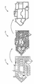
[0043]도 5는, 맵 이미지의 형태로 제공된 맵 데이터가 라우트 추출 모듈(404)과 그래프 구축 모듈(406)에 의해 프로세싱되는 기술을 도시한다. 도 5의 다이어그램(502)은, 위치확인이 바람직하게 수행되는 영역의 맵에 대응하는 이미지이다. 이 프로세싱이 일부 구현들에서 생략될 수 있지만, 맵 데이터 프로세싱 모듈(402)을 통해 상술된 바와 같이 맵 이미지가 프로세싱된다. 추가로, 맵 이미지는 시스템(400)에 의해 이용가능한 임의의 포맷일 수 있다. 이러한 포맷들은, 래스터화된 이미지 포맷들, 이를 테면, 비트맵 이미지 포맷들, GIF(Graphics Interchange Format), PNG(Portable Network Graphics), JPEG 등, 백터화된 이미지 포맷들, 이를 테면 SVG(Scalable Vector Graphics) 등을 포함할 수 있지만, 이것으로 제한되지 않는다.[0043] FIG. 5 illustrates a technique in which map data provided in the form of a map image is processed by the route extraction module 404 and the
[0044]여기서, 라우트 추출 모듈(404)은 맵 이미지 상에 도시된 이동가능한 라우트들을 추출하기 위해 이미지 형태학(morphology)을 사용한다. 형태학은 형상들에 기초하여 이미지들을 프로세싱하는 이미지 프로세싱 동작들의 광범위한 세트이다. 형태학적 동작들은 구조 엘리먼트를 입력 이미지에 적용하여, 동일한 사이즈의 출력 이미지를 생성한다. 형태학적 동작 시, 출력 이미지의 각각의 픽셀의 값은 입력 이미지의 대응 픽셀의 그의 이웃 픽셀들과의 비교에 기초한다.[0044] Here, the route extraction module 404 uses an image morphology to extract the movable routes shown on the map image. Morphology is a broad set of image processing operations that processes images based on shapes. Morphological operations apply the structural elements to the input image to produce an output image of the same size. In morphological operation, the value of each pixel of the output image is based on a comparison of its corresponding pixel of the input image with its neighboring pixels.
[0045]맵 이미지에 대하여 라우트 추출 모듈(404)에 의해 사용되는 형태학적 동작들은 원래 이미지에서의 파선들 및/또는 크랙들을 수정하는 이미지 확장으로 시작한다. 일반적으로, 이미지 확장은 픽셀들을 이미지의 오브젝트들의 경계들에 추가한다. 이는 오브젝트 경계들 상의 픽셀들을 제거하는 이루전(erosion)과 대조적이다. 이미지의 오브젝트들을 추가하거나 또는 제거하는 픽셀들의 수는, 이미지를 프로세싱하기 위해 사용된 구조 엘리먼트의 사이즈와 형상에 의존한다. 형태학적 확장 및 이루전 동작들 시, 출력 이미지의 임의의 주어진 픽셀의 상태는 입력 이미지의 대응 픽셀에 그리고 그의 이웃들에 규칙을 적용함으로써 결정된다. 픽셀들을 프로세싱하기 위해 사용되는 규칙은 확장 또는 이루전으로서 동작을 정의한다.[0045] The morphological operations used by the route extraction module 404 for the map image begin with an image extension that modifies the dashed lines and / or cracks in the original image. Generally, image expansion adds pixels to the boundaries of objects in the image. This is in contrast to erosion which removes pixels on object boundaries. The number of pixels that add or remove objects in an image depends on the size and shape of the structural elements used to process the image. During morphological expansion and tweaking operations, the state of any given pixel of the output image is determined by applying a rule to the corresponding pixel of the input image and to its neighbors. The rules used to process the pixels define the motion as an extension or an advance.
[0046]확장 다음, 맵에 의해 도시된 지역 내부의 영역들을 지역 외부의 영역들로부터 구분하는 분류가 맵 이미지에 대해 수행된다. 다음으로, 형태학적 이루전이 이미지 상에서 수행되어, 흑색 선들로서 이미지에 도시되고 0의 연관 값을 갖는 평행하는 벽들과 같이 가깝게 위치된 구조들이 결합된다. 보다 구체적으로, 이루전은 출력 픽셀의 값이 입력 픽셀 주변에 있는 픽셀들 모두의 최소 값이 되게 한다. 이와 같이, 2진(예를 들어, 흑색 및 백색) 이미지에서, 픽셀들 중 임의의 것이 0으로 셋팅되는 경우, 출력 픽셀이 0으로 셋팅된다.[0046] Extension Next, a classification is performed for the map image to distinguish the regions inside the region shown by the map from the regions outside the region. Next, a morphological rearrangement is performed on the image to combine structures that are positioned as close as parallel walls with an associated value of 0, shown in the image as black lines. More specifically, the transition causes the value of the output pixel to be a minimum of all of the pixels around the input pixel. Thus, in a binary (e.g., black and white) image, if any of the pixels is set to zero, the output pixel is set to zero.
[0047]이루전 다음, 맵 이미지에 도시된 모든 가능한 경로들을 획득하기 위해서 형태학적 골격화(morphological skeletonization)가 사용된다. 골격화는 오브젝트들의 경계들 상의 픽셀들은 제거하지만 오브젝트들을 쪼개지는 않는다. 나머지 픽셀들이 이미지 골격을 구성한다. 최종적으로, 모든 주요 경로들을 획득하기 위해서 형태학적 수축이 골격화된 이미지 상에서 수행된다. 여기서, "주요 경로"란 맵 이미지에서 루프를 형성하는 경로로서 정의된다. 주요 경로들은 통상적으로, 막다른 곳이나 또는 출구로 이어지지 않는 주요 복도들이지만, 다른 주요 경로들이 존재하고 식별될 수 있다. 수축시키는 것은 오브젝트들을 포인트들까지 감소시키고 픽셀들을 제거하여, 홀들이 없는 오브젝트들이 포인트까지 수축하고 홀들을 갖는 오브젝트들이 각각의 홀과 외부 경계 사이의 중간의 연결 링까지 수축하게 된다. 골격화의 결과 및 수축시키는 것이 다이어그램(504)에 나타내어지고, 선들은 골격화를 통해 발견된 경로들을 나타내고 굵은 선들은 수축을 통해 식별된 주요 경로들을 나타낸다.[0047] Next, morphological skeletonization is used to obtain all possible paths shown in the map image. Skeletonization removes pixels on the boundaries of objects, but does not split objects. The remaining pixels constitute the image frame. Finally, morphological contraction is performed on the skeletonized image to obtain all the major paths. Here, the "main path" is defined as a path forming a loop in the map image. The main routes are typically major corridors that do not lead to dead ends or exit, but other major routes exist and can be identified. Shrinking reduces the objects to points and removes the pixels so that the objects without holes collapse to the point and objects with holes contract to the intermediate connection ring between each hole and the outer boundary. The result and collapse of the skeleton are shown in diagram 504, where lines represent paths found through skeletalization and bold lines represent major paths identified through contraction.
[0048]상기 설명은 이미지 형태학을 통한 라우트 추출 모듈(404)의 동작에 관한 것이지만, 라우트 추출 모듈(404)이 관심 영역에 대한 라우팅 정보를 획득하게 하는 임의의 기술이 사용될 수 있다. 명시적으로 다르게 언급되지 않으면, 본원에 설명된 구현들은 영역에 걸쳐 이동가능한 경로들을 식별하거나 사용하기 위한 이러한 기술 또는 임의의 다른 기술로 제한되는 것으로 의도되지 않는다.[0048] While the above description is directed to the operation of route extraction module 404 through image morphology, any technique may be used that allows route extraction module 404 to obtain routing information for a region of interest. Unless expressly stated otherwise, the implementations described herein are not intended to be limited to this or any other technique for identifying or using mobile paths across a domain.
[0049]라우트 추출 모듈(404)을 통해 관심 영역에 걸친 이동가능한 라우트들 또는 경로들의 식별 시, 그래프 구축 모듈(406)은 영역에 대응하는 라우팅 그래프를 구축하기 위해 식별된 라우트들을 사용한다. 그래프 구축 모듈(406)에 의해 구축된 라우팅 그래프의 예가 도 5의 다이어그램(506)으로 나타내어진다. 여기서, 그래프 구축 모듈(406)은 라우트 추출 모듈(404)에 의해 식별된 주요 경로들에 기초하여 영역에 대해 라우팅 그래프를 구성하고, 라우트 추출 모듈(404)에 의해 식별된 다른 경로들은 폐기된다. 대안으로, 그러나, 그래프 구축 모듈(406)은 비-주요 경로들의 일부 또는 전부, 및/또는 영역과 연관된 임의의 다른 경로화 정보를 사용할 수 있다.[0049] Upon identification of mobile routes or paths through the ROI extraction module 404, the
[0050]라우트 추출 모듈(404)로부터 라우팅 정보의 수신 시, 그래프 구축 모듈(406)은 그래프 노드들을 식별된 라우트들을 따라 다양한 포인트들에 할당한다. 여기서, 노드들은, 일부 각도 상수(α)의 경우 (90±α)도의 각도로 라우팅 정보의 2개의 라인 세그먼트들을 연결하는 포인트들 또는 최소 임계 길이(예를 들어, 10 피트 등)의 3개 이상의 라인 세그먼트들을 연결하는 분기 포인트들로서 식별된다. 파라미터(α)는, 그래프 내 노드들의 수를 관리하기 위해 라우팅 그래프의 단순성과 강건성 사이의 트래이드오프를 고려하여 선택된다. 일 구현에서, α는 약 20도가 되도록 선택된다. 다른 구현들이 가능하다.Upon receiving the routing information from the route extraction module 404, the
[0051]요약하면, 시스템(400)의 결과는 노드들을 연결하는 경로들을 나타내는 영역과 에지들 내에서 관심 포인트들(예를 들어, 교차지점들 등)에 대응하는 노드들을 포함하는 주어진 영역에 대한 라우팅 그래프이다. 영역 내 사용자의 포지션을 추정하기 위해서, 사용자에 대응하는 궤적 정보가 추적되고 영역에 대한 라우팅 그래프와 비교된다. 다음으로 도 6을 참고하면, 궤적 모니터링 모듈(302)의 구현이 추가로 상세하게 도시된다. 궤적 모니터링 모듈(302)은 도 2에 대하여 상술된 바와 같이, 하나 이상의 배향 센서들(32), 이를 테면, 가속도계(602), 자이로스코프(604), 또는 자력계(606), 및/또는 하나 이상의 이미지 센서들(34), 이를 테면, 카메라들(612) 등을 포함한다. 배향 센서들(32) 및 이미지 센서들(32) 둘 모두가 도 6에 도시되지만, 궤적 모니터링 모듈(302)의 일부 구현들은 센서들(32, 34)의 하나의 세트만을 포함할 수 있다. 추가로, 배향 센서들은 임의의 수 또는 구성의 센서들(602, 604, 606)을 포함할 수 있고, 이미지 센서들은 임의의 수 또는 구성의 카메라들(612) 및/또는 다른 센서들을 포함할 수 있다.[0051] In summary, the results of the
[0052]센서들(32, 34)에 의해 수집된 미가공 데이터가 궤적 그래핑 모듈(304)로의 차후 통신을 위해 궤적 데이터 프로세싱 모듈(620)에 의해 프로세싱된다. 궤적 데이터 프로세싱 모듈(620)이 프로세서(20)를 통해 및/또는 모바일 디바이스(12)와 연관된 임의의 다른 적절한 수단에 의해 구현된다. 대안으로, 궤적 데이터 프로세싱 모듈(620)은, 센서들(32, 34)과 연관된 디바이스와 상이한 컴퓨팅 디바이스와 연관될 수 있다. 예를 들어, 센서 측정치들이 궤적 데이터 프로세싱 모듈(620)을 구현하는 서버로 송신될 수 있고, 프로세싱된 데이터 및/또는 프로세싱된 데이터를 통해 획득된 데이터가 필요에 따라 센서들(32, 34)과 연관된 디바이스로 역으로 전송될 수 있다. 다른 구현들이 또한 가능하다.The raw data collected by the
[0053]궤적 데이터 프로세싱 모듈(620)은, 시간에 따라 센서들(32, 34)의 궤적을 획득하기 위해서 센서들(32, 34)에 의해 제공된 측정치들을 이용한다. 본원에서 사용된 바와 같이, 사용자 및/또는 디바이스에 적용되는 것으로서 용어 "궤적"은 모니터링된 시간 기간에 걸쳐 사용자 및/또는 디바이스의 움직임과 연관된 사용자 및/또는 디바이스의 위치들의 플롯팅된 이력을 지칭한다. 궤적 데이터 프로세싱 모듈(620)은, 상술된 바와 같이 시각적 주행거리기록계, 센서-기반 주행거리기록계, 또는 시각적 및 센서-기반 기술들의 결합(예를 들어, 시각적-관성 주행거리기록계)과 같은 기술들을 이용하여 이 위치 이력을 획득한다. 예를 들어, 시각적 주행거리기록계 프로세싱의 경우, 궤적 데이터 프로세싱 모듈(620)은 하나 이상의 이미지 센서들(34)에 의해 캡쳐된 이미지들을 수신하고 이미지들에서 하나 이상의 오브젝트들 및/또는 다른 특징들을 식별한다. 상이한 시간의 포인트들에서 캡쳐된 이미지들 내의 이러한 이미지 특징들의 상대적인 포지션들은 이미지 센서(34)의 움직임(이미지 센서(34)의 움직임으로부터 궤적이 컴퓨팅될 수 있음)을 추론하는 데에 사용된다. 센서-기반 주행거리기록계 프로세싱의 경우, 궤적 데이터 프로세싱 모듈(620)은 시간 기간에 걸쳐 수집된 배향 측정치들(예를 들어, 가속도계들(602) 또는 자이로스코프들(604)로부터의 가속도 측정치들, 자력계(606)로부터의 자기 측정치들 등)을 수신하고 배향 측정치들에서의 관찰된 변화들에 기초하여 디바이스의 상대적인 움직임을 컴퓨팅한다. 시각적-관성 주행거리기록계에서, 이미지 특징들 및 센서 데이터 둘 모두가 2개의 포인트들 간의 상대적인 움직임의 추정 시 최적의 솔루션을 찾기 위해 사용된다.[0053] Trajectory
[0054]궤적 모니터링 모듈(302)에 의해 수행된 프로세싱의 결과로서, 디바이스(12)의 궤적의 그래피컬 추정치가, 도 7의 다이어그램(702)으로 도시된 바와 같이 획득된다. 이 추정치는 궤적 그래프를 형성하기 위해서 궤적 그래핑 모듈(304)에 의해 프로세싱된다. 궤적 그래핑 모듈(304)에 의한 프로세싱은 슬라이딩 윈도우 및/또는 다른 평탄화 기술들을 이용하여 궤적 모니터링 모듈(302)에 의해 제공된 궤적 데이터를 평탄화함으로써 시작한다. 다이어그램(704)은 다이어그램(702)에 도시된 초기 궤적 데이터에서 수행된 것과 같은 평탄화의 결과를 도시한다. 다음으로, 평탄화된 궤적에서의 방향 전환(turn)들이 궤적 그래프에서 잠재적인 노드들로서 식별되고 분류된다. 상술된 바와 같은 라우팅 그래프 상에서의 노드 식별과 유사하게, 궤적 상의 노드들이 (90±α)도 사이의 각도로 2개의 주요 라인 세그먼트들을 연결하는 포인트들로서 궤적 그래핑 모듈(704)에 의해 식별될 수 있다. 여기서, 라우팅 그래프의 구성을 위한 것과 유사한 기준을 이용하여 파라미터(α)가 선택되지만, 상이한 기준이 또한 사용될 수 있다. 정의된 노드들에 기초하여, 궤적 그래프의 에지들이 그래프의 노드들을 연결하는 직선 경로들로서 정의된다. 다이어그램(706)은 다이어그램(702)에 도시된 궤적 정보로부터 구성된 궤적 그래프를 도시한다.[0054] As a result of the processing performed by the
[0055]라우팅 그래프가 영역에 대해 구성되면, 영역 내의 디바이스(12)의 모션 궤적이 식별되고 궤적 그래프가 디바이스 궤적으로부터 구성되고, 그래프 매칭 모듈(306)은 궤적 그래프를 라우팅 그래프의 몇몇 서브셋과 매칭시킬 것을 시도한다. 그래프 매칭 모듈(306)에 의해 수행된 매칭의 예가 도 8의 다이어그램(800)에 의해 도시된다.Once the routing graph is configured for the region, the motion trajectory of the
[0056]그래프 매칭 모듈(306)은, 궤적 그래프와의 최소 임계 유사도를 나타내는 라우팅 그래프의 적어도 하나의 서브셋을 식별하기 위해서 궤적 그래프를 라우팅 그래프와 비교한다. 여기서, 최대 공통 에지 서브그래프 문제의 변수로서 궤적 그래프와 라우팅 그래프 간의 비교가 수행된다. 궤적 그래프와 라우팅 그래프 간의 매칭은 노드들 간의 에지들의 길이, 이웃 노드들의 수, 거리 및/또는 배향, 에지들의 배향(이러한 데이터가 이용가능하다면) 등과 같은 노드 또는 에지 기준에 기초할 수 있다. 일부 구현들에서, 라우팅 그래프의 각각의 정점부터 시작하는 깊이-우선 탐색이, 예를 들어, 잠재적인 매치들 모두의 최고 전체 스코어를 갖는 글로벌 솔루션을 찾음으로써 라우팅 그래프와 궤적 그래프 간의 매치를 찾기 위해 사용될 수 있다. 그래프들을 비교하기 위한 다른 기술들이 또한 사용될 수 있다. 예를 들어, 라우팅 그래프와 궤적 그래프 둘 모두가 평탄하기 때문에, 하나 이상의 다항 시간 알고리즘들이 그래프 매칭 모듈(306)에 의해 사용될 수 있다. 다른 알고리즘들이 또한 가능하다.[0056] The
[0057]그래프 매칭 모듈(306)은, 궤적 그래프와 라우팅 그래프의 서브셋 간의 고유 매치가 초기에 발견되지 않는 경우 하나 이상의 적응성 측정들을 추가적으로 수행할 수 있다. 예를 들어, 궤적 그리프와 라우팅 그래프의 비교가 충분한 신뢰도를 갖는 매치들이 없다는 결과가 발생하는 경우, 그래프 매칭 모듈(306)은, 각각의 서브셋으로부터 하나 이상의 노드들을 생략함으로써 궤적 그래프의 개별적인 서브셋들에 대한 매칭을 반복할 수 있다. 궤적 그래프로부터 하나 이상의 노드들을 생략한 후 궤적 그래프와 라우팅 그래프의 서브셋 사이에서 충분한 신뢰도 매치가 발견되는 경우, 생략된 노드들이 오류 노드들로서 분류되고 드롭될 수 있다. 그래프 매칭 모듈(306)은 또한, 초기 매칭 동작들 이전에 또는 초기 매칭 동작들 동안 궤적 그래프의 노드들을 오류 노드들로서 분류하기 위해서 이상치 검출을 위한 하나 이상의 기술들을 사용할 수 있다.[0057] The
[0058]다른 적응성 척도로서, 그래프 매칭 모듈(306)은, 궤적 그래프와 라우팅 그래프 간의 초기 비교가 라우팅 그래프의 다수의 매칭 서브셋들을 발생시키는 경우 다중-가설 추적을 이용할 수 있다. 이는, 예를 들어, 빌딩 또는 다른 연관된 영역의 다수의 부분들이 유사한 형성들 및/또는 사이즈들을 갖는 경우 발생할 수 있다. 도 9는, 다수의 매칭 가설들을 해결하기 위해 그래프 매칭 모듈(306)에 의해 사용될 수 있는 시스템(900)을 도시한다. 여기서, 그래프 매칭 모듈(306)은 하나의 가설에 대해 상술된 방식으로 다중 라우팅 가설들을 동시에 추적하기 위해 다중 가설 분석 모듈(902)을 사용한다. 다중 가설 분석 모듈(902)은 추가로, 다중 라우팅 가설들과 관련된 그래피컬 정보를 사용자가 보도록 연관 디바이스(12)의 디스플레이(26)에 제공한다. 디바이스(12)의 사용자가 이동함에 따라, 새로운 주행거리기록계 정보가 이용가능하다. 다중 가설 분석 모듈(902)은, 디스플레이(26) 상에 더 적은 수의 가설들이 남겨지도록, (가급적이면) 일부 가설들을 제거하기 위해 이러한 추가 정보를 사용한다.[0058] As another adaptive measure, the
[0059]이외에도, 그래프 매칭 모듈(306)은, 다른 규정된 방향들로 방향 전환들을 하고 그리고/또는 이동하도록 사용자를 명시적으로 또는 암시적으로 가이드하는 다중 가설 분석 모듈(902)과 결합하여 궤적 가이드(904)를 사용할 수 있고, 이로써 궤적 그래프와 라우팅 그래프 간의 고유 맵핑의 계산을 지원하기 위해 궤적 맵 상에 추가 노드들을 발생시킨다. 명시적인 가이드 정보의 경우, 궤적 가이드(904)는 다수의 가설들과 결합하여 볼 수 있게 디스플레이(26)에 움직임 제안들을 제공한다. 이러한 디스플레이의 예가 도 10에서 다이어그램(1000)으로 도시되며, 도 10에서, 2개의 위치확인 가설들(1002, 1004)의 세트와 명시적 가이딩 명령(여기서는, 좌회전 명령(1006))이 사용자에게 디스플레이된다. 사용자가 영역에 걸쳐 이동함에 따라, 새로운 궤적 데이터에 기초하지 않을 것으로 결정된 사전에 획득된 라우팅 추정치들이 그래프 매칭 모듈(306)과 디스플레이(26)에서의 도시에 의해 고려사항으로부터 제외된다.[0059] In addition, the
[0060]도 10에 도시된 것에 대한 다른 디스플레이 구성들 및/또는 디스플레이된 정보가 또한 사용될 수 있다. 추가로, 명시적인 가이드 방향들에 대한 대안으로서, 그래프 매칭 모듈(306)에 의해 가이드하는 것은, 위치확인 가설들, 예를 들어, 가설들(1002, 1004)의 디스플레이에 기초하여 암시적일 수 있다. 추가로, 궤적 가이드(904)가 도 9의 다중 가설 분석 모듈(902)과는 별개의 모듈인 것으로 도시되지만, 궤적 가이드(904)의 기능은, 다중 가설 분석 모듈(902)의 기능과 결합될 수 있거나, 또는 일부 구현들에서, (예를 들어, 암시적 가이딩의 경우) 궤적 가이드가 생략될 수 있다.[0060] Other display configurations and / or displayed information for that shown in FIG. 10 may also be used. In addition, as an alternative to explicit guiding directions, guiding by the
[0061]도 3으로 돌아가면, 궤적 그래프와 라우팅 그래프의 서브셋 간의 고유 매칭이 그래프 매칭 모듈(306)에 의해 획득되면, 포지션 추정 모듈(308)은 매칭 결과에 기초하여 모바일 디바이스(12)의 위치를 추정한다. 위치 추정 모듈(308)에 의해 획득된 위치는 상대적 위치, 예를 들어, 영역과 관련된 위치 및/또는 영역에 대하여 정의된 좌표계, 또는 절대 위치일 수 있다. 영역 내에서 디바이스의 상대적인 위치를 결정하기 위해서, 포지션 추정 모듈(308)은 그래프 매칭 모듈(306)에 의해 수행된 매칭에 기초한 영역 및 맵 데이터와 관련된 디바이스(12)의 과거 궤적을 식별하고, 궤적에 대응하는 가장 최근의 포인트를 획득하고, 그리고 가장 최근의 궤적 포인트를 맵 데이터에 의해 나타내어진 위치에 관련시킨다. 추가로, 포지션 추정 모듈(308)은, 영역에 대응하는 위치 정보, 이를 테면, 고도/경도 좌표들 및/또는 영역의 어드레스, 또는 포지션 추정 모듈(308)이 절대 위치에 대한 영역에 대하여, 예를 들어 지구에 대하여 디바이스(12)의 상대적인 포지션을 관련시키는 것을 가능하게 하는 데에 충분한 다른 정보를 이용하여, 영역에 대하여 상대적인 위치를 보충함으로써 디바이스(12)의 절대 위치를 결정할 수 있다. 디바이스(12)의 상대 및/또는 절대 위치의 결정 시, 결정된 위치는 또한 (예를 들어, 디스플레이(26) 상에) 디스플레이되고 그리고/또는 디바이스(12)에서의 다른 동작들을 위해 사용될 수 있다. 일부 구현들에서, 포지션 추정 모듈은 궤적-기반 포지션 추정을 (예를 들어, 안테나들(28)에서 수신된 신호들에 기초하는) 네트워크 측정들, (예를 들어, SPS 수신기(30)를 통해 수신된 신호들에 기초하는) SPS 측정들 등을 통해 획득된 하나 이상의 포지션 추정들로 보충할 수 있다.3, if the unique matching between the locus graph and a subset of the routing graph is obtained by the
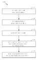
[0062]도 1 내지 도 10을 추가로 참고하면서 도 11을 참고하면, 궤적 정보를 이용하여 모바일 디바이스(12)의 포지션을 추정하는 프로세스(1100)는 도시된 스테이지들을 포함한다. 프로세스(1100)는, 그러나, 단지 예일 뿐이고 이것으로 제한되지 않는다. 프로세스(1100)는, 예를 들어, 스테이지들을 추가, 제거, 재배열, 결합, 및/또는 동시 수행되게 함으로써 변경될 수 있다. 도시되고 설명된 바와 같은 프로세스(1100)에 대한 또 다른 변경들이 가능하다.[0062] Referring to FIG. 11, with further reference to FIGS. 1-10, the
[0063]스테이지(1102)에서, 영역(예를 들어, 빌딩 또는 다른 지역)에 걸친 이동가능한 경로들을 나타내는 라우팅 그래프가 획득된다. 여기서, 라우팅 그래프가 시스템(400)에 대하여 상술된 바와 같이 구성된다. 라우팅 그래프는, 프로세스(1100)의 나머지 스테이지들(1104, 1106, 1108, 1110)이 수행될 때 구성되고 획득될 수 있다. 대안으로, 라우팅 그래프는 스테이지(1102)에서 미리 획득되고 필요할 때까지 저장될 수 있다.[0063] At
[0064]스테이지(1104)에서, 영역에 걸친 모바일 디바이스(12)의 움직임에 대응하는 궤적 정보가, 예를 들어, 궤적 모니터링 모듈(302)에 의해 수집된다. 궤적 정보를 제공할 수 있는 임의의 센서들로부터의 측정치들 및/또는 정보에 기초하는 임의의 적절한 기술들을 이용하여 궤적 정보가 수집될 수 있다. 예를 들어, 상술된 것들과 같은 시야-기반 또는 배향 센서-기반 궤적 추적 기술들, 및/또는 임의의 다른 기술들이 사용될 수 있다.In the
[0065]스테이지(1106)에서, 궤적 그래프가, 예를 들어, 궤적 그래핑 모듈(304)에 의해, 스테이지(1104)에서 획득된 궤적 정보로부터 형성된다. 도 7에 대하여 상술된 바와 같이, 궤적 정보에 의해 나타내어진 임계 범위(예를 들어, 주어진 파라미터(α)의 경우 90±α도) 내에서 각도의 방향 전환들을 식별하고, 궤적 그래프에서 노드들로 식별된 방향 전환들을 정의하고, 궤적 그래프에서 에지들로서 식별된 방향 전환들 간의 직선 세그먼트들 또는 다른 움직임 표현들을 정의함으로써 궤적 그래프가 스테이지(1106)에서 형성된다.[0065] At
[0066]스테이지(1108)에서, 라우팅 그래프의 적어도 하나의 매칭 서브셋을 결정하기 위해서, 스테이지(1106)에서 형성된 궤적 그래프가, 예를 들어, 그래프 매칭 모듈(306)에 의해, 스테이지(1102)에서 획득된 라우팅 그래프의 적어도 하나의 서브셋과 비교된다. 여기서, 비교 및 매칭이 도 8에 대하여 상술된 바와 같이 수행된다. 궤적 그래프를 라우팅 그래프의 서브셋들과 비교하는 데에 사용될 수 있는 인자들은, 예를 들어, 2개의 노드들 간의 에지들의 길이; 이웃 노드들의 수, 거리 및 배향; 에지들의 배향; 등을 포함한다.At
[0067]스테이지에서(1110), 모바일 디바이스(12)의 포지션이, 예를 들어, 스테이지(1108)에서 식별된 바와 같은 라우팅 그래프의 매칭 서브셋에 적어도 부분적으로 기초하여 포지션 추정 모듈(308)에 의해 추정된다. 추정된 포지션은, 상술된 바와 같이, 영역에 대한 상대적인 포지션이거나 또는 절대 포지션일 수 있다.At
[0068]도 1 내지 도 10을 추가로 참고하면서, 다음으로 도 12를 참고하면, 궤적 정보를 이용하여 모바일 디바이스(12)의 포지션을 추정하는 다른 프로세스(1200)는 도시된 스테이지들을 포함한다. 그러나, 프로세스(1200)는 단지 예일 뿐이고 이것으로 제한되지 않는다. 프로세스(1200)는, 예를 들어, 스테이지들을 추가, 제거, 재배열, 결합, 및/또는 동시 수행되게 함으로써 변경될 수 있다. 도시되고 설명된 바와 같은 프로세스(1200)에 대한 또 다른 변경들이 가능하다.[0068] Referring additionally to FIGS. 1 through 10, and referring now to FIG. 12, another
[0069]스테이지(1202)에서, 영역(예를 들어, 빌딩 또는 다른 지역)에 걸친 이동가능한 경로들을 나타내는 라우팅 그래프가 획득된다. 스테이지(1204)에서, 영역에 걸친 모바일 디바이스(12)의 움직임에 대응하는 궤적 정보가 수집된다. 스테이지(1206)에서, 궤적 그래프가, 스테이지(1204)에서 수집된 궤적 정보로부터 형성된다. 프로세스(1200)의 스테이지들(1202, 1204, 1206)이 프로세스(1100)의 스테이지들(1102, 1104, 1106)에 대하여 상술된 것과 유사한 방식으로 수행된다.[0069] At
[0070]스테이지(1208)에서, 라우팅 그래프의 적어도 하나의 매칭 서브셋을 결정하기 위해서, 스테이지(1206)에서 형성된 궤적 그래프가, 예를 들어, 그래프 매칭 모듈(306)에 의해, 스테이지(1202)에서 획득된 라우팅 그래프와 비교된다. 이후, 프로세스(1200)는, 스테이지(1208)에서 수행된 비교 및 매칭의 결과로서 최소 임계 매치를 궤적 그래프로 나타내는 라우팅 그래프의 서브셋들의 수에 기초하여 스테이지(1210)에서 분기한다.At
[0071]라우팅 그래프의 매칭 서브셋들이 스테이지(1208)에서 식별되지 않는 경우, 프로세스(1200)는 스테이지(1210)에서 스테이지(1212)로 분기한다. 스테이지(1212)에서, 궤적 그래프가, 상술된 바와 같이, 예를 들어, 궤적 그래프의 하나 이상의 노드들을 오류 노드들로서 식별하고, 업데이트된 궤적 그래프를 획득하기 위해 오류 노드들을 궤적 그래프로부터 제거함으로써 리파인된다(refined). 궤적 그래프의 리파인 시, 프로세스(1200)가 스테이지(1208)로 복귀하여 라우팅 그래프와 업데이트(리파인)된 궤적 그래프에 대해 시도된 매칭을 반복한다.If matching subsets of the routing graph are not identified in the
[0072]라우팅 그래프의 고유 매칭 서브셋이 스테이지(1208)에서 식별되는 경우, 프로세스(1200)는 스테이지(1210)에서 스테이지(1214)로 분기한다. 스테이지(1214)에서, 모바일 디바이스(12)의 포지션은, 예를 들어, 프로세스(1100)의 스테이지(1110)와 유사한 방식으로 모바일 디바이스(12)의 상대 또는 절대 위치를 결정하기 위해 상술된 기술들을 이용하여, 라우팅 그래프의 고유 매칭 서브셋에 적어도 부분적으로 기초하여 추정된다.[0072] When an inherent matching subset of the routing graph is identified in the
[0073]라우팅 그래프의 다수의 매칭 서브셋들이 스테이지(1208)에서 식별되는 경우, 프로세스(1200)가 스테이지(1210)에서 스테이지(1216)로 분기한다. 스테이지(1216)에서, 다수의 식별된 라우팅 그래프 서브셋들 중 고유한 것이 도 9 및 도 10에 대하여 상술된 바와 같이 다중-가설 분석을 통해 식별된다. 일반적으로, 다중-가설 분석은, 스테이지(1208)에서 식별된 라우팅 그래프의 매칭 서브셋들 중 개별 서브셋들에 대응하는 다중 매칭 가설들을 유지함으로써 진행된다. 이러한 다중 가설들을 하나의 고유 매치로 해결하기 위해서, (예를 들어, 도 10에 도시된 바와 같이, 디바이스(12)의 사용자에게 제공된 가이드 정보에 기초하여) 영역에 걸친 모바일 디바이스(12)의 추가 움직임에 대응하는 보충 궤적 정보가 획득되고 원래의 궤적 정보와 결합되고, 라우팅 그래프의 매칭 서브셋들 및 결합된 궤적 정보에 대한 매칭이 진행된다. 추가 궤적 정보를 획득하는 것과 추가 궤적 정보에 대한 매칭을 수행하는 것의 프로세스는 라우팅 그래프의 고유 서브셋에 대해 매칭이 수렴할 때까지 반복될 수 있다. 스테이지(1216)에서 다중-가설 분석을 통해 고유 매치가 획득되면, 프로세스(1200)는 상술된 바와 같이 모바일 디바이스(12)의 포지션을 추정함으로써 스테이지(1214)에서 끝난다.[0073] When multiple matching subsets of the routing graph are identified in
[0074]위에서 논의된 방법들, 시스템들 및 디바이스들은 예들이다. 다양한 대안적 구성들은 적절하게 다양한 프로시저들 또는 컴포넌트들을 생략, 치환 또는 부가할 수 있다. 예를 들어, 대안적인 구성들에서, 방법들은 설명된 것과 서로 다른 순서들로 수행될 수 있고 다양한 스테이지들이 부가, 생략 또는 결합될 수 있다. 또한, 특정 구성들에 관하여 설명된 특징들은 다양한 다른 구성들에서 결합될 수 있다. 구성들의 서로 다른 양상들 및 엘리먼트들은 유사한 방식으로 결합될 수 있다. 또한, 기술은 진화하고, 따라서, 많은 엘리먼트들이 예들이며, 본 개시 또는 청구항들의 범위를 제한하지 않는다.[0074] The methods, systems and devices discussed above are examples. Various alternative arrangements may appropriately omit, replace, or append various procedures or components. For example, in alternative arrangements, methods may be performed in different orders from those described, and various stages may be added, omitted, or combined. In addition, features described with respect to particular configurations may be combined in various other configurations. Different aspects and elements of the arrangements may be combined in a similar manner. Also, the technology evolves, and thus, many elements are examples and do not limit the scope of the disclosure or the claims.
[0075]구체적 세부사항들이 (구현들을 포함하는) 예시적 구성들의 완전한 이해를 제공하기 위해 설명에 주어진다. 그러나, 구성들은 이러한 구체적 세부사항들 없이 실시될 수 있다. 예를 들어, 잘 알려진 회로들, 프로세스들, 알고리즘들, 구조들 및 기법들은 구성들을 모호하게 하는 것을 회피하기 위해 불필요한 세부사항 없이 나타낸다. 이러한 설명은 단지 예시적 구성들만을 제공하며, 청구항들의 범위, 적용가능성, 또는 구성들을 제한하지 않는다. 오히려, 구성들의 상기 설명은 설명된 기법들을 구현할 수 있게 하는 설명을 당업자들에게 제공할 것이다. 본 개시의 사상 또는 범위로부터 벗어나지 않으면서 엘리먼트들의 배열 및 기능에서 다양한 변화들이 이루어질 수 있다.[0075] The specific details are set forth in the description to provide a thorough understanding of exemplary configurations (including implementations). However, configurations may be practiced without these specific details. For example, well-known circuits, processes, algorithms, structures and techniques may be present without unnecessary detail in order to avoid obscuring the configurations. This description merely provides exemplary configurations, and does not limit the scope, applicability, or configurations of the claims. Rather, the foregoing description of the arrangements will provide those skilled in the art with a description of enabling the described techniques. Various changes may be made in the arrangement and functioning of elements without departing from the spirit or scope of the disclosure.
[0076]또한, 구성들은 흐름도 또는 블록도로서 도시되는 프로세스로서 설명될 수 있다. 각각은 순차적 프로세스로서 동작들을 설명할 수 있지만, 동작들 중 다수는 병행하여 또는 동시에 수행될 수 있다. 또한, 동작들의 순서가 재배열될 수 있다. 프로세스는 도면에 포함되지 않는 추가 단계들 또는 기능들을 가질 수 있다. 게다가, 방법들의 예들은 하드웨어, 소프트웨어, 펌웨어, 미들웨어, 마이크로코드, 하드웨어 디스크립션 언어들 또는 이들의 임의의 결합에 의해 구현될 수 있다. 소프트웨어, 펌웨어, 미들웨어 또는 마이크로코드로 구현될 때, 필요한 태스크들을 수행하기 위한 프로그램 코드 또는 코드 세그먼트들은 저장 매체와 같은 비-일시적 컴퓨터 판독가능한 매체에 저장될 수 있다. 프로세서들은 설명된 태스크들을 수행할 수 있다.[0076] In addition, configurations can be described as a process that is shown as a flowchart or a block diagram. Each may describe operations as a sequential process, but many of the operations may be performed in parallel or concurrently. Also, the order of operations can be rearranged. The process may have additional steps or functions not included in the drawing. In addition, examples of methods may be implemented by hardware, software, firmware, middleware, microcode, hardware description languages, or any combination thereof. When implemented in software, firmware, middleware or microcode, the program code or code segments for performing the required tasks may be stored in a non-transitory computer readable medium, such as a storage medium. The processors may perform the described tasks.
[0077]청구항들을 비롯하여 본원에서 이용되는 바와 같이, 예를 들어, "A, B 또는 C 중 적어도 하나"의 리스트가 A 또는 B 또는 C 또는 AB 또는 AC 또는 BC 또는 ABC(즉, A 및 B 및 C), 또는 하나 초과의 특징과의 결합들(예를 들어, AA, AAB, ABBC 등)을 의미하도록, "~중 적어도 하나"로 서문에 쓰인(preface) 아이템들의 리스트에서 이용되는 "또는"은 이접성(disjunctive) 리스트를 표시한다.For example, a list of "at least one of A, B, or C" is used as A or B or C or AB or AC or BC or ABC (i.e., A and B, Quot; or "used in the list of items preface to at least one of " to mean one or more combinations of features (e.g., AA, AAB, ABBC, etc.) Indicates a disjunctive list.
[0078]몇몇 예시적 구성들을 설명하였지만, 본 개시의 사상으로부터 벗어나지 않고 다양한 변경들, 대안적 구성들 및 등가물들이 이용될 수 있다. 예를 들어, 위의 엘리먼트들은 더 큰 시스템의 컴포넌트들일 수 있으며, 여기서 다른 규칙들이 본 발명의 애플리케이션보다 우선할 수도 있고 또는 그렇지 않으면 애플리케이션을 변경할 수도 있다. 또한, 다수의 단계들이 위의 엘리먼트들이 고려되기 이전에, 고려되는 동안에 또는 고려된 이후에 착수될 수 있다. 따라서, 위의 설명은 청구항들의 범위를 제한하지 않는다.[0078] While several exemplary configurations have been described, various modifications, alternative constructions, and equivalents may be utilized without departing from the scope of the present disclosure. For example, the above elements may be components of a larger system, where other rules may take precedence over the application of the present invention, or otherwise modify the application. Also, a number of steps may be undertaken before, during, or after consideration of the above elements. Accordingly, the above description does not limit the scope of the claims.
Claims (50)
영역에 대응하는 라우팅 그래프를 획득하는 단계 ―상기 라우팅 그래프는 상기 영역에 걸친 이동가능한 경로들 나타냄―;
상기 영역에 걸친 상기 모바일 디바이스의 움직임에 대응하는 궤적 정보를 수집하는 단계;
상기 궤적 정보로부터 궤적 그래프를 형성하는 단계;
상기 라우팅 그래프의 적어도 하나의 매칭 서브셋을 결정하기 위해서 상기 궤적 그래프를 상기 라우팅 그래프의 적어도 하나의 서브셋과 비교하는 단계; 및
상기 라우팅 그래프의 적어도 하나의 매칭 서브셋에 적어도 부분적으로 기초하여 상기 모바일 디바이스의 상기 포지션을 추정하는 단계를 포함하는, 모바일 디바이스의 포지션을 추정하기 위한 방법.A method for estimating a position of a mobile device,
Obtaining a routing graph corresponding to an area, the routing graph indicating movable paths over the area;
Collecting locus information corresponding to movement of the mobile device over the area;
Forming a locus graph from the locus information;
Comparing the locus graph with at least one subset of the routing graph to determine at least one matching subset of the routing graph; And
And estimating the position of the mobile device based at least in part on at least one matching subset of the routing graph.
상기 궤적 그래프를 형성하는 단계는,
임계 범위 이내의 각도의 궤적 정보에 나타내어진 방향 전환(turn)들을 식별하는 단계;
상기 식별된 방향 전환들을 상기 궤적 그래프의 노드들로서 정의하는 단계; 및
상기 식별된 방향 전환들 간의 움직임의 세그먼트들을 상기 궤적 그래프 내 에지들로서 정의하는 단계를 포함하는, 모바일 디바이스의 포지션을 추정하기 위한 방법.The method according to claim 1,
Wherein the step of forming the locus graph comprises:
Identifying direction turns indicated in sign information of an angle within a critical range;
Defining the identified direction transitions as nodes of the locus graph; And
And defining segments of motion between the identified direction transitions as edges in the locus graph.
상기 비교하는 단계는 노드들 간의 에지들의 길이; 이웃 노드들의 수, 거리 및 배향; 또는 에지들의 배향 중 적어도 하나에 기초하여 상기 궤적 그래프를 상기 라우팅 그래프의 상기 적어도 하나의 서브셋과 비교하는 단계를 포함하는, 모바일 디바이스의 포지션을 추정하기 위한 방법.The method according to claim 1,
Wherein the comparing comprises: determining a length of edges between nodes; Number, distance and orientation of neighboring nodes; Or the orientation of the edges, to the at least one subset of the routing graph. ≪ Desc / Clms Page number 22 >
상기 비교하는 단계는, 상기 궤적 그래프에 대한 최소 임계 유사도를 나타내는 상기 라우팅 그래프의 서브셋들의 수를 결정하는 단계를 포함하는, 모바일 디바이스의 포지션을 추정하기 위한 방법.The method according to claim 1,
Wherein the comparing includes determining a number of subsets of the routing graph that represent a minimum threshold similarity to the locus graph.
상기 라우팅 그래프의 서브셋들이 상기 궤적 그래프에 대한 최소 임계 유사도를 나타내지 않는다는 결정에 응답하여,
리파인된 궤적 그래프를 획득하기 위해 상기 궤적 그래프를 리파이닝하는 단계; 및
상기 리파인된 궤적 그래프를 상기 라우팅 그래프의 상기 적어도 하나의 서브셋과 비교하는 단계를 더 포함하는, 모바일 디바이스의 포지션을 추정하기 위한 방법.5. The method of claim 4,
Responsive to determining that the subset of the routing graph does not represent a minimum critical similarity to the locus graph,
Refining the trajectory graph to obtain a refined trajectory graph; And
And comparing the refined locus graph with the at least one subset of the routing graph.
상기 궤적 그래프를 리파이닝하는 단계는,
상기 궤적 그래프의 하나 이상의 노드들을 오류 노드들로서 식별하는 단계; 및
업데이트된 궤적 그래프를 획득하기 위해서 상기 궤적 그래프로부터 상기 오류 노드들을 제거하는 단계를 포함하는, 모바일 디바이스의 포지션을 추정하기 위한 방법.6. The method of claim 5,
Wherein refining the trajectory graph comprises:
Identifying one or more nodes of the locus graph as fault nodes; And
And removing the error nodes from the locus graph to obtain an updated locus graph.
상기 라우팅 그래프의 복수의 서브셋들이 상기 궤적 그래프에 대한 최소 임계 유사도를 나타낸다는 결정에 응답하여, 상기 라우팅 그래프의 상기 복수의 서브셋들 중 개별 서브셋들에 대응하는 복수의 매칭 가설들을 유지하는 단계를 더 포함하는, 모바일 디바이스의 포지션을 추정하기 위한 방법.5. The method of claim 4,
Maintaining a plurality of matching hypotheses corresponding to respective subsets of the plurality of subsets of the routing graph in response to determining that a plurality of subsets of the routing graph represent a minimum critical similarity to the locus graph And determining a position of the mobile device.
상기 모바일 디바이스의 디스플레이 스크린 상에 상기 복수의 매칭 가설들을 디스플레이하는 단계를 더 포함하는, 모바일 디바이스의 포지션을 추정하기 위한 방법.8. The method of claim 7,
Further comprising displaying the plurality of matching hypotheses on a display screen of the mobile device.
상기 영역에 걸친 상기 모바일 디바이스의 추가 움직임에 대응하는 부가 궤적 정보를 획득하는 단계;
상기 궤적 정보와 상기 부가 궤적 정보를 결합하여 결합된 궤적 정보를 획득하는 단계;
상기 결합된 궤적 정보에 기초하여 업데이트된 궤적 그래프를 구축하는 단계; 및
상기 업데이트된 궤적 그래프를 상기 라우팅 그래프의 상기 적어도 하나의 서브셋과 비교하는 단계를 더 포함하는, 모바일 디바이스의 포지션을 추정하기 위한 방법.8. The method of claim 7,
Obtaining additional trajectory information corresponding to further movement of the mobile device over the area;
Combining the locus information and the additional locus information to obtain combined locus information;
Constructing an updated trajectory graph based on the combined trajectory information; And
And comparing the updated locus graph to the at least one subset of the routing graph.
상기 부가 궤적 정보를 획득하는 단계, 상기 궤적 정보와 상기 부가 궤적 정보를 결합하는 단계, 상기 업데이트된 궤적 그래프를 구축하는 단계 및 상기 업데이트된 궤적 그래프를 상기 라우팅 그래프의 상기 적어도 하나의 서브셋과 비교하는 단계를, 상기 라우팅 그래프의 하나의 서브셋이 상기 업데이트된 궤적 그래프와 일치할 때까지 반복하는 단계를 더 포함하는, 모바일 디바이스의 포지션을 추정하기 위한 방법.10. The method of claim 9,
The method comprising: obtaining the supplemental trajectory information; combining the trajectory information and the supplementary trajectory information; constructing the updated trajectory graph; and comparing the updated trajectory graph with the at least one subset of the routing graph Repeating the steps until one subset of the routing graph matches the updated trajectory graph. ≪ Desc / Clms Page number 22 >
상기 부가 궤적 정보와 연관된 상기 모바일 디바이스의 추가 움직임의 수행 시 상기 모바일 디바이스의 사용자를 지원하기 위해 상기 모바일 디바이스의 디스플레이 스크린 상에 가이드된 움직임 정보를 디스플레이하는 단계를 더 포함하는, 모바일 디바이스의 포지션을 추정하기 위한 방법.10. The method of claim 9,
Further comprising displaying the guided motion information on a display screen of the mobile device to support a user of the mobile device when performing further movement of the mobile device associated with the supplementary locus information. / RTI >
상기 모바일 디바이스의 상기 포지션을 추정하는 단계는 상기 영역과 관련하여 상기 모바일 디바이스의 상기 포지션을 추정하는 단계를 포함하는, 모바일 디바이스의 포지션을 추정하기 위한 방법.The method according to claim 1,
Wherein estimating the position of the mobile device comprises estimating the position of the mobile device with respect to the region.
상기 모바일 디바이스의 상기 포지션을 추정하는 단계는 상기 모바일 디바이스의 포지션을 지구에 대하여 추정하는 단계를 포함하는, 모바일 디바이스의 포지션을 추정하기 위한 방법.The method according to claim 1,
Wherein estimating the position of the mobile device comprises estimating a position of the mobile device with respect to the earth.
영역에 걸친 상기 모바일 디바이스의 움직임에 대응하는 궤적 정보를 수집하도록 구성된 궤적 모니터링 모듈;
상기 궤적 모니터링 모듈에 통신가능하게 결합되고 상기 궤적 정보로부터 궤적 그래프를 형성하도록 구성된 궤적 그래핑 모듈;
상기 궤적 그래핑 모듈에 통신가능하게 결합되고, 영역에 대응하는 라우팅 그래프를 획득하고―상기 라우팅 그래프는 상기 영역에 걸친 이동가능한 경로들을 나타냄―, 상기 라우팅 그래프의 적어도 하나의 매칭 서브셋을 결정하기 위해서 상기 궤적 그래프를 상기 라우팅 그래프의 적어도 하나의 서브셋과 비교하도록 구성된 그래프 매칭 모듈; 및
상기 그래프 매칭 모듈에 통신가능하게 결합되고 상기 라우팅 그래프의 상기 적어도 하나의 매칭 서브셋에 적어도 부분적으로 기초하여 상기 모바일 디바이스의 상기 포지션을 추정하도록 구성된 포지션 추정 모듈을 포함하는, 포지션 추정을 용이하게 하는 모바일 디바이스.1. A mobile device that facilitates position estimation,
A locus monitoring module configured to collect locus information corresponding to a motion of the mobile device over an area;
A trajectory graphing module communicatively coupled to the trajectory monitoring module and configured to form a trajectory graph from the trajectory information;
Wherein the routing graph is communicatively coupled to the locus graphing module and obtains a routing graph corresponding to an area, the routing graph representing movable paths over the area, to determine at least one matching subset of the routing graph A graph matching module configured to compare the locus graph with at least one subset of the routing graph; And
And a position estimation module communicatively coupled to the graph matching module and configured to estimate the position of the mobile device based at least in part on the at least one matching subset of the routing graph. device.
상기 궤적 그래핑 모듈은 추가로, 임계 범위 내의 각도의 궤적 정보에 나타내어진 방향 전환들을 식별하고, 식별된 방향 전환들을 상기 궤적 그래프의 노드들로서 정의하고, 그리고 상기 식별된 방향 전환들 간의 움직임의 세그먼트들을 상기 궤적 그래프의 에지들로서 정의함으로써 상기 궤적 그래프를 형성하도록 구성되는, 포지션 추정을 용이하게 하는 모바일 디바이스.15. The method of claim 14,
Wherein the trajectory graphing module is further configured to identify the direction changes indicated in the trajectory information of the angles within the critical range, define the identified direction changes as nodes of the trajectory graph, To define the trajectory graph by defining the trajectory graph as edges of the trajectory graph.
상기 그래프 매칭 모듈은 추가로, 노드들 간의 에지들의 길이; 이웃 노드들의 수, 거리 및 배향; 또는 에지들의 배향 중 적어도 하나에 기초하여 상기 궤적 그래프를 상기 라우팅 그래프의 상기 적어도 하나의 서브셋과 비교하도록 구성되는, 포지션 추정을 용이하게 하는 모바일 디바이스.15. The method of claim 14,
The graph matching module may further comprise: a length of edges between nodes; Number, distance and orientation of neighboring nodes; Or the orientation of the edges based on at least one of the orientation of the at least one subset of edges and the orientation of the edges.
상기 라우팅 그래프의 서브셋들이 상기 궤적 그래프와 일치하지 않는다는 결정에 응답하여,
상기 그래프 매칭 모듈은 추가로, 상기 궤적 그래핑 모듈에, 리파인된 궤적 그래프를 생성하고 리파인된 궤적 그래프를 상기 라우팅 그래프의 상기 적어도 하나의 서브셋과 비교할 것을 명령하도록 구성되는, 포지션 추정을 용이하게 하는 모바일 디바이스.15. The method of claim 14,
In response to determining that the subsets of the routing graph do not match the locus graph,
Wherein the graph matching module is further configured to instruct the trajectory graphing module to generate a refined trajectory graph and compare the refined trajectory graph to the at least one subset of the routing graph, Mobile device.
상기 궤적 그래핑 모듈은 추가로, 상기 궤적 그래프의 하나 이상의 노드들을 오류 노드들로서 식별하고 상기 오류 노드들을 상기 궤적 그래프로부터 제거함으로써 상기 리파인된 궤적 그래프를 생성하도록 구성되는, 포지션 추정을 용이하게 하는 모바일 디바이스.18. The method of claim 17,
Wherein the locus graphing module is further configured to generate the refined locus graph by identifying one or more nodes of the locus graph as error nodes and removing the error nodes from the locus graph, device.
상기 그래프 매칭 모듈은, 상기 궤적 그래프를 매칭시키는 상기 그래프 매칭 모듈에 의해 결정되는 상기 라우팅 그래프의 복수의 서브셋들 중 개별 서브셋들에 대응하는 복수의 매칭 가설들을 유지하도록 구성된 다중 가설 분석 모듈을 포함하는, 포지션 추정을 용이하게 하는 모바일 디바이스.15. The method of claim 14,
The graph matching module includes a multiple hypothesis analysis module configured to maintain a plurality of matching hypotheses corresponding to respective subsets of the plurality of subsets of the routing graph determined by the graph matching module that matches the locus graph , A mobile device that facilitates position estimation.
상기 다중 가설 분석 모듈은 추가로, 상기 모바일 디바이스의 디스플레이 스크린 상에 상기 복수의 매칭 가설들을 디스플레이하도록 구성되는, 포지션 추정을 용이하게 하는 모바일 디바이스.20. The method of claim 19,
Wherein the multiple hypothesis analysis module is further configured to display the plurality of matching hypotheses on a display screen of the mobile device.
상기 다중 가설 분석 모듈은 추가로, 상기 영역에 걸친 상기 모바일 디바이스의 추가 움직임에 대응하는 부가 궤적 정보의 수집을 디렉팅하고, 상기 궤적 정보와 상기 부가 궤적 정보를 결합하여 결합된 궤적 정보를 획득하고, 상기 결합된 궤적 정보에 기초하여 업데이트된 궤적 그래프의 생성을 디렉팅하고, 그리고 상기 업데이트된 궤적 그래프를 상기 라우팅 그래프의 상기 적어도 하나의 서브셋과 비교하도록 구성되는, 포지션 추정을 용이하게 하는 모바일 디바이스.20. The method of claim 19,
Wherein the multiple hypothesis analysis module further directs collection of supplementary trajectory information corresponding to an additional movement of the mobile device over the region, combines the trajectory information and the supplementary trajectory information to obtain combined trajectory information, Direct the generation of an updated locus graph based on the combined locus information, and compare the updated locus graph with the at least one subset of the routing graph.
상기 다중 가설 분석 모듈은 추가로, 상기 라우팅 그래프의 하나의 서브셋이 상기 업데이트된 궤적 그래프와 일치할 때까지 반복적으로 동작하도록 구성되는, 포지션 추정을 용이하게 하는 모바일 디바이스.22. The method of claim 21,
Wherein the multiple hypothesis analysis module is further configured to operate iteratively until one subset of the routing graph coincides with the updated trajectory graph.
상기 그래프 매칭 모듈은, 상기 다중 가설 분석 모듈에 통신가능하게 결합되고 상기 부가 궤적 정보와 연관된 상기 모바일 디바이스의 추가 움직임의 수행 시 상기 모바일 디바이스의 사용자를 지원하기 위해 상기 모바일 디바이스의 디스플레이 스크린 상에, 가이드된 움직임 정보를 디스플레이하도록 구성된 궤적 가이드를 더 포함하는, 포지션 추정을 용이하게 하는 모바일 디바이스.22. The method of claim 21,
Wherein the graph matching module is communicatively coupled to the multiple hypothesis analysis module and is configured to display on the display screen of the mobile device to support a user of the mobile device in performing further movement of the mobile device associated with the supplementary sign information, Further comprising a locus guide configured to display guided motion information.
상기 그래프 매칭 모듈은 서버 컴퓨팅 디바이스로부터 상기 라우팅 그래프를 획득하는, 포지션 추정을 용이하게 하는 모바일 디바이스.15. The method of claim 14,
Wherein the graph matching module obtains the routing graph from a server computing device, the mobile device facilitating position estimation.
상기 라우팅 그래프를 저장하도록 구성된 메모리를 더 포함하고,
상기 그래프 매칭 모듈은 추가로, 상기 메모리로부터 상기 라우팅 그래프를 획득하도록 구성되는, 포지션 추정을 용이하게 하는 모바일 디바이스.15. The method of claim 14,
Further comprising a memory configured to store the routing graph,
The graph matching module is further configured to obtain the routing graph from the memory, wherein the mobile device facilitates position estimation.
상기 포지션 추정 모듈에 통신가능하게 결합되고 위성 위치확인 측정치들을 수신하도록 구성된 SPS(satellite positioning system) 수신기를 더 포함하고, 상기 포지션 추정 모듈은 추가로, 상기 라우팅 그래프의 상기 적어도 하나의 매칭 서브셋과 상기 위성 위치확인 측정치들에 기초하여 상기 모바일 디바이스의 상기 포지션을 추정하도록 구성되는, 포지션 추정을 용이하게 하는 모바일 디바이스.15. The method of claim 14,
Further comprising a satellite positioning system (SPS) receiver communicatively coupled to the position estimation module and configured to receive satellite positioning measurements, the position estimation module further comprising: And to estimate the position of the mobile device based on satellite positioning measurements.
상기 포지션 추정 모듈에 통신가능하게 결합되고 연관된 무선 통신 시스템으로부터 네트워크 위치확인 측정치들을 수신하도록 구성되는 하나 이상의 안테나들을 더 포함하고, 상기 포지션 추정 모듈은 추가로, 상기 라우팅 그래프의 상기 적어도 하나의 매칭 서브셋과 상기 네트워크 위치확인 측정치들에 기초하여 상기 모바일 디바이스의 상기 포지션을 추정하도록 구성되는, 포지션 추정을 용이하게 하는 모바일 디바이스.15. The method of claim 14,
Further comprising one or more antennas communicatively coupled to the position estimation module and configured to receive network positioning measurements from an associated wireless communication system, the position estimation module further configured to receive the at least one matching subset And to estimate the position of the mobile device based on the network location measurements.
영역에 걸친 상기 모바일 디바이스의 움직임에 대응하는 궤적 정보를 수집하기 위한 수단;
상기 궤적 정보로부터 궤적 그래프를 형성하기 위한 수단;
상기 영역에 대응하는 라우팅 그래프를 획득하기 위한 수단 ―상기 라우팅 그래프는 상기 영역에 걸친 이동가능한 경로들을 나타냄―;
상기 라우팅 그래프의 적어도 하나의 매칭 서브셋을 결정하도록 상기 궤적 그래프를 상기 라우팅 그래프의 적어도 하나의 서브셋과 비교하기 위한 수단; 및
상기 라우팅 그래프의 상기 적어도 하나의 매칭 서브셋에 적어도 부분적으로 기초하여 상기 모바일 디바이스의 상기 포지션을 추정하기 위한 수단을 포함하는, 포지션 추정을 용이하게 하는 모바일 디바이스.1. A mobile device that facilitates position estimation,
Means for collecting locus information corresponding to a motion of the mobile device over a region;
Means for forming a locus graph from the locus information;
Means for obtaining a routing graph corresponding to the region, the routing graph indicating movable paths over the region;
Means for comparing the locus graph with at least one subset of the routing graph to determine at least one matching subset of the routing graph; And
And means for estimating the position of the mobile device based at least in part on the at least one matching subset of the routing graph.
상기 궤적 그래프를 형성하기 위한 수단은
임계 범위 내의 각도의 궤적 정보에 나타내어진 방향 전환들을 식별하기 위한 수단;
식별된 방향 전환들을 상기 궤적 그래프의 노드들로서 정의하기 위한 수단; 및
상기 식별된 방향 전환들 간의 움직임의 세그먼트들을 상기 궤적 그래프의 에지들로서 정의하기 위한 수단을 포함하는, 포지션 추정을 용이하게 하는 모바일 디바이스.29. The method of claim 28,
The means for forming the locus graph
Means for identifying direction changes indicated in sign information of angles within a critical range;
Means for defining identified direction changes as nodes of the locus graph; And
And means for defining segments of motion between the identified direction transitions as edges of the trajectory graph.
상기 비교하기 위한 수단은, 노드들 간의 에지들의 길이; 이웃 노드들의 수, 거리 및 배향; 또는 에지들의 배향 중 적어도 하나에 기초하여 상기 궤적 그래프를 상기 라우팅 그래프의 상기 적어도 하나의 서브셋과 비교하기 위한 수단을 포함하는, 포지션 추정을 용이하게 하는 모바일 디바이스.29. The method of claim 28,
Wherein the means for comparing comprises: a length of edges between nodes; Number, distance and orientation of neighboring nodes; Or the orientation of the edges, and means for comparing the locus graph with the at least one subset of the routing graph based on at least one of an orientation of the edges or an orientation of the edges.
상기 라우팅 그래프의 서브셋들이 상기 궤적 그래프와 일치하지 않는다는 결정에 응답하여 상기 궤적 그래프를 리파인하기 위한 수단; 및
리파인된 궤적 그래프를 상기 라우팅 그래프의 상기 적어도 하나의 서브셋과 비교하기 위한 수단을 더 포함하는, 포지션 추정을 용이하게 하는 모바일 디바이스.29. The method of claim 28,
Means for refining the locus graph in response to a determination that subsets of the routing graph do not match the locus graph; And
And means for comparing the refined locus graph with the at least one subset of the routing graph.
상기 궤적 그래프를 리파인하기 위한 수단은, 상기 궤적 그래프의 하나 이상의 노드들을 오류 노드들로서 식별하기 위한 수단; 및
상기 오류 노드들을 상기 궤적 그래프로부터 제거함으로써 업데이트된 궤적 그래프를 획득하기 위한 수단을 포함하는, 포지션 추정을 용이하게 하는 모바일 디바이스.32. The method of claim 31,
Wherein the means for refining the locus graph further comprises means for identifying one or more nodes of the locus graph as faulty nodes; And
And means for obtaining an updated trajectory graph by removing the error nodes from the locus graph.
상기 라우팅 그래프의 복수의 서브셋들이 상기 궤적 그래프와 일치한다는 결정에 응답하여 상기 라우팅 그래프의 복수의 서브셋들 중 개별 서브셋들에 대응하는 복수의 매칭 가설들을 유지하기 위한 수단을 더 포함하는, 포지션 추정을 용이하게 하는 모바일 디바이스.29. The method of claim 28,
Further comprising means for maintaining a plurality of matching hypotheses corresponding to respective subsets of the plurality of subsets of the routing graph in response to a determination that a plurality of subsets of the routing graph coincide with the locus graph. A mobile device that facilitates.
상기 복수의 매칭 가설들을 상기 모바일 디바이스에 디스플레이하기 위한 수단을 더 포함하는, 포지션 추정을 용이하게 하는 모바일 디바이스.34. The method of claim 33,
And means for displaying the plurality of matching hypotheses on the mobile device.
상기 복수의 매칭 가설들을 유지하기 위한 수단은,
상기 영역에 걸친 상기 모바일 디바이스의 추가 움직임에 대응하는 부가 궤적 정보를 획득하기 위한 수단;
상기 궤적 정보와 상기 부가 궤적 정보를 결합하여 결합된 궤적 정보를 획득하기 위한 수단;
상기 결합된 궤적 정보에 기초하여 업데이트된 궤적 그래프를 구축하기 위한 수단; 및
상기 업데이트된 궤적 그래프를 상기 라우팅 그래프의 상기 적어도 하나의 서브셋과 비교하기 위한 수단을 포함하는, 포지션 추정을 용이하게 하는 모바일 디바이스.34. The method of claim 33,
Wherein the means for maintaining the plurality of matching hypotheses comprises:
Means for obtaining additional trajectory information corresponding to further movement of the mobile device over the region;
Means for combining the locus information and the additional locus information to obtain combined locus information;
Means for constructing an updated trajectory graph based on the combined trajectory information; And
And means for comparing the updated trajectory graph with the at least one subset of the routing graph.
상기 복수의 매칭 가설들을 유지하기 위한 수단은, 상기 라우팅 그래프의 하나의 서브셋이 상기 업데이트된 궤적 그래프와 일치할 때까지 반복적으로 동작하는, 포지션 추정을 용이하게 하는 모바일 디바이스.36. The method of claim 35,
Wherein the means for maintaining the plurality of matching hypotheses repeatedly operate until a subset of the routing graph coincides with the updated trajectory graph.
상기 명령들은 프로세서로 하여금,
영역에 걸친 모바일 디바이스의 움직임에 대응하는 궤적 정보를 수집하게 하고;
상기 궤적 정보로부터 궤적 그래프를 생성하게 하고;
상기 영역에 대응하는 라우팅 그래프를 획득하는 것을 획득하게 하고 ―상기 라우팅 그래프는 상기 영역에 걸친 이동가능한 경로들 나타냄―;
상기 라우팅 그래프의 적어도 하나의 매칭 서브셋을 결정하기 위해서 상기 궤적 그래프를 상기 라우팅 그래프의 적어도 하나의 서브셋과 비교하게 하고; 그리고
상기 라우팅 그래프의 적어도 하나의 매칭 서브셋에 적어도 부분적으로 기초하여 상기 모바일 디바이스의 포지션을 추정하게 하도록 구성되는, 프로세서-실행가능 명령들을 포함하는 프로세서-판독가능 저장 매체.A processor-readable storage medium comprising processor-executable instructions
The instructions cause the processor to:
Collect trajectory information corresponding to movement of the mobile device over the area;
Generate a locus graph from the locus information;
To acquire a routing graph corresponding to the region, the routing graph indicating moveable paths over the region;
Compare the locus graph with at least one subset of the routing graph to determine at least one matching subset of the routing graph; And
And to estimate a position of the mobile device based at least in part on at least one matching subset of the routing graph.
상기 프로세서로 하여금 상기 궤적 그래프를 생성하게 하도록 구성된 상기 명령들은 추가로, 상기 프로세서로 하여금,
임계 범위 이내의 각도의 궤적 정보에 나타내어진 방향 전환(turn)들을 식별하게 하고;
상기 식별된 방향 전환들을 상기 궤적 그래프의 노드들로서 정의하게 하고; 그리고
상기 식별된 방향 전환들 간의 움직임의 세그먼트들을 상기 궤적 그래프 내 에지들로서 정의하게 하도록 구성되는, 프로세서-실행가능 명령들을 포함하는 프로세서-판독가능 저장 매체.39. The method of claim 37,
Wherein the instructions configured to cause the processor to generate the trajectory graph further comprise:
Identify turn turns indicated in the locus information of the angles within the critical range;
Define the identified direction transitions as nodes of the locus graph; And
And define segments of motion between the identified direction transitions as edges in the trajectory graph. ≪ Desc / Clms Page number 19 >
상기 프로세서로 하여금 비교하게 하도록 구성된 명령들은 추가로, 상기 프로세서로 하여금, 노드들 간의 에지들의 길이; 이웃 노드들의 수, 거리 및 배향; 또는 에지들의 배향 중 적어도 하나에 기초하여 상기 궤적 그래프를 상기 라우팅 그래프의 상기 적어도 하나의 서브셋과 비교하게 하도록 구성되는, 프로세서-실행가능 명령들을 포함하는 프로세서-판독가능 저장 매체.39. The method of claim 37,
The instructions configured to cause the processor to compare further cause the processor to: determine a length of edges between nodes; Number, distance and orientation of neighboring nodes; Or the orientation of the edges based on at least one of the at least one subset of the routing graph and the at least one subset of the routing graph.
상기 프로세서로 하여금,
상기 라우팅 그래프의 서브셋들이 상기 궤적 그래프와 일치하지 않는다는 결정에 응답하여 상기 궤적 그래프를 라파인하게 하고; 그리고
리파인된 궤적 그래프를 상기 라우팅 그래프의 상기 적어도 하나의 서브셋과 비교하게 하도록 구성된 명령들을 더 포함하는, 프로세서-실행가능 명령들을 포함하는 프로세서-판독가능 저장 매체.39. The method of claim 37,
The processor,
Render the locus graph responsive to a determination that subsets of the routing graph do not match the locus graph; And
And compare the refined locus graph to the at least one subset of the routing graph. ≪ Desc / Clms Page number 19 >
상기 프로세서로 하여금 상기 궤적 그래프를 리파인하게 하도록 구성된 명령들은 추가로, 상기 프로세서로 하여금 상기 궤적 그래프의 하나 이상의 노드들을 오류 노드들로서 식별하게 하고 그리고 상기 오류 노드들을 상기 궤적 그래프로부터 제거하여 업데이트된 궤적 그래프를 획득하게 하도록 구성되는, 프로세서-실행가능 명령들을 포함하는 프로세서-판독가능 저장 매체.41. The method of claim 40,
Wherein the instructions configured to cause the processor to refine the trajectory graph further include instructions that cause the processor to identify one or more nodes of the trajectory graph as fault nodes and remove the fault nodes from the trajectory graph to generate an updated trajectory graph The processor-executable instructions comprising: processor-executable instructions configured to:
상기 프로세서로 하여금, 상기 라우팅 그래프의 복수의 서브셋들이 상기 궤적 그래프와 일치한다는 결정에 응답하여 상기 라우팅 그래프의 복수의 서브셋들 중 개별적인 서브셋들에 대응하는 복수의 매칭 가설들을 유지하게 하도록 구성된 명령들을 더 포함하는, 프로세서-실행가능 명령들을 포함하는 프로세서-판독가능 저장 매체.39. The method of claim 37,
Instructions configured to cause the processor to maintain a plurality of matching hypotheses corresponding to respective ones of the plurality of subsets of the routing graph in response to a determination that a plurality of subsets of the routing graph match the locus graph ≪ / RTI > comprising processor-executable instructions.
상기 프로세서로 하여금 상기 복수의 매칭 가설들을 유지하게 하도록 구성된 명령들은 추가로, 상기 프로세서로 하여금,
상기 영역에 걸친 상기 모바일 디바이스의 추가 움직임에 대응하는 부가 궤적 정보를 획득하게 하고;
상기 궤적 정보와 상기 부가 궤적 정보를 결합하여 결합된 궤적 정보를 획득하게 하고;
상기 결합된 궤적 정보에 기초하여 업데이트된 궤적 그래프를 구축하게 하고; 그리고
상기 업데이트된 궤적 그래프를 상기 라우팅 그래프의 상기 적어도 하나의 서브셋과 비교하게 하도록 구성되는, 프로세서-실행가능 명령들을 포함하는 프로세서-판독가능 저장 매체.43. The method of claim 42,
Wherein the instructions configured to cause the processor to maintain the plurality of matching hypotheses further comprise:
Obtain additional trajectory information corresponding to further movement of the mobile device over the region;
Combining the locus information and the additional locus information to obtain combined locus information;
Construct an updated trajectory graph based on the combined trajectory information; And
And compare the updated trajectory graph with the at least one subset of the routing graph.
상기 프로세서로 하여금, 상기 복수의 매칭 가설들을 유지하게 하도록 구성된 명령들은 추가로, 상기 라우팅 그래프의 하나의 서브셋이 상기 업데이트된 궤적 그래프와 일치할 때까지 상기 프로세서에 의해 반복적으로 실행되도록 구성되는, 프로세서-실행가능 명령들을 포함하는 프로세서-판독가능 저장 매체.43. The method of claim 42,
Wherein the instructions configured to cause the processor to maintain the plurality of matching hypotheses are further configured to be repeatedly executed by the processor until a subset of the routing graph matches the updated trajectory graph. - a processor-readable storage medium comprising executable instructions.
영역에 대응하는 라우팅 그래프와 관련된 데이터를 저장하도록 구성된 메모리 ―상기 라우팅 그래프는 상기 영역에 걸친 이동가능한 경로들 나타냄―; 및
상기 메모리에 통신가능하게 결합되고 그리고 상기 영역에 걸친 상기 모바일 디바이스의 움직임에 대응하는 궤적 정보를 수집하고, 상기 궤적 정보로부터 궤적 그래프를 형성하고, 상기 라우팅 그래프의 적어도 하나의 매칭 서브셋을 결정하기 위해서 상기 궤적 그래프를 상기 라우팅 그래프의 적어도 하나의 서브셋과 비교하고 그리고 상기 라우팅 그래프의 적어도 하나의 매칭 서브셋에 적어도 부분적으로 기초하여 상기 모바일 디바이스의 포지션을 추정하도록 구성된 프로세서를 포함하는, 모바일 디바이스.As a mobile device,
A memory configured to store data associated with a routing graph corresponding to a region, the routing graph indicating movable paths over the region; And
Collect trajectory information communicatively coupled to the memory and corresponding to movement of the mobile device over the region, form a trajectory graph from the trajectory information, and determine at least one matching subset of the routing graph A processor configured to compare the locus graph with at least one subset of the routing graph and to estimate a position of the mobile device based at least in part on at least one matching subset of the routing graph.
상기 프로세서는 추가로, 상기 궤적 그래프에 대한 최소 임계 유사도를 나타내는 상기 라우팅 그래프의 서브셋들의 수를 결정하도록 구성되는, 모바일 디바이스.46. The method of claim 45,
Wherein the processor is further configured to determine a number of subsets of the routing graph representing a minimum critical similarity to the locus graph.
상기 프로세서는, 상기 라우팅 그래프의 서브셋들이 상기 궤적 그래프에 대한 최소 임계 유사도를 나타내지 않는다는 결정에 응답하여 상기 궤적 그래프를 리파인하여 리파인된 궤적 그래프를 획득하고 그리고 상기 리파인된 궤적 그래프를 상기 라우팅 그래프의 상기 적어도 하나의 서브셋과 비교하도록 구성되는, 모바일 디바이스.47. The method of claim 46,
Wherein the processor is further configured to refine the locus graph to obtain a refined locus graph in response to a determination that the subset of the routing graph does not represent a minimum threshold similarity to the locus graph, And compare the at least one subset with at least one subset.
상기 프로세서는, 상기 라우팅 그래프의 복수의 서브셋들이 상기 궤적 그래프에 대한 최소 임계 유사도를 나타낸다고 결정하는 것에 응답하여 상기 라우팅 그래프의 복수의 서브셋들 중 개별 서브셋들에 대응하는 복수의 매칭 가설들을 유지하도록 구성되는, 모바일 디바이스.47. The method of claim 46,
Wherein the processor is configured to maintain a plurality of matching hypotheses corresponding to respective subsets of the plurality of subsets of the routing graph in response to determining that a plurality of subsets of the routing graph represent a minimum threshold similarity to the locus graph. Mobile devices.
상기 프로세서는 추가로, 상기 영역에 걸친 상기 모바일 디바이스의 추가 움직임에 대응하는 부가 궤적 정보를 획득하고, 상기 궤적 정보와 상기 부가 궤적 정보를 결합하여 결합된 궤적 정보를 획득하고, 상기 결합된 궤적 정보에 기초하여 업데이트된 궤적 그래프를 구축하고, 그리고 상기 상기 업데이트된 궤적 그래프를 상기 라우팅 그래프의 상기 적어도 하나의 서브셋과 비교하도록 구성되는, 모바일 디바이스.49. The method of claim 48,
Wherein the processor further obtains supplementary trajectory information corresponding to an additional movement of the mobile device over the region, combines the trajectory information and the supplementary trajectory information to obtain combined trajectory information, And configured to compare the updated locus graph with the at least one subset of the routing graph.
상기 프로세서에 통신가능하게 결합된 디스플레이 스크린을 더 포함하고,
상기 프로세서는 추가로, 상기 부가 궤적 정보와 연관된 상기 모바일 디바이스의 추가 움직임의 수행 시 상기 모바일 디바이스의 사용자를 지원하기 위해 상기 디스플레이 스크린 상에 가이드된 움직임 정보를 디스플레이하도록 구성되는, 모바일 디바이스.50. The method of claim 49,
Further comprising a display screen communicatively coupled to the processor,
Wherein the processor is further configured to display motion information guided on the display screen to support a user of the mobile device in performing further motion of the mobile device associated with the supplementary trajectory information.
Applications Claiming Priority (3)
| Application Number | Priority Date | Filing Date | Title |
|---|---|---|---|
| US13/960,595 US9146299B2 (en) | 2013-08-06 | 2013-08-06 | Method and apparatus for position estimation using trajectory |
| US13/960,595 | 2013-08-06 | ||
| PCT/US2014/046963 WO2015020771A1 (en) | 2013-08-06 | 2014-07-17 | Method and apparatus for position estimation using trajectory |
Publications (1)
| Publication Number | Publication Date |
|---|---|
| KR20160040674A true KR20160040674A (en) | 2016-04-14 |
Family
ID=51293162
Family Applications (1)
| Application Number | Title | Priority Date | Filing Date |
|---|---|---|---|
| KR1020167005799A KR20160040674A (en) | 2013-08-06 | 2014-07-17 | Method and apparatus for position estimation using trajectory |
Country Status (6)
| Country | Link |
|---|---|
| US (1) | US9146299B2 (en) |
| EP (1) | EP3030861B1 (en) |
| JP (1) | JP6339200B2 (en) |
| KR (1) | KR20160040674A (en) |
| CN (1) | CN105556243A (en) |
| WO (1) | WO2015020771A1 (en) |
Cited By (1)
| Publication number | Priority date | Publication date | Assignee | Title |
|---|---|---|---|---|
| KR102262378B1 (en) * | 2019-12-13 | 2021-06-08 | 주식회사 엘지씨엔에스 | A method and system for managing maps |
Families Citing this family (30)
| Publication number | Priority date | Publication date | Assignee | Title |
|---|---|---|---|---|
| US9824481B2 (en) * | 2014-12-30 | 2017-11-21 | Qualcomm Incorporated | Maintaining heatmaps using tagged visual data |
| US10582105B2 (en) | 2014-12-30 | 2020-03-03 | Qualcomm Incorporated | Changing camera parameters based on wireless signal information |
| US9285227B1 (en) * | 2015-01-29 | 2016-03-15 | Qualcomm Incorporated | Creating routing paths in maps |
| EP3289376B1 (en) * | 2015-04-30 | 2020-02-19 | Fraunhofer Portugal Research | Determining a position of a mobile device within buildings |
| US20160349379A1 (en) * | 2015-05-28 | 2016-12-01 | Alberto Daniel Lacaze | Inertial navigation unit enhaced with atomic clock |
| CN105136143B (en) * | 2015-07-29 | 2017-09-29 | 哈尔滨工业大学 | User's indoor sport path matching method based on IMU data |
| JP6672711B2 (en) * | 2015-11-04 | 2020-03-25 | 富士通株式会社 | Path graph generation method, apparatus, and program |
| US10101466B2 (en) * | 2016-02-19 | 2018-10-16 | Ohio State Innovation Foundation | Systems, methods, and devices for geo-localization |
| CN106649450B (en) * | 2016-09-23 | 2019-07-23 | 厦门嵘拓物联科技有限公司 | The method of critical path is identified in a kind of location-based service |
| US10281279B2 (en) * | 2016-10-24 | 2019-05-07 | Invensense, Inc. | Method and system for global shape matching a trajectory |
| US10001543B1 (en) | 2017-02-01 | 2018-06-19 | International Business Machines Corporation | Methods and systems for noise removal in indoor positioning |
| CN108537094B (en) * | 2017-03-03 | 2022-11-22 | 株式会社理光 | Image processing method, device and system |
| CN107167143A (en) * | 2017-07-05 | 2017-09-15 | 乐高乐佳(北京)信息技术有限公司 | Guidance quality air navigation aid, device and equipment based on key point |
| GB201718507D0 (en) * | 2017-07-31 | 2017-12-27 | Univ Oxford Innovation Ltd | A method of constructing a model of the motion of a mobile device and related systems |
| CN109388132B (en) * | 2017-08-03 | 2024-03-19 | 罗伯特·博世有限公司 | Method, apparatus and device for trajectory tracking, control unit and machine readable medium |
| US20190196025A1 (en) * | 2017-12-21 | 2019-06-27 | Honda Motor Co., Ltd. | System and method for vehicle path estimation using vehicular communication |
| US10852443B2 (en) * | 2018-05-10 | 2020-12-01 | Here Global B.V. | Algorithm and architecture for map-matching streaming probe data |
| JP6513310B1 (en) * | 2018-06-13 | 2019-05-15 | 三菱電機株式会社 | Track estimation device and portable information terminal |
| KR102645260B1 (en) * | 2018-10-25 | 2024-03-11 | 삼성전자주식회사 | Electronic apparatus and method for measuring location in electronic apparatus |
| CN109827582A (en) * | 2019-03-29 | 2019-05-31 | 深圳市鹏途交通科技有限公司 | A kind of method and system of quick determining road network disease relative position |
| CN110191030A (en) * | 2019-05-05 | 2019-08-30 | 珠海格力电器股份有限公司 | Machine and the binding method of position, device, system and ad-hoc network devices |
| CN111929715A (en) * | 2020-06-28 | 2020-11-13 | 杭州云起智慧校园科技有限公司 | Positioning method, device and equipment for school badge and storage medium |
| CN111959505B (en) * | 2020-06-29 | 2022-10-11 | 阿波罗智能技术(北京)有限公司 | Vehicle cruise control method, device, electronic equipment and storage medium |
| CN114166224A (en) * | 2020-09-11 | 2022-03-11 | 原人股份有限公司 | Indoor traveling track recording system |
| CN113112151B (en) * | 2021-04-12 | 2023-12-08 | 河南鑫安利安全科技股份有限公司 | Intelligent wind control evaluation method and system based on multidimensional sensing and enterprise data quantification |
| TWI775599B (en) * | 2021-09-10 | 2022-08-21 | 中華電信股份有限公司 | Estimating device and estimating method for user mobility |
| CN113806607B (en) * | 2021-09-28 | 2022-12-02 | 重庆紫光华山智安科技有限公司 | Track display method and device, electronic equipment and storage medium |
| CN114222345B (en) * | 2021-11-26 | 2024-04-09 | 网络通信与安全紫金山实验室 | Routing path calculation method, device, electronic equipment and storage medium |
| CN114967751B (en) * | 2022-06-21 | 2022-12-06 | 深圳华创电科技术有限公司 | Aircraft track tracking method, device, equipment and storage medium |
| CN115586557B (en) * | 2022-12-12 | 2023-05-12 | 国网浙江省电力有限公司信息通信分公司 | Vehicle driving track deviation correcting method and device based on road network data |
Family Cites Families (10)
| Publication number | Priority date | Publication date | Assignee | Title |
|---|---|---|---|---|
| JPH06102052A (en) | 1992-09-17 | 1994-04-12 | Fujitsu Ten Ltd | Running track recording method |
| US5774824A (en) | 1995-08-24 | 1998-06-30 | The Penn State Research Foundation | Map-matching navigation system |
| JP3375258B2 (en) | 1996-11-07 | 2003-02-10 | 株式会社日立製作所 | Map display method and device, and navigation device provided with the device |
| US6560531B1 (en) | 2001-05-22 | 2003-05-06 | Navigation Technologies Corporation | Multi-resolution trend metric for shape comparison and applications thereof |
| WO2009021068A1 (en) | 2007-08-06 | 2009-02-12 | Trx Systems, Inc. | Locating, tracking, and/or monitoring personnel and/or assets both indoors and outdoors |
| CN101694749B (en) * | 2009-08-25 | 2012-08-08 | 北京世纪高通科技有限公司 | Method and device for speculating routes |
| US9261376B2 (en) | 2010-02-24 | 2016-02-16 | Microsoft Technology Licensing, Llc | Route computation based on route-oriented vehicle trajectories |
| JP5509991B2 (en) | 2010-03-29 | 2014-06-04 | 富士通株式会社 | Portable portable terminal and moving shape calculation program |
| US8775065B2 (en) | 2010-04-05 | 2014-07-08 | Qualcomm Incorporated | Radio model updating |
| US8838376B2 (en) | 2012-03-30 | 2014-09-16 | Qualcomm Incorporated | Mashup of AP location and map information for WiFi based indoor positioning |
-
2013
- 2013-08-06 US US13/960,595 patent/US9146299B2/en not_active Expired - Fee Related
-
2014
- 2014-07-17 KR KR1020167005799A patent/KR20160040674A/en active IP Right Grant
- 2014-07-17 CN CN201480041904.7A patent/CN105556243A/en active Pending
- 2014-07-17 WO PCT/US2014/046963 patent/WO2015020771A1/en active Application Filing
- 2014-07-17 EP EP14748043.8A patent/EP3030861B1/en not_active Not-in-force
- 2014-07-17 JP JP2016533307A patent/JP6339200B2/en not_active Expired - Fee Related
Cited By (1)
| Publication number | Priority date | Publication date | Assignee | Title |
|---|---|---|---|---|
| KR102262378B1 (en) * | 2019-12-13 | 2021-06-08 | 주식회사 엘지씨엔에스 | A method and system for managing maps |
Also Published As
| Publication number | Publication date |
|---|---|
| JP6339200B2 (en) | 2018-06-06 |
| JP2016534340A (en) | 2016-11-04 |
| CN105556243A (en) | 2016-05-04 |
| EP3030861B1 (en) | 2017-11-01 |
| US20150045072A1 (en) | 2015-02-12 |
| US9146299B2 (en) | 2015-09-29 |
| EP3030861A1 (en) | 2016-06-15 |
| WO2015020771A1 (en) | 2015-02-12 |
Similar Documents
| Publication | Publication Date | Title |
|---|---|---|
| US9146299B2 (en) | Method and apparatus for position estimation using trajectory | |
| Laoudias et al. | A survey of enabling technologies for network localization, tracking, and navigation | |
| Molina et al. | A multimodal fingerprint-based indoor positioning system for airports | |
| US9147122B2 (en) | Pose estimation based on peripheral information | |
| He et al. | Geomagnetism for smartphone-based indoor localization: Challenges, advances, and comparisons | |
| TWI619397B (en) | Methods and systems for a ranging protocol | |
| US20170299690A1 (en) | Location estimation based upon ambient identifiable wireless signal sources | |
| US9506761B2 (en) | Method and apparatus for indoor position tagging | |
| US10132933B2 (en) | Alignment of visual inertial odometry and satellite positioning system reference frames | |
| US11593951B2 (en) | Multi-device object tracking and localization | |
| Roy et al. | A survey on ubiquitous WiFi-based indoor localization system for smartphone users from implementation perspectives | |
| KR20170046665A (en) | Method and apparatus for real-time, mobile-based positioning according to sensor and radio frequency measurements | |
| EP3011271A1 (en) | Determination of positioning information of a mobile device using modulated light signals | |
| JP2017516079A (en) | System, method and device for distributing positioning assistance data | |
| CN114667773A (en) | Connectivity-based location determination in a wireless communication network | |
| US20180332557A1 (en) | New access point setup | |
| US20130329700A1 (en) | Mobile terminal with a reduced handoff delay time and a wireless network system comprising same | |
| US9451485B2 (en) | Detection of misleading identifiable wireless signal sources | |
| CN114513741B (en) | Method and device for positioning terminal equipment based on measurement report | |
| JPWO2018079043A1 (en) | Information processing apparatus, imaging apparatus, information processing system, information processing method, and program | |
| Musa | Advanced Techniques for Mobile Localization and Tracking | |
| Ruotsalainen et al. | The Present and Future of Indoor Navigation | |
| KR101697528B1 (en) | Method for providing location information of the terminal and appratus thererfor | |
| Wahid et al. | Mobile indoor localization using Kalman filter and trilateration technique |
Legal Events
| Date | Code | Title | Description |
|---|---|---|---|
| A201 | Request for examination | ||
| A302 | Request for accelerated examination | ||
| E701 | Decision to grant or registration of patent right |