KR101151099B1 - Position computation in a positioning system using synchronization time bias - Google Patents
Position computation in a positioning system using synchronization time bias Download PDFInfo
- Publication number
- KR101151099B1 KR101151099B1 KR1020057003760A KR20057003760A KR101151099B1 KR 101151099 B1 KR101151099 B1 KR 101151099B1 KR 1020057003760 A KR1020057003760 A KR 1020057003760A KR 20057003760 A KR20057003760 A KR 20057003760A KR 101151099 B1 KR101151099 B1 KR 101151099B1
- Authority
- KR
- South Korea
- Prior art keywords
- wireless communication
- communication system
- satellite navigation
- time
- bias
- Prior art date
Links
Images


Classifications
-
- G—PHYSICS
- G01—MEASURING; TESTING
- G01S—RADIO DIRECTION-FINDING; RADIO NAVIGATION; DETERMINING DISTANCE OR VELOCITY BY USE OF RADIO WAVES; LOCATING OR PRESENCE-DETECTING BY USE OF THE REFLECTION OR RERADIATION OF RADIO WAVES; ANALOGOUS ARRANGEMENTS USING OTHER WAVES
- G01S19/00—Satellite radio beacon positioning systems; Determining position, velocity or attitude using signals transmitted by such systems
- G01S19/38—Determining a navigation solution using signals transmitted by a satellite radio beacon positioning system
- G01S19/39—Determining a navigation solution using signals transmitted by a satellite radio beacon positioning system the satellite radio beacon positioning system transmitting time-stamped messages, e.g. GPS [Global Positioning System], GLONASS [Global Orbiting Navigation Satellite System] or GALILEO
- G01S19/42—Determining position
- G01S19/48—Determining position by combining or switching between position solutions derived from the satellite radio beacon positioning system and position solutions derived from a further system
-
- G—PHYSICS
- G01—MEASURING; TESTING
- G01S—RADIO DIRECTION-FINDING; RADIO NAVIGATION; DETERMINING DISTANCE OR VELOCITY BY USE OF RADIO WAVES; LOCATING OR PRESENCE-DETECTING BY USE OF THE REFLECTION OR RERADIATION OF RADIO WAVES; ANALOGOUS ARRANGEMENTS USING OTHER WAVES
- G01S19/00—Satellite radio beacon positioning systems; Determining position, velocity or attitude using signals transmitted by such systems
- G01S19/01—Satellite radio beacon positioning systems transmitting time-stamped messages, e.g. GPS [Global Positioning System], GLONASS [Global Orbiting Navigation Satellite System] or GALILEO
- G01S19/13—Receivers
- G01S19/20—Integrity monitoring, fault detection or fault isolation of space segment
-
- G—PHYSICS
- G01—MEASURING; TESTING
- G01S—RADIO DIRECTION-FINDING; RADIO NAVIGATION; DETERMINING DISTANCE OR VELOCITY BY USE OF RADIO WAVES; LOCATING OR PRESENCE-DETECTING BY USE OF THE REFLECTION OR RERADIATION OF RADIO WAVES; ANALOGOUS ARRANGEMENTS USING OTHER WAVES
- G01S5/00—Position-fixing by co-ordinating two or more direction or position line determinations; Position-fixing by co-ordinating two or more distance determinations
- G01S5/02—Position-fixing by co-ordinating two or more direction or position line determinations; Position-fixing by co-ordinating two or more distance determinations using radio waves
- G01S5/14—Determining absolute distances from a plurality of spaced points of known location
Abstract
Description
본 발명은 2002년 9월 5일 출원된 미국 가출원 번호 60/408,614에 대하여 우선권을 청구한다.The present invention claims priority to US Provisional Application No. 60 / 408,614, filed September 5, 2002.
본 명세서는 위치측정(positioning) 시스템들 특히, 이동 수신기들에 대한 위치 솔루션들의 계산에 관한 것이다.This specification relates to the calculation of position solutions for positioning systems, in particular mobile receivers.
위성 위치측정 시스템(GPS: golbal positioning system)은 전세계 거의 모든 곳에서 위치, 속도 및 시간 정보를 제공하기 위해 설계된 위성 네비게이션 시스템이다. GPS는 미국 국방부에 의해 개발되었으며, 현재는 24개의 가동 위성들의 집단을 포함한다. 다른 타입의 위성 네비게이션 시스템들은 광역 오차보정 시스템(WAAS: wide area augmentation system), 러시아 연방에 의해 개발된 글로벌 네비게이션 위성 시스템(GLONASS: global navigation satellite system) 및 유럽연합에 의해 고안된 갈릴레오 시스템을 포함한다.The GPS (Golbal Positioning System) is a satellite navigation system designed to provide position, velocity and time information from almost anywhere in the world. GPS was developed by the US Department of Defense and now includes a group of 24 mobile satellites. Other types of satellite navigation systems include wide area augmentation systems (WAAS), global navigation satellite systems (GLONASS) developed by the Russian Federation, and Galileo systems devised by the European Union.
다양한 수신기들이 위치, 속도 또는 시간을 결정하기 위해 위성들로부터 전송된 신호들을 디코딩하도록 설계되었다. 일반적으로, 신호들을 해독하고 최종 위치를 계산하기 위해, 수신기는 관측중인 위성들로부터 신호들을 획득하고, 수신된 신호들을 측정 및 추적하며, 신호들로부터 네비게이션 데이터를 복원한다. 3개의 상이한 위성들로부터의 거리를 정확하게 측정하기 위해, 수신기는 자신의 위치를 삼각측량(triangulate)하는데, 즉, 위도, 경도 및 고도를 구한다. 특히, 수신기는 각각의 신호가 개별 위성으로부터 수신기로 이동하는데 요구되는 시간을 측정함으로써 거리를 측정한다. 이는 정확한 시간 정보를 요구한다. 이러한 이유로, 제 4 위성으로부터의 측정치들은 통상적으로 수신기 내의 타이밍 회로들의 부정확성에 의해 생성된 에러들과 같은 시간 측정 에러들을 분석(resolve)하는 것을 보조하기 위해 필요하다.Various receivers have been designed to decode signals transmitted from satellites to determine position, speed or time. In general, to decode the signals and calculate the final position, the receiver obtains signals from the satellites under observation, measures and tracks the received signals, and recovers the navigation data from the signals. To accurately measure the distance from three different satellites, the receiver triangulates its position, i.e. finds latitude, longitude and altitude. In particular, the receiver measures the distance by measuring the time required for each signal to travel from the individual satellite to the receiver. This requires accurate time information. For this reason, measurements from the fourth satellite are typically needed to assist in resolving time measurement errors, such as errors generated by inaccuracies in the timing circuits in the receiver.
특정 위치들, 예컨대, 높은 빌딩들을 가진 도시 환경에서, 수신기는 단지 3개 또는 그 미만의 위성들로부터 신호들을 획득할 수 있다. 이러한 상황들에서, 수신기는 위치 솔루션의 4개의 변수들 모두: 위도, 경도, 고도 및 시간을 분석할 수 없을 것이다. 만일 수신기가 3개의 위성들로부터 신호들을 획득할 수 있다면, 예를 들어, 수신기는 위도, 경도 및 시간을 분석하기 위해 고도 계산을 선행할 것이다. 만일 3개 미만의 신호들이 사용가능하다면, 수신기는 자신의 위치를 계산할 수 없을 수 있다.In an urban environment with certain locations, such as tall buildings, a receiver can only acquire signals from three or fewer satellites. In such situations, the receiver will not be able to analyze all four variables of the location solution: latitude, longitude, altitude and time. If the receiver can obtain signals from three satellites, for example, the receiver will precede the altitude calculation to analyze latitude, longitude and time. If less than three signals are available, the receiver may not be able to calculate its position.
이러한 제한을 처리하기 위해, 많은 수신기들은 무선 통신 시스템의 기지국들로부터의 신호들을 사용하는 하이브리드 측량(location) 기술을 사용한다. 위성 신호들과 마찬가지로, 하이브리드 수신기들은 네트워크의 기지국들로부터의 거리들을 측정하기 위해 무선 신호들의 시간 지연들을 측정한다. 하이브리드 수신기들은 GPS 위성들로부터의 임의의 획득 신호들뿐만 아니라 기지국으로부터의 신호들을 위치 및 시간 변수들을 분석하는데 사용한다. 하이브리드 측량 기술은 종종 수신기들이 종래의 위치측정 기술들이 불가능한 여러 위치들에서의 위치 솔루션을 계산할 수 있도록 한다. 예를 들어, 코드 분할 다중 액세스(CDMA: codedivision multiple access) 시스템들에서, 이러한 하이브리드 기술의 이러한 기지국 측정 부분은 진보형 순방향 링크 삼변 측량(AFLT: advanced forward link trilateration)이라 불린다.To address this limitation, many receivers use hybrid location techniques that use signals from base stations of a wireless communication system. Like satellite signals, hybrid receivers measure the time delays of wireless signals to measure distances from base stations in a network. Hybrid receivers use signals from the base station as well as arbitrary acquisition signals from GPS satellites to analyze position and time variables. Hybrid surveying techniques often allow receivers to calculate a position solution at several locations where conventional positioning techniques are not possible. For example, in codedivision multiple access (CDMA) systems, this base station measurement portion of this hybrid technology is called advanced forward link trilateration (AFLT).
수신기에 의하여 결정되는 측량 솔루션의 정확성은 시스템 내의 시간 정확도에 의해 영향을 받는다. 현존하는 CDMA 시스템들과 같은 동기화된 시스템들에서, 셀룰러 기지국들에 의해 전달된 타이밍 정보는 GPS 위성들로부터의 타이밍 정보로 동기화되어, 시스템 전반을 통해 정확한 시간이 얻어질 수 있도록 한다. 이동 통신을 위한 글로벌 시스템(GSM: global system for mobile communications)과 같은 몇몇 시스템들에서, 타이밍 정보는 기지국들과 GPS 위성들 사이에서 동기화되지 않는다. 이들 시스템들에서, 위치 측정 유닛들(LMU: location measurement units)은 무선 네트워크에 대한 정확한 타이밍 정보를 제공하기 위해 현존하는 인프라구조에 부가된다.The accuracy of the survey solution as determined by the receiver is affected by the time accuracy in the system. In synchronized systems, such as existing CDMA systems, timing information delivered by cellular base stations is synchronized with timing information from GPS satellites, so that accurate time can be obtained throughout the system. In some systems, such as the global system for mobile communications (GSM), timing information is not synchronized between base stations and GPS satellites. In these systems, location measurement units (LMUs) are added to existing infrastructure to provide accurate timing information for the wireless network.
일반적으로, 본 명세서는 이동 유닛에 대한 위치측정 솔루션을 계산하기 위한 기술들에 관한 것이다. 특히, 이들 기술들은 위성 네비게이션 시스템에 대한 시스템 시간과 무선 통신 시스템에 대한 시스템 시간간의 차이를 정의할 수 있는 동기화 바이어스를 허용하고 이를 분석한다. 본 명세서에서 "동기화 바이어스(synchronization bias)"라 지칭되는 시간 바이어스를 사용하여, 이러한 기술들은 이동 유닛에 의해 제공되는 위치 솔루션의 정확성 및 신뢰성을 개선할 수 있다.In general, the present disclosure relates to techniques for calculating a positioning solution for a mobile unit. In particular, these techniques allow and analyze synchronization biases that can define the difference between the system time for a satellite navigation system and the system time for a wireless communication system. Using a time bias, referred to herein as a "synchronization bias," these techniques can improve the accuracy and reliability of the location solution provided by the mobile unit.
예를 들어, 일 실시예에서, 본 발명의 방법은 위성 내비게이션 시스템으로부터의 신호들 및 무선 통신 시스템으로부터의 신호들을 수신하는 단계, 및 위성 네비게이션 시스템에 대한 시스템 시간과 무선 통신 시스템에 대한 시스템 시간 간의 차이를 정의하는 동기화 바이어스를 사용하여 신호들의 함수로서 이동 유닛에 대한 위치 솔루션을 결정하는 단계를 포함한다.For example, in one embodiment, the method of the present invention comprises receiving signals from a satellite navigation system and signals from a wireless communication system, and between system time for a satellite navigation system and system time for a wireless communication system. Determining a location solution for the mobile unit as a function of the signals using a synchronization bias that defines the difference.
다른 실시예에서, 본 발명의 방법은 디바이스에 대한 위치 관련 측정치들의 세트들을 수신하는 단계를 포함하며, 각각의 세트들의 측정치들은 다른 세트에 대한 측정치들에 대해 공통 바이어스를 갖는다. 이러한 방법은 또한 측정치들과 공통 바이어스의 함수로서 디바이스에 대한 위치 솔루션을 결정하는 단계를 더 포함한다.In another embodiment, the method includes receiving sets of position related measurements for the device, each of the measurements having a common bias for the measurements for the other set. The method further includes determining a location solution for the device as a function of the measurements and the common bias.
다른 실시예에서, 본 발명의 방법은 위성 네비게이션 시스템 및 무선 통신 시스템을 가진 환경 내에서 동작하는 이동 유닛으로부터의 요청을 수신하는 단계, 및 요청에 응답하여 이동 유닛으로 무선 통신 시스템의 시스템 시간의 함수로서 위성 네비게이션 시스템의 시스템 시간을 제약하는 동기화 바이어스 데이터를 전달한다.In another embodiment, the method of the present invention comprises receiving a request from a mobile unit operating in an environment with a satellite navigation system and a wireless communication system, and in response to the request, a function of the system time of the wireless communication system. As a result, the system transmits synchronization bias data that limits the system time of the satellite navigation system.
다른 실시예에서, 본 발명의 시스템은 위성 네비게이션 시스템에 대한 시스템 시간과 무선 통신 시스템에 대한 시스템 시간 간의 차이를 정의하는 동기화 바이어스 데이터를 저장하기 위한 서버를 포함한다. 이러한 시스템은 수신기로부터 동기화 바이어스 데이터를 수신하고, 위성 네비게이션 시스템 및 무선 통신 시스템으로부터 수신된 신호들 및 동기화 바이어스 데이터의 함수로서 위치 솔루션을 결정하기 위한 이동 유닛을 더 포함한다.In another embodiment, a system of the present invention includes a server for storing synchronization bias data that defines a difference between a system time for a satellite navigation system and a system time for a wireless communication system. Such a system further includes a mobile unit for receiving synchronization bias data from a receiver and for determining a location solution as a function of the synchronization bias data and signals received from the satellite navigation system and the wireless communication system.
다른 실시예에서, 본 발명의 장치는 위성 네비게이션 시스템과 무선 통신 시스템으로부터의 신호들을 수신하기 위한 하나 이상의 안테나들을 포함한다. 이러한 장치는 위성 네비게이션 시스템에 대한 시스템 시간과 무선 통신 시스템에 대한 시스템 시간 간의 차이를 정의하는 동기화 바이어스를 사용하여 신호들의 함수로서 이동 유닛에 대한 위치 솔루션을 결정하기 위한 프로세서를 더 포함한다.In another embodiment, an apparatus of the present invention includes one or more antennas for receiving signals from a satellite navigation system and a wireless communication system. The apparatus further includes a processor for determining a location solution for the mobile unit as a function of signals using a synchronization bias that defines a difference between the system time for the satellite navigation system and the system time for the wireless communication system.
다른 실시예에서, 컴퓨터-판독가능 매체는 프로그래밍가능 프로세서가 위성 네비게이션 시스템으로부터 수신된 신호들, 무선 통신 시스템으로부터 수신된 신호들, 및 위성 네비게이션에 대한 시스템 시간과 무선 통신 시스템에 대한 시스템 시간 간의 차이를 정의하는 동기화 바이어스의 함수로서 이동 유닛에 대한 위치 솔루션을 결정할 수 있도록 하기 위한 지시들을 포함한다.In another embodiment, the computer-readable medium may comprise a difference between a signal received from a satellite navigation system, signals received from a wireless communication system, and a system time for satellite navigation and a system time for a wireless communication system. Instructions for making it possible to determine a location solution for the mobile unit as a function of a synchronization bias that defines.
다른 실시예에서, 컴퓨터-판독가능 매체는 하나 이상의 이동 유닛들에 대한 위치 솔루션들을 계산하기 위한 하나 이상의 동기화 바이어스들을 저장하는 데이터 구조를 포함하며, 여기서 각각의 동기화 바이어스들은 위성 네비게이션 시스템에 대한 시스템 시간과 무선 통신 시스템에 대한 시스템 시간 간의 차이를 정의한다.In another embodiment, the computer-readable medium includes a data structure that stores one or more synchronization biases for calculating location solutions for one or more mobile units, wherein each synchronization bias is a system time for the satellite navigation system. And the difference between system times for the wireless communication system.
본 발명의 하나 이상의 실시예들의 세부사항들이 첨부된 도면과 이하의 설명에 개시된다. 본 발명의 다른 특징, 목적 및 장점들은 상세한 설명, 도면 및 청구항들로부터 명백해질 것이다.The details of one or more embodiments of the invention are set forth in the accompanying drawings and the description below. Other features, objects, and advantages of the invention will be apparent from the description, drawings, and claims.
도 1은 이동 유닛이 위성 네비게이션 시스템에 대한 시스템 시간에 대해 무선 통신 시스템에 대한 시스템 시간을 제약하는 동기화 바이어스를 사용하여 위치 솔루션을 계산하는 예를 도시하는 블록도이다.1 is a block diagram illustrating an example in which a mobile unit calculates a location solution using a synchronization bias that constrains system time for a wireless communication system to system time for a satellite navigation system.
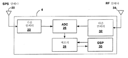
도 2는 이동 유닛의 예시적인 실시예를 도시하는 블록도이다.2 is a block diagram illustrating an exemplary embodiment of a mobile unit.
도 3은 이동 유닛의 동작의 예시적인 모드를 도시하는 흐름도이다.3 is a flowchart illustrating an exemplary mode of operation of a mobile unit.
도 4는 여기서 개시된 기술들에 따라 주어진 위성에 대한 의사범위(pseudorange)를 계산하기 위한 예시적인 프로세스를 도시하는 흐름도이다.4 is a flowchart illustrating an example process for calculating a pseudorange for a given satellite in accordance with the techniques disclosed herein.
도 1은 이동 유닛(4)이 위치 측량을 계산하기 위해 "동기화 바이어스"를 사용하는 예시적인 동기 환경(2)을 도시하는 블록도이다. 환경(2)은 위성 네비게이션 시스템(5)과 통신 네트워크(7)가 동기화 시스템 시간들을 가지도록 설계된 동기 환경으로 지칭된다. 다시 말해, 위성들(6)과 기지국들(8)은 동기화된 타이밍 정보를 정확하게 생성하도록 설계된다. 그럼에도 불구하고, 이동 유닛(4)은 위성 네비게이션 시스템(5)에 대한 시스템 시간과 무선 통신 시스템(7)에 대한 시스템 시간 간의 차이를 정의할 수 있는 동기화 바이어스를 허용하고 이를 분석한다. 위성 네비게이션 시스템(5)의 실시예는 미국 국방부에 의해 개발된 위성 위치측정 시스템(GPS)이다. 다른 형태의 위성 네비게이션 시스템들은 광역 오차보정 시스템(WAAS), 러시아 연방에 의해 개발된 글로벌 네비게이션 위성 시스템(GLONASS) 및 유럽연합에 의해 고안된 갈릴레오 시스템을 포함한다.1 is a block diagram illustrating an example synchronous environment 2 in which the mobile unit 4 uses “synchronization bias” to calculate a position measurement. The environment 2 is referred to as a synchronous environment in which the
이동 유닛(4)은 각각 위성들(6)과 기지국들(8)로부터 수신된 신호들(10, 12)에 기초하여 위치측정 솔루션을 계산하기 위한 기술들을 사용한다. 이동 유닛(4)은 관측중인 위성들(6)로부터 신호들(10)을 획득하고, 각각의 신호가 개별 위성들로부터 이동 유닛(4)으로 이동하는데 요구되는 시간을 측정함으로써 각각의 위성으로부터의 거리를 측정한다. 유사하게, 이동 유닛(4)은 무선 통신 시스템(7)의 기지국들(8)로부터의 신호들(12)을 수신하며, 각각의 무선 신호가 기지국들로부터 이동 유닛으로 이동하는데 요구되는 시간에 기초하여 기지국들(8)로부터의 거리들을 측정한다. 이동 유닛(4)은 측정치들에 기초하여 위치 및 시간 변수들을 분석한다.The mobile unit 4 uses techniques for calculating the positioning solution based on the
이동 유닛(4)에 의해 이용되는 기술들은 동기 환경(2)에서도 동기화 에러, 즉, 동기화 바이어스가 위성 네비게이션 시스템(5)에 대한 시스템 시간과 무선 통신 시스템(7)에 대한 시스템 시간 간에 존재한다는 인식에 기초한다. 이러한 시간 차이는 상이한 형태의 신호들(10, 12)을 프로세싱하기 위해 이동 유닛(4)에 의해 이용된 타이밍 회로들의 상이한 전파 지연들과 같은 다수의 요인들로부터 초래될 수 있다. 동기화 바이어스의 다른 원인들은 기지국들(8)의 송신기들 내의 공통 전파 지연들을 포함하며, 기지국들(8)로부터의 신호들(12)이 위성들(6)로부터의 신호들(10)보다 훨씬 낮은 앙각(elevation angle)에서 이동 유닛(4)에 도달하는 경향을 가진다는 사실을 포함한다. 이러한 낮은 앙각은 기지국들(8)부터의 신호들(12)이 위성들(6)로부터의 신호들(10)로보다 환경(2) 내에서 더 많은 물체들(미도시)로부터 반사되어 나오도록 하여, 기지국들(8)에 대한 이동 유닛(4)에 의해 계산된 타이밍 정보에서 초과 측정 신호 경로-길이들을 초래한다.The techniques used by the mobile unit 4 are also aware that synchronization errors, ie, synchronization bias, exist between the system time for the
따라서, 동기화 바이어스는 두 개의 시스템들, 즉, 위성들(6)과 기지국들(8)이 각각 속하는 위성 네비게이션 시스템(5)과 무선 통신 시스템(7) 사이의 공통 바이어스로서 관측될 수 있다. 다시 말해, 이동 유닛(4)으로부터의 관점으로부터, 시스템들이 제 시간에 동기적으로 동작하도록 설계된다 할지라도, 공통 동기화 바이어스가 두 시스템들(5, 7) 사이에 존재할 수 있다.Thus, the synchronization bias can be observed as a common bias between the two systems, namely the
시스템들(5, 7)이 매우 잘 동기화된 것으로 간주되는 경우, 하이브리드 위치측정 기술들은 위도, 경도 및 고도에 부가하여 단일 수신기 시간을 분석하는데 사용될 수 있다. 본 명세서에서 비동기 환경이라 지칭되는, 두 개의 시스템 시간들이 잘 동기화되지 않은 경우, 비동기 기술들이 독립적인 시스템 시간들을 분석하는데 사용될 수 있으나, 정확한 결과들을 생성하기 위해 이동 유닛(4)에 의해 추가의 측정을 요구한다. 예를 들어, 비동기 기술들은 5개의 독립 변수들: 위도, 경도, 고도, 위성에 대한 정확한 시간, 및 무선 네트워크에 대한 정확한 시간들의 값에 대한 적어도 5개의 측정치를 필요로 한다. 고도-보조 기술들은 위치 솔루션을 계산하는데 사용하기 위한 여분의 측정치를 제공하는데 사용되며, 이에 따라 필요한 측정치들의 수를 감소시킬 수 있다. 그럼에도 불구하고, 고도-보조를 사용하는 동기 기술들은 3개의 측정치들을 필요로 하는 반면, 비동기 기술들은 정확한 위치 솔루션을 계산하기 위해 추가로 제 4 측정치를 필요로 한다.If the
그럼에도 불구하고 이들 상황에서, 이동 유닛(4)은 시스템 시간들과 관련된 정의된 제약들을 이용함으로써 정확한 위치 솔루션을 계산하며, 이에 따라 추가의 독립적인 측정치를 필요로 하지 않고 비동기 기술들을 사용하여 위치 솔루션을 분석하는 것을 가능하게 한다. 특히, 시스템들(5, 7) 사이의 이러한 동기화 에러를 보상하기 위해, 이동 유닛(4)은 동기화 바이어스가 다른 시스템에 대한 시간의 함수로서 동기 환경(2)의 시스템들(5, 7)중 하나에 대한 시간을 표현할 수 있도록 하는 측량 기술들을 이용한다. 일례로, 동기화 바이어스는 다른 시스템의 시스템 시간으로부터 정의된 범위 내에서 시스템들(5, 7) 중 하나에 대한 시스템 시간을 정의할 수 있다. 예를 들어, 이동 유닛(4)은 위성 네비게이션 시스템(5)의 시스템 시간으로부터 시간 델타, 예를 들면, ±1 마이크로초 내로서 네트워크 통신 시스템(7)에 대한 시스템 시간을 정의하도록 구성될 수 있다. 다른 예에서, 동기화 바이어스는 다른 시스템의 시스템 시간으로부터의 시간 오프셋으로서 시스템들(5, 7) 중 하나에 대한 시스템 시간을 정의할 수 있다. 이러한 방식으로, 이러한 기술들은 동기화 바이어스가 제약되도록 하며, 시스템들의 시간들이 정확한 위치 솔루션을 계산하기 위해 부가의 측정치들 대신에 사용될 수 있는 단일 방정식에 따라 관련되도록 한다.Nevertheless, in these situations, the mobile unit 4 calculates the exact position solution by using defined constraints related to the system times, and thus does not require additional independent measurements and uses position solutions using asynchronous techniques. Makes it possible to analyze In particular, in order to compensate for this synchronization error between the
이하에서 설명될 바와 같이, 이동 유닛(4)은 위치 솔루션을 계산하기 위해 이러한 추가의 제약을 사용할 수 있다. 특히, 이동 유닛(4)은 환경(2)이 비동기 환경 즉, 위성 네비게이션 시스템(5)과 무선 통신 네트워크(7)에 대해 상이한 시간들을 갖는 환경인 것처럼 위치 솔루션을 계산할 수 있으나, 정의된 동기화 바이어스에 따라 시스템 시간들을 제약한다. 결과적으로, 본 명세서에서 이동 유닛(4)은 이동 유닛(4)이 동기 환경(2) 내의 위치 솔루션을 계산하기 위해 "준-동기화(semi-synchronous)" 모드로 동작할 수 있는 것으로 지칭된다. 이러한 기술은 통상적인 위치 계산 기술들이 실패하거나 덜 정확한 결과를 생성하는 광범위한 측량들에서 더 큰 정확성을 가진 위치 솔루션을 계산하도록 할 수 있다.As will be explained below, the mobile unit 4 can use this additional constraint to calculate the position solution. In particular, the mobile unit 4 can calculate the location solution as if the environment 2 is an asynchronous environment, ie an environment with different times for the
추가로, 이동 유닛(4)은 이동 유닛이 각각의 수신된 신호들(10, 12)로부터 유도된 위치 및 시간 솔루션들을 검증할 수 있도록 하는 수신기 자율 무결성 모니터링(RAIM: receiver autonomous integrity monitoring) 기능을 포함한다. 상술된 바와 같이, 적어도 4개의 소스들로부터의 신호들(10, 12)의 성공적인 획득이 일반적으로 이동 유닛(4)이 완전한 위치 솔루션을 계산하는데 필요하다. 5개 또는 그 이상의 신호들(10, 12)의 획득은 리던던트(redundant) 측정치들을 제공하며, 종종 이동 유닛(4)이 획득된 신호들의 전체 수에 따라 하나 이상의 신호들로부터 에러가 있는 측정치의 존재를 검출하도록 한다. 이동 유닛(4)은 GPS 시스템 또는 무선 통신 시스템으로부터의 하나 이상의 신호들로부터 에러가 있는 측정치를 검출하기 위해 그리고 위치 솔루션 계산으로부터의 측정치를 분리하기 위해 리던던트 측정치를 이용할 수 있다.In addition, the mobile unit 4 has a receiver autonomous integrity monitoring (RAIM) function that allows the mobile unit to verify positional and temporal solutions derived from the respective received
본 명세서에서 설명된 기술들에 따르면, 이동 유닛(4)은 RAIM 또는 유사한 기술들을 이러한 기술들이 불확실할(indeterminate) 수 있는 환경들에 적용하기 위해 정의된 동기화 바이어스를 이용할 수 있다. 예를 들어, 동기화 바이어스에 의해 정의된 추가의 제약은 이동 유닛(4)이 오로지 4개의 신호들만이 요구될 때 RAIM을 적용할 수 있도록 할 수 있다. 이러한 환경에서, 추가의 제약은 그 외에 제 5 위성 신호에 의해 제공될 수 있는 리던던시(redundancy)를 제공하기 위해 사용될 수 있다. 만일 이동 유닛(4)이 5개 보다 많은 신호를 필요로 한다면, 이동 유닛은 통상적인 RAIM 기술들을 적용할 것이며, 제약 동기화 바이어스를 검증 프로세스에 통합시킬 수 있다.According to the techniques described herein, the mobile unit 4 may use a defined synchronization bias to apply RAIM or similar techniques to environments where these techniques may be indeterminate. For example, an additional constraint defined by the synchronization bias may allow the mobile unit 4 to apply the RAIM when only four signals are required. In this environment, additional constraints can be used to provide redundancy that can otherwise be provided by the fifth satellite signal. If the mobile unit 4 needs more than five signals, the mobile unit will apply conventional RAIM techniques and can incorporate the constraint synchronization bias into the verification process.
이동 유닛(4)은 기지국들(8) 중 하나와 같은 무선 통신 시스템(5)의 컴포넌트로부터 동기화 바이어스 데이터를 수신할 수 있다. 특히, 무선 통신 시스템(5)은 동기화 바이어스 데이터를 유지 및 저장하기 위해 하나 이상의 서버들(14)을 포함할 수 있다. 서버(14)는 전-시스템(system-wide) 동기화 바이어스를 정의하는 데이터를 저장할 수 있다. 추가로, 서버(14)는 동기화 바이어스들의 세트를 정의하는 데이터를 저장할 수 있으며, 동기화 바이어스들을 다수의 이동 유닛들(4)에 대한 식별자들과 연관시킬 수 있다. 다시 말해, 서버(14)는 특정 이동 유닛(4)에 대해 특정한 동기화 바이어스 데이터를 유지할 수 있다. 이러한 방식으로, 동기화 바이어스 데이터는 타이밍 회로들, 타이밍 교정(calibration), 및 이동 유닛들(4) 간의 다른 변화들의 미세한 차이를 보상할 수 있다. 더욱이, 서버(14)는 무선 네트워크(5) 내의 다른 영역들, 예컨대, 셀들의 그룹에 대한 동기화 바이어스 데이터를 저장할 수 있다. 결과적으로, 서버(14)는 무선 통신 시스템의 개별 영역들에 대한 식별자들에 따라 동기화 바이어스 데이터를 배열할 수 있다.The mobile unit 4 can receive synchronization bias data from a component of the
서버(14)는 데이터 스토리지 파일들 또는 하나 이상의 데이터베이스 서버들상에서 실행되는 하나 이상의 데이터베이스 관리 시스템들(DBM: database management systems)을 포함하는 여러 형태의 동기화 바이어스 데이터를 저장할 수 있다. 데이터베이스 관리 시스템들은 관계형 데이터베이스 관리 시스템(RDBMS), 계층형 데이터베이스 관리 시스템(HDBMS), 다차원 데이터베이스 관리 시스템(MDBMS), 객체 지향 데이터베이스 관리 시스템(ODBMS 또는 OODBMS) 또는 객체 관계형 데이터베이스 관리 시스템(ORDBMS)일 수 있다. 데이터는 예를 들면, 마이크로소프트사의 SQL Sever™과 같은 단일 관계형 데이터베이스 내에 저장될 수 있다.The
이동 유닛(4)은 위치 솔루션을 계산하기 위해 무선 통신 신호들(12) 뿐만 아니라 위성 네비게이션 신호들(10)을 수신할 수 있는 여러 이동 수신기들 중 하나의 형태를 가질 수 있다. 이에 대한 예는 사용가능 이동 전화, 휴대형(handheld) 수신기, 비행기, 자동차, 트럭, 탱크, 선박 등과 같은 이동수단 내에 장착된 수신기를 포함한다. 기지국들(8)은 동기 환경에서 다수의 무선 통신 프로토콜들 중 하나에 따라 이동 유닛(4)과 통신할 수 있다. 하나의 공통 무선 통신 프로토콜은 무선-주파수(RF) 스펙트럼을 통해 다중 통신들이 동시에 수행되는 코드 분할 다중 액세스(CDMA)이다. CDMA 환경에서, 이러한 기술들은 개선된 진보형 순방향 링크 삼변 측량(AFLT)에 대한 메커니즘으로 관찰될 수 있다. 다른 예들은 데이터를 통신하기 위해 협대역 시분할 다중 액세스를 사용하는 이동 통신용 글로벌 시스템(GSM) 및 범용 패킷 무선 서비스(GPRS: general packet radio service)를 포함한다. 몇몇 환경들에서, 이동 유닛(4)은 음성 또는 데이터 통신을 위해 GPS 수신기 및 무선 통신 디바이스 모두를 포함할 수 있다.The mobile unit 4 may take the form of one of several mobile receivers capable of receiving satellite navigation signals 10 as well as wireless communication signals 12 to calculate a location solution. Examples of this include a mobile phone, a handheld receiver, a receiver mounted in a vehicle such as an airplane, automobile, truck, tank, ship, or the like. The base stations 8 may communicate with the mobile unit 4 in accordance with one of a number of wireless communication protocols in a synchronous environment. One common wireless communication protocol is code division multiple access (CDMA), where multiple communications are performed simultaneously over the radio-frequency (RF) spectrum. In a CDMA environment, these techniques can be observed as a mechanism for improved advanced forward link trilateration (AFLT). Other examples include Global System for Mobile Communications (GSM) and general packet radio service (GPRS) using narrowband time division multiple access to communicate data. In some circumstances, the mobile unit 4 may include both a GPS receiver and a wireless communication device for voice or data communication.
도 2는 예시적인 이동 유닛(4)을 상세하게 도시하는 블록도이다. 일반적으로, 이동 유닛(4)은 위성들(6) 및 기지국들(8) 각각으로부터 신호들(10, 12)을 수신하고 획득하기 위해 위성 위치측정 시스템(SPS: satellite positioning system) 안테나(20), RF 안테나(34), 다운 컨버터(22), 아날로그-디지털 컨버터(ADC: analog-to-digital converter)(26), 메모리(28) 및 디지털 신호 프로세서(DSP: digital signal processor)를 포함한다.2 is a block diagram illustrating in detail an exemplary mobile unit 4. In general, the mobile unit 4 receives a satellite positioning system (SPS)
다운 컨버터(22)는 SPS 안테나(20)를 통해 위성들(8)로부터 신호들(10)을 수신하며, 프로세싱을 위해 SPS 캐리어 주파수로부터 기저대역 주파수까지 신호들을 변환한다. 다운 컨버터(22)는 먼저 컨디셔닝을 위해 신호들(10)을 중간 주파수로 변환하고, 다음으로 컨디셔닝된 신호를 기저대역 주파수로 변환한다. 대안적으로, 다운 컨버터(22)는 기저대역으로의 직접 변환을 위한 제로 중간 주파수(ZIF: zero intermediate frequency) 아키텍처를 구현할 수 있다. 유사하게, 다운 컨버터(32)는 RF 안테나(34)로부터 수신된 신호들(12)을 기저대역 주파수로 변환한다. 비록 공통 안테나가 위성 및 셀룰러 통신들을 위해 사용될 수 있지만, 셀룰러 신호들(12) 및 위성 신호들(10)은 통상적으로 다른 RF 대역들을 사용하기 때문에 개별형 안테나들이 바람직하다.Down
ADC(26)는 신호들의 디지털화된 표현을 생성하기 위해 기저대역 신호들을 샘플링하고, 디지털화된 표현들을 메모리(28) 내에 저장한다. 예를 들어, 메모리(28)는 획득 프로세스 동안 DSP(30)에 의한 사용을 위해 통상적으로 기저대역 신호의 대략 100ms 내지 1초 또는 그 이상의 지속시간에 대응하는 디지털화된 데이터의 연속 세트를 저장할 수 있다.
DSP(30)는 위치 솔루션을 계산하기 위해 추가의 제약으로서 동기화 바이어스뿐만 아니라 신호들의 디지털화된 표현들을 사용한다. 특히, DSP(30)는 위성 네비게이션 시스템(5)과 무선 통신 네트워크(7)에 대한 시스템 시간들을 계산하기 위해 비동기 위치 솔루션 기술들을 적용하지만, 정의된 동기화 바이어스에 따라 시스템 시간들을 제약한다. 결과적으로, DSP(30)는 비동기 환경(2)에서 위치 솔루션을 계산하기 위해 준-동기(semi-synchronous) 모드로 동작한다.
DSP(30)는 메모리(28), 내부 온-칩(on-chip) 메모리 또는 다른 적절한 컴퓨터-판독가능 매체 내에 동기화 바이어스를 정의하는 데이터를 저장할 수 있다. 다시 말해, 동기화 바이어스는 이동 유닛(4) 내에 하드-코딩(hard-code)될 수 있다. 대안적으로, DSP(30)는 RF 안테나(34)를 통해 기지국 제어기(미도시)와 같은 무선 통신 시스템(8)의 컴포넌트로부터 비동기 바이어스 데이터를 수신할 수 있다.
DSP(30)는 통상적으로 컴퓨터-판독가능 매체로부터 인출된 실행가능 지시들에 따라 동작한다. 이러한 매체들의 예는 랜덤 액세스 메모리(RAM), 판독-전용 메모리(ROM), 비휘발성 랜덤 액세스 메모리(NVRAM), 전기적으로 삭제가능한 프로그래밍가능 판독전용 메모리(EEPROM), 플래시 메모리 등을 포함한다. 비록 디지털 신호 프로세서를 참조하여 설명되었지만, 다른 형태의 내장형 프로세서 또는 제어기가 이동 유닛(4) 내에서 사용될 수 있다.
도 3은 이동 유닛(4)의 예시적인 동작을 더 상세히 도시하는 흐름도이다. 위치 솔루션을 계산하기 위해, 이동 유닛(4)은 SPS 안테나(20)를 통해 위성 네비게이션 시스템(5)으로부터 위성 신호들(10)을 수신하며(42), 무선 모뎀(32) 및 RF 안테나(34)를 통해 무선 통신 시스템(7)으로부터 RF 신호들(12)을 수신한다(44).3 is a flow chart showing in more detail the exemplary operation of the mobile unit 4. To calculate the location solution, the mobile unit 4 receives satellite signals 10 from the
추가로, 이동 유닛(4)은 위성 네비게이션 시스템(5)에 대한 시스템 시간과 무선 통신 시스템(7)에 대한 시스템 시간 간의 차이를 정의하는 동기화 바이어스 데이터를 수신한다(46). 상술된 바와 같이, 동기화 바이어스는 시스템들(5, 7) 중 하나에 대한 시스템 시간을 다른 시스템의 시스템 시간으로부터 정의된 범위 내로 정의한다. 다른 예로서, 동기화 바이어스는 시스템들(5, 7) 중 하나에 대한 시스템 시간을 다른 시스템의 시스템 시간으로부터의 시간 오프셋으로서 정의한다. 이동 유닛(4)은 기지국 중 하나(8)와 같이 무선 통신 시스템(5)의 컴포넌트로부터 데이터를 수신할 수 있고, 상기 컴포넌트는 중앙 데이터베이스로부터 동기화 바이어스 데이터를 리트리빙(retrieve)할 수 있다. 대안적으로, 이동 유닛(4)은 도 2와 관련해서 상술된 바와 같이, 내부 메모리로부터 동기화 바이어스 데이터를 검색할 수 있다.In addition, the mobile unit 4 receives 46 synchronization bias data defining a difference between the system time for the
수신된 신호들 및 정의된 동기화 바이어스에 기초하여, 이동 유닛(4)은 시스템(5, 7)에 대한 시스템 시간들 및 위치 솔루션을 계산한다(48). 예를 들어, 이동 유닛(4)은 이동 유닛(4)에 대한 시스템 시간들, 위도, 경도 및 고도를 획득 신호와 동기화 바이어스 데이터에 의해 정의된 제약으로서 결정한다. 이동 유닛(4)은 동기화 바이어스에 기초하여 위성 네비게이션 시스템(5) 및 무선 통신 시스템(7)에 대한 시스템 시간들 사이에 정의된 제약 관계를 사용하여 위치를 계산하는데 비동기 기술들을 적용할 수 있다.Based on the received signals and the defined synchronization bias, the mobile unit 4 calculates 48 the system times and position solution for the
도 4는 서버(14)의 예시적인 동작 모드를 상세히 도시하는 흐름도이다. 초기에, 서버(14)는 통상적으로 하나 이상의 기지국들(8)을 통해 동기화 데이터에 대한 이동 유닛(4)으로부터의 요청을 수신한다(60). 응답하여, 서버(14)가 요청중인 이동 유닛(4) 및 이동 유닛이 현재 동작하고 있는 무선 통신 네트워크(5)의 영역을 식별한다(62). 다음으로, 서버(14)는 예를 들면, 데이터베이스로부터 동기화 바이어스 데이터를 검색하고 데이터를 이동 유닛(4)에 통신한다(64, 66). 상술된 바와 같이, 서버(14)는 전-시스템 동기화 바이어스, 요청중인 이동 유닛에 특정한 동기화 바이어스, 현재 영역에 특정한 동기화 바이어스 또는 이들의 조합을 검색하고 통신한다.4 is a flowchart detailing an exemplary mode of operation of
추가로, 일단 이동 유닛(4)이 위치 솔루션을 계산하면, 서버(14)는 계산된 동기화 바이어스를 설명하는 데이터를 수신한다. 다시 말해, 이동 유닛(4)은 시스템들(5, 7)의 실제 시스템 시간들을 분석하기 위해, 예를 들면, 시스템 시간차 범위와 같은 동기화 바이어스를 사용할 수 있다. 서버(14)는 계산된 동기화 바이어스를 정의하는 데이터를 수신할 수 있고, 수신된 데이터에 기초하여 데이터베이스를 업데이팅할 수 있다(70). 서버(14)는 계산된 동기화 바이어스를 예를 들면, 동기 환경(2)에 대한 시스템 시간들의 임계차인 사전결정 임계치와 비교할 수 있고(72), 비교에 기초하여 무선 통신 시스템(7)에 대한 제조자 또는 서비스 제공자에게 서비스 메시지들을 송출할 수 있다(74). 서비스 메시지는 무선 통신 시스템(7) 내의 하나 이상의 컴포넌트들의 결정된 기능 상태를 기술할 수 있다.In addition, once mobile unit 4 calculates the location solution,
비록 기술들이 예를 들어, 도 1의 이동 유닛(4)인 이동 유닛에 의해 위치 솔루션의 비교와 관련하여 일반적으로 설명되었지만, 이러한 기술들은 다른 디바이스들의 위치측정 엔진에 의해 쉽게 응용될 수 있다. 예를 들어, 이러한 기술들은 예를 들어, 분산형 위치결정 서버들, PDE(Position Determination Entities), LMU(Location Measuring Units), SMLC(Serving Mobile Location Centers), WLG(Wireless location Gateways), MLC(Mobile Location Centers) 등인 이동 유닛에 대한 위치 솔루션들의 계산을 보조하기 위해 다른 디바이스들에 의해 적용된다.Although the techniques have been described generally in connection with the comparison of the position solution by a mobile unit, for example the mobile unit 4 of FIG. 1, these techniques can be easily applied by the positioning engine of other devices. For example, these techniques may include, for example, distributed location servers, Position Determination Entities (PDEs), Location Measuring Units (LMUs), Serving Mobile Location Centers (SMLCs), Wireless Location Gateways (WLGs), and Mobiles (MLCs). Location centers), etc., to be used by other devices to assist in the calculation of location solutions for the mobile unit.
다양한 실시예들이 설명되었다. 이러한 그리고 다른 실시예들은 이하의 청구항의 범위 내이다.Various embodiments have been described. These and other embodiments are within the scope of the following claims.
Claims (76)
Applications Claiming Priority (4)
| Application Number | Priority Date | Filing Date | Title |
|---|---|---|---|
| US40861402P | 2002-09-05 | 2002-09-05 | |
| US60/408,614 | 2002-09-05 | ||
| US10/632,637 US7499712B2 (en) | 2002-09-05 | 2003-07-31 | Position computation in a positioning system using synchronization time bias |
| US10/632,637 | 2003-07-31 |
Publications (2)
| Publication Number | Publication Date |
|---|---|
| KR20050057176A KR20050057176A (en) | 2005-06-16 |
| KR101151099B1 true KR101151099B1 (en) | 2012-06-04 |
Family
ID=31981602
Family Applications (1)
| Application Number | Title | Priority Date | Filing Date |
|---|---|---|---|
| KR1020057003760A KR101151099B1 (en) | 2002-09-05 | 2003-09-05 | Position computation in a positioning system using synchronization time bias |
Country Status (10)
| Country | Link |
|---|---|
| US (2) | US7499712B2 (en) |
| EP (1) | EP1537434B1 (en) |
| JP (2) | JP5265074B2 (en) |
| KR (1) | KR101151099B1 (en) |
| CN (1) | CN1688893B (en) |
| AT (1) | ATE364185T1 (en) |
| AU (1) | AU2003268545A1 (en) |
| DE (1) | DE60314260T2 (en) |
| ES (1) | ES2287509T3 (en) |
| WO (1) | WO2004023156A1 (en) |
Families Citing this family (32)
| Publication number | Priority date | Publication date | Assignee | Title |
|---|---|---|---|---|
| US8948785B1 (en) * | 2002-10-03 | 2015-02-03 | Sprint Spectrum L.P. | Method and system for managing mobile station location information |
| US7215281B2 (en) * | 2003-04-25 | 2007-05-08 | New Jersey Institute Of Technology | Wireless network assisted GPS system |
| US7146185B2 (en) | 2003-06-12 | 2006-12-05 | Richard Lane | Mobile station-centric method for managing bandwidth and QoS in error-prone system |
| US20050202829A1 (en) * | 2004-03-01 | 2005-09-15 | Texas Instruments Incorporated | Satellite positioning system receiver utilizing time-aiding information from an independent source |
| US20050251798A1 (en) * | 2004-05-05 | 2005-11-10 | News, Iq, Inc. | System and method for inventory control and management |
| JP2006214934A (en) * | 2005-02-04 | 2006-08-17 | Seiko Epson Corp | Positioning system, terminal device, control method of terminal device, control program of terminal device, and computer readable recording medium having recorded control program of terminal device |
| US8228956B2 (en) | 2005-04-19 | 2012-07-24 | Alcatel Lucent | Time stamp offset in data packet bundling |
| US7574224B2 (en) * | 2005-06-13 | 2009-08-11 | Qualcomm Incorporated | Methods and apparatus for performing timing synchronization with base stations |
| US8001076B2 (en) * | 2005-07-12 | 2011-08-16 | International Business Machines Corporation | Ranging scalable time stamp data synchronization |
| US20070121555A1 (en) * | 2005-11-08 | 2007-05-31 | David Burgess | Positioning using is-95 cdma signals |
| CN101227338B (en) * | 2005-12-22 | 2010-12-08 | 阿尔卡特公司 | Time stamp offset in data packet bundling |
| KR100745829B1 (en) | 2006-03-09 | 2007-08-02 | 길 용 노 | Reciever for multiple electro navigation system and the method for determining location thereof |
| CN100442077C (en) * | 2007-07-12 | 2008-12-10 | 北京航空航天大学 | Usable forcasting method for receiver autonomic excellent monitoring |
| US7595754B2 (en) * | 2007-12-24 | 2009-09-29 | Qualcomm Incorporated | Methods, systems and apparatus for integrated wireless device location determination |
| US20090310593A1 (en) * | 2008-06-17 | 2009-12-17 | Qualcomm Incorporated | Self-positioning access points |
| WO2010034351A1 (en) * | 2008-09-26 | 2010-04-01 | Telecom Italia S.P.A. | Method and system for localizing mobile communications terminals |
| US8233840B2 (en) * | 2008-10-06 | 2012-07-31 | Viasat, Inc. | Ephemeris-based synchronization for mesh satellite communications |
| US8625572B2 (en) * | 2008-12-19 | 2014-01-07 | Nokia Corporation | Synchronization indication in networks |
| US8160610B2 (en) * | 2009-03-18 | 2012-04-17 | Andrew Llc | System and method for locating mobile device in wireless communication network |
| US9392521B2 (en) * | 2009-03-18 | 2016-07-12 | Telecommunication Systems, Inc. | System and method for concurrently determining locations of mobile device in wireless communication network |
| KR101302565B1 (en) * | 2009-12-15 | 2013-09-02 | 한국전자통신연구원 | System and method for estimating position of lost mobile terminal and mobile terminal |
| US8866670B2 (en) * | 2011-06-02 | 2014-10-21 | Qualcomm Incorporated | Hybrid positioning using synchronous and asynchronous techniques |
| JP6064507B2 (en) * | 2012-03-14 | 2017-01-25 | 株式会社リコー | Distribution apparatus, position management system, distribution method, and program |
| US9629111B2 (en) * | 2013-03-07 | 2017-04-18 | Telcom Ventures, Llc | Systems and methods for virtually synchronizing unsynchronized or loosely synchronized networks for position location determination |
| US9713110B2 (en) * | 2014-09-25 | 2017-07-18 | Telefonaktiebolaget Lm Ericsson (Publ) | Method and network node for facilitating timing synchronization in network |
| CN104730919B (en) * | 2015-04-02 | 2017-03-01 | 西安电子科技大学 | A kind of big-dipper satellite time dissemination system and its method |
| CN105943326A (en) * | 2016-07-18 | 2016-09-21 | 浙江钧普科技股份有限公司 | Intelligent outdoor blind guiding equipment and navigation and positioning method for controlling equipment |
| JP2018155665A (en) * | 2017-03-17 | 2018-10-04 | セイコーエプソン株式会社 | Timing signal output device, electronic apparatus, and mobile body |
| CN108957501B (en) * | 2018-06-04 | 2020-10-13 | 北京因子图导航技术有限公司 | Digital ground multimedia broadcast synchronous foundation navigation positioning method and system |
| CN114726467B (en) * | 2021-01-04 | 2023-11-21 | 中国移动通信有限公司研究院 | Synchronous monitoring method and device, time server and downstream time server |
| CN113055115B (en) * | 2021-03-11 | 2023-01-31 | 宸芯科技有限公司 | Timing adjustment method and device, internet of vehicles equipment and storage medium |
| CN114095304B (en) * | 2022-01-24 | 2022-05-10 | 深圳市山龙智控有限公司 | Inter-node synchronous precision compensation method and system based on EtherCAT bus |
Citations (1)
| Publication number | Priority date | Publication date | Assignee | Title |
|---|---|---|---|---|
| US6188354B1 (en) | 1999-03-29 | 2001-02-13 | Qualcomm Incorporated | Method and apparatus for determining the location of a remote station in a CDMA communication network |
Family Cites Families (19)
| Publication number | Priority date | Publication date | Assignee | Title |
|---|---|---|---|---|
| US5398263A (en) * | 1993-01-14 | 1995-03-14 | Motorola, Inc. | Autonomous pulse train timing controls for time-mark alignment |
| JPH10300835A (en) * | 1997-04-25 | 1998-11-13 | Lockheed Martin Corp | Quick and accurate specification of geographical position for cellular telephone using gps satellite system |
| US6353412B1 (en) * | 1998-03-17 | 2002-03-05 | Qualcomm, Incorporated | Method and apparatus for determining position location using reduced number of GPS satellites and synchronized and unsynchronized base stations |
| US6081229A (en) * | 1998-03-17 | 2000-06-27 | Qualcomm Incorporated | System and method for determining the position of a wireless CDMA transceiver |
| US5999124A (en) * | 1998-04-22 | 1999-12-07 | Snaptrack, Inc, | Satellite positioning system augmentation with wireless communication signals |
| EP1080555B1 (en) * | 1998-05-04 | 2009-08-12 | Nokia Corporation | Method of synchronisation of a base station network |
| US6252543B1 (en) * | 1998-05-28 | 2001-06-26 | Ericsson Inc. | Location system combining ranging measurements from GPS and cellular networks |
| US6313786B1 (en) * | 1998-07-02 | 2001-11-06 | Snaptrack, Inc. | Method and apparatus for measurement processing of satellite positioning system (SPS) signals |
| US6415154B1 (en) * | 1998-10-06 | 2002-07-02 | Ericsson Inc. | Method and apparatus for communicating auxilliary information and location information between a cellular telephone network and a global positioning system receiver for reducing code shift search time of the receiver |
| US6058338A (en) * | 1999-02-12 | 2000-05-02 | Qualcomm Incorporated | Method and apparatus for efficient GPS assistance in a communication system |
| US6249253B1 (en) | 1999-04-13 | 2001-06-19 | Nortel Networks Limited | Mobile radiotelephone determination using time of arrival of GPS and pilot signals |
| US6289280B1 (en) * | 1999-12-10 | 2001-09-11 | Qualcomm Incorporated | Method and apparatus for determining an algebraic solution to GPS terrestrial hybrid location system equations |
| US6603978B1 (en) | 2000-03-24 | 2003-08-05 | Ericsson Inc. | Accurate GPS time estimate based on information from a wireless communications system |
| JP2001343447A (en) * | 2000-03-30 | 2001-12-14 | Honda Motor Co Ltd | Method for detecting location of movable body |
| US6445927B1 (en) * | 2000-09-18 | 2002-09-03 | Motorola, Inc. | Method and apparatus for calibrating base station locations and perceived time bias offsets in an assisted GPS transceiver |
| JP4468567B2 (en) * | 2000-11-10 | 2010-05-26 | 日本無線株式会社 | Positioning method |
| US7454217B2 (en) * | 2001-10-04 | 2008-11-18 | Stephen William Edge | Method and apparatus for wireless network timekeeping and synchronization |
| US6806830B2 (en) * | 2001-12-31 | 2004-10-19 | Texas Instruments Incorporated | Electronic device precision location via local broadcast signals |
| US7243134B2 (en) * | 2002-06-25 | 2007-07-10 | Motorola, Inc. | Server-based navigation system having dynamic transmittal of route information |
-
2003
- 2003-07-31 US US10/632,637 patent/US7499712B2/en active Active
- 2003-09-05 DE DE60314260T patent/DE60314260T2/en not_active Expired - Lifetime
- 2003-09-05 KR KR1020057003760A patent/KR101151099B1/en active IP Right Grant
- 2003-09-05 AU AU2003268545A patent/AU2003268545A1/en not_active Abandoned
- 2003-09-05 JP JP2004534759A patent/JP5265074B2/en not_active Expired - Fee Related
- 2003-09-05 AT AT03749515T patent/ATE364185T1/en not_active IP Right Cessation
- 2003-09-05 WO PCT/US2003/028109 patent/WO2004023156A1/en active Search and Examination
- 2003-09-05 CN CN038241072A patent/CN1688893B/en not_active Expired - Fee Related
- 2003-09-05 ES ES03749515T patent/ES2287509T3/en not_active Expired - Lifetime
- 2003-09-05 EP EP03749515A patent/EP1537434B1/en not_active Expired - Lifetime
-
2009
- 2009-02-02 US US12/364,399 patent/US7991414B2/en not_active Expired - Fee Related
-
2012
- 2012-07-10 JP JP2012154725A patent/JP2012247429A/en not_active Withdrawn
Patent Citations (1)
| Publication number | Priority date | Publication date | Assignee | Title |
|---|---|---|---|---|
| US6188354B1 (en) | 1999-03-29 | 2001-02-13 | Qualcomm Incorporated | Method and apparatus for determining the location of a remote station in a CDMA communication network |
Also Published As
| Publication number | Publication date |
|---|---|
| JP2005538358A (en) | 2005-12-15 |
| AU2003268545A1 (en) | 2004-03-29 |
| KR20050057176A (en) | 2005-06-16 |
| JP2012247429A (en) | 2012-12-13 |
| US7991414B2 (en) | 2011-08-02 |
| ATE364185T1 (en) | 2007-06-15 |
| DE60314260D1 (en) | 2007-07-19 |
| WO2004023156A1 (en) | 2004-03-18 |
| US7499712B2 (en) | 2009-03-03 |
| DE60314260T2 (en) | 2008-02-14 |
| JP5265074B2 (en) | 2013-08-14 |
| EP1537434B1 (en) | 2007-06-06 |
| CN1688893A (en) | 2005-10-26 |
| CN1688893B (en) | 2013-05-08 |
| US20090195448A1 (en) | 2009-08-06 |
| EP1537434A1 (en) | 2005-06-08 |
| ES2287509T3 (en) | 2007-12-16 |
| US20040077311A1 (en) | 2004-04-22 |
Similar Documents
| Publication | Publication Date | Title |
|---|---|---|
| KR101151099B1 (en) | Position computation in a positioning system using synchronization time bias | |
| EP2342575B1 (en) | Method and system for localizing mobile communications terminals | |
| US7551931B2 (en) | Method and system for validating a mobile station location fix | |
| US6266533B1 (en) | GPS assistance data for positioning of mobiles with built-in GPS | |
| US7457584B2 (en) | Repeater with positioning capabilities | |
| US6570529B2 (en) | Autonomous calibration of a wireless-global positioning system | |
| RU2413959C2 (en) | Method for position finding by cross linking measurements | |
| EP1145035B1 (en) | Method and system for using altitude information in a satellite positioning system | |
| US7724186B2 (en) | Enhanced aiding in GPS systems | |
| US8213955B2 (en) | Network measurement report caching for location of mobile devices | |
| US20070279281A1 (en) | Server device, mobile terminal and positioning mode selecting method | |
| US20110148700A1 (en) | Method and system for mobile device based gnss position computation without ephemeris data | |
| JP2004515767A (en) | Method and apparatus for determining an error estimate in a hybrid position determination system | |
| JP2005538358A5 (en) | ||
| KR101874974B1 (en) | Apparatus and method for generating differential global navigation satellite system pseudo range correction information | |
| US7924221B2 (en) | Method and apparatus for monitoring the integrity of satellite navigation signals | |
| WO2005103753A1 (en) | Repeater with positioning capabilities | |
| WO2006098666A1 (en) | Method and device for assisted satellite-based positioning | |
| JP2001091623A (en) | Position specifying system and position specifying method |
Legal Events
| Date | Code | Title | Description |
|---|---|---|---|
| A201 | Request for examination | ||
| E902 | Notification of reason for refusal | ||
| E902 | Notification of reason for refusal | ||
| E701 | Decision to grant or registration of patent right | ||
| GRNT | Written decision to grant | ||
| FPAY | Annual fee payment |
Payment date: 20160330 Year of fee payment: 5 |
|
| FPAY | Annual fee payment |
Payment date: 20170330 Year of fee payment: 6 |
|
| FPAY | Annual fee payment |
Payment date: 20180329 Year of fee payment: 7 |
|
| FPAY | Annual fee payment |
Payment date: 20190327 Year of fee payment: 8 |