JP7680452B2 - Blocked Area Guidance - Google Patents
Blocked Area Guidance Download PDFInfo
- Publication number
- JP7680452B2 JP7680452B2 JP2022536678A JP2022536678A JP7680452B2 JP 7680452 B2 JP7680452 B2 JP 7680452B2 JP 2022536678 A JP2022536678 A JP 2022536678A JP 2022536678 A JP2022536678 A JP 2022536678A JP 7680452 B2 JP7680452 B2 JP 7680452B2
- Authority
- JP
- Japan
- Prior art keywords
- vehicle
- blocked
- area
- examples
- region
- Prior art date
- Legal status (The legal status is an assumption and is not a legal conclusion. Google has not performed a legal analysis and makes no representation as to the accuracy of the status listed.)
- Active
Links
Images


Classifications
-
- G—PHYSICS
- G08—SIGNALLING
- G08G—TRAFFIC CONTROL SYSTEMS
- G08G1/00—Traffic control systems for road vehicles
- G08G1/16—Anti-collision systems
- G08G1/164—Centralised systems, e.g. external to vehicles
-
- G—PHYSICS
- G05—CONTROLLING; REGULATING
- G05D—SYSTEMS FOR CONTROLLING OR REGULATING NON-ELECTRIC VARIABLES
- G05D1/00—Control of position, course, altitude or attitude of land, water, air or space vehicles, e.g. using automatic pilots
- G05D1/02—Control of position or course in two dimensions
- G05D1/021—Control of position or course in two dimensions specially adapted to land vehicles
- G05D1/0212—Control of position or course in two dimensions specially adapted to land vehicles with means for defining a desired trajectory
- G05D1/0214—Control of position or course in two dimensions specially adapted to land vehicles with means for defining a desired trajectory in accordance with safety or protection criteria, e.g. avoiding hazardous areas
-
- G—PHYSICS
- G05—CONTROLLING; REGULATING
- G05D—SYSTEMS FOR CONTROLLING OR REGULATING NON-ELECTRIC VARIABLES
- G05D1/00—Control of position, course, altitude or attitude of land, water, air or space vehicles, e.g. using automatic pilots
- G05D1/0011—Control of position, course, altitude or attitude of land, water, air or space vehicles, e.g. using automatic pilots associated with a remote control arrangement
- G05D1/0038—Control of position, course, altitude or attitude of land, water, air or space vehicles, e.g. using automatic pilots associated with a remote control arrangement by providing the operator with simple or augmented images from one or more cameras located onboard the vehicle, e.g. tele-operation
-
- G—PHYSICS
- G05—CONTROLLING; REGULATING
- G05D—SYSTEMS FOR CONTROLLING OR REGULATING NON-ELECTRIC VARIABLES
- G05D1/00—Control of position, course, altitude or attitude of land, water, air or space vehicles, e.g. using automatic pilots
- G05D1/0088—Control of position, course, altitude or attitude of land, water, air or space vehicles, e.g. using automatic pilots characterized by the autonomous decision making process, e.g. artificial intelligence, predefined behaviours
-
- G—PHYSICS
- G05—CONTROLLING; REGULATING
- G05D—SYSTEMS FOR CONTROLLING OR REGULATING NON-ELECTRIC VARIABLES
- G05D1/00—Control of position, course, altitude or attitude of land, water, air or space vehicles, e.g. using automatic pilots
- G05D1/02—Control of position or course in two dimensions
- G05D1/021—Control of position or course in two dimensions specially adapted to land vehicles
- G05D1/0212—Control of position or course in two dimensions specially adapted to land vehicles with means for defining a desired trajectory
- G05D1/0221—Control of position or course in two dimensions specially adapted to land vehicles with means for defining a desired trajectory involving a learning process
-
- G—PHYSICS
- G05—CONTROLLING; REGULATING
- G05D—SYSTEMS FOR CONTROLLING OR REGULATING NON-ELECTRIC VARIABLES
- G05D1/00—Control of position, course, altitude or attitude of land, water, air or space vehicles, e.g. using automatic pilots
- G05D1/02—Control of position or course in two dimensions
- G05D1/021—Control of position or course in two dimensions specially adapted to land vehicles
- G05D1/0287—Control of position or course in two dimensions specially adapted to land vehicles involving a plurality of land vehicles, e.g. fleet or convoy travelling
- G05D1/0291—Fleet control
-
- G—PHYSICS
- G06—COMPUTING OR CALCULATING; COUNTING
- G06N—COMPUTING ARRANGEMENTS BASED ON SPECIFIC COMPUTATIONAL MODELS
- G06N3/00—Computing arrangements based on biological models
- G06N3/02—Neural networks
- G06N3/04—Architecture, e.g. interconnection topology
- G06N3/0464—Convolutional networks [CNN, ConvNet]
-
- G—PHYSICS
- G06—COMPUTING OR CALCULATING; COUNTING
- G06N—COMPUTING ARRANGEMENTS BASED ON SPECIFIC COMPUTATIONAL MODELS
- G06N3/00—Computing arrangements based on biological models
- G06N3/02—Neural networks
- G06N3/08—Learning methods
-
- G—PHYSICS
- G08—SIGNALLING
- G08G—TRAFFIC CONTROL SYSTEMS
- G08G1/00—Traffic control systems for road vehicles
- G08G1/16—Anti-collision systems
- G08G1/165—Anti-collision systems for passive traffic, e.g. including static obstacles, trees
-
- G—PHYSICS
- G08—SIGNALLING
- G08G—TRAFFIC CONTROL SYSTEMS
- G08G1/00—Traffic control systems for road vehicles
- G08G1/16—Anti-collision systems
- G08G1/167—Driving aids for lane monitoring, lane changing, e.g. blind spot detection
-
- G—PHYSICS
- G08—SIGNALLING
- G08G—TRAFFIC CONTROL SYSTEMS
- G08G1/00—Traffic control systems for road vehicles
- G08G1/22—Platooning, i.e. convoy of communicating vehicles
-
- G—PHYSICS
- G06—COMPUTING OR CALCULATING; COUNTING
- G06N—COMPUTING ARRANGEMENTS BASED ON SPECIFIC COMPUTATIONAL MODELS
- G06N20/00—Machine learning
-
- G—PHYSICS
- G08—SIGNALLING
- G08G—TRAFFIC CONTROL SYSTEMS
- G08G1/00—Traffic control systems for road vehicles
- G08G1/09—Arrangements for giving variable traffic instructions
- G08G1/0962—Arrangements for giving variable traffic instructions having an indicator mounted inside the vehicle, e.g. giving voice messages
- G08G1/0967—Systems involving transmission of highway information, e.g. weather, speed limits
- G08G1/096708—Systems involving transmission of highway information, e.g. weather, speed limits where the received information might be used to generate an automatic action on the vehicle control
- G08G1/096725—Systems involving transmission of highway information, e.g. weather, speed limits where the received information might be used to generate an automatic action on the vehicle control where the received information generates an automatic action on the vehicle control
-
- G—PHYSICS
- G08—SIGNALLING
- G08G—TRAFFIC CONTROL SYSTEMS
- G08G1/00—Traffic control systems for road vehicles
- G08G1/09—Arrangements for giving variable traffic instructions
- G08G1/0962—Arrangements for giving variable traffic instructions having an indicator mounted inside the vehicle, e.g. giving voice messages
- G08G1/0967—Systems involving transmission of highway information, e.g. weather, speed limits
- G08G1/096733—Systems involving transmission of highway information, e.g. weather, speed limits where a selection of the information might take place
- G08G1/096758—Systems involving transmission of highway information, e.g. weather, speed limits where a selection of the information might take place where no selection takes place on the transmitted or the received information
-
- G—PHYSICS
- G08—SIGNALLING
- G08G—TRAFFIC CONTROL SYSTEMS
- G08G1/00—Traffic control systems for road vehicles
- G08G1/09—Arrangements for giving variable traffic instructions
- G08G1/0962—Arrangements for giving variable traffic instructions having an indicator mounted inside the vehicle, e.g. giving voice messages
- G08G1/0967—Systems involving transmission of highway information, e.g. weather, speed limits
- G08G1/096766—Systems involving transmission of highway information, e.g. weather, speed limits where the system is characterised by the origin of the information transmission
- G08G1/096775—Systems involving transmission of highway information, e.g. weather, speed limits where the system is characterised by the origin of the information transmission where the origin of the information is a central station
-
- G—PHYSICS
- G08—SIGNALLING
- G08G—TRAFFIC CONTROL SYSTEMS
- G08G1/00—Traffic control systems for road vehicles
- G08G1/09—Arrangements for giving variable traffic instructions
- G08G1/0962—Arrangements for giving variable traffic instructions having an indicator mounted inside the vehicle, e.g. giving voice messages
- G08G1/0968—Systems involving transmission of navigation instructions to the vehicle
- G08G1/096805—Systems involving transmission of navigation instructions to the vehicle where the transmitted instructions are used to compute a route
- G08G1/096811—Systems involving transmission of navigation instructions to the vehicle where the transmitted instructions are used to compute a route where the route is computed offboard
-
- G—PHYSICS
- G08—SIGNALLING
- G08G—TRAFFIC CONTROL SYSTEMS
- G08G1/00—Traffic control systems for road vehicles
- G08G1/20—Monitoring the location of vehicles belonging to a group, e.g. fleet of vehicles, countable or determined number of vehicles
- G08G1/207—Monitoring the location of vehicles belonging to a group, e.g. fleet of vehicles, countable or determined number of vehicles with respect to certain areas, e.g. forbidden or allowed areas with possible alerting when inside or outside boundaries
Landscapes
- Engineering & Computer Science (AREA)
- Physics & Mathematics (AREA)
- General Physics & Mathematics (AREA)
- Remote Sensing (AREA)
- Radar, Positioning & Navigation (AREA)
- Automation & Control Theory (AREA)
- Aviation & Aerospace Engineering (AREA)
- Theoretical Computer Science (AREA)
- Health & Medical Sciences (AREA)
- Artificial Intelligence (AREA)
- Evolutionary Computation (AREA)
- Biophysics (AREA)
- Data Mining & Analysis (AREA)
- General Engineering & Computer Science (AREA)
- Molecular Biology (AREA)
- Mathematical Physics (AREA)
- Software Systems (AREA)
- General Health & Medical Sciences (AREA)
- Computing Systems (AREA)
- Computational Linguistics (AREA)
- Biomedical Technology (AREA)
- Life Sciences & Earth Sciences (AREA)
- Business, Economics & Management (AREA)
- Game Theory and Decision Science (AREA)
- Medical Informatics (AREA)
- Traffic Control Systems (AREA)
Description
本開示は、ブロックされる領域の案内に関する。 This disclosure relates to guidance on blocked areas.
本出願は、「BLOCKED REGION GUIDANCE」と題される、2019年12月16日に出願された米国特許出願第16/716,411号の優先権を主張するものであり、その全体が参照により本明細書に組み込まれる。 This application claims priority to U.S. Patent Application No. 16/716,411, entitled "BLOCKED REGION GUIDANCE," filed December 16, 2019, which is incorporated by reference in its entirety.
自律的車両および半自律的な車両における計画システムは、動作環境において、車両が取るべき動きを決定する。車両に対する動きは、環境内に存在するオブジェクトを回避することに部分的に基づいて決定され得る。例えば、動きは、二重駐車した車両をよける、道路の別の車両を避けるために車線を変えるなどを行うように生成され得る。計画システムは、車両のための可能性のある動きに対する各検出されたオブジェクトの影響を決定するために、任意の数の動作(例えば、シミュレーションなど)を実施し得る。しかし、いくつかの状況においては、車両は、車両の進行を妨害する環境の一部を通過するようにナビゲートするための支援を要求し得る。 The planning system in autonomous and semi-autonomous vehicles determines the motion the vehicle should take in the operating environment. The motion for the vehicle may be determined based in part on avoiding objects present in the environment. For example, a motion may be generated to avoid a double-parked vehicle, change lanes to avoid another vehicle on the road, etc. The planning system may perform any number of actions (e.g., simulations, etc.) to determine the effect of each detected object on the possible motion for the vehicle. However, in some situations, the vehicle may request assistance to navigate through a portion of the environment that obstructs the vehicle's progress.
添付の図面を参照して詳細な説明が述べられる。図では、参照数字の最も左の数字は、その参照数字が最初に現れた図を識別する。異なる図において、同じ参照数字を使用することは、同様の、または同一のコンポーネントまたは機能を示す。 The detailed description is set forth with reference to the accompanying drawings. In the figures, the left-most digit of a reference number identifies the figure in which the reference number first appears. Use of the same reference number in different figures indicates similar or identical components or features.
上記で述べたように、車両は、車両の進行を妨げる環境内のオブジェクトを通過するようナビゲートするために、遠隔のエンティティに支援を要求し得る。遠隔のエンティティによる車両の支援を提供することの遅延は、支援が提供されるまで、車両をそこに留まらせる可能性があり、それは、車両の進行を遅らせ得、車両の乗員の体験を損ない、かつ乗員の安全に影響を与え得る。 As noted above, a vehicle may request assistance from a remote entity to navigate past an object in the environment that impedes the vehicle's progress. A delay in providing assistance to the vehicle by the remote entity may cause the vehicle to remain there until assistance is provided, which may slow the vehicle's progress, impairing the experience of the vehicle's occupants and affecting the safety of the occupants.
本出願は、車両から遠隔にあるコンピュータデバイスから、車両に案内を提供するための技術について述べる。いくつかの例では、遠隔操作センターのコンピュータデバイスは、環境を横断する車両からのセンサデータを受信し、車両の経路をブロックする障害物を含む環境における領域を決定し得る。様々な例では、コンピュータデバイスは、ブロックされる領域のインジケーションを車両に送信し得る。車両の車両コンピュータシステムは、コンピュータデバイスからのブロックされる領域のインジケーションを受信することに少なくとも部分的に基づいて、ブロックされる領域(例えば、ブロックされる車線)を回避する車両用の新しい軌道を計画し得る。いくつかの例では、コンピュータデバイスは、車両からの支援を求める要求を受信することに少なくとも部分的に基づいて、ブロックされる領域のインジケーションを車両に送信し得る。しかし、他の例では、コンピュータデバイスは、車両がブロックされた領域に接近していることを識別することにより車両がブロックされた領域に遭遇する前に、(例えば、車両から支援を求める要求を受信することなく)、ブロックされた領域の指示を車両に送信し得る。本明細書で述べられる案内を提供するための技術を用いると、車両は、車両によって使用できるコンピュータデバイスからブロックされた領域の案内情報を受信してよく、環境内のブロックされた領域を、迅速におよび/または先制して回避し、それにより、車両の安全性を向上させる。 This application describes techniques for providing guidance to a vehicle from a computing device remote from the vehicle. In some examples, a computing device at a remote operation center may receive sensor data from a vehicle traversing an environment and determine an area in the environment that includes an obstacle blocking the path of the vehicle. In various examples, the computing device may transmit an indication of the blocked area to the vehicle. A vehicle computer system of the vehicle may plan a new trajectory for the vehicle that avoids the blocked area (e.g., a blocked lane) based at least in part on receiving the indication of the blocked area from the computing device. In some examples, the computing device may transmit an indication of the blocked area to the vehicle based at least in part on receiving a request for assistance from the vehicle. However, in other examples, the computing device may transmit an indication of the blocked area to the vehicle before the vehicle encounters the blocked area (e.g., without receiving a request for assistance from the vehicle) by identifying that the vehicle is approaching the blocked area. Using the techniques for providing guidance described herein, a vehicle may receive blocked area guidance information from a computing device available to the vehicle to quickly and/or preemptively avoid blocked areas in the environment, thereby improving vehicle safety.
様々な例では、コンピュータデバイスのユーザインターフェースは、環境の1つまたは複数の領域がブロックされる領域(車両が通過できない)として注釈を付すことのできるコントロールを人間の遠隔操作者または管理者に対して提示する。ユーザインターフェースは、ブロックすべき領域の1つまたは複数の提案を含み得る。いくつかの例では、ブロックされる領域(例えば、道路におけるブロックされる車線、道路における建設ソーン、車両の視線を越える領域など)のインジケーションは、ブロックされる領域を車両が安全に通過するのをガイドするのに使用するために、コンピュータデバイスから車両に送信され得る。提案されるブロックすべき領域を提供し、かつ提案されるブロックすべき領域の選択または確認を可能にするユーザインターフェースを出力することにより、本明細書で述べられる技術は、従来の案内技術(例えば、妨げられた領域を手動で指定すること、または車両がブロックされた領域を迂回するためのルートを入力するなど)に対して、車両に案内を提供するために要する時間量を低減し得る。これは、車両がブロックされた領域をよけるための支援を待っている可能性がある時間量を低減することにより、車両の安全性を向上させる。加えて、本明細書で述べられる技術は、遠隔操作者または管理者が、従来の案内技術を用いて可能であったものよりも多くの車両を監視またはサポートすることを与え得る。 In various examples, the user interface of the computing device presents a control to a human remote operator or administrator that allows one or more areas of the environment to be annotated as blocked areas (through which the vehicle cannot pass). The user interface may include one or more suggestions of areas to block. In some examples, an indication of a blocked area (e.g., a blocked lane on a road, a construction zone on a road, an area beyond the vehicle's line of sight, etc.) may be transmitted from the computing device to the vehicle for use in guiding the vehicle through the blocked area safely. By providing suggested areas to block and outputting a user interface that allows selection or confirmation of the suggested areas to block, the techniques described herein may reduce the amount of time required to provide guidance to a vehicle relative to conventional guidance techniques (e.g., manually specifying an obstructed area or inputting a route for the vehicle to bypass the blocked area). This improves vehicle safety by reducing the amount of time a vehicle may be waiting for assistance to circumvent a blocked area. Additionally, the techniques described herein may allow a remote operator or manager to monitor or support many more vehicles than was possible using conventional guidance techniques.
いくつかの例では、車両は、自律的または半自律的な車両を含んでよく、ナビゲートするのが困難なシナリオ(例えば、計画者が、運転ポリシのセット、またはその他のものに従ってルートを計画できないもの)に遭遇することに基づいて、コンピュータデバイスに支援を求めるように構成された車両コンピュータシステムを含み得る。例であり、限定するものではないが、自律車両は、並列駐車しながら道路の車線をブロックしている車両に接近し得る。いくつかの状況においては、その車両が、並列駐車をしている、二重駐車をしている、または壊れているかどうか、状況からは明確ではない可能性がある。その場合、自律車両は、ブロックしている車両を通過するために支援を求めてよく、その要求に基づいて、ブロックされた車線または他の領域のインジケーション(例えば、道路セグメント識別、車線番号、車線識別、ブロックされた領域の開始点、ブロックされた領域の長さ、および以下同様のもの)を受信し得る。いくつかの例では、コンピュータデバイスは、通常は、車両に対して利用可能ではない(例えば、対向車線、バイク車線、肩部など)が、車両が障害物を横断するために使用できるエリアを識別することにより、案内を提供し得る。しかし、他の例では、コンピュータデバイスは、車両のいずれかからの明示的な要求がなく(例えば、支援を求める要求を受信することなく)、1つまたは複数の車両に対する案内を提供し得る。 In some examples, the vehicle may include an autonomous or semi-autonomous vehicle and may include a vehicle computer system configured to request assistance from a computing device based on encountering a scenario that is difficult to navigate (e.g., one in which a planner is unable to plan a route according to a set of driving policies, or otherwise). By way of example and not limitation, an autonomous vehicle may approach a vehicle that is blocking a lane of a road while parallel parking. In some situations, it may not be clear from the situation whether the vehicle is parallel parking, double parking, or broken down. In that case, the autonomous vehicle may request assistance to pass the blocking vehicle and may receive an indication of the blocked lane or other area based on the request (e.g., road segment identification, lane number, lane identification, start of the blocked area, length of the blocked area, and the like). In some examples, the computing device may provide guidance by identifying areas that are not normally available to the vehicle (e.g., oncoming traffic lanes, bike lanes, shoulders, etc.) but that the vehicle can use to traverse the obstacle. However, in other examples, the computing device may provide guidance to one or more vehicles without an explicit request from any of the vehicles (e.g., without receiving a request for assistance).
いくつかの例では、コンピュータデバイスのユーザインターフェースは、車両から受信されたセンサデータに少なくとも部分的に基づいて、環境における車両の表現(モデル、シミュレーション、推定された状態、および同様のもの)を出力し得る。例えば、コンピュータデバイスは、少なくとも部分的に車両のセンサデータに基づいて、ブロックすべき1つまたは複数の提案される領域を決定してよく、車両の位置に対して、ブロックすべき1つまたは複数の提案される領域をユーザインターフェースに提示し得る。様々な例では、車両は、少なくとも部分的に障害物を示すセンサデータに基づいて、ブロックすべき1つまたは複数の提案される領域を決定してよく、かつ1つまたは複数の提案されるブロックすべき領域のインジケーションをコンピュータデバイスに伝達する。いくつかの例では、コンピュータデバイスのユーザインターフェースは、提案された領域の1つをブロックされる領域として確認するユーザ入力を受信するように構成され得る。1つまたは複数の提案されるブロックすべき領域を出力することにより、遠隔操作者または他の管理者は、提案されるブロックすべき領域の中から、ブロックすべき領域を迅速に選択もしくは確認することができてよく、および/または提案される領域をブロックするように迅速に変更してよく、それにより、ブロックされる環境の領域を人が手動で決定することを必要とする典型的な技術に対して、案内をより迅速に車両に提供する、それは、車両のインジケーションが、環境内でなお移動しているとき(車両がなお障害物に接近している場合)は特にそうである。様々な例において、ブロックされる領域に関する情報は、提案された領域を、ブロックされる領域であると確認するユーザ入力に少なくとも部分的に基づいて、コンピュータデバイスから車両に伝達され得る。この方法では、車両が従うべき軌道を計画するとき、車両は、ブロックされる領域を示す案内が迅速に提供され得る。さらに本明細書で述べられる案内技術を実施することにより、車両は、車両インジケータが、ユーザインターフェースにおいて示された環境の表現における位置を変えた場合であっても、支援を受信することができる(例えば、車両のプランナがブロックされた領域を考慮する新しい経路を計画できるようにするために使用可能なブロックされた領域のインジケーションを受信する)。 In some examples, a user interface of the computing device may output a representation (model, simulation, estimated state, and the like) of the vehicle in the environment based at least in part on sensor data received from the vehicle. For example, the computing device may determine one or more proposed areas to block based at least in part on the sensor data of the vehicle and present the one or more proposed areas to block relative to the vehicle's location in the user interface. In various examples, the vehicle may determine one or more proposed areas to block based at least in part on sensor data indicating an obstacle and communicate an indication of the one or more proposed areas to block to the computing device. In some examples, the user interface of the computing device may be configured to receive user input confirming one of the proposed areas as an area to be blocked. By outputting one or more proposed regions to be blocked, a remote operator or other administrator may be able to quickly select or confirm a region to be blocked from among the proposed regions to be blocked and/or quickly modify the proposed regions to be blocked, thereby providing guidance to the vehicle more quickly relative to typical techniques that require a human to manually determine the regions of the environment that are blocked, especially when the vehicle's indication is still moving in the environment (if the vehicle is still approaching an obstacle). In various examples, information regarding the blocked region may be communicated from the computing device to the vehicle based at least in part on a user input that identifies the proposed region as being a blocked region. In this manner, when planning a trajectory for the vehicle to follow, the vehicle may be quickly provided with guidance indicating the blocked region. Furthermore, by implementing the guidance techniques described herein, the vehicle may receive assistance (e.g., receive an indication of the blocked region that may be used to enable the vehicle's planner to plan a new route that takes the blocked region into account) even if the vehicle indicator has changed position in the representation of the environment shown in the user interface.
いくつかの例では、車両は、環境内をナビゲートしている間、1つまたは複数のセンサを用いて、1つまたは複数のオブジェクトおよび/または領域を検出し得る。例えば、オブジェクトは、静的なオブジェクト(例えば、建物、橋、標識など)、および他の車両(例えば、自動車、トラック、オートバイ、原付自転車など)、歩行者、自転車に乗る人、または同様のものなどの動的なオブジェクトを含み得る。様々な例では、車両は、運転できない表面(例えば、大きな路面のくぼみ、浸水した道路、建設ゾーンなど)の領域を検出し得る。いくつかの例では、オブジェクトおよび/または領域は、車両のセンサ(例えば、カメラ、動き検出器、ライダーセンサ、レーダーセンサなど)からのセンサデータに基づいて検出され得る。さらに別の例では、オブジェクトおよび/または領域は、例えば、別の車両に関連付けられたセンサ、または複数の車両とデータを共用するように構成された環境内に存在するセンサなど、遠隔センサから受信されたセンサデータに基づいて検出され得る。検出されたオブジェクトおよび/または領域を表すセンサデータは、コンピュータデバイス(例えば、自律車両の群に対する遠隔操作センターなど)と通信され得る。様々な例では、センサデータは、車両の進行を妨げる可能性のある検出されたオブジェクトおよび/または領域を含む、車両が動作する環境を表し得る。したがって、コンピュータデバイスは、少なくともセンサデータに基づいて、環境を表す1つまたは複数のモデルを出力し得る。 In some examples, the vehicle may detect one or more objects and/or regions while navigating within the environment using one or more sensors. For example, the objects may include static objects (e.g., buildings, bridges, signs, etc.) and dynamic objects such as other vehicles (e.g., cars, trucks, motorcycles, mopeds, etc.), pedestrians, bicyclists, or the like. In various examples, the vehicle may detect regions of undrivable surfaces (e.g., large potholes, flooded roads, construction zones, etc.). In some examples, the objects and/or regions may be detected based on sensor data from sensors of the vehicle (e.g., cameras, motion detectors, lidar sensors, radar sensors, etc.). In yet another example, the objects and/or regions may be detected based on sensor data received from a remote sensor, such as, for example, a sensor associated with another vehicle or a sensor present in the environment configured to share data with multiple vehicles. The sensor data representing the detected objects and/or regions may be communicated to a computing device (e.g., a remote operation center for a fleet of autonomous vehicles, etc.). In various examples, the sensor data may represent an environment in which the vehicle operates, including detected objects and/or areas that may impede the vehicle's progress. Thus, the computing device may output one or more models representing the environment based at least on the sensor data.
コンピュータデバイスは、いくつかの例では、センサデータに少なくとも部分的に基づいて、車両の経路に沿った環境において、提案されるブロックすべき領域を決定し得る。様々な例では、コンピュータデバイスのユーザインターフェースは、提案されるブロックすべき領域(例えば、道路の車線、道路の多数の車線、道路の車線の一部など)を提示し得る。例であり、限定するものではないが、車両が、道路において、停止した車両または他のオブジェクトに接近しているときの例では、コンピュータデバイスは、ユーザインターフェース上に、提案されるブロックすべき領域を提示することができ、環境を表すモデルを示し得る。 The computing device, in some examples, may determine proposed areas to block in the environment along the vehicle's path based at least in part on the sensor data. In various examples, a user interface of the computing device may present the proposed areas to block (e.g., a lane on a road, multiple lanes on a road, a portion of a lane on a road, etc.). By way of example and not limitation, in an example when the vehicle is approaching a stopped vehicle or other object on a road, the computing device may present the proposed areas to block on the user interface and may show a model representing the environment.
いくつかの例では、コンピュータデバイスは、提案されるブロックすべき領域をブロックされる領域(例えば、ブロックされる車線)として選択することを確認するユーザ入力を受信し得る。例えば、遠隔の操作者(例えば、遠隔操作者、および/または遠隔からロボットをガイドするように訓練された熟練者など)は、ユーザインターフェースからコントロールを選択し、提案される領域をブロックされる領域として確認し得る。いくつかの例では、遠隔の操作者は、ブロックされる領域になる領域のサイズを変更(増やすまたは減らす)し得る(例えば、提案されるブロックすべき領域の幅および/または長さを調整する)。様々な例では、遠隔の操作者により、提案されるブロックすべき領域が選択された後、ユーザインターフェース上の視覚的な表現は、領域がいまやブロックされたことを反映するように変更され得る(例えば、選択されていないときの提案されるブロックすべき領域に対する第1の表現と、選択され/確認された後のブロックされる領域に対する第2の表現との間で変化する)。いくつかの例では、ブロックされる領域に対する第2の表現は、提案されるブロックすべき領域に対する第1の表現とは異なるサイズ(例えば、より長い、短い、広い、狭いなど)とされ得る。例えば、ブロックされる領域に対する開始位置を、少なくとも部分的に車両の速度に基づいて調整されてよく、ブロックされる領域が、ユーザインターフェースにおいて、車両の正面に十分に距離をおいて出現するようにし、障害物により停止する前にブロックされた領域をよける方法を車両が計画することを与える。 In some examples, the computing device may receive user input confirming selection of the proposed blocked area as a blocked area (e.g., a blocked lane). For example, a remote operator (e.g., a remote operator and/or a trained human trained to remotely guide a robot, etc.) may select a control from a user interface to confirm the proposed area as a blocked area. In some examples, the remote operator may change (increase or decrease) the size of the area that will become the blocked area (e.g., adjust the width and/or length of the proposed blocked area). In various examples, after the proposed blocked area is selected by the remote operator, the visual representation on the user interface may change to reflect that the area is now blocked (e.g., change between a first representation for the proposed blocked area when not selected and a second representation for the blocked area after it has been selected/confirmed). In some examples, the second representation for the blocked area may be a different size (e.g., longer, shorter, wider, narrower, etc.) than the first representation for the proposed blocked area. For example, the starting position for the blocked region may be adjusted based at least in part on the vehicle's speed so that the blocked region appears in the user interface far enough in front of the vehicle to allow the vehicle to plan how to get around the blocked region before being stopped by an obstacle.
いくつかの例では、ブロックされる領域として、提案されるブロックすべき領域の選択を確認するユーザ入力を受信することは、コンピュータデバイスの操作者による動きを必要とせずに、ブロックされる領域のインジケーションを車両に送信させ得る。この方法では、コンピュータデバイスは、ブロックされる領域のインジケーションを、さらなるユーザ入力を必要とせずに、車両へと送信し得る。様々な例では、提案されるブロックすべき領域をブロックされる領域として選択することを確認するユーザ入力を受信することは、ブロックされる領域の指示を、自律車両の群のうちの別の車両に送信させ得る。ブロックされる領域は、いくつかの例では、自律車両の群に利用可能に作られるマップに記憶され得る。 In some examples, receiving user input confirming selection of the proposed region to be blocked as the blocked region may cause an indication of the blocked region to be transmitted to the vehicle without requiring movement by an operator of the computing device. In this manner, the computing device may transmit an indication of the blocked region to the vehicle without requiring further user input. In various examples, receiving user input confirming selection of the proposed region to be blocked as the blocked region may cause an indication of the blocked region to be transmitted to another vehicle in the fleet of autonomous vehicles. The blocked region may, in some examples, be stored in a map that is made available to the fleet of autonomous vehicles.
いくつかの例では、コンピュータデバイスは、車両から支援を求める要求を受信してよく、車両からの支援を求める要求に少なくとも部分的に基づいて、環境内で提案されるブロックすべき領域を決定し得る。しかしながら、他の例では、提案されるブロックすべき領域は、車両からの支援を求める要求を受信することとは独立して決定され得る。例えば、コンピュータデバイスは、環境内において提案されるブロックすべき領域を決定し、かつ/またはブロックされる領域の近傍で動作している1つまたは複数の車両に対する安全性を向上させるために、先行して、ブロックされる領域のインジケーションを1つまたは複数の車両へと送信する。いくつかの例では、ブロックされる領域のインジケーションは、環境内で、車両がどのようにナビゲートするか(オブジェクトを回避する、かつ/またはオブジェクトと相互作用する)を向上させるために、車両コンピュータシステムの計画コンポーネントによって使用され得る。 In some examples, the computing device may receive a request for assistance from a vehicle and may determine proposed areas to block in the environment based at least in part on the request for assistance from the vehicle. However, in other examples, the proposed areas to block may be determined independent of receiving a request for assistance from the vehicle. For example, the computing device may determine proposed areas to block in the environment and/or transmit an indication of the blocked areas to one or more vehicles in advance to improve safety for one or more vehicles operating in the vicinity of the blocked areas. In some examples, the indication of the blocked areas may be used by a planning component of the vehicle computer system to improve how the vehicle navigates (avoids objects and/or interacts with objects) in the environment.
様々な例では、多数の領域が、ユーザインターフェースにより実質的に同時に、および/または連続してブロックされてよく、車両に、多様なブロックされる領域の多数のインジケーションを提供し、車両を支援する。例えば、第1の領域がブロックされた後、車両は、環境をナビゲートし得るが、さらに提案されるブロックすべき領域が、ブロックに対して遠隔の操作者により検討される。この方法では、コンピュータデバイスは、多数のブロックされる領域(多数のブロックされる車線)を決定してよく、そのインジケーションを車両に送信し得る(車両が、コンピュータデバイスに支援を求める要求を送るかどうかにかかわらず)。 In various examples, multiple regions may be blocked substantially simultaneously and/or sequentially by the user interface to provide the vehicle with multiple indications of the various blocked regions to assist the vehicle. For example, after a first region is blocked, the vehicle may navigate the environment while further suggested regions to block are reviewed by a remote operator for blocking. In this manner, the computing device may determine multiple blocked regions (multiple blocked lanes) and may send the indication to the vehicle (whether or not the vehicle sends a request for assistance to the computing device).
いくつかの例では、コンピュータデバイスは、車両が、ブロックされた領域を通過するのを明示的にガイドするために、車両に対して命令を提供し得る。例えば、コンピュータデバイスは、車両に対する軌道を決定してよく、車両がブロックされた領域を回避するように、その軌道を車両に提供し得る。さらに、またはあるいは、コンピュータデバイスは、車両の権限を得て、コンピュータデバイスにより車両を制御してよく、ブロックされた領域を車両が成功裏に通過するようにガイドした後、および/または車両によって案内が受信されたことを確認した後、制御をやめ得る。しかし、また他の例で前述したように、ブロックされる領域のインジケーションは、車両コンピュータシステムによって使用されるように車両へと送信され、ブロックされる領域を通過するよう車両をガイドし得る。 In some examples, the computing device may provide instructions to the vehicle to explicitly guide the vehicle through the blocked area. For example, the computing device may determine a trajectory for the vehicle and provide the trajectory to the vehicle so that the vehicle avoids the blocked area. Additionally or alternatively, the computing device may gain authority over the vehicle and control the vehicle through the computing device, and may cease control after successfully guiding the vehicle through the blocked area and/or after verifying that the guidance has been received by the vehicle. However, as also previously described in other examples, an indication of the blocked area may be sent to the vehicle for use by the vehicle computer system to guide the vehicle through the blocked area.
ブロックされた領域は、様々な方法で除外される、またはブロックが解除され得る。例えば、コンピュータデバイスの遠隔操作者は、1つまたは複数のブロックされた領域を除外するように構成されたコントロールを選択し得る。このような例では、コントロールの選択は、ブロックされた領域または多数のブロックされた領域のブロックを解除することを確認し得る。他の例では、ブロックされた領域は、ブロックされた領域を通過する車両に少なくとも部分的に基づいて、ブロック解除領域へと変更され得る。さらに他の例では、ブロックされた領域をブロック解除領域へと変更することは、ブロックされた領域を除去するように更新された自律車両の群により使用できる全体マップに基づき得る。いくつかの例では、群内にある車両は、ブロックされた領域を除外するように推奨してよく(例えば、コンピュータデバイスに要求を送る)、遠隔操作者は、コンピュータデバイスのユーザインターフェースに示されたコントロールを用いて、領域のブロック解除を確認し得る。さらに別の例では、車両の車両コンピュータシステムは、ブロックされた領域を除外してよく、その変更をコンピュータデバイスに伝達し得る。様々な例では、ブロックされた領域は、車両と車両から遠隔にあるコンピュータデバイスとの間のネットワーク接続の損失に少なくとも部分的に基づいて、ブロック解除領域に変更され得る。 A blocked region may be excluded or unblocked in various ways. For example, a remote operator of a computing device may select a control configured to exclude one or more blocked regions. In such examples, the selection of the control may confirm unblocking the blocked region or multiple blocked regions. In other examples, a blocked region may be changed to an unblocked region based at least in part on a vehicle passing through the blocked region. In yet other examples, changing a blocked region to an unblocked region may be based on an overall map available to the fleet of autonomous vehicles that has been updated to remove the blocked region. In some examples, a vehicle in the fleet may recommend (e.g., send a request to the computing device) to exclude the blocked region, and a remote operator may confirm unblocking of the region using a control presented in a user interface of the computing device. In yet another example, a vehicle computer system of the vehicle may exclude the blocked region and communicate the change to the computing device. In various examples, a blocked region may be changed to an unblocked region based at least in part on a loss of network connectivity between the vehicle and a computing device remote from the vehicle.
本明細書で論じられる技術は、いくつかの方法で、コンピュータデバイスの機能を向上させ得る。従来、遠隔支援は、ブロックされる領域の回避を行うために車両に対して新しいルートを決定することを含む(いくつかの場合、遠隔の操作者は、ユーザインターフェース上に経路を描く)。しかし、従来の手法を用いる車両に対して新しいルートを決定する(経路を描く)ことは、領域をブロックし、ブロックされる領域に関する情報を車両と共用することよりも時間がかかる。提案される領域をブロックできるようにするユーザインターフェースを出力することにより、人間の操作者が、車両がブロックされる領域をよけて通るための経路を描く従来の手法に対して、車両を支援する時間が短縮される。これは、車両が、普通であれば、ブロックされる領域に起因して環境内をナビゲートできない時間量を低減することにより、車両の安全性を向上させ得る。 The techniques discussed herein may improve the capabilities of computing devices in several ways. Traditionally, remote assistance involves determining a new route for the vehicle to avoid blocked areas (in some cases, the remote operator draws a route on a user interface). However, determining a new route for the vehicle (drawing a route) using traditional approaches takes more time than blocking areas and sharing information about the blocked areas with the vehicle. By outputting a user interface that allows for the suggested blocking of areas, the time to assist the vehicle is reduced relative to traditional approaches where a human operator draws a route for the vehicle to get around the blocked areas. This may improve vehicle safety by reducing the amount of time the vehicle would otherwise be unable to navigate the environment due to blocked areas.
本明細書で論じられる技術はまた、1つまたは複数のブロックされる領域のインジケーションを出力することにより、車両コンピューティングシステムの機能を向上させ得る。いくつかの例では、コンピュータデバイスは、車両が、まだ環境内を移動している間に、ブロック領域に関する情報を車両と共用することにより、安全性を向上させ得る。その結果、車両に関連付けられた車両コンピューティングシステムは、ブロックされる領域を識別する計画の考慮事項を利用することにより、車両の動作を制御することができる。本明細書で述べられる案内技術を実施することにより、車両は、典型的な手法より短い時間で、支援を受信してよく、それにより、車両を、ブロックされる領域をよけてナビゲートさせるようにする。 The techniques discussed herein may also enhance the capabilities of a vehicle computing system by outputting an indication of one or more blocked regions. In some examples, a computing device may enhance safety by sharing information about blocked regions with a vehicle while the vehicle is still moving through the environment. As a result, a vehicle computing system associated with the vehicle may control the operation of the vehicle by utilizing planning considerations that identify blocked regions. By implementing the guidance techniques described herein, a vehicle may receive assistance in less time than typical approaches, thereby enabling the vehicle to navigate around blocked regions.
本明細書で述べられる技術は、いくつかの方法で実施され得る。例示的な実装形態は、添付図を参照して以下で提供される。自律車両のコンテキストで論じられるが、本明細書で述べられる方法、装置、およびシステムは、様々なシステムに適用されてよく(例えば、手動で運転される車両、センサシステム、またはロボットプラットホーム)、自律車両に限定されない。別の例では、本技術は、航空もしくは航海分野で、またはマシンビジョンを用いる任意のシステム(例えば、画像データを用いるシステム)で利用され得る。コンピュータデバイスは、環境の1つまたは複数の領域が、ブロックされる領域(例えば、車両の進行を妨げる領域および/または障害物)として確認され得るユーザインターフェースを含み得る。 The techniques described herein may be implemented in a number of ways. Exemplary implementations are provided below with reference to the accompanying figures. Although discussed in the context of an autonomous vehicle, the methods, apparatus, and systems described herein may be applied to a variety of systems (e.g., manually operated vehicles, sensor systems, or robotic platforms) and are not limited to autonomous vehicles. In another example, the techniques may be utilized in aviation or marine applications, or in any system that uses machine vision (e.g., systems that use image data). The computing device may include a user interface in which one or more areas of the environment may be identified as blocked areas (e.g., areas and/or obstacles that impede the vehicle's progress).
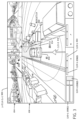
図1は、環境を横断する車両の例示的な表現を示す、ブロックされる車線に対する案内を提供するための案内コンポーネントの例示的なユーザインターフェース104の図である。概して、ユーザインターフェース104は、コンピュータデバイスが、環境のナビゲーション中に車両を支援することにより、ガイドされ得る(例えば、制御される、かつ/または情報が提供される)環境における車両の外観図を提供する。
1 is a diagram of an
図1で示されるように、1つまたは複数のコンピュータデバイス102は、ユーザインターフェース104および案内コンポーネント106を備える。図1の例で示されるように、ユーザインターフェース104は、ユーザ入力の受信に基づいて様々な機能を呼び出すためのコントロール108(1)、108(2)、108(3)、以下同様のもの(総称的に「コントロール108」と呼ばれる)と、環境内を横断する各車両を表す車両インジケータ110(1)および110(2)とを含む。例えば、車両インジケータ110(1)および110(2)が、各車両による位置および/または動きを示すために環境表現内に出現する。いくつかの例では、車両は、コンピュータデバイス102に支援を求める要求を送ることができ、車両を表す車両インジケータ110(1)または110(2)は、支援を求める要求のインジケーションを提供することになる(例えば、車両インジケータまたは関連するコントロールの注釈または外観を変更することにより)。この方法では、遠隔の操作者は、いくつかの例では、コンピュータデバイス102に、支援を開始させるために、コントロール108のうちの1つを選択することにより、車両に案内を提供し得る(例えば、車両を制御する、車両に対する細部を出力する、車両からセンサデータを受信するなど)。
As shown in FIG. 1, one or
コンピュータデバイス102は、群内の1つまたは複数の自律車両に対して遠隔支援を提供し得る遠隔操作センターに含まれ得る。いくつかの例では、遠隔操作センターは、車両からの支援を求める要求に応じて、車両に案内を提供し得る。遠隔操作者にいつ接触するかを決定するさらなる詳細、ならびに遠隔操作者から受信された命令を用いて自律車両をナビゲートするための技術は、「Techniques for Contacting a Teleoperator」と題する2019年6月28日に出願された特許文献1で述べられており、それは、参照により本明細書に組み込まれる。遠隔操作者から受信された命令を用いて自律車両をナビゲートするさらなる詳細は、「Techniques for Navigating Vehicles using Teleoperations Instructions」と題する2019年6月28に出願された特許文献2でさらに述べられており、それは、参照により本明細書に組み込まれる。
The
様々な例では、案内コンポーネント106は、環境内の1つまたは複数の車両に関連付けられたセンサデータを受信し得る。概して、案内コンポーネント106は、提案されるブロックすべき領域を決定し、提案されるブロックすべき領域の選択を確認するユーザ入力に少なくとも部分的に基づいて、ブロックされる領域のインジケーションを提供するように構成され得る。いくつかの例では、ユーザインターフェース104は、案内コンポーネント106の一部として、ブロックされる車線に関する案内を提供することが含まれ得る。
In various examples, the
前述のように、ユーザインターフェース104は、ユーザ入力に基づいて異なる機能を呼び出すためのコントロール108の1つを含み得る。いくつかの例では、コントロール108の1つは、環境内の車両に関連付けることができ、選択された場合、以下の図2を含むいずれかで論じられるように、車両に関する詳細が新しいユーザインターフェースに現れるようにさせ得る。さらに他の例では、車両インジケータ110(1)または110(2)の一方を選択することに応じて、車両に関する細部が新しいユーザインターフェースにおいて示され得る。概して、コントロール108、および/または車両インジケータ110(1)および110(2)は、支援を求める要求が受信されていることの視覚的なインジケーションを提供し得る(例えば、車両インジケータは、色、フラッシュ、および同様のものを変え得る)。いくつかの例では、支援を求める要求は、障害物(ブロックされた車線)に接近している、障害物により進むことができない車両に関する可能性がある。様々な例では、車両からのセンサデータは、支援を求める要求の一部として、コンピュータデバイス102に提供される。様々な例では、1つまたは複数の車両からのセンサデータは、(例えば、遠隔操作センターの)コンピュータデバイス102がユーザインターフェース104における環境を乱すことに関するデータを維持し、処理し、かつ/または出力するために、定期的にコンピュータデバイス102により受信され得る。
As previously mentioned, the
いくつかの例では、コンピュータデバイス102により受信されるセンサデータは、車両が、渋滞を生ずる領域に接近していることを示し得る。このような例では、関連する車両インジケータ110は、車両からの支援を求める要求を受信することなく、車両が支援を必要としているという視覚的なインジケーションを提供し得る。
In some examples, sensor data received by computing
図2は、例示的な環境を横断する車両202の例示的な表現を示すブロックされる領域に対する案内を提供するための案内コンポーネントの別の例示的なユーザインターフェース200の図である。いくつかの例では、ユーザインターフェース200は、車両202をガイドするために、図1のコントロール108のうちの1つのユーザ入力を受信したことに少なくとも部分的に基づいて提示され得る。
2 is a diagram of another
いくつかの例では、ユーザインターフェース200は、車両202のセンサに関連付けられたセンサデータに少なくとも部分的に基づいた1つまたは複数の画像を含む第1の部分204、および/または車両202のセンサに関連付けられたセンサデータに少なくとも部分的に基づいた環境のモデルを含む第2の部分206を含み得る。図2で示されるように、ユーザインターフェースは、そのいくつかをあげれば、車両202に対する経路を計画する、車両202を制御する、かつ/または環境の領域をブロックするためのコントロール208(1)、208(2)、208(3)、および同様のもの(総称的に「コントロール208」と呼ばれる)をさらに含み得る。いくつかの例では、ユーザインターフェース200はまた、車両202に関する情報210(例えば、速度、移動方向、ステアリング角、照明、音声、および同様のものなど)、および/または車線もしくは経路に対する移動方向を示すインジケータ212を提供し得る。ユーザインターフェース200は、車両202が目的地へと移動してよく、環境の一部を表す道路セグメント214を備えるものとしてさらに示される。いくつかの例では、インジケータ212は、道路セグメント214に対する車両202の移動方向、および/または車線の移動方向の視覚的なインジケーションを表し得る。
In some examples, the
概して、ユーザインターフェース200の第1の部分204および第2の部分206は、車両202がナビゲートし得る環境の別のモデルを表してよい。いくつかの例では、コンピュータデバイスに関連付けられた遠隔の操作者(例えば、遠隔操作者および/またはロボットを遠隔にガイドするように訓練された熟練者)は、車両202の現在の車線に到来する障害物を識別するために、環境のモデルの1つまたは複数のものを使用してよい。例であり、限定するものではないが、遠隔の操作者は、車両202を一時的にガイドするために、経路、ルート、軌道、および同様のものを提供することを含む車両202の動作を制御し得る。例えば、遠隔の操作者は、車両202からの支援を求める要求に少なくとも部分的に基づいて、車両202の動作を制御し、かつ車両202がブロックされた領域を過ぎるようにガイドした後、車両202の制御をやめ得る。自律車両にガイドを提供する権限を操作者に付与すること、権限を操作者間で移行すること、およびどの操作者が権限を有するか追跡することに関するさらなる詳細は、「Autonomous Vehicle Guidance Authority Framework」と題する2018年11月8日に出願された特許文献3で述べられており、それは、参照により、本明細書に組み込まれる。
In general, the
上記のように、いくつかの例では、第1の部分204は、車両202のセンサに関連付けられたセンサデータに少なくとも部分的に基づいた1つまたは複数の画像を含み得る。このような例では、1つまたは複数の画像は、車両202における車両コンピュータシステムの知覚システムにより取り込まれた場面を表し得る。図2で示されるように、多様な画像は、いくつかの例を挙げると、車両、歩行者、自転車に乗る人、および建物など、検出されたオブジェクトを含む、車両202の周囲の様々な場面(正面、後面、右側、および左側)を伝え得る。概して、ユーザインターフェース200の第1の部分204は、遠隔の操作者が、車両202の周囲を理解できるための十分な品質を有する画像(静止画像および/またはビデオ)を含む。第1の部分204で示されるように、コントロール(+、-)が、第1の部分204における様々な視点の1つまたは複数のものにおける画像をズームインおよび/またはズームアウトするために、ユーザインターフェース200に設けられ得る。様々な例では、遠隔の操作者は、環境内における車両202とオブジェクトの間の相互作用、および/または様々なオブジェクトの間の相互作用間に対する状況を決定し得る。
As noted above, in some examples, the
加えて、またはあるいは、ユーザインターフェース200の第2の部分206は、環境内で相互作用する車両202を示すモデルを含んでよく、ユーザインターフェース200の第1の部分204における1つまたは複数の画像に関連付けられ得る(例えば、同様の場面を表す)。いくつかの例では、車両202からのセンサデータは、環境内における車両202の場所および/または方向を連続的に決定してよく(例えば、車両の定位コンポーネントを用いて)、オブジェクトを連続的に検出し得る。図2で示されるように、車両202は、進行を妨げる障害物に遭遇することなく、第1の場所から第2の場所へと道路セグメント214(例えば、道路の車線)に沿って移動し得る。道路セグメント214は、道路セグメントの属性(例えば、開始点、終了点、道路状態、道路セグメント識別、車線番号、および同様のものなど)を記述するマップ特徴データに関連付けられ得る。道路セグメント214の属性のいくつかまたはすべては、道路セグメント214(またはその一部)がブロックされる領域になる場合、車両に送信され得る。道路セグメント214は、いくつかの例では、安全マージンに関連付けられた通路(corridor)に関連付けられ得る。例えば、コンピュータデバイスは、運転可能な表面を決定し、通路を決定してよく、オブジェクトを検出、および/またはオブジェクトを通路へと融合する。このような例では、車両202に対する安全マージンは、検出されたオブジェクトの通路への融合中に作成される。自律車両に対する通路を決定するさらなる詳細は、「Drive Envelope Determination」と題する2018年5月17日に出願された特許文献4で述べられており、それは、参照により本明細書に組み込まれる。自律車両に対する運転可能なエリアを決定するさらなる詳細は、「Vehicle Trajectory Modification For Following」と題する2018年11月5日に出願された特許文献5で述べられており、それは、参照により本明細書に組み込まれる。
Additionally or alternatively, the
図3は、例示的な環境を横断する図2の車両202の例示的な表現を示す、ブロックされる領域に対する案内を提供するための案内コンポーネントのさらに別の例示的なユーザインターフェース300の図である。
FIG. 3 is a diagram of yet another exemplary user interface 300 of a guidance component for providing guidance to blocked areas, showing an exemplary representation of the
ユーザインターフェース300の第1の部分204および第2の部分206で示されるように、車両202は、車両202が移動している車線を少なくとも部分的にブロックしている検出されたオブジェクト302(別の車両)に接近している。図3は、車両の周囲の例示的な集中的な領域をさらに示しており、車両202に対するオブジェクトの距離を示す。いくつかの例では、ユーザインターフェース300は、環境内において、領域のブロックを開始するためのコントロール304を提供し得る。
As shown in the
いくつかの例では、遠隔の操作者は、車両202が単に車両コンピュータシステムにより動作されるのではなく、遠隔の操作者に車両202の制御を行わせるコントロール(例えば、コントロール208(2))を選択し得る。このような例では、車両202は、環境内の領域が、ユーザインターフェース300によりブロックされる前に、ユーザインターフェース300により制御され得る。例えば、検出されたオブジェクト302を回避するために、ステアリング、加速、制動、および同様のものを制御するコントロール208(3)は、車両に対する経路を構築し得る。非限定的な一例では、コントロール208の1つは、ユーザインターフェース300の第1の部分204で提示された画像に基づいて、および/またはユーザインターフェース300の第2の部分206における環境のモデルに基づいて、車両に対するルートを計画するために使用され得る。進むのが困難な環境内で動作する車両に対して、増分的な案内を遠隔的に提供するさらなる詳細は、「Remote Vehicle Guidance」と題する2019年6月28日に出願された特許文献6で述べられており、それは、参照により本明細書に組み込まれる。進むのが困難な環境において動作する車両に、増分的な案内を遠隔から提供するさらなる詳細は、「Vehicle Control and Guidance」と題する2019年6月28日に出願された特許文献7で述べられており、それは、参照により本明細書に組み込まれる。しかしながら、他の例では、遠隔の操作者は、以下のいずれかでより詳細に論じられるように、車線をブロックされる車線として指定させるなど、車両202を明示的に制御することなく、ブロックされる領域の周囲で車両202を進ませるための支援を提供し得る。
In some examples, the remote operator may select a control (e.g., control 208(2)) that gives the remote operator control of
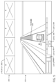
図4は、本明細書で述べられるブロックされる領域案内技術を実施するための例示的なユーザインターフェース400の図である。図4に関して論じられる例は、図3で述べられたブロックされる領域の例など、環境を横断する間に、障害物に接近する車両に少なくとも部分的に基付き得る。ユーザインターフェース400は、明確化のため、ユーザインターフェースの第1の部分および第2の部分からの細部は除外している。 FIG. 4 is a diagram of an example user interface 400 for implementing the blocked region guidance techniques described herein. The example discussed with respect to FIG. 4 may be based at least in part on a vehicle approaching an obstacle while traversing an environment, such as the blocked region example described in FIG. 3. User interface 400 omits details from the first and second portions of the user interface for clarity.
図4で示されるように、ユーザインターフェース400は、図2の車両202の正面に提案されるブロックすべき領域402、ならびにコントロール404および406を備える。車両の正面にあるように図4で示されているが、他の例では、提案されるブロックすべき領域402は、車両の後方、および/またはいずれかの側としてよい。様々な例では、コントロール404は、提案されるブロックすべき領域402をブロックされる領域であると確認するユーザ入力を受信し得る。コントロール406は、いくつかの例では、ブロックされる領域を削除する(領域のブロックを解除する)ユーザ入力を受信するように構成され得る。
As shown in FIG. 4, user interface 400 includes a proposed area to be blocked 402 in front of
いくつかの例では、提案されるブロックすべき領域402は、車両に関連付けられたセンサデータに少なくとも部分的に基づいて、コンピュータデバイスにより決定され得る。例えば、コンピュータデバイスは、環境を表す特徴を記憶しているマップに少なくとも部分的に基づいて提示するために、提案されるブロックすべき領域402のサイズ、および/または提案されるブロックすべき領域402の形状を決定し得る。ユーザインターフェース400に関連付けられたコンピュータシステムは、様々な例では、提案されるブロックすべき領域402を決定してよく、任意選択で、ユーザインターフェース300において、提案されるブロックすべき領域402を提示し得る。様々な例では、コンピュータデバイスは、領域をブロックする要求を示すコントロール404の選択に応じて、ユーザインターフェース400に、提案されるブロックすべき領域402を提示し得る。
In some examples, the proposed area to be blocked 402 may be determined by a computing device based at least in part on sensor data associated with the vehicle. For example, the computing device may determine a size of the proposed area to be blocked 402 and/or a shape of the proposed area to be blocked 402 for presentation based at least in part on a map that stores features representative of the environment. A computing system associated with the user interface 400 may, in various examples, determine the proposed area to be blocked 402 and, optionally, present the proposed area to be blocked 402 in the user interface 300. In various examples, the computing device may present the proposed area to be blocked 402 in the user interface 400 in response to a selection of a
加えて、またはあるいは、提案されるブロックすべき領域402は、車両に関連付けられたセンサデータに少なくとも部分的に基づいて、車両により決定され得る。例えば、センサデータは、オブジェクトおよび/または通行できない領域による障害を示してよく、提案されるブロックすべき領域402のインジケーションをコンピュータデバイスに伝え得る。このような例では、遠隔操作者は、ブロックされる領域として車両により提供された提案されるブロックすべき領域402を確認し得る。さらに他の例では、車両および/または遠隔操作センターにおけるコンピュータデバイスの機械学習されたモデルは、提案されるブロックすべき領域402をブロックされる領域として確認し得る(車両により決定されたか、または遠隔操作センターのコンピュータデバイスにより決定されたかにかかわらず)。 Additionally or alternatively, the proposed area to be blocked 402 may be determined by the vehicle based at least in part on sensor data associated with the vehicle. For example, the sensor data may indicate obstructions due to objects and/or impassable areas and may convey an indication of the proposed area to be blocked 402 to a computing device. In such an example, the teleoperator may confirm the proposed area to be blocked 402 provided by the vehicle as an area to be blocked. In yet another example, a machine learning model of the computing device in the vehicle and/or the teleoperation center may confirm the proposed area to be blocked 402 as an area to be blocked (whether determined by the vehicle or by the computing device at the teleoperation center).
様々な例では、提案されるブロックすべき領域402は、道路セグメント(道路セグメント214)、道路におけるブロックされる車線、道路における建設ゾーン、および/または車両の視線を越えた領域(例えば、地平線により)に関連付けられた領域に少なくとも部分的に基づいて決定され得る。例えば、コンピュータシステムは、提案されるブロックすべき領域402を、車両202の現在位置から延びている車線として、および/または道路セグメント214(マップ特徴データにより画定されたセグメント)として決定され得る。しかしながら、他の例では、提案されるブロックすべき領域402は、コンピュータデバイスにより、車両に隣接する車線(例えば、車両が走行する車線以外の車線など)として決定され得る。
In various examples, the proposed area to be blocked 402 may be determined at least in part based on an area associated with a road segment (road segment 214), a blocked lane on the road, a construction zone on the road, and/or an area beyond the line of sight of the vehicle (e.g., by the horizon). For example, the computer system may determine the proposed area to be blocked 402 as a lane extending from the current location of the
いくつかの例では、領域は、ブロックするのに適した領域である領域に少なくとも部分的に基づいて、提案されるブロックすべき領域402として提示され得る。例えば、領域は、1つまたは複数の要因(例えば、領域が短すぎる、領域が他の領域にリンクされていない、領域は通行できないなど)に基づいて、ブロックするのに適してはいない可能性がある。いくつかの例では、ブロックするのに適していない領域が、提案される(ブロックすべき領域とは異なる)ブロックを利用できないことを反映させる視覚的なインジケータを用いて提示され得る。他の例では、ブロックするのに適していない領域、および/または音声の合図は、ユーザインターフェース400において提示されなくてよい。さらに他の例では、ブロックするのに適していない領域をブロックする試みに応じて、視覚的なインジケータが、ユーザインターフェース400に提示され得る。例えば、ユーザインターフェース400は、適していない領域のユーザ入力を受信してよく、受信されたユーザ入力に基づいて、その領域がブロックするには適していないことを示す通知を出力する。 In some examples, a region may be presented as a proposed region to block 402 based at least in part on the region being a suitable region for blocking. For example, the region may not be suitable for blocking based on one or more factors (e.g., the region is too short, the region is not linked to other regions, the region is not traversable, etc.). In some examples, the region not suitable for blocking may be presented with a visual indicator reflecting the unavailability of the proposed block (different from the region to block). In other examples, the region not suitable for blocking and/or an audio cue may not be presented in the user interface 400. In yet other examples, a visual indicator may be presented in the user interface 400 in response to an attempt to block the region not suitable for blocking. For example, the user interface 400 may receive a user input of the region not suitable and output a notification indicating that the region is not suitable for blocking based on the received user input.
いくつかの例では、提案されるブロックすべき領域402は、選択可能な領域として構成されてよく、それは、遠隔の操作者によって選択された(例えば、タップされた)場合、提案されるブロックすべき領域402をブロックされる領域であると確認する(上記のコントロール404とは反対に)。 In some examples, the proposed area to block 402 may be configured as a selectable area that, when selected (e.g., tapped) by a remote operator, identifies the proposed area to block 402 as an area to be blocked (as opposed to control 404 above).
いくつかの例では、遠隔の操作者は、提案されるブロックすべき領域402の特徴(開始点、終了点、長さ、幅、および同様のものなど)を調整し得る。例えば、遠隔の操作者は、ユーザインターフェース400内における提案されるブロックすべき領域のサイズ、および/または提案されるブロックすべき領域の形状を調整し得る。この方法では、遠隔の操作者は、車両の車両コンピュータシステムによって決定できない提案されるブロックすべき領域402の特徴を識別し得る。例であり、限定するものではないが、道路の車線の幅は、ブロックされるべき他の車線の部分を示すために、別の車線(隣接する車線および/または対向車線)の一部へと広げられ得る。様々な例では、ブロックされる領域のサイズ、および/またはブロックされる領域への距離が、車両により横断するのに、車線の部分が利用できる/利用できない場合の変化に対して調整するために、短縮化される、かつ/または長くされ得る。例えば、提案されるブロックすべき領域および/またはブロックされる領域のサイズは、車線に対する識別に関連付けられた(マップに関連付けられたデータで指定された)長さよりも短く短縮され得る。いくつかの例では、提案されるブロックすべき領域402の特徴を調整することは、提案されるブロックすべき領域402がユーザインターフェースに提示されている間に、および/または提案されるブロックすべき領域402が、ブロックされる領域として選択された後に実施され得る。
In some examples, the remote operator may adjust characteristics of the proposed blocked area 402 (such as start point, end point, length, width, and the like). For example, the remote operator may adjust the size of the proposed blocked area in the user interface 400 and/or the shape of the proposed blocked area. In this manner, the remote operator may identify characteristics of the proposed blocked
様々な例では、コンピュータデバイスの遠隔の操作者は、車両に対する制御をやめる(コンピュータデバイスが車両の制御を行うときの例)前に、および/またはブロックされる領域のインジケーションを車両に送信する(コンピュータデバイスが先行する支援を提供するときの例)前に、さらなる提案されるブロックすべき領域402の選択を続けてよい。 In various examples, the remote operator of the computing device may continue to select additional proposed regions to block 402 before relinquishing control over the vehicle (an example of when the computing device assumes control of the vehicle) and/or before transmitting an indication of the blocked region to the vehicle (an example of when the computing device provides proactive assistance).
いくつかの例では、コンピュータデバイスは、通常、車両が利用できない可能性のあるエリア(例えば、対向車線、バイク車線、肩部など)であり、車両が障害物を横断するために使用できるエリアを識別することにより、案内を提供し得る。このような例では、利用可能なエリアのインジケーションが、ブロックされる領域のインジケーションの部分として車両に提供され得る。例えば、バイク車線または対向車線の一部は、遠隔の操作者により通行可能であると識別され、コンピュータデバイスにより、ブロックされる領域を横断するために、車両に送信され得る。したがって、遠隔の操作者は、通常は車両に利用できないエリアを使用するために、道路セグメントまたは車線に関連付けられた(車両によるアクセスを禁止する)ポリシを無効にし得る。 In some examples, the computing device may provide guidance by identifying areas that may not normally be available to vehicles (e.g., oncoming traffic lanes, bike lanes, shoulders, etc.) that the vehicle can use to cross an obstacle. In such examples, an indication of the available areas may be provided to the vehicle as part of an indication of a blocked area. For example, a portion of a bike lane or oncoming traffic lane may be identified by a remote operator as being passable and transmitted by the computing device to the vehicle to cross the blocked area. Thus, the remote operator may override policies (which prohibit access by vehicles) associated with a road segment or lane to use an area that is normally unavailable to vehicles.
いくつかの例では、ユーザインターフェース400は、ブロックされた領域を除外する(領域のブロックを解除する)ために、コントロール406からのユーザ入力を受信するように構成され得る。加えて、またはあるいは、ユーザインターフェース400は、コントロール208(2)からのユーザ入力を受信し、車両の制御をやめ、コンピュータデバイスによる制御中に決定された1つまたは複数のブロックされる領域を除外するように構成され得る。 In some examples, the user interface 400 may be configured to receive user input from the control 406 to exclude a blocked area (unblock an area). Additionally or alternatively, the user interface 400 may be configured to receive user input from the control 208(2) to cease control of the vehicle and exclude one or more blocked areas determined during control by the computing device.
ユーザインターフェース400は、車両の位置に基づいて、領域をブロックする要求を示すコントロール404を使用可能にし、かつ使用不能にするように構成され得る。例えば、車両202が、前方にブロックされる領域を含む車線にある場合、コントロール404は、その領域はすでにブロックされているため、使用不能にされ得る。しかし、いくつかの例では、車両が、ブロックするのに適した車線へと車線変更をしたとき、コントロール404は使用可能にされ得る。いくつかの例では、領域(例えば、道路の車線、道路セグメント、および同様のものなど)は、ブロックするには不適格である可能性があり、このような不適格の領域をブロックするための試みは、ユーザインターフェース400により、様々な視覚的、および/または音声の合図を受信し得る。
The user interface 400 may be configured to enable and disable the
図4で示されるように、ユーザインターフェース400は、後方からの鳥瞰斜視図を提示する。他の例では、ユーザインターフェース400は、提案されるブロックすべき領域402を選択するための視点を向上させる上面斜視図または他の斜視図を提示し得る。いくつかの例では、後方からの鳥瞰斜視図または上面斜視図は、ユーザインターフェース400の提示を開始するコントロール304の選択に応じて、ユーザインターフェース400に表示されるように出力され得る。 As shown in FIG. 4, the user interface 400 presents a bird's-eye view from the rear. In other examples, the user interface 400 may present a top or other perspective view that enhances the perspective for selecting the proposed region to block 402. In some examples, the bird's-eye view from the rear or the top perspective view may be output for display on the user interface 400 in response to selection of a control 304 that initiates the presentation of the user interface 400.
図5は、本明細書で述べられるブロックされる領域案内技術を実施するための例示的なユーザインターフェース500の図である。図5に関して論じられる例は、概して、図4およびその他に関して論じられた提案されるブロックすべき領域の選択に応じたブロックされる領域を述べる。ユーザインターフェース500は、明確化のために、図3で示されたユーザインターフェース300の第1の部分および第2の部分からの細部は除外している。 FIG. 5 is a diagram of an example user interface 500 for implementing the blocked region guidance techniques described herein. The example discussed with respect to FIG. 5 generally describes blocked regions in response to a selection of a suggested region to block as discussed with respect to FIG. 4 and others. User interface 500 omits details from the first and second portions of user interface 300 shown in FIG. 3 for clarity.
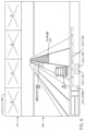
図5で示されるように、ユーザインターフェース500は、提案されるブロックすべき領域402をブロックされる領域502として確認する、コントロール404のユーザ入力を受信したことに応じたブロックされる領域502を含む。いくつかの例では、ブロックされる領域502は、成功裏にブロックされた車線を示すために、外観を変化させる。この方法では、遠隔の操作者は、ある領域が、提案されるブロックすべき領域であるか、またはブロックされた領域であるかを容易に決定することができる。様々な例では、コンピュータデバイスにより、ブロックされる領域502を決定することは、提案されるブロックすべき領域402の特徴(例えば、開始点、終了点、長さ、幅、および同様のものなど)を調整することを含み得る。いくつかの例では、ブロックされる領域502の長さ、および/またはブロックされる領域502の幅は、車両の速度に少なくとも部分的に基づいて決定され得る。例えば、ブロックされる領域502の開始は、ブロックされる領域502に接近する車両202の現在の速度を反映して自動的に調整され得る。いくつかの例では、車両202の速度は、車両に対してブロックされる領域502(例えば、ブロックされる車線)を開始する事前定義の距離を決定するための基準として働き得る。このため、図5で示されるブロックされる領域502の開始は、図4で示された提案されるブロックすべき領域402の開始よりも車両202に近い。加えて、またはあるいは、ブロックされる領域502の長さおよび/またはブロックされる領域502の幅は、ブロックされる領域502に関連付けられたマップ特徴データに少なくとも部分的に基づいて決定され得る。
As shown in FIG. 5, the user interface 500 includes a blocked
いくつかの例では、提案されるブロックすべき領域402をブロックされる領域として確認するために、車両コンピュータシステムおよび/またはコンピュータデバイス(例えば、遠隔操作センターのもの)により、機械学習されたモデルが実施され得る。例えば、人間の操作者とは独立して、ブロックすべき領域を確認するために、1つまたは複数の機械学習されたモデルが使用され得る。車両が、提案されるブロックすべき領域を決定する例では、車両の車両コンピュータシステムは、提案されるブロックすべき領域をブロックされる領域として確認するために、機械学習されたモデルを実装し得る。 In some examples, a machine learning model may be implemented by a vehicle computer system and/or a computing device (e.g., at a remote operation center) to identify the proposed area to be blocked 402 as an area to be blocked. For example, one or more machine learning models may be used to identify an area to be blocked independent of a human operator. In examples where the vehicle determines the proposed area to be blocked, the vehicle computer system of the vehicle may implement a machine learning model to identify the proposed area to be blocked as an area to be blocked.
いくつかの例では、ブロックされる領域502は、支援を要求する車両に対して、および/または遠隔の操作者により支援を求めるように識別された車両に対してだけ、適用し得る。このような例では、ブロックされる領域502のインジケーションは、車両に伝達されてよく、それは、ブロックされる領域502を、車両の車両コンピュータシステムの表示デバイス上に表示させ得る。しかしながら、他の例では、ブロックされる領域502は、車両の群に適用してよく、その場合、ブロックされる領域502のインジケーションが、車両の群へと伝達されてよく、それは、ブロックされる領域502を、各車両の各車両コンピュータシステムに関連付けられた各表示デバイス上に表示させ得る。遠隔操作センターと車両の群との間の動きのさらなる詳細は、「Software Application and Logic to Modify Configuration of an Autonomous Vehicle」と題する2015年11月5日に出願された特許文献8で述べられており、それは、参照により本明細書に組み込まれる。
In some examples, the blocked
コンピュータデバイスにより車両に送信されるブロックされる領域502のインジケーションは、ブロックされる領域に関する情報を含み得る(例えば、道路セグメント識別、車線識別、ブロックされる領域の開始点、ブロックされる領域の長さ、および同様のものなど)。いくつかの例では、ブロックされる領域502に関する情報は、車両に、ブロックされる領域502を安全に回避する軌道を決定させるために、車両コンピュータシステムの1つまたは複数のコンポーネント(知覚コンポーネント、計画コンポーネント、および同様のもの)により使用され得る。例えば、ブロックされる領域502に関連付けられる道路セグメントおよび/または車線識別データは、車両202に対する動作を計画するとき、車両コンピュータシステムにより処理され得る。
The indication of the blocked
いくつかの例では、ブロックされる領域502に関する情報は、車両により取り込まれたセンサデータと対立することもあり得る(例えば、センサデータは、ブロックされる領域が離れていることを示す)。このような例では、車両コンピュータシステムは、ブロックされる領域に関するセンサデータに対するよりも、コンピュータデバイスから受信されたブロックされる領域に関する情報により重み付けを与えることにより、計画の考慮において、ブロックされる領域のインジケーションを使用し得る。この方法では、ブロックされる領域は、ブロックされる領域が離れていることを示すセンサデータに対して、計画の考慮において優先し得る。図6は、本明細書で述べられるブロックされる領域案内技術を実施するための例示的なユーザインターフェース600の図である。図6に関して論じられる例は、図5およびその他で論じられるように、領域をブロックした後、提案されるブロックすべき領域602を提示することを概して述べる。図6は、明確化のために、図3で示されたユーザインターフェースの第1の部分および第2の部分からの細部は除外する。
In some examples, information regarding the blocked
図6で示されるように、コンピュータデバイスは、空いている車線へと変更する車両202に少なくとも部分的に基づいて、提案されるブロックすべき領域602を決定し得る。いくつかの例では、領域をブロックする要求を示すためのコントロール404は、提案されるブロックすべき領域602を提示することに、および/または空いた車線へと変更する車両202に少なくとも部分的に基づいて、使用可能に(選択に利用できるように)され得る。いくつかの例では、ユーザインターフェース600の遠隔の操作者は、車両に対する制御をやめる(コンピュータデバイスが車両の制御を行う例において)前に、および/またはブロックされる領域のインジケーションを車両に送信する前に、さらに提案されるブロックすべき領域を選択し続け得る。
As shown in FIG. 6, the computing device may determine a proposed
いくつかの例では、ブロックされた領域は、特定のブロックされた領域のブロックを解除する、かつ/またはブロックされた領域のセットのブロックを解除する、ユーザインターフェース600におけるコントロール406を用いてブロックが解除され得る。いくつかの例では、1つまたは複数のブロック車線は、各ブロックされた領域(図示せず)に対応するコントロールを個々に用いて、および/またはブロックされた領域を選択することにより、ブロックが解除され得る。 In some examples, a blocked area may be unblocked using a control 406 in the user interface 600 that unblocks a particular blocked area and/or unblocks a set of blocked areas. In some examples, one or more blocked lanes may be unblocked using a control that corresponds to each blocked area (not shown) individually and/or by selecting the blocked area.
コンピュータデバイスが、車両の少なくともいくつかの操作の制御を行う様々な例では、領域のブロックを解除することは、コンピュータデバイスが、車両の制御をやめると自動的に行われ得る。ブロックされた領域が解除されると、いくつかの例では、車両に送信されたブロックされた領域(およびそれに関連する情報)の対応するインジケーションは、車両の車両コンピュータシステムによって決定された計画考慮事項から除かれ得る。 In various examples in which a computing device has control over at least some operation of the vehicle, unblocking the area may occur automatically when the computing device ceases control of the vehicle. When a blocked area is unblocked, in some examples, the corresponding indication of the blocked area (and information related thereto) sent to the vehicle may be removed from planning considerations determined by the vehicle computer system of the vehicle.
いくつかの例では、ブロックされた領域は、車両がブロックされた領域を通過することに少なくとも部分的に基づいてブロック解除領域へと変更され得る。さらに他の例では、ブロックされた領域をブロック解除領域へと変更することは、ブロックされた領域を除去するように更新された、自律車両の群により使用可能な全体マップに基づき得る。いくつかの例では、群の中の車両は、ブロックされた領域を除くように推奨を行ってもよく(例えば、コンピュータデバイスに要求を送るなど)、遠隔操作者は、コンピュータデバイスのユーザインターフェースにおいて提示されたコントロールを用いて、その領域のブロック解除を確認し得る。さらに別の例では、車両の車両コンピュータシステムは、ブロックされた領域を除去してよく、その変更をコンピュータデバイスに伝え得る。 In some examples, the blocked region may be changed to an unblocked region based at least in part on the vehicle passing through the blocked region. In yet other examples, changing the blocked region to an unblocked region may be based on an overall map available to the fleet of autonomous vehicles that has been updated to remove the blocked region. In some examples, a vehicle in the fleet may make a recommendation (e.g., by sending a request to the computing device) to remove the blocked region, and the remote operator may confirm the unblocking of the region using a control presented in a user interface of the computing device. In yet another example, a vehicle computer system of the vehicle may remove the blocked region and communicate the change to the computing device.
図7は、ブロックされると指定された領域(ブロックされる領域502)を含む例示的な環境を横断する車両の例示的な表現を示す例示的なユーザインターフェース700の図である。図7に関して論じられる例は、概して、計画ツールのためのコントロール(コントロール208(3))、車両を制御するためのコントロール(コントロール208(2))、および1つまたは複数の領域をブロックするためのコントロール(コントロール404)を提示することを述べる。ユーザインターフェース700は、明確化のために、図3で示されたインターフェース300の第1の部分および第2の部分からの細部は除外する。 7 is a diagram of an example user interface 700 showing an example representation of a vehicle traversing an example environment including an area designated as blocked (blocked area 502). The example discussed with respect to FIG. 7 generally describes presenting a control for a planning tool (control 208(3)), a control for controlling the vehicle (control 208(2)), and a control for blocking one or more areas (control 404). User interface 700 omits details from the first and second portions of interface 300 shown in FIG. 3 for clarity.
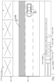
図7で示されるように、コンピュータデバイスは、ブロックされた領域502を含む環境を横断する車両202の上面斜視図を示すユーザインターフェース700を提示する。これは、車両202が車線を変更した後の、図6における例の続きを表し得る。いくつかの例では、車両202は、遠隔の操作者の制御下で車線を変更してよく、ユーザインターフェース700で利用可能な計画コントロールを用いて、環境内で車両202をナビゲートし続け得る。このような例では、コントロール208(3)は、ユーザインターフェース700において車両計画ツールがアクティブであることを示し、一方、コントロール304は、領域ブロック化ツールがアクティブであることを示す(図7でハッチングされて示される)。いくつかの例では、ブロックされた領域502は、指定された終点(車線変更の識別)まで、および/またはブロックされた領域が除かれる(ブロックが解除される)まで存続し得る。
As shown in FIG. 7, the computing device presents a user interface 700 showing a top perspective view of the
別個のシステムとして述べられているが、いくつかの例では、図1から図7に関して本明細書で述べられた案内技術は、他の車両システム、コンポーネント、および/またはコンピュータデバイスにより実施され得る。例えば、また図8に関してさらに詳細に述べられるように、図1から図7に関して本明細書で述べられた案内技術は、図8の知覚コンポーネント、計画コンポーネント、および/もしくは案内コンポーネントにより、またはそれに関連付けて少なくとも部分的に実施され得る。加えて、図1から図7に関して論じられた例は、車両から支援を求める要求を受信したことに少なくとも部分的に基づいてよく、または他の例では、車両からの支援を求める明示的な要求を受信することなく、車両に対する支援を開始するコンピュータデバイス(またはその遠隔の操作者)に少なくとも部分的に基づき得る。 Although described as separate systems, in some examples, the guidance techniques described herein with respect to FIGS. 1-7 may be implemented by other vehicle systems, components, and/or computing devices. For example, and as described in further detail with respect to FIG. 8, the guidance techniques described herein with respect to FIGS. 1-7 may be implemented at least in part by or in association with the perception, planning, and/or guidance components of FIG. 8. Additionally, the examples discussed with respect to FIGS. 1-7 may be based at least in part on receiving a request for assistance from the vehicle, or in other examples, may be based at least in part on the computing device (or a remote operator thereof) initiating assistance to the vehicle without receiving an explicit request for assistance from the vehicle.
図8は、本明細書で述べられる技術を実施するための例示的なシステム800のブロック図である。少なくとも1つの例では、システム800は、車両802などの車両を含み得る。
FIG. 8 is a block diagram of an
車両802は、車両コンピュータシステム804、1つまたは複数のセンサシステム806、1つまたは複数のエミッタ808、1つまたは複数の通信接続部810、少なくとも1つの直接接続部812、および1つまたは複数の駆動モジュール814を含み得る。
The vehicle 802 may include a
車両コンピュータシステム804は、1つまたは複数のプロセッサ816、および1つまたは複数のプロセッサ816と通信可能に結合されたメモリ818を含み得る。示された例では、車両802は自律車両である、しかしながら、車両802は、半自律車両、または少なくとも画像取り込みデバイス(例えば、カメラ使用可能なスマートホンなど)を有する任意の他のシステムなど、任意の他のタイプの車両であってもよい。いくつかの例では、自律車両802は、米国運輸省道路交通安全局(U.S.National Highway Traffic Safety Administration)により発行されたレベル5分類に従って動作するように構成された自律車両とすることができ、それは、走行全体に対して、安全を重視する機能をすべて実施できる車両を述べており、運転者(または乗員)は、どの時間においても、車両を制御することは期待されていない。しかしながら、他の例では、自律車両802は、任意の他のレベルまたは分類を有する完全にまたは部分的に自律的な車両であり得る。
The
様々な例では、車両コンピュータシステム804は、推定される状態のセットの最後(その時間期間の最後)において、オブジェクトの実際の場所に関連付けられたセンサデータを記憶してよく、このデータを、1つまたは複数のモデルを訓練するための訓練データとして使用し得る。いくつかの例では、車両コンピュータシステム804は、データ解析のために、遠隔のコンピュータデバイス(すなわち、コンピュータデバイス830など、車両コンピュータシステムから離れたコンピュータデバイス)にデータを提供し得る。このような例では、コンピュータデバイスは、決定を行うためにセンサデータを解析し得る。
In various examples,
示された例では、車両コンピュータシステム804のメモリ818は、定位コンポーネント820、知覚コンポーネント822、計画コンポーネント824、1つまたは複数のシステムコントローラ826、および1つまたは複数のマップ828を記憶する。例示目的で、メモリ818に常駐するものとして図8で示されているが、定位コンポーネント820、知覚コンポーネント822、計画コンポーネント824、1つまたは複数のシステムコントローラ826、および/または1つもしくは複数のマップ828は、さらに、またはあるいは、車両802にアクセス可能であり得る(例えば、コンピュータデバイス830のメモリ836など、車両802から遠隔にあるメモリに記憶される、またはその他の形で車両802によりアクセスできる)ことが企図される。
In the illustrated example, the memory 818 of the
少なくとも1つの例では、定位コンポーネント820は、車両802の位置および/または方向(例えば、x、y、z位置、ロール、ピッチ、またはヨーの1つまたは複数のものなど)を決定するために、センサシステム806からデータを受信する機能を含み得る。例えば、定位コンポーネント820は、マップ828および/またはマップコンポーネント838からなど、環境のマップを含む、かつ/または要求する/受信することができ、マップ内の自律車両の場所および/または方向を連続的に決定してよい。いくつかの例では、定位コンポーネント820は、自律車両の場所を正確に決定するために、SLAM(位置特定およびマッピングの同時実行)、CLAMS(較正、位置特定、およびマッピングの同時実行)、相対SLAM、バンドル調整、非線形最小二乗最適化、または同様のものを利用して、画像データ、ライダーデータ、レーダーデータ、IMUデータ、GPSデータ、ホィールエンコーダデータ、および同様のものを受信し得る。いくつかの例では、定位コンポーネント820は、車両802の様々なコンポーネントにデータを提供してよく、本明細書で論ずるように、車両802に対するオブジェクトの関連性を決定するために、自律車両の初期位置を決定し得る。
In at least one example, the
いくつかの例では、知覚コンポーネント822は、オブジェクト検出、セグメント化、および/または分類を実施する機能を含み得る。いくつかの例では、知覚コンポーネント822は、車両802の近くにあるオブジェクト(例えば、エンティティ)の存在、および/またはオブジェクトを、オブジェクトタイプ(例えば、車、歩行者、自転車に乗る人、動物、建物、木、道路面、縁石、歩道、未知のものなど)としての分類を示す処理されたセンサデータを提供し得る。いくつかの例では、知覚コンポーネント822は、車両802の近くにある静止したエンティティの存在、および/または静止したエンティティをタイプ(例えば、建物、木、道路面、縁石、歩道、未知のものなど)として分類することを示す処理されたセンサデータを提供し得る。さらなる、または代替的な例では、知覚コンポーネント822は、検出されたオブジェクト(例えば、追跡されたオブジェクト)に関連する1つまたは複数の特徴、および/またはオブジェクトが位置する環境を示す処理されたセンサデータを提供し得る。いくつかの例では、オブジェクトに関連する特徴は、限定されないが、x位置(全体的および/または局所的な位置)、y位置(全体的および/または局所的な位置)、z位置(全体的および/または局所的な位置)、方向付け(例えば、ロール、ピッチ、ヨー)、オブジェクトタイプ(例えば、分類)、オブジェクトの速度、オブジェクトの加速度、オブジェクトの広がり(サイズ)などを含み得る。環境に関連する特徴は、これだけに限らないが、環境内の別のオブジェクトの存在、環境内の別のオブジェクトの状態、時刻、曜日、季節、気象状態、暗さ/光のインジケーションなどを含み得る。
In some examples, the
概して、計画コンポーネント824は、車両802が環境を横断するために従うべき経路を決定し得る。例えば、計画コンポーネント824は、様々なルートおよび軌道、ならびに様々なレベルの細部を決定し得る。例えば、計画コンポーネント824は、第1の場所(例えば、現在の場所)から第2の場所(例えば、目標とする場所)に移動するためのルートを決定し得る。本論議の場合、ルートは、2つの場所の間を移動するための通過点のシーケンスを含み得る。非限定的な例として、通過点は、街路、交差点、全地球測位システム(GPS)座標などを含む。さらに計画コンポーネント824は、自律車両を、第1の場所から第2の場所へのルートの少なくとも一部に沿ってガイドするための命令を生成し得る。少なくとも1つの例では、計画コンポーネント824は、自律車両を、通過点のシーケンスの第1の通過点から、通過点のシーケンスの第2の通過点へとどのようにガイドするかを決定し得る。いくつかの例では、命令は、軌道、または軌道の一部としてよい。いくつかの例では、多数の軌道は、後退ホライゾン制御(receding horizon)技術に従って実質的に同時に生成され得る(例えば、技術的な許容差内で)、その場合、多数の軌道の1つが、ナビゲートすべき車両802に対して選択される。
In general, the
いくつかの例では、計画コンポーネント824は、環境内のオブジェクト(例えば、オブジェクト)の予測される軌道を生成し、および/または車両802に対して予測される候補軌道を生成する予測コンポーネントを含み得る。例えば、予測コンポーネントは、車両802からの閾値距離に含まれるオブジェクトに対する1つまたは複数の予測される軌道を生成し得る。いくつかの例では、予測コンポーネントは、オブジェクトの追跡を測定して、観察され、かつ予測される挙動に基づいて、オブジェクトに対する軌道を生成し得る。
In some examples, the
少なくとも1つの例では、車両コンピュータシステム804は、1つまたは複数のシステムコントローラ826を含むことができ、それは、車両802のステアリング、推進、制動、安全性、エミッタ、通信、および他のシステムを制御するように構成され得る。システムコントローラ826は、駆動モジュール814の対応システム、および/もしくは車両802の他のコンポーネントと通信してよく、および/またはそれを制御し得る。
In at least one example, the
メモリ818は、環境内をナビゲートするために車両802により使用され得る1つまたは複数のマップ828をさらに含み得る。本論議の場合、マップは、これだけに限らないが、トポロジー(交差点など)、街路、山脈、道路、地形、および環境全体など、環境に関する情報を提供できる、二次元、三次元、またはN次元でモデル化された任意の数の構造であり得る。いくつかの例では、マップは、これだけに限らないが、テクスチャ情報(例えば、色情報(RGB色情報、Lab色情報、HAV/HSL色情報)、および同様のもの)、強度情報(例えば、ライダー情報、レーダー情報、およびお同様のもの)、空間情報(例えば、メッシュに投影された画像データ、個々の「表面要素(surfels)」(例えば、個々の色および/または強度に関連する多角形)、反射率情報(例えば、鏡面性情報、再帰反射率情報、BRDF情報、BSSRDF情報、および同様のものなど)を含み得る。一例では、マップは、環境の三次元メッシュを含み得る。いくつかの例では、車両802は、マップ828に少なくとも部分的に基づいて制御され得る。すなわち、マップ828は、車両802の場所を決定し、環境内のオブジェクトおよび/領域を検出し、ルートを生成し、動きおよび/または軌道を決定して環境内でナビゲートするために、定位コンポーネント820、知覚コンポーネント822、および/または計画コンポーネント824と共に使用され得る。
The memory 818 may further include one or more maps 828 that may be used by the vehicle 802 to navigate within the environment. For the purposes of this discussion, a map may be any number of structures modeled in two, three, or N dimensions that may provide information about the environment, such as, but not limited to, topology (such as intersections), streets, mountain ranges, roads, terrain, and the environment as a whole. In some examples, the map may include, but is not limited to, texture information (e.g., color information (RGB color information, Lab color information, HAV/HSL color information), and the like), intensity information (e.g., lidar information, radar information, and the like), spatial information (e.g., image data projected onto a mesh, individual "surfels" (e.g., polygons associated with individual colors and/or intensities), reflectance information (e.g., specularity information, retroreflectance information, BRDF information, BSSRDF information, and the like). In one example, the map may include a three-dimensional mesh of the environment. In some examples, the vehicle 802 may be controlled based at least in part on the map 828. That is, the map 828 may be used in conjunction with the
いくつかの例では、1つまたは複数のマップ828は、ネットワーク844を介してアクセス可能な遠隔のコンピュータデバイス(コンピュータデバイス830など)に記憶され得る。いくつかの例では、多数のマップ828は、例えば、特性(例えば、エンティティのタイプ、時刻、曜日、季節など)に基づいて記憶され得る。多数のマップ828を記憶することは、同様のメモリ要件を有する可能性があるが、マップのデータがアクセスされ得る速度を増加させる。
In some examples, one or more maps 828 may be stored on a remote computing device (such as computing device 830) accessible via
図8で示されるように、コンピュータシステム830は、案内コンポーネント842を含み得る。様々な例では、案内コンポーネント842は、知覚コンポーネント822から、および/またはセンサシステム806から検出されたオブジェクトおよび/または領域に関連付けられたセンサデータを受信し得る。いくつかの例では、案内コンポーネント842は、知覚コンポーネント822および/またはセンサシステム806から、環境特性(例えば、環境的要因など)、および/または気象特性(例えば、雪、雨、氷などの気象要因など)を受信し得る。案内コンポーネント842は、図5の提案されるブロックすべき領域など、提案されるブロックすべき領域を決定するように構成され得る。図8では別々に示されているが、案内コンポーネント842は、車両802の計画コンポーネント824、または別のコンポーネントの一部であってもよい。
8, the computer system 830 may include a
様々な例では、案内コンポーネント842は、図5のブロックされる領域502など、提案されるブロックすべき領域をブロックされる領域として選択したことを確認するユーザ入力を受信するように構成され得る。案内コンポーネント842は、ブロックされる領域に関連する情報を決定してよく、その情報を、ネットワーク844を介して車両802に送信し得る。様々な例では、情報は、車両802に対する1つまたは複数の予測される軌道(例えば、移動方向、速度など)を生成するために、計画コンポーネント824により使用可能なブロックされる領域のインジケーションを含み得る。いくつかの例では、案内コンポーネント842は、ブロックされる領域を回避する、車両802が従うべき1つまたは複数の利用可能な軌道を決定するように構成され得る。加えて、またはあるいは、案内コンポーネント842は、車両が計画の考慮事項において検討するために、1つまたは複数の利用可能な軌道を車両802に送信するように構成され得る。いくつかの例では、案内コンポーネント842は、環境特性、気象特性、および同様のものに基づくなど、環境に適用可能な軌道を決定するように構成され得る。
In various examples, the
案内コンポーネント842は、ユーザインターフェースを介して遠隔の操作者からの入力を受信することによるなど、車両802の動作を制御するように構成され得る。例えば、遠隔の操作者は、ユーザインターフェースにおける計画ツールを実施するコントロールを選択してよく、車両に対する計画が、計画ツールにより自動的に、および/または遠隔の操作者により手動で実装されるようにしてもよい。
The
いくつかの例では、案内コンポーネント842は、1つまたは複数のブロックされた領域をブロック解除するための入力を受信するように構成され得る。いくつかの例では、ブロックされた車線は、特定のブロックされた領域をブロック解除する、かつ/またはブロックされた領域のセットをブロック解除する、ユーザインターフェースにおけるコントロールを用いてブロックが解除され得る。いくつかの例では、1つまたは複数のブロック車線は、各ブロックされた領域に対応するユーザインターフェースにおけるコントロールを用いて、および/またはブロックされた領域を選択することにより、個々にブロックが解除され得る。
In some examples, the
コンピュータデバイス830が車両の少なくともいくつかの動作の制御を行う様々な例では、領域のブロックを解除することは、コンピュータデバイスが、車両の制御をやめると、自動的に行われ得る。ブロックされた領域がブロック解除されたとき、いくつかの例では、車両に送信されたブロックされた領域の対応するインジケーション(およびそれに関連する情報)は、車両コンピュータシステムにより決定される計画考慮事項から除去され得る。 In various examples in which the computing device 830 has control over at least some operation of the vehicle, unblocking the area may occur automatically when the computing device ceases control of the vehicle. When a blocked area is unblocked, in some examples, the corresponding indication of the blocked area (and information associated therewith) sent to the vehicle may be removed from planning considerations determined by the vehicle computer system.
理解されるように、本明細書で論じられるコンポーネント(例えば、定位コンポーネント820、知覚コンポーネント822、計画コンポーネント824、1つまたは複数のシステムコントローラ826、1つまたは複数のマップ828、案内コンポーネント842は、例示のために分割されて述べられている。しかし、様々なコンポーネントにより行われる動作は、任意の他のコンポーネントと組み合わされる、または任意の他のコンポーネントで実施され得る。
As will be appreciated, the components discussed herein (e.g.,
いくつかの例では、本明細書で論じられるコンポーネントのいくつかまたはすべての態様は、任意のモデル、技術、および/または機械学習された技術を含み得る。例えば、いくつかの例では、メモリ818(および以下で論じられるメモリ836)におけるコンポーネントは、ニューラルネットワークとして実装され得る。 In some examples, some or all aspects of the components discussed herein may include any models, techniques, and/or machine-learned techniques. For example, in some examples, the components in memory 818 (and memory 836 discussed below) may be implemented as neural networks.
本明細書で述べられるように、例示的なニューラルネットワークは、出力を作成するために、入力データを、接続されたレイヤのシリーズを通過させる生物学的に影響を受けた技術である。ニューラルネットワークの各レイヤはまた、別のニューラルネットワークを含み得る、または任意の数のレイヤを含み得る(畳み込みであるかどうかにかかわらず)。本開示のコンテキストにおいて理解されるように、ニューラルネットワークは、機械学習を利用してよく、それは、出力が、学習されたパラメータに基づいて生成されるような技術の広いクラスを参照し得る。 As described herein, an exemplary neural network is a biologically inspired technology that passes input data through a series of connected layers to create an output. Each layer of a neural network may also include another neural network, or may include any number of layers (whether convolutional or not). As understood in the context of this disclosure, a neural network may utilize machine learning, which may refer to a broad class of technologies in which an output is generated based on learned parameters.
ニューラルネットワークのコンテキストで論じられるが、本開示と矛盾しない任意のタイプの機械学習が使用され得る。例えば、機械学習技術は、これだけに限らないが、回帰技術(例えば、通常の最小二乗回帰(OLSR)、線形回帰、ロジスティック回帰、段階的回帰、多変量適応回帰スプライン(MARS)、局所的に推定された散布図の平滑化(LOESS))、インスタンスベースの技術(例えば、リッジ回帰、最小絶対縮小選択演算子(LASSO)、エラスティックネット、最小角度回帰(LARS))、決定木技術(例えば、分類および回帰木(CART)、繰り返し分割器(ID3:iterative dichotomiser3)、カイ二乗自動相互作用検出(CHAID)、決定株、条件付き決定木)、ベイズの技術(例えば、単純ベイズ、ガウシアン単純ベイズ、多項分布単純ベイズ、平均1依存性推定子(AODE)、ベイジアン信念ネットワーク(BNN)、ベイジアンネットワーク)、クラスタリング技術(例えば、k平均法、kメディアン法、期待値最大化法(EM)、階層的クラスタリング)、相関ルール学習技術(例えば、パーセプロトン、逆向性伝播、ホップフィールドネットワーク、ラジアル基底関数ネットワーク(RBFN))、深層学習技術(例えば、深層ボルツマンマシン(DBM)、深層信念ネットワーク(DBN)、畳み込みニューラルネットワーク(CNN)、スタック型オートエンコーダ)、次元削減技術(例えば、主成分分析(PCA)、主成分回帰(PCR)、部分的最小二乗回帰(PLSR)、サモンのマップ化、多次元尺度構成法(MDS)、射影追跡、線形判別分析(LDA)、混合判別分析(MDA)、二次判別分析(QDA)、柔軟な判別分析(FDA))、アンサンブル技術(例えば、ブースティング、ブートストラップアグリゲーション(バギング)、AdaBoost、スタック汎化(ブレンディング)、勾配ブースティングマシン(GBM)、勾配ブースト回帰木(GBRT)、ランダムフォレスト)、SVM(サポートベクターマシン)、教師あり学習、教師なし学習、半教師あり学習などを含み得る。アーキテクチャのさらなる例は、ResNet70、ResNet101、VGG、DenseNet、PointNet、および同様のものを含む。 While discussed in the context of neural networks, any type of machine learning not inconsistent with this disclosure may be used. For example, machine learning techniques include, but are not limited to, regression techniques (e.g., ordinary least squares regression (OLSR), linear regression, logistic regression, stepwise regression, multivariate adaptive regression splines (MARS), locally estimated scatterplot smoothing (LOESS)), instance-based techniques (e.g., ridge regression, least absolute shrinkage and selection operator (LASSO), elastic net, least angle regression (LARS)), decision tree techniques (e.g., classification and regression trees (CART), iterative partitioners (ID3), etc.), and may be used to train machine learning techniques. dichotomiser3), chi-squared automated interaction detection (CHAID), decision strain, conditional decision tree), Bayesian techniques (e.g., naive Bayes, Gaussian naive Bayes, multinomial naive Bayes, average-one dependent estimator (AODE), Bayesian belief network (BNN), Bayesian network), clustering techniques (e.g., k-means, k-median, expectation maximization (EM), hierarchical clustering), association rule learning techniques (e.g., perceptron, backpropagation, Hopfield network, radial basis function network (RBFN)), deep learning techniques (e.g., deep Boltzmann machine (DBM), deep belief network (DBN), convolutional neural network) (CNN), stacked autoencoders), dimensionality reduction techniques (e.g., principal component analysis (PCA), principal component regression (PCR), partial least squares regression (PLSR), Sammon's mapping, multidimensional scaling (MDS), projection pursuit, linear discriminant analysis (LDA), mixed discriminant analysis (MDA), quadratic discriminant analysis (QDA), flexible discriminant analysis (FDA)), ensemble techniques (e.g., boosting, bootstrap aggregation (bagging), AdaBoost, stacked generalization (blending), gradient boosting machines (GBM), gradient boosted regression trees (GBRT), random forests), SVM (support vector machines), supervised learning, unsupervised learning, semi-supervised learning, etc. Further examples of architectures include ResNet70, ResNet101, VGG, DenseNet, PointNet, and the like.
少なくとも1つの例では、センサシステム806は、ライダーセンサ、レーダーセンサ、超音波変換器、ソナーセンサ、場所センサ(例えば、GPS、コンパスなど)、慣性センサ(例えば、慣性測定ユニット(IMU)、加速度計、磁力計、ジャイロスコープなど)、カメラ(例えば、RGB、IR、強度、深さ、TOF(time of flight)など)、マイクロフォン、ホィールエンコーダ、環境センサ(例えば、温度センサ、湿度センサ、光センサ、圧力センサなど)などを含み得る。センサシステム806は、これらのまたは他のタイプのセンサのそれぞれの多様なインスタンスを含み得る。例えば、ライダーセンサは、車両802のコーナ、前部、後部、側部、および/または上部に位置する個々のライダーセンサを含み得る。別の例として、カメラセンサは、車両802の外側および/内側付近の様々な場所に配置された多数のカメラを含み得る。センサシステム806は、車両コンピュータシステム804への入力を提供してよい。加えて、または代替的に、センサシステム806は、センサデータを、1つまたは複数のネットワーク844を介して特定の周波数にて、所定の時間期間が経過した後、ほぼ実時間でなど、1つまたは複数のコンピュータデバイス830に送ってよい。
In at least one example, the sensor system 806 may include lidar sensors, radar sensors, ultrasonic transducers, sonar sensors, location sensors (e.g., GPS, compass, etc.), inertial sensors (e.g., inertial measurement units (IMUs), accelerometers, magnetometers, gyroscopes, etc.), cameras (e.g., RGB, IR, intensity, depth, time of flight (TOF), etc.), microphones, wheel encoders, environmental sensors (e.g., temperature sensors, humidity sensors, light sensors, pressure sensors, etc.), and the like. The sensor system 806 may include various instances of each of these or other types of sensors. For example, the lidar sensors may include individual lidar sensors located at the corners, front, rear, sides, and/or top of the vehicle 802. As another example, the camera sensors may include multiple cameras positioned at various locations near the exterior and/or interior of the vehicle 802. The sensor system 806 may provide input to the
車両802はまた、光および/または音を放出するための1つまたは複数のエミッタ808を含み得る。エミッタ808は、車両802の乗員と通信するための内部の音声および映像的なエミッタを含み得る。例であり、限定するものではないが、内部のエミッタは、スピーカ、光、サイン、表示画面、タッチスクリーン、触覚エミッタ(例えば、振動および/または力のフィードバック)、機械的な作動器(例えば、シートベルト引張器、シート位置決め器、ヘッドレスト位置決め器など)、および同様のものを含み得る。エミッタ808はまた、外部のエミッタを含み得る。例であり、限定するものではないが、外部のエミッタは、移動方向を知らせるライト、または車両動きの他のインジケータ(例えば、インジケータ光、サイン、光のアレイなど)と、歩行者または他の近くの車両に音で伝えるための1つまたは複数の音声エミッタ(例えば、スピーカ、スピーカアレイ、ホーンなど)とを含むことができ、その1つまたは複数のものは、音響ビームステアリング技術を含む。 The vehicle 802 may also include one or more emitters 808 for emitting light and/or sound. The emitters 808 may include interior audio and visual emitters for communicating with occupants of the vehicle 802. By way of example and not limitation, the interior emitters may include speakers, lights, signs, display screens, touch screens, tactile emitters (e.g., vibration and/or force feedback), mechanical actuators (e.g., seat belt tensioners, seat locators, head rest locators, etc.), and the like. The emitters 808 may also include exterior emitters. By way of example and not limitation, the exterior emitters may include lights or other indicators of vehicle movement (e.g., indicator lights, signs, light arrays, etc.) to indicate direction of travel, and one or more audio emitters (e.g., speakers, speaker arrays, horns, etc.) for audibly informing pedestrians or other nearby vehicles, one or more of which may include acoustic beam steering technology.
車両802はまた、車両802と、1つまたは複数の他の局所的な、または遠隔のコンピュータデバイスとの間で通信可能な1つまたは複数の通信接続部810を含み得る。例えば、通信接続部810は、車両802の他の局所的なコンピュータデバイス、および/または駆動モジュール814との通信を容易にし得る。さらに通信接続部810は、車両が、他の近傍のコンピュータデバイス(例えば、コンピュータデバイス830、他の近傍の車両など)と、および/またはセンサデータを受信するために1つまたは複数の遠隔センサシステム846と通信することを与え得る。通信接続部810はまた、車両802が、遠隔の遠隔操作コンピュータデバイス、または他の遠隔サービスと通信可能にする。
The vehicle 802 may also include one or
通信接続部810は、車両コンピュータシステム804を、別のコンピュータデバイス、またはネットワーク844などのネットワークに接続するための物理的および/または論理的なインターフェースを含み得る。例えば、通信接続部810は、IEEE802.11規格により定義された周波数を介するなど、WiFiベースの通信、Bluetoothなどの近距離無線周波数、セルラ通信(例えば、2G、3G、4G、4GLTE、5Gなど)、または各コンピュータデバイスを他のコンピュータデバイスとインターフェースをとることができるようにする任意の適切な有線もしくは無線通信プロトコルを可能にすることができる。
The
少なくとも1つの例では、車両802は、1つまたは複数の駆動モジュール814を含み得る。いくつかの例では、車両802は、単一の駆動モジュール814を有し得る。少なくとも1つの例では、車両802が、多数の駆動モジュール814を有する場合、個々の駆動モジュール814は、車両802の両端部(例えば、前部および後部など)に位置され得る。少なくとも1つの例では、駆動モジュール814は、駆動モジュール814および/または車両802の周囲の状態を検出するための1つまたは複数のセンサシステムを含み得る。例であり、限定するものではないが、センサシステムは、駆動モジュールのホィールの回転を感知するための1つまたは複数のホィールエンコーダ(例えば、回転エンコーダ)、駆動モジュールの方向および加速度を測定するための慣性センサ(例えば、慣性測定ユニット、加速度計、ジャイロスコープ、磁力計など)、カメラまたは他の画像センサ、駆動モジュールの周囲におけるオブジェクトを音響的に検出するための超音波センサ、ライダーセンサ、レーダーセンサなどを含み得る。ホィールエンコーダなどのいくつかのセンサは、駆動モジュール814に対して一意のものであり得る。いくつかの場合では、駆動モジュール814におけるセンサシステムは、車両802の対応するシステム(例えば、センサシステム806)に対して重複する、または補足することもあり得る。
In at least one example, the vehicle 802 may include one or
駆動モジュール814は、高電圧電池、車両を推進するモータ、電池からの直流を他の車両システムにより使用するための交流に変換するインバータ、ステアリングモータおよびステアリングラック(電気的であり得る)を含むステアリングシステム、液圧式または電気的な作動器を含む制動システム、液体および/または空気コンポーネントを含むサスペンションシステム、制動力を分散させて、摩擦損失を軽減させ、かつ制御を維持するための安定性制御システム、HVACシステム、照明(例えば、車両の外側の周囲を照明するためのヘッドライト/テールライトなどの照明)、および1つまたは複数の他のシステム(例えば、冷却システム、安全システム、オンボードの充電システム、DC/DCコンバータなどの他の電気的なコンポーネント、高電圧ジャンクション、高電圧ケーブル、充電システム、充電ポートなど)を含む、車両システムの多くのものを含み得る。加えて、駆動モジュール814は、センサシステムからのデータを受信し、かつ前処理してよく、様々な車両システムの動作を制御する駆動モジュールコントローラを含み得る。いくつかの例では、駆動モジュールコントローラは、1つまたは複数のプロセッサと、1つまたは複数のプロセッサと通信可能に結合されるメモリとを含み得る。メモリは、駆動モジュール814の様々な機能を実施するための1つまたは複数のモジュールを記憶し得る。さらに駆動モジュール814はまた、各駆動モジュールにより、1つまたは複数の他のローカルまたは遠隔のコンピュータデバイスと通信できるようにする1つまたは複数の通信接続部を含み得る。
The
少なくとも1つの例では、直接接続部812は、1つまたは複数の駆動モジュール814を車両802の本体と結合するための物理的なインターフェースを提供し得る。例えば、直接接続部812は、駆動モジュール814と車両の間で、エネルギー、流体、空気、データなどの移送を与え得る。いくつかの例では、直接接続部812はさらに、駆動モジュール814を、車両802の本体に解放可能に固定し得る。
In at least one example, the
少なくとも1つの例では、定位コンポーネント820、知覚コンポーネント822、計画コンポーネント824、1つまたは複数のシステムコントローラ826、および1つまたは複数のマップ828は、上記で述べたように、センサデータを処理してよく、それらの各出力を、1つまたは複数のネットワーク844を介して、コンピュータデバイス830に送り得る。少なくとも1つの例では、定位コンポーネント820、知覚コンポーネント822、計画コンポーネント824、1つまたは複数のシステムコントローラ826、および1つまたは複数のマップ828は、それらの各出力を、特定の周波数にて、所定の時間期間の経過後に、ほぼ実時間になど、コンピュータデバイス830に送り得る。
In at least one example, the
いくつかの例では、車両802は、センサデータを、ネットワーク844を介してコンピュータデバイス830に送り得る。いくつかの例では、車両802は、コンピュータデバイス830から、および/または遠隔のセンサシステム846からネットワーク844を介して、センサデータを受信し得る。センサデータは、生のセンサデータおよび/または処理されたセンサデータおよび/またはセンサデータの表現を含み得る。いくつかの例では、センサデータ(生のまたは処理されたもの)は、1つまたは複数のログファイルとして送られ、かつ/または受信され得る。
In some examples, the vehicle 802 may send sensor data to the computing device 830 via the
コンピュータデバイス830は、プロセッサ832と、ユーザインターフェース834と、マップコンポーネント838、センサデータ処理コンポーネント840、および案内コンポーネント842を記憶するメモリ836とを含み得る。いくつかの例では、マップコンポーネント838は、様々な解像度のマップを生成する機能を含み得る。このような例では、マップコンポーネント838は、ナビゲーションのために、1つまたは複数のマップを、車両コンピュータシステム804に送り得る。様々な例では、センサデータ処理コンポーネント840は、センサシステム806および/または遠隔のセンサシステム846など、1つまたは複数の遠隔のセンサからデータを受信するように構成され得る。いくつかの例では、センサデータ処理コンポーネント840は、計画コンポーネント824により使用するためになど、データを処理して、処理されたセンサデータを車両コンピュータシステム804に送るように構成され得る。いくつかの例では、センサデータ処理コンポーネント840は、車両コンピュータシステム804に生のセンサデータを送るように構成され得る。
The computing device 830 may include a processor 832, a user interface 834, and a memory 836 that stores a map component 838, a sensor data processing component 840, and a
車両802のプロセッサ816、およびコンピュータデバイス830のプロセッサ832は、命令を実行して、データを処理し、かつ本明細書で述べられた動作を実施することのできる任意の適切なプロセッサであり得る。例であり、限定するものではないが、プロセッサ816および832は、1つまたは複数の中央処理装置(CPU)、グラフィック処理装置(GPU)、または電子データを処理して、その電子データを、レジスタおよび/もしくはメモリに記憶され得る他の電子データに変換する任意の他のデバイスもしくはデバイスの一部を含み得る。いくつかの例では、集積回路(例えば、ASICなど)、ゲートアレイ(例えば、FPGAなど)、および他のハードウェアデバイスはまた、エンコードされた命令を実施するように構成される限りにおいて、プロセッサであると考えられてよい。
メモリ818およびメモリ836は、非一時的なコンピュータ可読媒体の例である。メモリ818およびメモリ836は、オペレーティングシステムおよび1つもしくは複数のソフトウェアアプリケーション、命令、プログラム、ならびに/または本明細書で述べられた方法、および様々なシステムに属する機能を実施するためのデータを記憶し得る。様々な実装形態では、メモリは、スタティックランダムアクセスメモリ(SRAM)、シンクロナスダイナミックRAM(SDRAM)、不揮発性/フラッシュタイプメモリ、または情報を記憶できる任意のタイプのメモリなど、任意の適切なメモリ技術を用いて実装され得る。本明細書で述べられるアーキテクチャ、システム、および個々の要素は、多くの他の論理的、プログラム的、および物理的なコンポーネントを含んでよく、添付図で示されたそれらは、本明細書の論議に関係する単なる例に過ぎない。 Memory 818 and memory 836 are examples of non-transitory computer-readable media. Memory 818 and memory 836 may store an operating system and one or more software applications, instructions, programs, and/or data for implementing the methods and functions of the various systems described herein. In various implementations, memory may be implemented using any suitable memory technology, such as static random access memory (SRAM), synchronous dynamic RAM (SDRAM), non-volatile/flash type memory, or any type of memory capable of storing information. The architectures, systems, and individual elements described herein may include many other logical, programmatic, and physical components, and those shown in the accompanying figures are merely examples relevant to the discussion herein.
いくつかの例では、メモリ818およびメモリ836は、少なくとも作業メモリおよび記憶メモリを含み得る。例えば、作業メモリは、プロセッサ816および832によって動作されるデータを記憶するために使用される限定された容量の高速メモリ(例えば、キャッシュメモリ)であり得る。いくつかの例では、メモリ818およびメモリ836は、データの長期間記憶のために使用される比較的大容量の低速メモリであり得る記憶メモリを含み得る。いくつかの場合、プロセッサ816および832は、記憶メモリに記憶されたデータに対して、直接動作させることができず、データは、本明細書で論じられるように、データに基づいて動作を実施するために作業メモリへとロードされる必要があり得る。
In some examples, memory 818 and memory 836 may include at least working memory and storage memory. For example, working memory may be a limited capacity high-speed memory (e.g., cache memory) used to store data operated on by
図8は、分散されたシステムとして示されているが、代替的な例では、車両802のコンポーネントは、コンピュータデバイス830に関連付けられてよく、および/またはコンピュータデバイス830のコンポーネントは、車両802に関連付けられ得ることに留意されるべきである。すなわち、車両802は、逆も同様であるが、コンピュータデバイス830に関連付けられた機能の1つまたは複数のものを実施し得る。 It should be noted that while FIG. 8 is shown as a distributed system, in alternative examples, components of the vehicle 802 may be associated with the computing device 830 and/or components of the computing device 830 may be associated with the vehicle 802. That is, the vehicle 802 may perform one or more of the functions associated with the computing device 830, or vice versa.
図9は、本開示の実施形態による例示的なプロセスを示す。これらのプロセスは、論理的な流れグラフとして示されており、その各動作は、ハードウェア、ソフトウェア、またはそれらの組合せで実装得る動作のシーケンスを表す。ソフトウェアのコンテキストにおいて、導さは、1つまたは複数のプロセッサにより実行されたとき、記載された動作を実施する、1つまたは複数のコンピュータ可読記憶媒体に記憶されたコンピュータ実行可能命令を表す。概して、コンピュータ実行可能命令は、特定の機能を実施する、または特定の抽象データタイプを実施する、ルーチン、プログラム、オブジェクト、コンポーネント、データ構造、および同様のものを含む。動作が述べられている順序は、限定するものと解釈されるように意図されてはおらず、述べられた動作の任意の数が、任意の順序でおよび/または並列に、プロセスを実施するように組み合わされ得る。 9 illustrates exemplary processes according to an embodiment of the present disclosure. These processes are illustrated as logical flow graphs, each operation of which represents a sequence of operations that may be implemented in hardware, software, or a combination thereof. In the context of software, instructions represent computer-executable instructions stored on one or more computer-readable storage media that, when executed by one or more processors, perform the described operations. Generally, computer-executable instructions include routines, programs, objects, components, data structures, and the like that perform particular functions or implement particular abstract data types. The order in which the operations are described is not intended to be construed as limiting, and any number of the described operations may be combined in any order and/or in parallel to perform the process.
図9は、ブロックされる例示的な環境の領域を指定するための例示的なプロセス900を示す流れ図である。プロセス900のいくつか、またはすべては、本明細書で述べられる、図8における1つまたは複数のコンポーネントにより実施され得る。例えば、プロセス900のいくつかまたはすべては、コンピュータシステム830により実施され得る。
9 is a flow diagram illustrating an
オペレーション902では、プロセスは、センサデータを車両のセンサから受信することを含み得る。例えば、遠隔操作センターのコンピュータシステムは、環境内の1つまたは複数のオブジェクトに対する車両を表すセンサデータを受信するように構成され得る。センサデータは、車両上の1つまたは複数のセンサから、および/または1つまたは複数の遠隔センサから受信され得る。いくつかの例では、車両の車両コンピュータシステムは、動的なオブジェクト、静的なオブジェクト、および/または領域を検出するように構成され得る。いくつかの例では、センサデータは、これだけに限らないが、横断歩道、交通信号、スクールゾーン、自転車の車線、および同様のものを含む環境の固定された特徴を表すマップデータと組み合わされ得る。様々な例では、オブジェクトは、機械学習された技術を利用して検出され得る。このような例では、1つまたは複数の機械学習されたアルゴリズムが、センサデータに基づいてオブジェクトを検出するように訓練され得る。
In
オペレーション904では、プロセスは、センサデータに少なくとも部分的に基づいて、車両の経路に沿った環境において提案されるブロックすべき領域を決定することを含み得る。例えば、コンピュータデバイスは、センサデータおよびマップデータに少なくとも部分的に基づいて、提案されるブロックすべき領域402を決定し得る。例えば、コンピュータデバイス830は、環境を表す特徴を記憶するマップに少なくとも基づいて提示するように、提案されるブロックすべき領域402のサイズ、および/または提案されるブロックすべき領域402の形状を決定し得る。様々な例では、提案されるブロックすべき領域は、道路セグメント(道路セグメント214)、道路においてブロックされた車線、道路における建設ゾーン、および/または車両の視線を越える領域(例えば、地平線のため)に関連する領域に少なくとも部分的に基づいて決定され得る。例えば、コンピュータシステムは、提案されるブロックすべき領域402は、道路の車線、道路の多数の車線、道路の車線の一部などを表していると決定し得る。様々な例では、車両は、コンピュータデバイスによって処理されるように、および/またはユーザインターフェース上で提示されるように、提案されるブロックすべき領域502をコンピュータデバイスに伝え得る。
At
オペレーション906において、プロセスは、提案されるブロックすべき領域を、コンピュータデバイスのユーザインターフェースに提示させることを含み得る。例えば、コンピュータデバイス830は、様々な例において、提案されるブロックすべき領域402を決定してよく、かつ提案されるブロックすべき領域402をユーザインターフェース400に提示し得る。様々な例では、コンピュータデバイス830は、車両からの支援を求める要求を受信したことに少なくとも部分的に基づいて、提案されるブロックすべき領域402をユーザインターフェース400に提示し得る。様々な例では、コンピュータデバイス830は、提案されるブロックすべき領域の特徴(開始点、終了点、長さ、幅など)を調整するために、ユーザインターフェースを介してユーザ入力を受信し得る。
At
オペレーション908では、プロセスは、ユーザインターフェースを介して、提案されるブロックすべき領域をブロックされる領域として選択することを確認するユーザ入力を受信することを含み得る。様々な例では、ユーザインターフェース400は、提案されるブロックすべき領域402をブロックされる領域502として確認するためのコントロール(コントロール404)のユーザ入力を受信し得る。ユーザ入力が何も受信されない(「いいえ(No)」により示される)例では、プロセスは、車両からのさらなるセンサデータの受信を含み得る。このような例では、新しいセンサデータは、別の提案されるブロックすべき領域を提示させ得る。いくつかの例では、遠隔操作者は、提案されるブロックすべき領域402および/またはブロックされた領域502を修正し得る。例えば、コンピュータデバイスは、提案される領域402のサイズ、提案される領域402の形状、ブロックされた領域502のサイズ、またはブロックされた領域502の形状のうちの少なくとも1つを調整するためのユーザ入力を、ユーザインターフェースを介して受信し得る。
At
ユーザ入力が受信されたときの例では(「はい(YES)」により示される)、プロセスは、オペレーション910で、さらなるユーザ入力なしに、ブロックされる領域のインジケーションを車両に送信することを含み得る。様々な例では、コンピュータデバイス830は、ユーザインターフェース400のコントロール404において受信されるユーザ入力に少なくとも部分的に基づいて、ブロックされた領域502に関する情報を、車両に(またいくつかの例では、ブロックされた領域502によってまた影響され得るさらなる車両に)送信し得る。その情報(例えば、道路セグメント識別、車線識別、ブロックされる領域の開始点、ブロックされる領域の長さなど)は、ブロックされた領域を通過する車両をナビゲートするために、車両コンピュータシステムによって処理され得る。
In examples when user input is received (indicated by "YES"), the process may include, at
本明細書で述べられる方法は、ハードウェア、ソフトウェア、またはそれらの組合せで実施され得るオペレーションのシーケンスを表す。ソフトウェアのコンテキストでは、ブロックは、1つまたは複数のプロセッサにより実行されたとき、記載されるオペレーションを実施する、1つまたは複数のコンピュータ可読記憶媒体に記憶されたコンピュータ実行可能命令を表す。概して、コンピュータ実行可能命令は、特定の機能を実施する、または特定の抽象データタイプを実施するルーチン、プログラム、オブジェクト、コンポーネント、データ構造および同様のものを含む。オペレーションが述べられた順序は、限定するものと解釈されるように意図されておらず、任意の数の前述のオペレーションが、任意の順序でおよび/または並列に組み合わされて、プロセスを実施することができる。いくつかの実施形態では、方法の1つまたは複数のオペレーションは、完全に除外され得る。例であり、限定するものではないが、オペレーション604および608は、オペレーション610、612、および/または614なしに実施され得る。さらに本明細書で述べられる方法は、全体的に、または部分的に、互いに、または他の方法で組み合わされ得る。 The methods described herein represent sequences of operations that may be implemented in hardware, software, or a combination thereof. In the context of software, the blocks represent computer-executable instructions stored on one or more computer-readable storage media that, when executed by one or more processors, perform the described operations. Generally, computer-executable instructions include routines, programs, objects, components, data structures, and the like that perform particular functions or implement particular abstract data types. The order in which the operations are described is not intended to be construed as limiting, and any number of the aforementioned operations may be combined in any order and/or in parallel to implement a process. In some embodiments, one or more operations of a method may be omitted entirely. By way of example and not limitation, operations 604 and 608 may be implemented without operations 610, 612, and/or 614. Additionally, the methods described herein may be combined in whole or in part with each other or in other ways.
本明細書で述べられる様々な技術は、コンピュータ可読記憶装置に記憶され、諸図で示されたものなどの1つまたは複数のコンピュータデバイスのプロセッサにより実行されるコンピュータ実行可能命令、またはプログラムモジュールなどのソフトウェアのコンテキストで実施され得る。概して、プログラムモジュールは、ルーチン、プログラム、オブジェクト、コンポーネント、データ構造などを含み、特定のタスクを実施するための動作論理を定義する、または特定の抽象データタイプを実施する。 Various techniques described herein may be implemented in the context of software, such as computer-executable instructions, or program modules, stored in a computer-readable storage device and executed by a processor of one or more computing devices, such as those illustrated in the figures. Generally, program modules include routines, programs, objects, components, data structures, etc., that define operational logic for performing particular tasks or implement particular abstract data types.
他のアーキテクチャは、述べられた機能を実施するために使用されることができ、本開示の範囲に含まれるように意図される。さらに論議のために、特定の責務の分散が上記で規定されているが、様々な機能および責務は、環境に応じて様々な方法で分散され、かつ分割されてもよい。 Other architectures can be used to implement the described functions and are intended to be within the scope of this disclosure. Further, although for purposes of discussion, certain distributions of responsibilities are set forth above, various functions and responsibilities may be distributed and divided in various ways depending on the environment.
同様に、ソフトウェアは、様々な方法で、および異なる手段を用いて記憶され、かつ分散されることができ、上記で述べられた特定のソフトウェアの記憶および実行構成は、多くの異なった方法で変化され得る。したがって、上記で述べられた技術を実施するソフトウェアは、特に述べられたメモリの形態に限定されることなく、様々なタイプのコンピュータ可読媒体に分散され得る。 Similarly, software can be stored and distributed in a variety of ways and using different means, and the storage and execution configurations of the particular software described above can be varied in many different ways. Thus, software implementing the techniques described above can be distributed across various types of computer-readable media, without being limited to the forms of memory specifically described.
(例示項)
このセクションにおける例示的な節のいずれも、任意の他の例示的な節、および/または本明細書で述べられた任意の他の例もしくは実施形態と共に使用され得る。
(Example section)
Any of the example clauses in this section may be used with any other example clauses and/or any other examples or embodiments discussed herein.
A:システムであって、1つまたは複数のプロセッサと、1つまたは複数のプロセッサによって実行されると、環境を横断する車両に関連付けられたセンサからセンサデータを受信することと、センサデータに少なくとも部分的に基づいて、車両の経路に沿った環境内の提案されるブロックすべき領域を決定することと、ユーザインターフェースにおいて提案されるブロックすべき領域を提示させることと、ユーザインターフェースによって、ブロックされる領域として提案されるブロックすべき領域の選択することを確認するユーザ入力を受信することと、車両に対し、ブロックされる領域のインジケーションを送信することと、を含む動作をシステムに実行させる命令を記憶した非一時的コンピュータ可読媒体と、を含むシステム。 A: A system including one or more processors and a non-transitory computer-readable medium having stored thereon instructions that, when executed by the one or more processors, cause the system to perform operations including receiving sensor data from sensors associated with a vehicle traversing an environment; determining proposed areas to be blocked in the environment along a path of the vehicle based at least in part on the sensor data; presenting the proposed areas to be blocked in a user interface; receiving user input by the user interface confirming selection of the proposed areas to be blocked as areas to be blocked; and transmitting an indication of the blocked areas to the vehicle.
B:段落Aに記載のシステムであって、提案されるブロックすべき領域が、環境内の道路の車線を含むシステム。 B: The system described in paragraph A, wherein the proposed areas to be blocked include road lanes within the environment.
C:段落AまたはBに記載のシステムであって、環境内の提案されるブロックすべき領域を決定することが、さらに、環境の特徴を記憶するマップに少なくとも部分的に基づくシステム。 C: The system of paragraphs A or B, wherein determining the proposed areas to block within the environment is further based at least in part on a map that stores characteristics of the environment.
D:段落AからCに記載のシステムであって、車両が車両の群の個々車両であり、動作が車両の群の追加の車両に対し、ブロックされる領域のインジケーションを送信することをさらに含むシステム。 D: The system of paragraphs A-C, wherein the vehicle is an individual vehicle of a group of vehicles, and the operation further includes transmitting an indication of the blocked area to additional vehicles of the group of vehicles.
E:段落AからDに記載のシステムであって、動作が、ユーザインターフェースによって、運転できないと以前に指定された領域内で、車両が運転できるというインジケーションを受信することをさらに含むシステム。 E: The system of paragraphs A through D, wherein the operation further includes receiving an indication by the user interface that the vehicle can be driven within an area previously designated as not driveable.
F:方法であって、環境を横断する車両に関連付けられたセンサからセンサデータを受信することと、センサデータに少なくとも部分的に基づいて、車両が移動することから妨げられる環境の提案される領域を決定することと、提案される領域をユーザインターフェースに提示させることと、提案されるブロックすべき領域をブロックされる領域として選択することを確認するユーザ入力を受信することと、ブロックされる領域のインジケーションを送信することと、を含む方法。 F: A method, comprising: receiving sensor data from a sensor associated with a vehicle traversing an environment; determining a proposed area of the environment through which the vehicle is prevented from traveling based at least in part on the sensor data; causing a user interface to present the proposed area; receiving user input confirming selection of the proposed area to be blocked as a blocked area; and transmitting an indication of the blocked area.
G:段落Fに記載の方法の方法であって、提案されるブロックすべき領域が、環境内の道路の車線を含む方法。 G: The method of the method described in paragraph F, wherein the proposed areas to be blocked include lanes of roads in the environment.
H:段落FまたはGに記載の方法であって、ブロックされる領域をマップ内に記憶することをさらに含む方法。 H: The method of paragraph F or G, further comprising storing the blocked area in a map.
I:段落FからHに記載の方法であって、ブロックされる領域のブロックを解除する選択を確認するユーザ入力を、ユーザインターフェースを介して受信することをさらに含む方法。 I: The method of paragraphs F through H, further comprising receiving user input via a user interface confirming a selection to unblock the blocked region.
J:段落FからIに記載の方法であって、ブロックされる領域のブロックを解除するための要求を車両から受信することをさら含み、ブロックされる領域のブロックを解除する選択を確認するユーザ入力を、ユーザインターフェースを介して受信することが、要求に少なくとも部分的に基づく方法。 J: The method of paragraphs F through I, further comprising receiving a request from the vehicle to unblock the blocked area, wherein receiving user input via a user interface confirming a selection to unblock the blocked area is based at least in part on the request.
K:段落FからJに記載の方法であって、提案される領域のサイズ、または提案される領域の形状のうちの少なくとも一方を調整するユーザ入力を、ユーザインターフェース介して受信することをさらに含む方法。 K: The method of paragraphs F through J, further comprising receiving user input via a user interface to adjust at least one of the size of the proposed region or the shape of the proposed region.
L:段落FからKに記載の方法であって、ブロックされる領域のインジケーションを送信することが、ブロックされる領域のインジケーションを車両の群のうちの他の車両に送信することを含む方法。 L: The method of paragraphs F through K, wherein transmitting an indication of the blocked area includes transmitting an indication of the blocked area to other vehicles in the group of vehicles.
M:段落FからLに記載の方法であって、提案される領域が、マップデータに少なくとも部分的に基づく方法。 M: The method of paragraphs F through L, wherein the suggested areas are based at least in part on map data.
N:段落FからMに記載の方法であって、ブロックされる領域のインジケーションに少なくとも部分的に基づいて、車両に対し、環境をナビゲートさせることさらに含む方法。 N: The method of paragraphs F through M, further comprising causing the vehicle to navigate the environment based at least in part on the indication of the blocked area.
O:非一時的コンピュータ可読記憶媒体であって、実行されたとき、1つまたは複数のプロセッサに、環境を横断する車両に関連付けられたセンサからセンサデータを受信することと、センサデータに少なくとも部分的に基づいて、車両が移動することから妨げられる環境の提案される領域を決定することと、提案される領域を、ユーザインターフェースに提示させることと、提案されるブロックすべき領域をブロックされる領域として選択することを確認するユーザ入力を受信することと、ブロックされる領域のインジケーションを送信することと、を含む動作を実施させる命令を記憶した非一時的なコンピュータ可読記憶媒体。 O: A non-transitory computer-readable storage medium having stored thereon instructions that, when executed, cause one or more processors to perform operations including receiving sensor data from sensors associated with a vehicle traversing an environment; determining, based at least in part on the sensor data, proposed areas of the environment through which the vehicle may be prevented from traveling; presenting the proposed areas in a user interface; receiving user input confirming selection of the proposed areas to be blocked as blocked areas; and transmitting an indication of the blocked areas.
P:段落Oに記載の非一時的コンピュータ可読記憶媒体であって、提案されるブロックすべき領域が環境内の道路の車線を含む非一時的コンピュータ可読記憶媒体。 P: The non-transitory computer-readable storage medium of paragraph O, wherein the proposed area to be blocked includes lanes of roads in the environment.
Q:段落OまたはPに記載の非一時的コンピュータ可読記憶媒体であって、環境内で提案されるブロックすべき領域を決定することが、環境の特徴を記憶するマップに少なくとも部分的にさらに基づく非一時的コンピュータ可読記憶媒体。 Q: A non-transitory computer-readable storage medium as described in paragraph O or P, wherein determining the proposed areas to block within the environment is further based at least in part on a map that stores characteristics of the environment.
R:段落OからQに記載の非一時的コンピュータ可読記憶媒体であって、車両が、車両の群のうちの個々の車両であり、動作が、ブロックされる領域のインジケーションを車両の群のうちのさらなる車両に送信することをさらに含む非一時的コンピュータ可読記憶媒体。 R: The non-transitory computer readable storage medium of paragraphs O through Q, wherein the vehicle is an individual vehicle of a group of vehicles, and the operation further includes transmitting an indication of the blocked area to further vehicles of the group of vehicles.
S:段落OからRに記載の非一時的コンピュータ可読記憶媒体であって、動作が、マップデータに少なくとも部分的に基づいて、運転できないと以前に指定された領域内で、車両が運転できるというインジケーションをユーザインターフェースよって受信することをさらに含む非一時的コンピュータ可読記憶媒体。 S: The non-transitory computer-readable storage medium of paragraphs O through R, wherein the operation further includes receiving an indication by a user interface that the vehicle can be driven within an area previously designated as not driveable based at least in part on the map data.
T:段落OからQに記載の非一時的コンピュータ可読記憶媒体であって、ブロックされる領域のインジケーションを送信することが、ブロックされる領域のインジケーションを、車両の群のうちの別の車両に送信することを含む非一時的コンピュータ可読記憶媒体。 T: The non-transitory computer-readable storage medium of paragraphs O through Q, wherein transmitting the indication of the blocked area includes transmitting the indication of the blocked area to another vehicle in the group of vehicles.
上記で述べられた例示的な節は、1つの特定の実装形態に関して述べられているが、本文書のコンテキストにおいて、例示的な節の内容はまた、方法、デバイス、システム、コンピュータ可読媒体、および/または別の実装形態により実施され得ることが理解されるべきである。 Although the exemplary sections described above are described with respect to one particular implementation, it should be understood that in the context of this document, the contents of the exemplary sections may also be implemented by methods, devices, systems, computer-readable media, and/or other implementations.
本明細書で述べられる技術の1つまたは複数の例が述べられてきたが、その様々な改変、追加、置換、および等価物が、本明細書で述べられる技術の範囲に含まれる。 One or more examples of the technology described herein have been described, and various modifications, additions, permutations, and equivalents thereof are within the scope of the technology described herein.
諸例の記述において、本明細書の一部を形成する添付図面に対して参照が行われており、それは、例示のために、特許請求される主題の特定の例を示している。他の例も使用することができ、構造的な変更など、変更または改変が行われ得ることを理解されたい。このような例、変更、または改変は、必ずしも、意図された特許請求される主題に関する範囲から逸脱するものではない。本明細書においてステップが一定の順序で示され得るが、いくつかの場合には、その順序付けは、いくつかの入力が、述べられたシステムおよび方法の機能を変更することなく、異なる時間で、または異なる順序で提供されるように変更され得る。開示される手順はまた異なる順序で実行され得る。さらに、本明細書の様々な計算は、開示された順序で実施される必要はなく、また代替的な計算の順序を用いる他の例が、容易に実施され得る。再順序付けされるのに加えて、計算はまた、同じ結果が得られる下位の計算へと分解され得る。 In describing the examples, reference is made to the accompanying drawings which form a part hereof, and which show, by way of illustration, specific examples of the claimed subject matter. It is to be understood that other examples may be used, and that changes or modifications, such as structural changes, may be made. Such examples, changes, or modifications do not necessarily depart from the intended scope of the claimed subject matter. Although steps may be shown in a certain order herein, in some cases, the ordering may be changed such that some inputs are provided at different times or in a different order without changing the functionality of the described systems and methods. The procedures disclosed may also be performed in different orders. Furthermore, the various calculations herein need not be performed in the order disclosed, and other examples using alternative calculation orders may be readily implemented. In addition to being reordered, calculations may also be decomposed into sub-calculations which achieve the same results.
Claims (15)
1つまたは複数のプロセッサと、
非一時的コンピュータ可読記憶媒体であって、前記1つまたは複数のプロセッサによって実行されると、
環境を通過する車両に関連付けられたセンサからセンサデータを受信することと、
前記センサデータに少なくとも部分的に基づいて、前記車両の経路に沿った前記環境内の推奨ブロック領域を決定することと、
ユーザインターフェースにおいて前記推奨ブロック領域の提示をもたらすことと、
前記ユーザインターフェースによって、被ブロック領域として前記推奨ブロック領域の選択を確認するユーザ入力を受信することと、
前記車両をガイドして前記被ブロック領域を通過させるように、車両コンピューティングシステムによって使用するために、前記被ブロック領域のインジケーションを前記車両に送信することと、
を含む動作を前記システムに実行させる命令を記憶する、非一時的コンピュータ可読記憶媒体と、
を備える、システム。 1. A system comprising:
one or more processors;
A non-transitory computer-readable storage medium that, when executed by the one or more processors,
receiving sensor data from sensors associated with a vehicle passing through an environment;
determining a suggested blocking region within the environment along a path of the vehicle based at least in part on the sensor data;
causing a presentation of the recommended block region in a user interface; and
receiving, by the user interface, user input confirming selection of the proposed blocked region as a blocked region;
transmitting an indication of the blocked region to the vehicle for use by a vehicle computing system to guide the vehicle through the blocked region;
A non-transitory computer-readable storage medium storing instructions for causing the system to perform operations including:
A system comprising:
環境を通過する車両に関連付けられたセンサからセンサデータを受信するステップと、
前記センサデータに少なくとも部分的に基づいて、前記車両が走行を妨げられる前記環境内の推奨ブロック領域を決定するステップと、
ユーザインターフェースにおいて前記推奨ブロック領域の提示をもたらすステップと、
被ブロック領域として前記推奨ブロック領域の選択を確認するユーザ入力を受信するステップと、
前記車両をガイドして前記被ブロック領域を通過させるように、車両コンピューティングシステムによって使用するために、前記被ブロック領域のインジケーションを送信するステップと、
を備える、方法。 1. A method comprising:
receiving sensor data from sensors associated with a vehicle passing through an environment;
determining a suggested blocking area within the environment in which the vehicle may be prevented from traveling based at least in part on the sensor data;
causing a presentation of the suggested block regions in a user interface;
receiving user input confirming selection of the proposed blocked region as a blocked region;
transmitting an indication of the blocked region for use by a vehicle computing system to guide the vehicle through the blocked region;
A method comprising:
Applications Claiming Priority (3)
| Application Number | Priority Date | Filing Date | Title |
|---|---|---|---|
| US16/716,411 US11353877B2 (en) | 2019-12-16 | 2019-12-16 | Blocked region guidance |
| US16/716,411 | 2019-12-16 | ||
| PCT/US2020/065125 WO2021126853A1 (en) | 2019-12-16 | 2020-12-15 | Blocked region guidance |
Publications (3)
| Publication Number | Publication Date |
|---|---|
| JP2023506840A JP2023506840A (en) | 2023-02-20 |
| JPWO2021126853A5 JPWO2021126853A5 (en) | 2023-10-30 |
| JP7680452B2 true JP7680452B2 (en) | 2025-05-20 |
Family
ID=76317002
Family Applications (1)
| Application Number | Title | Priority Date | Filing Date |
|---|---|---|---|
| JP2022536678A Active JP7680452B2 (en) | 2019-12-16 | 2020-12-15 | Blocked Area Guidance |
Country Status (5)
| Country | Link |
|---|---|
| US (1) | US11353877B2 (en) |
| EP (1) | EP4078319A4 (en) |
| JP (1) | JP7680452B2 (en) |
| CN (1) | CN114830055B (en) |
| WO (1) | WO2021126853A1 (en) |
Families Citing this family (13)
| Publication number | Priority date | Publication date | Assignee | Title |
|---|---|---|---|---|
| CN108885436B (en) * | 2016-01-15 | 2021-12-14 | 美国iRobot公司 | Autonomous Monitoring Robot System |
| EP3882813B1 (en) | 2020-03-20 | 2025-05-07 | Aptiv Technologies AG | Method for generating a dynamic occupancy grid |
| US11730089B2 (en) * | 2020-03-25 | 2023-08-22 | Iunu, Inc. | Horticulture aided by autonomous systems |
| US11656624B2 (en) * | 2020-03-25 | 2023-05-23 | Iunu, Inc. | Horticulture aided by autonomous systems |
| EP3888988B1 (en) | 2020-03-30 | 2024-09-04 | Aptiv Technologies AG | Method and system for determining a usable distance in front of a vehicle |
| US11797016B2 (en) * | 2020-04-13 | 2023-10-24 | Boston Dynamics, Inc. | Online authoring of robot autonomy applications |
| EP3905106A1 (en) | 2020-04-27 | 2021-11-03 | Aptiv Technologies Limited | Method for determining a drivable area |
| EP3905105A1 (en) * | 2020-04-27 | 2021-11-03 | Aptiv Technologies Limited | Method for determining a collision free space |
| WO2022256818A1 (en) | 2021-06-04 | 2022-12-08 | Boston Dynamics, Inc. | Autonomous and teleoperated sensor pointing on a mobile robot |
| US12555385B2 (en) * | 2021-12-02 | 2026-02-17 | Nvidia Corporation | Deep learning based operational domain verification using camera-based inputs for autonomous systems and applications |
| US12406579B1 (en) * | 2022-10-04 | 2025-09-02 | Waymo Llc | Real-time multi-vehicle sensing and perception |
| EP4710178A1 (en) | 2023-05-08 | 2026-03-18 | Boston Dynamics, Inc. | Location based change detection within image data by a mobile robot |
| US20250321578A1 (en) * | 2024-04-12 | 2025-10-16 | Nvidia Corporation | Perception data fusion for autonomous systems and applications |
Citations (2)
| Publication number | Priority date | Publication date | Assignee | Title |
|---|---|---|---|---|
| WO2017136283A1 (en) | 2016-02-05 | 2017-08-10 | Pcms Holdings, Inc. | System and method for adaptively informing road users about a temporary traffic disturbance |
| JP2020166665A (en) | 2019-03-29 | 2020-10-08 | 日産自動車株式会社 | Vehicle route management method, vehicle route management device, and vehicle route management system |
Family Cites Families (20)
| Publication number | Priority date | Publication date | Assignee | Title |
|---|---|---|---|---|
| JP3348675B2 (en) * | 1999-03-16 | 2002-11-20 | 株式会社デンソー | Car navigation system |
| JP2002298293A (en) * | 2001-03-30 | 2002-10-11 | Mitsubishi Electric Corp | Road traffic information providing device and road traffic information providing method |
| JP4123949B2 (en) * | 2003-01-30 | 2008-07-23 | マツダ株式会社 | Vehicle navigation system, computer program for vehicle navigation, and vehicle navigation apparatus |
| JP5087352B2 (en) * | 2007-09-18 | 2012-12-05 | アルパイン株式会社 | Car navigation system |
| US8731777B2 (en) | 2009-08-18 | 2014-05-20 | Crown Equipment Corporation | Object tracking and steer maneuvers for materials handling vehicles |
| US9720410B2 (en) * | 2014-03-03 | 2017-08-01 | Waymo Llc | Remote assistance for autonomous vehicles in predetermined situations |
| US10401852B2 (en) * | 2015-11-04 | 2019-09-03 | Zoox, Inc. | Teleoperation system and method for trajectory modification of autonomous vehicles |
| WO2017079349A1 (en) | 2015-11-04 | 2017-05-11 | Zoox, Inc. | System for implementing an active safety system in an autonomous vehicle |
| US10322717B2 (en) * | 2016-01-04 | 2019-06-18 | GM Global Technology Operations LLC | Expert mode for vehicles |
| US10303166B2 (en) * | 2016-05-23 | 2019-05-28 | nuTonomy Inc. | Supervisory control of vehicles |
| CN109804223A (en) * | 2016-10-11 | 2019-05-24 | 御眼视觉技术有限公司 | Navigating a vehicle based on detected obstacles |
| US10163015B2 (en) | 2016-11-16 | 2018-12-25 | Ford Global Technologies, Llc | Detecting foliage using range data |
| EP3548974A4 (en) * | 2016-11-30 | 2019-12-18 | Nissan North America, Inc. | AUTONOMOUS VEHICLE MONITORING USING GENERATED INTERFACES |
| US10268191B1 (en) | 2017-07-07 | 2019-04-23 | Zoox, Inc. | Predictive teleoperator situational awareness |
| KR102007228B1 (en) * | 2017-11-10 | 2019-08-05 | 엘지전자 주식회사 | Vehicle control device mounted on vehicle and method for controlling the vehicle |
| KR102038317B1 (en) * | 2017-11-21 | 2019-10-30 | 주식회사 티티엔지 | Golf cart system capable of autonomous travel based on accurate position information and golf cart control method using the system |
| US10845207B2 (en) * | 2018-01-18 | 2020-11-24 | Verizon Patent And Licensing Inc. | Navigation based on regional navigation restrictions |
| US10955851B2 (en) * | 2018-02-14 | 2021-03-23 | Zoox, Inc. | Detecting blocking objects |
| CN108615389A (en) * | 2018-06-15 | 2018-10-02 | 邵文远 | A kind of urban traffic blocking FORECAST AND PREVENTION system |
| KR102759129B1 (en) * | 2019-07-24 | 2025-01-31 | 엘지전자 주식회사 | Autonomous driving control method in restricted area and autonomous driving system using the same |
-
2019
- 2019-12-16 US US16/716,411 patent/US11353877B2/en active Active
-
2020
- 2020-12-15 EP EP20903416.4A patent/EP4078319A4/en active Pending
- 2020-12-15 JP JP2022536678A patent/JP7680452B2/en active Active
- 2020-12-15 WO PCT/US2020/065125 patent/WO2021126853A1/en not_active Ceased
- 2020-12-15 CN CN202080086781.4A patent/CN114830055B/en active Active
Patent Citations (2)
| Publication number | Priority date | Publication date | Assignee | Title |
|---|---|---|---|---|
| WO2017136283A1 (en) | 2016-02-05 | 2017-08-10 | Pcms Holdings, Inc. | System and method for adaptively informing road users about a temporary traffic disturbance |
| JP2020166665A (en) | 2019-03-29 | 2020-10-08 | 日産自動車株式会社 | Vehicle route management method, vehicle route management device, and vehicle route management system |
Also Published As
| Publication number | Publication date |
|---|---|
| CN114830055B (en) | 2025-11-04 |
| EP4078319A1 (en) | 2022-10-26 |
| JP2023506840A (en) | 2023-02-20 |
| US11353877B2 (en) | 2022-06-07 |
| EP4078319A4 (en) | 2024-01-17 |
| US20210181750A1 (en) | 2021-06-17 |
| CN114830055A (en) | 2022-07-29 |
| WO2021126853A1 (en) | 2021-06-24 |
Similar Documents
| Publication | Publication Date | Title |
|---|---|---|
| JP7680452B2 (en) | Blocked Area Guidance | |
| US11708093B2 (en) | Trajectories with intent | |
| JP7566018B2 (en) | Collision Zone Based Trajectory Corrections | |
| US11554790B2 (en) | Trajectory classification | |
| JP7584457B2 (en) | Remote Vehicle Guidance | |
| JP7570332B2 (en) | Occlusion prediction and trajectory estimation | |
| US11584389B2 (en) | Teleoperations for collaborative vehicle guidance | |
| JP7411653B2 (en) | Systems, methods and computer programs for trajectory generation | |
| JP7628948B2 (en) | Trajectory prediction for top-down scenes | |
| US11513519B1 (en) | Sharing occlusion data | |
| JP2022550279A (en) | avoidance of obstacles | |
| US12195033B2 (en) | Techniques for detecting road blockages and generating alternative routes | |
| JP2025530784A (en) | Trajectory prediction based on decision trees | |
| US20250028318A1 (en) | Collaborative vehicle guidance | |
| JP7834031B2 (en) | Trajectory classification | |
| US20240174256A1 (en) | Vehicle trajectory tree search for off-route driving maneuvers | |
| US20250276714A1 (en) | Trajectory determination based on probabilistic graphs | |
| JP2024520301A (en) | Vehicle trajectory determination | |
| JP7546611B2 (en) | Techniques for contacting a teleoperator | |
| EP4136004B1 (en) | Teleoperations for collaborative vehicle guidance | |
| US12570323B2 (en) | Crosswalk handling for vehicles | |
| US20250108835A1 (en) | Lane ending cost | |
| US11772643B1 (en) | Object relevance determination |
Legal Events
| Date | Code | Title | Description |
|---|---|---|---|
| A521 | Request for written amendment filed |
Free format text: JAPANESE INTERMEDIATE CODE: A523 Effective date: 20231020 |
|
| A621 | Written request for application examination |
Free format text: JAPANESE INTERMEDIATE CODE: A621 Effective date: 20231020 |
|
| A977 | Report on retrieval |
Free format text: JAPANESE INTERMEDIATE CODE: A971007 Effective date: 20240809 |
|
| A131 | Notification of reasons for refusal |
Free format text: JAPANESE INTERMEDIATE CODE: A131 Effective date: 20240820 |
|
| A521 | Request for written amendment filed |
Free format text: JAPANESE INTERMEDIATE CODE: A523 Effective date: 20241017 |
|
| A131 | Notification of reasons for refusal |
Free format text: JAPANESE INTERMEDIATE CODE: A131 Effective date: 20241203 |
|
| A521 | Request for written amendment filed |
Free format text: JAPANESE INTERMEDIATE CODE: A523 Effective date: 20250207 |
|
| TRDD | Decision of grant or rejection written | ||
| A01 | Written decision to grant a patent or to grant a registration (utility model) |
Free format text: JAPANESE INTERMEDIATE CODE: A01 Effective date: 20250311 |
|
| A601 | Written request for extension of time |
Free format text: JAPANESE INTERMEDIATE CODE: A601 Effective date: 20250410 |
|
| A61 | First payment of annual fees (during grant procedure) |
Free format text: JAPANESE INTERMEDIATE CODE: A61 Effective date: 20250508 |
|
| R150 | Certificate of patent or registration of utility model |
Ref document number: 7680452 Country of ref document: JP Free format text: JAPANESE INTERMEDIATE CODE: R150 |