JP7647705B2 - Information processing device, electronic device, information processing method, and program - Google Patents
Information processing device, electronic device, information processing method, and program Download PDFInfo
- Publication number
- JP7647705B2 JP7647705B2 JP2022120210A JP2022120210A JP7647705B2 JP 7647705 B2 JP7647705 B2 JP 7647705B2 JP 2022120210 A JP2022120210 A JP 2022120210A JP 2022120210 A JP2022120210 A JP 2022120210A JP 7647705 B2 JP7647705 B2 JP 7647705B2
- Authority
- JP
- Japan
- Prior art keywords
- information
- feature
- point
- control unit
- activity
- Prior art date
- Legal status (The legal status is an assumption and is not a legal conclusion. Google has not performed a legal analysis and makes no representation as to the accuracy of the status listed.)
- Active
Links
Images


Classifications
-
- G—PHYSICS
- G01—MEASURING; TESTING
- G01C—MEASURING DISTANCES, LEVELS OR BEARINGS; SURVEYING; NAVIGATION; GYROSCOPIC INSTRUMENTS; PHOTOGRAMMETRY OR VIDEOGRAMMETRY
- G01C21/00—Navigation; Navigational instruments not provided for in groups G01C1/00 - G01C19/00
- G01C21/26—Navigation; Navigational instruments not provided for in groups G01C1/00 - G01C19/00 specially adapted for navigation in a road network
- G01C21/34—Route searching; Route guidance
- G01C21/3453—Special cost functions, i.e. other than distance or default speed limit of road segments
- G01C21/3476—Special cost functions, i.e. other than distance or default speed limit of road segments using point of interest [POI] information, e.g. a route passing visible POIs
-
- G—PHYSICS
- G01—MEASURING; TESTING
- G01C—MEASURING DISTANCES, LEVELS OR BEARINGS; SURVEYING; NAVIGATION; GYROSCOPIC INSTRUMENTS; PHOTOGRAMMETRY OR VIDEOGRAMMETRY
- G01C21/00—Navigation; Navigational instruments not provided for in groups G01C1/00 - G01C19/00
- G01C21/26—Navigation; Navigational instruments not provided for in groups G01C1/00 - G01C19/00 specially adapted for navigation in a road network
- G01C21/28—Navigation; Navigational instruments not provided for in groups G01C1/00 - G01C19/00 specially adapted for navigation in a road network with correlation of data from several navigational instruments
-
- A—HUMAN NECESSITIES
- A61—MEDICAL OR VETERINARY SCIENCE; HYGIENE
- A61B—DIAGNOSIS; SURGERY; IDENTIFICATION
- A61B5/00—Measuring for diagnostic purposes; Identification of persons
- A61B5/02—Detecting, measuring or recording for evaluating the cardiovascular system, e.g. pulse, heart rate, blood pressure or blood flow
- A61B5/0205—Simultaneously evaluating both cardiovascular conditions and different types of body conditions, e.g. heart and respiratory condition
- A61B5/02055—Simultaneously evaluating both cardiovascular condition and temperature
-
- A—HUMAN NECESSITIES
- A61—MEDICAL OR VETERINARY SCIENCE; HYGIENE
- A61B—DIAGNOSIS; SURGERY; IDENTIFICATION
- A61B5/00—Measuring for diagnostic purposes; Identification of persons
- A61B5/103—Measuring devices for testing the shape, pattern, colour, size or movement of the body or parts thereof, for diagnostic purposes
- A61B5/11—Measuring movement of the entire body or parts thereof, e.g. head or hand tremor or mobility of a limb
- A61B5/1112—Global tracking of patients, e.g. by using GPS
-
- A—HUMAN NECESSITIES
- A61—MEDICAL OR VETERINARY SCIENCE; HYGIENE
- A61B—DIAGNOSIS; SURGERY; IDENTIFICATION
- A61B5/00—Measuring for diagnostic purposes; Identification of persons
- A61B5/103—Measuring devices for testing the shape, pattern, colour, size or movement of the body or parts thereof, for diagnostic purposes
- A61B5/11—Measuring movement of the entire body or parts thereof, e.g. head or hand tremor or mobility of a limb
- A61B5/1118—Determining activity level
-
- G—PHYSICS
- G01—MEASURING; TESTING
- G01C—MEASURING DISTANCES, LEVELS OR BEARINGS; SURVEYING; NAVIGATION; GYROSCOPIC INSTRUMENTS; PHOTOGRAMMETRY OR VIDEOGRAMMETRY
- G01C21/00—Navigation; Navigational instruments not provided for in groups G01C1/00 - G01C19/00
- G01C21/10—Navigation; Navigational instruments not provided for in groups G01C1/00 - G01C19/00 by using measurements of speed or acceleration
- G01C21/12—Navigation; Navigational instruments not provided for in groups G01C1/00 - G01C19/00 by using measurements of speed or acceleration executed aboard the object being navigated; Dead reckoning
- G01C21/16—Navigation; Navigational instruments not provided for in groups G01C1/00 - G01C19/00 by using measurements of speed or acceleration executed aboard the object being navigated; Dead reckoning by integrating acceleration or speed, i.e. inertial navigation
- G01C21/18—Stabilised platforms, e.g. by gyroscope
-
- G—PHYSICS
- G01—MEASURING; TESTING
- G01C—MEASURING DISTANCES, LEVELS OR BEARINGS; SURVEYING; NAVIGATION; GYROSCOPIC INSTRUMENTS; PHOTOGRAMMETRY OR VIDEOGRAMMETRY
- G01C21/00—Navigation; Navigational instruments not provided for in groups G01C1/00 - G01C19/00
- G01C21/10—Navigation; Navigational instruments not provided for in groups G01C1/00 - G01C19/00 by using measurements of speed or acceleration
- G01C21/12—Navigation; Navigational instruments not provided for in groups G01C1/00 - G01C19/00 by using measurements of speed or acceleration executed aboard the object being navigated; Dead reckoning
- G01C21/16—Navigation; Navigational instruments not provided for in groups G01C1/00 - G01C19/00 by using measurements of speed or acceleration executed aboard the object being navigated; Dead reckoning by integrating acceleration or speed, i.e. inertial navigation
- G01C21/183—Compensation of inertial measurements, e.g. for temperature effects
- G01C21/185—Compensation of inertial measurements, e.g. for temperature effects for gravity
-
- G—PHYSICS
- G01—MEASURING; TESTING
- G01C—MEASURING DISTANCES, LEVELS OR BEARINGS; SURVEYING; NAVIGATION; GYROSCOPIC INSTRUMENTS; PHOTOGRAMMETRY OR VIDEOGRAMMETRY
- G01C21/00—Navigation; Navigational instruments not provided for in groups G01C1/00 - G01C19/00
- G01C21/26—Navigation; Navigational instruments not provided for in groups G01C1/00 - G01C19/00 specially adapted for navigation in a road network
- G01C21/34—Route searching; Route guidance
- G01C21/3407—Route searching; Route guidance specially adapted for specific applications
- G01C21/343—Calculating itineraries
-
- G—PHYSICS
- G01—MEASURING; TESTING
- G01C—MEASURING DISTANCES, LEVELS OR BEARINGS; SURVEYING; NAVIGATION; GYROSCOPIC INSTRUMENTS; PHOTOGRAMMETRY OR VIDEOGRAMMETRY
- G01C21/00—Navigation; Navigational instruments not provided for in groups G01C1/00 - G01C19/00
- G01C21/26—Navigation; Navigational instruments not provided for in groups G01C1/00 - G01C19/00 specially adapted for navigation in a road network
- G01C21/34—Route searching; Route guidance
- G01C21/3453—Special cost functions, i.e. other than distance or default speed limit of road segments
- G01C21/3484—Personalized, e.g. from learned user behaviour or user-defined profiles
-
- G—PHYSICS
- G16—INFORMATION AND COMMUNICATION TECHNOLOGY [ICT] SPECIALLY ADAPTED FOR SPECIFIC APPLICATION FIELDS
- G16H—HEALTHCARE INFORMATICS, i.e. INFORMATION AND COMMUNICATION TECHNOLOGY [ICT] SPECIALLY ADAPTED FOR THE HANDLING OR PROCESSING OF MEDICAL OR HEALTHCARE DATA
- G16H20/00—ICT specially adapted for therapies or health-improving plans, e.g. for handling prescriptions, for steering therapy or for monitoring patient compliance
- G16H20/30—ICT specially adapted for therapies or health-improving plans, e.g. for handling prescriptions, for steering therapy or for monitoring patient compliance relating to physical therapies or activities, e.g. physiotherapy, acupressure or exercising
-
- G—PHYSICS
- G16—INFORMATION AND COMMUNICATION TECHNOLOGY [ICT] SPECIALLY ADAPTED FOR SPECIFIC APPLICATION FIELDS
- G16H—HEALTHCARE INFORMATICS, i.e. INFORMATION AND COMMUNICATION TECHNOLOGY [ICT] SPECIALLY ADAPTED FOR THE HANDLING OR PROCESSING OF MEDICAL OR HEALTHCARE DATA
- G16H40/00—ICT specially adapted for the management or administration of healthcare resources or facilities; ICT specially adapted for the management or operation of medical equipment or devices
- G16H40/60—ICT specially adapted for the management or administration of healthcare resources or facilities; ICT specially adapted for the management or operation of medical equipment or devices for the operation of medical equipment or devices
- G16H40/63—ICT specially adapted for the management or administration of healthcare resources or facilities; ICT specially adapted for the management or operation of medical equipment or devices for the operation of medical equipment or devices for local operation
-
- G—PHYSICS
- G16—INFORMATION AND COMMUNICATION TECHNOLOGY [ICT] SPECIALLY ADAPTED FOR SPECIFIC APPLICATION FIELDS
- G16H—HEALTHCARE INFORMATICS, i.e. INFORMATION AND COMMUNICATION TECHNOLOGY [ICT] SPECIALLY ADAPTED FOR THE HANDLING OR PROCESSING OF MEDICAL OR HEALTHCARE DATA
- G16H40/00—ICT specially adapted for the management or administration of healthcare resources or facilities; ICT specially adapted for the management or operation of medical equipment or devices
- G16H40/60—ICT specially adapted for the management or administration of healthcare resources or facilities; ICT specially adapted for the management or operation of medical equipment or devices for the operation of medical equipment or devices
- G16H40/67—ICT specially adapted for the management or administration of healthcare resources or facilities; ICT specially adapted for the management or operation of medical equipment or devices for the operation of medical equipment or devices for remote operation
-
- G—PHYSICS
- G16—INFORMATION AND COMMUNICATION TECHNOLOGY [ICT] SPECIALLY ADAPTED FOR SPECIFIC APPLICATION FIELDS
- G16H—HEALTHCARE INFORMATICS, i.e. INFORMATION AND COMMUNICATION TECHNOLOGY [ICT] SPECIALLY ADAPTED FOR THE HANDLING OR PROCESSING OF MEDICAL OR HEALTHCARE DATA
- G16H50/00—ICT specially adapted for medical diagnosis, medical simulation or medical data mining; ICT specially adapted for detecting, monitoring or modelling epidemics or pandemics
- G16H50/70—ICT specially adapted for medical diagnosis, medical simulation or medical data mining; ICT specially adapted for detecting, monitoring or modelling epidemics or pandemics for mining of medical data, e.g. analysing previous cases of other patients
-
- A—HUMAN NECESSITIES
- A61—MEDICAL OR VETERINARY SCIENCE; HYGIENE
- A61B—DIAGNOSIS; SURGERY; IDENTIFICATION
- A61B2560/00—Constructional details of operational features of apparatus; Accessories for medical measuring apparatus
- A61B2560/02—Operational features
- A61B2560/0242—Operational features adapted to measure environmental factors, e.g. temperature, pollution
-
- A—HUMAN NECESSITIES
- A61—MEDICAL OR VETERINARY SCIENCE; HYGIENE
- A61B—DIAGNOSIS; SURGERY; IDENTIFICATION
- A61B5/00—Measuring for diagnostic purposes; Identification of persons
- A61B5/0002—Remote monitoring of patients using telemetry, e.g. transmission of vital signals via a communication network
- A61B5/0015—Remote monitoring of patients using telemetry, e.g. transmission of vital signals via a communication network characterised by features of the telemetry system
- A61B5/0022—Monitoring a patient using a global network, e.g. telephone networks, internet
-
- A—HUMAN NECESSITIES
- A61—MEDICAL OR VETERINARY SCIENCE; HYGIENE
- A61B—DIAGNOSIS; SURGERY; IDENTIFICATION
- A61B5/00—Measuring for diagnostic purposes; Identification of persons
- A61B5/02—Detecting, measuring or recording for evaluating the cardiovascular system, e.g. pulse, heart rate, blood pressure or blood flow
- A61B5/024—Measuring pulse rate or heart rate
- A61B5/02416—Measuring pulse rate or heart rate using photoplethysmograph signals, e.g. generated by infrared radiation
-
- A—HUMAN NECESSITIES
- A61—MEDICAL OR VETERINARY SCIENCE; HYGIENE
- A61B—DIAGNOSIS; SURGERY; IDENTIFICATION
- A61B5/00—Measuring for diagnostic purposes; Identification of persons
- A61B5/103—Measuring devices for testing the shape, pattern, colour, size or movement of the body or parts thereof, for diagnostic purposes
- A61B5/11—Measuring movement of the entire body or parts thereof, e.g. head or hand tremor or mobility of a limb
- A61B5/1116—Determining posture transitions
-
- A—HUMAN NECESSITIES
- A61—MEDICAL OR VETERINARY SCIENCE; HYGIENE
- A61B—DIAGNOSIS; SURGERY; IDENTIFICATION
- A61B5/00—Measuring for diagnostic purposes; Identification of persons
- A61B5/103—Measuring devices for testing the shape, pattern, colour, size or movement of the body or parts thereof, for diagnostic purposes
- A61B5/11—Measuring movement of the entire body or parts thereof, e.g. head or hand tremor or mobility of a limb
- A61B5/1123—Discriminating type of movement, e.g. walking or running
-
- A—HUMAN NECESSITIES
- A61—MEDICAL OR VETERINARY SCIENCE; HYGIENE
- A61B—DIAGNOSIS; SURGERY; IDENTIFICATION
- A61B5/00—Measuring for diagnostic purposes; Identification of persons
- A61B5/68—Arrangements of detecting, measuring or recording means, e.g. sensors, in relation to patient
- A61B5/6801—Arrangements of detecting, measuring or recording means, e.g. sensors, in relation to patient specially adapted to be attached to or worn on the body surface
- A61B5/6802—Sensor mounted on worn items
- A61B5/681—Wristwatch-type devices
Landscapes
- Engineering & Computer Science (AREA)
- Health & Medical Sciences (AREA)
- Radar, Positioning & Navigation (AREA)
- Remote Sensing (AREA)
- Life Sciences & Earth Sciences (AREA)
- Physics & Mathematics (AREA)
- Biomedical Technology (AREA)
- Medical Informatics (AREA)
- Public Health (AREA)
- General Health & Medical Sciences (AREA)
- General Physics & Mathematics (AREA)
- Automation & Control Theory (AREA)
- Physiology (AREA)
- Biophysics (AREA)
- Pathology (AREA)
- Epidemiology (AREA)
- Primary Health Care (AREA)
- Molecular Biology (AREA)
- Heart & Thoracic Surgery (AREA)
- Cardiology (AREA)
- Veterinary Medicine (AREA)
- Animal Behavior & Ethology (AREA)
- Surgery (AREA)
- Oral & Maxillofacial Surgery (AREA)
- Data Mining & Analysis (AREA)
- Business, Economics & Management (AREA)
- Dentistry (AREA)
- General Business, Economics & Management (AREA)
- Databases & Information Systems (AREA)
- Pulmonology (AREA)
- Physical Education & Sports Medicine (AREA)
- Social Psychology (AREA)
- Navigation (AREA)
- Instructional Devices (AREA)
Description
本発明は、情報処理装置、電子機器、情報処理方法及びプログラムに関する。 The present invention relates to an information processing device, an electronic device, an information processing method, and a program.
地図を表示してユーザを目的地まで誘導するナビゲーション装置には、車を運転する際に利用するカーナビゲーション装置だけでなく、自転車用のナビゲーション装置、ウォーキングやランニングを行う際に利用するナビゲーション装置等、様々なナビゲーション装置が開発されている。例えば、特許文献1には、ユーザの移動方法として、歩行、ランニング、自転車等を用いた場合に、ユーザの健康面を考慮したルートの設定を行うナビゲーション装置が開示されている。 Navigation devices that display maps and guide users to their destinations include not only car navigation devices used when driving a car, but also navigation devices for bicycles, navigation devices for walking and running, and many other types of navigation devices. For example, Patent Document 1 discloses a navigation device that sets a route that takes into account the health of the user when the user uses walking, running, cycling, etc. as their transportation method.
特許文献1に開示されているナビゲーション装置は、休憩地点情報を検索し、検索した休憩地点情報が示す休憩地点を経由地とする推奨移動経路を探索することで、ユーザの健康面を考慮したルートの設定を行えるようにしている。しかし、休憩地点を経由地とする経路が必ずしもユーザの希望する経路とは限らない。 The navigation device disclosed in Patent Document 1 searches for rest point information and searches for a recommended travel route that uses the rest points indicated in the searched rest point information as a stopover, thereby enabling the setting of a route that takes into consideration the health of the user. However, a route that uses rest points as a stopover is not necessarily the route that the user desires.
本発明は上記実情に鑑みてなされたものであり、ユーザの希望により合った経路を探索するための情報を生成することができる情報処理装置、電子機器、情報処理方法及びプログラムを提供することを目的とする。 The present invention has been made in consideration of the above-mentioned circumstances, and aims to provide an information processing device, electronic device, information processing method, and program that can generate information for searching for a route that matches the user's wishes.
上記目的を達成するため、本発明に係る情報処理装置の一態様は、
制御部を備え、
前記制御部は、
移動を伴う活動によって得られた位置又は領域に対応する統計情報を取得し、
前記統計情報に基づいて得られた前記位置又は領域の特徴量及び前記特徴量の信頼性を取得し、
前記位置又は領域を代表する地点である代表点を表す位置情報に対し、前記信頼性が所定の閾値より高い前記特徴量に応じて決定された説明情報を対応付けて、前記活動に関連する第1の特定地点情報として地図情報に記憶させ、
前記活動に関する条件を表す情報である条件情報を取得し、
前記条件情報に基づいて、前記第1の特定地点情報を含む前記地図情報から前記活動により移動する経路を探索する、
ことを特徴とする。
In order to achieve the above object, one aspect of the information processing device according to the present invention is
A control unit is provided,
The control unit is
Obtaining statistical information corresponding to a location or area obtained through an activity involving movement;
acquiring a feature of the position or area and reliability of the feature obtained based on the statistical information;
associates explanatory information determined according to the feature amount having a reliability higher than a predetermined threshold with location information indicating a representative point that is a point that represents the location or area, and stores the explanatory information in map information as first specific point information related to the activity;
acquiring condition information which is information representing a condition related to the activity;
searching for a route to be traveled for the activity from the map information including the first specific point information based on the condition information;
It is characterized by:
本発明によれば、ユーザの希望により合った経路を探索するための情報を生成することができる。 The present invention makes it possible to generate information for searching for a route that better suits the user's wishes.
実施の形態に係る情報処理システム等について、図面を参照して説明する。なお、図中同一又は相当する部分には同一符号を付す。 The information processing system and the like relating to the embodiment will be described with reference to the drawings. Note that the same or corresponding parts in the drawings are given the same reference numerals.
(実施の形態)
実施の形態に係る情報処理システムは、電子機器100とサーバ200とを備える。そして、図1に示すように、複数のランナー300がそれぞれランニングした時の経路310上の位置情報及び各種センサ情報をランニング統計情報として電子機器100が収集し、収集されたランニング統計情報をサーバ200が解析し、ランニング統計情報が特徴的な値を示す地点を説明地点320として抽出する。この説明地点320には、それぞれその地点の特徴を表す説明情報321を付与することができるので、いわゆるPOI(Point Of Interest)として扱うことができる。また、サーバ200は、ユーザ301の希望に合致した説明地点320を経由する経路311を探索することにより、ユーザが希望する条件に合致するランニングコースを提案することができる。
(Embodiment)
The information processing system according to the embodiment includes an
電子機器100は、ランナー300(ユーザ301を含む)がランニングする際に身に付ける情報処理装置であり、例えばスマートウォッチである。電子機器100は、図2に示すように、制御部110、記憶部120、入力部130、出力部140、通信部150、センサ部160を備える。
The
制御部110は、例えばCPU(Central Processing Unit)等のプロセッサで構成される。制御部110は、記憶部120に記憶されているプログラムにより、スマートウォッチの各種機能を実現する処理や後述する経路案内処理等を実行する。
The
記憶部120は、制御部110が実行するプログラムや、必要なデータを記憶する。記憶部120は、RAM(Random Access Memory)、ROM(Read Only Memory)、フラッシュメモリ等を含み得るが、これらに限られるものではない。なお、記憶部120は、制御部110の内部に設けられていてもよい。
The
入力部130は、押しボタンスイッチやタッチパネル等のユーザインタフェースであり、ユーザからの操作入力を受け付ける。入力部130がタッチパネルを備える場合は、出力部140のディスプレイと一体化したタッチパネルであってもよい。
The
出力部140は、液晶ディスプレイ、有機EL(Electro-Luminescence)ディスプレイ等のディスプレイを備え、電子機器100の機能を提供する表示画面や操作画面等を表示する。また、出力部140は、スピーカ等の音声出力手段も備えており、説明地点に付与されている説明情報を音声で出力することができる。
The
通信部150は、例えば無線LAN(Local Area Network)、LTE(Long Term Evolution)等に対応したネットワークインタフェースである。電子機器100は、通信部150を介してサーバ200等の他の情報処理装置と通信することができる。
The
センサ部160は、心拍センサ、温度センサ、気圧センサ、加速度センサ、ジャイロセンサ、GPS(Global Positioning System)デバイス等、ユーザの活動(ランニング、ウォーキング等)に関係する各種値を検出するデバイスを備える。制御部110は、センサ部160が備える各デバイスで検出した値を検出値として任意のタイミングで取得することができる。ただし、センサ部160は、上記センサを全て備えていなければならないわけではなく、例えば、温度センサや気圧センサを備えていなくてもよい。
The
心拍センサは、例えば、LED(Light Emitting Diode)及びPD(Photodiode)を備えるPPG(Photoplethysmography)センサにより、脈波を検出する。制御部110は、心拍センサで検出した脈波に基づき、単位時間(例えば1分間)当たりの脈拍数(心拍数)を計測することにより、心拍数を取得することができる。また、温度センサは、例えばサーミスタを備え、体温を計測することができる。気圧センサは、例えばピエゾ抵抗方式のIC(Integrated Circuit)を備え、周囲の気圧を計測することができる。
The heart rate sensor detects pulse waves, for example, using a PPG (Photoplethysmography) sensor equipped with an LED (Light Emitting Diode) and a PD (Photodiode). The
加速度センサは電子機器100の直交する3軸(X軸、Y軸、Z軸)の各方向の加速度を検出する。また、ジャイロセンサは、電子機器100の直交する3軸(X軸、Y軸、Z軸)のそれぞれを回転軸とする回転の角速度を検出する。また、GPSデバイスは、電子機器100の現在位置(例えば緯度、経度、高度の3次元のデータ)を取得する。センサ部160は、電子機器100の現在位置を取得するとき、位置取得部として機能する。
The acceleration sensor detects acceleration in each direction of three orthogonal axes (X-axis, Y-axis, Z-axis) of the
通常、電子機器100は、ユーザの手首に装着され、制御部110は、センサ部160で検出した各種検出値に基づいて、ユーザの位置、速度、心拍、各種ラン指標等を算出し、ランニング統計情報として記憶部120に保存していく。そして、ユーザのランニング中又はランニング後に、制御部110は、記憶部120に保存したランニング統計情報を通信部150によりサーバ200に送信する。
Typically, the
サーバ200は、電子機器100が収集したランニング統計情報を解析する情報処理装置である。サーバ200は、図3に示すように、制御部210、記憶部220、入力部230、出力部240、通信部250を備える。
The
制御部210は、例えばCPU(Central Processing Unit)等のプロセッサで構成される。制御部210は、記憶部220に記憶されているプログラムにより、サーバ200の各種機能を実現する処理や後述する説明地点生成処理等を実行する。
The
記憶部220は、制御部210が実行するプログラムや、必要なデータ(例えば、後述するランナーデータベース221、地図情報、説明地点データベース等)を記憶する。記憶部120は、RAM(Random Access Memory)、ROM(Read Only Memory)、フラッシュメモリ等を含み得るが、これらに限られるものではない。なお、記憶部220は、制御部210の内部に設けられていてもよい。
The
記憶部220に記憶されている地図情報には、少なくともユーザがランニングを行うコース周辺の地図の情報が含まれる。また地図情報には、地物データ、道路ネットワークデータ、特定地点の情報(いわゆるPOIデータ)が含まれる。地物データには、道路、鉄道、店舗、施設、信号機、街路樹等の物理的に存在するもの(実在地物)と、境界線、地名、バスルート等の物理的に存在しないもの(仮想地物)とが含まれる。道路ネットワークデータは、経路探索やナビゲーション等で利用するデータであって、道路を示すリンクと複数のリンクを結びつけるノード(例えば交差点)とが含まれる。特定地点の情報(POIデータ)は、地物である一般道路や高速道路、コンビニエンスストア等の店舗、駅や公園等の施設を代表する点やある場所の位置を特定するためのデータであって、地物の位置の情報と、それら地物の説明情報(例えば、営業時間、電話番号、メールアドレス等)とが含まれる。そして、制御部210はユーザの希望するランニングコースを探索する際には、特定地点の情報も参考にしながら経由地を探索する。
The map information stored in the
説明地点データベースは、後述する説明地点生成処理によって、説明地点の位置と特徴量と説明情報が記録されるデータベースである。 The explanation point database is a database in which the positions, features, and explanation information of explanation points are recorded by the explanation point generation process described below.
入力部230は、キーボード、マウス、タッチパネル等のユーザインタフェースであり、ユーザからの操作入力を受け付ける。入力部230がタッチパネルを備える場合は、出力部240のディスプレイと一体化したタッチパネルであってもよい。
The
出力部240は、液晶ディスプレイ、有機EL(Electro-Luminescence)ディスプレイ等のディスプレイを備え、サーバ200の機能を提供する表示画面や操作画面等を表示する。
The
通信部250は、例えば無線LAN(Local Area Network)、LTE(Long Term Evolution)等に対応したネットワークインタフェースである。サーバ200は、通信部250を介して電子機器100等の他の情報処理装置と通信することができる。
The
ユーザが電子機器100を装着してランニングを開始すると、制御部110は記憶部120に、ユーザの活動履歴として、図4に示すような活動ログデータ121を定期的(例えば1秒毎)に記録していく。図4の例では、活動ログデータ121には、GPSデバイスで取得した位置の情報、加速度センサで取得した加速度の情報、ジャイロセンサで取得した角速度の情報、心拍センサで取得した心拍の情報、温度センサで取得した体温の情報、気圧センサで取得した気圧の情報だけでなく、これらの情報から算出される各種指標(進行方向、スコア、種々のラン指標(ペース、ストライド、ピッチ等))、これらの情報や各種指標の変化量(ペース変化、心拍変化等)、直近の行動に関するデータ(停止回数、静止時間等)も含まれている。
When a user wears the
しかし、活動ログデータにどのような情報を含めるかについては任意であり、例えば、位置、加速度、角速度、心拍のような、センサ部160で得られる値のみが活動ログデータ121として記録されていてもよい。また、センサ部160で得られる値等に基づいて推定された行動内容(休憩中、歩行中、走行中等)も活動ログデータ121として記録されてもよい。
However, the type of information to be included in the activity log data is arbitrary, and for example, only values obtained by the
なお、図4の例では、最初の活動ログデータ121として、2022年3月4日の17時35分からランニングを開始した時のデータが1秒毎に記録されている。この活動ログデータ121において、位置の情報は、経度、緯度及び高度の情報である。また、加速度の情報は、XYZの各軸方向の加速度であり、角速度の情報は、XYZの各軸を回転軸とする回転の角速度である。進行方向はユーザが進んでいる方向を、例えば真北方向を0°、真東方向を90°、真南方向を180°、真西方向を270°として表した場合の数値である。
In the example of FIG. 4, the initial
また、図4に示されているスコアは、ユーザのランニングのレベルを数値化したものであり、センサ部160によって検出された値である検出値(加速度等)に基づいて算出される。例えば、ランニング時の姿勢(体全体の姿勢又は体の一部(胴、腕、腰、足、骨盤等)の姿勢)が良い場合、体(体全体又は体の一部)に負担の少ない走り方の場合、体全体又は体の一部がスムーズな動きの場合等は、スコアの値が高くなる。そして、これらの逆(例えば、ランニング時の姿勢が悪い、無駄な動きが多い等)の場合は、スコアの値が低くなる。
The score shown in FIG. 4 is a numerical representation of the user's running level, and is calculated based on the detection value (acceleration, etc.) detected by the
また、図4ではラン指標として、ペース(1km走るのにかかる時間)、ストライド(接地から次の接地までの1歩進む距離)、ピッチ(1分間あたりの歩数)が記録されているが、制御部110は、センサ部160から得られるデータに基づいて、ユーザのランニングを評価する様々な指標をラン指標として算出して活動ログデータ121として記録してもよい。
In addition, in FIG. 4, pace (time it takes to run 1 km), stride (distance of one step from one touchdown to the next), and pitch (number of steps per minute) are recorded as running indicators, but the
また、図4では、ペース変化(ペースの変化量。例えば1秒前のペースとの差。)、心拍変化(心拍の変化量。例えば1秒前の心拍との差。)が記録されているが、制御部110は、ラン指標や他の任意の情報について、その変化量(例えば1秒前の値との差)を算出して活動ログデータ121として記録してもよい。
In addition, in FIG. 4, pace change (amount of change in pace, e.g., difference from the pace one second ago) and heart rate change (amount of change in heart rate, e.g., difference from the heart rate one second ago) are recorded, but the
また、図4では、直近の行動に関するデータとして停止回数(一定の範囲の狭い領域(例えば現在値から10m以内の領域)内での停止回数)、静止時間(例えば直近の3分間において静止していた時間)が記録されているが、制御部110は、位置、加速度、角速度、心拍等に基づいて、直近の行動に関する任意のデータを活動ログデータ121として記録してもよい。
In addition, in FIG. 4, the number of stops (the number of stops within a certain narrow area (e.g., an area within 10 m from the current value)) and the stationary time (e.g., the time spent stationary in the last 3 minutes) are recorded as data related to the most recent behavior, but the
そして、電子機器100の制御部110は、記憶部120に記録した活動ログデータ121を、通信部150を介してサーバ200に送信することができる。
The
サーバ200は、複数のランナーが電子機器100で記録した活動ログデータ121を、通信部250を介して電子機器100から受信し、図5に示すようなランナーデータベース221として記憶部220に記録する。ランナーデータベース221には、ユーザID毎に当該ユーザIDに対応する活動ログデータだけでなく、当該ユーザIDに対応する身体的特徴(性別、身長、体重等)やレベル(マラソンタイム、平均ペース、短距離走タイム等)が記録されている。各ユーザは電子機器100でサーバ200にアクセスしたり、サーバ200の入力部230を介したりして、各ユーザのユーザIDに対応する身体的特徴やレベルの情報を任意のタイミングでランナーデータベース221に登録することができる。
The
サーバ200は、ランナーデータベース221に登録された活動ログデータを統計情報として用いて、何らかの特徴がある地点を抽出し、その地点に対する説明情報を生成することができる。この処理(説明地点生成処理)について、図6を参照して説明する。この説明地点生成処理の起動タイミングは任意であるが、例えばサーバ200が、新たな活動ログデータを電子機器100から受信し終えると起動する。ただし、電子機器100によっては、活動ログデータとしてセンサ部160から取得したデータ(例えば、位置、加速度、角速度、心拍等)だけしか記録しない場合がある。この場合は、サーバ200は受信したデータから、他のデータ(例えば図5に記載されている進行方向、スコア、ペース、ストライド、ピッチ、ペース変化、心拍変化、停止回数、静止時間等)を算出して、活動ログデータに追加する。
The
まず、制御部210は、各活動ログデータを解析し、特徴的な位置を特徴点として抽出する(ステップS101)。特徴的な位置とは、例えば以下のような位置であり、このような位置(緯度、経度、高度)を特徴点として、ユーザ毎に(ユーザIDと紐付けて)記憶部220に保存する。なお、この抽出で用いられた活動ログデータの値は、その特徴点の特徴量と考えることができる。
-活動ログデータに含まれる値(絶対量)が閾値に達する(例えば、心拍が心拍閾値(例えば200)を超える、停止回数が停止回数閾値(例えば3回)以上になる、静止時間が静止時間閾値(例えば1分)を超える、ペースが停止閾値(例えば120分/km)より遅くなる、等)。
-活動ログデータに含まれる値の変化量が閾値に達する(例えば、進行方向が角度変化閾値(例えば60°)以上変化する、ペースの変化量がペース変化閾値(例えば20分/km)以上、ペースの変化量がペース安定閾値(例えば1分/km)未満、心拍の変化量が心拍変化閾値(例えば20bpm)を超える、等)。
First, the
- A value (absolute amount) contained in the activity log data reaches a threshold (e.g., heart rate exceeds a heart rate threshold (e.g., 200), the number of stops is equal to or greater than a stop count threshold (e.g., 3 times), stationary time exceeds a stationary time threshold (e.g., 1 minute), pace becomes slower than a stop threshold (e.g., 120 min/km), etc.).
- The change in a value contained in the activity log data reaches a threshold (e.g., the direction of travel changes by more than an angle change threshold (e.g., 60°), the change in pace is more than a pace change threshold (e.g., 20 min/km), the change in pace is less than a pace stability threshold (e.g., 1 min/km), the change in heart rate exceeds a heart rate change threshold (e.g., 20 bpm), etc.).
上記の特徴点のうち、進行方向が角度変化閾値以上変化する地点は、経路を表す形状の特徴を示す特徴点と考えることができるため、形状特徴点とも呼ばれる。なお、制御部210は、形状特徴点を、上述のように進行方向の角度変化に基づいて抽出してもよいし、Douglas-Peuckerアルゴリズム等を利用して抽出してもよい。また、特徴点は特徴的な位置だけでなく、特徴的な領域(例えば基準となる位置から10m以内の狭い領域)であってもよい。上述した停止回数等、一定の範囲の狭い領域において取得される特徴量もあり得るからである。
Of the above feature points, points where the direction of travel changes by more than the angle change threshold value can be considered feature points that indicate the characteristics of the shape representing the route, and are therefore also called shape feature points. Note that the
そして、制御部210は、特徴点の抽出が終了したか否かを判定する(ステップS102)。例えば、制御部210は、ランナーデータベース221に記録されている全ての活動ログデータを解析し終えたなら、特徴点の抽出が終了したと判定する。特徴点の抽出が終了していないなら(ステップS102;No)、ステップS101に戻る。
Then, the
例えば図7(A)~(C)に示すように、各ランナー300A,300B,300Cは、同一のエリア内にあるそれぞれの経路310A,310B,310Cをランニングする。そして、これによって得られた活動ログデータがサーバ200の記憶部220のランナーデータベース221に記録されているとする。すると、ステップS101及びステップS102の処理により、例えば図8に示すような特徴点312が抽出される。ここで、図8(A)~(C)に示す特徴点312は、図7(A)~(C)に示す経路310A,310B,310Cにおける特徴点をそれぞれ表している。
For example, as shown in Figures 7(A) to (C),
特徴点の抽出が終了したなら(ステップS102;Yes)、制御部210は、抽出した特徴点群を各特徴点の位置に基づいてクラスタリングする(ステップS103)。例えば、図8(A)~(C)のそれぞれに示す各特徴点312は、地図において同一のエリア内にある図7(A)~(C)に示すそれぞれの経路310A,310B,310C上に存在する。したがって、図8(A)~(C)のそれぞれに示す各特徴点312には、位置情報が対応付けられている。そこで、制御部210は、図8(A)~(C)のそれぞれに示す各特徴点312の位置情報に基づいて、図8(A)~(C)の当該各特徴点312を空間上にプロットし、プロットされた特徴点に対してクラスタリングを行うと、例えば図9に示すように比較的位置の近い複数の特徴点が1つのクラスタに含まれる。図10は、クラスタリングされた結果として、クラスタA、B、C、D、Eの5つのクラスタに分類されたことを示す。なお、図9に示すクラスタリングでは、各クラスタには複数の特徴点が含まれるようにクラスタリングが行われているが、1つしか特徴点を含まないクラスタが存在してもよいようにクラスタリングが行われてもよい。なお、クラスタリングの手法については、既知の技術であるため、ここでの説明を省略する。
When the extraction of the feature points is completed (step S102; Yes), the
なお、ステップS101及びステップS102で抽出した特徴点には、ユーザ毎に偏りが生じる場合がある(例えばユーザ1は何回もランニングを行っていて活動ログデータが大量に存在するが、ユーザ2は1回しかランニングを行っておらず活動ログデータがその1回分しかない場合等)。そこで、ユーザ毎の偏りを無くすために、それぞれのユーザ毎に1回分のランニングについての活動ログデータのみから特徴点を抽出するようにしてもよい(例えば、各ユーザについて、最新のランニング時の活動ログデータのみを特徴点の抽出に使う)。このようにしても、サーバ200は、大量のランナーから活動ログデータを収集することで、十分な量の特徴点を抽出することが可能である。
Note that the feature points extracted in steps S101 and S102 may vary from user to user (for example, user 1 may have run many times and have a large amount of activity log data, while
そして、制御部210は、クラスタリングして得られた全てのクラスタについて、クラスタiの代表点FPiを算出し、記憶部220の説明地点データベースに記録する(ステップS104)。クラスタの代表点の算出方法は任意であるが、例えば、クラスタに属する全ての特徴点の位置の重心を代表点とすることができる。図10では、クラスタAに属する3つの特徴点の重心をクラスタAの代表点FPAとし、クラスタBに属する3つの特徴点の重心をクラスタBの代表点FPBとし、クラスタCに属する2つの特徴点の重心をクラスタCの代表点FPCとしている。クラスタDの代表点FPD、クラスタEの代表点FPEも同様である。
Then, the
また、これらの重心は、特徴点の各座標の平均値を座標とする点であるが、各座標の中央値を座標とする点を代表点としてもよいし、各座標の最頻値を座標とする点を代表としてもよい。より一般的には、クラスタリングして得られたクラスタのうち、当該クラスタに属する特徴点(クラスタ構成点)の数が閾値(例えば2)以上のクラスタにおいて、クラスタ構成点の座標の代表値(平均値、中央値、最頻値等)を座標とする点を当該クラスタの代表点とすればよい。 These centroids are points whose coordinates are the average values of the coordinates of the feature points, but the representative point may also be a point whose coordinates are the median value of the coordinates, or a point whose coordinates are the most frequent value of the coordinates. More generally, in clusters obtained by clustering where the number of feature points (cluster constituent points) belonging to the cluster is equal to or greater than a threshold value (e.g., 2), the representative point of the cluster may be a point whose coordinates are the representative value (average, median, mode, etc.) of the coordinates of the cluster constituent points.
次に、制御部210は、代表点FPiのクラスタ(クラスタi)に属する特徴点の数Fniをカウントし、説明地点データベースに記録する(ステップS105)。そして、制御部210は、算出した各代表点の特徴量を算出し、説明地点データベースに記録する(ステップS106)。この特徴量の算出方法は任意であるが、例えば、代表点のクラスタに属する各特徴点の特徴量の平均値を特徴量とする。ただし、特徴点の特徴量の分散(若しくは標準偏差)が大きい場合には平均値が意味を持たなくなる。そこで、基本的には平均値を特徴量とするが、その特徴量(平均値)の信頼性も算出し(例えば、信頼性=1/(分散+1)とする)、信頼性が高い特徴量を用いて後述する説明情報の生成や類似度の計算を行うようにする。
Next, the
例えば、代表点FPAがクラスタAに属しており、クラスタAには特徴点P1と特徴点P2と特徴点P3が属しているものとする。そして、特徴点P1の特徴量(特徴点P1の位置での活動ログデータ)が、ストライド=150、ペース=6、心拍変化=30であり、特徴点P2の特徴量(特徴点P2の位置での活動ログデータ)が、ストライド=160、ペース=5、心拍変化=10であり、特徴点P3の特徴量(特徴点P3の位置での活動ログデータ)が、ストライド=140、ペース=7、心拍変化=-10であるとすると、代表点の特徴量はこれらの平均値から求められるので、ストライド=150、ペース=6、心拍変化=10となる。ただし、この例の場合、ストライドとペースの分散は比較的小さいが、心拍変化の分散が大きすぎるため、ストライドとペースの信頼性は高いが、心拍変化の信頼性は低いということがわかる。 For example, it is assumed that the representative point FP A belongs to cluster A, and that the feature points P1, P2, and P3 belong to cluster A. If the feature amount of the feature point P1 (activity log data at the position of the feature point P1) is stride = 150, pace = 6, and heart rate change = 30, the feature amount of the feature point P2 (activity log data at the position of the feature point P2) is stride = 160, pace = 5, and heart rate change = 10, and the feature amount of the feature point P3 (activity log data at the position of the feature point P3) is stride = 140, pace = 7, and heart rate change = -10, then the feature amount of the representative point is calculated from the average values of these values, and thus the feature amount of the representative point is stride = 150, pace = 6, and heart rate change = 10. However, in this example, the variance of the stride and pace is relatively small, but the variance of the heart rate change is too large, so that it can be seen that the reliability of the stride and pace is high but the reliability of the heart rate change is low.
そして、制御部210は、ステップS106で算出した特徴量やステップS105でカウントした特徴点の数に基づいて各代表点の説明情報を生成し、説明地点データベースに記録し(ステップS107)、説明地点生成処理を終了する。以上の説明地点生成処理により、記憶部220の説明地点データベースには、各説明地点(代表点)の、位置、特徴量及び説明情報が記憶されることになる。
Then, the
なお、地図情報には既存の特定地点の情報(いわゆるPOI情報)が記録されているが、制御部210は、説明地点生成処理により生成した説明地点データベースの情報(各代表点の位置情報と説明情報)を地図情報に記録するようにしてもよい。そして制御部210は、説明地点(新たに生成されたPOIとみなすことができる)を既存の特定地点(既存のPOI)と同様に扱えるようにしてもよい。このようにすることにより、元々の地図情報に存在しなかった説明地点の情報が新たなPOI情報として地図情報に追加されることになる。また、新たにPOI情報を地図情報に追加する場合、制御部210は、説明地点データベース内の情報のうち、説明地点の位置及び説明情報を、特定地点の情報(POI情報)として地図情報に記録してもよい。つまり、説明地点の特徴量は地図情報に記録する必要はない。
In addition, while information on existing specific points (so-called POI information) is recorded in the map information, the
ステップS107での各代表点の説明情報の生成について、より詳細に説明する。まず、制御部210は、代表点の特徴量に基づいて、図11に示すような、特徴量の条件(特徴量条件)と説明基礎情報との対応が定義されている特徴量対応テーブル222を参照して、説明基礎情報を取得し、説明基礎情報から説明情報を生成する。図11では、説明の便宜上、特徴量条件は「多い」「少ない」等、具体的な値を示していないが、実際には例えば閾値を設定して、閾値より大きい場合、閾値より小さい場合、ある値の範囲に入る場合等と、任意の条件を設定可能である。
The generation of explanatory information for each representative point in step S107 will be described in more detail. First, the
また、図11では「要因」という項目も記載されているが、これは特徴量条件と説明基礎情報との対応をわかりやすく説明するためのものであり、実際の特徴量対応テーブル222においては、「要因」の項目は不要である。また、説明基礎情報には、その右欄に示されているように、統計ログデータ等から得られる統計情報と絡めた表現も含まれうる。 Although FIG. 11 also includes an item called "Factors," this is for the purpose of easily explaining the correspondence between the feature conditions and the explanatory basic information, and the "Factors" item is not necessary in the actual feature correspondence table 222. In addition, as shown in the right column, the explanatory basic information may also include expressions that relate to statistical information obtained from statistical log data, etc.
例えば各クラスタの代表点の特徴量として、図12に示すような値が算出されたとする。ただし、ここでは説明の便宜上、具体的な数値は示していない。また、分散が大きくて信頼性が低い特徴量は「-」で示している。そして、変化に関する特徴量についてはプラス方向の変化を(+)で、マイナス方向の変化を(-)で示している。 For example, suppose the values shown in Figure 12 are calculated as the feature quantities of the representative points of each cluster. However, for ease of explanation, specific numerical values are not shown here. Also, feature quantities with large variance and low reliability are indicated with a "-". And for feature quantities related to change, positive changes are indicated with (+) and negative changes are indicated with (-).
図12に示す例では、クラスタ代表点FPAの特徴量のうち、心拍変化が「プラス方向に大」になっている。そして図11に示す特徴量対応テーブル222を参照すると、心拍変化がプラス方向に大きい場合には、説明基礎情報として、「(坂なら)心拍数○○の心臓破りの坂です。(坂か不明なら)心拍への負荷がかかりやすいエリアです」が得られる。 In the example shown in Fig. 12, the heart rate change is "large in the positive direction" among the features of the cluster representative point FP A. When the feature correspondence table 222 shown in Fig. 11 is referenced, when the heart rate change is large in the positive direction, the explanation basic information obtained is "(if it is a slope) this is a heart-breaking slope with a heart rate of XX. (If it is unclear whether it is a slope) this is an area that is likely to put stress on the heart rate."
サーバ200は記憶部220に地図情報も記憶しているため、クラスタ代表点FPAの付近の地形も地図情報から取得でき、クラスタ代表点FPAの付近が坂であるか否かを判定可能である。ここではクラスタ代表点FPAの付近が坂であった場合を考える。また、図12ではクラスタ代表点FPAの心拍は「大」と記載されているが、実際には具体的な値(例えば180)が得られているので、制御部210は、説明基礎情報と、地形情報や心拍の情報とに基づき、例えば「心拍数180の心臓破りの坂です。」というような説明情報を生成することができる。
Since the
同様に、クラスタ代表点FPBでは、特徴量のうち、静止時間が「長」になっている。そして図11に示す特徴量対応テーブル222では、静止時間が長い場合には、説明基礎情報として、「休憩しやすい場所です」と「平均休憩時間は○分です」が得られる。 Similarly, at cluster representative point FP B , the rest time is "long" among the features. In the feature correspondence table 222 shown in Fig. 11, when the rest time is long, "This is a place where it is easy to take a rest" and "The average rest time is xx minutes" are obtained as the explanation basic information.
図12ではクラスタ代表点FPBの静止時間は「長」となっているが、実際には具体的な値(例えば5分)が得られているので、制御部210は、説明基礎情報と、静止時間等(例えば、ランナーデータベース221中の統計ログデータを解析して、より正確な休憩時間を求めてもよい)の情報に基づき、例えば「休憩しやすい場所です。平均休憩時間は5分です。」というような説明情報を生成することができる。
In FIG. 12, the rest time at cluster representative point FP B is indicated as "long," but in reality a specific value (for example, 5 minutes) is obtained, so the
同様に、クラスタ代表点FPCでは、特徴量のうち、ペースが「速」になっている。そして図11に示す特徴量対応テーブル222では、ペースが速い場合には、説明基礎情報として、「ペースの速い人が多く、走りやすいエリアです」と「ペース○ならここを通過したランナーの中で□番目の速さです」が得られる。 Similarly, at cluster representative point FP C , the pace is "fast" among the features. In the feature correspondence table 222 shown in Fig. 11, when the pace is fast, "There are many people who run at a fast pace, so this is an area that is easy to run in" and "If the pace is ○, then it is the □th fastest among the runners who have passed through here" are obtained as explanatory basic information.
図12ではクラスタ代表点FPCのペースは「速」となっているが、実際には具体的な値(例えば6分/km)が得られている。また、制御部210は、クラスタ代表点FPCのクラスタに属する特徴点を通過した全ランナーがどの程度のペースで走ったかについて順位付けした情報を作成し、このペース(例えば6分/km)なら、何位になるかを算出(例えば3位)する。制御部210は、これらの情報に基づき、例えば「ペースの速い人が多く、走りやすいエリアです。ペース6分/kmなら、ここを通過したランナーの中で3番目の速さです。」というような説明情報を生成することができる。
In FIG. 12, the pace of the cluster representative point FP C is "fast", but in reality, a specific value (e.g., 6 min/km) is obtained. The
制御部210は、このようにして生成した説明情報を説明地点データベースに記録、すなわち、クラスタの代表点に付与(代表点に対応付けて記憶部220に記憶)する。これにより、制御部210は、例えば図1に示すように、クラスタの代表点を説明地点320として説明情報321とともに経路上に表示させることができる。
The
なお、図11に示す特徴量対応テーブル222では、特徴量条件として1種類の特徴量についての条件に対して説明基礎情報が定義されているが、複数の特徴量の条件に対して説明基礎情報が定義されてもよい。また、図11に示す特徴量対応テーブル222に記載されている特徴量条件は一例であり、ここに記載されていない特徴量についての条件も任意に定義することが可能である。 In the feature quantity correspondence table 222 shown in FIG. 11, explanatory basic information is defined for a condition for one type of feature quantity as a feature quantity condition, but explanatory basic information may be defined for conditions for multiple feature quantities. Also, the feature quantity conditions listed in the feature quantity correspondence table 222 shown in FIG. 11 are just examples, and conditions for feature quantities not listed here can also be defined arbitrarily.
また、複数の特徴量条件に合致する場合には、それぞれの特徴量条件に対応する説明基礎情報に基づいて生成される説明情報を全て表示するようにしてもよい。例えば、ある代表点における特徴量のうち、ストライドが長く、停止回数が多い場合、制御部210は「ストライド走法に適しているエリアです。周囲に何か珍しいものがあるかもしれません。」というような説明情報を生成してもよい。
In addition, when multiple feature conditions are met, all explanatory information generated based on the explanatory basic information corresponding to each feature condition may be displayed. For example, when the features at a certain representative point include a long stride and a large number of stops, the
また、制御部210は、説明情報を生成する際に、必ず特徴量対応テーブル222を用いなければいけないわけではない。例えば、代表点の属するクラスタ内の特徴点(クラスタ構成点)全てにおいて、基準値を超える(又は下回る)特徴量の種類を抽出し、抽出された特徴量に基づいて説明文章を生成してもよい。例えば、制御部210は、クラスタ構成点の全てにおいて心拍数が120以上であれば、「心拍数が120以上になる地点」というような説明文章を生成してもよい。
Furthermore, the
次に、ユーザがランニング時に身に付ける電子機器100において、上述の説明情報を出力する処理(経路案内処理)について、図13を参照して説明する。経路案内処理は、ユーザが電子機器100に対し、経路案内処理の実行を指示すると、実行が開始される。
Next, the process of outputting the above-mentioned explanatory information (route guidance process) in the
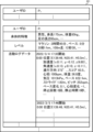
まず、電子機器100の制御部110は、入力部130を介してユーザから、ユーザの希望する条件を満たすランニングコースの情報(条件情報)を取得する(ステップS201)。このステップで制御部110は、例えば図14及び図15に示す画面を出力部140のディスプレイに表示し、ユーザによって入力されたランニングコースの情報(条件情報)を取得する。
First, the
そして、制御部110は、取得した条件情報を、通信部150を介してサーバ200に送信する(ステップS202)。するとサーバ200は、条件情報に基づいてランニングコースの探索を行い、条件情報に合致する経路情報(ランニングコースの候補等の情報)を電子機器100に送信する。そして、電子機器100の制御部110は、この経路情報をサーバ200から受信し、経路情報に基づいてランニングコースを出力部140のディスプレイに表示する(ステップS203)。
The
このステップで制御部110は、例えば図16に示すように、ランニングコースの候補を出力部140のディスプレイに表示する。図16では、ランニングコースの経路311がスタート地点313からゴール地点314まで破線で示されており、経路311の途中に存在する代表点が説明地点320として旗のマークで示されている。
In this step, the
そして、制御部110は、ユーザにこの経路が希望する経路であるかを確認する(ステップS204)。希望する経路でないなら(ステップS204;No)、ステップS201に戻る。
Then, the
希望する経路なら(ステップS204;Yes)、制御部110は、ユーザがランニングを開始するまで待機するために、ランニングが開始されたか否かを判定する(ステップS205)。制御部110は、ランニング開始の判定について、例えばセンサ部160からの検出値に基づいて判定してもよいが、単純にユーザが入力部130の「ランニング開始」を知らせるボタンを押下したらランニングが開始されたと判定してもよい。
If it is the desired route (step S204; Yes), the
ランニングが開始されていないなら(ステップS205;No)、ステップS205に戻る。ランニングが開始されたなら(ステップS205;Yes)、制御部110は、センサ部160からセンサ情報を取得し(ステップS206)、統計情報としてセンサ情報を記憶部120に保存する(ステップS207)。
If running has not started (step S205; No), the process returns to step S205. If running has started (step S205; Yes), the
そして、制御部110は、説明地点の近傍に到達した(現在位置が説明地点の近傍である)か否かを判定する(ステップS208)。このステップで制御部110は、例えばセンサ部160のGPSデバイスで取得した現在位置と説明地点の位置情報とを照合することで、説明地点の近傍に到達したか否かの判定を行うことができる。
Then, the
制御部110は、現在位置が説明地点の近傍に到達していないなら(ステップS208;No)、ステップS210に進む。現在位置が説明地点の近傍に到達しているなら(ステップS208;Yes)、制御部110は、当該説明地点に対応する説明情報を出力部140のスピーカから音声で出力し(ステップS209)、ステップS210に進む。
If the current location has not reached the vicinity of the explanation point (step S208; No), the
ステップS210では、制御部110はゴール地点に到着したか否かを判定する。ゴール地点に到着していなければ(ステップS210;No)、ステップS206に戻る。ゴール地点に到着したら(ステップS210;Yes)、経路案内処理を終了する。
In step S210, the
上記ステップS202で送信された条件情報に基づいて、サーバ200はユーザが希望する経路を探索するが、この処理(経路探索処理)について図17を参照して説明する。経路探索処理は、基本的には、条件情報に基づいて条件を満たす説明地点を抽出し、抽出した説明地点を経由するコースのうち、条件を満たすコースを電子機器100に送信する処理である。
Based on the condition information transmitted in step S202, the
まず、サーバ200の制御部210は、電子機器100から送信された条件情報を、通信部250を介して受信する(ステップS301)。
First, the
次に、制御部210は、受信した条件情報に合致する説明地点を抽出する(ステップS302)。サーバ200では事前に説明地点生成処理(図6)が行われており、記憶部220の説明地点データベースには、特徴量や説明情報が付与された説明地点が記憶されている。したがって、このステップで制御部210は、各説明地点の特徴量や説明情報に基づいて、条件情報と合致する説明地点を抽出する。
Next, the
そして、制御部210は、条件情報に含まれているスタート地点及びゴール地点の情報と、記憶部220に記憶されている地図情報と、に基づき、スタート地点からゴール地点までの経路のうち、ステップS302で抽出された説明地点を経由し、条件情報に含まれる経路の条件(例えばコース距離)に合致する経路を探索する(ステップS303)。
Then, based on the information on the start point and the finish point included in the condition information and the map information stored in the
そして、制御部210は、探索された経路の情報(経路情報)を、電子機器100に送信し(ステップS304)、経路探索処理を終了する。
Then, the
例えば、図14に示す「ユーザの走行レベル設定」では、平均ペース約5分/kmが選択されている。したがって、条件情報としてこの設定を受信したサーバ200の制御部210は、ランナーデータベース221から、各ランナーのレベルの情報を参照し、平均ペースが約5分/kmのランナー(例えば、ペースが5分30秒/kmより速く、4分30秒/kmより遅いランナー)を探索対象ランナーとして抽出する。もし、ここで「設定しない」が選択されていたら、探索対象ランナーはランナーデータベース221中の全ランナーとなる。
For example, in the "User running level setting" shown in FIG. 14, an average pace of approximately 5 minutes/km is selected. Therefore, the
また、図15に示す「ランニングコースの探索条件設定」では、「スタート地点」として「現在値」が、「コース距離」として「5km」が設定されている。そして、「ゴール地点を指定」にチェックが入っていないので、ゴール地点には何も設定されていないが、この場合にはデフォルトのゴール地点(例えば自宅)がゴール地点となる。そして、「経由地点」として「ランニングPOIをできるだけ多く含む」、「同レベルのランナーが経由する地点を含む」、「ランナーが頻繁に立ち寄る休憩地を含む」が設定されている。なお、ランニングPOIとは、探索対象ランナーに紐付けられている特徴点の属するクラスタの代表点である説明地点のことを意味する。このような説明地点(ランニングPOI)は、探索対象ランナーに紐付けられている説明地点と考えることもできる。 In addition, in the "Running Course Search Condition Settings" shown in FIG. 15, "Current Value" is set as the "Start Point" and "Course Distance" is set to "5km". And since "Specify Finish Point" is not checked, nothing is set as the finish point, but in this case the default finish point (e.g. home) becomes the finish point. And as "Intermediate Points", "Include as many running POIs as possible", "Include points that runners of the same level pass by", and "Include rest areas that runners frequently stop by" are set. Note that a running POI refers to an explanation point that is a representative point of a cluster to which a feature point linked to the search target runner belongs. Such an explanation point (running POI) can also be thought of as an explanation point linked to the search target runner.
したがって、条件情報としてこれらの設定を受信したサーバ200の制御部210は、まず現在地からスタートしてゴール地点(例えば自宅)に戻る約5kmのランニングコースの候補を抽出する。そして、抽出された候補に対して、経由地点の設定を考慮してさらにランニングコースの絞り込みを行う。
Therefore, the
例えば、「ランニングPOIをできるだけ多く含む」という条件を満たすために、ランニングコースの候補の中で、図14の設定で抽出された探索対象ランナーに紐付けられている説明地点をできるだけ多く経由するコースを抽出する。そして、「同レベルランナーが経由する地点を含む」や「ランナーが頻繁に立ち寄る休憩地を含む」という条件を満たすために、ランナーデータベース221中で、ユーザと同レベルのランナーが経由している地点や、ランナーが頻繁に立ち寄る休憩地の地点を抽出して、そのような地点を経由するコースを、それまでに抽出したコースからさらに抽出する。
For example, to satisfy the condition "including as many running POIs as possible," a course that passes through as many explanatory points as possible linked to the search target runner extracted in the settings of FIG. 14 is extracted from among the running course candidates. Then, to satisfy the conditions "including points passed through by runners of the same level" and "including rest areas frequently visited by runners," points passed through by runners of the same level as the user and rest areas frequently visited by runners are extracted from the
そして、ユーザが「探索」ボタンをクリックしたことをサーバ200が受信したら、サーバ200はそれまでに抽出されたコースに関しての経路情報を電子機器100に送信する。すると、電子機器100の出力部140のディスプレイには、図16に示すように「ランニングコースの探索結果」として、それまでに設定した条件に合致するランニングコースの候補が表示される。
When the
図16では、スタート地点313は現在値の○△公園で、ゴール地点314は自宅で、この間の経路311の距離は5kmで、3つの説明地点320を経由するコースであることが確認できる。そして、「ランニングPOIをマーク表示」にチェックが入っているので、説明地点データベースに記録されている説明地点320が旗のマークで示されていることが確認できる。また、「ランニングPOI以外のPOIをマーク表示」にもチェックが入っているので、元々地図情報に含まれていた特定地点322も旗のマークで示されていることが確認できる。また、スタート地点を現在時刻である12:00:00にスタートすると、ユーザの今までの活動ログデータに基づき、ゴール地点には12:32:00に到着することが推定されることも示されている。
In FIG. 16, it can be seen that the
なお、上述の経路探索処理(図17)のステップS302では、制御部210は説明地点データベースから説明地点を抽出しているので、説明地点生成処理によって生成された新規POIのうち条件情報に合致する説明地点が抽出される。しかし、ステップS302では、制御部210は、説明地点データベースから抽出するだけでなく、記憶部220に地図情報として記憶されている既存POIからも条件情報に合致する説明地点を抽出してよい。
In step S302 of the above-mentioned route search process (Figure 17), the
以上説明したように、説明地点生成処理により、制御部210は、ユーザの希望により合った経路を探索するための情報として、特徴量及び説明情報が付加された説明地点の情報を生成することができる。また、経路探索処理により、制御部210は、ユーザの条件情報に基づいて、ユーザの希望する条件により合った経路を探索することができる。また、経路案内処理により、制御部110は、説明地点の近傍にてユーザに当該説明地点を説明する情報を報知することができる。
As described above, the explanation point generation process enables the
なお、図14及び図15に示したランニングコースの探索条件はあくまでも一例に過ぎない。例えば、探索条件として「信号が少ないコース」という設定があってもよい。この場合、制御部210は、地図情報に信号の位置の情報が含まれる場合には、その情報に基づいて信号が少ないエリアの重心等を説明地点(信号が少ない説明地点)として説明地点データベースに記録し、この説明地点を経由するコースを探索する。地図情報に信号の情報が含まれていない場合は別途信号の位置の情報が得られるデータをダウンロードして信号が少ないエリアの重心等を説明地点(信号が少ない説明地点)として説明地点データベースに記録してもよいし、記憶部220に記憶されているランナーデータベース221中の活動ログデータに基づき、ランナーの停止が少ないエリアの重心等を説明地点(信号が少ない説明地点)として説明地点データベースに記録してもよい。
Note that the search conditions for the running course shown in FIG. 14 and FIG. 15 are merely examples. For example, a search condition may be set to "course with few traffic lights." In this case, if the map information includes information on the location of traffic lights, the
また、図14では、平均ペースに基づいてフィルタリングしたランナーを探索対象ランナーとしているが、例えばスコア、身長、体重、性別等でフィルタリングをしたり、これらの条件を組み合わせた条件でフィルタリングをしたりしたランナーを探索対象ランナーとしてもよい。そして、制御部210は、このようにフィルタリング(条件フィルタリング)をして得られた探索対象ランナーが利用している(ランニング時に通過している)説明地点を経路途中で経由するようなランニングコースを探索する。
In addition, in FIG. 14, the runners filtered based on average pace are set as the search target runners, but the search target runners may be filtered by, for example, score, height, weight, gender, etc., or by a combination of these conditions. The
また、ユーザの今までのコースの選択履歴や実際の走行履歴に存在する説明地点の特徴量と似た特徴量を持つ説明地点を、経路途中で経由する地点とするフィルタリング(コンテンツフィルタリング)をしてもよい。似た特徴量の説明地点を検索する際には、説明地点の複数の特徴量を正規化して1つのベクトルにまとめて当該説明地点の特徴ベクトルを算出し、特徴ベクトルの類似度(例えばコサイン類似度)が高いものを似た特徴量の説明地点とする。なお、正規化後の特徴量は、例えば以下の式(1)のようにして算出することができる。
正規化後の特徴量a’=(特徴量a-特徴量aの平均)/特徴量aの分散 …(1)
また、式(1)の右辺に特徴量aの信頼性(例えば1/(1+特徴量aの標準偏差))を乗算することにより、信頼性の低い特徴量の影響度を下げてもよい。
In addition, filtering (content filtering) may be performed to set explanation points having similar features to those of explanation points existing in the user's previous course selection history or actual driving history as points passed through on the route. When searching for explanation points with similar features, multiple feature values of the explanation points are normalized and combined into one vector to calculate the feature vector of the explanation point, and a feature vector with a high similarity (e.g., cosine similarity) is set as an explanation point with similar features. The normalized feature value can be calculated, for example, as shown in the following formula (1).
Normalized feature a' = (feature a - average of feature a) / variance of feature a ... (1)
In addition, the influence of a feature with low reliability may be reduced by multiplying the right side of equation (1) by the reliability of the feature a (for example, 1/(1+standard deviation of the feature a)).
また信頼性が低い特徴量(図12のクラスタ代表点FPAやFPBにおける停止回数のように「-」となっている特徴量)が含まれる場合もある。この場合、信頼性が低い特徴量の数が一定数以下の特徴ベクトルのみを類似度計算の対象としたり、信頼性が低い特徴量を除いた状態で類似度を算出し、他のベクトルの要素に基づいて信頼性が低い特徴量を推定してから類似度を算出したりしてもよい。 Also, there may be cases where a feature with low reliability (such as the number of stops at cluster representative points FP A and FP B in FIG. 12 and the feature with "-") is included. In this case, only feature vectors with a certain number or less of low reliability features may be subject to similarity calculation, or the similarity may be calculated in a state where the low reliability features are excluded, and the low reliability features may be estimated based on the elements of other vectors before the similarity is calculated.
また、ユーザと似たユーザがよく利用している説明地点を経路途中で経由する地点とするフィルタリング(協調フィルタリング)をしてもよい。また、これらの3種類のフィルタリング(条件フィルタリング、コンテンツフィルタリング、協調フィルタリング)を組み合わせて(例えば、各フィルタリングの結果に対してAND演算やOR演算を行って)フィルタリングを行ってもよい。これはハイブリッド型のフィルタリングとなる。 It is also possible to perform filtering (collaborative filtering) by specifying explanatory points frequently used by users similar to the user as points to be passed through on the route. It is also possible to perform filtering by combining these three types of filtering (conditional filtering, content filtering, collaborative filtering) (for example, performing AND or OR operations on the results of each filtering). This is a hybrid type of filtering.
なお、一般に地図情報に含まれている特定地点(既存のPOI)には上述の説明地点に付与されているような特徴量は付与されていない。しかし、フィルタリングの対象にしたい特定地点に対して手動で特徴量を付与したり、特定地点の情報(POIデータ)に基づいて特徴量を付与したりすることにより、説明地点だけでなく、特徴量が付与された特定地点も上述のフィルタリングの対象とすることができる。また、手動で既存のPOIに特徴量を付与した場合、制御部210は、その特徴量及び特徴量対応テーブル222に基づいて生成した説明情報を、記憶部220に地図情報として記憶されている既存のPOIに対応付けることができる。
Specific points (existing POIs) included in map information are generally not assigned features such as those assigned to the above-mentioned explanatory points. However, by manually assigning a feature to a specific point to be filtered or by assigning a feature based on information about the specific point (POI data), not only explanatory points but also specific points to which a feature has been assigned can be subject to the above-mentioned filtering. In addition, when a feature is manually assigned to an existing POI, the
また、上記実施の形態では、ユーザの活動として主にランニングを例として説明したが、電子機器100やサーバ200で扱うユーザの活動はランニングに限定されない。例えば、ユーザの活動はウォーキングであってもよいし、サイクリングであってもよい。つまり、ユーザの活動は、移動を伴う任意の活動である。同様に、上述の条件情報は、ユーザが希望する条件を満たすランニングコースの情報に限定されず、移動を伴う活動に関する任意の条件を表す情報である。
In addition, in the above embodiment, the user activity is mainly described as running, but the user activity handled by the
(その他の変形例)
なお、電子機器100は、スマートウォッチに限らず、センサ部160を備えたスマートフォン、携帯型のタブレットやPC(Personal Computer)等のコンピュータによっても実現することができる。また、サーバ200は、PC等のコンピュータによっても実現することができる。具体的には、上記実施の形態では、制御部110が実行する経路案内処理等のプログラムが記憶部120に予め記憶されており、制御部210が実行する説明地点生成処理等のプログラムが記憶部220に予め記憶されているものとして説明した。しかし、プログラムを、フレキシブルディスク、CD-ROM(Compact Disc Read Only Memory)、DVD(Digital Versatile Disc)、MO(Magneto-Optical disc)、メモリカード、USBメモリ等の非一時的なコンピュータ読み取り可能な記録媒体に格納して配布し、そのプログラムをコンピュータに読み込んでインストールすることにより、上述の各処理を実行することができるコンピュータを構成してもよい。
(Other Modifications)
The
さらに、プログラムを搬送波に重畳し、インターネットなどの通信媒体を介して適用することもできる。例えば、通信ネットワーク上の掲示板(BBS:Bulletin Board System)にプログラムを掲示して配信してもよい。そして、このプログラムを起動し、OS(Operating System)の制御下で、他のアプリケーションプログラムと同様に実行することにより、上述の各処理を実行できるように構成してもよい。 Furthermore, the program can be superimposed on a carrier wave and applied via a communication medium such as the Internet. For example, the program can be distributed by posting it on a bulletin board system (BBS) on a communication network. The program can then be started and executed under the control of an operating system (OS) in the same way as other application programs, thereby enabling the above-mentioned processes to be performed.
また、制御部110や制御部210は、シングルプロセッサ、マルチプロセッサ、マルチコアプロセッサ等の任意のプロセッサ単体で構成されるものの他、これら任意のプロセッサと、ASIC(Application Specific Integrated Circuit)やFPGA(Field‐Programmable Gate Array)等の処理回路とが組み合わせられて構成されてもよい。
In addition, the
以上、本発明の好ましい実施の形態について説明したが、本発明は係る特定の実施の形態に限定されるものではなく、本発明には、特許請求の範囲に記載された発明とその均等の範囲とが含まれる。以下に、本願出願の当初の特許請求の範囲に記載された発明を付記する。 Although the preferred embodiment of the present invention has been described above, the present invention is not limited to the specific embodiment, and includes the inventions described in the claims and their equivalents. The inventions described in the original claims of this application are described below.
(付記1)
制御部を備え、
前記制御部は、
移動を伴う活動によって得られた位置又は領域に対応する統計情報を取得し、
前記統計情報に基づいて得られた前記位置又は領域の特徴量を取得し、
前記位置又は領域を代表する地点である代表点に対して前記特徴量に応じた説明情報を対応付ける、
ことを特徴とする情報処理装置。
(Appendix 1)
A control unit is provided,
The control unit is
Obtaining statistical information corresponding to the location or area obtained by the movement activity;
acquiring a feature amount of the position or area obtained based on the statistical information;
associate explanatory information corresponding to the feature amount with a representative point that is a point that represents the position or area;
23. An information processing apparatus comprising:
(付記2)
前記制御部は、
前記統計情報に基づいて特徴的な位置または領域を特徴点として取得し、
前記取得した特徴点をクラスタリングして得られた各クラスタから前記代表点を算出し、
前記算出した代表点のクラスタに属する前記特徴点の前記統計情報に基づいて前記代表点の特徴量を算出し、
前記代表点に対して前記算出した特徴量に応じた説明情報を対応付ける、
ことを特徴とする付記1に記載の情報処理装置。
(Appendix 2)
The control unit is
acquiring characteristic positions or regions as feature points based on the statistical information;
Calculating the representative point from each cluster obtained by clustering the acquired feature points;
calculating a feature amount of the representative point based on the statistical information of the feature points belonging to the cluster of the calculated representative point;
Corresponding explanation information corresponding to the calculated feature amount to the representative point;
2. The information processing device according to claim 1 .
(付記3)
前記制御部は、
前記統計情報の絶対量又は変化量が閾値を超えた位置を特徴点として抽出し、
前記クラスタに属する全ての特徴点の位置の重心を前記クラスタの代表点とする、
ことを特徴とする付記2に記載の情報処理装置。
(Appendix 3)
The control unit is
extracting, as a feature point, a position where an absolute value or a change amount of the statistical information exceeds a threshold value;
The center of gravity of all the feature points belonging to the cluster is set as the representative point of the cluster.
3. The information processing device according to
(付記4)
前記制御部は、
特徴量対応テーブルを参照して、前記代表点の特徴量から前記説明情報を生成し、
前記生成した説明情報を前記代表点に対応付ける、
ことを特徴とする付記1から3のいずれか1つに記載の情報処理装置。
(Appendix 4)
The control unit is
generating the explanatory information from the feature amounts of the representative points by referring to a feature amount correspondence table;
Corresponding the generated explanatory information to the representative points;
4. The information processing device according to claim 1,
(付記5)
前記特徴量対応テーブルは、前記特徴量についての条件である特徴量条件と説明基礎情報との対応が示されているテーブルであり、
前記制御部は、
前記代表点の前記特徴量が前記特徴量対応テーブルに示される前記特徴量条件を満たしている場合に、前記特徴量条件に対応する前記説明基礎情報に基づいて前記代表点に対応付ける前記説明情報を生成し、
前記生成した説明情報を前記代表点に対応付ける、
ことを特徴とする付記4に記載の情報処理装置。
(Appendix 5)
the feature quantity correspondence table is a table showing correspondence between feature quantity conditions, which are conditions for the feature quantities, and explanatory basic information;
The control unit is
generating the explanation information to be associated with the representative point based on the explanation basic information corresponding to the feature amount condition when the feature amount of the representative point satisfies the feature amount condition shown in the feature amount correspondence table;
Corresponding the generated explanatory information to the representative points;
5. The information processing device according to claim 4.
(付記6)
前記制御部は、
前記説明情報を対応付けた前記代表点を説明地点として地図情報に記録する、
ことを特徴とする付記1に記載の情報処理装置。
(Appendix 6)
The control unit is
The representative point associated with the explanatory information is recorded in map information as an explanatory point.
2. The information processing device according to claim 1 .
(付記7)
前記地図情報には、説明情報が付与された地点が特定地点として記録されており、
前記制御部は、前記説明地点も前記特定地点として前記地図情報に記録する、
ことを特徴とする付記6に記載の情報処理装置。
(Appendix 7)
In the map information, a point to which explanatory information is added is recorded as a specific point,
The control unit also records the explanation point as the specific point in the map information.
7. The information processing device according to claim 6.
(付記8)
前記制御部は、
前記活動に関する条件を表す情報である条件情報を取得し、
前記条件情報に基づいて、前記説明地点を含む前記地図情報から前記活動により移動する経路を探索する、
ことを特徴とする付記6又は7に記載の情報処理装置。
(Appendix 8)
The control unit is
acquiring condition information which is information representing a condition related to the activity;
searching for a route to be traveled for the activity from the map information including the explanation point based on the condition information;
8. The information processing device according to claim 6 or 7.
(付記9)
現在位置を取得する位置取得部と、
制御部と、を備え、
前記制御部は、
移動を伴う活動に関する条件を表す情報である条件情報を取得し、
前記条件情報を付記8に記載の情報処理装置に送信し、
前記情報処理装置が探索した経路を取得し、
前記位置取得部で取得した現在位置が、前記説明地点の近傍に到達した場合、前記説明情報を出力する、
ことを特徴とする電子機器。
(Appendix 9)
A location acquisition unit for acquiring a current location;
A control unit,
The control unit is
Acquire condition information which is information expressing conditions related to an activity involving movement;
Transmitting the condition information to the information processing device described in Supplementary Note 8;
The information processing device acquires the route searched for,
When the current location acquired by the location acquisition unit reaches the vicinity of the explanation point, the explanation information is output.
1. An electronic device comprising:
(付記10)
前記条件情報は、
ユーザが指定した条件、前記ユーザの活動履歴、前記ユーザに似ているユーザの活動履歴のうちの少なくとも1つの情報を含む、
ことを特徴とする付記9に記載の電子機器。
(Appendix 10)
The condition information is
The information includes at least one of a condition specified by a user, an activity history of the user, and an activity history of a user similar to the user.
10. The electronic device according to claim 9.
(付記11)
制御部が、
移動を伴う活動によって得られた位置又は領域に対応する統計情報を取得し、
前記統計情報に基づいて得られた前記位置又は領域の特徴量を取得し、
前記位置又は領域を代表する地点である代表点に対して前記特徴量に応じた説明情報を対応付ける、
ことを特徴とする情報処理方法。
(Appendix 11)
The control unit:
Obtaining statistical information corresponding to the location or area obtained by the movement activity;
acquiring a feature amount of the position or area obtained based on the statistical information;
associate explanatory information corresponding to the feature amount with a representative point that is a point that represents the position or area;
23. An information processing method comprising:
(付記12)
情報処理装置の制御部に、
移動を伴う活動によって得られた位置又は領域に対応する統計情報を取得し、
前記統計情報に基づいて得られた前記位置又は領域の特徴量を取得し、
前記位置又は領域を代表する地点である代表点に対して前記特徴量に応じた説明情報を対応付ける、
処理を実行させることを特徴とするプログラム。
(Appendix 12)
A control unit of the information processing device
Obtaining statistical information corresponding to the location or area obtained by the movement activity;
acquiring a feature amount of the position or area obtained based on the statistical information;
associate explanatory information corresponding to the feature amount with a representative point that is a point that represents the position or area;
A program characterized by executing a process.
100…電子機器、110,210…制御部、120,220…記憶部、121…活動ログデータ、130,230…入力部、140,240…出力部、150,250…通信部、160…センサ部、200…サーバ、221…ランナーデータベース、222…特徴量対応テーブル、300,300A,300B,300C…ランナー、301…ユーザ、310,310A,310B,310C,311…経路、312…特徴点、313…スタート地点、314…ゴール地点、320…説明地点、321…説明情報、322…特定地点 100...Electronic device, 110, 210...Control unit, 120, 220...Storage unit, 121...Activity log data, 130, 230...Input unit, 140, 240...Output unit, 150, 250...Communication unit, 160...Sensor unit, 200...Server, 221...Runner database, 222...Feature correspondence table, 300, 300A, 300B, 300C...Runner, 301...User, 310, 310A, 310B, 310C, 311...Route, 312...Feature point, 313...Start point, 314...Finish point, 320...Explanation point, 321...Explanation information, 322...Specific point
Claims (11)
前記制御部は、
移動を伴う活動によって得られた位置又は領域に対応する統計情報を取得し、
前記統計情報に基づいて得られた前記位置又は領域の特徴量及び前記特徴量の信頼性を取得し、
前記位置又は領域を代表する地点である代表点を表す位置情報に対し、前記信頼性が所定の閾値より高い前記特徴量に応じて決定された説明情報を対応付けて、前記活動に関連する第1の特定地点情報として地図情報に記憶させ、
前記活動に関する条件を表す情報である条件情報を取得し、
前記条件情報に基づいて、前記第1の特定地点情報を含む前記地図情報から前記活動により移動する経路を探索する、
ことを特徴とする情報処理装置。 A control unit is provided,
The control unit is
Obtaining statistical information corresponding to a location or area obtained through an activity involving movement;
acquiring a feature of the position or area and reliability of the feature obtained based on the statistical information;
associates explanatory information determined according to the feature amount having a reliability higher than a predetermined threshold with location information indicating a representative point that is a point that represents the location or area, and stores the explanatory information in map information as first specific point information related to the activity;
acquiring condition information which is information representing a condition related to the activity;
searching for a route to be traveled for the activity from the map information including the first specific point information based on the condition information;
23. An information processing apparatus comprising:
前記統計情報に基づいて特徴的な位置または領域を特徴点として取得し、
前記取得した特徴点をクラスタリングして得られた各クラスタから前記代表点を算出し、
前記算出した代表点のクラスタに属する前記特徴点の前記統計情報に基づいて前記代表点の特徴量を算出し、
前記代表点に対して前記算出した特徴量に応じた説明情報を対応付ける、
ことを特徴とする請求項1に記載の情報処理装置。 The control unit is
acquiring characteristic positions or regions as feature points based on the statistical information;
Calculating the representative point from each cluster obtained by clustering the acquired feature points;
calculating a feature amount of the representative point based on the statistical information of the feature points belonging to the cluster of the calculated representative point;
Corresponding explanation information corresponding to the calculated feature amount to the representative point;
2. The information processing apparatus according to claim 1,
前記統計情報の絶対量又は変化量が閾値を超えた位置を特徴点として抽出し、
前記クラスタに属する全ての特徴点の位置の重心を前記クラスタの代表点とする、
ことを特徴とする請求項2に記載の情報処理装置。 The control unit is
extracting, as a feature point, a position where an absolute value or a change amount of the statistical information exceeds a threshold value;
The center of gravity of all the feature points belonging to the cluster is set as the representative point of the cluster.
3. The information processing apparatus according to claim 2.
特徴量対応テーブルを参照して、前記代表点の特徴量から前記説明情報を生成し、
前記生成した説明情報を前記代表点に対応付ける、
ことを特徴とする請求項1から3のいずれか1項に記載の情報処理装置。 The control unit is
generating the explanatory information from the feature amounts of the representative points by referring to a feature amount correspondence table;
Corresponding the generated explanatory information to the representative points;
4. The information processing apparatus according to claim 1, wherein the information processing apparatus is a computer.
前記制御部は、
前記代表点の前記特徴量が前記特徴量対応テーブルに示される前記特徴量条件を満たしている場合に、前記特徴量条件に対応する前記説明基礎情報に基づいて前記代表点に対応付ける前記説明情報を生成し、
前記生成した説明情報を前記代表点に対応付ける、
ことを特徴とする請求項4に記載の情報処理装置。 the feature quantity correspondence table is a table showing correspondence between feature quantity conditions, which are conditions for the feature quantities, and explanation basic information;
The control unit is
generating the explanation information to be associated with the representative point based on the explanation basic information corresponding to the feature amount condition when the feature amount of the representative point satisfies the feature amount condition shown in the feature amount correspondence table;
Corresponding the generated explanatory information to the representative points;
5. The information processing apparatus according to claim 4.
ことを特徴とする請求項1に記載の情報処理装置。 The explanatory information included in the first specific point information includes at least one of information representing a topographical condition at the representative point, an ease of taking a rest at the representative point, and a rest time for the movement.
2. The information processing apparatus according to claim 1,
前記制御部は、
前記条件情報に基づいて、前記第1の特定地点情報と前記第2の特定地点情報を含む前記地図情報から前記経路を探索する、
ことを特徴とする請求項1に記載の情報処理装置。 The map information stores in advance location information of features and explanatory information associated with the features as second specific point information not related to the activity,
The control unit is
searching for the route from the map information including the first specific point information and the second specific point information based on the condition information;
2. The information processing apparatus according to claim 1,
制御部と、を備え、
前記制御部は、
移動を伴う活動に関する条件を表す情報である条件情報を取得し、
前記条件情報を請求項7に記載の情報処理装置に送信し、
前記情報処理装置が探索した経路を取得し、
前記経路における前記第1の特定地点情報に含まれる位置情報が表す第1の地点マークと、前記第2の特定地点情報に含まれる位置情報が表す第2の地点マークとの表示形態を異ならせて、前記経路を前記表示部に表示させる、
ことを特徴とする電子機器。 A display unit;
A control unit,
The control unit is
Acquire condition information which is information expressing conditions related to an activity involving movement;
The condition information is transmitted to the information processing device according to claim 7 ,
The information processing device acquires the route searched for,
displaying the route on the display unit by changing a display form between a first location mark represented by location information included in the first specific location information on the route and a second location mark represented by location information included in the second specific location information;
1. An electronic device comprising:
前記経路における経由地点として前記第1の特定地点情報を含むこと、前記活動におけるレベルがユーザと同一の他のユーザに対応する前記第1の特定地点情報を含むこと、のうち少なくとも1つの情報である、
ことを特徴とする請求項8に記載の電子機器。 The condition information is
The information is at least one of: including the first specific point information as a waypoint on the route; and including the first specific point information corresponding to another user having the same level of activity as the user.
9. The electronic device according to claim 8.
移動を伴う活動によって得られた位置又は領域に対応する統計情報を取得し、
前記統計情報に基づいて得られた前記位置又は領域の特徴量及び前記特徴量の信頼性を取得し、
前記位置又は領域を代表する地点である代表点を表す位置情報に対し、前記信頼性が所定の閾値より高い前記特徴量に応じて決定された説明情報を対応付けて、前記活動に関連する第1の特定地点情報として地図情報に記憶させ、
前記活動に関する条件を表す情報である条件情報を取得し、
前記条件情報に基づいて、前記第1の特定地点情報を含む前記地図情報から前記活動により移動する経路を探索する、
ことを特徴とする情報処理方法。 The control unit:
Obtaining statistical information corresponding to a location or area obtained through an activity involving movement;
acquiring a feature of the position or area and reliability of the feature obtained based on the statistical information;
associates explanatory information determined according to the feature amount having a reliability higher than a predetermined threshold with location information indicating a representative point that is a point that represents the location or area, and stores the explanatory information in map information as first specific point information related to the activity;
acquiring condition information which is information representing a condition related to the activity;
searching for a route to be traveled for the activity from the map information including the first specific point information based on the condition information;
23. An information processing method comprising:
移動を伴う活動によって得られた位置又は領域に対応する統計情報を取得し、
前記統計情報に基づいて得られた前記位置又は領域の特徴量及び前記特徴量の信頼性を取得し、
前記位置又は領域を代表する地点である代表点を表す位置情報に対し、前記信頼性が所定の閾値より高い前記特徴量に応じて決定された説明情報を対応付けて、前記活動に関連する第1の特定地点情報として地図情報に記憶させ、
前記活動に関する条件を表す情報である条件情報を取得し、
前記条件情報に基づいて、前記第1の特定地点情報を含む前記地図情報から前記活動により移動する経路を探索する、
処理を実行させることを特徴とするプログラム。 A control unit of the information processing device
Obtaining statistical information corresponding to the location or area obtained by the movement activity;
acquiring a feature of the position or area and reliability of the feature obtained based on the statistical information;
associates explanatory information determined according to the feature amount having a reliability higher than a predetermined threshold with location information indicating a representative point that is a point that represents the location or area, and stores the explanatory information in map information as first specific point information related to the activity;
acquiring condition information which is information representing a condition related to the activity;
searching for a route to be traveled for the activity from the map information including the first specific point information based on the condition information;
A program characterized by executing a process.
Priority Applications (3)
| Application Number | Priority Date | Filing Date | Title |
|---|---|---|---|
| JP2022120210A JP7647705B2 (en) | 2022-07-28 | 2022-07-28 | Information processing device, electronic device, information processing method, and program |
| US18/218,269 US20240035826A1 (en) | 2022-07-28 | 2023-07-05 | Information processing device, electronic device, information processing method, and recording medium |
| JP2025026552A JP2025068102A (en) | 2022-07-28 | 2025-02-21 | Information processing device, electronic device, information processing method, and program |
Applications Claiming Priority (1)
| Application Number | Priority Date | Filing Date | Title |
|---|---|---|---|
| JP2022120210A JP7647705B2 (en) | 2022-07-28 | 2022-07-28 | Information processing device, electronic device, information processing method, and program |
Related Child Applications (1)
| Application Number | Title | Priority Date | Filing Date |
|---|---|---|---|
| JP2025026552A Division JP2025068102A (en) | 2022-07-28 | 2025-02-21 | Information processing device, electronic device, information processing method, and program |
Publications (2)
| Publication Number | Publication Date |
|---|---|
| JP2024017522A JP2024017522A (en) | 2024-02-08 |
| JP7647705B2 true JP7647705B2 (en) | 2025-03-18 |
Family
ID=89665133
Family Applications (2)
| Application Number | Title | Priority Date | Filing Date |
|---|---|---|---|
| JP2022120210A Active JP7647705B2 (en) | 2022-07-28 | 2022-07-28 | Information processing device, electronic device, information processing method, and program |
| JP2025026552A Pending JP2025068102A (en) | 2022-07-28 | 2025-02-21 | Information processing device, electronic device, information processing method, and program |
Family Applications After (1)
| Application Number | Title | Priority Date | Filing Date |
|---|---|---|---|
| JP2025026552A Pending JP2025068102A (en) | 2022-07-28 | 2025-02-21 | Information processing device, electronic device, information processing method, and program |
Country Status (2)
| Country | Link |
|---|---|
| US (1) | US20240035826A1 (en) |
| JP (2) | JP7647705B2 (en) |
Citations (5)
| Publication number | Priority date | Publication date | Assignee | Title |
|---|---|---|---|---|
| JP2007192697A (en) | 2006-01-20 | 2007-08-02 | Matsushita Electric Ind Co Ltd | Route search device, route search system, route search terminal device, route search center device |
| JP2008224993A (en) | 2007-03-12 | 2008-09-25 | Denso It Laboratory Inc | Map display device, map display method and program |
| JP2012184935A (en) | 2011-03-03 | 2012-09-27 | Navitime Japan Co Ltd | Navigation device, navigation system, navigation server, navigation method and program |
| JP2014230616A (en) | 2013-05-29 | 2014-12-11 | 株式会社ゼンリンデータコム | Sport supporting system, terminal device, server device, information providing method, information totaling method, information providing program, and information totaling program |
| JP2016010562A (en) | 2014-06-30 | 2016-01-21 | カシオ計算機株式会社 | Data analysis apparatus, data analysis method, and data analysis program |
-
2022
- 2022-07-28 JP JP2022120210A patent/JP7647705B2/en active Active
-
2023
- 2023-07-05 US US18/218,269 patent/US20240035826A1/en active Pending
-
2025
- 2025-02-21 JP JP2025026552A patent/JP2025068102A/en active Pending
Patent Citations (5)
| Publication number | Priority date | Publication date | Assignee | Title |
|---|---|---|---|---|
| JP2007192697A (en) | 2006-01-20 | 2007-08-02 | Matsushita Electric Ind Co Ltd | Route search device, route search system, route search terminal device, route search center device |
| JP2008224993A (en) | 2007-03-12 | 2008-09-25 | Denso It Laboratory Inc | Map display device, map display method and program |
| JP2012184935A (en) | 2011-03-03 | 2012-09-27 | Navitime Japan Co Ltd | Navigation device, navigation system, navigation server, navigation method and program |
| JP2014230616A (en) | 2013-05-29 | 2014-12-11 | 株式会社ゼンリンデータコム | Sport supporting system, terminal device, server device, information providing method, information totaling method, information providing program, and information totaling program |
| JP2016010562A (en) | 2014-06-30 | 2016-01-21 | カシオ計算機株式会社 | Data analysis apparatus, data analysis method, and data analysis program |
Also Published As
| Publication number | Publication date |
|---|---|
| US20240035826A1 (en) | 2024-02-01 |
| JP2024017522A (en) | 2024-02-08 |
| JP2025068102A (en) | 2025-04-24 |
Similar Documents
| Publication | Publication Date | Title |
|---|---|---|
| KR102216050B1 (en) | System and method for recommending exercise routes | |
| CN104252688B (en) | Device, method and the server of information are provided | |
| CN103279470B (en) | Mobile terminal apparatus, server unit, information providing system and method | |
| US20200348139A1 (en) | Automatically creating a terrain mapping database | |
| US8700320B1 (en) | Emphasizing featured locations during a journey | |
| JP2014230616A (en) | Sport supporting system, terminal device, server device, information providing method, information totaling method, information providing program, and information totaling program | |
| JP6015900B2 (en) | Information processing apparatus, exercise support information providing system, exercise support information providing method, and exercise support information providing program | |
| BR112014031805B1 (en) | NAVIGATION SYSTEM AND METHOD | |
| JP2017161522A (en) | Information providing system, information providing method and program | |
| JP2015004629A (en) | Waypoint candidate creation device, waypoint candidate display device, waypoint candidate creation method | |
| JP5892305B2 (en) | Activity amount measuring device, activity amount measuring system, program and recording medium | |
| JP7647705B2 (en) | Information processing device, electronic device, information processing method, and program | |
| JP2020193943A (en) | Navigation system, information processing device, navigation device, information processing method, navigation method, and program | |
| JP2003331063A (en) | Exercise history recording device and exercise history recording program | |
| JP2021148460A (en) | Movement amount estimation device, model generation device, movement amount estimation method, and program | |
| KR100762717B1 (en) | Mountaineering navigation terminal system and method of operating the mountaineering course guide using the same | |
| US10390703B2 (en) | Information notification system, information notification method, and display apparatus | |
| KR102614076B1 (en) | Method And Computer-Readable Recording Medium with Program for Recommending Walking Course | |
| JP4229146B2 (en) | NAVIGATION DEVICE AND PROGRAM | |
| JP5557312B2 (en) | MAP INFORMATION DISPLAY DEVICE, MAP INFORMATION DISPLAY METHOD, AND PROGRAM | |
| JP7262795B2 (en) | Information processing device, information processing method, program | |
| JP2019159714A (en) | Information collection system, information collection method, and program | |
| JP2024076496A (en) | Information processing device, information processing method, and program | |
| JP2007093264A (en) | Information distribution system | |
| JP2025096037A (en) | Information processing device, average training amount calculation method, and display system |
Legal Events
| Date | Code | Title | Description |
|---|---|---|---|
| A621 | Written request for application examination |
Free format text: JAPANESE INTERMEDIATE CODE: A621 Effective date: 20230801 |
|
| A977 | Report on retrieval |
Free format text: JAPANESE INTERMEDIATE CODE: A971007 Effective date: 20240603 |
|
| A131 | Notification of reasons for refusal |
Free format text: JAPANESE INTERMEDIATE CODE: A131 Effective date: 20240611 |
|
| A521 | Request for written amendment filed |
Free format text: JAPANESE INTERMEDIATE CODE: A523 Effective date: 20240805 |
|
| A131 | Notification of reasons for refusal |
Free format text: JAPANESE INTERMEDIATE CODE: A131 Effective date: 20241001 |
|
| A521 | Request for written amendment filed |
Free format text: JAPANESE INTERMEDIATE CODE: A523 Effective date: 20241112 |
|
| TRDD | Decision of grant or rejection written | ||
| A01 | Written decision to grant a patent or to grant a registration (utility model) |
Free format text: JAPANESE INTERMEDIATE CODE: A01 Effective date: 20250204 |
|
| A61 | First payment of annual fees (during grant procedure) |
Free format text: JAPANESE INTERMEDIATE CODE: A61 Effective date: 20250217 |
|
| R150 | Certificate of patent or registration of utility model |
Ref document number: 7647705 Country of ref document: JP Free format text: JAPANESE INTERMEDIATE CODE: R150 |