JP7581383B2 - Method for selecting satellite combinations for position determination - Patents.com - Google Patents
Method for selecting satellite combinations for position determination - Patents.com Download PDFInfo
- Publication number
- JP7581383B2 JP7581383B2 JP2022574169A JP2022574169A JP7581383B2 JP 7581383 B2 JP7581383 B2 JP 7581383B2 JP 2022574169 A JP2022574169 A JP 2022574169A JP 2022574169 A JP2022574169 A JP 2022574169A JP 7581383 B2 JP7581383 B2 JP 7581383B2
- Authority
- JP
- Japan
- Prior art keywords
- satellite
- gnss
- satellites
- sorting
- weighting
- Prior art date
- Legal status (The legal status is an assumption and is not a legal conclusion. Google has not performed a legal analysis and makes no representation as to the accuracy of the status listed.)
- Active
Links
Images
Classifications
-
- G—PHYSICS
- G01—MEASURING; TESTING
- G01S—RADIO DIRECTION-FINDING; RADIO NAVIGATION; DETERMINING DISTANCE OR VELOCITY BY USE OF RADIO WAVES; LOCATING OR PRESENCE-DETECTING BY USE OF THE REFLECTION OR RERADIATION OF RADIO WAVES; ANALOGOUS ARRANGEMENTS USING OTHER WAVES
- G01S19/00—Satellite radio beacon positioning systems; Determining position, velocity or attitude using signals transmitted by such systems
- G01S19/01—Satellite radio beacon positioning systems transmitting time-stamped messages, e.g. GPS [Global Positioning System], GLONASS [Global Orbiting Navigation Satellite System] or GALILEO
- G01S19/13—Receivers
- G01S19/24—Acquisition or tracking or demodulation of signals transmitted by the system
- G01S19/28—Satellite selection
-
- G—PHYSICS
- G01—MEASURING; TESTING
- G01S—RADIO DIRECTION-FINDING; RADIO NAVIGATION; DETERMINING DISTANCE OR VELOCITY BY USE OF RADIO WAVES; LOCATING OR PRESENCE-DETECTING BY USE OF THE REFLECTION OR RERADIATION OF RADIO WAVES; ANALOGOUS ARRANGEMENTS USING OTHER WAVES
- G01S19/00—Satellite radio beacon positioning systems; Determining position, velocity or attitude using signals transmitted by such systems
- G01S19/01—Satellite radio beacon positioning systems transmitting time-stamped messages, e.g. GPS [Global Positioning System], GLONASS [Global Orbiting Navigation Satellite System] or GALILEO
- G01S19/13—Receivers
- G01S19/24—Acquisition or tracking or demodulation of signals transmitted by the system
- G01S19/25—Acquisition or tracking or demodulation of signals transmitted by the system involving aiding data received from a cooperating element, e.g. assisted GPS
- G01S19/258—Acquisition or tracking or demodulation of signals transmitted by the system involving aiding data received from a cooperating element, e.g. assisted GPS relating to the satellite constellation, e.g. almanac, ephemeris data, lists of satellites in view
-
- G—PHYSICS
- G01—MEASURING; TESTING
- G01S—RADIO DIRECTION-FINDING; RADIO NAVIGATION; DETERMINING DISTANCE OR VELOCITY BY USE OF RADIO WAVES; LOCATING OR PRESENCE-DETECTING BY USE OF THE REFLECTION OR RERADIATION OF RADIO WAVES; ANALOGOUS ARRANGEMENTS USING OTHER WAVES
- G01S19/00—Satellite radio beacon positioning systems; Determining position, velocity or attitude using signals transmitted by such systems
- G01S19/38—Determining a navigation solution using signals transmitted by a satellite radio beacon positioning system
- G01S19/39—Determining a navigation solution using signals transmitted by a satellite radio beacon positioning system the satellite radio beacon positioning system transmitting time-stamped messages, e.g. GPS [Global Positioning System], GLONASS [Global Orbiting Navigation Satellite System] or GALILEO
- G01S19/42—Determining position
- G01S19/421—Determining position by combining or switching between position solutions or signals derived from different satellite radio beacon positioning systems; by combining or switching between position solutions or signals derived from different modes of operation in a single system
- G01S19/426—Determining position by combining or switching between position solutions or signals derived from different satellite radio beacon positioning systems; by combining or switching between position solutions or signals derived from different modes of operation in a single system by combining or switching between position solutions or signals derived from different modes of operation in a single system
-
- G—PHYSICS
- G01—MEASURING; TESTING
- G01S—RADIO DIRECTION-FINDING; RADIO NAVIGATION; DETERMINING DISTANCE OR VELOCITY BY USE OF RADIO WAVES; LOCATING OR PRESENCE-DETECTING BY USE OF THE REFLECTION OR RERADIATION OF RADIO WAVES; ANALOGOUS ARRANGEMENTS USING OTHER WAVES
- G01S5/00—Position-fixing by co-ordinating two or more direction or position line determinations; Position-fixing by co-ordinating two or more distance determinations
- G01S5/01—Determining conditions which influence positioning, e.g. radio environment, state of motion or energy consumption
- G01S5/011—Identifying the radio environment
Landscapes
- Engineering & Computer Science (AREA)
- Radar, Positioning & Navigation (AREA)
- Remote Sensing (AREA)
- Computer Networks & Wireless Communication (AREA)
- Physics & Mathematics (AREA)
- General Physics & Mathematics (AREA)
- Position Fixing By Use Of Radio Waves (AREA)
Description
背景技術
全地球航法衛星システム(GNSS)を用いて、地球のあらゆる地点において位置特定を実行することが可能である。GNSS衛星は、地球周回軌道内に存在しており、GNSS受信機によって受信され、受信機と衛星との間の距離を計算するために使用され得る符号化された信号を送信する。これは、GNSS衛星から受信機への信号伝搬時間によって発生する時間差を、距離特定のために使用することによって行われる。衛星までの距離を、GNSS受信機の位置の推定のために使用することができ、十分な数の衛星によって信号が受信されることが、これに対する前提条件となる。典型的には、5個以上の衛星による信号の受信が可能な場合には、正確な位置特定が可能である。現在、約120個のGNSS衛星が地球周回軌道内に存在する。これは、地球上のあらゆる地点において、幾何学的地平線において最大で約65個の衛星が可視であることを意味する。
2. Background Art It is possible to perform position determination at any point on the Earth using the Global Navigation Satellite System (GNSS). GNSS satellites are in Earth orbit and transmit coded signals that can be received by a GNSS receiver and used to calculate the distance between the receiver and the satellite. This is done by using the time difference caused by the signal propagation time from the GNSS satellite to the receiver for the distance determination. The distance to the satellite can be used to estimate the position of the GNSS receiver, a prerequisite for this is that the signals are received by a sufficient number of satellites. Typically, accurate position determination is possible if signals are received by five or more satellites. Currently, there are about 120 GNSS satellites in Earth orbit. This means that at any point on the Earth, a maximum of about 65 satellites are visible in the geometric horizon.
典型的には、GNSS受信機が同時に追跡することができる衛星の数には制限がある。極めて多くのGNSS衛星が利用可能であるので、実際には、可視の衛星の数は、GNSS受信機による衛生の追跡能力を超えてさらに増加してきている。このことから、高い可用性を保証するため、及び、位置特定の計算コストを低く抑制するためには、可視の衛星のどのような組合せが、良好な位置特定を実行するために最も適しているのかが問題になる。 Typically, a GNSS receiver is limited in the number of satellites it can simultaneously track. With so many GNSS satellites available, in practice the number of visible satellites is growing beyond the satellite tracking capabilities of the GNSS receiver. This raises the question of what combination of visible satellites is best suited to perform a good position determination, in order to ensure high availability and to keep the computational cost of position determination low.
発明の開示
従って、位置特定のための衛星の組合せを選択する新規のアプローチが提案される。
DISCLOSURE OF THE PRESENTING Accordingly, a novel approach to selecting a combination of satellites for position location is proposed.
本明細書においては、GNSS受信機において、各GNSS衛星の衛星信号の分散度を考慮して、複数の可視のGNSS衛星から、位置特定を実行するためのGNSS衛星の組合せを選択する方法を説明する。本方法は、
a)衛星信号の分散度を考慮する、予め定められた基準カタログに従って、少なくとも2つの異なるソートアルゴリズムを用いて可視のGNSS衛星をソートし、予め定められた各基準カタログに従って、低い分散度を有する衛星信号を有するGNSS衛星を求める少なくとも2つの衛星プレソート物を求めるステップと、
b)ステップa)において作成された衛星プレソート物に重み付けする重み付け関数を選択するステップと、
c)重み付された最終的な衛星ソート物が生じるように、各重み付け関数に従って衛星プレソート物を重み付けすることによって最終的な衛星ソート物を作成するステップと、
d)最終的な衛星ソート物に基づいて、衛星組合せ選択を実行するステップと、
を含む。
Described herein is a method for selecting a combination of GNSS satellites for performing position determination from a number of visible GNSS satellites in a GNSS receiver, taking into account the dispersion of the satellite signals of each GNSS satellite. The method comprises the steps of:
a) sorting visible GNSS satellites using at least two different sorting algorithms according to a predefined criteria catalog that takes into account the dispersion of the satellite signals, and determining at least two satellite presorts that determine GNSS satellites having satellite signals with low dispersion according to each predefined criteria catalog;
b) selecting a weighting function for weighting the satellite presorts created in step a);
c) creating a final satellite sort by weighting the satellite presorts according to respective weighting functions to produce a weighted final satellite sort;
d) performing satellite combination selection based on the final satellite sorting;
Includes.
衛星のどのような組合せが位置特定に利用されるべきかを、リアルタイムで、このように判断することは、1つの課題である。位置特定のための衛星の最適な組合せは、幾何学的な考察にも、衛星によって供給される信号データの、場合によって発生する誤差にも基づくべきである。ここで、発生するこのような誤差は、特に、各信号データの開始時間における時間的な誤差である。 Determining in real time what combination of satellites should be used for position determination in this way is a challenge. The optimal combination of satellites for position determination should be based on geometric considerations as well as possible errors in the signal data provided by the satellites, where such errors are in particular time errors in the start times of each signal data.
低い計算コストで衛星の最適な組合せを選択することは、1つの特別な課題である。なぜなら、衛星の最適な組合せの選択は、極めて多くの変数を伴う最適化問題であり、この最適化問題は基本的には、極めて高い計算コストを用いることによってしか、正確に解決することができないからである。この点において、本明細書においては、標準化された手法によって、この問題の良好な解決に至るアプローチが説明されており、この解決は、常に最善の解決であるとは言えないが、多くのケースにおいて、解決の極めて高い質をもたらす。特に、この方法を自動車用途において使用するためには、衛星の適当な組合せを見出すための計算コストを低く抑制する必要がある。本明細書において説明される手法は、衛星相互の適当な組合せを見出すための種々異なるアプローチを組み合わせることができる。これは、ステップa)において、少なくとも2つ(好ましくは、少なくとも3つ)の異なる衛星プレソート物を作成するために、種々異なる基準カタログを使用することができることによって行われる。これらの衛星プレソート物は、説明される方法によって、相互に組合せ可能である。基準カタログを、それに従って衛星信号の分散度を推定することができる規則と解することが可能である。ソートアルゴリズムは、各基準カタログの技術的な実装であり、この基準カタログに従って衛星がソートされる。ソートアルゴリズムは、好ましくは、このソートアルゴリズムに、利用可能な追加パラメータ(角度、補正データ等)を伴う衛星信号が伝送され、次いで、ソートアルゴリズムが出力変数として、衛星のリスティングを提供するように実装されている。このリスティングにおいては、衛星は、各基準カタログによって推定された分散度に従ってソートされている。好ましくは、関連性の上昇に伴って衛星がソートされるように、このリスティングが行われる。即ち、このリスティングの最初には、各基準カタログに従って分散度が低い衛星が来る。基準カタログによる、相応のソートアルゴリズムを用いて作成されたこのようなリストは、衛星プレソート物と称される。 Selecting the optimal combination of satellites at low computational cost is a special challenge, since the selection of the optimal combination of satellites is an optimization problem with a very large number of variables, which can basically only be solved accurately with very high computational cost. In this respect, an approach is described herein that leads to a good solution of this problem by a standardized method, which, although not always the best solution, in many cases leads to a very high quality of solution. In particular, in order to use this method in automotive applications, it is necessary to keep the computational cost of finding a suitable combination of satellites low. The method described herein can combine different approaches to finding a suitable combination of satellites with each other. This is done in that in step a), different reference catalogs can be used to create at least two (preferably at least three) different satellite presorts. These satellite presorts can be combined with each other by the method described. It is possible to interpret the reference catalogs as rules according to which the degree of dispersion of the satellite signals can be estimated. A sorting algorithm is a technical implementation of each reference catalog, according to which the satellites are sorted. The sorting algorithm is preferably implemented in such a way that the satellite signals with the available additional parameters (angles, correction data, etc.) are transmitted to the sorting algorithm, which then provides a listing of the satellites as output variables. In this listing, the satellites are sorted according to the degree of dispersion estimated by the respective reference catalog. Preferably, this listing is performed in such a way that the satellites are sorted according to increasing relevance, i.e. at the top of the listing come the satellites with a low degree of dispersion according to the respective reference catalog. Such a list, created by the corresponding sorting algorithm according to the reference catalog, is called a satellite pre-sort.
特に有利には、ステップa)において、角度に基づくソートアルゴリズムに従って少なくとも1つのソートが行われ、重み付けが、各GNSS衛星の角度パラメータに基づいて行われる。 Particularly preferably, in step a), at least one sorting is performed according to an angle-based sorting algorithm, and the weighting is based on the angle parameters of each GNSS satellite.
このような角度に基づくソートアルゴリズムは、特に、GNSS衛星とGNSS受信機との間の信号伝搬ベクトルの幾何学的な形状及び角度を考察する。 Such angle-based sorting algorithms consider, among other things, the geometric shape and angle of the signal propagation vector between the GNSS satellites and the GNSS receiver.
さらに、有利には、ステップa)において、幾何学的な形状に基づくソートアルゴリズムに従って少なくとも1つのソートが行われ、重み付けが、各GNSS衛星の周回軌道の幾何学的なパラメータに基づいて行われる。 Furthermore, advantageously, in step a), at least one sorting is performed according to a geometric shape-based sorting algorithm, and the weighting is based on the geometric parameters of the orbit of each GNSS satellite.
このような幾何学的な形状に基づくソートアルゴリズムは、特に、各GNSS衛星の周回軌道の幾何学的な形状を考察する。 Such geometric sorting algorithms consider, among other things, the geometric shape of the orbit of each GNSS satellite.
さらに、有利には、ステップa)において、測定誤差に基づくソートアルゴリズムに従って少なくとも1つのソートが行われ、重み付けが、格納され、推定された分散度データに基づいて行われる。 Furthermore, advantageously, in step a), at least one sorting is performed according to a sorting algorithm based on the measurement errors, and weighting is performed based on the stored and estimated dispersion data.
測定誤差に基づくソートアルゴリズムは、実質的に、格納されている分散度データに基づいており、この分散度データは、特にSVデータモジュールから提供可能である。 The sorting algorithm based on measurement error is substantially based on stored dispersion data, which may be provided in particular from the SV data module.
SVデータモジュールは、種々異なるソースから、データを受け取る又は求めることができる。例えば、GNSS信号が符号化されているデータをSVデータモジュールによって求めることができ、SVデータモジュールによってGNSSデータから抽出することができる。SVデータモジュールは、例えば、所定の期間又は時点ごとに、規則的に新たな補正データを提供する補正データサービスを用いる他のデータソースからの分散度データも格納することができる。SVデータモジュールによって提供されるデータは、規則的に、現存する期間又は時点だけに関連して規定されるのではなく、通常、現存する位置及び速度にも関連して規定されている。このデータは、特に、伝搬時間誤差(バイアス及びドリフト)を補正するための情報を含む。 The SV data module can receive or determine data from different sources. For example, data encoded in the GNSS signals can be determined by the SV data module and extracted from the GNSS data by the SV data module. The SV data module can also store dispersion data from other data sources, for example using a correction data service that regularly provides new correction data for a given period or time. The data provided by the SV data module is regularly defined not only in relation to an existing period or time, but usually also in relation to an existing position and velocity. This data includes, in particular, information for correcting propagation time errors (bias and drift).
角度に基づくソートアルゴリズム、及び、幾何学的な形状に基づくソートアルゴリズムは、例えば、「Geometric Dilution of Precision (GDOP)」を最小化することによって衛星の組合せを求めるアプローチに基づいている。「Geometric Dilution of Precision」とは、ドイツ語に翻訳すると、およそ「Verringerung der Ganauigkeit 精度低下率」を意味する。この精度低下率は、最小化されるべきである。精度低下率によって、測定値の散乱幅に対する尺度が意図される。これは、衛星同士の相対位置及び観測者(GNSS受信機)に対する相対位置に関連している。基本的には、第1の衛星とGNSS受信機の現在位置との間の第1の方向と、第2の衛星とGNSS受信機の現在位置との間の第2の方向との間の角度が、信号誤差によってわずかな精度低下率しか生じないような角度であるケースが有利である。極めて低い角度又は180°付近の角度は、不都合である。GDOPは、通常は、可視の衛星の特定の組合せが、位置特定にとってどの程度良好に適しているのかを示すパラメータとして提示される。この場合、1.0という値が最も良い値である。1より小さい値は、過剰決定された値であり、使用することはできない。より大きい値によって、使用される可視の衛星の組合せの最適化の可能性が示唆される。 The angle-based and geometric shape-based sorting algorithms are based on the approach of determining the satellite combination by minimizing the "Geometric Dilution of Precision (GDOP)". "Geometric Dilution of Precision" roughly translates into German to "Verringerung der Ganauigkeit" (Dilution of Precision). This dilution of precision should be minimized. By dilution of precision a measure for the scattering width of the measurements is intended. This is related to the relative positions of the satellites to each other and to the observer (GNSS receiver). Basically, it is advantageous if the angle between a first direction between a first satellite and the current position of the GNSS receiver and a second direction between a second satellite and the current position of the GNSS receiver is such that only a small dilution of precision occurs due to signal errors. Very low angles or angles near 180° are unfavourable. GDOP is usually presented as a parameter that indicates how well a particular combination of visible satellites is suitable for position location. In this case, a value of 1.0 is the best value. Values less than 1 are overdetermined and cannot be used. Higher values suggest possible optimization of the combination of visible satellites used.
本明細書において説明される方法によれば、上述の種々異なるソートアルゴリズムの組合せは、幾何学的な形状も、衛星によって提供された信号データの場合によって生じる誤差も考慮するアプローチとして使用される。この手法は、GNSS位置特定システムに適用可能であり、特に自動車分野に適している。さらに、本明細書において説明される手法は、限られた計算コストしか要求せず、従って、限られたコンピュータリソースしか要求しない。 According to the method described herein, a combination of the different sorting algorithms mentioned above is used as an approach that takes into account both the geometric shape and possible errors in the signal data provided by the satellites. This method is applicable to GNSS positioning systems and is particularly suitable for the automotive field. Furthermore, the method described herein requires only limited computational costs and therefore limited computer resources.
本明細書において説明されるアプローチは、位置特定において実際に生じている誤差の原因が、幾何学的な形状でもあり、信号誤差に関する格納されている情報でもあるということに基づいている。 The approach described here is based on the fact that the actual source of error in localization is both the geometry and the stored information about the signal error.
測定誤差に基づくソートアルゴリズムによって除去することができる信号誤差は、実質的に、衛星と各GNSS受信機との間の信号伝搬において遅延が発生することによって生じる。これは、対流圏又は電離圏によって引き起こされる。衛星位置特定の不正確さと、特に、衛星からGNSS受信機までの経路上において(例えば、建物における)反射によって引き起こされる、信号の非直線的な伝送区間に基づく不正確さとは、さらなる不正確さ又は信号誤差を生じさせる。従って、位置誤差を回避する位置特定に対する衛星の最適な組合せを求めるために、(従来のGDOPアプローチと同様に)幾何学的な形状だけを考慮するのではなく、このような信号誤差も考慮することが有利である。 The signal errors that can be removed by the sorting algorithm based on the measurement errors are essentially caused by delays in the signal propagation between the satellites and each GNSS receiver, which are caused by the troposphere or the ionosphere. Inaccuracies in the satellite positioning, and in particular inaccuracies due to non-linear transmission sections of the signal caused by reflections (e.g. at buildings) on the path from the satellite to the GNSS receiver, cause further inaccuracies or signal errors. It is therefore advantageous to consider such signal errors, rather than just the geometry (as in the conventional GDOP approach), in order to determine the optimal combination of satellites for positioning that avoids position errors.
本明細書において説明される方法は、最終的に、補正データの利用可能な分散度とともに、及び、幾何学的な形状とともに、測定の全体的な分散度を考慮する。衛星は、この方法の枠内において、求められた観測分散度に基づいてソートされ、次いで、相応に選択される。 The method described herein finally takes into account the overall dispersion of the measurements together with the available dispersion of the correction data and together with the geometric shape. Satellites are sorted within the framework of the method based on the determined observation dispersion and then selected accordingly.
特に不正確な測定を伴う特定の衛星を、位置特定から除外することを目的として、ステップa)において、角度に基づくソートアルゴリズム又は幾何学的な形状に基づくソートアルゴリズムによって、疑似距離測定のモデル化された分散度が使用される。 In step a) the modelled dispersion of the pseudorange measurements is used by an angle-based or geometric shape-based sorting algorithm in order to exclude certain satellites with particularly inaccurate measurements from the position determination.
疑似レンジングは、GNSS受信機を用いた測位の際の、基本的に知られている方法である。いわゆる疑似距離が位置特定に利用される。疑似距離は、本当の(実際の)距離から、一定の、しかし最初は未知の値だけ偏差している。初めに、使用される衛星から観察者の受信機までの、無線信号の伝搬時間が測定される。ここから、誤差を伴わない、衛星までの受信機の現在の距離が得られる。誤差は、一方では、衛星及び受信機における誤りのある、(即ち)異なっている時間測定によって引き起こされる。他方では、誤差に、さらなる影響が付随していることがある。これらのさらなる影響には、例えば、対流圏又は電離圏又は(例えば、建物における)反射等による、上記において既に説明した誤差が含まれる。 Pseudoranging is a fundamentally known method for positioning with GNSS receivers. So-called pseudoranges are used for the position determination. Pseudoranges deviate from the real (actual) distance by a constant, but initially unknown, value. First, the propagation time of the radio signal from the satellite used to the observer's receiver is measured. From this, the current distance of the receiver to the satellite is obtained, without error. The errors are caused, on the one hand, by erroneous (i.e.) different time measurements in the satellite and in the receiver. On the other hand, the errors may be accompanied by further influences. These further influences include, for example, the errors already mentioned above due to the troposphere or ionosphere or reflections (for example on buildings), etc.
衛星同士は、通常、自身の時間測定に関して極めて正確に(即ち、実質的に誤差を伴わずに)同期されている。従って、誤差は、特に、GNSS受信機における時間測定における誤差によって生じる。これに相応して、通常、GNSS衛星とGNSS受信機との間のすべての距離測定には、同等の伝搬時間誤差が伴い、これは疑似距離又は「Pseudo-Range」と称されることがあり、十分な衛星測定が存在するケースにおいては、衛星測定からそれ自体を容易に補正することができる。このような過程は、疑似距離測定と称される。 The satellites are usually very precisely synchronized (i.e. virtually without error) with respect to their time measurements. Errors are therefore caused in particular by errors in the time measurements at the GNSS receiver. Correspondingly, every distance measurement between a GNSS satellite and a GNSS receiver is usually accompanied by an equivalent propagation time error, which may be called pseudorange or "pseudo-range", and which can easily be corrected for itself from the satellite measurements in cases where sufficient satellite measurements are present. Such a process is called pseudorange measurement.
疑似距離測定のモデル化された分散度は、測定された分散度と、補正データに基づいて推定された分散度との組合せによって求められる。
obsVar=measVar+estVar
The modeled dispersion of the pseudorange measurements is determined by combining the measured dispersion and the estimated dispersion based on the correction data.
obsVar=measVar+estVar
モデル化された分散度は、各衛星が地平線上方の低い位置にある場合に大きくなり、特に、そこで信号反射が発生することを支持する理由が存在する場合に大きくなる。ここまで、本明細書において説明されるアプローチによって、基本的に、地平線上方の低い位置角度を有する衛星に対してネガティブランキングが作成され、信号反射が発生する可能性がある場合にも、ネガティブランキングが作成される。地平線上方の低い位置角度も、信号反射の確率も存在する場合には、このランキングは、特にネガティブである。 The modeled dispersion is large when satellites are low above the horizon, especially when there is reason to believe that signal reflections will occur there. Thus far, the approach described herein essentially creates a negative ranking for satellites with low above-horizon angles, and also when signal reflections are likely to occur. This ranking is especially negative when both low above-horizon angles and a probability of signal reflection exist.
測定された分散度measVarは、(この名称が既に表しているように)測定に基づいて求められ、その際に、測定された分散度が、地平線上方における衛星の高さ及び発生し得る信号反射を考慮した現実に関して補正される。 The measured dispersion measVar is determined on the basis of measurements (as the name already indicates), whereby the measured dispersion is corrected for reality taking into account the height of the satellite above the horizon and possible signal reflections.
推定された分散度estVarは、利用可能な補正データに基づいて特定され、この補正データは、特に、時点、衛星の各周回軌道、コード-位相のずれ、電離圏の影響及び対流圏の影響を考慮する。 The estimated dispersion estVar is determined based on available correction data, which takes into account, among other things, the time of day, the satellite's orbit, the code-phase offset, ionospheric effects and tropospheric effects.
幾何学的な形状に基づくソートアルゴリズムにおいて衛星の各組合せを選択するために幾何学的な形状をどのように使用することができるかについての重要な考察は、コストを規定し、最小化可能な、いわゆるコスト関数に基づいている。 An important consideration for how geometry can be used to select each combination of satellites in a geometric sorting algorithm is based on a so-called cost function, which specifies a cost that can be minimized.
ここでは、GDOPに対する代替手段であるコスト関数が挿入される。コスト関数が、GNSS受信機から各衛星への(仮想の)視線又は接続線を表す視線ベクトルの方向を、次のように考慮することが推定されている。

ここでは、θは、2つの衛星i及びjに対する視線ベクトル間の角度である。コスト関数は、各衛星に対して、あらゆる時点において実行され、このコスト関数が最も小さい、衛星の組合せが選択される。 Here, θ is the angle between the line-of-sight vectors for two satellites i and j. The cost function is run for each satellite at every instant in time, and the combination of satellites for which this cost function is smallest is selected.
さらに、有利には、ステップb)において、GNSS受信機からGNSS衛星への視線ベクトルが基本的に中断され得る複雑な環境が存在する場合に、第1の重み付け関数が選択される。 Furthermore, advantageously, in step b), a first weighting function is selected when a complex environment is present in which the line of sight vector from the GNSS receiver to the GNSS satellites may be fundamentally interrupted.
さらに、有利には、第1の重み付け関数を用いて、幾何学的な形状に基づくソートアルゴリズムに従って特定された衛星プレソート物が、低減された重み付け係数を用いて考慮される。 Furthermore, advantageously, using the first weighting function, satellite pre-sorts identified according to a sorting algorithm based on geometric shape are taken into account with a reduced weighting factor.
また、ステップb)において、オープンスカイ条件が存在し、GNSS受信機からGNSS衛星への視線ベクトルが基本的に自由である場合に、第2の重み付け関数が選択されることは有利である。 Also, in step b), it is advantageous that a second weighting function is selected when open sky conditions exist and the line of sight vector from the GNSS receiver to the GNSS satellite is essentially free.
オープンスカイ条件又は「Open Sky」は、GNSS受信機による位置特定に関する、確立された技術的な用語である。オープンスカイとは、GNSS受信機に対して少なくとも実質的に自由な視野が存在しており、従って、GNSS受信機の視界から幾何学的に地平線上方に位置する衛星のうちのすべての衛星又は少なくとも大部分の衛星の信号が、直接的な経路において(即ち、信号反射等を伴わずに)受信可能であることを意味している。 Open sky conditions or "Open Sky" is an established technical term for position determination by GNSS receivers. Open Sky means that there is at least a substantially free field of view for the GNSS receiver, and therefore signals from all or at least most of the satellites that are geometrically above the horizon from the view of the GNSS receiver can be received in a direct path (i.e., without signal reflections, etc.).
さらに、有利には、第2の重み付け関数を用いて、角度に基づくソートアルゴリズムに従って特定された衛星プレソート物が、低減された重み付け係数を用いて考慮される。 Furthermore, advantageously, using a second weighting function, satellite pre-sorts identified according to the angle-based sorting algorithm are taken into account with a reduced weighting factor.
本明細書において説明される方法は、好ましくは、2つのケース、即ち、複雑な環境のケースと、衛星への自由な視野(オープンスカイ又は「open sky」)のケースとを区別する。 The method described herein preferably distinguishes between two cases: the complex environment case and the open sky case.
複雑な環境においては、GNSS衛星は、特定のパターンに従ってソートされる。このパターンは、例えば、各衛星に対して配向(視線)がどのように存在するかに応じて、コスト関数に対してネガティブポイントを付与し得る。
・角度を基礎として、仰角に基づいて、
・幾何学的な形状を基礎として、衛星の各周回軌道に基づいて、
・測定誤差を基礎として、既知の又は予期される測定誤差に基づいて、
3つの異なるフィールドでポイントが付与される。
In a complex environment, GNSS satellites are sorted according to certain patterns that may, for example, contribute negative points to the cost function depending on how the orientation (line of sight) lies for each satellite.
Based on the angle, based on the elevation angle,
- Based on the geometric shape, based on each satellite orbit,
- On the basis of measurement error, based on known or expected measurement errors,
Points are awarded in three different fields.
衛星のソートは、これらの様々なパターンにおけるランキングの重み付けされた組合せに基づいて行われる。 The sorting of satellites is based on a weighted combination of their rankings in these various patterns.
例えば、仰角は、30%で考慮されるものとしてよい。さらに、幾何学的な形状は、10%で考慮されるものとしてよく、場合によって生じる測定誤差は、60%で考慮されるものとしてよい。 For example, the elevation angle may be taken into account at 30%, the geometric shape may be taken into account at 10%, and possible measurement errors may be taken into account at 60%.
自由な視野においては、例えば、10%での仰角の考慮及び30%での幾何学的な形状の考慮に対して、各重み付けを適合させることができる。 In a free field of view, each weighting can be adapted, for example, to consider elevation angle at 10% and geometric shape at 30%.
本明細書においては、上述の方法を実施するように構成されているGNSS受信機、上述の方法を実施するコンピュータプログラム製品及びこのようなコンピュータプログラム製品が格納されている電子記憶媒体についても記載される。 Also described herein is a GNSS receiver configured to implement the above-mentioned method, a computer program product implementing the above-mentioned method, and an electronic storage medium on which such a computer program product is stored.
以下において説明される各図面は、説明された方法を詳細に描写する。本開示は、各図面における図に限定されるものではなく、ここでは、1つの好ましい実施例が示されているだけである。 Each of the drawings described below illustrates the described method in detail. The present disclosure is not limited to the figures in each of the drawings, which show only one preferred embodiment.
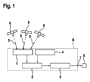
図1には、GNSS受信機8が示されており、GNSS受信機8は、GNSS衛星6を用いて位置特定を実行することができる。GNSS衛星6からの衛星信号5は、ナビゲーションフィルタモジュール1によって受信される。ナビゲーションフィルタモジュール1は、GNSS信号を信号トラッカモジュール2に伝送する。信号トラッカモジュール2は、本明細書において説明された方法を実施するように構成されており、位置特定のためのGNSS衛星6の選択又は組合せを行う。このために、信号トラッカモジュール2は、SVデータモジュール4によって提供されたデータも用いる。このデータには、例えば、電離圏又は対流圏を考慮するための補正データが含まれる。
1 shows a GNSS receiver 8, which can perform position determination using
位置特定用のGNSS衛星6の求められた組合せは、位置特定モジュール3に引き渡される。次いで、位置特定モジュール3は、GNSS衛星6のこの組合せに基づいて各位置を特定し、他の制御装置9への位置データ提供7を実行する。このような制御装置9は、例えば、自動車内の他のシステムの一部であるものとしてよい。
The determined combination of
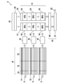
図2は、説明された方法を実施するための詳細な図解を示している。図2に示されたモジュール及びアルゴリズムは、好ましくは、信号トラッカモジュール2内に実装されている。
Figure 2 shows a detailed diagram for implementing the described method. The modules and algorithms shown in Figure 2 are preferably implemented in the
最初に、衛星信号5が求められ、種々異なるソートアルゴリズム11,12,13によって処理される。これは、ステップa)に相当する。角度に基づくソートアルゴリズム11においては、各GNSS衛星6の角度パラメータに基づいて重み付け及びソートが行われる。幾何学的な形状に基づくソートアルゴリズムにおいては、各GNSS衛星6の周回軌道のパラメータに基づいて重み付け及びソートが行われる。測定誤差に基づくソートアルゴリズムにおいては、格納され、推定された分散度データに基づいて重み付け及びソートが行われる。
First, the satellite signals 5 are determined and processed by
各ソートアルゴリズムは、好ましくは、基準カタログ15を含み、この基準カタログ15は、ランキング順序14に従ってソートされており、この基準カタログ15は、衛星プレソート物10を定めるために、この順序に従って処理される。好ましくは、各基準に対して、基準カタログ15内にコストパラメータ16が格納されており、これらのコストパラメータ16は、基準カタログの各基準が衛星プレソート物10にどのように作用するのかを示している。
Each sorting algorithm preferably includes a
このようにして、3つの異なる衛星プレソート物10が生じ、次いで、これらの衛星プレソート物10が、それぞれ重み付け関数17,18に従って重み付けされ、これによって最終的な衛星ソート物20が求められる。これは、説明された方法のステップc)に相当する。衛星プレソート物10と比較して、最終的な衛星ソート物20において、個々のGNSS衛星の位置がずれていることがある。好ましくは、第1の重み付け関数17が存在しており、この第1の重み付け関数17は、GNSS受信機からGNSS衛星への視線ベクトルが基本的に中断され得る、複雑な環境が存在する場合に選択される。好ましくは、第2の重み付け関数18が存在しており、この第2の重み付け関数18は、自由視野が存在し、GNSS受信機からGNSS衛星への視線ベクトルが基本的に自由である場合に選択される。適当な重み付け関数17,18の選択は、選択モジュール22を用いて行われる。この選択モジュール22は、特に、正しい重み付け関数17,18を選択するために、(推測される)現在の位置も考慮する。これは、説明された方法のステップb)に相当する。
In this way, three
次に、最終的な衛星ソート物20に基づいて、衛星組合せ選択21が行われる。これは、説明された方法のステップd)に相当する。
Next, based on the final satellite sorting 20, a
Claims (8)
a)前記衛星信号(5)の前記分散度を考慮する、予め定められた基準カタログ(15)に従って、少なくとも2つの異なるソートアルゴリズム(11,12,13)を用いて前記複数の可視のGNSS衛星(6)をソートし、各前記予め定められた基準カタログ(15)に従って、低い分散度を有する衛星信号(5)を有するGNSS衛星(6)を求める少なくとも2つの衛星プレソート物(10)を求めるステップであって、各前記衛星プレソート物(10)は、前記複数の可視のGNSS衛星(6)をソートすることにより提供された前記複数の可視のGNSS衛星(6)のリスティングを含む、ステップと、
b)ステップa)において作成された前記衛星プレソート物(10)に重み付けする重み付け関数(17,18)を選択するステップと、
c)重み付された最終的な衛星ソート物(20)が生じるように、各前記重み付け関数(17,18)に従って前記衛星プレソート物(10)を重み付けすることによって最終的な衛星ソート物(20)を作成するステップと、
d)前記最終的な衛星ソート物(20)に基づいて、衛星組合せ選択(21)を実行するステップと、
を含み、
ステップa)において、前記複数の可視のGNSS衛星(6)のうちの任意の第1及び第2のGNSS衛星(6)に関する、前記第1のGNSS衛星(6)と前記GNSS受信機(8)の現在位置との間の第1の方向と、前記第2のGNSS衛星(6)と前記GNSS受信機(8)の現在位置との間の第2の方向との間の角度に基づくソートアルゴリズム(11)に従って少なくとも1つのソートを行い、重み付けを、各前記第1及び第2のGNSS衛星(6)の前記角度に基づく角度パラメータに基づいて行い、
ステップa)において、幾何学的な形状に基づくソートアルゴリズム(12)に従って少なくとも1つのソートを行い、重み付けを、各前記GNSS衛星(6)の周回軌道の幾何学的なパラメータに基づいて行い、
ステップa)において、不正確な測定を伴う前記GNSS衛星(6)を位置特定から除外するために、前記角度に基づくソートアルゴリズム(11)又は前記幾何学的な形状に基づくソートアルゴリズム(12)によって、疑似距離測定のモデル化された分散度を使用する、方法。 A method for selecting a combination of GNSS satellites (6) for performing position determination from a plurality of visible GNSS satellites (6) in a GNSS receiver (8) taking into account the degree of dispersion of satellite signals (5) of each GNSS satellite (6), the method comprising the steps of:
a) sorting the plurality of visible GNSS satellites (6) using at least two different sorting algorithms (11, 12, 13) according to a predetermined reference catalog (15) that takes into account the degree of dispersion of the satellite signals (5), and obtaining at least two satellite pre-sorts (10) for GNSS satellites (6) having satellite signals (5) with a low degree of dispersion according to each of the predetermined reference catalogs (15), each of the satellite pre-sorts (10) including a listing of the plurality of visible GNSS satellites (6) provided by sorting the plurality of visible GNSS satellites (6);
b) selecting a weighting function (17, 18) for weighting the satellite presorts (10) created in step a);
c) creating a final satellite sort (20) by weighting said satellite presorts (10) according to each of said weighting functions (17, 18) to produce a weighted final satellite sort (20);
d) performing a satellite combination selection (21) based on said final satellite sorting (20);
Including,
In step a), performing at least one sorting according to a sorting algorithm (11) based on an angle between a first direction between the first GNSS satellite (6) and a current position of the GNSS receiver (8) and a second direction between the second GNSS satellite (6) and a current position of the GNSS receiver (8) for any first and second GNSS satellites (6) of the plurality of visible GNSS satellites (6), weighting being based on an angle-based angle parameter for each of the first and second GNSS satellites (6);
In step a), at least one sorting is performed according to a geometric sorting algorithm (12) and weighting is performed based on geometric parameters of the orbit of each of said GNSS satellites (6);
In step a), the method uses the modeled dispersion of pseudorange measurements by the angle-based sorting algorithm (11) or the geometric shape-based sorting algorithm (12) to exclude the GNSS satellites (6) with inaccurate measurements from position determination .
Applications Claiming Priority (3)
| Application Number | Priority Date | Filing Date | Title |
|---|---|---|---|
| DE102020206975.1 | 2020-06-04 | ||
| DE102020206975.1A DE102020206975A1 (en) | 2020-06-04 | 2020-06-04 | Method for selecting a combination of satellites for a position determination |
| PCT/EP2021/064626 WO2021245058A2 (en) | 2020-06-04 | 2021-06-01 | Method for selecting a satellite combination for a position determination |
Publications (2)
| Publication Number | Publication Date |
|---|---|
| JP2023527897A JP2023527897A (en) | 2023-06-30 |
| JP7581383B2 true JP7581383B2 (en) | 2024-11-12 |
Family
ID=76325512
Family Applications (1)
| Application Number | Title | Priority Date | Filing Date |
|---|---|---|---|
| JP2022574169A Active JP7581383B2 (en) | 2020-06-04 | 2021-06-01 | Method for selecting satellite combinations for position determination - Patents.com |
Country Status (5)
| Country | Link |
|---|---|
| US (1) | US20230103721A1 (en) |
| JP (1) | JP7581383B2 (en) |
| CN (1) | CN115698768A (en) |
| DE (1) | DE102020206975A1 (en) |
| WO (1) | WO2021245058A2 (en) |
Families Citing this family (1)
| Publication number | Priority date | Publication date | Assignee | Title |
|---|---|---|---|---|
| CN117949977B (en) * | 2023-12-25 | 2024-07-26 | 北京航空航天大学 | A satellite selection and delay control method for GNSS forwarding drone deception |
Citations (4)
| Publication number | Priority date | Publication date | Assignee | Title |
|---|---|---|---|---|
| JP2008281553A (en) | 2007-04-09 | 2008-11-20 | Seiko Epson Corp | Current position positioning method, program, storage medium, positioning device and electronic device |
| JP2009121971A (en) | 2007-11-15 | 2009-06-04 | Toyota Motor Corp | Mobile positioning device |
| JP2012108015A (en) | 2010-11-18 | 2012-06-07 | Alpine Electronics Inc | Satellite positioning apparatus |
| WO2017046914A1 (en) | 2015-09-17 | 2017-03-23 | 三菱電機株式会社 | Positioning satellite selecting device, positioning device, positioning system, positioning information transmitting device and positioning terminal |
Family Cites Families (6)
| Publication number | Priority date | Publication date | Assignee | Title |
|---|---|---|---|---|
| US7250904B2 (en) * | 2004-10-08 | 2007-07-31 | Motorola, Inc. | Navigation satellite acquisition in satellite positioning system receiver |
| US7019690B1 (en) * | 2004-10-15 | 2006-03-28 | Telecommunication Systems, Inc. | Culled satellite ephemeris information for quick, accurate assisted locating satellite location determination for cell site antennas |
| CN102401902A (en) * | 2010-09-08 | 2012-04-04 | 神讯电脑(昆山)有限公司 | Satellite state judging method |
| US20140266912A1 (en) * | 2013-03-15 | 2014-09-18 | Nextnav, Llc | Directional pruning of transmitters to improve position determination |
| JP2014219204A (en) * | 2013-05-01 | 2014-11-20 | 三菱電機株式会社 | Mobile information terminal |
| KR102441080B1 (en) * | 2017-12-04 | 2022-09-06 | 현대자동차주식회사 | Positioning device and method using heterogeneous satellite group |
-
2020
- 2020-06-04 DE DE102020206975.1A patent/DE102020206975A1/en active Pending
-
2021
- 2021-06-01 CN CN202180039672.1A patent/CN115698768A/en active Pending
- 2021-06-01 WO PCT/EP2021/064626 patent/WO2021245058A2/en not_active Ceased
- 2021-06-01 US US17/928,522 patent/US20230103721A1/en active Pending
- 2021-06-01 JP JP2022574169A patent/JP7581383B2/en active Active
Patent Citations (4)
| Publication number | Priority date | Publication date | Assignee | Title |
|---|---|---|---|---|
| JP2008281553A (en) | 2007-04-09 | 2008-11-20 | Seiko Epson Corp | Current position positioning method, program, storage medium, positioning device and electronic device |
| JP2009121971A (en) | 2007-11-15 | 2009-06-04 | Toyota Motor Corp | Mobile positioning device |
| JP2012108015A (en) | 2010-11-18 | 2012-06-07 | Alpine Electronics Inc | Satellite positioning apparatus |
| WO2017046914A1 (en) | 2015-09-17 | 2017-03-23 | 三菱電機株式会社 | Positioning satellite selecting device, positioning device, positioning system, positioning information transmitting device and positioning terminal |
Non-Patent Citations (2)
| Title |
|---|
| An-Lin Tao et al.,"Ionospheric correction and satellite selection techniques for medium-range baseline RTK positioning with GPS and QZSS",Proceedings of the 2015 International Technical Meeting of The Institute of Navigation (ITM 2015) ,The Institute of Navigation,2015年01月,pp. 343-352,ISSN:2330-3646 |
| Yun-En Lee et al.,"Combined Algorithm for Satellite Selection for Open-sky and Constrained Environments",Proceedings of the 30th International Technical Meeting of the Satellite Division of The Institute of Navigation (ION GNSS+ 2017) ,日本,The Institute of Navigation,2017年09月,pp. 3680-3693,DOI:10.33012/2017.15178, ISSN:2331-5911 |
Also Published As
| Publication number | Publication date |
|---|---|
| CN115698768A (en) | 2023-02-03 |
| JP2023527897A (en) | 2023-06-30 |
| WO2021245058A3 (en) | 2022-02-10 |
| DE102020206975A1 (en) | 2021-12-09 |
| US20230103721A1 (en) | 2023-04-06 |
| WO2021245058A2 (en) | 2021-12-09 |
Similar Documents
| Publication | Publication Date | Title |
|---|---|---|
| US11422271B2 (en) | Protection level generation methods and systems for applications using navigation satellite system (NSS) observations | |
| US6259398B1 (en) | Multi-valued variable ambiguity resolution for satellite navigation signal carrier wave path length determination | |
| JP4146877B2 (en) | Single positioning device and single positioning method | |
| US11781868B2 (en) | System and method for GNSS reflective surface mapping and position fix estimation | |
| EP0679901A2 (en) | Position estimation using satellite range rate measurements | |
| JP2010528321A (en) | Partial search carrier phase integer ambiguity determination | |
| US11156722B2 (en) | Post-processing global navigation satellite system (GNSS) position data using mirrored GNSS data | |
| CN113376675A (en) | Urban canyon positioning method based on GNSS/vision/Lidar fusion | |
| WO2023236643A1 (en) | Positioning method and apparatus, device and storage medium | |
| US10514467B2 (en) | Up sampling reference station data | |
| JP7581383B2 (en) | Method for selecting satellite combinations for position determination - Patents.com | |
| Ćwian et al. | GNSS-augmented LiDAR SLAM for accurate vehicle localization in large scale urban environments | |
| JP2023169881A (en) | Method and system for predicting GNSS location quality on roads in urban environments | |
| Suzuki | Open-source factor graph optimization package for GNSS: Examples and applications | |
| CN118818571B (en) | GNSS positioning method, device, GNSS receiver and storage medium | |
| CN113917509B (en) | Double-difference ambiguity fixing method, device and readable storage medium | |
| CN106707311B (en) | GLONASS RTK localization method based on GPS enhancing | |
| CN117434565A (en) | A fusion positioning method and device based on multiple receiving antennas | |
| Li et al. | Inertial aided cycle slip detection and repair for PPP/INS tightly coupled navigation | |
| CN115585807A (en) | GNSS/INS integrated navigation method based on machine learning | |
| EP3647819B1 (en) | Post-processing global navigation satellite system (gnss) position data using mirrored gnss data | |
| CN119689536B (en) | GNSS positioning method, system, terminal and medium based on signal-to-noise ratio arc segment analysis | |
| CN120195711B (en) | A method, device, equipment and storage medium for robust multi-frequency ambiguity resolution based on semi-tight combination | |
| EP4354182A1 (en) | Post-processing of global navigation satellite system (gnss) data | |
| CN118091718B (en) | A method to improve UT1 solution accuracy through downlink navigation signals from low-orbit satellites |
Legal Events
| Date | Code | Title | Description |
|---|---|---|---|
| A521 | Request for written amendment filed |
Free format text: JAPANESE INTERMEDIATE CODE: A523 Effective date: 20221201 |
|
| A621 | Written request for application examination |
Free format text: JAPANESE INTERMEDIATE CODE: A621 Effective date: 20221201 |
|
| A131 | Notification of reasons for refusal |
Free format text: JAPANESE INTERMEDIATE CODE: A131 Effective date: 20230808 |
|
| A601 | Written request for extension of time |
Free format text: JAPANESE INTERMEDIATE CODE: A601 Effective date: 20231108 |
|
| A521 | Request for written amendment filed |
Free format text: JAPANESE INTERMEDIATE CODE: A523 Effective date: 20240205 |
|
| A131 | Notification of reasons for refusal |
Free format text: JAPANESE INTERMEDIATE CODE: A131 Effective date: 20240514 |
|
| A521 | Request for written amendment filed |
Free format text: JAPANESE INTERMEDIATE CODE: A523 Effective date: 20240813 |
|
| TRDD | Decision of grant or rejection written | ||
| A01 | Written decision to grant a patent or to grant a registration (utility model) |
Free format text: JAPANESE INTERMEDIATE CODE: A01 Effective date: 20241002 |
|
| A61 | First payment of annual fees (during grant procedure) |
Free format text: JAPANESE INTERMEDIATE CODE: A61 Effective date: 20241030 |
|
| R150 | Certificate of patent or registration of utility model |
Ref document number: 7581383 Country of ref document: JP Free format text: JAPANESE INTERMEDIATE CODE: R150 |