JP6414255B2 - Semantic representation of road scene situations for understanding and sharing of road scene situations - Google Patents
Semantic representation of road scene situations for understanding and sharing of road scene situations Download PDFInfo
- Publication number
- JP6414255B2 JP6414255B2 JP2017040721A JP2017040721A JP6414255B2 JP 6414255 B2 JP6414255 B2 JP 6414255B2 JP 2017040721 A JP2017040721 A JP 2017040721A JP 2017040721 A JP2017040721 A JP 2017040721A JP 6414255 B2 JP6414255 B2 JP 6414255B2
- Authority
- JP
- Japan
- Prior art keywords
- road
- lane
- data
- scene
- vehicle
- Prior art date
- Legal status (The legal status is an assumption and is not a legal conclusion. Google has not performed a legal analysis and makes no representation as to the accuracy of the status listed.)
- Active
Links
Images


Classifications
-
- G—PHYSICS
- G08—SIGNALLING
- G08G—TRAFFIC CONTROL SYSTEMS
- G08G1/00—Traffic control systems for road vehicles
- G08G1/16—Anti-collision systems
- G08G1/167—Driving aids for lane monitoring, lane changing, e.g. blind spot detection
-
- G—PHYSICS
- G01—MEASURING; TESTING
- G01C—MEASURING DISTANCES, LEVELS OR BEARINGS; SURVEYING; NAVIGATION; GYROSCOPIC INSTRUMENTS; PHOTOGRAMMETRY OR VIDEOGRAMMETRY
- G01C21/00—Navigation; Navigational instruments not provided for in groups G01C1/00 - G01C19/00
- G01C21/26—Navigation; Navigational instruments not provided for in groups G01C1/00 - G01C19/00 specially adapted for navigation in a road network
- G01C21/34—Route searching; Route guidance
- G01C21/3407—Route searching; Route guidance specially adapted for specific applications
- G01C21/3415—Dynamic re-routing, e.g. recalculating the route when the user deviates from calculated route or after detecting real-time traffic data or accidents
-
- G—PHYSICS
- G01—MEASURING; TESTING
- G01C—MEASURING DISTANCES, LEVELS OR BEARINGS; SURVEYING; NAVIGATION; GYROSCOPIC INSTRUMENTS; PHOTOGRAMMETRY OR VIDEOGRAMMETRY
- G01C21/00—Navigation; Navigational instruments not provided for in groups G01C1/00 - G01C19/00
- G01C21/26—Navigation; Navigational instruments not provided for in groups G01C1/00 - G01C19/00 specially adapted for navigation in a road network
- G01C21/34—Route searching; Route guidance
- G01C21/36—Input/output arrangements for on-board computers
- G01C21/3602—Input other than that of destination using image analysis, e.g. detection of road signs, lanes, buildings, real preceding vehicles using a camera
-
- G—PHYSICS
- G06—COMPUTING; CALCULATING OR COUNTING
- G06V—IMAGE OR VIDEO RECOGNITION OR UNDERSTANDING
- G06V20/00—Scenes; Scene-specific elements
- G06V20/20—Scenes; Scene-specific elements in augmented reality scenes
-
- G—PHYSICS
- G06—COMPUTING; CALCULATING OR COUNTING
- G06V—IMAGE OR VIDEO RECOGNITION OR UNDERSTANDING
- G06V20/00—Scenes; Scene-specific elements
- G06V20/50—Context or environment of the image
- G06V20/56—Context or environment of the image exterior to a vehicle by using sensors mounted on the vehicle
- G06V20/588—Recognition of the road, e.g. of lane markings; Recognition of the vehicle driving pattern in relation to the road
-
- G—PHYSICS
- G06—COMPUTING; CALCULATING OR COUNTING
- G06V—IMAGE OR VIDEO RECOGNITION OR UNDERSTANDING
- G06V20/00—Scenes; Scene-specific elements
- G06V20/70—Labelling scene content, e.g. deriving syntactic or semantic representations
-
- G—PHYSICS
- G08—SIGNALLING
- G08G—TRAFFIC CONTROL SYSTEMS
- G08G1/00—Traffic control systems for road vehicles
- G08G1/09—Arrangements for giving variable traffic instructions
- G08G1/0962—Arrangements for giving variable traffic instructions having an indicator mounted inside the vehicle, e.g. giving voice messages
- G08G1/0967—Systems involving transmission of highway information, e.g. weather, speed limits
- G08G1/096708—Systems involving transmission of highway information, e.g. weather, speed limits where the received information might be used to generate an automatic action on the vehicle control
- G08G1/096716—Systems involving transmission of highway information, e.g. weather, speed limits where the received information might be used to generate an automatic action on the vehicle control where the received information does not generate an automatic action on the vehicle control
-
- G—PHYSICS
- G08—SIGNALLING
- G08G—TRAFFIC CONTROL SYSTEMS
- G08G1/00—Traffic control systems for road vehicles
- G08G1/09—Arrangements for giving variable traffic instructions
- G08G1/0962—Arrangements for giving variable traffic instructions having an indicator mounted inside the vehicle, e.g. giving voice messages
- G08G1/0967—Systems involving transmission of highway information, e.g. weather, speed limits
- G08G1/096733—Systems involving transmission of highway information, e.g. weather, speed limits where a selection of the information might take place
- G08G1/09675—Systems involving transmission of highway information, e.g. weather, speed limits where a selection of the information might take place where a selection from the received information takes place in the vehicle
-
- G—PHYSICS
- G08—SIGNALLING
- G08G—TRAFFIC CONTROL SYSTEMS
- G08G1/00—Traffic control systems for road vehicles
- G08G1/09—Arrangements for giving variable traffic instructions
- G08G1/0962—Arrangements for giving variable traffic instructions having an indicator mounted inside the vehicle, e.g. giving voice messages
- G08G1/0967—Systems involving transmission of highway information, e.g. weather, speed limits
- G08G1/096766—Systems involving transmission of highway information, e.g. weather, speed limits where the system is characterised by the origin of the information transmission
- G08G1/096791—Systems involving transmission of highway information, e.g. weather, speed limits where the system is characterised by the origin of the information transmission where the origin of the information is another vehicle
-
- H—ELECTRICITY
- H04—ELECTRIC COMMUNICATION TECHNIQUE
- H04W—WIRELESS COMMUNICATION NETWORKS
- H04W84/00—Network topologies
- H04W84/005—Moving wireless networks
-
- H—ELECTRICITY
- H04—ELECTRIC COMMUNICATION TECHNIQUE
- H04W—WIRELESS COMMUNICATION NETWORKS
- H04W84/00—Network topologies
- H04W84/18—Self-organising networks, e.g. ad-hoc networks or sensor networks
Description
本開示は道路シーン処理(road scene processing)に関する。より詳細な例では、本
開示は、道路シーン記述を作成し、車両間で交換するための技術に関する。
The present disclosure relates to road scene processing. In a more detailed example, the present disclosure relates to techniques for creating and exchanging road scene descriptions between vehicles.
最近の新式の車両は、ドライバ支援、乗員の安全・快適さ、診断・保守目的の外部サービスとの通信などに関する様々な異なるアプリケーションのために、外部環境などの車両の環境についての情報に依存している。しかしながら、これらの既存の手法は、一般に、自車両の挙動を適合させるためだけにその情報を使用している。これらの車両は、通常、他の近隣車両によって実行されている処理を把握しておらず、そのような状況を自身で検出できずに最新の状況に対処することができないか、または、このような状況を不完全または不正確しか把握できず、その範囲内でしか対処することができない。結果として、車載システムは、不正確な情報を乗員に提供することがあり、また、システムによって提供される運転支援は、ユーザの運転経験や安全を改善させなかったり、場合によっては悪化させたりすることがある。 Recent new vehicles rely on information about the vehicle's environment, such as the external environment, for a variety of different applications related to driver assistance, occupant safety and comfort, and communication with external services for diagnostic and maintenance purposes. ing. However, these existing approaches generally use that information only to adapt the behavior of the vehicle. These vehicles are usually not aware of the processes being performed by other neighboring vehicles and are unable to detect such situations themselves and are unable to cope with the latest situation or The situation is only incomplete or inaccurate and can only be addressed within that scope. As a result, in-vehicle systems may provide inaccurate information to occupants, and the driving assistance provided by the system may not improve or even worsen the user's driving experience and safety. Sometimes.
いくつかの例示的なアプリケーションでは、ナビゲーションシステムは、現在の道路シーン情報を他の車両と共有(シェア)する作業をユーザが行うことを要求する。詳細には、これらのソリューションは、他のドライバが知るべき交通状況を中央通信基盤にプロアクティブに報告することをユーザに要求する。そして、中央通信基盤は、そのような情報をシステムの他の車両にブロードキャストする。しかしながら、これらの既存の技法は、状況を報告するユーザによる道路シーンの主観的な観測および評価の影響を受ける。また、これらのソリューションは、ユーザが運転している際に、望ましくない注意散漫を引き起こす可能性がある。 In some exemplary applications, the navigation system requires a user to perform work to share current road scene information with other vehicles. Specifically, these solutions require the user to proactively report traffic conditions that other drivers should know to the central communications infrastructure. The central communications infrastructure then broadcasts such information to other vehicles in the system. However, these existing techniques are subject to subjective observation and evaluation of the road scene by the user reporting the situation. These solutions can also cause undesirable distraction when the user is driving.
上記の問題点を考慮して、本発明は、現在の道路シーン状況のセマンティック記述を、複数の車両および/または基盤の間で確実かつ自動的に交換することを目的とする。 In view of the above problems, the present invention aims to reliably and automatically exchange semantic descriptions of current road scene situations between multiple vehicles and / or platforms.
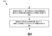
本開示に記載される主題の1つの発明的態様によれば、システムは、1つまたは複数のプロセッサ、ならびに、1つまたは複数のプロセッサによって実行されると、道路区間上の第1の車両に関連付けられた1つまたは複数のセンサから、道路シーンデータおよび車両動作データを受信することと、状況オントロジーデータを受信することと、道路シーンデータ、車両動作データ、および状況オントロジーデータを使用して、道路区間のセマンティック道路シーン記述を自動的に作成することと、通信ネットワークを介して、道路区間に関連付けられた1つまたは複数の他の車両にセマンティック道路シーン記述を送信することとをシステムに行わせる命令を記憶する、1つまたは複数のメモリを含む。 In accordance with one inventive aspect of the subject matter described in this disclosure, a system is implemented on one or more processors and a first vehicle on a road segment when executed by one or more processors. Receiving road scene data and vehicle motion data, receiving situation ontology data from the associated sensor or sensors, and using the road scene data, vehicle motion data, and situation ontology data; The system automatically creates a semantic road scene description for a road segment and transmits the semantic road scene description to one or more other vehicles associated with the road segment via a communication network. One or more memories for storing instructions to be stored.
一般に、本開示に記載される主題の別の発明的態様は、道路区間上の第1の車両に関連付けられた1つまたは複数のセンサから、道路シーンデータおよび車両動作データを受信することと、状況オントロジーデータを受信することと、道路シーンデータ、車両動作データ、および状況オントロジーデータを使用して、道路区間のセマンティック道路シーン記述を自動的に作成することと、通信ネットワークを介して、道路区間に関連付けられた1つまたは複数の他の車両にセマンティック道路シーン記述を送信することとを含む方法
において具現化することができる。
In general, another inventive aspect of the subject matter described in this disclosure includes receiving road scene data and vehicle motion data from one or more sensors associated with a first vehicle on a road segment; Receiving situation ontology data; automatically creating a semantic road scene description of a road section using road scene data, vehicle motion data, and situation ontology data; and via a communication network, a road section And transmitting the semantic road scene description to one or more other vehicles associated with the.
他の態様は、上記その他の発明的態様のための対応する方法、システム、装置、およびコンピュータプログラム製品を含む。 Other aspects include corresponding methods, systems, apparatuses, and computer program products for the above and other inventive aspects.
上記その他の実装形態は、各々、場合によっては、以下の特徴および/または動作のうちの1つまたは複数を含む場合がある。たとえば、一実施形態では、状況オントロジーデータが道路シーン状況を記述するための1つまたは複数のあらかじめ定義されたセマンティック用語(semantic term)を含んでもよい。 Each of the other implementations may optionally include one or more of the following features and / or operations. For example, in one embodiment, the context ontology data may include one or more predefined semantic terms for describing road scene conditions.
また一実施形態では、道路シーンデータに基づいて1つまたは複数の静的道路物体を検出し、検出された静的道路物体に基づいて道路区間の1つまたは複数の車線を特定してもよい。 In one embodiment, one or more static road objects may be detected based on the road scene data, and one or more lanes of the road section may be identified based on the detected static road objects. .
また一実施形態では、道路区間の1つまたは複数の車線を特定することが、道路区間に関連付けられた地図データを受信し、地図データおよび検出された静的道路物体に基づいて道路区間の1つまたは複数の車線を特定することを含んでもよい。 Also, in one embodiment, identifying one or more lanes of a road segment receives map data associated with the road segment, and determines one of the road segments based on the map data and the detected static road object. Identifying one or more lanes may be included.
また一実施形態では、道路シーンデータに基づいて1つまたは複数の動的道路物体を検出し、車線情報および動的道路物体情報に基づいて車線ごとの車線レベルアクティビティ情報を特定し、車線情報および動的道路物体情報に基づいて車線ごとの車線レベル空間レイアウトを特定してもよい。 In one embodiment, one or more dynamic road objects are detected based on road scene data, lane level activity information for each lane is identified based on lane information and dynamic road object information, and lane information and A lane level space layout for each lane may be specified based on the dynamic road object information.
また一実施形態では車線レベルアクティビティ情報を特定することが、1つまたは複数の動的道路物体の動きおよび車線位置を空間的および時間的に監視し、1つまたは複数の動的道路物体の監視された動きおよび監視された車線位置に基づいて車線ごとの車線レベルアクティビティ情報を作成することを含んでもよい。 Also, in one embodiment, identifying lane level activity information may monitor movement and lane position of one or more dynamic road objects spatially and temporally and monitor one or more dynamic road objects. Creating lane level activity information for each lane based on the monitored movement and the monitored lane position.
また一実施形態では、動きおよび車線位置を空間的および時間的に監視することが、検出された動的道路物体の各々に一意の物体識別子を割り当て、割り当てられた物体識別子に基づいて動的道路物体の動きおよび車線位置を空間的および時間的に監視することを含むことを含んでもよい。 Also, in one embodiment, spatial and temporal monitoring of movement and lane position assigns a unique object identifier to each detected dynamic road object and the dynamic road is based on the assigned object identifier. Including spatially and temporally monitoring object movement and lane position.
また一実施形態では、車線ごとの車線レベル空間レイアウトを特定することが、道路シーンデータに基づいて各車線内の動的道路物体の数を特定し、各車線内の動的道路物体の数および第1の車両に関連付けられた1つまたは複数のセンサのセンサ範囲に基づいて車線ごとの車線レベル空間レイアウトを特定することを含んでもよい。 Also, in one embodiment, identifying a lane level space layout for each lane identifies the number of dynamic road objects in each lane based on road scene data, and determines the number of dynamic road objects in each lane and Identifying a lane level space layout for each lane based on a sensor range of one or more sensors associated with the first vehicle may be included.
また一実施形態では、道路シーンデータに基づいて道路区間に関連付けられた地域属性、明暗属性、気象属性、およびシーンレベルコンテキストのうちの1つまたは複数を特定し、気象属性および車両動作データに基づいて道路区間に関連付けられた路面状態を特定し、車線ごとの車線レベルアクティビティ情報を特定し、車線ごとの車線レベル空間レイアウトを特定することであって、道路区間の作成されたセマンティック道路シーン記述が、道路区間に関連付けられた地域属性、明暗属性、気象属性、シーンレベルコンテキスト、路面状態、車線ごとの車線レベルアクティビティ情報、および車線ごとの車線レベル空間レイアウトのうちの1つまたは複数を含む、特定することを含んでもよい。 In one embodiment, one or more of a regional attribute, a light and dark attribute, a weather attribute, and a scene level context associated with the road segment are identified based on the road scene data, and based on the weather attribute and the vehicle motion data. The road surface condition associated with the road section, the lane level activity information for each lane, the lane level space layout for each lane, and the semantic road scene description created for the road section. Specific, including one or more of: regional attributes associated with road segments, light and dark attributes, weather attributes, scene level context, road surface conditions, lane level activity information for each lane, and lane level space layout for each lane May include.
また一実施形態では、道路区間に関連付けられた2つ以上の車両から、それぞれ、2つ以上の他のセマンティック道路シーン記述を受信し、2つ以上の他のセマンティック道路シーン記述の各々の中の1つまたは複数の態様に基づいて2つ以上の他のセマンティック
道路シーン記述を調整させ、調整したセマンティック道路シーン記述に基づいて道路区間に関する1つまたは複数の外部状態を特定し、1つまたは複数の外部状態に基づいて1つまたは複数の対話型ルーチンを実行することを含んでもよい。
In one embodiment, two or more other semantic road scene descriptions are received from two or more vehicles associated with the road segment, respectively, and each of the two or more other semantic road scene descriptions is Two or more other semantic road scene descriptions are adjusted based on one or more aspects, and one or more external states for the road segment are identified based on the adjusted semantic road scene descriptions, and the one or more May include executing one or more interactive routines based on the external state.
また一実施形態では、2つ以上の他のセマンティック道路シーン記述の各々の少なくとも1つの態様が車線情報であり、2つ以上の他のセマンティック道路シーン記述を調整させることが、2つ以上の他のセマンティック道路シーン記述の各々に含まれる車線情報に基づいて2つ以上の他のセマンティック道路シーン記述を調整させることを含んでもよい。 Also, in one embodiment, at least one aspect of each of the two or more other semantic road scene descriptions is lane information, and adjusting the two or more other semantic road scene descriptions to more than one other Adjusting two or more other semantic road scene descriptions based on lane information included in each of the semantic road scene descriptions.
また一実施形態では、道路区間に関連付けられた地図データを受信し、2つ以上の他のセマンティック道路シーン記述を調整させることが、2つ以上の他のセマンティック道路シーン記述の各々および地図データに含まれる車線情報に基づいて2つ以上の他のセマンティック道路シーン記述を調整させることを含んでもよい。 Also, in one embodiment, receiving map data associated with a road segment and adjusting two or more other semantic road scene descriptions includes in each of the two or more other semantic road scene descriptions and the map data. Adjusting two or more other semantic road scene descriptions based on the included lane information may be included.
また一実施形態では、1つまたは複数の対話型ルーチンを実行することが、1つまたは複数の外部状態に基づいてナビゲーションガイダンスを作成し、第1の車両のユーザにナビゲーションガイダンスを提供することを含んでもよい。 In one embodiment, executing one or more interactive routines creates navigation guidance based on one or more external conditions and provides navigation guidance to a user of the first vehicle. May be included.
また一実施形態では、1つまたは複数の他の車両が第1の車両の無線周波通信範囲内にあり、通信ネットワークが車両対車両ネットワークおよび車両対基盤ネットワークのうちの1つであることと、道路シーンデータが1つまたは複数の光学センサによって取り込まれた画像データを含んでもよい。 In one embodiment, the one or more other vehicles are within the radio frequency communication range of the first vehicle, and the communication network is one of a vehicle-to-vehicle network and a vehicle-to-base network, Road scene data may include image data captured by one or more optical sensors.
本開示における「道路シーン状況」は、道路における状況(situation)を表し、道路
・道路上または道路近傍のある物体・道路を取り巻く環境等の状態を含む概念である。道路の状態には、例えば、車線の数、通行規制の有無および内容、路面状態などが含まれる。道路上または道路近傍の物体には、車両(自動車、トラック、自動二輪車等)、歩行者、道路工事作業員、交通標識、ガードレール、中央分離帯、障害物、路側機などが含まれる。これらの物体の状態には、それらの位置、移動方向、移動速度および加速度、目的地などが含まれる。道路を取り巻く環境には、気象、明暗、日時などが含まれる。
本開示において「シーンレベルコンテキスト」は、道路に関するコンテキストを表し、気象、明暗、日時、交通状況(交通渋滞、道路工事、運転し易さ(度合い)、横断可能な道路領域)などが含まれる。
本開示において「車線レベルアクティビティ」は、車線上の道路物体が行っている活動を表す。車線レベルアクティビティは、例えば、どの車両がどの車線上を走行あるいは停止しているか、その移動速度、移動方向などを表す。また、移動以外の任意の動作もアク車線レベルティビティに含まれてよい。
本開示において「車線レベル空間レイアウト」は、道路上の道路物体の車線ごとの空間配置を表す。車線レベル空間レイアウトは、ある車線上での物体間の距離や位置関係を含む。
本開示における「セマンティック道路シーン記述」は、道路シーン状況を要約するものである。セマンティック道路シーン記述は、あらかじめ定義されたオントロジーを用いて表現することができる。
The “road scene situation” in the present disclosure represents a situation on the road, and is a concept including a state of an environment surrounding an object / road on or near the road / road. The road condition includes, for example, the number of lanes, the presence and content of traffic restrictions, the road surface condition, and the like. Objects on or near the road include vehicles (cars, trucks, motorcycles, etc.), pedestrians, road construction workers, traffic signs, guardrails, median strips, obstacles, roadside machines, and the like. The state of these objects includes their position, moving direction, moving speed and acceleration, destination, and the like. The environment surrounding the road includes weather, light and dark, date and time.
In the present disclosure, the “scene level context” represents a context related to a road, and includes weather, light and dark, date and time, traffic conditions (traffic jam, road construction, ease of driving (degree), road area that can be traversed), and the like.
In the present disclosure, “lane level activity” represents an activity performed by a road object on the lane. The lane level activity represents, for example, which vehicle is traveling or stopped on which lane, its moving speed, moving direction, and the like. Further, any operation other than movement may be included in the Ak lane level activity.
In the present disclosure, “lane level space layout” represents a spatial arrangement of road objects on a road for each lane. The lane level space layout includes the distance and positional relationship between objects on a certain lane.
The “semantic road scene description” in the present disclosure summarizes the road scene situation. The semantic road scene description can be expressed using a predefined ontology.
本開示における「道路物体(roadway object)」は、道路上または道路近傍に存在する物体である。「道路物体」は、「静的道路物体」と「動的道路物体」に分類できる。「静的道路物体」は、道路に対して移動しない物体である。ここで「移動しない」というのは、所定の時間スパンで移動しないことを意味する。静的道路物体には、例えば、車線、交通信号、道路標識、トラフィックコーン、バリケードが含まれる。「動的道路物体」は、
道路に対して移動する物体であり、例えば、車両(自動車、トラック、自動二輪車等)、歩行者、道路工事作業員が含まれる。
A “roadway object” in the present disclosure is an object that exists on or near a road. “Road objects” can be classified into “static road objects” and “dynamic road objects”. A “static road object” is an object that does not move relative to the road. Here, “does not move” means that it does not move in a predetermined time span. Static road objects include, for example, lanes, traffic signals, road signs, traffic cones, barricades. "Dynamic road objects"
An object that moves relative to a road, and includes, for example, vehicles (automobiles, trucks, motorcycles, etc.), pedestrians, and road construction workers.
本開示において提示される道路シーン状況を理解し、共有するための新規の技術は、いくつかの点で特に有利である。たとえば、本明細書に記載される技術により、現在の道路シーン状況のセマンティック記述が、複数の車両および/または基盤の間で確実かつ自動的に交換されることが可能になる。 The novel techniques for understanding and sharing the road scene situation presented in this disclosure are particularly advantageous in several respects. For example, the techniques described herein allow a semantic description of current road scene conditions to be reliably and automatically exchanged between multiple vehicles and / or platforms.
さらなる例として、本明細書に記載される技術により、シーン内の物体間関係を考慮に入れ、シーン内の複数の物体ならびにシーン自体のコンテキストからの情報を集約することによって、現在の状況のセマンティック記述に時空間情報が含められる。したがって、本技術により、ドライバの安全および運転経験を改善するために様々なアプリケーションにおいて使用するための現在の道路シーン状況の包括的理解を与えることができる。さらに、ユーザの介入なしに複数の車両から道路シーン情報を自動的に集約および送信することにより、運転時のユーザに不要な注意散漫を引き起こすことも回避することができる。 As a further example, the techniques described herein allow for the semantics of the current situation by taking into account the relationships between objects in the scene and aggregating information from multiple objects in the scene as well as the context of the scene itself. Spatio-temporal information is included in the description. Thus, the present technology can provide a comprehensive understanding of current road scene situations for use in various applications to improve driver safety and driving experience. Further, by automatically collecting and transmitting road scene information from a plurality of vehicles without user intervention, it is possible to avoid causing unnecessary distraction to the user during driving.
上記の利点は例として提供されたこと、および本技法は多数の他の利点および利益を有することができることを理解されたい。 It should be understood that the above advantages have been provided by way of example, and that the present techniques can have numerous other advantages and benefits.
本開示は、添付図面の図において限定としてではなく例として示され、添付図面では、同様の構成要素を参照するために同様の参照番号が使用される。
本明細書に記載される技術は、現在の道路シーン状況を処理および理解し、容易に交換
可能なフォーマットで現在の道路シーン状況を表すことができるものである。シーン状況の交換は、車車間(V2V)プロトコルを使用した複数の車両の間や、車路間/路車間(V2I/I2V)プロトコルを使用した車両と路側機(インフラストラクチャー。基盤とも称する。)の間で行われる。下記でさらに詳細に記載されるように、いくつかの実施形態では、交換されるべきセマンティック道路シーン記述は、対象車両の環境の様々な側面を記述することができ、一例として、内部環境や外部環境が含まれる。たとえば、当該記述は、車両が存在・移動している道路区間(road segment)に関連付けられた1つまたは複数の外部状態(outside condition)を含む。そのような状態の非限定的な例には、現
在のシーン構成要素(current scene composition)、個々のオブジェクト属性(たとえ
ば、車両の色やモデル)、シーン内に存在する1つまたは複数の道路物体によって実行されるアクティビティとそのアクティビティタイプ、シーン内の物体間関係(object-to-object relationship)、シーンパラメータなどが含まれる。シーンパラメータの非限定的
な例には、気象状態、明暗状態、地域のタイプ、運転のし易さの基準(ease-of-drive metric)、横断可能な道路領域などが含まれる。通信範囲内の別の車両からセマンティック記述を受信する車両は、セマンティック道路シーン記述から必要な情報を抽出し、それを処理して予測サービスをその乗員に提供することができる。
The techniques described herein are capable of processing and understanding the current road scene situation and representing the current road scene situation in an easily interchangeable format. The scene situation is exchanged between a plurality of vehicles using a vehicle-to-vehicle (V2V) protocol, or between a vehicle and a roadside device (infrastructure, also referred to as infrastructure) using a vehicle-to-vehicle / road-to-vehicle (V2I / I2V) protocol. Between. As described in more detail below, in some embodiments, the semantic road scene description to be exchanged can describe various aspects of the target vehicle's environment, such as the internal environment and the external The environment is included. For example, the description includes one or more outside conditions associated with a road segment in which the vehicle is present / moving. Non-limiting examples of such conditions include the current scene composition, individual object attributes (eg, vehicle color and model), and one or more road objects present in the scene. This includes the activities performed by and their activity types, object-to-object relationships in the scene, scene parameters, and so on. Non-limiting examples of scene parameters include weather conditions, light and dark conditions, region types, ease-of-drive metric, crossable road areas, and the like. A vehicle that receives a semantic description from another vehicle in communication range can extract the necessary information from the semantic road scene description and process it to provide a prediction service to its occupant.
図1は、道路シーン状況を処理および理解し、道路区間に関連付けられたセマンティック道路シーン記述を作成・共有するための例示的なシステム100のブロック図である。図示されたシステム100は、サーバ101と、地図サーバ170と、基盤サーバ190と、クライアントデバイス115と、移動プラットフォーム135とを含む。システム100のエンティティは、ネットワーク105を介して通信可能に結合される。図1に描写されたシステム100は、例示を目的として提供され、本開示によって考察されるシステム100および/またはさらなるシステムは、追加の構成要素を含んだり一部の構成要素を含まなかったりする場合があり、また、構成部品を組み合わせたり、構成部品のうちの1つまたは複数をさらなる構成部品に分割したりすることができることなどを理解されたい。たとえば、システム100は、任意の数の移動プラットフォーム135、クライアントデバイス115、基盤サーバ190、地図サーバ170、またはサーバ101を含む場合がある。追加または代替として、システム100は、ユーザから音声コマンドを受信し処理するための音声サーバ、検索クエリに該当する検索結果を提供するための検索サーバなどを含む場合がある。
FIG. 1 is a block diagram of an
ネットワーク105は、従来のタイプの有線またはワイヤレスであり得るし、星形構成、トークンリング構成、または他の構成を含む、多数の様々な構成を有する場合がある。さらに、ネットワーク105は、1つまたは複数のローカルエリアネットワーク(LAN)、ワイドエリアネットワーク(WAN)(たとえば、インターネット)、公衆ネットワーク、プライベートネットワーク、仮想ネットワーク、ピアツーピアネットワーク、および/または、複数のデバイスがそれを介して通信することができる他の相互接続データパスを含む場合がある。たとえば、ネットワーク105は、車両対車両ネットワーク、車両対基盤/基盤対車両ネットワークなどを含む場合がある。
ネットワーク105はまた、様々な異なる通信プロトコルでデータを送るための電気通信ネットワークの部分に結合されるか、またはそれらを含む場合がある。いくつかの実施形態では、ネットワーク105は、ショートメッセージングサービス(SMS)、マルチメディアメッセージングサービス(MMS)、ハイパーテキスト転送プロトコル(HTTP)、直接データ接続、WAP、電子メールなどを介して、データを送受信するためのBluetooth(登録商標)通信ネットワークまたはセルラー通信ネットワークを含む。いくつかの実施形態では、ネットワーク105は、DSRC、WAVE、802.11p、3G、4G、5G+ネットワーク、WiFi(登録商標)、または任意の他のワイヤレスネットワークなどの接続を使用するワイヤレスネットワークである。図1は、サーバ
101、地図サーバ170、基盤サーバ190、クライアントデバイス115、および移動プラットフォーム135に結合するネットワーク105用の単一ブロックを示すが、ネットワーク105は、実際には、上述されたように、ネットワークの任意の数の組合せを備える場合があることを理解されたい。
サーバ101は、プロセッサ、メモリ、およびネットワーク通信能力(たとえば、通信ユニット)を含むハードウェアサーバおよび/または仮想サーバを含むことができる。サーバ101は、信号線104によって表されるように、ネットワーク105に通信可能に結合することができる。いくつかの実施形態では、サーバ101は、地図サーバ170、基盤サーバ190、クライアントデバイス115、および移動プラットフォーム135のうちの1つまたは複数との間でデータを送受信することができる。サーバ101は、本明細書の中の他の場所でさらに説明されるように、道路シーンアプリケーションのインスタンス109aおよび状況オントロジーデータベース103を含む場合がある。
Server 101 may include a hardware server and / or a virtual server including a processor, memory, and network communication capabilities (eg, a communication unit). Server 101 can be communicatively coupled to
状況オントロジーデータベース(situation ontology database)103は、道路シー
ン状況を記述するための用語データ(terminology data)を記憶することができる。図1では、サーバ101が状況オントロジーデータベース103を含むものとして示されているが、移動プラットフォーム135および/またはクライアントデバイス115が、追加および/または代替として、用語データを記憶する場合があることを理解されたい。たとえば、移動プラットフォーム135および/またはクライアントデバイス115は、状況オントロジーデータベース103のインスタンスを含む場合があり、状況オントロジーデータベース103からのデータをキャッシュする(たとえば、様々な間隔で用語データをダウンロードする)ことなどができる。たとえば、用語データは、移動プラットフォーム135の中に事前に記憶/インストールされ、セットアップまたは最初の使用時に記憶および/またはリフレッシュされ、様々な間隔で複製されるなどの場合がある。さらなる実施形態では、状況オントロジーデータベース103からのデータは、実行時に要求/ダウンロードされる場合がある。他の適切な変形形態も可能であり、考えられる。
The
用語データは言語フレームワークを表すことができる。図11は、状況オントロジーデータベース103に記憶される状況オントロジーデータの一例を示す。図示されたように、状況オントロジーデータは、気象状態、明暗状態、フロントガラスの状態、路面状態、道路物体のタイプ、道路物体のアクティビティ、道路物体の相対速度などを記述するための、あらかじめ定義されたセマンティック用語を含む場合がある。たとえば、気象状態を記述するために、セマンティック道路シーン記述は、以下の言葉:晴れ、曇り、部分的に曇り、雨、雪、豪雨、および霧のうちの1つまたは複数を含む場合がある。別の例として、セマンティック道路シーン記述は、特定の移動プラットフォーム135の相対運動を遅いまたは速いと定量化することができる。いくつかの実施形態では、これらの特定のあらかじめ定義されたセマンティック用語は、移動プラットフォーム135間、および移動プラットフォーム135とシステム100内の基盤との間の通信用の共通用語の基礎(common terminology basis)を提供する。結果として、これらのエンティティは、相互に適用可能、解釈可能、および互いに理解可能なセマンティック道路シーン記述を作成することができる。いくつかの実施形態では、状況オントロジーデータベース103は、データを記憶しデータへのアクセスを提供するためのデータベース管理システム(DBMS)を含む場合があるか、またはその一部であり得る。
The term data can represent a language framework. FIG. 11 shows an example of situation ontology data stored in the
クライアントデバイス115は、メモリ、プロセッサ、および通信ユニットを含むコンピューティングデバイスである。クライアントデバイス115は、ネットワーク105に結合可能であり、サーバ101、地図サーバ170、基盤サーバ190、および移動プラットフォーム135(ならびに/またはネットワーク105に結合されたシステムの任意の他の構成部品)のうちの1つまたは複数との間でデータを送受信することができる。ク
ライアントデバイス115の非限定的な例には、ラップトップコンピュータ、デスクトップコンピュータ、タブレットコンピュータ、モバイル電話、携帯情報端末(PDA)、モバイル電子メールデバイス、または、情報を処理し、ネットワーク105にアクセスすることが可能な任意の他の電子デバイスが含まれる。いくつかの実施形態では、クライアントデバイスは、1つまたは複数のセンサ106を含む場合がある。
The client device 115 is a computing device that includes a memory, a processor, and a communication unit. The client device 115 can be coupled to the
いくつかの実施形態では、クライアントデバイス115は、ナビゲーションアプリケーションのインスタンス117bを含む場合があり、ナビゲーションアプリケーションは、セマンティック道路シーン記述から抽出された現在の道路シーン情報を利用して、ユーザにナビゲーション指示を与える。ユーザ125は、線110によって示されるように、クライアントデバイス115と対話することができる。図1は1つのクライアントデバイス115を示すが、システム100は1つまたは複数のクライアントデバイス115を含むことができる。
In some embodiments, the client device 115 may include an instance 117b of a navigation application that uses the current road scene information extracted from the semantic road scene description to provide navigation instructions to the user. give.
移動プラットフォーム135は、メモリ、プロセッサ、および通信ユニットを有するコンピューティングデバイスを含む。そのようなプロセッサの例には、1つまたは複数のセンサ、アクチュエータ、モチベータなどの、移動プラットフォーム135の他の構成部品に結合された、電子制御ユニット(ECU)または他の適切なプロセッサが含まれ得る。移動プラットフォーム135は、信号線134を介してネットワーク105に結合することができ、サーバ101、地図サーバ170、基盤サーバ190、およびクライアントデバイス115のうちの1つまたは複数との間でデータを送受信することができる。いくつかの実施形態では、移動プラットフォーム135は、ある点(位置)から別の点(位置)に移動することが可能である。移動プラットフォーム135は、移動可能コンピュータあるいは移動端末と称することもできる。移動プラットフォーム135の非限定的な例には、車両(vehicle)、自動車(automobile)、バス、ボート、飛行機、生体工学インプラ
ント、スマートフォン端末、タブレット端末、ポータブルコンピュータ端末、または、非一時的コンピュータエレクトロニクス(たとえば、プロセッサ、メモリ、もしくは非一時的コンピュータエレクトロニクスの任意の組合せ)を有する任意の他のモバイルシステムが含まれる。ユーザ125は、線154によって表されるように、移動プラットフォーム135と対話することができる。ユーザ125は、移動プラットフォーム135を運転する人間のユーザであり得る。たとえば、ユーザ125は車両のドライバであり得る。
The mobile platform 135 includes a computing device having a memory, a processor, and a communication unit. Examples of such processors include an electronic control unit (ECU) or other suitable processor coupled to other components of the mobile platform 135, such as one or more sensors, actuators, motivators, etc. obtain. Mobile platform 135 can be coupled to
移動プラットフォーム135は、1つまたは複数のセンサ106と、車両CAN(コントローラエリアネットワーク)データストア107と、道路シーンデータストレージ108と、ナビゲーションアプリケーションのインスタンス117aとを含むことができる。図1は1つの移動プラットフォーム135を示すが、システム100は1つまたは複数の移動プラットフォーム135を含むことができる。
The mobile platform 135 may include one or
車両CANデータストア107は、移動プラットフォーム135のコントローラエリアネットワーク(CAN)を使用して、移動プラットフォーム135の様々なモジュール間で通信されている様々なタイプの車両動作データ(車両CANデータと呼ばれることもある)を記憶する。いくつかの実施形態では、車両動作データは、移動プラットフォーム135の様々な構成部品の動作状態を監視するための、これらの構成部品に結合された複数のセンサ106から収集される。車両CANデータの例には、限定はしないが、速度、加速度、減速度、車輪速度(毎分回転数−RPM)、車輪スリップ、トラクション制御情報、牽引制御情報、ワイパー制御情報、ステアリング角、制動力などが含まれる。いくつかの実施形態では、車両動作データは、移動プラットフォーム135の現在位置を記述する位置データ(たとえば、GPS(全地球測位システム)座標)を含む場合もある。他の標準的な車両動作データも考えられる。いくつかの実施形態では、車両CANデータストア107は、データを記憶しデータへのアクセスを提供するためのデータストレージシステ
ム(たとえば、標準のデータまたはデータベースの管理システム)の一部であり得る。
The vehicle CAN data store 107 uses the controller area network (CAN) of the mobile platform 135 to communicate various types of vehicle operational data (also referred to as vehicle CAN data) that are communicated between the various modules of the mobile platform 135. Remember). In some embodiments, vehicle operational data is collected from a plurality of
道路シーンデータストレージ108は、移動プラットフォーム135の1つまたは複数のセンサによって取り込まれた道路シーンデータを記憶する。道路シーンデータは、移動プラットフォーム135の外部環境を記述するデータであり、外部環境には、車道や当該車道に沿って位置する他の物体が含まれる。いくつかの実施形態では、移動プラットフォーム135の1つまたは複数の第1のセンサ106は、移動プラットフォーム135の動作に関するセンサデータを取り込むことができる。このセンサデータは、処理され、車両動作データとして車両CANデータストア107に記憶され、かつ/または、本明細書の中の他の場所で説明されるように、道路シーンアプリケーション109に供給される場合がある。車両動作データのさらなる非限定的な例には、限定はしないが、速度、加速度、減速度、車輪速度、車輪スリップ、トラクション制御情報、牽引制御情報、ワイパー制御情報、ステアリング角、制動力などが含まれる。いくつかのさらなる実施形態では、移動プラットフォーム135の1つまたは複数の第2のセンサ106は、移動プラットフォーム135の外部および/または周囲の環境を記述するシーンデータを取り込むことができる。このシーンデータは、処理され、道路シーンデータとして道路シーンデータストレージ108に記憶され、かつ/または、本明細書の中の他の場所で説明されるように、道路シーンアプリケーション109に供給される場合がある。
The road scene data storage 108 stores road scene data captured by one or more sensors of the mobile platform 135. The road scene data is data describing the external environment of the mobile platform 135. The external environment includes a roadway and other objects located along the roadway. In some embodiments, the one or more
道路シーンデータに関するさらなる例では、センサ106は、屋内環境または屋外環境のビデオ画像および静止画像を含む画像を記録するように構成された1つまたは複数の光学センサを含む場合があり、任意の適用可能なフレームレートを使用してビデオストリームのフレームを記憶することができ、任意の適用可能な方法を使用して取り込まれたビデオ画像および静止画像を符号化および/または処理することができ、それらのセンサ範囲内の周辺環境の画像を取り込むことができる。たとえば、移動プラットフォームのコンテキストでは、センサ106は、移動プラットフォーム135のまわりの環境、例えば、道路、空、山、路側構造体、ビルディング、木、動的道路物体(たとえば、周囲の移動プラットフォーム135、歩行者、道路工事作業員など)、および/または静的道路物体(たとえば、車線、交通信号、道路標識、トラフィックコーン、バリケードなど)を取り込むことができる。いくつかの実施形態では、センサ106は、移動プラットフォーム135の経路に対していずれの方向(前方、後方、横方向、上方、下方、対向など)でも検知するように取り付けることができる。いくつかの実施形態では、1つまたは複数のセンサ106は、多方向(たとえば、LIDAR)であり得る。
In a further example for road scene data, the
サーバ101、移動プラットフォーム135および/またはクライアントデバイス115は、道路シーンアプリケーションのインスタンス109a、109b、および109c(本明細書では単に109とも呼ばれる)を含む場合がある。いくつかの構成では、道路シーンアプリケーション109は、異なる位置における異なるデバイス上にネットワーク105を介して分散配置される場合があり、その場合は、クライアントデバイス115、移動プラットフォーム135および/またはサーバ101は、各々、道路シーンアプリケーション109の種々の態様(同じ、同様、異なるなど)を備える道路シーンアプリケーション109のインスタンスを含む場合がある。たとえば、道路シーンアプリケーションの各インスタンス109a、109b、および109cは、下記でより詳細に説明される、図2Bに描写される副構成部品および/またはこれらの副構成部品の様々な変形形態のうちの1つまたは複数を備える場合がある。いくつかの実施形態では、道路シーンアプリケーション109は、たとえば、図2Bに描写される構成要素のすべてを備えるネイティブアプリケーションであり得る。
Server 101, mobile platform 135 and / or client device 115 may include road scene application instances 109a, 109b, and 109c (also referred to herein simply as 109). In some configurations, the road scene application 109 may be distributed over the
他の変形形態および/または組合せも可能であり、考えられる。図1に示されたシステム100は例示的なシステムの代表であり、様々な異なるシステム環境およびシステム構
成が考えられ、本開示の範囲内にあることを理解されたい。たとえば、様々な行為および/または機能をサーバからクライアントに、またはその逆に移動することができ、データは、単一のデータストアに統合されるか、または追加のデータストアの中にさらにセグメント化される場合があり、いくつかの実装形態は、追加のまたはより少ないコンピューティングデバイス、サービス、および/またはネットワークを含む場合があり、様々な機能のクライアントまたはサーバ側を実装する場合がある。さらに、システムの様々なエンティティは、単一のコンピューティングデバイスもしくはシステムの中に統合されるか、または追加のコンピューティングデバイスもしくはシステムの中に分割される場合などがある。
Other variations and / or combinations are possible and contemplated. It should be understood that the
道路シーンアプリケーション109は、道路シーンデータを処理し、道路シーン状況を推論し、セマンティック道路シーン記述を作成し、他の移動プラットフォーム135からの道路シーン記述を処理することなどを行うように実行可能なソフトウェアおよび/またはハードウェア論理を含む。いくつかの実施形態では、道路シーンアプリケーション109は、1つもしくは複数のコンピュータデバイスの1つもしくは複数のプロセッサによって実行可能なソフトウェア、限定はしないが、フィールドプログラマブルゲートアレイ(FPGA)、特定用途向け集積回路(ASIC)などのハードウェア、および/またはハードウェアとソフトウェアの組合せなどを使用して実装することができる。道路シーンアプリケーション109は、少なくとも図2〜図8を参照して下記でより詳細に記載される。 The road scene application 109 is executable to process road scene data, infer road scene conditions, create semantic road scene descriptions, process road scene descriptions from other mobile platforms 135, etc. Includes software and / or hardware logic. In some embodiments, the road scene application 109 is software executable by one or more processors of one or more computing devices, including but not limited to a field programmable gate array (FPGA), application specific integration. It can be implemented using hardware such as a circuit (ASIC) and / or a combination of hardware and software. The road scene application 109 is described in more detail below with reference to at least FIGS.
ナビゲーションアプリケーション117は、ユーザにナビゲーション指示を与えるように実行可能なソフトウェアおよび/またはハードウェア論理を含む。いくつかの実施形態では、ナビゲーションアプリケーション117は、1つもしくは複数のコンピュータデバイスの1つもしくは複数のプロセッサによって実行可能なソフトウェア、限定はしないが、フィールドプログラマブルゲートアレイ(FPGA)、特定用途向け集積回路(ASIC)などのハードウェア、および/またはハードウェアとソフトウェアの組合せなどを使用して実装することができる。 The navigation application 117 includes software and / or hardware logic that is executable to provide navigation instructions to the user. In some embodiments, the navigation application 117 is software executable by one or more processors of one or more computing devices, including but not limited to field programmable gate arrays (FPGAs), application specific integrated circuits. It can be implemented using hardware such as (ASIC) and / or a combination of hardware and software.
ナビゲーションアプリケーション117は、位置データ(たとえば、GPS三角測量)を受信し、対応するコンピューティングデバイスに供給するように構成された、地理位置トランシーバ(たとえば、GPS)などのセンサ106からのデータを利用することができる。たとえば、移動プラットフォーム135および/またはクライアントデバイス115は、そのような地理位置トランシーバを備えている場合があり、ナビゲーションアプリケーション117の対応するインスタンスは、そのようなトランシーバからの位置データを受信し処理するように構成される場合がある。
The navigation application 117 utilizes data from a
いくつかの実施形態では、第1の移動プラットフォーム135上で動作する道路シーンアプリケーション109のインスタンスは、(たとえば、第1の移動プラットフォーム135の通信範囲内の)他の移動プラットフォーム135から道路シーン記述を受信し、場合によってはローカルに作成された道路シーン記述とともに、受信された道路シーン記述を処理して、第1の移動プラットフォーム135、およびより具体的には、移動プラットフォーム135と対話しているユーザに関する包括的な現在の道路シーン状況を特定することができる。限定ではなく例として、ユーザの第1の移動プラットフォーム135および/またはクライアントデバイス115上で動作するナビゲーションアプリケーション117のインスタンスは、移動プラットフォーム135および/またはクライアントデバイス115の1つまたは複数の出力デバイス(たとえば、スピーカシステム、ディスプレイ上に表示されるグラフィカルユーザインターフェースなど)を介して、道路シーンアプリケーション109によって特定された現在の道路シーン状況に基づくナビゲーション指示をユーザに与えることができる。場合によっては、受信される道路シーン記述は、本明細
書の中の他の場所で説明されるように、ある時点に第1の移動プラットフォーム135のある特定の範囲内に位置する道路シーンアプリケーション109のインスタンスから受信される場合がある。
In some embodiments, an instance of the road scene application 109 running on the first mobile platform 135 can receive road scene descriptions from other mobile platforms 135 (eg, within communication range of the first mobile platform 135). A user interacting with the first mobile platform 135 and, more specifically, the mobile platform 135, processing the received road scene description along with the possibly locally generated road scene description. A comprehensive current road scene situation can be identified. By way of example and not limitation, an instance of a navigation application 117 running on a user's first mobile platform 135 and / or client device 115 may include one or more output devices (eg, mobile platform 135 and / or client device 115). Navigation instructions based on the current road scene situation identified by the road scene application 109 can be provided to the user via a speaker system, a graphical user interface displayed on the display, etc. In some cases, the received road scene description is a road scene application 109 that is located within a certain range of the first mobile platform 135 at some point in time, as described elsewhere herein. May be received from an instance of.
センサ106は、移動プラットフォーム135および/またはクライアントデバイス115に適した任意のタイプのセンサを含む場合がある。センサ106は、コンピューティングデバイスおよび/またはその周辺環境の特性を判断することに適した任意のタイプのデータを収集するように構成される場合がある。センサ106の非限定的な例には、様々な光学センサ(CCD、CMOS、2D、3D、レーザーイメージング検出・測距(LIDAR)、カメラなど)、オーディオセンサ、動き検出センサ、気圧計、高度計、熱電対、湿度センサ、IRセンサ、レーダーセンサ、他の光センサ、ジャイロスコープ、加速度計、速度計、ステアリングセンサ、制動センサ、スイッチ、車両インジケータセンサ、ワイパーセンサ、地理位置センサ、トランシーバ、ソナーセンサ、超音波センサ、タッチセンサ、近接センサなどが含まれる。
移動プラットフォーム135および/またはクライアントデバイス115のプロセッサ(たとえば、図2参照)は、センサデータを受信し処理することができる。移動プラットフォーム135のコンテキストでは、プロセッサは、車などの移動プラットフォーム135に実装された電子制御ユニット(ECU)であり得るが、他の移動プラットフォームのタイプも考えられる。ECUは、センサデータを受信し、道路シーンアプリケーション109によるアクセス・取出しのために車両動作データとして車両CANデータストア107に記憶することができる。さらなる例では、車両動作データは、(受信および/または処理されると、たとえば、車両バス、ECUなどを介して)道路シーンアプリケーション109に、より直接的に供給される。他の適切な変形形態も可能であり、考えられる。さらなる例として、1つまたは複数のセンサ106は、道路区間上を移動している移動プラットフォーム135(たとえば、車両)から画像データを取り込むことができ、画像データは道路区間を含むシーンを描写する。道路シーンアプリケーション109は、本明細書の中の他の場所でさらに説明されるように、(たとえば、バス、ECUなどを介して)センサ106から画像データ(たとえば、リアルタイムビデオストリーム、一連の静止画像など)を受信し、それを処理して現在の道路シーン状況を特定することができる。
The processor (eg, see FIG. 2) of mobile platform 135 and / or client device 115 can receive and process sensor data. In the context of mobile platform 135, the processor may be an electronic control unit (ECU) implemented in mobile platform 135, such as a car, although other mobile platform types are also contemplated. The ECU can receive the sensor data and store it in the vehicle CAN data store 107 as vehicle operation data for access and retrieval by the road scene application 109. In a further example, vehicle motion data is provided more directly to the road scene application 109 (eg, via a vehicle bus, ECU, etc., when received and / or processed). Other suitable variations are possible and contemplated. As a further example, one or
地図サーバ170は、プロセッサ、メモリ、およびネットワーク通信能力を有するハードウェアサーバおよび/または仮想サーバを含む。いくつかの実施形態では、地図サーバ170は、サーバ101、基盤サーバ190、移動プラットフォーム135、およびクライアントデバイス115のうちの1つまたは複数との間でデータを送受信する。たとえば、地図サーバ170は、特定の道路区間を含む地理空間領域の地図を記述するデータを、道路シーンアプリケーション109およびナビゲーションアプリケーション117のうちの1つまたは複数に送る。地図サーバ170は、信号線171を介してネットワーク105に通信可能に結合される。いくつかの実施形態では、地図サーバ170は、関心地点(POI)データベース172および地図データベース174を含む。
The map server 170 includes a hardware server and / or a virtual server having a processor, memory, and network communication capabilities. In some embodiments, the map server 170 sends data to and receives data from one or more of the server 101, infrastructure server 190, mobile platform 135, and client device 115. For example, the map server 170 sends data describing a map of a geospatial region that includes a particular road segment to one or more of the road scene application 109 and the navigation application 117. Map server 170 is communicatively coupled to
関心地点(POI)データベース172は、様々な地理的領域についての関心地点(POI)を記述するデータを記憶する。たとえば、POIデータベース172は、様々な道路区間に沿った観光地、ホテル、レストラン、ガソリンスタンド、大学スタジアム、ランドマークなどを記述するデータを記憶する。いくつかの実施形態では、POIデータベース172は、データを記憶しデータへのアクセスを提供するためのデータベース管理システム(DBMS)を含む場合がある。地図データベース174は、1つまたは複数の地理的領域に関連する地図を記述するデータを記憶する。いくつかの実施形態では、地図データは、地上部分における1つまたは複数の地理的領域を記述することができる。たとえば、地図データは、特定の道路に関連付けられた1つまたは複数の車線を記述する情報を含
む場合がある。より具体的には、地図データは、道路の進行方向、その道路上の車線の数、その道路の出口および入口、1つまたは複数の車線が特殊な状況を有している(たとえば、カープール車線である)かどうか、それらの車線における道路の状態、それらの車線についての交通および/または事故のデータ、それらの車線に関連する交通規制(たとえば、車線標識、路面標識、交通信号、交通標識など)などを記述することができる。いくつかの実施形態では、地図データベース174は、データを記憶しデータへのアクセスを提供するためのデータベース管理システム(DBMS)を含み、かつ/またはそれに関連付けられる場合がある。
Point of interest (POI)
基盤サーバ190は、プロセッサ、メモリ、およびネットワーク通信能力を有するハードウェアサーバおよび/または仮想サーバを含む。いくつかの実施形態では、基盤サーバ190は、サーバ101、地図サーバ170、移動プラットフォーム135、およびクライアントデバイス115のうちの1つまたは複数との間でデータを送受信する。いくつかの実施形態では、基盤サーバ190および/またはそれに結合された基盤コンポーネント(たとえば、タワーなど)は、移動プラットフォーム135とデータを交換するためのV2I/I2V通信プロトコルを利用する。基盤コンポーネント(基盤構成部品)の非限定的な例には、路側ユニット、たとえば、車道に沿って配備された固定ステーションなどが含まれる。基盤サーバ190は、自身が受信または交換したデータ、例えば、移動プラットフォーム135が他の移動プラットフォームに送信した道路シーン記述(V2Vデータ)や基盤サーバ190に送信した道路シーン記述(V2I/I2Vデータ)などを、V2Vデータストア192、V2I/I2Vデータストア194などの1つまたは複数の対応するデータリポジトリに記憶する。いくつかの実施形態では、V2Vデータストア192および/またはV2I/I2Vデータストア194は、データを記憶しデータへのアクセスを提供するためのデータベース管理システム(DBMS)を含み、かつ/またはそれに関連付けられる場合がある。移動プラットフォーム135および基盤は、ワイヤレス接続を介して、ネットワーク105に含まれるV2V通信ネットワークおよび/またはV2I/I2V通信ネットワークに通信可能に結合することができる。いくつかの実施形態では、移動プラットフォーム135および基盤は、それらの無線周波通信範囲内にあるネットワークに結合された他のエンティティにメッセージを送信し、それらからメッセージを受信することができる。
The base server 190 includes a hardware server and / or a virtual server having a processor, memory, and network communication capability. In some embodiments, the infrastructure server 190 sends data to and receives data from one or more of the server 101, the map server 170, the mobile platform 135, and the client device 115. In some embodiments, infrastructure server 190 and / or infrastructure components coupled thereto (eg, a tower, etc.) utilize a V2I / I2V communication protocol for exchanging data with mobile platform 135. Non-limiting examples of base components (base components) include roadside units, such as fixed stations deployed along a roadway. The base server 190 receives or exchanges data, for example, a road scene description (V2V data) transmitted by the mobile platform 135 to another mobile platform, a road scene description (V2I / I2V data) transmitted to the base server 190, and the like. Are stored in one or more corresponding data repositories, such as V2V data store 192, V2I /
図2Aは、サーバ101、クライアントデバイス115、移動プラットフォーム135、地図サーバ170、または基盤サーバ190のアーキテクチャを表すことができる、コンピューティングデバイス200のブロック図である。
FIG. 2A is a block diagram of a
描写されたように、コンピューティングデバイス200は、1つまたは複数のプロセッサ213と、1つまたは複数のメモリ215と、通信ユニット217と、1つまたは複数のセンサ106と、1つまたは複数の入力および/または出力デバイス219と、1つまたは複数のデータストア221とを含む。コンピューティングデバイス200の構成部品は、バス210によって通信可能に結合される。コンピューティングデバイス200がサーバ101、クライアントデバイス115、または移動プラットフォーム135を表す実装形態では、コンピューティングデバイス200は、ナビゲーションアプリケーション117および/または道路シーンアプリケーションを含む場合がある。さらに、コンピューティングデバイス200がサーバ101、地図サーバ170、および/または基盤サーバ190を表す実装形態では、コンピューティングデバイス200は、状況オントロジー103、POIデータベース172、地図データベース174、V2Vデータストア192、および/またはV2I/I2Vデータストア194などの、対応するデータリポジトリ221を含む場合がある。
As depicted, the
図2Aに描写されたコンピューティングデバイス200は例として提供され、それらは
、本開示の範囲から逸脱することなく、他の形態を取り、追加のまたはより少ない構成部品を含む場合があることを理解されたい。たとえば、図示されていないが、コンピューティングデバイス200は、様々なオペレーティングシステム、ソフトウェア構成部品、ハードウェア構成部品、および他の物理構成を含む場合がある。
The
コンピューティングデバイス200が移動プラットフォーム135に含まれるか、または組み込まれる実施形態では、コンピューティングデバイス200は、プラットフォームバス(たとえば、CAN)、1つまたは複数のセンサ(たとえば、1つまたは複数の制御ユニット(たとえば、ECU、ECM、PCMなど)、自動車用センサ、音響センサ、化学センサ、生体工学センサ、位置センサ(たとえば、GPS、コンパス、加速度計、ジャイロスコープなど)、スイッチ、およびコントローラ、カメラなど)、エンジン、動力伝達装置、サスペンションコンポーネント、計器(instrumentation)、温度調節器、およ
び/または、必要な任意の他の電気的、機械的、構造的、および機械的な構成部品などの、移動プラットフォーム135の様々なプラットフォーム構成部品を含み、かつ/またはそれらに結合される場合がある。
In embodiments where the
プロセッサ213は、様々な入力/出力演算、論理演算、および/または数学演算を実施することによって、ソフトウェア命令を実行することができる。プロセッサ213は、たとえば、複合命令セットコンピュータ(CISC)アーキテクチャ、縮小命令セットコンピュータ(RISC)アーキテクチャ、および/または命令セットの組合せを実装するアーキテクチャを含む、データ信号を処理する様々なコンピューティングアーキテクチャを有する場合がある。プロセッサ213は、実体および/または仮想であり得るし、シングルコアまたは複数の処理ユニットおよび/もしくはコアを含む場合がある。いくつかの実装形態では、プロセッサ213は、電子表示信号を生成し、ディスプレイデバイス(図示せず)に供給し、画像の表示をサポートし、画像を取り込み送信し、様々なタイプの特徴抽出およびサンプリングなどを含む複雑なタスクを実行することが可能であり得る。いくつかの実装形態では、プロセッサ213は、バス210を介してメモリ215に結合されて、そこからデータおよび命令にアクセスし、その中にデータを記憶することができる。バス210は、コンピューティングデバイス200の他の構成部品、たとえば、メモリ215、通信ユニット217、センサ106、入力/出力デバイス219、および/またはデータストア221を、プロセッサ213と結合することができる。
The
メモリ215は、データを記憶し、コンピューティングデバイス200の他の構成部品にデータへのアクセスを提供することができる。いくつかの実装形態では、メモリ215は、プロセッサ213によって実行され得る命令および/またはデータを記憶することができる。たとえば、コンピューティングデバイス200の構成に応じて、メモリ215は、アプリケーション117および/または109のうちの1つまたは複数を記憶することができる。メモリ215は、たとえば、本明細書に記載された様々なデータ、オペレーティングシステム、ハードウェアドライバ、他のソフトウェアアプリケーション、データベースなどを含む、他の命令およびデータを記憶することも可能である。メモリ215は、プロセッサ213およびコンピューティングデバイス200の他の構成部品との通信のために、バス210に結合することができる。
Memory 215 can store data and provide access to the data to other components of
メモリ215は、プロセッサ213によって、またはプロセッサ213とともに処理するための、命令、データ、コンピュータプログラム、ソフトウェア、コード、ルーチンなどを、含有、記憶、通信、伝搬、または搬送することができる任意の有形非一時的な装置またはデバイスであり得る、非一時的コンピュータ使用可能(たとえば、読取り可能、書込み可能などの)媒体を含む。いくつかの実装形態では、メモリ215は、揮発性メモリおよび不揮発性メモリのうちの1つまたは複数を含む場合がある。たとえば、メモリ215は、限定はしないが、ダイナミックランダムアクセスメモリ(DRAM)デバイス、ス
タティックランダムアクセスメモリ(SRAM)デバイス、ディスクリートメモリデバイス(たとえば、PROM、FPROM、ROM)、ハードディスクドライブ、光ディスクドライブ(CD、DVD、Blu−ray(登録商標)など)のうちの1つまたは複数を含む場合がある。メモリ215は単一のデバイスであり得るか、または複数のタイプのデバイスおよび構成を含む場合があることを理解されたい。
Memory 215 may be any tangible non-transitory that may contain, store, communicate, propagate, or carry instructions, data, computer programs, software, code, routines, etc. for processing by or with
通信ユニット217は、通信ユニット217がワイヤレス接続および/または有線接続を使用して、(たとえば、ネットワーク105を介して)通信可能に結合された他のコンピューティングデバイスにデータを送信し、それらからデータを受信する。通信ユニット217は、データを送受信するための1つまたは複数の有線インターフェースおよび/またはワイヤレストランシーバを含む場合がある。通信ユニット217は、ネットワーク105に結合し、(構成に応じて)クライアントデバイス115、移動プラットフォーム135、および/またはサーバ101などの他のコンピューティングノードと通信することができる。通信ユニット217は、上記で説明された通信方法などの標準の通信方法を使用して、他のコンピューティングノードとデータを交換することができる。
The
データストア221は、データを記憶する非一時的記憶媒体を含む。非限定的で例示的な非一時的記憶媒体には、ダイナミックランダムアクセスメモリ(DRAM)デバイス、スタティックランダムアクセスメモリ(SRAM)デバイス、フラッシュメモリ、ハードディスクドライブ、フロッピーディスクドライブ、ディスクベースのメモリデバイス(たとえば、CD、DVD、Blu−ray(登録商標)など)、フラッシュメモリデバイス、または他の何らかの既知の有形揮発性もしくは不揮発性ストレージデバイスが含まれ得る。図2Aによって表されたコンピューティングデバイスに応じて、データストアは、状況オントロジーデータストア103、車両CANデータストア107、道路シーンデータストア108、POIデータベース172、地図データベース174、V2Vデータストア192、および/またはV2I/I2Vデータストア194のうちの1つまたは複数を表すことができる。
The data store 221 includes a non-transitory storage medium that stores data. Non-limiting exemplary non-transitory storage media include dynamic random access memory (DRAM) devices, static random access memory (SRAM) devices, flash memory, hard disk drives, floppy disk drives, disk-based memory devices (e.g. , CD, DVD, Blu-ray®, etc.), flash memory device, or any other known tangible volatile or non-volatile storage device. Depending on the computing device represented by FIG. 2A, the data store includes a situation
データストア221は、コンピューティングデバイス200、あるいは、別のコンピューティングデバイス、および/またはコンピューティングデバイス200とは別個であるが、それと結合されたりアクセス可能なストレージシステムに含まれたりする場合がある。いくつかの実施形態では、データストア221は、サーバ101、地図サーバ170、基盤サーバ190、移動プラットフォーム135、および/またはクライアントデバイス115によって動作可能なデータベース管理システム(DBMS)と共同して、データを記憶することができる。たとえば、DBMSは、構造化照会言語(SQL)のDBMS、非SQLのDBMSなどを含む可能性がある。場合によっては、DBMSは、行と列から構成される多次元テーブルにデータを記憶し、プログラムに基づいた演算を使用して、データの行を操作、すなわち、挿入、問合せ、更新、および/または削除することができる。
Data store 221 may be separate from
入力/出力(I/O)デバイス219は、情報を入力および/または出力するための任意の標準デバイスを含む。非限定的で例示的なIOデバイス219には、ユーザ125に道路シーン情報を表示するためのスクリーン(たとえば、LEDベースのディスプレイ)、ユーザ125に音声情報を出力するためのオーディオ再生デバイス(たとえば、スピーカ)、音声コマンドおよび/もしくはボイスコマンドを取り込むためのマイクロフォン、キーボード、タッチスクリーン、ポインティングデバイス、インジケータ、ならびに/または、ユーザ125との通信および/もしくは対話を容易にするための任意の他のI/O構成部品が含まれ得る。入力/出力デバイス219は、直接または介在するI/Oコントローラを介してのいずれかで、コンピューティングデバイス200に結合することができる。
Input / output (I / O)
道路シーンアプリケーション109は、(たとえば、データストア221および/またはセンサ106から)道路シーンデータを受信し、道路シーンデータを処理して様々なタイプのシーン情報を抽出することができる。たとえば、道路シーンアプリケーション109は、画像データに基づいて、限定はしないが、地域性、明暗状態、気象状態、シーン構成要素(たとえば、動的道路物体、静的道路物体)、シーンレベルコンテキストなどを含むシーン情報を特定することができる。さらなる非限定的な例として、道路シーンアプリケーション109は、1つまたは複数の光センサおよび/またはレーダーセンサ(たとえば、1つまたは複数のカメラ)から画像データを受信し、画像データを処理して、特定の道路区間に関連付けられた様々なタイプの道路シーン情報を抽出することができる。 The road scene application 109 can receive road scene data (eg, from the data store 221 and / or sensor 106) and process the road scene data to extract various types of scene information. For example, the road scene application 109 may include, but is not limited to, regionality, light / dark conditions, weather conditions, scene components (eg, dynamic road objects, static road objects), scene level context, etc. based on image data. The scene information to be included can be specified. As a further non-limiting example, the road scene application 109 receives image data from one or more light sensors and / or radar sensors (eg, one or more cameras), processes the image data, Various types of road scene information associated with a specific road section can be extracted.
いくつかの実施形態では、道路シーンアプリケーション109は、たとえば、道路シーンデータから抽出されたシーン情報および移動プラットフォーム135から受信された車両動作データを使用して、道路シーン状況の1つまたは複数の態様を効率的に特定することができる。これらの態様には、限定はしないが、所与の道路区間の路面状態、道路区間の各車線に関連付けられた車線レベルアクティビティ情報、道路区間の各車線に関連付けられた車線レベル空間レイアウト、道路区間に関連付けられた気象、道路区間に関連付けられた明暗などが含まれ得る。 In some embodiments, the road scene application 109 uses one or more aspects of the road scene situation using, for example, scene information extracted from the road scene data and vehicle motion data received from the mobile platform 135. Can be identified efficiently. These aspects include, but are not limited to, road surface conditions for a given road section, lane level activity information associated with each lane of the road section, lane level space layout associated with each lane of the road section, road section May include weather associated with, light and dark associated with road segments, and the like.
道路シーンアプリケーション109は、状況オントロジーデータを適用してセマンティック道路シーン記述を作成することができ、セマンティック道路シーン記述は、本明細書の中の他の場所でさらに記載されるように、道路区間の道路シーン状況を要約するものである。セマンティック道路シーン記述は、道路区間に関連付けられた他の移動プラットフォーム135、たとえば、道路区間に近接している移動プラットフォーム135(たとえば、道路区間に接している移動プラットフォーム135、現在の移動プラットフォーム135の前方または後方のあらかじめ決定された距離内で移動している移動プラットフォーム135)に送信することができる。 The road scene application 109 can apply the situation ontology data to create a semantic road scene description, the semantic road scene description being as described further elsewhere in the specification. It summarizes the road scene situation. Semantic road scene descriptions may include other mobile platforms 135 associated with the road segment, eg, a mobile platform 135 that is proximate to the road segment (eg, mobile platform 135 adjacent to the road segment, forward of the current mobile platform 135 Or it can be transmitted to a moving platform 135) that is moving within a predetermined distance behind.
例示的な道路シーンアプリケーション109のブロック図を描写する図2Bに示されたように、道路シーンアプリケーション109は、POI抽出器252と、シーンプロセッサ254と、アクティビティアグリゲータ256と、空間レイアウトエンコーダ258と、道路状態推定器260と、セマンティック記述作成器262と、インターフェースエンジン264とを含む場合があるが、道路シーンアプリケーション109は、限定はしないが、構成エンジン、トレーニングエンジン、暗号化エンジンなどのさらなる構成部品を含む場合があり、かつ/またはこれらの様々な構成部品は、単一のエンジンに組み合わされるか、もしくはさらなるエンジンに分割される場合があることを理解されたい。
As shown in FIG. 2B depicting a block diagram of an exemplary road scene application 109, the road scene application 109 includes a
POI抽出器252、シーンプロセッサ254、アクティビティアグリゲータ256、空間レイアウトエンコーダ258、道路状態推定器260、セマンティック記述作成器262、および/またはインターフェースエンジン264は、ソフトウェア、ハードウェア、または上記の組合せとして実装することができる。いくつかの実装形態では、POI抽出器252、シーンプロセッサ254、アクティビティアグリゲータ256、空間レイアウトエンコーダ258、道路状態推定器260、セマンティック記述作成器262、および/またはインターフェースエンジン264は、バス210および/またはプロセッサ213により、互いに、かつ/またはコンピューティングデバイス200の他の構成部品に、通信可能に結合することができる。いくつかの実装形態では、構成部品109、252、254、256、258、260、262、および/または264のうちの1つまたは複数は、それらの機能を実現するためにプロセッサ213によって実行可能な命令のセットである。さらなる実装形態では、構成部品109、252、254、256、258、260、262、および/または264のうちの1つまたは複数は、メモリ215に記憶
可能であり、それらの機能を実現するためにプロセッサ213によってアクセス可能かつ実行可能である。上記の実装形態のいずれにおいても、これらの構成部品109、252、254、256、258、260、262、および/または264は、プロセッサ213およびコンピューティングデバイス200の他の構成部品との連携および通信に適合することができる。
The
POI抽出器252は、地図データを受信するために、メモリ215、通信ユニット217、データストア221、および/または他の構成部品に結合することができ、地図データから道路区間に関連付けられた1つまたは複数の関心地点(POI)および/またはランドマークを抽出することができる。いくつかの実施形態では、POI抽出器252は、たとえば、トランシーバ(たとえば、GPSデバイス)、測位システム、および/または車両CANデータストア107から、移動プラットフォーム135の現在位置に関連付けられた地理位置データ(たとえば、GPS座標)を受信することができる。次いで、POI抽出器252は、地理位置データを使用してPOIデータベース172および/または地図データベース174を検索することにより、移動プラットフォーム135の現在位置に近い1つまたは複数の関心地点および/またはランドマークを特定することができる。
The
一例として、車両が高速道路I−15を走行しており、GPSデバイスによって検出されたそのGPS座標が北緯40.5829°、西経111.8932°であると仮定すると、POI抽出器252は、この座標を使用して、あらかじめ決定された近接範囲(たとえば、2マイル)内の関心地点および/またはランドマークを求めるためにPOIデータベース172を検索することができる。この例では、POI抽出器252は、車両がリオティントスタジアムおよびジョーダンコモンズメガプレックス劇場の近傍内を移動していると判断することができる。いくつかの実施形態では、抽出されたPOIおよびランドマークは、セマンティック道路シーン記述内でどの道路区間が引用されるかを識別するのに役立つことができる。POIおよびランドマークは、本明細書の中の他の場所でさらに説明されるように、同じ道路区間に関連付けられた異なる車両から受信された複数のセマンティック道路シーン記述を統合するために役立てることもできる。
As an example, assuming that the vehicle is traveling on highway I-15 and its GPS coordinates detected by the GPS device are 40.5829 ° north latitude and 111.8932 ° west, the
シーンプロセッサ254は、センサデータを受信するためにセンサ106(たとえば、バス210および/もしくはプロセッサ213)ならびに/またはデータストア221に通信可能に結合されており、センサデータを処理して様々なタイプのシーン情報を抽出することができる。たとえば、センサ106は、移動プラットフォーム135の中に据え付けられ、移動プラットフォーム135の周囲の環境を記述する道路シーンデータを取り込むことができる。
Scene processor 254 is communicatively coupled to sensor 106 (eg, bus 210 and / or processor 213) and / or data store 221 for receiving sensor data and processes the sensor data to various types. Scene information can be extracted. For example, the
いくつかの実施形態では、センサ106は画像データを取り込むことができる。画像データは、移動プラットフォーム135が道路に沿って移動するにつれて、ある特定のレート/間隔(たとえば、0.5秒ごと、1秒ごと、3秒ごとなど)で取り込まれた画像を含む場合がある。いくつかの実施形態では、取込み間隔は、特定の時刻および/またはシーンレベルコンテキストに応じて変化する場合がある。たとえば、画像センサ106は、ピーク時間(たとえば平日のAM8時〜AM10時およびPM5時〜PM7時の間)はより頻繁に(たとえば、0.2秒ごとに)外部シーンを取り込むようにしてもよい。いくつかの実施形態では、画像センサ106は、道路シーンアプリケーション109によって特定されたシーンレベルコンテキストに基づいて、取込み間隔を調整することができる。たとえば、画像センサ106は、交通混雑および/または渋滞が発生すると0.2秒ごとに外部シーンを取り込むようにしてもよい。さらなる実施形態では、取込みレート/間隔は標準のフレームレートであり得る。
In some embodiments, the
いくつかの実施形態では、シーンプロセッサ254は、道路シーンデータを処理して1つまたは複数のシーン情報を特定するための1つまたは複数の構成部品を含む場合がある。図7に示されたように、道路シーンを処理するための例示的なシーンプロセッサ254は、地域性検出器702と、明暗検出器704と、気象検出器706と、動的道路物体検出器708と、静的道路物体検出器710と、シーンレベルコンテキスト検出器712とを含む場合がある。
In some embodiments, the scene processor 254 may include one or more components for processing road scene data to identify one or more scene information. As shown in FIG. 7, an exemplary scene processor 254 for processing a road scene includes a
いくつかの実施形態では、シーンプロセッサ254は、視覚アルゴリズムを使用して、道路シーンデータ(たとえば、画像センサデータなど)から1つまたは複数のシーンパラメータを抽出することができる。たとえば、地域性検出器702は、画像内に描写されたものに基づいて、移動プラットフォーム135に関連付けられた位置のタイプを識別することができる。たとえば、センサ106によって取り込まれた画像が高いビルディング、混雑した通り、および人が多い横断歩道を記述する場合、地域性検出器702は、移動プラットフォーム135の地域性を市街地として識別することができる。地域性の例示的なカテゴリには、限定はしないが、市街地、地方、ハイウェイ、横断歩道、ガソリンスタンド、林道、広場、市場などが含まれる。
In some embodiments, the scene processor 254 can use a visual algorithm to extract one or more scene parameters from road scene data (eg, image sensor data, etc.). For example, the
いくつかの実施形態では、明暗検出器704は、入力された画像データを処理して、それが関連付けられた移動プラットフォーム135によって知覚された現在のシーンの明暗レベルを推定することができる。明暗状態の例には、限定はしないが、昼間、夜間、通常、明るい(bright)、低い(low)、暗い(dark)、散乱(diffused)、まぶしい(glare)などが含まれる。
In some embodiments, the light /
いくつかの実施形態では、気象検出器706は、道路シーンデータおよび/または車両動作データ(たとえば、時間データ、温度データ、気圧データ、光データ、外部湿度データ、ワイパーデータ、および/または画像データなど)を処理することによって、それが関連付けられた移動プラットフォーム135の視点から観測された現在の気象状態を特定することができる。たとえば、場合によっては、気象検出器706は、画像データを分析して外部光特性、時刻に関する空の曇り具合、温度、および気圧の傾向を判断し、気象の変化を特定し、ワイパーの使用(オン対オフ、低速対高速)を決定し、降水量を判断することなどができる。たとえば、気象検出器706は、画像に描写された外部シーンおよびワイパーの動作に基づいて、豪雨であると判断することができる。気象状態の例には、限定はしないが、晴れ、雪、雨、豪雨、曇り、部分的に曇り、霧などが含まれる。いくつかの実施形態では、気象状態および他のシーンパラメータは、道路シーンデータに加えて移動プラットフォーム135の車両動作データに基づいて特定することもできる。
In some embodiments, the
いくつかの実施形態では、動的道路物体検出器708は、それが関連付けられた移動プラットフォーム135の視点から観測された1つまたは複数の動的道路物体を検出することができる。たとえば、動的道路物体検出器708は、光学センサ106の視界内の1つまたは複数の車両、歩行者、道路工事作業員などを検出することができる。たとえば、動的道路物体検出器708は、視覚アルゴリズムを使用して画像内の物体を検出し、この検出された物体を記録することができる。基準点に対する検出物体の相対位置が後続の画像および/またはフレームにわたって動的に変化する場合、動的道路物体検出器708は、検出物体が動的道路物体であると判断することができる。いくつかの実施形態では、動的道路物体検出器708は、各動的道路物体に一意の物体識別子(たとえば、物体ID)を割り当てることができる。物体IDは、道路区間上の動的道路物体のアクティビティおよび位置を監視するのに役立てることができる。
In some embodiments, the dynamic road object detector 708 can detect one or more dynamic road objects observed from the viewpoint of the mobile platform 135 with which it is associated. For example, the dynamic road object detector 708 can detect one or more vehicles, pedestrians, road construction workers, etc. within the field of view of the
いくつかの実施形態では、動的道路物体に割り当てられた物体IDは、移動プラットフォーム135に対してローカルに一意(ローカルユニーク)であり得る。一例として、車
両Aが識別した動的道路物体に第1のセットの物体IDを割り当て、車両Bが識別した動的道路物体に第2のセットの物体IDを割り当てると仮定する。第1のセットおよび第2のセットの中の物体IDは、それぞれ車両Aおよび車両Bに対してローカルに一意であり得るが、第1のセットの中の車両Aによって割り当てられた1つまたは複数の物体IDは、第2のセットの中の車両Bによって割り当てられた物体IDとランダムに同じ場合がある。いくつかの実施形態では、物体IDは普遍的に一意(ユニバーサルユニーク)であり得るし、各物体IDはシーン内に存在する動的道路物体を一意に識別することができ、したがって、異なる移動プラットフォーム135は同じ物体IDを使用して同じ動的道路物体を引用することができることを意味する。
In some embodiments, the object ID assigned to the dynamic road object may be locally unique to the mobile platform 135 (local unique). As an example, assume that a first set of object IDs is assigned to a dynamic road object identified by vehicle A, and a second set of object IDs is assigned to a dynamic road object identified by vehicle B. The object IDs in the first set and second set may be locally unique to vehicle A and vehicle B, respectively, but one or more assigned by vehicle A in the first set. May be randomly the same as the object ID assigned by vehicle B in the second set. In some embodiments, object IDs can be universally unique, and each object ID can uniquely identify a dynamic road object that exists in the scene, and thus different mobile platforms. 135 means that the same dynamic road object can be cited using the same object ID.
いくつかの実施形態では、静的道路物体検出器710は、それが関連付けられた移動プラットフォーム135の視点から観測された1つまたは複数の静的道路物体を検出することができる。例示的な静的道路物体には、限定はしないが、交通標識、交通信号、道路標識、工事コーン、バリケードなどが含まれる。たとえば、静的道路物体検出器710は、標準の物体検出アルゴリズムを使用して画像内の物体を検出し、検出された後はこの物体を追跡する。基準点に対する検出物体の相対位置が後続の画像および/またはフレームとのあいだで変化しない場合、静的道路物体検出器710は、検出された物体が静的道路物体であると判断する。道路構造が複雑(たとえば、複数車線のハイウェイ、複雑な交差点など)であるシナリオでは、静的道路物体検出器710は、道路区間に関連付けられた道路シーンデータおよび地図データに基づいて、道路標識(たとえば、車線境界)、交通信号などの静的道路物体を識別することができる。たとえば、静的道路物体検出器710は、地図データを参照して、交差点を通る車線ラインの延長線を識別することができる。
In some embodiments, the static
いくつかの実施形態では、静的道路物体は、シーンレベルコンテキストを特定するのに役立てることができる。たとえば、静的道路物体検出器710は、右カーブに道路工事標識があり、交差点の中央にトラフィックコーンがあると判断し、シーンレベルコンテキスト検出器712は、道路シーン状況のシーンレベルコンテキストが道路工事であると判断することができる。別の例では、静的道路物体検出器710は、車道をブロックするバリケードおよび矢印パネルがあると判断することができ、シーンレベルコンテキスト検出器712は、道路区間のシーンレベルコンテキストを車線閉鎖と判断することができる。
In some embodiments, static road objects can help identify scene level contexts. For example, the static
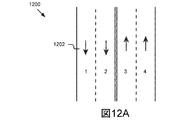
いくつかの実施形態では、静的道路物体は、道路区間の1つまたは複数の車線を記述する車線構造を判断するのに役立つことができる。道路区間に関連付けられた車線構造の一例が図12Aに示されている。図示されたように、静的道路物体検出器710が、路面上の(左から右に)白い実線、白い破線、黄色い二重線、白い破線、および白い実線を検出すると仮定する。これらの静的道路物体に基づいて、シーンプロセッサ254は、道路区間が各方向に2車線を有する4車線、2方向の通りであると判断することができる。いくつかの実施形態では、シーンプロセッサ254は、各車線に車線番号を割り当てることができる。たとえば、図12Aに描写されたように、4車線は、車道の左側から右側に昇順で番号付けされる場合があり、一番左の車線が車線1と見なされる。車線番号付けの他の例が考えられる。さらなる例では、道路区間上の車線の数を地図データから特定することができ、シーンプロセッサ254は、検出された静的道路物体(たとえば、移動プラットフォーム135から見える車線)に基づいて、移動プラットフォーム135がどの車線内に位置するかを判断することができる。
In some embodiments, static road objects can help determine lane structures that describe one or more lanes of a road segment. An example of a lane structure associated with a road segment is shown in FIG. 12A. As shown, assume that the static
いくつかの実施形態では、シーンレベルコンテキスト検出器712は、道路シーンデータおよび/または車両動作データを処理することによって、移動プラットフォーム135の視点から観測されたシーンレベルコンテキストを特定することができる。シーンレベルコンテキストの例には、限定はしないが、交通渋滞、道路工事、運転し易さ、横断可能な道路領域などが含まれる。いくつかの実施形態では、シーンレベルコンテキストはまた、
本明細書でさらに記載されるように、道路区間の各車線に関連付けられたアクティビティ情報および/もしくは空間レイアウトに基づいて特定することができるか、または地図データもしくは移動プラットフォーム135の地理位置から特定することができる。さらなる例では、シーンレベルコンテキスト検出器712は、道路シーンデータを処理してシーン内の物体を特定し、物体に基づいてコンテキストを特定することができる。
In some embodiments, the scene
As further described herein, it can be determined based on activity information and / or spatial layout associated with each lane of the road segment, or from map data or the geographic location of the mobile platform 135 be able to. In a further example, the scene
たとえば、カメラによって取り込まれた画像が道路の右側(右側通行を想定)に工事車両およびトラフィックコーンが存在することを記述する場合、シーンレベルコンテキスト検出器712は、道路区間のシーンレベルコンテキストを道路工事として識別することができる。別の例では、対象の移動プラットフォーム135の周囲の複数の移動プラットフォーム135の間隔がほとんどあるいはまったくないことを画像が示し、かつ、ブレーキライトがオンであることを示す赤い部分を各移動プラットフォーム135が含む場合、シーンレベルコンテキスト検出器712は、道路区間のシーンレベルコンテキストを運転がしにくい(運転し易さの基準が低い)交通渋滞として識別することができる。いくつかの他の変形形態も可能であり、考えられる。
For example, if the image captured by the camera describes the presence of construction vehicles and traffic cones on the right side of the road (assuming right-hand traffic), the scene
構成部品702、704、706、708、710、および/または712の各々は、受信および/または処理したデータを、セマンティック記述作成器262によるアクセスおよび/または取出しのために、道路シーンデータストア108に記憶することができる。
Each of the
図2Bに戻ると、いくつかの実施形態では、シーンプロセッサ254は、道路区間に関連付けられた地図データから、道路区間に関連付けられた車線構造を抽出することができる。たとえば、地図データは、州間高速道路15(I−15)がソルトレークシティの下町の近くの道路区間上で各方向に5車線を有することを示す場合がある。いくつかの実施形態では、シーンプロセッサ254は、地図データおよび静的道路物体に基づいて車線構造を特定することができる。たとえば、図12Bは、高速道路の2つの道路区間1252および1254に関連付けられた例示的な車線構造を明示する。この例では、地図データが、4車線を有するものとして高速道路を記述すると仮定する。地図データおよび検出された静的道路物体(たとえば、三角形部分を示す道路標識)に基づいて、シーンプロセッサ254は、道路区間1252が4車線を有し、道路区間1254が仕切り1256によって分割された4車線を有すると判断することができる。
Returning to FIG. 2B, in some embodiments, the scene processor 254 can extract the lane structure associated with the road segment from the map data associated with the road segment. For example, the map data may indicate that Interstate 15 (I-15) has 5 lanes in each direction on a road section near the downtown area of Salt Lake City. In some embodiments, the scene processor 254 can identify lane structures based on the map data and static road objects. For example, FIG. 12B demonstrates an exemplary lane structure associated with two
いくつかの実施形態では、シーンプロセッサ254は、道路区間の車線構造を記述する車線情報を作成することができる。いくつかの実施形態では、車線情報は車線番号および車線タイプを含む場合がある。たとえば、車線情報は、高速道路I−15上で、車線1がカープール車線であり、車線2が追越車線であり、車線3および4が走行車線であり、車線5が緊急車線であることを示す場合がある。いくつかの実施形態では、車線情報は、車線幅、車線容量(たとえば、大型車両の数)、車線状況(たとえば、車線工事、車線閉鎖など)、他の車線特性などを含む場合もある。
In some embodiments, the scene processor 254 can create lane information that describes the lane structure of a road segment. In some embodiments, the lane information may include a lane number and a lane type. For example, in the lane information,
いくつかの実施形態では、シーンプロセッサ254は、画像データおよび/または地図データから特定された複数の道路シーンパラメータ(たとえば、地域性、明暗状態、気象状態、静的道路物体、動的道路物体、車線情報、シーンレベルコンテキストなど)を、セマンティック記述作成器262を含む道路シーンアプリケーション109の他の構成部品に送り、かつ/または、これらもしくは他の構成部品によるアクセスおよび/もしくは取出しのためにデータストア221にパラメータを記憶する。図7に示されるように、セマンティック記述作成器262は、道路シーンパラメータ、車両動作データ、および状況オントロジーデータに基づいて、現在の外部状況についてのセマンティック記述を作成することができる。いくつかの実施形態では、地図データは、本明細書の中の他の場所でさら
に説明されるように、セマンティック道路シーン記述を作成する際に使用することができる。
In some embodiments, the scene processor 254 may include a plurality of road scene parameters identified from image data and / or map data (e.g., regionality, lightness / darkness conditions, weather conditions, static road objects, dynamic road objects, Lane information, scene level context, etc.) to other components of the road scene application 109 including the
アクティビティアグリゲータ256は、シーン構成要素(たとえば、動的道路物体、静的道路物体、車線情報など)を記述するデータを受信するために、シーンプロセッサ254、メモリ215、通信ユニット217、データストア221、および/または他の構成部品に結合することができ、様々な道路物体のアクティビティを記述する情報を集約して車線レベルアクティビティ情報を作成することができる。いくつかの実施形態では、車線レベルアクティビティ情報は、道路区間の各車線内の1つまたは複数の動的道路物体のアクティビティを記述する。いくつかの実施形態では、アクティビティアグリゲータ256は、シーン内に存在する道路物体に対して時空間追跡を実行し、時空間追跡情報に基づいて車線レベルアクティビティを特定する。
The
いくつかの実施形態では、アクティビティアグリゲータ256は、移動プラットフォーム135および1つまたは複数の動的物体の車線位置を検出することができる。たとえば、アクティビティアグリゲータ256は、検出された静的道路物体、車線情報、および/または地図データを使用して、道路区間上を移動している移動プラットフォームおよび他の周囲の移動プラットフォーム135の位置を特定することができる。一例として、図12Aに描写された道路区間1202上を第1の移動プラットフォーム135が走行している。シーンプロセッサ254は、第1の移動プラットフォーム135の右側の白い破線および左側の黄色い二重線を識別する。アクティビティアグリゲータ256は、道路区間1202の車線情報(たとえば、車線番号)を適用し、このようにして、第1の移動プラットフォーム135が車線3を走行しており、隣の左車線および隣の右車線の他の移動プラットフォーム135が、それぞれ道路区間の車線2および車線4を走行していると判断する。
In some embodiments,
別の例として、図12Bに描写された道路区間1252上を移動プラットフォーム135が走行している。シーンプロセッサ254は、移動プラットフォーム135の右側の白い実線および左側の白い破線を識別する。アクティビティアグリゲータ256は、したがって、移動プラットフォーム135が高速道路の最も右の車線を走行していると判断することができる。アクティビティアグリゲータ256は、地図データを参照することができ、高速道路が4車線を有すると判断する。したがって、アクティビティアグリゲータ256は、移動プラットフォーム135が高速道路の車線4を移動しており、隣の左車線にいる他の移動プラットフォーム135が高速道路の車線3を移動していると判断することができる。
As another example, a mobile platform 135 is traveling on a
いくつかの実施形態では、アクティビティアグリゲータ256は、動的道路物体が関連付けられた移動プラットフォーム135に対するその相対距離に基づいて、動的道路物体の車線位置を推定することができる。たとえば、第1の移動プラットフォーム135のセンサ106によって取り込まれた画像データは、第2の移動プラットフォーム135が、第1の移動プラットフォーム135の左側におおよそ車線幅の距離を置いて、第1の移動プラットフォーム135と平行に移動していることを記述する。第1の移動プラットフォーム135が車線4を移動している場合、アクティビティアグリゲータ256は、第2の移動プラットフォーム135が高速道路の車線2を移動していると判断することができる。
In some embodiments, the
さらなる例として、図12Bに描写された道路区間1254上を移動プラットフォーム135が走行している。この例では、地図データが、4車線および車線2と車線3との間の仕切り1256を有するものとして道路区間1254を記述すると仮定する。シーンプロセッサ254は、第1の移動プラットフォーム135の右側の仕切り/三角形標識およ
び左側の白い破線を検出する。シーンプロセッサ254は、地図データを参照し、移動プラットフォーム135が高速道路の車線2を移動していると判断する。第1の移動プラットフォーム135の隣の左車線にいる他の移動プラットフォーム135は、車線1を走行している。有利なことには、地図データは、道路構造が複雑(たとえば、複数車線の高速道路、複雑な交差点など)である場合、第1の移動プラットフォーム135および動的道路物体の位置を特定するのに役立てることができる。複雑な道路構造により、移動プラットフォーム135の視点から検出された静的道路物体のみに基づいて、車線位置を特定することが困難になり得る。
As a further example, mobile platform 135 is traveling on
いくつかの実施形態では、アクティビティアグリゲータ256は、動的道路物体の車線位置を空間的および時間的に監視して、動的道路物体によって実行されたアクティビティを抽出することができる。いくつかの実施形態では、アクティビティアグリゲータ256は、動的道路物体検出器708によって割り当てられたそれらの物体IDに基づいて、動的道路物体を監視することができる。いくつかの実施形態では、アクティビティアグリゲータ256は、第1の車両自体の車線位置を監視することもできる。
In some embodiments, the
さらなる例として、時間t=t0において、アクティビティアグリゲータ256は、車両1(自車両)が道路区間1254の車線4を走行しており、物体ID=10および11を有する2つの車両(たとえば、車両10および車両11)も車線4を走行しており、物体ID=12および13を有する2つの車両(たとえば、車両12および車両13)が車線3を走行していると判断する。時間t=t1(たとえば、ある特定の時間量の後)(たとえば、t1=t0+0.5秒)において、シーンプロセッサ254は、新しく受信された道路シーンデータを処理し、車両1(自車両)がまだ車線4を走行していると判断する。車両10、車両13、および物体ID=14を有する新しい車両(たとえば、車両14)は現在車線4を走行しているが、車両12はまだ車線3を走行している。このシナリオでは、アクティビティアグリゲータ256は、車両1、車両10、および車両12が以前と同じ車線内にあり、車両11が高速道路から離れ、車両13が車線3から車線4に変更し、車両14が車線4にちょうど進入した新しい車両であると判断する。空間的だけでなく時間的にも、動的道路物体および車両1の車線位置を監視することによって、アクティビティアグリゲータ256は、第1の車両の周囲の動的道路物体のアクティビティを抽出し、これらの動的道路物体の現在位置およびアクティビティを最新のままにすることができる。さらなる例では、アクティビティアグリゲータ256は、道路シーンデータに基づいて、車両13が水をまき散らしており車両14が衝突したと判断することができる。
As a further example, at time t = t0,
いくつかの実施形態では、アクティビティアグリゲータ256は、動的道路物体の動きを空間的および時間的に監視して、これらの動的道路物体によって実行されたアクティビティを抽出することができる。いくつかの実施形態では、アクティビティアグリゲータ256は、たとえば、アクティビティアグリゲータ256が関連付けられた移動プラットフォーム135の道路シーンデータおよび車両動作データに基づいて、1つまたは複数の動的道路物体の相対速度を監視することができる。
In some embodiments,
場合によっては、アクティビティアグリゲータ256は、取り込まれた画像内の動的道路物体を識別することができ、空間的および時間的に後続する複数の画像にわたって動的道路物体を監視することができる。次いで、アクティビティアグリゲータ256は、速度推定アルゴリズム(たとえば、オプティカルフロー計算)を適用して、動的道路物体の相対速度を推定することができる。動的道路物体の相対速度は、道路シーンデータから抽出された動的道路物体と移動プラットフォーム135との間の相対運動に基づいて、推定することができる。たとえば、上記のシナリオでは、アクティビティアグリゲータ256は、車両1に対する車両10の相対位置が複数のフレームにわたって変化しなかったことを道路シーンデータが示すので、車両10が車両1と同様の速度で移動していると判断する
ことができる。次いで、アクティビティアグリゲータ256は、車両1の車両動作データ(たとえば、速度計出力)によって識別されたように、車両10が約55mphで走行していると判断することができる。
In some cases,
いくつかの実施形態では、アクティビティアグリゲータ256は、特定の動的道路物体の識別された相対速度に基づいて、動的道路物体のアクティビティを特定することができる。たとえば、アクティビティアグリゲータ256は、特定の動的道路物体が一定の速度で移動しているか、速度を上げている(たとえば、加速している)か、速度を下げている(減速している)か、または停止したかを判定することができる。アクティビティアグリゲータ256は、その監視された動きに基づいて、動的道路物体が遅く移動しているか速く移動しているか、その特定の動的道路物体が道路区間に関連付けられた速度制限を超えているか否かを判定することもできる。たとえば、アクティビティアグリゲータ256は、右カーブにいる車が動いていない、たとえば、その相対速度がゼロに等しいので、その車が駐車していると判断することができる。
In some embodiments, the
いくつかの実施形態では、アクティビティアグリゲータ256は、複数の動的道路物体のアクティビティを集約して、道路区間の車線ごとの車線レベルアクティビティ情報を作成することができる。いくつかの実施形態では、車線レベルアクティビティ情報は、車線レベルでの各車線における1つまたは複数の車両のアクティビティを記述する。たとえば、アクティビティアグリゲータ256は、車線2にいる複数の車両が速度制限に近い一定の平均速度で移動していると判断し、したがって車線2内のスムーズな交通の流れを識別することができる。別の例として、アクティビティアグリゲータ256は、車線4にいる車両14が衝突し、車両14の後方の他の車両が動いていないと判断することができる。次いで、アクティビティアグリゲータ256は、車両14が衝突し、車線4にいる車が停止したことを記述する、車線4についての車線レベルアクティビティ情報を作成することができる。道路区間の各車線に関連するアクティビティ情報は、他の車両、たとえば、後方から道路区間に接近している車両にとって大きな価値があり得る。
In some embodiments,
シーン内の動的道路物体の時空間追跡を容易にするために、各動的道路物体は、物体を識別する特徴(たとえば、色、モデル、形状、ナンバープレートなど)とともに一意の物体IDを割り当てることができる。たとえば、上述されたシナリオでは、物体ID(たとえば、車両13)により、時間t=t1に車線4にいる車両13が時間t=t0に車線3にいた車両13と同じであることが、アクティビティアグリゲータ256に明らかにされる。したがって、アクティビティアグリゲータ256は、車両13が画像内に最近現れた新しい車両であると誤認することなく、車両13が車線3から車線4に変更したと判断することができる。いくつかの実施形態では、動的道路物体に対応する物体IDは、セマンティック道路シーン記述に含まれる場合があり、セマンティック道路シーン記述は、他の車両および/または基盤サーバ190および/またはサーバ101に送られる。物体IDにより、受信側エンティティ(たとえば、他の移動プラットフォーム135、基盤サーバ190、サーバ101など)がデータを分析(resolve)し、同じ動的道路物体に関する
車線レベルアクティビティ情報を集約するときの重複を回避することが可能になるので、これは有利である。たとえば、車両13が車線3から車線4に変更したことを車両Aから受信された車線レベルアクティビティ情報が示し、車両13が水をまき散らしていることを車両Bから受信された車線レベルアクティビティ情報が示す。物体ID(たとえば、物体ID=13)に基づいて、基盤サーバ190および/またはサーバ101および/または受信側車両は、車両Aおよび車両Bから受信された車線レベルアクティビティ情報を集約することができ、車両13が車線3から車線4に変更し、車両13が水をまき散らしているとの結論に達することができる。
To facilitate spatio-temporal tracking of dynamic road objects in the scene, each dynamic road object is assigned a unique object ID along with features that identify the object (eg, color, model, shape, license plate, etc.). be able to. For example, in the scenario described above, the activity aggregator indicates that the vehicle 13 in the
動的道路物体検出器708を参照して上述されたように、特定の動的道路物体に関連付
けられた物体IDは、各移動プラットフォーム135に対して普遍的に一意(ユニバーサルユニーク)であってもよく、ローカルに一意(ローカルユニーク)であってもよい。上記の例では、物体IDは普遍的に一意であり、したがって、車両Aおよび車両Bは、同じ物体ID(たとえば、物体ID=13)を使用して、同じ動的道路物体(たとえば、同じ車両13)について言及することができる。しかしながら、物体IDを生成した車両(たとえば、第1の車両)においてのみ物体IDが一意(ローカルユニーク)である実施形態でも、物体IDの使用は依然として有利であり得る。詳細には、物体IDは、異なる時点で同じ送信側エンティティから受信された車線レベルアクティビティ情報を集約するために、依然として使用することができる。たとえば、時間t=t1において車両Aから受信された車線レベルアクティビティ情報は、車両14が衝突したことを示し、時間t=t2において車両Aから受信された車線レベルアクティビティ情報は、車両14が緊急車線に移動したことを示す。物体ID(たとえば、物体ID=14)に基づいて、基盤サーバ190および/またはサーバ101および/または受信側車両は、時間t1およびt2において車両Aから受信された車線レベルアクティビティ情報を集約して、道路区間上の現在の状況を識別することができる。この例では、車両Cが車両14に異なる物体IDを割り当てることができるが、物体ID14は、車両Aの視点から分かるように、基盤サーバ190および/またはサーバ101および/または受信側車両に対して依然として一意である。したがって、物体ID14は、有利なことに、車両Aから受信された車両14に関するアクティビティ情報を処理するために使用することができる。いくつかの実施形態では、動的道路物体に対応する物体IDは、暗号化され、セマンティック道路シーン記述に含まれる場合がある。いくつかのさらなる実施形態では、物体IDはセマンティック道路シーン記述から割愛される場合がある。
As described above with reference to dynamic road object detector 708, the object ID associated with a particular dynamic road object may be universally unique for each mobile platform 135. It may be locally unique (local unique). In the above example, the object ID is universally unique, so vehicle A and vehicle B use the same object ID (eg, object ID = 13) and use the same dynamic road object (eg, the same vehicle). 13) can be mentioned. However, even in embodiments where the object ID is unique (local unique) only in the vehicle that generated the object ID (eg, the first vehicle), the use of the object ID may still be advantageous. In particular, the object ID can still be used to aggregate lane level activity information received from the same sending entity at different times. For example, lane level activity information received from vehicle A at time t = t1 indicates that
空間レイアウトエンコーダ258は、シーン構成要素(たとえば、動的道路物体、静的道路物体、車線情報、車線位置など)を記述するデータを受信するために、シーンプロセッサ254、アクティビティアグリゲータ256、メモリ215、通信ユニット217、データストア221、および/または他の構成部品に結合することができ、道路区間の車線ごとの車線レベル空間レイアウトを符号化することができる。いくつかの実施形態では、車線レベル空間レイアウトは、特定の車線内の動的道路物体の間の物体間関係を記述する。たとえば、車線レベル空間レイアウトは、車線を走行している2つの移動プラットフォーム135の間の平均距離を示すことができる。いくつかの実施形態では、平均距離は、車線内の2つの動的道路物体間の空間距離および/または時間距離であり得る。
The
いくつかの実施形態では、空間レイアウトエンコーダ258は、たとえば、車両のセンサ106によって取り込まれた道路シーンデータに基づいて、道路区間の各車線内の動的道路物体の数を特定することができる。一例として、道路区間の車線3を車両が移動していると仮定する。動的道路物体検出器708は、道路シーンデータを処理し、車線3内の第1の車両の前方を走行している車およびトラックがあると判断することができる。道路シーンデータは、車線2を走行している3台の車があり、車線4を走行している5台の車があることも記述する。
In some embodiments, the
いくつかの実施形態では、空間レイアウトエンコーダ258は、移動プラットフォーム135のセンサ106に関連付けられたセンサ範囲を受信することができる。いくつかの実施形態では、センサ106のセンサ範囲(可視範囲とも呼ばれる)は、その視界、たとえばセンサの取込み領域を指定する。センサ106のセンサ範囲は、固定値または動的値であり得る。いくつかの実施形態では、カメラのセンサ範囲は、ユーザによって手動で調整され、かつ/または現在の道路シーンの光の状態(たとえば、明るい、低い、通常など)に基づいて、自動的に調整される場合がある。たとえば、センサ106は、夜間に15m、昼光で45mの可視範囲をカバーすることができる。
In some embodiments, the
いくつかの実施形態では、空間レイアウトエンコーダ258は、各車線内で検出された動的道路物体の数およびセンサ106のセンサ範囲を使用して、車線ごとの車線レベル空間レイアウトを特定することができる。上記の例では、動的道路物体検出器708は、車線4内の5台の車を識別し、センサ106は25mのセンサ範囲で動作している。空間レイアウトエンコーダ258は、したがって、車線4の車線レベル空間レイアウトが25m内の5台の車であると判断することができる。いくつかの実施形態では、道路シーンアプリケーション109は、車両の動作およびその走行履歴内の交通パターンを監視するトレーニングエンジン(training engine)を含む場合がある。たとえば、トレーニングエン
ジンは、適度な交通状態では25mのセンサ範囲内に通常3台の車があると判断することができる。空間レイアウトエンコーダ258は、したがって、車両の位置が互いに近すぎるので、車線4において車両が一団になっていると判断することができる。空間レイアウトエンコーダ258は、したがって、車線4内の前方で渋滞状況が発生していると予測することができる。
In some embodiments, the
いくつかの実施形態では、空間レイアウトエンコーダ258は、道路シーンデータに基づいて、車線ごとの車線レベル空間レイアウトを特定することができる。いくつかの実施形態では、空間レイアウトエンコーダ258は、道路シーンデータに基づいて、センサ106から第1の動的道路物体および第2の動的道路物体までの距離を推定する。次いで、空間レイアウトエンコーダ258は、2つの推定された距離の間の差を計算することによって、これら2つの動的道路物体間の相対距離を特定する。たとえば、空間レイアウトエンコーダ258は、車線2内の車両間の平均距離が約5mであるか、または約2.3秒の車間距離であると特定することができる。
In some embodiments, the
さらなる例として、上記のシナリオでは、空間レイアウトエンコーダ258は、車線2において、車両20と車両21との間の相対距離が3秒であり、一方、車両21と車両22との間の相対距離が1秒であると判断することができる。この車線レベル空間レイアウト(たとえば、物体間関係)に基づいて、空間レイアウトエンコーダ258は、車線2内の交通が車線4ほど混雑しておらず(3台の車両対5台の車両)、車両22がおそらく車両21のぴったり後ろについて走っていると判断することができる。
As a further example, in the above scenario, the
いくつかの実施形態では、セマンティック記述作成器262は、アクティビティアグリゲータ256によって作成された車線レベルアクティビティ情報、空間レイアウトエンコーダ258によって作成された車線レベル空間レイアウト、および/または他の道路シーン情報に基づいて、道路区間に関連する現在の外部状態を特定することができる。一例として、アクティビティアグリゲータ256は、道路区間の制限速度が65mph(時速105km)であるが、特定の車線内の車両が25mph(時速40km)の平均速度でゆっくり移動していると判断する。空間レイアウトエンコーダ258は、あらゆる2台の車両間の相対車間距離が約1秒であるので、車線1内の車両が互いに接近して続いていると判断する。道路区間に関連付けられた車線情報は、その特定の車線が追越車線(たとえば、車線1)であり、そこでは車両が制限速度に近い速度で移動するべきであることを示す。したがって、セマンティック記述作成器262は、車線1において交通渋滞が発生していると判断し、セマンティック道路シーン記述内の車線1を記述する態様にこの情報を含めることができる。他の実施形態では、セマンティック記述作成器262は、外部シーンを記述する複数の個別の道路シーンパラメータを、セマンティック道路シーン記述に含めることができる。これらの実施形態では、これらの道路シーンパラメータに基づく外部状態の特定は、受信側エンティティによって実行される場合がある。これは、セマンティック道路シーン記述の受信側エンティティが、基盤サーバ190、サーバ101、他のクラウドサーバ、V2I/I2V通信ネットワーク内の基盤などのかなりの計算リソースを有するときに有利である。
In some embodiments,
道路状態推定器260は、車両動作データ(たとえば、車両CANデータ)およびシーン情報(たとえば、地域性、気象状態など)を記述するデータを受信するために、シーンプロセッサ254、メモリ215、通信ユニット217、データストア221、および/または他の構成部品に結合することができ、道路区間に関連付けられた路面状態を推定することができる。路面状態の例には、限定はしないが、通常(たとえば、乾燥)、湿潤、滑りやすい、水浸し、でこぼこ、横滑り、雪、跳ね返りなどが含まれる。
The
一例として、シーンプロセッサ254は、現在の気象状態を「豪雨」として識別する場合があり、第1の車両の車両動作データは、タイヤと道路との間の低い牽引力を示す場合がある。道路状態推定器260は、したがって、道路区間の路面状態が「湿潤」または「滑りやすい」と判断することができる。いくつかの実施形態では、道路状態推定器260は、路面状態を特定する際に、道路シーンデータ(たとえば、画像センサデータおよび他の道路シーン情報(たとえば、地域属性))を使用することができる。このシナリオのさらなる例として、シーンプロセッサ254は、道路区間の地域性を「林道」として分類する場合があり、道路シーンデータは、茶色で泥だらけの路面を記述する場合がある。道路状態推定器260は、したがって、道路区間の路面状態が「泥だらけで跳ね返り」と判断することができる。
As an example, the scene processor 254 may identify the current weather condition as “heavy rain” and the vehicle motion data for the first vehicle may indicate low traction between the tire and the road. Therefore, the
セマンティック記述作成器262は、車両移動プラットフォーム135の視点から観測されたように現在の外部状況を記述するデータ(道路シーンデータ、車両動作データ、地図データ、状況オントロジーデータなど)を受信するために、POI抽出器252、シーンプロセッサ254、アクティビティアグリゲータ256、空間レイアウトエンコーダ258、道路状態推定器260、メモリ215、通信ユニット217、データストア221、および/または他の構成部品に結合することができ、受信されたデータに基づいて道路区間を記述するセマンティック道路シーン記述を作成することができる。詳細には、セマンティック記述作成器262は、道路シーンアプリケーション109のこれらの構成部品によって特定された道路シーンパラメータを、状況オントロジーデータを使用してセマンティック道路シーン記述の中に組み合わせることができる。いくつかの実施形態では、セマンティック記述作成器262は、たとえば、アクティビティアグリゲータ256および空間レイアウトエンコーダ258を参照して上述されたように、これらの受信された道路シーンパラメータに基づいて現在の状況の1つまたは複数の外部状態を特定することもできる。セマンティック記述作成器262およびセマンティック道路シーン記述は、少なくとも図8および図9を参照して詳細に記載される。
図8は、道路区間用のセマンティック道路シーン記述を作成するための例示的なシステム800のブロック図である。図8に示されるように、セマンティック記述作成器262は、それぞれ、気象検出器706、地域性検出器702、明暗検出器704、シーンレベルコンテキスト検出器710、道路状態推定器260、アクティビティアグリゲータ256、および空間レイアウトエンコーダ258から、気象状態、地域性、明暗状態、シーンレベル交通コンテキスト、路面状態、車線レベルアクティビティ情報、および車線レベル空間レイアウトを受信することができる。いくつかの実施形態では、セマンティック記述作成器262は、POI抽出器252からPOI/ランドマーク情報を受信することもできる。いくつかの実施形態では、セマンティック記述作成器262は、次いで、状況オントロジーデータベース103に記憶され、かつ/またはローカルメモリ(たとえば、移動プラットフォーム135のメモリ215、道路シーンデータストア108、別のデータストアなど)に記憶および/もしくはキャッシュされた状況オントロジーデータを適用して、セマンティック道路シーン記述を作成することができる。セマンティック道路シーン記述は、これらの構成部品から受信された道路シーン情報を1つの表現に編集(compile)
し、この表現はその後、複数の車両および/または基盤と共有される。場合によっては、セマンティック道路シーン記述は、効率的な送信用に圧縮される場合がある。
FIG. 8 is a block diagram of an
However, this representation is then shared with multiple vehicles and / or infrastructure. In some cases, the semantic road scene description may be compressed for efficient transmission.
いくつかの実施形態では、セマンティック記述作成器262は、移動プラットフォーム135の現在位置を受信し、セマンティック道路シーン記述に現在位置を含めてもよい。移動プラットフォーム135の現在位置は、セマンティック道路シーン記述の受信側エンティティが、対応する道路シーン状況が発生した位置を特定するのに役立てることができる。たとえば、セマンティック道路シーン記述内の地理位置データ(たとえば、GPS座標)に基づいて、受信側移動プラットフォーム135は、セマンティック道路シーン記述内で記述された外部状況がその現在位置の5km後方で発生したと判断することができる。いくつかの実施形態では、送信側移動プラットフォーム135の現在位置は、完全に正確な位置である必要はなくおおよその位置であってよい。たとえば、GPSデバイスによって識別された地理位置(たとえば、GPS座標)は、完全に正確ではない可能性がある。別の例として、セマンティック道路シーン記述内の位置態様は、「ユタ大学プレジデントサークルを約200m過ぎたところ」であり得る。この例では、受信側移動プラットフォーム135は、自身の位置をたとえばプレジデントサークルの手前約150mと判断し、したがって、セマンティック記述に記述された道路シーン状況が350m前方で発生したと判断することができる。
In some embodiments, the
いくつかの実施形態では、セマンティック道路シーン記述は、構造化データファイルであり得る。たとえば、セマンティック道路シーン記述は、XML(拡張マークアップ言語)、CSV(コンマ区切り形式)、JSON(JavaScript(登録商標)オブジェクト表記)などの任意の形態の構造化データファイルフォーマットで作成することができる。いくつかの実施形態では、セマンティック道路シーン記述は、様々な移動プラットフォーム135、基盤サーバ190、サーバ101、基盤などの間で効率的に交換されるべき、あらかじめ定義されたテンプレートに準拠することができる。いくつかの実施形態では、あらかじめ定義されたテンプレートに含まれる道路シーン態様は、道路区間の地域性に基づいて動的に調整することができる。たとえば、「市街地」の地域性に適用されるあらかじめ定義されたテンプレートは、横断歩道を記述する態様を含む場合があり、「高速道路」の地域性に使用されるあらかじめ定義されたテンプレートは、横断歩道を記述する態様を含まない場合がある。 In some embodiments, the semantic road scene description may be a structured data file. For example, the semantic road scene description can be created in any form of structured data file format, such as XML (Extended Markup Language), CSV (Comma Separated Value Format), JSON (JavaScript (registered trademark) object notation). . In some embodiments, the semantic road scene description can conform to predefined templates that are to be efficiently exchanged between various mobile platforms 135, infrastructure server 190, server 101, infrastructure, etc. . In some embodiments, the road scene aspects included in the predefined template can be dynamically adjusted based on the regional nature of the road segment. For example, a predefined template applied to the “city” regionality may include an aspect describing a pedestrian crossing, and a predefined template used for the “highway” regionality It may not include a mode for describing a sidewalk.
図9は、セマンティック記述作成器262によって作成された例示的なセマンティック道路シーン記述を明示する。図示されたように、セマンティック記述作成器262は、状況オントロジーデータによって定義された対応する用語を使用して、気象状態、明暗状態、地域性、シーンレベル交通コンテキスト、および路面状態を記述することができる。たとえば、図9に描写されたように、セマンティック道路シーン記述900は、以下の態様:気象状態を「晴れ」として示す気象属性、明暗状態を「日中の明るさ(day bright)」として示す明暗属性、地域性を「ハイウェイ」として示す地域属性、路面状態を「湿潤(wet)」として示す道路状態属性、およびシーンレベルにおける交通コンテキストを「適
度(moderate)」として示すコンテキスト属性のうちの1つまたは複数を含む場合がある。
FIG. 9 demonstrates an exemplary semantic road scene description created by the
描写されたように、セマンティック道路シーン記述900は、第1の車両の現在位置、ならびに第1の車両の現在位置に近い1つまたは複数のPOIおよび/またはランドマークを含む場合がある。詳細には、セマンティック道路シーン記述900は、第1の車両の現在位置(たとえば、GPS座標)を「北緯40.5829°、西経111.8932°」として示す位置属性、ならびに近くのランドマークおよびPOIを「リオティントスタジアム」および「ジョーダンコモンズメガプレックス劇場」として示すランドマーク属性を含む場合がある。
As depicted, the semantic
図9に示されたように、セマンティック記述作成器262は、道路区間の各車線を記述
する1つまたは複数の態様を含む場合がある。いくつかの実施形態では、これらの態様は、各車線の車線固有情報、たとえば、車線番号、車線レベルアクティビティ情報(たとえば、車線内に存在する1つまたは複数の動的道路物体の属性(物体タイプ、物体IDなど)、1つまたは複数の動的道路物体のアクティビティなど)、および車線レベル空間レイアウト(たとえば、車線を占有する動的道路物体の数、車線内の物体間関係など)などを記述することができる。たとえば、図9に描写されたように、セマンティック道路シーン記述900は、道路区間の車線1、車線2、および車線3に対応する3つの態様を含む場合がある。図示されたように、態様「車線1」は、互いの間に3.5mの距離を置いて車線1を移動している3台の車があることを示す。態様「車線2」は、車線2を占有している2つのタイプの動的道路物体を記述する。詳細には、車線2を適度な速度で移動している3台の車および車線2をゆっくり移動している2台のトラックが存在する。態様「車線2」は、車線2内の車両の平均車間距離が2秒であることも示す。態様「車線3」は、物体ID=14を有する車が衝突し、車線3内の他の車両(たとえば、5台の車)が停止したことを示す。いくつかの実施形態では、セマンティック道路シーン記述は、他の道路シーン態様を含む場合がある。
As shown in FIG. 9, the
いくつかの実施形態では、送信側移動プラットフォーム135は、たとえば、V2V通信ネットワークを介して、道路区間に関連付けられた1つまたは複数の他の移動プラットフォーム135に、セマンティック道路シーン記述を送信することができる。いくつかの実施形態では、道路区間に関連付けられた移動プラットフォーム135とは、その道路区間に近接している1つまたは複数の移動プラットフォーム135である。たとえば、道路区間に関連付けられた移動プラットフォーム135は、限定はしないが、当該道路区間に接近している移動プラットフォーム135(たとえば、当該道路区間上の第1の車両の後方を移動している車両、次の15分以内に当該道路区間に到達すると予測される車両など)、当該道路区間を通過した移動プラットフォーム135(たとえば、当該道路区間上の第1の車両の前方を移動している車両、直前15分以内に当該道路区間を通過した車両など)、当該道路区間上の基準点からあらかじめ決定された距離内を移動している移動プラットフォーム135(たとえば、リオティントスタジアムから2マイルの半径内を移動している車両、第1の車両の現在位置から3kmの半径内を移動している車両など)などが含まれ得る。いくつかの実施形態では、送信側移動プラットフォーム135は、その無線周波通信範囲内にある任意の他の移動プラットフォーム135に、セマンティック道路シーン記述を送信することができる。いくつかの実施形態では、送信側移動プラットフォーム135は、V2I/I2V通信ネットワークを介して、基盤またはクラウドサーバにセマンティック道路シーン記述を送信することができる。他の変形形態も可能であり、考えられる。 In some embodiments, the sending mobile platform 135 may send the semantic road scene description to one or more other mobile platforms 135 associated with the road segment, eg, via a V2V communication network. it can. In some embodiments, the mobile platform 135 associated with a road segment is one or more mobile platforms 135 proximate to the road segment. For example, the mobile platform 135 associated with the road segment is not limited to, but may be a mobile platform 135 that is approaching the road segment (eg, a vehicle moving behind the first vehicle on the road segment, Vehicles that are expected to reach the road section within the next 15 minutes), mobile platforms 135 that have passed the road section (eg, vehicles moving in front of the first vehicle on the road section, immediately before A vehicle that has traveled within a predetermined distance from a reference point on the road section (for example, a vehicle that has passed the road section within 15 minutes), such as moving within a 2 mile radius from Rio Tinto Stadium. Vehicle, a vehicle moving within a radius of 3 km from the current position of the first vehicle, etc.). In some embodiments, the transmitting mobile platform 135 can transmit the semantic road scene description to any other mobile platform 135 that is within its radio frequency range. In some embodiments, the sending mobile platform 135 can send the semantic road scene description to the infrastructure or cloud server via the V2I / I2V communication network. Other variations are possible and contemplated.
いくつかの実施形態では、受信側移動プラットフォーム135は、他の周囲の移動プラットフォーム135からセマンティック記述を受信することで恩恵を受ける。なぜならば、自身が接近している現在の道路シーン状況をより正確に特定することができるためである。たとえば、図12Bを参照して、以下のような状況を考える。いくつかの第1の車両が道路区間1252上で第2の車両の後方を走行しており、自身が作成したセマンティック記述を第2の車両に通信している。第2の車両は、現在道路区間1254の車線3を走行している。作成されたセマンティック記述は、道路区間1252の車線4における自動車事故の発生を記述している。このような状況では、道路区間1252上の車線4における交通は、自動車事故のせいで進むことができず、したがって、車線4内の道路区間1254に接近する車両は存在しないはずであると判断できる。そこで、第2の車両は、より速く移動するために道路区間1254の車線3から車線4にシフトするように、そのドライバにナビゲーション提案を提供することができる。
In some embodiments, the receiving mobile platform 135 benefits from receiving semantic descriptions from other surrounding mobile platforms 135. This is because it is possible to more accurately identify the current road scene situation where the vehicle is approaching. For example, referring to FIG. 12B, consider the following situation. Several first vehicles are traveling behind the second vehicle on the
いくつかの実施形態では、セマンティック道路シーン記述は、たとえば、ネットワーク
の容量(たとえば、V2V通信ネットワークおよび/またはV2I/I2V通信ネットワークの帯域幅制限)に応じてリアルタイムまたは非リアルタイムで、1つまたは複数の受信側エンティティ(たとえば、他の移動プラットフォーム135、基盤構成要素、サーバ101、クライアントデバイス115など)に配布することができる。一例として、V2V通信ネットワークの利用可能な帯域幅がしきい値を満たす(しきい値以上である)場合、道路シーンデータがセンサ106から取り込まれ/収集され、道路シーンアプリケーション109によって処理されると、第1の車両はリアルタイムで他の車両にセマンティック道路シーン記述を通信する。いくつかの実施形態では、移動プラットフォーム135は、指定された間隔で(たとえば、4秒ごとに)セマンティック道路シーン記述を送信する。いくつかの実施形態では、セマンティック道路シーン記述の作成および送信は、ユーザの介入なしに道路シーンアプリケーション109によって自動的に実行される。
In some embodiments, the semantic road scene description may be one or more, for example, in real time or non-real time, depending on network capacity (eg, bandwidth limitations of V2V and / or V2I / I2V communication networks), for example. To other receiving platforms (eg, other mobile platforms 135, infrastructure components, servers 101, client devices 115, etc.). As an example, if the available bandwidth of the V2V communication network meets a threshold (greater than or equal to the threshold), road scene data is captured / collected from the
いくつかの実施形態では、道路シーンデータの取込みおよび処理は、特定の道路区間に沿った各々の移動プラットフォーム135が(たとえば、自動的に)行う。詳細には、道路区間上を走行している各移動プラットフォーム135は、その視点から知覚および分析された現在の道路シーン状況を記述するセマンティック記述を作成する。 In some embodiments, road scene data capture and processing is performed (eg, automatically) by each mobile platform 135 along a particular road segment. Specifically, each mobile platform 135 traveling on a road segment creates a semantic description that describes the current road scene situation perceived and analyzed from that viewpoint.
いくつかの実施形態では、道路区間に関連付けられた移動プラットフォーム135は、道路区間に関連付けられた2つ以上の他の移動プラットフォーム135から、道路区間の複数のセマンティック記述を受信する。たとえば、道路区間上を走行している第1の車両は、その道路区間に接近している1つまたは複数の第2の車両に、第1の車両が作成するセマンティック記述を送信し、その道路区間を通過した2つ以上の第3の車両から、これらの第3の車両が作成するセマンティック記述を受信する。各受信側車両が複数の周囲の車両からセマンティック記述を受信し、2つ以上のソースに基づいて現在の道路シーン状況を検証できるので、これは有利である。この例では、第1の車両、1つまたは複数の第2の車両、および2つ以上の第3の車両は、道路区間に関連付けられた車両と考えることができる。道路区間に関連付けられた車両の他の例が本明細書の中の他の場所に記載される。 In some embodiments, the mobile platform 135 associated with the road segment receives a plurality of semantic descriptions of the road segment from two or more other mobile platforms 135 associated with the road segment. For example, a first vehicle traveling on a road section transmits a semantic description created by the first vehicle to one or more second vehicles approaching the road section, and the road Semantic descriptions created by these third vehicles are received from two or more third vehicles that have passed through the section. This is advantageous because each receiving vehicle can receive semantic descriptions from multiple surrounding vehicles and verify current road scene conditions based on more than one source. In this example, the first vehicle, one or more second vehicles, and two or more third vehicles can be considered vehicles associated with the road segment. Other examples of vehicles associated with road segments are described elsewhere in this document.
いくつかの実施形態では、受信側車両は、2つ以上のセマンティック道路シーン記述を統合または調整(align)し、送信側車両が検知して2つ以上のセマンティック記述内に
記述した内容に基づいて、道路区間の外部状況を再現(reconstruct)することができる
。詳細には、受信側車両は、2つ以上のセマンティック道路シーン記述を、それらに含まれる1つまたは複数の道路シーン態様に基づいて統合することができる。
In some embodiments, the receiving vehicle integrates or aligns two or more semantic road scene descriptions and based on what the transmitting vehicle has detected and described in the two or more semantic descriptions. The external situation of road sections can be reconstructed. In particular, the receiving vehicle can integrate two or more semantic road scene descriptions based on one or more road scene aspects included therein.
いくつかの実施形態では、車両情報を使用して、2つ以上のセマンティック道路シーン記述を集約(aggregate)することができる。たとえば、第1の送信側車両から受信され
た第1のセマンティック記述は、車線1内の車が物体間距離3秒でスムーズに移動していることを記述し、第2の送信側車両から受信された第2のセマンティック記述は、車線1内の車およびトラックが物体間距離2.7秒でスムーズに移動していることを記述する。統合したセマンティック記述の車線1に関連付けられた道路シーン態様に基づいて、受信側車両の道路シーンアプリケーション109は、車線1内の車両は車およびトラックを含み、それらが2.7秒と3秒との間のいずれかの車間距離でスムーズに走行していると判断することができる。
In some embodiments, vehicle information can be used to aggregate two or more semantic road scene descriptions. For example, the first semantic description received from the first transmitting vehicle describes that the vehicle in the
いくつかの実施形態では、静的道路物体に基づいて、2つ以上のセマンティック道路シーン記述を統合することができる。たとえば、第1の送信側車両から受信された第1のセマンティック記述は、基準点としてステート通りとワシントン通りの交差点にある交通信号を記述し、ワシントン通りの車線2の赤信号で2台の車および牽引車両が停止していることを記述する。第2の送信側車両から受信された第2のセマンティック記述は、同じ交
差点にある同じ交通信号を記述する。第2のセマンティック記述はさらに、ワシントン通りの車線4および車線5の赤信号で車およびトラックが停止しており、右折信号を出していることを記述する。静的道路物体(たとえば、交通信号)に基づいて、受信側車両の道路シーンアプリケーション109は、第1のセマンティック記述を第2のセマンティック記述と統合して、交差点におけるより完全な外部状況を理解することができる。たとえば、受信側車両の道路シーンアプリケーション109は、車線2内の赤信号で停止している2台の車および牽引車両があり、右折してワシントン通りを離れようとしている車線4内の車および車線5内のトラックがあると判断することができる。
In some embodiments, two or more semantic road scene descriptions can be integrated based on static road objects. For example, the first semantic description received from the first transmitting vehicle describes a traffic signal at the intersection of State Street and Washington Street as a reference point, and two cars with a red light on
いくつかの実施形態では、道路区間に関連付けられた車線情報および地図データに基づいて、2つ以上のセマンティック道路シーン記述を統合してもよい。地図データは、道路区間が複雑な道路構造を有する場合の統合に特に役立てることができる。たとえば、上記の状況では、受信側車両は、地図データを参照して、ワシントン通りが5車線を有すること、ならびに第1のセマンティック記述および第2のセマンティック記述において記述された交通信号が実際は同じものであるか、または同じ交通の流れを制御することを判断すべき場合がある。そして、受信側車両の道路シーンアプリケーション109は、第1のセマンティック記述と第2のセマンティック記述を、それらに含まれる車線情報を使用して組み合わせることができる。この例では、受信側車両はまた、地図データを参照して、ワシントン通りがこの交差点において2つの右折車線を有し、赤信号時の右折を許可しないことを判断すべき場合もある。 In some embodiments, two or more semantic road scene descriptions may be integrated based on lane information and map data associated with a road segment. Map data can be particularly useful for integration when road sections have complex road structures. For example, in the above situation, the receiving vehicle refers to the map data that Washington Street has 5 lanes, and the traffic signals described in the first and second semantic descriptions are actually the same. Or may decide to control the same traffic flow. The road scene application 109 of the receiving vehicle can then combine the first semantic description and the second semantic description using the lane information contained therein. In this example, the receiving vehicle may also refer to the map data to determine that Washington Street has two right turn lanes at this intersection and does not allow a right turn at red light.
いくつかの実施形態では、動的道路物体に基づいて、2つ以上のセマンティック道路シーン記述を統合することができる。たとえば、第1のセマンティック記述および第2のセマンティック記述が両方とも同じ動的道路物体(たとえば、ナンバープレートXYZを有する黒い車)を記述する場合、受信側車両の道路シーンアプリケーション109は、動的道路物体に基づいて第1のセマンティック記述を第2のセマンティック記述と統合して、より完全な外部道路シーンを再現することができる。いくつかの実施形態では、動的道路物体の物体IDおよび/または識別形状は、セマンティック道路シーン記述内で表すことができ、したがって、統合用の動的道路物体を識別するために使用することができる。 In some embodiments, two or more semantic road scene descriptions can be integrated based on dynamic road objects. For example, if the first semantic description and the second semantic description both describe the same dynamic road object (eg, a black car with a license plate XYZ), the receiving vehicle road scene application 109 may Based on the object, the first semantic description can be integrated with the second semantic description to reproduce a more complete external road scene. In some embodiments, the object ID and / or identification shape of the dynamic road object can be represented in the semantic road scene description and thus can be used to identify the dynamic road object for integration. it can.
いくつかの実施形態では、複数のセマンティック記述の統合は、サーバ101、基盤サーバ190、および/またはシステム100の構成部品によって実行することができる。たとえば、サーバ101または190は、V2I/I2V通信ネットワークを介して、異なる第1の車両から同じ道路区間に関する複数のセマンティック記述を受信する。いくつかの実施形態では、サーバ101または190は、受信されたセマンティック記述を統合し、統合したセマンティック記述に基づいて外部状態を特定し、道路区間に関連付けられた他の車両に特定された外部状態を送信する。この実施形態では、サーバ101または190におけるセマンティック記述の処理のせいで何らかの遅延が生じうる。
In some embodiments, the integration of multiple semantic descriptions may be performed by server 101, infrastructure server 190, and / or
インターフェースエンジン264は、ユーザインターフェースを作成し、ユーザに提供するために、メモリ215、通信ユニット217、データストア221、および/または他の構成部品に結合することができる。いくつかの実施形態では、インターフェースエンジン264は、ユーザに道路シーン情報を提示するユーザインターフェースを提供するためのグラフィカルデータを作成することができる。さらなる実施形態では、ナビゲーションアプリケーション117は、それに提供されるか、または道路シーンアプリケーション109によって記憶された道路シーン情報に基づいて、これらの動作を実行することができる。
図10は、状況地図の形態の例示的なユーザインターフェースを描写する。いくつかの実施形態では、道路シーンアプリケーション109は、様々な車両から様々な位置におけ
る道路シーン状況を記述するセマンティック記述を受信する。次いで、道路シーンアプリケーション109は、各位置に関連付けられた外部状態を再現(再構成)し、インターフェースエンジン264は、これらの位置における現在の道路シーン状況をユーザに報告する状況地図を作成する。たとえば、図10に示されるように、状況地図1010は、位置1002にあるエンジンが止まった車、位置1004にある工事ゾーン、および位置1006にある水をまき散らしている車を記述する。状況地図は、特定の地理空間領域内の現在の外部状態をユーザに知らせることができ、ユーザは、したがって、これらの道路シーン状況を自分が望むように回避および/または適合することができる。いくつかの実施形態では、インターフェースエンジン264は、クライアントデバイス115および/またはモバイルコンピューティングシステム135にグラフィカルデータを送り、ユーザにユーザインターフェースを提示することをクライアントデバイス115および/またはモバイルコンピューティングシステム135に行わせる。
FIG. 10 depicts an exemplary user interface in the form of a situation map. In some embodiments, the road scene application 109 receives semantic descriptions describing road scene situations at different locations from different vehicles. The road scene application 109 then reproduces (reconstructs) the external state associated with each location, and the
いくつかの実施形態では、セマンティック記述から道路区間に関する1つまたは複数の外部状態を受信および/または特定することに応答して、受信側車両は、1つまたは複数の実行ルーチン、たとえば、図10を参照して上述されたように状況地図を作成することを実行することができる。いくつかの実施形態では、道路シーンアプリケーション109は、再現(再構成)された外部状態をナビゲーションアプリケーション117に送ることができる。次いで、ナビゲーションアプリケーション117は、外部状態に基づいてナビゲーションガイダンスを作成することができる。 In some embodiments, in response to receiving and / or identifying one or more external conditions for the road segment from the semantic description, the receiving vehicle may receive one or more execution routines, eg, FIG. Creating a situation map as described above with reference to FIG. In some embodiments, the road scene application 109 can send the reproduced (reconstructed) external state to the navigation application 117. The navigation application 117 can then create navigation guidance based on the external state.
一例として、第1の車両の前方(たとえば、5km前方)の複数の車両が、図9に描写されたセマンティック記述900に記述された道路シーン状況を検出する。第1の車両の道路シーンアプリケーション109は、これらの複数の車両から受信されたセマンティック記述を分析し、5km前方で発生している外部状態を算出する。詳細には、道路シーンアプリケーション109は、3台の車が車線1内で互いの間に3.5mの距離を取って移動しており、車線2内で、3台の車が適度な速度で移動し、2台のトラックが2秒の平均車間距離を取ってゆっくりと移動しており、物体ID=14を有する車が車線3において衝突し、車線3内の交通が停止したとことを特定する。道路シーンアプリケーション109は、この集約された外部状況情報をナビゲーションアプリケーション117に送ることができる。前方の状況に適合するために、ナビゲーションアプリケーション117は、車線3内の交通が停止したので、ユーザは車線3を回避するべきであると判断することができる。ナビゲーションアプリケーション117は、車線2が5台の車両で混雑しており、車線内をゆっくりと移動している2台のトラック(すなわち、大型車両)があるとき2秒の物体間距離は比較的小さいので、ユーザは車線2も回避するべきであると判断することができる。次いで、ナビゲーションアプリケーション117は、より速い通勤およびより良い運転経験のために、その道路区間に接近しているとき車線1に変更するようにユーザに提案するナビゲーションガイダンスを作成することができる。
As an example, a plurality of vehicles ahead of the first vehicle (eg, 5 km ahead) detect the road scene situation described in the
図3Aは、道路区間用のセマンティック道路シーン記述を作成するための例示的な方法300のフローチャートである。ブロック302において、道路シーンアプリケーション109は、道路区間上の第1の車両に関連付けられた道路シーンデータおよび車両動作データを受信する。いくつかの実施形態では、道路シーンデータは、センサ106(たとえば、カメラなど)によって取り込まれた画像データであり得る。ブロック304において、道路シーンアプリケーション109は、状況オントロジーデータを受信する。たとえば、状況オントロジーデータは、道路シーン状況を記述するための用語データであり得る。ブロック306において、セマンティック記述作成器306は、道路シーンデータ、車両動作データ、および状況オントロジーデータを使用して、道路区間のセマンティック道路シーン記述を自動的に作成する。ブロック308において、道路シーンアプリケーション109は、第2の車両にセマンティック道路シーン記述を送信する。いくつかの実施形態
では、第2の車両は、道路区間に関連付けられた車両(たとえば、道路区間に近接している車両)であり得る。
FIG. 3A is a flowchart of an
図3Bは、車両および/または道路区間に関する外部道路シーン状態を特定するための例示的な方法350のフローチャートである。ブロック352において、車両の道路シーンアプリケーション109は、道路区間に関連付けられた複数の他の車両(たとえば、道路区間に近接している他の車両)から、複数のセマンティック道路シーン記述を受信する。ブロック354において、道路シーンアプリケーション109は、1つまたは複数の静的道路物体および/または地図データを使用して、複数のセマンティック道路シーン記述を統合する。次に、ブロック356において、道路シーンアプリケーション109は、統合したセマンティック道路シーン記述に基づいて、車両および/または道路区間に関する外部状態を特定する。外部状態を特定することに応答して、ブロック358において、特定された外部状態に基づいて1つまたは複数の対話型ルーチンを実行する。たとえば、道路シーンアプリケーション109は、状況地図を作成し、車両のユーザに提示する。いくつかの実施形態では、状況地図は、車両に関する特定の地理的領域内の様々な位置における道路シーン状況を記述する。別の例として、ナビゲーションアプリケーション117は、道路シーンアプリケーション109によって特定された外部道路シーン状態に従って、ナビゲーションガイダンスを作成し、ユーザに提供する。
FIG. 3B is a flowchart of an
図4は、車両の視点から道路区間用のセマンティック道路シーン記述を作成するためのさらなる例示的な方法のフローチャートである。ブロック402において、セマンティック記述作成器262は、シーンプロセッサ254から、地域属性、明暗属性、およびシーンレベルコンテキストを受信する。いくつかの実施形態では、シーンプロセッサ254は、道路シーンデータを処理することによって、道路区間に関連付けられた地域属性、明暗属性、シーンレベルコンテキスト、および気象属性を特定する。いくつかの実施形態では、シーンプロセッサ254は、道路シーンデータを処理することによって、道路区間に関連付けられた1つまたは複数の静的道路物体、および1つまたは複数の動的道路物体を検出することもできる。次に、ブロック404において、道路状態推定器260は、気象属性および車両に関連付けられた車両動作データに基づいて、路面状態を特定する。
FIG. 4 is a flowchart of a further exemplary method for creating a semantic road scene description for a road segment from a vehicle perspective. At
方法400は、ブロック406に進んで、道路区間に関連付けられた地図データを受信する。ブロック408において、シーンプロセッサ254は、検出された静的道路物体および/または地図データを使用して、道路区間の1つまたは複数の車線を特定する。次いで、ブロック410において、アクティビティアグリゲータ256は、車線情報(たとえば、車線番号)および動的道路物体情報を使用して、車線ごとの車線レベルアクティビティ情報を特定する。たとえば、車線レベルアクティビティ情報は、2台の車および2台のトラックが道路区間の車線2をゆっくり移動していることを示す場合がある。ブロック412において、空間レイアウトエンコーダ258は、車線情報および動的道路物体情報を使用して、車線ごとの車線レベル空間レイアウトを特定する。たとえば、車線レベル空間レイアウトは、道路区間の車線2に4台の車両があることを示す場合がある。さらなる例として、車線レベル空間レイアウトは、これら4台の車両の間の物体間関係が3秒の平均車間時間/距離であることを示す場合がある。
The
方法400は、ブロック414に進んで、地域属性、明暗属性、気象属性、シーンレベルコンテキスト、路面状態、車線ごとの車線レベルアクティビティ情報、車線ごとの車線レベル空間レイアウト、および状況オントロジーデータに基づいて、セマンティック記述作成器262により、セマンティック道路シーン記述を414で自動的に作成する。たとえば、セマンティック記述作成器262は、状況オントロジーデータを適用して、有効かつ確実な共有のために、これらの道路シーン態様を道路シーン状況の包括的表現の中に集約する。
The
図5は、車線レベルアクティビティ情報を作成するための例示的な方法のフローチャートである。ブロック502において、アクティビティアグリゲータ256は、1つまたは複数の動的道路物体の動きおよび車線位置を空間的および時間的に監視する。いくつかの実施形態では、アクティビティアグリゲータ256は、各動的道路物体に割り当てられた一意の物体IDに基づいて、空間的および時間的に様々な動的道路物体を記録する。いくつかの実施形態では、アクティビティアグリゲータ256は、第1の車両の動きおよび車線位置を空間的および時間的に監視することもできる。ブロック504において、アクティビティアグリゲータ256は、動的道路物体および第1の車両の監視された動きおよび車線位置に基づいて、道路区間の車線ごとの車線レベルアクティビティ情報を作成する。たとえば、アクティビティアグリゲータ256は、特定の車両が隣接する左車線に変更したこと、および/または特定の車線内の交通が制限速度に近い速度でスムーズに動いていることを判断することができる。
FIG. 5 is a flowchart of an exemplary method for creating lane level activity information. At block 502,
図6は、車線レベル空間レイアウトを作成するための例示的な方法のフローチャートである。ブロック602において、空間レイアウトエンコーダ258は、たとえば、センサ106によって取り込まれた画像に基づいて、道路区間の各車線内の動的道路物体の数を特定する。ブロック604において、空間レイアウトエンコーダ258は、動的道路物体の数およびセンサ106のセンサ範囲を使用して、車線ごとの車線レベル空間レイアウトを特定することができる。たとえば、空間レイアウトエンコーダ258は、センサの25mのカバレージ範囲内の車線2に5台の車両があると特定する。別の例として、空間レイアウトエンコーダ258は、車線2内の車両間の平均距離が約5mであるか、または約2.3秒の車間距離であると特定することができる。
FIG. 6 is a flowchart of an exemplary method for creating a lane level space layout. At block 602, the
以上の説明では、説明の目的で、本明細書を完全に理解するために、多数の具体的な詳細が明記されている。しかしながら、本開示はこれらの具体的な詳細なしに実践され得ることは、当業者には明らかである。場合によっては、説明を不明瞭にすることを回避するために、構造およびデバイスがブロック図の形で示される。たとえば、本実装形態は、主にユーザインターフェースおよび特定のハードウェアを参照して、上記で記載することができる。しかしながら、本実装形態は、データおよびコマンドを受信することができる任意のタイプのコンピューティングデバイス、ならびにサービスを提供する任意の周辺デバイスに適用することができる。 In the above description, for purposes of explanation, numerous specific details are set forth in order to provide a thorough understanding of the specification. However, it will be apparent to those skilled in the art that the present disclosure may be practiced without these specific details. In some instances, structures and devices are shown in block diagram form in order to avoid obscuring the description. For example, the implementation can be described above primarily with reference to the user interface and specific hardware. However, the implementation can be applied to any type of computing device that can receive data and commands, as well as any peripheral device that provides services.
本明細書における「いくつかの実装形態」または「いくつかの事例」に対する参照は、その実装形態または事例とともに記載される特定の特徴、構造、または特性が説明の少なくとも1つの実装形態に含まれ得ることを意味する。本明細書における様々な場所での「いくつかの実装形態では」というフレーズの出現は、必ずしもすべてが同じ実装形態を参照しているとは限らない。 References herein to “some implementations” or “some instances” include in the at least one implementation a particular feature, structure, or characteristic described with that implementation or instance. It means getting. The appearances of the phrase “in some implementations” in various places in the specification are not necessarily all referring to the same implementation.
以下に続く詳細説明のいくつかの部分は、コンピュータメモリ内のデータビット上の演算のアルゴリズムおよびシンボル表現の観点から提示される。これらのアルゴリズム的な記述および表現は、データ処理技術分野の当業者により、他の当業者に自分の仕事の本質を最も効果的に伝達するために使用される手段である。本明細書において、かつ一般的に、アルゴリズムは、望ましい結果に導く自己矛盾のない一連のステップであると考えられる。ステップは、物理量の物理的操作を必要とするステップである。必ずしもそうであるとは限らないが、通常、これらの量は、記憶、転送、合成、比較、および他の方法で操作することが可能な電気信号または磁気信号の形態をとる。主に共通使用の理由で、これらの信号をビット、値、素子、シンボル、文字、用語、番号などとして参照することは、時には好都合であると証明されている。 Some portions of the detailed description that follows are presented in terms of algorithms and symbolic representations of operations on data bits in computer memory. These algorithmic descriptions and representations are the means used by those skilled in the data processing arts to most effectively convey the substance of their work to others skilled in the art. In this specification and in general, an algorithm is considered a self-consistent sequence of steps leading to a desired result. A step is a step that requires physical manipulation of physical quantities. Usually, though not necessarily, these quantities take the form of electrical or magnetic signals capable of being stored, transferred, combined, compared, and otherwise manipulated. It has proven convenient at times, principally for reasons of common usage, to refer to these signals as bits, values, elements, symbols, characters, terms, numbers, or the like.
しかしながら、これらおよび同様の用語のすべてが、適切な物理量に関連付けられ、これらの量に適用される便利なラベルにすぎないことは留意されるべきである。以下の説明から明白であると別段に明記されていない限り、説明全体にわたって、「処理」または「計算」または「算出」または「決定」または「表示」などを含む用語を利用する説明は、コンピュータシステムのレジスタおよびメモリ内の物理(電子)量として表されるデータを操作し、コンピュータシステムのメモリもしくはレジスタ、または他のそのような情報を記憶、送信、もしくは表示するデバイス内の物理量と同様に表される他のデータに変換する、コンピュータシステムまたは同様の電子コンピューティングデバイスのアクションおよびプロセスを参照する。 However, it should be noted that all of these and similar terms are merely convenient labels associated with and applied to appropriate physical quantities. Unless explicitly stated otherwise from the following description, throughout the description, explanations utilizing terms such as “processing” or “calculation” or “calculation” or “determination” or “display” Manipulate data represented as physical (electronic) quantities in system registers and memory, as well as physical quantities in devices that store, transmit, or display computer system memory or registers, or other such information References to actions and processes of a computer system or similar electronic computing device that translate into other data represented.
本明細書の本実装形態はまた、本明細書において動作を実行するための装置に関係することもできる。この装置は、必要な目的のために特別に構築される場合があるか、またはコンピュータに記憶されたコンピュータプログラムによって、選択的にアクティブ化もしくは再構成される汎用コンピュータを含む場合がある。そのようなコンピュータプログラムは、限定はしないが、各々がコンピュータシステムバスに結合される、フロッピーディスク、光ディスク、CD−ROM、および磁気ディスクを含む任意のタイプのディスク、読取り専用メモリ(ROM)、ランダムアクセスメモリ(RAM)、EPROM、EEPROM、磁気カードもしくは光カード、不揮発性メモリを有するUSBキーを含むフラッシュメモリ、または電子命令を記憶するのに適した任意のタイプの媒体を含む、コンピュータ可読記憶媒体に記憶される場合がある。 This implementation of the present specification may also relate to an apparatus for performing the operations herein. This apparatus may be specially constructed for the required purposes, or it may comprise a general purpose computer selectively activated or reconfigured by a computer program stored in the computer. Such a computer program may be any type of disk, including but not limited to a floppy disk, optical disk, CD-ROM, and magnetic disk, each coupled to a computer system bus, read only memory (ROM), random Computer-readable storage medium including access memory (RAM), EPROM, EEPROM, magnetic or optical card, flash memory including USB key with non-volatile memory, or any type of medium suitable for storing electronic instructions May be stored.
本明細書は、いくつかの全体的にハードウェアの実装形態、いくつかの全体的にソフトウェアの実装形態、またはハードウェアとソフトウェアの両方の構成要素を含んでいるいくつかの実装形態の形態をとることができる。いくつかの好ましい実装形態では、本明細書は、限定はしないが、ファームウェア、常駐ソフトウェア、マイクロコードなどを含む、ソフトウェアに実装される。 This specification presents several entirely hardware implementations, some entirely software implementations, or some implementation forms that include both hardware and software components. Can take. In some preferred implementations, the specification is implemented in software, including but not limited to firmware, resident software, microcode, etc.
さらに、説明は、コンピュータまたは任意の命令実行システムが使用するか、またはそれとともに使用されるプログラムコードを提供する、コンピュータ使用可能媒体またはコンピュータ可読媒体からアクセス可能なコンピュータプログラム製品の形態をとることができる。この説明の目的で、コンピュータ使用可能媒体またはコンピュータ可読媒体は、命令実行システム、命令実行装置、または命令実行デバイスが使用するか、またはそれとともに使用されるプログラムを、内蔵、記憶、通信、伝播、または転送することができる任意の装置であり得る。 Further, the description may take the form of a computer program product accessible from a computer-usable or computer-readable medium that provides program code for use by or in connection with a computer or any instruction execution system. it can. For purposes of this description, a computer-usable or computer-readable medium is an embedded, stored, communicated, propagated program that is used by or used with an instruction execution system, instruction execution device, or instruction execution device. Or any device that can be transferred.
プログラムコードを記憶または実行するのに適したデータ処理システムは、システムバスを介してメモリ素子に直接的または間接的に結合された少なくとも1つのプロセッサを含む。メモリ素子は、プログラムコードの実際の実行中に利用されるローカルメモリ、バルクストレージ、および、実行中にバルクストレージからコードが取り出されねばならない回数を低減するために、少なくともいくつかのプログラムコードの一時的ストレージを提供するキャッシュメモリを含むことができる。 A data processing system suitable for storing or executing program code includes at least one processor coupled directly or indirectly to memory elements through a system bus. The memory element is a temporary memory for at least some program code to reduce the number of times local code must be fetched from the local memory, bulk storage, and bulk storage during execution of program code. A cache memory that provides static storage can be included.
(限定はしないが、キーボード、ディスプレイ、ポインティングデバイスなどを含む)入力/出力デバイスまたはI/Oデバイスは、直接または介在するI/Oコントローラを介して、システムに結合することができる。 Input / output devices or I / O devices (including but not limited to keyboards, displays, pointing devices, etc.) can be coupled to the system either directly or through intervening I / O controllers.
ネットワークアダプタは、データ処理システムが、介在する専用ネットワークまたは公共ネットワークを介して、他のデータ処理システムまたはリモートプリンタまたはストレージデバイスに結合されるようになることを可能にするために、システムに結合される場合もある。モデム、ケーブルモデム、およびイーサネット(登録商標)カードは、現在利
用可能なタイプのネットワークアダプタのうちのほんの一部である。
A network adapter is coupled to the system to allow the data processing system to become coupled to other data processing systems or remote printers or storage devices via intervening dedicated or public networks. There is also a case. Modems, cable modems, and Ethernet cards are just a few of the currently available types of network adapters.
最後に、本明細書に提示されたアルゴリズムおよびディスプレイは、任意の特定のコンピュータまたは他の装置に本質的に関係しない。様々な汎用システムは、本明細書における教示によるプログラムとともに使用される場合があるか、または必要な方法ステップを実施するためにより特化した装置を構築することが好都合であると証明する場合がある。様々なこれらのシステムに必要な構造は、下記の説明から明らかになる。加えて、本明細書は、いかなる特定のプログラミング言語も参照して記載されていない。本明細書に記載された明細書の教示を実装するために、様々なプログラミング言語を使用できることが諒解されよう。 Finally, the algorithms and displays presented herein are not inherently related to any particular computer or other device. Various general purpose systems may be used with the programs according to the teachings herein, or may prove convenient to build a more specialized device to perform the required method steps . The required structure for a variety of these systems will appear from the description below. In addition, the specification is not described with reference to any particular programming language. It will be appreciated that a variety of programming languages may be used to implement the teachings of the specification as described herein.
本明細書の実装形態の上記の説明は、例示および説明の目的で提示されている。本明細書を開示されたそのままの形態に徹底または限定するものではない。上記の教示に照らして、多くの修正形態または変形形態が可能である。本開示の範囲は、この詳細説明によって限定されず、むしろ本出願の特許請求の範囲によって限定されるものである。当業者によって理解されるように、本明細書は、その趣旨または本質的な特性から逸脱することなく、他の固有の形態で具現化される場合がある。同様に、モジュール、ルーチン、特徴、属性、方法、および他の態様の特定の命名および分割は、必須または重要ではなく、本明細書またはその特徴を実装するメカニズムは、様々な名称、分割、またはフォーマットを有する場合がある。さらに、当業者には明らかなように、本開示のモジュール、ルーチン、特徴、属性、方法、および他の態様は、ソフトウェア、ハードウェア、ファームウェア、またはその3つの任意の組合せとして実装することができる。また、その例がモジュールである本明細書の構成部品がソフトウェアとして実装される場合はいつでも、構成部品は、スタンドアロンプログラムとして、より大きいプログラムの一部として、複数の別々のプログラムとして、静的もしくは動的にリンクされたライブラリとして、カーネルのロード可能なモジュールとして、デバイスドライバとして、または、コンピュータプログラミングの当業者に現在知られているか、もしくは将来知られるすべておよび任意の他の方法で、実装することができる。加えて、本開示は、任意の固有のプログラミング言語における、または任意の固有のオペレーティングシステムもしくは動作環境のための実装に少しも限定されない。したがって、本開示は、以下の特許請求の範囲で明記される本明細書の範囲を限定するものではなく、例示するものである。 The above description of implementations herein is presented for purposes of illustration and description. This specification is not intended to be exhaustive or limited to the precise forms disclosed. Many modifications or variations are possible in light of the above teaching. The scope of the present disclosure is not limited by this detailed description, but rather is limited by the claims of this application. As will be appreciated by those skilled in the art, the specification may be embodied in other specific forms without departing from its spirit or essential characteristics. Similarly, the specific naming and division of modules, routines, features, attributes, methods, and other aspects is not essential or important, and the mechanism for implementing this specification or features thereof can be various names, divisions, or May have a format. Further, as will be apparent to those skilled in the art, the modules, routines, features, attributes, methods, and other aspects of the present disclosure can be implemented as software, hardware, firmware, or any combination thereof. . Also, whenever a component herein is implemented as software, the component of which is a module, the component is either static, as a stand-alone program, as part of a larger program, as multiple separate programs, Implement as a dynamically linked library, as a kernel loadable module, as a device driver, or in all and any other way now known to the person skilled in the art of computer programming or known in the future be able to. In addition, the present disclosure is not limited in any way to implementations in any specific programming language or for any specific operating system or operating environment. Accordingly, this disclosure is intended to be illustrative, not limiting, of the scope of the specification as set forth in the following claims.
100 システム
101 サーバ
103 状況オントロジーデータベース
107 車両CAN(コントローラエリアネットワーク)データストア
108 道路シーンデータストレージ
109 道路シーンアプリケーション
115 クライアントデバイス
117 ナビゲーションアプリケーション
135 移動プラットフォーム
170 地図サーバ
172 関心地点(POI)データベース
174 地図データベース
190 基盤サーバ
192 V2Vデータストア
194 V2I/I2Vデータストア
100 system 101
Claims (16)
道路区間上の第1の車両のセンサから、道路シーンデータおよび車両動作データを受信するステップと、
状況オントロジーデータを受信するステップと、
前記道路シーンデータ、前記車両動作データ、および前記状況オントロジーデータを用いて、前記道路区間のセマンティック道路シーン記述を自動的に作成するステップと、
前記セマンティック道路シーン記述を、通信ネットワークを介して、前記道路区間に関連付けられた第2の車両に送信するステップと、
前記道路シーンデータに基づいて、静的道路物体を検出するステップと、
検出された前記静的道路物体に基づいて、前記道路区間上の車線を決定するステップと、
前記道路シーンデータに基づいて、動的道路物体を検出するステップと、
車線情報と動的道路物体情報とに基づいて、車線レベルアクティビティ情報を決定するステップと、
前記車線情報と前記動的道路物体情報とに基づいて、車線レベル空間レイアウトをそれぞれの車線について決定するステップと、
を含み、
車線レベル空間レイアウトをそれぞれの車線について決定する前記ステップは、
前記動的道路物体の動きおよび車線位置を空間的および時間的に監視するステップと、
前記動的道路物体の監視された動きおよび車線位置に基づいて、車線レベル空間レイアウトをそれぞれの車線について決定するステップと、
を含み、
前記動きおよび前記車線位置を空間的および時間的に監視する前記ステップは、
検出された前記動的道路物体に一意の物体識別子を割り当てるステップと、
割り当てられた前記物体識別子に基づいて、前記動的道路物体の動きおよび車線位置を空間的および時間的に監視するステップと、
を含む方法。 A method performed by a computer,
Receiving road scene data and vehicle motion data from a sensor of a first vehicle on a road section;
Receiving status ontology data;
Automatically creating a semantic road scene description of the road segment using the road scene data, the vehicle motion data, and the situation ontology data;
Transmitting the semantic road scene description to a second vehicle associated with the road segment via a communication network;
Detecting a static road object based on the road scene data;
Determining a lane on the road segment based on the detected static road object;
Detecting a dynamic road object based on the road scene data;
Determining lane level activity information based on lane information and dynamic road object information;
Determining a lane level space layout for each lane based on the lane information and the dynamic road object information;
Including
The step of determining a lane level space layout for each lane includes:
Spatially and temporally monitoring the movement and lane position of the dynamic road object;
Determining a lane level space layout for each lane based on the monitored movement and lane position of the dynamic road object;
Including
The step of spatially and temporally monitoring the movement and the lane position comprises:
Assigning a unique object identifier to the detected dynamic road object;
Spatially and temporally monitoring the movement and lane position of the dynamic road object based on the assigned object identifier;
Including methods.
道路区間上の第1の車両のセンサから、道路シーンデータおよび車両動作データを受信するステップと、Receiving road scene data and vehicle motion data from a sensor of a first vehicle on a road section;
状況オントロジーデータを受信するステップと、Receiving status ontology data;
前記道路シーンデータ、前記車両動作データ、および前記状況オントロジーデータを用いて、前記道路区間のセマンティック道路シーン記述を自動的に作成するステップと、Automatically creating a semantic road scene description of the road segment using the road scene data, the vehicle motion data, and the situation ontology data;
前記セマンティック道路シーン記述を、通信ネットワークを介して、前記道路区間に関連付けられた第2の車両に送信するステップと、Transmitting the semantic road scene description to a second vehicle associated with the road segment via a communication network;
前記道路シーンデータに基づいて、静的道路物体を検出するステップと、Detecting a static road object based on the road scene data;
検出された前記静的道路物体に基づいて、前記道路区間上の車線を決定するステップと、Determining a lane on the road segment based on the detected static road object;
前記道路シーンデータに基づいて、動的道路物体を検出するステップと、Detecting a dynamic road object based on the road scene data;
車線情報と動的道路物体情報とに基づいて、車線レベルアクティビティ情報を決定するステップと、Determining lane level activity information based on lane information and dynamic road object information;
前記車線情報と前記動的道路物体情報とに基づいて、車線レベル空間レイアウトをそれぞれの車線について決定するステップと、Determining a lane level space layout for each lane based on the lane information and the dynamic road object information;
を含み、Including
車線レベル空間レイアウトをそれぞれの車線について決定する前記ステップは、The step of determining a lane level space layout for each lane includes:
前記道路シーンデータに基づいて、各車線上の動的道路物体の数を決定するステップと、Determining the number of dynamic road objects on each lane based on the road scene data;
各車線上の動的道路物体の数と前記第1の車両のセンサのセンサ範囲とに基づいて、各車線について車線レベル空間レイアウトを決定するステップと、Determining a lane level space layout for each lane based on the number of dynamic road objects on each lane and the sensor range of the sensor of the first vehicle;
を含む方法。Including methods.
請求項1または2に記載の方法。 The second vehicle associated with the road section is a vehicle proximate to the road section;
The method according to claim 1 or 2 .
請求項1から3のいずれか1項に記載の方法。 The situation ontology data includes predefined semantic terms that describe a road scene situation.
4. A method according to any one of claims 1 to 3 .
前記道路区間に関連付けられた地図データを受信するステップと、
前記地図データと前記検出された静的道路物体とに基づいて、前記道路区間の車線を決定するステップと、
を含む、請求項1から4のいずれか1項に記載の方法。 The step of determining a lane on the road section comprises:
Receiving map data associated with the road segment;
Determining a lane of the road segment based on the map data and the detected static road object;
Including, method according to any one of claims 1 to 4.
前記道路区間に関連する路面状態を、前記気象属性および前記車両動作データに基づいて決定するステップと、
車線レベル空間レイアウトをそれぞれの車線について決定するステップと、
を含み、
前記道路区間について生成される前記セマンティック道路シーン記述は、前記道路区間に関連付けられた、前記地域属性、前記明暗属性、前記気象属性、前記シーンレベルコンテキスト、前記路面状態、前記各車線についての車線レベルアクティビティ情報を、および前記各車線についての車線レベル空間レイアウトの少なくともいずれかを含む、
請求項1から5のいずれか1項に記載の方法。 Determining at least one of a regional attribute, a light and dark attribute, a weather attribute, and a scene level context associated with the road section based on the road scene data;
Determining a road surface condition associated with the road segment based on the weather attributes and the vehicle motion data;
Determining a lane level space layout for each lane;
Including
The semantic road scene description generated for the road section includes the region attribute, the light and dark attribute, the weather attribute, the scene level context, the road surface condition, and the lane level for each lane associated with the road section. Including activity information and / or a lane level space layout for each lane,
6. A method according to any one of claims 1 to 5 .
前記他のセマンティック道路シーン記述のそれぞれについての態様に基づいて、前記複数の他のセマンティック道路シーン記述を調整するステップと、
調整された前記セマンティック道路シーン記述に基づいて、前記道路区間に関する外部状態を決定するステップと、
前記外部状態に基づいて、対話型ルーチンを実行するステップと、
をさらに含む、請求項1から6のいずれか1項に記載の方法。 Receiving a plurality of other semantic road scene descriptions from each of a plurality of vehicles associated with the road segment;
Adjusting the plurality of other semantic road scene descriptions based on an aspect for each of the other semantic road scene descriptions;
Determining an external state for the road segment based on the adjusted semantic road scene description;
Executing an interactive routine based on the external state;
The method of any one of claims 1 to 6 , further comprising:
前記複数の他のセマンティック道路シーン記述を調整する前記ステップでは、前記他のセマンティック道路シーン記述のそれぞれに含まれる前記車線情報に基づいて前記複数の他のセマンティック道路シーン記述を調整する、
請求項7に記載の方法。 The aspect for each of the other semantic road scene descriptions is lane information,
Adjusting the plurality of other semantic road scene descriptions based on the lane information included in each of the other semantic road scene descriptions, adjusting the plurality of other semantic road scene descriptions;
The method of claim 7 .
前記複数の他のセマンティック道路シーン記述を調整する前記ステップでは、前記他のセマンティック道路シーン記述のそれぞれに含まれる前記車線情報と前記地図データとに基づいて前記複数の他のセマンティック道路シーン記述を調整する、
請求項7または8に記載の方法。 Receiving map data associated with the road segment;
The step of adjusting the plurality of other semantic road scene descriptions adjusts the plurality of other semantic road scene descriptions based on the lane information and the map data included in each of the other semantic road scene descriptions. To
The method according to claim 7 or 8 .
前記外部状態に基づいて、ナビゲーションガイダンスを生成するステップと、
前記ナビゲーションガイダンスを、前記第1の車両のユーザに提供するステップと、
を含む、請求項7から9のいずれか1項に記載の方法。 The step of executing the interactive routine comprises:
Generating navigation guidance based on the external state;
Providing the navigation guidance to a user of the first vehicle;
10. A method according to any one of claims 7 to 9 comprising:
前記通信ネットワークは、車車間通信または路車間通信である、
請求項1から10のいずれか1項に記載の方法。 The vehicle is located within a wireless communication range of the first vehicle;
The communication network is vehicle-to-vehicle communication or road-to-vehicle communication.
11. A method according to any one of claims 1 to 10 .
請求項1から11のいずれか1項に記載の方法。 The road scene data includes image data acquired by an optical sensor,
12. A method according to any one of claims 1 to 11 .
道路区間上の第1の車両のセンサから、道路シーンデータを受信するステップと、
状況オントロジーデータを受信するステップと、
前記道路シーンデータに基づいて、静的道路物体を検出するステップと、
前記道路シーンデータに基づいて、動的道路物体を検出するステップと、
検出された前記静的道路物体に基づいて、前記道路区間上の車線を決定するステップと、
前記動的道路物体の動きおよび車線位置を空間的および時間的に監視するステップと、
前記動的道路物体の監視された動きおよび車線位置に基づいて、各車線についての車線レベルアクティビティ情報を作成するステップと、
前記状況オントロジーデータを用いて、各車線の車線レベルアクティビティ情報を含むセマンティック道路シーン記述を各車線について自動的に作成するステップと、
前記セマンティック道路シーン記述を、通信ネットワークを介して、前記道路区間に関連付けられた第2の車両に送信するステップと、
を含み、
前記動的道路物体の動きおよび車線位置を空間的および時間的に監視する前記ステップは、
検出された前記動的道路物体に一意の物体識別子を割り当てるステップと、
割り当てられた前記物体識別子に基づいて、前記動的道路物体の動きおよび車線位置を空間的および時間的に監視するステップと、
を含む方法。 A method performed by a computer,
Receiving road scene data from a sensor of a first vehicle on a road section;
Receiving status ontology data;
Detecting a static road object based on the road scene data;
Detecting a dynamic road object based on the road scene data;
Determining a lane on the road segment based on the detected static road object;
Spatially and temporally monitoring the movement and lane position of the dynamic road object;
Creating lane level activity information for each lane based on the monitored movement and lane position of the dynamic road object;
Automatically creating a semantic road scene description for each lane, including lane level activity information for each lane, using the situation ontology data;
Transmitting the semantic road scene description to a second vehicle associated with the road segment via a communication network;
Only including,
The step of spatially and temporally monitoring the movement and lane position of the dynamic road object comprises:
Assigning a unique object identifier to the detected dynamic road object;
Spatially and temporally monitoring the movement and lane position of the dynamic road object based on the assigned object identifier;
Including methods.
各車線上の動的道路物体の数と前記第1の車両のセンサのセンサ範囲とに基づいて、各車線について車線レベル空間レイアウトを決定するステップと、
をさらに含み、
前記道路区間について生成される前記セマンティック道路シーン記述は、前記道路区間に関連付けられた各車線の車線レベル空間レイアウトを含む、
請求項13に記載の方法。 Determining the number of dynamic road objects on each lane based on the road scene data;
Determining a lane level space layout for each lane based on the number of dynamic road objects on each lane and the sensor range of the sensor of the first vehicle;
Further including
The semantic road scene description generated for the road segment includes a lane level space layout for each lane associated with the road segment.
The method of claim 13 .
請求項1から14のいずれか1項に記載の方法の各ステップを前記プロセッサに実行させるためのプログラムを格納したメモリと、
を備える、コンピュータシステム。 A processor;
A memory storing a program for causing the processor to execute each step of the method according to any one of claims 1 to 14 ,
A computer system comprising:
Applications Claiming Priority (2)
| Application Number | Priority Date | Filing Date | Title |
|---|---|---|---|
| US15/081,756 | 2016-03-25 | ||
| US15/081,756 US9792821B1 (en) | 2016-03-25 | 2016-03-25 | Understanding road scene situation and semantic representation of road scene situation for reliable sharing |
Publications (2)
| Publication Number | Publication Date |
|---|---|
| JP2017174417A JP2017174417A (en) | 2017-09-28 |
| JP6414255B2 true JP6414255B2 (en) | 2018-10-31 |
Family
ID=59898153
Family Applications (1)
| Application Number | Title | Priority Date | Filing Date |
|---|---|---|---|
| JP2017040721A Active JP6414255B2 (en) | 2016-03-25 | 2017-03-03 | Semantic representation of road scene situations for understanding and sharing of road scene situations |
Country Status (2)
| Country | Link |
|---|---|
| US (1) | US9792821B1 (en) |
| JP (1) | JP6414255B2 (en) |
Families Citing this family (45)
| Publication number | Priority date | Publication date | Assignee | Title |
|---|---|---|---|---|
| JP6391507B2 (en) * | 2015-03-18 | 2018-09-19 | アイシン・エィ・ダブリュ株式会社 | Navigation device, navigation program, and navigation method |
| BR112018015498A2 (en) * | 2016-01-29 | 2019-01-22 | Nissan Motor | method for controlling the displacement of a vehicle and device for controlling the displacement of a vehicle |
| US10184800B2 (en) * | 2016-05-17 | 2019-01-22 | Here Global B.V. | Sharing safety driving metrics for navigable segments |
| US9747793B1 (en) * | 2016-08-21 | 2017-08-29 | International Business Machines Corporation | Transportation vehicle traffic management |
| US11144592B2 (en) * | 2016-10-27 | 2021-10-12 | Ricoh Company, Ltd. | Extendable JSON configuration architecture |
| US10297147B2 (en) * | 2016-12-06 | 2019-05-21 | Flir Commercial Systems, Inc. | Methods and apparatus for monitoring traffic data |
| US10679669B2 (en) * | 2017-01-18 | 2020-06-09 | Microsoft Technology Licensing, Llc | Automatic narration of signal segment |
| US10942519B2 (en) * | 2017-07-07 | 2021-03-09 | Autox, Inc. | System and method for navigating an autonomous driving vehicle |
| JP7040936B2 (en) * | 2017-12-26 | 2022-03-23 | 株式会社ゼンリンデータコム | Information gathering system and information gathering device |
| KR102595787B1 (en) | 2018-02-27 | 2023-11-24 | 삼성전자주식회사 | Electronic device and control method thereof |
| US10867510B2 (en) * | 2018-04-05 | 2020-12-15 | Toyota Jidosha Kabushiki Kaisha | Real-time traffic monitoring with connected cars |
| CN108564126B (en) * | 2018-04-19 | 2022-04-19 | 郑州大学 | Specific scene generation method fusing semantic control |
| US20190329770A1 (en) * | 2018-04-27 | 2019-10-31 | Honda Motor Co., Ltd. | System and method for lane level hazard prediction |
| CN108764137A (en) * | 2018-05-29 | 2018-11-06 | 福州大学 | Vehicle traveling lane localization method based on semantic segmentation |
| JP6750646B2 (en) * | 2018-06-07 | 2020-09-02 | トヨタ自動車株式会社 | In-vehicle device, information processing method, and information processing program |
| CN110163405B (en) * | 2018-07-23 | 2022-03-25 | 腾讯大地通途(北京)科技有限公司 | Method, device, terminal and storage medium for determining transit time |
| KR102521834B1 (en) | 2018-08-21 | 2023-04-17 | 삼성전자주식회사 | Method of providing image to vehicle, and electronic device therefor |
| US11280625B2 (en) * | 2018-09-07 | 2022-03-22 | Waymo Llc | Ambient lighting conditions for autonomous vehicles |
| US10969456B2 (en) * | 2018-09-13 | 2021-04-06 | Toyota Jidosha Kabushiki Kaisha | Context system for improved understanding of vehicle-to-everything (V2X) communications by V2X receivers |
| US11263245B2 (en) * | 2018-10-30 | 2022-03-01 | Here Global B.V. | Method and apparatus for context based map data retrieval |
| US11543262B2 (en) * | 2018-12-05 | 2023-01-03 | Toyota Motor North America, Inc. | Data analytics for smart vehicle fueling |
| CN109635719B (en) * | 2018-12-10 | 2023-11-17 | 宽凳(北京)科技有限公司 | Image recognition method, device and computer readable storage medium |
| US10929665B2 (en) * | 2018-12-21 | 2021-02-23 | Samsung Electronics Co., Ltd. | System and method for providing dominant scene classification by semantic segmentation |
| US11194847B2 (en) * | 2018-12-21 | 2021-12-07 | Here Global B.V. | Method, apparatus, and computer program product for building a high definition map from crowd sourced data |
| US11409285B2 (en) * | 2018-12-27 | 2022-08-09 | Continental Automotive Systems, Inc. | Method for maneuver prediction of traffic participant |
| CN111553374B (en) * | 2019-02-12 | 2022-07-26 | 腾讯大地通途(北京)科技有限公司 | Road scene dividing method and device, electronic equipment and storage medium |
| CN111316288A (en) * | 2019-02-28 | 2020-06-19 | 深圳市大疆创新科技有限公司 | Road structure information extraction method, unmanned aerial vehicle and automatic driving system |
| CN110332945B (en) * | 2019-08-01 | 2021-06-04 | 北京眸星科技有限公司 | Vehicle navigation method and device based on traffic road marking visual identification |
| US11113570B2 (en) | 2019-09-16 | 2021-09-07 | The Boeing Company | Systems and methods for automatically generating training image sets for an environment |
| US10885386B1 (en) | 2019-09-16 | 2021-01-05 | The Boeing Company | Systems and methods for automatically generating training image sets for an object |
| CN110599570B (en) * | 2019-09-17 | 2022-09-20 | 武汉中海庭数据技术有限公司 | Map generation method and system based on crowdsourcing data open scene |
| KR20210044961A (en) * | 2019-10-15 | 2021-04-26 | 현대자동차주식회사 | Apparatus for determining lane change strategy of autonomous vehicle and method thereof |
| CN110827578B (en) * | 2019-10-23 | 2022-05-10 | 江苏广宇协同科技发展研究院有限公司 | Vehicle anti-collision prompting method, device and system based on vehicle-road cooperation |
| US11640675B2 (en) | 2019-12-13 | 2023-05-02 | Toyota Motor Engineering & Manufacturing North America, Inc. | Methods and systems for interpreting traffic scenes |
| US10909392B1 (en) * | 2019-12-27 | 2021-02-02 | Lyft, Inc. | Systems and methods for computer-based labeling of sensor data captured by a vehicle |
| JP7444736B2 (en) | 2019-12-30 | 2024-03-06 | 株式会社Subaru | traffic control system |
| CN111582019B (en) * | 2020-03-24 | 2023-10-03 | 北京掌行通信息技术有限公司 | Unmanned vehicle lane level scene judging method, system, terminal and storage medium |
| CN111797183A (en) * | 2020-05-29 | 2020-10-20 | 汉海信息技术(上海)有限公司 | Method and device for mining road attribute of information point and electronic equipment |
| CN113936459A (en) * | 2020-06-11 | 2022-01-14 | 腾讯科技(深圳)有限公司 | Road condition information collection method, device, equipment and storage medium |
| US11302181B2 (en) * | 2020-07-16 | 2022-04-12 | Toyota Motor North America, Inc. | Methods and systems for enhancing vehicle data access capabilities |
| CN115705773A (en) * | 2021-08-12 | 2023-02-17 | 华为技术有限公司 | Interaction method and interaction device |
| CN113947893A (en) * | 2021-09-03 | 2022-01-18 | 网络通信与安全紫金山实验室 | Method and system for restoring driving scene of automatic driving vehicle |
| US20230099494A1 (en) * | 2021-09-29 | 2023-03-30 | Nvidia Corporation | Assigning obstacles to lanes using neural networks for autonomous machine applications |
| US20230400327A1 (en) * | 2022-06-09 | 2023-12-14 | AeroCine Ventures, Inc. | Localization processing service and observed scene reconstruction service |
| CN115223119A (en) * | 2022-06-15 | 2022-10-21 | 广州汽车集团股份有限公司 | Driving region detection method and system |
Family Cites Families (12)
| Publication number | Priority date | Publication date | Assignee | Title |
|---|---|---|---|---|
| US7555165B2 (en) | 2003-11-13 | 2009-06-30 | Eastman Kodak Company | Method for semantic scene classification using camera metadata and content-based cues |
| JP4350000B2 (en) * | 2004-08-17 | 2009-10-21 | 富士通テン株式会社 | Engine control device |
| DE602005017144D1 (en) | 2005-08-18 | 2009-11-26 | Honda Res Inst Europe Gmbh | Driver assistance system |
| JP4914592B2 (en) * | 2005-09-05 | 2012-04-11 | クラリオン株式会社 | Navigation device |
| JP5200926B2 (en) | 2008-12-26 | 2013-06-05 | トヨタ自動車株式会社 | Driving assistance device |
| JP5557472B2 (en) * | 2009-05-21 | 2014-07-23 | 三菱電機株式会社 | Road lane data generation device, road lane data generation method, and road lane data generation program |
| US20130031479A1 (en) * | 2011-07-25 | 2013-01-31 | Flowers Harriett T | Web-based video navigation, editing and augmenting apparatus, system and method |
| JP2013073422A (en) * | 2011-09-28 | 2013-04-22 | Daihatsu Motor Co Ltd | Portable terminal device |
| JP2014029655A (en) * | 2012-07-31 | 2014-02-13 | Jvc Kenwood Corp | Congestion information providing system, congestion information providing device, congestion information providing method, and program |
| US9461876B2 (en) * | 2012-08-29 | 2016-10-04 | Loci | System and method for fuzzy concept mapping, voting ontology crowd sourcing, and technology prediction |
| US20150278298A1 (en) * | 2012-11-06 | 2015-10-01 | Nokia Corporation | Apparatus and method for displaying image-based representations of geographical locations in an electronic text |
| FR3024699B1 (en) * | 2014-08-06 | 2016-07-22 | Renault Sa | DRIVER ASSISTANCE SYSTEM AND METHOD USED IN SUCH A SYSTEM |
-
2016
- 2016-03-25 US US15/081,756 patent/US9792821B1/en active Active
-
2017
- 2017-03-03 JP JP2017040721A patent/JP6414255B2/en active Active
Also Published As
| Publication number | Publication date |
|---|---|
| US20170278402A1 (en) | 2017-09-28 |
| US9792821B1 (en) | 2017-10-17 |
| JP2017174417A (en) | 2017-09-28 |
Similar Documents
| Publication | Publication Date | Title |
|---|---|---|
| JP6414255B2 (en) | Semantic representation of road scene situations for understanding and sharing of road scene situations | |
| US11257377B1 (en) | System for identifying high risk parking lots | |
| US10867510B2 (en) | Real-time traffic monitoring with connected cars | |
| EP3451312B1 (en) | Providing a confidence-based road event message | |
| EP3441724B1 (en) | Method and apparatus for detecting false positive slippery road reports using mapping data | |
| US20210108942A1 (en) | Warning polygons for weather from vehicle sensor data | |
| JP6468563B2 (en) | Driving support | |
| CN111301390A (en) | Updating map data for autonomous vehicles based on sensor data | |
| US20220013014A1 (en) | Method, apparatus, and system for detecting lane departure events based on probe data and sensor data | |
| US11663830B2 (en) | Node-based near-miss detection | |
| US10783384B2 (en) | Object detection using shadows | |
| US20210404818A1 (en) | Method, apparatus, and system for providing hybrid traffic incident identification for autonomous driving | |
| US20230196855A1 (en) | Detecting and Mitigating Local Individual Driver Anomalous Behavior | |
| US20230252084A1 (en) | Vehicle scenario mining for machine learning models | |
| US11227420B2 (en) | Hazard warning polygons constrained based on end-use device | |
| US20230222905A1 (en) | Method, apparatus, and system for traffic light signal phase and timing verification using sensor data and probe data | |
| US20230408276A1 (en) | Methods and apparatuses for late lane change prediction and mitigation | |
| US20230417559A1 (en) | Method, apparatus, and system for detecting road obstruction intensity for routing or mapping | |
| US20230085192A1 (en) | Systems and methods for traffic control | |
| US20240125617A1 (en) | Aggregation of Data Representing Geographical Areas | |
| US20230298362A1 (en) | Method, apparatus, and system for estimating a lane width | |
| US20240124009A1 (en) | Optimizing alerts for vehicles experiencing stuck conditions | |
| CN116534047A (en) | Method, system and storage medium for autonomous vehicles |
Legal Events
| Date | Code | Title | Description |
|---|---|---|---|
| A977 | Report on retrieval |
Free format text: JAPANESE INTERMEDIATE CODE: A971007 Effective date: 20180124 |
|
| A131 | Notification of reasons for refusal |
Free format text: JAPANESE INTERMEDIATE CODE: A131 Effective date: 20180130 |
|
| A521 | Written amendment |
Free format text: JAPANESE INTERMEDIATE CODE: A523 Effective date: 20180329 |
|
| TRDD | Decision of grant or rejection written | ||
| A01 | Written decision to grant a patent or to grant a registration (utility model) |
Free format text: JAPANESE INTERMEDIATE CODE: A01 Effective date: 20180904 |
|
| A61 | First payment of annual fees (during grant procedure) |
Free format text: JAPANESE INTERMEDIATE CODE: A61 Effective date: 20180917 |
|
| R151 | Written notification of patent or utility model registration |
Ref document number: 6414255 Country of ref document: JP Free format text: JAPANESE INTERMEDIATE CODE: R151 |