JP6408317B2 - Measuring method and measuring device for raw material mountain shape in raw material yard - Google Patents
Measuring method and measuring device for raw material mountain shape in raw material yard Download PDFInfo
- Publication number
- JP6408317B2 JP6408317B2 JP2014189735A JP2014189735A JP6408317B2 JP 6408317 B2 JP6408317 B2 JP 6408317B2 JP 2014189735 A JP2014189735 A JP 2014189735A JP 2014189735 A JP2014189735 A JP 2014189735A JP 6408317 B2 JP6408317 B2 JP 6408317B2
- Authority
- JP
- Japan
- Prior art keywords
- raw material
- yard
- material yard
- aerial
- measuring
- Prior art date
- Legal status (The legal status is an assumption and is not a legal conclusion. Google has not performed a legal analysis and makes no representation as to the accuracy of the status listed.)
- Expired - Fee Related
Links
Images
Landscapes
- Length Measuring Devices By Optical Means (AREA)
Description
本発明は、例えば製鉄所における原料ヤードの原料山形状(プロフィル)の計測を行う計測方法および計測装置に関するものである。 The present invention relates to a measuring method and a measuring device for measuring a raw material mountain shape (profile) of a raw material yard in an ironworks, for example.
製鉄所では、大型船で運ばれてきた鉄鉱石や石炭等の原料を原料岸壁で荷揚げし、荷揚げした原料を、スタッカ(積付機)により、種類および銘柄が混ざらないように別々の原料山として原料ヤードに山積みの状態にして保管している。原料ヤードに積み付けられた原料は、操業スケジュールに応じて、リクレーマ(払出機)により原料山から払い出され、焼結工場、コークス工場等の後工程に送られる。原料ヤードでは、操業スケジュールに応じて原料の積み付けと払い出しが行われる。原料山形状を計測し、これらの原料等の体積を管理することは、在庫管理および原料ヤードを効率よく運用するために重要である。 At steelworks, raw materials such as iron ore and coal that have been transported on large ships are unloaded at the raw material quay, and the unloaded materials are separated into different raw material piles by a stacker so that the types and brands are not mixed. As a pile in the raw material yard. The raw material stacked in the raw material yard is discharged from the raw material pile by a reclaimer (dispensing machine) according to the operation schedule, and sent to a subsequent process such as a sintering factory or a coke factory. In the raw material yard, the raw material is loaded and discharged according to the operation schedule. Measuring the shape of the raw material peaks and managing the volume of these raw materials is important for inventory management and efficient operation of the raw material yard.
従来、作業員が手作業で測量して原料山形状を計測することが行われていたが、製鉄所の原料ヤードは、原料山の高さが10m〜14m前後、原料ヤードの幅が50m前後、長さが500m〜900m程度と大規模であり、さらに、通常、一つの製鉄所で複数の原料ヤードを保有しているため、手作業では極めて手間や時間がかかり、1年に1〜2回の計測が行われる程度であった。 Conventionally, workers manually surveyed and measured the shape of the raw material pile, but the raw material yard of the steelworks has a raw material mountain height of around 10m to 14m and a raw material yard width of around 50m. In addition, the length is about 500m to 900m, and moreover, since a plurality of raw material yards are usually held in one steelworks, it takes a lot of labor and time for manual work. It was just enough to be measured once.
そこで、原料山形状を計測する技術として、特許文献1、特許文献2には、スタッカやリクレーマ等のヤード機械のブーム(アーム)に各種センサを搭載し、レーザ光を原料山に走査して山形状を計測する計測装置が開示されている。また、特許文献3には、ブームにステレオカメラを取り付けて山形状を計測するシステムが開示されている。
Therefore, as a technique for measuring the shape of the raw material mountain, in
製鉄所で用いられるスタッカやリクレーマ等のヤード機械は、4000〜5000t/時間の積み付け、払い出し能力を要求され、アームの長さだけで50m超もある巨大な構造体である。そのため、ヤード機械の移動速度は限られている。一方、製鉄所の一つの原料ヤードの大きさは、上記の通り、幅50m、長さ500〜900m程度である。例えば、ヤード機械の移動速度は高速モードでも30m/分程度であり、この場合、ヤード長さ500mの原料山形状を全て測定するには、16分超、ヤード長さ900mでは30分の時間を要することになる。そして、その測定作業の間は、ヤード機械を原料の受け入れや払い出しのために使用することができなくなる。したがって、ヤード機械によって原料山形状の計測を行うことは、原料ヤードの操業に影響を与えるという問題点がある。 Yard machines such as stackers and reclaimers used in steelworks are required to have a loading and unloading capacity of 4000 to 5000 tons / hour, and are a huge structure with an arm length of more than 50 m. Therefore, the moving speed of the yard machine is limited. On the other hand, the size of one raw material yard of the steel works is about 50 m in width and about 500 to 900 m in length as described above. For example, the moving speed of the yard machine is about 30 m / min even in the high speed mode. In this case, it takes more than 16 minutes to measure all the raw material mountain shapes with a yard length of 500 m, and 30 minutes with a yard length of 900 m. It will take. During the measurement operation, the yard machine cannot be used for receiving and dispensing raw materials. Therefore, the measurement of the shape of the raw material pile by the yard machine has a problem of affecting the operation of the raw material yard.
さらに、一つの製鉄所には、通常、原料ヤードの数が10〜20程度あり、ヤード機械は、1ヤードに1台、もしくは2ヤードに1台設置されている。したがって、全ての原料ヤードの原料山形状を計測するためには、少なくとも原料ヤードの数の半数の計測装置が必要であり、コスト的にも大きな負担となる。 Further, one steelworks usually has about 10 to 20 raw material yards, and one yard machine is installed in one yard or one in two yards. Therefore, in order to measure the shape of the raw material hills of all the raw material yards, at least half of the number of raw material yards is required, which is a heavy burden in terms of cost.
本発明は、以上の課題に鑑みてなされたものであり、原料ヤードのヤード機械の操業に影響を与えることなく、原料ヤード内の原料山形状を短時間で安価に計測できるようにすることを目的とする。 The present invention has been made in view of the above problems, and it is possible to measure a raw material mountain shape in a raw material yard in a short time and without affecting the operation of the raw material yard machine. Objective.
上記問題を解決するため、本発明は、無人飛行体に、前記無人飛行体を遠隔操縦するための制御装置、無線通信装置、バッテリ、および撮像装置を搭載し、前記無人飛行体を、原料ヤードの上方において前記原料ヤードの長さ方向に移動させながら、前記撮像装置により前記原料ヤードを連続的に空撮し、設置位置と寸法が把握できるものを全ての空撮画像に写し込んで基準となる寸法とし、その基準に基づいて、連続して撮影した空撮画像同士の重複部分の画像を利用してステレオ視法により、前記原料ヤードの原料山形状を計測することを特徴とする、原料ヤードの原料山形状の計測方法を提供する。
In order to solve the above problem, the present invention includes a control device, a wireless communication device, a battery, and an imaging device for remotely maneuvering the unmanned air vehicle on an unmanned air vehicle, While moving in the length direction of the raw material yard above the image, the raw material yard is continuously aerial photographed by the imaging device, and what can be grasped the installation position and dimensions are imprinted in all aerial images and The raw material mountain shape of the raw material yard is measured by stereo vision using images of overlapping portions of aerial images taken continuously based on the standard Provides a method for measuring the raw material pile shape in the yard.
各空撮画像には、前記設置位置と寸法が把握できるものとして、前記原料ヤードの全幅を写し込み、さらに、前記原料ヤードの長さ方向に沿って設置されたヤード機械用レール、コンベア、コンベア架台のうち少なくともいずれかを写し込むことが好ましい。また、前記空撮画像は、直前に撮影した空撮画像に対して、前記原料ヤードの長さ方向において50%以上を重複して撮影することが好ましい。
In each aerial image, the full width of the raw material yard is copied so that the installation position and dimensions can be grasped . Further, a rail for a yard machine, a conveyor, and a conveyor installed along the length direction of the raw material yard It is preferable to copy at least one of the mounts. Further, it is preferable that the aerial image is captured by overlapping 50% or more in the length direction of the raw material yard with respect to the aerial image captured immediately before.
また、本発明によれば、原料ヤードの原料山形状を計測する計測装置であって、制御装置、無線通信装置、バッテリ、および撮像装置を搭載し、遠隔操作で前記原料ヤードの上方を前記原料ヤードの長さ方向に移動可能な無人飛行体と、前記撮像装置により空撮した前記原料ヤードの空撮画像に写し込んだ設置位置と寸法が把握できるものを基準となる寸法とし、その基準に基づいて、複数の空撮画像の重複部を利用してステレオ視法により、前記原料ヤードの原料山形状を解析する解析システムを備えた画像処理装置と、を備えていることを特徴とする、原料ヤードの原料山形状の計測装置が提供される。
According to the present invention, there is also provided a measuring device for measuring the shape of the raw material hill in the raw material yard, which is equipped with a control device, a wireless communication device, a battery, and an imaging device, and that is remotely operated above the raw material yard. An unmanned aerial vehicle that can move in the length direction of the yard, and an installation position and dimension that can be grasped in the aerial image of the raw material yard taken by the imaging device as a standard dimension, Based on a stereo view using an overlapping portion of a plurality of aerial images, an image processing apparatus including an analysis system that analyzes the raw material mountain shape of the raw material yard, and A measuring device of a raw material mountain shape of a raw material yard is provided.
本発明によれば、原料ヤードの操業に影響を与えることなく、原料ヤードの原料山形状を短時間で安価に計測することができる。 ADVANTAGE OF THE INVENTION According to this invention, the raw material mountain shape of a raw material yard can be measured cheaply in a short time, without affecting the operation of a raw material yard.
以下、本発明の実施の形態を、図を参照して説明する。 Hereinafter, embodiments of the present invention will be described with reference to the drawings.
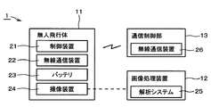
図1は、本発明の実施形態にかかる原料ヤードの原料山形状の計測装置を示す概略構成図である。計測装置1は、無人飛行体11、画像処理装置12、通信制御部13を備えている。
FIG. 1 is a schematic configuration diagram illustrating a raw material mountain-shaped measuring device of a raw material yard according to an embodiment of the present invention. The
無人飛行体11には、無人飛行体11を遠隔操作するための制御装置21、無線通信装置22、バッテリ23、および撮像装置24が搭載されている。本実施形態にかかる無人飛行体11としては、例えば市販の小型ラジコンヘリコプターを用いることができる。撮像装置24は、無人飛行体11の飛行中、常に無人飛行体11の直下の空撮画像を取得できるように、例えば三軸カメラジンバル等の姿勢制御手段によって支持されている。撮像装置24としては、市販のデジタルカメラを用いることができる。
The
画像処理装置12は、無人飛行体11に搭載された撮像装置24で撮影された複数の空撮画像から、ステレオ視法によって三次元解析して原料山の体積等を計測するものであり、パーソナルコンピュータに、市販の解析システム25、例えば倉敷紡績株式会社製の三次元写真応用計測用ソフトウェア「Kuraves-MD」等を導入して用いることができる。
The
通信制御部13は、無人飛行体11の無線通信装置22と通信するための無線通信装置26を備え、無人飛行体11の飛行ルートや撮像装置24の撮影条件等を制御する。
The
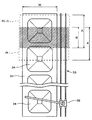
次に、上記の計測装置1を用いた原料ヤードの原料山形状の計測方法を、図2および図3を参照して説明する。図2は原料ヤード31を上から見た平面図の一例である。
Next, a method for measuring the shape of the raw material mountain in the raw material yard using the
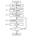
無人飛行体11は、離陸後、原料山形状の計測を行う原料ヤード31の長さ方向の一方の端から他方の端まで、原料ヤード31の幅方向ほぼ中央部の上方を、例えば高度約30mの高さを保って、原料ヤード31の長さ方向に移動する。無人飛行体11に搭載された撮像装置24は、無人飛行体11の移動中、無人飛行体11の直下を連続的に空撮する(図3,S1)。空撮は、全ての空撮画像にヤード幅Wの全幅が写るようにし、さらに、全ての空撮画像に、原料ヤード31の少なくとも幅方向片側に設けられたヤード機械32用の一対のレール33を写し込む。原料ヤード31の側方には、ヤード機械32用のレール33が必ず設置されており、この一対のレール33の間隔は例えば8m程度で原料ヤード31の全長にわたって一定であるため、このように設置位置と寸法が明確に把握できるものを全ての空撮画像に写し込んでおくことにより、原料山34の形状を解析する際の基準となる。基準となるものはレール33に限らず、例えば原料運搬用コンベアやコンベア架台等のように、原料ヤード31内に固定配置された設備のうち、少なくともいずれかを写し込めばよい。あるいは、予め決められた寸法の指標を地上に配置しておいて、それを空撮画像に写し込むようにしてもよい。
The
また、図2に示すように、連続して空撮する際、空撮画像Piは、直前に撮影した空撮画像P(i−1)に対して、原料ヤード31の長さ方向において、画像全体の少なくとも50%、好ましくは60%以上の範囲を重複するように撮影間隔を設定する。原理的には、原料ヤード31の長さ方向に重複する寸法Bは、画像全体の当該方向寸法Aの50%で問題ないが、使用する撮像装置24のレンズ収差等を考慮すると、B/Aは60%以上とすることが、より好ましい。
Further, as shown in FIG. 2, when continuously taking aerial images, the aerial image Pi is an image in the length direction of the
このようにして取得した空撮画像は、画像処理装置12により、補正および計測が行われる。まず、写し込んだヤード幅、一対のレール33の間隔等のゆがみの情報に基づいて、無人飛行体11の飛行姿勢(ヘディング角、ピッチ角、ロール角)による画像ひずみの影響を除去する。このひずみ除去後の空撮画像を第一補正画像とする(図3,S2)。
The aerial image acquired in this way is corrected and measured by the
なお、本実施形態では、コストや装置の信頼性確保の観点から採用しないが、無人飛行体11の飛行姿勢を、ジャイロなどの姿勢検出装置を用いて検出し、画像ひずみの影響を除去することもできる。
In this embodiment, although not adopted from the viewpoint of ensuring the cost and the reliability of the device, the flight posture of the
次に、飛行姿勢による画像ひずみを除去した第一補正画像から、写し込んだヤード幅や一対のレール33の間隔等、基準となる寸法に基づいて、空撮画像取得時の無人飛行体11の高度およびヤード幅方向の位置と、基準値(例えば高度30m、ヤード幅方向中央等)とのずれを補正する。このずれ補正後の画像を第二補正画像とする(図3,S3)。
Next, from the first corrected image from which the image distortion due to the flight posture is removed, the
無人飛行体11の高度およびヤード幅方向の位置を検出する方法としては、気圧計やGPS等を用いる方法もあるが、気圧計は天候の変化による気圧の影響を受けること、GPSは現在の技術レベルでは、本発明が対称とする計測の要求精度を満たしていないことから、本発明で用いるのは好ましくない。すなわち、本発明の計測対象である原料山では、例えば1mのずれは誤差として大きすぎるため、気圧計やGPSでは所望する精度が得られない。また、コスト面や装置の信頼性の観点からも、本発明には適していない。
As a method for detecting the altitude of the
次に、得られた第二補正画像群の中で、連続して撮影した2枚の第二補正画像の重複部をパターンマッチングすることにより、原料ヤードの長さ方向の視差を求め(図3,S4)、ステレオ視法によって、対応点の三次元計測を行う(図3,S5)。これをすべての第二補正画像群について繰り返し実施し、原料ヤード31の長さ方向全長について、原料山34の形状を求める。こうして求めた原料山形状に基づいて、原料の在庫を精度良く管理すると共に原料ヤードを効率よく運用することができる。
Next, in the obtained second corrected image group, parallax in the length direction of the raw material yard is obtained by pattern-matching overlapping portions of two second corrected images taken successively (FIG. 3). , S4), the corresponding points are three-dimensionally measured by stereo vision (FIG. 3, S5). This is repeatedly performed for all the second corrected image groups, and the shape of the
本発明によれば、無人飛行体11で空撮した空撮画像に基づいて原料山形状を計測するため、一つの計測装置1で複数の原料ヤード31の計測を兼用して行うことができる。したがって、原料ヤード毎に計測装置1を設置する必要がないので、大幅にコストを削減できる。しかも、計測時にヤード機械32の作業を制限しないため、原料の積み付けや払い出し作業を妨げることがない。
According to the present invention, since the raw material mountain shape is measured based on the aerial image taken by the
以上、本発明の好適な実施形態について説明したが、本発明はかかる例に限定されない。当業者であれば、特許請求の範囲に記載された技術的思想の範疇内において、各種の変更例または修正例に想到しうることは明らかであり、それらについても当然に本発明の技術的範囲に属するものと了解される。 As mentioned above, although preferred embodiment of this invention was described, this invention is not limited to this example. It is obvious for those skilled in the art that various changes or modifications can be conceived within the scope of the technical idea described in the claims. It is understood that it belongs to.
本発明は、製鉄所に限らず、例えば石炭火力発電所の石炭ヤードなどのように屋外で原料等を貯蔵する施設において、その山形状を計測する装置および方法として適用でき、在庫管理や施設の運用管理に利用できる。 The present invention is not limited to steelworks, but can be applied as an apparatus and method for measuring the shape of a mountain in a facility that stores raw materials and the like outdoors such as a coal yard of a coal-fired thermal power plant. Can be used for operation management.
1 計測装置
11 無人飛行体
12 画像処理装置
13 通信制御部
21 制御装置
22 無線通信装置
23 バッテリ
24 撮像装置
25 解析システム
26 無線通信装置
31 原料ヤード
32 ヤード機械
33 レール
34 原料山
DESCRIPTION OF
Claims (4)
前記無人飛行体を、原料ヤードの上方において前記原料ヤードの長さ方向に移動させながら、前記撮像装置により前記原料ヤードを連続的に空撮し、
設置位置と寸法が把握できるものを全ての空撮画像に写し込んで基準となる寸法とし、その基準に基づいて、連続して撮影した空撮画像同士の重複部分の画像を利用してステレオ視法により、前記原料ヤードの原料山形状を計測することを特徴とする、原料ヤードの原料山形状の計測方法。 A control device for remotely maneuvering the unmanned air vehicle, a wireless communication device, a battery, and an imaging device are mounted on the unmanned air vehicle,
While the unmanned air vehicle is moved in the length direction of the raw material yard above the raw material yard, the raw material yard is continuously aerial photographed by the imaging device,
Images that can be used to determine the installation position and dimensions are copied to all aerial images as reference dimensions, and based on the criteria, stereo images are displayed using overlapping images of aerial images that have been taken continuously. A method for measuring the shape of a raw material hill in the raw material yard, wherein the shape of the material hill in the raw material yard is measured by a method.
制御装置、無線通信装置、バッテリ、および撮像装置を搭載し、遠隔操作で前記原料ヤードの上方を前記原料ヤードの長さ方向に移動可能な無人飛行体と、
前記撮像装置により空撮した前記原料ヤードの空撮画像に写し込んだ設置位置と寸法が把握できるものを基準となる寸法とし、その基準に基づいて、複数の空撮画像の重複部を利用してステレオ視法により、前記原料ヤードの原料山形状を解析する解析システムを備えた画像処理装置と、を備えていることを特徴とする、原料ヤードの原料山形状の計測装置。
A measuring device for measuring the shape of a raw material mountain in a raw material yard,
An unmanned aerial vehicle equipped with a control device, a wireless communication device, a battery, and an imaging device, and capable of moving in the length direction of the raw material yard above the raw material yard by remote operation;
An installation position and dimensions captured in the aerial image of the raw material yard taken aerial by the imaging device are used as reference dimensions, and based on the criteria, a plurality of aerial image overlapping portions are used. And an image processing device provided with an analysis system for analyzing the shape of the raw material hills of the raw material yard by stereo vision.
Priority Applications (1)
| Application Number | Priority Date | Filing Date | Title |
|---|---|---|---|
| JP2014189735A JP6408317B2 (en) | 2014-09-18 | 2014-09-18 | Measuring method and measuring device for raw material mountain shape in raw material yard |
Applications Claiming Priority (1)
| Application Number | Priority Date | Filing Date | Title |
|---|---|---|---|
| JP2014189735A JP6408317B2 (en) | 2014-09-18 | 2014-09-18 | Measuring method and measuring device for raw material mountain shape in raw material yard |
Publications (2)
| Publication Number | Publication Date |
|---|---|
| JP2016061674A JP2016061674A (en) | 2016-04-25 |
| JP6408317B2 true JP6408317B2 (en) | 2018-10-17 |
Family
ID=55797515
Family Applications (1)
| Application Number | Title | Priority Date | Filing Date |
|---|---|---|---|
| JP2014189735A Expired - Fee Related JP6408317B2 (en) | 2014-09-18 | 2014-09-18 | Measuring method and measuring device for raw material mountain shape in raw material yard |
Country Status (1)
| Country | Link |
|---|---|
| JP (1) | JP6408317B2 (en) |
Families Citing this family (5)
| Publication number | Priority date | Publication date | Assignee | Title |
|---|---|---|---|---|
| JP6791041B2 (en) * | 2017-07-11 | 2020-11-25 | Jfeスチール株式会社 | Raw material mountain measurement method and raw material mountain measurement system |
| CN113167569B (en) * | 2018-11-21 | 2022-10-11 | 日本电气通信系统株式会社 | Volume measurement device, system, method, and program |
| JP7137509B2 (en) * | 2019-03-28 | 2022-09-14 | 五洋建設株式会社 | Quantity inspection system for ship cargo |
| EP3836054B1 (en) | 2019-12-13 | 2022-05-11 | SMS Group GmbH | Use of a remote-controlled drone |
| CN113155098B (en) | 2021-04-20 | 2022-08-09 | 中国铁路设计集团有限公司 | Existing railway track line high-precision three-dimensional reconstruction method based on unmanned aerial vehicle multi-view images |
Family Cites Families (6)
| Publication number | Priority date | Publication date | Assignee | Title |
|---|---|---|---|---|
| JP3922646B2 (en) * | 2004-07-01 | 2007-05-30 | 国際航業株式会社 | Stereo photo image search method, display method, and management system |
| JP2008105591A (en) * | 2006-10-26 | 2008-05-08 | Hiroboo Kk | Flight control method for autonomous control unmanned air vehicle |
| US8577518B2 (en) * | 2009-05-27 | 2013-11-05 | American Aerospace Advisors, Inc. | Airborne right of way autonomous imager |
| JP5847409B2 (en) * | 2011-03-17 | 2016-01-20 | 新日鐵住金株式会社 | Raw material yard management system, raw material yard management method, and computer program |
| JP5947634B2 (en) * | 2012-06-25 | 2016-07-06 | 株式会社トプコン | Aerial photography imaging method and aerial photography imaging system |
| JP6293593B2 (en) * | 2014-07-03 | 2018-03-14 | 株式会社日立ソリューションズ | Volume calculation device, volume calculation method, and volume calculation program |
-
2014
- 2014-09-18 JP JP2014189735A patent/JP6408317B2/en not_active Expired - Fee Related
Also Published As
| Publication number | Publication date |
|---|---|
| JP2016061674A (en) | 2016-04-25 |
Similar Documents
| Publication | Publication Date | Title |
|---|---|---|
| JP6408317B2 (en) | Measuring method and measuring device for raw material mountain shape in raw material yard | |
| JP4300118B2 (en) | Optical device for automatic loading and unloading of containers on vehicles | |
| CN112722873B (en) | Automatic control system of stacker-reclaimer | |
| US11620613B2 (en) | Drone-based inventory management methods and systems | |
| US9637887B2 (en) | Reclaimer 3D volume rate controller | |
| CN100406371C (en) | system and method for container identification | |
| US11113543B2 (en) | Facility inspection system and facility inspection method | |
| JP6809494B2 (en) | Belt conveyor management method and management system | |
| CN206420439U (en) | Contact net geometric parameter detection means based on machine vision | |
| CN102092405A (en) | Method and system device for measuring rail curve parameters | |
| CN106226157A (en) | Concrete structure member crevices automatic detection device and method | |
| JP6791041B2 (en) | Raw material mountain measurement method and raw material mountain measurement system | |
| WO2015135015A1 (en) | Train wagon 3d profiler | |
| KR101916248B1 (en) | Data collection system in shipyard | |
| CN111606205B (en) | Container crane comprising a reference mark | |
| JP6895788B2 (en) | Raw material mountain shape measurement method and measuring device in the raw material yard | |
| KR102504743B1 (en) | Position correction device and correction method of inspection drone based on the model of the facility | |
| FI128194B (en) | Mobile lifting device, arrangement and procedure | |
| CN113310722A (en) | Equipment and method for grid partition automatic random sampling of powder | |
| JP4700567B2 (en) | Steel material management method and management system | |
| KR101555105B1 (en) | Uninhabited aerial system for estimating the reserve quantity of pile and method for using the same | |
| KR101837906B1 (en) | Yard managmenting system for auto operating of stacker and reclaimer apparatus | |
| CN113086847B (en) | Method and device for determining state information of gantry crane equipment | |
| JPS6058134B2 (en) | Raw material yard management method | |
| JP6579142B2 (en) | Coil yard storage management method |
Legal Events
| Date | Code | Title | Description |
|---|---|---|---|
| A621 | Written request for application examination |
Free format text: JAPANESE INTERMEDIATE CODE: A621 Effective date: 20170626 |
|
| A977 | Report on retrieval |
Free format text: JAPANESE INTERMEDIATE CODE: A971007 Effective date: 20180524 |
|
| A131 | Notification of reasons for refusal |
Free format text: JAPANESE INTERMEDIATE CODE: A131 Effective date: 20180605 |
|
| A521 | Request for written amendment filed |
Free format text: JAPANESE INTERMEDIATE CODE: A523 Effective date: 20180731 |
|
| TRDD | Decision of grant or rejection written | ||
| A01 | Written decision to grant a patent or to grant a registration (utility model) |
Free format text: JAPANESE INTERMEDIATE CODE: A01 Effective date: 20180904 |
|
| A61 | First payment of annual fees (during grant procedure) |
Free format text: JAPANESE INTERMEDIATE CODE: A61 Effective date: 20180920 |
|
| R150 | Certificate of patent or registration of utility model |
Ref document number: 6408317 Country of ref document: JP Free format text: JAPANESE INTERMEDIATE CODE: R150 |
|
| S533 | Written request for registration of change of name |
Free format text: JAPANESE INTERMEDIATE CODE: R313533 |
|
| R350 | Written notification of registration of transfer |
Free format text: JAPANESE INTERMEDIATE CODE: R350 |
|
| R250 | Receipt of annual fees |
Free format text: JAPANESE INTERMEDIATE CODE: R250 |
|
| R250 | Receipt of annual fees |
Free format text: JAPANESE INTERMEDIATE CODE: R250 |
|
| R250 | Receipt of annual fees |
Free format text: JAPANESE INTERMEDIATE CODE: R250 |
|
| LAPS | Cancellation because of no payment of annual fees |