JP6336992B2 - Map-assisted sensor-based positioning for mobile devices - Google Patents
Map-assisted sensor-based positioning for mobile devices Download PDFInfo
- Publication number
- JP6336992B2 JP6336992B2 JP2015537723A JP2015537723A JP6336992B2 JP 6336992 B2 JP6336992 B2 JP 6336992B2 JP 2015537723 A JP2015537723 A JP 2015537723A JP 2015537723 A JP2015537723 A JP 2015537723A JP 6336992 B2 JP6336992 B2 JP 6336992B2
- Authority
- JP
- Japan
- Prior art keywords
- mobile device
- estimated
- trajectory
- estimating
- indoor environment
- Prior art date
- Legal status (The legal status is an assumption and is not a legal conclusion. Google has not performed a legal analysis and makes no representation as to the accuracy of the status listed.)
- Active
Links
Images


Classifications
-
- H—ELECTRICITY
- H04—ELECTRIC COMMUNICATION TECHNIQUE
- H04W—WIRELESS COMMUNICATION NETWORKS
- H04W4/00—Services specially adapted for wireless communication networks; Facilities therefor
- H04W4/02—Services making use of location information
- H04W4/029—Location-based management or tracking services
-
- G—PHYSICS
- G01—MEASURING; TESTING
- G01C—MEASURING DISTANCES, LEVELS OR BEARINGS; SURVEYING; NAVIGATION; GYROSCOPIC INSTRUMENTS; PHOTOGRAMMETRY OR VIDEOGRAMMETRY
- G01C21/00—Navigation; Navigational instruments not provided for in groups G01C1/00 - G01C19/00
- G01C21/20—Instruments for performing navigational calculations
- G01C21/206—Instruments for performing navigational calculations specially adapted for indoor navigation
-
- G—PHYSICS
- G01—MEASURING; TESTING
- G01C—MEASURING DISTANCES, LEVELS OR BEARINGS; SURVEYING; NAVIGATION; GYROSCOPIC INSTRUMENTS; PHOTOGRAMMETRY OR VIDEOGRAMMETRY
- G01C22/00—Measuring distance traversed on the ground by vehicles, persons, animals or other moving solid bodies, e.g. using odometers, using pedometers
- G01C22/006—Pedometers
Description
これは、その全体が参照により本明細書に組み込まれる、2012年10月22日に出願された、「MAP-ASSISTED SENSOR-BASED POSITIONING OF MOBILE DEVICES」の米国非仮特許出願第13/657,428号に対する優先権を主張するPCT出願である。 This is a US non-provisional patent application 13 / 657,428 of “MAP-ASSISTED SENSOR-BASED POSITIONING OF MOBILE DEVICES” filed on October 22, 2012, which is incorporated herein by reference in its entirety. PCT application claiming priority over issue.
[0001]本明細書で開示する主題は、電子デバイスに関し、より詳細には、1つまたは複数のモバイルデバイスのマップ支援センサーベース測位(map-assisted sensor-based positioning)を行うかまたはさもなければサポートするために1つまたは複数のコンピューティングプラットフォームにおいて使用する方法、装置および製造品に関する。 [0001] The subject matter disclosed herein relates to electronic devices, and more particularly to performing map-assisted sensor-based positioning or otherwise for one or more mobile devices. It relates to methods, apparatus and articles of manufacture for use in one or more computing platforms to support.
[0002]モバイルフォン、ノートブック、コンピュータなどのモバイルデバイスは一般に、たとえば、信号ベース測位システムおよび/または対応する信号のほんの数例を挙げると、衛星測位システム(たとえば、GPSなど)、アドバンストフォワードリンクトライラテレーション(AFLT:advanced forward-link trilateration)など、いくつかの技術のいずれか1つを使用して高度の精度でロケーションおよび/または位置を推定する能力を有する。高精度ロケーション情報を使用して、モバイルデバイスのアプリケーションは、たとえば、ほんの2、3の例を挙げると、車両/歩行者ナビゲーション、ロケーションベース探索など、多くの異なるサービスをユーザに与え得る。ここで、(たとえば、GPSおよび/または他の信号ベース測位システムから取得された)高精度信号ベースロケーション情報は、グローバル座標系(たとえば、緯度および経度または地球中心xyz座標)に従って処理され得る。グローバル座標系を基準とする(referenced)信号ベースロケーション情報のそのような使用は、いくつかのサービス(たとえば、屋外車両ナビゲーション)を提供するのに有用であり得るが、グローバル座標系を基準とするそのような信号ベースロケーション情報は、屋内歩行者ナビゲーションなど、他のタイプのサービスでは実際的でないことがある。 [0002] Mobile devices such as mobile phones, notebooks, computers, etc., typically include satellite-based positioning systems (eg, GPS, etc.), advanced forward links, to name just a few examples of signal-based positioning systems and / or corresponding signals, for example. Has the ability to estimate location and / or position with a high degree of accuracy using any one of several techniques, such as advanced forward-link trilateration (AFLT). Using high-precision location information, mobile device applications can provide users with many different services, such as vehicle / pedestrian navigation, location-based search, to name just a few examples. Here, high accuracy signal base location information (eg, obtained from GPS and / or other signal based positioning systems) may be processed according to a global coordinate system (eg, latitude and longitude or earth center xyz coordinates). Such use of signal-based location information referenced to the global coordinate system may be useful to provide some services (eg, outdoor vehicle navigation), but is referenced to the global coordinate system. Such signal-based location information may not be practical for other types of services, such as indoor pedestrian navigation.
[0003]オフィスビル、ショッピングモール、空港、スタジアムなど、いくつかの屋内環境では、いくつかの例示的な信号ベース測位技法は、たとえば、モバイルデバイスによって受信され、測位目的のために使用され得るワイヤレス信号を送信する、ワイヤレスネットワークアクセスポイント、セルラーネットワーク基地局、特殊目的ビーコン送信機など、様々な地上ベースワイヤレス信号送信デバイスを利用し得る。たとえば、モバイルデバイスが、送信機から信号ベース測位信号を受信し、それに基づいて送信機と受信機との間の擬似距離(a pseudorange)を判断し得る。したがって、たとえば、測位は、トライラテレーション(trilateration)および/または他の知られている信号ベース測位技法に基づいて行われ得る。しかしながら、すべての屋内環境が信号ベース測位システムによって適切にサポートされ得るとは限らない。その上、いくつかの事例では、モバイルデバイスが信号ベース測位技法を使用するのを回避することが有益であり得る。 [0003] In some indoor environments, such as office buildings, shopping malls, airports, stadiums, some exemplary signal-based positioning techniques may be received by a mobile device and used for positioning purposes, for example. Various terrestrial-based wireless signal transmission devices may be utilized, such as wireless network access points, cellular network base stations, special purpose beacon transmitters, that transmit signals. For example, a mobile device can receive a signal-based positioning signal from a transmitter and determine a pseudorange between the transmitter and the receiver based on the signal-based positioning signal. Thus, for example, positioning may be performed based on trilateration and / or other known signal-based positioning techniques. However, not all indoor environments can be adequately supported by signal-based positioning systems. Moreover, in some cases it may be beneficial to avoid mobile devices using signal-based positioning techniques.
[0004]屋内環境内でモバイルデバイスの軌道(trajectory)を推定するために実装され得る様々な方法、装置および/または製造品が提供される。 [0004] Various methods, apparatus and / or articles of manufacture are provided that can be implemented to estimate the trajectory of a mobile device within an indoor environment.
[0005]たとえば、いくつかの態様によれば、少なくとも1つのコンピューティングプラットフォームを用いて、屋内環境内のモバイルデバイスにおいて取得された1つまたは複数のセンサー測定値に少なくとも部分的に基づいてモバイルデバイスの軌道を推定することと、屋内環境の電子マップにおいて識別された1つまたは複数の物体に少なくとも部分的に基づいて推定された軌道に作用することとを備える、方法が実装され得る。 [0005] For example, according to some aspects, a mobile device based at least in part on one or more sensor measurements obtained at a mobile device in an indoor environment using at least one computing platform. A method may be implemented that includes estimating a trajectory of and acting on the estimated trajectory based at least in part on one or more objects identified in the electronic map of the indoor environment.
[0006]いくつかのさらなる態様によれば、屋内環境内のモバイルデバイスにおいて取得された1つまたは複数のセンサー測定値に少なくとも部分的に基づいてモバイルデバイスの軌道を推定するための手段と、屋内環境の電子マップにおいて識別された1つまたは複数の物体に少なくとも部分的に基づいて推定された軌道に作用するための手段とを備える、装置が提供され得る。 [0006] According to some further aspects, means for estimating a trajectory of the mobile device based at least in part on one or more sensor measurements obtained at the mobile device in the indoor environment; And a means for acting on an estimated trajectory based at least in part on one or more objects identified in an electronic map of the environment.
[0007]さらに他の態様によれば、メモリと、屋内環境内のモバイルデバイスにおいて取得された1つまたは複数のセンサー測定値に少なくとも部分的に基づいてモバイルデバイスの軌道を推定することと、メモリを介してアクセス可能な屋内環境の電子マップにおいて識別された1つまたは複数の物体に少なくとも部分的に基づいて推定された軌道に作用することとを行うための1つまたは複数の処理ユニットとを備える、コンピューティングプラットフォームが提供され得る。 [0007] According to yet another aspect, estimating a trajectory of a mobile device based at least in part on memory and one or more sensor measurements obtained at the mobile device in an indoor environment; One or more processing units for performing an estimated trajectory based at least in part on the one or more objects identified in the electronic map of the indoor environment accessible via A computing platform may be provided.
[0008]また別の態様によれば、屋内環境内のモバイルデバイスにおいて取得された1つまたは複数のセンサー測定値に少なくとも部分的に基づいてモバイルデバイスの軌道を推定することと、屋内環境の電子マップにおいて識別された1つまたは複数の物体に少なくとも部分的に基づいて推定された軌道に作用することと、を行うようにコンピューティングプラットフォーム中の1つまたは複数の処理ユニットによって実行可能なコンピュータ実装可能命令を記憶した非一時的コンピュータ可読媒体。 [0008] According to yet another aspect, estimating the trajectory of the mobile device based at least in part on one or more sensor measurements obtained at the mobile device in the indoor environment; Computer-implementable by one or more processing units in a computing platform to act on an estimated trajectory based at least in part on one or more objects identified in a map A non-transitory computer readable medium having stored possible instructions.
[0009]以下の図を参照しながら非限定的で非網羅的な態様について説明し、別段に規定されていない限り、様々な図の全体を通して、同様の参照番号は同様の部分を指す。 [0009] Non-limiting and non-exhaustive aspects are described with reference to the following figures, and like reference numerals refer to like parts throughout the various figures unless otherwise specified.
[0025]本明細書の例によって示されるように、1つまたは複数のモバイルデバイスのマップ支援センサーベース測位を行うかまたはさもなければサポートするために1つまたは複数のコンピューティングプラットフォームにおいて使用する様々な方法、装置および製造品が実装され得る。 [0025] As shown by the examples herein, various used in one or more computing platforms to perform or otherwise support map-assisted sensor-based positioning of one or more mobile devices Various methods, apparatus and articles of manufacture may be implemented.
[0026]いくつかの態様によれば、マップ支援センサーベース測位のための本明細書で提供する技法は、いくつかの信号ベース測位技法が何らかの理由でサポートされ得ないおよび/または不利であり得る(may be adverse)環境内で特に利益があり得る。たとえば、いくつかの屋内環境では、SPS信号に依拠する信号ベース測位技法が、追加の信号減衰(signal attenuation)などによりうまく機能しないことがある。さらに、いくつかの屋内環境は、いくつかの信号ベース測位技法において通常ならば(otherwise)有用であり得るアクセスポイントおよび/または他のワイヤレス送信機がないことがある。さらに、いくつかの事例では、モバイルデバイスが、そのような信号ベース測位技法によって使用され得るワイヤレス信号を含めてワイヤレス信号を送信および/または受信するのを回避することが望ましいことがある。たとえば、モバイルデバイスは、通信インターフェースまたはそれの一部分が何回動作させられるかを低減することによって、電力消費量を低減し得る。別の例では、いくつかの環境では、モバイルデバイスが、たとえば、他の電子デバイスに干渉することを回避するために、および/または他の理由で、それの通信インターフェースの全部または一部をアクティブにしないことが有益であり得る。いくつかの状況では、たとえば、所与の環境のグランドトゥルース(a ground truth)などに対応する情報が取得される(たとえば、新しくなる、更新されるなど)および/または適用される(たとえば、使用される、テストされる、検証されるなど)ことがあるなど、ワイヤレスシグナリングを使用しない処理のいくつかの他の利益が達成され得る。したがって、そのような新しいおよび/または改良された情報は、環境またはそれの一部分内のいくつかの特徴をマッピングするかまたはさもなければ識別するために使用される様々な他のプロセスに有益であり得る。したがって、そのような新しいおよび/または改良された情報は、たとえば、後処理(post-processing)および/またはポスト測位(post-positioning)の使用のために提供される1つまたは複数のシステムまたは機能において適用され得る。 [0026] According to some aspects, the techniques provided herein for map-assisted sensor-based positioning may not be supported for some reason and / or may be disadvantageous for some reason. (May be adverse) can be particularly beneficial within the environment. For example, in some indoor environments, signal-based positioning techniques that rely on SPS signals may not work well, such as with additional signal attenuation. Further, some indoor environments may lack access points and / or other wireless transmitters that may otherwise be useful in some signal-based positioning techniques. Further, in some instances, it may be desirable to avoid mobile devices transmitting and / or receiving wireless signals, including wireless signals that may be used by such signal-based positioning techniques. For example, a mobile device may reduce power consumption by reducing how many times a communication interface or portion thereof is operated. In another example, in some environments, a mobile device may activate all or part of its communication interface, eg, to avoid interfering with other electronic devices and / or for other reasons. It may be beneficial not to In some situations, for example, information corresponding to a ground truth of a given environment is obtained (eg, new, updated, etc.) and / or applied (eg, used) Some other benefits of processing that does not use wireless signaling may be achieved. Accordingly, such new and / or improved information is beneficial to various other processes used to map or otherwise identify some features within the environment or portions thereof. obtain. Accordingly, such new and / or improved information may be provided, for example, for one or more systems or functions provided for use in post-processing and / or post-positioning. Can be applied.
[0027]したがって、時々、モバイルデバイスは、いくつかの通信インターフェースほど多くの電力を消費しないおよび/または他のデバイスに干渉しないことがある1つまたは複数のオンボードセンサー、たとえば、慣性センサー、環境センサーなど、またはそれらの何らかの組合せからセンサー測定値を取得することが有益であり得る。いくつかの事例では、センサー測定値は、特定の環境内のモバイルデバイスの軌道および/または位置を推定するために使用され得る。たとえば、1つまたは複数の慣性センサー(たとえば、1つまたは複数の加速度計、ジャイロスコープなど)および/または1つまたは複数の環境センサー(たとえば磁力計または同様の他のデバイス、たとえば気圧計)からのセンサー測定値は、特定の環境内でナビゲートしながらモバイルデバイスのユーザによって動き回されるときにモバイルデバイスが受けるいくつかの移動に対応し得る。たとえば、1つまたは複数の加速度計は、モバイルデバイスのユーザが歩行またはランニングしながらステップを取っているときにモバイルデバイスが受ける力に基づいてセンサー測定値を生成し得る。たとえば、1つまたは複数の加速度計は、モバイルデバイスのユーザが加速、減速、回転などするときにモバイルデバイスが受ける力に基づいてセンサー測定値を生成し得る。たとえば、ジャイロスコープは、モバイルデバイスのユーザが特定の環境内の様々な物体の間をナビゲートするとき、モバイルデバイスの配向の変化に対応するセンサー測定値を生成し得る。たとえば、磁力計は、動き回っている、たとえば、歩行しながら回転していたり、起立しながら旋回していたり(pivoting)などするユーザによって生じるいくつかの方向変化に対応するセンサー測定値を生成し得る。たとえば、いくつかの事例では、気圧計は、動き回っている、たとえば、階段を上っていたり、エレベータまたはエスカレータに乗っていたりなどするユーザによって生じる高度のいくつかの変化に対応するセンサー測定値を生成し得る。 [0027] Thus, sometimes a mobile device does not consume as much power as some communication interfaces and / or does not interfere with other devices, such as one or more on-board sensors, eg, inertial sensors, environments It may be beneficial to obtain sensor measurements from a sensor or the like, or some combination thereof. In some cases, sensor measurements may be used to estimate the trajectory and / or position of a mobile device within a particular environment. For example, from one or more inertial sensors (eg, one or more accelerometers, gyroscopes, etc.) and / or one or more environmental sensors (eg, magnetometers or other similar devices such as barometers). The sensor measurements may correspond to a number of movements that the mobile device undergoes when moved around by a user of the mobile device while navigating within a particular environment. For example, the one or more accelerometers may generate sensor measurements based on the force experienced by the mobile device when the user of the mobile device is taking steps while walking or running. For example, the one or more accelerometers may generate sensor measurements based on forces that the mobile device experiences when a user of the mobile device accelerates, decelerates, rotates, and the like. For example, a gyroscope may generate sensor measurements that correspond to changes in the orientation of the mobile device as a user of the mobile device navigates between various objects in a particular environment. For example, a magnetometer may generate sensor measurements that correspond to several directional changes caused by a user moving around, for example, rotating while walking or pivoting while standing. . For example, in some cases, a barometer will produce sensor readings that correspond to some change in altitude caused by a user moving around, for example, climbing stairs or riding an elevator or escalator. Can be generated.
[0028]1つまたは複数のセンサーを備えることに加えて、モバイルデバイスは、環境内で動き回る人の能力に何らかの影響を及ぼす環境内のいくつかの物体を示し得る1つまたは複数の電子マップの全部または一部でさらにプロビジョニングされ得る(may be further provisioned)。例として、(たとえば、1つまたは複数の自然および/または人工構造物の全部または一部を備える)屋内環境用の電子マップは、その屋内環境に関係する様々な物体を識別し得る。たとえば、建築物用の電子マップは、壁および/または他の同様の物理的特徴によって分離された、建築物内の様々な領域を識別し得る。したがって、建築物用の例示的な電子マップは、様々な部屋、廊下、入口、出口、階段、エレベータ、窓などを有する間取り図を識別するコンピュータ支援設計(CAD)図面などを備え得る。いくつかの事例では、例示的な電子マップは、たとえば、デスク、キュービクル(cubicles)、ディスプレイケース、アプライアンス(appliances)など、いくつかの物体をさらに示し得る。さらに他の事例では、例示的な電子マップに関連付けられた1つまたは複数のデータファイルが、屋内構造内をナビゲートしているユーザに有用であり得る追加の情報を備え得る。たとえば、屋内構造内の特定の領域に関連付けられ得るいくつかのサービス、または場合によっては人またはエンティティを示す、ロケーションベースサービス情報および/または何らかの形態のメタデータが与えられ得る。当業者は、上記で説明したもの以外の物体が電子マップ中で識別され得ることを諒解されよう。さらに、当業者は、電子マップがモバイルデバイス以外のデバイスまたはロケーションにおいて、たとえばサーバまたはワークステーションにおいてプロビジョニングされ得ること、および電子マップが屋内エリア以外のエリアを記述し得ることを諒解されよう。たとえば、電子マップは、都市または公園内の屋外スタジアムまたは経路(pathways)を記述し得る。したがって、以下の実施形態では屋内環境および/またはマップに関して説明することがあるが、いくつかの実施形態は、他の環境内でまたは他の電子マップとともに使用され得る。 [0028] In addition to comprising one or more sensors, the mobile device may be an electronic map or maps that may represent a number of objects in the environment that have some impact on the person's ability to move around in the environment. May be further provisioned in whole or in part. By way of example, an electronic map for an indoor environment (eg, comprising all or part of one or more natural and / or man-made structures) may identify various objects related to the indoor environment. For example, an electronic map for a building may identify various regions within the building that are separated by walls and / or other similar physical features. Thus, an exemplary electronic map for a building may comprise computer aided design (CAD) drawings that identify floor plans with various rooms, hallways, entrances, exits, stairs, elevators, windows, and the like. In some instances, the example electronic map may further indicate a number of objects, such as desks, cubicles, display cases, appliances, and the like. In yet other instances, one or more data files associated with the example electronic map may comprise additional information that may be useful to a user navigating within an indoor structure. For example, location-based service information and / or some form of metadata may be provided that indicates some service, or possibly a person or entity, that may be associated with a particular area within an indoor structure. Those skilled in the art will appreciate that objects other than those described above can be identified in the electronic map. Further, those skilled in the art will appreciate that an electronic map can be provisioned at a device or location other than a mobile device, such as at a server or workstation, and that the electronic map can describe an area other than an indoor area. For example, an electronic map may describe an outdoor stadium or pathways within a city or park. Thus, although the following embodiments may be described in terms of indoor environments and / or maps, some embodiments may be used in other environments or with other electronic maps.
[0029]いくつかの実装形態では、ユーザおよび/または何らかの他のエンティティが、電子マップまたはそれに関連付けられた何らかのデータファイルの一部分にアノテーションを付ける(annotate)かまたはさもなければ強調する(enhance)ことに関係し得るおよび/またはさもなければそのために使用され得る追加の情報を与えることが可能であり得る。たとえば、いくつかの実装形態では、ユーザが屋内環境内で全体的にまたは部分的に従い得る1つまたは複数の予定ルートに関連付けられ得る、1つまたは複数の開始および/または終了ロケーション、および/または中間地点を、ユーザまたは何らかの他のエンティティが定義することを可能にする、1つまたは複数のアプリケーションが提供され得る。たとえば、表示マップレンダリング内の情報の表示に関するおよび/または電子マップに関連する(たとえば、1つまたは複数のボタンおよびノブ、キーパッド、タッチスクリーン、マイクロフォン、カメラなどを介した)ユーザ入力を受け付けるためのアプリケーションが提供され得る。したがって、たとえば、ユーザは、人々または注目するポイント、あるいは場合によっては間取り図の全部または一部分の視覚表現などのリストを提示され得、所望の開始ポイントおよび/または終了ポイントおよび/または1つまたは複数の中間地点などをプログラムするように何らかの方法で応答し得る。いくつかの例示的な実装形態では、モバイルデバイスは、(たとえば、オンボードおよび/または外部サービスアプリケーションなどから)特定の目的地へのルーティング方向を取得し得る。モバイルデバイスのユーザがそのようなルーティング方向に従うと仮定すると、1つまたは複数の中間地点は、そのようなルーティング方向に少なくとも部分的に基づいて判断され得る。 [0029] In some implementations, a user and / or some other entity annotate or otherwise enhance an electronic map or a portion of any data file associated therewith. It may be possible to provide additional information that may relate to and / or otherwise be used for that. For example, in some implementations, one or more start and / or end locations that can be associated with one or more scheduled routes that a user can follow in whole or in part within an indoor environment, and / or One or more applications may be provided that allow a user or some other entity to define a waypoint. For example, to accept user input related to the display of information in a display map rendering and / or related to an electronic map (eg, via one or more buttons and knobs, keypad, touch screen, microphone, camera, etc.) Applications can be provided. Thus, for example, a user may be presented with a list of people or points of interest, or possibly a visual representation of all or a portion of a floor plan, where desired starting and / or ending points and / or one or more You can respond in some way to program the waypoints. In some exemplary implementations, the mobile device may obtain a routing direction to a particular destination (eg, from onboard and / or external service applications, etc.). Assuming that the user of the mobile device follows such a routing direction, one or more waypoints may be determined based at least in part on such routing direction.
[0030]電子マップおよび/または他の同様の情報および/またはコンピュータ実装可能命令を表す1つまたは複数のデータファイルは、たとえば、(たとえば、1つまたは複数のワイヤードおよび/またはワイヤレス通信リンクを介して)1つまたは複数の他のコンピューティングデバイスから取得され、および/または様々な形態の非一時的コンピュータ可読媒体(たとえば、光ディスク、磁気ディスク、電子メモリデバイス、機械可読オブジェクトなど)から取得され得る。 [0030] One or more data files representing an electronic map and / or other similar information and / or computer-implementable instructions may be, for example, (eg, via one or more wired and / or wireless communication links). And / or may be obtained from one or more other computing devices and / or obtained from various forms of non-transitory computer readable media (eg, optical disks, magnetic disks, electronic memory devices, machine readable objects, etc.). .
[0031]いくつかの例示的な実装形態によれば、屋内環境内のモバイルデバイスにおいて取得された1つまたは複数のセンサー測定値に少なくとも部分的に基づいてモバイルデバイスの軌道を推定することと、屋内環境の電子マップにおいて識別された1つまたは複数の物体に少なくとも部分的に基づいて推定された軌道に作用することとを行うための、1つまたは複数のコンピューティングプラットフォームが、たとえば、コンピューティングデバイスおよび/またはモバイルデバイス内に設けられ得る。 [0031] According to some example implementations, estimating the trajectory of the mobile device based at least in part on one or more sensor measurements obtained at the mobile device in an indoor environment; One or more computing platforms for performing operations on estimated trajectories based at least in part on one or more objects identified in an electronic map of an indoor environment, for example, computing It may be provided in the device and / or mobile device.
[0032]例示的な実装形態では、コンピューティングプラットフォームが、モバイルデバイスにおける少なくとも1つの加速度計から取得された1つまたは複数のセンサー測定値のうちの少なくとも1つに少なくとも部分的に基づいて、動きモードに関連する少なくとも1つのアクションの発生を検出することによって、モバイルデバイスの軌道を推定し得る。例として、例示的な動きモードは、歩行中またはランニング中の人によって携帯されたモバイルデバイスが受け得る二足歩行移動など、1つまたは複数の形態の二足歩行移動に関係し得る。別の例では、特定の動きモードは、エレベータまたはエスカレータに乗っている人および/または何らかの方法で進ませられている(being propelled)人によって携帯されている間にモバイルデバイスが受け得る移動に関係し得る。 [0032] In an exemplary implementation, the computing platform moves based at least in part on at least one of one or more sensor measurements obtained from at least one accelerometer in the mobile device. By detecting the occurrence of at least one action associated with the mode, the trajectory of the mobile device may be estimated. By way of example, exemplary motion modes may relate to one or more forms of biped locomotion, such as biped locomotion that a mobile device carried by a person walking or running may undergo. In another example, a particular mode of motion relates to the movement that a mobile device can undergo while being carried by a person on an elevator or escalator and / or being propelled in some way. Can do.
[0033]少なくとも1つのそのような検出されたアクションの発生に少なくとも部分的に基づいて、コンピューティングプラットフォームは、ある時間期間中にモバイルデバイスが移動した距離、その時間期間中のモバイルデバイスの速度、および/または他の同様の動き関連情報を推定し得る。例として、動きモードが何らかの形態の二足歩行移動モードを備えると仮定すると、検出されたアクションは、1つまたは複数のステッピングアクション(stepping actions)を含み得る。したがって、コンピューティングプラットフォームは、たとえば、推定ストライド長、推定ストライド頻度(estimated stride frequency)など、または1つまたは複数の検出されたステッピングアクションに関連するそれらの何らかの組合せに少なくとも部分的に基づいて、移動した距離および/または速度を推定し得る。いくつかの例示的な実装形態では、コンピューティングプラットフォームは、ステップカウントを積算することと角速度を積算することとによって、移動した距離および/または速度を推定し得る。 [0033] Based at least in part on the occurrence of at least one such detected action, the computing platform determines the distance that the mobile device has traveled during a period of time, the speed of the mobile device during that period of time, And / or other similar motion related information may be estimated. By way of example, assuming that the motion mode comprises some form of bipedal locomotion mode, the detected actions may include one or more stepping actions. Accordingly, the computing platform moves based at least in part on, for example, an estimated stride length, an estimated stride frequency, etc., or some combination thereof associated with one or more detected stepping actions. Estimated distance and / or velocity. In some exemplary implementations, the computing platform may estimate distance traveled and / or velocity by accumulating step counts and accumulating angular velocities.
[0034]いくつかの例示的な実装形態によれば、コンピューティングプラットフォームは、モバイルデバイスにおけるジャイロスコープおよび/または磁力計から取得された1つまたは複数のセンサー測定値に少なくとも部分的に基づいて、モバイルデバイスの配向の変化が発生したのか発生しなかったのかを判断することに少なくとも部分的によって、モバイルデバイスの軌道を推定し得る。ここで、たとえば、コンピューティングプラットフォームは、変化が発生したのか発生しなかったのかの判断に少なくとも部分的に基づいて、モバイルデバイスの現在のヘッディング(current heading)を推定し得る。たとえば、コンピューティングプラットフォームは、少なくとも1つの前に推定されたヘッディングに少なくとも部分的に基づいて現在のヘッディングを推定し得る。 [0034] According to some example implementations, the computing platform may be based at least in part on one or more sensor measurements obtained from a gyroscope and / or magnetometer in the mobile device. The trajectory of the mobile device may be estimated at least in part by determining whether a change in orientation of the mobile device has occurred or has not occurred. Here, for example, the computing platform may estimate the current heading of the mobile device based at least in part on determining whether a change has occurred or not. For example, the computing platform may estimate the current heading based at least in part on at least one previously estimated heading.
[0035]いくつかの例示的な実装形態によれば、コンピューティングプラットフォームは、電子マップにおいて識別された屋内環境内の1つまたは複数の物体の配置に関して定義され得る1つまたは複数の中間地点の1つまたは複数のロケーションを使用することに少なくとも部分的によって推定された軌道に作用し得る。いくつかの事例では、コンピューティングプラットフォームは、たとえば、モバイルデバイスのユーザインターフェースから受信された少なくとも1つの入力に少なくとも部分的に基づいて中間地点のロケーションのうちの少なくとも1つを取得し得る。いくつかの事例では、コンピューティングプラットフォームは、たとえば、電子マップに少なくとも部分的に基づいて1つまたは複数の中間地点のロケーションのうちの1つまたは複数を判断し得る。 [0035] According to some exemplary implementations, the computing platform may define one or more waypoints that may be defined with respect to the placement of one or more objects within the indoor environment identified in the electronic map. Using one or more locations may affect the trajectory estimated at least in part. In some instances, the computing platform may obtain at least one of the waypoint locations based at least in part on, for example, at least one input received from a user interface of the mobile device. In some instances, the computing platform may determine one or more of one or more waypoint locations based at least in part on an electronic map, for example.
[0036]いくつかの例示的な実装形態によれば、コンピューティングプラットフォームは、推定された軌道において生じ、場合によっては時間とともにアグリゲートされ得るドリフト(drift)を補正することに少なくとも部分的によって、推定された軌道に作用し得る。たとえば、いくつかの実装形態では、軌道を推定し、ドリフトなどのいくつかのエラーを訂正するために、粒子フィルタ(particle filter)などが実装され得る。いくつかの事例では、粒子フィルタは、たとえば、電子マップおよび/またはその中で識別された何らかの物体に対するモバイルデバイスの推定位置、モバイルデバイスの推定ヘッディング、ある時間期間中にモバイルデバイスが移動した推定距離、ある時点におけるまたはある時間期間中のモバイルデバイスの推定速度など、あるいはそれらの何らかの組合せに少なくとも部分的に基づいて、粒子状態を維持し得る。 [0036] According to some exemplary implementations, the computing platform may be in an estimated trajectory and possibly at least in part in correcting for drift that may be aggregated over time. Can affect the estimated trajectory. For example, in some implementations, a particle filter or the like may be implemented to estimate the trajectory and correct some errors such as drift. In some cases, the particle filter may be, for example, an estimated location of the mobile device relative to the electronic map and / or any object identified therein, an estimated heading of the mobile device, an estimated distance that the mobile device has moved during a period of time The particle state may be maintained based at least in part on the estimated speed of the mobile device at some point in time or during a period of time, etc., or some combination thereof.
[0037]いくつかの事例では、推定ヘッディングは、推定回転特性(estimated turn characteristic)に少なくとも部分的に基づくヘッディングエラーを考慮に入れ、および/またはさもなければそれに関連付けられ得る。いくつかの事例では、粒子フィルタは、モバイルデバイスにおいて取得された1つまたは複数のセンサー測定値に少なくとも部分的に基づいて1つまたは複数の粒子を伝搬し得る。いくつかの事例では、粒子フィルタは、推定された軌道および/または他のラインからしきい値測定値超だけ(by more than a threshold measurement)それる(stray)伝搬粒子(propagated particles)を除去することに少なくとも部分的に基づいて粒子状態を維持し得る。 [0037] In some cases, the estimated heading may take into account and / or otherwise be associated with a heading error based at least in part on an estimated turn characteristic. In some instances, the particle filter may propagate one or more particles based at least in part on one or more sensor measurements acquired at the mobile device. In some cases, the particle filter removes stray propagated particles from estimated trajectories and / or other lines by more than a threshold measurement. In particular, the particle state may be maintained based at least in part.
[0038]いくつかの例示的な実装形態によれば、コンピューティングプラットフォームは、コスト関数などに少なくとも部分的に基づき得る個別回転割当て(discrete turn assignment)を使用して、推定された軌道のドリフトを補正することに少なくとも部分的によって、推定された軌道に作用し得る。たとえば、コスト関数は、何らかの時間期間中のモバイルデバイスの配向の差またはそれの欠如のコスト、何らかの時間期間中にモバイルデバイスが移動した推定距離に対して連続する中間地点間の距離(a distance between consecutive waypoints)をマッチングするコスト(マッチングコスト)など、あるいはそれらの何らかの組合せを考慮に入れ得る。いくつかの事例では、コスト関数は、たとえば、少なくとも部分的に、マッチングコストを最小限に抑えるための動的関数を使用して計算され得る。 [0038] According to some example implementations, the computing platform may use the discrete turn assignment, which may be based at least in part on a cost function, etc., to estimate the estimated trajectory drift. The correction can affect the estimated trajectory at least in part. For example, the cost function can be the cost of a difference in the orientation of a mobile device during some time period, or the cost of lack thereof, the distance between successive intermediate points relative to the estimated distance traveled by the mobile device during some time period (a distance between The cost of matching consecutive waypoints) (matching costs), etc., or some combination thereof may be taken into account. In some cases, the cost function may be calculated, for example, using a dynamic function to minimize matching costs, at least in part.
[0039]いくつかの例示的な実装形態によれば、コンピューティングプラットフォームは、推定された軌道と電子マップとの少なくとも一部分に少なくとも部分的に基づいてモバイルデバイスのロケーションを推定し得る。いくつかの例示的な実装形態では、コンピューティングプラットフォームは、たとえば、モバイルデバイス、および/または場合によっては何らかの他のコンピューティングデバイスの少なくとも1つのユーザ出力デバイスを介して、推定ロケーション、推定軌道、推定到着時間、推定速度など、またはそれらの何らかの組合せの提示を開始し得る。 [0039] According to some example implementations, the computing platform may estimate the location of the mobile device based at least in part on at least a portion of the estimated trajectory and the electronic map. In some exemplary implementations, the computing platform may be an estimated location, an estimated trajectory, an estimate, eg, via at least one user output device of a mobile device and / or possibly some other computing device. Presentation of arrival time, estimated speed, etc., or some combination thereof may begin.
[0040]いくつかの例示的な実装形態では、推定された軌道は、複数の潜在的な経路(potential paths)および/または制約に基づき得る。いくつかの実施形態では、たとえば、電子マップは、(たとえば、コスト関数などを介して)可能性が最も高い経路を判断するように探索され得る。したがって、いくつかの事例では、モバイルデバイスのロケーションは、測位のためのワイヤレス信号を使用せずに取得され得る。たとえば、本明細書の実施形態は、モバイルデバイスの概略位置をアプリオリに知ることもしくは概略位置を最初に判断すること(もしくは、たとえば近くの特徴(nearby features)に基づいて、潜在的な位置間の曖昧さを除去すること(disambiguating between potential positions))、および/または特定の経路に従わなければならないことに限定されない。そうではなく、実施形態は、たとえば電子マップ(もしくはそれの制約)およびモバイルデバイスの1つまたは複数のセンサーに基づいて、電子マップに対応する環境内の可能性があるルートまたは経路を判断するために、たとえばそのような情報が利用可能でないかあるいはこの情報を判断または収集しないことが有益である他の状況において使用され得る。したがって、モバイルデバイスのルートまたは位置は、いくつかの実施形態では、環境内のモバイルデバイスの概略位置またはルートが未知であるときでも推論され得る。 [0040] In some exemplary implementations, the estimated trajectory may be based on a plurality of potential paths and / or constraints. In some embodiments, for example, an electronic map may be searched to determine the most likely route (eg, via a cost function or the like). Thus, in some cases, the location of the mobile device may be obtained without using a wireless signal for positioning. For example, embodiments herein may know a priori the approximate location of a mobile device or determine the approximate location first (or, for example, based on near features, between potential locations It is not limited to disambiguating between potential positions) and / or having to follow a specific path. Rather, embodiments may determine a possible route or path in the environment corresponding to the electronic map, eg, based on the electronic map (or constraints thereof) and one or more sensors of the mobile device. For example, it may be used in other situations where such information is not available or it is beneficial not to determine or collect this information. Thus, the route or location of the mobile device can be inferred in some embodiments even when the approximate location or route of the mobile device in the environment is unknown.
[0041]次に図1に注目すると、図1は、例示的な実装形態による、それのうちの1つまたは複数がモバイルデバイス104のマップ支援センサーベース測位をサポートし得る、コンピューティングデバイス102とモバイルデバイス104とを含む例示的な環境100を示す概略ブロック図である。
[0041] Turning now to FIG. 1, FIG. 1 illustrates a
[0042]図示のように、コンピューティングデバイス102は、屋内環境140内のモバイルデバイス104に関してマップ支援センサーベース測位を行うための装置112を備える。装置112は、たとえば1つまたは複数のネットワーク120を介して、直接および/または間接的に1つまたは複数の他のリソース(デバイス)130と通信し得る1つまたは複数のコンピューティングプラットフォームを表し得る。装置112は、(たとえば、ワイヤレス通信リンク103によって示されるように)直接的に、および/または(たとえば、(1つまたは複数の)ネットワーク120を介して、およびワイヤレス通信リンク121によって示されるように)間接的に、モバイルデバイス104と通信し得る。コンピューティングデバイス102はこの例ではたまたま屋内環境140の外部に位置するものとして示されているが、いくつかの他の実装形態では、コンピューティングデバイス102および/または装置112の全部または一部は屋内環境140内に位置し得ることを認識されたい。
[0042] As shown, the
[0043](1つまたは複数の)ネットワーク120は、コンピューティングデバイス102と1つまたは複数の他のリソース(デバイス)130との間の通信をサポートする、様々な相互接続されたデバイスを有する1つまたは複数の通信システムおよび/またはデータネットワークを備え得る。述べたように、(1つまたは複数の)ネットワーク120は、コンピューティングデバイス102とモバイルデバイス104との間の通信をさらにサポートし得る。たとえば、コンピューティングデバイス102とモバイルデバイス104との間の通信によって、あるデータおよび/または命令がそれらの間で交換されることが可能になり得る。一例では、モバイルデバイス104に搭載された1つまたは複数のセンサーから取得された1つまたは複数のセンサー測定値がコンピューティングデバイス102内の装置112に送信され得、および/または、少なくとも部分的に装置110によって判断された、推定軌道および/または他の測位情報の全部または一部が、コンピューティングデバイス102、および/または場合によっては1つまたは複数の他のリソース(デバイス)130に送信され得る。逆に、別の例では、少なくとも部分的にコンピューティングデバイス102中の装置112によって判断された、推定軌道および/または他の測位情報の全部または一部が、モバイルデバイス104に送信され得る。
[0043] The network (s) 120 have various interconnected devices that support communication between the
[0044]本明細書で使用する「モバイルデバイス」は、屋内環境内で、たとえばユーザによって直接あるいは間接的に動き回らされ得る任意の電子デバイスを表し得る。いくつかの実施形態では、モバイルデバイスは、1つまたは複数のワイヤードおよび/またはワイヤレス通信リンクを介して1つまたは複数の他のデバイスと通信するように構成され得る。いくつかの例としては、セルフォン、スマートフォン、コンピュータ(たとえば、ラップトップコンピュータ、タブレットコンピュータ、ウェアラブルコンピュータなどのパーソナルコンピュータ)、ナビゲーションエイド、トラッキングデバイス、デジタルブックリーダー、ゲームデバイス、音楽および/またはビデオプレーヤデバイス、カメラ、機械、ロボットなどがある。 [0044] As used herein, a "mobile device" may refer to any electronic device that can be moved around in an indoor environment, for example, directly or indirectly by a user. In some embodiments, a mobile device may be configured to communicate with one or more other devices via one or more wired and / or wireless communication links. Some examples include cell phones, smartphones, computers (eg, personal computers such as laptop computers, tablet computers, wearable computers), navigation aids, tracking devices, digital book readers, gaming devices, music and / or video player devices. , Cameras, machines, robots, etc.
[0045]他のリソース(デバイス)130は、コンピューティングデバイス102および/またはモバイルデバイス104がいくつかのデータファイルおよび/または命令をそれから取得し得、および/またはコンピューティングデバイス102および/またはモバイルデバイス104がいくつかのデータファイルおよび/または命令をそれに与え得る、1つまたは複数のコンピューティングプラットフォームを表し得る。たとえば、いくつかの事例では、電子マップなどの全部または一部が、1つまたは複数の他のリソース(デバイス)130からコンピューティングデバイス102および/またはモバイルデバイス104によって取得され得る。たとえば、いくつかの事例では、装置112および/または装置110において使用する命令のセットの全部または一部が他のリソース(デバイス)130から取得され得る。
[0045] Other resources (devices) 130 may allow the
[0046]例示的な環境100は、いくつかの実施形態では、モバイルデバイス104に1つまたは複数の衛星測位システム(SPS:satellite positioning system)信号151を送信し得るSPS150をさらに含む。SPS150は、たとえば、1つまたは複数のGNSS、1つまたは複数の領域ナビゲーション衛星システムなど、あるいはそれらの何らかの組合せを表し得る。さらに、SPS150および/またはSPS信号151は、信号ベース測位において使用するためのワイヤレス信号を送信する1つまたは複数の地上ベースワイヤレス送信デバイスを表し得る。したがって、たとえば、SPS150はワイヤレスアクセスポイント、基地局などを表し得、SPS信号151は、信号ベース測位において使用するための対応するワイヤレス信号を表し得る。SPS信号151は、時々、モバイルデバイス104によって収集され、モバイルデバイスの位置ロケーションを推定するために使用され得る。
[0046] The
[0047]しかしながら、述べたように、ただしいくつかの事例では、屋内環境の全部または一部がそのような信号ベース測位信号のカバレージエリアの外部にあり得、および/またはモバイルデバイス104は、そのような信号ベース測位信号が受信可能であり得ないかまたは無視され得るモードで動作していることがある。したがって、そのような信号ベース測位信号がない場合、装置110および/または装置112は、本明細書で提供する例示的な技法に従ってマップ支援センサーベース測位を実行することを試み得る。
[0047] However, as noted, however, in some instances, all or part of the indoor environment may be outside the coverage area of such signal-based positioning signals and / or the
[0048]屋内環境140は、1つまたは複数の自然および/または人工構造物に関連付けられた1つまたは複数の屋内環境の全部または一部を表し得る。図示のように、屋内環境140は、モバイルデバイス104をもつユーザの移動に何らかの方法で作用し得る1つまたは複数の物体142を備え得る。さらに、図示のように、モバイルデバイス104の全部または一部は、屋内環境140に関連付けられた電子マップの全部または一部に対して判断され得る推定ロケーションに対応し得る、屋内環境140内の実際の物理的ロケーション144を有し得る。
[0048]
[0049]次に図2に注目すると、図2は、例示的な実装形態による、モバイルデバイスのマップ支援センサーベース測位をサポートするためのコンピューティングデバイス102中の例示的なコンピューティングプラットフォーム200のいくつかの特徴を示す概略ブロック図である。
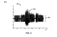
[0049] Turning now to FIG. 2, FIG. 2 illustrates a number of
[0050]図示のように、コンピューティングプラットフォーム200は、(たとえば、本明細書で提供する技法に従って、装置112の一部として、など)データ処理を実行するための、1つまたは複数の接続206を介してメモリ204に結合された1つまたは複数の処理ユニット202を備え得る。(1つまたは複数の)処理ユニット202は、たとえば、ハードウェアまたはハードウェアとソフトウェアとの組合せで実装され得る。(1つまたは複数の)処理ユニット202は、データコンピューティング手順またはプロセスの少なくとも一部分を実行するように構成可能な1つまたは複数の回路を表し得る。限定ではなく例として、処理ユニットは、1つまたは複数のプロセッサ、コントローラ、マイクロプロセッサ、マイクロコントローラ、特定用途向け集積回路、デジタル信号プロセッサ、プログラマブル論理デバイス、フィールドプログラマブルゲートアレイなど、またはそれらの任意の組合せを含み得る。
[0050] As shown, the
[0051]メモリ204は任意のデータ記憶機構を表し得る。メモリ204は、たとえば、1次メモリ204−1および/または2次メモリ204−2を含み得る。1次メモリ204−1は、たとえば、ランダムアクセスメモリ、読取り専用メモリなどを備え得る。この例では処理ユニットとは別個のものとして示されているが、1次メモリの全部または一部は、コンピューティングプラットフォーム200内の(1つまたは複数の)処理ユニット202または他の同様の回路内に設けられるか、あるいはさもなければそのような回路と共設/結合され(co-located/coupled)得ることを理解されたい。2次メモリ204−2は、たとえば、1次メモリと同じまたは同様のタイプのメモリ、および/または1つまたは複数のデータ記憶デバイスまたはシステム、たとえば、ディスクドライブ、光ディスクドライブ、テープドライブ、固体メモリドライブなどを備え得る。
[0051] The memory 204 may represent any data storage mechanism. The memory 204 may include, for example, a primary memory 204-1 and / or a secondary memory 204-2. Primary memory 204-1 may comprise, for example, random access memory, read only memory, and the like. Although shown in this example as separate from the processing unit, all or part of the primary memory is within the processing unit (s) 202 or other similar circuitry within the
[0052]いくつかの実装形態では、2次メモリは、非一時的コンピュータ可読媒体280を動作可能に受容するか、またはさもなければそれに結合するように構成され得る。メモリ204および/または非一時的コンピュータ可読媒体280は、たとえば、本明細書で提供する本技法および/または例示的な装置112(図1)および/または例示的なプロセス400(図4)による、データ処理に関連する命令282を備え得る。 [0052] In some implementations, the secondary memory may be configured to operatively receive or otherwise couple to the non-transitory computer readable medium 280. Memory 204 and / or non-transitory computer readable medium 280 may be, for example, according to the techniques and / or exemplary apparatus 112 (FIG. 1) and / or exemplary process 400 (FIG. 4) provided herein. Instructions 282 related to data processing may be provided.
[0053]コンピューティングプラットフォーム200は、たとえば、1つまたは複数の通信インターフェース208をさらに備え得る。(1つまたは複数の)通信インターフェース208は、たとえば、1つまたは複数のワイヤードおよび/またはワイヤレス通信リンクを介した、たとえば、(1つまたは複数の)ネットワーク120、モバイルデバイス104、および/または他のリソース(デバイス)130(図1)への接続性を与え得る。ここで示すように、(1つまたは複数の)通信インターフェース208は、1つまたは複数の受信機210、1つまたは複数の送信機212など、またはそれらの何らかの組合せを備え得る。(1つまたは複数の)通信インターフェース208は、1つまたは複数のワイヤードおよび/またはワイヤレス通信リンクをサポートするために必要とされ得る1つまたは複数の通信プロトコルを実装し得る。
[0053] The
[0054](1つまたは複数の)処理ユニット202および/または命令282は、たとえば、装置112、1つまたは複数のセンサー測定値220、1つまたは複数の推定軌道222、1つまたは複数の電子マップ224、動きモード226、移動した推定距離228、時間期間230、推定速度232、ステッピングアクション234、ステップカウント236、角速度238、配向240、推定された現在のヘッディング242、1つまたは複数の推定された前のヘッディング244、1つまたは複数の推定ロケーション246、1つまたは複数の中間地点248(および/またはそれらのロケーション)、ドリフト250などの1つまたは複数のエラー、粒子フィルタ252、粒子状態254、1つまたは複数の伝搬粒子256、ストライド頻度258、1つまたは複数の中間地点距離260、ヘッディングエラー262、1つまたは複数のコスト関数264、動的関数266、マッチングコスト268、1つまたは複数の回転特性270、1つまたは複数の個別回転割当て272、1つまたは複数のしきい値測定値274などの1つまたは複数のしきい値、1つまたは複数のストライド長276など、あるいはそれらの何らかの組合せなど、メモリ204に時々記憶され得る1つまたは複数の信号を与えるか、またはさもなければそれに関連付けられ得る。図2に示された要素のうちの1つまたは複数は、いくつかの実施形態では省略され得る。たとえば、要素220〜276のうちの1つまたは複数が省略され得る。
[0054] The processing unit (s) 202 and / or instructions 282 may include, for example, the
[0055]次に図3に注目すると、図3は、例示的な実装形態による、モバイルデバイス104のマップ支援センサーベース測位をサポートするためのモバイルデバイス104中の例示的なコンピューティングプラットフォーム300のいくつかの特徴を示す概略ブロック図である。
[0055] Turning now to FIG. 3, FIG. 3 illustrates a number of
[0056]図示のように、コンピューティングプラットフォーム300は、(たとえば、本明細書で提供する技法、および/または装置110などに従って)データ処理を実行するための、1つまたは複数の接続306を介してメモリ304に結合された1つまたは複数の処理ユニット302を備え得る。(1つまたは複数の)処理ユニット302は、たとえば、ハードウェアまたはハードウェアとソフトウェアとの組合せで実装され得る。(1つまたは複数の)処理ユニット302は、データコンピューティング手順またはプロセスの少なくとも一部分を実行するように構成可能な1つまたは複数の回路を表し得る。限定ではなく例として、処理ユニットは、1つまたは複数のプロセッサ、コントローラ、マイクロプロセッサ、マイクロコントローラ、特定用途向け集積回路、デジタル信号プロセッサ、プログラマブル論理デバイス、フィールドプログラマブルゲートアレイなど、またはそれらの任意の組合せを含み得る。
[0056] As illustrated, the
[0057]メモリ304は任意のデータ記憶機構を表し得る。メモリ304は、たとえば、1次メモリ304−1および/または2次メモリ304−2を含み得る。1次メモリ304−1は、たとえば、ランダムアクセスメモリ、読取り専用メモリなどを備え得る。この例では処理ユニットとは別個のものとして示されているが、1次メモリの全部または一部は、モバイルデバイス104内の(1つまたは複数の)処理ユニット302または他の同様の回路内に設けられるか、あるいはさもなければそのような回路と共設/結合され得ることを理解されたい。2次メモリ304−2は、たとえば、1次メモリと同じまたは同様のタイプのメモリ、および/または1つまたは複数のデータ記憶デバイスまたはシステム、たとえば、ディスクドライブ、光ディスクドライブ、テープドライブ、固体メモリドライブなどを備え得る。
[0057] Memory 304 may represent any data storage mechanism. The memory 304 may include, for example, a primary memory 304-1 and / or a secondary memory 304-2. Primary memory 304-1 may comprise, for example, random access memory, read only memory, and the like. Although shown in this example as separate from the processing unit, all or part of the primary memory is within the processing unit (s) 302 or other similar circuitry within the
[0058]いくつかの実装形態では、2次メモリは、非一時的コンピュータ可読媒体380を動作可能に受容するか、またはさもなければそれに結合するように構成され得る。メモリ304および/または非一時的コンピュータ可読媒体380は、たとえば、本明細書で提供する本技法および/または例示的な装置110(図1)および/または例示的なプロセス400(図4)による、データ処理に関連する命令382を備え得る。
[0058] In some implementations, the secondary memory may be configured to operatively receive or otherwise couple to the non-transitory computer readable medium 380. Memory 304 and / or non-transitory computer readable media 380 may be, for example, according to the techniques and / or exemplary apparatus 110 (FIG. 1) and / or exemplary process 400 (FIG. 4) provided herein.
[0059]コンピューティングプラットフォーム300は、たとえば、1つまたは複数の通信インターフェース308をさらに備え得る。(1つまたは複数の)通信インターフェース308は、たとえば、1つまたは複数のワイヤードおよび/またはワイヤレス通信リンクを介した、たとえば、(1つまたは複数の)ネットワーク120、コンピューティングデバイス102、および/または他のリソース(デバイス)130(図1)への接続性を与え得る。ここで示すように、(1つまたは複数の)通信インターフェース308は、1つまたは複数の受信機310、1つまたは複数の送信機312など、またはそれらの何らかの組合せを備え得る。(1つまたは複数の)通信インターフェース308は、1つまたは複数のワイヤードおよび/またはワイヤレス通信リンクをサポートするために必要とされ得る1つまたは複数の通信プロトコルを実装し得る。(1つまたは複数の)通信インターフェース308は、いくつかの例示的な事例では、時々、モバイルデバイス104のロケーションを推定するために処理され得る、SPS信号152および/または他の信号ベース測位信号を受信することが可能な1つまたは複数の受信機をさらに備え得る。
[0059] The
[0060]いくつかの例示的な実装形態によれば、(1つまたは複数の)通信インターフェース208、(1つまたは複数の)通信インターフェース308、および/または(1つまたは複数の)ネットワーク120中の他のリソースは、たとえば、ワイヤレスワイドエリアネットワーク(WWAN)、ワイヤレスローカルエリアネットワーク(WLAN)、ワイヤレスパーソナルエリアネットワーク(WPAN)などの様々なワイヤレス通信ネットワークとともに使用することが可能であり得る。「ネットワーク」および「システム」という用語は、本明細書では互換的に使用され得る。WWANは、符号分割多元接続(CDMA)ネットワーク、時分割多元接続(TDMA)ネットワーク、周波数分割多元接続(FDMA)ネットワーク、直交周波数分割多元接続(OFDMA)ネットワーク、シングルキャリア周波数分割多元接続(SC−FDMA)ネットワークなどであり得る。CDMAネットワークは、ほんのいくつかの無線技術を挙げれば、cdma2000、広帯域CDMA(W−CDMA(登録商標))、時分割同期符号分割多元接続(TD−SCDMA)などの1つまたは複数の無線アクセス技術(RAT)を実装し得る。ここで、cdma2000は、IS−95規格、IS−2000規格、およびIS−856規格に従って実装される技術を含み得る。TDMAネットワークは、モバイル通信用グローバルシステム(GSM(登録商標):Global System for Mobile Communications)、デジタルアドバンストモバイルフォンシステム(D−AMPS:Digital Advanced Mobile Phone System)、または何らかの他のRATを実装し得る。GSMおよびW−CDMAは、「第3世代パートナーシッププロジェクト」(3GPP:3rd Generation Partnership Project)と称する団体からの文書に記載されている。cdma2000は、「第3世代パートナーシッププロジェクト2」(3GPP2:3rd Generation Partnership Project 2)と称する団体からの文書に記載されている。3GPPおよび3GPP2の文書は公的に入手可能である。たとえば、WLANはIEEE802.11xネットワークを含み得、WPANは、Bluetooth(登録商標)ネットワーク、IEEE802.15xを含み得る。ワイヤレス通信ネットワークは、たとえば、ロングタームエボリューション(LTE:Long Term Evolution)、アドバンストLTE、WiMAX(登録商標)、ウルトラモバイルブロードバンド(UMB:Ultra Mobile Broadband)など、いわゆる次世代技術(たとえば、「4G」)を含み得る。さらに、(1つまたは複数の)通信インターフェース208および/または(1つまたは複数の)通信インターフェース308は、1つまたは複数の他のデバイスとの赤外線ベース通信をさらに提供し得る。
[0060] According to some exemplary implementations, in the communication interface (s) 208, the communication interface (s) 308, and / or the network (s) 120 Other resources may be usable with various wireless communication networks such as, for example, a wireless wide area network (WWAN), a wireless local area network (WLAN), a wireless personal area network (WPAN), and the like. The terms “network” and “system” may be used interchangeably herein. WWAN includes code division multiple access (CDMA) networks, time division multiple access (TDMA) networks, frequency division multiple access (FDMA) networks, orthogonal frequency division multiple access (OFDMA) networks, single carrier frequency division multiple access (SC-FDMA). ) Can be a network or the like. A CDMA network may include one or more radio access technologies such as cdma2000, wideband CDMA (W-CDMA®), time division synchronous code division multiple access (TD-SCDMA), to name just a few radio technologies. (RAT) may be implemented. Here, cdma2000 may include technologies implemented according to IS-95, IS-2000, and IS-856 standards. A TDMA network may implement a Global System for Mobile Communications (GSM), a Digital Advanced Mobile Phone System (D-AMPS), or some other RAT. GSM and W-CDMA are described in documents from an organization named “3rd Generation Partnership Project” (3GPP). cdma2000 is described in documents from an organization named “3rd
[0061]モバイルデバイス104は、たとえば、1つまたは複数の入力/出力ユニット314をさらに備え得る。入力/出力ユニット314は、1つまたは複数の他のデバイスおよび/またはモバイルデバイス104のユーザから入力を取得し、および/またはそれに出力を与えるために使用され得る1つまたは複数のデバイスまたは他の同様の機構を表し得る。したがって、たとえば、入力/出力ユニット314は、1つまたは複数のユーザ入力を受信するために使用され得る様々なボタン、スイッチ、タッチパッド、トラックボール、ジョイスティック、タッチスクリーン、マイクロフォン、カメラなどを備え得る。いくつかの事例では、入力/出力ユニット314は、ユーザのための視覚出力、可聴出力、および/または触覚出力を生成する際に使用され得る様々なデバイスを備え得る。
[0061] The
[0062]モバイルデバイス104は、たとえば、1つまたは複数のセンサー316を備え得る。たとえば、(1つまたは複数の)センサー316は、環境100および/またはモバイルデバイス104の態様を検出するのに有用であり得る、1つまたは複数の慣性センサー、1つまたは複数の環境センサーなどを表し得る。したがって、たとえば、(1つまたは複数の)センサー316は、1つまたは複数の加速度計、1つまたは1つまたは複数のジャイロスコープまたはジャイロメータ、1つまたは複数の磁力計など、1つまたは複数の気圧計、1つまたは複数の温度計などを備え得る。さらに、いくつかの事例では、(1つまたは複数の)センサー316は、マイクロフォン、カメラ、光センサーなど、1つまたは複数の入力デバイスを備え得る。
[0062] The
[0063](1つまたは複数の)処理ユニット302および/または命令382は、たとえば、装置110、1つまたは複数のセンサー測定値220、1つまたは複数の推定軌道222、1つまたは複数の電子マップ224、動きモード226、移動した推定距離228、時間期間230、推定速度232、ステッピングアクション234、ステップカウント236、角速度238、配向240、推定された現在のヘッディング242、1つまたは複数の推定された前のヘッディング244、1つまたは複数の推定ロケーション246、1つまたは複数の中間地点248(および/またはそれらのロケーション)、ドリフト250などの1つまたは複数のエラー、粒子フィルタ252、粒子状態254、1つまたは複数の伝搬粒子256、ストライド頻度258、1つまたは複数の中間地点距離260、ヘッディングエラー262、1つまたは複数のコスト関数264、動的関数266、マッチングコスト268、1つまたは複数の回転特性270、1つまたは複数の個別回転割当て272、1つまたは複数のしきい値測定値274などの1つまたは複数のしきい値、1つまたは複数のストライド長276など、あるいはそれらの何らかの組合せなど、メモリ304に時々記憶され得る1つまたは複数の信号を与えるか、またはさもなければそれに関連付けられ得る。図3に示されている例示的なデータおよび/または命令は図2に示されている例示的なデータおよび/または命令と同じ参照番号を共有するが、いくつかの事例では、そのような例示的なデータおよび/または命令の全部または一部は明確に異なり得ることに留意されたい。図3に示された要素のうちの1つまたは複数は、いくつかの実施形態では省略され得る。たとえば、要素220〜276のうちの1つまたは複数が省略され得る。
[0063] The processing unit (s) 302 and / or
[0064]次に図4に注目すると、図4は、例示的な実装形態による、モバイルデバイスのマップ支援センサーベース測位をサポートするために1つまたは複数のコンピューティングプラットフォームにおいて使用するプロセス400を示す例示的な図である。プロセス400は、たとえば、全体的または部分的に、装置110および/または装置112(図1)、コンピューティングプラットフォーム200(図2)、および/またはコンピューティングプラットフォーム300(図3)で実装され得る。
[0064] Turning now to FIG. 4, FIG. 4 illustrates a
[0065]例示的なブロック402において、屋内環境内のモバイルデバイスにおいて取得された1つまたは複数のセンサー測定値に少なくとも部分的に基づいてモバイルデバイスの軌道が推定され得る。たとえば、1つまたは複数のセンサー316を使用して取得された1つまたは複数のセンサー測定値220に少なくとも部分的に基づいて、1つまたは複数の推定軌道222(図2および図3参照)が判断され得る。
[0065] In an
[0066]いくつかの事例では、ブロック404において、モバイルデバイスが移動した推定距離228、モバイルデバイスの推定速度232、推定された現在のヘッディング242、配向240など、またはそれらの何らかの組合せが判断され得る。たとえば、いくつかの実装形態では、1つまたは複数のセンサー測定値220に少なくとも部分的に基づいてモバイルデバイスについて判断されたかまたはさもなければ推論された動きのタイプを示し得る動きモード226が判断され得る。たとえば、いくつかの実装形態では、動きモードは、モバイルデバイスが、歩行中、ランニング中、および/またはさもなければ何らかの示された方法で移動中の人によって携帯されている可能性があることを示し得る。したがって、いくつかの実装形態では、動きモードは、たとえば、モバイルデバイス、たとえばモバイルデバイス104に搭載された、および/またはコンピューティングプラットフォーム300によって実装された、1つまたは複数のセンサー316によって観測される検出された移動および/または力の1つまたは複数の特性によって判断された、人の歩行中またはランニング中のストライドを示し得る、検出されたステッピングアクション234および/またはストライド頻度258に対応し得る。いくつかの実装形態では、ステップカウント236は、この場合も、1つまたは複数のセンサー316によって観測される検出された移動および/または力に基づいて判断され得る。特定のステッピングアクションおよび/またはステップカウントは、特定の推定ストライド長276(たとえば、ステップ間の距離)に対応し得、それは順に、移動した距離を推定する際に考慮され得る。同様に、移動した推定距離228を用いて、時間期間230中のモバイルデバイスの少なくとも平均移動速度を判断することが可能であり得る。さらに、いくつかの実装形態では、特定の時間においておよび/または特定の時間期間にわたってモバイルデバイスの推定速度232を判断することが可能であり得る。さらに、いくつかの実装形態では、センサー測定値220を使用して、たとえば、モバイルデバイスの軌道または他の推定された動きに対応するおよび/または環境に関する配向240を判断し得る。たとえば、磁力計センサーは、地球の磁界に関する特定の配向、たとえば、磁北、南などを示すセンサー測定値を与え得る。同様に、いくつかの実装形態では、1つまたは複数のセンサー測定値220に基づいて角速度238が判断されるかまたはさもなければ推定され得る。ここで、たとえば、ジャイロスコープおよび/または他の同様の慣性センサー、および/またはいくつかの他の環境センサーによって方向変化が検出され得る。適用可能なセンサー測定値220が与えられれば、および/またはモバイルデバイスの前の位置および/または軌道に関する何らかの情報がわかっていれば、モバイルデバイスに関する様々な測位および/または移動情報が判断されるかまたはさもなければ推定され得ることを認識されたい。したがって、いくつかの実装形態では、たとえば、1つまたは複数の前のヘッディング244、および/またはロケーション246などとともに1つまたは複数のセンサー測定値に基づいて、モバイルデバイスの現在のヘッディング242が判断され得る。たとえば、いくつかの実装形態では、現在のヘッディング242は、環境および/またはモバイルデバイスに対応する何らかの基準点または基準システムに対する特定の方向を示し得る。たとえば、環境に関連する現在のヘッディング242は、磁北からの角度方向などに対応し得る。たとえば、モバイルデバイスに関連する現在のヘッディング242は、内部基準軸からの角度などに対応し得る。
[0066] In some cases, at
[0067]いくつかの態様によれば、例示的なブロック402および/または例示的なブロック404において実行される推定は、モバイルデバイスに関連する信号ベース測位情報を使用せずに実行され得ることに留意されたい。
[0067] According to some aspects, the estimation performed in the
[0068]例示的なブロック406において、屋内環境の電子マップにおいて識別された1つまたは複数の物体に少なくとも部分的に基づいて何らかの方法で、少なくとも推定された軌道に作用する。たとえば、1つまたは複数の電子マップ224は、モバイルデバイスを携帯している人が何らかの方法でその中を動き回り得る屋内環境内のいくつかのエリアを示し得る。たとえば、1つまたは複数の電子マップ224は、壁または他の同様の物体によって分離されたいくつかのルートまたは経路、いくつかの空間への入口、部屋、階段、エレベータなどを定義し得る。いくつかの実装形態では、1つまたは複数の電子マップ224は、屋内環境内をナビゲートしている人が従い得る、可能性があるかまたは可能なルートを示し得るルータビリティ図式(routability graph)などを備え得る。たとえば、ルータビリティ図式は、特定のルートまたは経路に沿って従われ得る、あるノードから次のノードに通じる1つまたは複数の相互接続エッジとともに、屋内環境内の特定のロケーションに関係する複数のノードを含み得る。
[0068] In an
[0069]いくつかの事例では、ブロック408において、少なくとも部分的に、推定された軌道に作用するために、1つまたは複数の中間地点の1つまたは複数のロケーションが使用され得る。たとえば、いくつかの実装形態では、推定された軌道に作用するために1つまたは複数の中間地点248および/またはそれらのロケーションが適用され得る。いくつかの事例では、1つまたは複数の中間地点248の1つまたは複数のロケーションが、たとえば、ユーザ入力から取得されおよび/または電子マップの全部または一部に基づいて判断され得る。いくつかの実装形態では、1つまたは複数の中間地点距離260、たとえば中間地点までの距離または中間地点からの距離/あるいは中間地点間の距離が考慮に入れられ得る。いくつかの事例では、ブロック410において、少なくとも部分的に、推定された軌道に作用する際に、推定された軌道に関連する、ドリフト250、ヘッディングエラー262などの1つまたは複数のエラーが補正され得る。
[0069] In some cases, at
[0070]これを考慮して、モバイルデバイスの軌道を推定するために使用され得る粒子フィルタなどに作用し得る何らかの方法で1つまたは複数のエラーが考慮されることを可能にするいくつかの例を以下に提示する。たとえば、粒子フィルタ252は、ドリフト250などの1つまたは複数のエラーを考慮に入れながら、1つまたは複数の伝搬粒子256を使用して粒子状態254を判断し得る。さらに、以下の例で提示するように、モバイルデバイスの軌道を判断する際に、装置110/112は、たとえば、1つまたは複数のコスト関数264、動的関数266、マッチングコスト268など、またはそれらの何らかの組合せを適用し得る。
[0070] In view of this, some examples that allow one or more errors to be considered in some way that may affect particle filters or the like that may be used to estimate the trajectory of the mobile device Is presented below. For example, the particle filter 252 may determine the particle state 254 using one or more propagating particles 256 while taking into account one or more errors, such as
[0071]本明細書で提供する技法を用いて、いくつかの例示的な実装形態では、1つまたは複数の回転特性270、1つまたは複数の個別回転割当て272など、またはそれらの何らかの組合せが判断され、モバイルデバイスの推定された軌道に作用するために使用され得る。 [0071] Using the techniques provided herein, in some example implementations, one or more rotation characteristics 270, one or more individual rotation assignments 272, etc., or some combination thereof, Can be determined and used to affect the estimated trajectory of the mobile device.
[0072]さらに、例示的なブロック412において、推定された軌道と電子マップとに少なくとも部分的に基づいてモバイルデバイスのロケーションが推定され得る。例示的なブロック414において、モバイルデバイスに関係する推定ロケーションおよび/または他の推定測位情報の全部または一部の提示が開始され得る。ここで、たとえば、提示は、少なくとも1つのユーザ出力デバイスを介したオーディオおよび/または視覚出力を備え得る。いくつかの事例では、提示は、1つまたは複数の他のデバイスに1つまたは複数のメッセージを送信することを備え得る。特定の例では、モバイルデバイスに関連付けられた人は、本明細書で提供するいくつかの技法を使用してそれらの人が屋内環境をナビゲートするときに追跡され得る。たとえば、警備員または郵便配達人、または場合によっては子供のロケーションおよび/またはルート/経路が、プロセス400において提示した技法などの技法を使用して屋内環境内で追跡され得る。さらに、そのような技法はまた、たとえば、コンテナ、機械など、人ではない物体に関連付けられたモバイルデバイスを追跡することおよび/またはそれの位置を特定することに適用され得る。いくつかの実施形態では、そのような位置特定および/または追跡は、たとえばモバイルデバイス104および/またはコンピューティングデバイス102において、リアルタイムで実行される。いくつかの実施形態では、そのような位置特定および/または追跡は、たとえばメモリ204および/または304に記憶されたデータに基づいて、ルートまたはルートの一部分をすでに移動した後に実行される。いくつかの実施形態では、モバイルデバイスに記憶されたデータは、経路が予想ルートと実質的に整合する(aligned)かどうかを判断するために、モバイルデバイスが経路に沿って移送された後に分析される。
[0072] Further, in the
[0073]いくつかの実施形態では、図4に示されたブロックのうちの1つまたは複数が省略されるかまたは並べ替えられ得る。たとえば、いくつかの実施形態では、ブロック412とブロック414の一方または両方が省略される。いくつかの実施形態では、ブロック404、408、および410のうちの1つまたは複数が代わりにまたはさらに省略される。
[0073] In some embodiments, one or more of the blocks shown in FIG. 4 may be omitted or rearranged. For example, in some embodiments, one or both of
[0074]いくつかの実施形態では、ブロック402、404、406、408、410、412、および414のうちの1つまたは複数が、たとえばメモリ204もしくは304および/またはコンピュータ可読媒体280もしくは380と組み合わせた処理ユニット202および/または302によって実行または実装され得る。いくつかの実施形態では、たとえばブロック402、404、406、408、410、412、および414のうちの1つまたは複数がコンピューティングデバイス102において実行され得るように、情報および/または測定値が、モバイルデバイス104における通信インターフェース308から送信され、コンピューティングデバイス102の通信インターフェース208において受信され得る。いくつかの実施形態では、そのような送信および受信は省略される。
[0074] In some embodiments, one or more of
[0075]以下のセクションは、全体的または部分的に、それぞれ前のセクションで説明した例示的な装置110、例示的な装置112、例示的なコンピューティングプラットフォーム200、例示的なコンピューティングプラットフォーム300のうちの1つまたは複数で、および/または例示的なプロセス400もしくはそれの何らかの部分の一部として実装され得るいくつかの例示的な技法を提示することを意図したものである。
[0075] The following sections, in whole or in part, of the
[0076]以下の例示的な技法は、コンシューマグレードまたはより良いグレードの慣性および/または環境センサーならびに基本的および/またはより高度な電子マップ情報および/またはそれに関連する中間地点を使用して正確な測位を達成し得る、いくつかの例示的なアルゴリズムおよび/または他の同様の実装可能な技法を示している。 [0076] The following exemplary techniques are accurate using consumer grade or better grade inertial and / or environmental sensors and basic and / or more advanced electronic map information and / or associated intermediate points. FIG. 9 illustrates some example algorithms and / or other similar implementable techniques that may achieve positioning.
[0077]多くのモバイルフォンおよび他の同様のモバイルデバイスは現在、動きを検出し、したがって、いくつかの条件下で測位情報を与えるために使用され得る、センサー(たとえば、加速度計、ジャイロスコープ、磁力計など)を装備している。信号ベース測位技法と比較して、いくつかの実装形態におけるセンサーベース測位は、より著しくエネルギー効率的であり得る。しかしながら、いくつかの事例では、対応する慣性測位が、角速度とステップカウントとを積算することを伴い得、それにより、たとえば、場合によっては、ユーザの体に対するモバイルデバイス、したがって(1つまたは複数の)センサーの位置の推定におけるセンサー雑音および/またはエラーに起因して、ドリフトエラーが大きくなり得る。たとえば、いくつかのセンサーは、ユーザの体に対するモバイルデバイスの位置に応じて、同じユーザの動きについて大幅に異なるセンサー測定値を生成し得る。 [0077] Many mobile phones and other similar mobile devices currently detect motion and thus can be used to provide positioning information under some conditions, sensors (eg, accelerometers, gyroscopes, Equipped with a magnetometer). Compared to signal-based positioning techniques, sensor-based positioning in some implementations may be significantly more energy efficient. However, in some cases, the corresponding inertial positioning may involve accumulating the angular velocity and the step count so that, for example, in some cases, the mobile device relative to the user's body, and thus the one or more ) Due to sensor noise and / or errors in sensor position estimation, drift errors can be large. For example, some sensors may generate significantly different sensor measurements for the same user movement, depending on the position of the mobile device relative to the user's body.
[0078]いくつかの態様によれば、屋内環境測位に関して、本明細書で提供するいくつかの例示的な技法は、いくつかの起こり得るドリフトエラーを低減するために、屋内環境の電子マップ内で識別された様々な物体を活用し得る。前述のように、いくつかの例示的な実装形態によれば、本明細書で提供する様々な技法は、モバイルデバイスに搭載された1つまたは複数のセンサーのセンサー測定値からオドメトリ(odometry)および/または他の同様の情報を取得し得る。本技法は、いくつかのドリフトエラーを低減(たとえば、補正)しようとする試みにおいて、1つまたは複数の電子マップ内で与えられる(および/またはさもなければそれを使用して取得された)何らかの情報をさらに利用し得る。 [0078] According to some aspects, with respect to indoor environment positioning, some exemplary techniques provided herein can be used in an electronic map of an indoor environment to reduce some possible drift errors. Various objects identified with can be utilized. As described above, according to some exemplary implementations, the various techniques provided herein can include odometry and sensor measurements from one or more sensors mounted on a mobile device. / Or other similar information may be obtained. The technique may be any given (and / or otherwise obtained using it) in one or more electronic maps in an attempt to reduce (eg, correct) some drift errors. Information can be further utilized.
[0079]いくつかの例示的な実装形態では、電子マップ情報は、たとえば、ルートの一部としてあらかじめ決定されたおよび/または場合によっては1つまたは複数の他の測位技法によって過去に識別された、何らかの電子マップ情報に基づいて、ユーザ入力から取得され得る時々の位置フィックス(position fixes)の形態で、中間地点のセットを備え得る。いくつかの実装形態によれば、本明細書で提供する技法の全部または一部は、1つまたは複数の他のデバイスを支援する1つまたは複数のデバイスにおいて実装され、単一のデバイスにおいて実装され、スタンドアロンナビゲーションにおいて使用するために実装され、1つまたは複数の他の測位システムグランドトゥルース情報などを与える際に使用するために実装され、1つまたは複数の他のポスト測位またはトラッキング目的のために実装され得る。 [0079] In some exemplary implementations, the electronic map information has been previously identified, for example, as part of a route and / or in the past, possibly by one or more other positioning techniques A set of waypoints may be provided in the form of occasional position fixes that may be obtained from user input based on some electronic map information. According to some implementations, all or part of the techniques provided herein are implemented in one or more devices that support one or more other devices, and implemented in a single device. Implemented for use in stand-alone navigation, implemented for use in providing one or more other positioning systems, such as ground truth information, and for one or more other post-positioning or tracking purposes Can be implemented.
[0080]いくつかの態様によれば、1つまたは複数のセンサーを使用して慣性オドメトリ情報が取得され得る。たとえば、いくつかの実装形態では、たとえば、1つまたは複数の加速度計からのセンサー測定値を使用して、ユーザのステップを検出しおよび/または1つまたは複数のステップ長を推定するために使用され得る技法が提供される。たとえば、いくつかの実装形態では、たとえば、1つまたは複数のジャイロスコープおよび/または1つまたは複数の磁力計などを使用して、モバイルデバイスの配向を推定しおよび/またはさもなければその変化を識別するために使用され得る技法が提供される。さらに、いくつかの例示的な実装形態によれば、ドリフトエラーをできる限り低減するために、電子マップおよび/またはそれに関係する中間地点に少なくとも部分的に基づくマッチング能力が考慮に入れられ得る。たとえば、いくつかの実装形態では、そのようなマッチング能力を実装するために粒子フィルタおよび/または他の同様のフィルタおよび/またはアルゴリズムが使用され得る。別の例では、いくつかの実装形態では、そのようなマッチング能力を実装するために個別回転割当てアルゴリズムなどが使用され得る。 [0080] According to some aspects, inertial odometry information may be obtained using one or more sensors. For example, in some implementations, for example, using sensor measurements from one or more accelerometers to detect user steps and / or to estimate one or more step lengths Techniques that can be done are provided. For example, in some implementations, the orientation of the mobile device is estimated and / or otherwise changed using, for example, one or more gyroscopes and / or one or more magnetometers. Techniques that can be used to identify are provided. Further, according to some exemplary implementations, matching capabilities based at least in part on the electronic map and / or associated intermediate points may be taken into account in order to reduce drift errors as much as possible. For example, in some implementations, particle filters and / or other similar filters and / or algorithms may be used to implement such matching capabilities. In another example, in some implementations, an individual rotation assignment algorithm or the like may be used to implement such matching capabilities.
[0081]いくつかの例示的な実装形態では、屋内環境および/またはそれの電子マップに対するモバイルデバイスの軌道および/または位置を推定するために、コンピューティングプラットフォームは、(1つまたは複数の)ユーザ入力から少なくとも部分的に取得され得る、以前に通過した経路(previously traversed path)の全部または一部に関する情報に、1つまたは複数のセンサーからのセンサー測定値を組み合わせ得る。予想される、より定常状態の重力ベクトルからz軸を判断するために、たとえば、調整されたz軸ジャイロなど、たとえば、いくつかのセンサー測定値を積算することによって少なくとも部分的に基づいて、推定ヘッディングが判断され得る。たとえば、1つまたは複数の加速度計から取得されたセンサー測定値によって少なくとも部分的に基づいて、ステップ頻度が推定され得る。いくつかの事例では、ステップ頻度を推定する際に有用であり得るいくつかのセンサー測定値は、たとえば、センサー測定値中に存在する雑音の量に応じて、積算されることも積算されないこともある。いくつかの例示的な実装形態では、ステップ頻度(f)とストライド長(l)とを関係付けるために、1つまたは複数の動きモーター他の同様のモデルが実装され得る。たとえば、いくつかの実装形態では、ストライド長lが、少なくとも部分的に、l=kfaなどの関数に基づいて判断され得、ここにおいて、パラメータkおよび/またはaは、推定(たとえば、プリプログラム)されおよび/または時間とともにユーザごとに学習(たとえば、動的にプログラム)され得る。いくつかの例示的な実装形態では、異なる動きモードについて複数の同様の関数および/またはパラメータが与えられ得る。たとえば、ストライド長および/または頻度は、ユーザが歩行中であるのかランニング中であるのかに応じて異なり得る。 [0081] In some exemplary implementations, in order to estimate the trajectory and / or location of the mobile device relative to the indoor environment and / or its electronic map, the computing platform (s) Sensor measurements from one or more sensors may be combined with information about all or part of previously traversed paths that may be obtained at least in part from the input. Estimate based at least in part, for example, by integrating several sensor measurements, such as an adjusted z-axis gyro, to determine the z-axis from the expected more steady-state gravity vector Heading can be determined. For example, the step frequency can be estimated based at least in part on sensor measurements obtained from one or more accelerometers. In some cases, some sensor measurements that may be useful in estimating the step frequency may or may not be integrated, for example, depending on the amount of noise present in the sensor measurements. is there. In some exemplary implementations, one or more motion motors or other similar models may be implemented to relate step frequency (f) and stride length (l). For example, in some implementations, the stride length l may be determined based at least in part on a function such as l = kf a , where the parameters k and / or a are estimated (eg, preprogrammed And / or learned (eg, dynamically programmed) for each user over time. In some exemplary implementations, multiple similar functions and / or parameters may be provided for different motion modes. For example, the stride length and / or frequency may vary depending on whether the user is walking or running.
[0082]次に図5および図6に注目すると、図5および図6は、何らかのステッピングアクションに関連する情報を判断する際に使用され得る例示的な慣性センサー測定値のプロットを示す例示的なグラフ500および600を提示している。
[0082] Turning now to FIGS. 5 and 6, FIGS. 5 and 6 show exemplary plots of exemplary inertial sensor measurements that may be used in determining information related to some stepping action.
[0083]グラフ500は、たとえば、ステップを検出するために使用され得るいくつかのセンサー測定値を示している。ここで、たとえば、水平軸は時間を表し、垂直軸は、重力を補償した後の加速度計から取得された加速度の大きさ(プロットライン502)を表す。このデータは、ステップを検出するためにしきい値ベースフィルタを通過させられ(プロットライン504)、ここで、a+1は歩行の立脚期(stance phase)を示し、−1は遊脚期(swing phase)を示す。+1とそれに続く−1とのサイクルが1つのステップとして計数される。
[0083] The
[0084]グラフ600は、たとえば、たとえば[0071]において説明したように検出され得るステップカウントから計算されたステップ頻度(プロットライン602)を示している。水平軸は時間を表し、垂直軸は、たとえば、検出されたステップの数の移動ウィンドウ平均として計算され得る、固定時間間隔中のステップの数である、ステップ頻度である。
[0084] The
[0085]図7に、例示的な実装形態による、屋内環境をナビゲートしながらモバイルデバイスを携帯している人について、ジャイロスコープ、または磁力計などのセンサー、または何らかの他のソースから取得され得る、角度方位情報(angular orientation information)のみから推定された例示的な軌道に対応するプロットライン702を示すグラフ700を示す。ここで、たとえば、水平軸および垂直軸は、推定位置の座標を表し得る。この位置推定は、移動した距離または直線速度(linear velocities)に関する情報を使用しないので、軌道のスケーリングは著しいエラーを有し得ることに留意されたい。
[0085] FIG. 7 may be obtained from a gyroscope, a sensor such as a magnetometer, or some other source for a person carrying a mobile device while navigating an indoor environment, according to an exemplary implementation. , A
[0086]図8に、例示的な実装形態による、オドメトリ情報などに少なくとも部分的に基づいて作用されたグラフ700の例示的な角度軌道データに少なくとも部分的に基づく、例示的な調整された軌道に対応するプロットライン802を示すグラフ800を示す。ここで、たとえば、水平軸および垂直軸は、推定位置の座標を表し得る。この例示的なデータでは、グラフ700に示された軌道は、グラフ600に示されているように計算されたステップ頻度を使用して、スケーリングエラーについて補正されている。
[0086] FIG. 8 illustrates an exemplary adjusted trajectory based at least in part on exemplary angular trajectory data of a
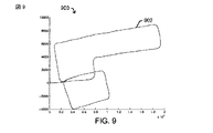
[0087]別の例として、図9に、別の例示的な実装形態による、屋内環境をナビゲートしながらモバイルデバイスを携帯している人の慣性センサー測定値および/または環境センサー測定値に関連する、ある例示的な角度軌道データに対応するプロットライン902を示すグラフ900を示す。ここで、たとえば、水平軸および垂直軸は、推定位置の座標を表し得る。図10に、例示的な実装形態による、オドメトリ情報などに少なくとも部分的に基づいて作用するグラフ900の例示的な角度軌道データに少なくとも部分的に基づく、例示的な調整された軌道1002を示すグラフ1000を示す。この場合も、水平軸および垂直軸は、推定位置の座標を表し得る。図9および図10は、図7および図8と同様であるが、データの異なるセットに基づく。
[0087] As another example, FIG. 9 relates to inertial sensor measurements and / or environmental sensor measurements of a person carrying a mobile device while navigating an indoor environment, according to another exemplary implementation. A
[0088]いくつかの例示的な実装形態によれば、軌道において生じ、場合によっては、センサー測定値を積算した結果としてアグリゲートし得る、ドリフトなどのエラーを低減するかまたはさもなければ補正するために、マッチング能力が与えられ得る。いくつかの例示的な実装形態によれば、1つのマッチング能力は、電子マップなど、および/または1つまたは複数のユーザ入力から(たとえば、オフラインで、動的になど、またはそれらの何らかの組合せで)取得され得る中間地点のロケーションを利用し得る。いくつかの例示的な実装形態では、この例示的なマッチング能力は、タイミング情報を考慮する必要がなく、中間地点のロケーションのシーケンスのみを考慮する必要があることに留意されたい。述べたように、いくつかの実装形態では、マッチング能力をサポートするおよび/またはさもなければ与えるために粒子フィルタなどが実装され得る。いくつかの他の実装形態では、能力をサポートするおよび/またはさもなければ与えるために個別回転割当てアルゴリズムなどが実装され得る。 [0088] According to some exemplary implementations, reduce or otherwise correct errors such as drift that may occur in the trajectory and possibly aggregate as a result of integrating sensor measurements. Therefore, a matching capability can be provided. According to some exemplary implementations, one matching capability may be from an electronic map and / or from one or more user inputs (eg, offline, dynamically, etc., or some combination thereof) ) The location of an intermediate point that can be obtained can be used. Note that in some example implementations, this example matching capability need not consider timing information, but only a sequence of waypoint locations. As noted, in some implementations, a particle filter or the like may be implemented to support and / or otherwise provide matching capabilities. In some other implementations, an individual rotation assignment algorithm or the like may be implemented to support and / or otherwise provide capabilities.
[0089]マッチング能力をサポートするおよび/またはさもなければ与えるために粒子フィルタなどが実装され得るいくつかの例示的な実装形態では、(たとえば、電子マップ上にあるが、必ずしも識別された物体に関して実現可能な(feasible)軌道ラインに沿うとは限らない)位置、ヘッディング角度、ストライド長/頻度関係式(frequency relation)のためのスケーリングおよびべき指数(exponent)係数など、またはそれらの何らかの組合せを備える、粒子状態が生成され得る。例示的な粒子フィルタは、たとえば、軌道からの位置およびヘッディングを初期化し、たとえば、軌道の全体的な長さだけ調整して、スケーリングおよびべき指数を公称値(nominal value)の周りに分布させ得る。ステッピングアクションについておよび/または何らの他の時点において、例示的な粒子フィルタは、たとえば、状態の小さいランダム変動を可能にしながらセンサー測定値に従って粒子を伝搬し、場合によっては、実現可能な軌道ラインからしきい値測定値(たとえば、0.6メートルなど)だけそれたと見なされ得る粒子を効果的に除去(たとえば、廃棄、重み付け解除(de-weight)など)し、リサンプリングし得る。いくつかの実装形態によれば、例示的なリサンプリングにおいて、粒子フィルタは、1つまたは複数の実現可能な軌道ラインからより小さいアグリゲート偏差(smaller aggregate deviations)をもつより多くの粒子を選択的に重み付けし得る。あるロケーションに従って、例示的なリサンプリングにおいて、粒子フィルタは、(たとえば、前に学習したパラメータを有する)軌道にさらに進むにつれていくつかの偏差を減衰させ(attenuate)得る。いくつかの実装形態によれば、粒子フィルタは、回転量に比例するようにヘッディングエラーをモデル化し得る(たとえば、回転アクションは、非回転アクションよりもエラーを受けやすくなり得る)。いくつかの実装形態によれば、粒子フィルタは、残存している粒子の履歴を維持し得、それにより、より正確な後続の軌道および/または位置の推定が可能になり得る。いくつかの実装形態によれば、粒子フィルタは、特に1つまたは複数のパラメータ値を強調することに規定時間を超えて焦点を当てる(focus overtime)ために何らかの方法で反復し得る。 [0089] In some exemplary implementations where a particle filter or the like may be implemented to support and / or otherwise provide matching capabilities (eg, on an electronic map, but not necessarily with respect to identified objects) With position, heading angle, scaling for stride length / frequency relation and exponential factor, etc., or some combination thereof, not necessarily along a feasible trajectory line A particle state can be generated. An exemplary particle filter may, for example, initialize position and heading from the trajectory and adjust, for example, the overall length of the trajectory to distribute scaling and power exponents around a nominal value . For a stepping action and / or at some other time, an exemplary particle filter, for example, propagates particles according to sensor measurements while allowing small random fluctuations in state, and in some cases, from a feasible trajectory line Particles that may be considered deviated by a threshold measurement (eg, 0.6 meters, etc.) can be effectively removed (eg, discarded, de-weighted, etc.) and resampled. According to some implementations, in exemplary resampling, the particle filter selectively selects more particles with smaller aggregate deviations from one or more feasible trajectory lines. Can be weighted. According to certain locations, in an exemplary resampling, the particle filter may attenuate some deviations as it progresses further into the trajectory (eg, with previously learned parameters). According to some implementations, the particle filter may model a heading error to be proportional to the amount of rotation (eg, a rotating action may be more susceptible to errors than a non-rotating action). According to some implementations, the particle filter may maintain a history of remaining particles, thereby allowing more accurate subsequent trajectory and / or position estimation. According to some implementations, the particle filter may be repeated in some way to focus over a specified time, particularly to emphasize one or more parameter values.
[0090]次に図11に注目すると、図11は、例示的な実装形態による、屋内環境の電子マップにおいて識別されたいくつかの物体の視覚表現と、初期軌道データに基づく初期ルート1102、および電子マップにおいて識別された物体のうちの1つまたは複数に少なくとも部分的に基づいて調整された初期軌道データに基づくさらに調整されたルート1104を示すオーバーレイとを示す図1100である。図示のように、何らかのドリフトエリアによって作用されているかのようにしか見えないが、実際にはユーザが通過することができないいくつかの物体(たとえば、オフィス壁など)を経路が通過するという点で実現不可能である経路を提示するようにも見える、初期ルート1102。しかしながら、マッチング能力を与えることが可能な例示的な粒子フィルタを実装することによって、調整されたルート1104においてドリフトエアが低減されるだけでなく、中間地点のロケーションを考慮に入れる得られた推定軌道が、電子マップにおいて識別された物体対する1つまたは複数の実現可能な経路にマッチングする。
[0090] Turning now to FIG. 11, FIG. 11 illustrates a visual representation of a number of objects identified in an electronic map of an indoor environment, an
[0091]いくつかの例示的な実装形態によれば、個別回転割当てアルゴリズムなどが実装され得る。たとえば、いくつかの実装形態では、個別回転割当てアルゴリズムは、コスト関数を最小限に抑えるために、示された軌道における中間地点を、オドメトリ情報などの中の検出されたステッピングアクションに割り当て得る。いくつかの実装形態では、個別回転割当てアルゴリズムは、たとえば、ストライドモデルなどに従って、1つまたは複数の実現可能な経路の1つまたは複数のセグメント内に検出されたステッピングアクションを分布させ得る。いくつかの例示的な実装形態によれば、例示的なコスト関数は、1つまたは複数の前のセグメントと比較される角度偏移、および/または公称値、平均値などからのスケーリング/べき指数変化を考慮に入れ得る。いくつかの例示的な実装形態によれば、ソリューションは、たとえば、できる限り、正確および/またはよりロバストなソリューションを提供し、および/または複雑さを低減するために、動的プログラミングを利用する。 [0091] According to some exemplary implementations, an individual rotation assignment algorithm or the like may be implemented. For example, in some implementations, an individual rotation assignment algorithm may assign an intermediate point in the indicated trajectory to a detected stepping action, such as in odometry information, to minimize the cost function. In some implementations, an individual rotation assignment algorithm may distribute detected stepping actions within one or more segments of one or more feasible paths, eg, according to a stride model. According to some example implementations, the example cost function is an angular shift compared to one or more previous segments, and / or a scaling / power exponent from a nominal value, average value, etc. Changes can be taken into account. According to some exemplary implementations, the solution utilizes dynamic programming, for example, to provide as accurate and / or more robust solution as possible and / or reduce complexity.
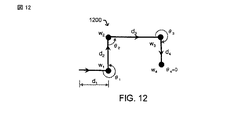
[0092]次に図12および図13に注目する。図12は、例示的な実装形態による、(角度θ1、θ2、θ3、およびθ4によって表される)いくつかの回転を取りながら、中間地点(w1,w2,w3,w4)のロケーションのシーケンスを通って進む軌道の(距離d1、d2、d3、d4によって表される)変化するセクションを有するルート1200の視覚表示を示す図である。図13は、例示的な実装形態による、取られるステップが黒丸(solid circles)によって表されており、いくつかのステップが中間地点(w1,w2,w3,w4)のロケーションにマッチングされている、ルート1300の視覚表現を示す図である。
[0092] Attention is now directed to FIGS. 12, according to example implementations, (the angle θ 1, θ 2, θ 3 , and is represented by theta 4) while taking some rotation,
[0093]例示的なルート1200および1300に関して、個別回転割当てアルゴリズムは、個別回転割当ての適用に従って、(たとえば、ドリフトなどを低減するために)推定された軌道に作用し得る。たとえば、ルート1200に示されているように、中間地点が、慣性オドメトリ分析における検出されたステップに、コスト関数を最小限に抑える方法で割り当てられ得る。たとえば、ルート1300に示されているように、検出されたステップは、ストライドモデルに従って軌道のセグメントに沿って分布され得る。述べたように、コスト関数および/または他の同様のモデルは、前のセグメントと比較されるいくつかの角度偏移(angular deviations)と、ステップまたはストライドに関連する公称/平均値からのスケーリング/べき指数変化とを考慮に入れ得る。たとえば、ルート1200は、角度(θ)と距離(d)とによって表され得、コスト関数を使用して、ラベル付きの丸で囲まれた黒点によって表されるルート1300のような一連の検出されたステップ(w1,w2,w3,w4)にマッチングされ得る、中間地点(w)のセットを示している。
[0093] For the
[0094]したがって、さらなる例として、以下を仮定する。 [0094] Thus, as a further example, assume the following.
1.軌道:中間地点のシーケンス(w1,w2,...wk)、ただし、各wi=<θi,di>は角度と距離とに関連付けられ得る、
2.慣性オドメトリ:ステップのシーケンス(s1,s2,...sn)、ただし、各sj=<φj,lj>は角度と距離とに関連付けられ得る。
1. Orbit: a sequence of intermediate points (w 1 , w 2 ,... W k ), where each w i = <θ i , d i > can be associated with an angle and a distance,
2. Inertial odometry: a sequence of steps (s 1 , s 2 ,... S n ), where each s j = <φ j , l j > can be associated with an angle and a distance.
ステップへの中間地点のマッピングf:(w1,w2,...wk)→(s1,s2,...sn)は、以下の例示的なコスト関数を最小限に抑えるように判断され得る。

[0095]例示的な成分corientationは、中間地点のロケーションに対する「マッチングされた」軌道の配向の差のコストを表し得る。たとえば、中間地点wi=<θi,di>がステップsj=<φj,lj>に割り当てられた場合、コストは単に|θi−φj|であり得る。しかしながら、ユーザステップにおいて回転が漸進的に発生し得、したがって、コストは、単一のステップの配向を使用して効果的に計算されることが可能でないことがある。したがって、いくつかの実装形態では、2はコストを計算し、たとえば、回転における配向の変化のためのガウスモデルなどを使用して、隣接するポイントの配向を考慮に入れ得る。 [0095] The example component c orientation may represent the cost of the difference in orientation of the “matched” trajectory relative to the location of the waypoint. For example, if the waypoint w i = <θ i , d i > is assigned to step s j = <φ j , l j >, the cost may simply be | θ i −φ j |. However, rotation can occur progressively in user steps, and thus the cost may not be able to be calculated effectively using a single step orientation. Thus, in some implementations, 2 may calculate the cost and take into account the orientation of adjacent points using, for example, a Gaussian model for orientation changes in rotation.
[0096]一例として、図14に注目すると、図14は、例示的な実装形態による、センサー測定値から取得された配向データ1404と、たとえば、動的関数などによって割り当てられ得る、適合回転モデリング情報1406とを示すグラフ1400および拡大図1402である。これらの図において、水平軸は秒での時間を表し、垂直軸はラジアンでの配向角度の変化を表す。
[0096] Focusing on FIG. 14 as an example, FIG. 14 shows
[0097]例示的な成分cscalingは、たとえば、ストライドモデルと慣性センサーデータとを使用して推定される距離に対して中間地点の連続ロケーションの間の距離をマッチングさせるコスト(マッチングコスト)を表し得る。したがって、たとえば、wi-1=<θi-1,di-1>がsj=<φj,lj>に割り当てられ、wi=<θi,di>がsk=<φk,lk>に割り当てられた場合、
、および
[0098]したがって、いくつかの例示的な実装形態では、解は、たとえば、以下のように、最適なサブ構造を活用することによって、動的関数などを使用して計算され得る。
ただし、C(i,j)は、(wi,wi+1,...wk)を(sj,sj+1,...sn)にマッチングさせる最小コストである。 However, C (i, j) is the (w i, w i + 1 , ... w k) to (s j, s j + 1 , ... s n) the minimum cost to match the.
[0099]さらなる例として、図15および16に、動的関数を使用して最小限に抑えられたコスト関数を有する例示的な個別回転割当てアルゴリズムの実装形態の結果としての、いくつかの例示的な実装形態による、いくつかの初期ルート(1502および1602)と、対応する調整されたルート(1504および1604)とを示すオーバーレイとともに、いくつかの追加の例示的な屋内環境を示す、例示的な図1500および1600をそれぞれ提示する。図示のように、調整されたルート1504および1604のみが、例示的な屋内環境に示された様々な物体に関して連続的に実現可能な経路を提示している。
[0099] As a further example, FIGS. 15 and 16 show some illustrative results as a result of an implementation of an exemplary individual rotation assignment algorithm having a cost function minimized using dynamic functions. Example showing several additional exemplary indoor environments with overlay showing some initial routes (1502 and 1602) and corresponding coordinated routes (1504 and 1604), according to various implementations Figures 1500 and 1600 are presented, respectively. As shown, only the adjusted
[00100]いくつかのさらなる例示的な実装形態によれば、中間地点のロケーションを利用しないことがあるいくつかのマッチング能力が与えられ得る。ここで、たとえば、粒子フィルタなどは、代わりに電子マップにおいて与えられた情報に基づいて動作して、必ずしも明示的中間地点を考慮に入れる必要があるとは限らない。いくつかの事例では、たとえば、動的プログラミングソリューションは、たとえば、電子マップにおいて識別されたいくつかの物体に関して、屋内環境内をナビゲートするユーザの能力に関して1つまたは複数の実現可能な経路に少なくとも部分的に基づく1つまたは複数の中間地点、および/または中間地点のシーケンスを仮定し得る。いくつかの例示的な事例では、1つまたは複数のそのような中間地点はまた、ユーザに関連する推定ストライド長、推定ストライド頻度、推定速度など、またはそれらの何らかの組合せを考慮に入れ、および/またはさもなければそれらに少なくとも部分的に基づいて選択され得る。いくつかの実装形態では、少なくとも部分的に、状況を仮定すれば不正確であると見なされ得る軌道および/または実現可能な経路を削除または重み解除するか、あるいはさもなければ識別するために、たとえば、電子マップ中の(および屋内環境における実際のロケーションに対応する)ロケーションに対する回転制約および/または他の同様の情報が使用され得る。 [00100] According to some further exemplary implementations, some matching capabilities may be provided that may not utilize the location of the waypoint. Here, for example, a particle filter or the like instead operates on the basis of information given in the electronic map and does not necessarily have to take into account explicit waypoints. In some cases, for example, the dynamic programming solution is at least on one or more feasible paths with respect to the user's ability to navigate within an indoor environment, for example, for some objects identified in an electronic map. One or more waypoints and / or a sequence of waypoints based in part may be assumed. In some exemplary cases, one or more such waypoints may also take into account the estimated stride length, estimated stride frequency, estimated speed, etc. associated with the user, or some combination thereof, and / or Or else it can be selected based at least in part on them. In some implementations, at least in part, to remove or deweight or otherwise identify trajectories and / or feasible paths that may be considered inaccurate given the situation, For example, rotation constraints and / or other similar information for locations in the electronic map (and corresponding to actual locations in an indoor environment) may be used.
[00101]いくつかの態様によれば、そのようなマップベースの実現可能な経路および中間地点の選択技法は、高度に制約された場所(highly constrained locales)を有する屋内環境、たとえば、オフィスビルのために特に価値および利益があり得る。実際、そのような技法は、特に、特定の電子マップタイプ、構造物タイプ、間取り図、ユーザ、モバイルデバイス、センサー、コンピューティングプラットフォームなどに関する性能および/または精度の最適化であり得る。いくつかの事例では、そのような技法の全部または一部は前処理演算(a preprocessing operation)において実行され得る。ここで、たとえば、いくつかの実装形態では、および電子マップは、いくつかの共通のまたはさもなければ予想される中間地点のいくつかの実現可能な経路および/またはロケーションを示し得る、対応するおよび/または特殊目的のルーティング図式などを生成するような方法で前処理され得る。 [00101] According to some aspects, such map-based feasible route and waypoint selection techniques can be used in indoor environments having highly constrained locales, eg, office buildings. Can be especially valuable and profitable. Indeed, such techniques may be optimization of performance and / or accuracy, particularly with respect to particular electronic map types, structure types, floor plans, users, mobile devices, sensors, computing platforms, and the like. In some cases, all or part of such techniques may be performed in a preprocessing operation. Here, for example, in some implementations, and the electronic map may indicate some possible paths and / or locations of some common or otherwise expected waypoints, corresponding and And / or may be preprocessed in such a way as to generate a special purpose routing scheme or the like.
[00102]いくつかの例示的な実装形態によれば、コンピューティングプラットフォームは、たとえば、最近生成されたセンサー測定値を用いた粒子フィルタなどを使用して、リアルタイムマッチング能力を実装するように与えられ得る。いくつかの例示的な実装形態では、十分な処理能力が与えられれば、動的プログラミング手法がリアルタイムで実装されることが可能であり得る。 [00102] According to some exemplary implementations, a computing platform is provided to implement real-time matching capabilities using, for example, a particle filter with recently generated sensor measurements. obtain. In some exemplary implementations, given sufficient processing power, dynamic programming techniques may be able to be implemented in real time.
[00103]いくつかの態様によれば、コンピューティングプラットフォームは、センサーベースオドメトリおよび電子マップ情報および/または他の定義された中間地点を使用してポスト測位を行い得る。本明細書で提示するように、いくつかの例示的な実装形態では、(1つまたは複数の)動的プログラミングベースの回転割当てアルゴリズムは、少なくとも部分的に、屋内環境の電子マップに関連する中間地点のロケーションおよび/または他の同様の情報を慣性センサーオドメトリ、環境センサーオドメトリなど、またはそれらの何らかの組合せにマッチングさせるように実装され得る。本明細書で提示するように、いくつかの例示的な実装形態では、粒子フィルタなど、および/または他の同様のアルゴリズムは、少なくとも部分的に、できる限りより良い軌道および/または位置推定値を促し、ドリフトエラーなどのエラーを低減し、および/または場合によってはストライドスケーリング係数および/または他の同様の情報を考慮に入れるように実装され得る。いくつかの実装形態では、1つまたは複数のセンサー測定値が、モバイルデバイスによって取得され、たとえば、軌道を判断するための電子マップへの比較など、後の使用のために記憶され得ることを理解されたい。そのようなセンサー測定値は、たとえば、モバイルデバイスの1つまたは複数の測位/ナビゲーション能力をサポートすること、1つまたは複数の電子マップの全部または一部を生成および/または更新することなど、様々な使用のために、たとえば、モバイルデバイス内で使用されおよび/または1つまたは複数の他のコンピューティングプラットフォームに通信され得る。 [00103] According to some aspects, the computing platform may perform post-positioning using sensor-based odometry and electronic map information and / or other defined waypoints. As presented herein, in some exemplary implementations, the dynamic programming-based rotation assignment algorithm (s) is at least partially associated with an electronic map of an indoor environment. It may be implemented to match point location and / or other similar information to inertial sensor odometry, environmental sensor odometry, etc., or some combination thereof. As presented herein, in some exemplary implementations, such as particle filters, and / or other similar algorithms, at least in part, provide a better trajectory and / or position estimate as much as possible. May be implemented to encourage, reduce errors such as drift errors, and / or possibly take into account stride scaling factors and / or other similar information. It is understood that in some implementations, one or more sensor measurements can be obtained by a mobile device and stored for later use, for example, comparison to an electronic map to determine a trajectory. I want to be. Such sensor measurements can vary, for example, to support one or more positioning / navigation capabilities of a mobile device, to generate and / or update all or part of one or more electronic maps, etc. For use, for example, may be used within a mobile device and / or communicated to one or more other computing platforms.
[00104]いくつかのさらなる態様によれば、コンピューティングプラットフォームは、たとえば、いくつかの電子マップ情報および/または中間地点のあらかじめ定義されたロケーションなどとともに、センサー測定値ベースのオドメトリなどを使用して、より多くのリアルタイム測位能力を与え得る。いくつかの実装形態では、粒子フィルタなどが、たとえば、いくつかの電子マップおよび/または中間地点制約を強制することによってモバイルデバイスの軌道および/または位置を推定するように実装され得る。いくつかの実装形態では、動的プログラミングソリューションが、たとえば、モバイルデバイスの軌道および/または位置を推定するのをサポートする電子マップ内の複数の実現可能な経路を探査するように実装され得る。 [00104] According to some further aspects, the computing platform uses, for example, sensor measurement based odometry, etc., along with some electronic map information and / or predefined locations of waypoints, etc. , Can give more real-time positioning ability. In some implementations, a particle filter or the like may be implemented to estimate the trajectory and / or position of the mobile device, for example, by enforcing some electronic maps and / or waypoint constraints. In some implementations, a dynamic programming solution may be implemented to explore multiple possible paths in an electronic map that supports, for example, estimating the trajectory and / or position of the mobile device.
[00105]したがって、いくつかの態様によれば、本明細書で提供する技法は、モバイルデバイスに搭載されて取得された1つまたは複数のセンサー測定値に基づいて推定された軌道を判断する際に考慮されるべき屋内環境内の複数の潜在的な経路、ただしいくつかの実施形態では、すべての潜在的な経路を考慮に入れ得る。その上、推定された軌道は、時々、1つまたは複数のセンサー測定値に少なくとも部分的に関連するエラーを備え、および/またはそれから生じ得る。ただし、そのようなエラーの影響は、屋内環境の電子マップにおいて識別された1つまたは複数の物体に少なくとも部分的に基づいて推定された軌道に作用することによって低減され得る。したがって、たとえば本明細書で指摘したように、いくつかの実装形態では、ドリフト250は、電子マップに基づいてモバイルデバイスの推定された軌道が作用されるとき、少なくとも部分的に補正されるかまたはさもなければ考慮に入れられ得る。したがって、モバイルデバイスの軌道および/または状態は、常に利用可能であるとは限らない信号ベース測位技法を使用せずに推定され得る。 [00105] Thus, according to some aspects, the techniques provided herein determine an estimated trajectory based on one or more sensor measurements acquired onboard a mobile device. Multiple potential paths within the indoor environment to be considered, but in some embodiments, all potential paths may be taken into account. Moreover, the estimated trajectory can sometimes comprise and / or result from an error that is at least partially related to one or more sensor measurements. However, the effects of such errors can be reduced by acting on an estimated trajectory based at least in part on one or more objects identified in the electronic map of the indoor environment. Thus, for example, as noted herein, in some implementations, drift 250 is at least partially corrected when an estimated trajectory of the mobile device is acted upon based on an electronic map, or Otherwise it can be taken into account. Thus, the trajectory and / or state of the mobile device can be estimated without using signal-based positioning techniques that are not always available.
[00106]いくつかの態様によれば、コンピューティングプラットフォームは、リアルタイム測位能力および/またはポスト測位能力の組合せを提供し得る。いくつかの実装形態では、そのような能力は、複数のデバイスの間で分散させられ、および/または1つまたは複数のコンピューティングプラットフォームを有する単一のデバイス内で実行され得る。いくつかの例示的な実装形態によれば、センサー測定値と電子マップ情報とに基づいて屋内環境内のモバイルデバイスの軌道および/または位置を推定する本明細書で提供する技法は、信号ベース測位信号の使用および/または考慮なしに実装され得る。 [00106] According to some aspects, a computing platform may provide a combination of real-time positioning capabilities and / or post-positioning capabilities. In some implementations, such capabilities may be distributed among multiple devices and / or executed within a single device having one or more computing platforms. According to some exemplary implementations, the techniques provided herein for estimating the trajectory and / or position of a mobile device within an indoor environment based on sensor measurements and electronic map information include signal-based positioning. It can be implemented without the use and / or consideration of signals.
[00107]本明細書で説明した方法は、特定の特徴および/または例に従って適用例に応じて様々な手段によって実装され得る。たとえば、そのような方法は、ソフトウェアとともにハードウェア、ファームウェア、および/またはそれらの組合せで実装され得る。ハードウェア実装の場合、たとえば、処理ユニットは、1つまたは複数の特定用途向け集積回路(ASIC)、デジタル信号プロセッサ(DSP)、デジタル信号処理デバイス(DSPD)、プログラマブル論理デバイス(PLD)、フィールドプログラマブルゲートアレイ(FPGA)、プロセッサ、コントローラ、マイクロコントローラ、マイクロプロセッサ、電子デバイス、本明細書で説明した機能を実行するように設計された他のデバイスユニット、および/またはそれらの組合せの中で実装され得る。 [00107] The methods described herein may be implemented by various means depending on the application according to particular features and / or examples. For example, such a method may be implemented in hardware, firmware, and / or combinations thereof with software. In a hardware implementation, for example, the processing unit may be one or more application specific integrated circuits (ASICs), digital signal processors (DSP), digital signal processing devices (DSPD), programmable logic devices (PLD), field programmable. Implemented in a gate array (FPGA), processor, controller, microcontroller, microprocessor, electronic device, other device units designed to perform the functions described herein, and / or combinations thereof obtain.
[00108]上記の詳細な説明では、特許請求する主題の完全な理解を与えるために多数の具体的な詳細を記載した。ただし、特許請求する主題は、これらの具体的な詳細なしに実施され得ることが当業者には理解されよう。他の事例では、特許請求する主題を不明瞭にしないように、当業者に知られているであろう方法および装置については詳細に説明していない。 [00108] In the above detailed description, numerous specific details are set forth in order to provide a thorough understanding of claimed subject matter. However, one of ordinary skill in the art appreciates that the claimed subject matter can be practiced without these specific details. In other instances, methods and apparatuses that would be known to one skilled in the art have not been described in detail so as not to obscure claimed subject matter.
[00109]上記の詳細な説明のいくつかの部分は、特定の装置あるいは特殊目的コンピューティングデバイスまたはプラットフォームのメモリ内に記憶された2値デジタル電子信号の演算のアルゴリズムまたは記号表現(symbolic representations)に関して提示した。この特定の明細書のコンテキストでは、特定の装置などの用語は、プログラムソフトウェアからの命令に従って特定の機能を実行するようにプログラムされた後の汎用コンピュータを含む。アルゴリズム記述または記号表現は、信号処理または関連技術の当業者がそれらの仕事(work)の本質を他の当業者に伝達するために使用する技法の例である。アルゴリズムは、本明細書では、また一般に、所望の結果につながる自己矛盾のない一連の演算または同様の信号処理であると考えられる。このコンテキストでは、演算または処理は物理量の物理的操作を伴う。必ずしもそうとは限らないが、一般に、電子信号は情報を表すので、そのような量は、記憶、転送、組合せ、比較、または他の方法で操作されることが可能な電気信号または磁気信号の形態をとり得る。主に一般的な用法という理由で、そのような信号をビット、データ、値、要素、記号、文字、項、数、数字、情報などと呼ぶことが時々便利であることがわかっている。ただし、これらおよび同様の用語はすべて、適切な物理量に関連付けられるべきであり、便宜的なラベルにすぎないことを理解されたい。別段に明記されていない限り、以下の説明から明らかなように、本明細書全体にわたって、「処理する」、「算出する」、「計算する」、「判断する」、「確立する」、「取得する」、「識別する」、「適用する」などの用語を利用する説明は、専用コンピュータまたは同様の専用電子コンピューティングデバイスなど、特定の装置のアクションまたはプロセスを指すことを諒解されたい。したがって、本明細書のコンテキストでは、専用コンピュータまたは同様の専用電子コンピューティングデバイスは、専用コンピュータまたは同様の専用電子コンピューティングデバイスのメモリ、レジスタ、または他の情報記憶デバイス、送信デバイス、またはディスプレイデバイス内の、電子的または磁気的な物理量として一般に表される信号を操作または変換することが可能である。この特定の特許出願のコンテキストでは、「特定の装置」という用語は、プログラムソフトウェアからの命令に従って特定の機能を実行するようにプログラムされた後の汎用コンピュータを含み得る。 [00109] Some portions of the detailed description above relate to algorithms or symbolic representations of operations on binary digital electronic signals stored in a particular device or special purpose computing device or platform memory. presentation. In the context of this particular specification, terms such as a particular device include a general purpose computer after being programmed to perform a particular function in accordance with instructions from program software. Algorithmic descriptions or symbolic representations are examples of techniques used by those skilled in the signal processing or related arts to convey the substance of their work to others skilled in the art. An algorithm is here and generally considered to be a self-consistent series of operations or similar signal processing that leads to a desired result. In this context, computation or processing involves physical manipulation of physical quantities. Generally, though not necessarily, electronic signals represent information, and such quantities are of electrical or magnetic signals that can be stored, transferred, combined, compared, or otherwise manipulated. Can take form. It has proven convenient at times, principally for reasons of common usage, to refer to such signals as bits, data, values, elements, symbols, characters, terms, numbers, numbers, information or the like. It should be understood, however, that all of these and similar terms are to be associated with the appropriate physical quantities and are merely convenient labels. Unless otherwise specified, as will be apparent from the following description, throughout the present specification, "process", "calculate", "calculate", "determine", "establish", "acquire" It should be understood that a description utilizing terms such as “to”, “identify”, “apply”, etc. refers to the action or process of a particular apparatus, such as a dedicated computer or similar dedicated electronic computing device. Accordingly, in the context of this specification, a dedicated computer or similar dedicated electronic computing device is within the memory, register, or other information storage device, transmitting device, or display device of the dedicated computer or similar dedicated electronic computing device. It is possible to manipulate or convert signals generally expressed as electronic or magnetic physical quantities. In the context of this particular patent application, the term “specific device” may include a general purpose computer after it has been programmed to perform a specific function in accordance with instructions from program software.
[00110]本明細書で使用する「および」、「または」、および「および/または」という用語は、そのような用語が使用されるコンテキストに少なくとも部分的に依存することも予想される様々な意味を含み得る。一般に、「または」がA、BまたはCなどのリストを関連付けるために使用される場合、ここで包含的な意味で使用されるA、B、およびCを意味し、ならびにここで排他的な意味で使用されるA、BまたはCを意味するものとする。さらに、本明細書で使用する「1つまたは複数」という用語は、単数形の任意の特徴、構造、もしくは特性について説明するために使用され得るか、または複数の特徴、構造もしくは特性、または特徴、構造もしくは特性の何らかの他の組合せについて説明するために使用され得る。ただし、これは例示的な例にすぎないこと、および特許請求する主題はこの例に限定されないことに留意されたい。 [00110] The terms "and", "or", and "and / or" as used herein are various that are also expected to depend at least in part on the context in which such terms are used. It can include meaning. In general, when “or” is used to associate a list such as A, B or C, it means A, B, and C, used here in an inclusive sense, and the exclusive meaning here Means A, B or C as used in Further, as used herein, the term “one or more” may be used to describe any feature, structure, or characteristic of the singular or may include more than one feature, structure or characteristic, or feature. Can be used to describe any other combination of structure or properties. However, it should be noted that this is only an illustrative example and that claimed subject matter is not limited to this example.
[00111]現在例示的な特徴と考えられることについて例示し説明したが、特許請求する主題から逸脱することなく、様々な他の変更が行われ得、均等物が代用され得ることが、当業者には理解されよう。さらに、本明細書で説明した中心概念から逸脱することなく、特許請求する主題の教示に特定の状況を適合させるための多くの変更が行われ得る。 [00111] Although illustrated and described herein as what are considered to be exemplary features, those skilled in the art will recognize that various other changes may be made and equivalents may be substituted without departing from the claimed subject matter. Will be understood. In addition, many modifications may be made to adapt a particular situation to the teachings of claimed subject matter without departing from the central concepts described herein.
[00112]したがって、特許請求する主題は、開示する特定の例に限定されず、そのような特許請求する主題はまた、添付の特許請求の範囲内に入るすべての態様とそれらの均等物とを含み得るものとする。
以下に、本願出願の当初の特許請求の範囲に記載された発明を付記する。
[C1]少なくとも1つのコンピューティングプラットフォームを用いて、
屋内環境内のモバイルデバイスにおいて取得された1つまたは複数のセンサー測定値に少なくとも部分的に基づいて前記モバイルデバイスの軌道を推定することと、
前記屋内環境の電子マップにおいて識別された1つまたは複数の物体に少なくとも部分的に基づいて前記推定された軌道に作用することと
を備える方法。
[C2]前記軌道を前記推定することは、
前記モバイルデバイスにおける少なくとも1つの加速度計から取得された前記1つまたは複数のセンサー測定値のうちの少なくとも1つに少なくとも部分的に基づいて、動きモードに関連する少なくとも1つのアクションの発生を検出することと、
前記少なくとも1つのアクションの前記発生に少なくとも部分的に基づいて、ある時間期間中に前記モバイルデバイスが移動した距離、または前記時間期間中の前記モバイルデバイスの速度のうちの少なくとも1つを推定することと
をさらに備える、[C1]に記載の方法。
[C3]前記動きモードが二足歩行移動モードを備え、前記少なくとも1つのアクションが少なくとも1つのステッピングアクションを備え、
前記少なくとも1つのステッピングアクションの、推定ストライド長、または推定ストライド頻度のうちの少なくとも1つに少なくとも部分的に基づいて、移動した前記距離、または前記速度のうちの少なくとも1つを推定すること
をさらに備える、[C2]に記載の方法。
[C4]移動した前記距離、または前記速度のうちの少なくとも1つを推定することが、
ステップカウントを積算すること
をさらに備える、[C3]に記載の方法。
[C5]前記軌道を前記推定することは、
前記モバイルデバイスにおけるジャイロスコープ、または前記モバイルデバイスにおける磁力計のうちの少なくとも1つから取得された前記1つまたは複数のセンサー測定値のうちの少なくとも1つに少なくとも部分的に基づいて、前記モバイルデバイスの配向の変化が発生したのか発生しなかったのかを判断することと、
前記配向の前記変化が発生したのか発生しなかったのかの前記判断に少なくとも部分的に基づいて前記モバイルデバイスの現在のヘッディングを推定することと
をさらに備える、[C1]に記載の方法。
[C6]前記モバイルデバイスの前記現在のヘッディングを前記推定することが、
少なくとも1つの前に推定されたヘッディングに少なくとも部分的に基づいて前記モバイルデバイスの前記現在のヘッディングを推定すること
をさらに備える、[C5]に記載の方法。
[C7]前記推定された軌道に前記作用することが、
前記電子マップにおいて識別された前記1つまたは複数の物体のうちの少なくとも1つに少なくとも部分的に基づいて定義された1つまたは複数の中間地点の1つまたは複数のロケーションを使用すること
をさらに備える、[C1]に記載の方法。
[C8]前記少なくとも1つのコンピューティングプラットフォームを用いて、
前記モバイルデバイスのユーザインターフェースから受信された少なくとも1つの入力に少なくとも部分的に基づいて前記1つまたは複数の中間地点の前記1つまたは複数のロケーションのうちの少なくとも1つを取得すること
をさらに備える、[C7]に記載の方法。
[C9]前記少なくとも1つのコンピューティングプラットフォームを用いて、
前記電子マップに少なくとも部分的に基づいて前記1つまたは複数の中間地点の前記1つまたは複数のロケーションのうちの少なくとも1つを判断すること
をさらに備える、[C7]に記載の方法。
[C10]前記推定された軌道に前記作用することが、
少なくとも部分的に、粒子フィルタを使用して、前記推定された軌道のドリフトを補正すること
をさらに備える、[C1]に記載の方法。
[C11]前記粒子フィルタは、前記電子マップ上の前記モバイルデバイスの推定位置、前記モバイルデバイスの推定ヘッディング、ある時間期間中に前記モバイルデバイスが移動した推定距離、または前記時間期間中の前記モバイルデバイスの推定速度のうちの少なくとも1つに少なくとも部分的に基づいて、粒子状態を維持する、[C10]に記載の方法。
[C12]前記推定ヘッディングが、推定回転特性に少なくとも部分的に基づくヘッディングエラーに関連付けられる、[C11]に記載の方法。
[C13]前記粒子フィルタが、前記推定された軌道からしきい値測定値超だけそれる伝搬粒子を除去することに少なくとも部分的に基づいて粒子状態を維持する、[C10]に記載の方法。
[C14]前記粒子フィルタが、前記モバイルデバイスにおいて取得された前記1つまたは複数のセンサー測定値のうちの少なくとも1つに少なくとも部分的に基づいて粒子を伝搬する、[C10]に記載の方法。
[C15]前記推定された軌道に前記作用することが、
少なくとも部分的に、コスト関数に少なくとも部分的に基づく個別回転割当てを使用して、前記推定された軌道のドリフトを補正すること
をさらに備える、[C1]に記載の方法。
[C16]前記コスト関数は、ある時間期間中の前記推定された軌道と比較される前記モバイルデバイスの配向の差に対応するコスト、または前記時間期間中に前記モバイルデバイスが移動した推定された距離に対する前記推定された軌道上の連続する中間地点間の距離に対応するコストのうちの少なくとも1つを考慮に入れる、[C15]に記載の方法。
[C17]前記コスト関数が、マッチングコストを最小限に抑えるための動的関数を使用して計算される、[C15]に記載の方法。
[C18]前記少なくとも1つのコンピューティングプラットフォームが前記モバイルデバイス中に設けられる、[C1]に記載の方法。
[C19]前記少なくとも1つのコンピューティングプラットフォームを用いて、
前記推定された軌道と前記電子マップとに少なくとも部分的に基づいて前記モバイルデバイスのロケーションを推定すること
をさらに備える、[C18]に記載の方法。
[C20]前記少なくとも1つのコンピューティングプラットフォームを用いて、
前記モバイルデバイスの少なくとも1つのユーザ出力デバイスを介して前記モバイルデバイスの前記推定されたロケーションの提示を開始すること
をさらに備える、[C19]に記載の方法。
[C21]前記推定することが、前記屋内環境の前記電子マップに少なくとも部分的に基づいて、前記屋内環境における複数の潜在的な軌道から前記軌道を推定することを備える、[C1]に記載の方法。
[C22]前記推定することが、信号ベース測位情報を使用せずに前記モバイルデバイスの前記軌道を推定することを備える、[C1]に記載の方法。
[C23]屋内環境内のモバイルデバイスにおいて取得された1つまたは複数のセンサー測定値に少なくとも部分的に基づいて前記モバイルデバイスの軌道を推定するための手段と、
前記屋内環境の電子マップにおいて識別された1つまたは複数の物体に少なくとも部分的に基づいて前記推定された軌道に作用するための手段と
を備える装置。
[C24]メモリと、
屋内環境内のモバイルデバイスにおいて取得された1つまたは複数のセンサー測定値に少なくとも部分的に基づいて前記モバイルデバイスの軌道を推定することと、
前記メモリを介してアクセス可能な前記屋内環境の電子マップにおいて識別された1つまたは複数の物体に少なくとも部分的に基づいて前記推定された軌道に作用することと
を行うための1つまたは複数の処理ユニットと
を備えるコンピューティングプラットフォーム。
[C25]前記1つまたは複数の処理ユニットは、
前記モバイルデバイスにおける少なくとも1つの加速度計から取得された前記1つまたは複数のセンサー測定値のうちの少なくとも1つに少なくとも部分的に基づいて、動きモードに関連する少なくとも1つのアクションの発生を検出することと、
前記少なくとも1つのアクションの前記発生に少なくとも部分的に基づいて、ある時間期間中に前記モバイルデバイスが移動した距離、または前記時間期間中の前記モバイルデバイスの速度のうちの少なくとも1つを推定することと
をさらに行うためのものである、[C24]に記載のコンピューティングプラットフォーム。
[C26]前記動きモードが二足歩行移動モードを備え、前記少なくとも1つのアクションが少なくとも1つのステッピングアクションを備え、前記1つまたは複数の処理ユニットが、
前記少なくとも1つのステッピングアクションの、推定ストライド長、または推定ストライド頻度のうちの少なくとも1つに少なくとも部分的に基づいて、移動した前記距離、または前記速度のうちの少なくとも1つを推定すること
をさらに行うためのものである、[C25]に記載のコンピューティングプラットフォーム。
[C27]前記1つまたは複数の処理ユニットが、
さらにステップカウントを積算すること
によって、移動した前記距離、または前記速度のうちの少なくとも1つを推定することをさらに行うためのものである、[C26]に記載のコンピューティングプラットフォーム。
[C28]前記1つまたは複数の処理ユニットは、
前記モバイルデバイスにおけるジャイロスコープ、または前記モバイルデバイスにおける磁力計のうちの少なくとも1つから取得された前記1つまたは複数のセンサー測定値のうちの少なくとも1つに少なくとも部分的に基づいて、前記モバイルデバイスの配向の変化が発生したのか発生しなかったのかを判断することと、
前記配向の前記変化が発生したのか発生しなかったのかの前記判断に少なくとも部分的に基づいて前記モバイルデバイスの現在のヘッディングを推定することと
をさらに行うためのものである、[C24]に記載のコンピューティングプラットフォーム。
[C29]前記1つまたは複数の処理ユニットが、
少なくとも1つの前に推定されたヘッディングに少なくとも部分的に基づいて前記モバイルデバイスの前記現在のヘッディングを推定すること
をさらに行うためのものである、[C28]に記載のコンピューティングプラットフォーム。
[C30]前記1つまたは複数の処理ユニットが、前記電子マップにおいて識別された前記1つまたは複数の物体のうちの少なくとも1つに少なくとも部分的に基づいて定義された1つまたは複数の中間地点の1つまたは複数のロケーションに少なくとも部分的に基づいて前記推定された軌道に作用することを行うためのものである、[C24]に記載のコンピューティングプラットフォーム。
[C31]前記1つまたは複数の処理ユニットが、
前記モバイルデバイスのユーザインターフェースから受信され、前記メモリを介してアクセス可能な少なくとも1つの入力に少なくとも部分的に基づいて前記1つまたは複数の中間地点の前記1つまたは複数のロケーションのうちの少なくとも1つを取得すること
をさらに行うためのものである、[C30]に記載のコンピューティングプラットフォーム。
[C32]前記1つまたは複数の処理ユニットが、
前記電子マップに少なくとも部分的に基づいて前記1つまたは複数の中間地点の前記1つまたは複数のロケーションのうちの少なくとも1つを判断すること
をさらに行うためのものである、[C30]に記載のコンピューティングプラットフォーム。
[C33]前記1つまたは複数の処理ユニットが、少なくとも部分的に、粒子フィルタを使用して、前記推定された軌道のドリフトを補正することによって少なくとも部分的に基づいて、前記推定された軌道に作用することをさらに行うためのものである、[C24]に記載のコンピューティングプラットフォーム。
[C34]前記粒子フィルタは、前記電子マップ上の前記モバイルデバイスの推定位置、前記モバイルデバイスの推定ヘッディング、ある時間期間中に前記モバイルデバイスが移動した推定距離、または前記時間期間中の前記モバイルデバイスの推定速度のうちの少なくとも1つに少なくとも部分的に基づいて、粒子状態を維持する、[C33]に記載のコンピューティングプラットフォーム。
[C35]前記推定ヘッディングが、推定回転特性に少なくとも部分的に基づくヘッディングエラーに関連付けられる、[C34]に記載のコンピューティングプラットフォーム。
[C36]前記粒子フィルタが、前記推定された軌道からしきい値測定値超だけそれる伝搬粒子を除去することに少なくとも部分的に基づいて粒子状態を維持する、[C33]に記載のコンピューティングプラットフォーム。
[C37]前記粒子フィルタが、前記モバイルデバイスにおいて取得された前記1つまたは複数のセンサー測定値のうちの少なくとも1つに少なくとも部分的に基づいて粒子を伝搬する、[C33]に記載のコンピューティングプラットフォーム。
[C38]前記1つまたは複数の処理ユニットが、少なくとも部分的に、コスト関数に少なくとも部分的に基づく個別回転割当てを使用して、前記推定された軌道のドリフトを補正することに少なくとも部分的によって、前記推定された軌道に作用することを行うためのものである、[C24]に記載のコンピューティングプラットフォーム。
[C39]前記コスト関数は、ある時間期間中の前記推定された軌道と比較される前記モバイルデバイスの配向の差に対応するコスト、または前記時間期間中に前記モバイルデバイスが移動した推定された距離に対する前記推定された軌道上の連続する中間地点間の距離に対応するコストのうちの少なくとも1つを考慮に入れる、[C38]に記載のコンピューティングプラットフォーム。
[C40]前記コスト関数が、マッチングコストを最小限に抑えるための動的関数を使用して計算される、[C38]に記載のコンピューティングプラットフォーム。
[C41]前記コンピューティングプラットフォームが前記モバイルデバイス中に設けられる、[C24]に記載のコンピューティングプラットフォーム。
[C42]前記1つまたは複数の処理ユニットが、
前記推定された軌道と前記電子マップとに少なくとも部分的に基づいて前記モバイルデバイスのロケーションを推定すること
をさらに行うためのものである、[C41]に記載のコンピューティングプラットフォーム。
[C43]前記モバイルデバイスが少なくとも1つのユーザ出力デバイスをさらに備え、前記1つまたは複数の処理ユニットが、前記少なくとも1つのユーザ出力デバイスを介して前記モバイルデバイスの前記推定されたロケーションの提示を開始することをさらに行うためのものである、[C42]に記載のコンピューティングプラットフォーム。
[C44]屋内環境内のモバイルデバイスにおいて取得された1つまたは複数のセンサー測定値に少なくとも部分的に基づいて前記モバイルデバイスの軌道を推定することと、
前記屋内環境の電子マップにおいて識別された1つまたは複数の物体に少なくとも部分的に基づいて前記推定された軌道に作用することと
を行うようにコンピューティングプラットフォーム中の1つまたは複数の処理ユニットによって実行可能なコンピュータ実装可能命令を記憶した非一時的コンピュータ可読媒体。
[00112] Accordingly, claimed subject matter is not limited to the specific examples disclosed, and such claimed subject matter also covers all aspects that come within the scope of the appended claims and their equivalents. It can be included.
Hereinafter, the invention described in the scope of claims of the present application will be appended.
[C1] using at least one computing platform,
Estimating the trajectory of the mobile device based at least in part on one or more sensor measurements acquired at the mobile device in an indoor environment;
Acting on the estimated trajectory based at least in part on one or more objects identified in the electronic map of the indoor environment;
A method comprising:
[C2] Estimating the trajectory is
Detecting the occurrence of at least one action associated with a motion mode based at least in part on at least one of the one or more sensor measurements obtained from at least one accelerometer in the mobile device. And
Estimating at least one of a distance traveled by the mobile device during a time period or a speed of the mobile device during the time period based at least in part on the occurrence of the at least one action. When
The method according to [C1], further comprising:
[C3] The movement mode includes a biped walking movement mode, and the at least one action includes at least one stepping action;
Estimating at least one of the distance traveled or the speed based at least in part on at least one of an estimated stride length or an estimated stride frequency of the at least one stepping action.
The method according to [C2], further comprising:
[C4] estimating at least one of the distance traveled or the speed;
Accumulating step count
The method according to [C3], further comprising:
[C5] Estimating the trajectory is
The mobile device based at least in part on at least one of the one or more sensor measurements obtained from at least one of a gyroscope in the mobile device or a magnetometer in the mobile device Determining whether a change in orientation occurred or not occurred,
Estimating a current heading of the mobile device based at least in part on the determination of whether the change in orientation has occurred or has not occurred;
The method according to [C1], further comprising:
[C6] The estimating the current heading of the mobile device;
Estimating the current heading of the mobile device based at least in part on at least one previously estimated heading
The method according to [C5], further comprising:
[C7] acting on the estimated trajectory;
Using one or more locations of one or more waypoints defined based at least in part on at least one of the one or more objects identified in the electronic map.
The method according to [C1], further comprising:
[C8] using the at least one computing platform,
Obtaining at least one of the one or more locations of the one or more waypoints based at least in part on at least one input received from a user interface of the mobile device.
The method according to [C7], further comprising:
[C9] using the at least one computing platform,
Determining at least one of the one or more locations of the one or more waypoints based at least in part on the electronic map.
The method according to [C7], further comprising:
[C10] The acting on the estimated trajectory;
Correcting the estimated orbital drift using a particle filter, at least in part.
The method according to [C1], further comprising:
[C11] The particle filter may include an estimated position of the mobile device on the electronic map, an estimated heading of the mobile device, an estimated distance that the mobile device has moved during a time period, or the mobile device during the time period. The method of [C10], wherein the particle state is maintained based at least in part on at least one of the estimated velocities.
[C12] The method of [C11], wherein the estimated heading is associated with a heading error based at least in part on an estimated rotational characteristic.
[C13] The method of [C10], wherein the particle filter maintains a particle state based at least in part on removing propagating particles that deviate from the estimated trajectory by more than a threshold measurement.
[C14] The method of [C10], wherein the particle filter propagates particles based at least in part on at least one of the one or more sensor measurements acquired at the mobile device.
[C15] Acting on the estimated trajectory;
Correcting the estimated trajectory drift using an individual rotation assignment based at least in part on a cost function
The method according to [C1], further comprising:
[C16] The cost function is a cost corresponding to a difference in orientation of the mobile device compared to the estimated trajectory during a time period, or an estimated distance traveled by the mobile device during the time period. The method according to [C15], which takes into account at least one of the costs corresponding to the distance between successive intermediate points on the estimated trajectory for.
[C17] The method of [C15], wherein the cost function is calculated using a dynamic function to minimize matching costs.
[C18] The method of [C1], wherein the at least one computing platform is provided in the mobile device.
[C19] using the at least one computing platform;
Estimating the location of the mobile device based at least in part on the estimated trajectory and the electronic map.
The method according to [C18], further comprising:
[C20] using the at least one computing platform,
Initiating presentation of the estimated location of the mobile device via at least one user output device of the mobile device
The method according to [C19], further comprising:
[C21] The method of [C1], wherein the estimating comprises estimating the trajectory from a plurality of potential trajectories in the indoor environment based at least in part on the electronic map of the indoor environment. Method.
[C22] The method of [C1], wherein the estimating comprises estimating the trajectory of the mobile device without using signal-based positioning information.
[C23] means for estimating a trajectory of the mobile device based at least in part on one or more sensor measurements obtained at the mobile device in an indoor environment;
Means for acting on the estimated trajectory based at least in part on one or more objects identified in the electronic map of the indoor environment;
A device comprising:
[C24] memory;
Estimating the trajectory of the mobile device based at least in part on one or more sensor measurements acquired at the mobile device in an indoor environment;
Acting on the estimated trajectory based at least in part on one or more objects identified in an electronic map of the indoor environment accessible via the memory;
One or more processing units for performing
A computing platform comprising:
[C25] The one or more processing units are:
Detecting the occurrence of at least one action associated with a motion mode based at least in part on at least one of the one or more sensor measurements obtained from at least one accelerometer in the mobile device. And
Estimating at least one of a distance traveled by the mobile device during a time period or a speed of the mobile device during the time period based at least in part on the occurrence of the at least one action. When
The computing platform according to [C24], wherein
[C26] The movement mode comprises a bipedal walking movement mode, the at least one action comprises at least one stepping action, and the one or more processing units include:
Estimating at least one of the distance traveled or the speed based at least in part on at least one of an estimated stride length or an estimated stride frequency of the at least one stepping action.
The computing platform according to [C25], wherein
[C27] the one or more processing units are
Further accumulating step counts
The computing platform according to [C26], further for estimating at least one of the distance moved or the velocity by.
[C28] The one or more processing units are:
The mobile device based at least in part on at least one of the one or more sensor measurements obtained from at least one of a gyroscope in the mobile device or a magnetometer in the mobile device Determining whether a change in orientation occurred or not occurred,
Estimating a current heading of the mobile device based at least in part on the determination of whether the change in orientation has occurred or has not occurred;
The computing platform according to [C24], wherein
[C29] the one or more processing units are
Estimating the current heading of the mobile device based at least in part on at least one previously estimated heading
The computing platform according to [C28], wherein
[C30] one or more intermediate points defined by the one or more processing units based at least in part on at least one of the one or more objects identified in the electronic map. A computing platform as recited in [C24], wherein the computing platform is for acting on the estimated trajectory based at least in part on one or more locations.
[C31] the one or more processing units are:
At least one of the one or more locations of the one or more waypoints based at least in part on at least one input received from a user interface of the mobile device and accessible via the memory. To get one
The computing platform according to [C30], wherein
[C32] the one or more processing units are
Determining at least one of the one or more locations of the one or more waypoints based at least in part on the electronic map.
The computing platform according to [C30], wherein
[C33] the one or more processing units at least partially based on the estimated trajectory based on at least partially correcting the estimated trajectory drift using a particle filter; The computing platform according to [C24], wherein the computing platform is for further acting.
[C34] The particle filter may include an estimated position of the mobile device on the electronic map, an estimated heading of the mobile device, an estimated distance traveled by the mobile device during a time period, or the mobile device during the time period. The computing platform of [C33], wherein the particle state is maintained based at least in part on at least one of the estimated speeds.
[C35] The computing platform of [C34], wherein the estimated heading is associated with a heading error based at least in part on an estimated rotational characteristic.
[C36] The computing of [C33], wherein the particle filter maintains a particle state based at least in part on removing propagating particles that deviate by more than a threshold measurement from the estimated trajectory. platform.
[C37] The computing of [C33], wherein the particle filter propagates particles based at least in part on at least one of the one or more sensor measurements acquired at the mobile device. platform.
[C38] the one or more processing units at least in part by correcting the estimated trajectory drift using an individual rotation assignment based at least in part on a cost function; The computing platform of [C24], for performing an action on the estimated trajectory.
[C39] The cost function is a cost corresponding to a difference in orientation of the mobile device compared to the estimated trajectory during a time period, or an estimated distance traveled by the mobile device during the time period. The computing platform according to [C38], which takes into account at least one of the costs corresponding to the distance between successive waypoints on the estimated trajectory for.
[C40] The computing platform of [C38], wherein the cost function is calculated using a dynamic function to minimize matching costs.
[C41] The computing platform of [C24], wherein the computing platform is provided in the mobile device.
[C42] the one or more processing units are:
Estimating the location of the mobile device based at least in part on the estimated trajectory and the electronic map.
The computing platform according to [C41], wherein
[C43] the mobile device further comprises at least one user output device, and the one or more processing units initiate presentation of the estimated location of the mobile device via the at least one user output device The computing platform according to [C42], wherein the computing platform is for further performing.
[C44] estimating a trajectory of the mobile device based at least in part on one or more sensor measurements obtained at the mobile device in an indoor environment;
Acting on the estimated trajectory based at least in part on one or more objects identified in the electronic map of the indoor environment;
A non-transitory computer-readable medium having stored thereon computer-implementable instructions that can be executed by one or more processing units in a computing platform.
Claims (15)
屋内環境内のモバイルデバイスにおいて取得された1つまたは複数のセンサー測定値に少なくとも部分的に基づいて前記モバイルデバイスの軌道を推定することと、
前記モバイルデバイスのユーザインターフェースから受信された少なくとも1つの入力に少なくとも部分的に基づいて中間地点の1つまたは複数のロケーションのうちの少なくとも1つを取得することと、前記1つまたは複数の中間地点の前記ロケーションが、前記屋内環境の電子マップにおいて識別された1つまたは複数の物体に少なくとも部分的に基づいて定義され、前記1つまたは複数の中間地点はさらに、前記モバイルデバイスのユーザが従う予定ルートのルーティング方向に少なくとも部分的に基づいて判断され、前記中間地点は、前記屋内環境内の1つまたは複数の物体の配置に関して定義され、
前記推定された軌道のドリフトを補正するために、前記1つまたは複数の中間地点の前記1つまたは複数のロケーションに少なくとも部分的に基づいて前記推定された軌道に作用することと
を備え、
前記推定された軌道に前記作用することが、
少なくとも部分的に、コスト関数に少なくとも部分的に基づく個別回転割当てアルゴリズムを使用して、前記推定された軌道のドリフトを補正すること
をさらに備え、前記個別回転割当てアルゴリズムは、前記中間地点を、前記1つまたは複数のセンサー測定値から取得されたオドメトリ情報中の検出されたステッピングアクションに割り当てる、方法。 Using at least one computing platform,
Estimating the trajectory of the mobile device based at least in part on one or more sensor measurements acquired at the mobile device in an indoor environment;
Obtaining at least one of one or more locations of intermediate points based at least in part on at least one input received from a user interface of the mobile device; and the one or more intermediate points Is defined based at least in part on one or more objects identified in the electronic map of the indoor environment, and the one or more waypoints are further to be followed by a user of the mobile device Determined based at least in part on the routing direction of the route, the waypoint is defined with respect to the placement of one or more objects within the indoor environment;
Acting on the estimated trajectory based at least in part on the one or more locations of the one or more intermediate points to correct drift of the estimated trajectory ;
Acting on the estimated trajectory;
Correcting the estimated trajectory drift using an individual rotation assignment algorithm based at least in part on a cost function
And wherein the individual rotation assignment algorithm assigns the waypoint to a detected stepping action in odometry information obtained from the one or more sensor measurements .
前記モバイルデバイスにおける少なくとも1つの加速度計から取得された前記1つまたは複数のセンサー測定値のうちの少なくとも1つに少なくとも部分的に基づいて、動きモードに関連する少なくとも1つのアクションの発生を検出することと、
前記少なくとも1つのアクションの前記発生に少なくとも部分的に基づいて、ある時間期間中に前記モバイルデバイスが移動した距離、または前記時間期間中の前記モバイルデバイスの速度のうちの少なくとも1つを推定することと
をさらに備える、請求項1に記載の方法。 The estimation of the trajectory is
Detecting the occurrence of at least one action associated with a motion mode based at least in part on at least one of the one or more sensor measurements obtained from at least one accelerometer in the mobile device. And
Estimating at least one of a distance traveled by the mobile device during a time period or a speed of the mobile device during the time period based at least in part on the occurrence of the at least one action. The method of claim 1, further comprising:
前記少なくとも1つのステッピングアクションの、推定ストライド長、または推定ストライド頻度のうちの少なくとも1つに少なくとも部分的に基づいて、移動した前記距離、または前記速度のうちの少なくとも1つを推定すること
をさらに備える、請求項2に記載の方法。 The movement mode comprises a bipedal movement mode, the at least one action comprises at least one stepping action;
Estimating at least one of the distance traveled or the speed based at least in part on at least one of an estimated stride length or an estimated stride frequency of the at least one stepping action. The method of claim 2 comprising.
ステップカウントを積算すること
をさらに備える、請求項3に記載の方法。 Estimating at least one of the distance traveled or the speed;
The method of claim 3, further comprising accumulating step counts.
前記モバイルデバイスにおけるジャイロスコープ、または前記モバイルデバイスにおける磁力計のうちの少なくとも1つから取得された前記1つまたは複数のセンサー測定値のうちの少なくとも1つに少なくとも部分的に基づいて、前記モバイルデバイスの配向の変化が発生したのか発生しなかったのかを判断することと、
前記配向の前記変化が発生したのか発生しなかったのかの前記判断に少なくとも部分的に基づいて前記モバイルデバイスの現在のヘッディングを推定することと
をさらに備える、請求項1に記載の方法。 The estimation of the trajectory is
The mobile device based at least in part on at least one of the one or more sensor measurements obtained from at least one of a gyroscope in the mobile device or a magnetometer in the mobile device Determining whether a change in orientation occurred or not occurred,
The method of claim 1, further comprising estimating a current heading of the mobile device based at least in part on the determination of whether the change in orientation occurred or did not occur.
少なくとも1つの前に推定されたヘッディングに少なくとも部分的に基づいて前記モバイルデバイスの前記現在のヘッディングを推定すること
をさらに備える、請求項5に記載の方法。 The estimating the current heading of the mobile device;
6. The method of claim 5, further comprising estimating the current heading of the mobile device based at least in part on at least one previously estimated heading.
少なくとも部分的に、粒子フィルタを使用して、前記推定された軌道のドリフトを補正すること
をさらに備え、
前記粒子フィルタは、前記電子マップ上の前記モバイルデバイスの推定位置、前記モバイルデバイスの推定ヘッディング、ある時間期間中に前記モバイルデバイスが移動した推定距離、または前記時間期間中の前記モバイルデバイスの推定速度のうちの少なくとも1つに少なくとも部分的に基づいて、粒子状態を維持し、
前記推定ヘッディングは、回転量に比例するようにモデル化されたヘッディングエラーに関連付けられる、請求項1に記載の方法。 Acting on the estimated trajectory;
At least partially using a particle filter to further correct the estimated trajectory drift;
The particle filter may include an estimated position of the mobile device on the electronic map, an estimated heading of the mobile device, an estimated distance traveled by the mobile device during a time period, or an estimated speed of the mobile device during the time period. Maintaining a particle state based at least in part on at least one of
The method of claim 1, wherein the estimated heading is associated with a heading error modeled to be proportional to the amount of rotation .
前記粒子フィルタが、前記モバイルデバイスにおいて取得された前記1つまたは複数のセンサー測定値のうちの少なくとも1つに少なくとも部分的に基づいて粒子を伝搬する、請求項7に記載の方法。 The particle filter, to maintain a particle state based at least in part on removing propagation particles deviates only threshold than from the estimated trajectory, and / or,
The method of claim 7, wherein the particle filter propagates particles based at least in part on at least one of the one or more sensor measurements acquired at the mobile device.
前記少なくとも1つのコンピューティングプラットフォームを用いて、
前記推定された軌道と前記電子マップとに少なくとも部分的に基づいて前記モバイルデバイスのロケーションを推定すること
をさらに備え、
前記少なくとも1つのコンピューティングプラットフォームを用いて、
前記モバイルデバイスの少なくとも1つのユーザ出力デバイスを介して前記モバイルデバイスの前記推定されたロケーションの提示を開始すること
をさらに備える、請求項1に記載の方法。 The at least one computing platform is provided in the mobile device ;
Before SL using at least one computing platform,
Estimating the location of the mobile device based at least in part on the estimated trajectory and the electronic map ;
Before SL using at least one computing platform,
The method of claim 1, further comprising: initiating presentation of the estimated location of the mobile device via at least one user output device of the mobile device.
前記モバイルデバイスのユーザインターフェースから受信された少なくとも1つの入力に少なくとも部分的に基づいて中間地点の1つまたは複数のロケーションのうちの少なくとも1つを取得するための手段と、前記1つまたは複数の中間地点の前記ロケーションが、前記屋内環境の電子マップにおいて識別された1つまたは複数の物体に少なくとも部分的に基づいて定義され、前記1つまたは複数の中間地点はさらに、前記モバイルデバイスのユーザが従う予定ルートのルーティング方向に少なくとも部分的に基づいて判断され、前記中間地点は、前記屋内環境内の1つまたは複数の物体の配置に関して定義され、
前記推定された軌道のドリフトを補正するために、前記1つまたは複数の中間地点の前記1つまたは複数のロケーションに少なくとも部分的に基づいて前記推定された軌道に作用するための手段と
を備え、
前記推定された軌道に作用するための前記手段が、
少なくとも部分的に、コスト関数に少なくとも部分的に基づく個別回転割当てアルゴリズムを使用して、前記推定された軌道のドリフトを補正するための手段
をさらに備え、前記個別回転割当てアルゴリズムは、前記中間地点を、前記1つまたは複数のセンサー測定値から取得されたオドメトリ情報中の検出されたステッピングアクションに割り当てる、装置。 Means for estimating a trajectory of the mobile device based at least in part on one or more sensor measurements acquired at the mobile device in an indoor environment;
Means for obtaining at least one of one or more locations of waypoints based at least in part on at least one input received from a user interface of the mobile device; and the one or more The location of a waypoint is defined based at least in part on one or more objects identified in the electronic map of the indoor environment, and the one or more waypoints are further defined by a user of the mobile device. Determined based at least in part on the routing direction of the planned route to follow, wherein the waypoint is defined with respect to the placement of one or more objects within the indoor environment;
Means for acting on the estimated trajectory based at least in part on the one or more locations of the one or more intermediate points to correct drift of the estimated trajectory. ,
Said means for acting on said estimated trajectory;
Means for correcting the estimated trajectory drift using an individual rotation assignment algorithm based at least in part on a cost function
And wherein the individual rotation assignment algorithm assigns the waypoint to a detected stepping action in odometry information obtained from the one or more sensor measurements .
Applications Claiming Priority (3)
| Application Number | Priority Date | Filing Date | Title |
|---|---|---|---|
| US13/657,428 US9116000B2 (en) | 2012-10-22 | 2012-10-22 | Map-assisted sensor-based positioning of mobile devices |
| US13/657,428 | 2012-10-22 | ||
| PCT/US2013/063756 WO2014066024A1 (en) | 2012-10-22 | 2013-10-08 | Map-assisted sensor-based positioning of mobile devices |
Publications (3)
| Publication Number | Publication Date |
|---|---|
| JP2016502069A JP2016502069A (en) | 2016-01-21 |
| JP2016502069A5 JP2016502069A5 (en) | 2016-11-04 |
| JP6336992B2 true JP6336992B2 (en) | 2018-06-06 |
Family
ID=49486668
Family Applications (1)
| Application Number | Title | Priority Date | Filing Date |
|---|---|---|---|
| JP2015537723A Active JP6336992B2 (en) | 2012-10-22 | 2013-10-08 | Map-assisted sensor-based positioning for mobile devices |
Country Status (6)
| Country | Link |
|---|---|
| US (1) | US9116000B2 (en) |
| EP (1) | EP2909582B1 (en) |
| JP (1) | JP6336992B2 (en) |
| KR (1) | KR20150074124A (en) |
| CN (1) | CN104736964B (en) |
| WO (1) | WO2014066024A1 (en) |
Families Citing this family (47)
| Publication number | Priority date | Publication date | Assignee | Title |
|---|---|---|---|---|
| US8635023B2 (en) * | 2011-11-22 | 2014-01-21 | Google Inc. | Position indication controls for device locations |
| US20140129177A1 (en) * | 2012-11-07 | 2014-05-08 | Motorola Mobility Llc | Systems and Methods for Frequency-Based Stride Length Correction in a Pedometer Device |
| US9730029B2 (en) * | 2012-11-08 | 2017-08-08 | Duke University | Unsupervised indoor localization and heading directions estimation |
| TWI457539B (en) * | 2012-12-19 | 2014-10-21 | Ind Tech Res Inst | Multi-posture step length calibration system and method for indoor positioning |
| US9292936B2 (en) * | 2013-01-09 | 2016-03-22 | Omiimii Ltd. | Method and apparatus for determining location |
| JP6062251B2 (en) * | 2013-01-11 | 2017-01-18 | 株式会社ソニー・インタラクティブエンタテインメント | Information processing apparatus, information processing method, portable terminal, and server |
| US10094905B2 (en) * | 2014-02-28 | 2018-10-09 | Qualcomm Incorporated | Opportunistic calibration of a barometer in a mobile device |
| US9510154B2 (en) | 2014-04-28 | 2016-11-29 | Samsung Electronics Co., Ltd | Location determination, mapping, and data management through crowdsourcing |
| US9528837B2 (en) * | 2014-06-04 | 2016-12-27 | Qualcomm Incorporated | Mobile device position uncertainty based on a measure of potential hindrance of an estimated trajectory |
| US9212924B1 (en) * | 2014-08-21 | 2015-12-15 | Microsoft Technology Licensing, Llc | Multimode transportation transitions |
| JP6783751B2 (en) * | 2014-09-08 | 2020-11-11 | インベンセンス・インコーポレーテッド | Methods and equipment to use portable navigation with improved quality of map information assistance |
| JP6183716B2 (en) * | 2014-09-19 | 2017-08-23 | カシオ計算機株式会社 | Exercise support device, exercise support method, and exercise support program |
| US9891072B2 (en) * | 2014-12-08 | 2018-02-13 | Here Global B.V. | Method and apparatus for providing a map display based on velocity information |
| US10451708B2 (en) * | 2015-04-01 | 2019-10-22 | Tata Consultancy Services Limited | Backtracking indoor trajectories using mobile sensors |
| CA2926505A1 (en) * | 2015-05-04 | 2016-11-04 | Wal-Mart Stores, Inc. | System and method for mapping product locations |
| CN104931057B (en) * | 2015-07-02 | 2018-07-27 | 深圳乐动机器人有限公司 | A kind of any position localization method, the apparatus and system of robot |
| CN105136143B (en) * | 2015-07-29 | 2017-09-29 | 哈尔滨工业大学 | User's indoor sport path matching method based on IMU data |
| FR3039737B1 (en) | 2015-07-31 | 2017-09-01 | Intersec | DEVICE FOR DETERMINING A TRACK |
| KR102398320B1 (en) | 2015-08-07 | 2022-05-16 | 삼성전자주식회사 | Method for providing route information and an electronic device thereof |
| CN105160659B (en) * | 2015-08-14 | 2018-01-12 | 无锡物讯科技有限公司 | The method that object supplementary view track is obtained in two dimensional surface topology area |
| US9686767B2 (en) * | 2015-08-24 | 2017-06-20 | Qualcomm Incorporated | Device, method, and system for determining location |
| CN105115497B (en) * | 2015-09-17 | 2018-07-24 | 南京大学 | A kind of reliable indoor mobile robot precision navigation positioning system and method |
| FR3042089B1 (en) | 2015-10-02 | 2017-11-24 | Intersec | IMPROVED COMMUNICATION DEVICE |
| US10185788B2 (en) * | 2015-10-13 | 2019-01-22 | Samsung Electronics Co., Ltd. | Rule based completion of maps with partial data |
| US10317243B2 (en) | 2015-10-15 | 2019-06-11 | Intertrust Technologies Corporation | Sensor information management systems and methods |
| CA3003417C (en) | 2015-11-02 | 2019-10-01 | Walmart Apollo, Llc | System and method for mapping wireless network coverage |
| CN105716608A (en) * | 2015-11-23 | 2016-06-29 | 南京华苏科技股份有限公司 | Positioning and display method of motion trajectories in building |
| CN105547299A (en) * | 2015-12-29 | 2016-05-04 | 哈尔滨工业大学 | WLAN (Wireless Local Area Network) indoor positioning method with automatic generation of radio map corner matrix based on track matching |
| CN105865445A (en) * | 2016-03-29 | 2016-08-17 | 全感(苏州)智能技术有限公司 | Inertial navigation indoor positioning system and use method thereof |
| WO2017184040A1 (en) * | 2016-04-20 | 2017-10-26 | Telefonaktiebolaget Lm Ericsson (Publ) | A wireless device, a positioning node and methods therein for positioning of a wireless device in a wireless communications network |
| US10547976B2 (en) * | 2016-09-07 | 2020-01-28 | Invensense, Inc. | Method and system for assigning point of sale information |
| US20180143024A1 (en) * | 2016-11-22 | 2018-05-24 | Microsoft Technology Licensing, Llc | Automated generation of indoor map data |
| US10234299B2 (en) * | 2016-12-16 | 2019-03-19 | Osvaldo Morales | Geo-location tracking system and method |
| FR3063168B1 (en) * | 2017-02-23 | 2022-06-03 | Intersec | PATH DETERMINATION DEVICE |
| US10979854B2 (en) | 2017-06-02 | 2021-04-13 | Apple Inc. | Extending a radio map |
| US10794986B2 (en) * | 2017-06-02 | 2020-10-06 | Apple Inc. | Extending a radio map |
| JP6747404B2 (en) * | 2017-08-23 | 2020-08-26 | 株式会社デンソー | Mobile communication system |
| US20190373413A1 (en) | 2018-06-01 | 2019-12-05 | Apple Inc. | Feature-based slam with z-axis location |
| CN111094895B (en) * | 2018-06-29 | 2023-08-22 | 百度时代网络技术(北京)有限公司 | System and method for robust self-repositioning in pre-constructed visual maps |
| EP3680618A1 (en) * | 2019-01-10 | 2020-07-15 | Technische Universität München | Method and system for tracking a mobile device |
| WO2020175778A1 (en) | 2019-02-28 | 2020-09-03 | Samsung Electronics Co., Ltd. | Electronic device for supporting user state-based geofencing services |
| CN109974690B (en) * | 2019-03-18 | 2021-07-09 | 汉海信息技术(上海)有限公司 | Vehicle positioning method, device and system |
| JP7226192B2 (en) | 2019-08-29 | 2023-02-21 | 新東工業株式会社 | Management method and mobile terminal |
| JP7243530B2 (en) * | 2019-08-29 | 2023-03-22 | 新東工業株式会社 | Management method and management device |
| CN110906830B (en) * | 2019-12-17 | 2022-02-11 | 美国西北仪器公司 | Intelligent distance measuring wheel system and distance measuring method thereof |
| CN114095853B (en) * | 2020-07-30 | 2023-04-14 | 华为技术有限公司 | Method and device for generating indoor map |
| CN114485627B (en) * | 2020-10-23 | 2023-10-31 | 广东博智林机器人有限公司 | Navigation method and device of rail trolley, rail trolley and storage medium |
Family Cites Families (13)
| Publication number | Priority date | Publication date | Assignee | Title |
|---|---|---|---|---|
| US6581000B2 (en) | 2001-01-04 | 2003-06-17 | Carnegie Mellon University | Position location system and method |
| AU2003900863A0 (en) | 2003-02-26 | 2003-03-20 | Commonwealth Scientific & Industrial Research Organisation | Inertial and radiolocation method |
| US7236091B2 (en) | 2005-02-10 | 2007-06-26 | Pinc Solutions | Position-tracking system |
| US8836580B2 (en) * | 2005-05-09 | 2014-09-16 | Ehud Mendelson | RF proximity tags providing indoor and outdoor navigation and method of use |
| US7496445B2 (en) | 2005-04-27 | 2009-02-24 | Proxemics, Llc | Wayfinding |
| US7522999B2 (en) | 2006-01-17 | 2009-04-21 | Don Wence | Inertial waypoint finder |
| US9448072B2 (en) | 2007-05-31 | 2016-09-20 | Trx Systems, Inc. | System and method for locating, tracking, and/or monitoring the status of personnel and/or assets both indoors and outdoors |
| US8204684B2 (en) | 2007-06-28 | 2012-06-19 | Apple Inc. | Adaptive mobile device navigation |
| FR2918745B1 (en) * | 2007-07-12 | 2009-09-18 | Commissariat Energie Atomique | DEVICE FOR ASSISTING THE NAVIGATION OF A PERSON |
| US8825388B2 (en) | 2010-07-13 | 2014-09-02 | Qualcomm Incorporated | Indoor likelihood heatmap |
| JP5059932B2 (en) * | 2010-12-02 | 2012-10-31 | 株式会社エヌ・ティ・ティ・ドコモ | Mobile terminal, system and method |
| US8498811B2 (en) * | 2011-02-09 | 2013-07-30 | SenionLab AB | Method and device for indoor positioning |
| US20130191019A1 (en) * | 2012-01-23 | 2013-07-25 | Qualcomm Incorporated | Methods and apparatuses for use in mobile device state/trajectory estimation within an indoor environment |
-
2012
- 2012-10-22 US US13/657,428 patent/US9116000B2/en active Active
-
2013
- 2013-10-08 WO PCT/US2013/063756 patent/WO2014066024A1/en active Application Filing
- 2013-10-08 CN CN201380054624.5A patent/CN104736964B/en active Active
- 2013-10-08 JP JP2015537723A patent/JP6336992B2/en active Active
- 2013-10-08 KR KR1020157013311A patent/KR20150074124A/en not_active Application Discontinuation
- 2013-10-08 EP EP13783143.4A patent/EP2909582B1/en active Active
Also Published As
| Publication number | Publication date |
|---|---|
| CN104736964A (en) | 2015-06-24 |
| CN104736964B (en) | 2018-06-19 |
| US9116000B2 (en) | 2015-08-25 |
| KR20150074124A (en) | 2015-07-01 |
| EP2909582A1 (en) | 2015-08-26 |
| JP2016502069A (en) | 2016-01-21 |
| US20140114561A1 (en) | 2014-04-24 |
| WO2014066024A1 (en) | 2014-05-01 |
| EP2909582B1 (en) | 2019-05-29 |
Similar Documents
| Publication | Publication Date | Title |
|---|---|---|
| JP6336992B2 (en) | Map-assisted sensor-based positioning for mobile devices | |
| CN108700421B (en) | Method and system for assisting enhanced portable navigation using offline map information | |
| US10281279B2 (en) | Method and system for global shape matching a trajectory | |
| JP6783751B2 (en) | Methods and equipment to use portable navigation with improved quality of map information assistance | |
| US10126134B2 (en) | Method and system for estimating uncertainty for offline map information aided enhanced portable navigation | |
| US9146113B1 (en) | System and method for localizing a trackee at a location and mapping the location using transitions | |
| CN104395697B (en) | Collaborative airmanship for mobile device | |
| US9182240B2 (en) | Method, apparatus and system for mapping a course of a mobile device | |
| US20130065604A1 (en) | Method for seamless transition from urban outdoor environments to indoor navigation | |
| EP2769333A1 (en) | Image and video based pedestrian traffic estimation | |
| JP2017520762A (en) | Uncertainty in mobile device position based on estimated trajectory potential disturbance | |
| US20220357463A1 (en) | Delivery detection-based positioning information extraction | |
| YuTian et al. | Integrated Bluetooth Fingerprinting and Pedestrian Dead Reckoning for Indoor Positioning on Apple’s iOS platform | |
| Bhatt et al. | Walking artifacts mitigation for improved heading estimation in a reduced multi-sensor configuration |
Legal Events
| Date | Code | Title | Description |
|---|---|---|---|
| A521 | Request for written amendment filed |
Free format text: JAPANESE INTERMEDIATE CODE: A523 Effective date: 20160909 |
|
| A621 | Written request for application examination |
Free format text: JAPANESE INTERMEDIATE CODE: A621 Effective date: 20160909 |
|
| A977 | Report on retrieval |
Free format text: JAPANESE INTERMEDIATE CODE: A971007 Effective date: 20170828 |
|
| A131 | Notification of reasons for refusal |
Free format text: JAPANESE INTERMEDIATE CODE: A131 Effective date: 20170905 |
|
| A521 | Request for written amendment filed |
Free format text: JAPANESE INTERMEDIATE CODE: A523 Effective date: 20171205 |
|
| TRDD | Decision of grant or rejection written | ||
| A01 | Written decision to grant a patent or to grant a registration (utility model) |
Free format text: JAPANESE INTERMEDIATE CODE: A01 Effective date: 20180403 |
|
| A61 | First payment of annual fees (during grant procedure) |
Free format text: JAPANESE INTERMEDIATE CODE: A61 Effective date: 20180507 |
|
| R150 | Certificate of patent or registration of utility model |
Ref document number: 6336992 Country of ref document: JP Free format text: JAPANESE INTERMEDIATE CODE: R150 |
|
| R250 | Receipt of annual fees |
Free format text: JAPANESE INTERMEDIATE CODE: R250 |
|
| R250 | Receipt of annual fees |
Free format text: JAPANESE INTERMEDIATE CODE: R250 |
|
| R250 | Receipt of annual fees |
Free format text: JAPANESE INTERMEDIATE CODE: R250 |