JP5627541B2 - 3D road map data generation device, 3D road map data processing system, and navigation device - Google Patents
3D road map data generation device, 3D road map data processing system, and navigation device Download PDFInfo
- Publication number
- JP5627541B2 JP5627541B2 JP2011140393A JP2011140393A JP5627541B2 JP 5627541 B2 JP5627541 B2 JP 5627541B2 JP 2011140393 A JP2011140393 A JP 2011140393A JP 2011140393 A JP2011140393 A JP 2011140393A JP 5627541 B2 JP5627541 B2 JP 5627541B2
- Authority
- JP
- Japan
- Prior art keywords
- point
- dimensional
- map data
- road map
- points
- Prior art date
- Legal status (The legal status is an assumption and is not a legal conclusion. Google has not performed a legal analysis and makes no representation as to the accuracy of the status listed.)
- Active
Links
Images


Description
この発明は、3次元道路地図情報を利用する3次元道路地図データ生成装置、3次元道路地図データ処理システム、ナビゲーション装置及び3次元道路地図データ生成方法に関する。 The present invention relates to a three-dimensional road map data generation device that uses three-dimensional road map information, a three-dimensional road map data processing system, a navigation device, and a three-dimensional road map data generation method.
一般に、道路形状を描くためには、道路を構成する道路成分となる道路リンクの始点と終点とを連結する直線を生成する。曲線部分を含む道路リンクを表現する場合には始点と終点とを結ぶ直線を作成するのではなく、始点と終点との間を複数の直線の集合により結ぶことにより表現される。このような複数の直線の端点(始点,終点を除く)を道路リンクの構成点と呼ぶ。構成点はそれぞれ座標情報を持っている。道路形状の曲線部分の精度はこれら構成点の数に依存して決まる。 In general, in order to draw a road shape, a straight line that connects a start point and an end point of a road link, which is a road component constituting the road, is generated. When a road link including a curved portion is expressed, it is expressed not by creating a straight line connecting the start point and the end point but by connecting the start point and the end point by a set of a plurality of straight lines. Such a plurality of straight line end points (excluding the start and end points) are referred to as road link constituent points. Each component point has coordinate information. The accuracy of the curved portion of the road shape is determined depending on the number of these constituent points.
2次元地図情報に含まれる道路形状の曲線部分はXY平面上の湾曲部のみである。一方で、3次元地図情報に含まれる道路形状の曲線部分はXY平面上の湾曲部とZ方向の勾配部が存在する。そのため、3次元地図情報を作成する際には、2次元地図情報に含まれる構成点の位置に単純に標高情報を付加して3次元座標として表現しても、勾配部の曲線を精度よく表現することはできない。 The curved portion of the road shape included in the two-dimensional map information is only a curved portion on the XY plane. On the other hand, the curved portion of the road shape included in the three-dimensional map information includes a curved portion on the XY plane and a gradient portion in the Z direction. Therefore, when creating 3D map information, even if the elevation information is simply added to the positions of the component points included in the 2D map information and expressed as 3D coordinates, the curve of the gradient portion can be expressed accurately. I can't do it.
3次元地図情報を作成する技術としては、例えば、特許文献1に開示された地図情報作成装置(方法)が挙げられる。特許文献1開示の装置では、2次元地図情報に標高情報を付加して3次元地図を作成する地図情報作成技術である。
As a technique for creating three-dimensional map information, for example, a map information creating apparatus (method) disclosed in
道路形状はXY平面上にある湾曲部とZ方向の勾配部の曲線部分との位置が異なるため、湾曲部と勾配部に必要となる構成点の位置は異なる。上記特許文献1に代表される従来技術では、湾曲部と勾配部との両方の構成点に対してそれぞれ3次元座標情報を持つため、精度よく道路形状は表現できるが、データサイズは増大してしまうという問題点があった。
In the road shape, since the positions of the curved portion on the XY plane and the curved portion of the gradient portion in the Z direction are different, the positions of the constituent points required for the curved portion and the gradient portion are different. In the prior art represented by the above-mentioned
この発明は上記問題点を解決するためになされたもので、格納する3次元道路地図データのデータサイズの削減を図ることができる3次元道路地図データ生成装置、及び当該3次元道路地図データ生成装置を用い、出力時に3次元道路形状精度を劣化させることなく出力用の3次元道路地図データを得ることができる3次元道路地図データ処理システム等を提供することを目的とする。 The present invention has been made to solve the above-described problems, and a three-dimensional road map data generation device capable of reducing the data size of stored three-dimensional road map data, and the three-dimensional road map data generation device. It is an object of the present invention to provide a 3D road map data processing system or the like that can obtain output 3D road map data without degrading the 3D road shape accuracy during output.
この発明に係る請求項1記載の3次元道路地図データ生成装置は、3次元座標による3次元道路地図情報に基づき、始点から終点に至る少なくとも一つの道路成分を構成要素とする3次元道路地図データを生成する3次元道路地図データ生成装置であって、前記少なくとも一つの前記道路成分はそれぞれXY構成点情報及びZ構成点情報を含み、前記3次元道路地図情報に基づき、前記道路成分を構成する、前記始点および前記終点を含む3次元構成点について、前記始点を開始点として連続する3つの3次元構成点を取り出し、前記3次元座標のXY平面上で前記3つの3次元構成点が同一直線上にある場合には、前記3つの3次元構成点のうちの2番目の3次元構成点を除外する操作を前記終点まで繰り返すことにより、XY平面上のX方向成分及びY方向成分のみにより位置決めされる第1の数のXY構成点を指示する前記XY構成点情報を作成するXY構成点作成部と、前記3次元道路地図情報に基づき、前記3次元構成点について、前記始点を開始点として連続する3つの3次元構成点を順次取り出し、前記3次元座標のZX平面又はZY平面上で前記3つの3次元構成点が同一直線上にある場合には、前記3つの3次元構成点のうちの2番目の3次元構成点を除外する操作を前記終点まで繰り返すことにより、Z方向成分により位置決めされる第2の数のZ構成点を指示する前記Z構成点情報を作成するZ構成点作成部とを備え、前記Z構成点情報に基づき、前記第1の数のXY構成点それぞれのZ方向成分が算出可能であることを特徴とする。
Three-dimensional road map data generation apparatus according to
請求項1記載の本願発明である3次元道路地図データ生成装置は道路成分をXY構成点情報及びZ構成点情報に分けることにより、XY成分変化及びZ方向成分変化に基づき第1の数及び第2の数を互いに独立して決定することができる分、第1の数及び第2の数を必要最小限に抑えることができる。 The three-dimensional road map data generation device according to the first aspect of the present invention divides road components into XY component point information and Z component point information, so that the first number and the first number are changed based on the XY component change and the Z direction component change. Since the number of 2 can be determined independently of each other, the first number and the second number can be minimized.
そして、請求項1記載の本願発明のXY構成点作成部により作成されるX構成成分情報はXY平面上のX方向成分及びY方向成分のみにより位置決めされる第1の数のXY構成点を指示する内容であるため、Z方向成分を必要としない分、格納用3次元道路地図データの情報量を削減することができる。
The X component information generated by the XY component point generator of the present invention according to
加えて、Z構成点情報に基づき、前記第1の数のXY構成点それぞれのZ方向成分が算出可能であるため、3次元道路地図データとしての精度を維持することができる。 In addition, since the Z direction component of each of the first number of XY constituent points can be calculated based on the Z constituent point information, the accuracy as the three-dimensional road map data can be maintained.
<前提技術>
図25はこの発明の前提技術となる、地図データ処理システムにて利用されるXY平面上における道路表現方法の構成例を示している。同図に示すように、道路データは各々が道路成分となる7つの道路リンクL1XY〜L7XYと、4つのノードN1〜N4から構成される。ノードN1〜N4は道路が交差する場所や属性が変化するような場所に設けられ、道路リンクL1XY〜L7XYはノードN1〜N4間を接続する直線または曲線である。例えば、道路リンクL1XYはノードN1が始点、ノードN2が終点となる。なお、道路リンクL4XY〜L7XYに関しては他方側のノード(始点あるいは終点)の図示を省略している。
<Prerequisite technology>
FIG. 25 shows a configuration example of a road expression method on the XY plane used in the map data processing system, which is a prerequisite technology of the present invention. As shown in the figure, the road data is composed of seven road links L1XY to L7XY, each of which is a road component, and four nodes N1 to N4. Nodes N1 to N4 are provided at places where roads intersect or where attributes change, and road links L1XY to L7XY are straight lines or curves connecting the nodes N1 to N4. For example, the road link L1XY has a node N1 as a start point and a node N2 as an end point. For the road links L4XY to L7XY, the illustration of the other side node (start point or end point) is omitted.
図26は一単位の道路リンクL40XYを前提技術(特許文献1等)の手法にて格納する方法を示している。
FIG. 26 shows a method of storing one unit of road link L40XY by the technique of the premise technique (
図26の(a)は道路リンクL40XYのXY平面上の形状を図示したものである。なお、図26の(a) で示す道路リンクL40XYは図25で示したリンクL1XY〜L7XYのいずれかに相当する。 FIG. 26A illustrates the shape of the road link L40XY on the XY plane. Note that the road link L40XY shown in FIG. 26A corresponds to one of the links L1XY to L7XY shown in FIG.
同図(a) に示すように、道路リンクL40XYは始点SXY〜終点EXY間に5つのXY構成点PXY11〜PXY15が設けられ、「始点SXY,XY構成点PXY11」間、「PXY1j,PXY1(j+1)(j=1〜4)」間、「XY構成点PXY15,終点EXY」間がそれぞれ直線で結ばれることにより構成される。このように、XY平面上にある道路リンクL40XYの湾曲部の道路リンク形状を表現する際に必要となる構成点を「XY構成点」と呼ぶ。 As shown in FIG. 6A, the road link L40XY is provided with five XY constituent points PXY11 to PXY15 between the start point SXY and the end point EXY. ) (J = 1 to 4) ”and“ XY constituent point PXY15, end point EXY ”are connected by straight lines. In this way, a configuration point that is necessary when expressing the road link shape of the curved portion of the road link L40XY on the XY plane is referred to as an “XY configuration point”.
図26(b) は道路リンクL40ZのZX平面上の形状を図示したものである。同図(b) に示すように、道路リンクL40Zは始点SZ〜終点EZ間に4つのZ構成点PZX11〜PZX14が設けられ、「始点SZ,Z構成点PZX11」間、「PZX1k,PZ1(k+1)(k=1〜3)」間、「Z構成点PZX14,終点EZ」間がそれぞれ直線で結ばれることにより構成される。このように、ZX平面上等において道路リンクL40ZのZ方向における湾曲部の道路リンク形状を表現する際に必要となる構成点を「Z構成点」と呼ぶ。 FIG. 26B illustrates the shape of the road link L40Z on the ZX plane. As shown in FIG. 6B, the road link L40Z is provided with four Z constituent points PZX11 to PZX14 between the start point SZ and the end point EZ. ) (K = 1 to 3) ”and“ Z composing point PZX14, end point EZ ”are connected by straight lines. As described above, a constituent point necessary for expressing the road link shape of the curved portion in the Z direction of the road link L40Z on the ZX plane or the like is referred to as a “Z constituent point”.
特許文献1で開示された技術では、2次元地図情報が従来持っていたXY構成点にZ構成点を追加し、3次元曲線を表現するものである。以下、3次元曲線を表現する点を「3次元構成点」と呼ぶものとする。
In the technique disclosed in
図26(c)は3次元構成点による3次元曲線表現をXY平面上に図示したものである。
同図(c) に示すように、道路リンクL40XYに対応する道路リンクL41XYは始点SXY〜終点EXY間に9つの3次元構成点3D11〜3D19が設けられ、「始点SXY,3次元構成点3D11」間、「3D1j,3D1(j+1)(j=1〜8)」間、「3次元構成点3D19,終点EXY」間がそれぞれ直線で結ばれることにより構成される。このように、XY平面上における湾曲部とZX平面上における湾曲部を共に道路リンク形状として表現する際に必要となるXY平面上の構成点を道路リンクL41XYの3次元構成点としている。
FIG. 26 (c) shows a three-dimensional curve expression by three-dimensional composing points on the XY plane.
As shown in FIG. 6C, the road link L41XY corresponding to the road link L40XY is provided with nine three-dimensional composing points 3D11 to 3D19 between the start point SXY and the end point EXY. And “3D1j, 3D1 (j + 1) (j = 1 to 8)” and “3D composing point 3D19, end point EXY” are connected by straight lines. As described above, the configuration points on the XY plane that are necessary when both the curved portion on the XY plane and the curved portion on the ZX plane are expressed as road link shapes are set as the three-dimensional configuration points of the road link L41XY.
図26(d)は3次元構成点による3次元曲線表現をXZ平面上に示したものである。同図(d) に示すように、道路リンクL40Zに対応する道路リンクL41Zは始点SZ〜終点EZ間に9つの3次元構成点3D21〜3D29が設けられ、「始点SZ,3次元構成点3D21」間、「3D2j,3D2(j+1)(j=1〜8)」間、「3次元構成点3D29,終点EZ」間がそれぞれ直線で結ばれることにより構成される。このように、ZX平面上における湾曲部とXY平面上における湾曲部を共に道路リンク形状として表現する際に必要となるZX平面上の構成点を道路リンクL41Zの3次元構成点としている。 FIG. 26 (d) shows a three-dimensional curve expression with three-dimensional composing points on the XZ plane. As shown in FIG. 6D, the road link L41Z corresponding to the road link L40Z is provided with nine three-dimensional configuration points 3D21 to 3D29 between the start point SZ and the end point EZ, and “start point SZ, three-dimensional configuration point 3D21”. And “3D2j, 3D2 (j + 1) (j = 1 to 8)” and “3D constituent point 3D29, end point EZ” are connected by straight lines. In this way, the constituent points on the ZX plane that are required when both the curved portion on the ZX plane and the curved portion on the XY plane are expressed as road link shapes are set as the three-dimensional constituent points of the road link L41Z.
なお、図26(c) ,(d) で示した道路リンクL41XYと道路リンクL41Zとは基本とする平面(XY平面,ZX平面)が異なるだけで内容は同一である。すなわち、「始点SXY=始点SZ」、「3次元構成点3D1i=3D2i(i=1〜9)」、「終点EXY=終点EZ」となる。 The road link L41XY and the road link L41Z shown in FIGS. 26 (c) and 26 (d) are the same except that the basic plane (XY plane, ZX plane) is different. That is, “start point SXY = start point SZ”, “three-dimensional configuration point 3D1i = 3D2i (i = 1 to 9)”, and “end point EXY = end point EZ”.
図27は前提技術(特許文献1等)における3次元道路地図データ用のレコードのデータ構成を示す説明図である。図27から、前提技術では、道路リンクの各3次元構成点において(x,y,z)の3次元座標情報を保持していることがわかる。
FIG. 27 is an explanatory diagram showing a data structure of a record for three-dimensional road map data in the base technology (
3DリンクレコードLR1〜LRn毎にリンクが管理される。例えば、図26(c) ,(dで示した道路リンクL41XY(道路リンクL41Z)が一つの3DリンクレコードLRi(i=1〜nのいずれか)に対応する。 A link is managed for each of the 3D link records LR1 to LRn. For example, the road link L41XY (road link L41Z) shown in FIGS. 26 (c) and 26 (d) corresponds to one 3D link record LRi (any one of i = 1 to n).
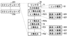
図27で示す例では、3DリンクレコードLR1に対応してリンクID70、その他項目71、構成点数72、3次元構成点3D1〜3Dnの順に格納される。その他項目71としては例えばリンク種別81があり、3次元構成点3Di(i=1〜n)それぞれにおいて、経度・X座標93X、経度・Y座標93Y、高度・Z座標93Z、標高93Hとからなる3次元情報が格納される。
In the example shown in FIG. 27, the
図27で示す例では、Z座標である高度の他に標高も追加されているが、標高は地表の標高を指しており、高度は標高に地表から道路までの高さを加えた値としている。 In the example shown in FIG. 27, the altitude is added in addition to the altitude that is the Z coordinate, but the altitude indicates the altitude of the ground surface, and the altitude is a value obtained by adding the height from the ground surface to the road. .
このように、特許文献1に代表される前提技術では、図26(c)や図26(d)のようにXY構成点とZ構成点とのうち少なくとも一つを3次元構成点として登録することにより、XY平面上の湾曲部の道路形状とZ方向の勾配部の道路形状の両方の曲線を精度よく表現することが可能となっている。
As described above, in the base technology represented by
しかし、道路リンクL40XYを道路リンクL41XYに変換することにより構成点数は“5”から“9”に増加し、あるいは、道路リンクL40Zを道路リンクL41Zに変換することにより構成点数は“4”から“9”に増加してしまい、格納すべき3次元道路地図データのデータ量が増加してしまうという問題点があった。 However, the number of constituent points increases from “5” to “9” by converting the road link L40XY to the road link L41XY, or the number of constituent points increases from “4” to “9” by converting the road link L40Z to the road link L41Z. There is a problem that the amount of 3D road map data to be stored increases.
以下での述べる実施の形態では、XY平面上の湾曲部の道路形状とZ方向の勾配部の道路形状の両方の曲線を精度よく表現可能にし、かつ、格納すべき3次元道路地図データのデータ量の削減を図る3次元道路地図データ生成装置、3次元道路地図データ処理システム等を提供する。 In the embodiment described below, it is possible to accurately represent the curves of the road shape of the curved portion on the XY plane and the road shape of the gradient portion in the Z direction, and data of 3D road map data to be stored Provided are a three-dimensional road map data generation device, a three-dimensional road map data processing system, and the like for reducing the amount.
<実施の形態1>
図1はこの発明の実施の形態1である3次元道路地図データ処理システムの構成を示すブロック図である。
<
FIG. 1 is a block diagram showing the configuration of a three-dimensional road map data processing system according to
3次元道路地図データ処理システム1の機能構成として、3次元道路地図データ生成装置11、3次元道路地図記憶装置12、及び3次元道路地図データ出力装置13を備えている。
As a functional configuration of the three-dimensional road map
3次元道路地図データ生成装置11は、XY構成点作成部24とZ構成点作成部25とを備えた道路リンクデータ構成部20、データを入力する入力部21、データを出力する出力部22を備えている。
The three-dimensional road map
3次元道路地図データ出力装置13は、Z座標直線近似値算出部41を備えた道路リンクデータ取得部30、入力部31、及び出力部32を備えている。
The three-dimensional road map
図2はこの実施の形態1である次元道路地図データ処理システム1が実現可能なコンピュータシステムのハードウェア構成例を示すブロック図である。同図に示すように、コンピュータシステム10は、ハードウェアとして、入力装置60、出力装置61、CPU62、メモリ63、通信装置64、及び記憶装置65を備えている。これらは、通常のコンピュータと同様のシステム構成である。
FIG. 2 is a block diagram showing a hardware configuration example of a computer system capable of realizing the dimensional road map
以下、図2で示したコンピュータシステム10によって実施の形態1の3次元道路地図データ処理システム1を実現するための一構成例を説明する。
Hereinafter, a configuration example for realizing the three-dimensional road map
(1) 入力装置60…入力部21、入力部31を実現、
(2) 出力装置61…出力部22、出力部32を実現、
(3) 記憶装置65…3次元道路地図記憶装置12を実現、
(4) CPU62,メモリ63…CPU62及びメモリ63上で動作するプログラムとして、道路リンクデータ構成部20(XY構成点作成部24、Z構成点作成部25)及び道路リンクデータ取得部30(Z座標直線近似値算出部41)を実現、
(5) 通信装置64…ネットワーク経由で3次元道路地図データ処理システム1にアクセスして出力結果を取得する態様の際に用いる。
(1) Input device 60: realizing the
(2)
(3)
(4)
(5)
以下、上記構成例について補足説明する。3次元道路地図記憶装置12への格納用の3次元道路地図データの出力は出力部22によって行われ、XY構成点におけるZ座標の出力等の処理は出力部32によって行われる。
Hereinafter, a supplementary explanation will be given of the above configuration example. Output of 3D road map data for storage in the 3D road
CPU62及びメモリ63上で動作するプログラムとは、記憶装置65から読み出したプログラムをCPU62がメモリ63を作業領域として実行することにより行われる。
The programs operating on the
入力部31は出力用の3次元道路地図データを必要とする別装置から入力(所望の道路リンクにおけるXY構成点のXY座標値)を得て、出力部32より出力(当該XY構成点におけるZ座標値)を出力する。例えば、GIS(Geographic Information System)システムや地図表示装置との連携があげられる。
The
入力装置60は例えばキーボードやマウス等によって構成され、3次元道路地図データ処理システム1に対してユーザが指示や対話処理を行うことができる。出力装置61はディスプレイ等によって構成され、入力内容の確認や3次元道路地図データの処理状況や結果の確認をすることができる。
The
図3は、実施の形態1による3次元道路地図データ処理システム1における3次元道路地図データ生成装置11によるデータ格納処理手順を示すフローチャートである。
FIG. 3 is a flowchart showing a data storage processing procedure by the three-dimensional road map
同図を参照して、ステップS11において、3次元道路地図データ生成装置11は様々なフォーマットで提供される3次元道路地図情報を入力部21より読み込む。読み込まれたデータは複数のデータ間で関連付けを行ったり、所望されるデータサイズに加工したり、入力された地図データからデフォルメされた地図データを作成したりすることができる。
Referring to FIG. 3, in step S <b> 11, 3D road map
次に、ステップS12において、読み込まれたデータのうち道路リンクデータは道路リンクデータ構成部20に送られ、XY構成点作成部24によって道路リングデータから第1の数のXY構成点からなるXY構成点情報が生成される。なお、XY構成点は、XY平面上のX方向成分及びY方向成分のみにより位置決めされる構成点であり、Z方向成分を含まない。
Next, in step S12, the road link data among the read data is sent to the road link data construction unit 20, and the XY construction composed of the first number of XY construction points from the road ring data by the XY construction
その後、ステップS13において、Z構成点作成部25は上記道路リンクデータに対し、第2の数のZ構成点からなるZ構成点情報が生成される。なお、Z構成点は、Z方向成分とX方向成分及びY方向成分と所定の関連性を有するXY関連成分とにより位置決めされる構成点である。
Thereafter, in step S13, the Z composing
最後に、ステップS14において、XY構成点情報とZ構成点情報に分けて構成された道路リンクデータは、その他入力データや加工されたデータとともにまとめられ格納用3次元道路地図データとして3次元道路地図記憶装置12に格納される。
Finally, in step S14, the road link data divided into XY constituent point information and Z constituent point information is gathered together with other input data and processed data, and is stored as a three-dimensional road map data for storage. It is stored in the
ステップS11で入力される3次元道路地図情報とは、道路形状を表現する3次元位置座標を持っている情報を意味する。道路形状以外にも、通常の地図データに含まれる背景データ、施設データ、道路幅や車線数のような道路属性等を含んでよい。 The three-dimensional road map information input in step S11 means information having three-dimensional position coordinates that express the road shape. In addition to the road shape, background data, facility data, road attributes such as road width and the number of lanes included in normal map data may be included.
図4は実施の形態1による3次元道路地図データ処理システム1の3次元道路地図データ生成装置11による格納用3次元道路地図データの出力処理を示すフローチャートである。
FIG. 4 is a flowchart showing output processing of storage 3D road map data by the 3D road map
3次元道路地図データ生成装置11は3次元道路地図記憶装置12よりデータを出力する際は、ステップS21において、入力部21より出力形式や出力部分を特定する出力形式パラメータを入力する。
When the three-dimensional road map
そして、ステップS22において、指定された部分を3次元道路地図記憶装置12より取り出した格納用3次元道路地図データを出力形式パラメータが指示する出力形式に変換した後、ステップS23において、出力部22よりデータ出力を行う。
In step S22, the storage unit 3D road map data obtained by extracting the designated portion from the 3D road
上記の出力部22より出力するデータの出力形式はカーナビゲーション装置のデータフォーマットや一般的な地図データのデータフォーマットによる出力があげられる。
Examples of the output format of the data output from the
図5は実施の形態1による道路リンクデータ構成部20が構築する格納用3次元道路地図データのデータ構造を示す説明図である。 FIG. 5 is an explanatory diagram showing a data structure of storage three-dimensional road map data constructed by the road link data construction unit 20 according to the first embodiment.
3DリンクレコードLR1〜LRn毎にリンクが管理され、3DリンクレコードLR1に対応してリンクID70、その他項目71、XY構成点数72、XY構成点PXY1〜PXYn、Z構成点数73、Z構成点PZ1〜PZnの順に格納される。その他項目71としては例えばリンク種別81があり、XY構成点PXYi(i=1〜n)それぞれにおいて、経度・X座標82X、経度・Y座標82YからなるX方向及びY方向成分のみの情報が格納される。すなわち、XY構成点は経度、緯度の2次元の座標情報を持ち、当該リンクのXY平面での道路形状を示す。
A link is managed for each of the 3D link records LR1 to LRn, and the
一方、Z構成点PZj(j=1〜m)それぞれにおいて経度・X座標83X、経度・Y座標83Y及び高度・Z座標83Zの3次元情報が格納される。すなわち、Z構成点PZjは、X方向成分及びY方向成分自体であるXY関連成分とZ方向成分とにより構成される。したがって、Z構成点は経度、緯度と高さ座標を持ち、当該リンクのZ方向の道路起伏形状を示す。 On the other hand, three-dimensional information of longitude / X coordinate 83X, longitude / Y coordinate 83Y, and altitude / Z coordinate 83Z is stored in each of the Z constituent points PZj (j = 1 to m). That is, the Z composing point PZj is composed of an XY-related component and a Z-direction component that are the X-direction component and the Y-direction component itself. Accordingly, the Z composing point has longitude, latitude, and height coordinates, and indicates the road undulation shape in the Z direction of the link.
なお、本明細書中において、「XY関連成分」とは、XY構成点情報と何らかの関連性を有し、Z構成点情報がZ方向成分に加え上記XY関連成分を有することにより、Z構成点情報に基づき、第1の数のXY構成点それぞれのZ方向成分が算出可能にした、情報成分を意味する。 In this specification, “XY related component” has some relationship with the XY composing point information, and the Z composing point information includes the XY related component in addition to the Z direction component. Based on information, it means an information component that enables calculation of the Z-direction component of each of the first number of XY constituent points.
上述したように、3DリンクレコードLR1〜LRnは3次元の道路リンクの数だけ存在し、各道路リンクの種別及び座標情報等が格納されたレコードである。これら3DリンクレコードLR1〜LRnは地図データ内の3次元道路リンクと1対1に対応する。3Dリンクレコードの中に道路リンクが含まれており、リンクIDやXY構成点数、XY構成点、Z構成点数、Z構成点、またその他複数の項目により構成されている。リンクID70は各道路リンクを識別するための番号である。XY構成点数72はXY構成点の数(第1の数)、Z構成点数73はZ構成点の数(第2の数)を示している。
As described above, the 3D link records LR1 to LRn exist as many as the number of three-dimensional road links, and are records in which the types and coordinate information of each road link are stored. These 3D link records LR1 to LRn have a one-to-one correspondence with the three-dimensional road links in the map data. A road link is included in the 3D link record, and is composed of a link ID, XY constituent points, XY constituent points, Z constituent points, Z constituent points, and a plurality of other items. The
3DリンクレコードLR1〜LRnは道路リンクに関する情報を保持するための複数の項目を持つ。例えば、上述したリンク種別やリンクの長さ、トンネルや橋の有無などがあげられる。 The 3D link records LR1 to LRn have a plurality of items for holding information on road links. For example, the above-mentioned link type, link length, presence / absence of a tunnel or a bridge, and the like can be given.
XY構成点やZ構成点の経度、緯度の値に関し、基準値の座標を決定し、差分を入力してもよい。基準値は、当該リンクの始点、終点となるノードや当該リンクの構成点の中の任意の点、地図の任意の矩形内の平均値等があげられる。また、基準値は3Dリンクレコードの持つ複数の項目の一つとして追加してもよい。 Regarding the longitude and latitude values of the XY constituent point and the Z constituent point, the coordinates of the reference value may be determined and the difference may be input. Examples of the reference value include the start point and end point of the link, an arbitrary point among the constituent points of the link, an average value in an arbitrary rectangle of the map, and the like. Further, the reference value may be added as one of a plurality of items that the 3D link record has.
高度とは、地形の高度と道路の高さやトンネル等を考慮した道路上での高さである。地形の高度のみから3次元道路地図データを作る場合や、トンネルや高架等の高度を別レコードとして持たせる場合は、高さ情報として地形高度のみの高さ座標を格納してもよい。高さ座標においても、経度、緯度の値と同様に基準値を決定し差分入力としてもよい。 The altitude is the height on the road in consideration of the altitude of the terrain, the height of the road, the tunnel and the like. When creating 3D road map data only from the altitude of the terrain, or when having altitudes such as tunnels and elevateds as separate records, the height coordinates of only the terrain altitude may be stored as height information. Also in the height coordinate, the reference value may be determined in the same manner as the longitude and latitude values, and the difference may be input.
3次元道路地図記憶装置12に格納されているすべての道路リンクデータを上記図5で示したデータ構成にて持つ必要はなく、湾曲部が多数存在するが勾配部の変化は乏しいランプのみ上記のデータ構成を適用するなど、一部分の適用でもよい。
It is not necessary to have all the road link data stored in the three-dimensional road
以上のように、実施の形態1では、各々がXY平面の湾曲部を表現する第1の数のXY構成点を指示するXY構成点情報と、Z方向の勾配部を表現する第2の数のZ構成点を指示するZ構成点情報とに分類された格納用3次元道路地図データを得ることによって、従来と同様の3次元精度を維持するデータを提供しながら格納サイズを小さくすることが可能である。 As described above, in the first embodiment, the XY composing point information indicating the first number of XY composing points each representing the curved portion of the XY plane and the second number representing the gradient portion in the Z direction. By obtaining storage three-dimensional road map data classified into the Z component point information indicating the Z component point, it is possible to reduce the storage size while providing data that maintains the same three-dimensional accuracy as before. Is possible.
図6は3次元道路地図データ生成装置11で得られるXY構成点情報及びZ構成点情報の一例を示す説明図である。
FIG. 6 is an explanatory diagram showing an example of XY composing point information and Z composing point information obtained by the three-dimensional road map
以下、図3のステップS11で読み込んだ3次元道路地図情報が図26の(c) ,(d) で示す道路リンクL41XY(道路リンクL41Z)からなる場合を例に挙げて、ステップS12におけるXY構成点抽出動作、ステップS13におけるZ構成点抽出動作について説明する。 Hereinafter, the XY configuration in step S12 will be described by taking as an example the case where the three-dimensional road map information read in step S11 in FIG. 3 is composed of road links L41XY (road links L41Z) shown in (c) and (d) in FIG. The point extraction operation and the Z constituent point extraction operation in step S13 will be described.
まず、ステップS12におけるXY構成点抽出方法について説明する。XY構成点の抽出方法は、道路リンクL41XYを構成する始点SXY、3次元構成点3D11〜3D19及び終点EXYのうち、始点SXYを開始点として連続する3点を順次取り出し、XY平面上で3点が同一直線上にある時は真ん中の点を除外する。 First, the XY composing point extraction method in step S12 will be described. The XY composing point is extracted by sequentially extracting three consecutive points starting from the starting point SXY out of the starting point SXY, the three-dimensional composing points 3D11 to 3D19, and the end point EXY constituting the road link L41XY, and three points on the XY plane. If are on the same straight line, the middle point is excluded.
図26(c) で示す道路リンクL41XYでは、3次元構成点3D14〜3D16は同一線上にあるため、真ん中の3次元構成点3D15を除外する。次に3次元構成点3D14,3D16及び3D17を取り出すと、これも同一線上にあるため、3次元構成点3D16を除外する。これをくり返し、連続する3点を取り出した時に同一線上にある点がなくなれば、これらをXY構成点と生成する。この際、生成するXY構成点ではZ成分の情報を除去する。 In the road link L41XY shown in FIG. 26 (c), since the three-dimensional composing points 3D14 to 3D16 are on the same line, the middle three-dimensional composing point 3D15 is excluded. Next, when the three-dimensional composing points 3D14, 3D16, and 3D17 are taken out, the three-dimensional composing points 3D16 are excluded because they are also on the same line. This is repeated, and when there are no points on the same line when three consecutive points are taken out, these are generated as XY constituent points. At this time, the Z component information is removed from the generated XY composing points.
その結果、図6(a) に示すように、3次元構成点3D11〜3D14及び3D19に対応する5つのXY構成点PXY11〜PXY15を選択的に抽出することができる。これらXY構成点PXY11〜PXY15はX方向成分及びY方向成分のみから構成される。 As a result, as shown in FIG. 6A, the five XY constituent points PXY11 to PXY15 corresponding to the three-dimensional constituent points 3D11 to 3D14 and 3D19 can be selectively extracted. These XY composing points PXY11 to PXY15 are composed of only the X direction component and the Y direction component.
次に、ステップS13におけるZ構成点抽出方法について説明する。Z構成点の抽出方法は、道路リンクL41Zを構成する始点SZ、3次元構成点3D21〜3D29及び終点EZのうち、始点SXを開始点として連続する3点を順次取り出し、XYZ空間上で3点が同一直線上にある時は真ん中の点を除外する。なお、説明の都合上、図6(b) 及び図26(d) で示すZX平面上の同一直線上のZ構成点は、XYZ空間上でも同一直線上に存在するとする。 Next, the Z constituent point extraction method in step S13 will be described. The method of extracting the Z constituent points is to sequentially extract three consecutive points starting from the starting point SX out of the starting points SZ, three-dimensional constituent points 3D21 to 3D29 and the end point EZ constituting the road link L41Z, and three points on the XYZ space. If are on the same straight line, the middle point is excluded. For convenience of explanation, it is assumed that the Z constituent points on the same straight line on the ZX plane shown in FIGS. 6B and 26D exist on the same straight line in the XYZ space.
図26(d) で示す道路リンクL41Zでは、始点SZ、3次元構成点3D21及び3D22は同一直線上にあるため、真ん中の3次元構成点3D21を除外する。次に、始点SZ、3次元構成点3D22,3D23を取り出すと、これも同一直線上にあるため、3次元構成点3D22を除外する。これをくり返し、連続する3点を取り出した時に同一線上にある点がなくなれば、これらをZ構成点とする。 In the road link L41Z shown in FIG. 26 (d), since the start point SZ, the three-dimensional configuration points 3D21 and 3D22 are on the same straight line, the middle three-dimensional configuration point 3D21 is excluded. Next, when the start point SZ and the three-dimensional configuration points 3D22 and 3D23 are taken out, the three-dimensional configuration point 3D22 is excluded because they are also on the same straight line. This is repeated, and when three consecutive points are taken out, if there are no points on the same line, these are set as Z constituent points.
その結果、図6(b) に示すように、3次元構成点3D24、3D26、3D28及び3D29に対応する4つのZ構成点PZ1〜PZ4を選択的に抽出することができる。Z構成点は示す情報は、Z方向成分に加え、X方向成分及びY方向成分をもXY関連成分として含んでいる。 As a result, as shown in FIG. 6B, four Z composing points PZ1 to PZ4 corresponding to the three-dimensional composing points 3D24, 3D26, 3D28 and 3D29 can be selectively extracted. The information indicating the Z composing point includes an X-direction component and a Y-direction component as XY-related components in addition to the Z-direction component.
なお、XY構成点及びZ構成点の抽出手法は上述した方法に限定するものではなく、XY構成点はXY平面上で連続する3点が同一線上に存在しないように抽出し、Z構成点はXYZ空間上で連続する3点が同一線上に存在しないように抽出すればよいものとする。 The method for extracting the XY constituent points and the Z constituent points is not limited to the above-described method. The XY constituent points are extracted so that three consecutive points on the XY plane do not exist on the same line, and the Z constituent points are It is only necessary to extract so that three consecutive points on the XYZ space do not exist on the same line.
(効果)
以下、図26(c) ,(d) で示す道路リンクL40XY(道路リンクL40Z)と、図6(a) ,(b) で示す道路リンクL20XY及び道路リンクL20Zの組合せとを比較検討する。
(effect)
Hereinafter, the road link L40XY (road link L40Z) shown in FIGS. 26 (c) and 26 (d) is compared with the combination of the road link L20XY and road link L20Z shown in FIGS. 6 (a) and 6 (b).
道路リンクL40XYに関し、図26 (c)のように(x,y,z)の3次元構成点が9個必要となる。一方、図6(a) に示すように、道路リンクL20XYに関し、(x,y)のXY構成点が5個で十分となる。 For the road link L40XY, nine (x, y, z) three-dimensional composing points are required as shown in FIG. On the other hand, as shown in FIG. 6A, five (x, y) XY composing points are sufficient for the road link L20XY.
そして、図9(b) に示すように、道路リンクL20Zに関し、(x,y,z)のZ構成点が4個で十分となる。 As shown in FIG. 9 (b), four (x, y, z) Z constituent points are sufficient for the road link L20Z.
x,y,zのデータサイズをすべて同じSDとした場合、特許文献1に代表される前提技術の3次元道路地図データ(道路リンクL40XYあるいは道路リンクL40Z)では、いずれも格納サイズは27SDとなり、実施の形態1により得られた格納用3次元道路地図データでは、22SD(10SD+12SD)となる。結果として、実施の形態1で得られる格納用3次元道路地図データの方がデータサイズを削減できていることがわかる。
When all of the data sizes of x, y, and z are the same SD, the storage size is 27SD in the three-dimensional road map data (road link L40XY or road link L40Z) of the base technology represented by
このように、格納用3次元道路地図データとしてXY構成点情報とZ構成点情報とに分類することにより、XY構成点情報及びZ構成点情報がそれぞれ不要な情報を持たずに精度よく表現することが可能である。 As described above, by classifying the XY component point information and the Z component point information as the storage three-dimensional road map data, the XY component point information and the Z component point information are accurately expressed without having unnecessary information. It is possible.
例えば、XY構成点を多数必要とするような湾曲部を持ち、Z方向の勾配については直線で表現できるためZ構成点を必要としないような道路形状の道路リンクにおいて、前提技術では、3次元の座標情報をすべての構成点において持たせては余分な情報を持つことになりデータサイズが増大する。一方、実施の形態1の3次元道路地図データ生成装置11によれば、上記ケースにおいて、Z構成点情報は余分な高さ情報を保持せず、格納用3次元道路地図データとしてデータサイズを小さくすることが可能となる。
For example, in a road link of a road shape that has a curved portion that requires a large number of XY composing points and that can express the gradient in the Z direction as a straight line, the base technology does not require a Z composing point. If all the constituent points are provided with the coordinate information, there will be extra information and the data size will increase. On the other hand, according to the three-dimensional road map
このように、実施の形態1における3次元道路地図データ生成装置11は道路リンクを示す情報として、XY構成点情報及びZ構成点情報に分けることにより、XY成分変化及びZ方向成分変化に基づき第1の数及び第2の数を互いに独立して決定することができる分、第1の数及び第2の数を必要最小限に抑えることができる。
As described above, the three-dimensional road map
さらに、実施の形態1における3次元道路地図データ生成装置11は、XY構成点作成部24により作成されるX構成成分情報はXY平面上のX方向成分及びY方向成分のみにより位置決めされる第1の数のXY構成点を指示する内容であるため、Z方向成分を必要としない分、格納用3次元道路地図データの情報量を削減することができる。その結果、格納用3次元道路地図データの減量化を図ることができる。
Furthermore, in the three-dimensional road map
加えて、Z構成点情報に基づき、第1の数のXY構成点それぞれのZ方向成分が算出可能であるため、3次元道路地図データとしての精度を維持することができる。 In addition, since the Z direction component of each of the first number of XY constituent points can be calculated based on the Z constituent point information, the accuracy as the three-dimensional road map data can be maintained.
また、実施の形態1の格納用3次元道路地図データにおけるZ構成点情報はXY座標値を持っているため、XY平面状でのZ構成点の位置を知るために計算を必要とせず、容易に出力可能である。 Further, since the Z constituent point information in the storage three-dimensional road map data according to the first embodiment has XY coordinate values, calculation is not required to know the position of the Z constituent point on the XY plane, and it is easy. Can be output.
3次元道路地図データ処理システム1は、地図表示機能や経路計算機能を有したり、地図情報を利用する装置と連携したり、組み込んだりしてもよい。その際に、3次元道路地図記憶装置12より任意のデータ値を取り出すために3次元道路地図データ出力装置13を備えている。取り出すデータとしては、位置座標を指定して道路リンクのZ座標値、道路属性、任意の位置の施設データを取得したり、指定の名前の施設を検索したりすることができる。3次元道路地図データ出力装置13は、3次元道路地図情報を利用するために、必要なデータへのアクセス機能を持っている。
The three-dimensional road map
3次元道路地図データ出力装置13は、入力部31より取り出すデータを指定するパラメータを受け付ける。3次元道路地図記憶装置12より指定されたデータを取り出し、出力部32より格納用3次元道路地図データに基づく出力用3次元道路地図データを出力する。
The three-dimensional road map
図7は、3次元道路地図データ出力装置13より道路リンクの任意の位置のZ座標値を取り出す場合のデータ出力処理を示すフローチャートである。
FIG. 7 is a flowchart showing a data output process in the case where a Z coordinate value at an arbitrary position of the road link is extracted from the three-dimensional road map
ステップS31において、入力部31より道路リンク上の(x,y)の位置(XY座標)を指定して、Z座標値を取得するよう命令を出す。
In step S31, the
次に、ステップS32において、3次元道路地図記憶装置12より格納用3次元道路地図データにおける道路リンクデータの情報を道路リンクデータ取得部30により取得する。道路リンクデータ取得部30は、入力部31より指定されたデータが道路リンクデータのZ座標値の場合には、Z座標直線近似値算出部41によって、指定した道路リンク上におけるXY座標が、当該道路リンクにおけるZ構成点(開始点SZ及び終了点SZを含む)間のどの位置にあるか算出する。
Next, in step S <b> 32, the road link data acquisition unit 30 acquires road link data information in the storage 3D road map data from the 3D road
そして、ステップS33において、隣接する2点のZ構成点(始点及び終点ノードを含む)から直線の式を求めて、直線の式にXY座標を代入し対応するZ座標を算出する。算出した値は出力部32より得る。
In step S33, a straight line expression is obtained from two adjacent Z constituent points (including the start point and end point node), and the corresponding Z coordinate is calculated by substituting the XY coordinates into the straight line expression. The calculated value is obtained from the
したがって、3次元道路地図データ出力装置13は、格納用3次元道路地図データ内のXY構成点情報が指示するXY構成点に基づきZ方向成分の情報であるZ座標値を含む出力用3次元道路地図データを精度良く算出することができる。
Therefore, the three-dimensional road map
図8は3次元道路地図データ出力装置13によるZ座標算出処理動作を説明する説明図である。同図(a) は道路リンクL20におけるXY構成点情報で指示される道路リンクL20XY、同図(b) は道路リンクL20におけるZ構成点情報で指示される道路リンクL20Zを示している。
FIG. 8 is an explanatory view for explaining the Z coordinate calculation processing operation by the three-dimensional road map
以下、図8を参照して、33次元道路地図記憶装置12に格納された格納用3次元道路地図データ内の道路リンクL20(道路リンクL20XY+道路リンクL20Z)から、道路リンクL20上の任意の位置としXY座標を指定された場合に、3次元道路地図データ出力装置13における道路リンクデータ取得部34内のZ座標直線近似値算出部41を用いて、対応するZ座標を求める方法を説明する。
Hereinafter, referring to FIG. 8, any position on the road link L20 from the road link L20 (road link L20XY + road link L20Z) in the storage 3D road map data stored in the 33D road
例えば、道路リンクL20上のXY構成点PXY1のXY座標が指定された場合、そのZ座標は開始点SZとZ構成点PZ1との間にあることがわかる。そこで、開始点SZとZ構成点PZ1とを結んだ直線の式を求め、XY構成点PXY1のXY座標を代入し、対応するZ座標を算出することにより、XY構成点PXY1のZ座標を精度良く算出することができる。 For example, when the XY coordinates of the XY composing point PXY1 on the road link L20 are designated, it can be seen that the Z coordinate is between the start point SZ and the Z composing point PZ1. Therefore, an equation of a straight line connecting the start point SZ and the Z constituent point PZ1 is obtained, the XY coordinates of the XY constituent point PXY1 are substituted, and the corresponding Z coordinate is calculated, whereby the Z coordinate of the XY constituent point PXY1 is accurately determined. It can be calculated well.
このように、実施の形態1の3次元道路地図データ処理システム1は3次元道路地図データ出力装置13を備えることによって、XY平面の湾曲部を表現する第1の数のXY構成点を指示するXY構成点情報と、Z方向の勾配部を表現する第2の数のZ構成点を指示するZ構成点情報とに分けた格納用3次元道路地図データから、適宜、各XY構成点にZ座標値を付加した出力用3次元道路地図データを精度良く取得することが可能となる。
As described above, the three-dimensional road map
その結果、特許文献1に代表される前提技術よりも、格納用3次元道路地図データのデータサイズを圧縮させながら、かつ、前提技術にて格納されていたZ座標と同等のZ座標値を3次元道路地図データ出力装置13により取得することができる効果をする。
As a result, the Z coordinate value equivalent to the Z coordinate stored in the base technology is reduced to 3 while compressing the data size of the storage three-dimensional road map data as compared with the base technology represented by
上述したように、Z構成点情報はX方向成分及びY方向成分自体であるXY関連成分とZ方向成分とにより位置決めされる第2の数のZ構成点を指示するため、XY関連成分に基づき、XY構成点情報が指示する各XY構成点のZ方向成分を精度良く算出することができる。その結果、3次元道路地図データ生成装置11より生成される格納用3次元道路地図データは、3次元道路地図情報としての3次元精度を維持することができる。
As described above, the Z composing point information indicates the second number of Z composing points to be positioned by the XY related component and the Z directional component which are the X direction component and the Y direction component itself. Thus, the Z direction component of each XY constituent point indicated by the XY constituent point information can be calculated with high accuracy. As a result, the three-dimensional road map data for storage generated by the three-dimensional road map
さらに、実施の形態1の3次元道路地図データ処理システム1におけるZ座標直線近似値算出部41は、始点、終点、第2の数のZ構成点のうち、隣接する2点間を直線近似する直線近似処理を実行することにより、Z構成点情報のデータサイズを増加させることなく、所望の道路リンク上のXY座標に対応するZ座標を得ることができる。
Furthermore, the Z-coordinate straight line approximate
<実施の形態2>
図9はこの発明の実施の形態2による道路リンクデータ構成部20が構築する格納用3次元道路地図データのデータ構造を示す説明図である。なお、実施の形態2の3次元道路地図データ処理システムは、図1で示した実施の形態1の3次元道路地図データ処理システム1と同等のシステム構成を呈している。ただし、Z構成点作成部25による生成されるZ構成点情報の内容が異なる。
<
FIG. 9 is an explanatory diagram showing a data structure of storage three-dimensional road map data constructed by the road link data construction unit 20 according to the second embodiment of the present invention. The 3D road map data processing system of the second embodiment has a system configuration equivalent to that of the 3D road map
同図に示すように、Z構成点情報が指示するZ構成点PZj(j=1〜m)それぞれにおいて始点相対距離84及び高度・Z座標83Zの情報が格納される。すなわち、Z構成点PZjは、Z方向成分と始点からの相対距離である始点相対距離であるXY関連成分とにより構成される。したがって、Z構成点は、経度、緯度座標が算出可能な始点相対距離と高さ座標とを持ち、当該道路リンクのZ方向の道路起伏形状を示している。 As shown in the figure, information on the start point relative distance 84 and the altitude / Z coordinate 83Z is stored in each of the Z constituent points PZj (j = 1 to m) indicated by the Z constituent point information. That is, the Z composing point PZj is composed of a Z direction component and an XY related component which is a start point relative distance which is a relative distance from the start point. Therefore, the Z composing point has a start point relative distance and a height coordinate from which longitude and latitude coordinates can be calculated, and indicates a road undulation shape in the Z direction of the road link.
図9で示すように、図5に示された実施の形態1のデータ構造ではZ構成点の位置は経度、緯度にて示しているのに対し、実施の形態2ではリンクの始点相対距離84をD座標とし、D座標の値によってZ構成点のXY方向の位置を間接的に示している。なお、他のデータ構造は図5で示した実施の形態1と同様であるため説明を省略する。 As shown in FIG. 9, in the data structure of the first embodiment shown in FIG. 5, the position of the Z composing point is indicated by the longitude and latitude, whereas in the second embodiment, the relative start point distance 84 of the link is shown. Is the D coordinate, and the position of the Z constituent point in the XY direction is indirectly indicated by the value of the D coordinate. Other data structures are the same as those in the first embodiment shown in FIG.
D座標はリンクの始点から当該Z構成点までの距離としているが、D座標の“0”となる基準値は上記差分表現と同様に限定するものではない。 D coordinate is the distance to the starting point or we those wherein Z configuration point of the link, the reference value to be "0" of the D coordinates is not limited as above differencing.
図10は実施の形態2の3次元道路地図データ生成装置11で得られるXY構成点情報及びZ構成点情報の一例を示す説明図である。
FIG. 10 is an explanatory diagram showing an example of XY composing point information and Z composing point information obtained by the three-dimensional road map
図10(a) に示すように、XY構成点情報が指示する内容は、実施の形態1の道路リンクL20XYと同一構成であり、始点SXY、XY構成点PXY11〜PXY15及び終点EXYからなる道路リンクL20XYを指示している。 As shown in FIG. 10 (a), the contents indicated by the XY composing point information have the same structure as the road link L20XY of the first embodiment, and the road link includes the start point SXY, the XY composing points PXY11 to PXY15, and the end point EXY. L20XY is indicated.
一方、図10(b) に示すように、Z構成点情報に関し、Z構成点PZ1〜PZ4の内容が実施の形態1と異なる。実施の形態2のZ構成点PZ1〜PZ4は、Z方向成分に加え、始点SXYとの相対距離dを含んで構成される。 On the other hand, as shown in FIG. 10B, the contents of the Z constituent points PZ1 to PZ4 are different from those of the first embodiment regarding the Z constituent point information. The Z constituent points PZ1 to PZ4 of the second embodiment are configured to include a relative distance d from the start point SXY in addition to the Z direction component.
x,y,z,dのデータサイズをすべて同じSDとした場合、実施の形態2により得られた格納用3次元道路地図データでは、18SD(10SD+8SD)となる。結果として、実施の形態2で得られる格納用3次元道路地図データは、実施の形態1のデータサイズの2/3にデータサイズを削減できていることがわかる。 When the data sizes of x, y, z, and d are all the same SD, the storage 3D road map data obtained by the second embodiment is 18SD (10SD + 8SD). As a result, it can be seen that the data size of the storage three-dimensional road map data obtained in the second embodiment can be reduced to 2/3 of the data size of the first embodiment.
このように、実施の形態2の3次元道路地図データ処理システムにおけるZ構成点作成部25は、XY関連成分として道路リンクの始点からの各Z構成点に至る距離を含ませることにより、実施の形態1以上に格納用3次元道路地図データの情報量を削減することができる。
As described above, the Z composing
また、実施の形態2のデータ構成では、ADAS(Advanced Driver Assistance System)対応のアプリケーションで、勾配位置を(経度、緯度)の2次元情報として情報取得するのではなく距離として勾配情報を利用する場合、計算する手間が発生せず、素早く処理することができる。 In the data structure of the second embodiment, the gradient information is used as a distance instead of acquiring the gradient position as two-dimensional information (longitude, latitude) in an ADAS (Advanced Driver Assistance System) compatible application. , It can be processed quickly without the need for calculation.
なお、3次元道路地図データ出力装置13によるZ座標の算出は以下のように行うことができる。例えば、道路リンクL20上のXY構成点PXY2のXY座標が指定された場合、始点SXYからXY構成点PXY1を経由してXY構成点PXY2に至る距離である始点相対距離を求める。その始点相対距離は開始点SZとZ構成点PZ1との間にあることがわかる。始点SZとZ構成点PZ1とを結んだ直線の式を求め、XY構成点PXY2の始点相対距離を代入し、対応するZ座標を算出することにより、実施の形態1と同様、XY構成点PXY1のZ座標を精度良く算出することができる。
The calculation of the Z coordinate by the three-dimensional road map
<実施の形態3>
図11はこの発明の実施の形態3による道路リンクデータ構成部20が構築する格納用3次元道路地図データのデータ構造を示す説明図である。なお、実施の形態2の3次元道路地図データ処理システムは、図1で示した実施の形態1の3次元道路地図データ処理システム1と同等のシステム構成を呈している。ただし、Z構成点作成部25が生成するZ構成点情報の内容が異なっている。
<
FIG. 11 is an explanatory diagram showing the data structure of storage three-dimensional road map data constructed by the road link data construction unit 20 according to
同図に示すように、Z構成点情報が指示するZ構成点PZj(j=1〜m)それぞれにおいて、XY構成点インデックス85、XY構成点相対距離86及び高度・Z座標83Zの情報が格納される。すなわち、Z構成点PZjは、XY構成点インデックス85で指示されるXY構成点からの相対距離であるXY構成点相対距離であるXY関連成分とZ方向成分とにより構成される。なお、XY構成点インデックス85は各Z構成点に最も近いXY構成点のインデックス情報である。インデックス情報とは例えばXY構成点PXYiの始点からの順序等が考えられる。したがって、Z構成点は、経度、緯度座標が算出可能なXY構成点インデックス85及びXY構成点相対距離86と共に高さ座標とを持ち、当該リンクのZ方向の道路起伏形状を示している。 As shown in the figure, in each of the Z constituent points PZj (j = 1 to m) indicated by the Z constituent point information, information of the XY constituent point index 85, the XY constituent point relative distance 86, and the altitude / Z coordinate 83Z is stored. Is done. That is, the Z composing point PZj is composed of an XY related component that is an XY composing point relative distance that is a relative distance from the XY composing point indicated by the XY composing point index 85 and a Z direction component. The XY composing point index 85 is index information of the XY composing point closest to each Z composing point. The index information may be, for example, the order from the start point of the XY composing point PXYi. Therefore, the Z composing point has a height coordinate together with an XY composing point index 85 and an XY composing point relative distance 86 capable of calculating longitude and latitude coordinates, and indicates a road undulation shape in the Z direction of the link.
図11に示すように、図5に示された実施の形態1のデータ構造ではZ構成点の位置は経度、緯度にて示しているが、実施の形態3では最も近いXY構成点を指示するXY構成点インデックス85と当該XY構成点までの相対距離を指示するXY構成点相対距離86とを有し、これらの情報によってZ構成点のXY方向の位置を間接的に示している。なお、他のデータ構造は図5で示した実施の形態1と同様であるため説明を省略する。 As shown in FIG. 11, in the data structure of the first embodiment shown in FIG. 5, the position of the Z constituent point is indicated by longitude and latitude, but in the third embodiment, the closest XY constituent point is indicated. An XY constituent point index 85 and an XY constituent point relative distance 86 indicating a relative distance to the XY constituent point are provided, and the position of the Z constituent point in the XY direction is indirectly indicated by these pieces of information. Other data structures are the same as those in the first embodiment shown in FIG.
図12は実施の形態3の3次元道路地図データ生成装置11で得られるXY構成点情報及びZ構成点情報の一例を示す説明図である。
FIG. 12 is an explanatory diagram showing an example of XY composing point information and Z composing point information obtained by the three-dimensional road map
図12(a) に示すように、XY構成点情報の指示する内容は実施の形態1の道路リンクL20XYと同一構成であり、始点SXY、XY構成点PXY1〜PXY5及び終点EXYからなる道路リンクL20XYを指示している。なお、XY構成点PXY1〜PXY5はそれぞれ簡単に表現可能なインデックス[0]〜[4]により識別可能である。 As shown in FIG. 12 (a), the contents designated by the XY composing point information are the same as the road link L20XY of the first embodiment, and the road link L20XY comprising the start point SXY, the XY composing points PXY1 to PXY5, and the end point EXY. Is instructing. Note that the XY constituent points PXY1 to PXY5 can be identified by indexes [0] to [4] that can be expressed easily.
一方、図12(b) に示すように、Z構成点情報はZ構成点PZ1〜PZ4の内容が実施の形態1と異なっており、Z方向成分に加え、元と近いXY構成点のインデックス情報を指示するidx、インデックス情報idxが指示するXY構成点から当該Z構成点までの相対距離d(終点側EZに向かう方向(図中右方向)の距離)を含んで構成される。 On the other hand, as shown in FIG. 12 (b), the Z composition point information differs from the first embodiment in the contents of the Z composition points PZ1 to PZ4, and in addition to the Z direction component, the index information of the XY composition points close to the original. And the relative distance d from the XY constituent point indicated by the index information idx to the Z constituent point (distance in the direction toward the end point side EZ (right direction in the figure)).
x,y,z,idx,dのデータサイズをすべて同じSDとした場合、実施の形態3により得られた格納用3次元道路地図データでは、22SD(10SD+10SD)となる。結果として、実施の形態3で得られる格納用3次元道路地図データは、実施の形態1と同等のデータサイズ削減を図ることができる。また、idx,dのデータサイズをx,y,z,のデータサイズより小さくすることができれば、実施の形態1以上のデータサイズ削減を図ることができる。
When the data sizes of x, y, z, idx, and d are all the same SD, the storage three-dimensional road map data obtained by
このように、実施の形態3の3次元道路地図データ処理システムにおけるZ構成点作成部25は、XY関連成分として最も近いXY構成点を指示するインデックス情報と、最も近いXY構成点からの相対距離(一方向における)を含ませることにより、実施の形態1以上に格納用3次元道路地図データの情報量を削減することができる。
As described above, the Z composing
なお、3次元道路地図データ出力装置13によるZ座標の算出は、各XY構成点が間に存在する2つのZ構成点(始点SZ,終点EZ含む)から、以下のように行うことができる。道路リンクL20上のXY構成点PXY5のXY座標が指定された場合、XY構成点PXY5は、XY構成点PXY5をインデックス情報([4])として指示するZ構成点PZ1と始点SZとの間に存在することを認識する。その結果、開始点SZとZ構成点PZ1とを結んだ直線上におけるXY構成点PXY5の位置(Z構成点PZ1の相対距離dに基づき算出)に対応するZ座標を精度良く算出することができる。
The calculation of the Z coordinate by the three-dimensional road map
上述のように、Z座標を求める際に、そのXY構成点がZ構成点と一致しているか、またはZ構成点の間に存在しているのかを取得する必要がある。Z構成点の間に存在している場合には、どのZ構成点の区間にあるか情報を取得しなければならない。本構成では、Z構成点と最も近いXY構成点とをXY構成点インデックス85によって関連付けているため、距離によって関連付けする実施の形態2の構成に比べ、XY構成点における高さ情報を取得する処理速度の向上が可能となる。 As described above, when obtaining the Z coordinate, it is necessary to acquire whether the XY composing point coincides with the Z composing point or exists between the Z composing points. If it exists between the Z composing points, information on which Z composing point is in the section must be acquired. In this configuration, the Z configuration point and the closest XY configuration point are associated with each other by the XY configuration point index 85, and therefore, processing for acquiring height information at the XY configuration point as compared with the configuration of the second embodiment that associates by the distance. The speed can be improved.
<実施の形態4>
図13はこの発明の実施の形態4による道路リンクデータ構成部20が構築する格納用3次元道路地図データのデータ構造を示す説明図である。なお、実施の形態4の3次元道路地図データ処理システムは図1で示した実施の形態1の3次元道路地図データ処理システム1と同等のシステム構成を呈している。ただし、Z構成点作成部25が生成するZ構成点情報の内容が異なっている。
<
FIG. 13 is an explanatory diagram showing the data structure of storage three-dimensional road map data constructed by the road link data construction unit 20 according to the fourth embodiment of the present invention. Note that the three-dimensional road map data processing system of the fourth embodiment has a system configuration equivalent to that of the three-dimensional road map
同図に示すように、Z構成点情報が指示するZ構成点PZj(j=1〜m)それぞれにおいて、高度・Z座標83Zの情報が格納される。すなわち、Z構成点PZjは、Z方向成分のみより構成される。ただし、Z構成点PZjを道路リンクの所定距離間隔に等分して得ることにより、始点SZから何番目のZ構成点であるか等によりZ構成点PZjを特定することにより間接的に始点SZから当該Z構成点までの距離を認識することができる。 As shown in the figure, information on altitude / Z coordinate 83Z is stored in each of the Z constituent points PZj (j = 1 to m) indicated by the Z constituent point information. That is, the Z composing point PZj is composed of only the Z direction component. However, by obtaining the Z composing point PZj by equally dividing it into predetermined distance intervals of the road link, the starting point SZ is indirectly determined by specifying the Z composing point PZj based on the Z constituent point from the starting point SZ. To the Z composing point can be recognized.
図13に示すように、図5に示された実施の形態1のデータ構造ではZ構成点の位置は経度、緯度にて示しているが、実施の形態4ではXY関連成分としてZ構成点PZjの設定間隔と始点からのZ構成点jの設定順序とを含ませ、Z構成点のXY方向の位置を間接的に算出可能にしている。なお、他のデータ構造は図5で示した実施の形態1と同様であるため説明を省略する。 As shown in FIG. 13, in the data structure of the first embodiment shown in FIG. 5, the position of the Z constituent point is indicated by longitude and latitude, but in the fourth embodiment, the Z constituent point PZj is used as the XY-related component. And the setting order of the Z constituent point j from the starting point are included so that the position of the Z constituent point in the XY direction can be indirectly calculated. Other data structures are the same as those in the first embodiment shown in FIG.
図14は実施の形態4の3次元道路地図データ生成装置11で得られるXY構成点情報及びZ構成点情報の一例を示す説明図である。
FIG. 14 is an explanatory diagram showing an example of XY composing point information and Z composing point information obtained by the three-dimensional road map
図14(a) に示すように、XY構成点情報は実施の形態1の道路リンクL20XYと同一構成であり、始点SXY、XY構成点PXY1〜PXY5及び終点EXYからなる道路リンクL20ZYを指示している。 As shown in FIG. 14 (a), the XY composing point information has the same structure as the road link L20XY of the first embodiment, and indicates the road link L20ZY including the start point SXY, the XY composing points PXY1 to PXY5, and the end point EXY. Yes.
一方、図14(b) に示すように、道路リンクL30Zを4等分にしたZ構成点PZ1〜PZ3を抽出することができる。実施の形態4のZ構成点PZ1〜PZ3はそれぞれZ方向成分を有している。 On the other hand, as shown in FIG. 14B, Z composing points PZ1 to PZ3 obtained by dividing the road link L30Z into four equal parts can be extracted. Z constituent points PZ1 to PZ3 of the fourth embodiment each have a Z-direction component.
x,y,zのデータサイズをすべて同じSDとした場合、実施の形態4により得られた格納用3次元道路地図データでは、13SD(10SD+3SD)となる。結果として、実施の形態4で得られる格納用3次元道路地図データは、実施の形態1〜実施の形態3以上にデータサイズ削減を図ることができる。
When the data sizes of x, y, and z are all the same SD, the storage three-dimensional road map data obtained by
このように、実施の形態4の3次元道路地図データ処理システムにおけるZ構成点作成部25は、XY関連成分として、始点〜終点間にZ構成点を設ける距離間隔と、始点からの当該Z構成点の設定順序とすることにより、各Z構成点に必要な情報はZ成分のみにすることができるため、実施の形態1以上に格納用3次元道路地図データの情報量を削減することができる。
As described above, the Z composing
なお、3次元道路地図データ出力装置13によるZ座標の算出は以下のように行うことができる。例えば、道路リンクL20上のXY構成点PXY1のXY座標が指定された場合、当該XY構成点PXY1の始点SXYからの距離を求める。その距離は始点SZとZ構成点PZ1との間にあることがわかる。そして、開始点SZとZ構成点PZ1とを結んだ直線の式を求め、XY構成点PXY1の始点からの距離dを代入し、対応するZ座標値を算出することにより、実施の形態1と同様、XY構成点PXY1のZ座標値を精度良く算出することができる。
The calculation of the Z coordinate by the three-dimensional road map
また、実施の形態4では、Z構成点の数(第2の数)によって勾配情報の精度を調整することができる。単純な形状であれば、Z構成点の数を少なくすることができる。一方、複雑な形状の場合はZ構成点の数を増やして勾配情報の精度を上げることができる。本構成は、勾配の変化が乏しい場合や、等分に構成点を配置した時に道路形状を表現できる場合、メッシュ標高データ(DEM(Digital Elevation Model)等)のみから勾配情報を作成するような勾配情報の精度が求められない場合に有効である。
In
<実施の形態5>
図15はこの発明の実施の形態5による道路リンクデータ構成部20が構築する格納用3次元道路地図データのデータ構造を示す説明図である。なお、実施の形態4の3次元道路地図データ処理システムじゃ図1で示した実施の形態1の3次元道路地図データ処理システム1と同等のシステム構成を呈している。ただし、Z構成点作成部25が生成するZ構成点情報の内容が異なっている。
<Embodiment 5>
FIG. 15 is an explanatory diagram showing the data structure of storage three-dimensional road map data constructed by the road link data construction unit 20 according to the fifth embodiment of the present invention. Note that the three-dimensional road map data processing system of the fourth embodiment has a system configuration equivalent to that of the three-dimensional road map
同図に示すように、XY構成点情報は実施の形態1〜実施の形態4と同様、3DリンクレコードLR1〜LRn単位にXY構成点を格納しているのに対し、Z構成点情報は、道路リンク単位ではなく複数のリンクからなる道路リンク列単位にZ構成点を格納している。すなわち、3Dリンク列レコードLRR1〜LRRnを対応させてZ構成点を格納している。なお、道路リンク列とは、道路リンクの接続関係や種別によって複数の道路リンクを1つにまとめたものである。道路リンク列情報は3Dリンク列レコードによって管理され、3次元のリンク列の数だけ存在し、リンク列に含まれるリンクIDが格納されたレコードである。3Dリンク列レコードは地図データ内の3次元リンク列と1対1に対応している。 As shown in the figure, the XY composition point information stores the XY composition point in units of 3D link records LR1 to LRn as in the first to fourth embodiments, whereas the Z composition point information is Z composing points are stored not in units of road links but in units of road link sequences composed of a plurality of links. That is, Z composing points are stored in association with the 3D link sequence records LRR1 to LRRn. The road link string is a collection of a plurality of road links in accordance with the connection relation and type of road links. The road link string information is managed by a 3D link string record, exists as many as the number of three-dimensional link strings, and is a record in which a link ID included in the link string is stored. The 3D link string record has a one-to-one correspondence with the three-dimensional link string in the map data.
3Dリンク列レコードLRR1において、リンク列ID74、リンク数75、リンクID・ID1〜IDn、Z構成点数73、Z構成点PZ1〜PZnから構成される。
The 3D link string record LRR1 includes a link string ID 74, a link count 75, link IDs / ID1 to IDn, a
Z構成点PZj(j=1〜m)それぞれにおいて、位置座標87、高度・Z座標83Zの情報が格納される。 In each of the Z composing points PZj (j = 1 to m), information on the position coordinate 87 and the altitude / Z coordinate 83Z is stored.
なお、位置座標87としては、実施の形態1の経度・X座標83X及び経度・Y座標83Y、実施の形態2の始点相対距離84、実施の形態3のXY構成点インデックス85及びXY構成点相対距離86等が考えられる。また、実施の形態4のように、道路リンク上にZ構成点PZjを所定の距離で等分して設ける場合、位置座標87は不要となる。上記のように、Z構成点PZjは、位置座標87とZ方向成分より構成される。 As the position coordinates 87, the longitude / X coordinate 83X and the longitude / Y coordinate 83Y of the first embodiment, the start point relative distance 84 of the second embodiment, the XY component point index 85 and the XY component point relative of the third embodiment. A distance 86 or the like is conceivable. Further, when the Z composing point PZj is equally divided by a predetermined distance on the road link as in the fourth embodiment, the position coordinate 87 is not necessary. As described above, the Z composing point PZj is composed of the position coordinate 87 and the Z direction component.
例えば、実施の形態3では、Z構成点を{XY構成点インデックス85(最も近いXY構成点のインデックス情報)、XY構成点相対距離86(XY構成点インデックス85が指示するY構成点からの距離)、高度・Z座標83Z(高さ座標)}という構成にしている。実施の形態5の場合、リンク列に対応して、Z構成点を実施の形態4の構成にて示すためには、(最も近いリンクのID、最も近いXY構成点のインデックス、インデックスが指示するXY構成点からの距離、高さ座標)として、最も近いXY構成点を持つリンクを特定できるようにする必要がある。また、リンクを特定できればよいので、位置座標87の一部としてリンクID情報を持つのではなく、リンク列の指定もインデックス情報で行うようにしても良い。 For example, in the third embodiment, the Z constituent point is represented by {XY constituent point index 85 (index information of the nearest XY constituent point), XY constituent point relative distance 86 (distance from the Y constituent point indicated by the XY constituent point index 85). ), Altitude / Z coordinate 83Z (height coordinate)}. In the case of the fifth embodiment, in order to indicate the Z configuration point in the configuration of the fourth embodiment corresponding to the link string, (the ID of the closest link, the index of the closest XY configuration point, the index indicates It is necessary to be able to specify the link having the closest XY composing point as the distance from the XY composing point and the height coordinate). Further, since it is sufficient if the link can be specified, the link string information may be specified by the index information instead of having the link ID information as a part of the position coordinate 87.
図15に示すように、実施の形態5では位置座標87を持たせて、Z構成点のXY方向の位置を算出可能にしている。なお、他のデータ構造は図5で示した実施の形態1と同様であるため説明を省略する。 As shown in FIG. 15, in the fifth embodiment, the position coordinate 87 is provided so that the position of the Z composing point in the XY direction can be calculated. Other data structures are the same as those in the first embodiment shown in FIG.
図16は実施の形態5の3次元道路地図データ生成装置11で得られるZ構成点情報の一例を示す説明図である。
FIG. 16 is an explanatory diagram showing an example of Z constituent point information obtained by the three-dimensional road map
図16では図示してしないが、XY構成点情報は、実施の形態1〜実施の形態4と同様に、リンクL1XY,L2XY及びL3XY(図示せず)毎にXY構成点が設けられる。 Although not shown in FIG. 16, XY composing point information is provided for each of links L1XY, L2XY, and L3XY (not shown) as in the first to fourth embodiments.
一方、図16に示すように、リンクL1XY,L2XY及びL3XYに対応する3つのリンクL1Z,L2X,L3Zからなるリンク列L1Z〜L3Zが一括してまとめられZ構成点PZ1,PZ12を抽出することができる。実施の形態5のZ構成点PZ1〜PZ2は、それぞれ上述した位置座標87に加え、Z方向成分を有している。 On the other hand, as shown in FIG. 16, link rows L1Z to L3Z composed of three links L1Z, L2X, and L3Z corresponding to the links L1XY, L2XY, and L3XY are collectively collected to extract the Z constituent points PZ1 and PZ12. it can. The Z composing points PZ1 and PZ2 of the fifth embodiment each have a Z direction component in addition to the position coordinates 87 described above.
このように、リンク列L1Z〜L3Z等の複数のリンク間にまたがった緩やかな勾配の湾曲部が形成されている場合、Z構成点を元にして近似曲線を引くことで間の高度を補間することができる。また、勾配の変化がリンク列を構成する複数のリンク列にまたがって直線で表現できる場合には、リンク列間を接続するノードの座標を3次元座標として持たずともノードの高度を求めることができるため、2次元で表現することが可能となる。そのため、Z構成点情報のデータサイズの削減につながる。 As described above, when a gently sloping curved portion is formed between a plurality of links such as the link rows L1Z to L3Z, the altitude between them is interpolated by drawing an approximate curve based on the Z composing points. be able to. Further, when the change in the gradient can be expressed by a straight line across a plurality of link strings constituting the link string, the height of the node can be obtained without having the coordinates of the nodes connecting the link strings as three-dimensional coordinates. Therefore, it can be expressed in two dimensions. For this reason, the data size of the Z composing point information is reduced.
このように、実施の形態5の3次元道路地図データ処理システムにおけるZ構成点作成部25は、複数のリンクからなるリンク列単位にZ構成点を求めてZ構成点情報を得ることにより、Z構成点情報のさらなるデータサイズの削減を図ることができる。
As described above, the Z composing
なお、3次元道路地図データ出力装置13によるZ座標の算出は位置座標87の内容に従い、実施の形態1〜実施の形態4で示した方法により行える。
The calculation of the Z coordinate by the three-dimensional road map
また、3Dリンク列レコードを構成する項目は図15に限定するものではなく、リンク列に関係する情報項目を追加してもよい。 Further, items constituting the 3D link string record are not limited to those in FIG. 15, and information items related to the link string may be added.
<実施の形態6>
図17は、実施の形態6による3次元道路地図データ処理システム2の機能構成を示すブロック図である。図1に示された実施の形態1における3次元道路地図データ処理システム1の3次元道路地図データ出力装置13内のZ座標直線近似値算出部41に代わって、3次元道路地図データ出力装置14内にZ座標曲線近似値算出部42を有している点が異なる。なお、他の構成は図1で示した実施の形態1の3次元道路地図データ処理システム1と同様である。
<Embodiment 6>
FIG. 17 is a block diagram showing a functional configuration of the three-dimensional road map
図18は、3次元道路地図データ処理システム2内の3次元道路地図データ出力装置14より指定された道路リンクにおける任意の位置のZ座標値を取り出す場合のデータ出力処理を示すフローチャートである。なお、説明の都合上、Z構成点情報におけるZ構成点PZjは、実施の形態1と同様、経度・X座標83X、経度・Y座標83Y及び高度・Z座標83Zによって示しているとする。
FIG. 18 is a flowchart showing a data output process when a Z coordinate value at an arbitrary position on a road link designated by the 3D road map
同図を参照して、ステップS41において、入力部31より道路リンク上の(x,y)の位置のZ座標値を取得するよう命令を出す。この際、道路リンクデータ取得部30を用いて、3次元道路地図記憶装置12より格納用3次元道路地図データを取得する。
With reference to the figure, in step S41, a command is issued from the
ステップS42において、道路リンクデータ取得部30は、入力部31より指定されたデータが道路リンクデータのZ座標値の場合にはZ座標曲線近似値算出部42によって、指定したXY座標が道路リンク列上のZ構成点(始点及び終点ノードを含む)間のどの位置にあるか算出する。
In step S42, when the data specified by the
その後、ステップS43において、指定されたXY座標の位置にある勾配の曲線はZ構成点を用いて近似曲線として求める。近似曲線には、多項式曲線やスプライン曲線、ベジェ曲線、円弧曲線、クロソイド曲線等を用いる。 Thereafter, in step S43, the gradient curve at the designated XY coordinate position is obtained as an approximate curve using the Z constituent points. A polynomial curve, a spline curve, a Bezier curve, an arc curve, a clothoid curve, or the like is used as the approximate curve.
したがって、Z構成点作成部25は、Z座標曲線近似値算出部42にて用いる近似曲線に応じて、Z構成点の個数や配置を決定する点が、実施の形態1〜実施の形態5と異なる。以下、この点を図26及び図6を参照して説明する。
Therefore, the Z component
実施の形態6におけるZ構成点の抽出方法は、道路リンクL41Zを構成するXYZ空間上での開始点SZ,終点EZを取り出し、開始点SZ,終点EZ間に指定された近似曲線を対応づけることにより行われる。 In the method of extracting the Z constituent points in the sixth embodiment, the start point SZ and the end point EZ in the XYZ space constituting the road link L41Z are extracted, and the designated approximate curve is associated between the start point SZ and the end point EZ. Is done.
図18に戻って、ステップS44において、ステップS43で求めた近似曲線に、ステップS41で指定したXY座標を代入し、対応するZ座標を算出し、当該Z座標を出力部32より出力する。
Returning to FIG. 18, in step S 44, the XY coordinates designated in step S 41 are substituted into the approximate curve obtained in step S 43, the corresponding Z coordinate is calculated, and the Z coordinate is output from the
以下、ステップS43の近似曲線を求める処理について詳述する。ステップS43において、予め決められた近似曲線を適用しても、道路種別や構成点の分布によって自動的に近似曲線を選択するようにしても良い。 Hereinafter, the process for obtaining the approximate curve in step S43 will be described in detail. In step S43, a pre-determined approximate curve may be applied, or an approximate curve may be automatically selected according to the road type and the distribution of the constituent points.
自動的に近似曲線を選択する場合は、道路種別によって判別する方法があげられる。高速道路では、カーブを設計する際にクロソイド曲線が利用されるため、近似曲線はクロソイド曲線を選択する。一般道では、クロソイド曲線のみで設計されていないため、勾配が緩やかに変化する箇所は折れ線、勾配形状が単純な曲線は円弧、複雑な場合はスプラインを選択する方法等があげられる。また、入力であるポリラインの形状に最も近い曲線を算出する方法もある。ポリラインと曲線の距離は、おのおのを媒介変数表現し、与えられた媒介変数の値に対応したポリラインおよび曲線上の2点間の距離の和により定義し、この値が小さいものほど近いと定義する。距離の定義については、X軸(もしくはY軸)に平行な(等間隔に配置された)直線とポリラインおよび曲線おのおのの交点との距離の和としてもよい。 In the case of automatically selecting an approximate curve, there is a method of discriminating according to the road type. On highways, clothoid curves are used when designing curves, so clothoid curves are selected as approximate curves. Since ordinary roads are not designed with only clothoid curves, there are methods such as selecting a polygonal line for a portion where the gradient changes slowly, a circular arc for a simple gradient shape, and a spline if complicated. There is also a method for calculating a curve closest to the shape of the input polyline. The distance between the polyline and the curve is expressed as a parametric variable, defined by the sum of the distance between the polyline and the two points on the curve corresponding to the given parametric value, and the smaller the value, the closer is defined. The distance may be defined as the sum of the distances between straight lines parallel to the X axis (or Y axis) (arranged at equal intervals) and the intersections of the polyline and the curve.
なお、予め決められた近似曲線を適用する場合には、Z構成点作成部25によってZ構成点を求める計算量が少なくてすむという効果がある。
In the case of applying a predetermined approximate curve, there is an effect that the calculation amount for obtaining the Z constituent point by the Z constituent
一方、複数の近似曲線から自動的に近似曲線を適用する場合には、適切な曲線を選ぶことで、実態と誤差の少ないZ座標を提供できる効果がある。 On the other hand, when an approximate curve is automatically applied from a plurality of approximate curves, there is an effect that Z coordinates with less actuality and error can be provided by selecting an appropriate curve.
図19は実施の形態6におけるZ座標算出方法を説明するための説明図である。以下、図19を参照して、3次元道路地図データ生成装置11を用いて3次元道路地図記憶装置12に格納された格納用3次元道路地図データにおける道路リンク列L1Z〜L3Zから、道路リンク列L1Z〜L3Z上の任意の位置のXY座標を指定された場合にZ座標曲線近似値算出部42を用いて、対応するZ座標を求める方法を説明する。
FIG. 19 is an explanatory diagram for explaining a Z coordinate calculation method according to the sixth embodiment. Hereinafter, referring to FIG. 19, the road link sequence from the road link sequences L1Z to L3Z in the storage 3D road map data stored in the 3D road
例えば、道路リンク列L1XY上の位置P6のXY座標が指定された場合には、道路リンク列L1Z〜L3Z上にあることがわかり、道路リンク列L1Z〜L3Zが形成する近似曲線を求める。図19では、Z構成点PZ1とPZnは曲線の変曲点として配置している。例えば、スプライン曲線にて近似を行う。求めたスプライン曲線の式から、指定された位置P6のXY座標の位置に対応するZ座標の値を取得する。 For example, when the XY coordinates of the position P6 on the road link row L1XY are designated, it can be seen that the vehicle is on the road link row L1Z to L3Z, and approximate curves formed by the road link row L1Z to L3Z are obtained. In FIG. 19, the Z constituent points PZ1 and PZn are arranged as inflection points of the curve. For example, approximation is performed using a spline curve. The value of the Z coordinate corresponding to the position of the XY coordinate of the designated position P6 is acquired from the obtained spline curve formula.
このように、実施の形態6の3次元道路地図データ処理システム2におけるZ座標曲線近似値算出部42は、第2の数のZ構成点間を曲線近似する曲線近似処理を実行することにより直線近似よりも精度のよい近似値を得ることができるため、Z構成点情報のデータサイズを増加させることなく、所望のリンク上のXY座標に対応するZ座標を精度良く得ることができる効果を奏する。
As described above, the Z coordinate curve approximate value calculation unit 42 in the three-dimensional road map
本実施の形態では、Z構成点が道路リンク列に対応した場合を示しているが、実施の形態1〜実施の形態4のようにZ構成点が道路リンクに対応してもよい。 In the present embodiment, the case where the Z composing point corresponds to the road link row is shown, but the Z composing point may correspond to the road link as in the first to fourth embodiments.
<実施の形態7>
図20はこの発明の実施の形態7による道路リンクデータ構成部20が構築する格納用3次元道路地図データのデータ構造を示す説明図である。
<Embodiment 7>
FIG. 20 is an explanatory diagram showing the data structure of storage three-dimensional road map data constructed by the road link data construction unit 20 according to Embodiment 7 of the present invention.
同図に示すように、さらに、Z構成点情報は、使用する近似式を指示する近似値情報76をさらに有している。図20で示す例では近似値情報76はクロソイド曲線88を指示している。なお、他のデータ構造は図5で示した実施の形態1と同様であるため説明を省略する。
As shown in the figure, the Z composing point information further includes
図21は、実施の形態7による3次元道路地図データ処理システム3の機能構成を示すブロック図である。図1に示された実施の形態1における3次元道路地図データ処理システム1の3次元道路地図データ出力装置13内のZ座標直線近似値算出部41に代わって、3次元道路地図データ出力装置15内にZ座標近似式算出部43を有している点が異なる。なお、他の構成は図1で示した実施の形態1の3次元道路地図データ処理システム1と同様である。
FIG. 21 is a block diagram showing a functional configuration of the three-dimensional road map
図22は、3次元道路地図データ処理システム3内の3次元道路地図データ出力装置15より道路リンクの任意の位置のZ座標値を取り出す場合のデータ出力処理を示すフローチャートである。
FIG. 22 is a flowchart showing data output processing when a Z coordinate value at an arbitrary position of a road link is extracted from the 3D road map
同図を参照して、ステップS41において、入力部31より道路リンク上の(x,y)の位置のZ座標値を取得するよう命令を出す。この際、道路リンクデータ取得部30を用いて、3次元道路地図記憶装置12より道路リンクデータの情報を取得する。
With reference to the figure, in step S41, a command is issued from the
ステップS52において、道路リンクデータ取得部34は、入力部31より指定されたデータが道路リンクデータのZ座標値の場合にはZ座標曲線近似値算出部43によって、指定したXY座標が道路リンク列上のZ構成点(始点及び終点ノードを含む)間のどの位置にあるか算出する。
In step S52, when the data specified by the
その後、ステップS53において、近似値情報76の指示する近似手法を特定する。図20で示した3DリンクレコードLR1で指示するリンクの場合は、データ内に近似式情報として、クロソイド曲線が指定されている。指定する近似値情報76としては、直線、クロソイド、円弧曲線等の道路設計上用いられる線形の式があげられる。その他、複雑な形状の場合には、スプライン曲線やベジエ曲線や多項式で示す曲線式等がある。
Thereafter, in step S53, the approximation method indicated by the
その後、ステップS54において、ステップS53で特定した近似手法により、Z構成点における勾配の近似式を求める。すなわち、指定されたXY座標の位置にある勾配の曲線はZ構成点や必要であれば始点及び終点ノードを用いてデータ内に格納された近似方法にて近似式を求める。 Thereafter, in step S54, an approximate expression of the gradient at the Z composing point is obtained by the approximation method specified in step S53. In other words, the gradient curve at the designated XY coordinate position is obtained by the approximation method stored in the data using the Z constituent points and, if necessary, the start point and end point nodes.
そして、ステップS55において、ステップS54で求めた近似曲線に、ステップS51で指定したXY座標を代入し、対応するZ座標を算出する算出し、当該Z座標を出力部32より出力する。
In step S55, the XY coordinates designated in step S51 are substituted into the approximate curve obtained in step S54, the corresponding Z coordinates are calculated, and the Z coordinates are output from the
なお、単体のリンクだけでなく、リンク列に対応して3Dリンク列レコードに近似式情報をもたせる構成としてもよい。 In addition, it is good also as a structure which gives approximate expression information not only to a single link but to a 3D link sequence record corresponding to a link sequence.
このように、3Dリンクレコードに近似式情報をもたせることによって、すべての直線あるいは曲線を同じ手法で近似するのではなく、道路リンクの形状に応じて適切な近似方法を指定することができる。そのため、精度のよい近似値を得ることができる。 As described above, by providing approximate expression information in the 3D link record, it is possible to specify an appropriate approximation method according to the shape of the road link, instead of approximating all the straight lines or curves by the same method. Therefore, an accurate approximate value can be obtained.
すなわち、実施の形態7の3次元道路地図データ処理システム3において、Z座標近似式算出部43は、複数の近似式から選ばれた選択近似式を用いて、直線近似処理あるいは曲線近似処理を実行するにより、指定されたリンク上のXY座標に応じて精度のよいZ座標値を得ることができる。
In other words, in the three-dimensional road map
<実施の形態8>
また、3次元道路地図データ出力装置13は3次元道路地図情報を利用するナビゲーション装置に組み込んでもよい。
<Eighth embodiment>
The three-dimensional road map
図23はこの発明の実施の形態8である移動体ナビゲーション装置を示すブロック図である。実施の形態8の移動体ナビゲーション装置100は、タッチパネルやリモコン等の入力装置160、ディプレイや音声出力を行う出力装置161、CPU162、メモリ163、外部サーバとの通信を行う通信装置164、地図情報を格納しておく地図データ記憶装置165、指定された目的地までの経路を計算し案内を行う経路案内処理部166、地図を表示する地図表示部167、ロケータやジャイロセンサ等の各種センサ168、GPS受信機169、地図データ記憶装置165から必要なデータを取り出す3次元道路地図データ出力装置13(〜15)を備えた地図データアクセス部170から構成されている。これらは、通常のカーナビゲーションに代表される移動体ナビゲーション装置と同様のシステム構成である。
FIG. 23 is a block diagram showing a mobile navigation apparatus according to Embodiment 8 of the present invention. The
地図データ記憶装置165には、3次元道路地図データ生成装置11にて作成した格納用3次元道路地図データを格納しており、3次元道路地図データ出力装置13を備えた地図データアクセス部170を用いてデータを取り出すことができる。
The map
例えば、地図表示部167が地図データを取り出す際には、地図データアクセス部170に必要なデータの要求を出し、3次元道路地図データ出力装置13から地図データ記憶装置165にアクセスして目的となるデータを取り出し、求められた形式に変換して値を地図表示部167に返却する。
For example, when the
具体的には、地図データアクセス部170は、GPS受信機169により現在位置(X、Y)を把握し、現在位置に合致する道路リンクを地図データ記憶装置165内の格納用3次元道路地図データから取り出し、必要に応じて取り出した道路リンクのXY構成点情報及びZ構成点情報に基づきXY構成点に対応するZ座標値を算出して、地図表示部167に地図情報を出力する。
Specifically, the map
このように、実施の形態8の移動体ナビゲーション装置100は、内部に3次元道路地図データ出力装置13を組み込むことで、データサイズを削減した格納用3次元道路地図データを移動体ナビゲーション装置内で利用することが可能となる。
As described above, the
なお、本実施の形態では地図データアクセス部170に3次元道路地図データ出力装置13を組み込んで構成したが、XY構成点に対応するZ座標値を求める処理は、地図データアクセス部170で実施しない構成にしても良い。
In the present embodiment, the map
例えば、地図データアクセス部170に代えて、経路案内処理実行時に経路誘導の計算を行う経路案内処理部166で実施しても良い、この場合、地図データアクセス部170は単に格納用3次元道路地図データにアクセスしそのまま格納用3次元道路地図データを経路案内処理部166に渡すだけでよい。このようにすることで、Z座標値が不要なときにはZ座標値を求める計算をしなくても良いのでCPU処理が削減される。
For example, instead of the map
例えば、Z座標値が必要な処理には、勾配を勘案したエコルート探索や、 EV(電気自動車),HEV(ハイブリッド電気自動車)の走行計画処理、カーブやインターチェンジなどの速度超過における安全警報計算がある。 For example, processes that require Z-coordinate values include eco-route search that takes the gradient into account, EV (electric vehicle) and HEV (hybrid electric vehicle) travel plan processing, and safety warning calculations for overspeeds such as curves and interchanges. .
また、Z座標値を求める処理を別の計算モジュールで一括して実行する構成にしても良く、この場合、複数の処理モジュールがZ座標値を必要とする場合に重複して計算する必要が無い。 Further, the processing for obtaining the Z coordinate value may be configured to be collectively executed by another calculation module. In this case, when a plurality of processing modules require the Z coordinate value, there is no need to perform redundant calculation. .
このように、移動体ナビゲーション装置100内の地図データ記憶装置165に格納される格納用3次元道路地図データにおける道路リンクを示す情報として、XY構成点情報及びZ構成点情報に分けることにより、XY成分変化及びZ方向成分変化に基づき第1の数及び第2の数を互いに独立して決定することができる分、第1の数及び第2の数を必要最小限に抑えることができる。
Thus, by dividing into XY constituent point information and Z constituent point information as information indicating the road link in the storage three-dimensional road map data stored in the map
さらに、実施の形態8の移動体ナビゲーション装置100において、地図データ記憶装置165に格納される格納用3次元道路地図データのX構成成分情報はXY平面上のX方向成分及びY方向成分のみにより位置決めされる第1の数のXY構成点を指示する内容であるためZ方向成分を必要としない分、情報量を削減することができる。その結果、格納用3次元道路地図データの減量化を図ることができる。
Furthermore, in the
さらに、格納用3次元道路地図データのZ構成点情報はXY関連成分とZ方向成分とにより位置決めされる第2の数のZ構成点を指示するため、上記XY関連成分に基づき、各XY構成点のZ方向成分を算出することができるため、3次元道路地図データとしての精度を維持することができる。 Furthermore, since the Z constituent point information of the storage three-dimensional road map data indicates the second number of Z constituent points positioned by the XY related component and the Z direction component, each XY constituent is based on the XY related component. Since the Z-direction component of the point can be calculated, the accuracy as the three-dimensional road map data can be maintained.
<その他>
(方法発明への適用)
実施の形態1〜実施の形態7で示した3次元道路地図データ処理システム1(〜3)における3次元道路地図データ生成装置11による格納用3次元道路地図データの作成方法は以下のステップを備える方法発明としても適用可能である。
<Others>
(Application to method invention)
The method for creating 3D road map data for storage by the 3D road map
すなわち、3次元座標による3次元道路地図データを受け、始点から終点に至る少なくとも一つの道路リンクからなる格納用3次元道路地図データを生成する方法であって、上記少なくとも一つの道路リンクはそれぞれXY構成点情報及びZ構成点情報を含み、以下のステップ(a) ,(b) を実行する。 That is, a method of receiving 3D road map data by 3D coordinates and generating storage 3D road map data including at least one road link from a start point to an end point, wherein each of the at least one road link is XY The following steps (a) and (b) are executed including the constituent point information and the Z constituent point information.
ステップ(a):3次元道路地図情報に基づき、XY平面上のX方向成分及びY方向成分のみにより位置決めされる第1の数のXY構成点を指示するXY構成点情報を作成する。 Step (a): Based on the three-dimensional road map information, XY composing point information indicating the first number of XY composing points positioned only by the X direction component and the Y direction component on the XY plane is created.
ステップ(b) :上記XY構成点情報と所定の関連性を有するXY関連成分とZ方向成分とにより位置決めされる第2の数のZ構成点を指示するZ構成点情報を作成する。 Step (b): Z configuration point information indicating a second number of Z configuration points positioned by the XY related component having a predetermined relationship with the XY configuration point information and the Z direction component is created.
そして、Z構成点情報に基づき、第1の数のXY構成点それぞれのZ方向成分が算出可能であることを特徴とする。 Then, the Z-direction component of each of the first number of XY constituent points can be calculated based on the Z constituent point information.
このように、上述した次元道路地図データの生成方法は、格納用3次元道路地図データにおける道路リンクを示す情報として、XY構成点情報及びZ構成点情報に分けることにより、XY成分変化及びZ方向成分変化に基づき第1の数及び第2の数を互いに独立して決定することができる分、第1の数及び第2の数を必要最小限に抑えることができる。 In this way, the above-described method for generating the dimensional road map data is divided into XY component point information and Z component point information as information indicating the road link in the storage three-dimensional road map data, thereby changing the XY component change and the Z direction. Since the first number and the second number can be determined independently of each other based on the component change, the first number and the second number can be minimized.
さらに、3次元道路地図データの生成方法において、上記ステップ(a) により作成されるX構成成分情報は、XY平面上のX方向成分及びY方向成分のみにより位置決めされる第1の数のXY構成点を指示する内容であるため、Z方向成分を必要としない分、格納用3次元道路地図データの情報量を削減することができる。その結果、格納用3次元道路地図データの減量化を図ることができる。 Further, in the method for generating three-dimensional road map data, the X component information generated by step (a) is a first number of XY components positioned by only the X direction component and the Y direction component on the XY plane. Since it is a content indicating a point, the amount of information of the storage three-dimensional road map data can be reduced by the amount that does not require the Z-direction component. As a result, the storage 3D road map data can be reduced.
加えて、上記ステップ(b) により作成されるZ構成点情報はXY構成点情報と所定の関連性を有するXY関連成分とZ方向成分とにより位置決めされる第2の数のZ構成点を指示するため、上記XY関連成分に基づき、各XY構成点のZ方向成分を算出することができるため、3次元道路地図データとしての精度を維持することができる。 In addition, the Z constituent point information created in step (b) indicates the second number of Z constituent points that are positioned by the XY related component having a predetermined relationship with the XY constituent point information and the Z direction component. Therefore, since the Z direction component of each XY composing point can be calculated based on the XY related component, the accuracy as the three-dimensional road map data can be maintained.
(他の態様)
また、図24に示すように、実施の形態1〜実施の形態7において、3次元道路地図データ出力装置13〜15を除き、3次元道路地図データ生成装置11及び3次元道路地図記憶装置12からなる構成に特化した3次元道路地図データ処理システム4を他の態様として考えられる。
(Other aspects)
Further, as shown in FIG. 24, in the first to seventh embodiments, except for the three-dimensional road map
この態様においても、格納用3次元道路地図データにおける道路リンクを示す情報として、XY構成点情報及びZ構成点情報に分けることにより、XY成分変化及びZ方向成分変化に基づき第1の数及び第2の数を互いに独立して決定することができる分、第1の数及び第2の数を必要最小限に抑えることができる効果を奏する。 Also in this aspect, the information indicating the road link in the storage three-dimensional road map data is divided into XY component point information and Z component point information, so that the first number and the first number are changed based on the XY component change and the Z direction component change. Since the number of 2 can be determined independently of each other, the first number and the second number can be minimized.
さらに、3次元道路地図データ生成装置11は、XY構成点作成部24により作成されるX構成成分情報はXY平面上のX方向成分及びY方向成分のみにより位置決めされる第1の数のXY構成点を指示する内容であるため、Z方向成分を必要としない分、格納用3次元道路地図データの情報量を削減することにより、システムの減量化を図ることができる効果を奏する。
Further, the three-dimensional road map
1〜3 3次元道路地図データ処理システム、11 3次元道路地図データ生成装置、12 3次元道路地図記憶装置、13〜15 3次元道路地図データ出力装置、20 道路リンクデータ構成部、21,31 入力部、22,32 出力部、24 XY構成点作成部、25 Z構成点作成部、30 道路リンクデータ取得部、41 Z座標直線近似値算出部、42 Z座標曲線近似値算出部、43 Z座標近似式算出部。 1 to 3 3D road map data processing system, 11 3D road map data generation device, 12 3D road map storage device, 13 to 15 3D road map data output device, 20 road link data configuration unit, 21 and 31 input Unit, 22, 32 output unit, 24 XY composing point creating unit, 25 Z composing point creating unit, 30 road link data acquiring unit, 41 Z coordinate straight line approximate value calculating unit, 42 Z coordinate curve approximating value calculating unit, 43 Z coordinate Approximation formula calculator.
Claims (13)
前記少なくとも一つの前記道路成分はそれぞれXY構成点情報及びZ構成点情報を含み、
前記3次元道路地図情報に基づき、前記道路成分を構成する、前記始点および前記終点を含む3次元構成点について、前記始点を開始点として連続する3つの3次元構成点を取り出し、前記3次元座標のXY平面上で前記3つの3次元構成点が同一直線上にある場合には、前記3つの3次元構成点のうちの2番目の3次元構成点を除外する操作を前記終点まで繰り返すことにより、XY平面上のX方向成分及びY方向成分のみにより位置決めされる第1の数のXY構成点を指示する前記XY構成点情報を作成するXY構成点作成部と、
前記3次元道路地図情報に基づき、前記3次元構成点について、前記始点を開始点として連続する3つの3次元構成点を順次取り出し、前記3次元座標のZX平面又はZY平面上で前記3つの3次元構成点が同一直線上にある場合には、前記3つの3次元構成点のうちの2番目の3次元構成点を除外する操作を前記終点まで繰り返すことにより、Z方向成分により位置決めされる第2の数のZ構成点を指示する前記Z構成点情報を作成するZ構成点作成部とを備え、
前記Z構成点情報に基づき、前記第1の数のXY構成点それぞれのZ方向成分が算出可能であることを特徴とする、
3次元道路地図データ生成装置。 Based on the three-dimensional road map information by the three-dimensional coordinates, and at least one of the three-dimensional road map data generation apparatus for generating a three-dimensional road map data shall be the components road components ranging from the start point to the end point,
The at least one road component includes XY composing point information and Z composing point information,
Based on the three-dimensional road map information, for the three-dimensional composing points including the start point and the end point constituting the road component, three consecutive three-dimensional composing points starting from the start point are extracted, and the three-dimensional coordinates are extracted. When the three three-dimensional composing points are on the same straight line on the XY plane, the operation of excluding the second three-dimensional composing point of the three three-dimensional composing points is repeated until the end point. , an XY configuration point creation unit that creates the XY configuration point information indicating XY configuration point of the first number to be positioned only by the X-direction component and Y direction component of the XY plane,
Based on the three-dimensional road map information, for the three-dimensional composing point, three consecutive three-dimensional composing points with the start point as a starting point are sequentially extracted, and the three three-dimensional coordinates on the ZX plane or the ZY plane of the three-dimensional coordinates are extracted. When the dimension composing points are on the same straight line, the operation of excluding the second three-dimensional composing point of the three three-dimensional composing points is repeated until the end point, so that the positioning by the Z direction component is performed. A Z composing point creating unit that creates the Z composing point information indicating two Z composing points,
Based on the Z constituent point information, the Z direction component of each of the first number of XY constituent points can be calculated,
3D road map data generator.
前記3次元道路地図データを格納する3次元道路地図情報記憶装置と、
前記3次元道路地図データにおける前記XY構成点情報で指示される各前記XY構成点について、各前記XY構成点のXY平面上のX方向成分およびY方向成分から各前記XY構成点が、前記Z構成点情報で示される、始点および終点を含めたZ構成点のうちのいずれの2つのZ構成点の間に位置するかを算出し、前記2つのZ構成点を結ぶ直線式におけるX方向成分およびY方向成分に、各前記XY構成点のXY平面上のX方向成分およびY方向成分をそれぞれ代入することにより、各前記XY構成点のZ方向成分を算出し、前記XY構成点に算出された前記Z方向成分を加味した出力用3次元道路地図データを出力可能な3次元道路地図データ出力装置とを備えることを特徴とする、
3次元道路地図データ処理システム。 The three-dimensional road map data generation device according to claim 1,
3D road map information storage device for storing pre-Symbol 3-dimensional road map data,
For each said XY configuration point indicated by the XY configuration data associated with the previous SL three-dimensional road map data, each said XY configuration from point X direction component and Y direction component of the XY plane of each of the XY configuration point, the The X direction in the linear expression connecting the two Z constituent points is calculated by calculating which of the Z constituent points including the start point and the end point, which is indicated by the Z constituent point information, is located between the two Z constituent points. By substituting the X direction component and the Y direction component on the XY plane of each of the XY constituent points into the component and the Y direction component, respectively, the Z direction component of each of the XY constituent points is calculated and calculated as the XY constituent point. characterized in that it comprises a three-dimensional road map data output device capable of outputting the Z direction component three-dimensional road map data for output in consideration of that is,
3D road map data processing system.
前記3次元道路地図データを格納する3次元道路地図情報記憶装置と、
前記3次元道路地図データにおける前記XY構成点情報で指示される各前記XY構成点について、各前記Z構成点情報で示される、始点および終点を含めたZ構成点を通る近似曲線式を算出し、各前記XY構成点のXY平面上のX方向成分およびY方向成分を前記近似曲線式のX方向成分およびY方向成分にそれぞれ代入することにより、各前記XY構成点のZ方向成分を算出し、前記XY構成点に算出された前記Z方向成分を加味した出力用3次元道路地図データを出力可能な3次元道路地図データ出力装置とを備えることを特徴とする、
3次元道路地図データ処理システム。 The three-dimensional road map data generation device according to claim 1,
A 3D road map information storage device for storing the 3D road map data;
For each of the XY constituent points indicated by the XY constituent point information in the three-dimensional road map data, an approximate curve equation passing through the Z constituent points including the start point and the end point indicated by the Z constituent point information is calculated. By substituting the X direction component and Y direction component on the XY plane of each of the XY constituent points into the X direction component and the Y direction component of the approximate curve equation, respectively, the Z direction component of each of the XY constituent points is calculated. A three-dimensional road map data output device capable of outputting output three-dimensional road map data taking into account the Z-direction component calculated at the XY composing points,
3D road map data processing system.
前記Z構成点作成部は、前記第2の数のZ構成点を指示し、かつ、
各前記Z構成点におけるX座標値及びY座標値を含む、前記Z構成点情報を作成する、
3次元道路地図データ処理システム。 A three-dimensional road map data processing system according to claim 2,
The Z composing point creation unit indicates the second number of Z composing points; and
Creating the Z constituent point information including the X coordinate value and the Y coordinate value at each Z constituent point;
3D road map data processing system.
前記Z構成点作成部は、各前記道路成分の始点から終点までの間に所定の距離間隔で順次設定される第2の数のZ構成点を指示し、かつ、
前記所定の距離間隔と始点からの設定順序とを含む、前記Z構成点情報を作成する、
3次元道路地図データ処理システム。 A three-dimensional road map data processing system according to claim 2,
The Z composing point creation unit indicates a second number of Z composing points that are sequentially set at a predetermined distance interval from a start point to an end point of each road component; and
Creating the Z constituent point information including the predetermined distance interval and the setting order from the start point;
3D road map data processing system.
前記Z構成点作成部は、第2の数のZ構成点を指示し、かつ、
各前記道路成分の始点から各Z構成点までの距離を含む、前記Z構成点情報を作成する、
3次元道路地図データ処理システム。 A three-dimensional road map data processing system according to claim 2,
The Z composing point creation unit indicates a second number of Z composing points; and
Creating the Z component point information, including the distance from the starting point of each road component to each Z component point;
3D road map data processing system.
前記Z構成点作成部は、第2の数のZ構成点を指示し、かつ、
前記第1の数のXY構成点中のうち各Z構成点に最も近いXY構成点を指示するインデックス情報及び当該最も近いXY構成点からの距離を含む、前記Z構成点情報を作成する、
3次元道路地図データ処理システム。 A three-dimensional road map data processing system according to claim 2,
The Z composing point creation unit indicates a second number of Z composing points; and
Creating the Z constituent point information including index information indicating an XY constituent point closest to each Z constituent point in the first number of XY constituent points and a distance from the closest XY constituent point;
3D road map data processing system.
少なくとも一つの道路成分は複数の道路成分を含み、
前記Z構成点作成部は、前記Z構成点情報を前記複数の道路成分単位で生成する、
3次元道路地図データ処理システム。 The three-dimensional road map data processing system according to any one of claims 2 to 7,
At least one road component includes a plurality of road components;
The Z constituent point creation unit generates the Z constituent point information in units of the plurality of road components.
3D road map data processing system.
前記3次元道路地図データ出力装置は、
始点、終点、及び前記第2の数のZ構成点のうち、隣接する2点間を直線近似する直線近似処理を実行して、前記第1の数のXY構成点それぞれにおけるZ方向成分を算出可能なZ方向成分近似算出部を含む、
3次元道路地図データ処理システム。 The three-dimensional road map data processing system according to any one of claims 2 to 7,
The three-dimensional road map data output device
Of the start point, end point, and the second number of Z constituent points, a straight line approximation process is performed to linearly approximate two adjacent points to calculate the Z direction component at each of the first number of XY constituent points. Including a possible Z-direction component approximation calculator,
3D road map data processing system.
前記3次元道路地図データ出力装置は、
始点、終点、及び前記第2の数のZ構成点のうち、隣接する2点間を曲線近似する曲線近似処理を実行して、前記第1の数のXY構成点それぞれにおけるZ方向成分を算出可能な、Z方向成分近似算出部を含む、
3次元道路地図データ処理システム。 The three-dimensional road map data processing system according to any one of claims 2 to 7,
The three-dimensional road map data output device
A curve approximation process for approximating two adjacent points among the start point, the end point, and the second number of Z constituent points is executed to calculate the Z direction component at each of the first number of XY constituent points. Including a Z-direction component approximate calculation unit,
3D road map data processing system.
前記Z方向成分近似算出部は、複数の近似式から選ばれた選択近似式を用いて、前記直線近似処理あるいは前記曲線近似処理を実行する、
3次元道路地図データ処理システム。 A three-dimensional road map data processing system according to claim 9 or claim 10,
The Z-direction component approximation calculation unit performs the linear approximation process or the curve approximation process using a selection approximation formula selected from a plurality of approximation formulas.
3D road map data processing system.
前記3次元道路地図データ生成装置によって生成される3次元道路地図データは曲線近似式を規定した近似式情報を含み、
前記Z方向成分近似算出部は、前記近似式情報が指示する曲線近似式を用いて、前記曲線近似処理を実行する、
3次元道路地図データ処理システム。 The three-dimensional road map data processing system according to claim 10,
The three-dimensional road map data generated by the three-dimensional road map data generation device includes approximate expression information that defines a curve approximation expression,
The Z-direction component approximation calculation unit executes the curve approximation process using a curve approximation formula indicated by the approximation formula information.
3D road map data processing system .
前記少なくとも一つの前記道路成分はそれぞれXY構成点情報及びZ構成点情報を含み、
前記XY構成点情報は、前記道路成分を構成する、前記始点および前記終点を含む3次元構成点について、前記始点を開始点として連続する3つの3次元構成点を取り出し、前記3次元座標のXY平面上で前記3つの3次元構成点が同一直線上にある場合には、前記3つの3次元構成点のうちの2番目の3次元構成点を除外する操作を前記終点まで繰り返すことにより、XY平面上のX方向成分及びY方向成分のみにより位置決めされる第1の数のXY構成点を指示し、
前記Z構成点情報は、前記3次元構成点について、前記始点を開始点として連続する3つの3次元構成点を順次取り出し、前記3次元座標のZX平面又はZY平面上で前記3つの3次元構成点が同一直線上にある場合には、前記3つの3次元構成点のうちの2番目の3次元構成点を除外する操作を前記終点まで繰り返すことにより、Z方向成分により位置決めされる第2の数のZ構成点とを指示し、
第1及び第2の算出方法のうちいずれか一つの方法を用いて、前記第1の数のXY構成点それぞれのZ方向成分が算出可能である前記3次元道路地図データ出力装置をさらに備え、
前記第1の算出方法は、
各前記XY構成点のXY平面上のX方向成分およびY方向成分から各前記XY構成点が、前記Z構成点情報で示される、始点および終点を含めたZ構成点のうちのいずれの2つのZ構成点の間に位置するかを算出し、前記2つのZ構成点を結ぶ直線式におけるX方向成分およびY方向成分に、各前記XY構成点のXY平面上のX方向成分およびY方向成分を代入することにより、前記第1の数のXY構成点それぞれのZ方向成分を算出する方法であり、
前記第2の算出方法は、
各前記Z構成点情報で示される、始点および終点を含めたZ構成点を通る近似曲線式を算出し、各前記XY構成点のXY平面上のX方向成分およびY方向成分を前記近似曲線式のX方向成分およびY方向成分にそれぞれ代入することにより、前記第1の数のXY構成点それぞれのZ方向成分を算出する方法であり、
X方向成分及びY方向成分の2次元の現在位置データを取得する現在位置取得部と、
前記3次元道路地図データから道路成分を抽出する前記3次元道路地図データ出力装置を用いて、前記3次元道路地図データ内における前記少なくとも一つの道路成分のうち、前記現在位置データに合致する道路成分を抽出する地図アクセス部とをさらに備える、
ナビゲーション装置。
A 3D road map information storage device that stores 3D road map data that is generated by the 3D road map data generation device according to claim 1 and that includes at least one road component from a start point to an end point as a constituent element,
The at least one road component includes XY composing point information and Z composing point information,
The XY composing point information extracts three consecutive 3D composing points starting from the start point for the 3D composing points including the start point and the end point constituting the road component, and XY of the 3D coordinates When the three three-dimensional composing points are on the same line on the plane, the operation of excluding the second three-dimensional composing point out of the three three-dimensional composing points is repeated until the end point. Indicating a first number of XY constituent points that are positioned by only the X and Y direction components on the plane;
The Z component point information sequentially extracts three three-dimensional component points starting from the start point for the three-dimensional component point, and the three three-dimensional components on the ZX plane or the ZY plane of the three-dimensional coordinates. If the points are on the same straight line, the second three-dimensional constituent point is excluded by repeating the operation of excluding the second three-dimensional constituent point to the end point. A number of Z composing points,
The apparatus further comprises the three-dimensional road map data output device capable of calculating the Z-direction component of each of the first number of XY constituent points using any one of the first and second calculation methods,
The first calculation method is:
Each of the two XY constituent points including the start point and the end point indicated by the Z constituent point information from the X direction component and the Y direction component on the XY plane of each of the XY constituent points. It is calculated whether it is located between the Z constituent points, and the X direction component and the Y direction component on the XY plane of each XY constituent point are added to the X direction component and the Y direction component in the linear equation connecting the two Z constituent points. Is a method of calculating the Z direction component of each of the first number of XY constituent points by substituting
The second calculation method is:
An approximate curve equation that passes through the Z component points including the start point and the end point indicated by each Z component point information is calculated, and the X direction component and the Y direction component of each XY component point on the XY plane are calculated as the approximate curve equations. And calculating the Z direction component of each of the first number of XY constituent points by substituting the X direction component and the Y direction component, respectively,
A current position acquisition unit for acquiring two-dimensional current position data of the X direction component and the Y direction component;
A road component that matches the current position data among the at least one road component in the three-dimensional road map data using the three-dimensional road map data output device that extracts a road component from the three-dimensional road map data. A map access unit for extracting
Navigation device.
Priority Applications (1)
| Application Number | Priority Date | Filing Date | Title |
|---|---|---|---|
| JP2011140393A JP5627541B2 (en) | 2011-06-24 | 2011-06-24 | 3D road map data generation device, 3D road map data processing system, and navigation device |
Applications Claiming Priority (1)
| Application Number | Priority Date | Filing Date | Title |
|---|---|---|---|
| JP2011140393A JP5627541B2 (en) | 2011-06-24 | 2011-06-24 | 3D road map data generation device, 3D road map data processing system, and navigation device |
Publications (3)
| Publication Number | Publication Date |
|---|---|
| JP2013007889A JP2013007889A (en) | 2013-01-10 |
| JP2013007889A5 JP2013007889A5 (en) | 2013-11-21 |
| JP5627541B2 true JP5627541B2 (en) | 2014-11-19 |
Family
ID=47675296
Family Applications (1)
| Application Number | Title | Priority Date | Filing Date |
|---|---|---|---|
| JP2011140393A Active JP5627541B2 (en) | 2011-06-24 | 2011-06-24 | 3D road map data generation device, 3D road map data processing system, and navigation device |
Country Status (1)
| Country | Link |
|---|---|
| JP (1) | JP5627541B2 (en) |
Families Citing this family (6)
| Publication number | Priority date | Publication date | Assignee | Title |
|---|---|---|---|---|
| JP6453586B2 (en) * | 2014-08-26 | 2019-01-16 | 株式会社ゼンリン | Automated driving system |
| JP6633893B2 (en) * | 2015-11-10 | 2020-01-22 | 田中 成典 | Road feature determination device |
| JP6250240B1 (en) * | 2016-04-06 | 2017-12-20 | 三菱電機株式会社 | Map data generation system and map data generation method |
| EP3385673B1 (en) | 2017-04-07 | 2023-07-05 | Continental Automotive Technologies GmbH | Method and device for the reducing the number of intermediate nodes in a route |
| US11042961B2 (en) * | 2019-06-17 | 2021-06-22 | Risk Management Solutions, Inc. | Spatial processing for map geometry simplification |
| CN112999658B (en) * | 2021-02-22 | 2023-12-05 | 珠海剑心互动娱乐有限公司 | Path finding method, device and medium for game three-dimensional space flight |
Family Cites Families (5)
| Publication number | Priority date | Publication date | Assignee | Title |
|---|---|---|---|---|
| JP3611351B2 (en) * | 1994-11-21 | 2005-01-19 | 株式会社日立製作所 | Recording method of solid figure data |
| KR100338573B1 (en) * | 1997-05-09 | 2002-05-30 | 하기와라 가즈토시 | Map database device, map displaying device and recording medium having and using height data efficiently |
| JP3606805B2 (en) * | 2000-02-14 | 2005-01-05 | 松下電器産業株式会社 | MAP INFORMATION CREATION DEVICE AND MAP INFORMATION DISPLAY DEVICE USING THE SAME |
| JP2003196683A (en) * | 2001-12-26 | 2003-07-11 | Mitsubishi Electric Corp | Three-dimensional city model generating device, and three-dimensional city model generating method |
| JP4917764B2 (en) * | 2005-06-14 | 2012-04-18 | 株式会社ゼンリン | MAP INFORMATION CREATION DEVICE, MAP INFORMATION CREATION METHOD, AND PROGRAM |
-
2011
- 2011-06-24 JP JP2011140393A patent/JP5627541B2/en active Active
Also Published As
| Publication number | Publication date |
|---|---|
| JP2013007889A (en) | 2013-01-10 |
Similar Documents
| Publication | Publication Date | Title |
|---|---|---|
| JP5627541B2 (en) | 3D road map data generation device, 3D road map data processing system, and navigation device | |
| CN110914777B (en) | High definition map for autonomous vehicle and route storage management system | |
| US20210049412A1 (en) | Machine learning a feature detector using synthetic training data | |
| US7411587B2 (en) | Method and apparatus for three-dimensionally transforming two-dimensional linear data in accordance with three-dimensional topography data in real time and method and apparatus for three-dimensionally visualizing two-dimensional linear data together with three-dimensional topography data in real time | |
| CN103562681A (en) | Method of generating a database for a navigation device, method of outputting a three-dimensional map, and navigation device | |
| JP2015055633A (en) | Technology for modifying digitalized map data | |
| WO2019065409A1 (en) | Automatic driving simulator and map generation method for automatic driving simulator | |
| EP3040855B1 (en) | Updating navigational map data organized in lists | |
| JP5794453B2 (en) | Navigation system, navigation program, and navigation method | |
| US20230132820A1 (en) | Topological Basemodel Supporting Improved Conflation and Stable Feature Identity | |
| JP2007071749A (en) | Navigation device | |
| KR20150132177A (en) | Drawing data generation device and drawing device | |
| CN114930122A (en) | Method and processor circuit for updating a digital road map | |
| KR100653627B1 (en) | Method for three-dimensional determining of basic design road route using three-dimensional geological spatial information treatment and aerial photograph | |
| JP6121071B1 (en) | Route evaluation apparatus and route evaluation method | |
| WO2015059872A1 (en) | Map data delivery system, server, and navigation device | |
| KR101949790B1 (en) | Stl format converting system using gradient by type for point, line and planar shape based on attributive value in the digital topographic map | |
| JP2019100924A (en) | Vehicle trajectory correction device | |
| JP6141173B2 (en) | Map information and map information processing device | |
| JP5203588B2 (en) | Map data generation method and map display device | |
| Abdul Rahman et al. | 3D Geospatial Database Schema for Istanbul 3D City Model | |
| JP3621286B2 (en) | Road map vectorization method and apparatus | |
| JP2017204088A (en) | Index information generation device, train operation output device, production method for index information, and program | |
| KR100967921B1 (en) | Method for matching and storing of 3 dimension link in navigation system | |
| Richter et al. | Challenges and experiences in using heterogeneous, geo-referenced data for automatic creation of driving simulator environments |
Legal Events
| Date | Code | Title | Description |
|---|---|---|---|
| A521 | Request for written amendment filed |
Free format text: JAPANESE INTERMEDIATE CODE: A523 Effective date: 20131004 |
|
| A621 | Written request for application examination |
Free format text: JAPANESE INTERMEDIATE CODE: A621 Effective date: 20131004 |
|
| A977 | Report on retrieval |
Free format text: JAPANESE INTERMEDIATE CODE: A971007 Effective date: 20140212 |
|
| A131 | Notification of reasons for refusal |
Free format text: JAPANESE INTERMEDIATE CODE: A131 Effective date: 20140225 |
|
| A521 | Request for written amendment filed |
Free format text: JAPANESE INTERMEDIATE CODE: A523 Effective date: 20140422 |
|
| A131 | Notification of reasons for refusal |
Free format text: JAPANESE INTERMEDIATE CODE: A131 Effective date: 20140708 |
|
| A521 | Request for written amendment filed |
Free format text: JAPANESE INTERMEDIATE CODE: A523 Effective date: 20140722 |
|
| TRDD | Decision of grant or rejection written | ||
| A01 | Written decision to grant a patent or to grant a registration (utility model) |
Free format text: JAPANESE INTERMEDIATE CODE: A01 Effective date: 20140902 |
|
| A61 | First payment of annual fees (during grant procedure) |
Free format text: JAPANESE INTERMEDIATE CODE: A61 Effective date: 20140930 |
|
| R150 | Certificate of patent or registration of utility model |
Ref document number: 5627541 Country of ref document: JP Free format text: JAPANESE INTERMEDIATE CODE: R150 |
|
| R250 | Receipt of annual fees |
Free format text: JAPANESE INTERMEDIATE CODE: R250 |
|
| R250 | Receipt of annual fees |
Free format text: JAPANESE INTERMEDIATE CODE: R250 |
|
| R250 | Receipt of annual fees |
Free format text: JAPANESE INTERMEDIATE CODE: R250 |
|
| R250 | Receipt of annual fees |
Free format text: JAPANESE INTERMEDIATE CODE: R250 |
|
| R250 | Receipt of annual fees |
Free format text: JAPANESE INTERMEDIATE CODE: R250 |
|
| R250 | Receipt of annual fees |
Free format text: JAPANESE INTERMEDIATE CODE: R250 |
|
| R250 | Receipt of annual fees |
Free format text: JAPANESE INTERMEDIATE CODE: R250 |