JP5439307B2 - Navigation system, terminal device, navigation server, navigation device, navigation method, and program - Google Patents
Navigation system, terminal device, navigation server, navigation device, navigation method, and program Download PDFInfo
- Publication number
- JP5439307B2 JP5439307B2 JP2010162839A JP2010162839A JP5439307B2 JP 5439307 B2 JP5439307 B2 JP 5439307B2 JP 2010162839 A JP2010162839 A JP 2010162839A JP 2010162839 A JP2010162839 A JP 2010162839A JP 5439307 B2 JP5439307 B2 JP 5439307B2
- Authority
- JP
- Japan
- Prior art keywords
- facility
- map
- information
- map display
- unit
- Prior art date
- Legal status (The legal status is an assumption and is not a legal conclusion. Google has not performed a legal analysis and makes no representation as to the accuracy of the status listed.)
- Active
Links
Images


Description
本発明は、ナビゲーションシステム、端末装置、ナビゲーションサーバ、ナビゲーション装置、ナビゲーション方法、および、プログラムに関する。 The present invention relates to a navigation system, a terminal device, a navigation server, a navigation device, a navigation method, and a program.
従来から、表示手段に表示した地図画像上に施設の種類を示すアイコン画像を該当施設の所在位置に表示する施設情報提供方法が知られている。 Conventionally, a facility information providing method for displaying an icon image indicating the type of facility on the map image displayed on the display means at the location of the facility is known.
例えば、特許文献1には、地図上の対応する位置に施設アイコンを表示し、ユーザが地図表示画面上で所望の施設アイコンを指定すると、施設詳細情報の表示や該当施設までの経路案内を行う技術が開示されている。
For example, in
しかしながら、従来技術(特許文献1等)においては、多数の施設アイコンが表示されている状態では、ユーザが地図表示画面上から所望の施設を探すのに時間がかかってしまうという問題点を有していた。また、従来技術においては、画面をスクロールしながら広範なエリアから施設を探す際には、視認性が制限され、所望の施設を見落としてしまう可能性が高いという問題点を有していた。
However, the conventional technology (
本発明は、上記問題点に鑑みてなされたもので、ユーザが効率よく所望の施設を探すことができ、所望の施設の見落としを防ぐことができるナビゲーションシステム、端末装置、ナビゲーションサーバ、ナビゲーション装置、ナビゲーション方法、および、プログラムを提供することを目的とする。 The present invention has been made in view of the above problems, and a navigation system, a terminal device, a navigation server, a navigation device, a user can efficiently search for a desired facility, and can prevent oversight of the desired facility. An object is to provide a navigation method and a program.
このような目的を達成するため、本発明のナビゲーション装置は、表示部と制御部と記憶部とを少なくとも備えたナビゲーション装置であって、上記記憶部は、地図の地図データを記憶する地図データ記憶手段と、施設の位置を示す施設位置情報を少なくとも含む施設情報を記憶する施設情報記憶手段と、を備え、上記制御部は、上記地図データ記憶手段に記憶された上記地図データ上に、上記施設情報記憶手段に記憶された上記施設情報が対応付けられた施設アイコンを、上記施設位置情報が示す上記施設の位置にて重畳させて表示した地図表示画面を生成し、当該生成された地図表示画面の少なくとも一部を上記表示部の地図表示領域に表示する地図表示手段と、上記地図表示手段により上記表示部の上記地図表示領域に表示された上記地図表示画面の変更を要求する変更要求信号に応じて、当該地図表示領域内の当該地図表示画面を変更する表示地図変更手段と、上記表示地図変更手段により上記地図表示領域内の上記地図表示画面が変更される際に、当該地図表示領域内の当該地図表示画面に含まれる上記施設アイコンに対応する上記施設情報を履歴情報として上記記憶部に格納する履歴情報格納手段と、上記履歴情報格納手段により上記記憶部に格納された上記履歴情報に基づいて、当該履歴情報に含まれる上記施設情報の少なくとも一部を上記表示部に表示する施設情報表示手段と、を備えたことを特徴とする。 In order to achieve such an object, the navigation device of the present invention is a navigation device including at least a display unit, a control unit, and a storage unit, wherein the storage unit stores map data of a map. And facility information storage means for storing facility information including at least facility location information indicating the location of the facility, and the control unit stores the facility on the map data stored in the map data storage means. A map display screen is generated by superimposing the facility icon associated with the facility information stored in the information storage unit at the location of the facility indicated by the facility location information, and the generated map display screen Map display means for displaying at least a part of the map in the map display area of the display section, and the map display means displayed in the map display area of the display section by the map display means Display map changing means for changing the map display screen in the map display area in response to a change request signal for requesting change of the map display screen, and the map display screen in the map display area by the display map changing means. History information storage means for storing the facility information corresponding to the facility icon included in the map display screen in the map display area as history information in the storage unit, and the history information storage means Based on the history information stored in the storage unit, a facility information display means for displaying at least a part of the facility information included in the history information on the display unit is provided.
また、本発明のナビゲーション装置は、上記記載のナビゲーション装置において、上記履歴情報格納手段は、上記表示地図変更手段により上記地図表示領域内の上記地図表示画面が変更される際に、当該地図表示領域内の当該地図表示画面に含まれる上記施設アイコンに対応する上記施設情報を第1の履歴情報として上記記憶部に格納し、更に、上記表示地図変更手段により上記地図表示領域内の上記地図表示画面が変更される際に、当該地図表示領域内の当該地図表示画面に含まれる上記施設アイコンに対応する上記施設情報を第2の履歴情報として上記記憶部に格納し、上記記憶部に記憶された上記第1の履歴情報と上記第2の履歴情報とを比較して得られた差分の上記施設情報を、上記地図表示領域から退出した上記施設アイコンに対応する上記施設情報と判定し、当該判定された当該施設情報を上記履歴情報として上記記憶部に格納すること、を特徴とする。 The navigation device according to the present invention is the navigation device described above, wherein the history information storage unit is configured to change the map display area when the map display screen in the map display area is changed by the display map change unit. The facility information corresponding to the facility icon included in the map display screen is stored in the storage unit as first history information, and the map display screen in the map display area is further displayed by the display map changing means. Is changed, the facility information corresponding to the facility icon included in the map display screen in the map display area is stored as second history information in the storage unit and stored in the storage unit. The facility information of the difference obtained by comparing the first history information and the second history information is assigned to the facility icon that has left the map display area. To determine the above facility information, storing the determined to be the facility information in the storage unit as the history information, and wherein.
また、本発明のナビゲーション装置は、上記記載のナビゲーション装置において、上記履歴情報格納手段は、上記記憶部に格納された上記第1履歴情報と上記第2履歴情報とを所定時間間隔で比較すること、を特徴とする。 In the navigation device of the present invention, in the navigation device described above, the history information storage means compares the first history information stored in the storage unit with the second history information at predetermined time intervals. It is characterized by.
また、本発明のナビゲーション装置は、上記記載のナビゲーション装置において、上記ナビゲーション装置は、入力部を更に備え、上記制御部は、上記施設情報の記憶開始を指示する記憶開始指示を利用者に上記入力部を介して入力させる記憶開始指示入力手段、を更に備え、上記履歴情報格納手段は、上記記憶開始指示入力手段により上記記憶開始指示が入力された場合、上記表示地図変更手段により上記地図表示領域内の上記地図表示画面が変更される際に、上記施設情報を上記履歴情報として上記記憶部に格納すること、を特徴とする。 The navigation device according to the present invention is the navigation device described above, wherein the navigation device further includes an input unit, and the control unit inputs the storage start instruction for instructing the storage start of the facility information to the user. Storage history instruction input means for inputting via the unit, the history information storage means, when the storage start instruction is input by the storage start instruction input means, the map display area by the display map change means The facility information is stored in the storage unit as the history information when the map display screen is changed.
また、本発明のナビゲーション装置は、上記記載のナビゲーション装置において、上記履歴情報格納手段は、所定の記憶条件に基づいて上記施設情報を上記履歴情報として上記記憶部に格納すること、を特徴とする。 The navigation device according to the present invention is characterized in that, in the above-described navigation device, the history information storage means stores the facility information as the history information in the storage unit based on a predetermined storage condition. .
また、本発明のナビゲーション装置は、上記記載のナビゲーション装置において、上記施設情報は、更に施設カテゴリ、営業時間、施設規模、クーポン情報、および、口コミのうち少なくとも一つを含み、上記記憶条件は、上記施設カテゴリ、上記営業時間、上記施設規模、上記クーポン情報、および、上記口コミのうちの少なくとも一つを含むこと、を特徴とする。 The navigation device of the present invention is the navigation device described above, wherein the facility information further includes at least one of a facility category, business hours, facility scale, coupon information, and word-of-mouth, and the storage condition is It includes at least one of the facility category, the business hours, the facility scale, the coupon information, and the word of mouth.
また、本発明のナビゲーション装置は、上記記載のナビゲーション装置において、上記制御部は、上記施設情報の表示を要求する施設表示要求を上記利用者に上記入力部を介して入力させる施設表示要求入力手段、を更に備え、上記施設情報表示手段は、上記施設表示要求入力手段により上記施設表示要求が入力された場合、上記履歴情報に含まれる上記施設情報の少なくとも一部を上記表示部に表示すること、を特徴とする。 The navigation device according to the present invention is the navigation device described above, wherein the control unit causes the user to input a facility display request for requesting the display of the facility information via the input unit. When the facility display request is input by the facility display request input unit, the facility information display unit displays at least a part of the facility information included in the history information on the display unit. It is characterized by.
また、本発明のナビゲーション装置は、上記記載のナビゲーション装置において、上記施設情報表示手段は、所定の表示条件に基づいて上記履歴情報に含まれる上記施設情報の少なくとも一部を上記表示部に表示すること、を特徴とする。 In the navigation device of the present invention, the facility information display means displays at least a part of the facility information included in the history information on the display unit based on a predetermined display condition. It is characterized by this.
また、本発明のナビゲーション装置は、上記記載のナビゲーション装置において、上記表示条件は、施設カテゴリ、営業時間、施設規模、クーポン情報、および、口コミのうちの少なくとも一つであること、を特徴とする。 The navigation device according to the present invention is characterized in that, in the navigation device described above, the display condition is at least one of a facility category, business hours, facility scale, coupon information, and word of mouth. .
また、本発明のナビゲーション装置は、上記記載のナビゲーション装置において、上記表示条件は、上記地図表示画面上のカーソル位置または表示中心位置からの距離であること、
を特徴とする。
Further, the navigation device of the present invention is the navigation device described above, wherein the display condition is a distance from a cursor position or a display center position on the map display screen,
It is characterized by.
また、本発明のナビゲーション装置は、上記記載のナビゲーション装置において、上記制御部は、上記ナビゲーション装置の利用者の現在位置情報を取得する現在位置情報取得手段、を更に備え、上記表示条件は、上記現在位置取得手段により取得された上記現在位置情報に基づく現在位置からの距離であること、を特徴とする。 The navigation device of the present invention is the navigation device described above, wherein the control unit further includes current position information acquisition means for acquiring current position information of a user of the navigation device, and the display condition is as described above. It is a distance from the current position based on the current position information acquired by the current position acquisition means.
また、本発明のナビゲーション装置は、上記記載のナビゲーション装置において、上記表示条件は、上記履歴情報格納手段により上記施設情報が上記履歴情報として上記記憶部に格納された順序であること、を特徴とする。 The navigation device according to the present invention is characterized in that, in the navigation device described above, the display condition is an order in which the facility information is stored in the storage unit as the history information by the history information storage means. To do.
また、本発明のナビゲーション装置は、上記記載のナビゲーション装置において、上記施設情報表示手段は、上記履歴情報に基づいて、当該履歴情報に含まれる上記施設情報を有する上記施設の一覧を示す施設リストを生成し、当該生成された施設リストの少なくとも一部を上記表示部に表示すること、を特徴とする。 Further, the navigation device of the present invention is the navigation device described above, wherein the facility information display means displays a facility list indicating a list of the facilities having the facility information included in the history information based on the history information. Generating and displaying at least a part of the generated facility list on the display unit.
また、本発明のナビゲーション装置は、上記記載のナビゲーション装置において、上記施設情報表示手段は、上記履歴情報格納手段により上記施設情報が上記履歴情報として上記記憶部に格納されると同時に上記施設リストを生成し、当該生成された施設リストの少なくとも一部を上記表示部の一部に設けられたリスト表示領域に表示すること、を特徴とする。 The navigation apparatus according to the present invention is the navigation apparatus described above, wherein the facility information display means stores the facility list at the same time as the facility information is stored in the storage unit as the history information by the history information storage means. Generating and displaying at least a part of the generated facility list in a list display area provided in a part of the display unit.
また、本発明のナビゲーション装置は、上記記載のナビゲーション装置において、上記記憶部は、利用者を一意に特定する利用者IDと上記施設情報とを対応付けて記憶する利用者指定地点記憶手段、を更に備え、上記制御部は、上記施設情報表示手段により上記表示部に表示された上記施設情報に含まれる上記施設のうち、上記利用者により上記入力部を介して指定される上記施設の上記施設情報を当該利用者ごとに上記利用者指定地点記憶手段に登録する利用者指定地点登録手段、を更に備えたことを特徴とする。 The navigation device according to the present invention is the navigation device described above, wherein the storage unit includes a user designated point storage unit that stores a user ID that uniquely identifies a user and the facility information in association with each other. The control unit further includes the facility specified by the user via the input unit among the facilities included in the facility information displayed on the display unit by the facility information display unit. It further comprises user designated point registration means for registering information in the user designated point storage means for each user.
また、本発明のナビゲーション装置は、上記記載のナビゲーション装置において、上記施設情報表示手段は、当該施設情報表示手段により上記表示部に表示された上記施設リストに含まれる上記施設のうち、上記利用者により上記入力部を介して指定される上記施設に関する上記施設情報の少なくとも一部を上記表示部に表示すること、を特徴とする。 The navigation device according to the present invention is the navigation device described above, wherein the facility information display means is the user among the facilities included in the facility list displayed on the display unit by the facility information display means. And displaying at least a part of the facility information related to the facility designated through the input unit on the display unit.
また、本発明のナビゲーション装置は、上記記載のナビゲーション装置において、上記ナビゲーション装置は、音声出力部を更に備え、上記記憶部は、交通網を規定するネットワークデータを記憶するネットワークデータ記憶手段、を更に備え、上記制御部は、上記施設情報表示手段により上記表示部に表示された上記施設リストに含まれる上記施設のうち、上記利用者により上記入力部を介して指定される上記施設までの案内経路を、上記ネットワークデータ記憶手段に記憶された上記ネットワークデータを用いて探索し、案内経路データを生成する案内経路探索手段と、上記案内経路探索手段により生成された上記案内経路データを少なくとも含む経路案内情報の少なくとも一部を上記表示部および/または上記音声出力部を介して出力して、経路案内を実行する経路案内手段と、を更に備えたことを特徴とする。 The navigation device of the present invention is the navigation device described above, wherein the navigation device further includes an audio output unit, and the storage unit further includes network data storage means for storing network data defining a traffic network. The control unit includes a guide route to the facility designated by the user via the input unit among the facilities included in the facility list displayed on the display unit by the facility information display unit. Is searched using the network data stored in the network data storage means to generate guide route data, and route guidance including at least the guide route data generated by the guide route search means Output at least part of information via the display unit and / or the audio output unit Te, characterized in that further comprising a route guidance means for performing route guidance, the.
また、本発明のナビゲーションシステムは、地図の地図データを記憶する地図データ記憶手段と、施設の位置を示す施設位置情報を少なくとも含む施設情報を記憶する施設情報記憶手段と、上記地図データ記憶手段に記憶された上記地図データ上に、上記施設情報記憶手段に記憶された上記施設情報が対応付けられた施設アイコンを、上記施設位置情報が示す上記施設の位置にて重畳させて表示した地図表示画面を生成する地図表示画面生成手段と、上記地図表示画面の少なくとも一部を表示部の地図表示領域に表示する地図表示手段と、上記地図表示手段により上記表示部の上記地図表示領域に表示された上記地図表示画面の変更を要求する変更要求信号に応じて、当該地図表示領域内の当該地図表示画面を変更する表示地図変更手段と、上記表示地図変更手段により上記地図表示領域内の上記地図表示画面が変更される際に、当該地図表示領域内の当該地図表示画面に含まれる上記施設アイコンに対応する上記施設情報を履歴情報として格納する履歴情報格納手段と、上記履歴情報格納手段により格納された上記履歴情報に基づいて、当該履歴情報に含まれる上記施設情報の少なくとも一部を上記表示部に表示する施設情報表示手段と、を備えたことを特徴とする。 The navigation system of the present invention includes a map data storage unit that stores map data of a map, a facility information storage unit that stores facility information including at least facility location information indicating the location of the facility, and the map data storage unit. A map display screen in which a facility icon associated with the facility information stored in the facility information storage means is superimposed on the stored map data at the position of the facility indicated by the facility position information. Displayed on the map display area of the display section by the map display means, the map display means for displaying at least a part of the map display screen in the map display area of the display section, Display map changing means for changing the map display screen in the map display area in response to a change request signal for requesting the change of the map display screen; When the map display screen in the map display area is changed by the display map changing means, the facility information corresponding to the facility icon included in the map display screen in the map display area is stored as history information. Based on the history information stored by the history information storage means, and facility information display means for displaying at least a part of the facility information included in the history information on the display unit. It is characterized by having.
また、本発明のナビゲーションシステムは、制御部と記憶部とを少なくとも備えたナビゲーションサーバ、および、表示部と制御部と記憶部とを少なくとも備えた端末装置、を通信可能に接続したナビゲーションシステムであって、上記ナビゲーションサーバの上記記憶部は、地図の地図データを記憶する地図データ記憶手段と、施設の位置を示す施設位置情報を少なくとも含む施設情報を記憶する施設情報記憶手段と、を備え、上記ナビゲーションサーバの上記制御部は、上記地図データ記憶手段に記憶された上記地図データ上に、上記施設情報記憶手段に記憶された上記施設情報が対応付けられた施設アイコンを、上記施設位置情報が示す上記施設の位置にて重畳させて表示した地図表示画面を生成する地図表示画面生成手段と、上記地図表示画面生成手段により生成された上記地図表示画面を上記端末装置へ送信する地図表示画面送信手段と、を備え、上記端末装置の上記制御部は、上記地図表示画面送信手段により上記ナビゲーションサーバから送信される上記地図表示画面の少なくとも一部を上記表示部の地図表示領域に表示する地図表示手段と、上記地図表示手段により上記表示部の上記地図表示領域に表示された上記地図表示画面の変更を要求する変更要求信号に応じて、当該地図表示領域内の当該地図表示画面を変更する表示地図変更手段と、上記表示地図変更手段により上記地図表示領域内の上記地図表示画面が変更される際に、当該地図表示領域内の当該地図表示画面に含まれる上記施設アイコンに対応する上記施設情報を履歴情報として上記端末装置の上記記憶部に格納する履歴情報格納手段と、上記履歴情報格納手段により上記端末装置の上記記憶部に格納された上記履歴情報に基づいて、当該履歴情報に含まれる上記施設情報の少なくとも一部を上記表示部に表示する施設情報表示手段と、を備えたことを特徴とする。 The navigation system of the present invention is a navigation system in which a navigation server including at least a control unit and a storage unit, and a terminal device including at least a display unit, a control unit, and a storage unit are communicably connected. The storage unit of the navigation server includes map data storage means for storing map data of a map, and facility information storage means for storing facility information including at least facility position information indicating the position of the facility, The facility position information indicates a facility icon in which the facility information stored in the facility information storage unit is associated with the map data stored in the map data storage unit. Map display screen generating means for generating a map display screen superimposed and displayed at the location of the facility; Map display screen transmission means for transmitting the map display screen generated by the display screen generation means to the terminal device, and the control unit of the terminal device transmits the map display screen transmission means from the navigation server. Map display means for displaying at least part of the map display screen in the map display area of the display section, and changing the map display screen displayed in the map display area of the display section by the map display means. When the map display screen in the map display area is changed by the display map changing means for changing the map display screen in the map display area and the display map changing means in response to the requested change request signal , The facility information corresponding to the facility icon included in the map display screen in the map display area as the history information Based on the history information stored in the storage unit and the history information stored in the storage unit of the terminal device by the history information storage unit, at least a part of the facility information included in the history information is stored in the storage unit. And a facility information display means for displaying on the display section.
また、本発明の端末装置は、ナビゲーションサーバに通信可能に接続された、表示部と制御部と記憶部とを少なくとも備えた端末装置であって、上記制御部は、上記ナビゲーションサーバから送信される、地図の地図データ上に、施設の位置を示す施設位置情報を少なくとも含む施設情報が対応付けられた施設アイコンを、上記施設位置情報が示す上記施設の位置にて重畳させて表示した地図表示画面、の少なくとも一部を上記表示部の地図表示領域に表示する地図表示手段と、上記地図表示手段により上記表示部の上記地図表示領域に表示された上記地図表示画面の変更を要求する変更要求信号に応じて、当該地図表示領域内の当該地図表示画面を変更する表示地図変更手段と、上記表示地図変更手段により上記地図表示領域内の上記地図表示画面が変更される際に、当該地図表示領域内の当該地図表示画面に含まれる上記施設アイコンに対応する上記施設情報を履歴情報として上記記憶部に格納する履歴情報格納手段と、上記履歴情報格納手段により上記記憶部に格納された上記履歴情報に基づいて、当該履歴情報に含まれる上記施設情報の少なくとも一部を上記表示部に表示する施設情報表示手段と、を備えたことを特徴とする。 The terminal device of the present invention is a terminal device that is connected to a navigation server so as to be communicable and includes at least a display unit, a control unit, and a storage unit, and the control unit is transmitted from the navigation server. A map display screen in which facility icons associated with facility information including at least facility location information indicating the location of the facility are superimposed on the map data of the map and superimposed at the location of the facility indicated by the facility location information And a change request signal for requesting a change of the map display screen displayed in the map display area of the display unit by the map display means. Display map changing means for changing the map display screen in the map display area according to the map, and the map in the map display area by the display map changing means History information storage means for storing the facility information corresponding to the facility icon included in the map display screen in the map display area in the storage unit as history information when the display screen is changed, and the history information And facility information display means for displaying at least a part of the facility information included in the history information on the display section based on the history information stored in the storage section by a storage means. To do.
また、本発明のナビゲーションサーバは、表示部を少なくとも備えた端末装置に通信可能に接続された、制御部と記憶部とを少なくとも備えたナビゲーションサーバであって、上記記憶部は、地図の地図データを記憶する地図データ記憶手段と、施設の位置を示す施設位置情報を少なくとも含む施設情報を記憶する施設情報記憶手段と、を備え、上記制御部は、上記地図データ記憶手段に記憶された上記地図データ上に、上記施設情報記憶手段に記憶された上記施設情報が対応付けられた施設アイコンを、上記施設位置情報が示す上記施設の位置にて重畳させて表示した地図表示画面を生成する地図表示画面生成手段と、上記地図表示画面生成手段により生成された上記地図表示画面を上記端末装置へ送信する地図表示画面送信手段と、を備え、上記地図表示画面は、上記端末装置において、当該地図表示画面の少なくとも一部が上記表示部の地図表示領域に表示され、上記表示部の上記地図表示領域に表示された上記地図表示画面の変更を要求する変更要求信号に応じて、当該地図表示領域内の当該地図表示画面が変更され、上記地図表示領域内の上記地図表示画面が変更される際に、当該地図表示領域内の当該地図表示画面に含まれる上記施設アイコンに対応する上記施設情報が履歴情報として上記端末装置に格納され、上記端末装置に格納された上記履歴情報に基づいて、当該履歴情報に含まれる上記施設情報の少なくとも一部が上記表示部に表示される画面であることを特徴とする。 In addition, the navigation server of the present invention is a navigation server including at least a control unit and a storage unit that are communicably connected to a terminal device including at least a display unit, and the storage unit includes map data of a map Map data storage means for storing the facility information storage means for storing facility information including at least facility location information indicating the location of the facility, and the control unit stores the map stored in the map data storage means Map display for generating a map display screen in which the facility icon associated with the facility information stored in the facility information storage means is superimposed on the data at the position of the facility indicated by the facility position information Screen generation means, and map display screen transmission means for transmitting the map display screen generated by the map display screen generation means to the terminal device. The map display screen is a change of the map display screen displayed in the map display area of the display unit, wherein at least a part of the map display screen is displayed in the map display area of the display unit in the terminal device. The map display screen in the map display area is changed when the map display screen in the map display area is changed and the map display screen in the map display area is changed. The facility information corresponding to the facility icon included in the screen is stored as history information in the terminal device, and based on the history information stored in the terminal device, at least one of the facility information included in the history information. The part is a screen displayed on the display part.
また、本発明のナビゲーションサーバは、表示部を少なくとも備えた端末装置に通信可能に接続された、制御部と記憶部とを少なくとも備えたナビゲーションサーバであって、上記記憶部は、地図の地図データを記憶する地図データ記憶手段と、施設の位置を示す施設位置情報を少なくとも含む施設情報を記憶する施設情報記憶手段と、を備え、上記制御部は、上記地図データ記憶手段に記憶された上記地図データ上に、上記施設情報記憶手段に記憶された上記施設情報が対応付けられた施設アイコンを、上記施設位置情報が示す上記施設の位置にて重畳させて表示した地図表示画面を生成する地図表示画面生成手段と、上記地図表示画面生成手段により生成された上記地図表示画面を上記端末装置へ送信して、当該地図表示画面の少なくとも一部を上記表示部の地図表示領域に表示させる地図表示制御手段と、上記地図表示制御手段により上記端末装置の上記表示部の上記地図表示領域に表示された上記地図表示画面の変更を要求する変更要求信号に応じて、当該地図表示領域内の当該地図表示画面が変更される際に、当該地図表示領域内の当該地図表示画面に含まれる上記施設アイコンに対応する上記施設情報を履歴情報として上記端末装置から受信し、当該履歴情報を上記記憶部に格納する履歴情報格納手段と、上記履歴情報格納手段により上記記憶部に格納された上記履歴情報に基づいて、当該履歴情報に含まれる上記施設情報の少なくとも一部を上記端末装置へ送信して、上記表示部に表示させる施設情報表示制御手段と、を備えたことを特徴とする。 In addition, the navigation server of the present invention is a navigation server including at least a control unit and a storage unit that are communicably connected to a terminal device including at least a display unit. Map data storage means for storing the facility information storage means for storing facility information including at least facility location information indicating the location of the facility, and the control unit stores the map stored in the map data storage means Map display for generating a map display screen in which the facility icon associated with the facility information stored in the facility information storage means is superimposed on the data at the position of the facility indicated by the facility position information Transmitting the map display screen generated by the screen generator and the map display screen generator to the terminal device; A map display control means for displaying a part in the map display area of the display section, and a request for changing the map display screen displayed in the map display area of the display section of the terminal device by the map display control means. When the map display screen in the map display area is changed in response to the change request signal, the facility information corresponding to the facility icon included in the map display screen in the map display area is used as history information. Based on the history information stored in the storage unit by the history information storage unit received from the terminal device and storing the history information in the storage unit, the history information is included in the history information. And facility information display control means for transmitting at least a part of the facility information to the terminal device and displaying the facility information on the display unit.
また、本発明のナビゲーション方法は、表示部と制御部と記憶部とを少なくとも備えたナビゲーション装置において実行されるナビゲーション方法であって、上記記憶部は、地図の地図データを記憶する地図データ記憶手段と、施設の位置を示す施設位置情報を少なくとも含む施設情報を記憶する施設情報記憶手段と、を備え、上記制御部において実行される、上記地図データ記憶手段に記憶された上記地図データ上に、上記施設情報記憶手段に記憶された上記施設情報が対応付けられた施設アイコンを、上記施設位置情報が示す上記施設の位置にて重畳させて表示した地図表示画面を生成し、当該生成された地図表示画面の少なくとも一部を上記表示部の地図表示領域に表示する地図表示ステップと、上記地図表示ステップにて上記表示部の上記地図表示領域に表示された上記地図表示画面の変更を要求する変更要求信号に応じて、当該地図表示領域内の当該地図表示画面を変更する表示地図変更ステップと、上記表示地図変更ステップにて上記地図表示領域内の上記地図表示画面が変更される際に、当該地図表示領域内の当該地図表示画面に含まれる上記施設アイコンに対応する上記施設情報を履歴情報として上記記憶部に格納する履歴情報格納ステップと、上記履歴情報格納ステップにて上記記憶部に格納された上記履歴情報に基づいて、当該履歴情報に含まれる上記施設情報の少なくとも一部を上記表示部に表示する施設情報表示ステップと、を含むことを特徴とする。 The navigation method of the present invention is a navigation method executed in a navigation device having at least a display unit, a control unit, and a storage unit, wherein the storage unit stores map data of a map. And facility information storage means for storing facility information including at least facility location information indicating the location of the facility, and executed on the map data storage means executed in the control unit, A map display screen is generated by superimposing a facility icon associated with the facility information stored in the facility information storage unit at the position of the facility indicated by the facility position information, and the generated map A map display step for displaying at least a part of the display screen in a map display area of the display unit, and the display unit in the map display step In response to a change request signal for requesting a change of the map display screen displayed in the map display area, a display map changing step for changing the map display screen in the map display area, and a display map changing step When the map display screen in the map display area is changed, the facility information corresponding to the facility icon included in the map display screen in the map display region is stored in the storage unit as history information. An information storage step, and a facility information display step for displaying at least a part of the facility information included in the history information on the display unit based on the history information stored in the storage unit in the history information storage step. It is characterized by including these.
また、本発明のナビゲーション方法は、ナビゲーションシステムにおいて実行されるナビゲーション方法であって、上記ナビゲーションシステムは、地図の地図データを記憶する地図データ記憶手段と、施設の位置を示す施設位置情報を少なくとも含む施設情報を記憶する施設情報記憶手段と、地図表示画面生成手段と、地図表示手段と、表示地図変更手段と、履歴情報格納手段と、施設情報表示手段と、を備え、上記地図表示画面生成手段が、上記地図データ記憶手段に記憶された上記地図データ上に、上記施設情報記憶手段に記憶された上記施設情報が対応付けられた施設アイコンを、上記施設位置情報が示す上記施設の位置にて重畳させて表示した地図表示画面を生成する地図表示画面生成ステップと、上記地図表示手段が、上記地図表示画面の少なくとも一部を表示部の地図表示領域に表示する地図表示ステップと、上記表示地図変更手段が、上記地図表示ステップにて上記表示部の上記地図表示領域に表示された上記地図表示画面の変更を要求する変更要求信号に応じて、当該地図表示領域内の当該地図表示画面を変更する表示地図変更ステップと、上記履歴情報格納手段が、上記表示地図変更ステップにて上記地図表示領域内の上記地図表示画面が変更される際に、当該地図表示領域内の当該地図表示画面に含まれる上記施設アイコンに対応する上記施設情報を履歴情報として格納する履歴情報格納ステップと、上記施設情報表示手段が、上記履歴情報格納ステップにて格納された上記履歴情報に基づいて、当該履歴情報に含まれる上記施設情報の少なくとも一部を上記表示部に表示する施設情報表示ステップと、を含むことを特徴とする。 Further, the navigation method of the present invention is a navigation method executed in a navigation system, and the navigation system includes at least facility data indicating a location of the facility and map data storage means for storing map data of the map. A facility information storage means for storing facility information, a map display screen generation means, a map display means, a display map change means, a history information storage means, and a facility information display means, the map display screen generation means The facility icon in which the facility information stored in the facility information storage unit is associated with the map data stored in the map data storage unit is displayed at the location of the facility indicated by the facility location information. A map display screen generation step for generating a map display screen displayed in an overlapping manner, and the map display means includes the map A map display step for displaying at least a part of the display screen in the map display area of the display unit, and the map display screen in which the display map changing means is displayed in the map display region of the display unit in the map display step. A display map changing step for changing the map display screen in the map display area in response to a change request signal for requesting a change, and the history information storage means in the map display area in the display map changing step. A history information storing step for storing the facility information corresponding to the facility icon included in the map display screen in the map display area as history information when the map display screen of the map is changed, and the facility information display Based on the history information stored in the history information storage step, the means increases at least a part of the facility information included in the history information. Characterized in that it comprises a facility information display step of displaying on the display unit.
また、本発明のナビゲーション方法は、制御部と記憶部とを少なくとも備えたナビゲーションサーバ、および、表示部と制御部と記憶部とを少なくとも備えた端末装置、を通信可能に接続したナビゲーションシステムにおいて実行されるナビゲーション方法であって、上記ナビゲーションサーバの上記記憶部は、地図の地図データを記憶する地図データ記憶手段と、施設の位置を示す施設位置情報を少なくとも含む施設情報を記憶する施設情報記憶手段と、を備え、上記ナビゲーションサーバの上記制御部において実行される、上記地図データ記憶手段に記憶された上記地図データ上に、上記施設情報記憶手段に記憶された上記施設情報が対応付けられた施設アイコンを、上記施設位置情報が示す上記施設の位置にて重畳させて表示した地図表示画面を生成する地図表示画面生成ステップと、上記ナビゲーションサーバの上記制御部において実行される、上記地図表示画面生成ステップにて生成された上記地図表示画面を上記端末装置へ送信する地図表示画面送信ステップと、上記端末装置の上記制御部において実行される、上記地図表示画面送信ステップにて上記ナビゲーションサーバから送信される上記地図表示画面の少なくとも一部を上記表示部の地図表示領域に表示する地図表示ステップと、上記端末装置の上記制御部において実行される、上記地図表示ステップにて上記表示部の上記地図表示領域に表示された上記地図表示画面の変更を要求する変更要求信号に応じて、当該地図表示領域内の当該地図表示画面を変更する表示地図変更ステップと、上記端末装置の上記制御部において実行される、上記表示地図変更ステップにて上記地図表示領域内の上記地図表示画面が変更される際に、当該地図表示領域内の当該地図表示画面に含まれる上記施設アイコンに対応する上記施設情報を履歴情報として上記端末装置の上記記憶部に格納する履歴情報格納ステップと、上記端末装置の上記制御部において実行される、上記履歴情報格納ステップにて上記端末装置の上記記憶部に格納された上記履歴情報に基づいて、当該履歴情報に含まれる上記施設情報の少なくとも一部を上記表示部に表示する施設情報表示ステップと、を含むことを特徴とする。 Further, the navigation method of the present invention is executed in a navigation system in which a navigation server having at least a control unit and a storage unit and a terminal device having at least a display unit, a control unit, and a storage unit are communicably connected. In the navigation method, the storage unit of the navigation server stores map data storage means for storing map data of a map, and facility information storage means for storing facility information including at least facility position information indicating the position of the facility A facility in which the facility information stored in the facility information storage unit is associated with the map data stored in the map data storage unit, which is executed by the control unit of the navigation server. A map in which icons are superimposed and displayed at the facility location indicated by the facility location information. Map display screen transmission for transmitting the map display screen generated in the map display screen generation step executed in the control unit of the navigation server and the map display screen generation step for generating the display screen to the terminal device A map that displays at least a part of the map display screen transmitted from the navigation server in the map display screen transmission step executed in the control unit of the terminal device in the map display area of the display unit In response to a change request signal for requesting a change of the map display screen displayed in the map display area of the display unit in the map display step executed in the control unit of the display device and the terminal device, A display map changing step for changing the map display screen in the map display area, and the control of the terminal device. When the map display screen in the map display area is changed in the display map change step executed in the section, the facility icon corresponding to the facility icon included in the map display screen in the map display area A history information storage step of storing facility information as history information in the storage unit of the terminal device and a history information storage step executed in the control unit of the terminal device and stored in the storage unit of the terminal device And a facility information display step of displaying at least a part of the facility information included in the history information on the display unit based on the history information.
また、本発明のナビゲーション方法は、ナビゲーションサーバに通信可能に接続された、表示部と制御部と記憶部とを少なくとも備えた端末装置において実行されるナビゲーション方法であって、上記制御部において実行される、上記ナビゲーションサーバから送信される、地図の地図データ上に、施設の位置を示す施設位置情報を少なくとも含む施設情報が対応付けられた施設アイコンを、上記施設位置情報が示す上記施設の位置にて重畳させて表示した地図表示画面、の少なくとも一部を上記表示部の地図表示領域に表示する地図表示ステップと、上記地図表示ステップにて上記表示部の上記地図表示領域に表示された上記地図表示画面の変更を要求する変更要求信号に応じて、当該地図表示領域内の当該地図表示画面を変更する表示地図変更ステップと、上記表示地図変更ステップにて上記地図表示領域内の上記地図表示画面が変更される際に、当該地図表示領域内の当該地図表示画面に含まれる上記施設アイコンに対応する上記施設情報を履歴情報として上記端末装置の上記記憶部に格納する履歴情報格納ステップと、上記履歴情報格納ステップにて上記端末装置の上記記憶部に格納された上記履歴情報に基づいて、当該履歴情報に含まれる上記施設情報の少なくとも一部を上記表示部に表示する施設情報表示ステップと、を含むことを特徴とする。 The navigation method of the present invention is a navigation method that is executed in a terminal device that is communicably connected to a navigation server and includes at least a display unit, a control unit, and a storage unit, and is executed in the control unit. A facility icon associated with facility information including at least facility location information indicating the location of the facility on map data transmitted from the navigation server is displayed at the location of the facility indicated by the facility location information. A map display step for displaying at least a part of the map display screen superimposed and displayed in the map display area of the display unit, and the map displayed in the map display area of the display unit in the map display step A display location for changing the map display screen in the map display area in response to a change request signal for requesting a change of the display screen The facility information corresponding to the facility icon included in the map display screen in the map display area when the map display screen in the map display area is changed in the change step and the display map change step Is stored in the history information based on the history information stored in the storage unit of the terminal device in the history information storage step. And a facility information display step for displaying at least a part of the facility information on the display unit.
また、本発明のナビゲーション方法は、表示部を少なくとも備えた端末装置に通信可能に接続された、制御部と記憶部とを少なくとも備えたナビゲーションサーバにおいて実行されるナビゲーション方法であって、上記記憶部は、地図の地図データを記憶する地図データ記憶手段と、施設の位置を示す施設位置情報を少なくとも含む施設情報を記憶する施設情報記憶手段と、を備え、上記制御部において実行される、上記地図データ記憶手段に記憶された上記地図データ上に、上記施設情報記憶手段に記憶された上記施設情報が対応付けられた施設アイコンを、上記施設位置情報が示す上記施設の位置にて重畳させて表示した地図表示画面を生成する地図表示画面生成ステップと、上記地図表示画面生成ステップにて生成された上記地図表示画面を上記端末装置へ送信する地図表示画面送信ステップと、を含み、上記地図表示画面は、上記端末装置において、当該地図表示画面の少なくとも一部が上記表示部の地図表示領域に表示され、上記表示部の上記地図表示領域に表示された上記地図表示画面の変更を要求する変更要求信号に応じて、当該地図表示領域内の当該地図表示画面が変更され、上記地図表示領域内の上記地図表示画面が変更される際に、当該地図表示領域内の当該地図表示画面に含まれる上記施設アイコンに対応する上記施設情報が履歴情報として上記端末装置に格納され、上記端末装置に格納された上記履歴情報に基づいて、当該履歴情報に含まれる上記施設情報の少なくとも一部が上記表示部に表示される画面であることを特徴とする。 Further, the navigation method of the present invention is a navigation method executed in a navigation server having at least a control unit and a storage unit, which is communicably connected to a terminal device having at least a display unit. The map data storage means for storing the map data of the map, and the facility information storage means for storing the facility information including at least the facility position information indicating the position of the facility, the map executed by the control unit A facility icon associated with the facility information stored in the facility information storage unit is superimposed on the map data stored in the data storage unit at the position of the facility indicated by the facility position information. The map display screen generation step for generating the map display screen and the map display generated in the map display screen generation step A map display screen transmission step of transmitting a plane to the terminal device, wherein the map display screen is displayed on the map display area of the display unit at least a part of the map display screen in the terminal device, The map display screen in the map display area is changed in response to a change request signal for requesting the change of the map display screen displayed in the map display area of the display unit, and the map display in the map display area is displayed. When the screen is changed, the facility information corresponding to the facility icon included in the map display screen in the map display area is stored as history information in the terminal device, and the history stored in the terminal device On the basis of the information, at least a part of the facility information included in the history information is a screen displayed on the display unit.
また、本発明のナビゲーション方法は、表示部を少なくとも備えた端末装置に通信可能に接続された、制御部と記憶部とを少なくとも備えたナビゲーションサーバにおいて実行されるナビゲーション方法であって、上記記憶部は、地図の地図データを記憶する地図データ記憶手段と、施設の位置を示す施設位置情報を少なくとも含む施設情報を記憶する施設情報記憶手段と、を備え、上記制御部において実行される、上記地図データ記憶手段に記憶された上記地図データ上に、上記施設情報記憶手段に記憶された上記施設情報が対応付けられた施設アイコンを、上記施設位置情報が示す上記施設の位置にて重畳させて表示した地図表示画面を生成する地図表示画面生成ステップと、上記地図表示画面生成ステップにて生成された上記地図表示画面を上記端末装置へ送信して、当該地図表示画面の少なくとも一部を上記表示部の地図表示領域に表示させる地図表示制御ステップと、上記地図表示制御ステップにて上記端末装置の上記表示部の上記地図表示領域に表示された上記地図表示画面の変更を要求する変更要求信号に応じて、当該地図表示領域内の当該地図表示画面が変更される際に、当該地図表示領域内の当該地図表示画面に含まれる上記施設アイコンに対応する上記施設情報を履歴情報として上記端末装置から受信し、当該履歴情報を上記記憶部に格納する履歴情報格納ステップと、上記履歴情報格納ステップにて上記記憶部に格納された上記履歴情報に基づいて、当該履歴情報に含まれる上記施設情報の少なくとも一部を上記端末装置へ送信して、上記表示部に表示させる施設情報表示制御ステップと、を含むことを特徴とする。 Further, the navigation method of the present invention is a navigation method executed in a navigation server having at least a control unit and a storage unit, which is communicably connected to a terminal device having at least a display unit. The map data storage means for storing the map data of the map, and the facility information storage means for storing the facility information including at least the facility position information indicating the position of the facility, the map executed by the control unit A facility icon associated with the facility information stored in the facility information storage unit is superimposed on the map data stored in the data storage unit at the position of the facility indicated by the facility position information. The map display screen generation step for generating the map display screen and the map display generated in the map display screen generation step A map display control step of transmitting a plane to the terminal device and displaying at least a part of the map display screen in a map display area of the display unit; and the map display control step of the display unit of the terminal device The map display in the map display area is changed when the map display screen in the map display area is changed in response to a change request signal for changing the map display screen displayed in the map display area. The facility information corresponding to the facility icon included in the screen is received as history information from the terminal device, and the history information storage step stores the history information in the storage unit, and the storage unit in the history information storage step Based on the history information stored in the history information, at least a part of the facility information included in the history information is transmitted to the terminal device and displayed on the display unit. Characterized in that it comprises a facility information display control step.
また、本発明のプログラムは、表示部と制御部と記憶部とを少なくとも備えたナビゲーション装置に実行させるためのプログラムであって、上記記憶部は、地図の地図データを記憶する地図データ記憶手段と、施設の位置を示す施設位置情報を少なくとも含む施設情報を記憶する施設情報記憶手段と、を備え、上記制御部において、上記地図データ記憶手段に記憶された上記地図データ上に、上記施設情報記憶手段に記憶された上記施設情報が対応付けられた施設アイコンを、上記施設位置情報が示す上記施設の位置にて重畳させて表示した地図表示画面を生成し、当該生成された地図表示画面の少なくとも一部を上記表示部の地図表示領域に表示する地図表示ステップと、上記地図表示ステップにて上記表示部の上記地図表示領域に表示された上記地図表示画面の変更を要求する変更要求信号に応じて、当該地図表示領域内の当該地図表示画面を変更する表示地図変更ステップと、上記表示地図変更ステップにて上記地図表示領域内の上記地図表示画面が変更される際に、当該地図表示領域内の当該地図表示画面に含まれる上記施設アイコンに対応する上記施設情報を履歴情報として上記記憶部に格納する履歴情報格納ステップと、上記履歴情報格納ステップにて上記記憶部に格納された上記履歴情報に基づいて、当該履歴情報に含まれる上記施設情報の少なくとも一部を上記表示部に表示する施設情報表示ステップと、を実行させることを特徴とする。 The program of the present invention is a program for causing a navigation device including at least a display unit, a control unit, and a storage unit to execute the map, and the storage unit stores map data storage means for storing map map data. Facility information storage means for storing facility information including at least facility location information indicating the location of the facility, and the control section stores the facility information storage on the map data stored in the map data storage means. Generating a map display screen on which the facility icon associated with the facility information stored in the means is superimposed and displayed at the position of the facility indicated by the facility position information, and at least of the generated map display screen A map display step for displaying a part in the map display area of the display section, and the map display step for displaying a part in the map display area of the display section. In response to a change request signal for requesting a change in the map display screen, a display map change step for changing the map display screen in the map display region, and the display in the map display region in the display map change step When the map display screen is changed, a history information storage step of storing the facility information corresponding to the facility icon included in the map display screen in the map display area in the storage unit as history information, and the history A facility information display step of displaying at least a part of the facility information included in the history information on the display unit based on the history information stored in the storage unit in the information storage step; Features.
また、本発明のプログラムは、ナビゲーションサーバに通信可能に接続された、表示部と制御部と記憶部とを少なくとも備えた端末装置に実行させるためのプログラムであって、上記制御部において、上記ナビゲーションサーバから送信される、地図の地図データ上に、施設の位置を示す施設位置情報を少なくとも含む施設情報が対応付けられた施設アイコンを、上記施設位置情報が示す上記施設の位置にて重畳させて表示した地図表示画面、の少なくとも一部を上記表示部の地図表示領域に表示する地図表示ステップと、上記地図表示ステップにて上記表示部の上記地図表示領域に表示された上記地図表示画面の変更を要求する変更要求信号に応じて、当該地図表示領域内の当該地図表示画面を変更する表示地図変更ステップと、上記表示地図変更ステップにて上記地図表示領域内の上記地図表示画面が変更される際に、当該地図表示領域内の当該地図表示画面に含まれる上記施設アイコンに対応する上記施設情報を履歴情報として上記端末装置の上記記憶部に格納する履歴情報格納ステップと、上記履歴情報格納ステップにて上記端末装置の上記記憶部に格納された上記履歴情報に基づいて、当該履歴情報に含まれる上記施設情報の少なくとも一部を上記表示部に表示する施設情報表示ステップと、を実行させることを特徴とする。 The program of the present invention is a program for causing a terminal device, which is connected to a navigation server to be communicable and includes at least a display unit, a control unit, and a storage unit, A facility icon associated with facility information including at least facility location information indicating the location of the facility is superimposed on the map data transmitted from the server at the location of the facility indicated by the facility location information. A map display step for displaying at least a part of the displayed map display screen in the map display region of the display unit, and a change of the map display screen displayed in the map display region of the display unit in the map display step A display map changing step for changing the map display screen in the map display area in response to a change request signal for requesting, and the display When the map display screen in the map display area is changed in the map changing step, the terminal uses the facility information corresponding to the facility icon included in the map display screen in the map display area as history information. Based on the history information stored in the storage unit of the terminal device and the history information stored in the storage unit of the terminal device in the history information storage step stored in the storage unit of the device, at least the facility information included in the history information And a facility information display step of displaying a part on the display unit.
また、本発明のプログラムは、表示部を少なくとも備えた端末装置に通信可能に接続された、制御部と記憶部とを少なくとも備えたナビゲーションサーバに実行させるためのプログラムであって、上記記憶部は、地図の地図データを記憶する地図データ記憶手段と、施設の位置を示す施設位置情報を少なくとも含む施設情報を記憶する施設情報記憶手段と、を備え、上記制御部において実行される、上記地図データ記憶手段に記憶された上記地図データ上に、上記施設情報記憶手段に記憶された上記施設情報が対応付けられた施設アイコンを、上記施設位置情報が示す上記施設の位置にて重畳させて表示した地図表示画面を生成する地図表示画面生成ステップと、上記地図表示画面生成ステップにて生成された上記地図表示画面を上記端末装置へ送信する地図表示画面送信ステップと、を実行させ、上記地図表示画面は、上記端末装置において、当該地図表示画面の少なくとも一部が上記表示部の地図表示領域に表示され、上記表示部の上記地図表示領域に表示された上記地図表示画面の変更を要求する変更要求信号に応じて、当該地図表示領域内の当該地図表示画面が変更され、上記地図表示領域内の上記地図表示画面が変更される際に、当該地図表示領域内の当該地図表示画面に含まれる上記施設アイコンに対応する上記施設情報が履歴情報として上記端末装置に格納され、上記端末装置に格納された上記履歴情報に基づいて、当該履歴情報に含まれる上記施設情報の少なくとも一部が上記表示部に表示される画面であることを特徴とする。 The program of the present invention is a program for causing a navigation server including at least a control unit and a storage unit, connected to a terminal device including at least a display unit to be communicable, the storage unit including: Map data storage means for storing map data of the map, and facility information storage means for storing facility information including at least facility position information indicating the position of the facility, and the map data executed in the control unit A facility icon associated with the facility information stored in the facility information storage unit is superimposed on the map data stored in the storage unit and displayed at the position of the facility indicated by the facility position information. A map display screen generating step for generating a map display screen, and the map display screen generated in the map display screen generating step are connected to the terminal device. A map display screen transmission step for transmitting to the terminal device, wherein the map display screen is displayed on the map display area of the display unit at least a part of the map display screen. The map display screen in the map display area is changed and the map display screen in the map display area is changed in response to a change request signal for requesting a change in the map display screen displayed in the map display area. The facility information corresponding to the facility icon included in the map display screen in the map display area is stored as history information in the terminal device, and based on the history information stored in the terminal device. The facility information included in the history information is a screen displayed on the display unit.
また、本発明のプログラムは、表示部を少なくとも備えた端末装置に通信可能に接続された、制御部と記憶部とを少なくとも備えたナビゲーションサーバに実行させるためのプログラムであって、上記記憶部は、地図の地図データを記憶する地図データ記憶手段と、施設の位置を示す施設位置情報を少なくとも含む施設情報を記憶する施設情報記憶手段と、を備え、上記制御部において、上記地図データ記憶手段に記憶された上記地図データ上に、上記施設情報記憶手段に記憶された上記施設情報が対応付けられた施設アイコンを、上記施設位置情報が示す上記施設の位置にて重畳させて表示した地図表示画面を生成する地図表示画面生成ステップと、上記地図表示画面生成ステップにて生成された上記地図表示画面を上記端末装置へ送信して、当該地図表示画面の少なくとも一部を上記表示部の地図表示領域に表示させる地図表示制御ステップと、上記地図表示制御ステップにて上記端末装置の上記表示部の上記地図表示領域に表示された上記地図表示画面の変更を要求する変更要求信号に応じて、当該地図表示領域内の当該地図表示画面が変更される際に、当該地図表示領域内の当該地図表示画面に含まれる上記施設アイコンに対応する上記施設情報を履歴情報として上記端末装置から受信し、当該履歴情報を上記記憶部に格納する履歴情報格納ステップと、上記履歴情報格納ステップにて上記記憶部に格納された上記履歴情報に基づいて、当該履歴情報に含まれる上記施設情報の少なくとも一部を上記端末装置へ送信して、上記表示部に表示させる施設情報表示制御ステップと、を実行させることを特徴とする。 The program of the present invention is a program for causing a navigation server including at least a control unit and a storage unit, connected to a terminal device including at least a display unit to be communicable, the storage unit including: A map data storage unit that stores map data of the map, and a facility information storage unit that stores facility information including at least facility location information indicating the location of the facility. In the control unit, the map data storage unit stores the facility information. A map display screen in which a facility icon associated with the facility information stored in the facility information storage means is superimposed on the stored map data at the position of the facility indicated by the facility position information. The map display screen generation step for generating the map display screen and the map display screen generated in the map display screen generation step are transmitted to the terminal device. A map display control step for displaying at least a part of the map display screen in the map display region of the display unit, and the map display region displayed in the map display region of the display unit of the terminal device in the map display control step. When the map display screen in the map display area is changed in response to a change request signal for requesting a change of the map display screen, the facility icon included in the map display screen in the map display area is supported. The facility information is received as history information from the terminal device, and the history information is stored in the storage unit. Based on the history information stored in the storage unit in the history information storage step. And a facility information display control step of transmitting at least a part of the facility information included in the history information to the terminal device and displaying the transmitted information on the display unit. , Characterized in that for the execution.
この発明によれば、地図の地図データを記憶部に記憶し、施設の位置を示す施設位置情報を少なくとも含む施設情報を記憶部に記憶し、記憶部に記憶された地図データ上に、記憶部に記憶された施設情報が対応付けられた施設アイコンを、施設位置情報が示す施設の位置にて重畳させて表示した地図表示画面を生成し、当該生成された地図表示画面の少なくとも一部を表示部の地図表示領域に表示し、表示部の地図表示領域に表示された地図表示画面の変更を要求する変更要求信号に応じて、当該地図表示領域内の当該地図表示画面を変更し、地図表示領域内の地図表示画面が変更される際に、当該地図表示領域内の当該地図表示画面に含まれる施設アイコンに対応する施設情報を履歴情報として記憶部に格納し、記憶部に格納された履歴情報に基づいて、当該履歴情報に含まれる施設情報の少なくとも一部を表示部に表示するので、例えば、地図をスクロールさせながら所望の施設に関する施設情報を自動的に履歴情報として収集することができ、これにより、地図表示を行うとともにユーザが効率よく所望の施設を検索することができ、所望の施設の見落としを防ぐことができるという効果を奏する。 According to this invention, the map data of the map is stored in the storage unit, the facility information including at least the facility position information indicating the location of the facility is stored in the storage unit, and the storage unit is stored on the map data stored in the storage unit. A map display screen in which the facility icon associated with the facility information stored in is superimposed and displayed at the facility position indicated by the facility position information is generated, and at least a part of the generated map display screen is displayed. The map display screen in the map display area is changed in response to a change request signal for requesting a change in the map display screen displayed in the map display area of the display section and displayed in the map display area of the display section. When the map display screen in the area is changed, the facility information corresponding to the facility icon included in the map display screen in the map display region is stored as history information in the storage unit, and the history stored in the storage unit Affection On the basis of the at least part of the facility information included in the history information is displayed on the display unit, for example, the facility information on the desired facility can be automatically collected as history information while scrolling the map, Thereby, while displaying a map, a user can search a desired facility efficiently, and there exists an effect that an oversight of a desired facility can be prevented.
また、この発明によれば、履歴情報の格納において、地図表示領域内の地図表示画面が変更される際に、当該地図表示領域内の当該地図表示画面に含まれる施設アイコンに対応する施設情報を第1の履歴情報として記憶部に格納し、更に、地図表示領域内の地図表示画面が変更される際に、当該地図表示領域内の当該地図表示画面に含まれる施設アイコンに対応する施設情報を第2の履歴情報として記憶部に格納し、記憶部に記憶された第1の履歴情報と第2の履歴情報とを比較して得られた差分の施設情報を、地図表示領域から退出した施設アイコンに対応する施設情報と判定し、当該判定された当該施設情報を履歴情報として記憶部に格納するので、画面上を通り過ぎた施設に関する施設情報についても自動的に履歴情報として収集することができるという効果を奏する。 According to the present invention, when the map display screen in the map display area is changed in storing history information, the facility information corresponding to the facility icon included in the map display screen in the map display area is displayed. When the map display screen in the map display area is changed, the facility information corresponding to the facility icon included in the map display screen in the map display area is stored in the storage unit as the first history information. A facility that is stored in the storage unit as the second history information, and that the facility information of the difference obtained by comparing the first history information and the second history information stored in the storage unit is withdrawn from the map display area Since the facility information corresponding to the icon is determined and the determined facility information is stored in the storage unit as history information, the facility information relating to the facility that has passed the screen is also automatically collected as history information. An effect that theft can be.
また、この発明によれば、履歴情報の格納においては、記憶部に格納された第1履歴情報と第2履歴情報とを所定時間間隔で比較するので、所定時間間隔ごとに施設情報を自動的に収集することができるという効果を奏する。 Further, according to the present invention, when storing history information, the first history information and the second history information stored in the storage unit are compared at a predetermined time interval, so that the facility information is automatically updated at every predetermined time interval. The effect is that it can be collected.
また、この発明によれば、施設情報の記憶開始を指示する記憶開始指示を利用者に入力部を介して入力させ、履歴情報の格納において、記憶開始指示が入力された場合、地図表示領域内の地図表示画面が変更される際に、施設情報を履歴情報として記憶部に格納するので、例えば、ユーザが地図表示のみを所望している場合、不必要な施設情報を履歴情報として収集する状況を防ぎ、記憶領域の有効かつ効率的な活用を実現することができるという効果を奏する。 Further, according to the present invention, when the storage start instruction for instructing the storage start of the facility information is input to the user via the input unit and the storage start instruction is input in the storage of the history information, When the map display screen is changed, the facility information is stored in the storage unit as history information. For example, when the user desires only the map display, unnecessary facility information is collected as history information. And effective and efficient use of the storage area can be realized.
また、この発明によれば、履歴情報の格納において、所定の記憶条件に基づいて施設情報を履歴情報として記憶部に格納するので、所定の記憶条件を満たさない不必要な施設情報を履歴情報として収集する状況を防ぎ、記憶領域の有効かつ効率的な活用を実現することができるという効果を奏する。 Further, according to the present invention, in storing history information, facility information is stored in the storage unit as history information based on a predetermined storage condition. Therefore, unnecessary facility information that does not satisfy the predetermined storage condition is used as history information. There is an effect that it is possible to prevent the situation of collection and realize effective and efficient utilization of the storage area.
また、この発明によれば、施設情報は、更に施設カテゴリ、営業時間、施設規模、クーポン情報、および、口コミのうち少なくとも一つを含み、記憶条件は、施設カテゴリ、営業時間、施設規模、クーポン情報、および、口コミのうちの少なくとも一つを含むので、ユーザが所望する施設の施設情報を、種々の検索キーワードを含む記憶条件に基づいて、より詳細に絞り込んで履歴情報として収集することができ、記憶領域の有効かつ効率的な活用を実現することができるという効果を奏する。 According to the present invention, the facility information further includes at least one of a facility category, business hours, facility scale, coupon information, and word of mouth, and the storage condition is the facility category, business hours, facility scale, coupon Since at least one of information and word-of-mouth is included, the facility information of the facility desired by the user can be collected as history information by narrowing down in more detail based on storage conditions including various search keywords. The storage area can be effectively and efficiently used.
また、この発明によれば、施設情報の表示を要求する施設表示要求を利用者に入力部を介して入力させ、施設情報の表示において、施設表示要求が入力された場合、履歴情報に含まれる施設情報の少なくとも一部を表示部に表示するので、例えば、ユーザが地図表示のみを所望している場合、不必要な施設情報を表示部に表示させる状況を防ぎ、表示領域の有効かつ効率的な活用を実現することができるという効果を奏する。 Further, according to the present invention, when a facility display request for requesting the display of facility information is input to the user via the input unit and the facility display request is input in the display of the facility information, it is included in the history information. Since at least part of the facility information is displayed on the display unit, for example, when the user only wants to display the map, the situation where unnecessary facility information is displayed on the display unit is prevented, and the display area is effective and efficient. There is an effect that can be realized.
また、この発明によれば、施設情報の表示において、所定の表示条件に基づいて履歴情報に含まれる施設情報の少なくとも一部を表示部に表示するので、所定の表示条件を満たさない不必要な施設情報を表示部に表示させる状況を防ぎ、表示領域の有効かつ効率的な活用を実現することができるという効果を奏する。 Further, according to the present invention, in the display of the facility information, at least a part of the facility information included in the history information is displayed on the display unit based on the predetermined display condition. There is an effect that it is possible to prevent the situation where the facility information is displayed on the display unit and to realize effective and efficient use of the display area.
また、この発明によれば、表示条件は、施設カテゴリ、営業時間、施設規模、クーポン情報、および、口コミのうちの少なくとも一つであるので、ユーザが所望する施設の施設情報を、種々の検索キーワードを含む表示条件に基づいて、より詳細に絞り込んで表示部に表示させることができ、表示領域の有効かつ効率的な活用を実現することができるという効果を奏する。 According to the present invention, since the display condition is at least one of the facility category, business hours, facility scale, coupon information, and word-of-mouth, the facility information of the facility desired by the user can be searched in various ways. Based on the display condition including the keyword, it is possible to narrow down in detail and display on the display unit, and there is an effect that the display area can be effectively and efficiently used.
また、この発明によれば、表示条件は、地図表示画面上のカーソル位置または表示中心位置からの距離であるので、例えば、ユーザが所望する施設の施設情報を、地図表示画面上のカーソル位置または表示中心位置からの距離順に提示することができ、より分かり易くユーザが所望する施設の施設情報を提示できるという効果を奏する。 Further, according to the present invention, since the display condition is a distance from the cursor position or the display center position on the map display screen, for example, the facility information of the facility desired by the user is changed to the cursor position on the map display screen or It is possible to present in order of distance from the display center position, and it is possible to present the facility information of the facility desired by the user more easily.
また、この発明によれば、利用者の現在位置情報を取得し、表示条件は、取得された現在位置情報に基づく現在位置からの距離であるので、例えば、ユーザが所望する施設の施設情報を、現在位置からの距離順に提示することができ、より分かり易くユーザが所望する施設の施設情報を提示できるという効果を奏する。 Further, according to the present invention, since the current position information of the user is acquired and the display condition is a distance from the current position based on the acquired current position information, for example, the facility information of the facility desired by the user is obtained. Thus, it is possible to present in order of distance from the current position, and it is possible to present the facility information of the facility desired by the user in an easy-to-understand manner.
また、この発明によれば、表示条件は、施設情報が履歴情報として記憶部に格納された順序であるので、例えば、ユーザが所望する施設の施設情報を、施設情報が履歴情報として記憶部に格納された順番に提示することができ、より分かり易くユーザが所望する施設の施設情報を提示できるという効果を奏する。 Further, according to the present invention, the display condition is the order in which the facility information is stored in the storage unit as history information. It is possible to present in the stored order, and it is possible to present the facility information of the facility desired by the user more easily.
また、この発明によれば、施設情報の表示において、履歴情報に基づいて、当該履歴情報に含まれる施設情報を有する施設の一覧を示す施設リストを生成し、当該生成された施設リストの少なくとも一部を表示部に表示するので、例えば、ユーザが所望する施設の施設情報の一覧をリスト形式でまとめた施設リストを提示することができ、当該施設リストからユーザが所望する施設を選択可能にすることができるという効果を奏する。 Further, according to the present invention, in the facility information display, a facility list indicating a list of facilities having the facility information included in the history information is generated based on the history information, and at least one of the generated facility lists is displayed. For example, it is possible to present a facility list in which a list of facility information of facilities desired by the user is summarized in a list format, and to select a facility desired by the user from the facility list. There is an effect that can be.
また、この発明によれば、施設情報の表示において、施設情報が履歴情報として記憶部に格納されると同時に施設リストを生成し、当該生成された施設リストの少なくとも一部を表示部の一部に設けられたリスト表示領域に表示するので、例えば、スクロール等の動きに合わせてリスト表示領域に施設情報が逐次蓄積されていく様子をユーザに確認させることができ、所望の施設を通過してしまう状況を防ぐことができるという効果を奏する。 According to the present invention, in the display of facility information, the facility information is stored in the storage unit as history information, and at the same time, the facility list is generated, and at least a part of the generated facility list is displayed as a part of the display unit. Display in the list display area provided in the list, for example, the user can check how the facility information is sequentially accumulated in the list display area in accordance with the movement of scrolling, etc. This has the effect of preventing the situation.
また、この発明によれば、利用者を一意に特定する利用者IDと施設情報とを対応付けて記憶部に記憶し、表示部に表示された施設情報に含まれる施設のうち、利用者により入力部を介して指定される施設の施設情報を当該利用者ごとに記憶部に登録するので、ユーザが所望する施設の施設情報のみを後から利用可能なデータとして記憶することができ、これにより、効率的に所望の施設情報を閲覧できるという効果を奏する。 Further, according to the present invention, the user ID for uniquely identifying the user and the facility information are stored in the storage unit in association with each other, and the user selects the facility among the facilities included in the facility information displayed on the display unit. Since the facility information of the facility designated via the input unit is registered in the storage unit for each user, only the facility information of the facility desired by the user can be stored as data that can be used later. The desired facility information can be browsed efficiently.
また、この発明によれば、施設情報の表示において、表示部に表示された施設リストに含まれる施設のうち、利用者により入力部を介して指定される施設に関する施設情報の少なくとも一部を表示部に表示するので、ユーザが所望する施設のみの施設情報の詳細を表示することができ、不必要な施設情報詳細が表示されないため、より効率的にユーザが所望の施設に関する施設情報の詳細を確認することができるという効果を奏する。 According to the invention, in the facility information display, at least a part of the facility information related to the facility specified by the user via the input unit is displayed among the facilities included in the facility list displayed on the display unit. Because it is possible to display the details of the facility information only for the facility desired by the user and the unnecessary facility information details are not displayed, the user can more efficiently view the details of the facility information regarding the desired facility. There is an effect that it can be confirmed.
また、この発明によれば、交通網を規定するネットワークデータを記憶部に記憶し、表示部に表示された施設リストに含まれる施設のうち、利用者により入力部を介して指定される施設までの案内経路を、記憶部に記憶されたネットワークデータを用いて探索し、案内経路データを生成し、生成された案内経路データを少なくとも含む経路案内情報の少なくとも一部を表示部および/または音声出力部を介して出力して、経路案内を実行するので、ユーザが所望する施設までの経路を確認させることができ、かつ、当該施設までの経路案内を提供することができるという効果を奏する。 According to the present invention, the network data defining the traffic network is stored in the storage unit, and the facilities specified by the user through the input unit among the facilities included in the facility list displayed on the display unit. The guide route is searched using the network data stored in the storage unit, the guide route data is generated, and at least a part of the route guide information including at least the generated guide route data is displayed and / or output as audio. Since the route guidance is executed by outputting via the unit, the route to the facility desired by the user can be confirmed, and the route guidance to the facility can be provided.
なお、上記において、本発明のナビゲーション装置を一例に効果の説明をしたが、ナビゲーションシステム、ナビゲーションサーバ、端末装置、ナビゲーション方法、および、プログラムにおいても同様の効果を奏する。 In the above description, the navigation apparatus of the present invention has been described as an example. However, the navigation system, the navigation server, the terminal device, the navigation method, and the program have the same effect.
以下に、本発明にかかるナビゲーションシステム、端末装置、ナビゲーションサーバ、ナビゲーション装置、ナビゲーション方法、および、プログラムの実施の形態を図面に基づいて詳細に説明する。なお、この実施の形態によりこの発明が限定されるものではない。 Hereinafter, embodiments of a navigation system, a terminal device, a navigation server, a navigation device, a navigation method, and a program according to the present invention will be described in detail with reference to the drawings. Note that the present invention is not limited to the embodiments.
以下、本発明の構成および処理について、第1の実施形態(ナビゲーションシステム)、第2の実施形態(ナビゲーションサーバ(サーバ主導型))、第3の実施形態(ナビゲーション装置(スタンドアローン型))の順にて詳細に説明する。 Hereinafter, with regard to the configuration and processing of the present invention, the first embodiment (navigation system), the second embodiment (navigation server (server-driven type)), and the third embodiment (navigation device (stand-alone type)) Details will be described in order.
[第1の実施形態]
最初に、本発明の第1の実施形態(ナビゲーションシステム)について、図1から図7を参照して以下に説明する。但し、以下に示す第1の実施形態は、本発明の技術思想を具体化するためのナビゲーションシステムを例示するものであって、本発明をこのナビゲーションシステムに特定することを意図するものではなく、特許請求の範囲に含まれるその他の実施形態のナビゲーションシステムにも等しく適用し得るものである。例えば、第1の実施形態で例示するナビゲーションシステムにおけるサーバ側と端末側の機能分散の形態は以下に限られず、同様の効果や機能を奏し得る範囲において、任意の単位で機能的または物理的に分散・統合して構成することができる。
[First Embodiment]
First, a first embodiment (navigation system) of the present invention will be described below with reference to FIGS. However, the following first embodiment exemplifies a navigation system for embodying the technical idea of the present invention, and is not intended to specify the present invention in this navigation system. It is equally applicable to the navigation systems of other embodiments that fall within the scope of the claims. For example, the form of function distribution on the server side and the terminal side in the navigation system exemplified in the first embodiment is not limited to the following, and functionally or physically in arbitrary units as long as similar effects and functions can be achieved. It can be configured to be distributed and integrated.
[ナビゲーションシステムの構成]
まず、第1の実施形態におけるナビゲーションシステムの構成の一例について、図1を参照して以下に説明する。ここで、図1は、第1の実施形態におけるナビゲーションシステムの構成の一例を示すブロック図であり、該構成のうち本発明に関係する部分のみを概念的に示している。なお、本実施形態1においては、通信型のナビゲーションを提供するナビゲーションシステムを具体例として説明するが、本発明はこれに限ることなく、スタンドアローンタイプのナビゲーションシステムなどにも適用可能である。
[Navigation system configuration]
First, an example of the configuration of the navigation system in the first embodiment will be described below with reference to FIG. Here, FIG. 1 is a block diagram showing an example of the configuration of the navigation system in the first embodiment, and conceptually shows only the portion related to the present invention in the configuration. In the first embodiment, a navigation system that provides communication-type navigation will be described as a specific example. However, the present invention is not limited to this and can be applied to a stand-alone navigation system.
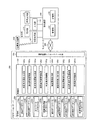
図1に示すように、第1の実施形態のナビゲーションシステムにおいて、ナビゲーションサーバ200は、概略的に、制御部202と記憶部206とを少なくとも備えており、端末装置100は、位置取得部112と出力部(表示部114および音声出力部118)と入力部116と制御部102と記憶部106とを少なくとも備える。
As shown in FIG. 1, in the navigation system of the first embodiment, the
[ナビゲーションサーバ200の構成]
ここで、図1において、ナビゲーションサーバ200は、記憶部206に記憶された地図データ上に、記憶部206に記憶された施設情報が対応付けられた施設アイコンを、施設位置情報が示す施設の位置にて重畳させて表示した地図表示画面を生成し、生成された地図表示画面を端末装置100へ送信する等の機能を有する。ナビゲーションサーバ200は、通信制御インターフェース部204を介してネットワーク300を経由し、端末装置100と相互に通信可能に接続されており、制御部202と記憶部206とを備える。制御部202は、各種処理を行う制御手段である。通信制御インターフェース部204は、通信回線や電話回線等に接続されるアンテナやルータ等の通信装置(図示せず)に接続されるインターフェースであり、ナビゲーションサーバ200とネットワーク300との間における通信制御を行う機能を有する。すなわち、通信制御インターフェース部204は、端末装置100等と通信回線を介してデータを通信する機能を有している。記憶部206は、HD(Hard Disk)等の固定ディスク装置およびSSD(Solid State Drive)等のストレージ手段であり、各種のデータベースやテーブル(例えば、地図データベース206a、施設情報データベース206b、ネットワークデータベース206c、経路案内情報データベース206d、および、案内データベース206e等)を格納する。
[Configuration of Navigation Server 200]
Here, in FIG. 1, the
これら記憶部206の各構成要素のうち、地図データベース206aは、地図の地図データを記憶する地図データ記憶手段である。ここで、地図データベース206aに記憶される地図データは、本発明において、例えば、縮尺に従ってメッシュ化された地図データ(例えば、JIS規格の第1〜3次地域区画メッシュデータ、および、100mメッシュデータ等)等の屋外地図データであってもよい。また、地図データベース206aは、全国および各地方の道路地図や路線図等の屋外地図データを記憶してもよい。また、地図データベース206aは、例えば、高さ情報を持つ建築物(例えば、立体駐車場、駅、デパート、および、学校等)に関するフロア案内地図等の屋内地図データを更に記憶してもよい。また、地図データベース206aは、3D地図および鳥瞰図表示に必要なデータを含んでいてもよい。
Among these components of the
また、地図データベース206aに記憶される地図データは、地図上に表示される地物(例えば、ビルや住宅や駅等の建造物、道路、線路、橋、トンネル、等高線、海岸線や湖岸線等の水涯線、海、河川、湖、池、沼、公園や屋外施設等の場地、行政界、行政区域、および、街区等)の形状についての形状データ、地図上に表示される注記(例えば、地名、住所、電話番号、店や公園や駅等の施設名称、名所や旧跡や河川や湖や湾や山や森林等の俗称を含む名称、道路や橋やトンネル等の名称、路線名称、地点情報、および、口コミ情報等)の注記データ、および、地図上に表示される記号(例えば、山、史跡、寺社、学校、病院、工場および墓地等の地図記号、ガソリンスタンド、コンビニエンスストア、スーパーマーケット、レストラン、銀行および郵便局等の店舗記号、道路上の信号、有料道路の出入口、料金所、サービスエリア、パーキングエリアおよびインターチェンジ等の記号、駐車場、駅、ホテル、美術館および博物館等の施設記号、ならびに、口コミ地点記号等)の記号データ等のデータを含んでいてもよい。
The map data stored in the
また、地図データベース206aに記憶される屋内地図データは、施設等の構内における屋内経路についての構内経路データを含んでいてもよい。ここで、構内経路データとは、駅等の構内における移動経路データと、当該移動経路を含む地図(施設案内図)の地図データと、に少なくとも基づくデータであってもよい。例えば、構内経路データは、施設案内図に移動経路が引いてある画像データであってもよい。また、例えば、構内経路データは、更に、移動経路を説明するメッセージデータを含んでいてもよい。ここで、移動経路データに基づく移動経路とは、施設内で複数の交通機関の乗換えをする場合の改札口等を結ぶ最適経路(例えば、最短経路またはバリアフリー経路等)であってもよい。
In addition, the indoor map data stored in the
また、屋外地図データおよび屋内地図データは、ラスタ形式、ベクタ形式等の地図描画用の画像データであってもよい。これら屋外地図データおよび屋内地図データは、地図データベース206aに予め記憶されており、ナビゲーションサーバ200の制御部202は、定期的にネットワーク300を介して最新のデータを外部機器(例えば、地図データを提供する地図提供サーバなど)等からダウンロードして地図データベース206aに記憶された屋外地図データおよび屋内地図データをアップデートしてもよい。
The outdoor map data and indoor map data may be map drawing image data in a raster format, a vector format, or the like. The outdoor map data and the indoor map data are stored in advance in the
また、施設情報データベース206bは、施設の位置を示す施設位置情報を少なくとも含む施設情報を記憶する施設情報記憶手段である。ここで、施設情報は、更に施設カテゴリ、営業時間、施設規模、クーポン情報、および、口コミのうち少なくとも一つを含んでいてもよい。
The
ここで、施設情報データベース206bに記憶された施設情報は、施設(POI)についての属性を示す項目を複数含む情報である。ここで、属性とは、例えば、施設の名称、ジャンルおよび種別(施設カテゴリ)、住所、電話番号、URL、営業時間、取扱商品、平均価格(例えば、平均使用料金など)、評判、ランキング、急上昇、立ち寄りやすさ、レコメンドスコア、写真データ、クーポン情報、口コミ(例えば、口コミ評価およびユーザコメントなど)、使用条件、使用可能性、施設規模、施設の座標位置を示す緯度経度高度(施設位置情報)、施設の存在する地点の立地(都市部、郊外、港湾部および駅周辺など)、用途制限、施設ID、当該施設情報へのアクセス回数またはアクセス頻度等の参照率、ならびに、当該施設情報の更新日時等であってもよい。ここで、レコメンドスコアとは、ユーザ情報および履歴情報等から自動的にお勧め度合いが算出された値であってもよい。
Here, the facility information stored in the
ここで、POIとは、point of interestの略称であり、例えば、便利な場所や興味のある場所などとして人が知覚する特定の地点や施設等であって、店舗、会社、事務所、公共施設、娯楽施設、および、屋外施設等であってもよい。ここで、店舗は、例えば、飲食店、食料品店、酒店、タバコ店、百貨店、ショッピングセンター、スーパーマーケット、コンビニエンスストア、ガソリンスタンド、金融機関、郵便局、立体駐車場、および、ホテルや旅館等の宿泊施設等であってもよい。また、公共施設は、例えば、官庁、警察署、交番、消防署、駅、医療機関、美術館、博物館、および、学校等であってもよい。また、娯楽施設は、例えば、映画館、劇場、遊園地、パチンコ店、カジノ、競馬場等であってもよい。また、屋外施設は、バスターミナル、公園、遊園地、キャンプ場、連絡通路、屋外駐車場、および、動物園等であってもよい。また、施設情報データベース206bは、施設に対応したアイコン(施設アイコン)を記憶していてもよい。これら施設情報は、施設情報データベース206bに予め記憶されており、ナビゲーションサーバ200の制御部202は、定期的にネットワーク300を介して最新のデータを外部機器(例えば、施設情報を提供する施設情報提供サーバなど)等からダウンロードして施設情報データベース206bに記憶された施設情報をアップデートしてもよい。
Here, POI is an abbreviation for point of interest, for example, a specific point or facility perceived by a person as a convenient place or an interesting place, such as a store, company, office, public facility, etc. It may be a recreational facility and an outdoor facility. Here, the stores are, for example, restaurants, grocery stores, liquor stores, tobacco stores, department stores, shopping centers, supermarkets, convenience stores, gas stations, financial institutions, post offices, multi-storey parking lots, hotels and inns, etc. It may be an accommodation facility. The public facility may be, for example, a government office, a police station, a police box, a fire station, a station, a medical institution, a museum, a museum, a school, and the like. The entertainment facility may be, for example, a movie theater, a theater, an amusement park, a pachinko parlor, a casino, a racetrack or the like. The outdoor facility may be a bus terminal, a park, an amusement park, a campsite, a communication passage, an outdoor parking lot, a zoo, or the like. The
また、ネットワークデータベース206cは、交通網を規定するネットワークデータを記憶するネットワークデータ記憶手段である。ここで、ネットワークデータベース206cに記憶されるネットワークデータは、道路ネットワークデータ、路線網ネットワークデータ、および、施設内ネットワークデータを含んでいてもよい。これらネットワークデータは、ネットワークデータベース206cに予め記憶されており、ナビゲーションサーバ200の制御部202は、定期的にネットワーク300を介して最新のデータを外部機器(例えば、地図データを提供する地図提供サーバなど)等からダウンロードしてネットワークデータベース206cに記憶されたネットワークデータをアップデートしてもよい。
The
ここで、ネットワークデータベース206cに記憶される道路ネットワークデータは、道路網を規定するネットワークデータであり、例えば、交差点等の道路網表現上の結節点であるノードのノードデータと、ノード間の道路区間であるリンクのリンクデータとの組み合わせによって表現されるネットワークデータである。ここで、ノードデータには、ノード番号(例えば、ノードID等)、ノードの名称、緯度経度高度等の位置座標、ノード種別、接続するリンク本数、接続ノード番号、および、交差点名称等の情報を含んでいてもよい。また、リンクデータには、リンク番号(例えば、リンクID等)、開始ノードID、終了ノードID、道路の種別、国道や県道や市道等の路線番号、重用する路線情報、リンクの存在する行政区域の属性情報、リンク長(例えば、距離等)、道路供用状況、異常気象時通行規制区間、車重制限、車両高さ制限、幅員、道路幅員区分、レーン情報(例えば、車線数、専用通行帯、路線バス等優先通行帯、車両通行区分、および、進行方向別通行区分などについての車両通行帯情報等)、制限速度、高架やトンネルや橋等のリンク内属性、および、名称等の情報を含んでいてもよい。また、道路ネットワークデータは、利用料金データ等を含んでいてもよい。ここで、利用料金データは、自動車およびオートバイ等で移動する場合に消費する燃料料金、ならびに、高速自動車国道および自動車専用道路等の有料道路の通行料金等を表す情報等であってもよい。また、道路ネットワークデータは、自動車、オートバイ、自転車、および、徒歩等で移動する場合の経路上に存在する施設等の緯度経度情報などの位置情報等を記憶してもよい。
Here, the road network data stored in the
また、道路ネットワークデータは、道路交通情報を含んでいてもよい。ここで、道路交通情報は、渋滞発生地点や渋滞距離や道路上の二地点間の通過時間(すなわち、旅行時間など)等の渋滞情報を含んでいてもよい。また、道路交通情報は、交通障害情報や交通規制情報等を含んでいてもよい。ここで、交通規制情報は、各種の交通規制を定義するデータであり、例えば、降水量規制、積雪・凍結規制、超波規制、風速規制、および視程規制等の異常気象時通行規制、高さ規制および重量規制等の車両通行規制、道路工事や作業、道路周辺の工事に伴う工事時規制、時間帯や車種により通行できる通行帯を規制している通行帯規制および道路の損壊等による車両通行止、交通の安全を確保するために設置されるコミュニティ・ゾーン等による一般車の進入禁止、ならびに、私有地への接続路であることによる一般車の進入禁止等の情報などを含んでもよい。これら道路交通情報は、ネットワークデータベース206cに予め記憶されており、ナビゲーションサーバ200の制御部202は、定期的(例えば、5分毎等)にネットワーク300を介して最新のデータを外部システム(例えば、VICS(Vehicle Information and Communication System)(登録商標)、および、ATIS(Advanced Traffic Information Service)、日本道路交通情報センター(JARTIC)など)等からダウンロードしてネットワークデータベース206cに記憶された道路交通情報をアップデートしてもよい。
The road network data may include road traffic information. Here, the road traffic information may include traffic jam information such as a traffic jam occurrence point, a traffic jam distance, and a transit time between two locations on the road (that is, travel time, etc.). Further, the road traffic information may include traffic obstacle information, traffic regulation information, and the like. Here, the traffic regulation information is data defining various traffic regulations.For example, traffic regulation during abnormal weather such as precipitation regulation, snow cover / freezing regulation, ultrasonic regulation, wind speed regulation, visibility regulation, etc., height Vehicle traffic regulations such as regulations and weight regulations, road construction and work, regulations during construction around roads, traffic zones that regulate traffic zones that can pass by time zone and vehicle type, and vehicle traffic due to road damage, etc. It may also include information such as a general vehicle entry prohibition by a community zone or the like installed to ensure traffic safety, and a general vehicle entry prohibition due to a connection path to private land. The road traffic information is stored in advance in the
また、ネットワークデータベース206cに記憶される路線網ネットワークデータは、鉄道、飛行機、バス、および、船等の各交通機関(例えば、公共交通機関等)の路線網を規定するネットワークデータであり、例えば、路線網表現上の結節点であるノード(例えば、交通機関の停留地点である駅、停留場、停車場、停留所、空港、港、および、ターミナル等)のノードデータと、ノード間を接続する鉄道路線、航空路線、航路、および、バス路線等のリンクのリンクデータとの組み合わせによって表現されるネットワークデータである。ここで、鉄道とは、ルート上に設置された固定式案内路(レール、案内軌条など)等に誘導されて走行し、旅客や貨物等を輸送する交通機関であり、例えば、電車、市電、ロープウェイ、モノレール、ケーブルカー、および、リニアモーターカー等であってもよい。また、ノードデータには、ノード番号(例えば、ノードID等)、ノードの名称(例えば、交通機関の停留地点の名称である駅名、停留場名、停車場名、停留所名、空港名、港名、および、ターミナルの名称等)、および、緯度経度高度などの位置座標等の情報を含んでいてもよい。また、リンクデータには、リンク番号(例えば、リンクID等)、開始ノードID、終了ノードID、種別、リンク長(例えば、距離等)、高架、トンネルおよび橋等のリンク内属性、ならびに、名称(例えば、路線名など)等の情報を含んでいてもよい。
In addition, the route network data stored in the
また、路線網ネットワークデータは、交通機関の時刻表データを含んでいてもよい。ここで、時刻表データは、鉄道、飛行機、バス、および、船等の各交通機関の時刻表を表す情報である。また、時刻表データは、更に、交通機関の行先情報(例えば、最終行先情報など)、および、交通機関の種別(例えば、特急、急行、準急、快速、快速急行、通勤特急、通勤快速、通勤急行、区間急行、区間準急、区間快速、各駅停車、および、普通など)を含む情報であってもよい。また、時刻表データは、更に、路線上のノード(すなわち、交通機関の停留地点)における交通機関の発着時刻(例えば、出発、経由、および到着の予定時刻など)、交通機関の路線の名称、および、交通機関の路線上のノード(すなわち、交通機関の停留地点)の名称等の属性情報を含む情報であってもよい。また、時刻表データは、交通機関の路線上のノードを結ぶ区間(例えば、一つまたは複数のリンク等)毎に対応付けられた交通機関の属性情報(例えば、種別および行先情報等)を含んでいてもよい。 The route network data may include transportation timetable data. Here, the timetable data is information representing a timetable of each transportation facility such as a railway, an airplane, a bus, and a ship. In addition, the timetable data further includes destination information (for example, final destination information) of transportation, and type of transportation (for example, limited express, express, semi-express, rapid, rapid express, commuter express, commuter express, commute) Information including express, section express, section semi-express, section rapid, each station stop, and normal). In addition, the timetable data further includes transportation departure and arrival times (for example, scheduled departure, transit and arrival times) at nodes on the route (that is, transportation stop points), transportation route names, Information including attribute information such as the name of a node on a route of transportation (that is, a stop point of transportation) may be used. Further, the timetable data includes transportation attribute information (for example, type and destination information) associated with each section (for example, one or a plurality of links) connecting nodes on the transportation route. You may go out.
また、路線網ネットワークデータは、交通機関の利用料金データを含んでいてもよい。ここで、利用料金データは、例えば、鉄道、飛行機、バス、および、船等の各交通機関を利用した場合に生じる利用料金等を表す情報等であってもよい。また、路線網ネットワークデータは、乗車位置データを含んでいてもよい。ここで、乗車位置データは、例えば、電車、市電、モノレール、ケーブルカー、および、リニアモーターカー等の複数の車両が連結した交通機関の乗車位置(一例として、改札口に近い車両、乗換に便利な位置の車両、混雑率の低い車両、および、女性専用車両等)を表す情報等であってもよい。また、路線網ネットワークデータは、鉄道運行情報、航空運行情報、船舶運行情報、および、バス運行情報等の各交通機関の運行情報を含んでいてもよい。これら各交通機関の運行情報は、ネットワークデータベース206cに予め記憶されており、ナビゲーションサーバ200の制御部202は、定期的にネットワーク300を介して最新のデータを外部システム等からダウンロードしてネットワークデータベース206cに記憶された各交通機関の運行情報をアップデートしてもよい。
The route network data may include transportation fee data. Here, the usage fee data may be, for example, information representing a usage fee or the like generated when each transportation means such as a railroad, an airplane, a bus, and a ship is used. The route network data may include boarding position data. Here, the boarding position data is, for example, a transportation boarding position where a plurality of vehicles such as trains, streetcars, monorails, cable cars, and linear motor cars are connected (for example, vehicles close to the ticket gates, convenient for transfer) Vehicle position information, low congestion rate vehicles, women-only vehicles, and the like). Further, the route network data may include operation information of each transportation such as railway operation information, air operation information, ship operation information, and bus operation information. The operation information of each transportation facility is stored in advance in the
また、ネットワークデータベース206cに記憶される施設内ネットワークデータは、施設内の経路網を規定するネットワークデータである。ここで、ネットワークデータベース206cに記憶される施設内ネットワークデータは、例えば、建造物内の店舗、会社、事務所、トイレ等の出入口、エレベータおよびエスカレータの乗降口、階段の出入口、飛行機等の搭乗口、駅のプラットホーム上の電車等の乗車位置、ならびに、駅の改札口等の、通路等を接続する結節点であるノードのノードデータと、ノード間を接続する通路、階段、動く歩道、エスカレータ、および、エレベータ等であるリンクのリンクデータとの組み合わせによって表現されるネットワークデータである。
The in-facility network data stored in the
ここで、ノードデータには、ノード番号(例えば、ノードID等)、ノードの名称(出入口名および乗降口名等)、緯度経度高度等の位置座標、ノード種別(例えば、出入口、乗降口、通路の曲がり角、および通路の分岐点等)、接続するリンク本数、および、接続ノード番号等の情報を含んでいてもよい。また、リンクデータには、リンク番号(例えば、リンクID等)、開始ノードID、終了ノードID、リンク長、幅員、リンク種別(例えば、ノード間を接続する通路、階段、スロープ、エスカレータ、エレベータ、および動く歩道など)、および、バリアフリー化の情報を含んでいてもよい。ここで、施設とは、駅、オフィスビル、ホテル、デパート、スーパーマーケット、博物館、美術館、学校、水族館、地下通路、立体駐車場、地下駐車場、および、地下街等の屋内建造物であってもよい。また、施設とは、バスターミナル、公園、遊園地、キャンプ場、連絡通路、屋外駐車場、および、動物園等の屋外建造物であってもよい。 Here, the node data includes a node number (for example, node ID, etc.), a node name (entrance / exit name, entrance / exit name, etc.), position coordinates such as latitude and longitude altitude, and node type (for example, entrance / exit / exit / exit, passage) And the like, the number of links to be connected, the connection node number, and the like may be included. The link data includes a link number (for example, link ID, etc.), a start node ID, an end node ID, a link length, a width, a link type (for example, a passage connecting steps between nodes, a stairs, a slope, an escalator, an elevator, And a moving walkway), and information on barrier-free. Here, the facility may be an indoor building such as a station, an office building, a hotel, a department store, a supermarket, a museum, a museum, a school, an aquarium, an underground passage, a multistory parking lot, an underground parking lot, and an underground mall. . The facility may be a bus terminal, a park, an amusement park, a campsite, a communication path, an outdoor parking lot, and an outdoor structure such as a zoo.
また、経路案内情報データベース206dは、経路案内情報を記憶する経路案内情報記憶手段である。ここで、経路案内情報データベース206dに記憶される経路案内情報は、制御部202により格納される、案内経路データを少なくとも含む経路案内情報であってもよい。また、経路案内情報は、地図データベース206aに記憶された、案内経路を含む地図の地図データを含んでいてもよい。また、経路案内情報は、案内データベース206eに記憶された、案内経路に含まれる案内対象地点にて出力される案内データを含んでいてもよい。
The route
また、案内データベース206eは、案内対象地点にて出力される案内データを記憶する案内データ記憶手段である。ここで、案内対象地点は、ノードおよびリンクで構成される案内経路上の任意の位置に設定されていてもよい。例えば、案内対象地点は、交差点等の分岐点に対応する結節点であるノード上に設定されていてもよく、また、ノード間の道路区間等を示すリンク上に設定されていてもよい。また、案内データベース206eに記憶された案内データは、文字データ、音声データ、および、表示データのうち少なくとも一つを含んでいてもよい。これら案内データは、案内データベース206eに予め記憶されており、ナビゲーションサーバ200の制御部202は、定期的にネットワーク300を介して最新のデータを外部機器等からダウンロードして案内データベース206eに記憶された案内データをアップデートしてもよい。
The
ここで、案内データベース206eに記憶された案内データのうち文字データは、案内対象地点(分岐点等)における進行方向等に対応付けられた、現在位置が目標物に近づいた旨や進行方向を知らせるメッセージを構成する文字データ(例えば、「まもなく目的地周辺です」、「次の交差点を左に曲がります」、「次の交差点を右に曲がります」、「そのまま直進して下さい」や交差点の名称等の文字データ)であり、例えば、端末装置100の制御部102が文字案内による経路案内を実行する際に用いられる。また、案内データベース206eに記憶された案内データのうち音声データは、案内対象地点(分岐点等)における進行方向等に対応付けられた現在位置が目標物に近づいた旨や進行方向を知らせるメッセージを構成する文字データからテキスト読み上げ(text−to−speech:TTS)システム等により変換された音声データ(例えば、「次の交差点を左に曲がります」や、現在位置が目的地に近づいた場合に対応付けられた「まもなく目的地周辺です」や、交差点の名称に対応する音声データ)であり、例えば、端末装置100の制御部102が音声案内による経路案内を実行する際に用いられる。また、案内データベース206eに記憶された案内データのうち表示データは、案内対象地点(分岐点等)における進行方向等に対応付けられた、右左折等の誘導を画面に表示する矢印ナビゲーションであるターンバイターン(TBT)(例えば、左折矢印、右折矢印、直進矢印等のアイコン等)や、道路標識(例えば、交差点名称、通行止め、車両進入禁止、一方通行等の標識等)や方面看板(例えば、左向き矢印と共に「A方面」と表示する看板、右向け矢印と共に「B方面」と表示する看板等)の画像データであり、例えば、端末装置100の制御部102が表示案内による経路案内を実行する際に用いられる。
Here, the character data of the guidance data stored in the
また、制御部202は、OS(Operating System)等の制御プログラムや、各種の処理手順等を規定したプログラム、および、所要データを格納するための内部メモリを有する。そして、制御部202は、これらのプログラム等により、種々の処理を実行するための情報処理を行う。制御部202は、機能概念的に、地図表示画面生成部202a、地図表示画面送信部202b、案内経路探索部202c、経路案内情報生成部202d、経路案内情報送信部202e、および、経路案内情報格納部202fを備える。
The
このうち、地図表示画面生成部202aは、地図データベース206aに記憶された地図データ上に、施設情報データベース206bに記憶された施設情報が対応付けられた施設アイコンを、施設位置情報が示す施設の位置にて重畳させて表示した地図表示画面を生成する地図表示画面生成手段である。
Among these, the map display
また、地図表示画面送信部202bは、地図表示画面生成部202aにより生成された地図表示画面を端末装置100へ送信する地図表示画面送信手段である。
The map display screen transmission unit 202b is a map display screen transmission unit that transmits the map display screen generated by the map display
また、案内経路探索部202cは、端末装置100の表示部114に表示された施設リストに含まれる施設のうち、利用者により入力部116を介して指定される施設に対応する施設位置情報を受信し、少なくとも当該施設位置情報に基づいて当該施設までの案内経路を、ネットワークデータベース206cに記憶されたネットワークデータを用いて探索し、案内経路データを生成する案内経路探索手段である。ここで、案内経路探索部202cは、端末装置100から送信される端末装置100の現在位置情報に基づく現在位置から施設までの案内経路を探索してもよい。また、案内経路探索部202cは、端末装置100から送信される少なくとも出発地と目的地とを含む経路探索条件を満たす出発地から目的地までの経路である案内経路を探索してもよい。ここで、経路探索条件は、端末装置100の利用者により入力部116を介して入力されたものであってもよい。また、経路探索条件に経由地が更に含まれている場合、案内経路探索部202cは、経由地を経由した案内経路を探索してもよい。
In addition, the guidance
また、経路案内情報生成部202dは、案内経路探索部202cにより生成された案内経路データを少なくとも含む経路案内情報を生成する経路案内情報生成手段である。ここで、経路案内情報は、地図データベース206aに記憶された、案内経路を含む地図の地図データを含んでいてもよい。また、経路案内情報は、案内データベース206eに記憶された、案内経路に含まれる案内対象地点にて出力される案内データを含んでいてもよい。
The route guidance
また、経路案内情報送信部202eは、経路案内情報生成部202dにより生成された案内経路データを少なくとも含む経路案内情報を端末装置100へ送信する経路案内情報送信手段である。ここで、経路案内情報は、地図データベース206aに記憶された、案内経路を含む地図の地図データを含んでいてもよい。また、経路案内情報は、案内データベース206eに記憶された、案内経路に含まれる案内対象地点にて出力される案内データを含んでいてもよい。
The route guidance
また、経路案内情報格納部202fは、経路案内情報生成部202dにより生成された案内経路データを少なくとも含む経路案内情報を経路案内情報データベース206dに格納する経路案内情報格納手段である。ここで、経路案内情報は、地図データベース206aに記憶された、案内経路を含む地図の地図データを含んでいてもよい。また、経路案内情報は、案内データベース206eに記憶された、案内経路に含まれる案内対象地点にて出力される案内データを含んでいてもよい。
The route guidance
[端末装置100の構成]
また、図1において、端末装置100は、ナビゲーションサーバ200から送信される地図表示画面の少なくとも一部を表示部114の地図表示領域に表示し、表示部114の地図表示領域に表示された地図表示画面の変更を要求する変更要求信号に応じて、当該地図表示領域内の当該地図表示画面を変更し、地図表示領域内の地図表示画面が変更される際に、当該地図表示領域内の当該地図表示画面に含まれる施設アイコンに対応する施設情報を履歴情報として端末装置100の記憶部106に格納し、端末装置100の記憶部106に格納された履歴情報に基づいて、当該履歴情報に含まれる施設情報の少なくとも一部を表示部114に表示する等の機能を有する。端末装置100は、例えば、一般に市販されるデスクトップ型またはノート型のパーソナルコンピュータ等の情報処理装置、携帯電話やPHSやPDA等の携帯端末装置、および、走行経路案内等を行うナビゲーション端末等である。ここで、端末装置100は、インターネットブラウザ等を搭載していてもよく、経路案内アプリケーションや乗換案内アプリケーション等を搭載していてもよい。また、端末装置100は、リアルタイムに現在位置取得が行えるよう、GPS機能やIMES機能等を有する位置取得部112を備えている。また、端末装置100は、少なくとも表示部114と音声出力部118とを少なくとも含む出力部を備えている。なお、図示しないが、端末装置100は、静止画および動画を撮影可能なカメラ等の撮影部を備えていてもよい。
[Configuration of Terminal Device 100]
In FIG. 1, the
ここで、表示部114は、地図表示画面、施設情報、および、施設リスト等を表示する表示手段(例えば、液晶や有機EL等から構成されるディスプレイやモニタ等)である。また、表示部114は、地図表示画面を表示する地図表示領域、および、施設リストを表示するリスト表示領域を更に設けていてもよい。また、音声出力部118は、ナビゲーションサーバ200から受信した音声データ等を音声として出力する音声出力手段(例えば、スピーカ等)である。また、端末装置100は、地図表示画面の変更操作、記憶条件および表示条件の入力、記憶開始指示および施設表示要求の入力、ならびに、経路探索条件の入力等を行う入力部116(例えば、キー入力部、タッチパネル、キーボード、マイク等)を備えている。また、入出力制御インターフェース部108は、位置取得部112、表示部114、入力部116、音声出力部118、撮影部(図示せず)等の制御を行う。
Here, the
ここで、位置取得部112は、例えば、位置発信装置500から発信される位置情報信号を受信する位置取得手段であってもよい。ここで、位置発信装置500は、位置情報信号(GPS信号)を発信するGPS装置であってもよい。また、位置発信装置500は、GPS信号と類似した特徴を持つ位置情報信号を用いて屋内測位を可能とするIMES(Indoor MesSEge System)技術を実現するIMES装置であってもよい。なお、IMES技術は測位衛星システムである準天頂衛星の枠組みから発案されたシステムである。
Here, the
また、位置発信装置500は、屋外で受信したGPS信号を屋内で発信するGPSリピータであってもよい。また、位置発信装置500は、建物(例えば、立体駐車場等)内の各フロアや地下構造物(例えば、地下鉄駅、地下街、地下連絡通路、地下駐車場等)の各所に任意に設置される小型発信装置であってもよい。なお、この小型発信装置には、設置場所に応じた自己位置情報(位置ID等)が割り振られている。そして、端末装置100が通信可能範囲に入ると、端末装置100は、小型発信装置から送信される自己位置情報を位置情報信号として受信する。この際の通信方式は、例えば、RFID(Radio Frequency Identification)タグシステムやBluetooth(登録商標)等の各種近距離無線方式や、赤外線通信方式等であってもよい。また、位置発信装置500は、無線LANのアクセスポイントであってもよい。本実施形態において、位置取得部112は、無線LAN信号等を受信して、アクセスポイントの識別情報を取得してもよい。そして、制御部102は、位置取得部112にて取得したアクセスポイント固有の識別情報からアクセスポイントの位置を特定して位置情報を取得してもよい。また、本実施形態において、制御部102は、位置取得部112にて取得された位置情報信号から、緯度、経度、および、高さ情報を含む位置情報を算出してもよい。
Further, the
また、位置取得部112は、例えば、方位センサにて検出した端末装置100の進行方向等の方位情報、距離センサにて検出した距離情報、および、地図データに基づいて端末装置100の利用者の現在位置を示す位置情報を取得してもよい。ここで、方位センサには、端末装置100の絶対走行方位を検出する地磁気センサおよび端末装置100の相対走行方位を検出する光ジャイロが使用されてもよい。また、方位センサは、地磁気センサと加速度センサを組み合わせることで方位や傾きに関する情報を取得できる電子コンパスであってもよい。
In addition, the
また、通信制御インターフェース部104は、通信回線や電話回線等に接続されるアンテナやルータ等の通信装置(図示せず)に接続されるインターフェースであり、端末装置100とネットワーク300との間における通信制御を行う機能を有する。すなわち、通信制御インターフェース部104は、ナビゲーションサーバ200等と通信回線を介してデータを通信する機能を有している。また、ネットワーク300は、端末装置100およびナビゲーションサーバ200と、外部機器または外部システムとを相互に接続する機能を有し、例えば、インターネット、電話回線網(携帯端末回線網および一般電話回線網等)、イントラネット、または、電力線通信(PLC)等であってもよい。
The communication
また、記憶部106は、HDやSSD等の大容量のストレージ手段、および/または、SRAM(Static Random Access Memory)等を用いて構成される小容量高速メモリ(例えば、キャッシュメモリ)等のストレージ手段であり、各種のデータベースやファイルやテーブル(履歴情報ファイル106a、記憶条件ファイル106b、表示条件ファイル106c、経路案内情報ファイル106d、および、利用者指定地点ファイル106e等)を格納してもよい。ここで、記憶部106は、各種のファイル等を一時的に記憶するものであってもよい。
The
このうち、履歴情報ファイル106aは、制御部102が施設情報を履歴情報として格納する際の格納先として用いられる、施設情報の履歴情報を記憶する履歴情報記憶手段である。ここで、本実施形態において、履歴情報ファイル106aの記憶領域に保存可能な施設件数および容量などの上限を設定してもよい。また、スクロール中などに当該上限に達した場合は、後述する記憶条件ファイル106bに記憶された記憶条件に順ずる所定条件を満たさないものから順次記憶済みの履歴情報を削除するよう設定してもよい。
Among these, the
また、記憶条件ファイル106bは、制御部102が施設情報を履歴情報として履歴情報ファイル106aに格納する際に参照する、利用者により予め設定された所定の記憶条件(登録条件)を記憶する記憶条件記憶手段である。ここで、一例として、記憶条件ファイル106bに記憶された記憶条件は、施設カテゴリ、営業時間、施設規模、クーポン情報、および、口コミのうちの少なくとも一つを含んでいてもよい。
The
また、表示条件ファイル106cは、制御部102が施設情報の少なくとも一部を表示部114に表示する際に参照する、利用者により予め設定された所定の表示条件を記憶する表示条件記憶手段である。ここで、一例として、表示条件ファイル106cに記憶された表示条件は、施設カテゴリ、営業時間、施設規模、クーポン情報、および、口コミのうちの少なくとも一つを含んでいてもよい。また、表示条件ファイル106cに記憶された表示条件は、地図表示画面上のカーソル位置または表示中心位置からの距離であってもよい。また、表示条件ファイル106cに記憶された表示条件は、制御部102により取得された現在位置情報に基づく現在位置からの距離であってもよい。また、表示条件ファイル106cに記憶された表示条件は、制御部102により施設情報が履歴情報として記憶部106に格納された順序であってもよい。この他、表示条件ファイル106cに記憶された表示条件は、制御部102により履歴情報の格納を開始した位置からの距離であってもよい。また、表示条件ファイル106cに記憶された表示条件は、制御部102により過去に履歴情報に含まれる施設情報の詳細を閲覧した回数および頻度であってもよい。
The
また、経路案内情報ファイル106dは、経路案内情報を記憶する案内情報記憶手段である。ここで、経路案内情報は、案内経路データを少なくとも含む経路案内情報であってもよい。また、経路案内情報は、案内経路を含む地図の地図データを含んでいてもよい。また、経路案内情報は、案内経路に含まれる案内対象地点にて出力される案内データを含んでいてもよい。
The route
また、利用者指定地点ファイル106eは、利用者を一意に特定する利用者IDと上記施設情報とを対応付けて記憶する利用者指定地点記憶手段である。本実施形態において、利用者指定地点ファイル106eは、制御部102により表示部114に表示された施設リストに含まれる施設のうち、利用者により入力部116を介して指定される施設の施設情報を当該利用者ごとに登録する際に用いられる。
The user designated
また、制御部102は、OS等の制御プログラムや、各種の処理手順等を規定したプログラム、および、所要データを格納するための内部メモリを有する。そして、制御部102は、これらのプログラム等により、種々の処理を実行するための情報処理を行う。制御部102は、機能概念的に、地図表示画面受信部102a、地図表示部102b、表示地図変更部102c、履歴情報格納部102d、施設情報表示部102e、記憶開始指示入力部102f、施設表示要求入力部102g、現在位置情報取得部102h、利用者指定地点登録部102i、経路案内情報受信部102j、および、経路案内部102kを備える。
The
このうち、地図表示画面受信部102aは、ナビゲーションサーバ200の地図表示画面送信部202bにより送信される地図表示画面を受信する地図表示画面受信手段である。
Among these, the map display
また、地図表示部102bは、地図表示画面受信部102aにより受信された地図表示画面の少なくとも一部を表示部114の地図表示領域に表示する地図表示手段である。ここで、地図表示部102bは、ナビゲーションサーバ200から地図データと施設情報を受信し、当該地図データ上の座標位置に対応する施設情報のアイコンを重畳させて表示部114に表示してもよい。
The
また、表示地図変更部102cは、地図表示部102bにより表示部114の地図表示領域に表示された地図表示画面の変更を要求する変更要求信号に応じて、当該地図表示領域内の当該地図表示画面を変更する表示地図変更手段である。ここで、表示地図変更部102cは、変更後の地図表示画面の地図表示領域内に、地図データがまだダウンロードされていない部分が存在する場合は、当該地図データをナビゲーションサーバ200から取得してもよい。
Further, the display map changing unit 102c responds to a change request signal for requesting a change of the map display screen displayed in the map display region of the
ここで、本実施形態において、変更要求信号は、表示部114の地図表示領域に表示された地図表示画面を変更させる変更操作(例えば、スクロール操作、拡大操作、および、縮小操作等)に伴って生成される操作量を示す信号を意味する。なお、変更操作は、利用者が入力部116を介して手動で行う手動スクロール等の変更操作であってもよく、制御部102により経路案内のトラッキング中に自動で行われる自動スクロール等の変更処理であってもよい。
Here, in the present embodiment, the change request signal is accompanied by a change operation (for example, a scroll operation, an enlargement operation, and a reduction operation) that changes the map display screen displayed in the map display area of the
また、履歴情報格納部102dは、表示地図変更部102cにより地図表示領域内の地図表示画面が変更される際に、当該地図表示領域内の当該地図表示画面に含まれる施設アイコンに対応する施設情報を履歴情報として履歴情報ファイル106aに格納する履歴情報格納手段である。ここで、履歴情報格納部102dは、表示地図変更部102cにより地図表示領域内の地図表示画面が変更される際に、当該地図表示領域内の当該地図表示画面に含まれる施設アイコンに対応する施設情報を第1の履歴情報として記憶部106に格納し、更に、表示地図変更部102cにより地図表示領域内の地図表示画面が変更される際に、当該地図表示領域内の当該地図表示画面に含まれる施設アイコンに対応する施設情報を第2の履歴情報として記憶部106に格納し、記憶部106に記憶された第1の履歴情報と第2の履歴情報とを比較して得られた差分の施設情報を、地図表示領域から退出した施設アイコンに対応する施設情報と判定し、当該判定された当該施設情報を履歴情報として履歴情報ファイル106aに格納してもよい。また、履歴情報格納部102dは、記憶部106に格納された第1履歴情報と第2履歴情報とを所定時間間隔で比較してもよい。また、履歴情報格納部102dは、後述する記憶開始指示入力部102fにより記憶開始指示が入力された場合、表示地図変更部102cにより地図表示領域内の地図表示画面が変更される際に、施設情報を履歴情報として履歴情報ファイル106aに格納してもよい。また、履歴情報格納部102dは、記憶条件ファイル106bに記憶された所定の記憶条件に基づいて施設情報を履歴情報として履歴情報ファイル106aに格納してもよい。ここで、一例として、記憶条件は、施設カテゴリ、営業時間、施設規模、クーポン情報、および、口コミのうちの少なくとも一つであってもよい。
Further, the history information storage unit 102d, when the map display screen in the map display area is changed by the display map change unit 102c, the facility information corresponding to the facility icon included in the map display screen in the map display area. Is a history information storage means for storing the information as history information in the
また、施設情報表示部102eは、履歴情報格納部102dにより履歴情報ファイル106aに格納された履歴情報に基づいて、当該履歴情報に含まれる施設情報の少なくとも一部を表示部114に表示する施設情報表示手段である。ここで、施設情報表示部102eは、後述する施設表示要求入力部102gにより施設表示要求が入力された場合、履歴情報に含まれる施設情報の少なくとも一部を表示部114に表示してもよい。また、施設情報表示部102eは、表示条件ファイル106cに記憶された所定の表示条件に基づいて履歴情報に含まれる施設情報の少なくとも一部を表示部114に表示してもよい。ここで、一例として、表示条件ファイル106cに記憶された表示条件は、施設カテゴリ、営業時間、施設規模、クーポン情報、および、口コミのうちの少なくとも一つを含んでいてもよい。また、表示条件ファイル106cに記憶された表示条件は、地図表示画面上のカーソル位置または表示中心位置からの距離であってもよい。また、表示条件ファイル106cに記憶された表示条件は、制御部102により取得された現在位置情報に基づく現在位置からの距離であってもよい。また、表示条件ファイル106cに記憶された表示条件は、制御部102により施設情報が履歴情報として履歴情報ファイル106aに格納された順序であってもよい。また、施設情報表示部102eは、履歴情報に基づいて、当該履歴情報に含まれる施設情報を有する施設の一覧を示す施設リストを生成し、当該生成された施設リストの少なくとも一部を表示部114に表示してもよい。また、施設情報表示部102eは、履歴情報格納部102dにより施設情報が履歴情報として履歴情報ファイル106aに格納されると同時に施設リストを生成し、当該生成された施設リストの少なくとも一部を表示部114の一部に設けられたリスト表示領域に表示してもよい。また、施設情報表示部102eは、表示部114に表示された施設リストに含まれる施設のうち、利用者により入力部116を介して指定される施設に関する施設情報の少なくとも一部を表示部114に表示してもよい。
Further, the facility
また、記憶開始指示入力部102fは、施設情報の記憶開始を指示する記憶開始指示を利用者に入力部116を介して入力させる記憶開始指示入力手段である。
The storage start instruction input unit 102 f is a storage start instruction input unit that allows a user to input a storage start instruction for instructing storage start of facility information via the
また、施設表示要求入力部102gは、施設情報の表示を要求する施設表示要求を利用者に入力部116を介して入力させる施設表示要求入力手段である。
The facility display
また、現在位置情報取得部102hは、端末装置100の利用者の現在位置情報を取得する現地位置情報取得手段である。ここで、現在位置情報取得部102hは、取得した現在位置情報をナビゲーションサーバ200へ送信してもよい。また、現在位置情報取得部102hは、端末装置100の利用者の現在位置情報を所定時間(所定周期)ごと(例えば、1秒ごと、3分ごと等)に取得してもよい。また、現在位置情報取得部102hは、位置取得部112にて位置発信装置500から受信した位置情報信号から算出した位置情報を端末装置100の利用者の現在位置情報として取得してもよい。また、現在位置情報取得部102hは、更に、位置取得部112の方位センサ等にて検出した端末装置100の進行方向等の方位情報を端末装置100の利用者の現在位置情報として取得してもよい。
The current position information acquisition unit 102h is a local position information acquisition unit that acquires the current position information of the user of the
また、利用者指定地点登録部102iは、施設情報表示部102eにより表示部114に表示された施設情報に含まれる施設のうち、利用者により入力部116を介して指定される施設の施設情報を当該利用者ごとに利用者指定地点ファイル106eに登録する利用者指定地点登録手段である。ここで、利用者指定地点登録部102iは、施設情報表示部102eにより表示部114に表示された施設リストに含まれる施設のうち、利用者により入力部116を介して指定される施設の施設情報を当該利用者ごとに利用者指定地点ファイル106eに登録してもよい。
In addition, the user designated
また、経路案内情報受信部102jは、ナビゲーションサーバ200の経路案内情報送信部202eにより送信される経路案内情報を受信する経路案内情報受信手段である。ここで、経路案内情報受信部102jは、受信した経路案内情報を経路案内情報ファイル106dに格納してもよい。また、経路案内情報は、案内経路データを少なくとも含む経路案内情報であってもよい。また、経路案内情報は、案内経路を含む地図の地図データを含んでいてもよい。また、経路案内情報は、案内経路に含まれる案内対象地点にて出力される案内データを含んでいてもよい。
The route guidance
また、経路案内部102kは、経路案内情報受信部102jにより受信された経路案内情報の少なくとも一部を表示部114および/または音声出力部118を介して出力して、経路案内を実行する経路案内手段である。ここで、経路案内部102kは、経路案内情報ファイル106dに記憶された経路案内情報の少なくとも一部を表示部114および/または音声出力部118を介して出力して、経路案内を実行してもよい。また、経路案内部102kは、地図表示部102bにより表示部114の地図表示領域に表示された地図表示画面に、案内経路データに基づく案内経路を重畳して表示させてもよい。また、経路案内部102kは、経路案内情報に基づく表示画面を表示部114に表示させてもよい。例えば、経路案内部102kは、案内経路データ、および/または、地図データに基づく表示画面を表示部114に表示させてもよい。また、経路案内部102kは、更に、端末装置100から送信される現在位置情報に基づく端末装置100の利用者の現在位置を出力部を介して出力させてもよい。例えば、経路案内部102kは、地図データ上に、案内経路データおよび/または端末装置100の利用者の現在位置を重畳した表示画面を表示部114に表示させてもよい。また、経路案内部102kは、経路案内情報に含まれる案内経路上の案内対象地点(分岐点等)における進行方向等に対応付けられた案内データを出力部を介して出力させてもよい。例えば、経路案内部102kは、案内データのうち文字データ(案内メッセージ等)を表示部114を介して表示させてもよい。また、経路案内部102kは、案内データのうち表示データ(TBT等)を表示部114を介して表示させてもよい。また、経路案内部102kは、案内データのうち音声データ(案内メッセージ等)を音声出力部118を介して出力させてもよい。
In addition, the route guidance unit 102k outputs at least part of the route guidance information received by the route guidance
以上で、第1の実施形態におけるナビゲーションシステムの構成の一例の説明を終える。 Above, description of an example of a structure of the navigation system in 1st Embodiment is finished.
[ナビゲーションシステムの処理]
次に、このように構成された第1の実施形態におけるナビゲーションシステムの処理の一例について、以下に図2から図7を参照して詳細に説明する。ここで、図2は、第1の実施形態におけるナビゲーションシステムの処理の一例を示すフローチャートである。また、図3は、第1の実施形態におけるナビゲーションシステムの履歴情報格納処理の一例を示すフローチャートである。また、図4は、本実施形態における地図表示画面が変更操作に伴って遷移していく様子の一例を示す図である。また、図5は、本実施形態における操作メニュー画面および操作設定画面の一例を示す図である。また、図6は、本実施形態におけるリスト表示領域に表示された施設リストの一例を示す図である。また、図7は、本実施形態における操作メニュー画面、施設リスト表示画面、および、施設情報表示画面の一例を示す図である。
[Navigation system processing]
Next, an example of the processing of the navigation system according to the first embodiment configured as described above will be described in detail with reference to FIGS. Here, FIG. 2 is a flowchart showing an example of processing of the navigation system in the first embodiment. FIG. 3 is a flowchart showing an example of history information storage processing of the navigation system in the first embodiment. Moreover, FIG. 4 is a figure which shows an example of a mode that the map display screen in this embodiment changes with change operation. FIG. 5 is a diagram illustrating an example of an operation menu screen and an operation setting screen in the present embodiment. FIG. 6 is a diagram showing an example of the facility list displayed in the list display area in the present embodiment. FIG. 7 is a diagram illustrating an example of an operation menu screen, a facility list display screen, and a facility information display screen in the present embodiment.
図2に示すように、まず、ナビゲーションサーバ200の地図表示画面生成部202aは、地図データベース206aに記憶された地図データ上に、施設情報データベース206bに記憶された施設情報が対応付けられた施設アイコンを、施設位置情報が示す施設の位置にて重畳させて表示した地図表示画面を生成する(ステップSA−1)。
As shown in FIG. 2, first, the map display
そして、ナビゲーションサーバ200の地図表示画面送信部202bは、ステップSA−1において地図表示画面生成部202aの処理により生成された地図表示画面を端末装置100へ送信する(ステップSA−2)。
And the map display screen transmission part 202b of the
そして、端末装置100の地図表示画面受信部102aは、ステップSA−2においてナビゲーションサーバ200の地図表示画面送信部202bの処理により送信される地図表示画面を受信する(ステップSA−3)。
And the map display
そして、端末装置100の地図表示部102bは、ステップSA−3において地図表示画面受信部102aの処理により受信された地図表示画面の少なくとも一部を表示部114の地図表示領域に表示する(ステップSA−4)。
And the
ここで、図4を参照し、ステップSA−4において地図表示部102bの処理により表示される地図表示画面の一例について説明する。
Here, with reference to FIG. 4, an example of the map display screen displayed by the process of the
図4(a)に示すように、地図表示画面は、地図データ上に施設情報が対応付けられた施設アイコン(例えば、図4(a)において、星型のアイコン1,2,3,4が示す施設アイコン)を、施設位置情報が示す施設の位置にて重畳させて表示した画面であり、表示部114の地図表示領域内に表示されている。ここで、図4(a)に示すように、地図表示画面は、端末装置100の現在位置情報取得部102hの処理により取得された現在位置情報に基づく端末装置100の利用者の現在位置を示す現在位置アイコンを更に含んでいてもよい。
As shown in FIG. 4A, the map display screen displays facility icons associated with facility information on map data (for example,
図2に戻り、端末装置100の表示地図変更部102cは、ステップSA−4において地図表示部102bの処理により表示部114の地図表示領域に表示された地図表示画面の変更を要求する変更要求信号が入力されたか否かを判定する(ステップSA−5)。
Returning to FIG. 2, the display map changing unit 102c of the
ここで、変更要求信号は、表示部114の地図表示領域に表示された地図表示画面を変更させる変更操作(例えば、スクロール操作、拡大操作、および、縮小操作等)に伴って生成される操作量を示す信号を意味する。なお、変更操作は、利用者が入力部116を介して手動で行う手動スクロール等の変更操作であってもよく、後述する経路案内部102kの処理により行われる経路案内のトラッキング中に、自動で行われる自動スクロール等の変更処理であってもよい。
Here, the change request signal is an operation amount generated in accordance with a change operation (for example, a scroll operation, an enlargement operation, and a reduction operation) that changes the map display screen displayed in the map display area of the
そして、端末装置100の表示地図変更部102cは、ステップSA−5において変更要求信号が入力されたと判定した場合(ステップSA−5:Yes)、次のステップSA−6の処理へ移行する。一方、端末装置100の表示地図変更部102cは、ステップSA−5において変更要求信号が入力されていないと判定した場合(ステップSA−5:No)、ステップSA−5の直前の処理に戻り、変更要求信号が入力されるまで判定処理を繰り返し実行する。
When the display map changing unit 102c of the
そして、端末装置100の表示地図変更部102cは、ステップSA−4において地図表示部102bの処理により表示部114の地図表示領域に表示された地図表示画面の変更を要求する変更要求信号に応じて、当該地図表示領域内の当該地図表示画面を変更する(ステップSA−6)。ここで、端末装置100の表示地図変更部102cは、変更後の地図表示画面の地図表示領域内に、地図データがまだダウンロードされていない部分が存在する場合は、当該地図データをナビゲーションサーバ200から取得してもよい。
Then, the display map changing unit 102c of the
ここで、再び図4を参照し、ステップSA−6において表示地図変更部102cの処理により変更される地図表示画面を、変更操作のうちスクロール操作が行われた場合を一例に説明する。 Here, with reference to FIG. 4 again, the map display screen changed by the process of the display map changing unit 102c in step SA-6 will be described as an example of a case where the scroll operation is performed among the change operations.
図4は、ステップSA−6における表示地図変更部102cの処理により、地図表示領域に表示された地図表示画面が、スクロール操作(手動スクロール操作および自動スクロール操作を含む)により生じる変更要求信号を示す操作量に応じて、図4(a)から図4(b)が示す地図表示画面へ変更され、そして、図4(b)から図4(c)が示す地図表示画面へ変更される様子を示している。具体的には、図4(a)に示される地図表示画面は、施設アイコン(例えば、図4(a)において、星形のアイコン1,2,3,4が示す施設アイコン)を4つ含んでいるが、表示地図変更部102cの処理により、スクロール操作に伴って右方向に続く地図表示画面を新たに地図表示領域に表示させているため、図4(b)に示される地図表示画面には、施設アイコン(例えば、図4(b)において、星形のアイコン3,4,5が示す施設アイコン)が3つ含まれている。すなわち、図4(b)は、表示地図変更部102cの処理による地図表示画面の変更に伴って、図4(a)の地図表示画面に含まれる施設アイコンのうち、施設アイコン1,2が地図表示領域外に移動し、新たに施設アイコン5が地図表示領域内に進入した状態を示している。同様に、図4(b)に示される地図表示画面は、施設アイコン(例えば、図4(b)において、星形のアイコン3,4,5が示す施設アイコン)を3つ含んでいるが、表示地図変更部102cの処理により、スクロール操作に伴って右方向に続く地図表示画面を新たに地図表示領域に表示させているため、図4(c)に示される地図表示画面には、施設アイコン(例えば、図4(c)において、星形のアイコン5が示す施設アイコン)が1つ含まれている。すなわち、図4(c)は、表示地図変更部102cの処理による地図表示画面の変更に伴って、図4(b)の地図表示画面に含まれる施設アイコンのうち、施設アイコン3,4が地図表示領域外に移動し、施設アイコン5が地図表示領域内に残った状態を示している。なお、図4(b)および(c)に示すように、地図表示画面は、地図表示画面の中心を示す表示中心位置を示すカーソルを含んでいてもよく、更に、現在位置から表示中心位置までの距離を示す表記(例えば、図4(b)において「48m」、図4(c)において、「97」m)を含んでいてもよい。
FIG. 4 shows a change request signal generated by the scroll operation (including manual scroll operation and automatic scroll operation) of the map display screen displayed in the map display area by the processing of the display map changing unit 102c in step SA-6. According to the operation amount, the map display screen shown in FIG. 4 (b) is changed to the map display screen shown in FIG. 4 (b), and the state is changed from FIG. 4 (b) to the map display screen shown in FIG. 4 (c). Show. Specifically, the map display screen shown in FIG. 4A includes four facility icons (for example, the facility icons indicated by the star-shaped
図2に戻り、端末装置100の履歴情報格納部102dは、ステップSA−6において表示地図変更部102cの処理により地図表示領域内の地図表示画面が変更される際に、記憶開始指示が有るか否かを判定する(ステップSA−7)。すなわち、履歴情報格納部102dは、記憶開始指示入力部102fの処理により施設情報の記憶開始を指示する記憶開始指示を利用者に入力部116を介して入力させたか否かを判定する。
Returning to FIG. 2, the history information storage unit 102d of the
ここで、図5を参照し、記憶開始指示入力部102fの処理による記憶開始指示の入力の一例について説明する。図5(a)に示す操作メニュー画面において、利用者が入力部116を介して(i)に示す「操作設定」を選択すると、図5(b)に示す操作設定画面が表示される。そして、図5(b)に示す操作設定画面において、記憶開始指示入力部102fは、施設情報の記憶開始を指示する記憶開始指示を利用者に入力部116を介して入力させる。例えば、記憶開始指示入力部102fは、図5(b)の(ii)に示す「履歴を保存する」のチェックボックスを利用者に入力部116を介して選択させることで、記憶開始指示を利用者に入力させてもよい。また、記憶開始指示入力部102fは、図5(b)の(iii)に示す「履歴を保存しない」のチェックボックスを利用者に入力部116を介して選択させることで、施設情報の記憶をさせないよう設定してもよい。この他、記憶開始指示入力部102fは、図5(a)の(iv)に示すチェックボックスを利用者に入力部116を介して選択させることで、記憶開始指示を利用者に入力させてもよい。なお、記憶開始指示(POI履歴記憶開始コマンド)は、地図表示中に任意のタイミングで利用者から入力されてもよい。
Here, an example of the input of the storage start instruction by the process of the storage start instruction input unit 102f will be described with reference to FIG. When the user selects “operation setting” shown in (i) on the operation menu screen shown in FIG. 5A via the
図2に戻り、端末装置100の履歴情報格納部102dは、ステップSA−7において記憶開始指示が有ると判定した場合(ステップSA−7:Yes)、次のステップSA−8の処理へ移行する。すなわち、履歴情報格納部102dは、ステップSA−7において記憶開始指示入力部102fの処理により記憶開始指示が入力された場合、ステップSA−6において表示地図変更部102cの処理により地図表示領域内の地図表示画面が変更される際に、施設情報を履歴情報として履歴情報ファイル106aに格納する処理へ移行する。一方、端末装置100の履歴情報格納部102dは、ステップSA−7において記憶開始指示が無いと判定した場合(ステップSA−7:No)、ステップSA−5の処理に戻る。
Returning to FIG. 2, when the history information storage unit 102d of the
そして、端末装置100の履歴情報格納部102dは、ステップSA−7において記憶開始指示が有ると判定した場合(ステップSA−7:Yes)、ステップSA−6において表示地図変更部102cの処理により地図表示領域内の地図表示画面が変更される際に、当該地図表示領域内の当該地図表示画面に含まれる施設アイコンに対応する施設情報が有るか否かを判定する(ステップSA−8)。例えば、履歴情報格納部102dは、上述した図4(a)に示される地図表示領域内の地図表示画面に、施設アイコン(例えば、図4(a)において、星型のアイコン1,2,3,4が示す施設アイコン)が有ると判定して、当該施設アイコンに対応する施設情報が有ると判定してもよい。
When the history information storage unit 102d of the
そして、端末装置100の履歴情報格納部102dは、ステップSA−8において施設情報が有ると判定した場合(ステップSA−8:Yes)、次のステップSA−9の処理へ移行する。一方、端末装置100の履歴情報格納部102dは、ステップSA−8において施設情報が無いと判定した場合(ステップSA−8:No)、ステップSA−5の処理に戻る。
When the history information storage unit 102d of the
そして、端末装置100の履歴情報格納部102dは、施設情報が、記憶条件ファイル106bに記憶された所定の記憶条件に合致するか否かを判定する(ステップSA−9)。ここで、一例として、記憶条件は、施設カテゴリ、営業時間、施設規模、クーポン情報、および、口コミのうちの少なくとも一つであってもよい。
Then, the history information storage unit 102d of the
ここで、再び図5を参照して、記憶条件のうち施設カテゴリが設定される場合を一例に、操作設定画面の一例について説明する。 Here, with reference to FIG. 5 again, an example of the operation setting screen will be described, taking as an example the case where the facility category is set among the storage conditions.
図5(b)に示す操作設定画面において、利用者が入力部116を介して(vi)に示す「更にカテゴリを設定する」のリンクを選択すると、図5(c)に示す操作設定画面が表示される。そして、図5(c)に示す操作設定画面において、制御部102は、記憶条件を利用者に入力部116を介して入力させる。例えば、制御部102は、図5(c)の(vii)に示す「ファッション」および「雑貨」のチェックボックスを利用者に入力部116を介して選択させることで、記憶条件を設定してもよい。
In the operation setting screen shown in FIG. 5B, when the user selects the link “set a category” shown in (vi) via the
図2に戻り、端末装置100の履歴情報格納部102dは、ステップSA−9において記憶条件に合致すると判定した場合(ステップSA−9:Yes)、次のステップSA−10の処理へ移行する。一方、端末装置100の履歴情報格納部102dは、ステップSA−9において記憶条件に合致しないと判定した場合(ステップSA−9:No)、ステップSA−5の処理に戻る。
Returning to FIG. 2, when the history information storage unit 102d of the
そして、端末装置100の履歴情報格納部102dは、記憶条件ファイル106bに記憶された所定の記憶条件に基づいて施設情報を履歴情報として履歴情報ファイル106aに格納する(ステップSA−10)。
Then, the history information storage unit 102d of the
このように、ステップSA−7〜SA−10において、端末装置100の履歴情報格納部102dは、ステップSA−6において表示地図変更部102cの処理により地図表示領域内の地図表示画面が変更される際に、当該地図表示領域内の当該地図表示画面に含まれる施設アイコンに対応する施設情報を履歴情報として履歴情報ファイル106aに格納する。その後、ステップSA−11の処理へ移行する。
As described above, in steps SA-7 to SA-10, the history information storage unit 102d of the
ここで、上述の図2に示した「履歴情報格納処理(ステップSA−4〜SA−10)」の他、図3に示す「履歴情報格納処理(ステップSB−1〜SB−15)」を行ってもよい。 Here, in addition to the “history information storage process (steps SA-4 to SA-10)” shown in FIG. 2, the “history information storage process (steps SB-1 to SB-15)” shown in FIG. You may go.
以下、図3を参照し、変更操作により地図表示領域画面上を通り過ぎた施設に関する施設情報を履歴情報として格納する場合の処理の一例について説明する。 Hereinafter, with reference to FIG. 3, an example of processing in the case where facility information related to a facility that has passed on the map display area screen due to a change operation is stored as history information will be described.
なお、図3において、ステップSB−1〜SB−6の処理は、上述の図2のステップSA−4〜SA−9の処理と同様であるため、説明を省略する。 In FIG. 3, the processes in steps SB-1 to SB-6 are the same as the processes in steps SA-4 to SA-9 in FIG.
図3に示すように、端末装置100の履歴情報格納部102dは、ステップSB−6において記憶条件に合致すると判定した場合(ステップSB−6:Yes)、記憶条件ファイル106bに記憶された所定の記憶条件に基づいて施設情報を第1の履歴情報として記憶部106に格納する(ステップSB−7)。すなわち、履歴情報格納部102dは、ステップSB−3において表示地図変更部102cの処理により地図表示領域内の地図表示画面が変更される際に(例えば、図4(a)から図4(b)の地図表示画面に変更される際に)、当該地図表示領域内の当該地図表示画面に含まれる施設アイコン(例えば、図4(a)の地図表示画面に含まれる星型のアイコン1,2,3,4が示す施設アイコン)に対応する施設情報(例えば、図4(a)において、POI−1,POI−2,POI−3,POI−4の施設情報)を第1の履歴情報として記憶部106(例えば、図4(a)において、メモリ)に格納する。その後、ステップSB−8の処理へ移行する。
As illustrated in FIG. 3, when the history information storage unit 102d of the
ここで、図3において、ステップSB−8〜SB−12の処理は、上述の図2のステップSA−5〜SA−9の処理と同様であるため、説明を省略する。 Here, in FIG. 3, the processing of steps SB-8 to SB-12 is the same as the processing of steps SA-5 to SA-9 of FIG.
そして、端末装置100の履歴情報格納部102dは、ステップSB−12において記憶条件に合致すると判定した場合(ステップSB−12:Yes)、記憶条件ファイル106bに記憶された所定の記憶条件に基づいて施設情報を第2の履歴情報として記憶部106に格納する(ステップSB−13)。すなわち、履歴情報格納部102dは、更に、ステップSB−9において表示地図変更部102cの処理により地図表示領域内の地図表示画面が変更される際に(例えば、図4(b)から図4(c)の地図表示画面に変更される際に)、当該地図表示領域内の当該地図表示画面に含まれる施設アイコン(例えば、図4(b)の地図表示画面に含まれる星型のアイコン3,4,5が示す施設アイコン)に対応する施設情報(例えば、図4(b)において、POI−3,POI−4,POI−5の施設情報)を第2の履歴情報として記憶部106(例えば、図4(b)において、メモリ)に格納する。その後、ステップSB−13の処理へ移行する。
When the history information storage unit 102d of the
そして、端末装置100の履歴情報格納部102dは、ステップSB−7およびSB−13において記憶部106(例えば、図4において、メモリ)に記憶された第1の履歴情報(例えば、図4(a)において、POI−1,POI−2,POI−3,POI−4)と第2の履歴情報(例えば、図4(b)において、POI−3,POI−4,POI−5)とを比較して、差分が有るか否かを判定する(ステップSB−14)。ここで、履歴情報格納部102dは、記憶部106に格納された第1履歴情報と第2履歴情報とを所定時間間隔で比較してもよい。
Then, the history information storage unit 102d of the
そして、端末装置100の履歴情報格納部102dは、ステップSB−14において差分が有ると判定した場合(ステップSB−14:Yes)、次のステップSB−15の処理へ移行する。一方、端末装置100の履歴情報格納部102dは、ステップSB−14において施設情報が無いと判定した場合(ステップSB−14:No)、ステップSB−8の処理に戻る。
If the history information storage unit 102d of the
そして、端末装置100の履歴情報格納部102dは、ステップSB−14において記憶部106に記憶された第1の履歴情報と第2の履歴情報とを比較して得られた差分の施設情報(例えば、図4(b)において、POI−1,POI−2の施設情報)を、地図表示領域から退出した施設アイコン(例えば、図4(b)において、星型のアイコン1,2が示す施設アイコン)に対応する施設情報と判定し、当該判定された当該施設情報を履歴情報として履歴情報ファイル106a(例えば、図4(b)において、履歴情報記憶手段)に格納する(ステップSB−15)。
Then, the history information storage unit 102d of the
なお、図3のフローチャートに示した履歴情報格納処理は、図4(c)の地図表示画面が変更される際も同様に適用することができる。 The history information storage process shown in the flowchart of FIG. 3 can be similarly applied when the map display screen of FIG. 4C is changed.
例えば、端末装置100の履歴情報格納部102dは、表示地図変更部102cの処理により地図表示領域内の地図表示画面が変更される際に(例えば、図4(b)から図4(c)の地図表示画面に変更される際に)、当該地図表示領域内の当該地図表示画面に含まれる施設アイコン(例えば、図4(b)の地図表示画面に含まれる星型のアイコン3,4,5が示す施設アイコン)に対応する施設情報(例えば、図4(b)において、POI−3,POI−4,POI−5の施設情報)を第1の履歴情報として記憶部106(例えば、図4(b)において、メモリ)に格納し、更に、表示地図変更部102cの処理により地図表示領域内の地図表示画面が変更される際に(例えば、図4(c)の地図表示画面が変更される際に)、当該地図表示領域内の当該地図表示画面に含まれる施設アイコン(例えば、図4(c)の地図表示画面に含まれる星型のアイコン5が示す施設アイコン)に対応する施設情報(例えば、図4(c)において、POI−5の施設情報)を第2の履歴情報として記憶部106(例えば、図4(c)において、メモリ)に格納し、記憶部106に記憶された第1の履歴情報(例えば、図4(b)において、POI−3,POI−4,POI−5)と第2の履歴情報(例えば、図4(c)において、POI−5)とを比較して得られた差分の施設情報(例えば、図4(c)において、POI−3,POI−4の施設情報)を、地図表示領域から退出した施設アイコン(例えば、図4(c)において、星型のアイコン3,4が示す施設アイコン)に対応する施設情報と判定し、当該判定された当該施設情報を履歴情報として履歴情報ファイル106a(例えば、図4(c)において、履歴情報記憶手段)に更に格納してもよい。このように、スクロール操作等が続くと、次々に施設情報が履歴情報として履歴情報ファイル106aへ記憶され、蓄積される。
For example, the history information storage unit 102d of the
その後、図3に示した履歴情報格納処理を終了し、図2のステップSA−11の処理へ移行する。 Thereafter, the history information storage process shown in FIG. 3 is terminated, and the process proceeds to the process of step SA-11 in FIG.
再び図2に戻り、端末装置100の施設情報表示部102eは、施設表示要求が有るか否かを判定する(ステップSA−11)。すなわち、施設情報表示部102eは、施設表示要求入力部102gの処理により、施設情報の表示を要求する施設表示要求を利用者に入力部116を介して入力させたか否かを判定する。
Returning to FIG. 2 again, the facility
ここで、再度図5および図7を参照し、施設表示要求入力部102gの処理による記憶開始指示の入力の一例について説明する。図5(b)に示す操作設定画面において、施設表示要求入力部102gは、図5(b)の(v)に示す「画面に表示する」のチェックボックスを利用者に入力部116を介して選択させることで、施設表示要求を利用者に入力させてもよい。また、図7(a)に示す操作メニュー画面において、施設表示要求入力部102gは、図7(a)の(i)に示す「POI履歴を確認」のチェックボックスを利用者に入力部116を介して選択させることで、施設表示要求を利用者に入力させてもよい。
Here, with reference to FIG. 5 and FIG. 7 again, an example of the input of the storage start instruction by the processing of the facility display
図2に戻り、端末装置100の施設情報表示部102eは、ステップSA−11において施設表示要求が有ると判定した場合(ステップSA−11:Yes)、次のステップSA−12の処理へ移行する。すなわち、施設情報表示部102eは、ステップSA−11において、施設表示要求入力部102gの処理により施設表示要求が入力された場合、履歴情報に含まれる施設情報の少なくとも一部を表示部114に表示する処理へ移行する。一方、端末装置100の施設情報表示部102eは、ステップSA−11において施設表示要求が無いと判定した場合(ステップSA−11:No)、その後処理を終了する。
Returning to FIG. 2, if the facility
そして、端末装置100の施設情報表示部102eは、履歴情報に含まれる施設情報が、表示条件ファイル106cに記憶された所定の表示条件に合致するか否かを判定する(ステップSA−12)。ここで、一例として、表示条件は、施設カテゴリ、営業時間、施設規模、クーポン情報、および、口コミのうちの少なくとも一つを含んでいてもよい。また、表示条件は、地図表示画面上のカーソル位置または表示中心位置からの距離であってもよい。また、表示条件は、現在位置情報取得部102hの処理により取得された現在位置情報に基づく現在位置からの距離であってもよい。また、表示条件は、履歴情報格納部102dの処理により施設情報が履歴情報として履歴情報ファイル106aに格納された順序であってもよい。
Then, the facility
ここで、例えば、制御部102は、上述の図5(c)に示す操作設定画面において、制御部102が記憶条件を利用者に入力部116を介して入力させたように、図5(c)の(vii)に示す「ファッション」および「雑貨」のチェックボックスを利用者に入力部116を介して選択させることで、表示条件を設定してもよい。
Here, for example, in the operation setting screen shown in FIG. 5C described above, the
そして、端末装置100の施設情報表示部102eは、ステップSA−12において表示条件に合致すると判定した場合(ステップSA−12:Yes)、次のステップSA−13の処理へ移行する。一方、端末装置100の施設情報表示部102eは、ステップSA−12において表示条件に合致しないと判定した場合(ステップSA−12:No)、その後処理を終了する。
If the facility
そして、端末装置100の施設情報表示部102eは、ステップSA−12において表示条件に合致すると判定した場合(ステップSA−12:Yes)、表示条件ファイル106cに記憶された所定の表示条件に基づいて履歴情報に含まれる施設情報の少なくとも一部(例えば、施設リスト)を表示部114に表示する(ステップSA−13)。ここで、施設情報表示部102eは、履歴情報に基づいて、当該履歴情報に含まれる施設情報を有する施設の一覧を示す施設リストを生成し、当該生成された施設リストの少なくとも一部を表示部114に表示してもよい。また、施設情報表示部102eは、ステップSA−10において履歴情報格納部102dの処理により施設情報が履歴情報として履歴情報ファイル106aに格納されると同時に施設リストを生成し、当該生成された施設リストの少なくとも一部を表示部114の一部に設けられたリスト表示領域に表示してもよい。ここで、施設情報表示部102eは、表示条件ファイル106に記憶された種々の表示条件に基づく施設のみ、または、所定の優先順位でソートして表示してもよい。さらに、表示順は、施設情報表示部102eの処理によりリスト出力された後であっても、入力部116を介してユーザが任意にソート可能であってもよい。
When the facility
ここで、図6および再び図7を参照し、ステップSA−13において施設情報表示部102eの処理により表示される施設リストの一例について説明する。図6に示すように、表示部には地図表示画面を表示する地図表示領域の他、施設リストを表示するリスト表示領域が設けられている。施設情報表示部102eの処理により図6のリスト表示領域に表示された施設リストには、一例として、地図表示画面外へ移動した星型のアイコン1,2が示す施設アイコンにそれぞれ対応する施設の一覧(例えば、図6において、POI−1,POI−2)が表示されており、施設ごとに表示中心位置からの距離(例えば、図6において、「XXm」)の表記もあわせて表示されている。また、図7に示すように、図7(a)の操作メニュー画面において、図7(a)の(i)に示す「POI履歴を確認」のチェックボックスを利用者が入力部116を介して選択すると、施設情報表示部102eは、図7(b)に示すような施設リスト表示画面を表示する。図7(b)の施設リスト表示画面に表示された施設リストには、一例として、星型のアイコン1,2,3,4が示す施設アイコンにそれぞれ対応する施設の一覧が表示中心位置からの距離順(例えば、図7(b)において、POI−3,POI−4,POI−2,POI−1)にソートされた状態で表示されている。
Here, with reference to FIG. 6 and FIG. 7 again, an example of the facility list displayed by the processing of the facility
図2に戻り、端末装置100の施設情報表示部102eは、ステップSA−13において表示部114に表示された施設リストに含まれる施設のうち、利用者により入力部116を介して特定の施設が選択されたか否かを判定する(ステップSA−14)。例えば、施設情報表示部102eは、図6の(i)に示すチェックボックス、または、図7(b)の(ii)に示すチェックボックスを、利用者が入力部116を介して選択したか否かを判定する。
Returning to FIG. 2, the facility
そして、端末装置100の施設情報表示部102eは、ステップSA−14において施設が選択されたと判定した場合(ステップSA−14:Yes)、次のステップSA−15の処理へ移行する。一方、端末装置100の施設情報表示部102eは、ステップSA−14において施設が選択されていないと判定した場合(ステップSA−14:No)、その後処理を終了する。
When the facility
そして、端末装置100の施設情報表示部102eは、指定される施設に関する施設情報の少なくとも一部を表示部114に表示する(ステップSA−15)。
And the facility
ここで、再び図7を参照し、ステップSA−15において施設情報表示部102eの処理により表示される施設情報の一例について説明する。
Here, with reference to FIG. 7 again, an example of the facility information displayed by the processing of the facility
図7(c)に示すように、図7(b)の施設リスト表示画面に表示された施設リストに含まれる施設のうち、利用者により入力部116を介して特定の施設(例えば、図7(b)の(ii)が示す「POI−4」)が選択されると、施設情報表示部102eは、図7(iii)に示す施設情報表示画面を表示する。図7(c)の施設情報表示画面において、施設情報表示部102eの処理により、指定される施設(例えば、図7(c)において、POI−4)に関する施設情報(例えば、図7(c)において、POI−4の住所「東京都港区○○町1−5」、電話番号「03−○○○○−△△」、営業時間「10:00〜19:00」、施設カテゴリ「カフェ」)が表示されている。
As shown in FIG. 7C, among the facilities included in the facility list displayed on the facility list display screen of FIG. 7B, the user selects a specific facility (for example, FIG. 7) via the
このように、ステップSA−11〜SA−15において、端末装置100の施設情報表示部102eは、ステップSA−10において履歴情報格納部102dの処理により履歴情報ファイル106aに格納された履歴情報に基づいて、当該履歴情報に含まれる施設情報の少なくとも一部を表示部114に表示する。その後、ステップSA−16の処理へ移行する。
As described above, in steps SA-11 to SA-15, the facility
図2に戻り、端末装置100の利用者指定地点登録部102iは、ステップSA−13において施設情報表示部102eの処理により表示部114に表示された施設リストに含まれる施設のうち、利用者により入力部116を介して指定される施設(例えば、図6の(i)が示す「POI−1」、図7(b)の(ii)が示す「POI−4」)の施設情報を当該利用者ごとに利用者指定地点ファイル106eに登録してもよい(ステップSA−16)。これにより、ユーザがリスト上に設けたチェックボックス等から指定した施設情報を利用者指定地点ファイル106eに本登録することで、後から再び利用可能なデータとして記憶することができる。
Returning to FIG. 2, the user designated
ここで、端末装置100の制御部102は、上述した図7の(c)が示す施設情報表示画面において、利用者が入力部116を介して(iv)に示すリンク「この地点へ行く」を選択した場合、以下に示す「POI−4」までの経路案内を実行する処理を開始してもよい(ステップSA−17〜SA−23)。
Here, the
具体的には、端末装置100の制御部102は、ステップSA−13において施設情報表示部102eの処理により表示部114に表示された施設リストに含まれる施設のうち、利用者により入力部116を介して指定される施設(図7(b)の(ii)が示す「POI−4」)に対応する施設位置情報を取得し、ナビゲーションサーバ200へ送信する(ステップSA−17)。
Specifically, the
そして、端末装置100の現在位置情報取得部102hは、端末装置100の利用者の現在位置情報を取得し、取得した現在位置情報をナビゲーションサーバ200へ送信する(ステップSA−18)。
Then, the current position information acquisition unit 102h of the
そして、ナビゲーションサーバ200の案内経路探索部202cは、ステップSA−17およびステップSA−18において端末装置100から送信される施設位置情報および現在位置情報を受信し、現在位置情報に基づく現在位置から施設位置情報に基づく施設(例えば、星型のアイコン4に対応する「POI−4」)までの案内経路を、ネットワークデータベース206cに記憶されたネットワークデータを用いて探索し、案内経路データを生成する(ステップSA−19)。
And the guidance
そして、ナビゲーションサーバ200の経路案内情報生成部202dは、ステップSA−19において案内経路探索部202cの処理により生成された案内経路データを少なくとも含む経路案内情報を生成する(ステップSA−20)。ここで、経路案内情報は、地図データベース206aに記憶された、案内経路を含む地図の地図データを含んでいてもよい。また、経路案内情報は、案内データベース206eに記憶された、案内経路に含まれる案内対象地点にて出力される案内データを含んでいてもよい。
Then, the route guidance
そして、ナビゲーションサーバ200の経路案内情報送信部202eは、ステップSA−20において経路案内情報生成部202dの処理により生成された案内経路データを少なくとも含む経路案内情報を端末装置100へ送信する(ステップSA−21)。ここで、ナビゲーションサーバ200の経路案内情報格納部202fは、ステップSA−20において経路案内情報生成部202dにより生成された案内経路データを少なくとも含む経路案内情報を経路案内情報データベース206dに格納してもよい。
Then, the route guidance
そして、端末装置100の経路案内情報受信部102jは、ステップSA−21においてナビゲーションサーバ200の経路案内情報送信部202eの処理により送信される経路案内情報を受信する(ステップSA−22)。ここで、経路案内情報受信部102jは、受信した経路案内情報を経路案内情報ファイル106dに格納してもよい。
And the route guidance
そして、端末装置100の経路案内部102kは、ステップSA−23において経路案内情報受信部102jの処理により受信された経路案内情報の少なくとも一部を表示部114および/または音声出力部118を介して出力して、経路案内を実行する(ステップSA−23)。ここで、経路案内部102kは、表示部114の地図表示領域に表示された地図表示画面に、案内経路データに基づく案内経路を重畳して表示させてもよい。また、経路案内部102kは、経路案内情報に基づく表示画面を表示部114に表示させてもよい。例えば、経路案内部102kは、案内経路データ、および/または、地図データに基づく表示画面を表示部114に表示させてもよい。また、経路案内部102kは、更に、端末装置100から送信される現在位置情報に基づく端末装置100の利用者の現在位置を出力部を介して出力させてもよい。例えば、経路案内部102kは、地図データ上に、案内経路データおよび/または端末装置100の利用者の現在位置を重畳した表示画面を表示部114に表示させてもよい。また、経路案内部102kは、経路案内情報に含まれる案内経路上の案内対象地点(分岐点等)における進行方向等に対応付けられた案内データを出力部を介して出力させてもよい。例えば、経路案内部102kは、案内データのうち文字データ(案内メッセージ等)を表示部114を介して表示させてもよい。また、経路案内部102kは、案内データのうち表示データ(TBT等)を表示部114を介して表示させてもよい。また、経路案内部102kは、案内データのうち音声データ(案内メッセージ等)を音声出力部118を介して出力させてもよい。
Then, the route guidance unit 102k of the
以上で、第1の実施形態におけるナビゲーションシステムの処理の一例の説明を終える。 Above, description of an example of the process of the navigation system in 1st Embodiment is finished.
[第2の実施形態]
続いて、本発明の第2の実施形態(ナビゲーションサーバ200(サーバ主導型))について、図8および図9を参照して以下に説明する。ここで、図8は、第2の実施形態におけるナビゲーションサーバ200の構成の一例を示すブロック図であり、該構成のうち本発明に関係する部分のみを概念的に示している。また、図9は、第2の実施形態におけるナビゲーションサーバ200の処理の一例を示すフローチャートである。
[Second Embodiment]
Next, a second embodiment (navigation server 200 (server-driven type)) of the present invention will be described below with reference to FIGS. Here, FIG. 8 is a block diagram showing an example of the configuration of the
なお、第2の実施形態においては、ナビゲーションサーバ200にて端末装置100の出力部(表示部114および音声出力部118)に出力させるデータを生成し、これらのデータを端末装置100へ送信することにより、当該端末装置100の出力部を機能させている。このように、第2の実施形態は、ナビゲーションサーバ200にてサーバ主導で処理を行う点がその他の実施形態と異なる。
In the second embodiment, the
[ナビゲーションサーバ200(サーバ主導型)の構成]
まず、第2の実施形態におけるナビゲーションサーバ200(サーバ主導型)の構成の一例について、図8を参照して以下に説明する。
[Configuration of the navigation server 200 (server-driven type)]
First, an example of the configuration of the navigation server 200 (server-driven type) in the second embodiment will be described below with reference to FIG.
図8に示すように、本発明の第2の実施形態のナビゲーションサーバ200は、位置取得部112と出力部(表示部114および音声出力部118)と入力部116と制御部102とを少なくとも備えた端末装置100に通信可能に接続された、制御部202と記憶部206とを少なくとも備える。なお、図示しないが、端末装置100は、静止画および動画を撮影可能なカメラ等の撮影部を備えていてもよい。通信には、一例として、ネットワーク300を介した有線・無線通信等の遠隔通信等を含む。また、これらナビゲーションサーバ200および端末装置100の各部は任意の通信路を介して通信可能に接続されている。
As illustrated in FIG. 8, the
図8において、ナビゲーションサーバ200は、記憶部206に記憶された地図データ上に、記憶部206に記憶された施設情報が対応付けられた施設アイコンを、施設位置情報が示す施設の位置にて重畳させて表示した地図表示画面を生成し、生成された地図表示画面を端末装置100へ送信して、当該地図表示画面の少なくとも一部を表示部114の地図表示領域に表示させる等の機能を有する。また、ナビゲーションサーバ200は、端末装置100の表示部114の地図表示領域に表示された地図表示画面の変更を要求する変更要求信号に応じて、当該地図表示領域内の当該地図表示画面が変更される際に、当該地図表示領域内の当該地図表示画面に含まれる施設アイコンに対応する施設情報を履歴情報として端末装置100から受信し、当該履歴情報を記憶部106に格納し、記憶部106に格納された履歴情報に基づいて、当該履歴情報に含まれる施設情報の少なくとも一部を端末装置100へ送信して、表示部114に表示させる等の機能を有する。
In FIG. 8, the
なお、ナビゲーションサーバ200における通信制御インターフェース部204および記憶部206(地図データベース206a、施設情報データベース206b、ネットワークデータベース206c、経路案内情報データベース206d、案内データベース206e、履歴情報データベース206f、記憶条件データベース206g、表示条件データベース206h、および、利用者指定地点データベース206i等)の機能、また、端末装置100における位置取得部112、表示部114、入力部116、および、音声出力部118の機能は、第1の実施形態と同様であるため説明を省略する。
The communication
また、図8において、制御部202は、OS等の制御プログラムや、各種の処理手順等を規定したプログラム、および、所要データを格納するための内部メモリを有する。そして、制御部202は、これらのプログラム等により、種々の処理を実行するための情報処理を行う。制御部202は、機能概念的に、地図表示画面生成部202a、案内経路探索部202c、経路案内情報生成部202d、経路案内情報格納部202f、地図表示制御部202g、履歴情報格納部202h、施設情報表示制御部202i、現在位置情報取得部202j、利用者指定地点登録部202k、および、経路案内制御部202mを備える。なお、地図表示画面生成部202a、案内経路探索部202c、経路案内情報生成部202d、および、経路案内情報格納部202fの機能は、第1の実施形態と同様であるため説明を省略する。
In FIG. 8, the
このうち、地図表示制御部202gは、地図表示画面生成部202aにより生成された地図表示画面を端末装置100へ送信して、当該地図表示画面の少なくとも一部を表示部114の地図表示領域に表示させる地図表示制御手段である。
Among these, the map
また、履歴情報格納部202hは、地図表示制御部202gにより端末装置100の表示部114の地図表示領域に表示された地図表示画面の変更を要求する変更要求信号に応じて、当該地図表示領域内の当該地図表示画面が変更される際に、当該地図表示領域内の当該地図表示画面に含まれる施設アイコンに対応する施設情報を端末装置100から受信し、当該施設情報を履歴情報として履歴情報データベース206fに格納する履歴情報格納手段である。ここで、履歴情報格納部202hは、端末装置100の制御部102により地図表示領域内の地図表示画面が変更される際に、当該地図表示領域内の当該地図表示画面に含まれる施設アイコンに対応する施設情報を端末装置100から受信し、当該施設情報を第1の履歴情報として記憶部206に格納し、更に、端末装置100の制御部102により地図表示領域内の地図表示画面が変更される際に、当該地図表示領域内の当該地図表示画面に含まれる施設アイコンに対応する施設情報を端末装置100から受信し、当該施設情報を第2の履歴情報として記憶部206に格納し、記憶部206に記憶された第1の履歴情報と第2の履歴情報とを比較して得られた差分の施設情報を、地図表示領域から退出した施設アイコンに対応する施設情報と判定し、当該判定された当該施設情報を履歴情報として履歴情報データベース206fに格納してもよい。また、履歴情報格納部202hは、記憶部206に格納された第1履歴情報と第2履歴情報とを所定時間間隔で比較してもよい。また、履歴情報格納部202hは、端末装置100の制御部102により記憶開始指示が入力され、当該記憶開始指示に基づく記憶開始指示信号を端末装置100から受信した場合、端末装置100の制御部102により地図表示領域内の地図表示画面が変更される際に、施設情報を端末装置100から受信し、当該施設情報を履歴情報として履歴情報データベース206fに格納してもよい。また、履歴情報格納部202hは、記憶条件データベース206gに記憶された所定の記憶条件に基づいて施設情報を履歴情報として履歴情報データベース206fに格納してもよい。ここで、一例として、記憶条件は、施設カテゴリ、営業時間、施設規模、クーポン情報、および、口コミのうちの少なくとも一つであってもよい。
In addition, the history
また、施設情報表示制御部202iは、履歴情報格納部202hにより履歴情報データベース206fに格納された履歴情報に基づいて、当該履歴情報に含まれる施設情報の少なくとも一部を端末装置100へ送信して、表示部114に表示させる施設情報表示制御手段である。ここで、施設情報表示制御部202iは、端末装置100の制御部102により施設表示要求が入力され、当該施設表示要求に基づく施設表示要求信号を端末装置100から受信した場合、履歴情報に含まれる施設情報の少なくとも一部を端末装置100へ送信して、表示部114に表示させてもよい。また、施設情報表示制御部202iは、表示条件データベース206hに記憶された所定の表示条件に基づいて履歴情報に含まれる施設情報の少なくとも一部を端末装置100へ送信して、表示部114に表示させてもよい。ここで、一例として、表示条件データベース206hに記憶された表示条件は、施設カテゴリ、営業時間、施設規模、クーポン情報、および、口コミのうちの少なくとも一つを含んでいてもよい。また、表示条件データベース206hに記憶された表示条件は、地図表示画面上のカーソル位置または表示中心位置からの距離であってもよい。また、表示条件データベース206hに記憶された表示条件は、現在位置情報取得部202jにより取得された現在位置情報に基づく現在位置からの距離であってもよい。また、表示条件データベース206hに記憶された表示条件は、履歴情報格納部202hにより施設情報が履歴情報として履歴情報データベース206fに格納された順序であってもよい。また、施設情報表示制御部202iは、履歴情報に基づいて、当該履歴情報に含まれる施設情報を有する施設の一覧を示す施設リストを生成し、当該生成された施設リストの少なくとも一部を端末装置100へ送信して、表示部114に表示させてもよい。また、施設情報表示制御部202iは、履歴情報格納部202hにより施設情報が履歴情報として履歴情報データベース206fに格納されると同時に施設リストを生成し、当該生成された施設リストの少なくとも一部を端末装置100へ送信して、表示部114の一部に設けられたリスト表示領域に表示させてもよい。また、施設情報表示制御部202iは、表示部114に表示された施設リストに含まれる施設のうち、利用者により入力部116を介して指定される施設に基づく施設選択信号を端末装置100から受信し、当該施設選択信号が示す施設に関する施設情報の少なくとも一部を端末装置100へ送信して、表示部114に表示させてもよい。
Further, the facility information display control unit 202i transmits to the
また、現在位置情報取得部202jは、端末装置100の利用者の現在位置情報を取得する現在位置情報取得手段である。ここで、現在位置情報取得部202jは、端末装置100の位置取得部112にて位置発信装置500から受信した位置情報信号を端末装置100から受信し、当該位置情報信号から算出した位置情報を端末装置100の利用者の現在位置情報として取得してもよい。また、現在位置情報取得部202jは、利用者により端末装置100の入力部116を介して入力された現在位置についての位置座標等の位置情報を受信し、当該位置情報を端末装置100の利用者の現在位置情報として取得してもよい。
The current position
また、利用者指定地点登録部202kは、施設情報表示制御部202iにより表示部114に表示させた施設情報に含まれる施設のうち、利用者により入力部116を介して指定される施設に基づく施設選択信号を端末装置100から受信し、当該施設選択信号が示す施設の施設情報を当該利用者ごとに利用者指定地点データベース206iに登録する利用者指定地点登録手段である。ここで、利用者指定地点登録部202kは、施設情報表示制御部202iにより表示部114に表示させた施設リストに含まれる施設のうち、利用者により入力部116を介して指定される施設に基づく施設選択信号を端末装置100から受信し、当該施設選択信号が示す施設の施設情報を当該利用者ごとに利用者指定地点データベース206iに登録してもよい。
The user designated
また、経路案内制御部202mは、経路案内情報生成部202dにより生成された経路案内情報または経路案内情報データベース206dに記憶された経路案内情報に基づく経路案内表示画面を端末装置100へ送信して当該端末装置100の出力部に当該経路案内表示画面の少なくとも一部を出力させることにより、経路案内を実行する経路案内制御手段である。ここで、経路案内制御部202mは、案内データベース206eに記憶された案内データのうち案内経路に対応する音声データを端末装置100へ送信することにより、端末装置100の音声出力部118を介して出力させて音声案内を実行させてもよい。
In addition, the route
以上で、第2の実施形態におけるナビゲーションサーバ200の構成の一例の説明を終える。
Above, description of an example of a structure of the
[ナビゲーションサーバ200(サーバ主導型)の処理]
次に、このように構成された第2の実施形態におけるナビゲーションサーバ200の処理の一例について、以下に図9を参照して詳細に説明する。
[Processing of navigation server 200 (server-driven type)]
Next, an example of processing of the
図9に示すように、まず、ナビゲーションサーバ200の地図表示画面生成部202aは、地図データベース206aに記憶された地図データ上に、施設情報データベース206bに記憶された施設情報が対応付けられた施設アイコンを、施設位置情報が示す施設の位置にて重畳させて表示した地図表示画面を生成する(ステップSC−1)。
As shown in FIG. 9, first, the map display
そして、ナビゲーションサーバ200の地図表示制御部202gは、ステップSC−1において地図表示画面生成部202aの処理により生成された地図表示画面を端末装置100へ送信して(ステップSC−2)、当該地図表示画面の少なくとも一部(例えば、図4(a)の地図表示画面等)を表示部114の地図表示領域に表示させる(ステップSC−3)。
And the map
そして、端末装置100の制御部102は、ステップSC−3において表示部114の地図表示領域に表示された地図表示画面の変更を要求する変更要求信号が入力されたか否かを判定する(ステップSC−4)。
And the
そして、端末装置100の制御部102は、ステップSC−4において変更要求信号が入力されたと判定した場合(ステップSC−4:Yes)、次のステップSC−5の処理へ移行する。一方、端末装置100の制御部102は、ステップSC−4において変更要求信号が入力されていないと判定した場合(ステップSC−4:No)、ステップSC−4の直前の処理に戻り、変更要求信号が入力されるまで判定処理を繰り返し実行する。
Then, when the
そして、端末装置100の制御部102は、ステップSC−4において変更要求信号(例えば、図4のスクロール操作により生じた変更要求信号)が入力されたと判定された場合(ステップSC−4:Yes)、ステップSC−3において表示部114の地図表示領域に表示された地図表示画面の変更を要求する変更要求信号に応じて、当該地図表示領域内の当該地図表示画面を変更する(例えば、図4(a)から図4(b)が示す地図表示画面へ変更する)(ステップSC−5)。ここで、端末装置100のの制御部102は、変更後の地図表示画面の地図表示領域内に、地図データがまだダウンロードされていない部分が存在する場合は、当該地図データをナビゲーションサーバ200から取得してもよい。
And the
そして、端末装置100の制御部102は、ステップSC−5において地図表示領域内の地図表示画面が変更される際に、記憶開始指示が有るか否かを判定する(ステップSC−6)。すなわち、制御部102は、施設情報の記憶開始を指示する記憶開始指示(例えば、図5(a)の(iv)に示すチェックボックス、または、図5(b)の(ii)に示す「履歴を保存する」のチェックボックス等)を利用者に入力部116を介して入力させたか否かを判定する。
Then, the
そして、端末装置100の制御部102は、ステップSC−6において記憶開始指示が有ると判定した場合(ステップSC−6:Yes)、次のステップSC−7の処理へ移行する。一方、端末装置100の制御部102は、ステップSC−6において記憶開始指示が無いと判定した場合(ステップSC−6:No)、ステップSC−4の処理に戻る。
If the
そして、端末装置100の制御部102は、記憶開始指示に基づく記憶開始指示信号をナビゲーションサーバ200へ送信する(ステップSC−7)。
Then, the
そして、ナビゲーションサーバ200の履歴情報格納部202hは、ステップSC−7において端末装置100から制御部102の処理により送信される記憶開始指示信号を受信する(ステップSC−8)。これにより、履歴情報格納部202hは、ステップSC−7において記憶開始指示信号を受信した場合、ステップSC−5において制御部102の処理により地図表示領域内の地図表示画面が変更される際に、当該地図表示領域内の当該地図表示画面に含まれる施設アイコンに対応する施設情報を端末装置100から受信し、当該施設情報を履歴情報として履歴情報データベース206fに格納する処理へ移行する。
Then, the history
そして、端末装置100の制御部102は、ステップSC−5において地図表示領域内の地図表示画面が変更される際に、当該地図表示領域内の当該地図表示画面に含まれる施設アイコンに対応する施設情報が有るか否かを判定する(ステップSC−9)。例えば、制御部102は、上述した図4(a)に示される地図表示領域内の地図表示画面に、施設アイコン(例えば、図4(a)において、星型のアイコン1,2,3,4が示す施設アイコン)が有ると判定して、当該施設アイコンに対応する施設情報が有ると判定してもよい。
Then, when the map display screen in the map display area is changed in Step SC-5, the
そして、端末装置100の制御部102は、ステップSC−9において施設情報が有ると判定した場合(ステップSC−9:Yes)、次のステップSC−10の処理へ移行する。一方、端末装置100の制御部102は、ステップSC−9において施設情報が無いと判定した場合(ステップSC−9:No)、ステップSC−4の処理に戻る。
If the
そして、端末装置100の制御部102は、施設情報をナビゲーションサーバ200へ送信する(ステップSC−10)。例えば、制御部102は、上述した図4(a)に示される地図表示領域内の地図表示画面に含まれる施設アイコン(例えば、図4(a)において、星型のアイコン1,2,3,4が示す施設アイコン)に対応する施設情報(例えば、図4(a)において、POI−1,POI−2,POI−3,POI−4の施設情報)をナビゲーションサーバ200へ送信してもよい。
And the
なお、本実施形態において、ナビゲーションサーバ200側に施設情報データベース206bが存在するため、端末装置100の制御部102は、施設アイコンに対応付けられた施設情報自体をナビゲーションサーバ200へ送信しなくてもよい。つまり、制御部102は、施設アイコンに対応付けられた施設情報を特定する施設IDをナビゲーションサーバ200へ送信し、ナビゲーションサーバ200側で受信した当該施設IDに対応する施設情報を施設情報データベース206bから抽出してもよい。
In this embodiment, since the
そして、ナビゲーションサーバ200の履歴情報格納部202hは、ステップSC−10において端末装置100から制御部102の処理により送信される施設情報を受信する(ステップSC−11)。
And the history
そして、ナビゲーションサーバ200の履歴情報格納部202hは、ステップSC−11において受信した施設情報が、記憶条件データベース206gに記憶された所定の記憶条件に合致するか否かを判定する(ステップSC−12)。ここで、一例として、記憶条件は、施設カテゴリ、営業時間、施設規模、クーポン情報、および、口コミのうちの少なくとも一つであってもよい。
Then, the history
そして、ナビゲーションサーバ200の履歴情報格納部202hは、ステップSC−12において記憶条件に合致すると判定した場合(ステップSC−12:Yes)、次のステップSC−13の処理へ移行する。一方、ナビゲーションサーバ200の履歴情報格納部202hは、ステップSC−12において記憶条件に合致しないと判定した場合(ステップSC−12:No)、端末装置100側のステップSC−4の処理に戻る。
When the history
そして、ナビゲーションサーバ200の履歴情報格納部202hは、記憶条件データベース206gに記憶された所定の記憶条件に基づいて施設情報を履歴情報として履歴情報データベース206fに格納する(ステップSC−13)。
Then, the history
このように、ステップSC−8,SC−11〜SC−13において、ナビゲーションサーバ200の履歴情報格納部202hは、地図表示制御部202gの処理により端末装置100の表示部114の地図表示領域に表示された地図表示画面の変更を要求する変更要求信号に応じて、当該地図表示領域内の当該地図表示画面が変更される際に、当該地図表示領域内の当該地図表示画面に含まれる施設アイコンに対応する施設情報を端末装置100から受信し、当該施設情報を履歴情報として履歴情報データベース206fに格納する。その後、端末装置100側のステップSC−14の処理へ移行する。
Thus, in steps SC-8 and SC-11 to SC-13, the history
ここで、上述の図9に示した「履歴情報格納処理(ステップSC−2〜SC−13)」の他、図10に示すように、変更操作により地図表示領域画面上を通り過ぎた施設に関する施設情報を履歴情報として格納する場合の「履歴情報格納処理(ステップSD−1〜SD−22)」を行ってもよい。 Here, in addition to the “history information storage process (steps SC-2 to SC-13)” shown in FIG. 9 as described above, as shown in FIG. 10, facilities relating to facilities that have passed over the map display area screen due to the change operation “History information storage processing (steps SD-1 to SD-22)” when information is stored as history information may be performed.
なお、図10において、ステップSD−1〜SD−11の処理は、上述の図9のステップSC−2〜SC−12の処理と同様であるため、説明を省略する。 In FIG. 10, the processes in steps SD-1 to SD-11 are the same as the processes in steps SC-2 to SC-12 in FIG.
図10に示すように、ナビゲーションサーバ200の履歴情報格納部202hは、ステップSD−11において記憶条件に合致すると判定した場合(ステップSD−11:Yes)、記憶条件データベース206gに記憶された所定の記憶条件に基づいて施設情報を第1の履歴情報として記憶部106に格納する(ステップSD−12)。すなわち、履歴情報格納部202hは、ステップSD−4において端末装置100の制御部102の処理により地図表示領域内の地図表示画面が変更される際に(例えば、図4(a)から図4(b)の地図表示画面に変更される際に)、ステップSD−10において当該地図表示領域内の当該地図表示画面に含まれる施設アイコン(例えば、図4(a)の地図表示画面に含まれる星型のアイコン1,2,3,4が示す施設アイコン)に対応する施設情報(例えば、図4(a)において、POI−1,POI−2,POI−3,POI−4の施設情報)を端末装置100から受信し、当該施設情報を第1の履歴情報として記憶部206(例えば、図4(a)において、メモリ)に格納する。その後、端末装置100側のステップSD−13の処理へ移行する。その後、ステップSD−13の処理へ移行する。
As illustrated in FIG. 10, when the history
ここで、図10において、ステップSD−13〜SD−19の処理は、上述の図9のステップSC−4〜SC−12の処理と同様であるため、説明を省略する。 Here, in FIG. 10, the processing of steps SD-13 to SD-19 is the same as the processing of steps SC-4 to SC-12 of FIG.
そして、ナビゲーションサーバ200の履歴情報格納部202hは、ステップSD−19において記憶条件に合致すると判定した場合(ステップSD−19:Yes)、記憶条件データベース206gに記憶された所定の記憶条件に基づいて施設情報を第2の履歴情報として記憶部106に格納する(ステップSD−20)。すなわち、履歴情報格納部202hは、更に、ステップSD−14において端末装置100の制御部102の処理により地図表示領域内の地図表示画面が変更される際に(例えば、図4(b)から図4(c)の地図表示画面に変更される際に)、ステップSD−18において当該地図表示領域内の当該地図表示画面に含まれる施設アイコン(例えば、図4(b)の地図表示画面に含まれる星型のアイコン3,4,5が示す施設アイコン)に対応する施設情報(例えば、図4(b)において、POI−3,POI−4,POI−5の施設情報)を端末装置100から受信し、当該施設情報を第2の履歴情報として記憶部206(例えば、図4(b)において、メモリ)に格納する。その後、ステップSD−21の処理へ移行する。
When the history
そして、ナビゲーションサーバ200の履歴情報格納部202hは、ステップSD−12およびSD−20において記憶部106(例えば、図4において、メモリ)に記憶された第1の履歴情報(例えば、図4(a)において、POI−1,POI−2,POI−3,POI−4)と第2の履歴情報(例えば、図4(b)において、POI−3,POI−4,POI−5)とを比較して、差分が有るか否かを判定する(ステップSD−21)。ここで、履歴情報格納部202hは、記憶部106に格納された第1履歴情報と第2履歴情報とを所定時間間隔で比較してもよい。
Then, the history
そして、ナビゲーションサーバ200の履歴情報格納部202hは、ステップSD−21において施設情報が有ると判定した場合(ステップSD−21:Yes)、次のステップSD−22の処理へ移行する。一方、ナビゲーションサーバ200の履歴情報格納部202hは、ステップSD−21において施設情報が無いと判定した場合(ステップSD−21:No)、端末装置100側のステップSD−13の処理に戻る。
When the history
そして、ナビゲーションサーバ200の履歴情報格納部202hは、ステップSD−21において差分が有ると判定した場合(ステップSD−21:Yes)、ステップSD−21において記憶部106に記憶された第1の履歴情報と第2の履歴情報とを比較して得られた差分の施設情報(例えば、図4(b)において、POI−1,POI−2の施設情報)を、地図表示領域から退出した施設アイコン(例えば、図4(b)において、星型のアイコン1,2が示す施設アイコン)に対応する施設情報と判定し、当該判定された当該施設情報を履歴情報として履歴情報データベース206f(例えば、図4(b)において、履歴情報記憶手段)に格納する(ステップSD−22)。
When the history
なお、図10のフローチャートに示した履歴情報格納処理は、図4(c)の地図表示画面が変更される際も同様に適用することができる。 The history information storage process shown in the flowchart of FIG. 10 can be similarly applied when the map display screen of FIG. 4C is changed.
例えば、ナビゲーションサーバ200の履歴情報格納部202hは、端末装置100の制御部102の処理により地図表示領域内の地図表示画面が変更される際に(例えば、図4(b)から図4(c)の地図表示画面に変更される際に)、当該地図表示領域内の当該地図表示画面に含まれる施設アイコン(例えば、図4(b)の地図表示画面に含まれる星型のアイコン3,4,5が示す施設アイコン)に対応する施設情報(例えば、図4(b)において、POI−3,POI−4,POI−5の施設情報)を端末装置100から受信し、当該施設情報を第1の履歴情報として記憶部106(例えば、図4(b)において、メモリ)に格納し、更に、端末装置100の制御部102の処理により地図表示領域内の地図表示画面が変更される際に(例えば、図4(c)の地図表示画面が変更される際に)、当該地図表示領域内の当該地図表示画面に含まれる施設アイコン(例えば、図4(c)の地図表示画面に含まれる星型のアイコン5が示す施設アイコン)に対応する施設情報(例えば、図4(c)において、POI−5の施設情報)を端末装置100から受信し、当該施設情報を第2の履歴情報として記憶部106(例えば、図4(c)において、メモリ)に格納し、記憶部106に記憶された第1の履歴情報(例えば、図4(b)において、POI−3,POI−4,POI−5)と第2の履歴情報(例えば、図4(c)において、POI−5)とを比較して得られた差分の施設情報(例えば、図4(c)において、POI−3,POI−4の施設情報)を、地図表示領域から退出した施設アイコン(例えば、図4(c)において、星型のアイコン3,4が示す施設アイコン)に対応する施設情報と判定し、当該判定された当該施設情報を履歴情報として履歴情報データベース206f(例えば、図4(c)において、履歴情報記憶手段)に更に格納してもよい。
For example, the history
その後、図10に示した履歴情報格納処理を終了し、図9のステップSC−14の処理へ移行する。 Thereafter, the history information storage process shown in FIG. 10 is terminated, and the process proceeds to step SC-14 in FIG.
再び図9に戻り、端末装置100の制御部102は、施設表示要求が有るか否かを判定する(ステップSC−14)。すなわち、制御部102は、施設情報の表示を要求する施設表示要求(例えば、図5(b)の(v)に示す「画面に表示する」のチェックボックス、または、図7(a)の(i)に示す「POI履歴を確認」のチェックボックス等)を利用者に入力部116を介して入力させたか否かを判定する。
Returning to FIG. 9 again, the
そして、端末装置100の制御部102は、ステップSC−14において施設表示要求が有ると判定した場合(ステップSC−14:Yes)、次のステップSC−15の処理へ移行する。一方、端末装置100の制御部102は、ステップSC−14において施設表示要求が無いと判定した場合(ステップSC−14:No)、その後処理を終了する。
And when it determines with the
そして、端末装置100の制御部102は、ステップSC−4において施設表示要求が有ると判定した場合(ステップSC−14:Yes)、当該施設表示要求に基づく施設表示要求信号をナビゲーションサーバ200へ送信する(ステップSC−15)。
When determining that there is a facility display request in Step SC-4 (Step SC-14: Yes), the
そして、ナビゲーションサーバ200の履歴情報格納部202hは、ステップSC−15において端末装置100から制御部102の処理により送信される施設表示要求信号を受信する(ステップSC−16)。これにより、履歴情報格納部202hは、ステップSC−16において施設表示要求信号を受信した場合、ステップSC−13において履歴情報格納部202hの処理により履歴情報データベース206fに格納された履歴情報に基づいて、当該履歴情報に含まれる施設情報の少なくとも一部を端末装置100へ送信して、表示部114に表示させる処理へ移行する。
Then, the history
そして、ナビゲーションサーバ200の施設情報表示制御部202iは、履歴情報に含まれる施設情報が、表示条件データベース206hに記憶された所定の表示条件に合致するか否かを判定する(ステップSC−17)。ここで、一例として、表示条件は、施設カテゴリ、営業時間、施設規模、クーポン情報、および、口コミのうちの少なくとも一つを含んでいてもよい。また、表示条件は、地図表示画面上のカーソル位置または表示中心位置からの距離であってもよい。また、表示条件は、現在位置情報取得部202jの処理により取得された現在位置情報に基づく現在位置からの距離であってもよい。また、表示条件は、履歴情報格納部202hの処理により施設情報が履歴情報として履歴情報データベース206fに格納された順序であってもよい。
The facility information display control unit 202i of the
そして、ナビゲーションサーバ200の施設情報表示制御部202iは、ステップSC−17において表示条件に合致すると判定した場合(ステップSC−17:Yes)、次のステップSC−18の処理へ移行する。一方、ナビゲーションサーバ200の施設情報表示制御部202iは、ステップSC−17において表示条件に合致しないと判定した場合(ステップSC−17:No)、その後処理を終了する。
If the facility information display control unit 202i of the
そして、ナビゲーションサーバ200の施設情報表示制御部202iは、ステップSC−17において表示条件に合致すると判定した場合(ステップSC−17:Yes)、表示条件データベース206hに記憶された所定の表示条件に基づいて履歴情報に含まれる施設情報の少なくとも一部(例えば、施設リスト)を端末装置100へ送信して(ステップSC−18)、表示部114に表示させる(ステップSC−19)。ここで、施設情報表示制御部202iは、履歴情報に基づいて、当該履歴情報に含まれる施設情報を有する施設の一覧を示す施設リスト(例えば、図6および図7(b)に示す施設リスト)を生成し、当該生成された施設リストの少なくとも一部を端末装置100へ送信して、表示部114に表示させてもよい。また、施設情報表示制御部202iは、ステップSC−13において履歴情報格納部202dの処理により施設情報が履歴情報として履歴情報データベース206fに格納されると同時に施設リストを生成し、当該生成された施設リストの少なくとも一部を端末装置100へ送信して、表示部114の一部に設けられたリスト表示領域(例えば、図6に示すリスト表示領域)に表示させてもよい。
When the facility information display control unit 202i of the
そして、端末装置100の制御部102は、ステップSC−19において表示部114に表示された施設リストに含まれる施設のうち、利用者により入力部116を介して特定の施設が選択されたか否かを判定する(ステップSC−20)。例えば、制御部102は、図6の(i)に示すチェックボックス、または、図7(b)の(ii)に示すチェックボックスを、利用者が入力部116を介して選択したか否かを判定する。
Then, the
そして、端末装置100の制御部102は、ステップSC−20において施設が選択されたと判定した場合(ステップSC−20:Yes)、次のステップSC−21の処理へ移行する。一方、端末装置100の制御部102は、ステップSC−20において施設が選択されていないと判定した場合(ステップSC−20:No)、その後処理を終了する。
And when it determines with the
そして、端末装置100の制御部102は、ステップSC−20において施設が選択されたと判定した場合(ステップSC−20:Yes)、指定される施設に基づく施設選択信号をナビゲーションサーバ200へ送信する(ステップSC−21)。
And when it determines with the
そして、ナビゲーションサーバ200の利用者指定地点登録部202kは、ステップSC−21において端末装置100から制御部102の処理により送信される施設選択信号を受信する(ステップSC−22)。
And the user designated
そして、ナビゲーションサーバ200の利用者指定地点登録部202kは、ステップSC−22において受信した当該施設選択信号が示す施設(例えば、図6の(i)が示す「POI−1」、図7(b)の(ii)が示す「POI−4」)の施設情報を当該利用者ごとに利用者指定地点データベース206iに登録してもよい(ステップSC−23)。
Then, the user designated
そして、ナビゲーションサーバ200の施設情報表示制御部202iは、ステップSC−22において受信した当該施設選択信号が示す施設(例えば、図7(b)の(ii)が示す「POI−4」)に関する施設情報の少なくとも一部(例えば、図7(c)の施設情報表示画面)を端末装置100へ送信して(ステップSC−24)、表示部114に表示させてもよい(ステップSC−25)。
The facility information display control unit 202i of the
そして、ナビゲーションサーバ200の経路案内制御部202mは、上述した図7の(c)が示す施設情報表示画面において、利用者が入力部116を介して(iv)に示すリンク「この地点へ行く」を選択した場合、以下に示す「POI−4」までの経路案内を実行する処理を開始してもよい(ステップSC−26〜SC−32)。
Then, the route
具体的には、ナビゲーションサーバ200の制御部202は、ステップSC−25において表示部114に表示された施設リストに含まれる施設のうち、利用者により入力部116を介して指定される施設(図7(b)の(ii)が示す「POI−4」)に対応する施設位置情報を取得する(ステップSC−26)。
Specifically, the
そして、端末装置100の制御部102は、位置取得部112にて位置発信装置500から受信した位置情報信号をナビゲーションサーバ200へ送信し(ステップSC−27)、ナビゲーションサーバ200の現在位置情報取得部202jは、端末装置100から受信した当該位置情報信号から算出した位置情報を端末装置100の利用者の現在位置情報として取得する(ステップSC−28)。
Then, the
そして、ナビゲーションサーバ200の案内経路探索部202cは、ステップSC−26およびステップSC−28において取得した施設位置情報および現在位置情報に基づいて、現在位置情報に基づく現在位置から施設位置情報に基づく施設(例えば、星型のアイコン4に対応する「POI−4」)までの案内経路を、ネットワークデータベース206cに記憶されたネットワークデータを用いて探索し、案内経路データを生成する(ステップSC−29)。
And the guidance
そして、ナビゲーションサーバ200の経路案内情報生成部202dは、ステップSC−29において案内経路探索部202cの処理により生成された案内経路データを少なくとも含む経路案内情報を生成する(ステップSC−30)。ここで、経路案内情報は、地図データベース206aに記憶された、案内経路を含む地図の地図データを含んでいてもよい。また、経路案内情報は、案内データベース206eに記憶された、案内経路に含まれる案内対象地点にて出力される案内データを含んでいてもよい。ここで、経路案内情報格納部202fは、ステップSC−30において経路案内情報生成部202dの処理により生成された案内経路データを少なくとも含む経路案内情報を経路案内情報データベース206dに格納してもよい。
Then, the route guidance
そして、ナビゲーションサーバ200の経路案内制御部202mは、ステップSC−30において経路案内情報生成部202dの処理により生成された経路案内情報に基づく経路案内表示画面を端末装置100へ送信して(ステップSC−31)、当該端末装置100の出力部に当該経路案内表示画面の少なくとも一部を出力させることにより、経路案内を実行する(ステップSC−32)。ここで、経路案内制御部202mは、案内データベース206eに記憶された案内データのうち案内経路に対応する音声データを端末装置100へ送信することにより、端末装置100の音声出力部118を介して出力させて音声案内を実行させてもよい。
Then, the route
以上で、第2の実施形態におけるナビゲーションサーバ200の処理の一例の説明を終える。
Above, description of an example of the process of the
[第3の実施形態]
続いて、本発明の第3の実施形態(ナビゲーション装置400(スタンドアローン型))について、図11および図12を参照して以下に説明する。ここで、図11は、第3の実施形態におけるナビゲーション装置400の構成の一例を示すブロック図であり、該構成のうち本発明に関係する部分のみを概念的に示している。また、図12は、第3の実施形態におけるナビゲーション装置400の処理の一例を示すフローチャートである。
[Third Embodiment]
Next, a third embodiment (navigation device 400 (stand-alone type)) of the present invention will be described below with reference to FIGS. 11 and 12. Here, FIG. 11 is a block diagram showing an example of the configuration of the
なお、第3の実施形態においては、全ての機能をナビゲーション装置400に集約し、ナビゲーションサーバ200に接続することなく、記憶部406に記憶された地図データ上に、記憶部406に記憶された施設情報が対応付けられた施設アイコンを、施設位置情報が示す施設の位置にて重畳させて表示した地図表示画面を生成し、当該生成された地図表示画面の少なくとも一部を表示部414の地図表示領域に表示し、表示部414の地図表示領域に表示された地図表示画面の変更を要求する変更要求信号に応じて、当該地図表示領域内の当該地図表示画面を変更し、地図表示領域内の地図表示画面が変更される際に、当該地図表示領域内の当該地図表示画面に含まれる施設アイコンに対応する施設情報を履歴情報として記憶部406に格納し、記憶部406に格納された履歴情報に基づいて、当該履歴情報に含まれる施設情報の少なくとも一部を表示部414に表示する等の機能を有する。このように、第3の実施形態は、ナビゲーション装置400がスタンドアローン型に構成され単独で処理を行う点がその他の実施形態と異なる。
In the third embodiment, all the functions are integrated into the
[ナビゲーション装置400(スタンドアローン型)の構成]
まず、第3の実施形態におけるナビゲーション装置400(スタンドアローン型)の構成の一例について、図11を参照して以下に説明する。
[Configuration of the navigation device 400 (stand-alone type)]
First, an example of the configuration of the navigation device 400 (stand-alone type) in the third embodiment will be described below with reference to FIG.
図11に示すように、本発明の第3の実施形態のナビゲーション装置400は、位置取得部412と出力部(表示部414および音声出力部418)と入力部416と制御部402と記憶部406とを少なくとも備える。なお、図示しないが、端末装置100は、静止画および動画を撮影可能なカメラ等の撮影部を備えていてもよい。これらナビゲーション装置400の各部は任意の通信路を介して通信可能に接続されてもよい。ナビゲーション装置400は、例えば、PND(Portable Navigation Device)等の各種ナビゲーション端末、ノート型のパーソナルコンピュータ等の各種情報処理装置、または、携帯電話やPHSやPDA等の携帯端末装置等であってもよい。
As illustrated in FIG. 11, the
図11において、入出力制御インターフェース部408、位置取得部412、表示部414、入力部416、および、音声出力部418の各機能は、第1の実施形態と同様であるため説明を省略する。また、記憶部406の各部(地図データベース406a、施設情報データベース406b、ネットワークデータベース406c、経路案内情報データベース406d、案内データベース406e、履歴情報データベース406f、記憶条件データベース406g、表示条件データベース406h、および、利用者指定地点データベース406i等)についても、ナビゲーションサーバ200等ではなく全てナビゲーション装置400に備えられている点を除き、各機能が第1の実施形態と同様であるため説明を省略する。
In FIG. 11, the functions of the input / output
また、制御部402の各部(地図表示部402a〜経路案内部402m等)については、本実施形態のナビゲーション装置400がスタンドアローン型であり、制御部402が各送信受信部を備えていない点を除き、各機能は第1の実施形態と基本的に同様である。
As for each part of the control unit 402 (map display unit 402a to route guide unit 402m, etc.), the
また、図11において、制御部402は、OS等の制御プログラムや、各種の処理手順等を規定したプログラム、および、所要データを格納するための内部メモリを有する。そして、制御部402は、これらのプログラム等により、種々の処理を実行するための情報処理を行う。制御部402は、機能概念的に、地図表示部402a、表示地図変更部402b、履歴情報格納部402c、施設情報表示部402d、記憶開始指示入力部402e、施設表示要求入力部402f、現在位置情報取得部402g、利用者指定地点登録部402h、案内経路探索部402i、経路案内情報生成部402j、経路案内情報格納部402k、および、経路案内部402mを備える。なお、表示地図変更部402b、履歴情報格納部402c、施設情報表示部402d、記憶開始指示入力部402e、施設表示要求入力部402f、利用者指定地点登録部402h、経路案内情報生成部402j、および、経路案内情報格納部402kの機能は、第1の実施形態と同様であるため説明を省略する。
In FIG. 11, the
このうち、地図表示部402aは、地図データベース406aに記憶された地図データ上に、施設情報データベース406bに記憶された施設情報が対応付けられた施設アイコンを、施設位置情報が示す施設の位置にて重畳させて表示した地図表示画面を生成し、当該生成された地図表示画面の少なくとも一部を表示部414の地図表示領域に表示する地図表示手段である。
Among these, the map display unit 402a displays the facility icon in which the facility information stored in the
また、現在位置情報取得部402gは、ナビゲーション装置400の利用者の現在位置情報を取得する現在位置情報取得手段である。ここで、現在位置情報取得部402gは、ナビゲーション装置400の利用者の現在位置情報を所定時間(所定周期)ごと(例えば、1秒ごと、3分ごと等)に取得してもよい。また、現在位置情報取得部402gは、位置取得部412にて位置発信装置500から受信した位置情報信号から算出した位置情報をナビゲーション装置400の利用者の現在位置情報として取得してもよい。また、現在位置情報取得部402gは、更に、位置取得部412の方位センサ等にて検出したナビゲーション装置400の進行方向等の方位情報をナビゲーション装置400の利用者の現在位置情報として取得してもよい。また、現在位置情報取得部402gは、利用者により入力部416を介して入力された現在位置についての位置座標等の位置情報をナビゲーション装置400の利用者の現在位置情報として取得してもよい。ここで、利用者により入力部416を介して入力された現在位置情報に基づく現在位置は、利用者が現実に存在する位置であってもよく、利用者により任意に選択された仮想の現在位置(一例として、東京にいる利用者により選択された大阪の駅や空港等の任意の地点)であってもよい。例えば、現在位置情報取得部402gは、入力部416を介して利用者に表示部414に表示された地図データの表示画面上で指定(例えば、タッチパネル式の表示部414での指定操作等)させた座標をナビゲーション装置400の利用者の現在位置情報として取得してもよい。また、現在位置情報取得部402gは、更に、入力部416を介して利用者に表示部414に表示された地図データの表示画面上で指定させた方位情報をナビゲーション装置400の利用者の現在位置情報として取得してもよい。
The current position information acquisition unit 402g is current position information acquisition means for acquiring the current position information of the user of the
また、案内経路探索部402iは、表示部414に表示された施設リストに含まれる施設のうち、利用者により入力部416を介して指定される施設までの案内経路を、ネットワークデータベース406cに記憶されたネットワークデータを用いて探索し、案内経路データを生成する案内経路探索手段である。ここで、案内経路探索部402iは、現在位置情報取得部402gにより取得された現在位置情報に基づく現在位置から施設までの案内経路を探索してもよい。また、案内経路探索部402iは、利用者により入力部406を介して入力される少なくとも出発地と目的地とを含む経路探索条件を満たす出発地から目的地までの経路である案内経路を探索してもよい。ここで、経路探索条件に経由地が更に含まれている場合、案内経路探索部402iは、経由地を経由した案内経路を探索してもよい。
In addition, the guidance route search unit 402i stores, in the
また、経路案内部402mは、経路案内情報生成部402jにより生成された経路案内情報の少なくとも一部を表示部414および/または音声出力部418を介して出力して、経路案内を実行する経路案内手段である。ここで、経路案内部402mは、経路案内情報データベース406dに記憶された経路案内情報の少なくとも一部を表示部414および/または音声出力部418を介して出力して、経路案内を実行してもよい。また、経路案内部402mは、地図表示部402aにより表示部414の地図表示領域に表示された地図表示画面に、案内経路データに基づく案内経路を重畳して表示させてもよい。また、経路案内情報に基づく表示画面を表示部414に表示させてもよい。例えば、経路案内部402mは、案内経路データ、および/または、地図データに基づく表示画面を表示部414に表示させてもよい。また、経路案内部402mは、更に、現在位置情報取得部402gにより取得された現在位置情報に基づくナビゲーション装置400の利用者の現在位置を出力部を介して出力させてもよい。例えば、経路案内部402mは、地図データ上に、案内経路データおよび/またはナビゲーション装置400の利用者の現在位置を重畳した表示画面を表示部414に表示させてもよい。また、経路案内部402mは、経路案内情報に含まれる案内経路上の案内対象地点(分岐点等)における進行方向等に対応付けられた案内データを出力部を介して出力させてもよい。例えば、経路案内部402mは、案内データのうち文字データ(案内メッセージ等)を表示部414を介して表示させてもよい。また、経路案内部402mは、案内データのうち表示データ(TBT等)を表示部414を介して表示させてもよい。また、経路案内部402mは、案内データのうち音声データ(案内メッセージ等)を音声出力部418を介して出力させてもよい。
Further, the route guidance unit 402m outputs at least a part of the route guidance information generated by the route guidance
以上で、第3の実施形態におけるナビゲーション装置400の構成の一例の説明を終える。
Above, description of an example of a structure of the
[ナビゲーション装置400(スタンドアローン型)の処理]
次に、このように構成された第3の実施形態におけるナビゲーション装置400の処理の一例について、以下に図12を参照して詳細に説明する。
[Processing of navigation device 400 (stand-alone type)]
Next, an example of the process of the
図12に示すように、まず、地図表示部402aは、地図データベース406aに記憶された地図データ上に、施設情報データベース406bに記憶された施設情報が対応付けられた施設アイコンを、施設位置情報が示す施設の位置にて重畳させて表示した地図表示画面(例えば、図4(a)の地図表示画面等)を生成し、当該生成された地図表示画面の少なくとも一部を表示部414の地図表示領域に表示する(ステップSE−1)。
As shown in FIG. 12, first, the map display unit 402a displays a facility icon in which facility information stored in the
そして、表示地図変更部402bは、ステップSE−1において地図表示部402aの処理により表示部414の地図表示領域に表示された地図表示画面の変更を要求する変更要求信号が入力されたか否かを判定する(ステップSE−2)。 Then, the display map changing unit 402b determines whether or not a change request signal for requesting a change of the map display screen displayed in the map display area of the display unit 414 by the processing of the map display unit 402a in step SE-1 is input. Determine (step SE-2).
そして、表示地図変更部402bは、ステップSE−2において変更要求信号(例えば、図4のスクロール操作により生じた変更要求信号)が入力されたと判定した場合(ステップSE−2:Yes)、次のステップSE−3の処理へ移行する。一方、表示地図変更部402bは、ステップSE−2において変更要求信号が入力されていないと判定した場合(ステップSE−2:No)、ステップSE−2の直前の処理に戻り、変更要求信号が入力されるまで判定処理を繰り返し実行する。 When the display map changing unit 402b determines in step SE-2 that a change request signal (for example, a change request signal generated by the scroll operation in FIG. 4) has been input (step SE-2: Yes), The process proceeds to step SE-3. On the other hand, if the display map changing unit 402b determines in step SE-2 that the change request signal is not input (step SE-2: No), the display map changing unit 402b returns to the process immediately before step SE-2, and the change request signal is received. The judgment process is repeatedly executed until input.
そして、表示地図変更部402bは、ステップSE−1において地図表示部402aの処理により表示部414の地図表示領域に表示された地図表示画面の変更を要求する変更要求信号に応じて、当該地図表示領域内の当該地図表示画面を変更する(例えば、図4(a)から図4(b)が示す地図表示画面へ変更する)(ステップSE−3)。 Then, the display map changing unit 402b responds to the change request signal for requesting the change of the map display screen displayed in the map display area of the display unit 414 by the processing of the map display unit 402a in step SE-1. The map display screen in the area is changed (for example, the map display screen shown in FIG. 4A is changed to the map display screen shown in FIG. 4B) (step SE-3).
そして、履歴情報格納部402cは、ステップSE−3において表示地図変更部402bの処理により地図表示領域内の地図表示画面が変更される際に、記憶開始指示が有るか否かを判定する(ステップSE−4)。すなわち、履歴情報格納部402cは、記憶開始指示入力部402eの処理により施設情報の記憶開始を指示する記憶開始指示(例えば、図5(a)の(iv)に示すチェックボックス、または、図5(b)の(ii)に示す「履歴を保存する」のチェックボックス等)を利用者に入力部416を介して入力させたか否かを判定する。
Then, the history information storage unit 402c determines whether or not there is a storage start instruction when the map display screen in the map display area is changed by the process of the display map changing unit 402b in step SE-3 (step S3). SE-4). That is, the history information storage unit 402c stores a storage start instruction (for example, the check box shown in (iv) of FIG. 5A) or the storage start instruction that instructs the storage start of facility information through the processing of the storage start
そして、履歴情報格納部402cは、ステップSE−4において記憶開始指示が有ると判定した場合(ステップSE−4:Yes)、次のステップSE−5の処理へ移行する。すなわち、履歴情報格納部402cは、ステップSE−4において記憶開始指示入力部402eの処理により記憶開始指示が入力された場合、ステップSE−3において表示地図変更部402bの処理により地図表示領域内の地図表示画面が変更される際に、施設情報を履歴情報として履歴情報データベース406fに格納する処理へ移行する。一方、履歴情報格納部402cは、ステップSE−4において記憶開始指示が無いと判定した場合(ステップSE−4:No)、ステップSE−2の処理に戻る。
When the history information storage unit 402c determines that there is a storage start instruction in Step SE-4 (Step SE-4: Yes), the history information storage unit 402c proceeds to the process of the next Step SE-5. That is, when the storage start instruction is input by the process of the storage start
そして、履歴情報格納部402cは、ステップSE−2において表示地図変更部402bの処理により地図表示領域内の地図表示画面が変更される際に、当該地図表示領域内の当該地図表示画面に含まれる施設アイコンに対応する施設情報が有るか否かを判定する(ステップSE−5)。例えば、履歴情報格納部402cは、上述した図4(a)に示される地図表示領域内の地図表示画面に、施設アイコン(例えば、図4(a)において、星型のアイコン1,2,3,4が示す施設アイコン)が有ると判定して、当該施設アイコンに対応する施設情報が有ると判定してもよい。
The history information storage unit 402c is included in the map display screen in the map display area when the map display screen in the map display area is changed by the processing of the display map change unit 402b in step SE-2. It is determined whether there is facility information corresponding to the facility icon (step SE-5). For example, the history information storage unit 402c displays the facility icons (for example, the star-shaped
そして、履歴情報格納部402cは、ステップSE−5において施設情報が有ると判定した場合(ステップSE−5:Yes)、次のステップSE−6の処理へ移行する。一方、履歴情報格納部402cは、ステップSE−5において施設情報が無いと判定した場合(ステップSE−5:No)、ステップSE−2の処理に戻る。 When the history information storage unit 402c determines that there is facility information in Step SE-5 (Step SE-5: Yes), the history information storage unit 402c proceeds to the process of the next Step SE-6. On the other hand, when it is determined in step SE-5 that there is no facility information (step SE-5: No), the history information storage unit 402c returns to the process of step SE-2.
そして、履歴情報格納部402cは、施設情報が、記憶条件データベース406gに記憶された所定の記憶条件に合致するか否かを判定する(ステップSE−6)。ここで、一例として、記憶条件は、施設カテゴリ、営業時間、施設規模、クーポン情報、および、口コミのうちの少なくとも一つであってもよい。
Then, the history information storage unit 402c determines whether the facility information matches a predetermined storage condition stored in the
そして、履歴情報格納部402cは、ステップSE−6において記憶条件に合致すると判定した場合(ステップSE−6:Yes)、次のステップSE−7の処理へ移行する。一方、履歴情報格納部402cは、ステップSE−6において記憶条件に合致しないと判定した場合(ステップSE−6:No)、ステップSE−2の処理に戻る。 When the history information storage unit 402c determines that the storage condition is met in Step SE-6 (Step SE-6: Yes), the history information storage unit 402c proceeds to the process of the next Step SE-7. On the other hand, when the history information storage unit 402c determines in step SE-6 that the storage condition is not met (step SE-6: No), the history information storage unit 402c returns to the process of step SE-2.
そして、履歴情報格納部402cは、記憶条件データベース406gに記憶された所定の記憶条件に基づいて施設情報を履歴情報として履歴情報データベース406fに格納する(ステップSE−7)。
Then, the history information storage unit 402c stores the facility information as history information in the history information database 406f based on a predetermined storage condition stored in the
このように、ステップSE−4〜SE−7において、履歴情報格納部402cは、ステップSE−3において表示地図変更部402bの処理により地図表示領域内の地図表示画面が変更される際に、当該地図表示領域内の当該地図表示画面に含まれる施設アイコンに対応する施設情報を履歴情報として履歴情報データベース406fに格納する。その後、ステップSE−8の処理へ移行する。 As described above, in steps SE-4 to SE-7, the history information storage unit 402c performs the process when the map display screen in the map display area is changed by the process of the display map change unit 402b in step SE-3. The facility information corresponding to the facility icon included in the map display screen in the map display area is stored in the history information database 406f as history information. Thereafter, the process proceeds to step SE-8.
ここで、上述の図12に示した「履歴情報格納処理(ステップSE−1〜SE−7)」の他、変更操作により地図表示領域画面上を通り過ぎた施設に関する施設情報を履歴情報として格納する履歴情報格納処理を行ってもよい。 Here, in addition to the “history information storage process (steps SE-1 to SE-7)” shown in FIG. 12 described above, the facility information related to the facility that has passed the map display area screen by the change operation is stored as history information. History information storage processing may be performed.
すなわち、履歴情報格納部402cは、表示地図変更部402bの処理により地図表示領域内の地図表示画面が変更される際に(例えば、図4(a)から図4(b)の地図表示画面に変更される際に)、当該地図表示領域内の当該地図表示画面に含まれる施設アイコン(例えば、図4(a)の地図表示画面に含まれる星型のアイコン1,2,3,4が示す施設アイコン)に対応する施設情報(例えば、図4(a)において、POI−1,POI−2,POI−3,POI−4の施設情報)を第1の履歴情報として記憶部406(例えば、図4(a)において、メモリ)に格納し、更に、表示地図変更部402bの処理により地図表示領域内の地図表示画面が変更される際に(例えば、図4(b)から図4(c)の地図表示画面に変更される際に)、当該地図表示領域内の当該地図表示画面に含まれる施設アイコン(例えば、図4(b)の地図表示画面に含まれる星型のアイコン3,4,5が示す施設アイコン)に対応する施設情報(例えば、図4(b)において、POI−3,POI−4,POI−5の施設情報)を第2の履歴情報として記憶部406(例えば、図4(a)において、メモリ)に格納し、記憶部406に記憶された第1の履歴情報と第2の履歴情報とを比較して得られた差分の施設情報(例えば、図4(b)において、POI−1,POI−2の施設情報)を、地図表示領域から退出した施設アイコン(例えば、図4(b)において、星型のアイコン1,2が示す施設アイコン)に対応する施設情報と判定し、当該判定された当該施設情報を履歴情報として履歴情報データベース406f(例えば、図4(b)において、履歴情報記憶手段)に格納してもよい。
That is, when the map display screen in the map display area is changed by the processing of the display map change unit 402b (for example, from the map display screen of FIG. 4A to the map display screen of FIG. 4B). When changed, facility icons included in the map display screen in the map display area (for example,
なお、当該履歴情報格納処理の詳細は、第1の実施形態において説明した図3に示す「履歴情報格納処理(ステップSB−1〜SB−15)」の処理と同様であるため、説明を省略する。 Note that details of the history information storage processing are the same as the processing of “history information storage processing (steps SB-1 to SB-15)” illustrated in FIG. 3 described in the first embodiment, and thus description thereof is omitted. To do.
そして、施設情報表示部402dは、施設表示要求が有るか否かを判定する(ステップSE−8)。すなわち、施設情報表示部402dは、施設表示要求入力部402fの処理により、施設情報の表示を要求する施設表示要求(例えば、図5(b)の(v)に示す「画面に表示する」のチェックボックス、または、図7(a)の(i)に示す「POI履歴を確認」のチェックボックス等)を利用者に入力部416を介して入力させたか否かを判定する。
Then, the facility
そして、施設情報表示部402dは、ステップSE−8において施設表示要求が有ると判定した場合(ステップSE−8:Yes)、次のステップSE−9の処理へ移行する。すなわち、施設情報表示部402dは、ステップSE−8において、施設表示要求入力部402fの処理により施設表示要求が入力された場合、履歴情報に含まれる施設情報の少なくとも一部を表示部414に表示する処理へ移行する。一方、施設情報表示部402dは、ステップSE−8において施設表示要求が無いと判定した場合(ステップSE−8:No)、その後処理を終了する。
If the facility
そして、施設情報表示部402dは、ステップSE−8において施設表示要求が有ると判定した場合(ステップSE−8:Yes)、履歴情報に含まれる施設情報が、表示条件データベース406hに記憶された所定の表示条件に合致するか否かを判定する(ステップSE−9)。ここで、一例として、表示条件は、施設カテゴリ、営業時間、施設規模、クーポン情報、および、口コミのうちの少なくとも一つを含んでいてもよい。また、表示条件は、地図表示画面上のカーソル位置または表示中心位置からの距離であってもよい。また、表示条件は、現在位置情報取得部402gの処理により取得された現在位置情報に基づく現在位置からの距離であってもよい。また、表示条件は、履歴情報格納部402cの処理により施設情報が履歴情報として履歴情報データベース406fに格納された順序であってもよい。
If the facility
そして、施設情報表示部402dは、ステップSE−9において表示条件に合致すると判定した場合(ステップSE−9:Yes)、次のステップSE−10の処理へ移行する。一方、施設情報表示部402dは、ステップSE−9において表示条件に合致しないと判定した場合(ステップSE−9:No)、その後処理を終了する。
If the facility
そして、施設情報表示部402dは、ステップSE−9において表示条件に合致すると判定した場合(ステップSE−9:Yes)、表示条件データベース406hに記憶された所定の表示条件に基づいて履歴情報に含まれる施設情報の少なくとも一部(例えば、施設リスト)を表示部414に表示する(ステップSE−10)。ここで、施設情報表示部402dは、履歴情報に基づいて、当該履歴情報に含まれる施設情報を有する施設の一覧を示す施設リスト(例えば、図6および図7(b)に示す施設リスト)を生成し、当該生成された施設リストの少なくとも一部を表示部414に表示してもよい。また、施設情報表示部402dは、ステップSE−7において履歴情報格納部402cの処理により施設情報が履歴情報として履歴情報データベース406fに格納されると同時に施設リストを生成し、当該生成された施設リストの少なくとも一部を表示部414の一部に設けられたリスト表示領域(例えば、図6に示すリスト表示領域)に表示してもよい。
If the facility
そして、施設情報表示部402dは、ステップSE−10において表示部414に表示された施設リストに含まれる施設のうち、利用者により入力部416を介して特定の施設が選択されたか否かを判定する(ステップSE−11)。例えば、施設情報表示部402dは、図6の(i)に示すチェックボックス、または、図7(b)の(ii)に示すチェックボックスを、利用者が入力部416を介して選択したか否かを判定する。
Then, the facility
そして、施設情報表示部402dは、ステップSE−11において施設が選択されたと判定した場合(ステップSE−11:Yes)、次のステップSE−12の処理へ移行する。一方、施設情報表示部402dは、ステップSE−11において施設が選択されていないと判定した場合(ステップSE−11:No)、その後処理を終了する。
If the facility
そして、施設情報表示部402dは、指定される施設に関する施設情報の少なくとも一部(例えば、図7(c)の施設情報表示画面)を表示部414に表示する(ステップSE−12)。
Then, the facility
このように、ステップSE−8〜SE−12において、施設情報表示部402dは、ステップSE−7において履歴情報格納部402cの処理により履歴情報データベース406fに格納された履歴情報に基づいて、当該履歴情報に含まれる施設情報の少なくとも一部を表示部414に表示する。その後、ステップSE−13の処理へ移行する。
As described above, in step SE-8 to SE-12, the facility
そして、利用者指定地点登録部402hは、ステップSE−10において施設情報表示部402dの処理により表示部414に表示された施設情報(例えば、施設リスト)に含まれる施設のうち、利用者により入力部416を介して指定される施設(例えば、図6の(i)が示す「POI−1」、図7(b)の(ii)が示す「POI−4」)の施設情報を当該利用者ごとに利用者指定地点データベース406iに登録してもよい(ステップSE−13)。
Then, the user designated
また、ナビゲーション装置400の制御部402は、上述した図7の(c)が示す施設情報表示画面において、利用者が入力部416を介して(iv)に示すリンク「この地点へ行く」を選択した場合、以下に示す「POI−4」までの経路案内を実行する処理を開始してもよい(ステップSE−14〜SE−18)。
Further, the
具体的には、ナビゲーション装置400の制御部402は、ステップSE−10において施設情報表示部402dの処理により表示部414に表示された施設リストに含まれる施設のうち、利用者により入力部416を介して指定される施設(図7(b)の(ii)が示す「POI−4」)に対応する施設位置情報を取得する(ステップSE−14)。
Specifically, the
そして、現在位置情報取得部402gは、ナビゲーション装置400の利用者の現在位置情報を取得する(ステップSE−15)。 Then, the current position information acquisition unit 402g acquires the current position information of the user of the navigation device 400 (step SE-15).
そして、案内経路探索部402iは、ステップSE−14およびステップSE−15において取得された施設位置情報および現在位置情報に基づいて、現在位置情報に基づく現在位置から施設位置情報に基づく施設(例えば、星型のアイコン4に対応する「POI−4」)までの案内経路を、ネットワークデータベース406cに記憶されたネットワークデータを用いて探索し、案内経路データを生成する(ステップSE−16)。
Then, the guidance route search unit 402i, based on the facility position information and the current position information acquired in Step SE-14 and Step SE-15, from the current position based on the current position information to the facility (for example, The guide route to “POI-4” corresponding to the star-shaped icon 4) is searched using the network data stored in the
そして、経路案内情報生成部402jは、ステップSE−16において案内経路探索部402iの処理により生成された案内経路データを少なくとも含む経路案内情報を生成する(ステップSE−17)。ここで、経路案内情報は、地図データベース406aに記憶された、案内経路を含む地図の地図データを含んでいてもよい。また、経路案内情報は、案内データベース406eに記憶された、案内経路に含まれる案内対象地点にて出力される案内データを含んでいてもよい。ここで、経路案内情報格納部402kは、ステップSE−17において経路案内情報生成部402jにより生成された案内経路データを少なくとも含む経路案内情報を経路案内情報データベース406dに格納してもよい。
Then, the route guidance
そして、経路案内部402mは、ステップSE−17において経路案内情報生成部402jにより生成された経路案内情報の少なくとも一部を表示部414および/または音声出力部418を介して出力して、経路案内を実行する(ステップSE−18)。ここで、経路案内部402mは、表示部414の地図表示領域に表示された地図表示画面に、案内経路データに基づく案内経路を重畳して表示させてもよい。また、経路案内部402mは、経路案内情報に基づく表示画面を表示部414に表示させてもよい。例えば、経路案内部402mは、案内経路データ、および/または、地図データに基づく表示画面を表示部414に表示させてもよい。また、経路案内部402mは、更に、端末装置100から送信される現在位置情報に基づくナビゲーション装置400の利用者の現在位置を出力部を介して出力させてもよい。例えば、経路案内部402mは、地図データ上に、案内経路データおよび/またはナビゲーション装置400の利用者の現在位置を重畳した表示画面を表示部414に表示させてもよい。また、経路案内部402mは、経路案内情報に含まれる案内経路上の案内対象地点(分岐点等)における進行方向等に対応付けられた案内データを出力部を介して出力させてもよい。例えば、経路案内部402mは、案内データのうち文字データ(案内メッセージ等)を表示部414を介して表示させてもよい。また、経路案内部402mは、案内データのうち表示データ(TBT等)を表示部414を介して表示させてもよい。また、経路案内部402mは、案内データのうち音声データ(案内メッセージ等)を音声出力部418を介して出力させてもよい。
Then, the route guidance unit 402m outputs at least a part of the route guidance information generated by the route guidance
以上で、第3の実施形態におけるナビゲーション装置400の処理の一例の説明を終える。
Above, description of an example of the process of the
[他の実施の形態]
さて、これまで本発明の実施形態について説明したが、本発明は、上述した実施の形態以外にも、特許請求の範囲に記載した技術的思想の範囲内において種々の異なる実施の形態にて実施されてよいものである。
[Other embodiments]
Although the embodiments of the present invention have been described so far, the present invention can be implemented in various different embodiments within the scope of the technical idea described in the claims other than the above-described embodiments. It may be done.
また、実施の形態において説明した各処理のうち、自動的に行われるものとして説明した処理の全部または一部を手動的に行うこともでき、あるいは、手動的に行われるものとして説明した処理の全部または一部を公知の方法で自動的に行うこともできる。 In addition, among the processes described in the embodiment, all or part of the processes described as being automatically performed can be performed manually, or the processes described as being performed manually can be performed. All or a part can be automatically performed by a known method.
このほか、上記文献中や図面中で示した処理手順、制御手順、具体的名称、各処理の登録データや検索条件等のパラメータを含む情報、画面例、データベース構成については、特記する場合を除いて任意に変更することができる。 In addition, unless otherwise specified, the processing procedures, control procedures, specific names, information including registration data for each processing, parameters such as search conditions, screen examples, and database configurations shown in the above documents and drawings Can be changed arbitrarily.
また、端末装置100、ナビゲーションサーバ200、および、ナビゲーション装置400に関して、図示の各構成要素は機能概念的なものであり、必ずしも物理的に図示の如く構成されていることを要しない。
Further, regarding the
例えば、端末装置100、ナビゲーションサーバ200、および、ナビゲーション装置400の各装置が備える処理機能、特に制御部102、制御部202、および、制御部402にて行われる各処理機能については、その全部または任意の一部を、CPU(Central Processing Unit)および当該CPUにて解釈実行されるプログラムにて実現することができ、あるいは、ワイヤードロジックによるハードウェアとして実現することも可能である。尚、プログラムは、後述する記録媒体に記録されており、必要に応じて端末装置100、ナビゲーションサーバ200、および、ナビゲーション装置400に機械的に読み取られる。すなわち、ROMまたはHD等の記憶部106、記憶部206、および、記憶部406等は、OSとして協働してCPUに命令を与え、各種処理を行うためのコンピュータプログラムが記録されている。このコンピュータプログラムは、RAMにロードされることによって実行され、CPUと協働して制御部を構成する。
For example, the processing functions provided in each device of the
また、このコンピュータプログラムは、端末装置100、ナビゲーションサーバ200、および、ナビゲーション装置400に対して任意のネットワーク300を介して接続されたアプリケーションプログラムサーバに記憶されていてもよく、必要に応じてその全部または一部をダウンロードすることも可能である。
Further, the computer program may be stored in an application program server connected to the
また、本発明に係るプログラムを、コンピュータ読み取り可能な記録媒体に格納してもよく、また、プログラム製品として構成することもできる。ここで、この「記録媒体」とは、メモリーカード、USBメモリ、SDカード、フレキシブルディスク、光磁気ディスク、ROM、EPROM、EEPROM、CD−ROM、MO、DVD、および、Blu−ray Disc等の任意の「可搬用の物理媒体」を含むものとする。 In addition, the program according to the present invention may be stored in a computer-readable recording medium, and may be configured as a program product. Here, the “recording medium” is any memory card, USB memory, SD card, flexible disk, magneto-optical disk, ROM, EPROM, EEPROM, CD-ROM, MO, DVD, Blu-ray Disc, etc. Of “portable physical media”.
また、「プログラム」とは、任意の言語や記述方法にて記述されたデータ処理方法であり、ソースコードやバイナリコード等の形式を問わない。なお、「プログラム」は必ずしも単一的に構成されるものに限られず、複数のモジュールやライブラリとして分散構成されるものや、OSに代表される別個のプログラムと協働してその機能を達成するものをも含む。なお、実施の形態に示した各装置において記録媒体を読み取るための具体的な構成、読み取り手順、あるいは、読み取り後のインストール手順等については、周知の構成や手順を用いることができる。 The “program” is a data processing method described in an arbitrary language or description method, and may be in any format such as source code or binary code. Note that the “program” is not necessarily limited to a single configuration, and functions are achieved in cooperation with a separate configuration such as a plurality of modules and libraries or a separate program represented by the OS. Including things. Note that a well-known configuration and procedure can be used for a specific configuration for reading a recording medium, a reading procedure, an installation procedure after reading, and the like in each device described in the embodiment.
記憶部106、記憶部206、および、記憶部406に格納される各種のデータベース等(履歴情報ファイル106a〜利用者指定地点ファイル106e、地図データベース206a〜利用者指定地点データベース206i、および、地図データベース406a〜利用者指定地点データベース406iなど)は、RAM、ROM等のメモリ装置、ハードディスク等の固定ディスク装置、フレキシブルディスク、および、光ディスク等のストレージ手段であり、各種処理やウェブサイト提供に用いる各種のプログラム、テーブル、データベース、および、ウェブページ用ファイル等を格納する。
Various databases and the like stored in the
また、端末装置100、ナビゲーションサーバ200、および、ナビゲーション装置400は、既知のパーソナルコンピュータ、ワークステーション等の情報処理装置として構成してもよく、また、該情報処理装置に任意の周辺装置を接続して構成してもよい。また、端末装置100、ナビゲーションサーバ200、および、ナビゲーション装置400は、該情報処理装置に本発明の方法を実現させるソフトウェア(プログラム、データ等を含む)を実装することにより実現してもよい。
Further, the
更に、装置の分散・統合の具体的形態は図示するものに限られず、その全部または一部を、各種の付加等に応じて、または、機能負荷に応じて、任意の単位で機能的または物理的に分散・統合して構成することができる。すなわち、上述した実施形態を任意に組み合わせて実施してもよく、実施形態を選択的に実施してもよい。 Furthermore, the specific form of distribution / integration of the devices is not limited to that shown in the figure, and all or a part of them may be functional or physical in arbitrary units according to various additions or according to functional loads. Can be distributed and integrated. That is, the above-described embodiments may be arbitrarily combined and may be selectively implemented.
以上詳述したように、本発明によれば、ユーザが効率よく所望の施設を探すことができ、所望の施設の見落としを防ぐことができるナビゲーションシステム、端末装置、ナビゲーションサーバ、ナビゲーション装置、ナビゲーション方法、および、プログラムを提供することができるので、ナビゲーションを支援する情報機器や情報処理分野などの様々な分野において極めて有用である。 As described above in detail, according to the present invention, a navigation system, a terminal device, a navigation server, a navigation device, and a navigation method that enable a user to efficiently search for a desired facility and prevent oversight of the desired facility. Since the program can be provided, it is extremely useful in various fields such as an information device that supports navigation and an information processing field.
100 端末装置
102 制御部
102a 地図表示画面受信部
102b 地図表示部
102c 表示地図変更部
102d 履歴情報格納部
102e 施設情報表示部
102f 記憶開始指示入力部
102g 施設表示要求入力部
102h 現在位置情報取得部
102i 利用者指定地点登録部
102j 経路案内情報受信部
102k 経路案内部
104 通信制御インターフェース部
106 記憶部
106a 履歴情報ファイル
106b 記憶条件ファイル
106c 表示条件ファイル
106d 経路案内情報ファイル
106e 利用者指定地点ファイル
108 入出力制御インターフェース部
112 位置取得部
114 表示部
116 入力部
118 音声出力部
200 ナビゲーションサーバ
202 制御部
202a 地図表示画面生成部
202b 地図表示画面送信部
202c 案内経路探索部
202d 経路案内情報生成部
202e 経路案内情報送信部
202f 経路案内情報格納部
202g 地図表示制御部
202h 履歴情報格納部
202i 施設情報表示制御部
202j 現在位置情報取得部
202k 利用者指定地点登録部
202m 経路案内制御部
204 通信制御インターフェース部
206 記憶部
206a 地図データベース
206b 施設情報データベース
206c ネットワークデータベース
206d 経路案内情報データベース
206e 案内データベース
206f 履歴情報データベース
206g 記憶条件データベース
206h 表示条件データベース
206i 利用者指定地点データベース
300 ネットワーク
400 ナビゲーション装置
402 制御部
402a 地図表示部
402b 表示地図変更部
402c 履歴情報格納部
402d 施設情報表示部
402e 記憶開始指示入力部
402f 施設表示要求入力部
402g 現在位置情報取得部
402h 利用者指定地点登録部
402i 案内経路探索部
402j 経路案内情報生成部
402k 経路案内情報格納部
402m 経路案内部
406 記憶部
406a 地図データベース
406b 施設情報データベース
406c ネットワークデータベース
406d 経路案内情報データベース
406e 案内データベース
406f 履歴情報データベース
406g 記憶条件データベース
406h 表示条件データベース
406i 利用者指定地点データベース
408 入出力制御インターフェース部
412 位置取得部
414 表示部
416 入力部
418 音声出力部
500 位置発信装置
100
102a Map display screen receiver
102b Map display part
102c Display map change part
102d History information storage unit
102e Facility information display section
102f Storage start instruction input unit
102g Facility display request input part
102h Current position information acquisition unit
102i user designated point registration part
102j Route guidance information receiver
102k
106a History information file
106b Storage condition file
106c Display condition file
106d Route guidance information file
106e User designated
202a Map display screen generator
202b Map display screen transmitter
202c Guide route search unit
202d Route guidance information generation unit
202e Route guidance information transmitter
202f Route guidance information storage unit
202g Map display controller
202h History information storage unit
202i Facility information display control unit
202j Current position information acquisition unit
202k User designated point registration section
202m Route
206a Map database
206b Facility information database
206c Network database
206d Route guidance information database
206e Information database
206f History information database
206g storage condition database
206h Display condition database
206i User designated
402a Map display section
402b Display map change unit
402c History information storage unit
402d Facility information display section
402e Storage start instruction input unit
402f Facility display request input part
402g Current position information acquisition unit
402h User designated point registration section
402i Guide route search unit
402j Route guidance information generation unit
402k route guidance information storage unit
402m
406a Map database
406b Facility information database
406c Network database
406d Route guidance information database
406e Information database
406f History information database
406g Storage condition database
406h Display condition database
406i User designated
Claims (15)
上記記憶部は、
地図の地図データを記憶する地図データ記憶手段と、
施設の位置を示す施設位置情報を少なくとも含む施設情報を記憶する施設情報記憶手段と、
を備え、
上記制御部は、
上記地図データ記憶手段に記憶された上記地図データ上に、上記施設情報記憶手段に記憶された上記施設情報が対応付けられた施設アイコンを、上記施設位置情報が示す上記施設の位置にて重畳させて表示した地図表示画面を生成し、当該生成された地図表示画面の少なくとも一部を上記表示部の地図表示領域に表示する地図表示手段と、
上記地図表示手段により上記表示部の上記地図表示領域に表示された上記地図表示画面の変更を要求する変更要求信号に応じて、当該地図表示領域内の当該地図表示画面を変更する表示地図変更手段と、
上記表示地図変更手段により上記地図表示領域内の上記地図表示画面が変更される際に、当該地図表示領域内の当該地図表示画面に含まれる上記施設アイコンに対応する上記施設情報を履歴情報として上記記憶部に格納する履歴情報格納手段と、
上記履歴情報格納手段により上記記憶部に格納された上記履歴情報に基づいて、当該履歴情報に含まれる上記施設情報の少なくとも一部を上記表示部に表示する施設情報表示手段と、
を備えたことを特徴とする、ナビゲーション装置。 A navigation device comprising at least a display unit, a control unit, and a storage unit,
The storage unit
Map data storage means for storing map map data;
Facility information storage means for storing facility information including at least facility location information indicating the location of the facility;
With
The control unit
A facility icon associated with the facility information stored in the facility information storage unit is superimposed on the map data stored in the map data storage unit at the position of the facility indicated by the facility position information. A map display screen for displaying the displayed map display screen, and displaying at least a part of the generated map display screen in the map display area of the display unit;
Display map changing means for changing the map display screen in the map display area in response to a change request signal for changing the map display screen displayed in the map display area of the display unit by the map display means. When,
When the map display screen in the map display area is changed by the display map changing means, the facility information corresponding to the facility icon included in the map display screen in the map display area is used as history information. History information storage means for storing in the storage unit;
Facility information display means for displaying at least a part of the facility information included in the history information on the display section based on the history information stored in the storage section by the history information storage means;
A navigation device comprising:
上記履歴情報格納手段は、
上記表示地図変更手段により上記地図表示領域内の上記地図表示画面が変更される際に、当該地図表示領域内の当該地図表示画面に含まれる上記施設アイコンに対応する上記施設情報を第1の履歴情報として上記記憶部に格納し、
更に、上記表示地図変更手段により上記地図表示領域内の上記地図表示画面が変更される際に、当該地図表示領域内の当該地図表示画面に含まれる上記施設アイコンに対応する上記施設情報を第2の履歴情報として上記記憶部に格納し、
上記記憶部に記憶された上記第1の履歴情報と上記第2の履歴情報とを比較して得られた差分の上記施設情報を、上記地図表示領域から退出した上記施設アイコンに対応する上記施設情報と判定し、当該判定された当該施設情報を上記履歴情報として上記記憶部に格納すること、
を特徴とする、ナビゲーション装置。 The navigation device according to claim 1, wherein
The history information storage means includes
When the map display screen in the map display area is changed by the display map changing means, the facility information corresponding to the facility icon included in the map display screen in the map display area is displayed as a first history. Store it in the storage unit as information,
Furthermore, when the map display screen in the map display area is changed by the display map changing means, the facility information corresponding to the facility icon included in the map display screen in the map display area is set to the second information. Is stored in the storage unit as history information,
The facility corresponding to the facility icon withdrawn from the map display area is the difference between the facility information obtained by comparing the first history information and the second history information stored in the storage unit. Determining the information, and storing the determined facility information as the history information in the storage unit,
A navigation device characterized by the above.
上記履歴情報格納手段は、
上記記憶部に格納された上記第1の履歴情報と上記第2の履歴情報とを所定時間間隔で比較すること、
を特徴とする、ナビゲーション装置。 The navigation device according to claim 2, wherein
The history information storage means includes
Comparing the said first history information stored in the storage unit and the second history information at predetermined time intervals,
A navigation device characterized by the above.
上記ナビゲーション装置は、入力部を更に備え、
上記制御部は、
上記施設情報の記憶開始を指示する記憶開始指示を利用者に上記入力部を介して入力させる記憶開始指示入力手段、
を更に備え、
上記履歴情報格納手段は、
上記記憶開始指示入力手段により上記記憶開始指示が入力された場合、上記表示地図変更手段により上記地図表示領域内の上記地図表示画面が変更される際に、上記施設情報を上記履歴情報として上記記憶部に格納すること、
を特徴とする、ナビゲーション装置。 The navigation device according to any one of claims 1 to 3,
The navigation device further includes an input unit,
The control unit
Storage start instruction input means for allowing a user to input a storage start instruction for instructing storage start of the facility information via the input unit;
Further comprising
The history information storage means includes
When the storage start instruction is input by the storage start instruction input unit, the facility information is stored as the history information when the map display screen in the map display area is changed by the display map change unit. Storing in the department,
A navigation device characterized by the above.
上記履歴情報格納手段は、
所定の記憶条件に基づいて上記施設情報を上記履歴情報として上記記憶部に格納すること、
を特徴とする、ナビゲーション装置。 The navigation device according to any one of claims 1 to 4,
The history information storage means includes
Storing the facility information as the history information in the storage unit based on a predetermined storage condition;
A navigation device characterized by the above.
上記施設情報は、更に
施設カテゴリ、営業時間、施設規模、クーポン情報、および、口コミのうち少なくとも一つを含み、
上記記憶条件は、
上記施設カテゴリ、上記営業時間、上記施設規模、上記クーポン情報、および、上記口コミのうちの少なくとも一つを含むこと、
を特徴とする、ナビゲーション装置。 The navigation device according to claim 5, wherein
The facility information further includes at least one of a facility category, business hours, facility size, coupon information, and reviews,
The above memory condition is
Including at least one of the facility category, the business hours, the facility scale, the coupon information, and the word of mouth,
A navigation device characterized by the above.
上記施設情報表示手段は、
所定の表示条件に基づいて上記履歴情報に含まれる上記施設情報の少なくとも一部を上記表示部に表示すること、
を特徴とする、ナビゲーション装置。 The navigation device according to any one of claims 1 to 4,
The facility information display means
Displaying at least a part of the facility information included in the history information on the display unit based on a predetermined display condition;
A navigation device characterized by the above.
上記表示条件は、
上記履歴情報格納手段により上記施設情報が上記履歴情報として上記記憶部に格納された順序であること、
を特徴とする、ナビゲーション装置。 The navigation device according to claim 7 ,
The above display conditions are
The history information storage means is the order in which the facility information is stored in the storage unit as the history information;
A navigation device characterized by the above.
施設の位置を示す施設位置情報を少なくとも含む施設情報を記憶する施設情報記憶手段と、
上記地図データ記憶手段に記憶された上記地図データ上に、上記施設情報記憶手段に記憶された上記施設情報が対応付けられた施設アイコンを、上記施設位置情報が示す上記施設の位置にて重畳させて表示した地図表示画面を生成する地図表示画面生成手段と、
上記地図表示画面の少なくとも一部を表示部の地図表示領域に表示する地図表示手段と、
上記地図表示手段により上記表示部の上記地図表示領域に表示された上記地図表示画面の変更を要求する変更要求信号に応じて、当該地図表示領域内の当該地図表示画面を変更する表示地図変更手段と、
上記表示地図変更手段により上記地図表示領域内の上記地図表示画面が変更される際に、当該地図表示領域内の当該地図表示画面に含まれる上記施設アイコンに対応する上記施設情報を履歴情報として格納する履歴情報格納手段と、
上記履歴情報格納手段により格納された上記履歴情報に基づいて、当該履歴情報に含まれる上記施設情報の少なくとも一部を上記表示部に表示する施設情報表示手段と、
を備えたことを特徴とする、ナビゲーションシステム。 Map data storage means for storing map map data;
Facility information storage means for storing facility information including at least facility location information indicating the location of the facility;
A facility icon associated with the facility information stored in the facility information storage unit is superimposed on the map data stored in the map data storage unit at the position of the facility indicated by the facility position information. A map display screen generating means for generating a map display screen displayed by
Map display means for displaying at least a part of the map display screen in the map display area of the display unit;
Display map changing means for changing the map display screen in the map display area in response to a change request signal for changing the map display screen displayed in the map display area of the display unit by the map display means. When,
When the map display screen in the map display area is changed by the display map changing means, the facility information corresponding to the facility icon included in the map display screen in the map display area is stored as history information. History information storage means,
Facility information display means for displaying at least a part of the facility information included in the history information on the display unit based on the history information stored by the history information storage means;
A navigation system characterized by comprising:
上記ナビゲーションサーバの上記記憶部は、
地図の地図データを記憶する地図データ記憶手段と、
施設の位置を示す施設位置情報を少なくとも含む施設情報を記憶する施設情報記憶手段と、
を備え、
上記ナビゲーションサーバの上記制御部は、
上記地図データ記憶手段に記憶された上記地図データ上に、上記施設情報記憶手段に記憶された上記施設情報が対応付けられた施設アイコンを、上記施設位置情報が示す上記施設の位置にて重畳させて表示した地図表示画面を生成する地図表示画面生成手段と、
上記地図表示画面生成手段により生成された上記地図表示画面を上記端末装置へ送信する地図表示画面送信手段と、
を備え、
上記端末装置の上記制御部は、
上記地図表示画面送信手段により上記ナビゲーションサーバから送信される上記地図表示画面の少なくとも一部を上記表示部の地図表示領域に表示する地図表示手段と、
上記地図表示手段により上記表示部の上記地図表示領域に表示された上記地図表示画面の変更を要求する変更要求信号に応じて、当該地図表示領域内の当該地図表示画面を変更する表示地図変更手段と、
上記表示地図変更手段により上記地図表示領域内の上記地図表示画面が変更される際に、当該地図表示領域内の当該地図表示画面に含まれる上記施設アイコンに対応する上記施設情報を履歴情報として上記端末装置の上記記憶部に格納する履歴情報格納手段と、
上記履歴情報格納手段により上記端末装置の上記記憶部に格納された上記履歴情報に基づいて、当該履歴情報に含まれる上記施設情報の少なくとも一部を上記表示部に表示する施設情報表示手段と、
を備えたことを特徴とする、ナビゲーションシステム。 A navigation system in which a navigation server including at least a control unit and a storage unit, and a terminal device including at least a display unit, a control unit, and a storage unit are communicably connected,
The storage unit of the navigation server includes:
Map data storage means for storing map map data;
Facility information storage means for storing facility information including at least facility location information indicating the location of the facility;
With
The control unit of the navigation server is
A facility icon associated with the facility information stored in the facility information storage unit is superimposed on the map data stored in the map data storage unit at the position of the facility indicated by the facility position information. A map display screen generating means for generating a map display screen displayed by
Map display screen transmission means for transmitting the map display screen generated by the map display screen generation means to the terminal device;
With
The control unit of the terminal device is
Map display means for displaying at least a part of the map display screen transmitted from the navigation server by the map display screen transmission means in a map display area of the display unit;
Display map changing means for changing the map display screen in the map display area in response to a change request signal for changing the map display screen displayed in the map display area of the display unit by the map display means. When,
When the map display screen in the map display area is changed by the display map changing means, the facility information corresponding to the facility icon included in the map display screen in the map display area is used as history information. History information storage means for storing in the storage unit of the terminal device;
Facility information display means for displaying at least a part of the facility information included in the history information on the display unit based on the history information stored in the storage unit of the terminal device by the history information storage unit;
A navigation system characterized by comprising:
上記制御部は、
上記ナビゲーションサーバから送信される、地図の地図データ上に、施設の位置を示す施設位置情報を少なくとも含む施設情報が対応付けられた施設アイコンを、上記施設位置情報が示す上記施設の位置にて重畳させて表示した地図表示画面、の少なくとも一部を上記表示部の地図表示領域に表示する地図表示手段と、
上記地図表示手段により上記表示部の上記地図表示領域に表示された上記地図表示画面の変更を要求する変更要求信号に応じて、当該地図表示領域内の当該地図表示画面を変更する表示地図変更手段と、
上記表示地図変更手段により上記地図表示領域内の上記地図表示画面が変更される際に、当該地図表示領域内の当該地図表示画面に含まれる上記施設アイコンに対応する上記施設情報を履歴情報として上記記憶部に格納する履歴情報格納手段と、
上記履歴情報格納手段により上記記憶部に格納された上記履歴情報に基づいて、当該履歴情報に含まれる上記施設情報の少なくとも一部を上記表示部に表示する施設情報表示手段と、
を備えたことを特徴とする、端末装置。 A terminal device including at least a display unit, a control unit, and a storage unit, connected to the navigation server in a communicable manner,
The control unit
A facility icon associated with facility information including at least facility location information indicating the location of the facility is superimposed on the map data transmitted from the navigation server at the location of the facility indicated by the facility location information. Map display means for displaying at least a part of the displayed map display screen in the map display area of the display unit;
Display map changing means for changing the map display screen in the map display area in response to a change request signal for changing the map display screen displayed in the map display area of the display unit by the map display means. When,
When the map display screen in the map display area is changed by the display map changing means, the facility information corresponding to the facility icon included in the map display screen in the map display area is used as history information. History information storage means for storing in the storage unit;
Facility information display means for displaying at least a part of the facility information included in the history information on the display section based on the history information stored in the storage section by the history information storage means;
A terminal device comprising:
上記記憶部は、
地図の地図データを記憶する地図データ記憶手段と、
施設の位置を示す施設位置情報を少なくとも含む施設情報を記憶する施設情報記憶手段と、
を備え、
上記制御部は、
上記地図データ記憶手段に記憶された上記地図データ上に、上記施設情報記憶手段に記憶された上記施設情報が対応付けられた施設アイコンを、上記施設位置情報が示す上記施設の位置にて重畳させて表示した地図表示画面を生成する地図表示画面生成手段と、
上記地図表示画面生成手段により生成された上記地図表示画面を上記端末装置へ送信する地図表示画面送信手段と、
を備え、
上記地図表示画面は、
上記端末装置において、当該地図表示画面の少なくとも一部が上記表示部の地図表示領域に表示され、上記表示部の上記地図表示領域に表示された上記地図表示画面の変更を要求する変更要求信号に応じて、当該地図表示領域内の当該地図表示画面が変更され、上記地図表示領域内の上記地図表示画面が変更される際に、当該地図表示領域内の当該地図表示画面に含まれる上記施設アイコンに対応する上記施設情報が履歴情報として上記端末装置に格納され、上記端末装置に格納された上記履歴情報に基づいて、当該履歴情報に含まれる上記施設情報の少なくとも一部が上記表示部に表示される画面であることを特徴とする、ナビゲーションサーバ。 A navigation server including at least a control unit and a storage unit, connected to a terminal device including at least a display unit in a communicable manner,
The storage unit
Map data storage means for storing map map data;
Facility information storage means for storing facility information including at least facility location information indicating the location of the facility;
With
The control unit
A facility icon associated with the facility information stored in the facility information storage unit is superimposed on the map data stored in the map data storage unit at the position of the facility indicated by the facility position information. A map display screen generating means for generating a map display screen displayed by
Map display screen transmission means for transmitting the map display screen generated by the map display screen generation means to the terminal device;
With
The above map display screen
In the terminal device, at least a part of the map display screen is displayed in the map display area of the display unit, and a change request signal for requesting a change of the map display screen displayed in the map display area of the display unit. Accordingly, when the map display screen in the map display area is changed and the map display screen in the map display area is changed, the facility icon included in the map display screen in the map display area is changed. The facility information corresponding to is stored in the terminal device as history information, and at least a part of the facility information included in the history information is displayed on the display unit based on the history information stored in the terminal device. A navigation server characterized by being a screen to be displayed.
上記記憶部は、
地図の地図データを記憶する地図データ記憶手段と、
施設の位置を示す施設位置情報を少なくとも含む施設情報を記憶する施設情報記憶手段と、
を備え、
上記制御部は、
上記地図データ記憶手段に記憶された上記地図データ上に、上記施設情報記憶手段に記憶された上記施設情報が対応付けられた施設アイコンを、上記施設位置情報が示す上記施設の位置にて重畳させて表示した地図表示画面を生成する地図表示画面生成手段と、
上記地図表示画面生成手段により生成された上記地図表示画面を上記端末装置へ送信して、当該地図表示画面の少なくとも一部を上記表示部の地図表示領域に表示させる地図表示制御手段と、
上記地図表示制御手段により上記端末装置の上記表示部の上記地図表示領域に表示された上記地図表示画面の変更を要求する変更要求信号に応じて、当該地図表示領域内の当該地図表示画面が変更される際に、当該地図表示領域内の当該地図表示画面に含まれる上記施設アイコンに対応する上記施設情報を履歴情報として上記端末装置から受信し、当該履歴情報を上記記憶部に格納する履歴情報格納手段と、
上記履歴情報格納手段により上記記憶部に格納された上記履歴情報に基づいて、当該履歴情報に含まれる上記施設情報の少なくとも一部を上記端末装置へ送信して、上記表示部に表示させる施設情報表示制御手段と、
を備えたことを特徴とする、ナビゲーションサーバ。 A navigation server including at least a control unit and a storage unit, connected to a terminal device including at least a display unit in a communicable manner,
The storage unit
Map data storage means for storing map map data;
Facility information storage means for storing facility information including at least facility location information indicating the location of the facility;
With
The control unit
A facility icon associated with the facility information stored in the facility information storage unit is superimposed on the map data stored in the map data storage unit at the position of the facility indicated by the facility position information. A map display screen generating means for generating a map display screen displayed by
Map display control means for transmitting the map display screen generated by the map display screen generating means to the terminal device and displaying at least a part of the map display screen in the map display area of the display unit;
The map display screen in the map display area is changed in response to a change request signal for requesting a change in the map display screen displayed in the map display area of the display unit of the terminal device by the map display control means. History information in which the facility information corresponding to the facility icon included in the map display screen in the map display area is received as history information from the terminal device, and the history information is stored in the storage unit. Storage means;
Based on the history information stored in the storage unit by the history information storage means, at least a part of the facility information included in the history information is transmitted to the terminal device and displayed on the display unit Display control means;
A navigation server comprising:
上記ナビゲーションシステムは、
地図の地図データを記憶する地図データ記憶手段と、施設の位置を示す施設位置情報を少なくとも含む施設情報を記憶する施設情報記憶手段と、地図表示画面生成手段と、地図表示手段と、表示地図変更手段と、履歴情報格納手段と、施設情報表示手段と、
を備え、
上記地図表示画面生成手段が、上記地図データ記憶手段に記憶された上記地図データ上に、上記施設情報記憶手段に記憶された上記施設情報が対応付けられた施設アイコンを、上記施設位置情報が示す上記施設の位置にて重畳させて表示した地図表示画面を生成する地図表示画面生成ステップと、
上記地図表示手段が、上記地図表示画面の少なくとも一部を表示部の地図表示領域に表示する地図表示ステップと、
上記表示地図変更手段が、上記地図表示ステップにて上記表示部の上記地図表示領域に表示された上記地図表示画面の変更を要求する変更要求信号に応じて、当該地図表示領域内の当該地図表示画面を変更する表示地図変更ステップと、
上記履歴情報格納手段が、上記表示地図変更ステップにて上記地図表示領域内の上記地図表示画面が変更される際に、当該地図表示領域内の当該地図表示画面に含まれる上記施設アイコンに対応する上記施設情報を履歴情報として格納する履歴情報格納ステップと、
上記施設情報表示手段が、上記履歴情報格納ステップにて格納された上記履歴情報に基づいて、当該履歴情報に含まれる上記施設情報の少なくとも一部を上記表示部に表示する施設情報表示ステップと、
を含むことを特徴とする、ナビゲーション方法。 A navigation method executed in a navigation system,
The above navigation system
Map data storage means for storing map data of the map, facility information storage means for storing facility information including at least facility position information indicating the position of the facility, map display screen generation means, map display means, and display map change Means, history information storage means, facility information display means,
With
The facility location information indicates a facility icon in which the facility information stored in the facility information storage unit is associated with the map data stored in the map data storage unit. A map display screen generation step for generating a map display screen displayed superimposed on the location of the facility;
A map display step in which the map display means displays at least a part of the map display screen in a map display area of a display unit;
In response to a change request signal for requesting a change in the map display screen displayed in the map display area of the display unit in the map display step, the display map changing means displays the map display in the map display area. A display map change step for changing the screen;
The history information storage means corresponds to the facility icon included in the map display screen in the map display area when the map display screen in the map display area is changed in the display map change step. A history information storage step for storing the facility information as history information;
A facility information display step for displaying at least a part of the facility information included in the history information on the display unit based on the history information stored in the history information storage step;
A navigation method comprising:
上記記憶部は、
地図の地図データを記憶する地図データ記憶手段と、
施設の位置を示す施設位置情報を少なくとも含む施設情報を記憶する施設情報記憶手段と、
を備え、
上記制御部において、
上記地図データ記憶手段に記憶された上記地図データ上に、上記施設情報記憶手段に記憶された上記施設情報が対応付けられた施設アイコンを、上記施設位置情報が示す上記施設の位置にて重畳させて表示した地図表示画面を生成し、当該生成された地図表示画面の少なくとも一部を上記表示部の地図表示領域に表示する地図表示ステップと、
上記地図表示ステップにて上記表示部の上記地図表示領域に表示された上記地図表示画面の変更を要求する変更要求信号に応じて、当該地図表示領域内の当該地図表示画面を変更する表示地図変更ステップと、
上記表示地図変更ステップにて上記地図表示領域内の上記地図表示画面が変更される際に、当該地図表示領域内の当該地図表示画面に含まれる上記施設アイコンに対応する上記施設情報を履歴情報として上記記憶部に格納する履歴情報格納ステップと、
上記履歴情報格納ステップにて上記記憶部に格納された上記履歴情報に基づいて、当該履歴情報に含まれる上記施設情報の少なくとも一部を上記表示部に表示する施設情報表示ステップと、
を実行させるためのプログラム。 A program for causing a navigation device including at least a display unit, a control unit, and a storage unit to execute,
The storage unit
Map data storage means for storing map map data;
Facility information storage means for storing facility information including at least facility location information indicating the location of the facility;
With
In the control unit,
A facility icon associated with the facility information stored in the facility information storage unit is superimposed on the map data stored in the map data storage unit at the position of the facility indicated by the facility position information. A map display step for generating a map display screen displayed and displaying at least a part of the generated map display screen in the map display area of the display unit;
Display map change for changing the map display screen in the map display area in response to a change request signal for requesting a change of the map display screen displayed in the map display area of the display unit in the map display step Steps,
When the map display screen in the map display area is changed in the display map change step, the facility information corresponding to the facility icon included in the map display screen in the map display area is used as history information. A history information storage step to be stored in the storage unit;
A facility information display step for displaying at least a part of the facility information included in the history information on the display unit based on the history information stored in the storage unit in the history information storage step;
A program for running
Priority Applications (1)
| Application Number | Priority Date | Filing Date | Title |
|---|---|---|---|
| JP2010162839A JP5439307B2 (en) | 2010-07-20 | 2010-07-20 | Navigation system, terminal device, navigation server, navigation device, navigation method, and program |
Applications Claiming Priority (1)
| Application Number | Priority Date | Filing Date | Title |
|---|---|---|---|
| JP2010162839A JP5439307B2 (en) | 2010-07-20 | 2010-07-20 | Navigation system, terminal device, navigation server, navigation device, navigation method, and program |
Publications (3)
| Publication Number | Publication Date |
|---|---|
| JP2012027075A JP2012027075A (en) | 2012-02-09 |
| JP2012027075A5 JP2012027075A5 (en) | 2012-08-02 |
| JP5439307B2 true JP5439307B2 (en) | 2014-03-12 |
Family
ID=45780110
Family Applications (1)
| Application Number | Title | Priority Date | Filing Date |
|---|---|---|---|
| JP2010162839A Active JP5439307B2 (en) | 2010-07-20 | 2010-07-20 | Navigation system, terminal device, navigation server, navigation device, navigation method, and program |
Country Status (1)
| Country | Link |
|---|---|
| JP (1) | JP5439307B2 (en) |
Families Citing this family (3)
| Publication number | Priority date | Publication date | Assignee | Title |
|---|---|---|---|---|
| KR102174099B1 (en) * | 2015-10-26 | 2020-11-04 | 에스케이텔레콤 주식회사 | Navigation service apparatus and control method thereof |
| JP6941917B2 (en) * | 2016-01-08 | 2021-09-29 | 株式会社ナビタイムジャパン | Information processing system, information processing device, information processing method, and information processing program |
| JP6267298B1 (en) * | 2016-08-29 | 2018-01-24 | ヤフー株式会社 | Providing device, providing method, providing program, terminal device, output method, and output program |
Family Cites Families (6)
| Publication number | Priority date | Publication date | Assignee | Title |
|---|---|---|---|---|
| JPH06167967A (en) * | 1992-12-01 | 1994-06-14 | Mitsubishi Electric Corp | Map display system |
| JP2000010472A (en) * | 1998-06-25 | 2000-01-14 | Zenrin Co Ltd | Map display device and method |
| JP4339231B2 (en) * | 2004-11-22 | 2009-10-07 | 三菱電機株式会社 | Map display device |
| JP4832842B2 (en) * | 2005-09-28 | 2011-12-07 | ヤフー株式会社 | Map movement trajectory management method and map movement trajectory management apparatus |
| JP4397369B2 (en) * | 2005-11-30 | 2010-01-13 | パイオニア株式会社 | Map display device, map display method, map display program |
| JP4758285B2 (en) * | 2006-06-06 | 2011-08-24 | 株式会社ナビタイムジャパン | MAP INFORMATION PROVIDING SYSTEM, MAP INFORMATION PROVIDING SERVER, TERMINAL DEVICE, AND MAP INFORMATION PROVIDING METHOD |
-
2010
- 2010-07-20 JP JP2010162839A patent/JP5439307B2/en active Active
Also Published As
| Publication number | Publication date |
|---|---|
| JP2012027075A (en) | 2012-02-09 |
Similar Documents
| Publication | Publication Date | Title |
|---|---|---|
| JP5832432B2 (en) | Navigation system, navigation method, and program | |
| JP2012078305A (en) | Navigation system, terminal device, navigation server, navigation device, navigation method and program | |
| JP2012174165A (en) | Navigation device, navigation system, navigation server, navigation method and program | |
| JP5889588B2 (en) | Information processing system, information processing method, and information processing program | |
| JP5808932B2 (en) | Navigation system, navigation method, and program | |
| JP5695349B2 (en) | Navigation system, terminal device, navigation server, navigation device, navigation method, and program | |
| JP2012189365A (en) | Navigation device, navigation system, navigation server, navigation method, and program | |
| JP2014041022A (en) | Information providing system, information providing server, information providing method, and program | |
| JP2012146068A (en) | Search system, navigation server, search device, search method, and program | |
| JP2013217742A (en) | Navigation system, navigation server, navigation method, and program | |
| JP5858617B2 (en) | Navigation system, terminal device, navigation server, navigation device, navigation method, and program | |
| JP6105853B2 (en) | Information processing system, information processing program, and information processing method | |
| JP5466219B2 (en) | Navigation device, navigation system, navigation server, navigation method, and program | |
| JP5439307B2 (en) | Navigation system, terminal device, navigation server, navigation device, navigation method, and program | |
| JP2017053869A (en) | Information processing system | |
| JP2011145169A (en) | Navigation system, terminal device, navigation server, navigation apparatus, navigation method, and program | |
| JP2012207950A (en) | Navigation device, navigation system, navigation server, navigation method, and program | |
| JP2012220480A (en) | Navigation device, navigation system, navigation server, navigation method, and program | |
| JP5620253B2 (en) | Navigation system, navigation server, navigation method, and program | |
| JP2012207949A (en) | Navigation device, navigation system, navigation server, navigation method, and program | |
| JP6246182B2 (en) | Information processing system, information processing program, and information processing method | |
| JP2018067319A (en) | Information processing system, information processing device, information processing method, and information processing program | |
| JP2012184935A (en) | Navigation device, navigation system, navigation server, navigation method and program | |
| JP5669593B2 (en) | Information processing system, information processing server, information processing apparatus, information processing method, and program | |
| JP6106105B2 (en) | Information processing apparatus, navigation system, navigation method, and program |
Legal Events
| Date | Code | Title | Description |
|---|---|---|---|
| A521 | Request for written amendment filed |
Free format text: JAPANESE INTERMEDIATE CODE: A523 Effective date: 20120618 |
|
| A621 | Written request for application examination |
Free format text: JAPANESE INTERMEDIATE CODE: A621 Effective date: 20120618 |
|
| A977 | Report on retrieval |
Free format text: JAPANESE INTERMEDIATE CODE: A971007 Effective date: 20130821 |
|
| A131 | Notification of reasons for refusal |
Free format text: JAPANESE INTERMEDIATE CODE: A131 Effective date: 20130917 |
|
| A521 | Request for written amendment filed |
Free format text: JAPANESE INTERMEDIATE CODE: A523 Effective date: 20131108 |
|
| TRDD | Decision of grant or rejection written | ||
| A01 | Written decision to grant a patent or to grant a registration (utility model) |
Free format text: JAPANESE INTERMEDIATE CODE: A01 Effective date: 20131203 |
|
| A61 | First payment of annual fees (during grant procedure) |
Free format text: JAPANESE INTERMEDIATE CODE: A61 Effective date: 20131216 |
|
| R150 | Certificate of patent or registration of utility model |
Ref document number: 5439307 Country of ref document: JP Free format text: JAPANESE INTERMEDIATE CODE: R150 Free format text: JAPANESE INTERMEDIATE CODE: R150 |
|
| R250 | Receipt of annual fees |
Free format text: JAPANESE INTERMEDIATE CODE: R250 |
|
| R250 | Receipt of annual fees |
Free format text: JAPANESE INTERMEDIATE CODE: R250 |
|
| R250 | Receipt of annual fees |
Free format text: JAPANESE INTERMEDIATE CODE: R250 |