JP5290493B2 - Method of collecting geographic database information for use in a navigation system - Google Patents
Method of collecting geographic database information for use in a navigation system Download PDFInfo
- Publication number
- JP5290493B2 JP5290493B2 JP2005219563A JP2005219563A JP5290493B2 JP 5290493 B2 JP5290493 B2 JP 5290493B2 JP 2005219563 A JP2005219563 A JP 2005219563A JP 2005219563 A JP2005219563 A JP 2005219563A JP 5290493 B2 JP5290493 B2 JP 5290493B2
- Authority
- JP
- Japan
- Prior art keywords
- video
- route
- guidance information
- geographic
- overlay
- Prior art date
- Legal status (The legal status is an assumption and is not a legal conclusion. Google has not performed a legal analysis and makes no representation as to the accuracy of the status listed.)
- Expired - Fee Related
Links
- 238000000034 method Methods 0.000 title abstract description 20
- 230000007423 decrease Effects 0.000 claims description 3
- 238000013500 data storage Methods 0.000 claims 2
- 230000006870 function Effects 0.000 description 64
- 238000004364 calculation method Methods 0.000 description 30
- 238000010586 diagram Methods 0.000 description 6
- 230000000007 visual effect Effects 0.000 description 6
- 238000004891 communication Methods 0.000 description 4
- 241000272470 Circus Species 0.000 description 3
- 230000005055 memory storage Effects 0.000 description 3
- 235000004522 Pentaglottis sempervirens Nutrition 0.000 description 2
- 239000003086 colorant Substances 0.000 description 2
- 238000005516 engineering process Methods 0.000 description 2
- 230000007246 mechanism Effects 0.000 description 2
- 230000009286 beneficial effect Effects 0.000 description 1
- 230000015572 biosynthetic process Effects 0.000 description 1
- 230000001413 cellular effect Effects 0.000 description 1
- 238000013480 data collection Methods 0.000 description 1
- 238000013479 data entry Methods 0.000 description 1
- 238000004519 manufacturing process Methods 0.000 description 1
- 230000000153 supplemental effect Effects 0.000 description 1
- 238000003786 synthesis reaction Methods 0.000 description 1
Images


Classifications
-
- G—PHYSICS
- G06—COMPUTING; CALCULATING OR COUNTING
- G06F—ELECTRIC DIGITAL DATA PROCESSING
- G06F16/00—Information retrieval; Database structures therefor; File system structures therefor
- G06F16/20—Information retrieval; Database structures therefor; File system structures therefor of structured data, e.g. relational data
- G06F16/29—Geographical information databases
-
- G—PHYSICS
- G01—MEASURING; TESTING
- G01C—MEASURING DISTANCES, LEVELS OR BEARINGS; SURVEYING; NAVIGATION; GYROSCOPIC INSTRUMENTS; PHOTOGRAMMETRY OR VIDEOGRAMMETRY
- G01C21/00—Navigation; Navigational instruments not provided for in groups G01C1/00 - G01C19/00
- G01C21/38—Electronic maps specially adapted for navigation; Updating thereof
- G01C21/3804—Creation or updating of map data
- G01C21/3807—Creation or updating of map data characterised by the type of data
- G01C21/3811—Point data, e.g. Point of Interest [POI]
-
- G—PHYSICS
- G01—MEASURING; TESTING
- G01C—MEASURING DISTANCES, LEVELS OR BEARINGS; SURVEYING; NAVIGATION; GYROSCOPIC INSTRUMENTS; PHOTOGRAMMETRY OR VIDEOGRAMMETRY
- G01C21/00—Navigation; Navigational instruments not provided for in groups G01C1/00 - G01C19/00
- G01C21/38—Electronic maps specially adapted for navigation; Updating thereof
- G01C21/3804—Creation or updating of map data
- G01C21/3833—Creation or updating of map data characterised by the source of data
- G01C21/3848—Data obtained from both position sensors and additional sensors
Landscapes
- Engineering & Computer Science (AREA)
- Remote Sensing (AREA)
- Radar, Positioning & Navigation (AREA)
- General Physics & Mathematics (AREA)
- Physics & Mathematics (AREA)
- Automation & Control Theory (AREA)
- Theoretical Computer Science (AREA)
- Databases & Information Systems (AREA)
- General Engineering & Computer Science (AREA)
- Data Mining & Analysis (AREA)
- Navigation (AREA)
- Instructional Devices (AREA)
- Processing Or Creating Images (AREA)
- Traffic Control Systems (AREA)
- Information Retrieval, Db Structures And Fs Structures Therefor (AREA)
Abstract
Description
本発明は、ナビゲーション特徴及び機能を与える方法及びシステムに係り、より詳細には、映像を収集して、その映像を使用してナビゲーション特徴を与えるための方法及びシステムに係る。 The present invention relates to a method and system for providing navigation features and functions, and more particularly to a method and system for collecting video and using that video to provide navigation features.
関連出願のリファレンス:本出願は、参考としてここに全体を援用する、同日に出願された「METHOD OF COLLECTING INFORMATION FOR A GEOGRAPHIC DATABASE FOR USE WITH A NAVIGATION SYSTEM」と題する出願中の特許出願(代理人ドケット第N0181US号)に係る。又、本出願は、参考としてここに全体を援用する、同日に出願された「METHOD OF COLLECTING INFORMATION FOR A GEOGRAPHIC DATABASE FOR USE WITH A NAVIGATION SYSTEM」と題する出願中の特許出願(代理人ドケット第N0182US号)にも係る。更に、本出願は、参考としてここに全体を援用する、同日に出願された「METHOD OF OPERATING A NAVIGATION SYSTEM」と題する出願中の特許出願(代理人ドケット第N0183US号)にも係る。更に、本出願は、参考としてここに全体を援用する、同日に出願された「METHOD OF COLLECTING INFORMATION FOR A GEOGRAPHIC DATABASE FOR USE WITH A NAVIGATION SYSTEM」と題する出願中の特許出願(代理人ドケット第N0192US号)にも係る。更に、本出願は、参考としてここに全体を援用する、同日に出願された「METHOD OF OPERATING A NAVIGATION SYSTEM USING IMAGES」と題する出願中の特許出願(代理人ドケット第N0193US号)にも係る。 Related Application Reference: This application is a pending patent application entitled “METHOD OF COLLECTING INFORMATION FOR A GEOGRAPHIC DATABASE FOR USE WITH A NAVIGATION SYSTEM” filed on the same day, which is incorporated herein by reference in its entirety. No. N0181US). In addition, this application is a pending patent application entitled “METHOD OF COLLECTING INFORMATION FOR A GEOGRAPHIC DATABASE FOR USE WITH A NAVIGATION SYSTEM” filed on the same day, which is incorporated herein by reference in its entirety (Attorney Docket No. 0018US). ). The present application further relates to a pending patent application entitled “METHOD OF OPERATING A NAVIGATION SYSTEM” filed on the same day (Attorney Docket No. 0183US), which is hereby incorporated by reference in its entirety. In addition, this application is a pending patent application entitled “METHOD OF COLLECTING INFORMATION FOR A GEOGRAPHIC DATABASE FOR USE WITH A NAVIGATION SYSTEM” filed on the same day, which is incorporated herein by reference in its entirety (Attorney Docket No. 0192US). ). The present application further relates to a pending patent application entitled “METHOD OF OPERATING A NAVIGATION SYSTEM USING IMAGES” filed on the same day (Attorney Docket No. 0193US), which is incorporated herein by reference in its entirety.
乗物のナビゲーションシステムは、種々のナビゲーション関連機能及び特徴をエンドユーザに与えるものが入手できる。例えば、あるナビゲーションシステムは、地理的領域において原点位置から行先位置へ道路網に沿って進行するための最適なルートを決定することができる。エンドユーザからの入力、及び任意であるが、エンドユーザの位置を決定することのできる装置(例えば、GPSシステム)からの入力を使用して、ナビゲーションシステムは、原点位置と行先位置との間の種々の潜在的なルートを検討し、最適なルートを決定することができる。次いで、ナビゲーションシステムは、最適なルートに関する情報を、エンドユーザが原点位置から行先位置まで進行するための運転操縦を識別するガイダンスの形態で、エンドユーザに与えることができる。このガイダンスは、エンドユーザがルートを進行するときにその経路に沿って与えられる視覚及び又は聴覚命令の形態を取ることができる。あるナビゲーションシステムは、ルートの概略を示すディスプレイ上に詳細な地図と、そのルートに沿った種々の位置において取るべき操縦の形式と、ある形式の特徴の位置、等々を示すことができる。 Vehicle navigation systems are available that provide end users with various navigation-related functions and features. For example, a navigation system can determine an optimal route for traveling along a road network from an origin location to a destination location in a geographic region. Using input from the end user and, optionally, input from a device that can determine the position of the end user (eg, a GPS system), the navigation system can determine whether the location is between an origin position and a destination position. Various potential routes can be considered and an optimal route can be determined. The navigation system can then provide information about the optimal route to the end user in the form of guidance identifying the driving maneuver for the end user to travel from the origin position to the destination position. This guidance can take the form of visual and / or auditory commands given along the route as the end user travels the route. Some navigation systems can show a detailed map on a display that outlines the route, the type of maneuver to take at various locations along the route, the location of certain types of features, and so on.
これら及び他のナビゲーション関連機能及び特徴を与えるために、ナビゲーションシステムは、地理的データを使用する。この地理的データは、地理的領域における物理的特徴を表わすデータを含む1つ以上の地理的データベースの形態でよい。この地理的データベースは、表示される地理的特徴、例えば、道路の位置、道路の部分に沿った速度限界、道路の部分に沿った住所範囲、道路の交差点における転回制限、方向制限、例えば一方通行道路、等に関する情報を含む。更に、地理的データは、該当ポイント、例えば、レストラン、ホテル、空港、ガソリンスタンド、スタジアム、警察署、等を含むことができる。 In order to provide these and other navigation-related functions and features, the navigation system uses geographic data. This geographic data may be in the form of one or more geographic databases that contain data representing physical characteristics in a geographic region. This geographic database includes displayed geographic features, such as road location, speed limits along road sections, address ranges along road sections, turn restrictions at road intersections, direction restrictions, eg one-way Includes information about roads, etc. Further, the geographic data can include relevant points, such as restaurants, hotels, airports, gas stations, stadiums, police stations, and the like.
ナビゲーションシステムは、多数の重要な特徴を与えるが、新たな特徴や改良の余地が残されている。改良の余地がある1つの領域は、ルートをたどるためのガイダンスを改良することに関連している。ある状況では、ルートをたどるときに付加的なガイダンス及びオリエンテーション情報が役立つ。例えば、あるエリアは、多数の道路セグメントがそのエリアに交差していて、進行するために多数の異なる転回の選択肢があるために、ナビゲーションシステム100のユーザが横断するのが困難なことがある。更に、歩行者は、その動きに相当の自由度があり、行先へのオリエンテーション(定位)に関してしばしば混乱を招くことがあり得るので、ルートを進むときの助けとなる付加的なガイダンス及びオリエンテーション情報を捜すことができる。 Navigation systems provide a number of important features, but leave new features and room for improvement. One area with room for improvement is related to improving the guidance for following the route. In some situations, additional guidance and orientation information can be helpful when following a route. For example, an area may be difficult for a user of the navigation system 100 to traverse because a number of road segments intersect the area and there are a number of different turn options to proceed. In addition, pedestrians have considerable freedom of movement and can often be confused about orientation to destinations, so additional guidance and orientation information to help them follow the route. Can be searched.
従って、改良されたナビゲーション関連機能及び特徴を提供するのに使用できる映像を収集して与える方法を得ることが有益となろう。 Accordingly, it would be beneficial to have a method for collecting and providing video that can be used to provide improved navigation-related functions and features.
ナビゲーションシステムに使用するための地理的データベースのデータを収集する方法は、ここに開示する実施形態において説明する。この方法は、地理的エリアの映像を得るステップを備えている。この映像に見られる複数の地理的特徴が識別される。この識別された地理的特徴の各々に対し、映像における地理的特徴に対応する映像上の場所が識別される。識別された地理的特徴の各々を映像上の識別された場所に関連付けるデータが地理的データベースに記憶される。 A method for collecting data in a geographic database for use in a navigation system is described in the embodiments disclosed herein. The method includes obtaining an image of a geographical area. A plurality of geographic features seen in the video are identified. For each of the identified geographic features, a location on the video corresponding to the geographic feature in the video is identified. Data is stored in the geographic database that associates each identified geographic feature with the identified location on the video.
別の実施形態では、ナビゲーションシステムに使用するための地理的データベースが開示される。このデータベースは、地理的エリアの映像を表わすデータと、映像上の複数の地理的特徴の場所を指示するデータとを含む。一実施形態では、映像上の地理的特徴の場所を指示するデータは、地理的エリアの幾何学形状を表わすベクトルデータクリップである。 In another embodiment, a geographic database for use in a navigation system is disclosed. The database includes data representing a video of a geographical area and data indicating the location of a plurality of geographical features on the video. In one embodiment, the data indicating the location of the geographic feature on the video is a vector data clip representing the geometric shape of the geographic area.
I.ナビゲーションシステム
図1は、本発明の実施形態により、パーソナルデジタルアシスタント(PDA)、移動電話又はコンピュータのようなコンピューティングプラットホーム102に関連したナビゲーションシステム100のブロック図である。このナビゲーションシステム100は、ハードウェア及びソフトウェアコンポーネントの組合せである。一実施形態において、ナビゲーションシステム100は、プロセッサ104と、このプロセッサに接続されたドライブ106と、ナビゲーションアプリケーションソフトウェアプログラム110及びおそらく他の情報を記憶するための不揮発性メモリー記憶装置108とを備えている。
I. Navigation System FIG. 1 is a block diagram of a navigation system 100 associated with a computing platform 102, such as a personal digital assistant (PDA), mobile phone or computer, according to an embodiment of the invention. The navigation system 100 is a combination of hardware and software components. In one embodiment, the navigation system 100 includes a processor 104, a
又、ナビゲーションシステム100は、ポジショニングシステム112も備えている。このポジショニングシステム112は、GPS型の技術、デッドレコニング(dead reckoning)型システム、或いはこれら又は他のシステムの組合せを使用することができ、これらは全て既知のものである。ポジショニングシステム112は、進行距離速度、方向、オリエンテーション(定位)、等々を測定するのに適した感知装置を含むことができる。又、ポジショニングシステム112は、GPSシステムを含んでもよい。ポジショニングシステム112は、プロセッサ104へ信号を出力する。プロセッサ104上で実行されるナビゲーションアプリケーションソフトウェアプログラム110は、ポジショニングシステム112からの信号を使用して、コンピューティングプラットホーム102の位置、方向、オリエンテーション、等を決定する。 The navigation system 100 also includes a positioning system 112. The positioning system 112 may use GPS type technology, dead reckoning type system, or a combination of these or other systems, all of which are known. The positioning system 112 may include a sensing device suitable for measuring travel distance speed, direction, orientation, etc. The positioning system 112 may also include a GPS system. The positioning system 112 outputs a signal to the processor 104. A navigation application software program 110 running on the processor 104 uses signals from the positioning system 112 to determine the position, orientation, orientation, etc. of the computing platform 102.
又、ナビゲーションシステム100は、エンドユーザがナビゲーションシステム100に情報を入力しそしてナビゲーションシステム100から情報を得るのを許すユーザインターフェイス114を備えている。入力情報は、ナビゲーションシステム100のナビゲーション特徴及び機能の要求を含むことができる。一実施形態において、ナビゲーションシステム100からの情報は、ユーザインターフェイス114のディスプレイスクリーン上に与えられる。ナビゲーション特徴及び機能を与えるために、ナビゲーションシステム100は、記憶媒体118に記憶された地理的データベース116を使用する。一実施形態において、記憶媒体118は、ドライブ106にインストールされ、従って、地理的データベース116をナビゲーションシステム100により読み取って使用することができる。一実施形態において、地理的データベース116は、イリノイ州シカゴのNAVTEQ North America,LLCにより公表された地理的データベースでよい。記憶媒体118及び地理的データベース116は、ナビゲーションシステム100の場所に物理的に設ける必要はない。別の実施形態では、幾つかの又は全ての地理的データベース116が記憶される記憶媒体118は、ナビゲーションシステム100の他部分から離れて位置され、そして地理的データの部分が必要に応じて通信システム120を経て供給されてもよい。
The navigation system 100 also includes a
システムの一例においては、ナビゲーションアプリケーションソフトウェアプログラム110が、不揮発性メモリー記憶装置108から、プロセッサ104に関連したランダムアクセスメモリー(RAM)122へロードされる。又、プロセッサ104は、ユーザインターフェイス114から入力を受け取る。ナビゲーションシステム100は、記憶媒体118に記憶された地理的データベース116を、おそらく、ポジショニングシステム112及び通信システム120からの出力と共に使用して、種々のナビゲーション特徴及び機能を与える。ナビゲーションアプリケーションソフトウェアプログラム110は、種々のナビゲーション関連特徴及び機能を与える個別のアプリケーション(又はサブプログラム)を含んでもよい。ナビゲーション機能及び特徴は、ルート計算124(原点から行先までのルートが決定される)、ルートガイダンス126(希望の行先に到達するための詳細な方向が与えられる)、地図ディスプレイ128、及びポジショニング130(例えば、地図一致)を含んでもよい。
In one example system, navigation application software program 110 is loaded from non-volatile memory storage 108 into random access memory (RAM) 122 associated with processor 104. The processor 104 also receives input from the
ナビゲーションシステム100には、他の機能及びプログラミング132が含まれてもよい。ナビゲーションアプリケーションソフトウェアプログラム110は、Cのような適当なコンピュータプログラミング言語で書かれてもよいが、C++又はJava(登録商標)のような他のプログラミング言語も適している。上述した全てのコンポーネントは、従来(又は従来以外の)ものでよく、これらコンポーネントの製造及び使用は、当業者に明らかであろう。 The navigation system 100 may include other functions and programming 132. The navigation application software program 110 may be written in a suitable computer programming language such as C, but other programming languages such as C ++ or Java are also suitable. All the components described above may be conventional (or non-conventional), and the manufacture and use of these components will be apparent to those skilled in the art.
II.地理的データベース
ナビゲーション関連特徴及び機能をエンドユーザに与えるために、ナビゲーションシステム100は、地理的データベース116を使用する。この地理的データベース116は、1つ以上の地理的領域に関する情報を含む。図2は、地理的領域202の地図200を示す。地理的領域202は、都会又は田園地帯、州、国、又はその組合せ、或いは他の地域に対応してもよい。地理的領域202に位置しているのは、物理的な地理的特徴、例えば、道路、当該ポイント(会社、地方自治施設、等を含む)、湖、河川、鉄道、市庁舎、等である。
II. Geographic Database The navigation system 100 uses a
又、図2は、地理的領域202の一部分206の拡大地図204も含む。この拡大地図204は、地理的領域202における道路網208の一部分を示す。この道路網208は、とりわけ、地理的領域202に位置する道路及び交差点を含む。この部分206に示されたように、地理的領域202における各道路は、1つ以上の道路セグメント210で構成される。道路セグメント210は、道路の一部分を表わす。各道路セグメント210は、2つのノード212が関連付けられて示されており、一方のノードは、その道路セグメントの一端におけるポイントを表し、そして他方のノードは、その道路セグメントの他端におけるポイントを表す。道路セグメント210の各端におけるノード212は、道路が別の道路に合流する位置、即ち交差点、或いは道路が行き止まりとなる場所に対応する。又、地理的領域202の部分206には、公園や広場にいる歩行者が横断することのある通路又は通路網(図示せず)も含まれる。
FIG. 2 also includes an
図3を参照すれば、地理的データベース116は、図2に示す地理的領域202における物理的な地理的特徴の幾つかを表すデータ302を含む。地理的データベース116に含まれたこのデータ302は、道路網208を表すデータを含む。図3の実施例では、地理的領域202を表す地理的データベース116は、地理的領域202における各道路セグメント210のための少なくとも1つの道路セグメントデータベース記録304(「エンティティ」又は「エントリー」とも称される)を含む。又、地理的領域202を表す地理的データベース116は、地理的領域202における各ノード212のためのノードデータベース記録306(又は「エンティティ」又は「エントリー」)も含む。「ノード」及び「セグメント」という語は、これらの物理的な地理的特徴を記述する1つの用語を表すものに過ぎず、これらの特徴を記述する他の用語も、これら概念の範囲内に包含されるものとする。又、一実施形態において、地理的領域202を表す地理的データベース116は、地理的領域202における各歩行者セグメントのための少なくとも1つの歩行者セグメントデータベース記録308と、地理的領域202における各オリエンテーションノードのためのオリエンテーションノードデータベース記録310も含む。歩行者セグメント及びオリエンテーションノードには、公園や広場にいる歩行者が横断できる通路も関連付けされる。歩行者セグメント及びオリエンテーションノードの更に詳細な説明が、参考としてここにその全開示を援用する、同日に出願された「METHOD OF COLLECTING INFORMATION FOR A GEOGRAPHIC DATABASE FOR USE WITH A NAVIGATION SYSTEM」と題する出願中の特許出願(代理人ドケット第N0181US号)に見ることができる。
Referring to FIG. 3, the
又、地理的データベース116は、他の種類のデータ312を含むこともできる。他の種類のデータ312は、他の種類の地理的特徴又は他の何かを表すことができる。他の形式のデータは、該当ポイントデータを含んでもよい。例えば、該当ポイントデータは、形式(例えば、該当ポイントの形式、例えば、レストラン、ホテル、市役所、警察署、歴史的標識、ATM、ゴルフコース、等)、該当ポイントの場所、電話番号、営業時間、等を含む該当ポイント記録を含むことができる。又、地理的データベース116は、インデックス314も含む。インデックス314は、異なる形式のデータを互いに関連付けるか、又は地理的データベース116に含まれたデータの他の観点に関連付ける種々の形式のインデックスを含むことができる。例えば、インデックス314は、ノードデータ記録306のノードを、道路セグメントデータ記録304における道路セグメントの各ポイントに関連付けることができる。別の例として、インデックス314は、他のデータ記録312における該当ポイントデータをセグメントデータ記録304における道路セグメントに関連付けることができる。
The
図4は、地理的データベース116に含まれた道路セグメントデータ記録304の幾つかのコンポーネントを示す。道路セグメントデータ記録304は、地理的データベース116においてデータ記録を識別できるようにするセグメントID304(1)を含む。各道路セグメントデータ記録304には、表示される道路セグメントの特徴を記述する情報(「属性」、「フィールド」等のような)が関連付けられる。道路セグメントデータ記録304は、表示される道路セグメント上に許される乗物の進行方向に関して制約がもしあればそれを指示するデータ304(2)を含むことができる。道路セグメントデータ記録304は、表示される道路セグメント上の速度限界又は速度分類(即ち、最大許容乗物進行速度)を指示するデータ304(3)を含む。又、道路セグメントデータ記録304は、表示される道路セグメントが、アクセス管理型道路(高速道路のような)の一部分であるか、そのアクセス管理型道路へのランプであるか、橋であるか、トンネルであるか、有料道路であるか、フェリーであるか、等々を指示するデータ304(4)を含むこともできる。
FIG. 4 illustrates some components of the road
又、道路セグメントデータ記録304は、表示される道路セグメントのエンドポイントの地理的座標(例えば、緯度及び経度)を与えるデータ304(6)も含む。一実施形態において、データ304(6)は、表示される道路セグメントのエンドポイントに対応するノードを表すノードデータ記録306へのリファレンスである。
The road
又、道路セグメントデータ記録304は、表示される道路セグメントの種々の他の属性を指す他のデータ304(7)を含んでもよいし又はそれに関連付けられてもよい。道路セグメントに関連付けられる種々の属性は、単一の道路セグメント記録に含まれてもよいし、或いは互いにクロスリファレンスする2つ以上の形式の記録に含まれてもよい。例えば、道路セグメントデータ記録304は、道路セグメントにより表示された道路部分の終りの交差点に対応する各ノードにどんな転回制限が存在するかを識別するデータと、表示される道路セグメントが分かる名前(1つ又は複数)と、表示される道路セグメントに沿った街路住所範囲、等々を含むことができる。
The road
又、図4は、地理的データベース116に含まれたノードデータ記録306の幾つかのコンポーネントも示している。ノードデータ記録306の各々は、それに接続する道路セグメント(1つ又は複数)及び/又はその地理的位置(例えば、経度及び緯度座標)の識別を許す関連情報(「属性」、「フィールド」等のような)を有してもよい。図4に示す実施形態では、ノードデータ記録306(1)及び306(2)は、それらのノードに対する緯度及び経度座標306(1)(1)及び306(2)(1)を含む。又、ノードデータ記録306(1)及び306(2)は、ノードの種々の他の属性を指す他のデータ306(1)(3)及び306(2)(3)を含んでもよい。
FIG. 4 also shows some components of the
図5は、地理的データベース116に含まれた歩行者セグメントデータ記録308の幾つかのコンポーネントを示す。歩行者セグメントデータ記録308は、地理的データベース116においてデータ記録を識別できるようにするセグメントID308(1)を含む。各歩行者セグメントデータ記録308には、表示される歩行者セグメントの特徴を記述する情報(「属性」、「フィールド」、等のような)が関連付けられる。歩行者セグメントデータ記録308は、歩行者セグメントの形式、例えば、仮想歩行者経路、舗装された歩行者通路、舗装されない歩行者通路、歩道、路地、敷地内通路を指示するデータ308(2)を含むことができる。歩行者セグメントデータ記録308は、フレーズIDを指示するデータ308(3)と、セグメント名308(4)を指示するデータとを含み、これらは、一緒に、歩行者セグメントのテキスト記述を与える。フレーズIDを指示するデータは、歩行者セグメントを記述するためにセグメント名を付随する所定のフレーズを与える。又、歩行者セグメントデータ記録308は、歩行者セグメント上の進行方向が、歩行者セグメントをいかに記述すべきかに影響を及ぼすかどうか指示し、もしそうであれば、上記データに関連した進行方向を指示する適応可能な方向データ308(5)を含んでもよい。
FIG. 5 illustrates several components of the pedestrian
又、歩行者セグメントデータ記録308は、表示される歩行者セグメントのエンドポイントに関するデータ308(7)も含む。このエンドポイントデータ308(7)は、表示される歩行者セグメントのエンドポイントに対応するオリエンテーションノードを表すオリエンテーションノードデータ記録310へのリファレンス308(7)(1)を含む。又、歩行者セグメントデータ記録308は、表示される歩行者セグメントの種々の他の属性を指す他のデータ308(8)を含んでもよいし又はそれに関連付けられてもよい。歩行者セグメントに関連付けられた種々の属性は、単一歩行者セグメント記録に含まれてもよいし、又は互いにクロスリファレンスする2つ以上の形式の記録に含まれてもよい。
The pedestrian
又、図5は、地理的データベース116に含まれるオリエンテーションノードデータ記録310の幾つかのコンポーネントも示す。各オリエンテーションノードデータ記録310(1)及び310(2)は、地理的データベース116においてデータ記録を識別できるようにするノードID310(1)(1)及び310(2)(1)を含む。オリエンテーションノードデータ記録310の各々は、それに接続する歩行者セグメント及び又はその地理的位置(例えば、その緯度及び経度座標)の識別を許す情報(例えば、「属性」、「フィールド」、等)に関連付けられてもよい。図5に示す実施形態の場合、オリエンテーションノードデータ記録310(1)及び310(2)は、それらのノードに対する緯度及び経度座標310(1)(2)及び310(2)(2)を含む。
FIG. 5 also shows some components of the orientation
又、各オリエンテーションノードデータ記録は、オリエンテーションノード名310(1)(3)及び310(2)(3)を指示するデータも含む。又、各オリエンテーションノードデータ記録は、道路網への接続がもしあればそれを指示する接続データ310(1)(5)及び310(2)(5)も含む。一実施形態において、接続データ310(1)(5)及び310(2)(5)は、オリエンテーションノードに接続する道路セグメント及びノードを表す道路セグメントデータ記録304及び/又は道路網ノードデータ記録306へのリファレンスである。又、ノードデータ記録310(1)及び310(2)は、ノードの種々の他の属性を指す他のデータ310(1)(6)及び310(2)(6)を含んでもよい。
Each orientation node data record also includes data indicating the orientation node names 310 (1) (3) and 310 (2) (3). Each orientation node data record also includes connection data 310 (1) (5) and 310 (2) (5) that indicate a connection to the road network, if any. In one embodiment, the connection data 310 (1) (5) and 310 (2) (5) are transferred to the road
III.映像の収集
図1を参照すれば、ナビゲーションシステムシステム100は、ルートガイダンス126を含む種々のナビゲーション関連特徴及び機能を与える。ルートガイダンス126は、ナビゲーションシステムシステム100のユーザに、希望の行先へ到達するための詳細な方向を与える。一実施形態では、この方向は、指定の交差点における操縦命令を含む。
III. Video Collection Referring to FIG. 1, navigation system system 100 provides various navigation-related features and functions, including route guidance 126. The route guidance 126 gives the user of the navigation system system 100 detailed directions to reach the desired destination. In one embodiment, this direction includes a maneuver instruction at a designated intersection.
地理的領域202内のあるエリアは、従来のルートガイダンス特徴126からの詳細な方向があっても、横断が困難なことがある。図6は、英国ロンドンにおけるピカディリーサーカスの360度パノラマ映像である。ピカディリーサーカスは、多数の道路セグメントがこのエリアで交差していて、進行のために多数の異なる転回選択肢が得られるので、ナビゲーションシステムシステム100のユーザにとって横断が困難となるエリアの一例である。更に、歩行者も、乗物同様に相当の移動自由度を有するので、ピカディリーサーカスのようなあるエリアを横断するのは困難である。歩行者は、乗物のように方向制限を有しておらず、一方通行路を両方向に歩行することができる。更に、歩行者は、進行方向及びオリエンテーションに関してより頻繁に混乱することがある。 Certain areas within the geographic region 202 may be difficult to traverse, even with detailed directions from the conventional route guidance feature 126. FIG. 6 is a 360 degree panoramic image of Piccadilly Circus in London, UK. The Piccadilly Circus is an example of an area that is difficult to traverse for the user of the navigation system system 100 because many road segments intersect in this area and many different turn options are available for progress. Furthermore, pedestrians have a considerable degree of freedom of movement like vehicles, so it is difficult to cross certain areas such as Piccadilly Circus. A pedestrian does not have a direction restriction like a vehicle, and can walk on a one-way street in both directions. In addition, pedestrians may become more confused with respect to direction of travel and orientation.
ナビゲーションシステムシステム100が、改良されたルートガイダンスを与えるのを許すために、地理的データベース開発者は、道路セグメント、道路のノード又は交差点、歩行者セグメント、オリエンテーションノード、及び他の地理的特徴の映像データを収集する。一実施形態において、地理調査者は、地理的領域を進行して映像データを収集する。別の実施形態では、地理調査者は、映像貯蔵所のような他のソースから映像データを得る。 In order to allow navigation system system 100 to provide improved route guidance, geographic database developers can view images of road segments, road nodes or intersections, pedestrian segments, orientation nodes, and other geographic features. Collect data. In one embodiment, the geographer proceeds through a geographic area and collects video data. In another embodiment, the geographer obtains video data from other sources, such as a video repository.
図7は、ここに示す実施形態に基づいて地理的領域202における映像データを収集するためのフローチャートである。ステップ700において、調査者は、映像データを収集するのに適した地理的領域のエリアを識別する。一実施形態では、映像データを収集するのに適したエリアは、混乱し易い交差点である。別の実施形態では、映像データを収集するのに適したエリアは、ナビゲーションシステムシステム100のユーザが転回の選択肢を有する道路又は歩行者道路網に沿った判断ポイントである。他の実施形態では、映像データを収集するのに適したエリアは、交差点、道路セグメント、歩行者セグメント、オリエンテーションノード、景色の良いところ、該当ポイント、例えば、会社又は施設、或いは他の地理的特徴部を含むことができる。別の実施形態では、調査者は、道路及び/又は歩行者セグメントに沿って一連の映像を収集し、ユーザがルートの連続的な視覚表示又はルートの顕著な部分の視覚表示を得られるようにする。
FIG. 7 is a flow chart for collecting video data in the geographic region 202 based on the embodiment shown here. In
ステップ702において、調査者は、エリアの写真映像を捉える。ある地理的エリアでは、映像が昼間及び夜間に撮影されてもよい。更に、クリアな写真を得るために天気が乾燥期であるときに映像を捕らえることが更に望まれる。更に、エリアが無人であるときに写真を撮影して、車や歩行者が視界の妨げとならないようにすることもできる。
In
一実施形態では、地理調査者は、デジタルカメラ、ビデオカメラ、フィルムカメラ、又は他の装置を使用して、映像を得る。映像は、単一ビュー、180度ビュー、360度パノラマビュー、例えば、図6の360度パノラマ映像600、或いは他の形式の映像でよい。一実施形態では、360度パノラマ映像は、360度パノラマ写真を撮影するように設計されたカメラを使用することにより撮影されてもよい。例えば、カメラは、魚眼/180/360度カメラレンズを有するものでよい。或いは又、360度パノラマ映像は、当業者に良く知られたように、360度ビューの1つの区分を示す一連の単一ビュー映像から一緒に縫合されてもよい。映像を捕獲した後、映像はメモリー装置にデジタルで記憶される。
In one embodiment, the geographer obtains the video using a digital camera, video camera, film camera, or other device. The video may be a single view, a 180-degree view, a 360-degree panoramic view, such as the 360-degree
ステップ704において、調査者は、映像に関連した場所を記録する。一実施形態では、調査者は、映像が捕獲された場所の位置を記録する。別の実施形態では、調査者は、交差点、道路セグメント、ビルディング又は他の特徴のような、捕獲された映像内の地理的特徴の位置及び/又は名前を記録する。更に別の実施形態では、調査者は、映像が捕獲された場所の近くの地理的特徴の位置及び/又は名前を記録する。調査者は、ポジショニングシステムを使用して場所を決定することができる。ポジショニングシステムは、図1に示すポジショニングシステム112と同じシステムでも異なるシステムでもよい。ポジショニングシステムは、GPS型の技術、デッドレコニング(dead reckoning)型システム、或いはこれら又は他のシステムの組合せを使用することができ、これらは全て既知のものである。ポジショニングシステムは、システムの進行距離速度、方向等を測定する適当な感知装置を含むことができる。又、ポジショニングシステムは、この分野で知られたように、GPS信号を得るための適当な技術を含むこともできる。ポジショニングシステムは、映像が捕獲された場所の緯度及び経度を出力として与えることもできる。更に、エリアの地図及びアンテナ映像を使用して、捕獲した映像に関連する位置を決定することができる。調査者は、ハンドライティング、ボイスレコーディング、及びユーザ装置へのデータエントリーのような任意のデータ収集方法を使用して、映像に関連した位置情報及び他の情報を記録することができる。
In
ステップ706において、調査者は、捕獲した映像に関連した方向を記録する。一実施形態では、捕獲した映像に関連した方向は、映像が捕獲されたときにカメラが向いていた方向である。調査者は、一般的な知識、コンパス、ポジショニングシステム、又は他の方向決定方向を使用して、ビューの方向を決定することができる。別の実施形態では、映像に関連した方向は、例えば、道路セグメントに沿って又はビルディングにおいて映像に捕獲された地理的特徴をリファレンスする。
In
ステップ708において、映像は、少なくとも1つの地理的特徴とクロスリファレンスされる。一実施形態では、映像は、道路網ノード及び/又は歩行者オリエンテーションノードとクロスリファレンスされる。別の実施形態では、映像は、道路セグメント、歩行者セグメント、及び/又はそれら道路セグメント又は歩行者セグメントに沿った位置に関連付けられる。更に別の実施形態では、映像は、該当ポイント、例えば、ビルディング、会社、レストラン、ホテル、市役所、警察署、歴史的標識、ATM、或いは他の形式の該当ポイント、又は他の地理的特徴に関連付けられる。調査者は、映像を捕獲するときに地理的特徴を記録することにより、映像を少なくとも1つの地理的特徴とクロスリファレンスすることができる。或いは又、緯度及び経度座標のような場所は、映像に関連した場所の近傍の地理的特徴を地理的データベース116において識別するように地理的コード化(geo-coded)されてもよい。
In
ブロック710において、映像は、経路、特定の操縦、進行方向、ラベル又は他のオーバーレイのようなガイダンス情報オーバーレイとしてコード化される。図8は、一実施形態に基づきガイダンス情報オーバーレイに対して映像をコード化するところを以下で説明する。ステップ712において、映像及びそれに関連したデータは、以下に詳細に述べるように、地理的データベース116に記憶される。別の実施形態では、映像データを収集するステップは、図7に示したものとは異なる順序で実行される。更に、地理的領域を進行する地理調査者が図7の前記ステップの幾つかを実行する間に、中央ベースステーションにいる別の地理調査者が図7の残りのステップを実行してもよい。
At
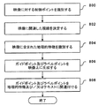
図8は、一実施形態に基づきガイダンス情報オーバーレイに対して映像をコード化するためのフローチャートである。図8のステップの幾つかは、図9の映像900と共に説明する。ステップ800において、調査者は、映像900に対する制御ポイント902を識別する。一実施形態において、制御ポイント902は、映像900における「北」のような方向を指示する。別の実施形態では、制御ポイント902は、映像が捕獲された場所を指示する。ステップ802において、調査者は、捕獲した映像に関連した視線を決定する。捕獲した映像に関連した視線は、映像900において見ることのできる距離、例えば、20メーターである。この視線は、標準的な地理的情報システム(GIS)ソフトウェアを使用して計算することができる。或いは又、視線の計算は、デジタルエレベーションモデル(DEM)を使用して実行されてもよい。視線は、ビルディングや木々のようなビュー内の障害物により制限されることがある。
FIG. 8 is a flowchart for encoding video for a guidance information overlay according to one embodiment. Some of the steps of FIG. 8 are described in conjunction with the
ステップ804において、調査者は、映像900における地理的特徴を識別する。一実施形態では、道路セグメント、ノード又は交差点、歩行者セグメント、歩行者オリエンテーションノードが識別される。更に、映像内に存在する特徴であって、湖、河川、鉄道、市庁舎、当該ポイント、例えば、ビルディング、会社、レストラン、店舗、ホテル、市役所、歴史的標識、ATM、ゴルフコース、噴水、彫像、バイクラック、等を含む特徴を識別することができる。図9の映像900の場合に、調査者は、舗装された歩行者セグメント904、歩行者セグメントの交差点にある歩行者オリエンテーションノード906、及び彫像908を識別する。
In
ステップ806において、調査者は、映像900にガイドポイント910及びラベルポイント912を形成する。ガイドポイント910は、ガイダンス形式の情報を映像900上にオーバーレイすることのできる場所に対応する映像900上の位置に配置される。例えば、ガイドポイント910は、映像900において道路セグメント、道路セグメントのノード又は交差点、歩行者セグメント904、歩行者オリエンテーションノード906及び/又は判断ポイントに対応するように配置されてもよい。一実施形態では、ガイドポイント910は、ルートハイライト及びガイダンス矢印のようなガイダンス情報オーバーレイに適した映像900上の位置に配置される。一実施形態では、ガイドポイントは、道路又は歩行者セグメントのエンドポイント並びに中間の場所に配置され、各セグメントに対する形状ポイントを与える。一実施形態では、ガイドポイント910は、映像900におけるセグメントの視覚端に配置され、視線の計算を使用して、ガイドポイントの配置を決定することができる。例えば、木があるセグメントの視界を妨げる場合には、1つのガイドポイントが木の直前のエンドポイントとして配置され、そして木の後でセグメントが見える場合には、木の後のエンドポイントとして別のガイドポイントが配置される。別の実施形態では、木の各側のガイドポイントは、映像において木を越えてハイライトしないように、これらガイドポイント間のルートハイライトが透過的でなければならないことを指定してもよい。ラベルポイント912は、ラベル形式の情報を映像900にオーバーレイできる場所に対応する映像900上の位置に配置される。例えば、ラベルポイントは、彫像908のような当該ポイントに対応するように配置されてもよい。別の実施形態では、ラベルポイントは、広告、住所、方向(北)、アイコン、場所名、又は他の情報を映像900上にオーバーレイできるところの映像900上の位置に対応するように配置されてもよい。
In
一実施形態では、調査者又は専門家は、映像上のガイドポイント及びラベルポイントの場所を手動で識別する。調査者又は専門家は、映像上のガイドポイント及びラベルポイントをデジタル化する。映像900上のガイドポイント910及びラベルポイント912は、ガイダンス情報オーバーレイに対する場所を与える。例えば、地理的オーバーレイが、道路セグメントをたどるようにナビゲーションシステム100のユーザを案内するルートハイライトである場合には、映像内の道路セグメントに関連するガイドポイントを接続するルートハイライトを描くことができる。一実施形態では、オーバーレイの配置を容易にするために、ガイドポイント及びラベルポイントに対する識別された場所に対応する映像のピクセルがコード化される。映像は、多数のピクセルで構成される。各ピクセルは、この分野で良く知られたように、オーバーレイ情報の1つ以上のビットを含むことができる。例えば、ピクセル値は、オーバーレイの使用をサポートするためにオーバーレイ情報の1ビットを有してもよい。オーバーレイ情報の1ビットは、トグルビットとして使用されてもよい。トグルビットがセットされると、ピクセルが無視され、ガイダンス情報オーバーレイのようなオーバーレイを映像上に配置することができる。別の実施形態において、ピクセル値は、8ビットのオーバーレイ情報を有してもよく、これは、オーバーレイと下部映像との間の透過性の変化を許すことができる。映像におけるガイドポイント及びラベルポイントに対するオーバーレイピクセルのコード化は、ナビゲーションシステム100が、ルートハイライト、操縦矢印、方向又はラベルのような多数の異なるガイダンス情報オーバーレイを映像上に動的に配置できるようにする。
In one embodiment, the researcher or expert manually identifies the location of guide points and label points on the video. The researcher or expert digitizes the guide points and label points on the video. Guide points 910 and label points 912 on the
ステップ808において、ガイドポイント及びラベルポイントは、地理的特徴及び/又はテキストラベルに関連付けされる。例えば、道路セグメントに対応するガイドポイントは、各道路セグメントIDに関連付けされ、ノードに対応するガイドポイントは、各ノードIDに関連付けされ、歩行者セグメントに対応するガイドポイントは、各歩行者セグメントIDに関連付けされ、オリエンテーションノードに対応するガイドポイントは、オリエンテーションノードIDに関連付けされ、当該ポイントに対応するガイドポイント又はラベルポイントは、各当該ポイントに関連付けされる。更に、ラベルポイントは、対応するテキストに関連付けされる。映像データ、ガイドポイント及びラベルポイント情報、関連特徴及びラベルは、次いで、以下に詳細に述べるように、地理的データベースに記憶される。
In
別の実施形態では、ステップ804、806及び808は、地理的エリアの幾何学形状を表わすベクトルデータを映像上にオーバーレイすることにより実行される。視線決定から映像に見られる距離、並びに映像が捕獲された場所及び方向に基づいて、映像に見られる地理的エリアの幾何学形状を表わすベクトルデータが地理的データベース116から得られる。例えば、映像に対する視線が20メーターである場合には、映像に見られる20メーターエリアに対応するベクトルデータクリップが、地理的データベース116から得られる。映像は地表面上のある高さにおいて捕獲されるので、映像は、地理的エリアの鳥瞰図を与える。鳥瞰図パースペクティブを受け容れるために、映像における地理的エリアのベクトルデータクリップは、映像に対して斜めに投影される。更に、ベクトルデータクリップは、ベクトルデータのオーバーレイが映像の特徴に一致するように、適切にスケーリングすることができる。ノードにおけるベクトルポイント及びセグメントに沿った形状ポイントで構成されるオーバーレイされるベクトルデータは、映像におけるそれらの各交差点及び経路に整列される。ベクトルデータクリップは、映像に見られる経路及び交差点を識別できるようにするセグメントID及びノードIDを含む。更に、映像及びそれに関連したベクトルデータクリップは、地理的データベースに記憶される。
In another embodiment, steps 804, 806 and 808 are performed by overlaying vector data representing the geometric shape of the geographic area on the video. Based on the distance seen in the video from the line of sight determination, and the location and direction in which the video was captured, vector data representing the geometric shape of the geographic area seen in the video is obtained from the
IV.映像データを伴う地理的データベース
図7を参照して上述したように収集された映像データは、地理的領域202における物理的な地理的特徴の幾つかを表わす地理的データベース116に含まれる。図4の実施形態では、地理的データベース116の道路セグメントデータ記録304は、映像データ記録304(5)を含み、そして地理的データベース116のノードデータ記録306(1)及び306(2)も、映像データ記録306(1)(2)及び306(2)(2)を含む。図5の実施形態では、地理的データベース116の歩行者セグメントデータ記録308は、映像データ記録308(5)を含み、そして地理的データベース116のオリエンテーションノードデータ記録310(1)及び310(2)も、映像データ記録310(1)(4)及び310(2)(4)を含む。一実施形態において、道路セグメントデータ記録304、ノードデータ記録306、歩行者セグメントデータ記録308及び/又はオリエンテーションノードデータ記録310に関連した映像データは、図10を参照して説明するように、映像データ記録1000に対するリファレンスである。更に、道路セグメントデータ記録304、ノードデータ記録306、歩行者セグメントデータ記録308及び/又はオリエンテーションノードデータ記録310は、各々、多数の映像データ記録1000に関連付けられてもよい。例えば、2つの道路の交差点を表わすノードデータ記録306は、4つの映像データ記録1000に関連付けられてもよい。
IV. Geographic Database with Video Data Video data collected as described above with reference to FIG. 7 is contained in a
図10は、地理的データベース116に収容された映像データ記録1000の幾つかのコンポーネントを示す。この映像データ記録1000は、地理的データベース116においてデータ記録を識別できるようにする映像ID1000(1)を含む。各映像データ記録1000は、表示される映像の特徴を記述する情報(「属性」、「フィールド」等の)が関連付けされる。映像データ記録1000は、データ1000(2)、即ち道路セグメント、道路交差点、歩行者セグメント、オリエンテーションノード、当該ポイント、景色の良いところ、又は地理的領域の地理的特徴のような、各映像に捕獲された地理的特徴の形式を指示する特徴コードを含むことができる。又、映像データ記録1000は、場所の経度及び緯度座標のような、映像に関連した場所を指示するデータ1000(3)も含む。又、映像データ記録1000は、映像内の制御ポイントに関連した方向のような、映像に関連した方向を指示するデータ1000(4)も含む。
FIG. 10 shows several components of the
映像データ記録1000は、映像を表示できるようにするデータ1000(5)も含む。更に、映像データ記録1000は、ナビゲーションシステム100が映像上にガイダンス情報オーバーレイを形成できるようにするためのデータを与えるオーバーレイデータ1000(6)を含むこともできる。一実施形態では、このオーバーレイデータ1000(6)は、映像のガイドポイント及びラベルポイントに対応するオーバーレイピクセルを識別する。更に、オーバーレイデータ1000(6)は、地理的特徴に対応する場所において映像上にルートハイライト及び操縦矢印をオーバーレイするのを許すために、道路セグメント、歩行者セグメント、ノード及びオリエンテーションノードのような地理的特徴に対応するオーバーレイピクセルを識別する。更に、オーバーレイデータ1000(6)は、テキスト、広告及びアイコンのようなガイダンス情報オーバーレイに適した映像内の当該ポイント又は他のアイテムに対応するオーバーレイピクセルを識別することもできる。又、オーバーレイデータ1000(6)は、ガイダンス情報オーバーレイに含まれたスタイル及び情報を含むこともできる。映像内のピクセルを識別することにより、ガイダンス情報オーバーレイは、ナビゲーションシステム100により動的に形成することができ、これは、同じ映像の多数のコピーを記憶する必要性を回避できる。例えば、オーバーレイは、図6に示す矢印602のように、歩く方向を指す矢印でもよい。別の例として、オーバーレイは、ナビゲーションシステム100のユーザがたどるための一連のドットより成るルートハイライトであってもよい。ラベル及び方向指示のような他のオーバーレイが使用されてもよい。別の実施形態では、オーバーレイデータ1000(6)は、複数の確立されたガイダンス情報オーバーレイ、例えば、道路セグメント又は歩行者セグメントに関連したルートハイライト又は操縦矢印を含んでもよい。
又、映像データ記録1000は、映像に関連した地理的特徴ID又は多数の地理的特徴を指示するデータ1000(7)を含むこともできる。図7を参照して上述したように、映像は、地理的特徴(1つ又は複数)とクロスリファレンスされる。関連地理的特徴IDデータは、道路セグメントID、ノードID、歩行者セグメントID、オリエンテーションノードID、当該ポイントID、又は地理的データベース116の他の地理的特徴へのリファレンスでよい。又、映像データ記録1000は、他のデータ1000(8)を含んでもよい。
The
別の実施形態では、映像データ記録1000は、写真データ1000(5)に対応するベクトルデータクリップ(図示せず)を与えるデータを含む。
In another embodiment,
V.映像上のガイダンス情報オーバーレイ
図1を参照して上述したように、ナビゲーションシステム100は、種々のナビゲーション特徴及び機能を与えるナビゲーションアプリケーションソフトウェアプログラム110を備えている。一実施形態において、ナビゲーション機能及び特徴は、ルート計算124及びルートガイダンス126を含むことができる。ルート計算機能124は、希望の行先へのルートを計算するための要求を受け取る。この要求は、出発場所及び希望の行先場所の指示の形態でよい。これらの場所の識別は、これらの場所の地理的座標を含んでもよい。又、ルート計算機能には、好み(例えば、景色の良いところを通るルート、障害者でもアクセスできるところ又は他の好み)のような他のデータ又はパラメータが設けられてもよい。少なくとも、出発場所及び行先場所の識別が与えられると、ルート計算機能124は、出発場所と行先場所との間の1つ以上の解答ルートを決定するように試みる。解答ルートは、ナビゲーションシステム100のユーザが出発場所から行先場所へ進行できるところの一連の接続された道路及び/又は歩行者セグメントで形成される。ルート計算機能124は、ルートを計算するときに、地理的データベース116にアクセスし、そして出発場所と行先場所との間及びそれらをめぐるセグメントを表わす道路セグメントデータエンティティ304及び/又は歩行者セグメントデータエンティティ308を得る。ルート計算機能124は、道路及び/又は歩行者セグメントデータエンティティ304及び308の情報を使用して、出発場所から行先場所への少なくとも1つの有効な解答ルートを決定するように試みる。歩行者が進行するための有効な解答ルートを決定する際に、ルート計算機能124は、道路及び/又は歩行者セグメントデータエンティティに関連したデータ属性を使用して、好みを考慮する。ルート計算機能124は、所要進行時間が最小で、最小距離をカバーするか又は他の指定基準を満足する解答ルートを見出すように試みることができる。
V. Guidance Information Overlay on Video As described above with reference to FIG. 1, the navigation system 100 includes a navigation application software program 110 that provides various navigation features and functions. In one embodiment, navigation functions and features may include route calculation 124 and route guidance 126. The route calculation function 124 receives a request for calculating a route to a desired destination. This request may be in the form of an indication of a departure location and a desired destination location. The identification of these locations may include the geographic coordinates of these locations. The route calculation function may also be provided with other data or parameters such as preferences (eg, route through a good spot, accessible by disabled people or other preferences). At least given the departure and destination location identifications, the route calculation function 124 attempts to determine one or more answer routes between the departure location and the destination location. The answer route is formed by a series of connected roads and / or pedestrian segments where the user of the navigation system 100 can proceed from the departure location to the destination location. The route calculation function 124 accesses the
ルート計算機能124は、解答ルートを決定するのに種々の手段又はアルゴリズムを使用することができる。ルート計算方法が、参考としてここに全体を援用する米国特許第6,192,314号に開示されている。(前記特許に開示された方法は、ルートを計算できる幾つかのやり方を示すに過ぎず、そこに請求された要旨は、特定のルート計算方法に限定されない。現在知られているか又は将来開発されるいかなる適当なルート計算方法を使用できる。) The route calculation function 124 can use various means or algorithms to determine the answer route. A route calculation method is disclosed in US Pat. No. 6,192,314, which is hereby incorporated by reference in its entirety. (The methods disclosed in the above patents only show some ways in which routes can be calculated, and the claimed subject matter is not limited to any particular route calculation method. Currently known or developed in the future. Any suitable route calculation method can be used.)
ルート計算機能124は、出力を発生する。一実施形態において、ルート計算機能124の出力は、複数の道路及び/又は歩行者セグメントデータエンティティを識別する順序付けされたリストの形態である。複数の道路及び/又は歩行者セグメントデータエンティティは、ルート計算機能124により計算された出発場所と行先との間の連続的にナビゲーション可能なルートを形成する道路及び/又は歩行者セグメントを表わす。ルート計算機能124は、複数の道路及び/又は歩行者セグメントの別の順序付けされたリストを含む2つ以上の解答ルートを計算することができる。 The route calculation function 124 generates an output. In one embodiment, the output of the route calculation function 124 is in the form of an ordered list that identifies multiple road and / or pedestrian segment data entities. The plurality of road and / or pedestrian segment data entities represent roads and / or pedestrian segments that form a continuously navigable route between the departure location and the destination calculated by the route calculation function 124. The route calculation function 124 can calculate two or more answer routes that include another ordered list of roads and / or pedestrian segments.
図1を参照して上述したように、ナビゲーションシステム100は、ナビゲーションシステム100のユーザに対してルートガイダンス126のナビゲーション特徴及び機能を与えるナビゲーションアプリケーションソフトウェアプログラム110を備えている。ルートガイダンス機能126は、希望の行先に到達するための詳細な方向を与える。一実施形態では、ルート計算機能124により決定された道路及び/又は歩行者セグメントデータエンティティのリストは、ルートガイダンス機能126に与えられる。ルートガイダンス機能126は、リストの情報と、地理的データベース116からの付加的情報とを使用して、ルート計算機能124により出力されたリストで定義されたルートを進行するようにエンドユーザに命令を与える。ルートガイダンス機能126は、エンドユーザに操縦命令が与えられるところの計算されたルートに沿った場所を識別する機能を含むことができる。ルートガイダンス機能126は、全ての操縦命令を一度に与えてもよいし、或いはルートガイダンス機能126は、エンドユーザが進行するときに操縦命令を一度に1つ与えてもよい。一実施形態では、エンドユーザが必要な操縦を行う準備ができるように、特定の操縦を行うことが必要になる前に、各操縦命令が別々に(又は結合操縦命令の小さなグループで)与えられる。ルートガイダンス機能126の出力は、コンピューティングプラットホーム102に含まれたユーザインターフェイス114を経てエンドユーザへ与えられる。ルートガイダンスの出力は、スピーチ合成により聴覚的に搬送されてもよいし、視覚的ディスプレイに表示されてもよい。
As described above with reference to FIG. 1, the navigation system 100 includes a navigation application software program 110 that provides navigation features and functions of the route guidance 126 to the user of the navigation system 100. The route guidance function 126 provides detailed directions for reaching the desired destination. In one embodiment, the list of road and / or pedestrian segment data entities determined by the route calculation function 124 is provided to the route guidance function 126. The route guidance function 126 uses the information in the list and the additional information from the
地理的データを使用してルートガイダンスを与える方法が、参考としてここに全体を援用する米国特許第6,199,013号に開示されている。(前記特許に開示された方法は、ルートガイダンスを計算できる幾つかのやり方を示すに過ぎず、そこに請求された要旨は、特定のルートガイダンス方法に限定されない。現在知られているか又は将来開発されるいかなる適当なルートガイダンス方法を使用してもよい。) A method for providing route guidance using geographic data is disclosed in US Pat. No. 6,199,013, hereby incorporated by reference in its entirety. (The methods disclosed in the above patents only show some ways in which route guidance can be calculated, and the claimed subject matter is not limited to a particular route guidance method. Currently known or developed in the future. Any suitable route guidance method may be used.)
適当な時間及び/又は場所で操縦命令を与えるために、ナビゲーションシステム100は、ポジショニングシステム(図1の112)からのデータを使用する。ポジショニングシステム112は、エンドユーザ(コンピューティングプラットホーム102)が進行しているときにその位置を決定する。ナビゲーションプログラミング110におけるポジショニング(地図一致)機能130は、ポジショニングシステム112により決定されたユーザの位置を、解決ルートにおいて道路及び/又は歩行者セグメントデータエンティティにより表わされた道路及び/又は歩行者セグメントの位置と比較する。この比較を使用して、解決ルートに沿った位置に関連した操縦命令を、それらの位置に近づきつつあるときに、適当な時間に与えることができる。 The navigation system 100 uses data from the positioning system (112 in FIG. 1) to provide steering instructions at the appropriate time and / or location. The positioning system 112 determines its position when the end user (computing platform 102) is advancing. The positioning (map matching) function 130 in the navigation programming 110 determines the location of the user determined by the positioning system 112 for the road and / or pedestrian segment represented by the road and / or pedestrian segment data entity in the solution route. Compare with position. Using this comparison, maneuver instructions related to positions along the resolution route can be given at the appropriate time as they are approaching those positions.
又、ルートガイダンス機能126は、行先場所への残りの距離に関する情報をエンドユーザに与えることもできる。又、ルート計算機能124からの道路及び/又は歩行者セグメントデータエンティティのリストを、地図表示機能128に与えることもできる。地図表示機能128は、このリストの情報と、地理的データベース116からの付加的な情報とを使用して、ユーザインターフェイス114のディスプレイにグラフィック地図を与える。このグラフィック地図は、計算されたルートが通るエリアを示す。計算されたルートの経路は、表示された地図上でハイライトすることができる。
The route guidance function 126 can also provide the end user with information regarding the remaining distance to the destination location. A list of road and / or pedestrian segment data entities from the route calculation function 124 may also be provided to the
一実施形態では、ルートガイダンス機能126は、ガイダンス情報オーバーレイをもつ映像も与える。オーバーレイをもつ情報は、操縦命令と共に与えられてもよい。別の実施形態では、ルートガイダンス機能126は、音声又はテキストの操縦命令ではなくガイダンス情報オーバーレイを映像に与える。別の実施形態では、ルートガイダンス機能126は、解答ルートに沿った種々の場所、例えば、判断ポイントにおいてガイダンス情報オーバーレイを映像に与える。更に別の実施形態では、ルートガイダンス機能126は、解答ルートの連続的な視覚表示を与えるためのガイダンス情報オーバーレイを一連の映像に与える。 In one embodiment, the route guidance function 126 also provides a video with guidance information overlay. Information with an overlay may be provided along with the maneuver instructions. In another embodiment, the route guidance function 126 provides a guidance information overlay to the video rather than voice or text maneuvers. In another embodiment, the route guidance function 126 provides a guidance information overlay to the video at various locations along the answer route, eg, decision points. In yet another embodiment, the route guidance function 126 provides a series of videos with a guidance information overlay to provide a continuous visual display of the answer route.
図11は、映像にガイダンス情報オーバーレイを与えるためにルートガイダンス機能126により遂行されるステップを示すフローチャートである。ステップ1100において、ルートガイダンス機能126は、ルート計算機能124により与えられた解答ルートに沿って進行するときにナビゲーションシステム100の現在位置及び方向に対応して、映像が地理的データベース116に得られるかどうか決定する。一実施形態では、ルートガイダンス機能126は、ナビゲーションシステム100の現在位置に対応して、道路セグメントデータ記録304、ノードデータ記録306、歩行者セグメントデータ記録308及び/又はオリエンテーションノードデータ記録310をリファレンスして、映像データ記録1000が存在するかどうか決定する。一実施形態では、この決定は、移動方向及び/又は1日の時刻に基づく適当な映像がリファレンス映像データ記録1000から得られるかどうかを含む。ステップ1102において、ルートガイダンス機能126は、ユーザインターフェイス114を経てナビゲーションシステム100のユーザに映像を提示すべきかどうか決定する。一実施形態では、ナビゲーションシステム100は、ナビゲーションシステム100のユーザにより要求されたときだけ映像を提供する。例えば、ユーザは、ユーザインターフェイス114を使用して映像を要求することができる。別の実施形態では、ナビゲーションシステム100は、計算されたルートに沿った各判断ポイントにおいて自動的に映像を与える。
FIG. 11 is a flowchart illustrating the steps performed by the route guidance function 126 to provide a guidance information overlay on the video. In step 1100, the route guidance function 126 obtains video in the
ステップ1104において、ルートガイダンス機能126は、適当なガイダンス情報オーバーレイを決定する。このガイダンス情報オーバーレイは、操縦矢印、解答ルート又は代替ルートをハイライトする線又は複数のドット、テキストラベル、方向ラベル、又は他の情報でよい。ルートガイダンス機能126は、ルートの現在部分を構成する道路セグメント、歩行者セグメント、ノード及び/又はオリエンテーションノードに対応するオーバーレイピクセルを指示するデータを映像データ記録1000から得ることができる。更に、ルートガイダンス機能126は、オーバーレイピクセルに配置するのに適したガイダンスオーバーレイを選択することもできる。例えば、運転方向が次の交差点の道路セグメントで右転回である場合には、ルートガイダンス機能126は、関連映像における道路セグメント上で右転回するための操縦矢印を与えるガイダンス情報オーバーレイを選択する。ステップ1106において、ガイダンス情報オーバーレイをもつ映像が形成される。図6、12−15は、ガイダンス情報オーバーレオをもつ映像の実施形態を説明するのに使用される。
In
図6は、操縦矢印602のガイダンス情報オーバーレイの一実施形態を示す。映像600は、道路ノードの360度パノラマ写真である。映像600は、解答ルートをたどるために接続された道路セグメント上の現在場所から必要とされる進行方向又は転回を指示する操縦矢印602のガイダンス情報オーバーレイを含む。360度パノラマ写真600は、ナビゲーションシステム100のユーザを定位する上で役立つと共に、歩行者にとって特に有用であろう。操縦矢印602のガイダンス情報オーバーレイは、映像600上の特徴を目に見える周囲と比較することによりユーザがより容易に識別できる指示された道路セグメント上で転回するようにユーザに指令する。更に、操縦矢印602は、いかなるカラーでもよく、カラーは、ユーザがガイダンス情報オーバーレイ602に素早く気付くものを選択することができる。図6は、360度の写真を示すが、映像は単一ビューの写真でもよい。
FIG. 6 illustrates one embodiment of a guidance information overlay of steering
別の実施形態では、ガイダンス情報オーバーレイは、計算されたルートに沿った目に見える当該ポイントを指示するラベル604を含む。図6に示すように、ラベル604は、解答ルートに沿って「銀行」があることを指示する。別の実施形態では、ラベルは、解答ルートからユーザに見える他の当該ポイントに関連したものでもよい。更に、ラベル604は、当該ポイントの形式を指示するアイコン、当該ポイントの説明、当該ポイントの名称、又は当該ポイントに関する他の情報でもよい。ラベル604は、補足的なガイダンス情報をユーザに与え、計算されたルートをユーザがたどることを確認するのに使用できる。更に、ガイダンス情報オーバーレイは、ユーザを定位する上で助けとするために映像内の他の当該ポイント又は特徴に対するラベルを含んでもよい。例えば、ガイダンス情報オーバーレイは、通信用の塔のような目に入り易い目印を識別するラベルを含んでもよい。一実施形態では、ガイダンス情報オーバーレイは、方向を指示するラベルである。別の実施形態では、オーバーレイは、映像600に見える会社、又は映像600のエリアの近くに位置する会社に関連した広告を含んでもよい。
In another embodiment, the guidance information overlay includes a
図12は、ガイダンス情報オーバーレイの別の実施形態を示す。図12の映像1200は、360度の写真である。ガイダンス情報オーバーレイは、複数のドット即ち「パン粉」で示されたように、ルートハイライトである。第1の一連のドット1202は、進行した解答ルートの一部分を示すのに使用され、そして第2の一連のドット1204は、解答ルートの次の道路及び/又は歩行者セグメントを示すのに使用される。ドット1204は、ユーザが映像1200上でルートの次の部分を視覚的に識別するのを許すと共に、映像及びガイダンス情報オーバーレイを使用して地理的領域内でユーザを視覚的に定位させるのを許す。図12ではドットが使用されているが、一連の矢印、実線1206、破線又は他の形状のようなルートハイライトを使用してもよい。第1及び第2の一連のドット1202及び1204は、回廊ルートの2つの部分を区別するために異なるカラーでもよい。図12に示すように、歩行者に接近したドットは、離れたドットより大きく見える。ドットの間隔及びサイズは、図13を参照して詳細に説明する。
FIG. 12 illustrates another embodiment of a guidance information overlay.
図13は、一実施形態に基づき一連のドットで構成されたガイダンス情報オーバーレイの絵画的表示1300である。ドット1302は、映像が捕獲された場所を指示することができる。更に、ドット1302は、映像におけるユーザの場所、例えば、映像における「you are here(あなたはここ)」ガイダンス情報を表わすのに使用できる。ドット1302からの距離1304が増加するにつれて、ドットのサイズが比例的に減少する。ドットの間隔及び大きさは、ガイダンスのための充分な接続性を与えるように選択できると共に、視線計算に基づくことができる。
FIG. 13 is a
図14は、ガイダンス情報オーバーレイの別の実施形態を示す。図14は、一実施形態に基づき代替ルートを示すガイダンス情報オーバーレイを描いた単一ビュー映像1400である。上述したように、ルート計算機能124は、原点と行先との間の多数のルート解答を計算することができる。これらのルート解答は、異なるセグメントを含むが、幾つかの同じ道路及び/又は歩行者セグメントで構成することができる。1つ以上の代替ルートは、進行時間又は距離が変化してもよいが、ユーザにとって魅力的な異なる特徴を有してもよい。例えば、代替ルートは、より景色の良いところでもよいし、勾配がより平坦なところでもよいし、夜間でも充分明るいところでもよいし、障害者でもアクセスできるところでもよいし、等々でよい。
FIG. 14 illustrates another embodiment of a guidance information overlay. FIG. 14 is a
図14を参照すれば、ガイダンス情報オーバーレイは、第1のルートを示す第1の一連のドット1402により表わされたルートハイライトと、第2のルートを示す第2の一連のドット1404により表わされたルートハイライトとを含む。第1及び第2の一連のドット1402及び1404は、2つのルートを区別するために異なるカラーでよい。第1の一連のドット1402は、メインルートをハイライトし、一方、第2の一連のドット1404は、代替ルートをハイライトする。ガイダンス情報オーバーレイは、噴水の周りのいずれかのルートハイライト1402又は1404をたどるオプションをユーザに与える。例えば、ユーザは、並木道で日陰が多いので第2のルート1404を選択してもよい。この実施形態は、2つのルートを使用して描かれているが、ルートの数は3本より多くてもよい。更に、ルートハイライト1402及び1404は、道路網208内の道路セグメント210にオーバーレイしてもよい。
Referring to FIG. 14, the guidance information overlay is represented by a route highlight represented by a first series of
別の実施形態では、ガイダンス情報オーバーレイは、各々の描かれる代替ルートに関する付加的な情報を搬送する。図15は、別の実施形態に基づき代替ルートを示すためのガイダンス情報オーバーレイを含む単一ビュー映像1500である。この例では、ガイダンス情報オーバーレイは、第1ルートを描く第1の一連のドット1502により表わされたルートハイライトと、第2ルートを描く第2の一連のドット1504により表わされたルートハイライトとを備えている。第1の一連のドット1502は、階段を含むより直接的なルートをハイライトする一方、第2の一連のドット1504は、障害者がアクセスできる代替ルートをハイライトすることができる。第2の一連のドット1504は、代替ルート1504の特徴を記述する障害者アイコンを各ドットに含む。障害者アイコンをもつルートハイライトのルートガイダンスオーバーレイは、ナビゲーションシステム100のユーザに視覚的に有用な情報を与える。例えば、障害者アイコンをもつルートハイライトは、障害者がアクセスできるビルディングの入口へユーザを案内することができる。更に、ユーザは、ベビーカーを押したり、ローラースケートを着用したり、又は階段を有するルートハイライト1502を進むのが困難である医学的状況にあることがある。
In another embodiment, the guidance information overlay carries additional information about each drawn alternate route. FIG. 15 is a
図15は、ガイダンス情報オーバーレイにおける障害者アイコンの使用を示しているが、種々の他の記号又はアイコンを使用して、特定ルートの特徴をハイライトしてもよい。例えば、木の記号のオーバーレイを使用して、並木道を識別することもできるし、噴水アイコン又はトイレットアイコンを使用して、各々噴水又はトイレットの近くを通るルートを識別こともできるし、アイコン又は記号を使用して、充分照明されたルート、静寂なルート、景観の良いルート、混雑したルート、平穏なルート、自転車に馴染み深いルート、又は他のルートを識別することができる。ルートガイダンス機能126は、解答ルートの特徴に対応する適切な記号又はアイコンを含んでもよい。 Although FIG. 15 illustrates the use of a disabled icon in a guidance information overlay, various other symbols or icons may be used to highlight specific route features. For example, a tree symbol overlay can be used to identify a tree-lined path, or a fountain icon or toilet icon can be used to identify a route that passes near a fountain or toilet, respectively. Can be used to identify well-lit routes, quiet routes, scenic routes, crowded routes, calm routes, bicycle-friendly routes, or other routes. The route guidance function 126 may include appropriate symbols or icons corresponding to the characteristics of the answer route.
図11を再び参照すれば、ガイダンス情報オーバーレイをもつ映像が生成された後に、ナビゲーションシステム100のユーザには、ユーザインターフェイス114を経てガイダンス情報オーバーレイをもつ映像が与えられる。図16は、一実施形態に基づきガイダンス情報オーバーレイ1604及び1606をもつ映像1602を示すユーザインターフェイス114のスクリーンショット1600である。ガイダンス情報オーバーレイ1604及び1606をもつ映像1602は、ユーザを定位すると共に、ユーザが行先へ至る解答ルートを正しくたどる再保証を与える。ユーザは、スクリーンショット1600に示されたメッセージアイコン又は地図アイコンにタッチすることにより、ガイダンスメッセージ(テキスト又は音声)或いは地図を得ることができる。
Referring back to FIG. 11, after the video with the guidance information overlay is generated, the user of the navigation system 100 is given the video with the guidance information overlay via the
図17は、ガイダンス情報オーバーレイをもつ映像をユーザに与える別の実施形態を示す。図17は、ルートハイライトのガイダンス情報オーバーレイ1704をもつ映像1702及びテキストガイダンスメッセージ1706を与えるユーザインターフェイス114のスクリーンショット1700である。図17に示す例では、ユーザインターフェイス114は、歩行者が解答ルートを進むときに見える映像1702を与え、ガイダンス情報オーバーレイ1704は、ルートに沿ってユーザを視覚的に案内し、そしてテキストガイダンスメッセージ1706は、経路を説明する。一実施形態において、映像1702は、テキストガイダンスメッセージでリファレンスされる特徴、例えば、「ミシガン湖」を識別するラベル1708を含む。
FIG. 17 illustrates another embodiment of providing a user with a video with a guidance information overlay. FIG. 17 is a
図18A及び18Bは、ガイダンス情報オーバーレイをもつ映像をユーザに与える更に別の実施形態を示す。図18Aは、ガイダンス情報オーバーレイをもつ映像1802と、テキストガイダンスメッセージの表示を要求するタッチスクリーンアイコン1804とのスクリーンショット1800であり、一方、図18Bは、テキストガイダンスメッセージ1808と、映像の表示を要求するタッチスクリーンアイコン1810とのスクリーンショット1806である。図18A及び18Bは、図17に示されたガイダンス情報オーバーレイ及びテキストガイダンス1706をもつ同じ映像1702を含むが、この例では、映像1802と、ガイダンスメッセージ1808とが異なるスクリーンに示されている。ユーザは、タッチスクリーンアイコン1804、1810を使用して、写真1802と歩行者ガイダンスメッセージ1808との間をトグルすることができる。この例ではユーザインターフェイス114へのタッチスクリーン入力メカニズムを使用するが、ユーザ装置への他の入力メカニズムが使用されてもよい。
18A and 18B illustrate yet another embodiment for providing a user with a video with a guidance information overlay. FIG. 18A is a
スクリーンショット1600、1700、1800及び1806は、パーソナルデジタルアシスタント上に示されたが、セルラー電話や、乗物ナビゲーションシステムや、コンピュータのような他のユーザ装置を使用して、映像及びそれに関連したガイダンス情報オーバーレイを表示することもできる。更に、ユーザは、解答ルートを前進する前に映像及びそれに関連したガイダンス情報オーバーレイを得ることもできる。別の例として、個人が固定のコンピュータから映像を得て、これをユーザがプリントして取り出すことができる。さらに別の例では、ユーザは、インターネットウェブサイトや、コンピュータターミナルや、キオスクのような公衆アクセス装置からガイダンス情報オーバーレイをもつ映像を得ることができる。更に、ユーザは、進行の前に得た映像を使用して解答ルートの仮想ツアーを実行することもできる。
VI.映像に情報オーバーレイを伴う別の実施形態
前記説明は、希望の行先への解答ルートに沿ってナビゲーションシステム100のユーザをガイドするためのガイダンス情報オーバーレイをもつ映像について述べた。図19は、情報オーバーレイをもつ映像の別の実施形態を示す。図19は、一実施形態に基づくラベルオーバーレイ1902を含む景観映像1900である。ラベルオーバーレイは、都市風景映像1900における人気のある場所を識別する。図19に示すように、情報オーバーレイは、映像1900における種々のビルディングの名称を識別するテキストラベルを含む。ビルディングのためのラベルに加えて、映像は、映像内の当該ポイント又は地理的特徴のためのラベルを含んでもよい。別の実施形態では、情報オーバーレイは、ビルディングに対応する住所を含んでもよい。更に別の実施形態では、情報オーバーレイは、歴史的、ツーリスト形式又は広告ラベルを含んでもよい。ユーザは、娯楽の目的で映像の情報オーバーレイを使用してもよい。情報オーバーレイは、ツーリスト、建築家等にとって関心のある重要なビルディング及び建築物をユーザが識別するのを許す。
VI. Another Embodiment with Information Overlay on Video The above description has described a video with a guidance information overlay to guide the user of the navigation system 100 along the answer route to the desired destination. FIG. 19 illustrates another embodiment of a video with an information overlay. FIG. 19 is a
一実施形態では、ナビゲーションシステム100は、ユーザが場所を入力するために、ラベルオーバーレイ1902をもつ映像1900をユーザインターフェイス114上に与える。ユーザは、映像1900上のラベル即ちビルディングを選択して、ユーザの希望の場所を入力することができる。例えば、ユーザ装置がPDAである場合には、歩行者は、スタイラスを使用してタッチスクリーンディスプレイにタッチすることによりラベルを選択することができる。別の実施形態では、ユーザは、ユーザインターフェイスを経てラベル名を希望の場所として入力することもできる。
In one embodiment, the navigation system 100 provides a
一実施形態において、ユーザは、映像1900を使用して希望の行先を入力することができる。図1を参照して上述したように、ナビゲーションシステム100は、ルート計算機能124を備えている。このルート計算機能124は、希望の行先へのルートを計算する要求を受け取る。この要求は、情報オーバーレイをもつ映像を使用して行先を入力する要求の形態でよい。次いで、ユーザは、情報オーバーレイをもつ映像が与えられる。例えば、シカゴにいるツーリストは、景観映像1900を使用して行先を入力することを要求してもよく、次いで、ナビゲーションシステムは、ユーザに映像1900を与える。ユーザは、映像1900を使用して行先を選択し、ルート計算機能124は、その入力された行先を使用して、ユーザの現在の場所からその入力された行先までの解答ルートを計算する。別の実施形態では、ユーザは、映像1900を使用してルートの出発場所を入力する。例えば、ツーリストキオスクは、映像1900を与え、ユーザは、種々の行先への及びそこからのルートを決定することができる。出発場所及び行先場所が入力されると、ルート計算機能124は、上述したように、出発場所と行先場所との間の1つ以上の解答ルートを決定するように試みる。更に、ナビゲーションシステム100は、解答ルートに沿ってその入力された希望の行先へユーザをガイドするために解答ルートに対するルートガイダンス機能及び特徴を与える。ルートガイダンスは、ガイダンス情報オーバーレイ、テキストメッセージ、又は他のガイダンス情報をもつ映像を含むことができる。更に、ナビゲーションシステム100は、地図表示をユーザに与えることもできる。
In one embodiment, the user can use
更に、映像1900を使用して、ナビゲーション特徴及び機能に対する場所を入力することができる。別の実施形態では、ユーザ1900は、映像1900を使用して、希望の当該ポイントを入力し、その当該ポイントに関する情報を要求することができる。例えば、ユーザは、会社に関する情報、営業時間、電話番号及びその他の情報を要求することができる。更に、映像のラベルオーバーレイ1902は、広告を含んでもよい。
In addition,
以上、本発明を詳細に説明したが、これは、本発明を単に例示するもので、これに限定するものではなく、本発明の範囲は、特許請求の範囲及びその全ての等効物により限定されることを理解されたい。 Although the present invention has been described in detail above, this is merely illustrative of the present invention and is not limited thereto, and the scope of the present invention is limited by the claims and all equivalents thereof. Please understand that.
100:ナビゲーションシステム
102:コンピューティングプラットホーム
104:プロセッサ
106:ドライブ
108:不揮発性メモリー記憶装置
110:ナビゲーションアプリケーションソフトウェアプログラム
112:ポジショニングシステム
114:ユーザインターフェイス
116:地理的データベース
118:記憶媒体
120:通信システム
122:ランダムアクセスメモリー
124:ルート計算
126:ルートガイダンス
128:地図ディスプレイ
130:ポジショニング
132:他の機能及びプログラミング
200:地図
202:地理的領域
208:道路網
210:道路セグメント
212:ノード
304:道路セグメントデータ記録
306:ノードデータベース記録
308:歩行者セグメントデータベース記録
310:オリエンテーションノードデータベース記録
314:インデックス
DESCRIPTION OF SYMBOLS 100: Navigation system 102: Computing platform 104: Processor 106: Drive 108: Non-volatile memory storage device 110: Navigation application software program 112: Positioning system 114: User interface 116: Geographic database 118: Storage medium 120: Communication system 122 : Random access memory 124: Route calculation 126: Route guidance 128: Map display 130: Positioning 132: Other functions and programming 200: Map 202: Geographic region 208: Road network 210: Road segment 212: Node 304: Road segment data Record 306: Node database record 308: Pedestrian segment database Recording 310: Orientation node database record 314 Index
Claims (17)
プロセッサと、
データストレージと、
前記プロセッサによって実行できる前記データストレージ内に記憶された機械語指示と、を備え、
前記機械語の指示によって、前記プロセッサが、
地理的エリアの写真映像を入力し、
前記写真映像が捕獲された場所を入力し、
前記写真映像において見ることが可能な視線に沿った距離を決定し、
前記写真映像において見ることが可能な前記距離のための経路幾何学形状を表わす経路についてのベクトルデータを取得し、
前記写真映像上のガイダンス情報オーバーレイが配置されるところにガイドポイントを形成し、
ガイダンス情報オーバーレイは、前記写真映像において見ることが可能な前記距離のための経路幾何学形状を表わす前記ベクトルデータであり、
前記経路幾何学形状は、ドット、矢印、実線、又は、破線で表され、当該経路幾何学形状のサイズは、距離が増加するにつれて減少することを特徴としており、
さらに、前記機械語の指示によって、前記プロセッサが、
前記地理的データベースに前記写真映像を記憶し、
前記ガイドポイント及び前記ガイダンス情報オーバーレイを表すデータを前記地理的データベースに記憶し、
前記地理的データベースに記憶されている前記映像には、当該映像上の前記ガイダンス情報オーバーレイが含まれていないことを特徴とするシステム。 In a system that collects data in a geographic database,
A processor;
Data storage,
Machine language instructions stored in the data storage that can be executed by the processor,
According to the instructions in the machine language, the processor
Enter a photo image of a geographical area,
Enter the location where the photographic video was captured,
Determining the distance along the line of sight that can be seen in the photographic image;
Obtaining vector data about a path representing a path geometry for the distance visible in the photographic image;
Forming a guide point where a guidance information overlay is placed on the photographic image;
Guidance information overlay is the vector data representing the path geometry for the distance that can be seen in the photographic image ;
The path geometry is represented by dots, arrows, solid lines, or broken lines, and the size of the path geometry decreases as the distance increases ,
Further, according to the instruction in the machine language, the processor
Storing the photographic images in the geographic database;
Storing data representing the guide points and the guidance information overlay in the geographic database;
The video stored in the geographic database does not include the guidance information overlay on the video.
前記コンピュータは、
地理的エリアの写真映像を取得するためのコンピュータ読み取り可能なプログラムコードと、
前記写真映像が捕獲された場所を取得するためのコンピュータ読み取り可能なプログラムコードと、
前記写真映像において見ることが可能な視線に沿った距離を取得するためのコンピュータ読み取り可能なプログラムコードと、
前記写真映像において見ることが可能な前記距離のための経路幾何学形状を表わす経路についてのベクトルデータを取得するためのコンピュータ読み取り可能なプログラムコードと、
複数のガイダンス情報オーバーレイを配置するのに適した前記写真映像上のガイドポイントを形成するためのコンピュータ読み取り可能なプログラムコードと、を実行し、
ガイダンス情報オーバーレイは、前記写真映像において見ることが可能な前記距離のための経路幾何学形状を表わす前記ベクトルデータであり、
前記経路幾何学形状は、ドット、矢印、実線、又は、破線で表され、当該経路幾何学形状のサイズは、距離が増加するにつれて減少することを特徴としており、
さらに、前記コンピュータは、
前記地理的データベースに前記写真映像を記憶するためのコンピュータ読み取り可能なプログラムコードと、
前記地理的データベースに前記ガイドポイント及び前記ガイダンス情報オーバーレイを表すデータを記憶するためのコンピュータ読み取り可能なプログラムコードと、を実行し、
前記地理的データベースに記憶されている前記映像には、当該映像上の前記ガイダンス情報オーバーレイが含まれていないことを特徴とするコンピュータが読み取り可能な記憶媒体。 A computer-readable storage medium comprising a stored program, the program causing the computer to obtain data for a geographic database;
The computer
Computer readable program code for obtaining a photo image of a geographical area;
Computer readable program code for obtaining the location where the photographic image was captured;
Computer readable program code for obtaining a distance along a line of sight visible in the photographic image;
Computer readable program code for obtaining vector data for a path representing a path geometry for the distance visible in the photographic image;
Executing computer readable program code for forming guide points on the photographic image suitable for arranging a plurality of guidance information overlays;
Guidance information overlay, Ri Ah in the vector data representing the path geometry for the distance that can be seen in the photo image,
The path geometry is represented by dots, arrows, solid lines, or broken lines, and the size of the path geometry decreases as the distance increases ,
Further, the computer
Computer readable program code for storing the photographic video in the geographic database;
Executing computer readable program code for storing data representing the guide points and the guidance information overlay in the geographic database;
The computer-readable storage medium, wherein the video stored in the geographic database does not include the guidance information overlay on the video.
Applications Claiming Priority (2)
| Application Number | Priority Date | Filing Date | Title |
|---|---|---|---|
| US10/880,816 US20060002590A1 (en) | 2004-06-30 | 2004-06-30 | Method of collecting information for a geographic database for use with a navigation system |
| US10/880816 | 2004-06-30 |
Related Child Applications (1)
| Application Number | Title | Priority Date | Filing Date |
|---|---|---|---|
| JP2011287431A Division JP5496997B2 (en) | 2004-06-30 | 2011-12-28 | Method of collecting geographic database information for use in a navigation system |
Publications (3)
| Publication Number | Publication Date |
|---|---|
| JP2006030208A JP2006030208A (en) | 2006-02-02 |
| JP2006030208A5 JP2006030208A5 (en) | 2008-07-31 |
| JP5290493B2 true JP5290493B2 (en) | 2013-09-18 |
Family
ID=34979702
Family Applications (2)
| Application Number | Title | Priority Date | Filing Date |
|---|---|---|---|
| JP2005219563A Expired - Fee Related JP5290493B2 (en) | 2004-06-30 | 2005-06-30 | Method of collecting geographic database information for use in a navigation system |
| JP2011287431A Active JP5496997B2 (en) | 2004-06-30 | 2011-12-28 | Method of collecting geographic database information for use in a navigation system |
Family Applications After (1)
| Application Number | Title | Priority Date | Filing Date |
|---|---|---|---|
| JP2011287431A Active JP5496997B2 (en) | 2004-06-30 | 2011-12-28 | Method of collecting geographic database information for use in a navigation system |
Country Status (3)
| Country | Link |
|---|---|
| US (1) | US20060002590A1 (en) |
| EP (1) | EP1612707B1 (en) |
| JP (2) | JP5290493B2 (en) |
Families Citing this family (63)
| Publication number | Priority date | Publication date | Assignee | Title |
|---|---|---|---|---|
| US8150617B2 (en) * | 2004-10-25 | 2012-04-03 | A9.Com, Inc. | System and method for displaying location-specific images on a mobile device |
| US7281208B2 (en) * | 2004-11-18 | 2007-10-09 | Microsoft Corporation | Image stitching methods and systems |
| US8843309B2 (en) | 2005-04-21 | 2014-09-23 | Microsoft Corporation | Virtual earth mapping |
| US20070210937A1 (en) * | 2005-04-21 | 2007-09-13 | Microsoft Corporation | Dynamic rendering of map information |
| US7451041B2 (en) * | 2005-05-06 | 2008-11-11 | Facet Technology Corporation | Network-based navigation system having virtual drive-thru advertisements integrated with actual imagery from along a physical route |
| US7933929B1 (en) | 2005-06-27 | 2011-04-26 | Google Inc. | Network link for providing dynamic data layer in a geographic information system |
| US7933897B2 (en) | 2005-10-12 | 2011-04-26 | Google Inc. | Entity display priority in a distributed geographic information system |
| KR100649674B1 (en) * | 2005-11-28 | 2006-11-27 | 한국전자통신연구원 | Method for recognizing position using a built-in camera and apparatus thereof |
| US20070156335A1 (en) | 2006-01-03 | 2007-07-05 | Mcbride Sandra Lynn | Computer-Aided Route Selection |
| US7706973B2 (en) * | 2006-01-03 | 2010-04-27 | Navitrail Llc | Computer-aided route selection |
| US7797019B2 (en) | 2006-03-29 | 2010-09-14 | Research In Motion Limited | Shared image database with geographic navigation |
| US8688375B2 (en) * | 2006-05-31 | 2014-04-01 | Trx Systems, Inc. | Method and system for locating and monitoring first responders |
| KR100875374B1 (en) | 2007-03-07 | 2008-12-23 | 팅크웨어(주) | Tree structure name retrieval method and its system |
| US7990394B2 (en) | 2007-05-25 | 2011-08-02 | Google Inc. | Viewing and navigating within panoramic images, and applications thereof |
| CA3036872C (en) * | 2007-05-25 | 2020-04-28 | Google Llc | Rendering, viewing and annotating panoramic images, and applications thereof |
| US9733091B2 (en) | 2007-05-31 | 2017-08-15 | Trx Systems, Inc. | Collaborative creation of indoor maps |
| US9395190B1 (en) | 2007-05-31 | 2016-07-19 | Trx Systems, Inc. | Crowd sourced mapping with robust structural features |
| US9448072B2 (en) | 2007-05-31 | 2016-09-20 | Trx Systems, Inc. | System and method for locating, tracking, and/or monitoring the status of personnel and/or assets both indoors and outdoors |
| FR2918745B1 (en) * | 2007-07-12 | 2009-09-18 | Commissariat Energie Atomique | DEVICE FOR ASSISTING THE NAVIGATION OF A PERSON |
| US20100122208A1 (en) * | 2007-08-07 | 2010-05-13 | Adam Herr | Panoramic Mapping Display |
| EP2223041A1 (en) * | 2007-12-20 | 2010-09-01 | TomTom International B.V. | Improved navigation device and method |
| US7991285B2 (en) * | 2008-01-08 | 2011-08-02 | Sony Ericsson Mobile Communications Ab | Using a captured background image for taking a photograph |
| JP5658144B2 (en) * | 2008-05-28 | 2015-01-21 | グーグル・インコーポレーテッド | Visual navigation method, system, and computer-readable recording medium |
| FR2943827A1 (en) * | 2009-03-27 | 2010-10-01 | Commissariat Energie Atomique | DEVICE FOR STORING THE TRACK FOLLOWED BY A BEARER, IN PARTICULAR TO GUIDE A PERSON |
| US20100304720A1 (en) * | 2009-05-27 | 2010-12-02 | Nokia Corporation | Method and apparatus for guiding media capture |
| US8515450B2 (en) * | 2009-08-25 | 2013-08-20 | Arkadiusz Wysocki | Method of creating an audience map |
| US8611592B2 (en) * | 2009-08-26 | 2013-12-17 | Apple Inc. | Landmark identification using metadata |
| US8682391B2 (en) * | 2009-08-27 | 2014-03-25 | Lg Electronics Inc. | Mobile terminal and controlling method thereof |
| JP2011055250A (en) * | 2009-09-02 | 2011-03-17 | Sony Corp | Information providing method and apparatus, information display method and mobile terminal, program, and information providing system |
| US8838332B2 (en) * | 2009-10-15 | 2014-09-16 | Airbiquity Inc. | Centralized management of motor vehicle software applications and services |
| US8234063B2 (en) * | 2009-12-18 | 2012-07-31 | Telenav, Inc. | Navigation system with location profiling and method of operation thereof |
| US8301364B2 (en) * | 2010-01-27 | 2012-10-30 | Navteq B.V. | Method of operating a navigation system to provide geographic location information |
| US20110190008A1 (en) * | 2010-01-29 | 2011-08-04 | Nokia Corporation | Systems, methods, and apparatuses for providing context-based navigation services |
| JP5057184B2 (en) * | 2010-03-31 | 2012-10-24 | アイシン・エィ・ダブリュ株式会社 | Image processing system and vehicle control system |
| US9122707B2 (en) * | 2010-05-28 | 2015-09-01 | Nokia Technologies Oy | Method and apparatus for providing a localized virtual reality environment |
| JP2012002595A (en) * | 2010-06-15 | 2012-01-05 | Sony Corp | Information processing device, information processing method, information processing system, and program |
| US8385593B2 (en) | 2010-06-18 | 2013-02-26 | Google Inc. | Selecting representative images for establishments |
| US8620023B1 (en) * | 2010-09-13 | 2013-12-31 | The Boeing Company | Object detection and location system |
| US8451174B1 (en) | 2010-09-13 | 2013-05-28 | The Boeing Company | Beam-scanning system |
| US8787114B1 (en) | 2010-09-13 | 2014-07-22 | The Boeing Company | Audio surveillance system |
| US9317133B2 (en) | 2010-10-08 | 2016-04-19 | Nokia Technologies Oy | Method and apparatus for generating augmented reality content |
| US8952983B2 (en) * | 2010-11-04 | 2015-02-10 | Nokia Corporation | Method and apparatus for annotating point of interest information |
| US8612149B2 (en) * | 2011-02-10 | 2013-12-17 | Blackberry Limited | System and method of relative location detection using image perspective analysis |
| US9664527B2 (en) * | 2011-02-25 | 2017-05-30 | Nokia Technologies Oy | Method and apparatus for providing route information in image media |
| JP5765019B2 (en) | 2011-03-31 | 2015-08-19 | ソニー株式会社 | Display control apparatus, display control method, and program |
| US9196086B2 (en) | 2011-04-26 | 2015-11-24 | Here Global B.V. | Method, system, and computer-readable data storage device for creating and displaying three-dimensional features on an electronic map display |
| US20130061147A1 (en) * | 2011-09-07 | 2013-03-07 | Nokia Corporation | Method and apparatus for determining directions and navigating to geo-referenced places within images and videos |
| WO2013128078A1 (en) | 2012-02-29 | 2013-09-06 | Nokia Corporation | Method and apparatus for rendering items in a user interface |
| US8553942B2 (en) | 2011-10-21 | 2013-10-08 | Navteq B.V. | Reimaging based on depthmap information |
| US9116011B2 (en) | 2011-10-21 | 2015-08-25 | Here Global B.V. | Three dimensional routing |
| US9047688B2 (en) | 2011-10-21 | 2015-06-02 | Here Global B.V. | Depth cursor and depth measurement in images |
| US9024970B2 (en) | 2011-12-30 | 2015-05-05 | Here Global B.V. | Path side image on map overlay |
| US9404764B2 (en) | 2011-12-30 | 2016-08-02 | Here Global B.V. | Path side imagery |
| JP6006536B2 (en) * | 2012-06-01 | 2016-10-12 | 任天堂株式会社 | Information processing program, information processing apparatus, information processing system, and panoramic video display method |
| US9020278B2 (en) * | 2012-06-08 | 2015-04-28 | Samsung Electronics Co., Ltd. | Conversion of camera settings to reference picture |
| US8838382B2 (en) * | 2012-11-11 | 2014-09-16 | White Wolf Investments Pty Ltd | Method of providing natural tour guide functionality to location tracking computerized devices |
| CN103913174B (en) * | 2012-12-31 | 2016-10-19 | 深圳先进技术研究院 | The generation method and system of a kind of navigation information and mobile client and server end |
| US11268818B2 (en) | 2013-03-14 | 2022-03-08 | Trx Systems, Inc. | Crowd sourced mapping with robust structural features |
| US11156464B2 (en) | 2013-03-14 | 2021-10-26 | Trx Systems, Inc. | Crowd sourced mapping with robust structural features |
| CN103785169A (en) * | 2013-12-18 | 2014-05-14 | 微软公司 | Mixed reality arena |
| US10217283B2 (en) | 2015-12-17 | 2019-02-26 | Google Llc | Navigation through multidimensional images spaces |
| CA3009317A1 (en) * | 2015-12-23 | 2017-06-29 | Viking Scientific, Inc. | Hydrogel prodrug for treatment |
| US10593074B1 (en) * | 2016-03-16 | 2020-03-17 | Liberty Mutual Insurance Company | Interactive user interface for displaying geographic boundaries |
Family Cites Families (44)
| Publication number | Priority date | Publication date | Assignee | Title |
|---|---|---|---|---|
| US674929A (en) * | 1900-03-22 | 1901-05-28 | Castner Electrolytic Alkali Company | Drumheading-machine. |
| NL8901695A (en) * | 1989-07-04 | 1991-02-01 | Koninkl Philips Electronics Nv | METHOD FOR DISPLAYING NAVIGATION DATA FOR A VEHICLE IN AN ENVIRONMENTAL IMAGE OF THE VEHICLE, NAVIGATION SYSTEM FOR CARRYING OUT THE METHOD AND VEHICLE FITTING A NAVIGATION SYSTEM. |
| JP3511561B2 (en) * | 1996-09-11 | 2004-03-29 | パイオニア株式会社 | Map information display device, navigation device, and recording medium recording navigation program |
| JPH05113343A (en) * | 1991-10-22 | 1993-05-07 | Pioneer Electron Corp | Navigation system |
| US6037936A (en) * | 1993-09-10 | 2000-03-14 | Criticom Corp. | Computer vision system with a graphic user interface and remote camera control |
| JPH07221734A (en) * | 1994-01-31 | 1995-08-18 | Matsushita Electric Ind Co Ltd | Code division multiple access equipment |
| JP3474022B2 (en) * | 1995-04-20 | 2003-12-08 | 株式会社日立製作所 | Map display device, map display method, arithmetic processing unit for map display device, and navigation system |
| JP3568621B2 (en) * | 1995-04-20 | 2004-09-22 | 株式会社日立製作所 | Map display device |
| JP2644706B2 (en) * | 1995-08-18 | 1997-08-25 | 工業技術院長 | Route guidance system and method |
| US6282362B1 (en) * | 1995-11-07 | 2001-08-28 | Trimble Navigation Limited | Geographical position/image digital recording and display system |
| JP3658659B2 (en) * | 1995-11-15 | 2005-06-08 | カシオ計算機株式会社 | Image processing device |
| JP3267842B2 (en) * | 1995-11-17 | 2002-03-25 | 松下電器産業株式会社 | Vehicle navigation device |
| US6169552B1 (en) * | 1996-04-16 | 2001-01-02 | Xanavi Informatics Corporation | Map display device, navigation device and map display method |
| JPH10143640A (en) * | 1996-11-15 | 1998-05-29 | Nippon Lsi Card Kk | Portable computer, information management system using it and strepscropic map creating method using it |
| US6222583B1 (en) * | 1997-03-27 | 2001-04-24 | Nippon Telegraph And Telephone Corporation | Device and system for labeling sight images |
| US6199014B1 (en) * | 1997-12-23 | 2001-03-06 | Walker Digital, Llc | System for providing driving directions with visual cues |
| JP3511570B2 (en) * | 1998-03-06 | 2004-03-29 | パイオニア株式会社 | Map information display device and recording medium recording navigation program |
| US6023241A (en) * | 1998-11-13 | 2000-02-08 | Intel Corporation | Digital multimedia navigation player/recorder |
| DE19852660C2 (en) * | 1998-11-16 | 2001-03-08 | Bosch Gmbh Robert | Device for entering travel destinations in a navigation device |
| US6182010B1 (en) * | 1999-01-28 | 2001-01-30 | International Business Machines Corporation | Method and apparatus for displaying real-time visual information on an automobile pervasive computing client |
| JP3614709B2 (en) * | 1999-05-20 | 2005-01-26 | 日本電信電話株式会社 | Landscape image index method, apparatus, and recording medium recording landscape image index program |
| AU2001243377A1 (en) * | 2000-02-28 | 2001-09-12 | Zi Corporation Of America | System and method for using real-world images for providing routing directions |
| US6621423B1 (en) * | 2000-03-06 | 2003-09-16 | Sony Corporation | System and method for effectively implementing an electronic visual map device |
| JP3583974B2 (en) * | 2000-04-10 | 2004-11-04 | 日本電信電話株式会社 | Route guidance information providing device and route guidance information providing method |
| EP1158803A3 (en) * | 2000-05-24 | 2003-12-10 | Matsushita Electric Industrial Co., Ltd. | Rendering device for generating a display image |
| US6292745B1 (en) * | 2000-07-24 | 2001-09-18 | Navigation Technologies Corp. | Method and system for forming a database of geographic data for distribution to navigation system units |
| US6983203B1 (en) * | 2000-07-28 | 2006-01-03 | Alpine Electronics, Inc. | POI icon display method and navigation system |
| DE10044935B4 (en) * | 2000-09-12 | 2010-12-16 | Robert Bosch Gmbh | navigation device |
| US6810323B1 (en) * | 2000-09-25 | 2004-10-26 | Motorola, Inc. | System and method for storing and using information associated with geographic locations of interest to a mobile user |
| US6351710B1 (en) * | 2000-09-28 | 2002-02-26 | Michael F. Mays | Method and system for visual addressing |
| US6895126B2 (en) * | 2000-10-06 | 2005-05-17 | Enrico Di Bernardo | System and method for creating, storing, and utilizing composite images of a geographic location |
| GB0103138D0 (en) * | 2001-02-08 | 2001-03-28 | Huckle Neil | Navigation system |
| US6356837B1 (en) * | 2001-03-19 | 2002-03-12 | Alpine Electronics, Inc. | Navigation system |
| JP4672190B2 (en) * | 2001-04-26 | 2011-04-20 | 三菱電機株式会社 | Video navigation device |
| JP2002340596A (en) * | 2001-05-14 | 2002-11-27 | Clarion Co Ltd | Navigation system and method and software for navigation |
| KR100485059B1 (en) * | 2001-10-19 | 2005-04-22 | 후지쓰 텐 가부시키가이샤 | Image display |
| US6850269B2 (en) * | 2001-12-03 | 2005-02-01 | James F. Maguire | Mobile traffic camera system |
| JP2003287434A (en) * | 2002-01-25 | 2003-10-10 | Iwane Kenkyusho:Kk | Image information searching system |
| JP4014447B2 (en) * | 2002-05-23 | 2007-11-28 | 富士通テン株式会社 | Navigation device |
| JP3949007B2 (en) * | 2002-05-30 | 2007-07-25 | アルパイン株式会社 | Navigation device |
| JP2004045651A (en) * | 2002-07-10 | 2004-02-12 | Victor Co Of Japan Ltd | Motion picture processing method |
| TW200424963A (en) * | 2003-05-02 | 2004-11-16 | Sin Etke Technology Co Ltd | Cross country navigation system |
| US7383123B2 (en) * | 2003-06-03 | 2008-06-03 | Samsung Electronics Co., Ltd. | System and method of displaying position information including an image in a navigation system |
| US7155336B2 (en) * | 2004-03-24 | 2006-12-26 | A9.Com, Inc. | System and method for automatically collecting images of objects at geographic locations and displaying same in online directories |
-
2004
- 2004-06-30 US US10/880,816 patent/US20060002590A1/en not_active Abandoned
-
2005
- 2005-06-29 EP EP05254076.2A patent/EP1612707B1/en active Active
- 2005-06-30 JP JP2005219563A patent/JP5290493B2/en not_active Expired - Fee Related
-
2011
- 2011-12-28 JP JP2011287431A patent/JP5496997B2/en active Active
Also Published As
| Publication number | Publication date |
|---|---|
| JP5496997B2 (en) | 2014-05-21 |
| EP1612707B1 (en) | 2020-09-09 |
| JP2006030208A (en) | 2006-02-02 |
| EP1612707A2 (en) | 2006-01-04 |
| US20060002590A1 (en) | 2006-01-05 |
| JP2012084172A (en) | 2012-04-26 |
| EP1612707A3 (en) | 2008-11-12 |
Similar Documents
| Publication | Publication Date | Title |
|---|---|---|
| JP5290493B2 (en) | Method of collecting geographic database information for use in a navigation system | |
| JP5351371B2 (en) | Navigation system | |
| US10281293B2 (en) | Method of operating a navigation system using images | |
| JP4855729B2 (en) | Method for collecting information for a geographic database for use with a navigation system | |
| US8660316B2 (en) | Navigating on images | |
| US5884218A (en) | Map indication device and navigation device | |
| US8019537B2 (en) | Method of collecting information for a geographic database for use with a navigation system | |
| EP1614993B1 (en) | Method of collecting information for a geographic database for use with a navigation system | |
| US20090093955A1 (en) | Apparatus and Method of Compiling a Combined Picture and Showing It on a Display | |
| CN102003965A (en) | Method of operating a navigation system to provide route guidance | |
| JP4622126B2 (en) | Navigation device, navigation method, and navigation program | |
| JP2003014481A (en) | Electronic map information device | |
| NZ562195A (en) | Apparatus for and method of compiling a combined picture and showing it on a display |
Legal Events
| Date | Code | Title | Description |
|---|---|---|---|
| A521 | Request for written amendment filed |
Free format text: JAPANESE INTERMEDIATE CODE: A523 Effective date: 20080616 |
|
| A621 | Written request for application examination |
Free format text: JAPANESE INTERMEDIATE CODE: A621 Effective date: 20080616 |
|
| A131 | Notification of reasons for refusal |
Free format text: JAPANESE INTERMEDIATE CODE: A131 Effective date: 20101025 |
|
| A601 | Written request for extension of time |
Free format text: JAPANESE INTERMEDIATE CODE: A601 Effective date: 20110120 |
|
| A602 | Written permission of extension of time |
Free format text: JAPANESE INTERMEDIATE CODE: A602 Effective date: 20110125 |
|
| A02 | Decision of refusal |
Free format text: JAPANESE INTERMEDIATE CODE: A02 Effective date: 20110905 |
|
| A521 | Request for written amendment filed |
Free format text: JAPANESE INTERMEDIATE CODE: A523 Effective date: 20111228 |
|
| A911 | Transfer to examiner for re-examination before appeal (zenchi) |
Free format text: JAPANESE INTERMEDIATE CODE: A911 Effective date: 20120111 |
|
| A912 | Re-examination (zenchi) completed and case transferred to appeal board |
Free format text: JAPANESE INTERMEDIATE CODE: A912 Effective date: 20120309 |
|
| A601 | Written request for extension of time |
Free format text: JAPANESE INTERMEDIATE CODE: A601 Effective date: 20121203 |
|
| A602 | Written permission of extension of time |
Free format text: JAPANESE INTERMEDIATE CODE: A602 Effective date: 20121206 |
|
| A601 | Written request for extension of time |
Free format text: JAPANESE INTERMEDIATE CODE: A601 Effective date: 20121227 |
|
| A602 | Written permission of extension of time |
Free format text: JAPANESE INTERMEDIATE CODE: A602 Effective date: 20130107 |
|
| A711 | Notification of change in applicant |
Free format text: JAPANESE INTERMEDIATE CODE: A711 Effective date: 20130215 |
|
| A521 | Request for written amendment filed |
Free format text: JAPANESE INTERMEDIATE CODE: A523 Effective date: 20130314 |
|
| A521 | Request for written amendment filed |
Free format text: JAPANESE INTERMEDIATE CODE: A523 Effective date: 20130502 |
|
| A61 | First payment of annual fees (during grant procedure) |
Free format text: JAPANESE INTERMEDIATE CODE: A61 Effective date: 20130606 |
|
| R150 | Certificate of patent or registration of utility model |
Ref document number: 5290493 Country of ref document: JP Free format text: JAPANESE INTERMEDIATE CODE: R150 |
|
| S533 | Written request for registration of change of name |
Free format text: JAPANESE INTERMEDIATE CODE: R313533 |
|
| R350 | Written notification of registration of transfer |
Free format text: JAPANESE INTERMEDIATE CODE: R350 |
|
| R250 | Receipt of annual fees |
Free format text: JAPANESE INTERMEDIATE CODE: R250 |
|
| R250 | Receipt of annual fees |
Free format text: JAPANESE INTERMEDIATE CODE: R250 |
|
| R250 | Receipt of annual fees |
Free format text: JAPANESE INTERMEDIATE CODE: R250 |
|
| R250 | Receipt of annual fees |
Free format text: JAPANESE INTERMEDIATE CODE: R250 |
|
| R250 | Receipt of annual fees |
Free format text: JAPANESE INTERMEDIATE CODE: R250 |
|
| R250 | Receipt of annual fees |
Free format text: JAPANESE INTERMEDIATE CODE: R250 |
|
| R250 | Receipt of annual fees |
Free format text: JAPANESE INTERMEDIATE CODE: R250 |
|
| LAPS | Cancellation because of no payment of annual fees |