JP4855729B2 - Method for collecting information for a geographic database for use with a navigation system - Google Patents
Method for collecting information for a geographic database for use with a navigation system Download PDFInfo
- Publication number
- JP4855729B2 JP4855729B2 JP2005219565A JP2005219565A JP4855729B2 JP 4855729 B2 JP4855729 B2 JP 4855729B2 JP 2005219565 A JP2005219565 A JP 2005219565A JP 2005219565 A JP2005219565 A JP 2005219565A JP 4855729 B2 JP4855729 B2 JP 4855729B2
- Authority
- JP
- Japan
- Prior art keywords
- pedestrian
- data
- segment
- node
- guidance
- Prior art date
- Legal status (The legal status is an assumption and is not a legal conclusion. Google has not performed a legal analysis and makes no representation as to the accuracy of the status listed.)
- Expired - Fee Related
Links
Images


Classifications
-
- G—PHYSICS
- G01—MEASURING; TESTING
- G01C—MEASURING DISTANCES, LEVELS OR BEARINGS; SURVEYING; NAVIGATION; GYROSCOPIC INSTRUMENTS; PHOTOGRAMMETRY OR VIDEOGRAMMETRY
- G01C21/00—Navigation; Navigational instruments not provided for in groups G01C1/00 - G01C19/00
- G01C21/20—Instruments for performing navigational calculations
-
- Y—GENERAL TAGGING OF NEW TECHNOLOGICAL DEVELOPMENTS; GENERAL TAGGING OF CROSS-SECTIONAL TECHNOLOGIES SPANNING OVER SEVERAL SECTIONS OF THE IPC; TECHNICAL SUBJECTS COVERED BY FORMER USPC CROSS-REFERENCE ART COLLECTIONS [XRACs] AND DIGESTS
- Y10—TECHNICAL SUBJECTS COVERED BY FORMER USPC
- Y10S—TECHNICAL SUBJECTS COVERED BY FORMER USPC CROSS-REFERENCE ART COLLECTIONS [XRACs] AND DIGESTS
- Y10S707/00—Data processing: database and file management or data structures
- Y10S707/99941—Database schema or data structure
- Y10S707/99944—Object-oriented database structure
- Y10S707/99945—Object-oriented database structure processing
-
- Y—GENERAL TAGGING OF NEW TECHNOLOGICAL DEVELOPMENTS; GENERAL TAGGING OF CROSS-SECTIONAL TECHNOLOGIES SPANNING OVER SEVERAL SECTIONS OF THE IPC; TECHNICAL SUBJECTS COVERED BY FORMER USPC CROSS-REFERENCE ART COLLECTIONS [XRACs] AND DIGESTS
- Y10—TECHNICAL SUBJECTS COVERED BY FORMER USPC
- Y10S—TECHNICAL SUBJECTS COVERED BY FORMER USPC CROSS-REFERENCE ART COLLECTIONS [XRACs] AND DIGESTS
- Y10S707/00—Data processing: database and file management or data structures
- Y10S707/99941—Database schema or data structure
- Y10S707/99948—Application of database or data structure, e.g. distributed, multimedia, or image
Description
関連出願の参照
本願は、ここに参照のために組み込まれたアトーニイ・ドケット番号N0182USの同日出願で共通継続の発明の名称「ナビゲーション・システムと共に使用する地理データベース用の情報の収集方法」の特許出願、ここに参照のために組み込まれたアトーニイ・ドケット番号N0183USの同日出願で共通継続の発明の名称「ナビゲーション・システムの動作方法」の特許出願、ここに参照のために組み込まれたアトーニイ・ドケット番号N0192USの同日出願で共通継続の発明の名称「ナビゲーション・システムと共に使用する地理データベース用の情報の収集方法」の特許出願、ここに参照のために組み込まれたアトーニイ・ドケット番号N0193USの同日出願で共通継続の発明の名称「イメージを使用したナビゲーション・システムの動作方法」の特許出願、及び、ここに参照のために組み込まれたアトーニイ・ドケット番号N0194USの同日出願で共通継続の発明の名称「ナビゲーション・システムと共に使用する地理データベース用の情報の収集方法」の特許出願、に関連する。
REFERENCE TO RELATED APPLICATIONS This application is a patent application of the title "Common Method for Collecting Information for Geographic Databases for Use with Navigation Systems" in the same-day application of Attorney Docket No. N0182US, incorporated herein by reference. Patent application entitled "Method of Operation of Navigation System" in the same-day application of Atonie Docket Number N0183US, incorporated herein by reference, Atonie Docket Number incorporated herein for reference Commonly filed in the same-day application of N0192US, entitled “Gathering Information for Geographic Databases for Use with Navigation Systems”, a common continuation of the invention, and the same-day application of Attorney Docket No. Continuing invention name "Use image Patent application entitled "How to Operate a Navigation System" and the name of the common continuation invention in the same-day application of Attorney Docket No. N0194US, which is incorporated herein by reference, "Information for Geographic Databases Used with Navigation Systems" Related to the patent application of "collection method".
本発明は、地理データベース用の情報収集方法及びシステムに関し、より詳細には、地理データベース用の歩行者に関連した情報を収集する方法及びシステムに関する。 The present invention relates to an information collection method and system for a geographic database, and more particularly to a method and system for collecting information related to pedestrians for a geographic database.
エンドユーザにさまざまなナビゲーションに関連した機能と特徴を提供する乗物ナビゲーション・システムが入手可能である。例えば、いくつかのナビゲーション・システムは、地理的領域の出発地点から目的地点へ道ネットワークを移動するための最適なルートを決定することができる。エンドユーザからの入力、又は、選択的に(GPSシステムなど)エンドユーザの位置を決定できる装置からの入力を使用して、ナビゲーション・システムは、最適ルートを決定するために出発位置と目的位置との間のさまざまな潜在的なルートを検査できる。そして、ナビゲーション・システムは、エンドユーザが出発点から目的地場所へ移動するために取る必要のある運転操作を示す案内形式で最適ルートに関する情報をエンドユーザへ提供する。案内は、エンドユーザが移動するルートの道と共に提供される視覚的及び/又は音声的指示の形式を取る。いくつかのナビゲーション・システムは、ルートの概観を示す詳細な地図、ルートと共にさまざまな地点で取られるべき運転操作のタイプ、あるタイプの特徴の場所等をディスプレイ上に表示できる。 Vehicle navigation systems are available that provide end users with various navigation-related functions and features. For example, some navigation systems can determine an optimal route for moving a road network from a starting point in a geographic region to a destination point. Using input from the end user or optionally from a device that can determine the position of the end user (such as a GPS system), the navigation system uses the starting and destination positions to determine the optimal route. You can inspect various potential routes between. The navigation system then provides the end user with information about the optimal route in a guidance format that indicates the driving operations that the end user must take to move from the starting point to the destination location. Guidance takes the form of visual and / or audio instructions provided with the route of the route the end user travels. Some navigation systems can display a detailed map showing an overview of the route, the type of driving operation to be taken at various points along with the route, the location of certain types of features, etc. on the display.
これら及びその他のナビゲーション関連機能及び特徴を提供するために、ナビゲーション・システムは地理データを使用する。地理データは、地理的領域内の物理的特徴を表すデータを含んだ1つ又は複数の地理データベースの形式内にあることができる。地理データベースは、道路の位置などの代表的な地理的特徴に関する情報、道路の部分と共に速度制限、道路の部分と共にアドレス範囲、道路の交差点の左折右折制限、方向制限、一方通行路等の情報を含む。さらに、地理データは、レストラン、ホテル、空港、給油場所、スタジアム、警察署等の興味有る地点を含むことができる。 In order to provide these and other navigation-related functions and features, the navigation system uses geographic data. The geographic data can be in the form of one or more geographic databases that contain data representing physical characteristics within a geographic region. Geographic database contains information on typical geographical features such as road location, speed restriction with road part, address range with road part, left turn right turn restriction at road intersection, direction restriction, one-way road, etc. Including. Further, the geographic data can include points of interest such as restaurants, hotels, airports, refueling locations, stadiums, police stations, and the like.
ナビゲーション・システムは、多くの重要な特徴を提供するが、新しい特徴及び改良の余地がまだある。改良の余地がある1つの領域は、歩行者用のルートの決定及びそのルートを歩行者が従うための案内を提供することに関する。歩行者用ルートと案内は乗物の案内とは関連しない挑戦を与える。歩行者は道路ネットワークのみを移動することに限定されない。歩行者は、道路ネットワークと関係無い、広場や公園などの公的スペースを通って歩くことができる。さらに、歩行者は乗物のような方向制限を持たない。歩行者は一方通行の道を両方向へ歩くことができる。さらに、歩行者は移動の大きな自由度を持ち、そして、目的地への彼等のオリエンテーションに関してよりしばしば混乱を生ずるであろう。 Although the navigation system provides many important features, there is still room for new features and improvements. One area with room for improvement relates to determining a route for a pedestrian and providing guidance for the pedestrian to follow the route. Pedestrian routes and guidance present challenges that are not related to vehicle guidance. Pedestrians are not limited to moving only on the road network. Pedestrians can walk through public spaces such as plazas and parks that are unrelated to the road network. Furthermore, pedestrians do not have direction restrictions like vehicles. Pedestrians can walk in both directions on a one-way street. In addition, pedestrians have great freedom of movement and will often be more confused about their orientation to the destination.
したがって、歩行者及び他のユーザに対して改良されたナビゲーション関連機能及び特徴を提供するために使用できる情報を収集する方法を有することは利益がある。 Accordingly, it would be beneficial to have a method of collecting information that can be used to provide improved navigation-related functions and features for pedestrians and other users.
これら及び他の目的を達成するため、本発明はナビゲーション・システムに使用される地理データベース用のデータを収集する方法を含む。この方法は、組織化されていない地理的領域を通過する経路を提供する仮想歩行者セグメントを識別する。組織化されていない地理的領域は、道路及び経路の下にある組織を欠く。仮想歩行者セグメントの位置を示すデータが収集される。この方法は、仮想歩行者セグメントを表す地理データベース内にデータを格納する。地理データベースは、ナビゲーション関連特徴と共に使用するために提供される。 To achieve these and other objectives, the present invention includes a method for collecting data for a geographic database used in a navigation system. The method identifies virtual pedestrian segments that provide a route through unorganized geographic areas. Unorganized geographic regions lack the organization under the roads and routes. Data indicating the position of the virtual pedestrian segment is collected. This method stores data in a geographic database that represents virtual pedestrian segments. A geographic database is provided for use with navigation-related features.
本発明の別の観点は、地理的領域内の特徴を表す地理データベースである。地理データベースは、地理的領域の組織化されていない地理的部分内の仮想ネットワークを表すデータを含む。仮想ネットワークを表すデータは、複数の仮想セグメントを表すデータおよび仮想ネットワークと道路ネットワークとの間の接続を示すデータを含む。
本発明の例示的な実施の形態を添付図面を参照して説明する。
Another aspect of the present invention is a geographic database that represents features within a geographic region. The geographic database includes data representing virtual networks in an unorganized geographic portion of a geographic region. The data representing the virtual network includes data representing a plurality of virtual segments and data indicating a connection between the virtual network and the road network.
Exemplary embodiments of the present invention will be described with reference to the accompanying drawings.
I.ナビゲーション・システム
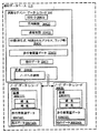
図1は、例示的な実施の形態によるパーソナル・デジタル・アシスタント(PDA)、携帯電話機、又は他のコンピュータなどの計算プラットホーム102に付随したナビゲーション・システム100のブロック図である。ナビゲーション・システム100は、ハードウェア及びソフトウェア部品の組合わせである。1つの実施の形態では、ナビゲーション・システム100は、プロセッサ104と、プロセッサ104に接続されたドライブ106と、ナビゲシーョン・アプリケーション・プログラム110と他の情報を記憶するための不揮発性メモリ記憶装置108とを含む。
I. Navigation System FIG. 1 is a block diagram of a navigation system 100 associated with a
また、ナビゲーション・システム100は、位置決めシステム112を含む。位置決めシステム112は、GPSタイプ技術、デッド・レコニング・タイプ・システム、又は、これら及び他のシステムの組合わせを使用することができる。これらは当業者に知られている。位置決めシステム112は移動距離速度、方向、オリエンテーション等を測定する適当な検知装置を含む。また、位置決めシステム112はGPSシステムを含むことができる。位置決めシステム112は、プロセッサ104へ信号を出力する。プロセッサ104上で走るナビゲーション・アプリケーション・ソフトウェア・プログラム110は、計算プラットホーム102の位置、方向、オリエンテーション等を決定するために位置決めシステム112からの信号を使用する。
The navigation system 100 also includes a positioning system 112. The positioning system 112 may use GPS type technology, dead reckoning type system, or a combination of these and other systems. These are known to those skilled in the art. Positioning system 112 includes suitable sensing devices for measuring travel distance speed, direction, orientation, and the like. The positioning system 112 can also include a GPS system. The positioning system 112 outputs a signal to the
また、ナビゲーション・システム100は、エンドユーザがナビゲーション・システム100へ情報を入力し、そしてナビゲーション・システム100から情報を得ることが可能なユーザ・インターフエイス114を含む。入力情報は、ナビゲーション特徴及びナビゲーション・システム100の機能への要求を含む。ナビゲーション特徴及び機能を提供するため、ナビゲーション・システム100は記憶媒体118上に記憶されている地理データベース116を使用する。1つの実施の形態では、記憶媒体118は、地理データベース116がナビゲーション・システム100に読み出されて使用されるためにドライブ106内に搭載される。1つの実施の形態では、地理データベース116は、米国イリノイ州シカゴ、NAVTEQノースアメリカLLCにより発行された地理データベースである。記憶媒体118及び地理データベース116は、ナビゲーション・システム100の場所に物理的に設けられる必要はない。代替的な実施の形態では、その上に地理データベース116の全体又は部分が記憶される記憶媒体118は、ナビゲーション・システム100の残りから遠くに離れていて、そして、必要に応じて通信システム120を経由して地理データの部分が提供される。
The navigation system 100 also includes a
例示的なタイプのシステムでは、ナビゲーション・アプリケーション・ソフトウェア・プログラム110は、不揮発性メモリ記憶装置108からプロセッサ104に付随したランダム・アクセス・メモリ(RAM)122へロードされる。また、プロセッサ104は、ユーザ・インターフエイス114から入力を受信する。ナビゲーション・システム100は、さまざまなナビゲーション特徴及び機能を提供するために、おそらく位置決めシステム112及び通信システム120からの出力と一緒に、記憶媒体118上に記憶された地理データベース116を使用する。ナビゲーション・アプリケーション・ソフトウェア・プログラム110は、さまざまなナビゲーション関連特徴及び機能を提供する別のアプリケーション(又は、サブプログラム)を含む。ナビゲーション機能及び特徴は、ルート計算124(出発点から目的地までのルートがここで決定される)、ルート案内126(所望の目的地へ到達するために詳細な指示がここで提供される)、地図表示128、及び位置決め130(例えば、地図一致)を含むことができる。
In an exemplary type of system, navigation application software program 110 is loaded from non-volatile memory storage 108 into random access memory (RAM) 122 associated with
他の機能及びプログラミング132を、ナビゲーション・システム100内に含むことができる。ナビゲーション・アプリケーション・ソフトウェア・プログラム110は、Cなどの適当なコンピュータ・プログラミング言語で書かれる。C++又はジャバなどの他のプログラミング言語も適当である。上述した全ての部品は従来技術(又は従来技術以外)であり、これらの部品の使用及び製造は当業者に知られている。 Other functions and programming 132 can be included in the navigation system 100. The navigation application software program 110 is written in a suitable computer programming language such as C. Other programming languages such as C ++ or Java are also suitable. All the parts described above are prior art (or non-prior art) and the use and manufacture of these parts are known to those skilled in the art.
II.地理データベース
エンドユーザにナビゲーション関連特徴と機能を提供するために、ナビゲーション・システム100は、地理データベース116を使用する。地理データベース116は、1つ又は複数の地理的領域に関する情報を含む。図2は、地理的領域202の地図200を示す。地理的領域202は、都市又は田舎領域、州、国、又は、それらの組合わせ、又は、その他の領域に対応する。地理的領域202内に位置するのは、道路、興味有る場所(ビジネス、市の施設等)、湖、川、鉄道、市役所等である。
II. Geographic Database In order to provide navigation-related features and functions to end users, the navigation system 100 uses a
また、図2は、地理的領域202の一部206の拡大地図204を含む。拡大地図204は、地理的領域202の道路ネットワークの一部を示す。道路ネットワーク208は、とりわけ、地理的領域202内に位置する道路及び交差点を含む。部分206に示されるように、地理的領域202内の各道路は、1つ又は複数の道路セグメント210から構成される。道路セグメント210は道路の一部を表す。各道路セグメント210は2つのノード212と関連付けられるように示される。1つのノードは道路セグメントの一端の点を表し、他のノードは道路セグメントの他端の点を表す。道路セグメント210のいずれの端のノード212は、道路が他の道路と会う場所、すなわち、交差点又は道路の行止まりである。
FIG. 2 also includes an
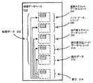
図3を参照すると、地理データベース116が図2に示された地理的領域202内の物理的地理特徴のいくつかを表すデータを含む。地理データベース116に含まれたデータ302は、道路ネットワーク208を表すデータを含む。図3の実施の形態において、地理的領域202を表す地理データベース116は、地理的領域202中の各道路セグメント210について少なくとも1つの道路セグメント・データベース・レコード304(また、「エンティテイ」又は「項目」とも言う)を含む。また、地理的領域202を表す地理データベース116は、地理的領域202中の各ノード212についてノード・データベース・レコード306(「エンティテイ」又は「項目」)を含む。「ノード」及び「セグメント」の用語は、これら物理的地理特徴を記述するための1つの用語を表すに過ぎず、これらの特徴を記述するための他の用語もこれらの観念の範囲内に含まれることを意図している。
Referring to FIG. 3, the
また、地理データベース116は、他の種類のデータ312も含む。他の種類のデータ312は、他の種類の地理的特徴又はその他を表す。他の種類のデータは興味有る場所のデータを含む。例えば、興味有る場所のデータは、タイプ(例えば、レストラン、ホテル、市役所、警察署、史跡、ATM、ゴルフコースなどの興味有る場所のタイプ)、興味有る場所の位置、電話番号、営業時間等を含んだ興味有る場所のレコードを含む。また、地理データベース116は、索引314を含む。索引314は、異なるタイプのデータを互いに関連付ける又は地理データベース116中に含まれるデータの他の観点に関連付けるさまざまなタイプの索引を含む。例えば、索引314はノード・データ・レコード306中のノードを道路セグメント・データ・レコード304中の道路セグメントの端点と関連付ける。別の例では、索引314は、その他のデータ・レコード312中の興味有る場所をセグメント・データ・レコード304中の道路セグメントと関連付ける。
The
図4は、地理データベース116内に含まれる道路セグメント・データ・レコード304の成分のいくつかを示す。道路セグメント・データ・レコード304は、地理データベース116内でデータ・レコードを識別することができるセグメントID304(1)を含む。各道路セグメント・データ・レコード304は、表される道路セグメントの特徴を記述する情報(「属性」、「フィールド」等)と関連付けられている。道路セグメント・データ・レコード304は、表される道路セグメントについて許される乗物の走行方向に関する制限があればそれを含んだ制限を示すデータ304(2)を含むことができる。道路セグメント・データ・レコード304は、表される道路セグメントについて速度制限又は速度分類(すなわち、自動車の走行の最大許容速度)を示すデータ304(3)を含む。また、道路セグメント・データ・レコード304は、表される道路セグメントがアクセスが制御される道路(高速道路など)の部分か、アクセスが制御される道路へのランプか、トンネルか、有料道路か、フェリーか、等を示すデータ304(4)を含むことができる。
FIG. 4 shows some of the components of the road
また、道路セグメント・データ・レコード304は、表される道路セグメントの終端の地理座標(例えば、緯度及び経度)を提供するデータ304(6)を含む。1つの実施の形態では、データ304(6)は表される道路セグメントの終端に対応したノードを表すノード・データ・レコード306への参照である。
The road
また、道路セグメント・データ・レコード304は、表される道路セグメントのさまざまな他の属性に関連する他のデータ304(7)を含むか又は関連付けられている。道路セグメントに関連付けられているさまざまな属性は、単一の道路セグメント・レコード内に含まれるか、又は、互いに相互参照する複数のタイプのレコード内に含まれることができる。例えば、道路セグメント・データ・レコード304は、道路セグメントにより表されるロード部分の端の交差点に対応する各ノードにおいて右折又は左折禁止制限が存在するかについて識別するデータ、表される道路を示す名前、表される道路に沿う通り住所範囲等を含む。
The road
また、図4は、地理データベース116内に含まれるノード・データ・レコード306の成分のいくつかを示す。ノード・データ・レコード306の各々は、それに接続する道路セグメント及び/又はその地理的位置(例えば、その経度及び緯度座標)の識別を可能にする関連情報(「属性」、「フィールド」等)を持つことができる。図4に示された実施の形態については、ノード・データ・レコード306(1)及び306(2)はそれらのノードについて経度及び緯度座標306(1)(1)及び306(2)(1)を含む。また、ノード・データ・レコード306(1)及び306(2)はノードの他のさまざまな属性に関連する他のデータ306(1)(3)及び306(2)(3)を含む。
FIG. 4 also shows some of the components of the
III.歩行者データの収集
図2を参照すると、示された地理的領域202の拡大部分206が道路ネットワーク208の一部及び公園214の一部を含む。1つの実施の形態では、ナビゲーション・システム100は、トラック、自動車、又は、モーターサイクルなどの動力車を運転するユーザへナビゲーション関連特徴及び機能を提供する。この実施の形態については、ナビゲーション・システム100は、ルート計算及び道路案内などのナビゲーション関連特徴及び機能を提供するために地理データベース116内の道路ネットワーク208を表すデータを利用する。例えば、ルート計算アプリケーションは、出発点から目的地までの連続したナビゲート可能ルートを複数の道路セグメント・エンティテイを識別するオーダー・リストとして提供する。道路案内アプリケーションは、計算されたルートに従うために道路ネットワークに沿った運転指示を提供する。
III. Pedestrian Data Collection Referring to FIG. 2, an
別の実施の形態では、ナビゲーション・システム100は、歩行者など、自動車を運転しないユーザへナビゲーション関連特徴及び機能を提供する。例えば、歩行者は道路ネットワーク208上のみを移動するとは限定されない。むしろ、歩行者は関連する道路ネットワークのない公園及び公的広場を通り抜けることができる。さらに、歩行者は自動車のように歩行制限を持たない。歩行者は一方通行の道を両方向へ歩くことができる。さらに、歩行者は移動の大きな自由度を持ちより頻繁に彼等のオリエンテーションについて混乱を生ずる。
In another embodiment, the navigation system 100 provides navigation-related features and functions to users who do not drive a car, such as pedestrians. For example, a pedestrian is not limited to moving only on the
図5は、図2の地理的領域202内の公園214の部分を示す。歩行者がナビゲーション・システム100から彼又は彼女の現在位置502よりカフェ504へのルートを要求していると仮定する。もし、ナビゲーション・システム100が道路ネットワーク208のみを使用してルートを計算する場合、カフェ504へのルートはノード514と516で左折をする連続した道路セグメント506、508、510及び512を含む。しかし、歩行者は公園を通り抜けることができるから、より直接でより短いルートが可能である。ナビゲーション・システム100が改良された歩行者ルートを提供できるようにするため、地理データベース開発者は、歩行者及び他のユーザへナビゲーション関連特徴及び機能を提供するために有用な地理的領域の地理的特徴に関する情報を収集する。1つの実施の形態では、地理調査者が、歩行者にナビゲーション関連特徴及び機能を提供するために有用な地理的特徴に関する情報(以下、「歩行者データ」)を収集するために地理的領域を旅行する。別の実施の形態では、地理調査者が歩行者データを収集するために航空写真を使用する。
FIG. 5 shows a portion of the
A.未組織化地理的範囲について歩行者データの収集
未組織化地理的範囲とは、基礎に有る道路及び経路への組織化を欠いた地理的範囲である。すなわち、未組織化地理的範囲とは、地表と対照的な、コンクリート上のペンキ道又は草原を通る未舗装道など、舗装により幾何学的にマークされた路又は道を含まない。例えば、図5に示された公園は、舗装又は未舗装の確立された道518及び520を含む。しかし、公園はまた、草地など道がなくとも歩行者が歩くことができる、未組織化部分522を含む。
A. Collecting Pedestrian Data for Unorganized Geographic Ranges An unorganized geographical range is a geographical range that lacks organization into the underlying roads and routes. That is, unorganized geographic coverage does not include roads or roads that are geometrically marked by pavement, such as paint roads on concrete or unpaved roads through grassland, as opposed to the ground. For example, the park shown in FIG. 5 includes paved or unpaved established
図6は、例示的な実施の形態による未組織化地理的範囲について歩行者データを収集するためのフローチャート600を示す。図6のステップは、図5中の公園214の未組織化地理的範囲522を使用して説明される。ステップ600で、地理調査者が、仮想歩行者ネットワークについて適当な未組織化地理的範囲の部分を識別する。仮想歩行者ネットワークは道路ネットワーク208に類似している。道路ネットワーク208は、道路セグメント及びノードを含むが、仮想歩行者ネットワークは仮想歩行者セグメントとオリエンテーション・ノードとを含む。自動車が出発地から目的地まで道路ネットワーク208上を案内されるのに対して、歩行者又は他のユーザは出発地から目的地まで道路ネットワーク又は確立された路が無い未組織化地理的範囲を横断する仮想歩行者ネットワーク上を部分的または全体的に案内される。1つの実施の形態では、地理調査者は、歩行者が容易に横断できる未組織化地理的範囲を決定すること、歩行者が未組織化地理的範囲を横断することにより移動時間及び/又は移動距離を減少できること、及び/又は、歩行者が未組織化地理的範囲内の興味ある場所又は特徴へ案内されることを望むこと、を決定することにより、仮想歩行者ネットワークについて適当な未組織化地理的範囲の部分を識別できる。
FIG. 6 shows a
地理調査者が一旦、仮想歩行者ネットワークについて適当な未組織化地理的範囲の部分を識別すると、地理調査者は一連の相互接続された仮想歩行者セグメント及び関連するオリエンテーション・ノードを識別する。仮想歩行者セグメントの各々は2つのオリエンテーション・ノードに関連する。1つのオリエンテーション・ノードは仮想歩行者セグメントの一端を表し、そして他のオリエンテーション・ノードは仮想歩行者セグメントの他端を表す。仮想歩行者セグメントのいずれの端のオリエンテーション・ノードは、興味ある場所又は仮想歩行者セグメントの行止まりにおいて、仮想歩行者セグメントが別の仮想歩行者セグメントに会う位置、仮想歩行者セグメントが道路セグメントに会う場所、仮想歩行者セグメントが組織化地理的範囲の道に関連した歩行者セグメントに会う場所、に対応する。 Once the geographer identifies a portion of the appropriate unorganized geographic area for the virtual pedestrian network, the geographer identifies a series of interconnected virtual pedestrian segments and associated orientation nodes. Each virtual pedestrian segment is associated with two orientation nodes. One orientation node represents one end of the virtual pedestrian segment and the other orientation node represents the other end of the virtual pedestrian segment. The orientation node at either end of the virtual pedestrian segment is the location where the virtual pedestrian segment meets another virtual pedestrian segment at the location of interest or the end of the virtual pedestrian segment, and the virtual pedestrian segment is the road segment. Corresponds to a meeting place, a place where a virtual pedestrian segment meets a pedestrian segment associated with a road in an organized geographic area.
図6を参照すると、ステップ602おいて、地理調査者はオリエンテーション・ノードを識別する。オリエンテーション・ノードの場所は、歩行者にオリエンテーションを提供するために容易に説明できる場所に選択される。1つの実施の形態では、オリエンテーション・ノードは歩行者により視覚的に識別できる場所に選択される。図5に示される例示的な実施の形態では、オリエンテーション・ノード524は、彫像526の近くに位置する。彫像526は歩行者により視覚的に容易に観察される顕著な特徴である。さらに、馬上の人物の彫像など、彫像526の簡潔で明確な説明が歩行者へのオリエンテーションで提供される。
Referring to FIG. 6, at
ステップ604において、調査者がオリエンテーション・ノードの属性情報を収集する。属性情報は、オリエンテーション・ノードの場所及び周囲の特徴を特徴付ける記述の言葉を含む。例えば、オリエンテーション・ノード524については、馬上の彫像の人物などである。また、属性情報は、オリエンテーション・ノード524の経度及び緯度位置を含む。位置決めシステムは、オリエンテーション・ノードの経度及び緯度位置を決定するために使用できる。位置決めシステムは、GPSタイプ技術、デッド・レコニングタイプ・システム、又は、これら又は他のシステムの組合わせを使用でき、全て既知の技術である。位置決めシステムは、GPS信号を獲得するため、システムの移動距離、速度、方向等を測定するため、適当な検出装置を含む。代替的に、地理的範囲の空中写真がオリエンテーション・ノードの場所を決定するために使用できる。
In
収集できるオリエンテーション・ノードの別の属性情報は、車椅子アクセス可能性、子供向き、ペット可、明るい領域、暗い領域、賑やかな場所、賑やかでない場所、うるさい/静かな、悪臭/汚染、雨から保護された、雨から保護されない、バイク禁止、並木道、舗装領域、未舗装領域、草地、砂利、土、濡れた時に泥、及び、その他の属性情報を含む。地理調査者は、筆記、音声録音、ユーザ装置へのデータ入力等、いずれのデータ収集方法を使用して属性情報を記録する。1つの実施の形態では、調査者はデジタル・カメラにより周囲の領域を含むオリエンテーション・ノードの映像を得る。さらに、調査者は、オリエンテーション・ノードについて、図8を参照して、以下に説明するように案内情報を収集する。 Additional orientation node attribute information that can be collected is wheelchair accessibility, children friendly, pets allowed, bright areas, dark areas, lively places, no busy places, noisy / quiet, odor / contamination, rain protected In addition, it is not protected from rain, includes bike prohibition, tree-lined roads, paved areas, unpaved areas, grassland, gravel, soil, mud when wet, and other attribute information. The geographer records the attribute information using any data collection method such as writing, voice recording, and data input to the user device. In one embodiment, the investigator obtains an orientation node image that includes the surrounding area with a digital camera. Further, the investigator collects guidance information for the orientation node as described below with reference to FIG.
1つの実施の形態では、調査者は、オリエンテーション・ノードが道路ネットワーク208に近いかどうかを示す接続情報を収集する。もし、オリエンテーション・ノードが道路ネットワーク208に近い場合、調査者はオリエンテーション・ノードに近い道路ノードを識別する。別の実施の形態では、調査者は接続情報について道路セグメントを識別することができる。調査者は、接続情報を通りの住所、道路ノード又は道路セグメントの名前又はID、識別された道路セグメントに沿ってノードからの距離、2つの識別された道路セグメントの交差点、興味ある場所の形式又は他の適当な形式で記録できる。図5に示された例について、調査者はオリエンテーション・ノード524が道路セグメント506に接続することを識別する接続情報を記録する。もし、オリエンテーション・ノードが道路ネットワークに近くない場合、調査者はそのような識別を記録する。
In one embodiment, the researcher collects connection information indicating whether the orientation node is close to the
ステップ606において、地理調査者は別のオリエンテーション・ノードを識別する。第2オリエンテーション・ノード528は、歩行者にオリエンテーションを提供するために容易に説明できる別の場所が選択される。さらに、第2オリエンテーション・ノードは、歩行者が第1オリエンテーション・ノード場所から第2オリエンテーション・ノード場所へ指示される場所に選択される。1つの実施の形態では、第2オリエンテーション・ノードは、歩行者が第1オリエンテーション・ノードの場所から第2オリエンテーション・ノードの場所を視覚的に識別できるように、第1オリエンテーション・ノードからある距離に選ばれる。別の実施の形態では、第2オリエンテーション・ノード場所は第1オリエンテーション・ノード場所からは視界が遮られている又は視覚的に識別できなくてよい。例えば、歩行者はある距離だけ、例えば、湖の方向などへ、歩くことが指示されて、ある距離だけ歩くと、第2オリエンテーション・ノードが見える。
In
図5に示される例示的な実施の形態について、第2オリエンテーション・ノード528は、バーベキュー場530の近くに位置する。バーベキュー場530は、歩行者により容易に視覚的に観察できる顕著な特徴である。さらに、バーベキュー場530の明確で簡潔な説明、例えば、ピザ・オーブン特徴を持った石バーベキュー場など、が歩行者のオリエンテーションに提供される。ステップ608において、調査者は第1オリエンテーション・ノード524について上述した同様の方法でオリエンテーション・ノードの属性情報を収集する。
For the exemplary embodiment shown in FIG. 5, the
ステップ610において、調査者は仮想歩行者セグメント532を識別する。仮想歩行者セグメント532は、歩行者が第1オリエンテーション・ノード524から第2オリエンテーション・ノード528へ有ることができる未組織化部分522上に人工的に生成されたセグメントである。仮想歩行者セグメントを識別する時、地理調査者は歩行者が第1から第2オリエンテーション・ノードまで妨害されずに歩くことができることを保証する。例えば、地理調査者は崖の上を行くような仮想歩行者セグメントを識別しない。
In
ステップ612で、調査者は仮想歩行者セグメントの属性情報を収集する。属性情報は、仮想歩行者セグメント及びいずれの周囲の特徴を特徴付ける説明的言葉を含む。例えば、仮想歩行者セグメント532は、「池をあなたの右/左側に見る(維持する)」として説明される。また、属性情報は、50メートルなどの仮想歩行者セグメントの長さ又は距離、又は、仮想歩行者セグメントを歩く推定移動時間を含むことができる。収集される仮想歩行者セグメントの他の属性情報は、車椅子アクセス可能性、子供向き、ペット可、明るい領域、暗い領域、賑やかな領域、賑やかでない領域、騒々しい、静か、悪臭/汚染、雨よけがある、雨よけがない、バイク禁止、並木道、舗装領域、未舗装領域、草地、砂利地、裸地、濡れた時に泥地、丘、階段、起伏のある地形、勾配、及び、その他の属性情報を含む。さらに、調査者は、バイク・ラック、水のみ場、トイレット、史跡、レクレーション施設、及び興味ある場所への入り口の位置を含む仮想歩行者セグメントに近い興味ある場所に関する情報を収集する。さらに、調査者は、仮想歩行者セグメントを製図的に表す形状の点として使用するために、仮想歩行者セグメントに沿った位置データを集める。1つの実施の形態では、調査者は、デジタル・カメラにより周囲の領域を含む仮想歩行者セグメントの映像を獲得できる。さらに、調査者は仮想歩行者セグメントについて図8と関連して以下に詳細に説明するような案内情報を収集する。
In
図5を参照すると、調査者は未組織化範囲522について仮想歩行者セグメント及びオリエンテーション・ノードを識別し続ける。例えば、別のオリエンテーション・ノード534がテニスコート536近辺に識別される。そして、別の仮想歩行者セグメント538がオリエンテーション・ノード528をオリエンテーション・ノード534と接続する。さらに、別のオリエンテーション・ノード540がカフェ504と駐車場542との近くに識別される。そして、別の仮想歩行者セグメント544がオリエンテーション・ノード534をオリエンテーション・ノード540と接続する。
Referring to FIG. 5, the investigator continues to identify virtual pedestrian segments and orientation nodes for the
代替的な実施の形態では、未組織化地理的領域についての歩行者データを収集するステップが、図6に示されたのと異なる順序で実行される。別の実施の形態では、調査者は第1オリエンテーション・ノードを識別し、第1オリエンテーション・ノードからの仮想歩行者セグメントを識別し、そして仮想歩行者セグメントを完成する第2オリエンテーション・ノードを識別する。さらに、別の実施の形態では、調査者は仮想歩行者セグメントを識別し、そして仮想歩行者セグメントに沿ったオリエンテーション・ノードを識別する。例えば、調査者は、最初に湖岸に沿った仮想歩行者セグメントを識別し、そして、仮想歩行者セグメント間のオリエンテーション・ノードを識別することにより、湖岸に沿った景観歩道用の歩行者データを収集する。 In an alternative embodiment, the steps for collecting pedestrian data for unorganized geographic regions are performed in a different order than that shown in FIG. In another embodiment, the investigator identifies a first orientation node, identifies a virtual pedestrian segment from the first orientation node, and identifies a second orientation node that completes the virtual pedestrian segment. . Further, in another embodiment, the investigator identifies a virtual pedestrian segment and identifies an orientation node along the virtual pedestrian segment. For example, the investigator collects pedestrian data for landscape trails along the lake shore by first identifying virtual pedestrian segments along the lake shore and then identifying the orientation nodes between the virtual pedestrian segments To do.
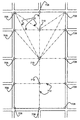
図7Aは、別の未組織化地理的範囲700を示す。未組織化範囲700は、市中心部の広場である。いくつかの道路セグメント704とノード706とを含む道路ネットワーク702の一部が広場700を取囲む。広場700は、舗装されていてもよいが、ペンキの印による道又は対照的な舗装レンガにより印付けられた道などの、基礎的な道に組織化されていない。道への組織化は無いが、歩行者は広場を自由に通り抜けることができる。1つの実施の形態では、調査者は図6と関連して上述したのと同じ方法で広場700について歩行者データを収集する。図7Aの例示的な実施の形態については、調査者は、鉾者が容易に広場700を横断でき、そして歩行者が広場700を横断することにより移動距離及び/又は移動時間を短縮できるので、広場の未組織化地理的範囲700を仮想歩行者ネットワークとして適当であると識別する。
FIG. 7A shows another unorganized
歩行者データを収集するため、調査者は公園700の境界の交差する道路セグメント702と関連する道路ネットワーク・ノード706に近接したオリエンテーション・ノード708を識別する。図7Bは、広場700の境界の交差点の道路ノード706に近接したオリエンテーション・ノード708を示す。また、調査者は各オリエンテーション・ノード708の属性情報を収集する。属性情報は、対応する交差点の通りの名前、通りの住所、顕著な建物の説明、オリエンテーション・ノードに近い興味ある場所又は顕著な場所等の、オリエンテーション・ノードの場所及び周囲の特徴を特徴付ける言葉を含む。さらに、収集された属性情報は経度及び緯度位置を含む。車椅子アクセス可能性、子供向き、ペット可、明るい領域、暗い領域、賑やかな領域、賑やかでない領域、騒々しい、静か、悪臭/汚染、雨よけがある、雨よけがない、バイク禁止、並木道、舗装領域、未舗装領域、草地、砂利地、裸地、濡れた時に泥地、日除けあり、ショッピング・ゾーン、縁石切除、横断歩道、及びその他の属性情報を含むオリエンテーション・ノードの他の情報が収集される。1つの実施の形態では、調査者はデジタル・カメラによりそれぞれの周囲の領域を含むオリエンテーション・ノードの映像を獲得する。
To collect pedestrian data, the researcher identifies an
図7A及び図7Bの例示的な実施の形態について、また、調査者は広場700の中心内のオリエンテーション・ノードを識別する。調査者は、広場700の中心位置のオリエンテーション・ノード710を識別する。また、調査者は、各オリエンテーション・ノード710について属性情報を収集する。属性情報は、オリエンテーション・ノードの位置及び、バンド・ハビリオン、大きな噴水、禿げた男の彫像、顕著な建物、又は、その他の特徴などの周囲の特徴を特徴付ける言葉を含む。さらに、収集された属性情報は、経度及び緯度位置、及びオリエンテーション・ノード708について上述したような他の情報を含む。
For the exemplary embodiment of FIGS. 7A and 7B, the investigator also identifies an orientation node within the center of the square 700. The researcher identifies the
図7A及び図7Bの例示的な実施の形態について、また、調査者は、広場700内の識別されたオリエンテーション・ノード708及び710間の仮想歩行者セグメント712を識別する。調査者は、2つのオリエンテーション・ノード708と710との間を接続する仮想歩行者セグメントを識別する。仮想歩行者セグメントが各オリエンテーション・ノード間に確立される。しかし、季節的なカフェの座席などにより、いくつかのオリエンテーション・ノード間の道が封鎖されるかもしれないため、いくつかのオリエンテーション・ノード間のみに仮想歩行者セグメントを確立するように決定してもよい。また、調査者は各仮想歩行者セグメント712の各々について属性情報を収集する。属性情報は、仮想歩行者セグメント及びいずれの周囲の特徴を特徴付ける説明的言葉を含む。さらに、収集された属性情報は、仮想歩行者セグメントのおおよその長さ、又は上述したようなその他の属性情報を含む。1つの実施の形態では、調査者は、デジタル・カメラによりそれらの周囲の領域を含む仮想歩行者セグメントの映像を獲得する。図7Bを参照すると、調査者がオリエンテーション・ノード708及び710と仮想歩行者セグメント712を識別した後、仮想歩行者ネットワークは歩行者が案内されることのできるナビゲート可能な結合構造を提供する。
For the exemplary embodiment of FIGS. 7A and 7B, the investigator also identifies a
B.組織化地理的範囲について歩行者データの収集
組織化地理的範囲は、道路及び道に組織化されている基礎を持つ地理的範囲である。例えば、図5に示されている公園は、舗装又は未舗装の、確立された道518及び520を含む。地理調査者は、基礎の組織を使用する歩行者ネットワークを提供するため歩行者データを収集する。歩行者ネットワークは、道路ネットワーク208と類似する。道路ネットワーク208が道路セグメントとノードを含むのに対して、歩行者ネットワークは既存の路に従う歩行者セグメントと既存の路上又はその近くのオリエンテーション・ノードを含む。自動車は出発地から目的地まで道路ネットワーク208上のルートを案内されるのに対して、歩行者は既存の又は確立された路を使用して組織化地理的範囲を横断する歩行者ネットワーク上のルートを部分的に又は全体的に出発地から目的地を案内される。歩行者ネットワークを開発するために、地理調査者は一連の相互接続された歩行者セグメント及び関連したオリエンテーション・ノードを識別する。各歩行者セグメントは、2つのオリエンテーション・ノードと関連する。1つのオリエンテーション・ノードは歩行者セグメントの一端を表し、他のオリエンテーション・ノードは歩行者セグメントの他端を表す。歩行者セグメントのいずれの端のオリエンテーション・ノードは、興味ある場所又は歩行者セグメントの行止まりで、歩行者セグメントが別の歩行者セグメントに会う位置、歩行者セグメントが道路セグメントに会う場所、歩行者セグメントが仮想歩行者セグメントに会う場所に対応する。
B. Collecting pedestrian data for an organized geographic area An organized geographic area is a geographical area with a foundation organized into roads and roads. For example, the park shown in FIG. 5 includes established
図8は、例示的な実施の形態による組織化地理的範囲について歩行者データを収集するためのフローチャートである。図8のステップは、図5の公園214の確立された路518と520を使用して説明される。1つの実施の形態では、地理調査者は歩行者データを収集するために路518と520を歩く。ステップ800で、地理調査者は、既存の路518についてオリエンテーション・ノードを識別する。オリエンテーション・ノードの位置は、歩行者へのオリエンテーションを提供するために説明し易い位置に選ばれる。1つの実施の形態では、オリエンテーション・ノードが2つ又はそれ以上の確立した路の交差点で提供される。1つの実施の形態では、オリエンテーション・ノードは歩行者により視覚的に識別できる場所が選ばれる。図5中の例示的な実施の形態では、オリエンテーション・ノード548は公園の入口ゲート550の近くに位置する。入口ゲート550は歩行者により容易に視覚的に観察される顕著な特徴である。さらに、X通りから公園への入口ゲートなどの、入口ゲート550の明確で簡潔な説明が、歩行者へのオリエンテーションとして提供される。
FIG. 8 is a flow chart for collecting pedestrian data for an organized geographic area according to an exemplary embodiment. The steps of FIG. 8 are described using established
ステップ802で、調査者はオリエンテーション・ノードの属性情報を収集する。また、属性情報はオリエンテーション・ノードの経度及び緯度位置を含む。位置決めシステムがオリエンテーション・ノードの経度及び緯度位置を決定するために使用できる。位置決めシステムは、GPSタイプ技術、デッド・レコニングタイプ・システム、又はこれら又は他のシステムの組合わせを利用し、これらの全ては既知である。位置決めシステムは、GPS信号を獲得して、システムの移動距離、速度、方向等を測定するための適当な検出装置を含む。代替的に、オリエンテーション・ノードの位置を決定するために範囲の航空写真が使用できる。車椅子アクセス可能性、子供向き、ペット可、明るい領域、暗い領域、賑やかな領域、賑やかでない領域、騒々しい、静か、悪臭/汚染、雨よけがある、雨よけがない、バイク禁止、並木道、舗装領域、未舗装領域、草地、砂利地、裸地、濡れた時に泥地、及びその他の属性情報を含むオリエンテーション・ノードの他の属性情報が収集される。地理調査者は、手書き、音声録音、ユーザ装置へのデータ入力などのいずれかのデータ収集方法を使用して、属性情報を記録できる。
In
ステップ804で、調査者はオリエンテーション・ノードについて案内情報を収集する。案内情報は、例えば、オリエンテーション・ノード548について、X通りから公園への入口ゲートなどの、オリエンテーション・ノードの位置及びいずれの周囲の特徴を特徴付ける説明を含む。これらの説明の言葉はオリエンテーション・ノードについての名前として使用される。1つの実施の形態では、調査者はオリエンテーション・ノードの位置から見える特徴の名前としてオリエンテーション・ノードの名前を収集する。図5に示された例については、オリエンテーション・ノードについての名前は、「X通りから公園への入口ゲート」である。1つの実施の形態では、調査者は、オリエンテーション・ノード名前又は説明の言葉に関する季節的な制限又は時刻を識別する。例えば、夜間又は凍るような冬の間は、入口ゲートは歩行者に容易に視覚されないだろう。地理調査者は、時間及び季節の適当な代替を記録してもよい。
At
調査者により収集される追加的な案内情報は、計算された角度データである。すなわち、調査者は、2つ又はそれ以上の歩行者セグメントの交差点などにおいて、オリエンテーション・ノードで方向指示が実行されるどうかを指示する。もし、方向指示がオリエンテーション・ノードにおいて実行される場合、ルート案内特徴は方向指示角度を計算しなければならない。図5中のオリエンテーション・ノード548について、調査者は計算角度データについてイエスを示す。さらに、調査者は解説データを収集する。すなわち、オリエンテーション・ノードの位置及びいずれの周囲の特徴を特徴付ける説明的言葉が、方向指示を実行する場所を指示するために役立つか、又は、オリエンテーション・ノードを通過するルート上で歩行者を案内する時に歩行者が位置する場所を指示するのに役立つことを示す。図5の例については、調査者は、オリエンテーション・ノード548において「入口ゲートにおいて」が歩行者に有用な案内を提供することを示す「において」説明データについてイエス指示を記録する。1つの実施の形態では、調査者はデジタル・カメラによりオリエンテーション・ノード548とその周囲の映像を獲得する。
Additional guidance information collected by the investigator is calculated angle data. That is, the investigator indicates whether direction indication is performed at the orientation node, such as at the intersection of two or more pedestrian segments. If the direction indication is performed at the orientation node, the route guidance feature must calculate the direction indication angle. For
1つの実施の形態では、また、調査者は、オリエンテーション・ノードが道路ネットワーク208に近接しているかどうかを示す接続情報を収集する。もし、オリエンテーション・ノードが道路ネットワーク208に近接しているならば、調査者はオリエンテーション・ノードに近い道路ノードを識別する。別の実施の形態では、調査者は接続情報のために道路セグメントを識別する。調査者は、接続情報を、通りの住所、道路セグメント又は道路ノードのID又は名前、識別された道路セグメントに沿ったノードからの距離、2つの識別された道路セグメントの交差、興味ある場所の形式、又は、他の適当な形式で記録できる。もし、オリエンテーション・ノードが道路ネットワークに近くになければ、調査者はそのような指示を記録する。
In one embodiment, the investigator also collects connection information that indicates whether the orientation node is in proximity to the
ステップ806で、調査者は歩行者セグメントを識別する。図5を参照すると、歩行者セグメント552は確立された路518の一部である。ステップ808で、調査者は歩行者セグメント552の属性情報を収集する。また、属性情報は、歩行者セグメント552に沿った形状点の経度及び緯度位置を含む。また、属性情報は、50メートル又は歩行者セグメントを歩く推定移動時間など、歩行者セグメントの距離又は長さを含む。車椅子アクセス可能、子供向き、ペット可、明るい領域、暗い領域、賑やかな領域、賑やかでない領域、騒々しい、静か、悪臭/汚染、雨よけがある、雨よけがない、バイク禁止、並木道、舗装領域、未舗装領域、草地、砂利地、裸地、濡れた時に泥地、丘、階段、起伏のある地形、勾配、及び、その他の属性情報を含む、歩行者セグメントの他の属性情報が収集されてもよい。さらに、調査者は、バイク・ラックの位置、水のみ場、トイレット、史跡、リクレーション施設、興味ある場所への入口、又はその他の情報を含む歩行者セグメントに近い興味ある場所に関する情報を収集する。さらに、調査者は、製図的に歩行者セグメントを表すために形状点として使用されるべき歩行者セグメントに沿って位置データを収集する。1つの実施の形態では、調査者はデジタル・カメラにより歩行者セグメント552及びその周囲の映像を獲得する。
At
ステップ810で、調査者は歩行者セグメント552についての案内情報を収集する。案内情報は歩行者セグメント及びいずれの周囲の特徴を特徴付ける説明的な言葉を含む。これらの説明的な言葉は、歩行者セグメントの名前として使用される。1つの実施の形態では、調査者は路から見ることのできる特徴の名前として歩行者セグメントの名前を収集する。1つの実施の形態では、見ることのできる特徴は、路自身以外の容易に識別できる地理的特徴である。1つの実施の形態では、調査者は歩行者セグメントの文章説明のために所定の文句のリストを使用する。表Iは、例示的な実施の形態による歩行者セグメントを特徴付ける説明的言葉を収集するために調査者が使用する文句をリストする。追加的な文句が表Iにリストされている以外に使用できる。
At
表I:

図5を参照すると、調査者は、「<池>を左手に見る」を歩行者セグメント552及び/又はその周囲を特徴付ける説明的言葉として収集する。すなわち、歩行者セグメント522からの視覚できる特徴の名前は、「池」であり、そして、視覚できる特徴と一緒に文句「<空白>を左手に見る」が歩行者セグメント552の文章説明を提供する。別の実施の形態では、調査者は、「20メートルを歩いて自転車道を横断する」など、文句の1つを参照することなく、歩行者セグメントのより詳細な文章説明を収集できる。1つの実施の形態では、調査者は、説明的な言葉又はセグメント名前に関する季節的制限又は時刻を識別できる。例えば、夜間又は厳冬期の間、池は歩行者には見えないであろう。地理調査者は適当な代替の時間と季節を記録できる。
Referring to FIG. 5, the investigator collects “Look at <pond> on the left” as descriptive words characterizing the
また、調査者は案内情報として私の後についてのデータを記録できる。すなわち、次の歩行者セグメント558を記述する前に歩行者セグメント552を説明するかどうかは、その歩行者セグメントから次の歩行者セグメントへ通過する路上の歩行者をオリエンテーイングするのに役立つ。図5の例について、調査者は、歩行者セグメント552のセグメント名前が、次の歩行者セグメント558のそのセグメント名前も「<空白>を左手に見る」と同じであるため、私の後に続けデータの「<空白>を左手に見る」は有用なオリエンテーションを提供するものではないため、指示を記録しない。私の後に続けのデータの積極的な指示の例は、「歩行者橋の後」である。
Also, the investigator can record data about me as guidance information. That is, whether the
さらに、調査者は、ノードを説明しないデータの案内情報を収集する。1つの実施の形態では、歩行者セグメントと関連するオリエンテーション・ノード又は端点の1つは参照ノードに指定される。他の端点又はオリエンテーション・ノードは非参照ノードに指定される。1つの実施の形態では、参照ノードは、位置が最も南及び西にあるオリエンテーション・ノードである。説明しない参照ノード・データについて、調査者は、歩行者セグメントを通過するルート上の歩行者を案内する時に、参照オリエンテーション・ノードのオリエンテーション名前が役立たないかどうかを指示する。図5中の歩行者セグメント552について、調査者はオリエンテーション・ノード548の名前「入口ゲート」を説明することが有用であることの指示を記録しない。また、調査者は説明しない非参照ノード・データの案内情報を収集する。説明しない非参照ノード・データについて、調査者は、歩行者セグメントを通過するルート上の歩行者を案内する時に、非参照オリエンテーション・ノードのオリエンテーション名前が役立たないかどうかを指示する。図5中の歩行者セグメント552について、調査者はオリエンテーション・ノード554の名前「水のみ場」を説明することが有用であることの指示を記録しない。
Further, the investigator collects data guidance information that does not explain the node. In one embodiment, one of the orientation nodes or endpoints associated with the pedestrian segment is designated as a reference node. Other endpoints or orientation nodes are designated as non-reference nodes. In one embodiment, the reference node is the orientation node that is located most south and west. For non-explained reference node data, the investigator indicates whether the orientation name of the reference orientation node is not useful when guiding a pedestrian on a route that passes through the pedestrian segment. For the
1つの実施の形態では、調査者は歩行者セグメントの幾何形状を表示するデータを獲得する。歩行者セグメントの幾何形状は航空又は衛星写真から得られる。代替的に、調査者は位置決めシステムを用いて歩行者セグメントに沿ったいくつかの場所で経度及び緯度位置を収集してもよい。1つの実施の形態では、歩行者セグメントの幾何形状は、角度イン及び角度アウトデータの案内情報を計算するために使用される。角度インデータは、参照オリエンテーション・ノード548での歩行者セグメントの初期一般方向を示し、角度アウトデータは非参照オリエンテーション・ノード554での歩行者セグメントの終了一般方向を示す。別の実施の形態では、調査者は、彼又は彼女が歩行者セグメントを移動する時に角度イン及び角度アウト情報を記録する。歩行者セグメント552について、調査者は角度インをほぼ真東と記録し、角度アウトをほぼ真東と記録する。
In one embodiment, the investigator obtains data representing the pedestrian segment geometry. The geometry of the pedestrian segment can be obtained from aerial or satellite photographs. Alternatively, the investigator may collect longitude and latitude locations at several locations along the pedestrian segment using a positioning system. In one embodiment, the pedestrian segment geometry is used to calculate angle-in and angle-out data guidance information. The angle-in data indicates the initial general direction of the pedestrian segment at the
また、調査者は上の記録された案内情報が方向に敏感かどうかを決定する。例えば、図5中の歩行者セグメント552の案内情報は方向に敏感である。歩行者セグメント552に沿って一方向へ移動する場合、歩行者セグメント名前は、「<池>を左手に見る」であり、歩行者セグメントに沿って反対方向へ移動する場合、歩行者セグメント名前は、「<池>を右手に見る」である。1つの実施の形態では、もし、歩行者セグメントが方向に敏感である場合、調査者は反対方向に歩く歩行者のために上述した別の案内データを収集する。1つの実施の形態では、また、調査者はデジタル・カメラにより歩行者セグメント522とその周囲の映像を獲得する。さらに、別の実施の形態では、調査者は歩行者セグメントに近接するトイレット、自転車置き場、水のみ場、リクレーション施設、史跡などの興味ある場所又はその他の興味ある場所を識別する。
The investigator also determines whether the recorded guidance information above is sensitive to direction. For example, the guidance information for the
図8を参照すると、調査者はステップ812で確立された路518に沿って別のオリエンテーション・ノードを識別する。オリエンテーション・ノードの位置は、確立された路518に沿って歩行者にオリエンテーションを提供するために容易に説明できる別の場所に選択される。第2オリエンテーション・ノードは、歩行者が第1オリエンテーション・ノード位置から第2オリエンテーション・ノード位置へ向かわせるために、確立された路518に沿った第1オリエンテーション・ノードからある距離に選択される。1つの実施の形態では、歩行者が第1オリエンテーション・ノードの位置から第2オリエンテーション位置を視覚で識別できるように、第1オリエンテーション・ノードから路518に沿った距離に第2オリエンテーション・ノードが選択される。別の実施の形態では、第2オリエンテーション・ノード位置は、第1オリエンテーション・ノード位置から視覚による識別の外又は視覚から隠されている。例えば、歩行者は、湖の方向など、ある方向へ確立された路518に沿って歩くことを指示される。そして、ある距離歩くと、第2オリエンテーション・ノードが見える。
Referring to FIG. 8, the investigator identifies another orientation node along the
図5中に示される例示的な実施の形態については、確立された路518に沿って第2オリエンテーション・ノード554は、水のみ場556の近くに位置する。水のみ場は、確立された路518からちょっと離れた特徴であり、歩行者により容易に視覚的に観察される。第2オリエンテーション554は、歩行者セグメント552を終了する。
For the exemplary embodiment shown in FIG. 5, along the established
ステップ814において、調査者はオリエンテーション・ノードの属性情報を収集する。属性情報は、また、オリエンテーション・ノードの経度及び緯度位置を含む。第2オリエンテーション・ノードについての他の属性情報は、第1オリエンテーション・ノードについて上述したのと同じである。ステップ816で、調査者は第2オリエンテーション・ノード554について案内情報を収集する。第2オリエンテーション・ノードについての案内情報は、第1オリエンテーション・ノード548について上述したのと同じである。オリエンテーション・ノード554について、収集された案内情報は、「水のみ場」のオリエンテーション・ノード名前を含み、計算角度データについてはノー、「において」説明データについてはイエスを含む。
In
図5を参照すると、調査者は図8の次のステップに従って確立された路518と520について歩行者セグメントおよびオリエンテーション・ノードの情報を識別し収集し続ける。以下の説明は、図5に示される例示的な実施の形態について収集される情報の部分をハイライトする。調査者は、歩行者セグメント558を識別して、そして歩行者セグメント558について属性データ及び案内情報を収集する。簡単に説明すると、歩行者セグメント558について収集された案内情報は、「<池>を左手に見る」などの歩行者セグメント558を特徴付ける説明的文章、私の後にデータについてはノー、説明的な参照ノード・データでないについてはノー、非説明的な参照ノード・データでないについてはノー、角度インデータについてはほぼ真東、角度アウトデータについてはほぼ真北、そして、上に記録された案内情報は歩行者セグメント558について方向敏感であるという指示を含む。
Referring to FIG. 5, the investigator continues to identify and collect pedestrian segment and orientation node information for
調査者はオリエンテーション・ノード562を識別して、オリエンテーション・ノード562について属性データと案内情報を収集する。オリエンテーション・ノード562について、収拾された案内情報は「歩行者橋」のオリエンテーション・ノード名前、角度データの計算についてノー、そして「において」説明データについてはノーを含む。調査者は歩行者セグメント564を識別し、歩行者セグメント564について属性データと案内情報を収集する。簡単に説明すると、歩行者セグメント564について収集された案内情報は、「横断」及び「橋」など歩行者セグメント564を特徴付ける説明的文章、私の後についてはイエス、非説明的参照ノード・データについてはノー、非参照ノード・データでないについてはイエス、角度インデータについてはほぼ真北、角度アウトデータについてはほぼ真北、そして上に記録された案内情報は歩行者セグメント564について方向敏感ではないと言う指示を含む。
The researcher identifies the
調査者は、オリエンテーション・ノード566を識別して、オリエンテーション・ノード566について属性データと案内情報を収集する。オリエンテーション・ノード566について、収集された案内情報は、「歩行者橋」のオリエンテーション・ノード名前、角度データ計算についてはノー、「において」説明データについてはノーを含む。調査者は歩行者セグメント568を識別し、そして歩行者セグメント568について属性データと案内情報を収集する。簡単に説明すると、歩行者セグメント568について収集された案内情報は、文句「上」及び「丘」などの歩行者セグメント568を特徴付ける説明的文章、私の後へのデータについてはノー、参照ノード・データを説明しないについてはノー、非参照ノード・データを説明しないについてはノー、角度インデータについてはほぼ真北、角度アウトデータについてはほぼ北東、そして、上に記録された案内情報は歩行者セグメント568については方向敏感である指示を含む。
The researcher identifies the
調査者は、オリエンテーション・ノード570を識別して、オリエンテーション・ノード570についてのデータ属性と案内情報を収集する。オリエンテーション・ノード570について、収集された案内情報は、「トイレット」のオリエンテーション・ノード名前、角度データ計算についてはノー、「において」説明データについてイエスを含む。調査者は歩行者セグメント574を識別し、そして歩行者セグメント574についてのデータ属性と案内情報を収集する。簡単に説明すると、歩行者セグメント574について収集された案内情報は、「<駐車場>を左手に見る」など歩行者セグメント558を特徴付ける説明的言葉、私の後のデータについてはノー、参照ノード・データを説明しないについてはノー、非参照ノード・データを説明しないについてはノー、角度インデータについてはほぼ北東、角度アウトデータについてはほぼ真東、そして、歩行者セグメント574について上の記録された案内情報は方向敏感であることの指示を含む。オリエンテーション・ノード576について、収集された案内情報は、「Y通りへの入口ゲート」のオリエンテーション・ノード名前、角度データの計算についてはイエス、データ説明についてはイエス、そして道路セグメント512への接続を含む。
The researcher identifies the
代替的な実施の形態では、組織化地理的範囲について歩行者データを収集するステップは、図8に示されたのとは異なる順番で実行できる。1つの実施の形態では、調査者は識別された歩行者セグメントを両方向へ移動して移動の各方向に関して異なる案内情報を収集する。複数の言語を支援するために、歩行者セグメント、他の案内情報、及びオリエンテーション・ノードについて説明的言葉は、個別の言語の規則に従い複数の言語で収集される。代替的に、案内文章及び他の案内情報は他の言語に翻訳できる。さらに、案内情報の収集は組織化地理的範囲についての歩行者データの収集と一緒に説明されたが、同様な案内情報が、仮想歩行者ノード及びオリエンテーション・ノードについての説明的文書を含み、未組織化地理的範囲について仮想歩行者ネットワークのために収集される。 In an alternative embodiment, the steps for collecting pedestrian data for an organized geographic area can be performed in a different order than that shown in FIG. In one embodiment, the investigator moves the identified pedestrian segment in both directions and collects different guidance information for each direction of movement. To support multiple languages, descriptive words for pedestrian segments, other guidance information, and orientation nodes are collected in multiple languages according to individual language rules. Alternatively, the guidance text and other guidance information can be translated into other languages. Furthermore, while the collection of guidance information has been described along with the collection of pedestrian data for organized geographic areas, similar guidance information includes descriptive documents for virtual pedestrian and orientation nodes, and Collected for a virtual pedestrian network for organized geographical coverage.
さらに、組織化地理的範囲について歩行者データを収集するための上記説明は、公園214の確立された路518と520を使用して説明されたが、調査者は次の節で簡単に説明されるように建物の内側及び既存の道路ネットワークについても歩行者データを収集できる。
Furthermore, while the above description for collecting pedestrian data for organized geographic areas has been described using established
地理調査者は、図8に関して上述したのと同じ態様で既存の道路ネットワークについて歩行者データを収集する。1つの実施の形態では、地理調査者は道路セグメントに沿う歩道を歩いて、オリエンテーション・ノード及び歩行者セグメントを識別し、そしてこれにオリエンテーション・ノード及び歩行者セグメントについてのデータ属性と案内情報を収集する。既存の歩道は公園214の既存の路518と520に似ている。1つの実施の形態では、調査者は、道路ネットワーク・ノードに対応する少なくとも2つの道路セグメントの交差点のオリエンテーション・ノードを識別する。識別されたオリエンテーション・ノードは、対応する道路ネットワーク・ノードと同じ位置情報を割当てられる。代替的に、オリエンテーション・ノードについての位置情報は、上述したように位置決めシステムを使用して決定できる。また、調査者は道路ネットワーク・ノードと関連しない追加のオリエンテーション・ノードを識別できる。調査者は、図8と関連して上述したのと同様にオリエンテーション・ノードの属性情報を収集する。また、調査者は、オリエンテーション・ノードの位置を特徴付ける説明的文章を含みそしてオリエンテーション・ノードから見える特徴を識別するオリエンテーション・ノードについての案内情報、「において」説明データ、及び角度データ計算を収集する。1つの実施の形態では、また、調査者デジタル・カメラによりオリエンテーション・ノード548及びその周囲の映像を獲得する。
The geographer collects pedestrian data for the existing road network in the same manner as described above with respect to FIG. In one embodiment, the geographer walks along the sidewalk along the road segment, identifies the orientation node and pedestrian segment, and collects data attributes and guidance information about the orientation node and pedestrian segment in this To do. Existing sidewalks are similar to existing
1つの実施の形態では、調査者は既存の歩道に沿い歩行者セグメントを識別する。調査者は、図8と関連して上述したのと同様に歩行者セグメントについて属性データと案内情報を収集する。歩行者セグメントについての位置情報は関連する道路セグメントについての位置情報と同一である。代替的に、歩行者セグメントについての位置情報は上述したように位置決めシステムを使用して決定される。また、調査者は表Iからの文句を使用して、そして歩行者セグメントから見える特徴を識別する説明的言葉を収集する。また、調査者は、私の後へのデータ、角度イン及び角度アウト・データ、案内情報が方向敏感であるかどうかの指示を記録する。1つの実施の形態では、調査者はデジタル・カメラにより歩行者セグメント及びその周囲の映像を獲得する。さらに、別の実施の形態では、歩行者セグメントに近い興味ある場所の位置を識別する。また、調査者は、車椅子アクセス可能性、子供向き、ペット可、明るい領域、暗い領域、賑やかな領域、賑やかでない領域、騒々しい、静か、悪臭/汚染、雨よけがある、雨よけがない、バイク禁止、並木道、舗装領域、未舗装領域、砂利地、裸地、丘、階段、起伏のある地形、勾配、裏道、縁石削除、道路機能クラスに類似した歩行者機能クラス、ショッピング・ゾーン、近隣ゾーン、交通信号位置、停止信号位置、横断歩道、興味ある場所への入口位置、関連する道路セグメントをどの位置でも横断可能か、及び、その他の属性情報を含む、歩行者セグメントの属性情報を収集してもよい。 In one embodiment, the investigator identifies pedestrian segments along an existing sidewalk. The investigator collects attribute data and guidance information for the pedestrian segment as described above in connection with FIG. The position information for the pedestrian segment is the same as the position information for the associated road segment. Alternatively, location information about the pedestrian segment is determined using a positioning system as described above. The investigator also uses the phrases from Table I and collects descriptive words that identify features visible from the pedestrian segment. In addition, the investigator records my back-to-back data, angle-in and angle-out data, and an indication of whether the guidance information is direction sensitive. In one embodiment, the investigator acquires the pedestrian segment and surrounding video with a digital camera. Furthermore, in another embodiment, the location of a location of interest close to the pedestrian segment is identified. In addition, the investigator is wheelchair accessible, suitable for children, pets allowed, bright areas, dark areas, busy areas, non-busy areas, noisy, quiet, odor / pollution, rain protection, rain protection, bikes Ban, tree-lined road, paved area, unpaved area, gravel, bare ground, hills, stairs, rough terrain, slope, back road, curb removal, pedestrian function class similar to road function class, shopping zone, neighborhood zone Collect pedestrian segment attribute information, including traffic signal position, stop signal position, pedestrian crossing, entrance position to places of interest, whether the relevant road segment can be crossed anywhere, and other attribute information May be.
さらに、地理調査者は、図8と関連して上述したのと同様の態様で建物内部の既存の路について歩行者データを収集する。1つの実施の形態では、地理調査者は、オリエンテーション・ノード及び歩行者セグメントを識別し、これらオリエンテーション・ノード及び歩行者セグメントについてデータ属性及び案内情報を収集するために、オフィス建物内の廊下、コリドール、ウォークウエイ、階段、エレベータ、エスカレータなどの路を歩く。別の実施の形態では、地理調査者は歩行者データを収集するためにフロアプランと建物青写真を使用する。 In addition, the geographer collects pedestrian data for existing roads inside the building in a manner similar to that described above in connection with FIG. In one embodiment, the geographer identifies the orientation nodes and pedestrian segments and collects data attributes and guidance information for these orientation nodes and pedestrian segments, corridors in the office building, corridors Walk the streets, walkways, stairs, elevators, escalators. In another embodiment, the geographer uses floor plans and building blueprints to collect pedestrian data.
1つの実施の形態では、調査者は少なくとも2つの廊下、コリドール、ウォークウエイ、階段、エレベータ、エスカレータなど又は他の路との交差点のオリエンテーション・ノードを識別する。また、調査者は、「水のみ場」などの文章説明に基づいて容易に視覚的に識別できる場所において追加のオリエンテーション・ノードを識別する。簡単に説明すると、調査者は図8に関連して上述したのと類似のオリエンテーション・ノードの属性情報を収集する。また、調査者は、オリエンテーション・ノードの位置を特徴付ける説明的文章及び「複写装置」などオリエンテーション・ノードから見える特徴を識別する説明的文章を含んだオリエンテーション・ノードの案内情報を収集する。また、調査者は角度データの計算の案内情報、及び「において」説明データの案内情報を収集する。1つの実施の形態では、また、調査者はデジタル・カメラでオリエンテーション・ノード548とその周囲の映像を獲得する。
In one embodiment, the investigator identifies orientation nodes at intersections with at least two corridors, corridors, walkways, stairs, elevators, escalators, etc. or other roads. The investigator also identifies additional orientation nodes in places that are easily visually identifiable based on textual descriptions such as “water only”. Briefly, the investigator collects orientation node attribute information similar to that described above in connection with FIG. In addition, the researcher collects orientation node guidance information including explanatory text that characterizes the position of the orientation node and explanatory text that identifies features visible from the orientation node, such as “copying device”. In addition, the investigator collects guidance information for calculation of angle data and guidance information for explanation data “in”. In one embodiment, the investigator also captures the
1つの実施の形態では、調査者はオフィス建物内の確立されたオリエンテーション・ノード間の既存の路に沿う歩行者セグメントを識別する。簡単に説明すると、調査者は図8に関連して上述したのと同様に歩行者セグメントの属性情報を収集する。また、調査者は、表Iからの文句を使用して、「<ウォタークーラー>を右手に見て」などの歩行者セグメントから見える特徴を識別する説明的文章を含んだ、歩行者セグメントについての案内情報を収集する。また、調査者は、私の後のデータ、参照ノード・データを説明せず、非参照ノード・データを説明せず、角度イン及び角度アウトデータ、及び案内情報が方向敏感であるかどうかの指示を記録する。また、1つの実施の形態では、デジタル・カメラにより歩行者セグメント及びその周囲の映像を獲得する。さらに、別の実施の形態では、調査者は、歩行者セグメントに近い、オフィス、キュービクル、会議室、コンピュータ装置の位置、非常出口ルート、階段数、又はその他のオフイス・アイテム、を識別する。他の実施の形態では、調査者は、倉庫、小売店、博物館、図書館、学校、レストラン、又はその他の構造を含む他の建物について歩行者データを収集する。 In one embodiment, the investigator identifies pedestrian segments along existing paths between established orientation nodes in the office building. Briefly, the investigator collects pedestrian segment attribute information as described above in connection with FIG. The investigator also uses the phrases from Table I to identify pedestrian segments that contain descriptive text that identifies features that are visible to pedestrian segments, such as “Look at <water cooler> to the right”. Collect guidance information. In addition, the investigator does not explain the data after me, the reference node data, does not explain the non-reference node data, and indicates whether the angle-in and angle-out data and the guidance information are direction sensitive. Record. In one embodiment, a pedestrian segment and surrounding video are acquired by a digital camera. Further, in another embodiment, the investigator identifies an office, cubicle, meeting room, computer device location, emergency exit route, number of steps, or other office items that are close to the pedestrian segment. In other embodiments, the investigator collects pedestrian data for other buildings, including warehouses, retail stores, museums, libraries, schools, restaurants, or other structures.
別の実施の形態では、地理調査者は図6の仮想歩行者ネットワークについてデータを収集することに関して上述したのと同様な態様で路が存在しない建物の内側の歩行者データを収集する。1つの実施の形態では、地理調査者はオリエンテーション・ノード及び仮想歩行者セグメントを識別して、これらのオリエンテーション・ノード及び仮想歩行者セグメントについて案内情報とデータ属性を収集するために建物を歩く。 In another embodiment, the geographer collects pedestrian data inside a building that has no roads in a manner similar to that described above with respect to collecting data for the virtual pedestrian network of FIG. In one embodiment, a geographer walks a building to identify orientation nodes and virtual pedestrian segments and collect guidance information and data attributes for these orientation nodes and virtual pedestrian segments.
代替的な実施の形態では、地理調査者は道路ネットワークについて図8と関連して上述した歩行者データと同様なデータを収集する。すなわち、調査者は道路セグメント及び道路ネットワーク・ノードについて同様の案内情報を収集する。すなわち、調査者は道路セグメント及び道路ネットワーク・ノードについて同様な案内情報を収集する。 In an alternative embodiment, the geographer collects data similar to the pedestrian data described above in connection with FIG. 8 for the road network. That is, the researcher collects similar guidance information for road segments and road network nodes. That is, the researcher collects similar guidance information for road segments and road network nodes.
C.文章歩行者案内データの収集
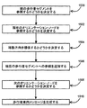
別の実施の形態では、調査者は識別された出発点から識別された目的点までの文章案内ルートを提供するためにデータを収集する。すなわち、文章案内ルートは路を記述する一連のメッセージであり、出発点から目的点まで移動するための方向を指示する。いくつかの環境では、地下鉄駅又は大きな建物などのある地理的範囲内を移動するために予め作成された文章案内を歩行者に提供することが最適である。例えば、地下鉄車両を出る歩行者は、道路ネットワーク及び/又は歩行者ネットワークに接続するために移動及び/又は出る方向についての選択についていくつかの混乱して選択に直面する。
C. Collecting Text Pedestrian Guidance Data In another embodiment, the researcher collects data to provide a text guidance route from the identified starting point to the identified destination point. That is, the text guidance route is a series of messages describing a route, and indicates a direction for moving from the starting point to the destination point. In some circumstances, it is best to provide pedestrians with pre-written text guidance for traveling within a certain geographic area such as a subway station or large building. For example, a pedestrian exiting a subway vehicle faces several confusing choices about choices about the direction to move and / or exit to connect to the road network and / or pedestrian network.
図9aは、例示的な実施の形態による文章案内ルートの収集のフローチャートである。図9aのステップは、図9b中の鉄道駅910の説明と共に説明される。ステップ900で、調査者は出発点と目的点を識別する。例示的な実施の形態では、出発点912は乗客が列車を降りる駅プラットホームである。目的点は道路ネットワーク916に接続する南側出口914である。ステップ902で、調査者は識別された出発点と目的点との間のルートを決定する。1つの実施の形態では、調査者は出発点と目的点との間のいくつかの異なるルートを移動し、どちらが最も好ましい利用可能なルートであるかを決定する。どちらのルートが最も好ましいかを決定する時、調査者は、移動の容易性、説明の容易性、移動距離、ルート移動時間、混雑レベル又はその他の情報を含むいくつかのファクターを考慮する。ステップ904で、調査者は文章案内ルートを構成する情報を記録する。1つの実施の形態では、調査者は、他人に出発点から目的点までのルートを移動するための言葉の説明を提供するのと同様な態様で情報を記録する。調査者は、どのようにしてルートを移動するかを説明する情報を記録する。情報は、周囲の構造、特徴、興味ある場所、及び/又は標識への参照、及び、エレベータ又は階段を上へ、右又は左に曲る、20メートル真直ぐ前方へ、などのオリエンテーション情報を含む。
FIG. 9a is a flowchart of collecting sentence guidance routes according to an exemplary embodiment. The steps of FIG. 9a are described in conjunction with the description of the railway station 910 in FIG. 9b. In
1つの実施の形態では、調査者は文章案内ルートについて時刻関連情報を収集する。時刻情報を使用して、ステップ902で決定されたルートは時刻に基づいて修正される。例えば、鉄道駅は逆向き可能なエスカレータを有する。朝方、エスカレータは鉄道駅を出る乗客に便利な方向である。しかし、夕方、エスカレータは鉄道駅に到着する乗客に便利な方向である。
In one embodiment, the researcher collects time-related information for the text guidance route. Using the time information, the route determined in
以下は、鉄道駅910について、駅プラットホーム912の出発点からY通り出口914の目的点まで移動するために、調査者により収集された文章案内ルート情報の例である。
The following is an example of the text guidance route information collected by the investigator for moving from the starting point of the
「列車を降りた後、左に曲がる。駅内に入った後、右に曲がりそして階段を降りる。階段の下に到達した後、左に曲がりエスカレータ方向へ向かう。3つのエスカレータの1つで上に行く。エスカレータを降りた後、右手に店を見ながら通過してエスカレータの別の組へ歩く。2つのエスカレータの内の1つに乗って上に行き、ドアを通過してY通りへ出る。」 "After getting off the train, turn left. After entering the station, turn right and go down the stairs. After reaching the bottom of the stairs, turn left and head towards the escalator. Up on one of the three escalators After getting off the escalator, walk to the other set of escalators while looking at the store on your right, go up on one of the two escalators, go through the door and exit on Y street . "
ステップ906において、調査者は文章案内ルートについて属性情報を収集する。属性情報は、車椅子アクセス可能性、子供向き、ペット可、明るい領域、暗い領域、賑やかな領域、賑やかでない領域、騒々しい、静か、悪臭/汚染、雨よけがある、雨よけがない、バイク禁止、並木道、舗装領域、未舗装領域、砂利地、裸地、丘、階段、起伏のある地形、勾配、裏道、縁石削除、道路機能クラスに類似した歩行者機能クラス、ショッピング・ゾーン、及びその他の属性情報を含む。1つの実施の形態では、調査者は同じ出発点から目的点までのいくつかの文章案内ルートを識別する。各ルートは、車椅子アクセス可能性又は雨よけがあるなどの特定の属性を持つ。
In
ステップ908で、調査者は、文章案内ルートに対応する仮想歩行者セグメント及び/又はオリエンテーション・ノード、いずれの道路セグメント、道路ノード、歩行者セグメントを識別する。例示的な実施の形態では、文章案内ルートはいくつかの歩行者セグメント及びオリエンテーション・ノード918、920、922、924及び926を横断する。
In
1つの実施の形態では、文章案内ルートは道路ネットワークと公衆移動ネットワークとの間の移行を提供するために使用できる。代替的な実施の形態では、文章案内ルートは公衆移動ネットワーク上を移動するユーザを案内するために作成される。例えば、調査者は出発点と公衆交通を含む目的点との間のルートを決定できる。調査者により記録される公衆交通を含む文章案内ルートの一例は、部分的に、「プラットホーム2でバス7に乗り、Q通り、L通り、及びK通りバス停をバスに乗ったまま通過し、そして、Y通りバス停で降りる。」さらに、調査者は道路セグメント、道路ノード、及び公衆交通により通過する他の地理的特徴を識別する。
In one embodiment, the text guidance route can be used to provide a transition between a road network and a public mobile network. In an alternative embodiment, a text guidance route is created to guide a user traveling on a public mobile network. For example, an investigator can determine a route between a starting point and a destination point including public traffic. An example of a text guidance route that includes public traffic recorded by an investigator is, in part, “take
IV.歩行者データを持つ地理データベース
上述のようにして収集された歩行者データは、地理的領域202中のいくつかの物理的地理的特徴を表す地理データベース116内に含まれる。図3中の実施の形態において、地理的領域202を表す地理データベース116は、地理的領域202中で識別された各歩行者セグメントについて少なくとも1つの歩行者セグメント・データベース・レコード308を含む。また、地理データベース116は、地理的領域202中に識別された各オリエンテーション・ノードに対して歩行者オリエンテーション・ノード・データベース・レコード310を含む。
IV. Geographic Database with Pedestrian Data Pedestrian data collected as described above is contained in a
図10は、地理データベース116に含まれる歩行者セグメント・データ・レコード308のいくつかの成分を示す。歩行者セグメント・データ・レコード308は、それにより地理データベース116内でデータ・レコードを識別できるセグメントID308(1)を含む。各歩行者セグメント・データ・レコード308は、表された歩行者セグメントの特徴を記述する情報(「属性」、「フィールド」等など)と関連付けられている。歩行者セグメント・データ・レコード308は、仮想歩行者路、舗装歩行者路、未舗装歩行者路、歩道、裏道、屋内路など、歩行者セグメントのタイプを示すデータ308(2)を含む。歩行者セグメント・データ・レコード308は、セグメントから見える特徴の名前など、一緒に歩行者セグメントを特徴付ける文章説明を提供する名前308(4)を含む文句ID及びデータを示すデータ308(3)を含む。文句IDを含むデータは、歩行者セグメントを説明するために名前を伴う、例えば、「<>を左手に見て」は文句であり、「池」は名前である。文句IDは表Iにて上述されたものに似ている。
FIG. 10 shows some components of the pedestrian
また、歩行者セグメント・データ・レコード304は、歩行者をルート上を歩行者セグメントから次の歩行者セグメントへ渡すオリエンテイングに次の歩行者セグメントを記述する前に表されている歩行者セグメントを記述することが役立つかどうかを示す私の後のデータ308(5)を含む。また、歩行者セグメント・データ・レコード308は、参照オリエンテーション・ノードからの歩行者セグメントの一般的方向(角度イン)を示す角度インデータ及び非参照オリエンテーション・ノード方向への歩行者セグメントの端の一般的方向(角度アウト)を示す角度アウトデータを含む。歩行者セグメント・データ・レコード308はさらに、どのように歩行者セグメントを説明するかについて歩行者セグメント上を移動する方向が影響するかどうかを示す適用可能な方向データ308(8)を含む。もし、影響するならば、上記データと関連した移動方向を含む。
In addition, the pedestrian
また、歩行者セグメント・データ・レコード308は、表されている歩行者セグメントを端点に関連したデータ308(6)を含む。端点データは、歩行者セグメントを通過するルートを説明する時、参照及び/又は非参照オリエンテーション・ノードが識別されるべきかどうかを指示するデータ308(6)(1)を含む。1つの実施の形態では、また、端点データ308(6)は、表されている歩行者セグメントの端点に対応するオリエンテーション・ノードを表すオリエンテーション・ノードを表すオリエンテーション・ノード・データ・レコード310へのレファレンス308(6)(2)を含む。また、歩行者セグメント・データ・レコード308は、表されている歩行者セグメントのさまざまな他の属性を参照する他のデータ308(9)を含む又はと関連付けられている。1つの実施の形態では、他のデータはセグメントの幾何形状を表すデータを提供する他のデータベース・レコードを参照する。さらに、歩行者セグメントと関連するさまざまな属性が単一の歩行者セグメント・レコード内に含まれるか又は互いに交互参照する1つのタイプより多いレコード内に含まれる。歩行者セグメントの属性は歩行者データの議論と関連して上述した属性のいずれかである。すなわち、車椅子アクセス可能性、子供向き、ペット可、明るい領域、暗い領域、賑やかな領域、賑やかでない領域、騒々しい、静か、悪臭/汚染、雨よけがある、雨よけがない、バイク禁止、並木道、舗装領域、未舗装領域、草地、砂利地、裸地、濡れた時に泥、ショッピング・ゾーン、近隣ゾーン、映像及びその他の属性情報を含む。
The pedestrian
また、図10は、地理データベース116内に含まれるオリエンテーション・ノード・データ・レコード310のいくつかの成分を示す。各オリエンテーション・ノード・レコード310(1)及び310(2)は、それにより地理データベース116内のデータ・レコードが識別できるノードID310(1)(1)及び310(2)(1)を含む。各オリエンテーション・ノード・データ・レコード310は、歩行者セグメントに接続する歩行者セグメントの識別及び/又はその地理的位置(例えば、その経度及び緯度座標)の識別を可能にする関連情報(「属性」、「フィールド」等など)を持つ。図10に示される実施の形態について、オリエンテーション・ノード・データ・レコード310(1)及び310(2)はそれらのノードについて経度及び緯度座標310(1)(2)及び310(2)(2)を含む。
FIG. 10 also shows some components of the orientation
また、各オリエンテーション・ノード・データ・レコードは、オリエンテーション・ノードの位置を特徴付ける視認可能な特徴名前など、オリエンテーション・ノード名前310(1)(3)及び310(2)(3)を含むデータを含む。さらに、各オリエンテーション・ノード・データ・レコードは、ノードを通過する歩行者ルートについて案内を提供する時にオリエンテーション・ノードが参照されるべきかどうかを指示する「において」説明データ310(1)(4)及び310(2)(4)を含む。さらに、オリエンテーション・ノード・データ・レコードは、ノードを通過する歩行者ルートについて案内を提供する時、オリエンテーション・ノードで指示される角度が計算されるべきかどうかを指示する計算角度データ310(1)(5)及び310(2)(5)を含む。また、各オリエンテーション・ノード・データ・レコードは、もしあれば、道路ネットワークへの接続を示す接続データ310(1)(6)及び310(2)(6)を含む。1つの実施の形態では、接続データ310(1)(6)及び310(2)(6)は、オリエンテーション・ノードと接続する道路セグメント及びノードを表す道路セグメント・データ・レコード304及び/又は道路ネットワーク・ノード・データ・レコード306への参照である。また、ノード・データ・レコード310(1)及び310(2)は、ノードのさまざまな他の属性を参照する他のデータ310(1)(7)及び310(2)(7)を含む。オリエンテーション・ノードの属性は、車椅子アクセス可能性、子供向き、ペット可、明るい領域、暗い領域、賑やかな領域、賑やかでない領域、騒々しい、静か、悪臭/汚染、雨よけがある、雨よけがない、バイク禁止、並木道、舗装領域、未舗装領域、草地、砂利地、裸地、濡れた時に泥、映像及びその他の属性情報を含む。
Each orientation node data record also includes data including orientation node names 310 (1) (3) and 310 (2) (3), such as visible feature names that characterize the position of the orientation node. . In addition, each orientation node data record “in” description data 310 (1) (4) indicates whether the orientation node should be referenced when providing guidance for pedestrian routes passing through the node. And 310 (2) (4). In addition, the orientation node data record calculates angle data 310 (1) that indicates whether the angle indicated by the orientation node should be calculated when providing guidance for pedestrian routes passing through the node. (5) and 310 (2) (5) are included. Each orientation node data record also includes connection data 310 (1) (6) and 310 (2) (6) indicating connection to the road network, if any. In one embodiment, the connection data 310 (1) (6) and 310 (2) (6) are road
図11は、例示的な実施の形態による歩行者セグメント・データ・レコード308の表1100である。表1100は、地理データベース116に格納されているデータの部分を表す。表1100の列は、地理データベース116内に格納されている歩行者セグメント・データ・レコード308について上述したデータに対応する。セグメント・タイプ列1102内のデータは、特定のセグメント・タイプ・コードを識別する。例えば、セグメント・タイプ・コード996は、歩行者セグメントが舗装された歩行者専用路であることを表す。セグメントID列1104内のデータは、それによりデータ・レコードが地理データベース116内で識別できる識別コードを提供する。セグメント識別コードは特定の歩行者セグメント・レコード308へ割当てられた独特な識別子である。図11に示された例示的な実施の形態について、独特なセグメントID1104は文字である。しかし、数字又は英数字コードなど他の独特な識別子も、歩行者セグメント・レコード308を独特に識別するために使用できる。
FIG. 11 is a table 1100 of a pedestrian
参照ノードID列1106及び非参照ノードID列1108内のデータは、参照ノードとして識別されるオリエンテーション・ノードの1つ及び非参照ノードとして識別される他のオリエンテーション・ノードと共に、歩行者セグメントと関連した端点又はそれぞれのオリエンテーション・ノードを識別する。参照ノードID列1106及び非参照ノードID列1108内のデータは、それぞれのオリエンテーション・ノードのオリエンテーション・ノードIDを提供する。
The data in reference
文句ID列1110内のデータは、歩行者セグメントの文章説明を形成するためにセグメント名前と共に使用する特定の文句を識別する。表Iは、例示的な実施の形態による文句IDと関連する文句のリストを提供する。既存の文句の同意語及び追加の文句が表Iに追加できる。名前列1112内のデータは、歩行者セグメントについての名前を提供する。私の後の列1114内のデータは、セグメント名前列1112内に見つけられような前の歩行者セグメント名前のセグメント名前の「後に」続く言葉により、次の歩行者セグメントについての歩行者案内メッセージが開始するかどうかを識別する。例えば、前の歩行者セグメントは図11に記載されるような歩行者セグメントEである。歩行者セグメントEのセグメント名前は、「橋」である。文句「橋の後」は歩行者に有用であるから、歩行者セグメントEについて私の後のデータはイエスを含み、橋に続く歩行者セグメントについての歩行者案内メッセージは、「橋の後」により開始されることを示す。
The data in the
説明的でない参照ノード列1116及び説明的でない非参照ノード列1118内のデータは、歩行者案内を提供する時に歩行者セグメントと関連したオリエンテーション・ノード又は端点への参照を禁止するために各々が使用される。この特徴は、オリエンテーション・ノードへの参照が特定の方向からは意味がないであろう時に使用される。角度イン列1120内のデータは、参照オリエンテーション・ノード又は端点から歩行者セグメントの最初の部分について移動する方向又は移動する角度を識別する。角度アウト列1122内のデータは、非参照オリエンテーション・ノード又は端点方向へ歩行者セグメントの最後の部分へ移動する方向又は移動する角度を識別する。参照ノード方向から適用可能な列1124及び参照ノード方向へ適用可能な列1126内のデータは、歩行者案内メッセージが移動方向(すなわち、関連参照オリエンテーション・ノードへの方向又はから離れる方向)に依存して異なる時に使用される。表1100は追加的データを含むことができるる。例えば、表は、関連する道路セグメントID又は道路ネットワーク・ノードIDを識別する列を含む。
The data in the non-descriptive
図12は、例示的な実施の形態による、オリエンテーション・ノード・レコード310の表1200である。表1200は、地理データベース116内に格納されているデータの部分を表す。表1200の列は、地理データベース116内に格納されているオリエンテーション・ノード・データ・レコード310について上述したデータに対応する。ノードID列1202内のデータは、オリエンテーション・ノード・データ・レコードがそれにより地理データベース116内で識別できる識別コードを提供する。オリエンテーション・ノード識別コードは特定のオリエンテーション・ノード・データ・レコード310へ割当てられた独特な識別子である。図12に示される例示的な実施の形態については、独特なオリエンテーション・ノードIDは数である。しかし、数又は英数字コードなど他の独特な識別子もオリエンテーション・ノード・データ・レコード310を独特に識別するために使用できる。
FIG. 12 is a table 1200 of
列1204及び1206内のデータは、各オリエンテーション・ノード310の経度及び緯度の座標を提供する。名前列1208内のデータは、オリエンテーション・ノードの名前を含む。計算角度列1210内のデータは、オリエンテーション・ノードでノードを通過する歩行者の案内を提供するために曲がる角度を決定すべきかどうかを指示する。もし、計算角度データがノー(N)を含む場合、角度は決定される必要が無い。もし、計算角度データがイエス(Y)を含む場合、ノードを通過する案内を提供するために曲がる角度が決定される。
The data in columns 1204 and 1206 provides the longitude and latitude coordinates of each
「において」説明列1212内のデータは、オリエンテーション・ノード名前データ内の名前がオリエンテーション・ノードにおいて歩行者案内メッセージ内に使用されるべきかどうかを指示する。いくつかの状況では、歩行者案内メッセージ内に現在のオリエンテーション・ノードを説明することが歩行者に有用である。この場合、歩行者案内メッセージに現在のオリエンテーション・ノードへの参照が追加されるように「において」説明データはイエスを含む。しかし、他の状況では、現在のオリエンテーション・ノードへの参照を追加することは不恰好であり、歩行者に有用な案内を提供しない。例えば、歩行者が橋に到着する時、「橋において、橋を歩いて渡る。」メッセージは不恰好である。「において」説明データにノーを入れることにより、歩行者は、「橋を歩いて渡る。」メッセージを受取る。接続列1214内のデータは、オリエンテーション・ノードに接続する、道路セグメント・データ・レコード304又はノード・データ・レコード306のいずれかの、道路ネットワーク・データ・レコードへの参照を提供する。
The data in the “in”
図13は、地理データベース116内に含まれる歩行者文章案内ルート・データ・レコード1300のいくつかの成分を示す。歩行者文章案内ルート・データ・レコード1300は指定された出発点から指定された目的点までの完全な文章案内ルートを提供するために収集された情報を含む。歩行者文章案内ルート・データ・レコード1300は、それによりデータ・レコードが地理データベース116内で識別できる文章案内ルートID1302を含む。各歩行者文章案内ルート・データ・レコード1300は、ルート案内文章データ1304内に確立された出発点から確立された目的点までの完全なルート案内を含む。ルート案内文章データ1304の一例は、鉄道駅について、駅プラットホームの出発点とY通り出口との間の以下の通りである。
FIG. 13 shows some components of the pedestrian text guidance route data record 1300 included in the
「列車を降りた後、左に曲がる。駅構内に入った後、右に曲がって階段を降りる。階段の下に到着した後、左に折れてエスカレート方向へ向かう。3つのエスカレータの1つに乗り上に行く。エスカレータを出た後、店を右手に見て通過して別の組のエスカレータへ歩く。2つのエスカレータの内の1つに乗り上に行き、ドアを通ってY通りへ行く。」 "After getting off the train, turn left. After entering the station, turn right and go down the stairs. After arriving under the stairs, turn left and head towards the escalation. One of the three escalators After getting out of the escalator, walk through the store to the right and walk to another set of escalators, get on one of the two escalators, go through the door to Y street . "
各歩行者文章案内ルート・データ・レコード1300は、車椅子アクセス可能性、明るい場所、賑やかな場所、うるさい、雨よけがある、階段数、ショッピング・ゾーン、映像及びその他の属性情報などのルート案内の特徴を説明する属性データ1306と関連付けられている。1つの実施の形態では、歩行者文章案内ルート・データ・レコード1300は、異なる時刻について代替的なルート案内を含む。 Each pedestrian text guidance route data record 1300 features features of route guidance such as wheelchair accessibility, bright places, lively places, noisy, rainproof, number of stairs, shopping zones, video and other attribute information Is associated with attribute data 1306 for explaining. In one embodiment, the pedestrian text guidance route data record 1300 includes alternative route guidance for different times.
また、歩行者文章ルート案内データ・レコード1300は、ルート案内文章により通過されるセグメント及び/又はノードに関連するデータ1308を含む。データ1308は、ルートが通過するセグメント及び/又はノードへの参照を提供する。データ1308は、ルート案内文章により通過するセグメントに対応するルートを強調表示した地図ディスプレスを提供するために使用できる。歩行者文章ルート案内データ・レコード1300は、表されたルート案内文章の端点に関連するデータ1310を含む。端点データは、表されたルート案内文章の出発点と目的点とを示すデータを含む。1つの実施の形態では、端点データ1310は、表されたルート案内文章の出発点及び目的点に対応する興味ある場所及び/又はノードを表す興味ある場所及びノード・データ・レコード306及び310への参照を含む。また、歩行者文章案内ルート・データ・レコード1300は、表されたルート案内文章のさまざまな他の情報を参照する他のデータ1312を含むか又は関連付けられている。
The pedestrian text route guidance data record 1300 also includes
図4を参照すると、また、道路セグメント・データ・レコード304及び道路ネットワーク・ノード・データ・レコード306は、歩行者関連データ304(5)及び306(1)(2)、306(2)(2)を含む。1つの実施の形態では、道路セグメント・データ・レコード304に関連する歩行者関連データ304(5)は、歩道を表す歩行者セグメントなど、道路セグメントと関連した歩行者セグメント・データ・レコード308への参照である。同様に、道路ネットワーク・ノード・データ・レコード306に関連した歩行者関連データ306(1)(2)、306(2)(2)は、道路ノードに関連したオリエンテーション・ノード・データ・レコード310への参照である。別の実施の形態では、歩行者関連データ304(5)及び306(1)(2)は、道路セグメント、道路ノード、又は、道路セグメント又は道路ノードに近い興味ある場所又は道路ノードと関連した歩行者文章ルート案内データ・レコード1300への参照である。
Referring to FIG. 4, the road
別の実施の形態では、道路セグメント・データ・レコード304と関連した歩行者関連データ304(5)は、歩道の記述、横断歩道の位置、縁石の切欠、並木道、交通信号の位置、停止サインの位置、歩行者可能、道路セグメントの交差可能性、うるさい、汚染、自転車可、車椅子アクセス可能性、ショッピング・ゾーン、近隣ゾーン、又はその他の属性情報などの道路セグメントの歩行者関連属性である。道路ノード・データ・レコード306に関連した歩行者関連データ306(1)(2)は、道路ノードの同様な歩行者関連属性である。
In another embodiment, the pedestrian-related data 304 (5) associated with the road
V.歩行者のルート計算
図1と関連して説明したように、ナビゲーション・システム100は、さまざまなナビゲーション特徴と機能を提供するナビゲーション・アプリケーション・ソフトウェア・プログラム110を含む。1つの実施の形態では、ナビゲーション機能と特徴は歩行者についてルート計算124を含む。ルート計算機能124は所望の目的点までのルートを計算する要求を受信する。要求は、出発位置と所望の目的位置の識別の形式である。これらの位置の識別は、これらの位置の地理座標を含む。また、ルート計算機能は、歩く好み(例えば、汚染地域を避ける)などの他のデータ又はパラメータを備えている。少なくとも出発位置と目的位置が与えられると、ルート計算機能124が、出発位置と宛先位置との間の1つ又は複数の解答ルートを決定することを試みる。解答ルートは、その上を歩行者が出発位置から目的位置まで移動できる一連の接続された道路及び/又は歩行者セグメントで形成されている。ルート計算機能124がルートを計算する時、それは地理データベース116を評価して、出発位置と目的位置との間及び周りのセグメントを表す道路セグメント・データ・エンティテイ304及び/又は歩行者セグメント・データ・エンティテイ308を得る。ルート計算機能124は、道路及び/又は歩行者セグメント・データ・エンティテイ304及び308内の情報を使用して、出発位置から目的位置までの少なくとも1つの有効な解答ルートを決定することを試みる。歩行者が移動するために有効な解答ルートを決定する際、ルート計算プログラム124は、歩く好み(例えば、舗装された表面、並木道)を説明するために、道路及び/又は歩行者セグメント・データ・エンティテイと関連したデータ属性を使用する。ルート計算機能124は、移動するために最小時間を要する、最小距離をカバーする、又はいくつかの他の指定可能基準を満足する解決ルートを見つけることを試みる。
V. Pedestrian Route Calculation As described in connection with FIG. 1, the navigation system 100 includes a navigation application software program 110 that provides various navigation features and functions. In one embodiment, navigation functions and features include route calculation 124 for pedestrians. The route calculation function 124 receives a request to calculate a route to a desired destination point. The request is in the form of identification of the starting position and the desired destination position. The identification of these locations includes the geographic coordinates of these locations. The route calculation function also includes other data or parameters such as walking preferences (eg, avoiding contaminated areas). Given at least a starting location and a destination location, the route calculation function 124 attempts to determine one or more answer routes between the starting location and the destination location. The answer route is formed by a series of connected roads and / or pedestrian segments on which a pedestrian can move from a starting location to a destination location. When the route calculation function 124 calculates a route, it evaluates the
ルート計算機能124は、解答ルートを決定する際にさまざまな手段又はアルゴリズムを使用する。ルート計算のための手段は、米国特許第6,192,314号に開示されている。(前記特許に開示されている方法は、ルートが計算できるいくつかの方法のみを表しており、本願発明はルート計算の特定の方法に限定されるものではない。既知の又は将来開発されるどんな適当なルート計算方法が使用できる。) The route calculation function 124 uses various means or algorithms in determining the answer route. Means for route calculation are disclosed in US Pat. No. 6,192,314. (The methods disclosed in the above patents represent only some of the ways in which routes can be calculated, and the present invention is not limited to any particular method of route calculation. Any known or future developed Any suitable route calculation method can be used.)
ルート計算機能124は、出力を提供する。1つの実施の形態では、ルート計算機能124の出力は、複数の道路及び/又は歩行者セグメント・データ・エンティテイを識別する順番付けられたリスト1400の形式をとる。図14は、ルート計算機能124により生成された例示的出力リスト1300内に含まれる地理データベース116からの歩行者セグメント・データ・エンティテイ308(すなわち、seg1,seg2,seg3,...,seg(E),seg(F))を示す。複数の歩行者セグメント・データ・エンティテイ1400は、ルート計算機能124により計算された出発点と目的点との間の連続的なナビゲート可能なルートを形成する歩行者セグメントを表す。(ルート計算機能124は、複数の解答ルートを計算してもよい。)
The route calculation function 124 provides an output. In one embodiment, the output of the route calculation function 124 takes the form of an ordered
VI.歩行者のためのルート案内
図1に関連して上述したように、ナビゲーション・システム100は、さまざまなナビゲーション特徴と機能を提供するナビゲーション・アプリケーション・ソフトウェア・プログラム110を含む。ナビゲーション機能及び特徴は歩行者のためのルート案内126を含む。ルート案内機能126は、所望の目的点に到達するために詳細な指示を提供する。1つの実施の形態では、ルート計算機能124により決定された歩行者セグメント・データ・エンティテイのリスト1400は、ルート案内機能126へ提供される。ルート案内機能126は、ルート計算機能124により出力されたリスト1400により定義されたルートを移動するエンドユーザに指示を提供するために、リスト1400内の情報を地理データベース116からの追加情報と共に使用する。ルート案内機能126は、動作指示がエンドユーザに提供されるべき計算されたルートに沿った場所を識別する機能を含む。ルート案内機能126は、動作指示126を一度に提供してもよいし、又は、代替的に、ルート案内機能126は、歩行者が移動する時に一度に1つの動作指示を与えてもよい。1つの実施の形態では、各動作指示は、エンドユーザが必要な動作をすることを準備できるようにするため、特定の動作を行うことが必要となる前に個別に(又は、組合わせられた動作指示の小さなグループで)提供される。ルート案内機能126の出力は、コンピューテイング・プラットホーム102上に含まれるユーザ・インターフェイスを介してエンドユーザに提供される。ルート案内の出力は音声合成によって聞こえるように伝えられるか又は視覚ディスプレイ上で伝えられる。
VI. Route Guidance for Pedestrians As described above with respect to FIG. 1, the navigation system 100 includes a navigation application software program 110 that provides various navigation features and functions. Navigation functions and features include route guidance 126 for pedestrians. The route guidance function 126 provides detailed instructions to reach a desired destination point. In one embodiment, a
米国特許第6,199,013号に地理データを使用したルート案内を提供する方法が開示されている。(前記特許に開示されている方法は、ルート案内が計算できるいくつかの方法のみを表しており、本願発明はルート案内の特定の方法に限定されるものではない。既知の又は将来開発されるどんな適当なルート案内方法が使用できる。) US Pat. No. 6,199,013 discloses a method for providing route guidance using geographic data. (The methods disclosed in the above patents represent only some of the ways in which route guidance can be calculated, and the present invention is not limited to any particular method of route guidance. Known or developed in the future. Any suitable route guidance method can be used.)
適当な時間及び/又は場所で動作指示を提供するために、ナビゲーション・システム100は、位置決めシステム(図1中の112)からのデータを使用する。位置決めシステム112は、歩行者が移動する時に彼又は彼女(コンピューテイング・プラットホーム102)の位置を決定する。ナビゲーション・プログラム110内の位置決め(地図一致)機能130は、位置決めシステム112により決定された位置を解答歩行ルート1400中の歩行者セグメント・データ・エンティテイにより表される歩行者セグメントの位置と比較する。この比較を使用して、解答歩行ルートに沿った位置に関連する動作指示がこれらの位置に接近する時に適当な時間で提供できる。
In order to provide operational instructions at the appropriate time and / or location, the navigation system 100 uses data from the positioning system (112 in FIG. 1). The positioning system 112 determines the position of him or her (computing platform 102) as the pedestrian moves. A positioning (map matching) function 130 in the navigation program 110 compares the position determined by the positioning system 112 with the position of the pedestrian segment represented by the pedestrian segment data entity in the
また、ルート案内機能126は、エンドユーザに目的点までの残りの距離に関する情報を提供する。また、ルート計算機能124からの歩行者セグメント・データ・エンティテイのリスト1400が、地図表示機能128へ提供される。地図表示機能128は、図形的地図をユーザ・インターフェイス114上に提供するために、リスト1400内の情報を地理データベース116からの追加情報と共に使用する。図形的地図は計算されたルートが通過する領域を示す。計算されたルートの路は表示された地図上で強調表示してもよい。
In addition, the route guidance function 126 provides information regarding the remaining distance to the destination point to the end user. A
ルート案内機能126は、歩行者を計算された歩行ルートに沿って案内して歩行者が彼等の方向について混乱する可能性を減少するために十分な情報を持つ歩行者案内メッセージを含む。1つの実施の形態では、歩行者案内機能はルート計算機能124からの順序付きリスト1400中の各歩行者セグメントに対して歩行者案内メッセージを生成する。例示的な実施の形態では、各歩行者案内メッセージは前の歩行者セグメント(もし、あれば)への参照を提供し、現在のオリエンテーション・ノードへの参照が後に続き、現在の歩行者セグメントへの参照が後に続き、そして次のオリエンテーション・ノードへの参照が後に続く。全ての歩行者案内メッセージが4つの全ての参照を含むものではない。1つの実施の形態では、オリエンテーション・ノード・データ・エンティテイ310内のデータ及び地理データベース116の歩行者セグメント・データ・エンティテイは、歩行者案内メッセージ内にどんな情報が含まれるかを指示する。
The route guidance function 126 includes a pedestrian guidance message with sufficient information to guide the pedestrian along the calculated walking route and reduce the likelihood that the pedestrian will be confused about their direction. In one embodiment, the pedestrian guidance function generates a pedestrian guidance message for each pedestrian segment in the ordered
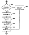
図15は、例示的な実施の形態による、歩行者案内メッセージを生成するために歩行者案内機能により実行されるステップを示す。ブロック1500で、歩行者案内機能は、前の歩行者セグメントを参照するかどうかを決定する。ブロック1502で、歩行者案内機能は現在のオリエンテーション・ノードを参照するかどうかを決定する。ブロック1502で、歩行者案内機能は現在のオリエンテーション・ノードを参照するかどうかを決定する。ブロック1504で、歩行者案内機能は移動方向を与えるかどうかを決定する。ブロック1506で、歩行者案内機能は現在の歩行者セグメントへの参照を含む。ブロック1508で、歩行者案内機能は次のオリエンテーション・ノードを参照するかどうかを決定する。ブロック1510で、歩行者案内メッセージが、ブロック1500−1504、1508−1510で実行された決定及びブロック1506で実行された現在の歩行者セグメントへの参照に基づいて生成される。図16A−16Dを参照して、歩行者案内メッセージを構築するために歩行者案内機能により実行されるステップが詳細に説明される。
FIG. 15 illustrates the steps performed by the pedestrian guidance function to generate a pedestrian guidance message, according to an exemplary embodiment. At
図16A−16Dは、例示的な実施の形態による、図15に特定された歩行者案内メッセージを構成するより詳細な方法を示すフローチャートである。ブロック1600で、歩行者案内機能は、歩行者案内メッセージが前の歩行者セグメントを参照すべきかどうかを決定する。特に、ブロック1602で、歩行者案内機能は、もしあれば、順序付きリスト1400の前の歩行者セグメントについて地理データベース116内の歩行者セグメント・データ・レコード308中の私の後のデータ308(5)を獲得する。私の後のデータは、イエス又はノーを含む。ブロック1604で、もし、前の歩行者セグメントの私の後のデータがイエスを示す場合、歩行者案内機能が言葉「後」と共に歩行者案内メッセージを開始する。ブロック1606で、もし、歩行者案内メッセージが言葉「後」と共に開始する場合、歩行者案内機能は前の歩行者セグメント・データ・レコード308の名前データ308(4)から前の歩行者セグメントの名前を検索して、その名前を歩行者案内メッセージに追加する。そして、カンマが文法的目的のために歩行者案内メッセージへ追加される。それ以外は、ブロック1608で、歩行者案内メッセージは前の歩行者セグメントへの参照と共に開始しない。
16A-16D are flowcharts illustrating a more detailed method of constructing the pedestrian guidance message identified in FIG. 15, according to an exemplary embodiment. At
ブロック1610で、歩行者案内機能は歩行者案内メッセージ内で現在のオリエンテーション・ノードを参照するかどうかを決定する。ブロック1612で、歩行者案内機能が、地理データベース116内の現在オリエンテーション・ノード・データ・レコード310中の「において」説明データを獲得する。「において」説明データは、イエス又はノーを含む。ブロック1614で、もし、「において」説明データがイエスを含む場合、歩行者案内機能は、言葉「において」と共に歩行者案内メッセージを開始又は続ける。ブロック1616で、現在オリエンテーション・ノード・データ・レコードについてオリエンテーション・ノード名前データから現在オリエンテーション・ノードの名前を獲得して、その名前を歩行者案内メッセージへ追加する。そして、カンマが文法的目的のために歩行者案内メッセージへ追加される。それ以外は、ブロック1618で、歩行者案内メッセージは現在オリエンテーション・ノードの名前を含まない。
At
ブロック1620で、歩行者案内機能が移動方向を提供するかどうかを決定する。ブロック1622で、歩行者案内機能は、現在オリエンテーション・ノード・データ・レコードについて地理データベース116内の計算角度データを検査する。計算角度データはイエス又はノーにより満たされている。ブロック1624で、もし、計算角度データがイエスを含む場合、歩行者案内機能が前の歩行者セグメントと現在の歩行者セグメントとの間の角度を計算する。1つの実施の形態では、2つのセグメント間の角度の大きさと方向は、前の歩行者セグメントと関連する角度アウトデータ及び現在の歩行者セグメントと関連する角度インデータを使用して決定される。そして、計算された角度の大きさと方向は、どの方向の文章が歩行者案内メッセージへ追加されるかを決定するために使用される。例えば、もし、2つの歩行者セグメント間の角度の大きさが10度以下の場合、「真直ぐを続ける」などの文句が歩行者案内メッセージへ追加される。角度の大きさが増加する時、角度の方向が歩行者に左又は右に曲がれを指示するかどうかを決定するために使用される。追加的に、曲がりの大きさを示す文句がメッセージ内に追加できる。例えば、小さい角度について「僅かに」という言葉がメッセージに追加される。そして、歩行者セグメント間の角度が大きい時に「鋭く」という言葉がメッセージに追加される。
At
角度計算が実行された後、ブロック1626において、歩行者案内機能が歩行者案内メッセージに移動方向を記述する文章を追加する。文章は角度の方向と大きさに基づいて選択される。例えば、文章は、左に鋭く曲がる、左に曲がる、左に僅かに曲がる、真直ぐを続ける、右に僅かに曲がる、右に曲がる、及び、右に鋭く曲がる、を含む。方向文章が歩行者案内メッセージへ追加された後、ブロック1628で、歩行者案内機能は歩行者案内メッセージへ「及び」という言葉を含む。それ以外は、ブロック1630において、歩行者案内メッセージは移動方向を含まない。
After the angle calculation is performed, at
ブロック1632で、歩行者案内機能は歩行者案内で現在歩行者セグメントを参照するかどうかを決定する。ブロック1634で、歩行者案内機能は、現在の歩行者セグメントについての歩行者セグメント・データ・レコード308が文句IDを含むかどうかを決定する。もし、文句IDが存在する場合、ブロック1636で、歩行者案内機能は歩行者案内メッセージへ言葉「歩く」を追加する。ブロック1638で、歩行者案内機能が、歩行者セグメントに関連する文句を識別して、歩行者案内メッセージに文句を追加する。文句IDデータは特定の文句、表I中に示される対応する、文句IDなど、に関連する数を表す。ブロック1640で、歩行者案内機能は名前データ308(4)から現在の歩行者セグメントの名前を獲得し、そしてその名前を歩行者案内メッセージへ追加する。それ以外は、ブロック1642で、歩行者案内メッセージは現在の歩行者セグメントの名前のみを含む。
At
ブロック1644で、歩行者案内機能は次のオリエンテーション・ノードを参照するかどうかを決定する。ブロック1646で、歩行者案内機能が歩行者セグメント・データ・レコード308の説明ノード・データ・レコード308(6)(1)からデータを獲得する。図11に示すように、説明的でない参照又は非参照ノード・データは、イエス又はノーで満たされている。ブロック1648で、もし、説明的でない参照又は非参照ノード・データがノーを含んでいる場合、歩行者案内メッセージは、言葉「方へ」を含む。ブロック1650で、言葉「方へ」には、オリエンテーション・ノード・レコード310(2)(3)内の名前が前に付く。それ以外は、歩行者案内メッセージは次のオリエンテーション・ノード名前を含まない。
At
図17A及び17Bは、歩行者案内メッセージを生成するために地理データベース116からの情報を使用する歩行者案内機能の2つの例を提供する。図17A、例1では、歩行者案内機能が、前の歩行者セグメント、現在のオリエンテーション・ノード、現在の歩行者セグメント及び次のオリエンテーション・ノードについて説明されたデータを獲得する。例1については、歩行者案内機能は前の歩行者セグメントの私の後のデータについて、ノー、「において」説明データについて、イエス、ノード名前データについて「彫像」、現在オリエンテーション・ノードの計算角度データについて、イエス、文句IDデータについて“10”(「沿う」に対応する)、セグメント名前データについて「レンガ路」、そして現在歩行者セグメントの参照ノード・データを説明しないについてはノー、そして次のオリエンテーション・ノードのノード名前については「池」、を獲得する。
17A and 17B provide two examples of pedestrian guidance functions that use information from the
私の後のデータがノーを含むため、歩行者案内メッセージは、言葉「後」に前の歩行者セグメント名前が続いて開始されることはない。「において」説明データがイエスを含むため、歩行者案内メッセージは、言葉「において」の前に現在のオリエンテーション・ノードの名前が付いて開始される。そして、カンマが、文法的目的のために導入文句に追加される。したがって、例1の歩行者案内メッセージについての導入文句は、「彫像において」である。 The pedestrian guidance message will not begin with the word “after” followed by the name of the previous pedestrian segment because the data after me includes no. Since the explanation data “in” includes yes, the pedestrian guidance message is started with the name of the current orientation node before the word “in”. A comma is then added to the introductory phrase for grammatical purposes. Therefore, the introductory phrase for the pedestrian guidance message of Example 1 is “in the statue”.
例1について、続ける。計算角度データがイエスであるため、導入文句に行動文章が追加される。歩行者案内機能が前の路セグメントと現在の路セグメントとの間の角度を計算する。角度の方向と大きさが、歩行者案内メッセージにどの行動文書を追加すべきかを決定する。この例では、角度はメッセージに追加される文句「右に曲がれ」に対応する。そして、行動文章の後に言葉「及び」がメッセージに追加される。 Continue for Example 1. Since the calculation angle data is yes, an action sentence is added to the introduction phrase. A pedestrian guidance function calculates the angle between the previous road segment and the current road segment. The direction and size of the angle determines which action document should be added to the pedestrian guidance message. In this example, the angle corresponds to the phrase “turn right” added to the message. Then, the word “and” is added to the message after the action sentence.
文句IDデータが番号10により満たされているため、歩行者案内メッセージは、表Iにおいて、言葉「沿う」として表されている、文句ID10に関連する文句が後に続く、言葉「歩く」を含む。そして、現在の歩行者セグメントの名前「レンガ路」がメッセージに追加される。
Because the phrase ID data is filled with the
参照ノード・データを説明しないがノーで満たされているため、例1のメッセージは、次のオリエンテーション・ノードの名前、「池」、が「の方向へ」の前に付く。この結果、例1の歩行者案内メッセージは、「彫像において、右に曲がる。及び、池の方向へレンガ路に沿って歩く。」である。 Because the reference node data is not explained but filled with no, the message of Example 1 is preceded by the name of the next orientation node, “pond”, in the “to” direction. As a result, the pedestrian guidance message of Example 1 is “Turn right in the statue and walk along the brick road in the direction of the pond”.
図17B中の、例2において、歩行者案内機能は前の歩行者セグメントの私の後のデータについてノーを獲得し、「において」説明データについてイエスを獲得し、ノード名前データについて「水のみ場」を獲得し、現在のオリエンテーション・ノードの計算角度データについてノーを獲得し、文句IDデータについて“4”(「<空白>を右手に見て」に対応する)を獲得し、セグメント名前データについて「カヤック・コース」を獲得し、現在の歩行者セグメントの参照ノード・データを説明しないについてイエスを獲得し、そして、次のオリエンテーション・ノードのノード名前について「カヤック・コース」を獲得する。 In Example 2 in FIG. 17B, the pedestrian guidance function obtains no for the data after me of the previous pedestrian segment, obtains yes for the “in” explanation data, and “no water” for the node name data. ”, No for the calculation angle data of the current orientation node,“ 4 ”(corresponding to“ <blank> in the right hand ”) for the phrase ID data, and segment name data Obtain a “kayak course”, obtain a yes for not describing the reference node data for the current pedestrian segment, and obtain a “kayak course” for the node name of the next orientation node.
私の後のデータがノーを含むため、歩行者案内メッセージは、前の歩行者セグメント名前が言葉「後」に付いて開始しない。「において」説明データがイエスを含むため、歩行者案内メッセージは言葉「において」に現在のオリエンテーション・ノードが付いて開始する。カンマが文法的目的のために導入文句に追加される。従って、例2中の歩行者案内メッセージの導入文句は、「水のみ場において」である。 The pedestrian guidance message does not start with the word “after” the name of the previous pedestrian segment because the data after me includes no. The pedestrian guidance message begins with the word “in” with the current orientation node because the explanatory data includes “in”. A comma is added to the introductory phrase for grammatical purposes. Therefore, the introductory phrase of the pedestrian guidance message in Example 2 is “in a water fountain”.
例2に続いて、計算角度データがノーを含むために行動文書が導入文句に追加されない。文句IDデータが番号4で満たされているため、歩行者案内メッセージは、表Iに文句「<空白>を右手に見て」として表される文句ID4に関連する文句がついた言葉「歩く」を含む。そして、現在の歩行者セグメントの名前「カヤック・コース」がメッセージに追加される。参照ノード・データを説明しないがイエスのため、メッセージは次のオリエンテーション・ノードの名前を参照することなく終了する。この結果、例2中の歩行者案内メッセージは、「水のみ場において、カヤック・コースを右手に見て歩く。」である。
Continuing from example 2, the behavior document is not added to the introductory phrase because the calculated angle data includes no. Since the phrase ID data is filled with the
図17A及び17Bに示されるように、歩行者案内メッセージは最初に歩行者が現在見ることができる(例えば、彫像において、水のみ場において)歩行者セグメント名前又はオリエンテーション・ノード名前のいずれかを参照することにより、歩行者を案内する。この最初のオリエンテーションは、歩行者に彼等が正しい位置で出発していることの安心を与える。そして、歩行者案内メッセージは、必要に応じて行動を含む、この開始点からどのように移動するかについて案内を提供する。代替的な実施の形態では、歩行者は必要に応じて追加の案内を受取る。 As shown in FIGS. 17A and 17B, the pedestrian guidance message initially refers to either the pedestrian segment name or the orientation node name that is currently visible to the pedestrian (eg, in the statue, in a water basin). To guide the pedestrian. This initial orientation gives pedestrians the peace of mind that they are starting in the right position. The pedestrian guidance message then provides guidance on how to move from this starting point, including actions as needed. In an alternative embodiment, the pedestrian receives additional guidance as needed.
VII.歩行者に対するルート案内の例
図18A、18B及び18Cは、計算プラットホーム102のユーザ・インターフェイス114上に表示される歩行者案内メッセージの例を示す。図18Aと18Bを参照すると、歩行者が鉄道駅に到着してビーチへ歩くことを欲する。計算プラットホーム102のユーザ・インターフェイスにより、歩行者は彼又は彼女のビーチの所望の目的点を入力する。1つの実施の形態では、ユーザ装置は歩行者の出発点を決定する。代替的に、歩行者は彼又は彼女の鉄道駅の出発点を入力する。ナビゲーション・システム100は、鉄道駅からビーチまでの接続された歩行者セグメントのリストを生成するために、収集された歩行者データと共に地理データベースを使用して上述の方法でルート計算機能124を実行する。そして、ナビゲーション・システムは、図18Aに示された歩行者案内メッセージを提供するために収集された歩行者データと共に地理データベース116を使用して上述した方法でルート案内機能を実行する。
VII. Examples of Route Guidance for Pedestrians FIGS. 18A, 18B and 18C show examples of pedestrian guidance messages displayed on the
図18Aを参照すると、ユーザ・インターフェイス114は、鉄道駅について列車プラットホームからK通り出口までの案内を提供する第1歩行者案内メッセージを表示する。
Referring to FIG. 18A, the
「列車を降りた後、右に曲がる。駅構内に入った後、右に曲がり階段を歩いて降りる。階段の下に着いた後、左に折れてエスカレータ方向に向かう。エスカレータの右のドアを通過してK通りへ出る。」 "After getting off the train, turn right. After entering the station, turn right and walk down the stairs. After reaching the stairs, turn left and head towards the escalator. Pass through to K street. "
図18Bを参照すると、歩行者が鉄道駅を出た後、ユーザ・インターフェイス114は、歩行者又はユーザ装置により提供された出発点を参照することにより最初に歩行者を案内する第2歩行者案内メッセージ1802を表示する。文句「鉄道駅において」は、歩行者に近接している容易に視覚できる特徴、鉄道駅、を参照する。そして、メッセージは、歩行者を「交通信号」により参照されるオリエンテーション・ノード方向へ「右に曲がり」そして「K通りに沿って」歩くことを指示することにより、第2歩行者セグメントを説明する。計算されたルートの第2歩行者セグメントの端に到着した時、ユーザ・インターフェイス114は歩行者案内メッセージ1804を表示する。メッセージ1804は、歩行者をオリエンテーションし、「左に曲がる」という行動指示を与える。そして、メッセージ1804は、歩行者に「袋小路」と共に参照される次のオリエンテーション・ノード方向へ「北通りに沿って」歩くことを指示することにより、第3歩行者セグメントを記述する。計算されたルートの第3歩行者セグメントの終わりに到達した時、ユーザ・インターフェイス114は、第4歩行者案内メッセージ1806を表示する。メッセージ1806は、歩行者をオリエンテーション・ノードでオリエンテーションし、「トンネル」と参照された次のオリエンテーション・ノード方向へ歩いて「階段を降りる」を歩行者に指示することにより、第4歩行者セグメントを記述する。計算されたルートの第4歩行者セグメントの終わりに到達した時、ユーザ・インターフェイス114は第5歩行者案内メッセージ1808を表示する。メッセージ1808は、歩行者をオリエンテーションし、歩行者に歩いて「トンネルを通過する」ことを指示することにより、第5歩行者セグメントを記述する。計算されたルートの第5歩行者セグメントの終わりに到達した時、ユーザ・インターフェイス114は歩行者案内メッセージ1810を表示する。メッセージ1810は、歩行者にオリエンテーションし、そして「右に曲がれ」の行動指示を与える。そして、メッセージ1810は、歩行者の所望の目的点、「ビーチ」を参照する次のオリエンテーション・ノード方向へ歩いて「自転車路を横断する」ことを歩行者へ指示することにより、第6歩行者セグメントを記述する。
Referring to FIG. 18B, after the pedestrian leaves the railway station, the
図18Cを参照すると、歩行者はビーチにおり、そして動物園へ歩くことを望む。計算プラットホーム102のユーザ・インターフェイス114により、歩行者は彼又は彼女の目的地の動物園を入力する。ナビゲーション・システム100は、ビーチから動物園までの接続された歩行者セグメントのリストを生成するために収集された歩行者データと共に地理データベースを使用して、上述した方法でルート計算機能を実行する。そして、ナビゲーション・システムは、歩行者に図18Cに示されるような歩行者案内メッセージを提供するために収集された歩行者データと共に地理データベース116を使用して上述の方法でルート案内機能126を実行する。
Referring to FIG. 18C, the pedestrian is at the beach and wants to walk to the zoo. The
図18Cを参照すると、ユーザ・インターフェイス114は、歩行者又はユーザ装置により与えられた出発点を参照することにより、歩行者を最初にオリエンテーションする第1歩行者案内メッセージ1812を表示する。文句「ボートハウスにおいて」は、歩行者の出発点に近い興味ある場所、すなわち、容易に視覚できるボートハウスを参照する。そして、メッセージは、「歩行者橋」により参照されるオリエンテーション・ノードの方向へ「ミシガン湖を右手に見て」歩くことを歩行者に指示することにより第1歩行者セグメントを記述する。計算されたルートの第1歩行者セグメントの終わりに到達した時、ユーザ・インターフェイス114は第2歩行者案内メッセージ1814を表示する。第2メッセージ1814は、歩行者に「歩行者橋を歩いて渡る」ことを指示することにより、第2歩行者セグメントを記述する。計算されたルートの第2歩行者セグメントの終わりに到達した時、ユーザ・インターフェイス114は第3歩行者案内メッセージ1816を表示する。第3メッセージ1816は、オリエンテーション・ノードで歩行者をオリエンテーションし、「バレーボール・コート」により参照される次のオリエンテーション・ノード方向へ「駐車場を右手に見て」歩くことを歩行者に指示することにより第3歩行者セグメントを記述する。計算された第3歩行者セグメントの終わりに到達した時、ユーザ・インターフェイス114は第4歩行者案内メッセージ1818を表示する。第4メッセージ1818は歩行者をオリエンテーションし、「左に曲がれ」の行動指示を与える。そして、第4メッセージは、「馬上の人の彫像」として参照される次のオリエンテーション・ノードの方向へ「丘を歩いて上る」ことを歩行者に指示する。計算されたルートの第4歩行者セグメントの終わりに到達した時、ユーザ・インターフェイス114は第5歩行者案内メッセージ1820を表示する。第5メッセージ1820は歩行者をオリエンテーションし、歩行者の所望の目的地の「フラグポールの隣の動物園入口方向へ」歩くことを歩行者に指示することにより、第5歩行者セグメントを記述する。
Referring to FIG. 18C, the
図18A、18B及び18Cは、計算プラットホーム102のユーザ・インターフェイス114上に表示される歩行者案内メッセージを示す。しかし、歩行者案内メッセージは別の実施の形態ではオーディオ・メッセージでよい。さらに、図18A、18B、及び18Cに示される計算プラットホーム102は、PDAである。しかし、セルラー電話機などの他のユーザ装置も、歩行者に歩行者案内メッセージを提供するために使用できる。さらに、人は歩く前に歩行者案内メッセージを得ることができる。例えば、人が歩行者案内メッセージを車両ナビゲーション・システム又はコンピュータから獲得でき、それを印刷して出発点から歩く人が持つことができる。さらに別の例として、インターネット・ウェブサイト、コンピュータ端末、又はキオスクなど公衆アクセス装置から歩行者案内を獲得できる。さらに、メッセージ内の文章は標準の文章−音声技術を使用して音声メッセージへ変換できる。
18A, 18B and 18C show pedestrian guidance messages displayed on the
図18A、18B及び18Cは、歩行者がナビゲーション・システム100から受信する歩行者案内メッセージを示すが、ナビゲーション・システム100はまた地図及び映像の形式で追加の歩行者案内を提供する。1つの実施の形態では、ナビゲーション・システムは、対応したルートを強調表示する地図の表示を提供するために道路及び/又は歩行者セグメントのリスト1400を使用する。別の実施の形態では、ナビゲーション・システム100はまた、ルートの部分の映像を提供する。映像を提供するより詳細な説明が、同日出願の共同係属出願、発明の名称「映像を使用したナビゲーション・システムの動作方法」アトーニー・ドケット番号N0193USに記載されている。別の実施の形態では、歩行者案内メッセージは、地図及び/又は映像とスクリーンを共有する。又は、ユーザ装置は歩行者案内メッセージと地図及び/又は映像との間をトグルすることを歩行者が可能にするプッシュ・ボタン選択を含む。歩行者が歩く時、歩行者案内メッセージ、地図、及び/又は映像が歩行者をオリエンテーションし、歩行者が正しい方向へ移動することの確認を与える。歩行者が歩行者案内を要求するために使用する装置のタイプは、歩行者が受取る歩行者案内のタイプがどんなものかを決定する。例えば、もし、歩行者はグラフイックスをサポートできない装置を使用する場合、歩行者は歩行者案内メッセージのみを受取る。
18A, 18B, and 18C show pedestrian guidance messages that pedestrians receive from the navigation system 100, the navigation system 100 also provides additional pedestrian guidance in the form of maps and videos. In one embodiment, the navigation system uses a
VIII.別の実施の形態
1つの実施の形態では、上述した歩行者データはGPS信号及び領域のローカル知識が無い時、ユーザの現在位置を識別するために使用できる。例えば、領域に不慣れなユーザは、通りの名前及び通りの住所を知らないであろう。次の方法が、GPS位置決めシステム又は通り又は住所情報の入力からの現在位置の代わりに出発点の選択のために使用できる。1つの実施の形態では、ユーザが所望の目的点を入力する。歩行者の典型的に歩く距離は2キロメートル程度である、目的点の近さに基づいて、ナビゲーション・システム100は、「港が見えるか?」、又は、「フェリス観覧車が見えるか?」など、ユーザの現在位置から特定の地理的特徴が見えるかを尋ねる一連の質問を提供する。ナビゲーション・システム100は、選択された目的点に近いデータベース116内の歩行者セグメント及びオリエンテーション・ノードの名前から質問のために見える特徴を選択する。ユーザが質問の1つについて肯定的に答える時、ナビゲーション・システム100はユーザが位置する正確なセグメント又はノードを識別するために見える特徴の位置に近い特徴について質問を集中する。
VIII. Alternative Embodiments In one embodiment, the pedestrian data described above can be used to identify a user's current location when there is no local knowledge of GPS signals and areas. For example, a user unfamiliar with the area will not know the street name and street address. The following method can be used for the selection of the starting point instead of the current position from the GPS positioning system or the input of street or address information. In one embodiment, the user inputs a desired destination point. Based on the proximity of the destination point, the navigation system 100 determines that the pedestrian typically walks about 2 kilometers, such as “Can you see the harbor?” Or “Can you see the Ferris wheel?” Provide a series of questions asking if a particular geographic feature is visible from the user's current location. The navigation system 100 selects features that are visible for the question from the names of pedestrian segments and orientation nodes in the
さらに、上記説明は歩行者についてのナビゲーション特徴及び機能を説明しているが、自動車、モーターサイクル、スクーター、インライン・スケート、自転車、又はその他のどんな他の移動モードにも使用される。請求項はその効果が述べられていなければ、説明された順番又は要素に限定されない。請求項及びその均等物の範囲とその精神の中に入る全ての実施の形態は本発明としてクレームされる。 Furthermore, while the above description describes navigation features and functions for pedestrians, it may be used for automobiles, motorcycles, scooters, inline skates, bicycles, or any other mode of travel. The claims are not limited to the described order or elements unless stated to that effect. All embodiments that come within the scope and spirit of the claims and their equivalents are claimed as the invention.
116 地理データベース
208 道路ネットワーク
214 公園
506 道路セグメント
522 未組織化地理的範囲
526 彫像
524、528、534 オリエンテーション・ノード
530 バーベキュー場
532、538、544 仮想歩行者セグメント
Claims (8)
プロセッサと;
機械語命令を記憶するデータストレージと;
を含み、
前記機械語命令は、前記プロセッサに:
歩行者により視覚的に識別できる場所に選択される第1オリエンテーション・ノードについての位置データを得るステップと、
歩行者が前記第1オリエンテーション・ノードの場所から視覚的に識別できる場所に選択される第2オリエンテーション・ノードについての位置データを得るステップと、
前記第1オリエンテーション・ノードの場所と前記第2オリエンテーション・ノードの場所との間で、基礎にある道路及び路に組織化されていない未組織化地理的範囲を通る路を提供する仮想歩行者セグメントを定義するステップと、
前記第1オリエンテーション・ノードについての位置データと前記第2オリエンテーション・ノードについての位置データとを前記データストレージに記憶するステップと、を実行させることを特徴とするシステム。 A system for collecting data for a geographic database:
With a processor;
Data storage for storing machine language instructions ;
Including
The machine language instruction is sent to the processor:
Obtaining position data for a first orientation node selected at a location visually identifiable by a pedestrian;
Obtaining position data for a second orientation node selected at a location that a pedestrian can visually distinguish from the location of the first orientation node;
Virtual pedestrian segment providing a path through an unorganized geographic area that is not organized into an underlying road and road between the location of the first orientation node and the location of the second orientation node A step of defining
Storing the position data for the first orientation node and the position data for the second orientation node in the data storage.
許される交通手段のタイプ、車椅子アクセス可能性、ペット可、明るさのレベル、騒音のレベル、汚染のレベル、活気があるか、気象の影響、から成るグループから選択された前記仮想歩行者セグメントの少なくとも1つの特徴を含む、前記仮想歩行者セグメントの属性情報を記録するステップを実行させる、請求項1に記載のシステム。 The machine language instruction stored in the data storage is further transmitted to the processor.
Of the virtual pedestrian segment selected from the group consisting of the type of means of transportation permitted, wheelchair accessibility, pets allowed, level of brightness, level of noise, level of contamination, lively or weather effects The system of claim 1, wherein the system performs the step of recording attribute information of the virtual pedestrian segment including at least one feature.
前記仮想歩行者セグメントの前記位置から見える少なくとも1つの特徴を含む、前記仮想歩行者セグメントの文章説明を得るステップを実行させる、請求項1に記載のシステム。 The machine language instruction stored in the data storage is further transmitted to the processor.
The system of claim 1, wherein the step of obtaining a text description of the virtual pedestrian segment including at least one feature visible from the position of the virtual pedestrian segment is performed.
前記第1オリエンテーション・ノードの位置から見える少なくとも1つの特徴を含む、前記第1オリエンテーション・ノードの文章説明を得るステップを実行させる、請求項1に記載のシステム。 The machine language instruction stored in the data storage is further transmitted to the processor.
The first comprises at least one feature visible from the position of the orientation node to perform the steps of obtaining a sentence description of the first orientation node system of claim 1.
前記仮想歩行者セグメントに接続する道路セグメントを識別するデータを得るステップを実行させる、請求項1に記載のシステム。 The machine language instruction stored in the data storage is further transmitted to the processor.
The system of claim 1, wherein the step of obtaining data identifying road segments connected to the virtual pedestrian segment is performed.
Applications Claiming Priority (2)
| Application Number | Priority Date | Filing Date | Title |
|---|---|---|---|
| US10/881,312 US7266447B2 (en) | 2004-06-30 | 2004-06-30 | Method of collecting information for a geographic database for use with a navigation system |
| US10/881312 | 2004-06-30 |
Publications (3)
| Publication Number | Publication Date |
|---|---|
| JP2006350273A JP2006350273A (en) | 2006-12-28 |
| JP2006350273A5 JP2006350273A5 (en) | 2008-05-22 |
| JP4855729B2 true JP4855729B2 (en) | 2012-01-18 |
Family
ID=35207653
Family Applications (1)
| Application Number | Title | Priority Date | Filing Date |
|---|---|---|---|
| JP2005219565A Expired - Fee Related JP4855729B2 (en) | 2004-06-30 | 2005-06-30 | Method for collecting information for a geographic database for use with a navigation system |
Country Status (3)
| Country | Link |
|---|---|
| US (1) | US7266447B2 (en) |
| EP (1) | EP1614991B1 (en) |
| JP (1) | JP4855729B2 (en) |
Families Citing this family (22)
| Publication number | Priority date | Publication date | Assignee | Title |
|---|---|---|---|---|
| US7149626B1 (en) * | 2004-06-30 | 2006-12-12 | Navteq North America, Llc | Method of operating a navigation system |
| US8751156B2 (en) | 2004-06-30 | 2014-06-10 | HERE North America LLC | Method of operating a navigation system using images |
| US9214033B2 (en) * | 2005-06-01 | 2015-12-15 | Invention Science Fund I, Llc | Map display system and method |
| US7451041B2 (en) | 2005-05-06 | 2008-11-11 | Facet Technology Corporation | Network-based navigation system having virtual drive-thru advertisements integrated with actual imagery from along a physical route |
| US20070050183A1 (en) * | 2005-08-26 | 2007-03-01 | Garmin Ltd. A Cayman Islands Corporation | Navigation device with integrated multi-language dictionary and translator |
| US7706973B2 (en) * | 2006-01-03 | 2010-04-27 | Navitrail Llc | Computer-aided route selection |
| US20070156335A1 (en) | 2006-01-03 | 2007-07-05 | Mcbride Sandra Lynn | Computer-Aided Route Selection |
| US20080312828A1 (en) * | 2006-02-15 | 2008-12-18 | Marsalka Joseph P | System and method for providing directions |
| US8050863B2 (en) | 2006-03-16 | 2011-11-01 | Gray & Company, Inc. | Navigation and control system for autonomous vehicles |
| JP4914632B2 (en) * | 2006-04-17 | 2012-04-11 | クラリオン株式会社 | Navigation device |
| US20090248295A1 (en) * | 2008-03-26 | 2009-10-01 | Agere Systems Inc. | Terrain overlay for route planner |
| US8374780B2 (en) * | 2008-07-25 | 2013-02-12 | Navteq B.V. | Open area maps with restriction content |
| US8775070B1 (en) * | 2008-10-15 | 2014-07-08 | Intuit Inc. | Method and system for user preference-based route calculation |
| JP2010277540A (en) * | 2009-06-01 | 2010-12-09 | Nippon Telegr & Teleph Corp <Ntt> | Motion history verification system, motion history verification method, and motion history verification program |
| US8543326B2 (en) * | 2009-09-29 | 2013-09-24 | Telenav, Inc. | Navigation system with orientation mechanism and method of operation thereof |
| JP5260483B2 (en) * | 2009-12-11 | 2013-08-14 | 株式会社ナビタイムジャパン | Navigation system, terminal device, navigation server, navigation device, and navigation method |
| US9037402B2 (en) * | 2012-07-26 | 2015-05-19 | Four Winds Interactive, LLC | System and method for programming and displaying directionally based textual wayfinding content |
| US9212924B1 (en) * | 2014-08-21 | 2015-12-15 | Microsoft Technology Licensing, Llc | Multimode transportation transitions |
| US10412453B2 (en) * | 2015-10-13 | 2019-09-10 | Futurewei Technologies, Inc. | Probability weighted DASH based video streaming over an information-centric network |
| US10845199B2 (en) * | 2016-06-10 | 2020-11-24 | Apple Inc. | In-venue transit navigation |
| JP6715706B2 (en) * | 2016-07-04 | 2020-07-01 | 日本電信電話株式会社 | Current position estimation device, map survey support device, method, and program |
| US11580322B2 (en) * | 2020-05-15 | 2023-02-14 | International Business Machines Corporation | Scalable attributed graph embedding for large-scale graph analytics |
Family Cites Families (33)
| Publication number | Priority date | Publication date | Assignee | Title |
|---|---|---|---|---|
| JP2628048B2 (en) * | 1987-10-22 | 1997-07-09 | 日瀝化学工業株式会社 | How to create a road surface characteristic map |
| JP3244939B2 (en) * | 1994-04-21 | 2002-01-07 | アルプス電気株式会社 | Patrol terminal device |
| JPH095421A (en) * | 1995-06-19 | 1997-01-10 | Pacific Consultants Kk | Site investigation data collecting device |
| JP3370555B2 (en) * | 1996-07-09 | 2003-01-27 | 松下電器産業株式会社 | Pedestrian information provision system |
| JP3322137B2 (en) * | 1996-08-29 | 2002-09-09 | 株式会社デンソー | Vehicle navigation device |
| US6208934B1 (en) | 1999-01-19 | 2001-03-27 | Navigation Technologies Corp. | Method and system for providing walking instructions with route guidance in a navigation program |
| JP3791249B2 (en) * | 1999-07-12 | 2006-06-28 | 株式会社日立製作所 | Mobile device |
| JP3749821B2 (en) * | 1999-09-30 | 2006-03-01 | 株式会社東芝 | Pedestrian road guidance system and pedestrian road guidance method |
| JP3751795B2 (en) * | 1999-11-22 | 2006-03-01 | 株式会社東芝 | Pedestrian route guidance automatic creation device and method, and recording medium |
| JP2001167133A (en) * | 1999-12-10 | 2001-06-22 | Kajima Corp | Gathering and displaying system and recording medium for information |
| JP3514197B2 (en) * | 2000-01-12 | 2004-03-31 | 日本電気株式会社 | Road guidance explanation device and road guidance explanation system |
| JP3717045B2 (en) * | 2000-01-19 | 2005-11-16 | 松下電器産業株式会社 | Navigation device |
| EP1160694A3 (en) | 2000-06-02 | 2005-08-03 | Navteq North America, LLC | Method and system for forming a keyword database for referencing physical locations |
| FI20001374A0 (en) | 2000-06-09 | 2000-06-09 | Arcus Software Oy | Method for Communicating Data and Memory Capacity of a Workstation Using a 3D Model |
| DE10030805A1 (en) * | 2000-06-29 | 2002-01-10 | Nokia Mobile Phones Ltd | Method and mobile station for guidance |
| JP2002169914A (en) * | 2000-11-30 | 2002-06-14 | Toyota Motor Corp | Apparatus and method for route guidance |
| JP2002183878A (en) * | 2000-12-15 | 2002-06-28 | Toshiba Corp | Road guide system for pedestrian, road guide service method for pedestrian, road guide data collection device, and road guide data collection method |
| JP3727854B2 (en) * | 2001-01-30 | 2005-12-21 | 株式会社東芝 | Road guide generation method, road guide device, server device, map information editing support device, and program |
| US6477460B2 (en) * | 2001-02-27 | 2002-11-05 | Metro One Telecommunications, Inc. | Process and system for the annotation of machine-generated directions with easily recognized landmarks and other relevant information |
| JP3793032B2 (en) * | 2001-02-28 | 2006-07-05 | 株式会社東芝 | Road guide method and apparatus |
| JP2002260160A (en) * | 2001-02-28 | 2002-09-13 | Toshiba Corp | Method and device for guidance |
| US6356837B1 (en) * | 2001-03-19 | 2002-03-12 | Alpine Electronics, Inc. | Navigation system |
| JP2002312497A (en) * | 2001-04-12 | 2002-10-25 | Nippon Telegr & Teleph Corp <Ntt> | Nature observation system |
| JP2002341756A (en) * | 2001-05-14 | 2002-11-29 | Yazaki Corp | Regional information map preparation system |
| JP3841401B2 (en) * | 2001-09-26 | 2006-11-01 | 株式会社東芝 | Campus guidance device, server device, and program |
| JP2003195746A (en) * | 2001-12-25 | 2003-07-09 | Sagamihara City | Road ledger creating system and road ledger creating program |
| US6766245B2 (en) * | 2002-03-14 | 2004-07-20 | Microsoft Corporation | Landmark-based location of users |
| JP4126485B2 (en) * | 2002-06-24 | 2008-07-30 | カシオ計算機株式会社 | NAVIGATION DEVICE AND PROGRAM |
| JP2004046736A (en) * | 2002-07-15 | 2004-02-12 | Mitsui Mining & Smelting Co Ltd | System for supporting environmental research, method for generating boring core histogram, and program for performing the method by computer |
| JP2004171408A (en) * | 2002-11-21 | 2004-06-17 | Tamano Consultants Co Ltd | Outdoor activity information using method and outdoor activity information using system |
| US20040122591A1 (en) * | 2002-12-18 | 2004-06-24 | Macphail Philip | Method of initializing a navigation system |
| JP4130600B2 (en) * | 2003-03-24 | 2008-08-06 | 日本電信電話株式会社 | Feature attribute information distribution system and feature attribute information distribution method |
| TW200424963A (en) * | 2003-05-02 | 2004-11-16 | Sin Etke Technology Co Ltd | Cross country navigation system |
-
2004
- 2004-06-30 US US10/881,312 patent/US7266447B2/en active Active
-
2005
- 2005-06-30 JP JP2005219565A patent/JP4855729B2/en not_active Expired - Fee Related
- 2005-06-30 EP EP05254125.7A patent/EP1614991B1/en active Active
Also Published As
| Publication number | Publication date |
|---|---|
| US20060004513A1 (en) | 2006-01-05 |
| JP2006350273A (en) | 2006-12-28 |
| EP1614991B1 (en) | 2014-06-04 |
| US7266447B2 (en) | 2007-09-04 |
| EP1614991A1 (en) | 2006-01-11 |
Similar Documents
| Publication | Publication Date | Title |
|---|---|---|
| JP4855729B2 (en) | Method for collecting information for a geographic database for use with a navigation system | |
| US7487041B2 (en) | Method of collecting information for a geographic database for use with a navigation system | |
| US7421341B1 (en) | Method of collecting information for a geographic database for use with a navigation system | |
| EP1614993B1 (en) | Method of collecting information for a geographic database for use with a navigation system | |
| US9217648B2 (en) | Method of operating a navigation system to provide a pedestrian route | |
| JP5290493B2 (en) | Method of collecting geographic database information for use in a navigation system | |
| JP5351371B2 (en) | Navigation system | |
| US6208934B1 (en) | Method and system for providing walking instructions with route guidance in a navigation program | |
| CN102003964A (en) | Method of operating a navigation system to provide route guidance | |
| CN102003965A (en) | Method of operating a navigation system to provide route guidance |
Legal Events
| Date | Code | Title | Description |
|---|---|---|---|
| A521 | Request for written amendment filed |
Free format text: JAPANESE INTERMEDIATE CODE: A523 Effective date: 20080403 |
|
| A621 | Written request for application examination |
Free format text: JAPANESE INTERMEDIATE CODE: A621 Effective date: 20080403 |
|
| A131 | Notification of reasons for refusal |
Free format text: JAPANESE INTERMEDIATE CODE: A131 Effective date: 20110328 |
|
| A521 | Request for written amendment filed |
Free format text: JAPANESE INTERMEDIATE CODE: A523 Effective date: 20110624 |
|
| A131 | Notification of reasons for refusal |
Free format text: JAPANESE INTERMEDIATE CODE: A131 Effective date: 20110808 |
|
| A521 | Request for written amendment filed |
Free format text: JAPANESE INTERMEDIATE CODE: A523 Effective date: 20110927 |
|
| TRDD | Decision of grant or rejection written | ||
| A01 | Written decision to grant a patent or to grant a registration (utility model) |
Free format text: JAPANESE INTERMEDIATE CODE: A01 Effective date: 20111024 |
|
| A01 | Written decision to grant a patent or to grant a registration (utility model) |
Free format text: JAPANESE INTERMEDIATE CODE: A01 |
|
| A61 | First payment of annual fees (during grant procedure) |
Free format text: JAPANESE INTERMEDIATE CODE: A61 Effective date: 20111027 |
|
| FPAY | Renewal fee payment (event date is renewal date of database) |
Free format text: PAYMENT UNTIL: 20141104 Year of fee payment: 3 |
|
| R150 | Certificate of patent or registration of utility model |
Ref document number: 4855729 Country of ref document: JP Free format text: JAPANESE INTERMEDIATE CODE: R150 |
|
| S111 | Request for change of ownership or part of ownership |
Free format text: JAPANESE INTERMEDIATE CODE: R313113 |
|
| FPAY | Renewal fee payment (event date is renewal date of database) |
Free format text: PAYMENT UNTIL: 20141104 Year of fee payment: 3 |
|
| R350 | Written notification of registration of transfer |
Free format text: JAPANESE INTERMEDIATE CODE: R350 |
|
| R250 | Receipt of annual fees |
Free format text: JAPANESE INTERMEDIATE CODE: R250 |
|
| S533 | Written request for registration of change of name |
Free format text: JAPANESE INTERMEDIATE CODE: R313533 |
|
| R350 | Written notification of registration of transfer |
Free format text: JAPANESE INTERMEDIATE CODE: R350 |
|
| R250 | Receipt of annual fees |
Free format text: JAPANESE INTERMEDIATE CODE: R250 |
|
| R250 | Receipt of annual fees |
Free format text: JAPANESE INTERMEDIATE CODE: R250 |
|
| R250 | Receipt of annual fees |
Free format text: JAPANESE INTERMEDIATE CODE: R250 |
|
| R250 | Receipt of annual fees |
Free format text: JAPANESE INTERMEDIATE CODE: R250 |
|
| R250 | Receipt of annual fees |
Free format text: JAPANESE INTERMEDIATE CODE: R250 |
|
| R250 | Receipt of annual fees |
Free format text: JAPANESE INTERMEDIATE CODE: R250 |
|
| R250 | Receipt of annual fees |
Free format text: JAPANESE INTERMEDIATE CODE: R250 |
|
| LAPS | Cancellation because of no payment of annual fees |