JP5204792B2 - Navigation system, navigation server, navigation device, navigation method, and program - Google Patents
Navigation system, navigation server, navigation device, navigation method, and program Download PDFInfo
- Publication number
- JP5204792B2 JP5204792B2 JP2010001459A JP2010001459A JP5204792B2 JP 5204792 B2 JP5204792 B2 JP 5204792B2 JP 2010001459 A JP2010001459 A JP 2010001459A JP 2010001459 A JP2010001459 A JP 2010001459A JP 5204792 B2 JP5204792 B2 JP 5204792B2
- Authority
- JP
- Japan
- Prior art keywords
- link
- information
- poi
- route
- unit
- Prior art date
- Legal status (The legal status is an assumption and is not a legal conclusion. Google has not performed a legal analysis and makes no representation as to the accuracy of the status listed.)
- Expired - Fee Related
Links
- 238000000034 method Methods 0.000 title claims description 58
- 238000013500 data storage Methods 0.000 claims description 47
- 238000004364 calculation method Methods 0.000 claims description 31
- 230000005540 biological transmission Effects 0.000 claims description 20
- 238000012545 processing Methods 0.000 description 32
- 238000004891 communication Methods 0.000 description 30
- 238000010586 diagram Methods 0.000 description 18
- 230000006870 function Effects 0.000 description 18
- 230000010365 information processing Effects 0.000 description 10
- 230000000694 effects Effects 0.000 description 7
- JCYWCSGERIELPG-UHFFFAOYSA-N imes Chemical group CC1=CC(C)=CC(C)=C1N1C=CN(C=2C(=CC(C)=CC=2C)C)[C]1 JCYWCSGERIELPG-UHFFFAOYSA-N 0.000 description 4
- 238000004590 computer program Methods 0.000 description 3
- 238000012546 transfer Methods 0.000 description 3
- 238000005516 engineering process Methods 0.000 description 2
- 238000009434 installation Methods 0.000 description 2
- 230000003287 optical effect Effects 0.000 description 2
- 244000061176 Nicotiana tabacum Species 0.000 description 1
- 235000002637 Nicotiana tabacum Nutrition 0.000 description 1
- 230000002159 abnormal effect Effects 0.000 description 1
- 230000001133 acceleration Effects 0.000 description 1
- 238000007792 addition Methods 0.000 description 1
- 238000013459 approach Methods 0.000 description 1
- 238000005452 bending Methods 0.000 description 1
- 238000010276 construction Methods 0.000 description 1
- 239000006185 dispersion Substances 0.000 description 1
- 239000000284 extract Substances 0.000 description 1
- 239000000446 fuel Substances 0.000 description 1
- 230000010354 integration Effects 0.000 description 1
- 239000004973 liquid crystal related substance Substances 0.000 description 1
- 230000002093 peripheral effect Effects 0.000 description 1
- 238000003672 processing method Methods 0.000 description 1
- 238000012552 review Methods 0.000 description 1
- 239000007787 solid Substances 0.000 description 1
- 230000003068 static effect Effects 0.000 description 1
- XLYOFNOQVPJJNP-UHFFFAOYSA-N water Substances O XLYOFNOQVPJJNP-UHFFFAOYSA-N 0.000 description 1
Images


Landscapes
- Traffic Control Systems (AREA)
- Instructional Devices (AREA)
- Navigation (AREA)
Description
本発明は、ナビゲーションシステム、ナビゲーションサーバ、ナビゲーション装置、ナビゲーション方法、および、プログラムに関する。 The present invention relates to a navigation system, a navigation server, a navigation device, a navigation method, and a program.
従来から、ユーザが安全に歩行等ができる経路を探索する技術が開示されている。 2. Description of the Related Art Conventionally, a technique for searching for a route on which a user can safely walk or the like has been disclosed.
例えば、特許文献1に記載のナビゲーション装置においては、移動体を予め設定された目的地への経路にしたがって誘導する際に、安全な経路探索の要求を受け付けると、出発地である現在位置から目的地までの候補経路が探索され、当該候補経路を構成するリンクに対応するコストを、各リンクに紐付けられている基本コスト(各リンクの長さ、屈曲率、および、平均徒歩移動速度等)およびコスト調整値(移動時間、歩道の有無や種類、人通り、領域の明暗、街灯の数、明るさ、および、犯罪発生率等)に基づき算出し、トータルコストが最小となる候補経路を安全な経路として設定し、当該経路を用いて再び誘導する技術が開示されている。
For example, in the navigation device described in
しかしながら、特許文献1に記載のナビゲーション装置においては、経路を構成するリンクの安全度を規定するコストを、公共機関等による既存の公開情報(例えば、道路データ、地図データ、犯罪発生率データ等)だけでなく、現地調査や交通量調査等が必要な「人通り」や「明るさ」等に基づき算出しているため、調査時期や調査員の主観等に左右されることで信頼性に欠けたり、広範囲に調査をする場合には大人数での調査を要したりするため費用や時間がかかるという問題点を有していた。
However, in the navigation device described in
また、特許文献1に記載のナビゲーション装置においてコストを算出する際に用いるデータとして、例えば、リンクの安全度を規定する「歩道」種別が用いられており、歩道のない道路は狭く人通りが少ないものであると規定し、安全性が低くなるように設定している。しかしながら、商店街等を形成する道路等は歩道が無く狭い道路がほとんどであり、必ずしも当該データは、安全性を正確に反映していないという問題点も有していた。
In addition, as data used when calculating costs in the navigation device described in
また、特許文献1に記載のナビゲーション装置においては、出発地から目的地までの複数の経路(すなわち、全候補経路等)を探索し、当該候補経路ごとのコストを算出するため、地理的に離れた地点同士を結ぶ経路探索をする場合においては、無数の候補経路が存在することになり計算量が膨大になり、計算時間が多くかかるという問題点も有していた。
Further, in the navigation device described in
本発明は、上記問題点に鑑みてなされたもので、ネットワークデータ、および、店舗や公共施設等のPOI(point of interest)情報に基づき、安心度情報が予め紐付けられた新たなリンクデータを提供することで、安心度を考慮した案内経路を即座に探索して提供することができるナビゲーションシステム、ナビゲーションサーバ、ナビゲーション装置、ナビゲーション方法、および、プログラムを提供することを目的とする。 The present invention has been made in view of the above problems, and based on network data and POI (point of interest) information such as stores and public facilities, new link data in which safety level information is linked in advance is provided. It is an object of the present invention to provide a navigation system, a navigation server, a navigation device, a navigation method, and a program capable of immediately searching and providing a guidance route in consideration of the degree of security.
このような目的を達成するため、本発明のナビゲーション装置は、制御部と記憶部とを少なくとも備えたナビゲーション装置であって、上記記憶部は、POIの位置情報を少なくとも含むPOI情報を記憶するPOI情報記憶手段と、交通網を規定する、リンクの距離を少なくとも含むリンクデータを少なくとも含むネットワークデータを記憶するネットワークデータ記憶手段と、を備え、上記制御部は、上記ネットワークデータ記憶手段に記憶された上記リンクの上記距離と、上記POI情報記憶手段に記憶された上記POIの上記位置情報に基づいて抽出された当該リンク近傍に存在する上記POIの数と、に基づき、当該リンクにおける上記POIの密度を算出する密度算出手段と、少なくとも上記密度算出手段により算出された上記密度に基づき、上記リンクの安心度を定義したリンク安心度情報を生成するリンク安心度情報生成手段と、を備えたことを特徴とする。 In order to achieve such an object, the navigation device of the present invention is a navigation device including at least a control unit and a storage unit, and the storage unit stores POI information including at least POI position information. Information storage means and network data storage means for storing network data including at least link data including at least a link distance, which defines a traffic network, and the control unit is stored in the network data storage means Based on the distance of the link and the number of POIs present in the vicinity of the link extracted based on the position information of the POI stored in the POI information storage means, the density of the POI in the link Density calculating means for calculating the above, and at least the above-mentioned density calculated by the density calculating means Based on time, characterized by comprising a link confidence index information generating means for generating a link confidence level information defining confidence degree of the link.
また、本発明のナビゲーション装置は、上記記載のナビゲーション装置において、上記POI情報は、更に、上記POIの営業時間情報を含んでおり、上記リンク安心度情報生成手段は、更に、上記リンク近傍に存在する上記POIの上記営業時間情報に基づき、上記リンク安心度情報を生成することを特徴とする。 In the navigation device of the present invention, in the above navigation device, the POI information further includes business hours information of the POI, and the link safety information generating means further exists in the vicinity of the link. The link safety information is generated based on the business hours information of the POI.
また、本発明のナビゲーション装置は、上記記載のナビゲーション装置において、上記POI情報は、更に、上記POIの安心度を定義したPOI安心度情報を含んでおり、上記リンク安心度情報生成手段は、更に、上記リンク近傍に存在する上記POIの上記POI安心度情報に基づき、上記リンク安心度情報を生成することを特徴とする。 In the navigation device of the present invention, in the above navigation device, the POI information further includes POI safety level information that defines the safety level of the POI, and the link safety level information generating means further includes: The link safety information is generated based on the POI safety information of the POI existing in the vicinity of the link.
また、本発明のナビゲーション装置は、上記記載のナビゲーション装置において、上記リンク安心度情報生成手段は、更に、上記リンクの上記距離に基づき、上記リンク安心度情報を生成することを特徴とする。 The navigation device according to the present invention is characterized in that, in the above-described navigation device, the link safety information generating means further generates the link safety information based on the distance of the link.
また、本発明のナビゲーション装置は、上記記載のナビゲーション装置において、上記リンク安心度情報生成手段は、更に、上記リンクに隣接する上記リンクの上記リンク安心度情報に基づき、上記リンク安心度情報を生成することを特徴とする。 In the navigation device according to the present invention, in the navigation device described above, the link safety information generation unit further generates the link safety information based on the link safety information of the link adjacent to the link. It is characterized by doing.
また、本発明のナビゲーション装置は、上記記載のナビゲーション装置において、上記ナビゲーション装置は、出力部、を更に備え、上記制御部は、少なくとも出発地と目的地とを含む経路探索条件を満たす上記出発地から上記目的地までの案内経路を、上記ネットワークデータ記憶手段に記憶された上記ネットワークデータ、および、上記リンク安心度情報生成手段により生成された上記リンク安心度情報を用いて探索し、案内経路データを生成する経路探索手段と、上記経路探索手段により生成された上記案内経路データを少なくとも含む経路案内情報を上記出力部を介して出力させる経路案内手段と、を備えたことを特徴とする。 The navigation device according to the present invention is the navigation device described above, wherein the navigation device further includes an output unit, and the control unit satisfies the route search condition including at least a departure point and a destination. A guide route from the destination to the destination is searched using the network data stored in the network data storage unit and the link safety level information generated by the link safety level information generation unit. And route guidance means for outputting route guidance information including at least the guidance route data generated by the route search means via the output unit.
また、本発明のナビゲーションシステムは、制御部と記憶部とを少なくとも備えたナビゲーションサーバ、および、制御部と出力部とを少なくとも備えた端末装置を通信可能に接続したナビゲーションシステムであって、上記ナビゲーションサーバの上記記憶部は、POIの位置情報を少なくとも含むPOI情報を記憶するPOI情報記憶手段と、交通網を規定する、リンクの距離を少なくとも含むリンクデータを少なくとも含むネットワークデータを記憶するネットワークデータ記憶手段と、を備え、上記ナビゲーションサーバの上記制御部は、上記ネットワークデータ記憶手段に記憶された上記リンクの上記距離と、上記POI情報記憶手段に記憶された上記POIの上記位置情報に基づいて抽出された当該リンク近傍に存在する上記POIの数と、に基づき、当該リンクにおける上記POIの密度を算出する密度算出手段と、少なくとも上記密度算出手段により算出された上記密度に基づき、上記リンクの安心度を定義したリンク安心度情報を生成するリンク安心度情報生成手段と、上記端末装置から送信される少なくとも出発地と目的地とを含む経路探索条件を満たす上記出発地から上記目的地までの案内経路を、上記ネットワークデータ記憶手段に記憶された上記ネットワークデータ、および、上記リンク安心度情報生成手段により生成された上記リンク安心度情報を用いて探索し、案内経路データを生成する経路探索手段と、上記案内経路データを少なくとも含む経路案内情報を上記端末装置へ送信する経路案内情報送信手段と、を備え、上記端末装置の上記制御部は、上記ナビゲーションサーバから送信される上記経路案内情報を受信する経路案内情報受信手段と、上記経路案内情報を上記出力部を介して出力させる経路案内手段と、を備えたことを特徴とする。 The navigation system of the present invention is a navigation system in which a navigation server including at least a control unit and a storage unit, and a terminal device including at least a control unit and an output unit are communicably connected. The storage unit of the server stores POI information storage means for storing POI information including at least POI position information, and network data storage for storing network data including at least link data including a link distance, which defines a traffic network And the control unit of the navigation server extracts the link based on the distance of the link stored in the network data storage unit and the position information of the POI stored in the POI information storage unit. The P present near the link Based on the number of I, density calculation means for calculating the density of the POI in the link, and link security level information defining the security level of the link based on at least the density calculated by the density calculation means. Link safety information generating means to be generated, and a guide route from the starting point to the destination satisfying a route search condition including at least the starting point and the destination transmitted from the terminal device are stored in the network data storage unit. Search using the stored network data and the link safety information generated by the link safety information generating means to generate guide route data, and a route including at least the guide route data Route guidance information transmitting means for transmitting guide information to the terminal device, and the control unit of the terminal device includes: Characterized by comprising the route guidance information receiving means for receiving the route guidance information transmitted from the navigation server, a route guidance means for outputting the route guidance information through the output unit.
また、本発明のナビゲーションサーバは、表示部を少なくとも備えた端末装置に通信可能に接続された、制御部と記憶部とを少なくとも備えたナビゲーションサーバであって、上記記憶部は、POIの位置情報を少なくとも含むPOI情報を記憶するPOI情報記憶手段と、交通網を規定する、リンクの距離を少なくとも含むリンクデータを少なくとも含むネットワークデータを記憶するネットワークデータ記憶手段と、を備え、上記制御部は、上記ネットワークデータ記憶手段に記憶された上記リンクの上記距離と、上記POI情報記憶手段に記憶された上記POIの上記位置情報に基づいて抽出された当該リンク近傍に存在する上記POIの数と、に基づき、当該リンクにおける上記POIの密度を算出する密度算出手段と、少なくとも上記密度算出手段により算出された上記密度に基づき、上記リンクの安心度を定義したリンク安心度情報を生成するリンク安心度情報生成手段と、上記端末装置から送信される少なくとも出発地と目的地とを含む経路探索条件を満たす上記出発地から上記目的地までの案内経路を、上記ネットワークデータ記憶手段に記憶された上記ネットワークデータ、および、上記リンク安心度情報生成手段により生成された上記リンク安心度情報を用いて探索し、案内経路データを生成する経路探索手段と、上記案内経路データを少なくとも含む経路案内情報に基づく表示画面を生成する経路案内表示画面生成手段と、上記経路案内表示画面生成手段により生成された上記表示画面を上記端末装置へ送信することにより、当該端末装置の上記表示部に当該表示画面を表示させる経路案内表示制御手段と、を備えたことを特徴とする。 In addition, the navigation server of the present invention is a navigation server including at least a control unit and a storage unit that are communicably connected to a terminal device including at least a display unit, and the storage unit includes POI position information. And POI information storage means for storing POI information including at least, and network data storage means for storing network data defining at least link data including at least link distance, which defines a traffic network, and the control unit includes: The distance of the link stored in the network data storage means and the number of the POIs present in the vicinity of the link extracted based on the position information of the POI stored in the POI information storage means. A density calculating means for calculating the density of the POI in the link, and at least Based on the density calculated by the density calculating means, link safety information generating means for generating link safety information defining the safety of the link, and at least a starting point and a destination transmitted from the terminal device, The link data generated by the network data stored in the network data storage unit and the link security level information generating unit for a guide route from the starting point to the destination satisfying the route search condition including A route search means for searching using information to generate guide route data, a route guide display screen generating means for generating a display screen based on route guide information including at least the guide route data, and the route guide display screen generating means By transmitting the display screen generated by the terminal device to the terminal device, the display screen of the terminal device Characterized by comprising a route guidance display control means for displaying a display screen, a.
また、本発明のナビゲーション方法は、制御部と記憶部とを少なくとも備えたナビゲーション装置において実行されるナビゲーション方法であって、上記記憶部は、POIの位置情報を少なくとも含むPOI情報を記憶するPOI情報記憶手段と、交通網を規定する、リンクの距離を少なくとも含むリンクデータを少なくとも含むネットワークデータを記憶するネットワークデータ記憶手段と、を備え、上記制御部において実行される、上記ネットワークデータ記憶手段に記憶された上記リンクの上記距離と、上記POI情報記憶手段に記憶された上記POIの上記位置情報に基づいて抽出された当該リンク近傍に存在する上記POIの数と、に基づき、当該リンクにおける上記POIの密度を算出する密度算出ステップと、少なくとも上記密度算出ステップにて算出された上記密度に基づき、上記リンクの安心度を定義したリンク安心度情報を生成するリンク安心度情報生成ステップと、を含むことを特徴とする。 The navigation method of the present invention is a navigation method executed in a navigation device including at least a control unit and a storage unit, wherein the storage unit stores POI information including at least POI position information. Storage means, and network data storage means for storing network data including at least link data including at least a link distance, which defines a traffic network, and is stored in the network data storage means executed in the control unit The POI in the link based on the distance of the link and the number of POIs present in the vicinity of the link extracted based on the position information of the POI stored in the POI information storage unit A density calculating step for calculating the density of at least the above Based on the above density calculated by degree calculating step, characterized in that it comprises a link confidence index information generating step of generating a link confidence level information defining confidence degree of the link.
また、本発明のナビゲーション方法は、制御部と記憶部とを少なくとも備えたナビゲーションサーバ、および、制御部と出力部とを少なくとも備えた端末装置を通信可能に接続したナビゲーションシステムにおいて実行されるナビゲーション方法であって、上記ナビゲーションサーバの上記記憶部は、POIの位置情報を少なくとも含むPOI情報を記憶するPOI情報記憶手段と、交通網を規定する、リンクの距離を少なくとも含むリンクデータを少なくとも含むネットワークデータを記憶するネットワークデータ記憶手段と、を備え、上記ナビゲーションサーバの上記制御部において実行される、上記ネットワークデータ記憶手段に記憶された上記リンクの上記距離と、上記POI情報記憶手段に記憶された上記POIの上記位置情報に基づいて抽出された当該リンク近傍に存在する上記POIの数と、に基づき、当該リンクにおける上記POIの密度を算出する密度算出ステップと、上記ナビゲーションサーバの上記制御部において実行される、少なくとも上記密度算出ステップにて算出された上記密度に基づき、上記リンクの安心度を定義したリンク安心度情報を生成するリンク安心度情報生成ステップと、上記ナビゲーションサーバの上記制御部において実行される、上記端末装置から送信される少なくとも出発地と目的地とを含む経路探索条件を満たす上記出発地から上記目的地までの案内経路を、上記ネットワークデータ記憶手段に記憶された上記ネットワークデータ、および、上記リンク安心度情報生成ステップにて生成された上記リンク安心度情報を用いて探索し、案内経路データを生成する経路探索ステップと、上記ナビゲーションサーバの上記制御部において実行される、上記案内経路データを少なくとも含む経路案内情報を上記端末装置へ送信する経路案内情報送信ステップと、上記端末装置の上記制御部において実行される、上記ナビゲーションサーバから送信される上記経路案内情報を受信する経路案内情報受信ステップと、上記端末装置の上記制御部において実行される、上記経路案内情報を上記出力部を介して出力させる経路案内ステップと、を含むことを特徴とする。 Further, the navigation method of the present invention is a navigation method executed in a navigation system in which a navigation server including at least a control unit and a storage unit, and a terminal device including at least a control unit and an output unit are communicably connected. The storage unit of the navigation server includes POI information storage means for storing POI information including at least POI position information, and network data including at least link data defining a traffic network and including at least a link distance. Network data storage means for storing the link, the distance of the link stored in the network data storage means executed in the control unit of the navigation server, and the above-mentioned stored in the POI information storage means In the position information of POI A density calculating step of calculating the density of the POI in the link based on the number of the POIs present in the vicinity of the link extracted based on the link, and at least the density executed in the control unit of the navigation server The link safety information generation step for generating link safety information that defines the security of the link based on the density calculated in the calculation step, and the terminal device that is executed in the control unit of the navigation server The network data stored in the network data storage means, and the link security level, from the starting point to the destination that satisfy the route search condition including at least the starting point and the destination transmitted from Search using the link safety information generated in the information generation step A route searching step for generating guide route data, a route guide information transmitting step for transmitting route guide information including at least the guide route data to the terminal device, which is executed in the control unit of the navigation server, and the terminal A route guidance information receiving step for receiving the route guidance information transmitted from the navigation server, executed in the control unit of the device; and the route guidance information executed in the control unit of the terminal device as the output And a route guidance step for outputting via the unit.
また、本発明のナビゲーション方法は、表示部を少なくとも備えた端末装置に通信可能に接続された、制御部と記憶部とを少なくとも備えたナビゲーションサーバにおいて実行されるナビゲーション方法であって、上記記憶部は、POIの位置情報を少なくとも含むPOI情報を記憶するPOI情報記憶手段と、交通網を規定する、リンクの距離を少なくとも含むリンクデータを少なくとも含むネットワークデータを記憶するネットワークデータ記憶手段と、を備え、上記制御部において実行される、上記ネットワークデータ記憶手段に記憶された上記リンクの上記距離と、上記POI情報記憶手段に記憶された上記POIの上記位置情報に基づいて抽出された当該リンク近傍に存在する上記POIの数と、に基づき、当該リンクにおける上記POIの密度を算出する密度算出ステップと、少なくとも上記密度算出ステップにて算出された上記密度に基づき、上記リンクの安心度を定義したリンク安心度情報を生成するリンク安心度情報生成ステップと、上記端末装置から送信される少なくとも出発地と目的地とを含む経路探索条件を満たす上記出発地から上記目的地までの案内経路を、上記ネットワークデータ記憶手段に記憶された上記ネットワークデータ、および、上記リンク安心度情報生成ステップにて生成された上記リンク安心度情報を用いて探索し、案内経路データを生成する経路探索ステップと、上記案内経路データを少なくとも含む経路案内情報に基づく表示画面を生成する経路案内表示画面生成ステップと、上記経路案内表示画面生成ステップにて生成された上記表示画面を上記端末装置へ送信することにより、当該端末装置の上記表示部に当該表示画面を表示させる経路案内表示制御ステップと、を含むことを特徴とする。 Further, the navigation method of the present invention is a navigation method executed in a navigation server having at least a control unit and a storage unit, which is communicably connected to a terminal device having at least a display unit. Comprises POI information storage means for storing POI information including at least POI position information, and network data storage means for storing network data for defining a traffic network and including at least link data including at least a link distance. In the vicinity of the link extracted based on the distance of the link stored in the network data storage unit and the position information of the POI stored in the POI information storage unit, which is executed in the control unit. Based on the number of POIs present and A density calculation step for calculating the density of the POI, a link safety level information generation step for generating link security level information defining the security level of the link based on at least the density calculated in the density calculation step, and The network data stored in the network data storage means, and the link, the guide route from the starting point to the destination that satisfies the route search condition including at least the starting point and the destination transmitted from the terminal device Search using the link safety information generated in the security information generation step, a route search step for generating guide route data, and a route for generating a display screen based on the route guidance information including at least the guide route data Generated in the guidance display screen generation step and the route guidance display screen generation step The 示画 surface by transmitting to said terminal apparatus, characterized by comprising a route guidance display control step of displaying the display screen on the display unit of the terminal device.
また、本発明のプログラムは、制御部と記憶部とを少なくとも備えたナビゲーション装置に実行させるためのプログラムであって、上記記憶部は、POIの位置情報を少なくとも含むPOI情報を記憶するPOI情報記憶手段と、交通網を規定する、リンクの距離を少なくとも含むリンクデータを少なくとも含むネットワークデータを記憶するネットワークデータ記憶手段と、を備え、上記制御部において、上記ネットワークデータ記憶手段に記憶された上記リンクの上記距離と、上記POI情報記憶手段に記憶された上記POIの上記位置情報に基づいて抽出された当該リンク近傍に存在する上記POIの数と、に基づき、当該リンクにおける上記POIの密度を算出する密度算出ステップと、少なくとも上記密度算出ステップにて算出された上記密度に基づき、上記リンクの安心度を定義したリンク安心度情報を生成するリンク安心度情報生成ステップと、を実行させることを特徴とする。 The program of the present invention is a program for causing a navigation device including at least a control unit and a storage unit to execute, and the storage unit stores POI information including at least POI position information. Means and network data storage means for storing network data including at least link data including at least a link distance, which defines a traffic network, and the link stored in the network data storage means in the control unit. The density of the POI at the link is calculated based on the distance and the number of the POIs present in the vicinity of the link extracted based on the position information of the POI stored in the POI information storage means. Density calculation step and at least the above density calculation step. It was based on the above density, characterized in that to execute a link confidence index information generating step of generating a link confidence level information defining confidence degree of the link.
また、本発明のプログラムは、表示部を少なくとも備えた端末装置に通信可能に接続された、制御部と記憶部とを少なくとも備えたナビゲーションサーバに実行させるためのプログラムであって、上記記憶部は、POIの位置情報を少なくとも含むPOI情報を記憶するPOI情報記憶手段と、交通網を規定する、リンクの距離を少なくとも含むリンクデータを少なくとも含むネットワークデータを記憶するネットワークデータ記憶手段と、を備え、上記制御部において、上記ネットワークデータ記憶手段に記憶された上記リンクの上記距離と、上記POI情報記憶手段に記憶された上記POIの上記位置情報に基づいて抽出された当該リンク近傍に存在する上記POIの数と、に基づき、当該リンクにおける上記POIの密度を算出する密度算出ステップと、少なくとも上記密度算出ステップにて算出された上記密度に基づき、上記リンクの安心度を定義したリンク安心度情報を生成するリンク安心度情報生成ステップと、上記端末装置から送信される少なくとも出発地と目的地とを含む経路探索条件を満たす上記出発地から上記目的地までの案内経路を、上記ネットワークデータ記憶手段に記憶された上記ネットワークデータ、および、上記リンク安心度情報生成ステップにて生成された上記リンク安心度情報を用いて探索し、案内経路データを生成する経路探索ステップと、上記案内経路データを少なくとも含む経路案内情報に基づく表示画面を生成する経路案内表示画面生成ステップと、上記経路案内表示画面生成ステップにて生成された上記表示画面を上記端末装置へ送信することにより、当該端末装置の上記表示部に当該表示画面を表示させる経路案内表示制御ステップと、を実行させることを特徴とする。 The program of the present invention is a program for causing a navigation server including at least a control unit and a storage unit, connected to a terminal device including at least a display unit to be communicable, the storage unit including: POI information storage means for storing POI information including at least POI position information; and network data storage means for storing network data defining at least link data including at least a link distance for defining a traffic network. In the control unit, the POI existing in the vicinity of the link extracted based on the distance of the link stored in the network data storage unit and the position information of the POI stored in the POI information storage unit And calculate the density of the POI in the link based on the number of A link security level information generation step for generating link security level information defining the security level of the link based on the density calculated at least in the density calculation step; and at least transmitted from the terminal device. In the network data stored in the network data storage means and the link safety information generation step, a guide route from the starting point to the destination satisfying the route search condition including the starting point and the destination is generated. A search using the generated link safety information and a route search step for generating guide route data; a route guidance display screen generation step for generating a display screen based on route guide information including at least the guide route data; The display screen generated in the route guidance display screen generation step is sent to the terminal device. It allows, characterized in that to execute the route guidance display control step of displaying the display screen on the display unit of the terminal device, the for.
この発明によれば、リンクの距離と、POIの位置情報に基づいて抽出された当該リンク近傍に存在するPOIの数と、に基づき、当該リンクにおけるPOIの密度を算出し、少なくとも当該密度に基づき、リンクの安心度を定義したリンク安心度情報を生成するので、毎日のようにデータ更新がされる更新頻度の高いPOI情報に基づいてリンクの安心度を定義することができ、例えば、年単位で更新される道路データ、地図データ、および、犯罪発生率データ等の公共データに基づいて当該安心度を定義する場合に比べて、より現状に即した、リアルタイムのリンクの安心度を定義することができるという効果を奏する。また、本発明は、リンクの人通りや明るさ等のデータに基づいて当該安心度を定義する場合に比べて、現地調査や交通量調査等を行う必要がないため調査費用や時間の節約することができ、調査日時や調査員等の差異によるデータのばらつきや調査結果反映までのタイムラグを少なくすることができるという効果を奏する。 According to the present invention, the density of the POI in the link is calculated based on the link distance and the number of POIs present in the vicinity of the link extracted based on the POI position information, and at least based on the density. Because link safety information that defines link security is generated, link security can be defined based on POI information that is frequently updated and updated frequently, for example, on a yearly basis. Define the real-time link security level that is more relevant to the current situation than when defining the security level based on public data such as road data, map data, and crime rate data updated in There is an effect that can be. In addition, the present invention saves survey costs and time because there is no need to conduct on-site surveys or traffic volume surveys, as compared to the case where the degree of security is defined based on data such as link traffic and brightness. It is possible to reduce the time lag until the dispersion of data and the reflection of the survey result due to the difference in the survey date and time, the surveyor, and the like.
この発明によれば、更に、リンク近傍に存在するPOIの営業時間情報に基づき、リンク安心度情報を生成するので、店舗等の営業時間の違いによる人通りや明るさ等の時間帯による変化も考慮したリンクの安心度を定義することができるという効果を奏する。 According to the present invention, since link safety information is generated based on POI business hours information existing in the vicinity of the link, changes due to time zones such as traffic and brightness due to differences in business hours of stores, etc. There is an effect that it is possible to define the safety level of the link in consideration.
この発明によれば、更に、リンク近傍に存在するPOIのPOI安心度情報に基づき、リンク安心度情報を生成するので、POIの属性や立地等も考慮したリンクの安心度を定義することができるという効果を奏する。 According to the present invention, since link safety information is generated based on POI security information of POI existing in the vicinity of the link, it is possible to define link security considering the POI attributes and location. There is an effect.
この発明によれば、更に、リンクの距離に基づき、リンク安心度情報を生成するので、リンクにおけるPOIの密度だけでなく、当該リンクにおいてどの位の間隔でPOIが存在するかということも考慮したリンクの安心度を定義することができるという効果を奏する。 Further, according to the present invention, since link safety information is generated based on the distance of the link, not only the density of POI in the link but also how often the POI exists in the link is considered. There is an effect that the safety level of the link can be defined.
この発明によれば、更に、リンクに隣接するリンクのリンク安心度情報に基づき、リンク安心度情報を生成するので、周辺環境も考慮したリンクの安心度を定義することができるという効果を奏する。 According to the present invention, since link safety information is generated based on the link safety information of the link adjacent to the link, there is an effect that it is possible to define the safety of the link in consideration of the surrounding environment.
この発明によれば、少なくとも出発地と目的地とを含む経路探索条件を満たす出発地から目的地までの案内経路を、ネットワークデータ、および、リンク安心度情報を用いて探索し、案内経路データを生成し、生成された案内経路データを少なくとも含む経路案内情報を出力部を介して出力させるので、各リンクの安心度情報に基づいた経路探索を行うことで、単純に距離に基づいて経路を探索する場合に比して、店舗が密集しているリンクを優先的に通過する経路を探索することができ、女性や子供が夜間に通行する場合等に、人通りの多い安心度の高い案内経路を提供することができるという効果を奏する。 According to the present invention, a guide route from a departure point to a destination satisfying a route search condition including at least a departure point and a destination is searched using the network data and the link reliability information, and the guide route data is obtained. Generates and outputs route guidance information including at least the generated guidance route data via the output unit. Therefore, a route search based on the safety information of each link is performed, and a route is simply searched based on the distance. Compared to the case where you can search for a route that preferentially passes through links where shops are densely packed, and when women and children travel at night, etc. There is an effect that can be provided.
なお、上記において、本発明のナビゲーション装置を一例に効果の説明をしたが、ナビゲーションシステム、ナビゲーションサーバ、ナビゲーション方法、および、プログラムにおいても同様の効果を奏する。 In the above description, the navigation apparatus of the present invention has been described as an example. However, the navigation system, the navigation server, the navigation method, and the program have the same effect.
以下に、本発明にかかるナビゲーションシステム、端末装置、ナビゲーションサーバ、ナビゲーション装置、ナビゲーション方法、および、プログラムの実施の形態を図面に基づいて詳細に説明する。なお、この実施の形態によりこの発明が限定されるものではない。 Hereinafter, embodiments of a navigation system, a terminal device, a navigation server, a navigation device, a navigation method, and a program according to the present invention will be described in detail with reference to the drawings. Note that the present invention is not limited to the embodiments.
以下、本発明の構成および処理について、第1の実施形態(ナビゲーションシステム)、第2の実施形態(ナビゲーションサーバ(サーバ主導型))、第3の実施形態(ナビゲーション装置(スタンドアローン型))の順にて詳細に説明する。 Hereinafter, with regard to the configuration and processing of the present invention, the first embodiment (navigation system), the second embodiment (navigation server (server-driven type)), and the third embodiment (navigation device (stand-alone type)) Details will be described in order.
[第1の実施形態]
最初に、本発明の第1の実施形態(ナビゲーションシステム)について、図1から図9を参照して以下に説明する。
[First Embodiment]
First, a first embodiment (navigation system) of the present invention will be described below with reference to FIGS.
[ナビゲーションシステムの構成]
まず、第1の実施形態におけるナビゲーションシステムの構成の一例について、図1および図2を参照して以下に説明する。ここで、図1は、第1の実施形態におけるナビゲーションシステムの概略構成の一例を示す概念図である。図2は、第1の実施形態におけるナビゲーションシステムの構成の一例を示すブロック図であり、該構成のうち本発明に関係する部分のみを概念的に示している。
[Navigation system configuration]
First, an example of the configuration of the navigation system in the first embodiment will be described below with reference to FIGS. 1 and 2. Here, FIG. 1 is a conceptual diagram illustrating an example of a schematic configuration of the navigation system according to the first embodiment. FIG. 2 is a block diagram showing an example of the configuration of the navigation system in the first embodiment, and conceptually shows only the portion related to the present invention in the configuration.
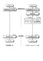
図1に示すように、第1の実施形態のナビゲーションシステムは、概略的に、経路探索等を行うナビゲーションサーバ200、および、単数または複数の経路案内アプリケーションや乗換案内アプリケーション等を搭載した端末装置100、を通信可能に接続して構成される。ここで、図1に示すように、通信には、一例として、ネットワーク300を介した有線・無線通信等の遠隔通信等を含む。また、これらナビゲーションシステムの各部は任意の通信路を介して通信可能に接続されている。また、第2の実施形態においても図1におけるシステム構成と同様に構成されてもよい。
As shown in FIG. 1, the navigation system of the first embodiment schematically includes a
そして、図2に示すように、第1の実施形態のナビゲーションシステムにおいて、ナビゲーションサーバ200は、概略的に、制御部202と記憶部206とを少なくとも備えて構成されており、端末装置100は、位置取得部112と出力部(表示部114および音声出力部118)と入力部116と制御部102と記憶部106とを少なくとも備えて構成されている。
As shown in FIG. 2, in the navigation system of the first embodiment, the
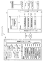
[ナビゲーションサーバ200の構成]
ここで、図2において、ナビゲーションサーバ200は、リンクの距離と、POIの位置情報に基づいて抽出された当該リンク近傍に存在するPOIの数と、に基づき、当該リンクにおけるPOIの密度を算出し、少なくとも当該密度に基づき、リンクの安心度を定義したリンク安心度情報を生成し、端末装置100から送信される少なくとも出発地と目的地とを含む経路探索条件を満たす出発地から目的地までの案内経路を、ネットワークデータ、および、リンク安心度情報を用いて探索し、案内経路データを生成し、案内経路データを少なくとも含む経路案内情報を端末装置100へ送信する等の機能を有する。ナビゲーションサーバ200は、通信制御インターフェース部204を介してネットワーク300を経由し、端末装置100と相互に通信可能に接続されており、制御部202と記憶部206とを備えて構成される。制御部202は、各種処理を行う制御手段である。通信制御インターフェース部204は、通信回線や電話回線等に接続されるアンテナやルータ等の通信装置(図示せず)に接続されるインターフェースであり、ナビゲーションサーバ200とネットワーク300との間における通信制御を行う機能を有する。すなわち、通信制御インターフェース部204は、端末装置100等と通信回線を介してデータを通信する機能を有している。記憶部206は、HD(Hard Disk)等の固定ディスク装置やSSD(Solid State Drive)等のストレージ手段であり、各種のデータベースやテーブル(ネットワークデータベース206a、POI情報データベース206b、リンク安心度情報データベース206c、地図データベース206d、および、案内データベース206e等)を格納する。
[Configuration of Navigation Server 200]
Here, in FIG. 2, the
これら記憶部206の各構成要素のうち、ネットワークデータベース206aは、交通網を規定する、リンクの距離を少なくとも含むリンクデータを少なくとも含むネットワークデータを記憶するネットワークデータ記憶手段である。ここで、ネットワークデータベース206aに記憶されるネットワークデータは、道路ネットワークデータ、路線網ネットワークデータ、および、施設内ネットワークデータを含んでいてもよい。これらネットワークデータは、ネットワークデータベース206aに予め記憶されており、ナビゲーションサーバ200の制御部202は、定期的にネットワーク300を介して最新のデータを外部機器(例えば、地図データを提供する地図提供サーバなど)等からダウンロードしてネットワークデータベース206aに記憶されたネットワークデータをアップデートしてもよい。
Among these components of the
ここで、ネットワークデータベース206aに記憶される道路ネットワークデータは、道路網を規定するネットワークデータであり、例えば、交差点等の道路網表現上の結節点であるノードのノードデータと、ノード間の道路区間であるリンクのリンクデータとの組み合わせによって表現されるネットワークデータである。また、ノードデータには、ノード番号(例えば、ノードID等)、緯度経度高度等の位置座標、ノード種別、接続するリンク本数、接続ノード番号、および、交差点名称等の情報を含んでいてもよい。また、リンクデータには、リンク番号(例えば、リンクID等)、開始ノードID、終了ノードID、道路の種別、国道や県道や市道等の路線番号、重用する路線情報、リンクの存在する行政区域の属性情報、リンク長(例えば、距離等)、道路供用状況、異常気象時通行規制区間、車重制限、車両高さ制限、幅員、道路幅員区分、車線数、制限速度など交通規制、高架やトンネルや橋等のリンク内属性、および、名称等の情報を含んでいてもよい。また、道路ネットワークデータは、交通規制データや利用料金データ等を含んでいてもよい。ここで、交通規制データは、各種の交通規制を定義するデータであり、例えば、道路の損壊や道路工事等による車両通行止、交通の安全を確保するために設置されるコミュニティ・ゾーン等による一般車の進入禁止、および、私有地への接続路であることによる一般車の進入禁止等の情報などを含んでもよい。また、利用料金データは、自動車、オートバイ等で移動する場合に消費する燃料料金、高速自動車国道や自動車専用道路等の有料道路の通行料金等を表す情報等であってもよい。また、道路ネットワークデータは、自動車、オートバイ、自転車、徒歩等で移動する場合の経路上に存在する施設等の緯度経度情報などの位置情報等を記憶してもよい。
Here, the road network data stored in the
また、ネットワークデータベース206aに記憶される路線網ネットワークデータは、電車、飛行機、バス、市電、ロープウェイ、モノレール、ケーブルカー、および、船等の各交通機関の路線網を規定するネットワークデータであり、例えば、駅、空港、港、および、停留所等の路線網表現上の結節点であるノードのノードデータと、ノード間を接続する鉄道路線、航空路線、航路、および、バス路線等のリンクのリンクデータとの組み合わせによって表現されるネットワークデータである。また、路線網ネットワークデータは、交通機関の時刻表データ、利用料金データ、および、乗車位置データ等を含んでいてもよい。ここで、時刻表データは、例えば、電車、飛行機、バス、市電、ロープウェイ、モノレール、ケーブルカー、および、船等の各公共交通機関の時刻表を表す情報等であってもよい。また、利用料金データは、例えば、電車、飛行機、バス、市電、ロープウェイ、モノレール、ケーブルカー、および、船等の各交通機関を利用した場合に生じる利用料金等を表す情報等であってもよい。また、乗車位置データは、例えば、電車、市電、モノレール、ならびに、ケーブルカー等の複数の車両が連結した交通機関の乗車位置(一例として、改札口に近い車両、乗換に便利な位置の車両、混雑率の低い車両、および、女性専用車両等)を表す情報等であってもよい。
In addition, the route network data stored in the
また、ネットワークデータベース206aに記憶される施設内ネットワークデータは、施設内の経路網を規定するネットワークデータであり、例えば、建造物内の店舗、会社、事務所、トイレ等の出入口、エレベータおよびエスカレータの乗降口、階段の出入口、飛行機等の搭乗口、駅のプラットホーム上の電車等の乗車位置、ならびに、駅の改札口等の、通路等を接続する結節点であるノードのノードデータと、ノード間を接続する通路、階段、動く歩道、エスカレータ、および、エレベータ等であるリンクのリンクデータとの組み合わせによって表現されるネットワークデータである。ここで、ノードデータには、ノード番号(例えば、ノードID等)、緯度経度高度等の位置座標(例えば、座標情報等)、ノード種別(例えば、出入口、乗降口、通路の曲がり角、および、通路の分岐点等)、接続するリンク本数、ならびに、接続ノード番号等の情報を含んでいてもよい。また、リンクデータには、リンク番号(例えば、リンクID等)、開始ノードID、終了ノードID、リンク長、幅員、ならびに、リンク種別(例えば、ノード間を接続する通路、階段、スロープ、エスカレータ、エレベータ、および、動く歩道など)の情報を含んでいてもよい。ここで、施設とは、駅、オフィスビル、ホテル、デパート、スーパーマーケット、博物館、美術館、学校、水族館、地下通路、立体駐車場、地下駐車場、および、地下街等の屋内建造物、ならびに、公園、遊園地、キャンプ場、連絡通路、屋外駐車場、および、動物園等の屋外建造物であってもよい。
The in-facility network data stored in the
また、POI情報データベース206bは、POIの位置情報を少なくとも含むPOI情報を記憶するPOI情報記憶手段である。ここで、POIの位置(座標)情報は、POIの緯度経度高度、POIの電話番号、POIの住所、および、POIの存在する地点の立地(都市部、郊外、港湾部、および、駅周辺等)や用途制限(例えば、第一種低層住居専用地域、準住居地域、近隣商業地域、商業地域、準工業地域、工業地域、および、工業専用地域など)等を含んでいてもよい。また、POI情報は、更に、POIの営業時間情報を含んでいてもよい。また、POI情報は、更に、POIのPOI ID、名称、種別等の属性、取扱商品情報、クーポン情報、および、当該POI情報の更新日時等の情報を含んでいてもよい。ここで、POIとは、point of interestの略称であり、便利な場所や興味のある場所として人が知覚する特定の地点や施設等であって、店舗(例えば、飲食店、食料品店、酒店、タバコ店、百貨店、ショッピングセンター、スーパーマーケット、コンビニエンスストア、ガソリンスタンド、金融機関、郵便局、立体駐車場、および、ホテルや旅館等の宿泊施設など)、会社、事務所、公共施設(例えば、官庁、警察署、交番、消防署、駅、医療機関、美術館、博物館、および、学校など)、娯楽施設(例えば、映画館、劇場、遊園地、パチンコ店、カジノ、競馬場、競輪場、競艇場、オートレース場、場外馬券場など)、ならびに、屋外施設(公園、動物園、および、屋外駐車場など)等であってもよい。また、POI情報は、更に、POIの安心度を定義したPOI安心度情報を含んでいてもよい。ここで、POI安心度情報は、POI情報に含まれるPOIの属性、位置情報、営業時間情報、取扱商品情報等に基づいて設定されてもよい。これらPOI情報は、POI情報データベース206bに予め記憶されており、ナビゲーションサーバ200の制御部202は、定期的にネットワーク300を介して最新のデータを外部機器(例えば、POI情報を提供する施設情報提供サーバなど)等からダウンロードしてPOI情報データベース206bに記憶されたPOI情報をアップデートしてもよい。
The
また、リンク安心度情報データベース206cは、リンクの安心度を定義したリンク安心度情報を記憶するリンク安心度情報記憶手段である。ここで、リンク安心度情報には、リンクのリンクID、および、当該リンク通行時の安心度(例えば、安心通行レベルなど)等の情報を少なくとも含んでいてもよい。
The link
また、地図データベース206dは、地図の地図データを記憶する地図データ記憶手段である。ここで、地図データベース206dに記憶される地図データは、本発明において、例えば、縮尺に従ってメッシュ化された地図データ(例えば、JIS規格の第1〜3次地域区画メッシュデータ、および、100mメッシュデータ等)等の屋外地図データであってもよい。また、地図データベース206dは、全国および各地方の道路地図や路線図等の屋外地図データを記憶してもよい。また、地図データベース206dは、例えば、高さ情報を持つ建築物(例えば、立体駐車場、駅、デパート、および、学校等)に関するフロア案内地図等の屋内地図データをさらに記憶してもよい。また、地図データベース206dに記憶される地図データは、地図上に表示される地物(例えば、ビルや住宅や駅等の建造物、道路、線路、橋、トンネル、等高線、海岸線や湖岸線等の水涯線、海、河川、湖、池、沼、公園や屋外施設等の場地、行政界、行政区域、および、街区等)の形状についての形状データ、地図上に表示される注記(例えば、地名、住所、電話番号、店や公園や駅等の施設名称、名所や旧跡や河川や湖や湾や山や森林等の俗称を含む名称、道路や橋やトンネル等の名称、路線名称、地点情報、および、口コミ情報等)の注記データ、ならびに、地図上に表示される記号(例えば、山や史跡や寺社や学校や病院や工場や墓地等の地図記号、ガソリンスタンドやコンビニエンスストアやスーパーマーケットやレストランや銀行や郵便局等の店舗記号、道路上の信号や有料道路の出入口や料金所やサービスエリアやパーキングエリアやインターチェンジ等の記号、駐車場や駅やホテルや美術館や博物館等の施設記号、および、口コミ地点記号等)の記号データ等のデータを含んでいてもよい。また、屋外地図データや屋内地図データは、ラスタ形式、ベクタ形式等の地図描画用の画像データであってもよい。これら屋外地図データや屋内地図データは、地図データベース206dに予め記憶されており、ナビゲーションサーバ200の制御部202は、定期的にネットワーク300を介して最新のデータを外部機器等からダウンロードして地図データベース206dに記憶された屋外地図データおよび屋内地図データをアップデートしてもよい。
The
また、案内データベース206eは、案内データ(音声案内データおよび表示案内データ等)を記憶する案内データ記憶手段である。ここで、案内データベース206eに記憶された表示案内データは、案内経路上の分岐点等における進行方向等に対応付けられた、右左折等の誘導を画面に表示する矢印ナビゲーションであるターンバイターン(TBT)や、現在位置が目標物に近づいた旨を知らせる文字データ等であり、例えば、端末装置100の制御部102が表示案内を実行する際に用いられる。また、案内データベース206eに記憶された音声案内データは、案内経路上の分岐点等における進行方向等に対応付けられた「次の交差点を左に曲がります」や、現在位置が目的地に近づいた場合に対応付けられた「まもなく目的地周辺です」等の音声データであり、例えば、端末装置100の制御部102が音声案内を実行する際に用いられる。
The
また、制御部202は、OS(Operating System)等の制御プログラムや、各種の処理手順等を規定したプログラム、および、所要データを格納するための内部メモリを有する。そして、制御部202は、これらのプログラム等により、種々の処理を実行するための情報処理を行う。制御部202は、機能概念的に、POI安心度情報生成部202a、POI安心度情報格納部202b、密度算出部202c、リンク安心度情報生成部202d、リンク安心度情報格納部202e、経路探索条件受信部202f、経路探索部202g、および、経路案内情報送信部202hを備えて構成される。
The
このうち、POI安心度情報生成部202aは、POI情報データベース206bに記憶されたPOI情報に基づき、POIの安心度を定義したPOI安心度情報を生成するPOI安心度情報生成手段である。ここで、POI安心度情報生成部202aは、POI情報データベース206bに記憶された、POIの位置情報、POIの営業時間情報、属性、および、取扱商品情報等に基づき、POIの安心度をランク付け(ABCDEランク等)したPOI安心度情報を生成してもよい。
Among these, the POI reassurance level
また、POI安心度情報格納部202bは、POI安心度情報生成部202aにより生成されたPOIのPOI安心度情報を、当該POIのPOI IDに対応付けてPOI情報データベース206bに格納するリンク安心度情報格納手段である。
The POI safety
また、密度算出部202cは、ネットワークデータベース206aに記憶されたリンクの距離と、POI情報データベース206bに記憶されたPOIの位置情報に基づいて抽出された当該リンク近傍に存在するPOIの数と、に基づき、当該リンクにおけるPOIの密度を算出する密度算出手段である。
In addition, the
また、リンク安心度情報生成部202dは、少なくとも密度算出部202cにより算出されたPOIの密度に基づき、リンクの安心度を定義したリンク安心度情報を生成するリンク安心度情報生成手段である。ここで、リンク安心度情報生成部202dは、更に、POI情報データベース206bに記憶された、リンク近傍に存在するPOIの営業時間情報に基づき、リンク安心度情報を生成してもよい。また、リンク安心度情報生成部202dは、更に、POI情報データベース206bに記憶された、リンク近傍に存在するPOIのPOI安心度情報に基づき、リンク安心度情報を生成してもよい。また、リンク安心度情報生成部202dは、更に、ネットワークデータベース206aに記憶されたリンクデータに含まれるリンクの距離に基づき、リンク安心度情報を生成してもよい。また、リンク安心度情報生成部202dは、更に、リンク安心度情報データベース206cに記憶された、リンクに隣接するリンクのリンク安心度情報に基づき、リンク安心度情報を生成してもよい。
The link safety
また、リンク安心度情報格納部202eは、リンク安心度情報生成部202dにより生成されたリンクのリンク安心度情報を、ネットワークデータベース206aに記憶されたリンクデータに含まれる当該リンクのリンク番号、すなわち、リンクIDに対応付けてリンク安心度情報データベース206cに格納するリンク安心度情報格納手段である。
Further, the link safety
また、経路探索条件受信部202fは、端末装置100から送信される少なくとも出発地と目的地とを含む経路探索条件を受信する経路探索条件受信手段である。ここで、経路探索条件は、更に、経由地等を含んでいてもよい。
The route search
また、経路探索部202gは、少なくとも出発地と目的地とを含む経路探索条件を満たす出発地から目的地までの案内経路を、ネットワークデータベース206aに記憶されたネットワークデータ、および、リンク安心度情報を用いて探索し、案内経路データを生成する経路探索手段である。ここで、経路探索条件は、端末装置100の利用者により入力部116を介して入力されたものであってもよい。また、経路探索部202gは、少なくとも出発地と目的地と利用者が要求するリンク安心度とを含む経路探索条件を満たす出発地から目的地までの利用者が要求するリンク安心度を満たす案内経路を、ネットワークデータベース206aに記憶されたネットワークデータ、および、リンク安心度情報を用いて探索し、案内経路データを生成してもよい。また、経路探索部202gは、少なくとも出発地と目的地とを含む経路探索条件を満たす出発地から目的地までの案内経路を、ネットワークデータベース206aに記憶されたネットワークデータを用いて探索し、案内経路データを生成してもよい。また、経路探索条件に経由地が更に含まれている場合、経路探索部202gは、経由地を経由した案内経路を探索してもよい。
In addition, the
また、経路案内情報送信部202hは、案内経路データを少なくとも含む経路案内情報を端末装置100へ送信する経路案内情報送信手段である。ここで、経路案内情報は、更に、地図データベース206dに記憶された、案内経路を含む地図の地図データを含んでいてもよい。また、経路案内情報は、更に、案内データベース206eに記憶された、案内経路上において出力される案内データ(表示案内データおよび音声案内データ等)を含んでいてもよい。
The route guidance information transmission unit 202h is route guidance information transmission means for transmitting route guidance information including at least guidance route data to the
[端末装置100の構成]
また、図2において、端末装置100は、ナビゲーションサーバ200から送信される経路案内情報を受信し、受信された経路案内情報を出力部を介して出力させる等の機能を有する。端末装置100は、例えば、一般に市販されるデスクトップ型またはノート型のパーソナルコンピュータ等の情報処理装置、携帯電話やPHSやPDA等の携帯端末装置、および、走行経路案内等を行なうナビゲーション端末等である。ここで、端末装置100は、インターネットブラウザ等を搭載していてもよく、経路案内アプリケーションや乗換案内アプリケーション等を搭載していてもよい。また、端末装置100は、リアルタイムに現在位置取得が行えるよう、GPS機能やIMES機能等を有する位置取得部112を備えている。また、端末装置100は、少なくとも表示部114と音声出力部118とを少なくとも含む出力部を備えている。ここで、表示部114は、表示案内データ等の表示画面を表示する表示手段(例えば、液晶や有機EL等から構成されるディスプレイやモニタ等)である。また、音声出力部118は、ナビゲーションサーバ200から受信した音声案内データ等を音声として出力する音声出力手段(例えば、スピーカ等)である。また、端末装置100は、経路探索条件の入力等を行う入力部116(例えば、キー入力部、タッチパネル、キーボード、マイク等)を備えている。また、入出力制御インターフェース部108は、位置取得部112、表示部114、入力部116、および、音声出力部118等の制御を行う。
[Configuration of Terminal Device 100]
In FIG. 2, the
ここで、位置取得部112は、例えば、位置発信装置500から発信される位置情報信号を受信する位置取得手段であってもよい。ここで、位置発信装置500は、位置情報信号(GPS信号)を発信するGPS装置であってもよく、また、GPS信号と類似した特徴を持つ位置情報信号を用いて屋内測位を可能とするIMES(Indoor Message System)技術を実現するIMES装置であってもよい。なお、IMES技術は測位衛星システムである準天頂衛星の枠組みから発案されたシステムである。また、位置発信装置500は、屋外で受信したGPS信号を屋内で発信するGPSリピータであってもよい。また、位置発信装置500は、建物(例えば、立体駐車場等)内の各フロアや地下構造物(例えば、トンネル、地下駐車場等)の各所に任意に設置される小型発信装置であってもよい。なお、この小型発信装置には、設置場所に応じた自己位置情報(位置ID等)が割り振られている。そして、端末装置100が通信可能範囲に入ると、端末装置100は、小型発信装置から送信される自己位置情報を位置情報信号として受信する。この際の通信方式は、例えば、RFID(Radio Frequency Identification)タグシステムやBluetooth(登録商標)等の各種近距離無線方式や、赤外線通信方式等であってもよい。また、位置発信装置500は、無線LANのアクセスポイントであってもよい。本実施形態において、位置取得部112は、無線LAN信号等を受信して、アクセスポイントの識別情報を取得してもよい。そして、制御部102は、位置取得部112にて取得したアクセスポイント固有の識別情報からアクセスポイントの位置を特定して位置情報を取得してもよい。また、本実施形態において、制御部102は、位置取得部112にて取得された位置情報信号から、緯度、経度、および、高さ情報を含む位置情報を算出してもよい。
Here, the
また、位置取得部112は、例えば、方位センサにて検出した端末装置100の進行方向等の方位情報、距離センサにて検出した距離情報、および、地図データに基づいて端末装置100の利用者の現在位置を示す位置情報を取得してもよい。ここで、方位センサには、端末装置100の絶対走行方位を検出する地磁気センサおよび端末装置100の相対走行方位を検出する光ジャイロが使用されてもよい。また、方位センサは、地磁気センサと加速度センサを組み合わせることで方位や傾きに関する情報を取得できる電子コンパスであってもよい。
In addition, the
また、通信制御インターフェース部104は、通信回線や電話回線等に接続されるアンテナやルータ等の通信装置(図示せず)に接続されるインターフェースであり、端末装置100とネットワーク300との間における通信制御を行う機能を有する。すなわち、通信制御インターフェース部104は、ナビゲーションサーバ200等と通信回線を介してデータを通信する機能を有している。また、ネットワーク300は、端末装置100、ナビゲーションサーバ200、および、外部の地図提供サーバ等の外部機器とを相互に接続する機能を有し、例えば、インターネット、電話回線網(携帯端末回線網および一般電話回線網等)、イントラネット、または、電力線通信(PLC)等であってもよい。
The communication
また、記憶部106は、HDやSSD等の大容量のストレージ手段、および/または、SRAM(Static Random Access Memory)等を用いて構成される小容量高速メモリ(例えば、キャッシュメモリ)等のストレージ手段であり、各種のデータベースやファイルやテーブル(経路案内情報ファイル106a等)を格納してもよい。ここで、記憶部106は、各種のファイル等を一時的に記憶するものであってもよい。
The
このうち、経路案内情報ファイル106aは、経路案内情報を記憶する経路案内情報記憶手段である。
Among these, the route
また、制御部102は、OS等の制御プログラムや、各種の処理手順等を規定したプログラム、および、所要データを格納するための内部メモリを有する。そして、制御部102は、これらのプログラム等により、種々の処理を実行するための情報処理を行う。制御部102は、機能概念的に、現在位置情報取得部102a、経路探索条件送信部102b、経路案内情報受信部102c、および、経路案内部102dを備えて構成される。
The control unit 102 includes an internal memory for storing a control program such as an OS, a program defining various processing procedures, and necessary data. And the control part 102 performs the information processing for performing various processes by these programs. The control unit 102 is functionally conceptually configured to include a current position
また、現在位置情報取得部102aは、端末装置100の利用者の現在位置情報を取得する現在位置情報取得手段である。ここで、現在位置情報取得部102aは、端末装置100の利用者の現在位置情報を所定周期ごと(例えば、1秒ごと等)に取得してもよい。また、現在位置情報取得部102aは、位置取得部112にて位置発信装置500から受信した位置情報信号から算出した位置情報、および/または、位置取得部112の方位センサにて検出した端末装置100の進行方向等の方位情報を端末装置100の利用者の現在位置情報として取得してもよい。また、現在位置情報取得部102aは、利用者により入力部116を介して入力された現在位置についての位置座標等を端末装置100の利用者の現在位置情報として取得してもよい。ここで、利用者により入力部116を介して入力された現在位置は、利用者が現実に存在する位置であってもよく、利用者により任意に選択された仮想の現在位置(一例として、東京にいる利用者により選択された大阪の駅や空港等の任意の地点)であってもよい。具体的には、現在位置情報取得部102aは、入力部116を介して利用者に表示部114に表示された地図データの表示画面上で指定(例えば、タッチパネル式の表示部114での指定操作等)させた座標、および/または、方位情報を端末装置100の利用者の現在位置情報として取得してもよい。
The current position
また、経路探索条件送信部102bは、少なくとも出発地と目的地とを含む経路探索条件をナビゲーションサーバ200へ送信する経路探索条件送信手段である。ここで、出発地は、現在位置情報取得部102aにより取得される現在位置情報に基づく端末装置100の利用者の現在位置であってもよい。また、経路探索条件は、更に、利用者が要求するリンク安心度、および、経由地等を含んでいてもよい。
The route search
また、経路案内情報受信部102cは、ナビゲーションサーバ200から送信される経路案内情報を受信する経路案内情報受信手段である。ここで、経路案内情報受信部102cは、更に、受信した経路案内情報を経路案内情報ファイル106aに格納してもよい。
The route guidance
また、経路案内部102dは、経路案内情報を出力部を介して出力させる経路案内手段である。ここで、経路案内部102dは、経路案内情報に基づく表示画面を表示部114に表示させてもよい。例えば、経路案内部102dは、案内経路データ、地図データ、および/または、案内データに含まれるTBT等の表示案内データの表示画面を表示部114に表示させてもよい。また、経路案内部102dは、経路案内情報と、端末装置100の利用者の現在位置情報と、を出力部を介して出力させてもよい。例えば、経路案内部102dは、地図データ上に、案内経路データ、および/または、端末装置100の利用者の現在位置情報を重畳した表示画面を表示部114に表示させてもよい。また、経路案内部102dは、経路案内情報を音声出力部118を介して出力させてもよい。具体的に、経路案内部102dは、案内データに含まれる案内経路上の分岐点等における進行方向等に対応付けられた音声案内データを、音声出力部118を介して出力させてもよい。
The
以上で、第1の実施形態におけるナビゲーションシステムの構成の一例の説明を終える。 Above, description of an example of a structure of the navigation system in 1st Embodiment is finished.
[ナビゲーションシステムの処理]
次に、このように構成された第1の実施形態におけるナビゲーションシステムの処理の一例について、以下に図3から図9を参照して詳細に説明する。
[Navigation system processing]
Next, an example of processing of the navigation system according to the first embodiment configured as described above will be described in detail with reference to FIGS.
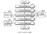
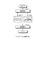
[リンク安心度情報生成処理]
まず、第1の実施形態におけるリンク安心度情報生成処理の一例について、以下に図3から図7を参照して詳細に説明する。図3は、第1の実施形態におけるリンク安心度情報生成処理の一例を示すフローチャートである。
[Link safety information generation processing]
First, an example of link safety level information generation processing in the first embodiment will be described in detail with reference to FIGS. FIG. 3 is a flowchart illustrating an example of link safety level information generation processing according to the first embodiment.
図3に示すように、まず、ナビゲーションサーバ200のPOI安心度情報生成部202aは、POI情報データベース206bに記憶されたPOI情報に含まれる、POIの位置情報、POIの営業時間情報、属性、および、取扱商品情報等に基づき、POIの安心度を定義したPOI安心度情報を生成する(ステップSA−1)。ここで、POI安心度情報生成部202aは、POIの安心度をランク付け(ABCDEランク等)したPOI安心度情報を生成してもよい。
As shown in FIG. 3, first, the POI safety level
そして、ナビゲーションサーバ200のPOI安心度情報格納部202bは、POI安心度情報生成部202aにより生成されたPOIのPOI安心度情報を、当該POIのPOI IDに対応付けてPOI情報データベース206bに格納する(ステップSA−2)。
Then, the POI safety
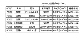
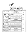
ここで、図4を参照して、本実施形態におけるPOI安心度情報の一例について説明する。図4は、本実施形態におけるPOI情報データベース206bに記憶されたPOI情報の一例を示す図である。
Here, with reference to FIG. 4, an example of POI relief information in the present embodiment will be described. FIG. 4 is a diagram showing an example of POI information stored in the
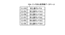
図4に示すように、POI情報データベース206bに記憶されたPOIの安心度をABCDEランクでランク付けしたPOI安心度情報(すなわち、POI安心レベル)は、POI情報データベース206bに記憶された、POIの属性(コンビニエンスストア、飲食店、ショッピングセンター、交番、競馬場、パチンコ店)、POIの営業時間(24時間等)、および/または、POIの座標情報等に基づき、安心度が高い順にPOI安心レベルAからPOI安心レベルEへと定義されている。
As shown in FIG. 4, POI safety information (that is, POI safety level) obtained by ranking the POI security level stored in the
図3に戻り、ナビゲーションサーバ200の密度算出部202cは、ネットワークデータベース206aに記憶されたリンクの距離と、POI情報データベース206bに記憶されたPOIの位置情報に基づいて抽出された当該リンク近傍に存在するPOIの数と、に基づき、当該リンクにおけるPOIの密度を算出する(ステップSA−3)。
Returning to FIG. 3, the
ここで、密度算出部202cは、下記の式を用いてPOIの密度を算出してもよい。
(密度)=(リンク近傍に存在するPOIの数)/(リンクの距離)
Here, the
(Density) = (Number of POIs present near the link) / (Link distance)
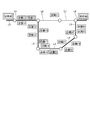
ここで、図4から図6を参照して、本実施形態におけるPOI密度算出処理の一例について説明する。図5は、本実施形態におけるリンクとPOIの位置関係の一例を示す図である。図6は、本実施形態におけるネットワークデータベース206aに記憶されたネットワークデータの一例を示す図である。
Here, an example of POI density calculation processing in the present embodiment will be described with reference to FIGS. 4 to 6. FIG. 5 is a diagram illustrating an example of a positional relationship between a link and a POI in the present embodiment. FIG. 6 is a diagram showing an example of network data stored in the
図5に示すような位置関係に、店舗1〜4、公共施設1、および、娯楽施設1の各POIとリンクA〜Eとがある場合、密度算出部202cは、図6に示したネットワークデータベース206aに記憶されたリンクの距離(すなわち、リンクA=5m、リンクB=15m、リンクC=20m、リンクD=5m、および、リンクE=10m)と、図4に示したPOI情報データベース206bに記憶されたPOIの座標情報に基づいて抽出されたリンクA〜E近傍に存在するPOIの数(すなわち、リンクA:2、リンクB:1、リンクC:1、リンクD:0、および、リンクE:2)と、に基づき、リンクにおけるPOIの密度を、リンクAのPOIの密度=2/5、リンクBのPOIの密度=1/15、リンクCのPOIの密度=1/20、リンクDのPOIの密度=0、および、リンクEのPOIの密度=2/10、と算出することができる。
When the positional relationships as shown in FIG. 5 include the POIs of the
再び図3に戻り、ナビゲーションサーバ200のリンク安心度情報生成部202dは、少なくとも密度算出部202cにより算出されたPOIの密度に基づき、リンクの安心度を定義したリンク安心度情報を生成する(ステップSA−4)。ここで、リンク安心度情報生成部202dは、更に、POI情報データベース206bに記憶された、リンク近傍に存在するPOIの営業時間情報に基づき、リンク安心度情報を生成してもよい。また、リンク安心度情報生成部202dは、更に、POI情報データベース206bに記憶された、リンク近傍に存在するPOIのPOI安心度情報に基づき、リンク安心度情報を生成してもよい。また、リンク安心度情報生成部202dは、更に、ネットワークデータベース206aに記憶されたリンクデータに含まれるリンクの距離に基づき、リンク安心度情報を生成してもよい。また、リンク安心度情報生成部202dは、更に、リンク安心度情報データベース206cに記憶された、リンクに隣接するリンクのリンク安心度情報に基づき、リンク安心度情報を生成してもよい。また、リンク安心度情報生成部202dは、POI情報データベース206bに記憶されたPOI情報の各項目(属性、営業時間、位置情報等)について、レベル付けをして、当該各項目の値を加算する等によりリンク安心度情報を生成してもよい。
Returning to FIG. 3 again, the link security level
そして、ナビゲーションサーバ200のリンク安心度情報格納部202eは、リンク安心度情報生成部202dにより生成されたリンクのリンク安心度情報を、ネットワークデータベース206aに記憶されたリンクデータに含まれる当該リンクのリンクIDに対応付けてリンク安心度情報データベース206cに格納する(ステップSA−5)。
Then, the link safety
ここで、図6および図7を参照して、本実施形態におけるリンク安心度情報データベース206cに記憶されたリンク安心度情報の一例について説明する。図7は、本実施形態におけるリンク安心度情報データベース206cに記憶されたリンク安心度情報の一例を示す図である。
Here, an example of link safety information stored in the link
図7に示すように、リンク安心度情報データベース206cには、リンク安心度情報生成部202dにより生成された、ABCDEランクでランク付けしたリンク安心度情報(すなわち、安心通行レベル)が、図6に示すネットワークデータベース206aに記憶されたリンクデータ(リンクID、距離、道路種別、開始ノードID、終了ノードID)に含まれるリンクIDに対応付けて格納されている。
As shown in FIG. 7, in the link
以上で、第1の実施形態におけるリンク安心度情報生成処理の一例の説明を終える。 Above, description of an example of the link comfort level information generation process in 1st Embodiment is finished.
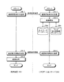
[ナビゲーション処理]
次に、第1の実施形態におけるナビゲーション処理の一例について、以下に図8および図9を参照して詳細に説明する。図8は、第1の実施形態におけるナビゲーション処理の一例を示すフローチャートである。
[Navigation process]
Next, an example of the navigation processing in the first embodiment will be described in detail with reference to FIGS. 8 and 9 below. FIG. 8 is a flowchart illustrating an example of the navigation process in the first embodiment.
図8に示すように、まず、端末装置100の経路探索条件送信部102bは、利用者により入力部116を介して入力された少なくとも出発地と目的地と利用者が要求するリンク安心度とを含む経路探索条件をナビゲーションサーバ200へ送信する(ステップSB−1)。ここで、出発地は、現在位置情報取得部102aにより取得される現在位置情報に基づく端末装置100の利用者の現在位置であってもよい。また、経路探索条件は、更に、経由地等を含んでいてもよい。
As shown in FIG. 8, first, the route search
そして、ナビゲーションサーバ200の経路探索条件受信部202fは、端末装置100から送信される少なくとも出発地と目的地と利用者が要求するリンク安心度とを含む経路探索条件を受信する(ステップSB−2)。
Then, the route search
そして、ナビゲーションサーバ200の経路探索部202gは、経路探索条件受信部202fにより受信された少なくとも出発地と目的地と利用者が要求するリンク安心度とを含む経路探索条件を満たす出発地から目的地までの利用者が要求するリンク安心度を満たす案内経路を、ネットワークデータベース206aに記憶されたネットワークデータ、および、リンク安心度情報データベース206cに記憶されたリンク安心度情報を用いて探索し、案内経路データを生成する(ステップSB−3)。ここで、経路探索部202gは、例えば、利用者が要求するリンク安心度(例えば、安心通行レベル等)を満たすリンクの、リンク安心度情報データベース206cに記憶されたリンクIDを特定し、当該リンクIDに対応するネットワークデータベース206aに記憶されたリンクデータを用いて、出発地から目的地までの案内経路を探索してもよい。また、経路探索条件に経由地が更に含まれている場合、経路探索部202gは、経由地を経由した案内経路を探索してもよい。また、経路探索部202gは、経路探索条件に利用者が要求するリンク安心度が含まれていることで、利用者が求める安全レベルに応じた経路探索を行うことができる。
Then, the
ここで、図9を参照して、本実施形態におけるPOIの密度に基づくリンク安心度情報を用いた経路探索の一例について説明する。図9は、本実施形態におけるリンク安心度情報に基づき探索された案内経路の一例を示す図である。 Here, with reference to FIG. 9, an example of the route search using the link comfort level information based on the density of the POI in the present embodiment will be described. FIG. 9 is a diagram illustrating an example of a guidance route searched based on link safety information in the present embodiment.
経路探索部202gは、出発地から目的地まで単純に距離に基づき経路探索した場合、「出発地(リンクL0)→リンクL1→リンクL6→リンクL7→目的地(リンクL8)」という案内経路を探索することになる。しかしながら、図9に示すように、経路探索部202gは、本実施形態において少なくとも出発地と目的地と利用者が要求するリンク安心度(例えば、近傍に2つ以上のPOIが存在、または、安心通行レベルC以上等)とを含む経路探索条件を満たす、出発地から目的地までの利用者が要求するリンク安心度を満たす案内経路を探索するため、リンクL6およびリンクL7に比して店舗が密集していることでPOIの密度に基づくリンク安心度情報が高く設定されているリンクL2〜L5を通る「出発地(リンクL0)→リンクL1→リンクL2→リンクL3→リンクL4→リンクL5→目的地(リンクL8)」という案内経路(太線)を探索している。なお、経路探索部202gは、迂回路となる他のリンクが存在しない場合(例えば、リンクL0およびリンクL8等)、および、利用者が要求するリンク安心度を満たすリンクが存在しない場合、利用者が要求するリンク安心度を下回るリンクを案内経路に含ませてもよい(例えば、なるべくリンク安心度の高いリンクを案内経路に含ませる等)。
When the
再び図8に戻り、ナビゲーションサーバ200の経路案内情報送信部202hは、経路探索部202gにより生成された案内経路データを少なくとも含む経路案内情報を端末装置100へ送信する(ステップSB−4)。ここで、経路案内情報は、更に、地図データベース206dに記憶された、案内経路を含む地図の地図データを含んでいてもよい。また、経路案内情報は、更に、案内データベース206eに記憶された、案内経路上において出力される案内データ(表示案内データおよび音声案内データ等)を含んでいてもよい。
Returning to FIG. 8 again, the route guidance information transmission unit 202h of the
そして、端末装置100の経路案内情報受信部102cは、ナビゲーションサーバ200から送信される経路案内情報を受信して、経路案内情報ファイル106aに格納する(ステップSB−5)。
And the route guidance
そして、端末装置100の経路案内部102dは、経路案内情報ファイル106aに記憶された経路案内情報を出力部を介して出力させる(ステップSB−6)。ここで、経路案内部102dは、経路案内情報ファイル106aに記憶された経路案内情報に基づく表示画面を表示部114に表示させてもよい。また、経路案内部102dは、経路案内情報ファイル106aに記憶された、案内経路データ、地図データ、および/または、案内データに含まれるTBT等の表示案内データの表示画面を表示部114に表示させてもよい。また、経路案内部102dは、経路案内情報ファイル106aに記憶された経路案内情報と、端末装置100の利用者の現在位置情報と、を出力部を介して出力させてもよい。また、経路案内部102dは、経路案内情報ファイル106aに記憶された地図データ上に、経路案内情報ファイル106aに記憶された案内経路データ、および/または、端末装置100の利用者の現在位置情報を重畳した表示画面を表示部114に表示させてもよい。また、経路案内部102dは、経路案内情報ファイル106aに記憶された経路案内情報を音声出力部118を介して出力させてもよい。また、経路案内部102dは、経路案内情報ファイル106aに記憶された案内データに含まれる案内経路上の分岐点等における進行方向等に対応付けられた音声案内データを、音声出力部118を介して出力させてもよい。なお、経路案内部102dによる経路案内や音声ナビゲーションの実行処理は、経路案内や音声ナビゲーションの開始後、端末装置100が目的地、経由地、または、案内地点等に到達するまで、継続して、および/または、繰り返し行ってもよい。
And the
以上で、第1の実施形態におけるナビゲーションシステムの処理の一例の説明を終える。 Above, description of an example of the process of the navigation system in 1st Embodiment is finished.
[第2の実施形態]
続いて、本発明の第2の実施形態(ナビゲーションサーバ200(サーバ主導型))について、図10および図11を参照して以下に説明する。ここで、図10は、第2の実施形態におけるナビゲーションサーバ200の構成の一例を示すブロック図であり、該構成のうち本発明に関係する部分のみを概念的に示している。また、図11は、第2の実施形態におけるナビゲーション処理の一例を示すフローチャートである。
[Second Embodiment]
Subsequently, a second embodiment (navigation server 200 (server-driven type)) of the present invention will be described below with reference to FIGS. 10 and 11. Here, FIG. 10 is a block diagram showing an example of the configuration of the
なお、第2の実施形態においては、ナビゲーションサーバ200にて端末装置100の表示部114に表示させるデータを生成し、これらのデータを端末装置100へ送信することにより、当該端末装置100の表示部114を機能させている。このように、第2の実施形態は、ナビゲーションサーバ200にてサーバ主導で処理を行う点がその他の実施形態と異なる。
In the second embodiment, the
[ナビゲーションサーバ200(サーバ主導型)の構成]
まず、第2の実施形態におけるナビゲーションサーバ200(サーバ主導型)の構成の一例について、図10を参照して以下に説明する。
[Configuration of the navigation server 200 (server-driven type)]
First, an example of the configuration of the navigation server 200 (server-driven type) in the second embodiment will be described below with reference to FIG.
図10に示すように、本発明の第2の実施形態のナビゲーションサーバ200は、位置取得部112と出力部(表示部114および音声出力部118)と入力部116と制御部102とを少なくとも備えた端末装置100に通信可能に接続された、制御部202と記憶部206とを少なくとも備えて構成される。通信には、一例として、ネットワーク300を介した有線・無線通信等の遠隔通信等を含む。また、これらナビゲーションサーバ200および端末装置100の各部は任意の通信路を介して通信可能に接続されている。
As illustrated in FIG. 10, the
図10において、ナビゲーションサーバ200は、リンクの距離と、POIの位置情報に基づいて抽出された当該リンク近傍に存在するPOIの数と、に基づき、当該リンクにおけるPOIの密度を算出し、少なくとも当該密度に基づき、リンクの安心度を定義したリンク安心度情報を生成し、端末装置100から送信される少なくとも出発地と目的地とを含む経路探索条件を満たす出発地から目的地までの案内経路を、ネットワークデータ、および、リンク安心度情報を用いて探索し、案内経路データを生成し、案内経路データを少なくとも含む経路案内情報に基づく表示画面を生成し、表示画面を端末装置100へ送信することにより、当該端末装置100の表示部114に当該表示画面を表示させる等の機能を有する。
In FIG. 10, the
なお、ナビゲーションサーバ200における通信制御インターフェース部204および記憶部206(ネットワークデータベース206a、POI情報データベース206b、リンク安心度情報データベース206c、地図データベース206d、および、案内データベース206e等)の機能、また、端末装置100における位置取得部112、表示部114、入力部116、および、音声出力部118の機能は、第1の実施形態と同様であるため説明を省略する。
The functions of the communication
また、図10において、制御部202は、OS等の制御プログラムや、各種の処理手順等を規定したプログラム、および、所要データを格納するための内部メモリを有する。そして、制御部202は、これらのプログラム等により、種々の処理を実行するための情報処理を行う。制御部202は、機能概念的に、POI安心度情報生成部202a、POI安心度情報格納部202b、密度算出部202c、リンク安心度情報生成部202d、リンク安心度情報格納部202e、経路探索条件受信部202f、経路探索部202g、経路案内表示画面生成部202i、および、経路案内表示制御部202jを備えて構成される。なお、POI安心度情報生成部202a、POI安心度情報格納部202b、密度算出部202c、リンク安心度情報生成部202d、リンク安心度情報格納部202e、経路探索条件受信部202f、および、経路探索部202gの機能は、第1の実施形態と同様であるため説明を省略する。
In FIG. 10, the
このうち、経路案内表示画面生成部202iは、案内経路データを少なくとも含む経路案内情報に基づく表示画面を生成する経路案内表示画面生成手段である。ここで、経路案内表示画面生成部202iは、案内経路の進行方向等に対応付けられた、案内データベース206eに記憶されたTBT等の表示案内データの表示画面を生成してもよい。また、経路案内表示画面生成部202iは、経路案内情報、および、端末装置100の利用者の現在位置情報に基づく表示画面を生成してもよい。また、経路案内表示画面生成部202iは、地図データベース206dに記憶された地図データ上に、案内経路データ、および/または、端末装置100の利用者の現在位置情報を重畳した表示画面を生成してもよい。
Among these, the route guidance display screen generation unit 202i is route guidance display screen generation means for generating a display screen based on route guidance information including at least guidance route data. Here, the route guidance display screen generation unit 202i may generate a display screen of display guidance data such as TBT stored in the
また、経路案内表示制御部202jは、経路案内表示画面生成部202iにより生成された表示画面を端末装置100へ送信することにより、当該端末装置100の表示部114に当該表示画面を表示させる経路案内表示制御手段である。ここで、経路案内表示制御部202jは、案内データベース206eに記憶された案内経路に対応する音声案内データを端末装置100へ送信することにより、端末装置100の音声出力部118を介して出力させて音声案内を実行させてもよい。
Further, the route guidance
以上で、第2の実施形態におけるナビゲーションサーバ200の構成の一例の説明を終える。
Above, description of an example of a structure of the
[ナビゲーションサーバ200(サーバ主導型)の処理]
次に、このように構成された第2の実施形態におけるナビゲーションサーバ200の処理の一例について、以下に図11を参照して詳細に説明する。
[Processing of navigation server 200 (server-driven type)]
Next, an example of processing of the
[リンク安心度情報生成処理]
第2の実施形態におけるリンク安心度情報生成処理は、図3に示す第1の実施形態におけるリンク安心度情報生成処理と同様であるため説明を省略する。
[Link safety information generation processing]
The link safety information generation process in the second embodiment is the same as the link safety information generation process in the first embodiment shown in FIG.
[ナビゲーション処理]
図11に示すように、まず、端末装置100の制御部102は、利用者により入力部116を介して入力された少なくとも出発地と目的地と利用者が要求するリンク安心度とを含む経路探索条件をナビゲーションサーバ200へ送信する(ステップSC−1)。ここで、出発地は、位置取得部112にて位置発信装置500から受信した位置情報信号に基づく端末装置100の利用者の現在位置であってもよい。例えば、制御部102は、位置取得部112にて位置発信装置500から受信した位置情報信号から算出した位置情報を端末装置100の利用者の現在位置情報として取得し、当該現在位置情報に基づく端末装置100の利用者の現在位置を出発地として設定してもよい。また、制御部102は、位置取得部112にて位置発信装置500から受信した位置情報信号をナビゲーションサーバ200へ送信してもよい。また、経路探索条件は、更に、経由地等を含んでいてもよい。
[Navigation process]
As shown in FIG. 11, first, the control unit 102 of the
そして、ナビゲーションサーバ200の経路探索条件受信部202fは、端末装置100から送信される少なくとも出発地と目的地と利用者が要求するリンク安心度とを含む経路探索条件を受信する(ステップSC−2)。ここで、経路探索条件受信部202fは、端末装置100から位置情報信号を受信した場合、当該位置情報信号から算出した位置情報を端末装置100の利用者の現在位置情報として取得し、当該現在位置情報に基づく端末装置100の利用者の現在位置を経路探索条件の出発地として設定してもよい。
Then, the route search
そして、ナビゲーションサーバ200の経路探索部202gは、経路探索条件受信部202fにより受信された少なくとも出発地と目的地と利用者が要求するリンク安心度とを含む経路探索条件を満たす出発地から目的地までの利用者が要求するリンク安心度を満たす案内経路を、ネットワークデータベース206aに記憶されたネットワークデータ、および、リンク安心度情報データベース206cに記憶されたリンク安心度情報を用いて探索し、案内経路データを生成する(ステップSC−3)。ここで、経路探索条件に経由地が更に含まれている場合、経路探索部202gは、経由地を経由した案内経路を探索してもよい。
Then, the
そして、ナビゲーションサーバ200の経路案内表示画面生成部202iは、経路探索部202gにより生成された案内経路データを少なくとも含む経路案内情報に基づく表示画面を生成する(ステップSC−4)。ここで、経路案内表示画面生成部202iは、案内経路の進行方向等に対応付けられた、案内データベース206eに記憶されたTBT等の表示案内データの表示画面を生成してもよい。また、経路案内表示画面生成部202iは、経路探索部202gにより生成された案内経路データ、および、端末装置100の利用者の現在位置情報に基づく表示画面を生成してもよい。また、経路案内表示画面生成部202iは、地図データベース206dに記憶された案内経路を含む地図の地図データ上に、経路探索部202gにより生成された案内経路データ、および/または、端末装置100の位置取得部112にて位置発信装置500から定期的に受信した位置情報信号に基づく端末装置100の利用者の現在位置情報を重畳した表示画面を生成してもよい。ここで、経路案内表示画面生成部202iは、端末装置100から位置情報信号を受信して、当該位置情報信号から位置情報を算出し、当該位置情報を端末装置100の利用者の現在位置情報として取得することで、表示画面を生成してもよい。
Then, the route guidance display screen generation unit 202i of the
そして、ナビゲーションサーバ200の経路案内表示制御部202jは、経路案内表示画面生成部202iにより生成された表示画面を端末装置100へ送信することにより、当該端末装置100の表示部114に当該表示画面を表示させる(ステップSC−5)。ここで、経路案内表示制御部202jは、例えば、利用者により端末装置100の入力部116を介して入力された経路案内開始要求等を受信した場合、経路案内表示画面生成部202iにより生成された、地図データベース206dに記憶された案内経路を含む地図の地図データ上に、経路探索部202gにより生成された案内経路データ、および/または、定期的に取得される端末装置100の利用者の現在位置情報を重畳した表示画面を端末装置100へ送信することにより、当該端末装置100の表示部114に当該表示画面を表示させてもよい。また、経路案内表示制御部202jは、例えば、利用者により入力部116を介して入力された音声ナビゲーション開始要求等を受信した場合、案内データベース206eに記憶された案内経路上の分岐点等の案内地点における進行方向等に対応付けられた音声案内データを端末装置100へ送信することにより、当該端末装置100の音声出力部118を介して出力させてもよい。なお、経路案内表示制御部202jによる経路案内の表示制御や音声出力制御の実行処理は、経路案内や音声ナビゲーションの開始後、端末装置100が目的地、経由地、または、案内地点等に到達するまで、継続して、および/または、繰り返し行ってもよい。
Then, the route guidance
以上で、第2の実施形態におけるナビゲーションサーバ200の処理の一例の説明を終える。
Above, description of an example of the process of the
[第3の実施形態]
続いて、本発明の第3の実施形態(ナビゲーション装置400(スタンドアローン型))について、図12および図13を参照して以下に説明する。ここで、図12は、第3の実施形態におけるナビゲーション装置400の構成の一例を示すブロック図であり、該構成のうち本発明に関係する部分のみを概念的に示している。また、図13は、第3の実施形態におけるナビゲーション処理の一例を示すフローチャートである。
[Third Embodiment]
Next, a third embodiment (navigation device 400 (stand-alone type)) of the present invention will be described below with reference to FIGS. Here, FIG. 12 is a block diagram showing an example of the configuration of the
なお、第3の実施形態においては、全ての機能をナビゲーション装置400に集約し、ナビゲーションサーバ200に接続することなく、リンクの距離と、POIの位置情報に基づいて抽出された当該リンク近傍に存在するPOIの数と、に基づき、当該リンクにおけるPOIの密度を算出し、少なくとも当該密度に基づき、リンクの安心度を定義したリンク安心度情報を生成する。このように、第3の実施形態は、ナビゲーション装置400がスタンドアローン型に構成され単独で処理を行う点がその他の実施形態と異なる。
Note that, in the third embodiment, all functions are aggregated in the
[ナビゲーション装置400(スタンドアローン型)の構成]
まず、第3の実施形態におけるナビゲーション装置400(スタンドアローン型)の構成の一例について、図12を参照して以下に説明する。
[Configuration of the navigation device 400 (stand-alone type)]
First, an example of the configuration of the navigation device 400 (stand-alone type) in the third embodiment will be described below with reference to FIG.
図12に示すように、本発明の第3の実施形態のナビゲーション装置400は、位置取得部412と出力部(表示部414および音声出力部418)と入力部416と制御部402と記憶部406とを少なくとも備えて構成される。これらナビゲーション装置400の各部は任意の通信路を介して通信可能に接続されている。
As shown in FIG. 12, the
図12において、入出力制御インターフェース部408、位置取得部412、表示部414、入力部416、および、音声出力部418の各機能は、第1の実施形態と同様であるため説明を省略する。また、記憶部406の各部(ネットワークデータベース406a、POI情報データベース406b、リンク安心度情報データベース406c、地図データベース406d、および、案内データベース406e等)についても、ナビゲーションサーバ200ではなくナビゲーション装置400に備えられている点を除き、各機能が第1の実施形態と同様であるため説明を省略する。
In FIG. 12, the functions of the input / output
また、制御部402の各部(POI安心度情報生成部402a〜経路案内部402h等)については、本実施形態のナビゲーション装置400がスタンドアローン型であり、制御部402が各送信部を備えていない点を除き、各機能は第1の実施形態と基本的に同様である。
As for each part of the control unit 402 (POI safety information generation unit 402a to route guidance unit 402h, etc.), the
また、図12において、制御部402は、OS等の制御プログラムや、各種の処理手順等を規定したプログラム、および、所要データを格納するための内部メモリを有する。そして、制御部402は、これらのプログラム等により、種々の処理を実行するための情報処理を行う。制御部402は、機能概念的に、POI安心度情報生成部402a、POI安心度情報格納部402b、密度算出部402c、リンク安心度情報生成部402d、リンク安心度情報格納部402e、現在位置情報取得部402f、経路探索部402g、および、経路案内部402hを備えて構成される。
In FIG. 12, the
このうち、POI安心度情報生成部402aは、POI情報データベース406bに記憶されたPOI情報に基づき、POIの安心度を定義したPOI安心度情報を生成するPOI安心度情報生成手段である。ここで、POI安心度情報生成部402aは、POI情報データベース406bに記憶された、POIの位置情報、POIの営業時間情報、属性、および、取扱商品情報等に基づき、POIの安心度をランク付け(ABCDEランク等)したPOI安心度情報を生成してもよい。
Among these, the POI safety level information generation unit 402a is a POI safety level information generation unit that generates POI safety level information defining POI level of safety based on the POI information stored in the
また、POI安心度情報格納部402bは、POI安心度情報生成部402aにより生成されたPOIのPOI安心度情報を、当該POIのPOI IDに対応付けてPOI情報データベース406bに格納するリンク安心度情報格納手段である。
Further, the POI safety
また、密度算出部402cは、ネットワークデータベース406aに記憶されたリンクの距離と、POI情報データベース406bに記憶されたPOIの位置情報に基づいて抽出された当該リンク近傍に存在するPOIの数と、に基づき、当該リンクにおけるPOIの密度を算出する密度算出手段である。
In addition, the density calculation unit 402c includes the link distance stored in the
また、リンク安心度情報生成部402dは、少なくとも密度算出部402cにより算出されたPOIの密度に基づき、リンクの安心度を定義したリンク安心度情報を生成するリンク安心度情報生成手段である。ここで、リンク安心度情報生成部402dは、更に、POI情報データベース406bに記憶された、リンク近傍に存在するPOIの営業時間情報に基づき、リンク安心度情報を生成してもよい。また、リンク安心度情報生成部402dは、更に、POI情報データベース406bに記憶された、リンク近傍に存在するPOIのPOI安心度情報に基づき、リンク安心度情報を生成してもよい。また、リンク安心度情報生成部402dは、更に、ネットワークデータベース406aに記憶されたリンクデータに含まれるリンクの距離に基づき、リンク安心度情報を生成してもよい。また、リンク安心度情報生成部402dは、更に、リンク安心度情報データベース406cに記憶された、リンクに隣接するリンクのリンク安心度情報に基づき、リンク安心度情報を生成してもよい。
The link safety
また、リンク安心度情報格納部402eは、リンク安心度情報生成部402dにより生成されたリンクのリンク安心度情報を、ネットワークデータベース406aに記憶されたリンクデータに含まれる当該リンクのリンク番号、すなわち、リンクIDに対応付けてリンク安心度情報データベース406cに格納するリンク安心度情報格納手段である。
Further, the link safety
また、現在位置情報取得部402fは、ナビゲーション装置400の利用者の現在位置情報を取得する現在位置情報取得手段である。ここで、現在位置情報取得部402fは、ナビゲーション装置400の利用者の現在位置情報を所定周期ごと(例えば、1秒ごと等)に取得してもよい。また、現在位置情報取得部402fは、位置取得部412にて位置発信装置500から受信した位置情報信号から算出した位置情報、および/または、位置取得部412の方位センサにて検出したナビゲーション装置400の進行方向等の方位情報をナビゲーション装置400の利用者の現在位置情報として取得してもよい。また、現在位置情報取得部402fは、利用者により入力部416を介して入力された現在位置についての位置座標等をナビゲーション装置400の利用者の現在位置情報として取得してもよい。ここで、利用者により入力部416を介して入力された現在位置は、利用者が現実に存在する位置であってもよく、利用者により任意に選択された仮想の現在位置(一例として、東京にいる利用者により選択された大阪の駅や空港等の任意の地点)であってもよい。例えば、現在位置情報取得部402fは、入力部416を介して利用者に表示部414に表示された地図データの表示画面上で指定(例えば、タッチパネル式の表示部414での指定操作等)させた座標、および/または、方位情報をナビゲーション装置400の利用者の現在位置情報として取得してもよい。
The current position
また、経路探索部402gは、少なくとも出発地と目的地とを含む経路探索条件を満たす出発地から目的地までの案内経路を、ネットワークデータベース406aに記憶されたネットワークデータ、および、リンク安心度情報を用いて探索し、案内経路データを生成する経路探索手段である。また、経路探索部402gは、少なくとも出発地と目的地と利用者が要求するリンク安心度とを含む経路探索条件を満たす出発地から目的地までの利用者が要求するリンク安心度を満たす案内経路を、ネットワークデータベース406aに記憶されたネットワークデータ、および、リンク安心度情報を用いて探索し、案内経路データを生成してもよい。また、経路探索部402gは、少なくとも出発地と目的地とを含む経路探索条件を満たす出発地から目的地までの案内経路を、ネットワークデータベース406aに記憶されたネットワークデータを用いて探索し、案内経路データを生成してもよい。また、経路探索条件に経由地が更に含まれている場合、経路探索部402gは、経由地を経由した案内経路を探索してもよい。
Further, the route search unit 402g obtains the guide route from the departure point to the destination that satisfies the route search condition including at least the departure point and the destination, the network data stored in the
また、経路案内部402hは、案内経路データを少なくとも含む経路案内情報を出力部を介して出力させる経路案内手段である。ここで、経路案内部402hは、案内経路データと、ナビゲーション装置400の利用者の現在位置情報と、を出力部を介して出力させてもよい。例えば、経路案内部402hは、案内経路データ、地図データ、および/または、案内データに含まれるTBT等の表示案内データの表示画面を表示部414に表示させてもよい。また、経路案内部402hは、地図データ上に、案内経路データ、および/または、ナビゲーション装置400の利用者の現在位置情報を重畳した表示画面を表示部414に表示させてもよい。また、経路案内部402hは、案内データに含まれる案内経路上の分岐点等における進行方向等に対応付けられた音声案内データを、音声出力部418を介して出力させてもよい。
The route guidance unit 402h is route guidance means for outputting route guidance information including at least guidance route data via the output unit. Here, the route guide unit 402h may output the guide route data and the current position information of the user of the
以上で、第3の実施形態におけるナビゲーション装置400の構成の一例の説明を終える。
Above, description of an example of a structure of the
[ナビゲーション装置400(スタンドアローン型)の処理]
次に、このように構成された第3の実施形態におけるナビゲーション装置400の処理の一例について、以下に図13を参照して詳細に説明する。
[Processing of navigation device 400 (stand-alone type)]
Next, an example of the process of the
[リンク安心度情報生成処理]
第3の実施形態においてナビゲーション装置400にて実行されるリンク安心度情報生成処理は、図3に示す第1の実施形態におけるナビゲーションサーバ200の対応する構成にて実行されるリンク安心度情報生成処理と同様であるため説明を省略する。
[Link safety information generation processing]
The link comfort level information generation process executed in the
[ナビゲーション処理]
図13に示すように、まず、経路探索部402gは、利用者により入力部416を介して入力された少なくとも出発地と目的地と利用者が要求するリンク安心度とを含む経路探索条件を満たす出発地から目的地までの利用者が要求するリンク安心度を満たす案内経路を、ネットワークデータベース406aに記憶されたネットワークデータ、および、リンク安心度情報データベース406cに記憶されたリンク安心度情報を用いて探索し、案内経路データを生成する(ステップSD−1)。ここで、出発地は、現在位置情報取得部402fにより取得される現在位置情報に基づくナビゲーション装置400の利用者の現在位置であってもよい。また、経路探索条件は、更に、経由地等を含んでいてもよい。ここで、経路探索条件に経由地が更に含まれている場合、経路探索部402gは、経由地を経由した案内経路を探索してもよい。
[Navigation process]
As shown in FIG. 13, first, the route search unit 402g satisfies a route search condition including at least a departure place, a destination, and a link comfort level requested by the user, which are input via the
そして、経路案内部402hは、経路探索部402gにより生成された案内経路データを少なくとも含む経路案内情報を出力部を介して出力させる(ステップSD−2)。ここで、経路案内部402hは、例えば、利用者により入力部416を介して経路案内開始要求等が入力された場合、地図データベース406dに記憶された案内経路を含む地図の地図データ上に、経路探索部402gにより生成された案内経路データ、および/または、現在位置情報取得部402fにより定期的に取得されるナビゲーション装置400の利用者の現在位置情報を重畳した表示画面を表示部414に表示させてもよい。また、経路案内部402hは、更に、案内経路の進行方向等に対応付けられた、案内データベース406eに記憶された案内データに含まれるTBT等の表示案内データの表示画面を表示部414に表示させてもよい。また、経路案内部402hは、例えば、利用者により入力部416を介して音声ナビゲーション開始要求等が入力された場合、案内データベース406eに記憶された案内データに含まれる案内経路上の分岐点等の案内地点における進行方向等に対応付けられた音声案内データを、音声出力部418を介して出力させてもよい。なお、経路案内部402hによる経路案内や音声ナビゲーションの実行処理は、経路案内や音声ナビゲーションの開始後、ナビゲーション装置400が目的地、経由地、または、案内地点等に到達するまで、継続して、および/または、繰り返し行ってもよい。
Then, the route guidance unit 402h outputs route guidance information including at least the guidance route data generated by the route search unit 402g via the output unit (step SD-2). Here, for example, when a user inputs a route guidance start request or the like via the
以上で、第3の実施形態におけるナビゲーション装置400の処理の一例の説明を終える。
Above, description of an example of the process of the
[他の実施の形態]
さて、これまで本発明の実施形態について説明したが、本発明は、上述した実施の形態以外にも、特許請求の範囲に記載した技術的思想の範囲内において種々の異なる実施の形態にて実施されてよいものである。
[Other embodiments]
Although the embodiments of the present invention have been described so far, the present invention can be implemented in various different embodiments within the scope of the technical idea described in the claims other than the above-described embodiments. It may be done.
また、実施の形態において説明した各処理のうち、自動的に行われるものとして説明した処理の全部または一部を手動的に行うこともでき、あるいは、手動的に行われるものとして説明した処理の全部または一部を公知の方法で自動的に行うこともできる。 In addition, among the processes described in the embodiment, all or part of the processes described as being automatically performed can be performed manually, or the processes described as being performed manually can be performed. All or a part can be automatically performed by a known method.
このほか、上記文献中や図面中で示した処理手順、制御手順、具体的名称、各処理の登録データや検索条件等のパラメータを含む情報、画面例、データベース構成については、特記する場合を除いて任意に変更することができる。 In addition, unless otherwise specified, the processing procedures, control procedures, specific names, information including registration data for each processing, parameters such as search conditions, screen examples, and database configurations shown in the above documents and drawings Can be changed arbitrarily.
また、端末装置100、ナビゲーションサーバ200、および、ナビゲーション装置400に関して、図示の各構成要素は機能概念的なものであり、必ずしも物理的に図示の如く構成されていることを要しない。
Further, regarding the
例えば、端末装置100、ナビゲーションサーバ200、および、ナビゲーション装置400の各装置が備える処理機能、特に制御部102、制御部202、および、制御部402にて行われる各処理機能については、その全部または任意の一部を、CPU(Central Processing Unit)および当該CPUにて解釈実行されるプログラムにて実現することができ、あるいは、ワイヤードロジックによるハードウェアとして実現することも可能である。尚、プログラムは、後述する記録媒体に記録されており、必要に応じて端末装置100、ナビゲーションサーバ200、および、ナビゲーション装置400に機械的に読み取られる。すなわち、ROMまたはHD等の記憶部106、記憶部206、および、記憶部406等は、OSとして協働してCPUに命令を与え、各種処理を行うためのコンピュータプログラムが記録されている。このコンピュータプログラムは、RAMにロードされることによって実行され、CPUと協働して制御部を構成する。
For example, the processing functions provided in each device of the
また、このコンピュータプログラムは、端末装置100、ナビゲーションサーバ200、および、ナビゲーション装置400に対して任意のネットワーク300を介して接続されたアプリケーションプログラムサーバに記憶されていてもよく、必要に応じてその全部または一部をダウンロードすることも可能である。
Further, the computer program may be stored in an application program server connected to the
また、本発明に係るプログラムを、コンピュータ読み取り可能な記録媒体に格納してもよく、また、プログラム製品として構成することもできる。ここで、この「記録媒体」とは、フレキシブルディスク、光磁気ディスク、ROM、EPROM、EEPROM、CD−ROM、MO、DVD、Blu−ray Disc等の任意の「可搬用の物理媒体」、あるいは、LAN、WAN、インターネットに代表されるネットワーク300を介してプログラムを送信する場合の通信回線や搬送波のように、短期にプログラムを保持する「通信媒体」を含むものとする。
In addition, the program according to the present invention may be stored in a computer-readable recording medium, and may be configured as a program product. Here, the “recording medium” is an arbitrary “portable physical medium” such as a flexible disk, a magneto-optical disk, a ROM, an EPROM, an EEPROM, a CD-ROM, an MO, a DVD, a Blu-ray Disc, or the like. It includes a “communication medium” that holds a program in a short period of time, such as a communication line or a carrier wave in the case of transmitting a program via a
また、「プログラム」とは、任意の言語や記述方法にて記述されたデータ処理方法であり、ソースコードやバイナリコード等の形式を問わない。なお、「プログラム」は必ずしも単一的に構成されるものに限られず、複数のモジュールやライブラリとして分散構成されるものや、OSに代表される別個のプログラムと協働してその機能を達成するものをも含む。なお、実施の形態に示した各装置において記録媒体を読み取るための具体的な構成、読み取り手順、あるいは、読み取り後のインストール手順等については、周知の構成や手順を用いることができる。 The “program” is a data processing method described in an arbitrary language or description method, and may be in any format such as source code or binary code. Note that the “program” is not necessarily limited to a single configuration, and functions are achieved in cooperation with a separate configuration such as a plurality of modules and libraries or a separate program represented by the OS. Including things. Note that a well-known configuration and procedure can be used for a specific configuration for reading a recording medium, a reading procedure, an installation procedure after reading, and the like in each device described in the embodiment.
記憶部106、記憶部206、ならびに、記憶部406に格納される各種のデータベース等(経路案内情報ファイル106a、ネットワークデータベース206a、POI情報データベース206b、リンク安心度情報データベース206c、地図データベース206d、案内データベース206e、ネットワークデータベース406a、POI情報データベース406b、リンク安心度情報データベース406c、地図データベース406d、および、案内データベース406e等)は、RAM、ROM等のメモリ装置、HD等の固定ディスク装置、フレキシブルディスク、光ディスク等のストレージ手段であり、各種処理やウェブサイト提供に用いる各種のプログラムやテーブルやデータベースやウェブページ用ファイル等を格納する。
また、端末装置100、ナビゲーションサーバ200、および、ナビゲーション装置400は、既知のパーソナルコンピュータ、ワークステーション等の情報処理装置として構成してもよく、また、該情報処理装置に任意の周辺装置を接続して構成してもよい。また、端末装置100、ナビゲーションサーバ200、および、ナビゲーション装置400は、該情報処理装置に本発明の方法を実現させるソフトウェア(プログラム、データ等を含む)を実装することにより実現してもよい。
Further, the
更に、装置の分散・統合の具体的形態は図示するものに限られず、その全部または一部を、各種の付加等に応じて、または、機能負荷に応じて、任意の単位で機能的または物理的に分散・統合して構成することができる。 Furthermore, the specific form of distribution / integration of the devices is not limited to that shown in the figure, and all or a part of them may be functional or physical in arbitrary units according to various additions or according to functional loads. Can be distributed and integrated.
以上詳述したように、本発明によれば、ネットワークデータ、および、店舗や公共施設等のPOI情報に基づき、安心度情報が予め紐付けられた新たなリンクデータを提供することで、安心度を考慮した案内経路を即座に探索して提供することができるナビゲーションシステム、ナビゲーションサーバ、ナビゲーション装置、ナビゲーション方法、および、プログラムを提供することができるので、ナビゲーションを支援する情報機器や情報処理分野などの様々な分野において極めて有用である。 As described above in detail, according to the present invention, the security level is provided by providing new link data preliminarily linked with the security level information based on the network data and the POI information of stores, public facilities, and the like. Navigation system, navigation server, navigation device, navigation method, and program that can instantly search for and provide guidance routes that take into account information processing, information processing fields that support navigation, etc. It is extremely useful in various fields.
100 端末装置
102 制御部
102a 現在位置情報取得部
102b 経路探索条件送信部
102c 経路案内情報受信部
102d 経路案内部
104 通信制御インターフェース部
106 記憶部
106a 経路案内情報ファイル
108 入出力制御インターフェース部
112 位置取得部
114 表示部
116 入力部
118 音声出力部
200 ナビゲーションサーバ
202 制御部
202a POI安心度情報生成部
202b POI安心度情報格納部
202c 密度算出部
202d リンク安心度情報生成部
202e リンク安心度情報格納部
202f 経路探索条件受信部
202g 経路探索部
202h 経路案内情報送信部
202i 経路案内表示画面生成部
202j 経路案内表示制御部
204 通信制御インターフェース部
206 記憶部
206a ネットワークデータベース
206b POI情報データベース
206c リンク安心度情報データベース
206d 地図データベース
206e 案内データベース
300 ネットワーク
400 ナビゲーション装置
402 制御部
402a POI安心度情報生成部
402b POI安心度情報格納部
402c 密度算出部
402d リンク安心度情報生成部
402e リンク安心度情報格納部
402f 現在位置情報取得部
402g 経路探索部
402h 経路案内部
406 記憶部
406a ネットワークデータベース
406b POI情報データベース
406c リンク安心度情報データベース
406d 地図データベース
406e 案内データベース
408 入出力制御インターフェース部
412 位置取得部
414 表示部
416 入力部
418 音声出力部
500 位置発信装置
100 terminal device 102 control unit
102a Current position information acquisition unit
102b Route search condition transmitter
102c Route guidance information receiver
102d
106a Route guidance information file 108 Input / output
202a POI relief information generation unit
202b POI safety information storage unit
202c Density calculation unit
202d Link safety information generation unit
202e Link safety information storage unit
202f Route search condition receiver
202g Route search unit
202h Route guidance information transmitter
202i Route guidance display screen generator
202j Route guidance
206a Network database
206b POI information database
206c Link safety information database
206d map database
402a POI relief information generation unit
402b POI safety information storage unit
402c Density calculation unit
402d Link safety information generating unit
402e Link safety information storage unit
402f Current position information acquisition unit
402g Route search unit
402h
406a Network database
406b POI information database
406c Link safety information database
406d Map database
Claims (13)
上記記憶部は、
POIの位置情報を少なくとも含むPOI情報を記憶するPOI情報記憶手段と、
交通網を規定する、リンクの距離を少なくとも含むリンクデータを少なくとも含むネットワークデータを記憶するネットワークデータ記憶手段と、
を備え、
上記制御部は、
上記ネットワークデータ記憶手段に記憶された上記リンクの上記距離と、上記POI情報記憶手段に記憶された上記POIの上記位置情報に基づいて抽出された当該リンク近傍に存在する上記POIの数と、に基づき、当該リンクにおける上記POIの密度を算出する密度算出手段と、
少なくとも上記密度算出手段により算出された上記密度に基づき、上記リンクの安心度を定義したリンク安心度情報を生成するリンク安心度情報生成手段と、
を備えたことを特徴とする、ナビゲーション装置。 A navigation device comprising at least a control unit and a storage unit,
The storage unit
POI information storage means for storing POI information including at least POI position information;
Network data storage means for storing network data defining at least a link data including at least a link distance defining a traffic network;
With
The control unit
The distance of the link stored in the network data storage means and the number of the POIs present in the vicinity of the link extracted based on the position information of the POI stored in the POI information storage means. Based on the density calculating means for calculating the density of the POI in the link,
Link safety information generating means for generating link safety information defining the safety of the link based on at least the density calculated by the density calculating means;
A navigation device comprising:
上記POI情報は、更に、
上記POIの営業時間情報を含んでおり、
上記リンク安心度情報生成手段は、
更に、上記リンク近傍に存在する上記POIの上記営業時間情報に基づき、上記リンク安心度情報を生成することを特徴とする、ナビゲーション装置。 The navigation device according to claim 1, wherein
The POI information further includes
Includes business hours information for the above POI,
The link security level information generation means
Further, the link safety level information is generated based on the business hours information of the POI existing in the vicinity of the link.
上記POI情報は、
更に、上記POIの安心度を定義したPOI安心度情報を含んでおり、
上記リンク安心度情報生成手段は、
更に、上記リンク近傍に存在する上記POIの上記POI安心度情報に基づき、上記リンク安心度情報を生成することを特徴とする、ナビゲーション装置。 The navigation device according to claim 1 or 2,
The POI information is
Furthermore, it contains POI safety level information that defines the safety level of the POI,
The link security level information generation means
Further, the link safety level information is generated based on the POI safety level information of the POI existing in the vicinity of the link.
上記リンク安心度情報生成手段は、
更に、上記リンクの上記距離に基づき、上記リンク安心度情報を生成することを特徴とする、ナビゲーション装置。 The navigation device according to any one of claims 1 to 3,
The link security level information generation means
Further, the link safety level information is generated based on the distance of the link.
上記リンク安心度情報生成手段は、
更に、上記リンクに隣接する上記リンクの上記リンク安心度情報に基づき、上記リンク安心度情報を生成することを特徴とする、ナビゲーション装置。 The navigation device according to any one of claims 1 to 4,
The link security level information generation means
Furthermore, the link safety information is generated based on the link safety information of the link adjacent to the link.
上記ナビゲーション装置は、
出力部、を更に備え、
上記制御部は、
少なくとも出発地と目的地とを含む経路探索条件を満たす上記出発地から上記目的地までの案内経路を、上記ネットワークデータ記憶手段に記憶された上記ネットワークデータ、および、上記リンク安心度情報生成手段により生成された上記リンク安心度情報を用いて探索し、案内経路データを生成する経路探索手段と、
上記経路探索手段により生成された上記案内経路データを少なくとも含む経路案内情報を上記出力部を介して出力させる経路案内手段と、
を備えたことを特徴とする、ナビゲーション装置。 The navigation device according to any one of claims 1 to 5,
The navigation device is
An output unit,
The control unit
By using the network data stored in the network data storage means and the link safety information generating means, a guide route from the departure place to the destination satisfying a route search condition including at least the departure place and the destination is provided. Search using the generated link safety information, route search means for generating guide route data,
Route guidance means for outputting route guidance information including at least the guidance route data generated by the route search means via the output unit;
A navigation device comprising:
上記ナビゲーションサーバの上記記憶部は、
POIの位置情報を少なくとも含むPOI情報を記憶するPOI情報記憶手段と、
交通網を規定する、リンクの距離を少なくとも含むリンクデータを少なくとも含むネットワークデータを記憶するネットワークデータ記憶手段と、
を備え、
上記ナビゲーションサーバの上記制御部は、
上記ネットワークデータ記憶手段に記憶された上記リンクの上記距離と、上記POI情報記憶手段に記憶された上記POIの上記位置情報に基づいて抽出された当該リンク近傍に存在する上記POIの数と、に基づき、当該リンクにおける上記POIの密度を算出する密度算出手段と、
少なくとも上記密度算出手段により算出された上記密度に基づき、上記リンクの安心度を定義したリンク安心度情報を生成するリンク安心度情報生成手段と、
上記端末装置から送信される少なくとも出発地と目的地とを含む経路探索条件を満たす上記出発地から上記目的地までの案内経路を、上記ネットワークデータ記憶手段に記憶された上記ネットワークデータ、および、上記リンク安心度情報生成手段により生成された上記リンク安心度情報を用いて探索し、案内経路データを生成する経路探索手段と、
上記案内経路データを少なくとも含む経路案内情報を上記端末装置へ送信する経路案内情報送信手段と、
を備え、
上記端末装置の上記制御部は、
上記ナビゲーションサーバから送信される上記経路案内情報を受信する経路案内情報受信手段と、
上記経路案内情報を上記出力部を介して出力させる経路案内手段と、
を備えたことを特徴とする、ナビゲーションシステム。 A navigation system including at least a control unit and a storage unit, and a navigation system in which a terminal device including at least a control unit and an output unit is communicably connected,
The storage unit of the navigation server includes:
POI information storage means for storing POI information including at least POI position information;
Network data storage means for storing network data defining at least a link data including at least a link distance defining a traffic network;
With
The control unit of the navigation server is
The distance of the link stored in the network data storage means and the number of the POIs present in the vicinity of the link extracted based on the position information of the POI stored in the POI information storage means. Based on the density calculating means for calculating the density of the POI in the link,
Link safety information generating means for generating link safety information defining the safety of the link based on at least the density calculated by the density calculating means;
The network data stored in the network data storage means, the guide route from the starting point to the destination that satisfies the route search condition including at least the starting point and the destination transmitted from the terminal device, and Search using the link safety information generated by the link safety information generation means, and route search means for generating guide route data;
Route guidance information transmitting means for transmitting route guidance information including at least the guidance route data to the terminal device;
With
The control unit of the terminal device is
Route guidance information receiving means for receiving the route guidance information transmitted from the navigation server;
Route guidance means for outputting the route guidance information via the output unit;
A navigation system characterized by comprising:
上記記憶部は、
POIの位置情報を少なくとも含むPOI情報を記憶するPOI情報記憶手段と、
交通網を規定する、リンクの距離を少なくとも含むリンクデータを少なくとも含むネットワークデータを記憶するネットワークデータ記憶手段と、
を備え、
上記制御部は、
上記ネットワークデータ記憶手段に記憶された上記リンクの上記距離と、上記POI情報記憶手段に記憶された上記POIの上記位置情報に基づいて抽出された当該リンク近傍に存在する上記POIの数と、に基づき、当該リンクにおける上記POIの密度を算出する密度算出手段と、
少なくとも上記密度算出手段により算出された上記密度に基づき、上記リンクの安心度を定義したリンク安心度情報を生成するリンク安心度情報生成手段と、
上記端末装置から送信される少なくとも出発地と目的地とを含む経路探索条件を満たす上記出発地から上記目的地までの案内経路を、上記ネットワークデータ記憶手段に記憶された上記ネットワークデータ、および、上記リンク安心度情報生成手段により生成された上記リンク安心度情報を用いて探索し、案内経路データを生成する経路探索手段と、
上記案内経路データを少なくとも含む経路案内情報に基づく表示画面を生成する経路案内表示画面生成手段と、
上記経路案内表示画面生成手段により生成された上記表示画面を上記端末装置へ送信することにより、当該端末装置の上記表示部に当該表示画面を表示させる経路案内表示制御手段と、
を備えたことを特徴とする、ナビゲーションサーバ。 A navigation server including at least a control unit and a storage unit, connected to a terminal device including at least a display unit in a communicable manner,
The storage unit
POI information storage means for storing POI information including at least POI position information;
Network data storage means for storing network data defining at least a link data including at least a link distance defining a traffic network;
With
The control unit
The distance of the link stored in the network data storage means and the number of the POIs present in the vicinity of the link extracted based on the position information of the POI stored in the POI information storage means. Based on the density calculating means for calculating the density of the POI in the link,
Link safety information generating means for generating link safety information defining the safety of the link based on at least the density calculated by the density calculating means;
The network data stored in the network data storage means, the guide route from the starting point to the destination that satisfies the route search condition including at least the starting point and the destination transmitted from the terminal device, and Search using the link safety information generated by the link safety information generation means, and route search means for generating guide route data;
Route guidance display screen generating means for generating a display screen based on route guidance information including at least the guide route data;
Route guidance display control means for displaying the display screen on the display unit of the terminal device by transmitting the display screen generated by the route guidance display screen generating means to the terminal device;
A navigation server comprising:
上記記憶部は、
POIの位置情報を少なくとも含むPOI情報を記憶するPOI情報記憶手段と、
交通網を規定する、リンクの距離を少なくとも含むリンクデータを少なくとも含むネットワークデータを記憶するネットワークデータ記憶手段と、
を備え、
上記制御部において実行される、
上記ネットワークデータ記憶手段に記憶された上記リンクの上記距離と、上記POI情報記憶手段に記憶された上記POIの上記位置情報に基づいて抽出された当該リンク近傍に存在する上記POIの数と、に基づき、当該リンクにおける上記POIの密度を算出する密度算出ステップと、
少なくとも上記密度算出ステップにて算出された上記密度に基づき、上記リンクの安心度を定義したリンク安心度情報を生成するリンク安心度情報生成ステップと、
を含むことを特徴とする、ナビゲーション方法。 A navigation method executed in a navigation device having at least a control unit and a storage unit,
The storage unit
POI information storage means for storing POI information including at least POI position information;
Network data storage means for storing network data defining at least a link data including at least a link distance defining a traffic network;
With
Executed in the control unit,
The distance of the link stored in the network data storage means and the number of the POIs present in the vicinity of the link extracted based on the position information of the POI stored in the POI information storage means. A density calculating step for calculating the density of the POI in the link,
A link safety information generation step for generating link safety information that defines the security of the link based on at least the density calculated in the density calculation step;
A navigation method comprising:
上記ナビゲーションサーバの上記記憶部は、
POIの位置情報を少なくとも含むPOI情報を記憶するPOI情報記憶手段と、
交通網を規定する、リンクの距離を少なくとも含むリンクデータを少なくとも含むネットワークデータを記憶するネットワークデータ記憶手段と、
を備え、
上記ナビゲーションサーバの上記制御部において実行される、上記ネットワークデータ記憶手段に記憶された上記リンクの上記距離と、上記POI情報記憶手段に記憶された上記POIの上記位置情報に基づいて抽出された当該リンク近傍に存在する上記POIの数と、に基づき、当該リンクにおける上記POIの密度を算出する密度算出ステップと、
上記ナビゲーションサーバの上記制御部において実行される、少なくとも上記密度算出ステップにて算出された上記密度に基づき、上記リンクの安心度を定義したリンク安心度情報を生成するリンク安心度情報生成ステップと、
上記ナビゲーションサーバの上記制御部において実行される、上記端末装置から送信される少なくとも出発地と目的地とを含む経路探索条件を満たす上記出発地から上記目的地までの案内経路を、上記ネットワークデータ記憶手段に記憶された上記ネットワークデータ、および、上記リンク安心度情報生成ステップにて生成された上記リンク安心度情報を用いて探索し、案内経路データを生成する経路探索ステップと、
上記ナビゲーションサーバの上記制御部において実行される、上記案内経路データを少なくとも含む経路案内情報を上記端末装置へ送信する経路案内情報送信ステップと、
上記端末装置の上記制御部において実行される、上記ナビゲーションサーバから送信される上記経路案内情報を受信する経路案内情報受信ステップと、
上記端末装置の上記制御部において実行される、上記経路案内情報を上記出力部を介して出力させる経路案内ステップと、
を含むことを特徴とする、ナビゲーション方法。 A navigation method executed in a navigation system in which a navigation server including at least a control unit and a storage unit, and a terminal device including at least a control unit and an output unit are communicably connected,
The storage unit of the navigation server includes:
POI information storage means for storing POI information including at least POI position information;
Network data storage means for storing network data defining at least a link data including at least a link distance defining a traffic network;
With
The link extracted based on the distance of the link stored in the network data storage unit and the position information of the POI stored in the POI information storage unit, which is executed in the control unit of the navigation server. A density calculating step for calculating the density of the POI in the link based on the number of the POIs present in the vicinity of the link;
A link safety level information generation step for generating link safety level information defining the safety level of the link based on at least the density calculated in the density calculation step, which is executed in the control unit of the navigation server;
A guide route from the starting point to the destination that satisfies a route search condition including at least a starting point and a destination transmitted from the terminal device, which is executed by the control unit of the navigation server, is stored in the network data storage. A route search step for searching using the network data stored in the means and the link safety information generated in the link safety information generation step to generate guide route data;
A route guidance information transmission step for transmitting route guidance information including at least the guidance route data to the terminal device, which is executed in the control unit of the navigation server;
A route guidance information receiving step for receiving the route guidance information transmitted from the navigation server, executed in the control unit of the terminal device;
A route guidance step for outputting the route guidance information via the output unit, which is executed in the control unit of the terminal device;
A navigation method comprising:
上記記憶部は、
POIの位置情報を少なくとも含むPOI情報を記憶するPOI情報記憶手段と、
交通網を規定する、リンクの距離を少なくとも含むリンクデータを少なくとも含むネットワークデータを記憶するネットワークデータ記憶手段と、
を備え、
上記制御部において実行される、
上記ネットワークデータ記憶手段に記憶された上記リンクの上記距離と、上記POI情報記憶手段に記憶された上記POIの上記位置情報に基づいて抽出された当該リンク近傍に存在する上記POIの数と、に基づき、当該リンクにおける上記POIの密度を算出する密度算出ステップと、
少なくとも上記密度算出ステップにて算出された上記密度に基づき、上記リンクの安心度を定義したリンク安心度情報を生成するリンク安心度情報生成ステップと、
上記端末装置から送信される少なくとも出発地と目的地とを含む経路探索条件を満たす上記出発地から上記目的地までの案内経路を、上記ネットワークデータ記憶手段に記憶された上記ネットワークデータ、および、上記リンク安心度情報生成ステップにて生成された上記リンク安心度情報を用いて探索し、案内経路データを生成する経路探索ステップと、
上記案内経路データを少なくとも含む経路案内情報に基づく表示画面を生成する経路案内表示画面生成ステップと、
上記経路案内表示画面生成ステップにて生成された上記表示画面を上記端末装置へ送信することにより、当該端末装置の上記表示部に当該表示画面を表示させる経路案内表示制御ステップと、
を含むことを特徴とする、ナビゲーション方法。 A navigation method executed in a navigation server including at least a control unit and a storage unit, which is communicably connected to a terminal device including at least a display unit,
The storage unit
POI information storage means for storing POI information including at least POI position information;
Network data storage means for storing network data defining at least a link data including at least a link distance defining a traffic network;
With
Executed in the control unit,
The distance of the link stored in the network data storage means and the number of the POIs present in the vicinity of the link extracted based on the position information of the POI stored in the POI information storage means. A density calculating step for calculating the density of the POI in the link,
A link safety information generation step for generating link safety information that defines the security of the link based on at least the density calculated in the density calculation step;
The network data stored in the network data storage means, the guide route from the starting point to the destination that satisfies the route search condition including at least the starting point and the destination transmitted from the terminal device, and Search using the link safety information generated in the link safety information generation step, and a route search step for generating guide route data;
A route guidance display screen generating step for generating a display screen based on route guidance information including at least the guide route data;
A route guidance display control step for displaying the display screen on the display unit of the terminal device by transmitting the display screen generated in the route guidance display screen generating step to the terminal device;
A navigation method comprising:
上記記憶部は、
POIの位置情報を少なくとも含むPOI情報を記憶するPOI情報記憶手段と、
交通網を規定する、リンクの距離を少なくとも含むリンクデータを少なくとも含むネットワークデータを記憶するネットワークデータ記憶手段と、
を備え、
上記制御部において、
上記ネットワークデータ記憶手段に記憶された上記リンクの上記距離と、上記POI情報記憶手段に記憶された上記POIの上記位置情報に基づいて抽出された当該リンク近傍に存在する上記POIの数と、に基づき、当該リンクにおける上記POIの密度を算出する密度算出ステップと、
少なくとも上記密度算出ステップにて算出された上記密度に基づき、上記リンクの安心度を定義したリンク安心度情報を生成するリンク安心度情報生成ステップと、
を実行させるためのプログラム。 A program for causing a navigation device including at least a control unit and a storage unit to execute,
The storage unit
POI information storage means for storing POI information including at least POI position information;
Network data storage means for storing network data defining at least a link data including at least a link distance defining a traffic network;
With
In the control unit,
The distance of the link stored in the network data storage means and the number of the POIs present in the vicinity of the link extracted based on the position information of the POI stored in the POI information storage means. A density calculating step for calculating the density of the POI in the link,
A link safety information generation step for generating link safety information that defines the security of the link based on at least the density calculated in the density calculation step;
A program for running
上記記憶部は、
POIの位置情報を少なくとも含むPOI情報を記憶するPOI情報記憶手段と、
交通網を規定する、リンクの距離を少なくとも含むリンクデータを少なくとも含むネットワークデータを記憶するネットワークデータ記憶手段と、
を備え、
上記制御部において、
上記ネットワークデータ記憶手段に記憶された上記リンクの上記距離と、上記POI情報記憶手段に記憶された上記POIの上記位置情報に基づいて抽出された当該リンク近傍に存在する上記POIの数と、に基づき、当該リンクにおける上記POIの密度を算出する密度算出ステップと、
少なくとも上記密度算出ステップにて算出された上記密度に基づき、上記リンクの安心度を定義したリンク安心度情報を生成するリンク安心度情報生成ステップと、
上記端末装置から送信される少なくとも出発地と目的地とを含む経路探索条件を満たす上記出発地から上記目的地までの案内経路を、上記ネットワークデータ記憶手段に記憶された上記ネットワークデータ、および、上記リンク安心度情報生成ステップにて生成された上記リンク安心度情報を用いて探索し、案内経路データを生成する経路探索ステップと、
上記案内経路データを少なくとも含む経路案内情報に基づく表示画面を生成する経路案内表示画面生成ステップと、
上記経路案内表示画面生成ステップにて生成された上記表示画面を上記端末装置へ送信することにより、当該端末装置の上記表示部に当該表示画面を表示させる経路案内表示制御ステップと、
を実行させるためのプログラム。 A program for causing a navigation server including at least a control unit and a storage unit to be communicably connected to a terminal device including at least a display unit,
The storage unit
POI information storage means for storing POI information including at least POI position information;
Network data storage means for storing network data defining at least a link data including at least a link distance defining a traffic network;
With
In the control unit,
The distance of the link stored in the network data storage means and the number of the POIs present in the vicinity of the link extracted based on the position information of the POI stored in the POI information storage means. A density calculating step for calculating the density of the POI in the link,
A link safety information generation step for generating link safety information that defines the security of the link based on at least the density calculated in the density calculation step;
The network data stored in the network data storage means, the guide route from the starting point to the destination that satisfies the route search condition including at least the starting point and the destination transmitted from the terminal device, and Search using the link safety information generated in the link safety information generation step, and a route search step for generating guide route data;
A route guidance display screen generating step for generating a display screen based on route guidance information including at least the guide route data;
A route guidance display control step for displaying the display screen on the display unit of the terminal device by transmitting the display screen generated in the route guidance display screen generating step to the terminal device;
A program for running
Priority Applications (1)
| Application Number | Priority Date | Filing Date | Title |
|---|---|---|---|
| JP2010001459A JP5204792B2 (en) | 2010-01-06 | 2010-01-06 | Navigation system, navigation server, navigation device, navigation method, and program |
Applications Claiming Priority (1)
| Application Number | Priority Date | Filing Date | Title |
|---|---|---|---|
| JP2010001459A JP5204792B2 (en) | 2010-01-06 | 2010-01-06 | Navigation system, navigation server, navigation device, navigation method, and program |
Publications (2)
| Publication Number | Publication Date |
|---|---|
| JP2011141171A JP2011141171A (en) | 2011-07-21 |
| JP5204792B2 true JP5204792B2 (en) | 2013-06-05 |
Family
ID=44457128
Family Applications (1)
| Application Number | Title | Priority Date | Filing Date |
|---|---|---|---|
| JP2010001459A Expired - Fee Related JP5204792B2 (en) | 2010-01-06 | 2010-01-06 | Navigation system, navigation server, navigation device, navigation method, and program |
Country Status (1)
| Country | Link |
|---|---|
| JP (1) | JP5204792B2 (en) |
Cited By (1)
| Publication number | Priority date | Publication date | Assignee | Title |
|---|---|---|---|---|
| CN107543555A (en) * | 2016-06-27 | 2018-01-05 | 高德信息技术有限公司 | A kind of route planning method and device |
Families Citing this family (6)
| Publication number | Priority date | Publication date | Assignee | Title |
|---|---|---|---|---|
| JP5781904B2 (en) * | 2011-11-30 | 2015-09-24 | トヨタ自動車株式会社 | In-vehicle information providing apparatus and method |
| JP2014020989A (en) * | 2012-07-20 | 2014-02-03 | Zenrin Datacom Co Ltd | Route guidance system, route guidance method and computer program |
| JP6573465B2 (en) * | 2015-03-23 | 2019-09-11 | 旭化成ホームズ株式会社 | Walking environment display system, data measurement cage, walking environment display method, and walking environment map |
| JP6941917B2 (en) * | 2016-01-08 | 2021-09-29 | 株式会社ナビタイムジャパン | Information processing system, information processing device, information processing method, and information processing program |
| CN117113037B (en) * | 2023-10-23 | 2024-04-05 | 腾讯科技(深圳)有限公司 | Traffic data determining method and device, electronic equipment and storage medium |
| JP7801384B2 (en) * | 2024-02-26 | 2026-01-16 | ジオテクノロジーズ株式会社 | Information processing system, information processing method, information processing program, information processing device, and data structure |
Family Cites Families (8)
| Publication number | Priority date | Publication date | Assignee | Title |
|---|---|---|---|---|
| JP2006092258A (en) * | 2004-09-24 | 2006-04-06 | Denso Corp | Pop-out warning control device and pop-out warning control program |
| JP2007017192A (en) * | 2005-07-05 | 2007-01-25 | Zenrin Co Ltd | Route retrieval system for pedestrian |
| JP2006053154A (en) * | 2005-09-06 | 2006-02-23 | Zenrin Co Ltd | Electronic map data and route search device |
| JP2007240433A (en) * | 2006-03-10 | 2007-09-20 | E-Jidai:Kk | Route guidance device, terminal device, danger information management program, terminal program, and danger information management method |
| JP2007333423A (en) * | 2006-06-12 | 2007-12-27 | Nec Corp | Route guiding system for guiding safe route |
| JP2009162702A (en) * | 2008-01-10 | 2009-07-23 | Sharp Corp | Navigation system, navigation server and mobile phone |
| JP2009229108A (en) * | 2008-03-19 | 2009-10-08 | Pioneer Electronic Corp | Navigation device, route searching method, and route searching program |
| JP2009257792A (en) * | 2008-04-11 | 2009-11-05 | Toyota Motor Corp | Navigation device |
-
2010
- 2010-01-06 JP JP2010001459A patent/JP5204792B2/en not_active Expired - Fee Related
Cited By (1)
| Publication number | Priority date | Publication date | Assignee | Title |
|---|---|---|---|---|
| CN107543555A (en) * | 2016-06-27 | 2018-01-05 | 高德信息技术有限公司 | A kind of route planning method and device |
Also Published As
| Publication number | Publication date |
|---|---|
| JP2011141171A (en) | 2011-07-21 |
Similar Documents
| Publication | Publication Date | Title |
|---|---|---|
| JP5715791B2 (en) | Navigation system, navigation server, navigation method, and program | |
| JP2011215118A (en) | Navigation system, navigation server, navigation device, navigation method, and program | |
| JP2012141145A (en) | Navigation device, navigation system, navigation server, navigation method, and program | |
| JP5204792B2 (en) | Navigation system, navigation server, navigation device, navigation method, and program | |
| JP5808932B2 (en) | Navigation system, navigation method, and program | |
| JP5671350B2 (en) | Search system, navigation server, search method, and program | |
| JP2013002844A (en) | Navigation device, navigation system, navigation server, navigation method, and program | |
| JP2014041022A (en) | Information providing system, information providing server, information providing method, and program | |
| JP6138419B2 (en) | Route information providing system, route information providing device, route information providing method, and route information providing program | |
| JP2014048085A (en) | Travel support system, travel support server, travel support method and program | |
| JP2014052264A (en) | Information output system, server device, terminal device, information output method, and program | |
| JP6795542B2 (en) | Information processing system, information processing method, and information processing program | |
| JP5466219B2 (en) | Navigation device, navigation system, navigation server, navigation method, and program | |
| JP2012184935A (en) | Navigation device, navigation system, navigation server, navigation method and program | |
| JP6105853B2 (en) | Information processing system, information processing program, and information processing method | |
| JP2012132769A (en) | Navigation system, navigation server, navigation device, navigation method, and program | |
| JP6334654B2 (en) | Information processing system, information processing method, and information processing program | |
| JP5566725B2 (en) | Navigation system, terminal device, navigation server, navigation device, navigation method, and program | |
| JP2011145169A (en) | Navigation system, terminal device, navigation server, navigation apparatus, navigation method, and program | |
| JP6030744B2 (en) | Information processing system, information processing program, information processing apparatus, and information processing method | |
| JP2014115147A (en) | Information providing system, information providing server, information providing method, and program | |
| JP2014016248A (en) | Navigation system, server device, navigation device, and navigation method and program | |
| JP2020129007A (en) | Information processing system, information processing method, and information processing program | |
| JP2012220480A (en) | Navigation device, navigation system, navigation server, navigation method, and program | |
| JP5669593B2 (en) | Information processing system, information processing server, information processing apparatus, information processing method, and program |
Legal Events
| Date | Code | Title | Description |
|---|---|---|---|
| A621 | Written request for application examination |
Free format text: JAPANESE INTERMEDIATE CODE: A621 Effective date: 20111108 |
|
| TRDD | Decision of grant or rejection written | ||
| A01 | Written decision to grant a patent or to grant a registration (utility model) |
Free format text: JAPANESE INTERMEDIATE CODE: A01 Effective date: 20130129 |
|
| A977 | Report on retrieval |
Free format text: JAPANESE INTERMEDIATE CODE: A971007 Effective date: 20130131 |
|
| A61 | First payment of annual fees (during grant procedure) |
Free format text: JAPANESE INTERMEDIATE CODE: A61 Effective date: 20130215 |
|
| R150 | Certificate of patent or registration of utility model |
Ref document number: 5204792 Country of ref document: JP Free format text: JAPANESE INTERMEDIATE CODE: R150 Free format text: JAPANESE INTERMEDIATE CODE: R150 |
|
| FPAY | Renewal fee payment (event date is renewal date of database) |
Free format text: PAYMENT UNTIL: 20160222 Year of fee payment: 3 |
|
| R250 | Receipt of annual fees |
Free format text: JAPANESE INTERMEDIATE CODE: R250 |
|
| R250 | Receipt of annual fees |
Free format text: JAPANESE INTERMEDIATE CODE: R250 |
|
| LAPS | Cancellation because of no payment of annual fees |