JP4457569B2 - Map information processing system - Google Patents
Map information processing system Download PDFInfo
- Publication number
- JP4457569B2 JP4457569B2 JP2003089627A JP2003089627A JP4457569B2 JP 4457569 B2 JP4457569 B2 JP 4457569B2 JP 2003089627 A JP2003089627 A JP 2003089627A JP 2003089627 A JP2003089627 A JP 2003089627A JP 4457569 B2 JP4457569 B2 JP 4457569B2
- Authority
- JP
- Japan
- Prior art keywords
- map
- paper
- coordinates
- information
- electronic
- Prior art date
- Legal status (The legal status is an assumption and is not a legal conclusion. Google has not performed a legal analysis and makes no representation as to the accuracy of the status listed.)
- Expired - Fee Related
Links
Images


Landscapes
- Instructional Devices (AREA)
Description
【0001】
【発明の属する技術分野】
本発明は、紙上の特定の位置を電子ペンにより取得して電子的情報に変換するシステムに関し、特に地図上の位置座標を取得して電子的情報に変換して、変換した座標情報を別の装置で利用する地図情報処理システムに関する。
【0002】
【従来の技術】
従来、紙に印刷された地図における特定の地点の2次元位置情報を検出・変換して、地図の座標として出力するため、数々の方式が考えられてきた。座標の書かれたシートを地図の上に固定して任意の点のペーパ座標を読み取る方式や、地図をいくつかの区画に分割して、区画番号と区画の中の位置から地図全体における位置を特定する方式がある。地図情報の入力には、透過型パネルやタブレットを用い、ボタン操作やペン入力により地図から情報を取得する。
【0003】
例えば、特開平9−138131号公報の装置では、座標の設定された地図上に透明タブレットを固定し、シート上の座標をカーソルにより指定し入力することにより、地図座標を取得している。
また、地図情報の取得方法の例としては、他にGIS(Geographic Information System、地図情報システム)の利用がある。GISでは、電子情報の形で地図上のデータを直接入力して、コンピュータ上に電子地図を再現し、その地図情報を用いてデータベース構築や解析などの操作を行うことが出来る。
【0004】
【特許文献1】
特開平9−138131号公報(段落番号0006、図4)
【0005】
【発明が解決しようとする課題】
地図から読み取ったペーパ座標を別の装置に入力して使うためには、地図上のペーパ座標を地理座標に変換することが必要となる。従来は、紙地図上の図形や位置をGISで使うには、地理座標をGIS上に直接入力しなければならなかった。しかし、この場合、入力するのに複雑なボタン操作を必要とすることが多く、地理情報も電子情報の形で直接入力しなければならなかった。もしくは、紙地図上の手書きの図形や位置の情報をそのまま入力した後、地理座標へと座標変換する必要があった。その場合、入力装置自体の大きさや重さゆえ携帯するには不向きであることが多く、入力の手軽さ、保存性、曲げに対する柔らかさなどの点で紙の有する特性の方が優れていると言える。また、地図自体に座標情報が保持されていないため、入力装置と地図の位置合わせを必要としたり、画面の切り替えや拡大表示、座標の入力にキー操作を必要とすることが多かった。さらに、複数区画の地図を用いる場合はデータの繋ぎ合わせを行わなければならならないなど、従来の技術では操作が非常に煩雑であることが多かった。複数の地図や縮尺の異なる地図を比較しながら任意の地点を探し出すには、地図からの応答を必要としない紙の地図を用いて地理座標を入力する方が、短時間での処理が可能である。地域を特定する時も、住所から位置を特定するのではなく、地図上の位置で指し示すことが必要な場合も多くある。
【0006】
本発明は、以上のような従来の装置の欠点を補うため、紙の地図の利点を生かして、紙の地図上のペーパ座標を地理座標に変換し、別の装置に送信する方法の提供を目的としている。
【0007】
【課題を解決するための手段】
上記目的を達成するため、本発明は、以下に記載の構成を備える。
位置情報をドットパターンで記録した紙と、前記ドットパターンを読み取ることで位置情報を取得し電子的に読み取り可能な位置情報に変換する電子ペンを備えた地図情報処理システムにおいて、前記紙に地理座標と対応付けられたドットパターンを印刷した地図と、前記地図に前記地図を特定するための紙の識別情報を有しており、電子ペンにより取得した紙の位置情報を電子地図上の座標に変換する手段を備えたことを特徴とする地図情報処理システムである。
【0008】
より具体的には、本発明では、電子地図1を切り分けて、縮尺に応じて電子ペーパ2上に印刷し、図1に示すように、電子ペーパの番号3と電子地図の番号4、電子ペーパの保持するドットパターン5と電子ペーパ上に印刷された地図7の地理座標6、および、電子ペーパ上に印刷された地図7の地理座標6と電子地図上の地理座標を一致させている。
電子ペーパの番号と電子ペーパ上の地図を対応付ける情報は、データベースに格納して保持することを一つの特徴とする。
上記において、ドットパターンと地図の座標を対応付けて印刷した電子ペーパ上の地図から、電子ペンを用いてペーパ座標を読み取る。電子ペーパ上のペーパ座標と電子地図の地理座標を対応付けるデータベースを使用することで、ペーパ座標は地理座標として取得することが出来ることも一つの特徴である。
上記において、取得したペーパ座標とペーパIDは、各々を個別に処理装置に送信することが出来ること。また、同時に纏めて送信したデータを、送信先で混同することなく分離してもとの状態のデータとしても取得できることも一つの特徴である。
電子ペンで取得した地図上の座標を実際の緯度経度に変換する方法は、XY座標と平面直角座標の変換として実現できる。この場合、取得したペーパIDと地図番号を対応付け、ページ上の基準点となる絶対座標X、Yを地図番号から求める。次に、地図帳上の基準点とオフセットを考慮して、ペンで指定された位置の絶対座標を求める。絶対座標から緯度・経度への変換は、通常の方法を用いて実現できる。
これにより、電子ペンで取得した地図上の座標を実際の緯度経度に変換することができる。
なお、ペーパIDと地図のXY座標から直接緯度・経度を求めることも可能である。
【0009】
また、地図帳の余白をなくして、オフセットを0とすることにより、地図のXY座標とペーパのXY座標を一致させた地図データベースを予め作成することができる。
また、上記では、WGS(world geodetic system)を用いて緯度経度への変換を行っているが、UTM(universal transverse mercator's projection)座標、平面直角座標などへ変換した地理座標を用いても良い。
地図から取得したペーパ座標をネットワーク経由で処理する場合、地図上、もしくはドットパターンの印刷された他の電子ペーパ上に印刷された機能ボックス25を用いる。データの転送先を振り分けて送信ボックス26をチェックして送信することにより、一つのデータを複数のアプリケーションで利用可能にする。また、送信先を振り分ける機能ボックスは、使用済みのものを剥がしていく方式や上から順にめくっていく方式をとることで、繰り返し利用しても汚損せず使用することが可能である。
【0010】
電子ペーパ上に印刷された地図21からペーパ座標を読み取るだけでなく、地理情報に付随する情報、あるいは、利便性のために付加させたい情報、も同時に読み取るために、地図と同一ページ、もしくは他ページ、もしくは別紙、に印刷されたメモ欄27に書き込んだ文字・図形を追加情報として送信できる。また、メモ欄は、使用済みのものを剥がしていく方式や上から順にめくっていく方式をとると、繰り返し利用しても汚損せず使用することが可能であることも一つの特徴である。
地図データを各電子ペンと1対1で対応させて複数のレイヤに分割する、あるいは機能ボックスを利用して、入力者ごとに識別して地図データのレイヤを分割することで、入力者単位での地図の入力データ・更新データを容易に管理することが可能である。また、レイヤ単位で地図の入力・更新データのタイムスタンプを設定することで、利用者の更新履歴を管理できることもひとつの特徴である。
地図の再利用を考慮する場合は、ドットパターンと地図情報、およびその対応関係が全く同一の電子ペーパを複数枚作ることで、地図自体を使い捨てにする。もしくは、地図の上に透明あるいは透過性の高いシートをかぶせ、その上から地図上の任意の位置をペンで指定すれば、地図を汚損することなくシートの交換により再利用が可能である。また、地図からペンを用いてデータを入力する際、通常の黒インクのみだけでなく、蛍光塗料のインクや一定時間が経過すると消えるインクの利用、消しゴムのような修正手段により消去可能なインクの利用、あるいは、インクを使わずに地図上の位置をなぞるという入力手段があげられる。
処理を施した地図情報を保持する共有サーバをネットワーク上に置くことで、複数の端末装置などから複数人の間で、新規データや更新データを共有できることもひとつの特徴である。
【0011】
【発明の実施の形態】
まず、本発明の最も単純で基本的なシステム構成について述べる。
システム自体は、図3のように、ドットパターンの印刷された電子ペーパ上に書かれた地図、電子ペン、PCから構成される。PC内には送信されてきたペーパ座標を地理座標に変換する地図座標変換データベースと、その変換した地理座標や種々の地図情報を保持する地図データベースと、地図情報を利用するアプリケーションが組み込まれている。電子ペンでの処理とPC33での処理プログラムの流れを示すフローチャートは、図15のようになる。
まず、利用者が、地図32上の特定位置を電子ペン31で指定すると、そのドットパターンからペーパ座標と地図を特定する情報が読み取られる。(S11)
送信ボックスにチェックを入れて、伝送の合図を送ると、読み取られたペーパ座標はPC33へ送信される(S12)。
ペーパ座標は地図座標変換データベースにより地理座標に変換されてから、アプリケーションで利用される(S13)。
紙の上で、ペンで指し示した部分の位置情報を取得する方法の一つとして、国際出願番号PCT/SE00/01897号(WO01/26033A1号)に記載の技術がある。この技術では、電子ペーパ上のドットに位置の符号化パターンを与え、電子ペンを用いて電子ペーパ上に書き込んだ文字や図形を、そのドットの符号化パターンから読み取るようになっており、文字図形の軌跡はドットパターンのベクトル情報として保存・送信されることを特徴として有しており、本実施形態では、その電子ペンもしくは電子ペーパを一例として説明する。必ずしも、その例に限定されるものではない。
次に、電子ペーパ上に印刷した地図から読み取ったペーパ座標(XY座標)を、地理座標に変換する方法の一例を挙げる。
【0012】
図2に、地図帳のうち地図が印刷されている1つのページを示す。実際に地図が印刷されているのは、余白と下段にある機能ボックス領域23を除いた部分である。ただし、余白や機能ボックス領域についてもドットパターンは印刷されている。
どの地図に対応しているのかは、ペーパID22によって識別できるので、ペーパIDとページの左上を原点とするX座標28a、Y座標28bから緯度・経度を求めることが出来る。ある関数Fを用いて
[Xg, Yg] = F(PPID, Xm, Ym)
により、計算できる。
ただし、
PPID:ペーパID
Xm:地図帳上のX座標
Ym:地図帳上のY座標
Xg:緯度
Yg:経度
とする。ここで、関数Fは以下の計算を行う。
地図帳におけるページを識別するIDはないため、ペーパIDを地図上の地図番号に対応付ける必要がある。これは、101に示すデータテーブルによって対応付けを定める。さらに、102に示す地図データベースの情報により、そのページ左上の絶対座標X,Yを地図番号から求めることが出来る。さらに、地図帳上のページの左上からの座標(Xm,Ym)と、オフセット(Xoff, Yoff)28c、28dを考慮し、ペンで指定された位置の絶対座標(X+Xm-Xoff, Y+Ym-Yoff)が求まる。
絶対座標から緯度・経度への変換は一般に広く行われており、関数Hを用いて、[Xg, Yg]=H(X+Xm-Xoff, Y+Ym-Yoff)
の計算により、地図における緯度と経度へ変換ができる。
なお、ペーパIDと地図のXY座標から直接緯度・経度を求める方法もあり、関数Iを用いて[Xg, Yg]=I(index, Xm-Xoff, Ym-Yoff)
の計算により、求めてもよい。
上記では、WGSを用いて緯度経度への変換を行っているが、UTM座標、平面直角座標などへ変換した地理座標を用いる場合もある。
【0013】
上記のシステムを用いた具体例として、既存のカーナビゲーションシステムと組み合わせて、紙の地図をナビゲーションへの入力装置とする例を図4、5、6に示す実施形態によって詳細に説明する。
ここでは、地図帳とコンピュータ装置を備えたナビゲーションシステムのうちカーナビゲーションシステムについて、操作者が電子ペーパに印刷された地図帳を用いて、目的地入力や地図の拡大・縮小、道路の混雑状況や特定の地図上の観光情報を表示する方法の一例を実施形態として説明する。
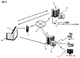
図4において、カーナビゲーションシステム41は、カーナビゲーション端末42、地図帳32、電子ペン31から構成される。カーナビゲーション端末42は、一般に販売されているカーナビゲーション端末に、ペーパID及びXY座標を縮尺に応じた緯度・経度に変換する変換部などを備えたコンピュータ装置である。地図帳32は、従来技術において説明した書き込み位置特定のためのドットパターンが印刷された電子ペーパの上に、電子ペーパのペーパID及びXY座標と、地図における緯度・経度とを正確に位置あわせして印刷した複数ページからなる地図帳である。電子ペン31は、従来技術において説明した電子ペンと同じ構成要素を持つ電子ペンである。
【0014】
図5の地図帳には、各ページに異なるドットパターンが印刷されており、ペンで特定の位置を指すことにより、どのページのどのXY座標かを判別することができる。
また、各ページには、ナビゲーション機能を指定するための特殊なボックス領域53を作り、カーナビゲーションシステムを操作するために利用することが考えられる。これらの特殊ボックス機能の全てもしくは一部は、必要により各ページに印刷せずに表紙など特定のページに配置できる。目的地設定ボックス53aは、該当ページの特定個所を目的地として選択することを指定するためのボックスである。地図表示ボックス53bは、該当ページの地図を表示することを指定するためのボックスである。送信ボックス54は、指定した機能をカーナビゲーションシステムの送信するボックスである。
図6のカーナビゲーション端末42は、3つの処理手段66〜68と、地図変換データベース63b、地図データベース63a、通信装置である受信部65bとペンインターフェイス65a、音声処理部69、表示装置であるディスプレイ64bを保有している。
制御部68は、カーナビゲーション端末全体の入出力や処理などの制御を行う。制御部のナビゲーション処理機能は、ペン31からペンインターフェイス65aを介して受信したペーパIDとXY座標を受け取り、座標変換処理部66によって特定された緯度・経度情報とともに、機能判別部67によって指定された機能の判別を行い、地図情報や特定の情報などの表示をディスプレイ64bに表示することや、目的地を設定することなどを行う。
機能判別部67は、ペーパIDとXY座標から、利用者の指定した機能を判別する。座標変換部66は、ペーパIDとXY座標から、地図データベース63aを用いて緯度・経度へと変換処理を行う。
ペンインターフェイス65aは、ペンから送信されてきたデータを受信する通信装置である。
表示装置64bは、カーナビゲーション端末42で処理されている情報や地図などの情報を表示するためのディスプレイである。
音声処理部69aは、カーナビゲーション端末42で処理されている情報や、利用者への操作説明などを音声出力するスピーカまたは、カーナビゲーション端末42に音声入力するためのマイクである。
【0015】
以上のカーナビゲーション端末42は、一般に市販されているカーナビゲーション端末にペンとの通信装置と地図帳の座標変換処理部66、機能判別部67などの装置やプログラムを搭載することでも実現が可能である。
本実施形態でのカーナビゲーションシステム41の具体的な利用方法について述べる。
利用者がカーナビゲーションシステム41を利用して、目的地を入力する場合を例に説明する。
利用者は、地図帳32から目的地が存在するページを探す。この時、地図のどの縮尺のページを選択するかは利用者が自由に選択してよい。(ステップ61)
利用者は、目的地のあるページのうち、目的地の特定位置を電子ペン31を使って指定する。指定する方法としては、目的地を丸で囲む、タッチする、などをする。(ステップ62)
利用者は、目的地設定ボックス53をチェックする。(ステップ63)
利用者は、送信ボックス54をチェックする。(ステップ64)
送信ボックス54がチェックされると、電子ペン31からペンインターフェイス65aに、ペーパIDとXY座標データが送信される。(ステップ65)
ペンインターフェイス65aからのデータを制御部68が受け取ると、制御部68は機能判別部67によって、選択された機能の判別を行う。本例では、目的地設定機能であると判別される。(ステップ66)
制御部68は、地図変換データベース63bによって、受信したペーパIDとXY座標データを緯度・経度へと変換を行う。(ステップ67)
変換された緯度・経度に相当する位置を目的地に設定する。(ステップ68)
同時に目的地を中心とする地図を地図データベース63aから取得し、ディスプレイ64bに表示する。(ステップ69)
終了(ステップ70)
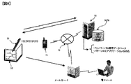
上記の電子ペン、電子ペーパ、PCのみで構築されるシステムをさらにネットワーク経由で応用する例も考えられる。インターネット網でのオープンネットワーク上で、ペンからの入力情報を指定したアプリケーションに送信して処理するシステム(図7)と、さらにセキュリティ面などに考慮して、行政や企業内部で適用できるようにクローズドドメインにおいて実施するシステム(図8、図9、図10)である。各々のシステムの仕組みについては以下のようになる。また、このようなネットワーク上のシステムの場合、ネットワーク上の他の情報端末と通信を行い、情報を送受信して情報を共有することも出来る。またデータは即時更新可能なので、常に最新の情報を得ることが出来る。
▲1▼オープンネットワークでのアプリケーション振り分け型サーバを利用する場合。
図7に示すように、図3のシステムに加えて、ペーパIDとペーパ座標から、利用するサービスアプリケーションサーバを特定するアプリケーション振り分け型サーバ73(サーバには、全てのペーパIDと対応するアプリケーションの所在地がマッチングされて保存されたデータベース74がある)と、ペンと通信を行いペーパIDとペーパ座標から様々なサービスを提供するアプリケーションサーバ75と、ペーパIDとペーパ座標から地図上の地理座標へと変換する地図座標変換データベース76から構成される。
【0016】
図7で示されたハードウエアを含むオープンネットワークにおけるプログラム処理の流れを表すフローチャートを図16に示す。
利用者が、紙の地図32上の特定位置を電子ペン31で指定し、送信ボックスにチェックを入れて、伝送の合図を送る。(S21)
伝送の合図を契機に、紙の地図上から入力された座標が、無線通信を通して携帯電話やパソコンなどの中継装置33に伝送される。(S22)
ペーパ座標はさらに、インターネット72を通してアプリケーション振り分け型サーバ73に送信される。(S23)
サーバには全てのペーパIDとそれらに対応するアプリケーションの所在地(URL)が保存されており、送信されたペーパIDに適合するアプリケーションのURL情報が検出される。(S24)
URL情報は、再び電子ペン31に返送される。(S25)
ペンは中継装置71を経て、入力したペーパ座標そのものをアプリケーションサーバ75へ送信し、地理座標を取得する。
返されたURL情報を受けて、変換した緯度経度の情報を該当するアプリケーション77へ送信し、指定された種類の処理を行う。(S26、S27)
このようなオープンネットワークを利用して、以下のような具体例が考えられる。
【0017】
スケジュール帳の地図帳に、店や建物などの地図情報と属性データを記入し、電子メールやFAXの機能ボックスをチェックすることで、指定したアドレス、電話番号先へ電子メールやFAXの形でデータを送信することが出来る。
【0018】
旅行記の作成では、電子ペーパ上の地図に旅行の軌跡や各地点の情報を書き込むと、中継装置を通してネットワーク上に送信され、Web上の記録が即時更新される。
この中の、スケジュール帳での利用を取り上げて、次に詳しく説明する。
【0019】
図8に示すように、電子ペン31、地図帳32、中継装置71としての携帯電話、通信網72、アプリケーション振り分け型サーバ73から構成されるが、データの送信先として電子メールやFAXが設定される。利用例を以下に示す。ここでは、新たに見つけた店についての情報を、電子メールを用いて送信する場合の例をあげる。
まず、図9の地図帳にあるように、地図の位置情報であることを指定する機能ボックス93aをチェックし、地図92上で店舗の位置に印をつける。(ステップ81)
メモ欄95を指定する機能ボックス93cにチェックを入れ、メモ欄95に感想、商品価格、他店舗などの情報を記入する。(ステップ82)
送信先の電子メールアドレスを指定の欄96cに記入し、電子メールの機能ボックス96aにチェックを入れる。FAXに送信したい場合は、FAX番号を指定の欄に記入し、FAXの機能ボックス96bにチェックを入れる。(ステップ83)
必要事項の記入が終了したら、送信ボックス94にチェックを入れる。(ステップ84)
送信ボックスがチェックされると、電子ペン31から中継装置71を経て、ペンIDとペーパIDがアプリケーション振り分け型サーバ73に送信される。(ステップ85)
アプリケーション振り分け型サーバ73で、ペンIDとペーパIDから該当するアプリケーションが判別され、そのURL情報が再び電子ペンに返される。すると、返されたURL先のアプリケーションに入力データそのものが送信される。(ステップ86)
送信されたデータのうち、ペーパ座標は地理座標に座標変換され、メモ欄への記入事項は手書き文字イメージをコード化して文字データに変換される。変換されたデータは、それぞれ、電子メールやFAXとして送信される。(ステップ87)
場合によっては、機能ボックスとして、キーワード検索欄を設ける。キーワード検索欄に検索したいキーワードを入力すると検索エンジンに送信され、入力したキーワードに関連した事柄について電子メールで返信される、というシステムにすることも可能である。
▲2▼クローズドネットワーク内でアプリケーションの振り分け型サーバを利用する場合。
基本的にオープンネットワークでのシステムと同様であるが、クローズドメインで行われるシステムであるという点で、省庁・自治体・企業などの機密保持が重要である団体向けと言える。ただし、このシステムでは、図10のように地理座標変換データベース76がアプリケーション振り分け型サーバ73に含まれる場合、図11のようにアプリケーションサーバ75に含まれる場合、図12のように電子ペン31自体が地理座標変換を行う場合、の3通りが考えられる。
【0020】
クローズドドメインでの利用例として、以下のような具体例が考えられる。
事故現場や新しく建設された家屋の位置を記録する場合、地図帳上で確認した場所に電子ペンで印をつける。場所以外の属性、例えば、事故現場の状況や家屋の特徴、周辺地域の情報などは、地図とは別に設定したメモ欄に書き込む。どの事項に対する入力であるかは、地図帳上に設けた機能ボックスにチェックを入れることで行う。また、家屋場所と事故現場、それぞれの入力であることを指定する機能ボックスを利用すれば、両方に関する情報を一つの地図上から入力する事が出来る。メモ欄や機能ボックスは、ドットパターンが印字された紙を多数貼付して、使用済みのものを上から順にめくっていく、もしくは剥がしていく方式にすれば、繰り返し使用することも可能である。ネットワークを介してデータを処理するシステムの場合、電子ペンにより読み取られた情報は、ネットワークを通じてデータベースに追加される。複数の人間が、それぞれ異なる電子ペンで一つの地図帳に情報を書き込むことの出来るシステムであれば、このデータベースにアクセスすることで関係者間での情報の共有が可能となる。
不法投棄や悪臭、騒音などに対する苦情や通報、自治体へのゴミ捨て場の申請、あるいは道路占有許可申請においても、電子ペンを用いて電子ペーパ上の地図に申請したい位置を記入することで、地域住民自身が容易に申請手続きを行うことが可能である。
森林の基本計画や都市計画の入力でも、地域住民や職員が任意の地域を入力する場合、ペンと紙を用いて、容易に計画入力が行える。従来は、図面をスキャナ装置で読み取り、デジタイザでベクトルに変換するという煩雑な手順を踏んでいたが、この方法によれば、容易に地理座標に変換することができる。
災害現場における調査活動を支援するシステムとしても応用できる。例えば、火災が起こった場合、メモ欄に調査状況や現場の場所を記述したデータを入力し、地図上で場所を指定して、当該消防署や警察署へ伝送すると、リアルタイムの調査報告を関係者に即時に送付でき、最新の被害状況を関係者間で共有することが可能になる。
【0021】
同様の方法は、電力・水道・ガスなどの公共機関の調査員が、各戸の位置、利用状況、発生した問題などを調査する場合や、複数地点にある施設や建造物、例えば公衆電話や公共のトイレなどの故障状況・修理状況、清掃の確認を行うなど場合に活用することも可能である。
野外調査で利用する場合は、調査対象(動物・植物・鉱物など)を発見・確認した時点で、調査対象に関する情報を地図上に書き込む。調査対象の分布域や生息状況の分析が可能であると同時に、同一地域への情報の追加により情報共有が可能となる。
【0022】
以上の応用例の中から、災害現場における調査支援システムを取り上げて、図13、図14で詳しく説明する。
図13に示すように、スケジュール帳での利用と同様、電子ペン31、地図帳32、中継装置71としての携帯電話、通信網、アプリケーション振り分け型サーバから構成されるシステムである。図14の地図帳は、従来技術において、例として説明したユニークなドットパターンの印字された電子ペーパ上に印刷された地図といくつかの機能ボックスを備える。利用例を以下に示す。
まず、災害発生時に、消防署員が地図帳141上の現場位置の確認であることを認識する機能ボックス143aをチェックし、地図142上で現場の位置に印をつける。(ステップ131)
次に、メモ欄144への機能を指定する機能ボックス143bにチェックを入れ、メモ欄に被害の程度や負傷者の様子などの現場状況を記入する。(ステップ132)
必要事項への記入が終了したら、送信ボックス145にチェックを入れる。(ステップ133)
送信ボックス145がチェックされると、電子ペン31から中継装置71を経て、ペンIDとペーパIDがアプリケーション振り分け型サーバに送信される。アプリケーション振り分け型サーバは、消防署や警察署、市役所などの各機関のものがあり、ペンIDとペーパIDは全てのサーバへ送信されるように設定しておく。それぞれのサーバはネットワークを介して相互に接続しているため、情報の即時共有が可能である。(ステップ134)
ペンIDとペーパIDから該当する業務アプリケーション77が判別され、そのURL情報が再び電子ペンに返される。すると、返されたURL先のアプリケーション77にデータそのものが送信される。(ステップ135)
送信されたデータのうち、ペーパ座標は地理座標に座標変換され、メモ欄への記入事項は手書き文字イメージをコード化して文字データに変換される。変換されたデータは、アプリケーションで各種処理される。(ステップ136)
以上、3つのシステム構成のパターンとそれぞれの応用例を挙げたが、いずれの応用例においても、ローカル、オープンネットワーク、クローズドネットワークのどの形態でも応用することが出来る。また、いずれの応用例においても、リアルタイムでデータをネットワーク上へ送信して情報を更新することが出来るが、電子ペン自体にデータを蓄積しておいて、最後に纏めてデータの更新を行うことも可能である。
【0023】
【発明の効果】
以上述べたように、本発明によれば、電子ペーパ上の地図の特定地点を電子ペンで指すだけで、指定した部分の位置座標を容易に取得でき、また、地図の電子的な座標情報への迅速な変換が可能である。変換された座標情報は、即座に処理装置に送信され、関係者間で情報を共有しながら、様々なシステムやサービスに応用することが出来る。
【図面の簡単な説明】
【図1】電子地図と電子ペーパ上に印刷された地図の対応づけを示す図。
【図2】電子ペーパ上に印刷された地図帳の一例を示す図。
【図3】ネットワークを介さないシステムの一例を示す図。
【図4】カーナビゲーションシステムへの応用例を示す図。
【図5】カーナビゲーションシステムで用いる地図帳の例を示す図。
【図6】カーナビゲーションシステムのシステム構成例を示す図。
【図7】オープンネットワークを介したシステム構成の例を示す図。
【図8】スケジュール帳を用いて電子メールへ送信するシステムの例を示す図。
【図9】スケジュール帳を用いて電子メールへ送信するシステムで使用する地図帳の例を示す図。
【図10】クローズドネットワークを介したシステムの一例を示す図。
【図11】クローズドネットワークを介したシステムの一例を示す図。
【図12】クローズドネットワークを介したシステムの一例を示す図。
【図13】災害現場における調査支援システムの例を示す図。
【図14】災害現場における調査支援システムで使用する地図帳の例を示す図。
【図15】クローズドネットワークを介したシステムの処理を示すフローチャート。
【図16】オープンネットワークを介したシステムの処理を示すフローチャート。
【符号の説明】
1・・・電子地図、2・・・電子ペーパ、3・・・ペーパID、4・・・地図番号、5・・・ドットパターン、6・・・地理座標、7・・・地図[0001]
BACKGROUND OF THE INVENTION
The present invention relates to a system for acquiring a specific position on paper with an electronic pen and converting it into electronic information, and in particular, acquiring a position coordinate on a map and converting it into electronic information, and converting the converted coordinate information into another information. The present invention relates to a map information processing system used in an apparatus.
[0002]
[Prior art]
Conventionally, a number of methods have been considered in order to detect and convert two-dimensional position information of a specific point on a map printed on paper and output it as map coordinates. A sheet with coordinates is fixed on the map to read the paper coordinates of an arbitrary point, or the map is divided into several sections, and the position in the entire map is determined from the section number and the position in the section. There is a method to identify. To input map information, a transparent panel or tablet is used, and information is acquired from the map by button operation or pen input.
[0003]
For example, in the apparatus disclosed in Japanese Patent Laid-Open No. 9-138131, map coordinates are acquired by fixing a transparent tablet on a map in which coordinates are set, and specifying and inputting coordinates on a sheet with a cursor.
Another example of the map information acquisition method is the use of GIS (Geographic Information System). In GIS, it is possible to directly input data on a map in the form of electronic information, reproduce the electronic map on a computer, and perform operations such as database construction and analysis using the map information.
[0004]
[Patent Document 1]
Japanese Patent Laid-Open No. 9-138131 (paragraph number 0006, FIG. 4)
[0005]
[Problems to be solved by the invention]
In order to use the paper coordinates read from the map by inputting it to another device, it is necessary to convert the paper coordinates on the map into geographical coordinates. In the past, in order to use a figure or position on a paper map in GIS, the geographical coordinates had to be entered directly on the GIS. However, in this case, complicated button operations are often required for input, and geographic information must also be input directly in the form of electronic information. Alternatively, it is necessary to input the handwritten figure and position information on the paper map as they are and then convert the coordinates to geographic coordinates. In that case, it is often unsuitable for carrying because of the size and weight of the input device itself, and the characteristics of paper are superior in terms of ease of input, storage stability, softness to bending, etc. I can say that. In addition, since coordinate information is not held in the map itself, it is often necessary to align the input device with the map, or to change the screen, display an enlarged image, and input coordinates. Furthermore, in the case of using a map of a plurality of sections, the operation is often very complicated in the conventional technology, for example, data must be connected. In order to find an arbitrary point while comparing multiple maps or maps with different scales, it is faster to enter geographical coordinates using a paper map that does not require a response from the map. is there. When specifying a region, it is often necessary to indicate the location by a location on the map rather than specifying the location from the address.
[0006]
The present invention provides a method for converting paper coordinates on a paper map into geographical coordinates and transmitting them to another device by taking advantage of the paper map in order to compensate for the drawbacks of the conventional device as described above. It is aimed.
[0007]
[Means for Solving the Problems]
In order to achieve the above object, the present invention has the following configuration.
In a map information processing system comprising paper on which position information is recorded in a dot pattern, and an electronic pen that acquires the position information by reading the dot pattern and converts it into electronically readable position information, the geographical coordinates on the paper A map printed with a dot pattern associated with the map, and paper identification information for identifying the map on the map, and converting the position information of the paper acquired by the electronic pen into coordinates on the electronic map A map information processing system comprising means for performing
[0008]
More specifically, in the present invention, the
One feature of the present invention is that information that associates the electronic paper number with the map on the electronic paper is stored and held in a database.
In the above description, the paper coordinates are read from the map on the electronic paper printed by associating the dot pattern with the map coordinates using the electronic pen. One feature is that paper coordinates can be obtained as geographic coordinates by using a database that associates the paper coordinates on the electronic paper with the geographic coordinates of the electronic map.
In the above, the acquired paper coordinates and paper ID can be individually transmitted to the processing device. Another feature is that the data transmitted at the same time can be acquired as original data without being confused at the transmission destination.
A method of converting coordinates on a map acquired with an electronic pen into actual latitude and longitude can be realized as conversion between XY coordinates and plane rectangular coordinates. In this case, the acquired paper ID and map number are associated with each other, and absolute coordinates X and Y serving as reference points on the page are obtained from the map number. Next, the absolute coordinates of the position designated by the pen are obtained in consideration of the reference point on the map book and the offset. The conversion from absolute coordinates to latitude / longitude can be realized using a normal method.
Thereby, the coordinate on the map acquired with the electronic pen can be converted into actual latitude and longitude.
It is also possible to obtain the latitude / longitude directly from the paper ID and the XY coordinates of the map.
[0009]
In addition, by eliminating the margin of the map book and setting the offset to 0, a map database in which the XY coordinates of the map and the XY coordinates of the paper are matched can be created in advance.
In the above description, the conversion to latitude and longitude is performed using a world geodetic system (WGS). However, geographical coordinates converted into UTM (universal transverse mercator's projection) coordinates, plane rectangular coordinates, or the like may be used.
When processing paper coordinates acquired from a map via a network, a
[0010]
In order to read not only the paper coordinates from the map 21 printed on the electronic paper but also the information accompanying the geographic information or the information to be added for convenience, the same page as the map or other Characters / graphics written in the
Map data in one-to-one correspondence with each electronic pen and divide it into multiple layers, or use the function box to identify each input person and divide the map data layer for each input person. It is possible to easily manage the input data and update data of the map. Another feature is that a user's update history can be managed by setting a time stamp of map input / update data in units of layers.
When the reuse of the map is considered, the map itself is made disposable by creating a plurality of electronic papers having exactly the same dot pattern, map information, and corresponding relationship. Alternatively, if a transparent or highly transparent sheet is placed on the map and an arbitrary position on the map is designated with a pen from the top, the sheet can be reused by exchanging the sheet without soiling the map. In addition, when inputting data using a pen from a map, not only normal black ink, but also the use of fluorescent paint ink or ink that disappears after a certain period of time, and ink that can be erased by correction means such as an eraser. Use or input means to trace the position on the map without using ink.
One feature is that new data and updated data can be shared among a plurality of terminals from a plurality of terminal devices by placing a shared server that holds the processed map information on the network.
[0011]
DETAILED DESCRIPTION OF THE INVENTION
First, the simplest and basic system configuration of the present invention will be described.
As shown in FIG. 3, the system itself includes a map, an electronic pen, and a PC written on electronic paper on which a dot pattern is printed. A map coordinate conversion database that converts received paper coordinates into geographic coordinates, a map database that stores the converted geographic coordinates and various map information, and an application that uses the map information are incorporated in the PC. . A flowchart showing the flow of the processing with the electronic pen and the processing program with the
First, when the user designates a specific position on the
When the transmission box is checked and a transmission signal is sent, the read paper coordinates are transmitted to the PC 33 (S12).
The paper coordinates are converted into geographic coordinates by the map coordinate conversion database and then used by the application (S13).
One of the methods for obtaining the position information of the part pointed with a pen on paper is a technique described in International Application No. PCT / SE00 / 01897 (WO01 / 26033A1). In this technology, the encoding pattern of the position is given to the dot on the electronic paper, and the character or figure written on the electronic paper using the electronic pen is read from the encoding pattern of the dot. Is stored and transmitted as dot pattern vector information. In this embodiment, the electronic pen or the electronic paper will be described as an example. It is not necessarily limited to that example.
Next, an example of a method for converting paper coordinates (XY coordinates) read from a map printed on electronic paper into geographical coordinates will be described.
[0012]
FIG. 2 shows one page on the map book on which a map is printed. The map is actually printed in the portion excluding the margin and the
The map corresponding to which map can be identified by the
[X g , Y g ] = F (PP ID , X m , Y m )
Can be calculated.
However,
PP ID : Paper ID
X m : X coordinate on the map book
Y m : Y coordinate on the map book
X g :latitude
Y g :longitude
And Here, the function F performs the following calculation.
Since there is no ID for identifying the page in the map book, it is necessary to associate the paper ID with the map number on the map. This is determined by the data table 101. Furthermore, the absolute coordinates X and Y at the upper left of the page can be obtained from the map number based on the information in the
Conversion from absolute coordinates to latitude / longitude is generally performed widely, and the function H g, Y g ] = H (X + X m -X off , Y + Y m -Y off )
Can be converted into latitude and longitude on the map.
There is also a method for obtaining the latitude and longitude directly from the paper ID and the XY coordinates of the map. g, Y g ] = I (index, X m -X off , Y m -Y off )
You may obtain | require by calculation of.
In the above, conversion to latitude and longitude is performed using WGS, but geographical coordinates converted to UTM coordinates, plane rectangular coordinates, etc. may be used.
[0013]
As a specific example using the above system, an example in which a paper map is used as an input device for navigation in combination with an existing car navigation system will be described in detail with reference to the embodiments shown in FIGS.
Here, among navigation systems equipped with a map book and a computer device, the car navigation system is used by the operator to input destinations, zoom in / out of maps, road congestion, etc. using a map book printed on electronic paper. An example of a method for displaying tourist information on a specific map will be described as an embodiment.
In FIG. 4, the car navigation system 41 includes a car navigation terminal 42, a
[0014]
In the map book of FIG. 5, different dot patterns are printed on each page. By pointing to a specific position with a pen, it is possible to determine which XY coordinate of which page.
Further, it is conceivable that a
The car navigation terminal 42 in FIG. 6 includes three processing units 66 to 68, a map conversion database 63b, a map database 63a, a receiving unit 65b and a pen interface 65a that are communication devices, a voice processing unit 69, and a
The
The function determining unit 67 determines the function designated by the user from the paper ID and the XY coordinates. The coordinate conversion unit 66 performs conversion processing from the paper ID and XY coordinates to latitude / longitude using the map database 63a.
The pen interface 65a is a communication device that receives data transmitted from the pen.
The
The voice processing unit 69 a is a speaker that outputs information processed by the car navigation terminal 42, an operation explanation to the user, or a microphone for inputting voice to the car navigation terminal 42.
[0015]
The above-described car navigation terminal 42 can also be realized by installing devices and programs such as a pen communication device, a coordinate conversion processing unit 66 of a map book, and a function determination unit 67 on a commercially available car navigation terminal. is there.
A specific method of using the car navigation system 41 in this embodiment will be described.
A case where the user inputs a destination using the car navigation system 41 will be described as an example.
The user searches the
The user uses the
The user checks the
The user checks the
When the
When the
The
The position corresponding to the converted latitude / longitude is set as the destination. (Step 68)
At the same time, a map centered on the destination is acquired from the map database 63a and displayed on the
End (step 70)
An example in which a system constructed only by the electronic pen, electronic paper, and PC is applied via a network is also conceivable. A system (Fig. 7) that sends input information from the pen to the specified application for processing on an open network, such as the Internet, and is closed so that it can be applied to governments and companies in consideration of security. It is a system (FIGS. 8, 9, and 10) implemented in a domain. The structure of each system is as follows. In addition, in the case of such a system on the network, it is also possible to communicate with other information terminals on the network, transmit / receive information, and share information. Moreover, since the data can be updated immediately, the latest information can always be obtained.
(1) When using an application distribution type server in an open network.
As shown in FIG. 7, in addition to the system shown in FIG. 3, an application distribution type server 73 for identifying a service application server to be used from a paper ID and paper coordinates (the server includes all the paper IDs and the locations of the corresponding applications) The
[0016]
FIG. 16 is a flowchart showing the flow of program processing in an open network including the hardware shown in FIG.
The user designates a specific position on the
In response to the transmission signal, coordinates input from a paper map are transmitted to a
The paper coordinates are further transmitted to the application distribution type server 73 through the
The server stores all the paper IDs and the locations (URLs) of the applications corresponding to them, and detects the URL information of the application that matches the transmitted paper ID. (S24)
The URL information is sent back to the
The pen transmits the input paper coordinates themselves to the
Upon receiving the returned URL information, the converted latitude / longitude information is transmitted to the
The following specific examples can be considered using such an open network.
[0017]
Fill in the map book of the schedule book with map information and attribute data such as shops and buildings, and check the function box for e-mail and fax to send data to the specified address and phone number in the form of e-mail or fax Can be sent.
[0018]
In creating a travel journal, when a travel locus or information on each point is written on a map on electronic paper, it is transmitted to the network through a relay device, and the record on the Web is immediately updated.
Of these, the use in the schedule book will be taken up and explained in detail next.
[0019]
As shown in FIG. 8, the
First, as shown in the map book of FIG. 9, the function box 93 a for designating the location information of the map is checked, and the location of the store is marked on the
The
Enter the destination e-mail address in the designated
When the entry of necessary items is completed, the
When the transmission box is checked, the pen ID and the paper ID are transmitted from the
The application distribution server 73 determines the corresponding application from the pen ID and paper ID, and returns the URL information to the electronic pen again. Then, the input data itself is sent to the returned URL application. (Step 86)
Among the transmitted data, the paper coordinates are converted into geographic coordinates, and the entry in the memo field is converted into character data by encoding a handwritten character image. The converted data is transmitted as e-mail or FAX, respectively. (Step 87)
In some cases, a keyword search field is provided as a function box. It is also possible to adopt a system in which a keyword to be searched for is input to a keyword search field and transmitted to a search engine, and a matter related to the input keyword is returned by e-mail.
(2) When using an application distribution type server in a closed network.
It is basically the same as a system in an open network, but it can be said that it is a system that is performed in a closed domain, and that it is for organizations where confidentiality is important such as ministries, local governments, and companies. However, in this system, when the geographic coordinate
[0020]
The following specific examples can be considered as examples of use in the closed domain.
If you want to record the location of an accident site or a newly built house, mark the location confirmed on the map book with an electronic pen. Attributes other than the location, for example, the situation of the accident site, the characteristics of the house, information on the surrounding area, etc. are written in a memo field set separately from the map. Which item is input is determined by checking a function box provided on the map book. Moreover, if the function box which designates that it is each input of a house location and an accident scene is used, the information regarding both can be input from one map. The memo field and function box can be used repeatedly by sticking a large number of papers with dot patterns printed on them and turning the used ones from the top in order or removing them. In the case of a system that processes data via a network, information read by the electronic pen is added to the database via the network. If a plurality of people can write information in one map book with different electronic pens, the information can be shared among the parties concerned by accessing this database.
Use the electronic pen to fill in a map on the electronic paper and fill in the location where you want to apply for complaints and reports regarding illegal dumping, bad odors, noise, etc. The residents themselves can easily apply.
Even when inputting basic forest plans and city plans, when local residents and staff enter any area, they can easily input plans using pen and paper. Conventionally, a complicated procedure of reading a drawing with a scanner device and converting it into a vector with a digitizer has been taken, but according to this method, it can be easily converted into geographic coordinates.
It can also be applied as a system that supports investigation activities at disaster sites. For example, if a fire breaks out, enter the data describing the survey status and site location in the memo field, specify the location on the map, and transmit it to the relevant fire department or police station. The latest damage situation can be shared among the parties concerned.
[0021]
The same method can be used when investigators of public institutions such as electric power, water, and gas investigate the location, usage status, and problems that have occurred, or facilities and buildings at multiple locations such as public telephones and public buildings. It can also be used for checking the failure status, repair status, and cleaning of toilets.
When used in field surveys, information on the survey target is written on the map when the survey target (animal, plant, mineral, etc.) is discovered and confirmed. It is possible to analyze the distribution area and habitat of the survey target, and at the same time to share information by adding information to the same area.
[0022]
Of the above application examples, the investigation support system at the disaster site will be taken up and described in detail with reference to FIGS.
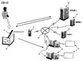
As shown in FIG. 13, the system is composed of an
First, when a disaster occurs, the
Next, the function box 143b for designating a function to the
After completing the necessary information, check the
When the
The
Among the transmitted data, the paper coordinates are converted into geographic coordinates, and the entry in the memo field is converted into character data by encoding a handwritten character image. The converted data is variously processed by the application. (Step 136)
The three system configuration patterns and the respective application examples have been described above, but any of the application forms can be applied to any form of local, open network, and closed network. In any application, data can be transmitted over the network in real time to update the information, but the data is stored in the electronic pen itself and updated at the end. Is also possible.
[0023]
【The invention's effect】
As described above, according to the present invention, it is possible to easily acquire the position coordinates of a designated portion by simply pointing a specific point on the map on the electronic paper with the electronic pen, and to the electronic coordinate information of the map. Can be converted quickly. The converted coordinate information is immediately transmitted to the processing device, and can be applied to various systems and services while sharing information among the parties concerned.
[Brief description of the drawings]
FIG. 1 is a diagram showing correspondence between an electronic map and a map printed on electronic paper.
FIG. 2 is a diagram showing an example of a map book printed on electronic paper.
FIG. 3 is a diagram illustrating an example of a system not via a network.
FIG. 4 is a diagram showing an application example to a car navigation system.
FIG. 5 is a diagram showing an example of a map book used in a car navigation system.
FIG. 6 is a diagram showing a system configuration example of a car navigation system.
FIG. 7 is a diagram showing an example of a system configuration via an open network.
FIG. 8 is a diagram illustrating an example of a system that transmits to an e-mail using a schedule book.
FIG. 9 is a diagram showing an example of a map book used in a system that transmits to an e-mail using a schedule book.
FIG. 10 is a diagram illustrating an example of a system via a closed network.
FIG. 11 is a diagram illustrating an example of a system via a closed network.
FIG. 12 is a diagram showing an example of a system via a closed network.
FIG. 13 is a diagram showing an example of an investigation support system at a disaster site.
FIG. 14 is a diagram showing an example of a map book used in an investigation support system at a disaster site.
FIG. 15 is a flowchart showing processing of a system via a closed network.
FIG. 16 is a flowchart showing processing of the system via an open network.
[Explanation of symbols]
DESCRIPTION OF
Claims (3)
前記紙が、電子地図上の地理座標と対応付けられたドットパターンを印刷した地図、及び前記電子ペンにより前記ドットパターンから読み取られる該地図を特定するための前記紙の識別情報を有しており、
前記紙の識別情報と前記紙上の前記地図を示す位置情報と前記電子地図上の地理座標とを対応付けて記憶する手段と、
前記電子ペンから、前記紙上の前記地図を示す位置情報及び該紙の識別情報を取得する手段と、
該取得した紙上の前記地図を示す位置情報及び紙の識別情報と前記記憶手段に記憶されている情報とに基づき、前記取得した前記紙上の前記地図を示す位置情報を前記電子地図上の地理座標に
変換する手段と、を有する
ことを特徴とする地図情報処理システム。A map information processing system comprising paper having position information recorded in a dot pattern, and an electronic pen that acquires the position information by reading the dot pattern and converts it into electronically readable position information,
The paper has a map printed with a dot pattern associated with geographical coordinates on an electronic map, and identification information of the paper for specifying the map read from the dot pattern by the electronic pen. ,
Means for storing the identification information of the paper, position information indicating the map on the paper, and geographical coordinates on the electronic map in association with each other;
Means for acquiring position information indicating the map on the paper and identification information of the paper from the electronic pen;
Based on the position information indicating the map on the acquired paper and the identification information of the paper and the information stored in the storage means, the acquired position information indicating the map on the paper is converted into geographical coordinates on the electronic map. A map information processing system characterized by comprising:
ことを特徴とする請求項1に記載の地図情報処理システム。The map information processing system according to claim 1, further comprising means for executing an application using the geographical coordinates converted by the conversion means and outputting the execution result.
前記電子ペンから、前記紙上の前記地図を示す位置情報、該紙の識別情報及び前記何れかの機能を示す位置情報を取得する手段と、該取得した紙上の前記地図を示す位置情報及び紙の識別情報と前記記憶手段に記憶されている情報とに基づき、前記取得した前記紙上の前記地図を示す位置情報を前記電子地図上の地理座標に変換するとともに前記取得した機能を示す位置情報から該機能の判別を行う手段と、前記変換された地理座標及び前記判別した機能を用いて前記アプリケーションを実行し、該実行結果を出力する手段をさらに有する
ことを特徴とする請求項2に記載の地図情報処理システム。The paper further includes a plurality of function designation areas related to the application on which the dot pattern is printed,
Means for acquiring position information indicating the map on the paper, identification information of the paper and position information indicating any of the functions from the electronic pen, position information indicating the map on the acquired paper, Based on the identification information and the information stored in the storage means, the position information indicating the acquired map on the paper is converted into geographical coordinates on the electronic map, and the position information indicating the acquired function is used to convert the position information. The map according to claim 2, further comprising: means for determining a function; and means for executing the application using the converted geographic coordinates and the determined function and outputting the execution result. Information processing system.
Priority Applications (1)
| Application Number | Priority Date | Filing Date | Title |
|---|---|---|---|
| JP2003089627A JP4457569B2 (en) | 2003-03-28 | 2003-03-28 | Map information processing system |
Applications Claiming Priority (1)
| Application Number | Priority Date | Filing Date | Title |
|---|---|---|---|
| JP2003089627A JP4457569B2 (en) | 2003-03-28 | 2003-03-28 | Map information processing system |
Publications (2)
| Publication Number | Publication Date |
|---|---|
| JP2004294942A JP2004294942A (en) | 2004-10-21 |
| JP4457569B2 true JP4457569B2 (en) | 2010-04-28 |
Family
ID=33403432
Family Applications (1)
| Application Number | Title | Priority Date | Filing Date |
|---|---|---|---|
| JP2003089627A Expired - Fee Related JP4457569B2 (en) | 2003-03-28 | 2003-03-28 | Map information processing system |
Country Status (1)
| Country | Link |
|---|---|
| JP (1) | JP4457569B2 (en) |
Cited By (1)
| Publication number | Priority date | Publication date | Assignee | Title |
|---|---|---|---|---|
| CN103942941A (en) * | 2014-04-11 | 2014-07-23 | 中国人民解放军61139部队 | Mobile monitoring fusion platform based on geographic information system (GIS) |
Families Citing this family (25)
| Publication number | Priority date | Publication date | Assignee | Title |
|---|---|---|---|---|
| JP4518926B2 (en) * | 2004-11-30 | 2010-08-04 | 株式会社ワオ・コーポレーション | E-mail system, server device, and information processing method |
| WO2006087824A1 (en) * | 2005-02-17 | 2006-08-24 | Hitachi, Ltd. | Information management system and document information management method |
| JP3830956B1 (en) * | 2005-09-14 | 2006-10-11 | 健治 吉田 | Information output device |
| JP4645379B2 (en) * | 2005-09-14 | 2011-03-09 | 富士ゼロックス株式会社 | Printing apparatus, printing method, and program |
| JP4669381B2 (en) | 2005-12-01 | 2011-04-13 | 株式会社日立製作所 | Map information system, map information processing method and program thereof |
| JP4042065B1 (en) * | 2006-03-10 | 2008-02-06 | 健治 吉田 | Input processing system for information processing device |
| JP4203517B2 (en) | 2006-08-22 | 2009-01-07 | 健治 吉田 | Information output device |
| JP5028936B2 (en) * | 2006-10-03 | 2012-09-19 | 株式会社Jvcケンウッド | Navigation system and landmark display method |
| JP4770686B2 (en) * | 2006-10-11 | 2011-09-14 | 株式会社ケンウッド | Navigation system and guide route updating method |
| JP2008139512A (en) * | 2006-11-30 | 2008-06-19 | Hitachi East Japan Solutions Ltd | Information registration apparatus and method |
| JP2008139807A (en) * | 2007-01-09 | 2008-06-19 | Hitachi East Japan Solutions Ltd | Information registration apparatus and information registration method |
| JPWO2008088000A1 (en) * | 2007-01-17 | 2010-05-13 | 株式会社ケンウッド | Navigation system, portable reading device, and method for selecting point or facility using portable reading device and printed map |
| JP4915244B2 (en) * | 2007-01-22 | 2012-04-11 | コニカミノルタビジネステクノロジーズ株式会社 | Electronic paper, control method thereof, control program thereof, and image processing system |
| JP4301524B2 (en) * | 2007-03-27 | 2009-07-22 | 株式会社沖データ | Printing system and information processing apparatus |
| JP5320976B2 (en) * | 2008-10-23 | 2013-10-23 | 富士ゼロックス株式会社 | Display device and information processing system |
| JP5814497B2 (en) * | 2008-12-05 | 2015-11-17 | 株式会社日立製作所 | Map / handwritten information input / utilization system, method and program thereof |
| JP5294060B2 (en) * | 2009-01-05 | 2013-09-18 | 健治 吉田 | Print output processing method |
| JP2010164488A (en) * | 2009-01-16 | 2010-07-29 | Zenrin Printex Co Ltd | Input device |
| JP5740077B2 (en) * | 2009-02-24 | 2015-06-24 | 株式会社ゼンリン | Input device |
| JP5648410B2 (en) * | 2010-10-13 | 2015-01-07 | 富士通株式会社 | Image processing apparatus, image processing method, and image processing program |
| JP5866874B2 (en) * | 2011-08-30 | 2016-02-24 | 大日本印刷株式会社 | Electronic pen system |
| CN104246436B (en) * | 2012-04-23 | 2018-07-27 | 索尼公司 | Information processing device, information processing method, and program |
| JP5663543B2 (en) * | 2012-09-24 | 2015-02-04 | グリッドマーク株式会社 | Map with dot pattern printed |
| JP6092149B2 (en) * | 2014-05-07 | 2017-03-08 | グリッドマーク株式会社 | Information processing device |
| CN111353007B (en) * | 2018-12-24 | 2024-03-01 | 杭州海康威视系统技术有限公司 | Geographic element pickup method, coding method and device based on vector slicing and electronic equipment |
-
2003
- 2003-03-28 JP JP2003089627A patent/JP4457569B2/en not_active Expired - Fee Related
Cited By (1)
| Publication number | Priority date | Publication date | Assignee | Title |
|---|---|---|---|---|
| CN103942941A (en) * | 2014-04-11 | 2014-07-23 | 中国人民解放军61139部队 | Mobile monitoring fusion platform based on geographic information system (GIS) |
Also Published As
| Publication number | Publication date |
|---|---|
| JP2004294942A (en) | 2004-10-21 |
Similar Documents
| Publication | Publication Date | Title |
|---|---|---|
| JP4457569B2 (en) | Map information processing system | |
| US20010005854A1 (en) | System for sending and receiving e-mail to which a plurality of positional data are attachable | |
| JP2010176703A (en) | Program for generating three-dimensional map image | |
| RU2009112616A (en) | ADDING DESTINATION POINTS TO THE NAVIGATION DEVICE | |
| CN1719439B (en) | Server system, user terminal, service providing method, and service providing system | |
| JP2015138412A (en) | Real estate information display system, real estate information display method and program | |
| JP2007102263A (en) | Disaster action support system and its management server | |
| Smith et al. | Spatial data infrastructure requirements for mobile location based journey planning | |
| JP2004046424A (en) | Geographic information providing system, geographic information providing method, geographic information providing program, and electronic pen form | |
| JP3966123B2 (en) | Document creation support system and document creation support apparatus | |
| JP2011197938A (en) | Map information processing apparatus and map information processing program | |
| JP2001344249A (en) | Mobile terminal and support system using this mobile terminal | |
| JP2004227531A (en) | Customer information management system using map information | |
| JPH11132774A (en) | Portable navigation device and navigation system | |
| JP2006227897A (en) | Method and apparatus for searching for guide information of facility in specific area by mobile using two-dimensional code | |
| JP2003148975A (en) | Map information creation method and system | |
| CN111062831A (en) | Law enforcement and case handling self-service terminal, method and device | |
| JP2001243251A (en) | Automatic telephone number list data creation system | |
| KR100337016B1 (en) | System and method for displaying vehicle location information | |
| JP3799107B2 (en) | Residential map | |
| JP2011059818A (en) | Sediment control related information management system | |
| JPH1125157A (en) | Business electronic manual providing apparatus and program storage medium | |
| KR20180008382A (en) | Information link system, information link program, and information link system operating method | |
| JP2012155592A (en) | Investigation support apparatus and investigation support method | |
| US20240273656A1 (en) | Real estate information matching system, method, and program |
Legal Events
| Date | Code | Title | Description |
|---|---|---|---|
| A621 | Written request for application examination |
Free format text: JAPANESE INTERMEDIATE CODE: A621 Effective date: 20051227 |
|
| RD01 | Notification of change of attorney |
Free format text: JAPANESE INTERMEDIATE CODE: A7421 Effective date: 20060420 |
|
| A977 | Report on retrieval |
Free format text: JAPANESE INTERMEDIATE CODE: A971007 Effective date: 20080326 |
|
| A131 | Notification of reasons for refusal |
Free format text: JAPANESE INTERMEDIATE CODE: A131 Effective date: 20080729 |
|
| A521 | Request for written amendment filed |
Free format text: JAPANESE INTERMEDIATE CODE: A523 Effective date: 20080912 |
|
| A131 | Notification of reasons for refusal |
Free format text: JAPANESE INTERMEDIATE CODE: A131 Effective date: 20090324 |
|
| A521 | Request for written amendment filed |
Free format text: JAPANESE INTERMEDIATE CODE: A523 Effective date: 20090513 |
|
| A131 | Notification of reasons for refusal |
Free format text: JAPANESE INTERMEDIATE CODE: A131 Effective date: 20090825 |
|
| A521 | Request for written amendment filed |
Free format text: JAPANESE INTERMEDIATE CODE: A523 Effective date: 20090907 |
|
| TRDD | Decision of grant or rejection written | ||
| A01 | Written decision to grant a patent or to grant a registration (utility model) |
Free format text: JAPANESE INTERMEDIATE CODE: A01 Effective date: 20100119 |
|
| A01 | Written decision to grant a patent or to grant a registration (utility model) |
Free format text: JAPANESE INTERMEDIATE CODE: A01 |
|
| A61 | First payment of annual fees (during grant procedure) |
Free format text: JAPANESE INTERMEDIATE CODE: A61 Effective date: 20100201 |
|
| FPAY | Renewal fee payment (event date is renewal date of database) |
Free format text: PAYMENT UNTIL: 20130219 Year of fee payment: 3 |
|
| FPAY | Renewal fee payment (event date is renewal date of database) |
Free format text: PAYMENT UNTIL: 20130219 Year of fee payment: 3 |
|
| FPAY | Renewal fee payment (event date is renewal date of database) |
Free format text: PAYMENT UNTIL: 20140219 Year of fee payment: 4 |
|
| LAPS | Cancellation because of no payment of annual fees |