JP4255441B2 - GPS system interface - Google Patents
GPS system interface Download PDFInfo
- Publication number
- JP4255441B2 JP4255441B2 JP2004529542A JP2004529542A JP4255441B2 JP 4255441 B2 JP4255441 B2 JP 4255441B2 JP 2004529542 A JP2004529542 A JP 2004529542A JP 2004529542 A JP2004529542 A JP 2004529542A JP 4255441 B2 JP4255441 B2 JP 4255441B2
- Authority
- JP
- Japan
- Prior art keywords
- protocol
- data
- gps
- interface
- call processor
- Prior art date
- Legal status (The legal status is an assumption and is not a legal conclusion. Google has not performed a legal analysis and makes no representation as to the accuracy of the status listed.)
- Expired - Fee Related
Links
Images


Classifications
-
- G—PHYSICS
- G01—MEASURING; TESTING
- G01S—RADIO DIRECTION-FINDING; RADIO NAVIGATION; DETERMINING DISTANCE OR VELOCITY BY USE OF RADIO WAVES; LOCATING OR PRESENCE-DETECTING BY USE OF THE REFLECTION OR RERADIATION OF RADIO WAVES; ANALOGOUS ARRANGEMENTS USING OTHER WAVES
- G01S19/00—Satellite radio beacon positioning systems; Determining position, velocity or attitude using signals transmitted by such systems
- G01S19/01—Satellite radio beacon positioning systems transmitting time-stamped messages, e.g. GPS [Global Positioning System], GLONASS [Global Orbiting Navigation Satellite System] or GALILEO
- G01S19/03—Cooperating elements; Interaction or communication between different cooperating elements or between cooperating elements and receivers
- G01S19/05—Cooperating elements; Interaction or communication between different cooperating elements or between cooperating elements and receivers providing aiding data
-
- G—PHYSICS
- G01—MEASURING; TESTING
- G01S—RADIO DIRECTION-FINDING; RADIO NAVIGATION; DETERMINING DISTANCE OR VELOCITY BY USE OF RADIO WAVES; LOCATING OR PRESENCE-DETECTING BY USE OF THE REFLECTION OR RERADIATION OF RADIO WAVES; ANALOGOUS ARRANGEMENTS USING OTHER WAVES
- G01S19/00—Satellite radio beacon positioning systems; Determining position, velocity or attitude using signals transmitted by such systems
- G01S19/01—Satellite radio beacon positioning systems transmitting time-stamped messages, e.g. GPS [Global Positioning System], GLONASS [Global Orbiting Navigation Satellite System] or GALILEO
- G01S19/13—Receivers
- G01S19/24—Acquisition or tracking or demodulation of signals transmitted by the system
- G01S19/25—Acquisition or tracking or demodulation of signals transmitted by the system involving aiding data received from a cooperating element, e.g. assisted GPS
- G01S19/258—Acquisition or tracking or demodulation of signals transmitted by the system involving aiding data received from a cooperating element, e.g. assisted GPS relating to the satellite constellation, e.g. almanac, ephemeris data, lists of satellites in view
-
- G—PHYSICS
- G01—MEASURING; TESTING
- G01S—RADIO DIRECTION-FINDING; RADIO NAVIGATION; DETERMINING DISTANCE OR VELOCITY BY USE OF RADIO WAVES; LOCATING OR PRESENCE-DETECTING BY USE OF THE REFLECTION OR RERADIATION OF RADIO WAVES; ANALOGOUS ARRANGEMENTS USING OTHER WAVES
- G01S19/00—Satellite radio beacon positioning systems; Determining position, velocity or attitude using signals transmitted by such systems
- G01S19/01—Satellite radio beacon positioning systems transmitting time-stamped messages, e.g. GPS [Global Positioning System], GLONASS [Global Orbiting Navigation Satellite System] or GALILEO
- G01S19/13—Receivers
- G01S19/35—Constructional details or hardware or software details of the signal processing chain
- G01S19/37—Hardware or software details of the signal processing chain
-
- G—PHYSICS
- G01—MEASURING; TESTING
- G01S—RADIO DIRECTION-FINDING; RADIO NAVIGATION; DETERMINING DISTANCE OR VELOCITY BY USE OF RADIO WAVES; LOCATING OR PRESENCE-DETECTING BY USE OF THE REFLECTION OR RERADIATION OF RADIO WAVES; ANALOGOUS ARRANGEMENTS USING OTHER WAVES
- G01S5/00—Position-fixing by co-ordinating two or more direction or position line determinations; Position-fixing by co-ordinating two or more distance determinations
- G01S5/02—Position-fixing by co-ordinating two or more direction or position line determinations; Position-fixing by co-ordinating two or more distance determinations using radio waves
- G01S5/0205—Details
- G01S5/0236—Assistance data, e.g. base station almanac
Landscapes
- Engineering & Computer Science (AREA)
- Radar, Positioning & Navigation (AREA)
- Remote Sensing (AREA)
- Physics & Mathematics (AREA)
- General Physics & Mathematics (AREA)
- Computer Networks & Wireless Communication (AREA)
- Signal Processing (AREA)
- Position Fixing By Use Of Radio Waves (AREA)
- Mobile Radio Communication Systems (AREA)
Abstract
Description
(関連出願の相互参照)
本出願は、2002年8月15日出願の仮特許出願第60/403,836号「SATPSシステム用インターフェース(INTERFACE FOR SATPS SYSTEMS)」を基礎として優先権を主張する。その仮特許出願は参照により本明細書に援用される。
(Cross-reference of related applications)
This application claims priority on the basis of provisional patent application No. 60 / 403,836 “INTERPS FOR SATPS SYSTEMS” filed Aug. 15, 2002. That provisional patent application is incorporated herein by reference.
(発明の背景)
(1.技術分野)
本発明は一般に無線通信の分野に関する。特に、本発明は全地球測位システム(「GPS」)機器と、当該通信機器に基づくあらゆる支援専用プロトコルから独立した異なる通信機器との間のインターフェースを提供する方法および装置に関する。
(Background of the Invention)
(1. Technical field)
The present invention relates generally to the field of wireless communications. In particular, the present invention relates to a method and apparatus for providing an interface between a global positioning system (“GPS”) device and a different communication device independent of any support-only protocol based on the communication device.
(2.関連技術)
双方向ラジオ、携帯テレビ、携帯情報端末(「PDA」)、セルラー電話(「無線電話」、「ワイヤレス電話」、「移動電話」「携帯電話」および/または「移動局」とも呼ばれる)、衛星ラジオ受信機およびナブスター(NAVSTAR)とも呼ばれる全地球測位システム(「GPS」)等の衛星測位システム(「SATPS」)等の無線機器(「移動機器とも呼ばれる」)の利用が世界的に急成長している。無線機器を利用する人の数が増加するにつれて、無線サービスプロバイダが提供する機能の数が増加し、同時にこれら無線機器と他の製品の一体化も進んでいる。
(2. Related technology)
Two-way radio, portable TV, personal digital assistant ("PDA"), cellular phone (also called "wireless phone", "wireless phone", "mobile phone", "mobile phone" and / or "mobile station"), satellite radio The use of receivers and wireless devices (also called “mobile devices”) such as satellite positioning systems (“SATPS”) such as the global positioning system (“GPS”), also known as NAVSTAR, has grown rapidly worldwide. Yes. As the number of people who use wireless devices increases, the number of functions provided by wireless service providers increases, and at the same time, integration of these wireless devices with other products is also progressing.
1970年代初頭におけるアメリカ合衆国国防総省(「DoD」)によるNAVSTAR GPSシステムの開発以来、GPSに関連する新技術を利用した多くの民間用途が生まれている。これらの新技術には例えば、ユーザーが地球上で自分の位置を特定できるGPS受信機、および符号分割多重アクセス(CDMA)および時分割多重アクセス(TDMA)セルラーネットワーク等、動作にGPS時計基準を利用する多くの通信ネットワークが含まれる。これらの新技術の結果、特に緊急時に自身の位置を送信し、通信機器に位置情報を組み込んで観光客、児童および高齢者を発見・追跡し、高価な資産の安全を確保することができる移動通信機器に対する要求が高まっている。 Since the development of the NAVSTAR GPS system by the United States Department of Defense ("DoD") in the early 1970s, many civilian applications using new GPS related technologies have emerged. These new technologies use GPS clock standards for operations, such as GPS receivers that allow users to locate themselves on the earth, and code division multiple access (CDMA) and time division multiple access (TDMA) cellular networks Many communication networks are included. As a result of these new technologies, especially in emergencies, the location can be transmitted, the location information can be incorporated into the communication equipment to discover and track tourists, children and the elderly, and secure the safety of expensive assets There is an increasing demand for communication equipment.
GPSシステムは一般に、通常は衛星(「スペースビークル」または「SV」とも呼ばれる)に基づくナビゲーション・システムである。GPSの例として、アメリカ合衆国(「U.S.」)海軍ナビゲーション衛星システム(「NNSS」)(TRANSITとも呼ばれる)、LORAN、Shoran、Decca、TACAN、国防総省(DoD)が開発したNAVSTARとして知られるジョイント・プログラム・オフィス(「JPO」)全地球測位システム、全地球ナビゲーション衛星システム(「GLONASS」)として知られるロシア側の類似システム、および提唱された「ガリレオ」プログラム等の将来的な西欧のGPSが含まれるが、これに限定されない。NAVSTAR GPS(以後単に「GPS」と示す)は本来アメリカ合衆国軍の要望を満たすべく軍事システムとして開発されたものであるが、アメリカ合衆国連邦議会は後に、国防総省に対してGPSの一般人利用を進めるように指示した。その結果、GPSは現在、アメリカ合衆国政府機関(例えば軍隊)および一般人の双方によるアクセスが可能な、軍事と民生の両方で利用可能な(デュアル・ユースの)システムである。GPSシステムは、ホフマン(Hofmann)−ウェレンホフ(Wellenhof)、リヒテネッガー(Lichtenegger)およびコリンズ(Collins)編集「全地球測位システム、理論と実装」第5版、シュプリンガー・フェアラーク(Springer Verlag)、ウィーン(Wien)、ニューヨーク(NewYork)、2001年、に記述されている。その文献は参照により本明細書にその全文を援用される。 The GPS system is generally a navigation system that is usually based on satellites (also called “space vehicles” or “SVs”). As an example of GPS, a joint known as the NAVSTAR developed by the United States (“US”) Naval Navigation Satellite System (“NNSS”) (also known as TRANSIT), LORAN, Shoran, Decca, TACAN, and the Department of Defense (DoD) Future Western GPS such as the Program Office (“JPO”) Global Positioning System, a similar system on the Russian side known as the Global Navigation Satellite System (“GLONASS”), and the proposed “Galileo” program Including, but not limited to. NAVSTAR GPS (hereinafter simply referred to as “GPS”) was originally developed as a military system to meet the needs of the United States military, but the US Congress will later promote the general use of GPS to the Department of Defense. I directed. As a result, GPS is now a military and civilian (dual use) system that can be accessed by both US government agencies (eg, the military) and the general public. The GPS system is Hofmann-Wellenhof, Richtenegger and Collins, Global Positioning System, Theory and Implementation, 5th edition, Springer Verlag, Wien. ), New York, 2001. That document is incorporated herein by reference in its entirety.
通常、GPSの利用には、地上での正確な位置を特定させること、および軍用通信ネットワークといった電気通信ネットワークと、CDMAおよびTDMA形式のシステムといったセルラー電話ネットワークを同期化させることが含まれる。さらに、緊急時に50フィート以内の精度でセルラー電話ユーザーの位置を提供可能な(「拡張911」または「E911」サービスとして一般に知られる)セルラー電話ネットワークに対するアメリカ合衆国連邦議会の勧告が連邦通信委員会(「FCC」)を通じて提出されことにより、GPSは多くのセルラー電話アプリケーションにおいて、測位と同期化の両方に利用されつつある。 The use of GPS typically involves locating an accurate location on the ground and synchronizing telecommunication networks such as military communication networks with cellular telephone networks such as CDMA and TDMA type systems. In addition, the United States Congress recommendation for a cellular telephone network (commonly known as the “Extended 911” or “E911” service) that can provide the location of a cellular telephone user with an accuracy within 50 feet in an emergency is the Federal Communications Commission (“ Submitted via the FCC "), GPS is being used for both positioning and synchronization in many cellular telephone applications.
一般に、多数のGPS衛星(一般に「GPS衛星群」として知られる)が極めて正確な時間符号化情報を送信しており、それによってGPS受信器は自身の位置を地球上の緯度と経度、および海面からの高度として計算することができる。GPSは、(選択利用性「SA」をONにセットした状態で)非軍事ユーザー向けに約100メートル以内、軍事その他の承認されたユーザーにはより高い精度のベース・ナビゲーション・システムを提供すべく設計されている。 In general, a number of GPS satellites (commonly known as “GPS satellites”) transmit highly accurate time-encoded information, which allows the GPS receiver to determine its position on the earth's latitude and longitude, and the sea level. Can be calculated as altitude from. GPS should be within about 100 meters for non-military users (with selective availability “SA” set to ON) and provide a more accurate base navigation system for military and other authorized users. Designed.
一般に、GPSはスペース、コントロールおよびユーザーという3つの主要なシステムセグメントを含む。GPSのスペースセグメントは、地球上を周回している衛星の集団であり、地上のGPS受信器に極めて正確なタイミング情報を送る送信器を含んでいる。現在、実装されているGPS衛星群は、21個の主要な運行衛星に3個の有効な予備衛星を加えたものを含む。これらの衛星が6個の軌道に配置されていて、各々の軌道に3〜4個の衛星が含まれる。軌道面は、赤道と55°の角度を形成する。衛星群は地球の上を約10,898海里(20,200キロメートル)の高さで周回し、各衛星の軌道周期は約12時間である。 In general, GPS includes three major system segments: space, control and user. The GPS space segment is a group of satellites orbiting the earth and includes transmitters that send highly accurate timing information to terrestrial GPS receivers. Currently implemented GPS satellites include 21 major operating satellites plus 3 valid spare satellites. These satellites are arranged in six orbits, and each orbit contains 3 to 4 satellites. The orbital plane forms an angle of 55 ° with the equator. The group of satellites orbits the earth at a height of about 10,898 nautical miles (20,200 kilometers), and the orbit period of each satellite is about 12 hours.
各々の周回している衛星は通常、4個の極めて正確な原子時計(うち2個がルビジウム時計で2個がセシウム時計)を含む。これらの原子時計は、地球へ送信される固有の2進符号(擬似乱数「PRNコード」または擬似雑音「PNコード」とも呼ばれる)の生成に用いる高精度タイミング・パルスを提供する。PRNコードは、GPS衛星群内の特定の衛星を識別する。当該衛星はまた、衛星群の宇宙空間内位置を決定するための、アルマナック・データおよびエフェメリス・データとして知られる2種類の軌道パラメータを含むデジタル符号化された情報の組を送信する。 Each orbiting satellite typically contains four very accurate atomic clocks, two of which are rubidium clocks and two of which are cesium clocks. These atomic clocks provide high precision timing pulses that are used to generate unique binary codes (also called pseudorandom “PRN codes” or pseudonoise “PN codes”) that are transmitted to the Earth. The PRN code identifies a specific satellite in the GPS satellite group. The satellite also transmits a digitally encoded set of information including two types of orbit parameters known as almanac data and ephemeris data to determine the position of the satellites in space.
エフェメリス・データ(「エフェメリデス」としても知られる)は、衛星の正確な軌道を定める。エフェメリス・データは任意の時点で衛星がどこにあるかを示し、その位置は正確な緯度および経度測定値により衛星の地表航跡として指定することができる。エフェメリス・データ内の情報は符号化されて当該衛星から送信され、任意の時点における地球上空の衛星の位置を正確に示す。通常、現行のエフェメリス・データは、宇宙空間における位置をSAの現行レベルで数メートルまたは数十分の一メートル単位で特定するのに充分である。地上制御局は、精度を保証すべく毎時間エフェメリス・データを更新する。しかし、約2時間後にはエフェメリス・データの精度が低下し始める。 Ephemeris data (also known as “ephemides”) defines the precise orbit of the satellite. The ephemeris data indicates where the satellite is at any given time, and its location can be specified as the satellite's surface wake with accurate latitude and longitude measurements. The information in the ephemeris data is encoded and transmitted from the satellite and accurately indicates the position of the satellite over the earth at any point in time. Typically, the current ephemeris data is sufficient to identify the location in outer space in units of a few meters or even tens of meters at the current level of SA. The ground control station updates the ephemeris data every hour to ensure accuracy. However, after about 2 hours, the accuracy of the ephemeris data begins to decline.
アルマナック・データは、エフェメリス・データの部分集合である。アルマナック・データが含む情報は、衛星群内の全ての衛星の位置に関しては精度が劣る。アルマナック・データは、含まれるパラメータが比較的少なく、一般に宇宙空間内位置を2〜3キロメートル単位で特定するのに充分である。各GPS衛星は、GPS衛星群内の全GPS衛星についてのアルマナック・データを12分半(「12.5」)の周期で放送する。従って、1基の衛星だけを追跡すれば軌道上の他の全ての衛星のアルマナック・データが得られる。アルマナック・データは、数日ごとに更新され、約数ヵ月間有効である。寿命が比較的長いため、2〜3時間以上オフ状態にあったGPS受信器は通常、アルマナック・データを利用してどのGPS衛星が交信可能範囲に存在するかを判定する。しかし、アルマナックおよびエフェメリス・データは両方とも、限られた期間しか有効でない。このように、アルマナックおよびエフェメリス・データは、データが適当な間隔で更新されない限り劣化するため、この情報に基づく衛星群の位置は次第に不正確になっていく。 Almanac data is a subset of ephemeris data. The information contained in the almanac data is less accurate with respect to the position of all the satellites in the satellite group. Almanac data contains relatively few parameters and is generally sufficient to identify a location in outer space in units of 2-3 kilometers. Each GPS satellite broadcasts almanac data for all GPS satellites in the GPS satellite group at a period of 12 and a half minutes (“12.5”). Therefore, if only one satellite is tracked, the almanac data of all other satellites in orbit can be obtained. Almanac data is updated every few days and is valid for several months. A GPS receiver that has been off for more than a few hours due to its relatively long lifespan typically uses almanac data to determine which GPS satellites are in coverage. However, both almanac and ephemeris data are only valid for a limited period of time. Thus, since almanac and ephemeris data are degraded unless the data is updated at appropriate intervals, the position of the satellite group based on this information becomes increasingly inaccurate.
エフェメリス・データは、任意の瞬間で地上の基準フレームにおける衛星の位置および速度ベクトルを決定するために利用できる3組のデータを含む。これら3組のデータには、アルマナック・データ、放送エフェメリス・データ、および精密エフェメリス・データが含まれる。当該データの精度は異なっており、リアルタイムまたは事象発生後のいずれかに利用できる。通常、アルマナック・データの目的は、受信器による衛星探索を容易にしたり、あるいは交信可能チャートの計算といった作業計画を立案するために、ユーザーに精度の低いデータを提供することである。アルマナック・データは、少なくとも6日ごと更新され、衛星メッセージの一部として放送される。アルマナック・メッセージは基本的に、全ての衛星の軌道のパラメータおよび衛星時計の時刻調整項を含む。GPSアルマナック・データは、「ナブスターGPS宇宙空間セグメントおよびナビゲーション・ユーザー・インターフェース(NAVSTAR GPS Space Segment and Navigation User Interfaces)」の「GPSインターフェース管理文書(GPS Interface Control Document)ICD−GPS−200」、ナブテックセミナー(NavTech Seminars)およびナブテック書籍/ソフトウェア販売(NavTech Book and Software Store)バージニア州アーリントン(Arlington、Va.)出版、1995年2月重版、に記述されている。その文献は参照により本明細書に援用される。 The ephemeris data includes three sets of data that can be used to determine satellite position and velocity vectors in a ground reference frame at any moment. These three sets of data include almanac data, broadcast ephemeris data, and precision ephemeris data. The accuracy of the data is different and can be used either in real time or after the event occurs. Usually, the purpose of almanac data is to provide the user with less accurate data in order to facilitate a satellite search by a receiver or to develop a work plan such as calculation of a communicable chart. Almanac data is updated at least every 6 days and broadcast as part of a satellite message. Almanac messages basically contain all satellite orbit parameters and satellite clock time adjustment terms. The GPS almanac data is “GPS Interface Control Document” ICD-GPS-200, “Navstar GPS Space Segment and Navigation User Interfaces”, “Navstar GPS Space Segment and Navigation User Interfaces”. Described in seminars (NavTech Seminars) and NabTech Books / Software Sales (Arlington, Va.), February 1995. That document is hereby incorporated by reference.
典型的な動作例として、GPS受信器が最初に始動された(一般に「コールド・スタート」と呼ばれる)か、または2〜3時間以上の長い待機状態から起動された場合、GPS受信器はGPSスペクトルを走査して利用可能なGPS衛星から送信されたGPS信号を捕捉する。GPS信号が捕捉されると、GPS受信器は次いでGPS衛星群のGPSアルマナック・データ、エフェメリス・データおよび時刻調整情報を、捕捉したGPS衛星からダウンロードする。アルマナック・データがダウンロードされたならば、GPS衛星は次いで、アルマナック・データによって示される利用可能な(すなわち「交信範囲内」の)GPS衛星を求めるべくGPSスペクトルを走査する。理想的には、十分な時間が与えられていて、GPS受信器が更に2〜3個の交信可能なGPS衛星を捕捉することをGPS受信器の周囲の環境が許容するものと仮定すれば、当該GPS受信器は、3〜4個の衛星から距離およびタイミング情報の両方を受信して地上の位置を計算する。 As a typical example of operation, if a GPS receiver is first started (commonly referred to as a “cold start”) or started from a long standby state of 2-3 hours or more, the GPS receiver To capture GPS signals transmitted from available GPS satellites. When the GPS signal is acquired, the GPS receiver then downloads GPS almanac data, ephemeris data and time adjustment information for the GPS satellites from the acquired GPS satellites. Once the almanac data has been downloaded, the GPS satellites then scan the GPS spectrum for available (ie “in-range”) GPS satellites indicated by the almanac data. Ideally, given sufficient time, and assuming that the environment around the GPS receiver allows the GPS receiver to capture a few more communicable GPS satellites, The GPS receiver receives both distance and timing information from 3-4 satellites and calculates the position on the ground.
あいにく、多くの用途において、時間および環境の状態の双方によって、特に屋内または上空の見通しが制約される状況下で、GPS受信器がGPSアルマナック・データをダウンロードする能力が制限される場合がある。時間に付随する問題は通常、初期測位時間(「TTFF」)値により記述される。TTFF値が高い場合、初期位置の決定に時間がかかり過ぎるため、GPS受信器の用途が限られてしまう。 Unfortunately, in many applications, both time and environmental conditions can limit the ability of a GPS receiver to download GPS almanac data, particularly in situations where indoor or skyline visibility is constrained. Problems associated with time are usually described by an initial positioning time ("TTFF") value. If the TTFF value is high, it takes too much time to determine the initial position, which limits the application of the GPS receiver.
例えば、無線または移動電話(セルラー電話等)の用途において、一体型GPS受信器を有する移動電話または携帯情報端末(「PDA」)は、発呼前にGPS受信器がGPSアルマナックをダウンロードするために(全ての必要な交信可能衛星が交信されている完全な環境条件を仮定して)約12.5分間待つ必要がある。これは、大多数の用途において許容されないであろう。 For example, in a wireless or mobile phone (such as a cellular phone) application, a mobile phone or personal digital assistant ("PDA") that has an integrated GPS receiver can cause the GPS receiver to download a GPS almanac before making a call. It is necessary to wait about 12.5 minutes (assuming full environmental conditions in which all necessary communicable satellites are in communication). This would not be acceptable in the majority of applications.
セルラー電話の用途において、E911緊急通報を行なう際に、救急隊員にセルラー電話が自身の位置情報を送信することを義務付けたE911勧告の観点からこの制約はさらに許容できない。ユーザーが緊急事態に直面した際に、GPS機能を有するセルラー電話の電源が切られていたり、長時間待機状態にあった場合、それらのユーザーは通常、当該ユーザーの位置を救急隊員へ送信する緊急通報が可能になる前に、(通常はGPS受信器が確実にアルマナックおよび/またはエフェメリス・データを取得するために強力な信号を必要とするため)まず継続的に衛星との交信が中断されない状態で約12.5分間待たなければならない。典型的な大都市圏、または自然に閉塞された環境では、この待機が12.5分を超える場合がある。その理由は、環境の状態によって最初に衛星を捕捉することがより困難になるためである。これは特に生命が危険に瀕している状況下では容認できないことがわかる。 In cellular telephone applications, this restriction is further unacceptable in view of the E911 recommendation that requires emergency personnel to send their location information when making an E911 emergency call. When a user encounters an emergency and the cellular phone with GPS function is turned off or has been on standby for a long time, they usually send an emergency response to the user's location First, continuous communication with the satellite is not interrupted (usually because the GPS receiver needs a strong signal to ensure that the almanac and / or ephemeris data is acquired) before reporting is possible You have to wait about 12.5 minutes. In a typical metropolitan area, or in a naturally blocked environment, this wait may exceed 12.5 minutes. The reason is that it is more difficult to acquire satellites initially depending on the environmental conditions. This proves unacceptable, especially in situations where life is at risk.
アルマナック・データのダウンロードに要する時間を短縮する従来の方法には、何がしかのアルマナック・データ(工場で組み込まれたアルマナック・データ等)をGPS受信器内のメモリ装置(読出し専用メモリ「ROM」等)に保存しておくことが含まれる。通常、この事前に保存されたアルマナック・データを用いて、コールド・スタート状態でのTTFFを短縮する。この方法では、衛星の位置および事前に保存されているアルマナックの経過時間に伴なう不確実性のために、多くの場合コールド・スタート状態のTTFF時間は依然として比較的長い。最初の測位が得られたならば、当該GPS受信器は捕捉した衛星から更新されたアルマナック・データをダウンロードして、将来利用すべくROM(またはランダム・アクセス・メモリ「RAM」)を更新することができる。しかし、この方法でも依然として、将来の捕捉のために更新されたアルマナック・データをGPS受信器が受信する(すなわちアルマナック・データの「新鮮な」コピーを受信する)必要がある。更新されたアルマナック・データの受信には、依然としてGPS受信器の性能に影響を及ぼす程度の時間を要する。 A conventional method for shortening the time required for downloading almanac data is that some almanac data (such as almanac data built in the factory) is stored in a memory device (read-only memory “ROM”) in the GPS receiver. Etc.) are included. Normally, this pre-stored almanac data is used to shorten the TTFF in the cold start state. In this method, the cold start TTFF time is often still relatively long due to uncertainties associated with satellite position and pre-stored almanac elapsed time. Once the first position is obtained, the GPS receiver downloads updated almanac data from the acquired satellite and updates the ROM (or random access memory “RAM”) for future use. Can do. However, this method still requires the GPS receiver to receive almanac data that has been updated for future acquisitions (ie, to receive a “fresh” copy of the almanac data). Receiving the updated almanac data still takes time to affect the performance of the GPS receiver.
これらの問題に応えるべく、捕捉、位置計算および/または感度向上等を目的として、通信モジュール(「コール・プロセッサ」または「CP」とも呼ばれる)から支援データを提供することにより、GPS受信器を支援する、移動電話用の支援方法が開発されている。残念ながら、無線ネットワークにおけるこれらの支援方法は、通常セルラーネットワーク(すなわちTDMA、GSM、CDMA等のセルラー・プラットフォーム)およびベンダーに固有のものであり、セルラーネットワークに設置された地上位置サーバー局から提供される。その結果、移動電話のGPS受信器(「移動局」または「MS」とも呼ばれる)は通常、セルラーネットワークの地上位置サーバー局と互換性がなければならない。 To support these problems, GPS receivers are supported by providing assistance data from a communication module (also called “call processor” or “CP”) for purposes such as acquisition, position calculation and / or sensitivity enhancement. Support methods for mobile phones have been developed. Unfortunately, these support methods in wireless networks are usually specific to cellular networks (ie, cellular platforms such as TDMA, GSM, CDMA, etc.) and vendors and are provided by terrestrial location server stations installed in the cellular network. The As a result, mobile phone GPS receivers (also referred to as “mobile stations” or “MS”) typically must be compatible with cellular network ground location server stations.
しかし、アメリカ合衆国および海外で運用されている多数のセルラーネットワークは、
お互いに互換性が無い地上位置サーバー局プロトコルを利用する地上位置サーバー局を組み込んでいるか、あるいは組み込もうとしている。従って、GPS受信器が地上位置サーバー局プロトコルに依存せず、且つ多数の地上位置サーバー局と協働可能にするシステムに対する要望がある。
However, many cellular networks operating in the United States and abroad
A terrestrial location server station that uses a terrestrial location server station protocol that is not compatible with each other is or is being incorporated. Accordingly, there is a need for a system that allows a GPS receiver to be independent of a terrestrial location server station protocol and to work with multiple terrestrial location server stations.
(要旨)
移動機器内で、全地球測位システム(「GPS」)インターフェースを備えるコール・プロセッサにおいて受信されたプロトコル支援データを処理するためのプロトコル独立インターフェースを開示する。ここに、当該プロトコル支援データは地上位置サーバー局プロトコルにより生成される。当該プロトコル独立インターフェースは、コール・プロセッサにおいて受信されたプロトコル支援データを、GPSインターフェースにおいて、受信する手段と、当該支援データを地上位置サーバー局プロトコルに対して透過的なインターフェース・データに変換する手段と、当該インターフェース・データをGPSモジュールに渡す手段とを備えてよい。
(Summary)
Disclosed is a protocol independent interface for processing protocol assistance data received in a call processor with a Global Positioning System ("GPS") interface in a mobile device. Here, the protocol support data is generated by the ground location server station protocol. The protocol independent interface comprises means for receiving protocol assistance data received at the call processor at the GPS interface and means for converting the assistance data into interface data transparent to the ground location server station protocol. And means for passing the interface data to the GPS module.
動作時において、当該プロトコル独立インターフェースは、全地球測位システム(「GPS」)インターフェースを備えるコール・プロセッサにおいて受信されたプロトコル支援データを移動機器内で処理するプロセスを実行する。ここに、当該プロトコル支援データは地上位置サーバー局プロトコルに従い生成される。当該プロトコル独立なインターフェースは、コール・プロセッサにおいて受信された支援データを、GPSインターフェースにおいて、受信するプロセスを実行し、受信された当該プロトコル支援データを地上位置サーバー局プロトコルに対して透明なインターフェース・データに変換し、当該インターフェース・データをGPSモジュールに渡す。 In operation, the protocol independent interface performs a process for processing protocol assistance data received in a call processor with a Global Positioning System (“GPS”) interface within a mobile device. Here, the protocol support data is generated according to the terrestrial location server station protocol. The protocol-independent interface executes a process of receiving assistance data received at the call processor at the GPS interface, and the received protocol assistance data is interface data transparent to the terrestrial location server station protocol. And the interface data is passed to the GPS module.
本発明の他のシステム、方法、特徴および利点は、以下の図面および詳細な記述を精査することにより当業者には明らかになろう。このような全ての追加的システム、方法、特徴および利点は記述に含まれており、本発明の範囲内に含まれていて、添付の請求項により保護されることを意図するものである。 Other systems, methods, features and advantages of the present invention will become apparent to those skilled in the art upon review of the following drawings and detailed description. All such additional systems, methods, features and advantages are included in the description, are within the scope of the present invention, and are intended to be protected by the accompanying claims.
(好適な実施形態の詳細な説明)
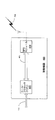
まず図1を参照する。図1に、公知の全地球測位システム(「GPS」)の実施例の模式図100を示す。動作時において、地球104上に位置するGPS受信器102は数個のGPS衛星114、116、118、および120から各々の信号106、108、110、および112を同時に捕捉するよう設計されている。GPS受信器102は、情報を復号化し、時間およびエフェメリス・データを利用して、地球104上のGPS受信器102の位置を計算する。
GPS受信器102は通常、必要な計算を実行する浮動小数点プロセッサ(図示せず)を含み、緯度および経度、並びに高度をディスプレイ122上に10進数または図形による表示で出力することができる。一般に、緯度と経度の情報を取得するためには、少なくとも3個の衛星114、116、および118からのそれぞれの信号106、108、および110が必要とされる。高度を計算するためには衛星120からの第4の衛星信号112が必要とされる。
(Detailed description of preferred embodiments)
Reference is first made to FIG. FIG. 1 shows a schematic diagram 100 of an example of a known global positioning system (“GPS”). In operation, the
The
図2に、多くの異なる公知なGPSの用途の模式図200を示す。図2に、多数の機器の例206、204、202、208、210、および212が、複数衛星からなるGPS衛星群226(個々の衛星は示さず)から各々GPS信号214、216、218、222、220、および224を受信して利用する様子を示す。当該機器の例には、携帯型のGPS受信器202、自動車用のGPS受信器204、セルラー電話一体型のGPS受信器206、携帯情報端末(PDA)一体型のGPS受信器208、(通常の「ラップトップ」または「ノートブック」コンピュータといった)移動コンピュータ一体型のGPS受信器210、(位置を固定された)コンピュータ一体型のGPS受信器212、あるいはGPS受信器を組み込み可能なその他任意の類似機器が含まれていてよい。
FIG. 2 shows a schematic diagram 200 of many different known GPS applications. In FIG. 2, a number of
従来のGPS受信器は通常、外部ソースから一切の支援なしにGPS衛星群226からGPS信号を受信するスタンドアローン型機器であることを当業者は認識していよう。しかし、連邦議会のE911勧告とともに、およびセルラー/非セルラーネットワーク両方の成長が続くとともに、E911勧告を達成すべく、および/またはネットワークを利用したGPS受信器支援を行なうべく、ますます多くの通信機器にGPS受信器が組込まれ始めている。 Those skilled in the art will recognize that conventional GPS receivers are typically stand-alone devices that receive GPS signals from GPS satellites 226 without any assistance from an external source. However, with the Congressional E911 recommendation and as both cellular and non-cellular networks continue to grow, more and more telecommunication equipment is needed to achieve the E911 recommendation and / or to support GPS receivers using the network GPS receivers are beginning to be incorporated into
これらの新たな一体型通信機器は、基地局タワー228等の収集ノードを経由してセルラー電話通信ネットワークと、あるいは非セルラー収集ポイント230を経由して非セルラー通信ネットワークと、いずれか一方と通信することができる。セルラー通信ネットワークは、TDMA、CDMA、GSM、広帯域CDMA(「W−CDMA」および/またはユニバーサル移動通信システム「UMTS」とも呼ばれる)、CDMA−2000、汎用パケット無線サービス(「GPRS」)、あるいは先進移動電話サービス(「AMPS」)方式のセルラーネットワークであってよい。非セルラー通信ネットワークは、BlueTooth(登録商標)、IEEE 802.11に基づく無線高忠実性(「Wi−Fi(登録商標)」)ネットワーク、その他同様の無線ネットワークを含んでいてよい。例えば、携帯型のGPS受信器202、自動車一体型のGPS受信器204、セルラー電話一体型のGPS受信器206、PDA208、および移動コンピュータ210は各々、信号経路232、234、236、238、および240を介してセルラー基地局228と通信可能である。同様に、携帯型のGPS受信器202、PDA208、および移動コンピュータ210は各々、信号経路242、246、および244を介して非セルラー接続ポイント230と信号通信可能である。
These new integrated communication devices communicate with either the cellular telephone communication network via a collection node such as the
非無線の通信環境における一体型GPS受信器の例として、位置を固定されたコンピュータ212は、内部のマザーボード上に組み込まれた、あるいは内部に追加された周辺機器を通じて組み込まれた、あるいは外部に接続された周辺機器として組み込まれた、一体型GPS受信器(図示せず)を含んでいてよい。この例では、一体型GPS受信器(図示せず)は、ネットワーク250およびモデム252を介してネットワーク・サーバー248から支援を受けることができる。ネットワーク250は、公知の従来型電話サービス(「POTS」)、イーサネット、インターネットその他の類似ネットワークであってよい。POTS、イーサネット、およびインターネットに接続された他の装置、例えば自動販売機、事務所および業務用装置、または他の重要な装置もまた、位置を固定されたコンピュータ212と同様な方法で利用してもよい。
As an example of an integrated GPS receiver in a non-wireless communication environment, a fixed-
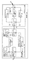
図3は、信号経路302、304を介してGPS衛星群226からGPSデータを受信する、公知の無線移動測位システム・アーキテクチャ300を示す。アーキテクチャ300は、移動機器306、基地局308、無線ネットワーク基盤設備310、地上位置サーバー局312、GPS基準受信器314、およびオプションとしてエンドユーザー316を含んでいてよい。GPS基準受信器314は、信号経路302を介してGPS衛星群226からGPS信号を受信する。移動機器306は、信号経路304を介してGPS衛星群226からのGPS信号を受信し、信号経路318を介して基地局308と信号通信状態にある。一般に、移動機器306はコール・プロセッサ320およびGPSモジュール322を含む。コール・プロセッサ320とGPSモジュール322の両方が、信号経路324を介して信号通信状態にある。信号経路324は、RS232リンク、ソフトウェア・データ構造体のメモリ共有を介した論理インターフェース、あるいは他の種類の電気および/または論理インターフェースであってよい。GPSモジュール322は、コール・プロセッサ320を含む移動機器306内の任意の場所に設置可能な別個のモジュールおよび/または機器として、あるいは機能装置として実装可能なことが当業者には理解される。
FIG. 3 shows a known wireless mobile
一般に、図3に示すアーキテクチャ300では、地上位置サーバー局312からあらゆるGPS支援情報を受信するために、地上位置サーバー局312が用いるものと同一のプロトコルをGPSモジュール322が利用する必要がある。
In general, the
図4に、信号経路406を介してGPSモジュール404と信号通信が可能なコール・プロセッサ402を含む移動機器400の典型的な実装例を示す。移動機器400は、図2に示す機器の例202、204、206、208、210、および212のいずれかであってよい。コール・プロセッサ402は信号経路318を介して基地局308と信号通信が可能であり、GPSモジュール404は信号経路304を介してGPS衛星群226からGPSデータを受信する。一例として、コール・プロセッサ402およびGPSモジュール404が物理的に別個の機器である場合、信号経路406はRS232データリンクにより実装することができる。信号経路406はまた、ソフトウェア・データ構造体のメモリ共有を介した論理インターフェース、あるいは他の種類の電気および/または論理インターフェースとして実装することができる。
FIG. 4 illustrates an exemplary implementation of a mobile device 400 that includes a
移動機器400は通常の動作時において、図3のGPS衛星群226からGPS信号304を受信し、基地局タワー308経由でセルラー電話通信ネットワーク基盤設備310から、あるいは図2の非セルラー収集ポイント230経由で非セルラー通信ネットワーク(図示せず)を用いて、通信信号318を受信する。
The mobile device 400 receives the
図4のコール・プロセッサ402は、図3のセルラー電話通信ネットワーク基盤設備310、あるいは非セルラー無線または非無線ネットワーク(図示せず)といった、外部通信ネットワークと一方向または双方向通信が可能な任意の通信機器であってよい。コール・プロセッサ402は、電気通信接続を確立して管理する専用ハードウェア(図示せず)およびソフトウェア(図示せず)を含む。
The
セルラー電話型のコール・プロセッサ402の例として、セルラー電話の呼を処理するイリノイ州シャウムバーグ(Schaumberg,Illinois)のモトローラ社(Motorola,Inc.)製の統合発信拡張ネットワーク(「iDEN(商標)」)、フィンランドのノキア社(Nokia)、スウェーデンのソニー・エリクソン(Sony Ericsson)、カリフォルニア州サンディエゴ(San Diego,California)のクアルコム社(Qualcomm,Inc)が使用しているCDMA2000(登録商標)1X型のチップセット、あるいはGPSモジュール308内でGPS受信器と通信可能な他の任意の種類のGSM/CDMA/TDMA/UMTS型通信機器が含まれる。通信機器の非セルラー電話型の例として、ドイツのシーメンス社(Siemens SA)製のSX45 GPSアクセサリ、BlueTooth(登録商標)と通信可能な任意の通信機器、IEEE802.11に基づく無線高忠実性(「Wi−Fi(登録商標)」)ネットワーク、その他の類似無線ネットワークが含まれていてよい。GPSモジュール404は、コール・プロセッサ402と通信可能な任意のGPS受信器も含んでいてよい。
As an example of a cellular telephone-
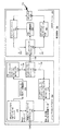
図5に、プロトコル独立な無線移動測位システム・アーキテクチャ500の実装例を示す。図5において、アーキテクチャ500は移動機器506、基地局508、無線ネットワーク基盤設備510、地理位置サーバー局512、GPS基準受信器514、およびオプションとしてエンドユーザー516を含んでいてよい。移動機器506およびGPS基準受信器514は、各々信号経路504、502を介してGPS衛星群226からGPS信号を受信する。
FIG. 5 shows an example implementation of a protocol-independent wireless mobile
移動機器506は、コール・プロセッサ520、GPSモジュール522、およびプロトコル独立なインターフェース(本明細書では「PI2」と称する)524を含んでいてよい。PI2(524)は、GPSモジュール522に地上位置サーバー局512が用いたものと同一のプロトコルを利用させる必要なしに、GPSモジュール522が地上位置サーバー局512から支援データを受信可能にするインターフェースである。従って、PI2(524)は、異なる地上位置サーバー局のために多数のプロトコルを個別に実装することからGPSモジュール522を解放することができる。モジュールという用語は、主基板または集積回路に一体化された独立モジュールあるいはサブシステムであってよい。
Mobile device 506 may include a
動作時において、各地上位置プロトコルは、地上位置サーバー局512のプロトコルを、GPSモジュール522が用いる独立プロトコルへ変換するPI2(524)内の変換器を介して実装することができる。これにより、移動機器506がある無線通信標準から別の標準へ切り替わる際に地上位置情報をシームレスに利用することが可能になり、移動機器506が支援データを受信して、場所その他の地上位置結果をコール・プロセッサ520から地上位置サーバー局512へ送信する方法が変化する。その結果、移動機器506のユーザー(図示せず)が契約している通信システムの地上位置サーバー局512からのGPS情報をPI2(524)によりGPSモジュール522が用いるプロトコルに変換することができるため、世界中のさまざまな地域で用いられている全ての異なる無線インターフェースの各々の固有な地上位置プロトコル(IS−817、IS−801等)を、GPSモジュール522を再設定または再構成する必要なしに、GPS装置506により利用することができる。PI2(524)の一例には、これに限定されるわけではないが、カリフォルニア州サンノゼ(San Jose,California)のサーフテクノロジー社(SiRF Technology,Inc.)が開発し権利を保有している、支援方式から独立した相互運用インターフェース(「AI3」)が含まれる。
In operation, each terrestrial location protocol can be implemented via a converter in PI2 (524) that converts the terrestrial
異なる種類の無線ネットワーク用に開発された異なる地上位置標準があることは当業者には認識されている。例えば、基地局508と基盤設備510の間のインターフェース526は、任意の無線インターフェースであってよい。インターフェース526は通常、コール・プロセッサ520の製造元により制御される。通常、PI2(524)は一般に「F」インターフェース(図示せず)および「G」インターフェース(図示せず)として公知の2種のインターフェースを含んでいる。
Those skilled in the art recognize that there are different ground location standards developed for different types of wireless networks. For example, the
FインターフェースはGPSモジュール522とコール・プロセッサ520の間のクライアント・システム・インターフェースであり、常駐のブートストラップ・プロトコルとして機能し、支援カプセル化層においてGPSモジュール522にどのように支援を搬送するかをコール・プロセッサ520が実行時に選択することを可能にする。コール・プロセッサ520は、無線インターフェース(端末間システム・アーキテクチャの場合におけるインターフェース526等)、あるいはGインターフェースのどちらかを選択することができる。Fインターフェースは、以下のタスクを実行することができる:すなわち、コール・プロセッサ520からのGPSモジュール522のハードウェアを管理すること(電源オン/オフ、リセット);もし利用可能であれば、暗黙的な支援インターフェース、すなわちコール・プロセッサ520を介したネットワークからの(またはコール・プロセッサ520の実時間時計からの)時間と周波数の転送、および(それが存在していても、ネットワークからは一般にはっきりしない)移動機器506の近似位置を送信すること;セッションを開始/終了すること(すなわち無線インターフェース接続が開始/終了されたことをGPSモジュール522へ通知すること);およびデュアルモードの移動機器506において、どの無線インターフェースが有効であるかをGPSモジュール522に通知し、地上位置サーバー局との対話にどの地上位置無線インターフェース・プロトコルの組を用いるべきかをGPSモジュール522に通知すること。
The F interface is a client system interface between the GPS module 522 and the
Fインターフェースと異なり、Gインターフェースは基地局508から受信したGPS支援情報をGPSモジュール522へ搬送するために用いられる。通常は多くの既存の地上位置プロトコルがあるため、Gインターフェースは広範な地上位置標準と無線インターフェースに対し独立して使用可能なように設計されている。すなわち適用可能な無線インターフェースに対して固有なものである。PI2(524)は、適用可能な地上位置標準の簡易版として実装することができる。
Unlike the F interface, the G interface is used to carry GPS assistance information received from the
動作時において、コール・プロセッサ520はGインターフェースを介して、測位要求情報およびネットワーク支援情報をPI2フォーマットでGPSモジュール522へ送信する。それに応答して、GPSモジュール522は同じインターフェースを介して、位置結果またはエラー通知をコール・プロセッサ520へ送信する。SAMPS、GSM、およびCDMAを含む全ての地上位置プロトコルが相互作用パラダイムの下で機能することを理解されたい。基地局508は、移動機器506が要求したものだけを返送する。一般に、相互作用を実行する際の戦略は、GPSモジュール522の処理に関する知識に大きく依存する。
In operation, the
さらに、多くのプロトコル・スタックのレベルとは対照的に、地上位置プロトコルはアプリケーション・プロトコルである。これは、それらがメッセージのセマンティクス(意味)を扱うことを意味する。従って、TCP−IPスタックのようにエラーの訂正および入れ替わりや重複の除去をせずに単に一方から他方へデータを転送することはしない。このように、プロトコルを扱う(例えば、何らかのデータの要求を決定する)全てのエンティティは、そのデータを使用する目的およびプロトコルを介してやり取りされる全てのパラメータの意味を知っている必要がある(すなわち、GPS側で何が起こっているかを知っている必要がある)。従って、地上位置プロトコルの開発者はGPSに「精通」している必要がある。 Furthermore, in contrast to many protocol stack levels, the ground location protocol is an application protocol. This means that they handle the semantics of the message. Therefore, data is not simply transferred from one to the other without correcting and replacing errors or removing duplicates as in the TCP-IP stack. In this way, every entity that handles a protocol (eg, decides on a request for some data) needs to know the purpose of using that data and the meaning of all parameters exchanged over the protocol ( That is, you need to know what is happening on the GPS side). Thus, developers of ground location protocols need to be “familiar” with GPS.
従って、PI2(524)は無線インターフェースの有限状態機械(「FSM」)(図示せず)を利用する。一般には、これによってGPSメモリ(図示せず)の内容に関する現時点の知識によってFSMの現在の状態が与えられることとなり、いくつかの不完全なGPS情報を補完するために要求メッセージを送信するという決定がFSMそれ自身の内部で形成されることとなる。 Thus, PI2 (524) utilizes a finite state machine ("FSM") (not shown) with a wireless interface. In general, this will give the current state of the FSM with current knowledge of the contents of GPS memory (not shown), and the decision to send a request message to supplement some incomplete GPS information. Will be formed within the FSM itself.
図6を参照するに、図6はFSMを用いる移動機器600のブロック図を示す。移動機器600は、コール・プロセッサ602およびGPSモジュール604を含む。コール・プロセッサ602は、無線インターフェースCPモジュール606、無線インターフェース・プロトコルからGPSモジュール・インターフェースへのコンバータ608、GPSモジュール・データ構造体610、GPSモジュールの無線インターフェース・アセンブラ/逆アセンブラ612、GPSモジュール/CPシステム・メッセージ・プロトコル・アセンブラ/逆アセンブラ614、およびGPSモジュール・インターフェース・モジュール616を含む。GPSモジュール604は、CPインターフェース・モジュール618、PI2インターフェース・モジュール620、PI2データ構造体622、CPシステム・インターフェースFSM624、およびGPSコア626を含む。GPSコア626は信号経路632を介してGPS衛星群226からGPS信号を受信し、無線インターフェースCPモジュール606は信号経路630を介して基地局(図示せず)と信号通信可能である。
Referring to FIG. 6, FIG. 6 shows a block diagram of a mobile device 600 that uses FSM. Mobile device 600 includes a call processor 602 and a GPS module 604. Call processor 602 includes radio
図6は、IS−801に基づくCDMA移動機器600内に実装されるPI2の高水準なアーキテクチャを示す。コール・プロセッサ602は、信号経路(RS232リンクを含んでいてよいがこれに限定されない)628および(時間および周波数の転送のための)ハードウェア線を介して、GPSモジュール604と通信可能である。信号経路628はRS232インターフェース、ソフトウェア・データ構造体のメモリ共有を介した論理インターフェース、その他の電気および/または論理インターフェースとして実装可能である。FおよびGインターフェース636、634は、RS232インターフェース用の2個の別々の論理チャネルである。Gインターフェース634は、GPSモジュール604へPI2の支援データを渡すべく設計されている。残りの支援データは、Fインターフェース636を介してGPSモジュール604へ渡される。GPSモジュール604側では、Fインターフェース638は(SiRFLocといった)標準的なGPSクライアント・インターフェースであり、Gインターフェース640はいかなる標準的な無線インターフェース・プロトコルに対しても透過的である。
IS−801のコール・プロセッサ602の場合、PI2データは無線インターフェース・プロトコルからGPSモジュール・インターフェースへのコンバータ(IS801メッセージからPI2へのコンバータとも呼ばれる)を介して生成される。PI2データは、信号経路628経由でGPSモジュール604へ渡される前に、GPSモジュールの無線インターフェース・アセンブラ/逆アセンブラ(PI2インターフェース・メッセージ・ハンドラとも呼ばれる)612を介して、Gメッセージ・フォーマットに圧縮される。コール・プロセッサ602は、適当な無線インターフェース・メッセージから、時間、位置、および周波数のデータを取得する。位置データは、「F」インターフェース636メッセージ(移動機器600の近似位置応答メッセージ)を介して、GPSモジュール604へ渡される。時間および周波数データは、GPSモジュール604に渡される。
FIG. 6 shows a high level architecture of PI2 implemented in a CDMA mobile device 600 based on IS-801. Call processor 602 can communicate with GPS module 604 via a signal path (which may include but is not limited to RS232 links) 628 and hardware lines (for time and frequency transfer). The
For the IS-801 call processor 602, PI2 data is generated via a radio interface protocol to GPS module interface converter (also referred to as an IS801 message to PI2 converter). The PI2 data is compressed into the G message format via the GPS module radio interface assembler / disassembler (also called PI2 interface message handler) 612 before being passed to the GPS module 604 via the
PI2データ構造体は、電離層、衛星エフェメリス、および移動機器600の測位要求パラメータに関する情報を含む。これら全てのデータは通常、バイト表現されている。PI2データ構造体は、コール・プロセッサ602が基地局(図示せず)との通信リンクを確立した後で0に再設定する必要がある。移動機器600の近似位置、測位要求パラメータ、エフェメリス・データ、GPS時間および周波数を含む支援データのソースは幾つか存在する。第1のソースは、基地局の位置に関する知識により取得することができる。基地局の位置は移動機器600の近似位置として用いることができる。基地局の位置データを取得する2つの方法として、IS−95の暗黙的なメッセージによるものと、IS−801のプロトコル・メッセージによるものがある。IS−95のページング・チャネルの「システム・パラメータ・メッセージ」は、基地局の経度と緯度の位置データを含む。このメッセージでは高度データが得られないため、移動機器600の近似位置の高度は0に設定される。コール・プロセッサ602はまた、IS−801の「基地局アルマナック提供」メッセージを介して基地局の位置データを取得することもできる。このメッセージは、基地局の経度、緯度および高度の計算に利用できる十分なデータを含んでいる。この方法においてコール・プロセッサ602は、PDEが「基地局アルマナック提供」メッセージで応答可能となる前に、IS−801の「基地局アルマナック要求」メッセージを送る必要がある。これは通常、IS−95の暗黙的な方法と比較して余分なメッセージ・ハンドリングを必要とする。 The PI2 data structure includes information regarding the ionosphere, satellite ephemeris, and positioning request parameters of the mobile device 600. All these data are usually represented in bytes. The PI2 data structure needs to be reset to 0 after call processor 602 establishes a communication link with a base station (not shown). There are several sources of assistance data including approximate location of the mobile device 600, positioning request parameters, ephemeris data, GPS time and frequency. The first source can be obtained by knowledge about the location of the base station. The position of the base station can be used as an approximate position of the mobile device 600. There are two ways to obtain base station location data: IS-95 implicit message and IS-801 protocol message. The “system parameter message” of the IS-95 paging channel contains the longitude and latitude location data of the base station. Since altitude data cannot be obtained with this message, the altitude of the approximate position of the mobile device 600 is set to zero. Call processor 602 may also obtain base station location data via IS-801 “provide base station almanac” message. This message contains sufficient data that can be used to calculate the longitude, latitude and altitude of the base station. In this manner, call processor 602 needs to send an IS-801 “Base Station Almanac Request” message before the PDE can respond with a “Base Station Almanac Provided” message. This usually requires extra message handling compared to the IS-95 implicit method.
測位要求パラメータも移動機器600の測位を支援することができる。IS−801の「位置応答要求」メッセージは、PI2の測位要求パラメータに対して測位回数および測位の時間間隔を計算するデータを提供する。さらに、エフェメリス・データに関して、IS−801の「GPSエフェメリス提供」メッセージはPI2のためにエフェメリス・データに変換される全てのデータを提供する。 The positioning request parameter can also support the positioning of the mobile device 600. The IS-801 “position response request” message provides data for calculating the number of times of positioning and the time interval of positioning for the positioning request parameter of PI2. Further, with respect to ephemeris data, the IS-801 “GPS Ephemeris Provided” message provides all the data that is converted to ephemeris data for PI2.
支援されたGPS時間はまたGPS時間の不確実性を低減することが可能であり、GPSモジュール604は時間転送の方法によりGPS時計をCDMAシステム時計と同期させることができる。コール・プロセッサ602は携帯端末の時計を、CDMA同期チャネルの「チャネル同期メッセージ」から取得できるCDMAシステム時間に同期させる。
同様に、周波数支援を用いて、GPS周波数の不確実性を低減することが可能であり、GPSモジュール604は周波数転送の方法を介してGPS時計をコール・プロセッサ602および基地局の時計に同期させることができる。
Assisted GPS time can also reduce GPS time uncertainty, and the GPS module 604 can synchronize the GPS clock with the CDMA system clock by way of time transfer. Call processor 602 synchronizes the mobile terminal's clock to the CDMA system time, which can be obtained from the “channel synchronization message” of the CDMA synchronization channel.
Similarly, frequency assistance can be used to reduce GPS frequency uncertainty, and the GPS module 604 synchronizes the GPS clock to the call processor 602 and the base station clock via a method of frequency transfer. be able to.
動作時において、コール・プロセッサ602のソフトウェアは、IS−801およびIS−95のメッセージ・プロトコルを介して、ネットワーク支援データのための基地局との通信を扱う。PI2データは、エフェメリス支援データ並びに移動機器600の測位要求パラメータを含む。コール・プロセッサ602は、IS−801の「位置応答要求」メッセージから検索される位置測位データの数を用いて、移動機器600の測位要求パラメータを計算することができる。コール・プロセッサ602は、IS−801の「GPSエフェメリス提供」メッセージから圧縮されたエフェメリス・データを検索することにより、エフェメリス支援データをPI2フォーマットで生成する。コール・プロセッサ602は、PI2データ構造体内に、移動機器600の測位要求パラメータおよびエフェメリス支援データを保存する。 In operation, call processor 602 software handles communication with the base station for network assistance data via IS-801 and IS-95 message protocols. The PI2 data includes the ephemeris support data and the positioning request parameter of the mobile device 600. The call processor 602 can calculate the positioning request parameters of the mobile device 600 using the number of positioning data retrieved from the IS-801 “Location Response Request” message. The call processor 602 generates ephemeris support data in the PI2 format by retrieving the compressed ephemeris data from the IS-801 “GPS Ephemeris Provided” message. The call processor 602 stores the positioning request parameters and ephemeris assistance data of the mobile device 600 in the PI2 data structure.
コール・プロセッサ602は、移動機器600がアイドル状態にある間にIS−95の「システム・パラメータ・メッセージ」から得られた基地局データを利用することができ、それを移動機器600の近似位置として利用することができる。IS−801の「システム・パラメータ・メッセージ」内には基地局の高度の情報が欠落しているため、コール・プロセッサ602は、移動機器600の近似位置の高度をゼロに設定する。 The call processor 602 can utilize base station data obtained from the IS-95 “system parameter message” while the mobile device 600 is idle, and use that as an approximate location of the mobile device 600. Can be used. Since the base station altitude information is missing in the IS-801 “system parameter message”, the call processor 602 sets the altitude of the approximate location of the mobile device 600 to zero.
コール・プロセッサ602は、IS−801の「基地局アルマナック提供」メッセージから基地局の位置データの取得を選択することができる。この方法を選択することにより、コール・プロセッサ602は移動機器600がシステム・アイドル状態、または移動機器600がトラフィック・チャネル制御状態にある間、IS−801の「基地局アルマナック要求」メッセージを送る必要がある。この方法は暗黙的なIS−95の方法と比較して、2つのIS−801のメッセージの処理を必要とし、移動機器600のアイドル状態より長い時間遅れを要する。「基地局アルマナック」メッセージに見られる複数の基地局の座標のうち、コール・プロセッサ602は、移動機器600の近似位置の基準基地局として自身が直接無線接続している基地局を選択するであろう。 Call processor 602 may select to obtain base station location data from the IS-801 “provide base station almanac” message. By selecting this method, call processor 602 needs to send an IS-801 “Base Station Almanac Request” message while mobile device 600 is in a system idle state or mobile device 600 is in a traffic channel control state. There is. This method requires the processing of two IS-801 messages compared to the implicit IS-95 method, and requires a longer time delay than the mobile device 600 is idle. Of the plurality of base station coordinates found in the “base station almanac” message, the call processor 602 selects the base station that is directly wirelessly connected as the reference base station of the approximate position of the mobile device 600. Let's go.
コール・プロセッサ602は、IS−95の「チャネル同期メッセージ」から得られたCDMAシステム時間をコール・プロセッサ602時間として使用する。コール・プロセッサ602は時間転送の方法を介して、タイミング情報をGPSモジュール604へ送信する。同様に、コール・プロセッサ602は、周波数転送の方法を介して自身のクロック周波数をGPSモジュール604の周波数に同期させる。 The call processor 602 uses the CDMA system time derived from the IS-95 “channel synchronization message” as the call processor 602 time. Call processor 602 sends timing information to GPS module 604 via a time transfer method. Similarly, call processor 602 synchronizes its clock frequency to the frequency of GPS module 604 via a frequency transfer method.
コール・プロセッサ602は、Gインターフェース634の「PI2データ・メッセージ」を介してPI2データをGPSモジュール604へ送信する。コール・プロセッサ602は適当なFインターフェース636を介して、移動機器600の近似位置、時間および周波数の転送データを送信する。
The call processor 602 transmits the PI2 data to the GPS module 604 via the “PI2 data message” of the
PI2に基づく測位サービスを提供すべく、コール・プロセッサ602はIS−801メッセージの特定のデータ・フィールドに適当な値を設定する。コール・プロセッサ602がFインターフェース636を介してGPSモジュール604から位置結果を受信した場合、当該位置結果をPDEへ送信すべくIS−801メッセージ・フォーマットに変換する。
In order to provide a positioning service based on PI2, the call processor 602 sets an appropriate value in a specific data field of the IS-801 message. When call processor 602 receives a location result from GPS module 604 via
コール・プロセッサ602はPDEから送信されたIS−801の「MS情報要求」メッセージに応答して、IS−801の「移動機器600の情報提供」メッセージのREQ_PAR_RECORDを以下のように設定する: In response to the IS-801 “MS Information Request” message sent from the PDE, the call processor 602 sets REQ_PAR_RECORD of the IS-801 “Provide Information for Mobile Device 600” message as follows:
1.RESP_PAR_RECORDのGPS_ACQ_CAPおよびLOC_CALC_CAPを以下に述べる値に設定する:GPS_ACQ_CAP(12ビット)の第4ビット(GPSエフェメリス)および第7ビット(GPSの自律的な捕捉可能)を「1」に設定し、その他のビットを「0」に設定する; 1. Set GPS_ACQ_CAP and LOC_CALC_CAP of RESP_PAR_RECORD to the values described below: Set the 4th bit (GPS ephemeris) and 7th bit (GPS autonomous capture possible) of GPS_ACQ_CAP (12 bits) to “1”, Set the bit to "0";
2.LOC_CALC_CAP(12ビット)の第5ビット(エフェメリスを用いた位置計算可能)および第7ビット(自律的な位置計算可能)を「1」に設定し、その他のビットを「0」に設定する。 2. The fifth bit (position calculation is possible using ephemeris) and the seventh bit (autonomous position calculation is possible) of LOC_CALC_CAP (12 bits) are set to “1”, and the other bits are set to “0”.
コール・プロセッサ602がIS−801の基地局のアルマナック・データを介した移動機器600の近似位置の取得を選択した場合、コール・プロセッサ602はIS−801の「基地局アルマナック要求」メッセージのREQ_PAR_RECORDを以下のように設定する:EXT_BS_ALM(1ビット)を1に設定する。 If the call processor 602 chooses to obtain the approximate location of the mobile device 600 via the IS-801 base station almanac data, the call processor 602 sets the REQ_PAR_RECORD in the IS-801 “Base Station Almanac Request” message. Set as follows: Set EXT_BS_ALM (1 bit) to 1.
コール・プロセッサ602はIS−801の「GPSエフェメリス要求」メッセージを送信してエフェメリス支援データを取得する。コール・プロセッサ602はIS−801の「GPSエフェメリス要求」メッセージのREQ_PAR_RECORDを以下のように設定する:AB_PAR_REQ(1ビット)を1に設定する。 Call processor 602 obtains the ephemeris assistance data by sending an IS-801 “GPS ephemeris request” message. Call processor 602 sets REQ_PAR_RECORD in the IS-801 “GPS ephemeris request” message as follows: AB_PAR_REQ (1 bit) is set to 1.
コール・プロセッサ602は、GPSモジュール604から「F」インターフェースの「位置結果」メッセージを受信した後で、以下のように位置結果データをIS−801の「位置応答提供」メッセージへ変換する: After receiving the “F” interface “position result” message from the GPS module 604, the call processor 602 converts the position result data into an IS-801 “position response provided” message as follows:
1.TIME_REF_CDMA(14ビット)。コール・プロセッサ602は、GPS時間をCDMAシステム時間に変換する。GPS時間は「F」インターフェースの「位置結果」メッセージのMEAS_GPS_WEEKおよびMEAS_GPS_SECONDSにより決定される。MEAS_GPS_WEEKは拡張されたGPS週の番号であり、MEAS_GPS_SECONDSは、現在のGPS週の開始からの1/1000秒単位での経過時間である。CDMAシステム時間はTIA/EIA−95−Bの1.2に定義されている。TIME_REF_CDMAは、IS−801に定義されているように(t/50)mod16384に設定される。ここに、tはフレーム単位でのCDMAシステム時間である。 1. TIME_REF_CDMA (14 bits). Call processor 602 converts GPS time to CDMA system time. The GPS time is determined by MEAS_GPS_WEEK and MEAS_GPS_SECONDS of the “position result” message of the “F” interface. MEAS_GPS_WEEK is the extended GPS week number, and MEAS_GPS_SECONDS is the elapsed time in 1/1000 second from the start of the current GPS week. The CDMA system time is defined in TIA / EIA-95-B 1.2. TIME_REF_CDMA is set to (t / 50) mod 16384 as defined in IS-801. Here, t is the CDMA system time in units of frames.
2.LAT(25ビット)。LAT=scale_factor_meas_lat × MEAS_LAT(位置結果メッセージ)。LATは180/225単位であり、MEAS_LATは180/232単位である。従って、scale_factor_meas_lat=(180/232)/(180/225)=1/27である; 2. LAT (25 bits). LAT = scale_factor_meas_lat × MEAS_LAT (position result message). LAT is 180/2 25 units, and MEAS_LAT is 180/2 32 units. Therefore, scale_factor_meas_lat = (180/2 32 ) / (180/2 25 ) = 1/2 7 ;
3.LONG(26ビット)。LONG=scale_factor_meas_long × MEAS_LONG(位置結果メッセージ)。LONGは、360/226単位であり、MEAS_LONGは360/232単位である。従って、Scale_factor_meas_long=(360/232)/(360/226)=1/26である; 3. LONG (26 bits). LONG = scale_factor_meas_long × MEAS_LONG (position result message). LONG is 360/2 26 units, MEAS_LONG is 360/2 32 units. Therefore, Scale_factor_meas_long = is (360/2 32) / (360/2 26) = 1/2 6;
4.LOC_UNCRTNTY_ANG(4ビット)、LOC_UNCRTNTY_A(5ビット)、LOC_UNCRTNTY_P(5ビット)。OTHER_SECTIONS(位置結果メッセージ)の第0ビット(LSB)が「0」に等しい(データ内に水平エラー部分が存在しない)場合、LOC_UNCRTNTY_ANG=0、LOC_UNCRTNTY_A=「11111」(計算不能)、LOC_UNCRTNTY_P=「11111」(計算不能)である; 4). LOC_UNCRTNTY_ANG (4 bits), LOC_UNCRTNTY_A (5 bits), LOC_UNCRTNTY_P (5 bits). When the 0th bit (LSB) of OTHER_SECTIONS (position result message) is equal to “0” (there is no horizontal error portion in the data), LOC_UNCRTNTY_ANG = 0, LOC_UNCRTNTY_A = “11111” (cannot be calculated), LOC_UNCRTNTTY_P = “11111” "(Cannot be calculated);
5.FIX_TYPE(1ビット)。POS_TYPE(位置結果メッセージ)=0x00ならばFIX_TYPE=0であり、POS_TYPE=0x01ならばFIX_TYPE=1である; 5). FIX_TYPE (1 bit). If POS_TYPE (position result message) = 0x00, FIX_TYPE = 0; if POS_TYPE = 0x01, FIX_TYPE = 1;
6.VELOCITY_INCL(1ビット)、VELOCITY_HOR(9ビット)、VELOCITY_VER(8ビット)、HEADING(10ビット)。VELOCITY_INCL(IS−801、1ビット)=OTHER_SECTIONS(位置結果メッセージ)の第2ビット;VELOCITY_INCL=「1」ならば、VELOCITY_HOR=scale_factor_hv × HOR_VEL(位置結果メッセージ)であり、scale_factor_hv=0.0625/0.25=0.25である;HEADING=scale_factor_heading × HEADING(位置結果メッセージ)である;scale_factor_heading=(360/216)/(360/210)=2−6である;VELOCITY_INCL=「1」かつFIX_TYPE=「1」ならば、VELOCITY_VER(IS801、8ビット)=VER_VEL(位置結果メッセージ)である;VELOCITY_INCL=「0」ならば、IS−801の「位置応答提供」はVELOCITY_HOR、VELOCITY VER、およびHEADINGパラメータを含まない; 6). VELOCITY_INCL (1 bit), VELOCITY_HOR (9 bits), VELOCITY_VER (8 bits), HEADING (10 bits). VELOCITY_INCL (IS-801, 1 bit) = the second bit of OTHER_SECTIONS (position result message); if VELOCITY_INCL = “1”, VELOCITY_HOR = scale_factor_hv × HOR_VEL (position result message) is 25 = 0.25; HEADING = scale_factor_heading a × HEADING (position result message); scale_factor_heading = (360/2 16) / is (360/2 10) = 2 -6; VELOCITY_INCL = "1" and FIX_TYPE == "1", VELOCITY_VER (IS801, 8 bits) = VER_V EL (position result message); if VELOCITY_INCL = “0”, IS-801 “Provide Position Response” does not include VELOCITY_HOR, VELOCITY VER, and HEADING parameters;
7.CLOCK_INCL(1ビット)、CLOCK_BIAS(18ビット)、CLOCK_DRIFT(16ビット)。CLOCK_INCL=OTHER_SECTIONS(位置結果メッセージ)の第3ビットである;CLOCK_INCL=「1」ならば、CLOCK_BIAS=scale_factor_clk_bias × CLK_BIAS(位置結果メッセージ) + offset_clk_biasである;ここに、scale_factor_clk_bias=1e9である;offset_clk_bias=13,000 nsである。 7. CLOCK_INCL (1 bit), CLOCK_BIAS (18 bits), CLOCK_DRIFT (16 bits). CLOCK_INCL = the third bit of OTHER_SECTIONS (position result message); if CLOCK_INCL = “1”, CLOCK_BIAS = scale_factor_clk_bias × CLK_BIAS (et_cl_as_c1_c1; , 000 ns.
8.HEIGHT_INCL(1ビット)、HEIGHT(14ビット)。HEIGHT_INCL=OTHER_SECTIONS(位置結果メッセージ)の第1ビットである;HEIGHT_INCL=「1」ならば、HEIGHT=scale_factor_height × HEIGHT(位置結果メッセージ)であり、scale_factor_height= 0.1である; 8). HEIGHT_INCL (1 bit), HEIGHT (14 bits). HEIGHT_INCL = the first bit of OTHER_SECTIONS (position result message); if HEIGHT_INCL = “1”, HEIGHT = scale_factor_height × HEIGHT (position result message), scale_factor_height = 0.1;
9.LOC_UNCRTNTY_V(5ビット)。HEIGHT_INCL=「1」ならば、LOC_UNCRTNTY_V=HEIGHT_STD_ER(位置結果メッセージ)である。 9. LOC_UNCRTNTY_V (5 bits). If HEIGHT_INCL = “1”, LOC_UNCRTNTY_V = HEIGHT_STD_ER (position result message).
コール・プロセッサ602は、IS−801の「基地局アルマナック要求」メッセージに応答するPDEからのIS−801の「基地局アルマナック提供」メッセージを受信する。このメッセージは、IS−95の暗黙的な方法の代わりに、移動機器600の近似位置データを取得する方法を提供する。 Call processor 602 receives an IS-801 “Base Station Almanac Provided” message from the PDE in response to an IS-801 “Base Station Almanac Request” message. This message provides a way to obtain approximate location data for the mobile device 600 instead of the IS-95 implicit method.
IS−801の「基地局アルマナック提供」から「F」インターフェースの「移動機器600の近似位置応答」へのメッセージ・マッピングについて本節で説明する。「F」インターフェースの「移動機器600の近似位置応答」データのフィールド名には(F)とラベル付けされている。IS−801の「基地局アルマナック提供」のフィールド名には、(IS−801)とラベル付けされている。 Message mapping from “provided by base station almanac” of IS-801 to “approximate position response of mobile device 600” of “F” interface is described in this section. The field name of the “approximate position response of mobile device 600” data of the “F” interface is labeled (F). The field name “provided by base station almanac” of IS-801 is labeled (IS-801).
「GPSエフェメリス提供」メッセージは、エフェメリス・データをPI2インターフェース・データの一部として提供する。エフェメリス・データ・セットの大きさに応じて、PDEはIS−801の「GPSエフェメリス提供」をいくつかの部分に分けて送信してもよい。部分の総数およびメッセージの部分番号は各々TOTAL_PARTSおよびPART_NUMの要素に示される。コール・プロセッサ602がエフェメリス・データの全ての部分を受信したならば、それらをPI2構造体へマッピングする。 The “GPS Ephemeris Provided” message provides the ephemeris data as part of the PI2 interface data. Depending on the size of the ephemeris data set, the PDE may send the IS-801 “GPS Ephemeris Provided” in several parts. The total number of parts and the part number of the message are shown in the TOTAL_PARTS and PART_NUM elements, respectively. Once call processor 602 has received all parts of the ephemeris data, it maps them to the PI2 structure.
動作時において、コール・プロセッサ602はGPSモジュール604と「F」インターフェース・メッセージを介して相互作用する。コール・プロセッサ602は、新たなコール・プロセッサ602のデータが(GPSモジュール604からの要求なしに)利用可能な場合はいつでもPI2データをGPSモジュール604へ送信する。CPとGPSモジュール604の間にはPI2インターフェースを介した相互作用は存在しない。 In operation, the call processor 602 interacts with the GPS module 604 via “F” interface messages. Call processor 602 sends PI2 data to GPS module 604 whenever new call processor 602 data is available (without request from GPS module 604). There is no interaction between the CP and the GPS module 604 via the PI2 interface.
コール・プロセッサ602のIS−801セッションは、GPSモジュール604に電源投入される前に、または(PI2インターフェース・フラグと共に設定された)GPSモジュール604セッションが開始される前に、開始されてよい。GPSモジュール604セッションはIS−801セッションが終了する前に終了してもよい。IS−801セッションが開始されたならば、コール・プロセッサ602はPI2データ構造体を再設定する。 The IS-801 session of call processor 602 may be started before the GPS module 604 is powered on or before the GPS module 604 session (set with the PI2 interface flag) is started. The GPS module 604 session may end before the IS-801 session ends. If an IS-801 session is initiated, the call processor 602 resets the PI2 data structure.
GPSモジュール604に電源が投入される前にIS−801セッションが開始されたならば、コール・プロセッサ602がGPSモジュール604との時間転送を実行する準備が整う前にCDMAシステム時間が利用可能になっている。この方式において、コール・プロセッサ602はまた、GPSモジュール604が「F」インターフェースの「移動機器600の近似位置要求」を送信する準備ができる前に移動機器600の近似位置データを取得することができるため、GPSモジュール604のGPS性能がさらに最適化される。 If an IS-801 session is started before the GPS module 604 is powered on, the CDMA system time is available before the call processor 602 is ready to perform a time transfer with the GPS module 604. ing. In this manner, the call processor 602 can also obtain approximate location data for the mobile device 600 before the GPS module 604 is ready to send an “approximate location request for the mobile device 600” on the “F” interface. Therefore, the GPS performance of the GPS module 604 is further optimized.
コール・プロセッサ602は、(IS−95の「システム・パラメータ・メッセージ」からの)IS−95の暗黙的な方法、またはIS−801のメッセージのいずれかを介して移動機器600の近似位置を取得することができる。IS−95の暗黙的な方法は、IS−801のメッセージと比較して、より高速に基地局の位置を取得する方法であると考えられる。IS−95の「システム・パラメータ」は、CDMA移動機器600がアイドル状態の間、IS−801セッションに関わらず、基地局からコール・プロセッサ602へ送信される必須のメッセージである。他方、IS−801の「基地局アルマナック要求/提供」は2種の双方向メッセージ交換を要求するだけでなく、IS−801セッションが開始されるまで起動されない。 Call processor 602 obtains the approximate location of mobile device 600 via either IS-95 implicit method (from IS-95 “System Parameter Message”) or IS-801 message. can do. The implicit method of IS-95 is considered to be a method of acquiring the position of the base station at a higher speed than the IS-801 message. IS-95 “system parameters” are mandatory messages sent from the base station to the call processor 602 regardless of the IS-801 session while the CDMA mobile device 600 is idle. On the other hand, IS-801 “Base Station Almanac Request / Provide” not only requires two types of bidirectional message exchanges, but is not activated until an IS-801 session is initiated.
コール・プロセッサ602がIS−801インターフェース経由で基地局から渡された全く新規なエフェメリス・データの組を変換した場合、PI2データは準備完了していると見なされる。コール・プロセッサ602はGPSモジュール604からの問い合わせがなくても、PI2データの準備完了後2秒未満でPI2データをGPSモジュール604へ送信する。コール・プロセッサ602は基地局に対し、2時間を超えない間隔で周期的に、エフェメリス・データの送信を要求すべきである。周期が速いほどGPS性能がより最適化される。 If the call processor 602 converts a completely new ephemeris data set passed from the base station via the IS-801 interface, the PI2 data is considered ready. Even if there is no inquiry from the GPS module 604, the call processor 602 transmits the PI2 data to the GPS module 604 in less than 2 seconds after the preparation of the PI2 data is completed. Call processor 602 should request the base station to transmit ephemeris data periodically at intervals not exceeding two hours. The faster the cycle, the more optimized the GPS performance.
GPSモジュール604は、PI2データ構造体で指定された測位回数に基づき、「F」インターフェースを介してコール・プロセッサ602へ位置結果を周期的に送信する。コール・プロセッサ602は、たとえデータが利用できない場合でも、PI2構造体の測位回数を設定する。 The GPS module 604 periodically sends location results to the call processor 602 via the “F” interface based on the number of positioning specified in the PI2 data structure. The call processor 602 sets the positioning count of the PI2 structure even if data is not available.
図7に目を転じれば、図7はGSM環境でFSMを用いる移動機器700のブロック図を示す。移動機器700は、信号経路706を介して信号通信が可能であるコール・プロセッサ702およびGPSモジュール704を含む。ここでも、信号経路706はRS232インターフェース、ソフトウェア・データ構造体のメモリ共有を介した論理インターフェース、あるいは他の電気および/または論理インターフェースとして実装可能である。コール・プロセッサ702は、無線インターフェースCPモジュール708、RRLPメッセージからPI2データへのコンバータ710、GPSモジュールのPI2データ構造体712、PI2インターフェース・メッセージ・アセンブラ/逆アセンブラ714、CP/GPSモジュール・システム・メッセージ・プロトコル・アセンブラ/逆アセンブラ716、およびGPSモジュール・インターフェース・モジュール718を含む。GPSモジュール704はCPインターフェース・モジュール720、PI2インターフェース・モジュール722、PI2データ構造体724、CPシステム・インターフェースFSM726、およびGPSコア728を含む。GPSコア728は、信号経路732を介してGPS衛星群226からGPS信号を受信し、無線インターフェースCPモジュール708は信号経路730を介して基地局(図示せず)と信号通信が可能である。
Turning to FIG. 7, FIG. 7 shows a block diagram of a mobile device 700 that uses FSM in a GSM environment. The mobile device 700 includes a call processor 702 and a GPS module 704 that are capable of signal communication via a
移動機器700のブロック図は、RRLPに基づく携帯端末(すなわちGSMに基づくセルラー電話)内に実装されるPI2の高水準のアーキテクチャである。コール・プロセッサ702は図7に示すように、信号経路706および(時間および周波数を転送するための)ハードウェア線を介して、GPSモジュール704と通信することができる。Fインターフェース736およびGインターフェース734は、RS232インターフェース706の2個の別々の論理チャネルである。Gインターフェース734は、GPSモジュール704にPI2支援データを渡すべく設計されるだろう。残りの支援データは、Fインターフェース736を介してGPSモジュール704へ渡される。GPSモジュール704側では、Fインターフェース738は標準的なGPSクライアント・インターフェース(サーフテクノロジー社(SiRF Technology,Inc.)が権利を所有するSiRFLoc等)であってよく、Gインターフェース740は任意の標準的な無線インターフェース・プロトコルに対して透過的である。コール・プロセッサ702は無線インターフェース・プロトコルを介してRRLPメッセージからPI2データへのコンバータ710へのPI2データを生成することができる。PI2データは、信号経路706を介してGPSモジュール704へ渡される前に、PI2インターフェース・メッセージ・アセンブラ/逆アセンブラ712(PI2インターフェース・メッセージ・ハンドラ等)を介してGメッセージ・フォーマットに圧縮される。コール・プロセッサ702は、適当なRRLP無線インターフェース・メッセージから、時間および基準位置データを取得することができ、CP/GPSモジュール・システム・メッセージ・プロトコル・アセンブラ/逆アセンブラ716を経由して適当なFインターフェース736を介してGPSモジュール704へ渡すことができる。
The block diagram of the mobile device 700 is a high-level architecture of PI2 implemented in a mobile terminal based on RRLP (ie, a cellular phone based on GSM). Call processor 702 can communicate with GPS module 704 via
PI2インターフェーはコール・プロセッサ702に使用され、Fインターフェース736のセッション開始メッセージにおける特別な「無線インターフェース」コードによってGPSモジュール704に通知される。この後で、(時間転送や周波数転送といった)全ての暗黙的な支援は、Fインターフェースを通して送信される。もし可能であれば、移動機器700の近時位置も基地局518から、コール・プロセッサ702を通じて、Fインターフェース736を介してGPSモジュール704へ送信される。GPSモジュール704は次いで、Fインターフェース738を介して移動機器700の位置報告を以って応答することができる。
The PI2 interface is used by the call processor 702 and is notified to the GPS module 704 by a special “wireless interface” code in the
PI2インターフェースは通常、メモリ・セクション(図示せず)として実装可能な大規模データ構造体により規定されることが認識されている。一般に、インターフェースに存在する全ての情報は、この大規模データ構造体内に所定の位置を有する。情報の全項目が有効であることを示すために、有効性フラグもこの構造体の全フィールドに割り当てることができる。次いで情報の送信は、構造体全体を所定の順序(MSB優先等)で「1バイト毎に読んで送信」される。クライアント側では同様のデータ構造体を有しており、情報が到来したならば直ちに1バイト毎に書き込むことができる。有効性を検証すべく、構造体全体に対して単一のチェックサム・テストを行なってもよい。 It is recognized that the PI2 interface is typically defined by a large data structure that can be implemented as a memory section (not shown). In general, all information present in the interface has a predetermined position within this large data structure. Validity flags can also be assigned to all fields of this structure to indicate that all items of information are valid. Next, the information is transmitted by “reading and transmitting every byte” in a predetermined order (MSB priority etc.). The client side has a similar data structure, and can be written byte by byte as soon as information arrives. To verify validity, a single checksum test may be performed on the entire structure.
ある場合には必ずしも全てのエフェメリスが有効ではないことが知られており、理論的には、実際に有効な情報を有するエフェメリス・スロットだけを送信することによりメッセージを短縮することができる。しかし、メモリ・ミラーリング機構がメッセージの意味に依存しないように、これを避ける方が好ましい。これを避ける方法は、(有効フィールドを含めて)全ての未使用フィールドの値を「0」に設定する方式を選択することである。単純な圧縮メカニズム、すなわちビット自身の代わりにゼロに設定された連続するビット数を送る方式も同じ目的に利用できる。この方式でのメカニズムは、ビット自身の代わりに「0」にセットされた連続するビットの多数回の繰り返しを示す固定フィールドに先行する曖昧性の無い特別なメタキャラクタを利用することができる。この状況で、メモリ・ミラーリング構造体の内容は、厳密にエフェメリス情報および場合によっては電離層パラメータで構成されている。 In some cases, it is known that not all ephemeris is valid, and theoretically, the message can be shortened by transmitting only the ephemeris slot that actually has valid information. However, it is preferable to avoid this so that the memory mirroring mechanism does not depend on the meaning of the message. A way to avoid this is to select a scheme that sets the value of all unused fields (including valid fields) to “0”. A simple compression mechanism, ie sending a number of consecutive bits set to zero instead of the bits themselves, can be used for the same purpose. The mechanism in this scheme can use an unambiguous special metacharacter preceding a fixed field that indicates multiple repetitions of consecutive bits set to “0” instead of the bits themselves. In this situation, the contents of the memory mirroring structure are strictly composed of ephemeris information and possibly ionospheric parameters.
当業者は、Fインターフェース736およびGインターフェース734の両方がコール・プロセッサ702とGPSモジュール704の間で任意のシリアルリンクを介して送信可能なことを知っている。実施例としてはRS232のみが示されているが、他の任意のシリアルリンクも同様に機能することが認識されている。さらに、コール・プロセッサ702およびGPSモジュール704の両方が同じ半導体ダイ上に一体化されている状況において、共通メモリ・モジュールまたはシステム(またはサブシステム)バスの共有を含む、しかしこれに限定されないが、コール・プロセッサ702とGPSモジュール704の間でデータをやり取りする他の多くの技術を用いることができる。
Those skilled in the art know that both the
FおよびGインターフェース736、734の実装例として、シリアルリンクは、コール・プロセッサ702とGPSモジュール704の間でメッセージを交換すべく用いられる双方向TTLレベル通信インターフェースであってよい。時間および周波数の転送のために2本のハードウェア線を用いてもよい。一例として、PI2インターフェースは汎用パケット・フォーマットを利用することができる。ここに、TYPE_FIELDは「0x01」であり、「無線インターフェース・メッセージ」または「PI2メッセージ」のいずれかに対応する。セッション開始要求メッセージにおけるPI2インターフェースへ切り替えるべく、コール・プロセッサ702はGPSモジュール704に対し、「SESSION_OPEN_REQ_INFO」フォーマットで適当な値を用いることによって「PI2」内の支援データを送信するように通知する。「PI2」とは別に、コール・プロセッサ702およびGPSモジュール704が、「SESSION_OPEN_REQ_INFO」フィールドの適当な値を用いて実行時に起動可能な他の無線インターフェースに対応可能なことが認識されている。 As an example implementation of the F and G interfaces 736, 734, the serial link may be a bi-directional TTL level communication interface used to exchange messages between the call processor 702 and the GPS module 704. Two hardware lines may be used for time and frequency transfer. As an example, the PI2 interface can utilize a general packet format. Here, TYPE_FIELD is “0x01”, which corresponds to either “wireless interface message” or “PI2 message”. To switch to the PI2 interface in the session start request message, the call processor 702 informs the GPS module 704 to send assistance data in “PI2” by using an appropriate value in the “SESSION_OPEN_REQ_INFO” format. Apart from “PI2”, it has been recognized that the call processor 702 and the GPS module 704 can accommodate other wireless interfaces that can be activated at runtime using the appropriate value of the “SESSION_OPEN_REQ_INFO” field.
PI2パケット構造体は、次表に示すようにPAYLOADフィールドに規定されて送信されるPI2セグメントを用いる。 The PI2 packet structure uses a PI2 segment that is defined in the PAYLOAD field and transmitted as shown in the following table.

ここに、MSG_IDはメッセージ識別子、SEGMENTはメッセージ・セグメントである。 Here, MSG_ID is a message identifier, and SEGMENT is a message segment.
一例として、PI2セグメント・フォーマットは、表2に示すように3個のフィールドを含んでいてよい。第1バイトは、PI2メッセージの搬送に用いるセグメントの総数を示す。第2バイトは、1から始まるセグメントのインデックスである。最後のフィールドは、大きさが最大1016バイトの圧縮されたPI2データである。 As an example, the PI2 segment format may include three fields as shown in Table 2. The first byte indicates the total number of segments used for carrying the PI2 message. The second byte is the index of the segment starting from 1. The last field is compressed PI2 data with a maximum size of 1016 bytes.
NUM_OF_SEGMENTSはセグメントの個数であり、PI2データをいくつかのセグメントで送信することができる。このフィールドは、PI2データの完全な組のセグメント総数を表わすことができる。この場合、0は無効な値である。 NUM_OF_SEGMENTS is the number of segments, and PI2 data can be transmitted in several segments. This field can represent the total number of segments in the complete set of PI2 data. In this case, 0 is an invalid value.
SEGMENT_INDEXはセグメントのインデックスであり、このフィールドの値はこのメッセージにより搬送されるPI2データセグメントのシーケンス番号としてよい。その範囲は1〜255であってよい。PI2データセットの最後のメッセージは、NUM_OF_SEGMENTSに等しいSEGMENT_INDEXを有し、ここでもこのフィールドで0は無効な値である。 SEGMENT_INDEX is the index of the segment, and the value of this field may be the sequence number of the PI2 data segment carried by this message. The range may be 1 to 255. The last message of the PI2 data set has a SEGMENT_INDEX equal to NUM_OF_SEGMENTS, where 0 is also an invalid value in this field.
COMPRESSED_PI2_DATAは圧縮されたPI2データであり、このフィールドは圧縮されたPI2データのセクションであってよい。 COMPRESSED_PI2_DATA is compressed PI2 data, and this field may be a section of compressed PI2 data.
PI2パケット内の各PAYLOADフィールドは、サイズ総計が最大1019バイトであるため、SEGMENTフィールドにおいて最大1018バイトしか搬送できない。この例では、全てのセグメントが2バイトのヘッダーを有するため、圧縮されたPI2データのサイズが1016バイトを超える場合、セグメントに分割する必要があり、各セグメントは別々のパケットで順次送信される。 Each PAYLOAD field in the PI2 packet can carry a maximum of 1018 bytes in the SEGMENT field because the total size is a maximum of 1019 bytes. In this example, since all segments have a 2-byte header, if the size of the compressed PI2 data exceeds 1016 bytes, it needs to be divided into segments, and each segment is sent sequentially in separate packets.
この例では、いくつかのメッセージのサイズが極めて大きい場合があることがわかる。例えば、PI2データ・メッセージを8個の交信可能エフェメリスと共に、かつアルマナック・データ無しで送信するのに、9600ボー・レートで約2.14秒かかる場合がある。 In this example, it can be seen that some messages may be quite large. For example, sending a PI2 data message with 8 communicable ephemeris and without almanac data may take about 2.14 seconds at 9600 baud rate.
さらに、必ずしもメッセージ内の全てのデータが有効ではない。すなわち0に設定された多くのフィールドが存在することを意味する。簡単なデータ圧縮アルゴリズムで、送信したいデータのサイズを大幅に減らすことができる。データ圧縮アルゴリズムは、無損失圧縮であってよく、バイトの意味に関係なくバイト・ストリームを操作することができる。 Furthermore, not all data in the message is necessarily valid. That is, there are many fields set to 0. A simple data compression algorithm can significantly reduce the size of the data you want to send. The data compression algorithm may be lossless compression and can manipulate the byte stream regardless of the meaning of the bytes.
全てのPI2メッセージに適用されるデータ圧縮アルゴリズムは「パックビット(packbits)」方法であってよく、ラン・レングス符号化方法の簡単かつ普及している変型例である。ランとは、同一の連続的な文字のグループである。各々のランは、ランの種類とその長さを記述する2バイトのヘッダー、およびデータを含む1個以上のバイトとして符号化されている。全ての場合に、ヘッダーは2個の部分に分割されることができる。表3に示すように、そのMSBは自身が文字型ラン(非圧縮)または充填ラン(圧縮済)のいずれであるかを記述し、続く15ビットはランの長さを指定する。 The data compression algorithm applied to all PI2 messages may be the “packbits” method, which is a simple and popular variant of the run length encoding method. A run is a group of identical consecutive characters. Each run is encoded as a two-byte header describing the type of run and its length, and one or more bytes containing data. In all cases, the header can be divided into two parts. As shown in Table 3, the MSB describes whether it is a character run (uncompressed) or a filled run (compressed), and the following 15 bits specify the length of the run.
この例において、文字型ランは文字型バイト(すなわち圧縮ではなく保存されるバイト)のランである。この場合、RUN_INDICATOR_BITは0であり、下位15ビットは文字型ランのランの長さを指定する。次いで文字型バイトはこのヘッダーの後で直接符号化することができる。 In this example, the character type run is a run of character type bytes (ie, bytes stored rather than compressed). In this case, RUN_INDICATOR_BIT is 0, and the lower 15 bits specify the run length of the character type run. The character byte can then be encoded directly after this header.
充填ランとは、全てのバイトが同一であるバイトのシーケンスである。この場合、RUN_INDICATOR_BITは1であり、下位15ビットはラン長を指定する。ヘッダーの後に、所定個数だけ複製されなければならないバイトが続く。以下に、データ圧縮アルゴリズムがどのように機能するかを示すため一例を挙げる。 A fill run is a sequence of bytes where all bytes are identical. In this case, RUN_INDICATOR_BIT is 1, and the lower 15 bits specify the run length. The header is followed by a predetermined number of bytes that must be duplicated. The following is an example to show how the data compression algorithm works.
原バイト・ストリーム:0x01 0xFF 0x00 0x89 0x00 0x00 0x00 0x00 0x00 0x00 0x00 0x12 Original byte stream: 0x01 0xFF 0x00 0x89 0x00 0x00 0x00 0x00 0x00 0x00 0x00 0x12
圧縮後:0x00 0x04 0x0l 0xFF 0x00 0x89 0x80 0x07 0x00 0x00 0x01 0x12 After compression: 0x00 0x04 0x01 0xFF 0x00 0x89 0x80 0x07 0x00 0x00 0x01 0x12
データ解凍アルゴリズムの例もまた簡単でなければならない。GPSモジュール704は、RUN_INDICATOR_BITと長さを取得する。RUN_INDICATOR_BITが0ならば、単に次のLENGTHバイトが複製されるだけである。RUN_INDICATOR_BITが1ならば、次に来るバイトは「LENGTH」回だけ複製される。以下に例を挙げる。 An example data decompression algorithm should also be simple. The GPS module 704 acquires RUN_INDICATOR_BIT and the length. If RUN_INDICATOR_BIT is 0, the next LENGTH byte is simply duplicated. If RUN_INDICATOR_BIT is 1, the next byte is duplicated "LENGTH" times. Examples are given below.
圧縮済みデータ:0x80 0x08 0x00 0x00 0x05 0x44 0x00 0x01 0x66 0x45 Compressed data: 0x80 0x08 0x00 0x00 0x05 0x44 0x00 0x01 0x66 0x45
解凍後:0x00 0x00 0x00 0x00 0x00 0x00 0x00 0x00 0x44 0x00 0x01 0x66 0x45 After decompression: 0x00 0x00 0x00 0x00 0x00 0x00 0x00 0x00 0x44 0x00 0x01 0x66 0x45
ACK/NACK/ERRORメッセージとは別に、PI2メッセージは大規模な構造体内に所定の位置を有していてよい。情報の全項目の有効性を示すべく、この構造体内の情報の各グループに対しても有効化フラグを割り当てることができる。この特別な構成は、同一プロセッサ上のタスク間の共有メモリとして本プロトコルの変換を容易にすべく選択することができる。現時点では、PI2プロトコルは、2個の別々のプロセッサ間でシリアルリンクを介して利用するように特別設計がなされていてよい。 Apart from the ACK / NACK / ERROR message, the PI2 message may have a predetermined position in a large structure. An activation flag can also be assigned to each group of information in this structure to show the validity of all items of information. This special configuration can be selected to facilitate conversion of this protocol as a shared memory between tasks on the same processor. At present, the PI2 protocol may be specially designed to be utilized via a serial link between two separate processors.
一例として、PI2要求は測位要求情報、電離層パラメータ、捕捉支援データ、衛星エフェメリスおよびアルマナックから厳密に構成することができる。(例えばユーザーの近似位置、時間および周波数転送といった)無線インターフェース・プロトコルを介して受信される他の支援データは、Fインターフェース736を介してGPSモジュール704へ配信することができる。
As an example, the PI2 request can consist strictly of positioning request information, ionosphere parameters, acquisition assistance data, satellite ephemeris and almanac. Other assistance data received via the radio interface protocol (eg, user approximate location, time and frequency transfer) can be delivered to the GPS module 704 via the
この場合、PI2要求に存在する全ての情報は、大規模な構造体内に所定の位置を有していてよい。情報の全項目の有効性を示すべく、この構造体内の情報の各グループに対しても有効化フラグを割り当てることができる。 In this case, all information present in the PI2 request may have a predetermined position in the large-scale structure. An activation flag can also be assigned to each group of information in this structure to show the validity of all items of information.
PI2要求および応答は、大規模なデータ構造体として規定することができる。これらのメッセージは、メモリ・ミラーリング機構を用いることにより実装することができる。全てのメッセージに対して、コール・プロセッサ702およびGPSモジュール704側で同一のメモリ構造体が規定されている。1方向毎に1組のメモリを規定することができる。 PI2 requests and responses can be defined as large data structures. These messages can be implemented by using a memory mirroring mechanism. For all messages, the same memory structure is defined on the call processor 702 and GPS module 704 side. One set of memories can be defined for each direction.
情報の送信は、送信側における構造体全体の「1バイト毎の読み出し、圧縮、および送信」であってよい。受信側における同一データ構造体は、情報が到来して解凍されるとすぐに、1バイト毎に書き込まれる。 The transmission of information may be “reading, compression, and transmission for each byte” of the entire structure on the transmission side. The same data structure on the receiving side is written byte by byte as soon as the information arrives and is decompressed.
コール・プロセッサ702は、たとえPI2データ構造体が更新されていない場合であっても、「PI2」セッションの開始時点でPI3要求メッセージを送信することができる。GPSモジュール704は、データ構造体それ自身に含まれる有効化フラグを用いて、どの情報が関連するかを判定することができる。 Call processor 702 can send a PI3 request message at the start of a “PI2” session, even if the PI2 data structure has not been updated. The GPS module 704 can determine which information is relevant using the validation flag included in the data structure itself.
通常、GPSモジュール704、コール・プロセッサ702のいずれも、Fインターフェース736、738を介して「RI2」タイプのセッション開始要求/応答のペアが交換される前に、またはセッション終了要求/応答のペアが交換された後でPI2メッセージも送信することはできない。セッションが「PI2」タイプと認識されたならば、PI2メッセージが交換される。
Typically, both the GPS module 704 and the call processor 702 are configured before the “RI2” type session initiation request / response pair is exchanged via the
受信された全てのメッセージに対して、受信に失敗した場合にメッセージの反復速度を上げるべく、通常はACK/NACK/ERRORメッセージが返信される。この仕組みは、好適にはローカル・シリアル・リンクで用いられ、強力なエラー検出・訂正機構は備えていない。 For all received messages, an ACK / NACK / ERROR message is usually returned in order to increase the message repetition rate when reception fails. This mechanism is preferably used on a local serial link and does not have a powerful error detection and correction mechanism.
一例として、GPSモジュール704の受信手順は以下のステップを含んでいてよい。第1に、PI2セッションが開始された後でPI2要求メッセージを受信したならば、GPSモジュール704は受信したPI2メッセージを調べることができる。
PI2メッセージがいくつかのパケットで搬送されている場合、GPSモジュール704は分割されたデータを再構成する。PI2メッセージの全てパケットを正しく受信した後で、GPSモジュール704は、再構成したデータを解凍してGPSモジュール704側の構造体へ複製する。第2に、PI2セッションが開始される前にPI2メッセージを受信したならば、GPSモジュール704は黙ってメッセージを破棄する。第3に、セグメント・データが欠落している場合、メッセージ全体が破棄される。
As an example, the reception procedure of the GPS module 704 may include the following steps. First, if a PI2 request message is received after the PI2 session is initiated, the GPS module 704 can examine the received PI2 message.
If the PI2 message is carried in several packets, the GPS module 704 reconstructs the divided data. After correctly receiving all the packets of the PI2 message, the GPS module 704 decompresses the reconstructed data and copies it to the structure on the GPS module 704 side. Second, if a PI2 message is received before the PI2 session is initiated, the GPS module 704 silently discards the message. Third, if segment data is missing, the entire message is discarded.
同様に、GPSモジュール704の送信手順の例は以下のステップを含んでいてよい。最初に、POS_REQ_FLAGが1に設定された状態でPI2要求メッセージを受信したならば、GPSモジュール704は要求された測位方法がサポートされているか否かを調べる。LOCATION_METHODが0x00または0x03に設定されていて、要求された測位方法をGPSモジュール704がサポートしない場合、GPSモジュール704は、GPS_MEAS_FLAGが「1」(GPS測定セクションは有効)およびMEAS_ERROR_STATUSが「要求測位方法をサポートせず」に設定された状態でPI2応答メッセージを送信する。LOCATION_METHODが0x01または0x02に設定されていて、要求された測位方法をGPSモジュール704がサポートしない場合、GPSモジュール704は、POSITION_RESULTS_FLAGが「1」(位置セクションは有効)およびPOSITION_ERROR_STATUSが「要求測位方法をサポートせず」に設定された状態でPI2応答メッセージを送信する。 Similarly, an example transmission procedure for the GPS module 704 may include the following steps. Initially, if a PI2 request message is received with POS_REQ_FLAG set to 1, the GPS module 704 checks whether the requested positioning method is supported. If the LOCATION_METHOD is set to 0x00 or 0x03 and the GPS module 704 does not support the requested positioning method, the GPS module 704 will indicate that the GPS_MEAS_FLAG is “1” (GPS measurement section is enabled) and the MEAS_ERROR_STATUS is “Requested positioning method. A PI2 response message is transmitted in a state set to “not supported”. If the LOCATION_METHOD is set to 0x01 or 0x02 and the GPS module 704 does not support the requested positioning method, the GPS module 704 will set the POSITION_RESULTS_FLAG to “1” (position section is valid) and the POSITION_ERROR_STATUS will support “requested positioning method” A PI2 response message is transmitted in a state set to “No”.
移動機器700に基づく測位方法の一例として、PI2要求に見られるMAX_RESP_TIMEフィールドにより設定された時間に関わらず、測位が完了したならば、GPSモジュール704は、POSITION_RESULTS_FLAGが「1」(位置セクションは有効)およびPOSITION_ERROR_STATUSが「0」(位置は有効)に設定された状態で、測位結果を提供するPI2応答を送信する。 As an example of a positioning method based on the mobile device 700, if positioning is completed regardless of the time set by the MAX_RESP_TIME field found in the PI2 request, the GPS module 704 indicates that POSITION_RESULTS_FLAG is “1” (the position section is valid). With POSITION_ERROR_STATUS set to “0” (position is valid), a PI2 response providing a positioning result is transmitted.
移動機器700支援による測位方法の場合、PI2要求メッセージに見られるMAX_RESP_TIMEフィールドにより設定された時間に関わらず、十分に有効なGPS測定値が得られたならば、GPSモジュール704は、GPS_MEAS_FLAGが「1」(GPS測定セクションは有効)、およびMEAS_ERROR_STATUSが「0」(GPS測定値は有効)に設定された状態で、GPS測定値を提供するPI2応答メッセージを送信する。 In the case of the positioning method assisted by the mobile device 700, the GPS module 704 sets the GPS_MEAS_FLAG to “1” if a sufficiently effective GPS measurement value is obtained regardless of the time set by the MAX_RESP_TIME field found in the PI2 request message. ”(GPS measurement section is valid), and MEAS_ERROR_STATUS is set to“ 0 ”(GPS measurement is valid), and sends a PI2 response message providing the GPS measurement.
さらに、移動機器700に基づく測位方法の場合、PI2要求に見られるMAX_RESP_TIMEフィールドがタイムアウトし、かつ測位が未だ行なわれていければ、GPSモジュール704は、POSITION_RESULTS_FLAGが「1」(位置セクションは有効)およびPOSITION_ERROR_STATUSが「さらに時間が必要」に設定された状態で、PI2応答メッセージを送信する。 Further, in the case of the positioning method based on the mobile device 700, if the MAX_RESP_TIME field found in the PI2 request has timed out and positioning has not yet been performed, the GPS module 704 sets the POSITION_RESULTS_FLAG to “1” (position section is valid) and With POSITION_ERROR_STATUS set to “more time required”, a PI2 response message is transmitted.
同様に、移動機器700支援による測位方法の場合、PI2要求に見られるMAX_RESP_TIMEフィールドがタイムアウトし、かつ十分に有効なGPS測定値が得られていなければ、GPSモジュール704は、GPS_MEAS_FLAGが「1」(GPS測定セクションは有効)およびMEAS_ERROR_STATUSが「さらに時間が必要」に設定された状態で、PI2応答メッセージを送信する。 Similarly, in the case of the positioning method supported by the mobile device 700, if the MAX_RESP_TIME field seen in the PI2 request times out and a sufficiently valid GPS measurement value is not obtained, the GPS module 704 sets the GPS_MEAS_FLAG to “1” ( With the GPS measurement section enabled) and MEAS_ERROR_STATUS set to “more time needed”, send a PI2 response message.
移動機器700に基づく測位方法の場合、GPSの探索領域の終わりに到達して位置が見つからなかったならば、GPSモジュール704は、POSITION_RESULTS_FLAGが「1」(位置セクションは有効)およびPOSITION_ERROR_STATUSが「全ての探索終了後でも測位できず」が設定された状態で、PI2応答メッセージを送信する。 In the case of the positioning method based on the mobile device 700, if the position is not found by reaching the end of the GPS search area, the GPS module 704 indicates that the POSITION_RESULTS_FLAG is “1” (position section is valid) and the POSITION_ERROR_STATUS is “all”. A PI2 response message is transmitted in a state where “positioning is not possible even after the end of search” is set.
MS支援による測位方法の場合、GPSの探索領域の終わりに到達して十分に有効なGPS測定値が得られなかったならば、GPSモジュール704は、GPS_MEAS_FLAGが「1」(GPS測定セクションは有効)およびMEAS_ERROR_STATUSが「追跡対象衛星の個数不足」に設定された状態で、PI2応答メッセージを送る。 In the case of an MS-assisted positioning method, if the GPS search area is reached and a sufficiently valid GPS measurement value is not obtained, the GPS module 704 indicates that GPS_MEAS_FLAG is “1” (the GPS measurement section is valid). And MEAS_ERROR_STATUS is set to “insufficient number of tracked satellites”, and a PI2 response message is sent.
GPSモジュール704がより多くのエフェメリス支援データを必要とするならば、GPSモジュール604は、POSITION_RESULTS_FLAGが「1」(位置セクションは有効)およびPOSITION_ERROR_STATUSが「GPS支援データが欠落」に設定された状態でPI2応答メッセージを送信してもよい。 If the GPS module 704 needs more ephemeris support data, the GPS module 604 may use PI2 with POSITION_RESULTS_FLAG set to “1” (position section is valid) and POSITION_ERROR_STATUS set to “GPS support data missing”. A response message may be sent.
GPSモジュール704がより多くの捕捉支援データを必要とするならば、GPSモジュール704は、GPS_MEAS_FLAGが「1」(GPS測定セクションは有効)およびMEAS_ERROR_STATUSが「GPS支援データが欠落」に設定された状態でPI2応答メッセージを送信する。 If the GPS module 704 needs more acquisition assistance data, the GPS module 704 will have the GPS_MEAS_FLAG set to “1” (GPS measurement section is valid) and MEAS_ERROR_STATUS set to “missing GPS assistance data”. Send a PI2 response message.
状況に応じて、個別的に定められる基準に従い、GPSモジュール704は任意のPI2応答メッセージにアルマナック基準日付セクションを追加してよい。この機能により、コール・プロセッサ702はGPSモジュール704内のアルマナックの経過時間を評価することができ、PI2要求メッセージによって、それらをより新しいものに取り替えることができる。 Depending on the circumstances, the GPS module 704 may add an almanac reference date section to any PI2 response message according to individually defined criteria. This feature allows the call processor 702 to evaluate the almanac elapsed time in the GPS module 704 and replace them with newer ones via PI2 request messages.
コール・プロセッサ702の受信手順の例として、無線インターフェース・プロトコル・メッセージ(またはそのグループ)を受信したならば、コール・プロセッサ702は受信された無線インターフェース・メッセージ情報を用いて、コール・プロセッサ702側の「PI2データ構造体」の関連するフィールドに(必要に応じて再フォーマットしながら)書き込む。現在PI2セッションが開始されているならば、コール・プロセッサ702は、情報またはその一部が何らの要求なしにコール・プロセッサ702の構造体内で更新された際に、PI2要求メッセージを送信する。 As an example of the reception procedure of the call processor 702, if a radio interface protocol message (or group thereof) is received, the call processor 702 uses the received radio interface message information to call the call processor 702 side. Write to the relevant field of the “PI2 Data Structure” (with reformatting if necessary). If a PI2 session is currently being initiated, call processor 702 sends a PI2 request message when the information or part of it is updated in the structure of call processor 702 without any request.
PI2応答メッセージを受信したならば、コール・プロセッサ702は受信したPI2メッセージを調べる。PI2メッセージがいくつかのパケットで搬送されている場合、コール・プロセッサ702は分割されたデータを再構成する。PI2メッセージがいくつかのパケットで搬送されている場合、コール・プロセッサ702は分割されたデータを再構成する。PI2メッセージの全てパケットを正しく受信した後で、コール・プロセッサ702は、再構成したデータを解凍してコール・プロセッサ702側の構造体へ複製する。 If a PI2 response message is received, the call processor 702 examines the received PI2 message. If the PI2 message is carried in several packets, the call processor 702 reconstructs the divided data. If the PI2 message is carried in several packets, the call processor 702 reconstructs the divided data. After correctly receiving all the packets of the PI2 message, the call processor 702 decompresses the reconstructed data and copies it to the structure on the call processor 702 side.
PI2セッションが開始される前にPI2メッセージを受信したならば、コール・プロセッサ702はメッセージを破棄する。分割されたデータの一部が欠落しているならば、メッセージ全体が破棄される。 If a PI2 message is received before the PI2 session is started, the call processor 702 discards the message. If some of the split data is missing, the entire message is discarded.
コール・プロセッサ702の送信手順の一例として、SESSION_OPEN_STATUSフィールドがセッション開始成功に設定された状態のセッション開始通知メッセージが受信されてから2秒以内に、コール・プロセッサ702は自身が有効な支援情報を有するか否かに関わらず、PI2要求メッセージの送信を開始する。PI2要求は圧縮されて、圧縮されたデータストリームのみがGPSモジュール704へ送信される。圧縮されたデータストリームのサイズが最大値より大きい場合、いくつかのデータ・パケットに分割してもよい。データ・パケットは、分割された順番で逐次送信される。 As an example of the transmission procedure of the call processor 702, the call processor 702 has valid support information within 2 seconds after receiving the session start notification message in which the SESSION_OPEN_STATUS field is set to session start success. Regardless of whether or not, transmission of the PI2 request message is started. The PI2 request is compressed and only the compressed data stream is sent to the GPS module 704. If the size of the compressed data stream is larger than the maximum value, it may be divided into several data packets. Data packets are sequentially transmitted in the order of division.
コール・プロセッサ702側でのものを含んだ、コール・プロセッサ702からGPSモジュール704へのPI2要求メッセージの例外手順の例として、コール・プロセッサ702がPI2要求メッセージを送信した際に、コール・プロセッサ702はメッセージ送信後3秒以内にGPSモジュール704からACK/NACK/ERRORメッセージの返信を待つ。 As an example of an exception procedure for the PI2 request message from the call processor 702 to the GPS module 704, including the one on the call processor 702 side, when the call processor 702 sends a PI2 request message, the call processor 702 Waits for a reply of the ACK / NACK / ERROR message from the GPS module 704 within 3 seconds after sending the message.
3秒以内にコール・プロセッサ702が何も受信しなければ、再びPI2要求メッセージを送信する。コール・プロセッサ702は、3回までこのシーケンスを繰り返すことができる。3回の繰り返しの後、コール・プロセッサ702は、PI2チャネルを閉じる。 If the call processor 702 does not receive anything within 3 seconds, it again sends a PI2 request message. Call processor 702 can repeat this sequence up to three times. After three iterations, call processor 702 closes the PI2 channel.
ACK/NACK/ERRORフィールドが0xFEに設定された状態で、コール・プロセッサ702がACK/NACK/ERRORメッセージを受信したならば、コール・プロセッサ702はPI2チャネルを閉じる。 If the call processor 702 receives an ACK / NACK / ERROR message with the ACK / NACK / ERROR field set to 0xFE, the call processor 702 closes the PI2 channel.
ACK/NACK/ERRORフィールドが0xFFに設定された状態で、コール・プロセッサ702がACK/NACK/ERRORメッセージを受信したならば、コール・プロセッサ702は直ちに同じメッセージを再送信する。3回の繰り返しの後で、コール・プロセッサ702は、PI2チャネルを閉じる。
GPSモジュール604側でも同様に、GPSモジュール704がコール・プロセッサ702からメッセージを受信して当該メッセージを適切に復号化したら直ちに、GPSモジュール704はICD_REV_NUMフィールドの値を調べる。GPSモジュール704は次いで、受信後3秒以内に、ACK/NACK/ERRORフィールドが0x00に設定された状態で、ACK/NACK/ERRORメッセージを送信することができる。あるいは、GPSモジュール704は、ACK/NACK/ERRORフィールドが0xFEに設定された状態で、受信後3秒以内にACK/NACK/ERRORメッセージを送信することができる。メッセージが適切に復号化できない場合、GPSモジュール704は3秒以内に、ACK/NACK/ERRORフィールドが0xFFに設定された状態で、ACK/NACK/ERRORメッセージを送信する。
If the call processor 702 receives an ACK / NACK / ERROR message with the ACK / NACK / ERROR field set to 0xFF, the call processor 702 immediately resends the same message. After three iterations, the call processor 702 closes the PI2 channel.
Similarly, on the GPS module 604 side, as soon as the GPS module 704 receives a message from the call processor 702 and properly decodes the message, the GPS module 704 checks the value of the ICD_REV_NUM field. The GPS module 704 can then send an ACK / NACK / ERROR message with the ACK / NACK / ERROR field set to 0x00 within 3 seconds after reception. Alternatively, the GPS module 704 can transmit an ACK / NACK / ERROR message within 3 seconds after reception with the ACK / NACK / ERROR field set to 0xFE. If the message cannot be properly decoded, the GPS module 704 sends an ACK / NACK / ERROR message within 3 seconds with the ACK / NACK / ERROR field set to 0xFF.
同一メッセージの分割された部分を順不同に受信したならば、GPSモジュール704は既に受信済みの分割された部分を破棄し、残りの分割された部分を無視して、ACK/NACK/ERRORフィールドが0xFFに設定された状態で、3秒以内にACK/NACK/ERRORメッセージを送信する。 If the divided parts of the same message are received out of order, the GPS module 704 discards the already received divided parts, ignores the remaining divided parts, and the ACK / NACK / ERROR field is 0xFF. In the state set to ACK / NACK / ERROR message is transmitted within 3 seconds.
さらに、GPSモジュール704からコール・プロセッサ702へ送信されたPI2応答メッセージに対して、GPSモジュール704は、メッセージ送信後3秒以内のコール・プロセッサ702からのACK/NACK/ERRORメッセージの返信を待つ。GPSモジュール704が3秒以内に何も受信しなければ、GPSモジュール704はPI2応答を再送信する。3回までこのシーケンスを繰り返すことができる。3回繰り返した後で、GPSモジュール704はメッセージの送信を停止する。GPSモジュール704がACK/NACK/ERRORフィールド0xFFに設定された状態で、ACK/NACK/ERRORメッセージを受信したならば、GPSモジュール704は直ちに同じメッセージを再送信する。3回繰り返した後で、GPSモジュール704は、メッセージの送信を停止する。 Further, in response to the PI2 response message transmitted from the GPS module 704 to the call processor 702, the GPS module 704 waits for a reply of an ACK / NACK / ERROR message from the call processor 702 within 3 seconds after the message transmission. If the GPS module 704 does not receive anything within 3 seconds, the GPS module 704 resends the PI2 response. This sequence can be repeated up to 3 times. After repeating three times, the GPS module 704 stops sending messages. If the GPS module 704 receives an ACK / NACK / ERROR message with the ACK / NACK / ERROR field set to 0xFF, the GPS module 704 immediately resends the same message. After repeating three times, the GPS module 704 stops sending messages.
コール・プロセッサ702側では、コール・プロセッサ702がGPSモジュール704からメッセージを受信して適切に復号化したならば直ちに、コール・プロセッサ702は受信後3秒以内に、ACK/NACKフィールドが0x00に設定された状態で、ACK/NACK/ERRORメッセージを送信する。メッセージが適切に復号化できない場合、コール・プロセッサ702は3秒以内に、ACK/NACK/ERRORフィールドが0xFFに設定された状態で、ACK/NACK/ERRORメッセージを送信する。3回繰り返した後で、GPSモジュール704はメッセージの送信を停止する。同一メッセージの分割された部分を順不同に受信したならば、コール・プロセッサ702は既に受信済みの分割された部分を破棄し、残りの分割された部分を無視して、ACK/NACK/ERRORフィールドが0xFFに設定された状態で、3秒以内にACK/NACK/ERRORメッセージを送信する。 On the call processor 702 side, as soon as the call processor 702 receives the message from the GPS module 704 and properly decodes it, the call processor 702 sets the ACK / NACK field to 0x00 within 3 seconds after receiving it. In such a state, an ACK / NACK / ERROR message is transmitted. If the message cannot be decoded properly, the call processor 702 sends an ACK / NACK / ERROR message with the ACK / NACK / ERROR field set to 0xFF within 3 seconds. After repeating three times, the GPS module 704 stops sending messages. If the divided parts of the same message are received out of order, the call processor 702 discards the already received divided parts, ignores the remaining divided parts, and sets the ACK / NACK / ERROR field. In the state set to 0xFF, an ACK / NACK / ERROR message is transmitted within 3 seconds.
本システムはまた、フラッシュ内のアルマナックをネットワークから更新する等の特別な手順を含んでいてよい。この手順例は、コール・プロセッサ702がネットワークから有効なアルマナックを受信して、GPSモジュール704のフラッシュ内のアルマナックを更新したい場合に実行される:すなわち、1)コール・プロセッサ702は、ALM_REQ_FLAGが「0」およびALM_DATA_FLAGが「1」に設定され、アルマナック・セクションに有効なアルマナック情報を備える「PI2要求メッセージ」を送信する。2)GPSモジュール704がPI2要求メッセージを取得したならば直ちにアルマナック・データをRAMに保存する。3)コール・プロセッサ702がFインターフェース736からPI2セッションを終了する際に、GPSモジュール704はアルマナック情報をRAMからフラッシュへ転送する。
The system may also include special procedures such as updating the almanac in flash from the network. This example procedure is performed when the call processor 702 receives a valid almanac from the network and wants to update the almanac in the flash of the GPS module 704: 1) The call processor 702 has an ALM_REQ_FLAG of “ “0” and ALM_DATA_FLAG are set to “1”, and a “PI2 request message” with valid almanac information is sent to the almanac section. 2) As soon as the GPS module 704 obtains the PI2 request message, the almanac data is saved in the RAM. 3) When the call processor 702 terminates the PI2 session from the
RAMからフラッシュへのアルマナックの転送が成功した場合、Fインターフェース736内の「セッション終了通知メッセージ」終了セッション内のSESSION_CLOSE_STATUSが「セッション終了」に設定される。RAMからフラッシュへのアルマナックの転送が失敗した場合、Fインターフェース内の「セッション終了通知メッセージ」終了セッション内のSESSION_CLOSE_STATUSが「セッション終了失敗」に設定される。
When the transfer of the almanac from the RAM to the flash is successful, SESSION_CLOSE_STATUS in the “session end notification message” end session in the
本システムはまた、衛星(「SV」)からのアルマナックにおけるアルマナックを更新する等の特別な手順を含んでいてよい。以下の手順は、コール・プロセッサ702が強制的にGPSモジュール704に新しいアルマナックを収集させてGPSモジュール704のフラッシュ内のアルマナックを収集したアルマナック情報で更新したい場合に実行される: The system may also include special procedures such as updating the almanac in the almanac from the satellite (“SV”). The following procedure is performed when the call processor 702 forces the GPS module 704 to collect a new almanac and wants to update the almanac information in the GPS module 704's flash with the collected almanac information:
1)コール・プロセッサ702は、ALM_REQ_FLAGが「2」(SVからのアルマナック収集を要求)およびALM_DATA_FLAGが「0」に設定され、アルマナック・セクションが存在しない状態のPI2要求メッセージを送信する; 1) Call processor 702 sends a PI2 request message with ALM_REQ_FLAG set to “2” (requests almanac collection from SV) and ALM_DATA_FLAG set to “0” and no almanac section present;
2)受信したならば、GPSモジュール704は放送からからアルマナック・データの収集を試みる; 2) If received, the GPS module 704 attempts to collect almanac data from the broadcast;
3)進捗を確認すべく、コール・プロセッサ702は周期的に、ALM_REQ_FLAGが「3」(アルマナック更新状況を報告)に設定された状態でPI2要求メッセージを送信する。更新状況の要求メッセージを受信したならば、GPSモジュール704は直ちにPI2応答メッセージを送信する:その際に、SLCが衛星群を探索中であってNAVメッセージを全く収集していない場合はALM_DATA_STATUSを「1」に設定し;GPSモジュール704がデータを収集するのに十分強力な少なくとも1個の衛星を追跡しており、実際にデータを収集している場合はALM_DATA_STATUSを「2」に設定し;GPSモジュール704が完全な探索シーケンスを実行済みであってデータ収集に適した衛星を全く発見しなかった場合はALM_DATA_STATUSを「3」に設定し;GPSモジュール704がRAMまたはフラッシュのいずれかに保存されたアルマナックから、完全なアルマナックとALM_WEEK_NUMBERとTOAを収集済みである場合はALM_DATA_STATUSを「4」に設定する。 3) To confirm progress, the call processor 702 periodically sends a PI2 request message with ALM_REQ_FLAG set to “3” (reports almanac update status). If the update status request message is received, the GPS module 704 immediately sends a PI2 response message: if the SLC is searching for satellites and has not collected any NAV messages, set ALM_DATA_STATUS to “ Set to “1”; set ALM_DATA_STATUS to “2” if GPS module 704 is tracking at least one satellite sufficiently powerful to collect data and is actually collecting data; Set ALM_DATA_STATUS to "3" if module 704 has performed a complete search sequence and found no satellites suitable for data collection; GPS module 704 was saved in either RAM or flash Almanac, complete almanac If you have gathered the ALM_WEEK_NUMBER and TOA sets the ALM_DATA_STATUS to "4".
4)コール・プロセッサ702がFインターフェース736からのPI2セッションを終了する場合、GPSモジュール704はアルマナック情報をRAMからフラッシュへ転送する。RAMからフラッシュへのアルマナック転送が成功したならば、Fインターフェース736内の「セッション終了通知メッセージ」終了セッション内のSESSION_CLOSE_STATUSは「セッション終了」に設定される。RAMからフラッシュへのアルマナック転送が失敗したならば、Fインターフェース内の「セッション終了通知メッセージ」終了セッション内のSESSION_CLOSE_STATUSが「セッション終了失敗」に設定される。セッションの間に完全なアルマナックが収集されなかった(かつステップ3の間にALM_DATA_STATUSが全く「4」にならなかった)場合、GPSモジュール704はRAMからフラッシュへ不完全なアルマナックの転送は試みない。「セッション通知メッセージ」内のSESSION_CLOSE_STATUSは「セッション終了」に設定される。完全なアルマナック収集サイクルは通常13分未満である。コール・プロセッサ702は、ALM_DATA_STATUSが「2」に設定されたのを最初に認識した時点から、これだけの時間が経過しないうちに「4」に設定されたALM_DATA_STATUSを受信することを期待すべきでない。
4) When the call processor 702 terminates the PI2 session from the
PI2セッションが開始されている場合、コール・プロセッサ702は現在フラッシュ内にあるアルマナックの経過時間をいつでも調べることができる。コール・プロセッサ702は、ALM_REQ_FLAGが「1」およびALM_DATA_FLAGが「0」に設定され、アルマナック・セクションが存在しない状態で、PI2要求メッセージを送信する。アルマナックの経過時間の要求メッセージを受信したならば、GPSモジュール704は直ちに、ALM_DATA_STATUSが「0」に設定され、フラッシュに保存されたアルマナックからのALM_WEEK_NUMBERおよびTOAを備える、PI2応答メッセージを送信する。POS_REQ_FLAGとALM_REQ_FLAGが共に「1」設定された状態で、コール・プロセッサ702がPI2要求メッセージを送信したならば、応答は未定義である。 When a PI2 session is started, the call processor 702 can check the elapsed time of the almanac currently in flash. Call processor 702 sends a PI2 request message with ALM_REQ_FLAG set to “1” and ALM_DATA_FLAG set to “0” and no almanac section exists. Upon receipt of the Almanac Elapsed Time Request message, the GPS module 704 immediately sends a PI2 response message with ALM_DATA_STATUS set to “0” and the ALM_WEEK_NUMBER and TOA from the almanac stored in flash. If POS_REQ_FLAG and ALM_REQ_FLAG are both set to “1” and the call processor 702 sends a PI2 request message, the response is undefined.
図8に、地上位置サーバー局802、コール・プロセッサ804、およびGPSモジュール806の間でのRRLPからPI2へのメッセージ・フロー図800の例を示す。図8は、上述のプロセスを視覚的に示すものである。
FIG. 8 shows an example of an RRLP to PI2 message flow diagram 800 between the ground
図9に、コール・プロセッサ902、GPSモジュール904、および基地局(「BS」)906の間でのPI2メッセージ・フロー図900の例を示す。コール・プロセッサ902は、基地局インターフェース・ハンドラ908、PI2コンバータ910、Fインターフェース・ハンドラ912、およびGインターフェース・ハンドラ914を含む。図9は、上述のプロセスを視覚的に示すものである。
FIG. 9 shows an example of a PI2 message flow diagram 900 between call processor 902,
本発明の各種の実施形態について述べてきたが、より多くの実施形態および実装方式が本発明の範囲内に含まれることは当業者には明らかであろう。 While various embodiments of the invention have been described, it will be apparent to those skilled in the art that many more embodiments and implementations are within the scope of the invention.
(図面の簡単な説明)
図面内の構成要素は必ずしも実物大ではなく、本発明の原理を図解すべく強調されている場合がある。全図面にわたり、同一参照番号により同一要素を示す。
The components in the drawings are not necessarily to scale, and may be emphasized to illustrate the principles of the invention. The same reference numerals denote the same elements throughout the drawings.
Claims (23)
前記コール・プロセッサにおいて受信された複数種類のプロトコル支援データを、前記GPSインターフェースにおいて、受信する工程と;
前記受信されたプロトコル支援データを透過的なインターフェース・データに変換する工程と;
前記インターフェース・データをGPSモジュールへ渡す工程
を備え、
前記複数種類のプロトコル支援データのそれぞれは、異なる地上位置サーバー局プロトコルに従って生成されている
ことを特徴とする方法。A method of processing protocol assistance data received within a mobile device at a call processor comprising a Global Positioning System (“GPS”) interface, wherein the protocol assistance data is generated according to a terrestrial location server station protocol. Cage:
A plurality of types of protocols assistance data received at the call processor, in the GPS interface, the steps of receiving;
And converting the received protocol aiding data to transparently interface data;
Passing the interface data to a GPS module ;
Each of the plurality of types of protocol support data is generated according to a different ground location server station protocol.
A method characterized by that .
前記コール・プロセッサにおいて受信された複数種類のプロトコル支援データを、前記GPSインターフェースにおいて、受信する手段と;
前記受信されたプロトコル支援データを透過的なインターフェース・データに変換する手段と;
前記インターフェース・データをGPSモジュールに渡す手段
を備え、
前記複数種類のプロトコル支援データのそれぞれは、異なる地上位置サーバー局プロトコルに従って生成されている
ことを特徴とするプロトコル独立インターフェース。A protocol independent interface for processing protocol assistance data received within a mobile device at a call processor comprising a Global Positioning System (“GPS”) interface, wherein the protocol assistance data is a terrestrial location server station protocol Is generated according to:
A plurality of types of protocols assistance data received at the call processor, in the GPS interface, means for receiving;
It means for converting the received protocol aiding data to transparently interface data;
Means for passing the interface data to a GPS module ;
Each of the plurality of types of protocol support data is generated according to a different ground location server station protocol.
Protocol independent interface characterized by that .
Applications Claiming Priority (2)
| Application Number | Priority Date | Filing Date | Title |
|---|---|---|---|
| US40383602P | 2002-08-15 | 2002-08-15 | |
| PCT/US2003/025821 WO2004017092A1 (en) | 2002-08-15 | 2003-08-15 | Interface for a gps system |
Publications (3)
| Publication Number | Publication Date |
|---|---|
| JP2005535901A JP2005535901A (en) | 2005-11-24 |
| JP2005535901A5 JP2005535901A5 (en) | 2006-01-12 |
| JP4255441B2 true JP4255441B2 (en) | 2009-04-15 |
Family
ID=31888289
Family Applications (1)
| Application Number | Title | Priority Date | Filing Date |
|---|---|---|---|
| JP2004529542A Expired - Fee Related JP4255441B2 (en) | 2002-08-15 | 2003-08-15 | GPS system interface |
Country Status (9)
| Country | Link |
|---|---|
| US (2) | US8301375B2 (en) |
| EP (1) | EP1537435B1 (en) |
| JP (1) | JP4255441B2 (en) |
| KR (1) | KR100722350B1 (en) |
| CN (1) | CN100409029C (en) |
| AT (1) | ATE389889T1 (en) |
| AU (1) | AU2003265476A1 (en) |
| DE (1) | DE60319846T2 (en) |
| WO (1) | WO2004017092A1 (en) |
Families Citing this family (71)
| Publication number | Priority date | Publication date | Assignee | Title |
|---|---|---|---|---|
| US6411892B1 (en) * | 2000-07-13 | 2002-06-25 | Global Locate, Inc. | Method and apparatus for locating mobile receivers using a wide area reference network for propagating ephemeris |
| US7236883B2 (en) * | 2000-08-14 | 2007-06-26 | Sirf Technology, Inc. | Aiding in a satellite positioning system |
| US7505757B2 (en) * | 2003-01-31 | 2009-03-17 | Qualcomm Incorporated | Location based service (LBS) system, method and apparatus for triggering of mobile station LBS applications |
| US8010124B2 (en) * | 2003-03-24 | 2011-08-30 | Sony Ericsson Mobile Communications Ab | Methods, systems and computer program products for providing location determination information to an assisted location service |
| US8483717B2 (en) * | 2003-06-27 | 2013-07-09 | Qualcomm Incorporated | Local area network assisted positioning |
| US8971913B2 (en) | 2003-06-27 | 2015-03-03 | Qualcomm Incorporated | Method and apparatus for wireless network hybrid positioning |
| CN1860378A (en) * | 2003-09-18 | 2006-11-08 | SiRF技术公司 | Partial almanac collection system |
| US20050117546A1 (en) * | 2003-12-02 | 2005-06-02 | Marcello Lioy | Method and apparatus for supporting inter-technology handoffs with Mobile IP |
| US7319878B2 (en) | 2004-06-18 | 2008-01-15 | Qualcomm Incorporated | Method and apparatus for determining location of a base station using a plurality of mobile stations in a wireless mobile network |
| US8760345B2 (en) | 2005-02-28 | 2014-06-24 | Nokia Corporation | Supporting a satellite based positioning |
| US7257413B2 (en) | 2005-08-24 | 2007-08-14 | Qualcomm Incorporated | Dynamic location almanac for wireless base stations |
| RU2390791C2 (en) | 2005-11-07 | 2010-05-27 | Квэлкомм Инкорпорейтед | Positioning for wlan and other wireless networks |
| US7609203B2 (en) * | 2005-12-14 | 2009-10-27 | Delphi Technologies, Inc. | Method for ephemeris assisted global positioning |
| JP2007324701A (en) * | 2006-05-30 | 2007-12-13 | Hitachi Industrial Equipment Systems Co Ltd | Communication terminal |
| US8331888B2 (en) * | 2006-05-31 | 2012-12-11 | The Boeing Company | Remote programmable reference |
| US7495608B1 (en) | 2006-06-16 | 2009-02-24 | Cellco Partnership | Position determination using almanac for virtual base stations |
| US8018884B2 (en) | 2006-06-21 | 2011-09-13 | Qualcomm Incorporated | Low duty cycle network controller |
| US8700105B2 (en) | 2006-06-22 | 2014-04-15 | Qualcomm Incorporated | Low duty cycle device protocol |
| KR20090055590A (en) * | 2006-08-24 | 2009-06-02 | 퀄컴 인코포레이티드 | Method and apparatus for supporting positioning of roaming mobile stations |
| US7983711B2 (en) * | 2006-08-24 | 2011-07-19 | Kyocera Corporation | Software architecture for dual mode phone and method of use |
| US9137629B2 (en) | 2006-08-31 | 2015-09-15 | Qualcomm Incorporated | Apparatus and methods for providing location-based services to a mobile computing device having a dual processor architecture |
| US9226257B2 (en) | 2006-11-04 | 2015-12-29 | Qualcomm Incorporated | Positioning for WLANs and other wireless networks |
| US7999734B2 (en) * | 2007-03-29 | 2011-08-16 | Silicon Laboratories Inc. | Apparatus having integrated radio and GPS receivers |
| JP5490985B2 (en) * | 2007-08-30 | 2014-05-14 | 京セラ株式会社 | Wireless communication terminal |
| US20090085801A1 (en) * | 2007-09-28 | 2009-04-02 | Uttam Sengupta | Method and Apparatus for Faster Global Positioning System (GPS) Location Using Pre-Downloaded Assistance Data |
| EP2260319B1 (en) * | 2008-03-20 | 2017-08-02 | Telespazio S.p.A. | Improved sbas receiver |
| US8085190B2 (en) | 2008-03-31 | 2011-12-27 | Intel Corporation | Method and apparatus for faster global positioning system (GPS) location using a pre-computed spatial location for tracking GPS satellites |
| US9185654B2 (en) | 2008-07-16 | 2015-11-10 | Qualcomm Incorporated | Network server having an information and scheduling controller to support one or more low duty cycle wireless devices |
| US8478228B2 (en) * | 2008-10-20 | 2013-07-02 | Qualcomm Incorporated | Mobile receiver with location services capability |
| US20100137001A1 (en) * | 2008-12-01 | 2010-06-03 | Electronics And Telecommunications Research Institute | Terminal and method for providing terminal position |
| CN101566678A (en) * | 2009-05-27 | 2009-10-28 | 刘建 | Method and system for updating ephemeris |
| KR101657121B1 (en) * | 2009-07-02 | 2016-09-13 | 엘지전자 주식회사 | Dual mode device supporting location-based service and controlling method therefor |
| US20150302279A1 (en) * | 2009-12-22 | 2015-10-22 | Ricoh Company, Ltd. | Run Length Compression Mechanism |
| US9489552B2 (en) | 2011-01-20 | 2016-11-08 | Innovative Timing Systems, Llc | RFID timing system and method with integrated event participant location tracking |
| JP2011257418A (en) * | 2011-08-01 | 2011-12-22 | Nokia Corp | Satellite positioning support |
| EP2759178A4 (en) | 2011-09-23 | 2015-02-25 | Rx Networks Inc | Geo-reference based positioning of a mobile device |
| US8897298B2 (en) * | 2011-11-02 | 2014-11-25 | Qualcomm Incorporated | Systems and methods for compressing headers and payloads |
| US9215019B2 (en) * | 2012-02-13 | 2015-12-15 | Alcatel Lucent | Method and apparatus for interference cancellation in hybrid satellite-terrestrial network |
| US20140111375A1 (en) * | 2012-10-19 | 2014-04-24 | Qualcomm Incorporated | Gnss fine-time assistance over rtt-capable wireless networks |
| US9451394B2 (en) | 2012-12-31 | 2016-09-20 | Elwha Llc | Cost-effective mobile connectivity protocols |
| US9876762B2 (en) | 2012-12-31 | 2018-01-23 | Elwha Llc | Cost-effective mobile connectivity protocols |
| US9635605B2 (en) | 2013-03-15 | 2017-04-25 | Elwha Llc | Protocols for facilitating broader access in wireless communications |
| US9713013B2 (en) | 2013-03-15 | 2017-07-18 | Elwha Llc | Protocols for providing wireless communications connectivity maps |
| US9980114B2 (en) | 2013-03-15 | 2018-05-22 | Elwha Llc | Systems and methods for communication management |
| US9832628B2 (en) | 2012-12-31 | 2017-11-28 | Elwha, Llc | Cost-effective mobile connectivity protocols |
| US8965288B2 (en) | 2012-12-31 | 2015-02-24 | Elwha Llc | Cost-effective mobile connectivity protocols |
| US9781664B2 (en) | 2012-12-31 | 2017-10-03 | Elwha Llc | Cost-effective mobile connectivity protocols |
| CN104919336B (en) * | 2013-01-10 | 2017-06-23 | 诺基亚技术有限公司 | Process the assistance data for global location |
| JP5795603B2 (en) * | 2013-02-01 | 2015-10-14 | ノキア コーポレイション | Support for positioning by satellite |
| US9596584B2 (en) | 2013-03-15 | 2017-03-14 | Elwha Llc | Protocols for facilitating broader access in wireless communications by conditionally authorizing a charge to an account of a third party |
| US9843917B2 (en) | 2013-03-15 | 2017-12-12 | Elwha, Llc | Protocols for facilitating charge-authorized connectivity in wireless communications |
| US9813887B2 (en) | 2013-03-15 | 2017-11-07 | Elwha Llc | Protocols for facilitating broader access in wireless communications responsive to charge authorization statuses |
| US9706060B2 (en) | 2013-03-15 | 2017-07-11 | Elwha Llc | Protocols for facilitating broader access in wireless communications |
| US9693214B2 (en) | 2013-03-15 | 2017-06-27 | Elwha Llc | Protocols for facilitating broader access in wireless communications |
| US9781554B2 (en) | 2013-03-15 | 2017-10-03 | Elwha Llc | Protocols for facilitating third party authorization for a rooted communication device in wireless communications |
| US9807582B2 (en) | 2013-03-15 | 2017-10-31 | Elwha Llc | Protocols for facilitating broader access in wireless communications |
| US9706382B2 (en) | 2013-03-15 | 2017-07-11 | Elwha Llc | Protocols for allocating communication services cost in wireless communications |
| US9866706B2 (en) | 2013-03-15 | 2018-01-09 | Elwha Llc | Protocols for facilitating broader access in wireless communications |
| US9774728B2 (en) | 2013-09-30 | 2017-09-26 | Elwha Llc | Mobile device sharing facilitation methods and systems in a context of plural communication records |
| US9838536B2 (en) | 2013-09-30 | 2017-12-05 | Elwha, Llc | Mobile device sharing facilitation methods and systems |
| US9740875B2 (en) | 2013-09-30 | 2017-08-22 | Elwha Llc | Mobile device sharing facilitation methods and systems featuring exclusive data presentation |
| US9826439B2 (en) | 2013-09-30 | 2017-11-21 | Elwha Llc | Mobile device sharing facilitation methods and systems operable in network equipment |
| US9813891B2 (en) | 2013-09-30 | 2017-11-07 | Elwha Llc | Mobile device sharing facilitation methods and systems featuring a subset-specific source identification |
| US9805208B2 (en) | 2013-09-30 | 2017-10-31 | Elwha Llc | Mobile device sharing facilitation methods and systems with recipient-dependent inclusion of a data selection |
| EP3109669A1 (en) * | 2015-06-26 | 2016-12-28 | Nxp B.V. | Assisted gps |
| CN105974457A (en) * | 2015-11-19 | 2016-09-28 | 乐卡汽车智能科技(北京)有限公司 | Hybrid location method and device based on V2X and GNSS |
| US10598796B1 (en) * | 2015-12-01 | 2020-03-24 | Marvell International Ltd. | Method and apparatus for positioning |
| EP3358808B1 (en) * | 2017-02-02 | 2019-11-20 | ADVA Optical Networking SE | A network element for distributing timing information |
| JP2019060625A (en) * | 2017-09-25 | 2019-04-18 | カシオ計算機株式会社 | Satellite radio wave receiver, electronic timepiece, positioning information acquisition control method and program |
| JP2019060624A (en) * | 2017-09-25 | 2019-04-18 | カシオ計算機株式会社 | Satellite radio wave receiver, electronic timepiece, positioning control method and program |
| CN117406249B (en) * | 2023-12-14 | 2024-03-08 | 成都安则优科技有限公司 | Anti-unmanned aerial vehicle satellite navigation equipment and data playback method |
Family Cites Families (68)
| Publication number | Priority date | Publication date | Assignee | Title |
|---|---|---|---|---|
| US5274839A (en) * | 1992-02-12 | 1993-12-28 | General Electric Co. | Satellite communications system with the zero-db coupler |
| DE4222028A1 (en) * | 1992-07-04 | 1994-01-05 | Philips Patentverwaltung | Light source with a luminescent layer |
| US5841396A (en) | 1996-03-08 | 1998-11-24 | Snaptrack, Inc. | GPS receiver utilizing a communication link |
| DK0880713T4 (en) | 1995-10-09 | 2011-05-16 | Snaptrack Inc | Combined GPS positioning system and communication system using shared circuit |
| US6131067A (en) * | 1995-10-09 | 2000-10-10 | Snaptrack, Inc. | Client-server based remote locator device |
| US5884214A (en) * | 1996-09-06 | 1999-03-16 | Snaptrack, Inc. | GPS receiver and method for processing GPS signals |
| US6002363A (en) * | 1996-03-08 | 1999-12-14 | Snaptrack, Inc. | Combined GPS positioning system and communications system utilizing shared circuitry |
| DE69638262D1 (en) * | 1995-10-09 | 2010-10-28 | Snaptrack Inc | GPS receiver and method for processing GPS signals |
| AU7396596A (en) * | 1995-10-09 | 1997-04-30 | Precision Tracking, Inc. | Method and apparatus for determining the location of an object which may have an obstructed view of the sky |
| US6208290B1 (en) * | 1996-03-08 | 2001-03-27 | Snaptrack, Inc. | GPS receiver utilizing a communication link |
| US5831574A (en) * | 1996-03-08 | 1998-11-03 | Snaptrack, Inc. | Method and apparatus for determining the location of an object which may have an obstructed view of the sky |
| US5874914A (en) * | 1995-10-09 | 1999-02-23 | Snaptrack, Inc. | GPS receiver utilizing a communication link |
| AU7396096A (en) * | 1995-10-09 | 1997-04-30 | Precision Tracking, Inc. | Improved gps receivers and garments containing gps receivers and methods for using these gps receivers |
| US5825327A (en) * | 1996-03-08 | 1998-10-20 | Snaptrack, Inc. | GPS receivers and garments containing GPS receivers and methods for using these GPS receivers |
| US6133874A (en) * | 1996-03-08 | 2000-10-17 | Snaptrack, Inc. | Method and apparatus for acquiring satellite positioning system signals |
| US5945944A (en) * | 1996-03-08 | 1999-08-31 | Snaptrack, Inc. | Method and apparatus for determining time for GPS receivers |
| US5671303A (en) * | 1996-04-17 | 1997-09-23 | Motorola, Inc. | Molecular detection apparatus and method using optical waveguide detection |
| US5663735A (en) * | 1996-05-20 | 1997-09-02 | Trimble Navigation Limited | GPS receiver using a radio signal for improving time to first fix |
| US6185427B1 (en) * | 1996-09-06 | 2001-02-06 | Snaptrack, Inc. | Distributed satellite position system processing and application network |
| US5812087A (en) * | 1997-02-03 | 1998-09-22 | Snaptrack, Inc. | Method and apparatus for satellite positioning system based time measurement |
| US6377209B1 (en) * | 1997-02-03 | 2002-04-23 | Snaptrack, Inc. | Method and apparatus for satellite positioning system (SPS) time measurement |
| US6215442B1 (en) * | 1997-02-03 | 2001-04-10 | Snaptrack, Inc. | Method and apparatus for determining time in a satellite positioning system |
| US6289041B1 (en) * | 1997-02-11 | 2001-09-11 | Snaptrack, Inc. | Fast Acquisition, high sensitivity GPS receiver |
| US6215441B1 (en) * | 1997-04-15 | 2001-04-10 | Snaptrack, Inc. | Satellite positioning reference system and method |
| US6411254B1 (en) * | 1997-04-15 | 2002-06-25 | Snaptrack, Inc. | Satellite positioning reference system and method |
| US6522265B1 (en) * | 1997-06-25 | 2003-02-18 | Navox Corporation | Vehicle tracking and security system incorporating simultaneous voice and data communication |
| US6118977A (en) * | 1997-09-11 | 2000-09-12 | Lucent Technologies, Inc. | Telecommunications-assisted satellite positioning system |
| US6107960A (en) * | 1998-01-20 | 2000-08-22 | Snaptrack, Inc. | Reducing cross-interference in a combined GPS receiver and communication system |
| US6424817B1 (en) * | 1998-02-04 | 2002-07-23 | California Amplifier, Inc. | Dual-polarity low-noise block downconverter systems and methods |
| US5999124A (en) * | 1998-04-22 | 1999-12-07 | Snaptrack, Inc, | Satellite positioning system augmentation with wireless communication signals |
| US6104338A (en) * | 1998-05-04 | 2000-08-15 | Snaptrack, Inc. | Method and apparatus for operating a satellite positioning system receiver |
| US6061018A (en) * | 1998-05-05 | 2000-05-09 | Snaptrack, Inc. | Method and system for using altitude information in a satellite positioning system |
| US6208291B1 (en) * | 1998-05-29 | 2001-03-27 | Snaptrack, Inc. | Highly parallel GPS correlator system and method |
| US6133873A (en) * | 1998-06-03 | 2000-10-17 | Krasner; Norman F. | Method and apparatus for adaptively processing GPS signals in a GPS receiver |
| US6236354B1 (en) * | 1998-07-02 | 2001-05-22 | Snaptrack, Inc. | Reducing satellite signal interference in a global positioning system receiver |
| US6313786B1 (en) * | 1998-07-02 | 2001-11-06 | Snaptrack, Inc. | Method and apparatus for measurement processing of satellite positioning system (SPS) signals |
| US6314308B1 (en) * | 1998-07-02 | 2001-11-06 | Snaptrack, Inc. | Method and apparatus for providing reserve power in a cellular telephone |
| US6272345B1 (en) * | 1998-07-31 | 2001-08-07 | Motorola, Inc. | Method and apparatus for region based hand-offs in a satellite communication system |
| US6204808B1 (en) * | 1998-08-13 | 2001-03-20 | Ericsson Inc. | Method and system for aiding GPS receivers via a cellular or PCS network |
| US6188351B1 (en) * | 1998-08-13 | 2001-02-13 | Ericsson Inc. | Method for improving signal acquistion in a global positioning system receiver |
| US6058338A (en) * | 1999-02-12 | 2000-05-02 | Qualcomm Incorporated | Method and apparatus for efficient GPS assistance in a communication system |
| US6411892B1 (en) * | 2000-07-13 | 2002-06-25 | Global Locate, Inc. | Method and apparatus for locating mobile receivers using a wide area reference network for propagating ephemeris |
| US7053824B2 (en) * | 2001-11-06 | 2006-05-30 | Global Locate, Inc. | Method and apparatus for receiving a global positioning system signal using a cellular acquisition signal |
| US6453237B1 (en) * | 1999-04-23 | 2002-09-17 | Global Locate, Inc. | Method and apparatus for locating and providing services to mobile devices |
| EP1056306B1 (en) * | 1999-05-26 | 2006-10-11 | Sony Deutschland GmbH | Geolocation determination |
| US6480788B2 (en) * | 1999-07-12 | 2002-11-12 | Eagle-Eye, Inc. | System and method for fast acquisition reporting using communication satellite range measurement |
| US6727848B2 (en) * | 1999-07-27 | 2004-04-27 | Ralph F. Eschenbach | Global positioning system using almanac data for a fast time to first fix |
| IL151951A0 (en) * | 2000-03-29 | 2003-04-10 | Astrovision International Inc | Direct broadcast imaging satellite system, apparatus and method for providing real-time, continuous monitoring of earth from geostationary earth orbit and related services |
| US6895310B1 (en) * | 2000-04-24 | 2005-05-17 | Usa Technologies, Inc. | Vehicle related wireless scientific instrumentation telematics |
| US6389291B1 (en) * | 2000-08-14 | 2002-05-14 | Sirf Technology | Multi-mode global positioning system for use with wireless networks |
| US6427120B1 (en) * | 2000-08-14 | 2002-07-30 | Sirf Technology, Inc. | Information transfer in a multi-mode global positioning system used with wireless networks |
| US6671620B1 (en) * | 2000-05-18 | 2003-12-30 | Sirf Technology, Inc. | Method and apparatus for determining global position using almanac information |
| US6775802B2 (en) * | 2000-08-08 | 2004-08-10 | Qualcomm Incorporated | Method, apparatus, and system for signal prediction |
| US7254402B2 (en) * | 2000-10-12 | 2007-08-07 | Qualcomm Incorporated | GPS satellite signal acquisition assistance system and method in a wireless communications network |
| US6429814B1 (en) * | 2000-11-17 | 2002-08-06 | Global Locate, Inc. | Method and apparatus for enhancing a global positioning system with terrain model |
| US6542820B2 (en) * | 2001-06-06 | 2003-04-01 | Global Locate, Inc. | Method and apparatus for generating and distributing satellite tracking information |
| US6417801B1 (en) * | 2000-11-17 | 2002-07-09 | Global Locate, Inc. | Method and apparatus for time-free processing of GPS signals |
| US6438382B1 (en) * | 2001-02-14 | 2002-08-20 | Telefonaktiebolaget Lm Ericsson (Publ.) | Expedited location determination in analog service areas |
| EP1235076A1 (en) * | 2001-02-23 | 2002-08-28 | Cambridge Positioning Systems Limited | Improvements in positioning systems and methods |
| US6538601B2 (en) * | 2001-02-27 | 2003-03-25 | Itt Manufacturing Enterprises, Inc. | Hybrid system for position determination by a mobile communications terminal |
| US6570530B2 (en) * | 2001-03-05 | 2003-05-27 | Qualcomm Incorporated | Method and apparatus providing improved position estimate based on an initial coarse position estimate |
| US7373175B2 (en) * | 2001-03-09 | 2008-05-13 | Qualcomm Incorporated | Method and apparatus for timebase synchronization for use with cellular base stations |
| US6529160B2 (en) * | 2001-07-18 | 2003-03-04 | Fast Location.Net, Llc | Method and system for determining carrier frequency offsets for positioning signals |
| US7359706B2 (en) * | 2001-08-21 | 2008-04-15 | Motorola Inc. | Data transmission for mobile wireless communication devices |
| US7574218B2 (en) * | 2002-01-16 | 2009-08-11 | Kyocera Wireless Corp. | Systems and methods for transmitting global positioning system information |
| US20030151506A1 (en) * | 2002-02-11 | 2003-08-14 | Mark Luccketti | Method and apparatus for locating missing persons |
| US6915210B2 (en) * | 2003-07-17 | 2005-07-05 | Motorola, Inc. | Method of updating GPS almanac data for satellites not in view |
| US7415353B2 (en) * | 2004-05-25 | 2008-08-19 | Seiko Epson Corporation | Satellite-position table messaging |
-
2003
- 2003-08-15 AU AU2003265476A patent/AU2003265476A1/en not_active Abandoned
- 2003-08-15 KR KR1020057002508A patent/KR100722350B1/en not_active IP Right Cessation
- 2003-08-15 EP EP03788610A patent/EP1537435B1/en not_active Expired - Lifetime
- 2003-08-15 CN CNB038191377A patent/CN100409029C/en not_active Expired - Fee Related
- 2003-08-15 DE DE60319846T patent/DE60319846T2/en not_active Expired - Lifetime
- 2003-08-15 AT AT03788610T patent/ATE389889T1/en not_active IP Right Cessation
- 2003-08-15 WO PCT/US2003/025821 patent/WO2004017092A1/en active Application Filing
- 2003-08-15 JP JP2004529542A patent/JP4255441B2/en not_active Expired - Fee Related
- 2003-08-15 US US10/523,669 patent/US8301375B2/en active Active
-
2012
- 2012-09-14 US US13/616,583 patent/US8762054B2/en not_active Expired - Lifetime
Also Published As
| Publication number | Publication date |
|---|---|
| DE60319846T2 (en) | 2009-04-16 |
| EP1537435B1 (en) | 2008-03-19 |
| US8301375B2 (en) | 2012-10-30 |
| KR100722350B1 (en) | 2007-05-29 |
| KR20050035884A (en) | 2005-04-19 |
| CN100409029C (en) | 2008-08-06 |
| DE60319846D1 (en) | 2008-04-30 |
| WO2004017092A1 (en) | 2004-02-26 |
| EP1537435A1 (en) | 2005-06-08 |
| US20130006527A1 (en) | 2013-01-03 |
| ATE389889T1 (en) | 2008-04-15 |
| CN1675564A (en) | 2005-09-28 |
| US8762054B2 (en) | 2014-06-24 |
| JP2005535901A (en) | 2005-11-24 |
| US20060036365A1 (en) | 2006-02-16 |
| AU2003265476A1 (en) | 2004-03-03 |
Similar Documents
| Publication | Publication Date | Title |
|---|---|---|
| JP4255441B2 (en) | GPS system interface | |
| US7239272B2 (en) | Partial almanac collection system | |
| CN1222780C (en) | System and method for incremental broadcast of GPS navigation data in a cellular network | |
| USRE48176E1 (en) | Method and apparatus for generating and distributing satellite tracking information in a compact format | |
| EP1989566B1 (en) | Methods and apparatuses for assisted navigation systems | |
| JP5558860B2 (en) | Method and apparatus for operating a satellite positioning system receiver | |
| US6507738B1 (en) | Long baseline RTK using a secondary base receiver a non-continuous data link and a wireless internet connectivity | |
| JP2009515156A (en) | Method for providing assistance data to a mobile station of a satellite positioning system | |
| WO2003024131A1 (en) | System for utilizing cell information to locate a wireless device | |
| MXPA00010881A (en) | Method and system for using altitude information in a satellite positioning system. | |
| JP2009515156A5 (en) | ||
| KR20060065590A (en) | Method and apparatus for communication of gps ephemeris | |
| RU2439604C2 (en) | Method, system, user equipment, network element and software product for transfer of auxiliary positioning data in universal format | |
| Garin et al. | Wireless assisted GPS-SiRF architecture and field test results | |
| JP5078352B2 (en) | Partial almanac collection system | |
| RU2392636C1 (en) | Method and device for supported navigation systems | |
| KR20180102774A (en) | Method, apparatus and system for indoor satellite navigation signal transmission | |
| Dominici et al. | An Augmented GPS/EGNOS Localization System for Alpine Rescue Teams Based on a VHF Communication Infrastructure |
Legal Events
| Date | Code | Title | Description |
|---|---|---|---|
| A621 | Written request for application examination |
Free format text: JAPANESE INTERMEDIATE CODE: A621 Effective date: 20050811 |
|
| A521 | Request for written amendment filed |
Free format text: JAPANESE INTERMEDIATE CODE: A523 Effective date: 20051115 |
|
| A131 | Notification of reasons for refusal |
Free format text: JAPANESE INTERMEDIATE CODE: A131 Effective date: 20080708 |
|
| A601 | Written request for extension of time |
Free format text: JAPANESE INTERMEDIATE CODE: A601 Effective date: 20081007 |
|
| A602 | Written permission of extension of time |
Free format text: JAPANESE INTERMEDIATE CODE: A602 Effective date: 20081015 |
|
| A521 | Request for written amendment filed |
Free format text: JAPANESE INTERMEDIATE CODE: A523 Effective date: 20081029 |
|
| TRDD | Decision of grant or rejection written | ||
| A01 | Written decision to grant a patent or to grant a registration (utility model) |
Free format text: JAPANESE INTERMEDIATE CODE: A01 Effective date: 20090120 |
|
| A01 | Written decision to grant a patent or to grant a registration (utility model) |
Free format text: JAPANESE INTERMEDIATE CODE: A01 |
|
| A61 | First payment of annual fees (during grant procedure) |
Free format text: JAPANESE INTERMEDIATE CODE: A61 Effective date: 20090127 |
|
| FPAY | Renewal fee payment (event date is renewal date of database) |
Free format text: PAYMENT UNTIL: 20120206 Year of fee payment: 3 |
|
| R150 | Certificate of patent or registration of utility model |
Free format text: JAPANESE INTERMEDIATE CODE: R150 |
|
| FPAY | Renewal fee payment (event date is renewal date of database) |
Free format text: PAYMENT UNTIL: 20120206 Year of fee payment: 3 |
|
| FPAY | Renewal fee payment (event date is renewal date of database) |
Free format text: PAYMENT UNTIL: 20130206 Year of fee payment: 4 |
|
| FPAY | Renewal fee payment (event date is renewal date of database) |
Free format text: PAYMENT UNTIL: 20140206 Year of fee payment: 5 |
|
| R250 | Receipt of annual fees |
Free format text: JAPANESE INTERMEDIATE CODE: R250 |
|
| LAPS | Cancellation because of no payment of annual fees |