JP3899970B2 - Mobile terminal, location information provision system - Google Patents
Mobile terminal, location information provision system Download PDFInfo
- Publication number
- JP3899970B2 JP3899970B2 JP2002079759A JP2002079759A JP3899970B2 JP 3899970 B2 JP3899970 B2 JP 3899970B2 JP 2002079759 A JP2002079759 A JP 2002079759A JP 2002079759 A JP2002079759 A JP 2002079759A JP 3899970 B2 JP3899970 B2 JP 3899970B2
- Authority
- JP
- Japan
- Prior art keywords
- information
- position information
- terminal
- base station
- gps
- Prior art date
- Legal status (The legal status is an assumption and is not a legal conclusion. Google has not performed a legal analysis and makes no representation as to the accuracy of the status listed.)
- Expired - Fee Related
Links
Images


Landscapes
- Navigation (AREA)
- Traffic Control Systems (AREA)
- Position Fixing By Use Of Radio Waves (AREA)
- Mobile Radio Communication Systems (AREA)
Abstract
Description
【0001】
本発明は、移動端末で位置情報を取得し、位置情報またはそれに関連する情報を出力する移動端末、位置情報提供システムに関するものである。
【0002】
【従来の技術】
携帯電話やPDAなどの携帯可能な情報処理端末が普及してきている。これらの携帯端末は、GPS衛星から電波を捕捉して自己の現在位置を測位するシステムを搭載したり、携帯電話あるいはPHSの基地局の位置情報から自己の現在位置を取得するシステムを搭載することにより、携帯端末、すなわち携帯端末を持ったユーザの位置情報を出力できる。また、自己の現在地を示す機能を備えた移動端末としては、車載のカーナビゲーションがある。
【0003】
【発明が解決しようとする課題】
GPS衛星からの電波により現在地を測位するGPSユニットを搭載した携帯電話が登場している。GPSユニットを搭載した携帯電話であれば基地局の位置情報の提供を受けることにより、GPSを用いた現在地と、基地局の位置に基づく現在地の2つの位置情報を得ることができる。しかしながら、GPSを用いた位置情報であると誤差が数mから10数m程度で現在地が判明するのに対し、PHSの基地局の位置情報であると数100m程度の誤差があり、また、携帯電話の基地局の位置情報であると数km程度の誤差がある。したがって、GPSユニットを搭載した携帯電話のような複数の位置情報を取得可能なハードウェアを備えた移動端末においても、GPSを用いた現在地が用いられているだけである。
【0004】
これに対し、特開平10−281801号では、GPS衛星からの電波が受けられないなどの理由によりGPSを用いた現在地の情報が得られないときに、基地局の位置に基づく現在地の情報を得ることが提案されている。したがって、GSPを用いた現在地の情報が得られなくても、その他の位置特定システムを用いることにより、必ず何らかの方法で位置情報を取得および表示することが可能となる。
【0005】
しかし、GPSを用いた現在地の情報が得られないときに、GPSユニットのバックアップとして何も最新の現在地を示唆する情報が得られないよりは、精度が低くても基地局の位置から現在地を推定できる情報が得られることは有効であるが、異なる位置特定システムから得られる位置情報の精度は上述したように大きく異なるので、同一に評価したり、利用したりすることは不可能な場合がある。したがって、この利用方法では、GPSユニットが稼動している限りは、基地局の位置を取得しても有効ではなく、そのような基地局の位置を取得して現在地を推定するシステムを導入する経済的な価値はほとんどない。
【0006】
そこで、本発明においては、異なる位置特定システムから得られる位置情報の新たな利用方法を提案する。本発明においては、GPS以外の位置特定システムからの位置情報は、GPSを用いた位置情報の単なるバックアップではなく、異なる目的のためにも利用され、移動端末における位置情報あるいはそれに関連した情報を出力する能力を向上することができる。また、移動端末の現在地を移動端末の所有者あるいは外部から特定する能力も向上することができる。したがって、本発明により、基地局の位置により現在地を推定するシステムの利用価値が向上し、そのようなシステムを導入する経済的効果を大幅に向上することができる。
【0007】
本発明に移動端末は、位置情報または位置関連情報の要求があると、第1の位置特定システムから得られる第1の位置情報の最新の情報の取得をスタートする第1の位置情報取得ユニットと、この第1の位置情報取得ユニットと並列に、第2の位置特定システムから得られる第2の位置情報の最新の情報の取得をスタートする第2の位置情報取得ユニットと、第1の位置情報またはそれに関連する情報を出力する第1の出力ユニットと、第2の位置情報またはそれに関連する情報を出力する第2の出力ユニットとを有する。この出力ユニットでは、第1および第2の位置特定システムを、一方を他方のバックアップとして利用するのではなく、それぞれから同時に(厳密な意味での同時ではなく、同時期にあるいは並列にという意味である)位置情報を取得し、それぞれを出力する。これら第1および第2の位置特定システムは、全く同じシステムではないので、精度や位置情報を演算あるいは取得する処理に要する時間などに差がある。したがって、同時に最新の位置情報の取得を開始したとしても、実際に位置情報が得られるタイミングが異なったり、精度が異なる。このため、それぞれの位置情報あるいはそれに関連する情報を独立に出力することにより、それぞれの位置情報を独立した目的で利用できる。したがって、それぞれの位置特定システムの利用価値が高くなる。
【0008】
その一方で、移動端末の現在地は1つであるので、異なる位置特定システムから得られる位置情報は、移動端末の現在地を示す情報であるという点では一致する。したがって、独立して第1および第2の位置情報を出力したとしても、それらの出力は関連性があるものとなり、移動端末における、現在地あるいはそれに関連する情報の出力機能を向上できる。
【0009】
第1および第2の位置特定システムから得られる位置情報が同一の精度であると、その位置情報を取得するために必要な時間もほぼ同一になり、利用目的も同一となりやすく、2つあるいは3つ以上の位置情報を並列に出力する意味がほとんどなくなる。しかしながら、第1および第2の位置特定システムから得られる位置情報の精度が異なると、利用目的が異なり、さらに、一般に、精度の低い位置情報の方が短時間に取得できるので、その点でも利用目的を変えることができる。したがって、2つあるいは3つ以上の位置情報を並列に出力することによる効果が大きい。このため、第2の位置情報取得ユニットでは、第1の位置情報よりも高精度の第2の位置情報の取得をスタートすることが望ましい。そのような位置特定システムは、基地局の情報を用いた測位システムと、衛星を用いた測位システム、だとえばGPSとがある。
【0010】
本発明は、GPSユニットなどの個別で測位可能な機能を備えた端末と、位置情報を提供および/または仲介する機能を備えたサーバとを備えたシステムで実行することが可能である。また、端末単体でも実行することが可能である。本発明の移動端末は、第1の位置特定システムから第1の位置情報を取得可能な第1の位置情報取得ユニットと、第2の位置特定システムから第2の位置情報を取得可能な第2の位置情報取得ユニットと、第1の位置情報またはそれに関連する情報、および、第2の位置情報またはそれに関連する情報を出力可能な出力ユニットとを備えたものである。そして、位置情報または位置関連情報の要求があると、第1および第2の位置情報取得ユニットに対して最新の情報の取得を並列にスタートさせ、その結果に基づき、第1の位置情報またはそれに関連する情報、および、第2の位置情報またはそれに関連する情報を出力させる制御ユニットにより、上記ハードウエアを制御することにより本発明を実行できる。
【0012】
本発明において、第1および第2の位置情報の出力は、画像などにより移動端末上に出力することに限られるものではない。携帯電話やPHSの機能、さらには、それにより接続されたコンピュータネットワークを用いて外部の端末やサーバに出力することも含む。すなわち、移動端末の出力ユニットは、当該移動端末上に出力するユニットに限らず、情報を移動端末から外部に出力するユニットも含む。
【0013】
本発明の出力の利用の1つは、位置情報の範囲、すなわち、精度を円などで示すことである。高精度の第2の位置情報は点でも良いが、それに対して低精度の第1の位置情報を示す第1の出力ユニット、あるいは出力させる手段では、出力ユニットから第1の位置情報の範囲を示す情報も出力することが望ましい。低精度の第1の位置情報は、高精度の第2の位置情報よりも短時間で得ることができるので、先ずは、低精度の第1の位置情報が出力され、次に、その第1の位置情報の中に含まれる状態で高精度の第2の位置情報が出力されるようになる。したがって、短時間で概略の位置が把握でき、次に詳細な位置が把握できるので、位置情報の出力を待つ時間を短縮できる。それと共に、位置情報が有る程度の範囲から詳細な位置に絞り込まれるような出力になるので、あたかも位置情報を演算している過程を出力している印象をユーザに与えることができる。したがって、興味を持って位置情報の出力を見るであろうし、位置情報を利用する機会を増大するに適している。本発明において、第1の位置情報と第2に位置情報とを同時に継続して表示しておく必要はないかもしれないが、その場合は、第1の位置情報から第2の位置情報に遷移することが分かるような表示手段が採用されることが望ましい。
【0014】
また、外部に位置情報を出力する場合を考えると、まず、「どこそこ付近」あるいは「どこそこ近傍」などという概略の位置を示す情報が出力され、次に詳細に位置を示す情報が出力される。したがって、緊急時に移動端末を持ったユーザにアクセスした場合に、先ずは概略の位置がわかるので、その方向に向かってスタートすることができる。そして、移動端末を持ったユーザの近傍に到着するときあるいはその前に詳細な位置が分かる。したがって、移動端末を持ったユーザに対するアクセス時間を短縮することができる。このため、本発明の携帯端末を所有させることにより、老人や病人などの位置を緊急事態のときに把握して駆けつけるサービスシステムの質の向上を図ることが可能となる。
【0015】
そのようなサービスシステムが移動端末からの位置情報の取得指示に基づき基地局の位置情報を独自で入手できる機能あるいはサーバを備えている場合は、移動端末側は、2つの異なる位置特定システムに対して最新の位置情報の取得をスタートさせ、サービスシステムで入手できないGPSを用いた位置情報だけをサービスシステムに出力するだけでも良い。これにより、サービスシステムでは、被検索者の位置情報を2つの異なる位置特定システムから得て、検索者に対して独立に出力することができる。
【0016】
さらに、低精度の位置情報を範囲で出力することにより、低精度および高精度の位置情報の信頼性を把握することができる。すなわち、本来、高精度の位置情報は低精度の位置情報の範囲内に収まるはずであるが、第1および第2の位置特定システムからの電波の伝達状況などによっては、必ずしもそうならない。そのような出力が得られた場合は、位置情報の信頼性を疑ることが必要であり、得られた位置情報だけで現在地の判断をしてよいか否かはユーザが判断すべきことになる。したがって、ユーザに対し、位置情報の信頼性も合わせて伝達することは、位置情報を利用するユーザにとって大きな意味がある。
【0017】
さらに、GPS衛星からの電波が届かないケースも想定されるが、そのときに第2の出力工程で第2の位置情報としては、過去ログから予想位置を演算して出力することができる。そして、予想位置が低精度の位置情報の範囲内であるか否かは、予想位置の信頼性も合わせてユーザに提供することを意味し、ユーザにとっては貴重な情報となる。演算された予想位置または予測位置は、そのまま出力しても良いし、同時に取得処理がスタートしていることにより、第1の位置情報が得られているので、演算された予想位置を第1の位置情報により評価した結果を出力することも可能である。たとえば、予想位置が第1の位置情報の範囲に含まれないときは、予想位置を出力しないで、端末から出力される位置情報の信頼性をある程度確保し、ユーザの混乱を未然に防ぐことができる。
【0018】
また、低精度の位置情報は短時間で入手できるので、その低精度の位置情報にマッチした位置関連情報、たとえば地図を先に出力し、それに重ねて高精度の位置情報を出力することも有効である。すなわち、第1の出力ユニットでは、第1の位置情報取得ユニットで取得された第1の位置情報の範囲を含む地図を出力し、第2の出力ユニットでは、第2の位置情報を地図に重ねて出力する。移動端末の出力ユニットには、最新の第1の位置情報の範囲を含む地図が出力され、それに重ねて最新の第2の位置情報が出力される。地図上に第2の位置情報が出力されるという結果は、第2の位置情報に基づいて地図を選択して表示する方法と変わりない。しかしながら、GPSユニットで演算した詳細な位置情報が得られた後に、位置情報を表示する地図をサーバなどから取得するのに対し、本発明では、詳細な位置情報が得られる前に、表示するための地図情報を取得することができるので、短時間で地図上に現在地を表示できる。また、まず、地図が表示されてから詳細な位置が表示されるので、ユーザにとっても概略の位置を理解してから詳細な位置を与えられることとなり、現在地を把握し易すくなる。
【0019】
また、短時間で得られる低精度の第1の位置情報によりプリロードしておき、高精度の第2の位置情報により選択して出力する時間を短縮することも可能である。すなわち、第2の位置情報により選択される位置関連情報を第1の位置情報の範囲でプリロードする手段を設け、第2の出力ユニットでは、プリロードされた位置関連情報を第1の位置情報で選択して出力することができる。そのため、移動端末の制御ユニット用のプログラムには、第2の位置情報により選択される位置関連情報を第1に位置情報の範囲でプリロードする処理を実行可能な手段をさらに設け、出力手段では、プリロードされた位置関連情報から、第1の位置情報により選択された位置関連情報を出力することが望ましい。
【0020】
たとえば、第2の位置情報により詳細な地図を表示する場合、第1の位置情報により、第1の位置情報の誤差範囲内の地図情報を予めダウンロードしておけば、第2の位置情報により地図情報をダウンロードする時間を省くことができる。位置情報に関連したレストランやショッピングなどの情報を含むタウン情報を提供する場合も、第1の位置情報に関連する情報を予めダウンロードしておき、第2の位置情報によりそれから選択したり、編集することにより、現在地にマッチした位置関連情報を短時間に出力することができる。
【0021】
また、第1の位置情報取得ユニットで得られた最新の第1の位置情報を、最新の第2の位置情報を演算するために利用する手段を設けることも可能である。GPSを用いて現在地を演算する場合、現在地に近い位置情報を初期値として演算することにより演算時間を短縮することができる。したがって、制御ユニットに、第2の位置情報取得ユニットに、最新の第1の位置情報を供給する手段を設けておくことも有効である。
【0022】
本発明をサーバと端末とを備えたシステムで実行する場合は、第1の端末側で第1および第2の位置特定システムから第1および第2の位置情報を取得し、サーバを介して第2の端末にそれらの位置情報を提供することができる。すなわち、本発明を実行するシステムとして、第1の位置特定システムから第1の位置情報を取得可能な第1の位置情報取得手段および第2の位置特定システムから第2の位置情報を取得可能な第2の位置情報取得手段を備えた第1の端末と、この第1の端末および他の第2に端末と交信可能なサーバとを有する位置情報提供システムを提供することが可能である。第1の端末は、サーバから位置情報の要求があると、第1および第2に位置情報の取得をスタートする機能を設け、サーバには、第1に位置情報が第1の端末から得られると、その第1の位置情報またはそれに関連する情報を第2の端末に出力し、第2の位置情報が第1の端末から得られると、その第2の位置情報またはそれに関連する情報を第2の端末に出力する機能を設けることにより、第2の端末では、第1の端末の位置を迅速に取得することができる。
【0023】
また、第1の端末と、この第1の端末と交信可能なサーバとを有する位置情報提供システムであって、サーバが、基地局の位置情報のように、第1の端末の交信に基づき第1の位置特定システムから第1の端末の第1の位置情報を取得可能な第1の位置情報取得手段を備えている場合は、第1の端末には、GPSのように、第2の位置特定システムから第2の位置情報を取得可能な第2の位置情報取得手段を設けることにより、本発明の出力方法を実行可能なシステムとして提供できる。この位置情報提供システムにおいては、サーバは、交信可能な第2の端末から第1の端末の位置情報の要求があると、第1の端末に位置情報の取得を要求すると共に、第1の位置情報の取得をスタートし、第1の位置情報が得られると、その第1の位置情報またはそれに関連する情報を第2の端末に出力し、第2の位置情報が第1の端末から得られると、その第2の位置情報またはそれに関連する情報を第2の端末に出力する。
【0024】
【発明の実施の形態】
以下に図面を参照して本発明の実施の形態を説明する。図1に示した携帯端末10は、GPS衛星1からの電波を用いて現在地を測位する機能を備えた携帯電話である。したがって、携帯電話の基地局2の位置データを携帯電話10にフィードバックする検索サーバ5を備えた位置情報提供システム4へアクセスすることにより、現在地を示す位置情報としてGPSを利用した位置情報(第2の位置情報)に加えて、基地局2の位置情報(第1の位置情報)を得ることができる。
【0025】
図2に、携帯端末10の概略構成を示してある。この携帯端末10は、無線通信用の機能として、携帯電話モジュール11と、PHS電話モジュール12とを備えている。したがって、それぞれのアンテナ11aおよび12aを介して基地局とデータを送受信することにより、公衆電話網を利用した通信が可能である。また、GPS衛星1からの電波を利用して測位するGPSモジュール13を備えており、GPS衛星1からの電波を受信するためのアンテナ13aがハウジング19から突き出ている。また、表示装置14であるLCDと、入力装置15となるスイッチ類およびデジタイザなどがハウジング19の表面に配置されている。さらに、これらのモジュールを制御するためのCPU16と、データおよびプログラムの記憶領域となるメモリユニット17を備えており、メモリユニット17にはCPU16を制御して位置情報を取得するためのプログラム18も記録されている。
【0026】
図3に、本例の位置情報を取得するためのプログラム18の処理をフローチャートにより示してある。ステップ21において、位置情報の要求があると、ステップ22で、基地局の位置情報とGPSによる位置情報を取得する処理をスタートする。基地局の位置情報を取得するためには、携帯電話モジュール11から、基地局の位置情報の取得を指示する要求を検索サーバ5に送出する。したがって、本例の携帯端末10においては、携帯電話モジュール11が基地局の位置情報を取得するための位置情報取得ユニットとなる。携帯端末10が交信している基地局2の位置情報を取得すれば、その基地局2から交信可能な範囲に携帯端末10が位置していることを意味するので、基地局2の位置情報がある程度の広がり、たとえば数km程度の誤差を含んだ低精度の位置情報(第1の位置情報)となる。
【0027】
一方、GPSを用いた高精度の位置情報(第2の位置情報)を取得するためには、GPSモジュール13に位置情報の取得を指示すれば良い。これにより、GPSモジュール13は、その時刻および位置で有効なGPS衛星1からの電波を受信して、携帯端末10の現在地を演算する。GPSを用いた位置情報は、誤差が数mから数10m程度であり高精度の位置情報であると言える。
【0028】
さらに、本例の携帯端末10はPHS通信モジュール12を備えているので、上述した携帯電話モジュール11を利用して基地局2の位置情報を取得するのと同様の手続きでPHS基地局の位置情報を取得することも可能である。PHSは基地局と通信可能な範囲が数100m程度に限られているので、携帯電話モジュール11を利用した位置情報と、GPSモジュール13から得られた位置情報との中間的な精度の位置情報を得ることができる。したがって、精度の異なる3種類の位置情報の取得を同時にスタートさせることにより、精度の異なる3種類の位置情報を利用することが可能である。しかしながら、説明を簡単にするために、以下では、携帯電話の基地局の位置情報と、GPSによる位置情報の2種類を用いた例を説明する。
【0029】
ステップ22で基地局およびGPSによる位置情報の取得をスタートした後、ステップ23で位置情報が得られると、ステップ24で得られた位置情報に対応した出力を行う。本例では、ステップ22において、検索サーバ5に対して基地局の位置情報と共に、その基地局の位置情報を表示するのに適した地図情報を送出するように指示する。したがって、ステップ23で基地局の位置情報が得られたときには、それを表示するのに適した地域および縮尺の地図情報が自動的に得られる。このため、ステップ24では、その地図情報を端末の出力ユニット14に出力する。さらに、地図に重ねて、出力ユニット14に基地局の位置情報を中心として誤差範囲を円で表示する。
【0030】
一方、GPSモジュール13から位置情報が得られると、出力ユニット14に、その位置情報を点で表示する。基地局の位置情報は、検索サーバ5で基地局位置管理サーバなどのデータベースを検索するだけで得られるので、比較的短時間で端末10は得ることができる。これに対し、GPSの位置情報は、GPS衛生1から得られた情報に基づき現在地を演算して求める必要があるので、時間がかかる。したがって、これらの位置情報は同時には得られないので、ステップ25で基地局およびGPSの位置情報の取得が終了したか否かを確認し、GPSの位置情報が未取得であればステップ23に戻って計算結果を待つ。そして、GPSの位置情報が得られると、ステップ24で出力ユニット14に出力された地図に重ねてGPSによる位置情報を出力する。GPS衛星1からの電波が受信できない場合はGPSによる最新の位置情報が得られない。そのような場合は、GPSモジュール13から電波測位が不可能である情報が得られるので、位置表示をパスしたり、以下で説明するように予測した位置を表示するようにすることも可能である。
【0031】
図4に、端末10と、位置情報提供システム4との間におけるデータの交換手順を示してある。まず、ステップ21の位置情報取得要求があると、ステップ22−1として基地局の位置情報の取得を開始し、携帯電話モジュール11を介して検索サーバ5に基地局情報取得指示C1を送出する。この指示C1は携帯電話の基地局2から公衆電話網、ゲートウェイサーバ6あるいはプロバイダのダイアルアップサーバ、およびインターネット7を介して検索サーバ5に伝達される。ステップ22−1と並列に、すなわち前後した短時間の間に、ステップ22−2としてGPSモジュール13にGPS単独測位をスタートする指示が出力される。これにより、GPSモジュール13はGPS衛星1からの電波C9の受信を開始する。
【0032】
検索サーバ5は、基地局情報取得指示を受けると、インターネット7などを経由して、基地局位置管理サーバ3に対して、携帯端末10が交信している基地局位置情報の要求C3を送出する。基地局位置管理サーバ3から該当する基地局位置データの応答C4を受けると、検索サーバ5は、基地局の位置情報C5を取得指示C1と逆ルートで端末10に送出する。この際、本例では、基地局情報取得指示C1と共に地図情報の取得指示C2も端末10から出力され、検索サーバ5はそれらの指示C1およびC2を受けているので、検索サーバ5は基地局の位置情報C5に対応する地図情報C6を地図データベースサーバなどから検索し、位置情報C5と共に端末10に送出する。
【0033】
端末10では、ステップ23−1で、基地局の位置情報C5の取得を確認すると、ステップ24−1で、位置情報C5と共に送られている地図情報C6をLCDなどの出力ユニット14に表示する。それと共に、基地局の位置情報C5を誤差範囲付きで表示する。その後、ステップ23−2でGPSモジュール13により演算されたGPSデータが確認されると、ステップ24−2で出力ユニット14にGPSデータを出力する。
【0034】
図5に、出力ユニット14の表示例を示してある。出力ユニット14には、検索サーバ5から得られた地図C6が先ず表示され、それに重ねて基地局の位置情報C5が誤差範囲を示す円で表示される。その後、GPSデータC7が得られると、その位置が地図C6の上に表示される。基地局の位置情報C5と、GPSデータC7とは、独立して得られた位置情報であるが、共に端末10の現在地を示す位置情報である。したがって、通常は、基地局の位置情報C5に基づき選択された地図C6の上にGPSデータC7を重ねて表示することが可能であり、さらに、基地局の位置情報C5の誤差範囲を示す円の中にCPSデータC7が表示される。
【0035】
このため、本例の携帯端末10においては、図3に示した処理を実行可能な命令を含むプログラム18を実行することにより、位置情報の要求があると、複数の位置特定手段、本例では、基地局2の位置情報を提供する位置情報提供システム4から交信中の基地局の位置情報を取得する手段と、GPS衛星1を用いて最新の現在地を電波測位する手段とを同時、すなわち並列にスタートさせる。GPS測位には時間がかかる(数秒から数分)ので、通常は、低精度であるが短時間に取得できる基地局2の位置情報C5をGPSデータC7より先に得ることができる。したがって、基地局2の位置情報C5またはこの位置情報に関連する情報である地図を出力する工程(第1の出力工程)を、GPSデータ7を出力する工程(第2の出力工程)とは別に実行することにより、大まかな位置情報であってもGPS測位が完了する前に、現在地を示す地図、さらには、概略の現在地を表示できる。このように段階的に位置情報を表示することにより、出力を待つというユーザのストレスを軽減できる。
【0036】
さらに、大まかな位置情報から詳細な位置情報と出力が遷移するので、あたかも現在地を特定している処理過程を順番に表示しているような出力となるので、ユーザが興味をもって見ることができる位置情報の出力方法となる。特に、GPSデータC7を出力するときに、基地局2の位置情報C5を示す円がGPSデータC7に向かって縮小されるような表示方法は、ユーザの興味を引きやすい表示方法の1つである。
【0037】
さらに、GPSデータC7が得られる前に、それを表示するための地図情報C6を基地局2の位置情報C5に基づきダウンロードしておけるので、GPSデータC7が得られてから地図情報をダウンロードする処理に比べると短時間でGPデータC7をユーザが分かりやすい状態で表示することが可能となる。したがって、単純にGPSデータC7の表示速度を比較しても、本例の出力方法によりGPSデータの出力速度を向上することができる。
【0038】
また、この出力方法は、得られた基地局2の位置情報C5と、GPSデータC7の信頼性を評価することも可能とする。すなわち、これらの位置情報C5およびC7は、同一の移動端末10の現在地に関わる情報なので、GPSデータC7は、基地局2の位置情報C5の誤差範囲に含まれるべきである。しかしながら、基地局2との交信状況や、GPS衛星からの電波の受信状況によっては、いずれか一方の位置情報の誤差範囲が大きくなり、GPSデータC7が基地局の位置情報C5の誤差範囲に含まれなくなる可能性がある。そのような状態であることは本例の出力方法によりユーザは知ることができ、どちらのデータが正しいかを判断することはできないとしても、不確かな位置情報が得られている可能性があることは知ることができる。
【0039】
図6に、本例の携帯端末10の位置を検索端末8に提供する位置情報提供システム30の概要を示してある。この位置情報提供システム30を利用することにより、保護者の検索端末8から携帯端末10の保有者9、たとえば、老人や子供の位置を検索することが可能となる。検索端末8は、保護者の要求により被検索者である携帯端末10の保有者9へ急行する警察、消防署あるいは警備会社のスタッフが保持している携帯端末8であってもよい。
【0040】
本例の携帯端末10は、位置情報の要求があると、上述したように基地局の位置情報とGPSデータの取得を同時にスタートする。このため、被検索者の詳細な現在地を示すGPSデータを取得する前に、基地局の位置情報から携帯端末10の概略の位置が判明する。したがって、携帯端末10の保有者9が急病になったり、迷子になったような緊急事態のときは、警察、消防署さらには警備会社などに対し、概略の位置を早いタイミングで指示したり被検索者の現在地を示すことが可能となる。その後、GPSデータによる精度の高い現在地を指示したり表示することが可能となる。このため、被検索者の位置や状態に対して、より迅速に対応できる。
【0041】
図7に、端末10と、位置情報提供システム30との間のデータの交換手順を示してある。まず、ステップ37で検索者の端末8で検索要求が入力されると、検索者の端末8から検索サーバ31に検索要求D1が送出される。検索者の端末8が携帯電話などであれば、基地局2、ゲートウェイサーバ6、インターネット7を介してインターネット上にオープンした検索サーバ31に検索要求D1が送られる。検索サーバ31では、検索要求D1が登録済みのユーザからのものであるか、また、被検索者も登録済みのものであるかなどのチェックを行う。所定の条件を満たしている場合は、ステップ41で、検索サーバ31から被検索者の携帯端末10に対し基地局の位置情報とGPS位置データの取得を指示する検索指示D2が送出される。この検索指示D2は、インターネット7、ゲートウェイサーバ6および基地局2を介して無線で携帯端末10に送られる。
【0042】
携帯端末10では、検索指示D2を、上述のステップ21の位置情報取得要求と解釈し、検索サーバ31に対して検索応答D3を返すと共に、ステップ22−1で基地局の位置情報の取得をスタートし、これと並行して、ステップ22−2でGPS単独測位をスタートする。基地局2の位置情報を取得する処理およびGPSデータを取得する処理は、図5を参照して説明した手順と同様である。概略を説明すると、GPSモジュール13ではGPS衛星1からの電波D12の受信を開始しGPS単独測位を開始する。また、携帯電話モジュール11から検索サーバ31に対して基地局の測位要求D4が送出され、これにより検索サーバ31から位置管理サーバ3に対して基地局の位置要求D5が出力される。位置管理サーバ3から基地局位置データ応答D6が得られると、検索サーバ31は、基地局位置データ応答D7を被検索者の端末10に送出する。
【0043】
本例の検索サーバ31のように基地局位置を検索する機能を備えたサーバであると、被検索者の端末10との交信から基地局の情報を取得し、位置管理サーバ3から基地局位置データ応答D6を得ることができる。したがって、被検索者の端末10に基地局の位置情報の取得を指示する代わりに、検索サーバ31で基地局2の位置情報を取得し、ステップ42で、得られた基地局位置データ応答D6を検索者の端末8に基地局位置データ応答D9として送出することが可能である。
【0044】
被検索者の端末10では、ステップ23−1で、検索サーバ31からの基地局位置データ応答D7を確認すると、ステップ24−1で、得られた基地局位置データD8を、携帯電話モジュール11を介して携帯電話網を用いて検索サーバ31に送出する。したがって、本例では、携帯電話モジュール11が位置情報を外部に出力するための出力ユニットとして機能する。その結果、検索サーバ31は、被検索者の端末10の概略の位置を示すデータが得られたので、ステップ43で、その基地局位置データ応答D9を被検索者の概略位置として検索者の端末8に送出する。したがって、検索者の端末8には、まず、ステップ38で、被検索者の概略の位置が表示される。
【0045】
その後、被検索者の端末10において、ステップ23−2でGPSモジュール13により演算されたGPSデータが確認されると、ステップ24−2で、携帯電話モジュール11を出力ユニットとしてGPSデータD10を出力する。検索サーバ31は、ステップ44で、被検索者の端末10の詳細な位置を示すデータが得られたので、そのGPS位置データD11を検索者の端末8に送出する。したがって、被検索者の端末8には、ステップ39で、被検索者の詳細な位置が表示される。
【0046】
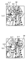
このようにして、本例の位置情報提供システム30を利用することにより、検索者の端末8から被検索者の端末10の検索要求D1を出力すると、まず、被検索者の端末10の概略の位置を示す情報D9が得られ、次に、被検索者の端末10の詳細な位置を示す情報D11が得られる。検索者の端末8において概略の位置と詳細な位置とを表示する方法はいつか考えられる。図8(a)では、基地局の位置情報D9により、その基地局の位置情報が含む範囲をカバーする中域の地図33をLCDなどに表示し、次に、GPS位置データD11により、GPS位置データD11を含む詳細な地図34を表示している。図8(b)では、基地局の位置情報D9により、その基地局の位置情報が含む範囲をカバーする中域の地図33と基地局の位置情報D9を示す円を表示し、次に、GPS位置データD11により、同じ中域の地図33にGPS位置データD11により特定される位置を表示している。
【0047】
また、位置を表示すると共に、あるいは表示する代わりに音声で基地局の位置情報D9とGPS位置データD11とを出力することも可能である。基地局の位置情報D9を出力する場合は、ある一定の誤差範囲を持った情報であるので「村井駅付近」、「村井駅周辺」あるいは「村井町内」などといった出力が望ましい。一方、GPS位置データD11はピンポイントの位置情報となるので、「村井駅前」あるいは「村井駅前交差点」などといった出力が可能となる。
【0048】
いずれの表示方法であっても、本例の位置情報提供システム30では、基地局の位置情報の取得とGPSによる位置情報の取得とを並列にスタートさせることにより、それぞれの位置情報を、それぞれの位置情報を取得する最短の処理時間で取得することができる。したがって、概略の位置情報は短時間で出力でき、詳細な位置情報を続いて出力することができる。このため、短時間に被検索者の概略の位置がわかるので、まず、その位置に向かって人や車を派遣することが可能であり、ファーストアクションを短時間で起こすことができる。そして、被検索者の近傍に到着するまでに被検索者の詳細な位置が判明するので、単に被検索者の詳細な位置が出力されるシステムと比較すると、より早いタイミングで確実に被検索者を発見することが可能となる。
【0049】
また、GPS衛星1からの電波が届かない場所に被検索者の端末10があるときは、GPS位置データが取得できない。しかしながら、本例の位置情報提供システム30であれば、携帯電話の電波が届く範囲に携帯端末10があれば、少なくとも概略の位置情報を得ることが可能であり、それを検索者の携帯端末8に出力することができる。さらに、基地局位置データの取得と、GPS位置データの取得とがほぼ同時にスタートするので、GPS位置データが取得できないという状態が分かってから基地局位置データの取得をスタートするのと異なり、概略の位置情報はGPSの状況のいかんにかかわらず迅速に得ることができる。
【0050】
さらに、本例の検索サーバ31は、GPS位置データが取得できないときに、過去ログから現在地を予測する機能を備えている。図9に、本例の検索サーバ31の概略機能を示してある。検索サーバ31は、基地局位置管理サーバ3から基地局情報を取得するインターフェイス51と、被検索者の端末10および検索者の端末8と通信するインターフェイス52とを備えている。検索サーバ31がインターネット7に接続されているのであれば、これらのインターフェイス51および52はインターネット7を介してデータを送受信することができる。さらに、検索者や被検索者を識別するためのID・パスワード管理手段53と、上述した中域や詳細な地図を送出するための地図データベース54と、これらを制御して検索者の端末8からの検索要求に対して基地局の位置情報とGPS位置情報とを、それぞれのタイミングで送出する処理を行う制御手段55とを備えている。
【0051】
また、検索サーバ31は、過去の位置データをログファイル58に記録するログデータ管理手段56と、ログデータから現在地を予測する手段57とを備えている。この位置情報提供システム30では、ログデータ管理手段56により、被検索者の携帯端末10のウォッチングがオーダされていると、携帯端末10に対して定期的に検索指示D2を出力し、得られた基地局位置データD8とGPS位置データD10を記録する。そして、検索者の端末8から検索要求があったときにGPS位置データD10が得られない場合は、現在位置予測手段57が、ログを利用してから被検索者の携帯端末10の現在位置を予測する。
【0052】
図10に、位置情報提供システム30において現在位置の予測される工程を示してある。ステップ61で検索者の端末8から検索サーバ31に位置取得の要求があると、検索サーバ31の指示により被検索者の端末10がステップ62で基地局測位を開始し、ステップ63でGPS測位を開始する。基地局の位置データD8が得られるとステップ64でそのデータD8を検索者の端末8に送る。また、ステップ65でGPS測位の結果が得られるとステップ66で、GPSの位置データD11を検索者の端末8に送る。
【0053】
一方、ステップ65で測位結果が得られないときは、ステップ67で、ログデータ管理手段56からログを現在位置予測手段57に送ってステップ68で位置予測計算を行う。ステップ69で、その結果が基地局の位置データD8の誤差範囲内であれば、その予測結果がある程度正しいものとし、ステップ70で、予測結果を、その属性を持たせて、GPSの位置データの代わりに検索者の端末8に送る。一方、ステップ69で、予測結果が基地局の位置データD8の誤差範囲内に収まらない場合は、予測結果が利用できないので、ステップ71で過去ログと基地局の位置データD8だけを検索者の端末8に送る。検索者の端末8では、ステップ72において、これらのデータに基づいて被検索者の位置が表示される。
【0054】
図11に、検索者の端末8における表示のいくつかの例を示してある。図11(a)に示した表示は、予想された位置D19が基地局の位置データD9の範囲内、すなわち基地局エリアにあるケースであり、基地局の位置データD9を示す円(基地局エリア)の表示の中に、予想された位置D19が表示されている。図11(b)に示した表示も、予想された位置D19が基地局の位置データD9の範囲内にあるケースであり、予想された位置D19がログデータD18と共に表示されている。
【0055】
図11(c)は、予想された位置D19が、基地局エリアの外にあるケースであり、予想位置D19と、基地局エリアD9とが示されている。この表示であると、現在地が予想位置D19と、基地局エリアD9のいずれにあるのかが判断しにくい。このため、図11(d)では、過去ログD18も表示することにより、判断を検索者に委ねるようにしている。一方、図11(e)では、実際に得られている基地局エリアD9を優先し、基地局エリアD9に入らない予想位置は表示せず、代わりに過去ログD18を表示することにより被検索者の現在地の判断を検索者に委ねている。
【0056】
GPSによる位置データが取得できないときに、基地局エリアだけを示したのでは、そのエリアの中にいることはわかっても、基地局によってはカバーエリアが広く、期待する位置情報とはならないことが多い。また、過去の軌跡(ログ)情報から、現在位置を推測して出力しただけでは、その予想位置の信頼性が不明であり、位置情報として利用できるのかどうかが判断できない。これに対し、現在位置の推測を行った結果と、基地局のエリア情報を元に、推測結果の信頼性を確認することが可能であり、エリア内に予想位置があればその位置情報の利用価値が向上し、信頼度の高い現在位置予測結果を提供することができる。
【0057】
図12に、ログファイル58のいくつかの例を示してある。図12(a)は、基地局の位置情報D8と、GPS位置データD10とが取得された時間順に記録されている例である。このログファイル58aには、時刻情報59aと、緯度情報59bと、経度情報59cと、高度情報59dと、測位方法59eが記録されている。測位方法59eは、「1」が基地局の位置データであることを示し、「3」がGPSによる位置データであることを示している。基地局の位置データと、GPSによる位置データは、それぞれを取得する処理が同時にスタートしたとしても必ずしも同時に得られる情報ではない。したがって、このログファイル58の形式であると、取得された位置情報が時間順にソートされた状態で保存されるので、これらの位置情報を一連のログとして表示したり、計算する場合には取り扱い易い。
【0058】
図12(b)は、GPSにより得られた位置データだけが記録されたログファイル58bを示しており、図12(c)は、基地局の位置データだけが記録されたログファイル58cを示している。したがって、記録されているデータには、測位方法を示すデータ59eは含まれていない。これらのログファイル58bおよび58cは、それぞれに位置情報の種別毎にログ表示を行うときは扱い易い。
【0059】
このようなログファイル58が作成されていると、検索者の端末8に被検索者の位置を表示するときや、自己の端末10に現在地を表示するときに過去ログもあわせて表示することにより、ユーザに提供される情報量を増加することができる。したがって、ユーザは自ら判断して,実質的な位置情報の精度を向上させることが期待できる。一般に、携帯電話などの基地局情報よりGPSにより得られた位置情報の方が、精度が良いと考えられるが、高層ビルの間などの環境下では、マルチパスなどの影響により、GPSで得られた位置情報に大きな誤差が生じるときもある。そのような条件下では、GPS以外の位置情報取得手段により得られた位置情報をユーザに提供することは有意義なことである。
【0060】
図13(a)は、サーバ31から出力された最新の基地局エリアD9がログ情報D17と共に表示され、さらに、最新のGPS位置データD11もログ情報D18と共に表示されている。GPS位置データのログD18は、基地局エリアのログD17の範囲内に入っており、GPSによる位置情報と、基地局エリアから得られる位置情報が合致しており正常な状態で位置情報が得られていることが分かる。これに対し、図13(b)では、GPS位置データのログD18が、基地局エリアのログD17から外れている。したがって、マルチパスなどの影響が懸念される状況で位置情報が得られていることが分かる。したがって、ユーザは得られている位置情報の信頼性を考慮した判断を行うことができる。
【0061】
さらに、検索サーバ31においては、端末10から得られた基地局の位置情報D8に基づき詳細な地図を前もって検索者の端末8に送って、検索者の端末8においてGPS位置データD11を短時間で表示させることができる。図8(a)では、基地局の位置情報D9を中域の地図33により端末8に表示し、GPS位置データD11を詳細な地図34で表示する。この処理を実行するために、基地局の位置情報D9と共に送出される中域の地図33のデータに加え、基地局エリアD9に含まれる詳細な地図34のデータを、サーバ31の地図データベース54から携帯端末8に前もってダウンロード(プリロード)させておくことができる。詳細な地図をプリロードさせておくと、携帯端末8には詳細な地図データがすでにあるので、GPS位置データD10が得られたときは、その位置データを被検索者の詳細な位置データD11として送るだけでよい。したがって、GPS位置データD10がサーバ31で得られると、地図データを送信する時間を省き、短時間で検索者の端末8に被検索者のGPS位置データD11を表示することが可能となる。
【0062】
図14に、地図情報を前もってダウンロードする処理を示してある。位置情報を表示する端末8または10では、ステップ81で基地局情報が得られると、ステップ82で中域地図をダウンロードし、ステップ83で中域地図を表示すると共に、それに重ねて基地局エリアD9を表示する。続いて、ステップ84で基地局エリアD9に対応する詳細地図もダウンロードする。ステップ85でGPS位置データが得られると、すでにダウンロードされている詳細地図の中から、GPS位置データD11を表示するのに適した地図を選択する。そして、ステップ86で詳細地図表示すると共に、それに重ねてGPS位置D11を表示する。したがって、GPS位置データが得られるとすぐに詳細な地図を含めて端末に表示することが可能となり、ユーザを待たせることなく詳細な位置を表示することができる。
【0063】
基地局の位置情報D9に付随してプリロード可能な情報は詳細な地図情報に限定されることはない。たとえば、現在地の周囲のレストランやショップなどのタウン情報も、基地局エリアD9が判明すればある程度限られるので、前もってダウンロードすることができる。そして、GPS位置データD11により詳細な現在地が判明したときに、すぐに、周辺のレストランやショップに限って出力したり、近い順番に出力することが短時間で可能になる。
【0064】
また、基地局の位置情報をGPSで測位するために利用することも可能である。現在、GPSの測位方式でよく使われているマルチチャンネル測位方式では、探したい衛星をチャンネルに割り当てて衛星からの情報を取得する。しかし、一般的には、地球上を周っている32個(実働24個)の衛星の数よりチャンネルの数は少ないため、一定時間、衛星からの情報が得られない場合、探す衛星を切り換えて、衛星からの情報を得るようにしている。基地局の位置情報が早い段階で得られるのであれば、その現在位置情報を元に、その測位場所で捕捉できるはずの衛星が特定できるので、無駄に他の衛星を探すことなく測位することができる。すなわち、見かけ上の感度を上げることが出来る。
【0065】
また、GPS測位により現在地を求める際に、演算の初期値となる位置情報が要求されるが、現在地に近い位置情報であれば演算結果が得られる時間を短縮することができる。したがって、基地局の位置情報を初期値として利用することによりGPS測位の時間を短縮することも可能となる。
【0066】
以上に説明したように、本例の携帯端末10、また、位置情報提供システム30においては、異なる位置特定システムから位置情報が得られる複数の位置測位手段を同時に利用することにより、携帯端末10のユーザ、または位置情報提供システム30のユーザに対し、位置に関する情報を、より早く伝えることができる。複数の位置測位手段は、誤差範囲の異なる位置情報を得ることができるものであることが望ましく、誤差範囲が小さい位置情報は取得に時間がかかり、誤差範囲が大きな位置情報は短時間に取得できるのが一般的であるので、同時に位置情報の取得をスタートしても、結果が得られるタイミングは時間差がある。したがって、その時間差を有効に利用することにより、ラフな位置情報から高精度の位置情報に遷移するような表示を行ったり、地図情報などをプリロードすることが可能となり、結果として詳細な位置情報をより分かりやすく、短時間でユーザに伝達することができる。
【0067】
このため、本発明の出力方法を利用することにより、緊急を要する火災や交通事故などの場合には、GPSによる正確な位置情報を取得する前に,大まかでも位置のわかる基地局情報を利用することにより、迅速な対応が期待できる位置情報提供システムを構築できる。
【0068】
また、GPSにより位置情報と、基地局の位置情報とを共に出力することにより、これらの位置情報の信頼性をユーザが判断することが可能となる。したがって、GPSによる位置情報が得られないときには、過去のログを使い位置予測を行い、その予測位置を基地局情報などでフィルタリングすることにより信頼度の高い予測位置情報を提供することができる。
【0069】
異なる位置特定システムとして、上記では、GPSと、携帯電話システムあるいはPHSシステムとを組み合わせた例を説明しているが、本発明は、これらの位置特定システムの組み合わせに限定されるものではない。しかしながら、現状で高精度な位置特定システムとしてもっともポピュラーなシステムはGPSである。また、それに対抗して比較的簡易にエリアを特定できる位置特定システムは携帯電話またはPHSの基地局情報を利用した位置特定システムである。したがって、本例で示した位置特定システムの組み合わせがもっとも現実的で有効な組み合わせであると考えられる。
【0070】
【発明の効果】
以上に説明したように、本発明においては、複数の異なる位置特定システムから位置情報を並列に取得し、出力することにより、ある位置特定システムを他の位置特定システムの単なるバックアップとして用いるだけではなく、それらの位置特定システムの特性を生かした出力を行うことが可能となる。そして、本発明により、位置情報をさらに有効な情報として、短時間に出力することが可能となるなど、上記にて開示した種々の効果を得ることができる。
【図面の簡単な説明】
【図1】本発明に係る位置情報提供システムの概要を示す図である。
【図2】図1に示した携帯端末の概略構成を示すブロック図である。
【図3】図2に示した携帯端末において位置情報を出力する処理を示すフローチャートである。
【図4】図1に示した位置情報提供システムにおいて位置情報が伝達される様子を示す図である。
【図5】携帯端末に位置情報が出力される例を示す図である。
【図6】本発明の異なる位置情報提供システムの概要を示す図である。
【図7】図6に示す位置情報提供システムにおいて位置情報が伝達される様子を示す図である。
【図8】検索者の端末に位置情報が表示される例を示す図である。
【図9】検索サーバの概略構成を示す図である。
【図10】位置情報提供システムにおいて、位置予測結果を表示する処理を示すフローチャートである。
【図11】検索者の端末に位置予測結果が表示される例を示す図である。
【図12】ログファイルの例を示す図である。
【図13】基地局の位置情報とGPSの位置情報がログ情報と共に表示される例を示す図である。
【図14】地図情報をプリロードする処理を示すフローチャートである。
【符号の説明】
1 GPS衛星
2 基地局
3 基地局位置管理サーバ
4、30 位置情報提供システム
5、31 検索サーバ
7 インターネット
8 検索者の携帯端末(携帯電話)
9 被検索者
10 携帯端末(携帯電話)
11 携帯電話モジュール
12 PHSモジュール
13 GPSモジュール
16 CPU
17 メモリ
18 CPUのプログラム[0001]
The present invention acquires position information at a mobile terminal and outputs position information or information related thereto. Mobile terminal, location information provision system It is about.
[0002]
[Prior art]
Portable information processing terminals such as mobile phones and PDAs have become widespread. These mobile terminals must be equipped with a system that captures radio waves from GPS satellites and measures their current location, or a system that acquires their current location from location information of a mobile phone or PHS base station. Thus, the position information of the mobile terminal, that is, the user having the mobile terminal can be output. In addition, as a mobile terminal having a function of indicating its current location, there is an in-vehicle car navigation.
[0003]
[Problems to be solved by the invention]
Mobile phones equipped with a GPS unit that measures the current location by radio waves from GPS satellites have appeared. If the mobile phone is equipped with a GPS unit, the location information of the base station can be received to obtain two pieces of location information, the current location using GPS and the current location based on the location of the base station. However, in the case of position information using GPS, the current location can be determined with an error of several meters to several tens of meters, whereas the position information of the PHS base station has an error of several hundred meters, The location information of the telephone base station has an error of about several kilometers. Therefore, even in a mobile terminal equipped with hardware capable of acquiring a plurality of pieces of position information such as a mobile phone equipped with a GPS unit, the current location using GPS is only used.
[0004]
In contrast, Japanese Patent Laid-Open No. 10-281801 obtains current location information based on the position of a base station when information on the current location using GPS cannot be obtained due to reasons such as the inability to receive radio waves from GPS satellites. It has been proposed. Therefore, even if the current location information using GSP cannot be obtained, the location information can always be acquired and displayed by some method by using another location specifying system.
[0005]
However, when the current location information using GPS cannot be obtained, the current location is estimated from the position of the base station even if the accuracy is lower than when no information suggesting the latest current location is obtained as a backup of the GPS unit. It is effective to be able to obtain information that can be obtained, but the accuracy of the position information obtained from different position identification systems is greatly different as described above, and therefore it may not be possible to evaluate and use the same. . Therefore, in this method of use, as long as the GPS unit is operating, it is not effective to acquire the position of the base station, and the economy of introducing a system for acquiring the position of such a base station and estimating the current location is introduced. Little value.
[0006]
Therefore, in the present invention, a new method of using position information obtained from different position specifying systems is proposed. In the present invention, position information from a position determination system other than GPS is not merely a backup of position information using GPS, but is also used for different purposes, and outputs position information on a mobile terminal or information related thereto. You can improve your ability. In addition, the ability to specify the current location of the mobile terminal from the owner of the mobile terminal or from the outside can be improved. Therefore, according to the present invention, the utility value of the system that estimates the current location based on the position of the base station is improved, and the economic effect of introducing such a system can be greatly improved.
[0007]
In the present invention, a mobile terminal When there is a request for position information or position-related information, the first start of acquisition of the latest information of the first position information obtained from the first position specifying system Location information acquisition unit And this first Location information acquisition unit In parallel with the second start of acquisition of the latest information of the second location information obtained from the second location system Location information acquisition unit And first position information or information related to the first position information is output. Output unit And outputting the second position information or information related thereto, Output unit And have. this Output unit So, instead of using the first and second location systems as backups for the other, they are located at the same time from each other (in the sense that they are in the same period or in parallel, not simultaneously in the strict sense) Get information and output each. Since these first and second position specifying systems are not the same system, there is a difference in accuracy, time required for processing to calculate or acquire position information, and the like. Therefore, even if acquisition of the latest position information is started at the same time, the timing at which the position information is actually obtained is different and the accuracy is different. For this reason, each positional information can be utilized for the independent objective by outputting each positional information or the information relevant to it independently. Therefore, the utility value of each position specifying system is increased.
[0008]
On the other hand, since the current location of the mobile terminal is one, the location information obtained from different location specifying systems is identical in that it is information indicating the current location of the mobile terminal. Therefore, even if the first and second position information are output independently, the outputs are related, and the output function of the current location or related information in the mobile terminal can be improved.
[0009]
If the position information obtained from the first and second position specifying systems has the same accuracy, the time required to acquire the position information is almost the same, and the purpose of use is likely to be the same. The meaning of outputting two or more pieces of position information in parallel is almost eliminated. However, if the accuracy of the position information obtained from the first and second position specifying systems is different, the purpose of use is different, and in general, position information with lower accuracy can be acquired in a shorter time, and is also used in that respect. The purpose can be changed. Therefore, the effect of outputting two or three or more pieces of position information in parallel is great. Because of this, the second Location information acquisition unit Then, it is desirable to start acquisition of the second position information with higher accuracy than the first position information. Such a positioning system includes a positioning system using base station information and a positioning system using satellites, for example, GPS.
[0010]
The present invention It can be executed in a system including a terminal having a function capable of positioning individually, such as a GPS unit, and a server having a function of providing and / or mediating position information. It can also be executed by a single terminal. Of the present invention The mobile terminal includes a first position information acquisition unit capable of acquiring first position information from the first position specifying system, and second position information capable of acquiring second position information from the second position specifying system. And an output unit capable of outputting the first position information or information related thereto and the second position information or information related thereto. When there is a request for position information or position-related information, the first and second position information acquisition units start acquiring the latest information in parallel, and based on the result, the first position information or By controlling the hardware by a control unit that outputs related information and second position information or related information. The present invention can be implemented .
[0012]
In the present invention, the output of the first and second position information is not limited to being output on the mobile terminal by an image or the like. This includes outputting to an external terminal or server using the function of the mobile phone or PHS, and further using the computer network connected thereby. That is, the output unit of the mobile terminal is not limited to a unit that outputs information on the mobile terminal, but also includes a unit that outputs information from the mobile terminal to the outside.
[0013]
Of the present invention Using output One of the range of location information, ie accuracy Indicated by a circle That is. The second position information with high accuracy may be a point, but the first position information indicating the first position information with low accuracy is low. Output unit Or output means Then, it is desirable to output information indicating the range of the first position information from the output unit. Since the low-precision first position information can be obtained in a shorter time than the high-precision second position information, the low-precision first position information is output first, and then the first position information is output. The second position information with high accuracy is output in a state included in the position information. Accordingly, since the approximate position can be grasped in a short time and the next detailed position can be grasped, the time for waiting for the output of the position information can be shortened. At the same time, since the output is narrowed down to a detailed position from a certain range of position information, it is possible to give the user an impression of outputting the process of calculating the position information. Therefore, you will be interested in seeing the output of location information and have the opportunity to use location information. Suitable for growing . In the present invention It may not be necessary to continuously display the first position information and the second position information at the same time, but in that case, the transition from the first position information to the second position information may occur. Intuitive display means Is preferably adopted.
[0014]
Considering the case where position information is output to the outside, first, information indicating a rough position such as “whereabouts” or “whereabouts” is output, and then information indicating the position in detail is output. The Therefore, when a user with a mobile terminal is accessed in an emergency, the approximate position is first known, so that the user can start in that direction. Then, when the user arrives in the vicinity of the user holding the mobile terminal, or before that, the detailed position is known. Therefore, the access time for a user having a mobile terminal can be shortened. For this reason, by having the portable terminal of the present invention owned, it is possible to improve the quality of a service system that grasps and rushes the positions of elderly people and sick people in an emergency.
[0015]
If such a service system has a function or server that can independently acquire the location information of the base station based on the location information acquisition instruction from the mobile terminal, the mobile terminal side must The acquisition of the latest position information may be started, and only position information using GPS that cannot be obtained by the service system may be output to the service system. Thereby, in the service system, the position information of the search target person can be obtained from two different position specifying systems and can be output independently to the search person.
[0016]
Furthermore, by outputting low-accuracy position information in a range, it is possible to grasp the reliability of low-precision and high-accuracy position information. In other words, high-accuracy position information should naturally fall within the range of low-accuracy position information, but this is not necessarily the case depending on the state of transmission of radio waves from the first and second position specifying systems. If such an output is obtained, it is necessary to doubt the reliability of the position information, and the user should determine whether or not the present location may be determined based only on the obtained position information. Become. Therefore, it is significant for the user who uses the position information to transmit the reliability of the position information to the user together.
[0017]
Furthermore, a case where the radio wave from the GPS satellite does not reach is assumed. At that time, as the second position information in the second output step, the predicted position can be calculated from the past log and output. Whether or not the predicted position is within the range of low-precision position information means that the reliability of the predicted position is also provided to the user, and is valuable information for the user. The calculated predicted position or the predicted position may be output as it is, or since the first position information is obtained by starting the acquisition process at the same time, the calculated predicted position is set as the first predicted position. It is also possible to output the evaluation result based on the position information. For example, when the predicted position is not included in the range of the first position information, the reliability of the position information output from the terminal is ensured to some extent without outputting the predicted position, thereby preventing confusion of the user. it can.
[0018]
In addition, since low-accuracy position information can be obtained in a short time, position-related information that matches the low-accuracy position information, such as a map, is output first, and high-accuracy position information is output on top of it. To do It is valid. That is, the first Output unit Then, the first Location information acquisition unit Output a map including the range of the first position information acquired in
[0019]
It is also possible to preload with the first position information with low accuracy obtained in a short time, and to shorten the time for selection and output with the second position information with high accuracy. That is, the position related information selected by the second position information is preloaded within the range of the first position information. means And provide a second Output unit Then, it is possible to select and output the preloaded position related information with the first position information. Therefore, the program for the control unit of the mobile terminal can execute a process of preloading the position related information selected by the second position information first within the range of the position information. means Further provided, In the output means It is desirable to output the position related information selected by the first position information from the preloaded position related information.
[0020]
For example, when a detailed map is displayed using the second position information, if the map information within the error range of the first position information is downloaded in advance using the first position information, the map is displayed using the second position information. Save time downloading information. Even when providing town information including information such as restaurants and shopping related to location information, information related to the first location information is downloaded in advance, and then selected or edited from the second location information. As a result, position-related information that matches the current location can be output in a short time.
[0021]
Also, the first Location information acquisition unit The latest first position information obtained in the above is used to calculate the latest second position information. means It is also possible to provide. When calculating the current location using GPS, the calculation time can be shortened by calculating position information close to the current location as an initial value. Therefore, Control unit The latest position information is sent to the second position information acquisition unit. Means to supply It is also effective to provide
[0022]
The present invention When executed in a system including a server and a terminal, the first terminal acquires the first and second position information from the first and second position specifying systems on the first terminal side, and the second terminal via the server The location information can be provided. That is, Implement the present invention As a system, first position information acquisition means capable of acquiring first position information from the first position specifying system and second position information acquisition means capable of acquiring second position information from the second position specifying system. It is possible to provide a position information providing system having a first terminal equipped with a server capable of communicating with the first terminal and another second terminal. When there is a request for location information from the server, the first terminal has first and second functions for starting acquisition of location information, and the server can first obtain location information from the first terminal. And outputting the first position information or information related thereto to the second terminal, and when the second position information is obtained from the first terminal, the second position information or information related thereto is By providing the function of outputting to the second terminal, the second terminal can quickly acquire the position of the first terminal.
[0023]
A position information providing system having a first terminal and a server capable of communicating with the first terminal, wherein the server is based on communication with the first terminal as in the position information of the base station. When the first location information acquisition unit capable of acquiring the first location information of the first terminal from one location specifying system is provided, the second location, such as GPS, is included in the first terminal. By providing the second position information acquisition means capable of acquiring the second position information from the specific system, it can be provided as a system capable of executing the output method of the present invention. In this position information providing system, when there is a request for position information of the first terminal from a second terminal capable of communication, the server requests the first terminal to acquire the position information, and the first position When acquisition of information is started and the first position information is obtained, the first position information or information related thereto is output to the second terminal, and the second position information is obtained from the first terminal. Then, the second position information or information related thereto is output to the second terminal.
[0024]
DETAILED DESCRIPTION OF THE INVENTION
Embodiments of the present invention will be described below with reference to the drawings. A
[0025]
FIG. 2 shows a schematic configuration of the
[0026]
FIG. 3 is a flowchart showing the processing of the
[0027]
On the other hand, in order to acquire highly accurate position information (second position information) using GPS, the
[0028]
Furthermore, since the
[0029]
After the acquisition of the position information by the base station and the GPS is started in
[0030]
On the other hand, when the position information is obtained from the
[0031]
FIG. 4 shows a data exchange procedure between the terminal 10 and the position information providing system 4. First, when there is a location information acquisition request in
[0032]
Upon receiving the base station information acquisition instruction, the search server 5 sends a request C3 for base station position information with which the
[0033]
When the terminal 10 confirms the acquisition of the position information C5 of the base station in Step 23-1, the terminal 10 displays the map information C6 sent together with the position information C5 on the
[0034]
FIG. 5 shows a display example of the
[0035]
For this reason, in the
[0036]
In addition, since detailed position information and output transition from rough position information, the output is as if the processing process specifying the current location is displayed in order, so that the position that the user can see with interest This is the information output method. In particular, a display method in which the circle indicating the position information C5 of the
[0037]
Further, before the GPS data C7 is obtained, the map information C6 for displaying the GPS data C7 can be downloaded based on the position information C5 of the
[0038]
This output method also makes it possible to evaluate the reliability of the obtained position information C5 of the
[0039]
FIG. 6 shows an outline of a position
[0040]
When there is a request for position information, the
[0041]
FIG. 7 shows a data exchange procedure between the terminal 10 and the position
[0042]
The
[0043]
If it is a server having a function of searching for a base station position like the
[0044]
When the searchee's terminal 10 confirms the base station location data response D7 from the
[0045]
Thereafter, when the GPS data calculated by the
[0046]
In this way, when the search request D1 of the searchee's terminal 10 is output from the searcher's
[0047]
Further, the position information D9 and the GPS position data D11 of the base station can be output by voice together with or instead of displaying the position. When the position information D9 of the base station is output, it is information having a certain error range, and therefore output such as “Near Murai Station”, “Around Murai Station” or “Inside Murai” is desirable. On the other hand, since the GPS position data D11 is pinpoint position information, it is possible to output "Murai station square" or "Murai station square intersection".
[0048]
Regardless of the display method, in the position
[0049]
Further, when the searchee's terminal 10 is in a place where radio waves from the
[0050]
Furthermore, the
[0051]
The
[0052]
FIG. 10 shows a process of predicting the current position in the position
[0053]
On the other hand, when the positioning result cannot be obtained in
[0054]
FIG. 11 shows some examples of display on the
[0055]
FIG. 11C shows a case where the predicted position D19 is outside the base station area, and the predicted position D19 and the base station area D9 are shown. In this display, it is difficult to determine whether the current location is in the predicted position D19 or the base station area D9. For this reason, in FIG. 11D, the past log D18 is also displayed so that the determination is left to the searcher. On the other hand, in FIG. 11 (e), the base station area D9 actually obtained is prioritized, the predicted position that does not enter the base station area D9 is not displayed, and the past log D18 is displayed instead. The searcher is left to determine your current location.
[0056]
When the position data by GPS cannot be acquired, only the base station area is shown, but even if it is known that it is in that area, the coverage area is wide depending on the base station, and it may not be the expected position information. Many. Further, just by estimating and outputting the current position from past trajectory (log) information, the reliability of the predicted position is unknown, and it cannot be determined whether it can be used as position information. On the other hand, it is possible to confirm the reliability of the estimation result based on the estimation result of the current position and the area information of the base station. If there is an expected position in the area, the use of the position information is possible. Value can be improved, and a highly reliable current position prediction result can be provided.
[0057]
FIG. 12 shows some examples of the log file 58. FIG. 12A is an example in which base station position information D8 and GPS position data D10 are recorded in the order of acquisition time. In the
[0058]
FIG. 12B shows a log file 58b in which only position data obtained by GPS is recorded, and FIG. 12C shows a log file 58c in which only position data of the base station is recorded. Yes. Accordingly, the recorded data does not include
[0059]
When such a log file 58 is created, when the position of the search target person is displayed on the searcher's terminal 8 or when the current location is displayed on his / her
[0060]
In FIG. 13A, the latest base station area D9 output from the
[0061]
Further, the
[0062]
FIG. 14 shows a process for downloading map information in advance. In the
[0063]
Information that can be preloaded along with the base station position information D9 is not limited to detailed map information. For example, town information such as restaurants and shops around the current location is limited to some extent if the base station area D9 is known, and can be downloaded in advance. Then, when the detailed current location is found from the GPS position data D11, it is possible to immediately output only to nearby restaurants and shops, or to output in close order in a short time.
[0064]
It is also possible to use the position information of the base station to measure with GPS. Currently, in the multi-channel positioning method often used in the GPS positioning method, a satellite to be searched is assigned to a channel and information from the satellite is acquired. However, in general, the number of channels is less than the number of 32 (actual 24) satellites orbiting the earth, so if information from the satellite cannot be obtained for a certain period of time, the satellite to be searched is switched. Information from satellites. If the location information of the base station can be obtained at an early stage, it is possible to identify the satellite that should be able to be captured at the location based on the current location information. it can. That is, the apparent sensitivity can be increased.
[0065]
Further, when the current location is obtained by GPS positioning, position information that is an initial value of the calculation is required, but if the position information is close to the current position, the time for obtaining the calculation result can be shortened. Therefore, it is possible to shorten the time of GPS positioning by using the position information of the base station as an initial value.
[0066]
As described above, in the
[0067]
For this reason, by using the output method of the present invention, in the case of an emergency fire or a traffic accident, before acquiring accurate position information by GPS, base station information whose position can be roughly understood is used. Thus, it is possible to construct a position information providing system that can be expected to respond quickly.
[0068]
Further, by outputting the position information and the position information of the base station together by GPS, the user can determine the reliability of the position information. Therefore, when position information by GPS cannot be obtained, position prediction is performed using a past log, and predicted position information with high reliability can be provided by filtering the predicted position using base station information or the like.
[0069]
As an example of a different location specifying system, an example in which GPS and a mobile phone system or a PHS system are combined has been described above. However, the present invention is not limited to a combination of these location specifying systems. However, the most popular system as a highly accurate position specifying system at present is GPS. In addition, a position specifying system that can specify an area relatively easily is a position specifying system that uses base station information of a mobile phone or PHS. Therefore, the combination of the position specifying systems shown in this example is considered to be the most realistic and effective combination.
[0070]
【The invention's effect】
As described above, in the present invention, by acquiring and outputting position information from a plurality of different position specifying systems in parallel, not only using one position specifying system as a mere backup of another position specifying system. Thus, it is possible to perform output utilizing the characteristics of these position identification systems. According to the present invention, it is possible to obtain the various effects disclosed above, such as enabling position information to be output in a short time as more effective information.
[Brief description of the drawings]
FIG. 1 is a diagram showing an outline of a position information providing system according to the present invention.
FIG. 2 is a block diagram showing a schematic configuration of the mobile terminal shown in FIG. 1;
FIG. 3 is a flowchart showing a process for outputting position information in the mobile terminal shown in FIG. 2;
4 is a diagram illustrating how position information is transmitted in the position information providing system illustrated in FIG. 1. FIG.
FIG. 5 is a diagram illustrating an example in which position information is output to a mobile terminal.
FIG. 6 is a diagram showing an outline of a different location information providing system of the present invention.
7 is a diagram showing how position information is transmitted in the position information providing system shown in FIG. 6;
FIG. 8 is a diagram illustrating an example in which position information is displayed on a searcher's terminal.
FIG. 9 is a diagram showing a schematic configuration of a search server.
FIG. 10 is a flowchart showing a process for displaying a position prediction result in the position information providing system.
FIG. 11 is a diagram illustrating an example in which a position prediction result is displayed on a searcher's terminal.
FIG. 12 is a diagram illustrating an example of a log file.
FIG. 13 is a diagram illustrating an example in which base station position information and GPS position information are displayed together with log information.
FIG. 14 is a flowchart showing a process of preloading map information.
[Explanation of symbols]
1 GPS satellite
2 base stations
3 Base station location management server
4, 30 Location information provision system
5, 31 Search server
7 Internet
8 Searcher's mobile terminal (mobile phone)
9 Searchee
10 Mobile devices (cell phones)
11 Mobile phone module
12 PHS module
13 GPS module
16 CPU
17 memory
18 CPU program
Claims (6)
この第1の端末および他の第2の端末と交信可能なサーバとを有する位置情報提供システムであって、
前記第1の端末は、前記サーバから位置情報の要求があると、前記第1および第2の位置情報の取得をスタートする機能を備えており、
前記サーバは、前記第1の位置情報を前記第1の端末から得て、その第1の位置情報またはそれに関連する情報を前記第2の端末に出力した後、
前記第2の位置情報が前記第1の端末から得られた場合は、その第2の位置情報またはそれに関連する情報を前記第2の端末に出力し、
前記第2の位置情報が前記第1の端末から得られない場合は、過去ログデータから位置予測計算を行い、その予測結果を前記第2の端末に出力する機能を備えている位置情報提供システム。1st position information acquisition means which can acquire the 1st position information from the 1st position specifying system, and 2nd position information acquisition means which can acquire the 2nd position information from the 2nd position specifying system A first terminal;
A position information providing system having a server capable of communicating with the first terminal and the other second terminal,
The first terminal has a function of starting acquisition of the first and second position information when there is a request for position information from the server;
The server obtains the first location information from the first terminal and outputs the first location information or information related thereto to the second terminal;
When the second location information is obtained from the first terminal, the second location information or related information is output to the second terminal,
When the second location information cannot be obtained from the first terminal, a location information providing system having a function of performing location prediction calculation from past log data and outputting the prediction result to the second terminal .
前記予測結果が前記第1の位置情報の範囲を示す情報内に含まれるか判断し、含まれないときは過去ログデータと前記第1の位置情報またはそれに関連する情報を前記第2の端末に出力する機能を備えていることを特徴とする位置情報提供システム。The server according to claim 1, wherein:
It is determined whether the prediction result is included in the information indicating the range of the first position information. If not, the past log data and the first position information or related information are sent to the second terminal. A position information providing system having a function of outputting.
前記サーバから位置情報の要求があると、前記第1および第2の位置情報の取得を並列にスタートすることを特徴とする移動端末。The first terminal according to claim 1,
A mobile terminal characterized in that, when there is a request for location information from the server, acquisition of the first and second location information is started in parallel.
前記第2の位置情報取得手段は、前記第1の位置情報取得手段よりも高精度の前記第2の位置情報を取得することを特徴とする移動端末The first terminal according to claim 1,
The second location information acquisition unit acquires the second location information with higher accuracy than the first location information acquisition unit.
前記第1の位置情報取得手段は、基地局の情報を用いた測位手段であり、前記第2の位置取得手段は、GPS衛星からの情報を用いた測位手段であることを特徴とする移動端末。The first terminal according to claim 1,
The mobile terminal characterized in that the first position information acquisition means is positioning means using base station information, and the second position acquisition means is positioning means using information from a GPS satellite. .
前記第1の位置情報の範囲を含む中域の地図情報に加え、更に詳細な地図情報をプリロードし、前記第2の位置情報を取得したとき前記詳細な地図情報に重ねて最新の前記第2の位置情報を出力することを特徴とする移動端末。In Claim 1, the second terminal is:
In addition to the map information of the middle region including the range of the first position information, more detailed map information is preloaded, and when the second position information is acquired, the latest second information is superimposed on the detailed map information. A mobile terminal characterized by outputting location information.
Priority Applications (1)
| Application Number | Priority Date | Filing Date | Title |
|---|---|---|---|
| JP2002079759A JP3899970B2 (en) | 2002-03-20 | 2002-03-20 | Mobile terminal, location information provision system |
Applications Claiming Priority (1)
| Application Number | Priority Date | Filing Date | Title |
|---|---|---|---|
| JP2002079759A JP3899970B2 (en) | 2002-03-20 | 2002-03-20 | Mobile terminal, location information provision system |
Publications (3)
| Publication Number | Publication Date |
|---|---|
| JP2003284121A JP2003284121A (en) | 2003-10-03 |
| JP2003284121A5 JP2003284121A5 (en) | 2005-06-23 |
| JP3899970B2 true JP3899970B2 (en) | 2007-03-28 |
Family
ID=29229073
Family Applications (1)
| Application Number | Title | Priority Date | Filing Date |
|---|---|---|---|
| JP2002079759A Expired - Fee Related JP3899970B2 (en) | 2002-03-20 | 2002-03-20 | Mobile terminal, location information provision system |
Country Status (1)
| Country | Link |
|---|---|
| JP (1) | JP3899970B2 (en) |
Families Citing this family (7)
| Publication number | Priority date | Publication date | Assignee | Title |
|---|---|---|---|---|
| JP2005326225A (en) * | 2004-05-13 | 2005-11-24 | Sony Corp | Information processor, method, and program |
| JP2006109355A (en) * | 2004-10-08 | 2006-04-20 | Ntt Docomo Inc | Mobile communication terminal and location information utilizing method |
| JP5205761B2 (en) * | 2007-01-10 | 2013-06-05 | 富士通モバイルコミュニケーションズ株式会社 | Information processing device |
| JP5077678B2 (en) * | 2008-02-25 | 2012-11-21 | Necカシオモバイルコミュニケーションズ株式会社 | Communication terminal device and program |
| JP2010054469A (en) * | 2008-08-29 | 2010-03-11 | Pioneer Electronic Corp | Current position detector, current position detection method, and program for current position detection |
| JP2014009964A (en) * | 2012-06-27 | 2014-01-20 | Ntt Docomo Inc | Mobile terminal, system, and method |
| JP5862777B2 (en) * | 2012-07-11 | 2016-02-16 | 日産自動車株式会社 | Traffic information providing system and traffic information providing method |
-
2002
- 2002-03-20 JP JP2002079759A patent/JP3899970B2/en not_active Expired - Fee Related
Also Published As
| Publication number | Publication date |
|---|---|
| JP2003284121A (en) | 2003-10-03 |
Similar Documents
| Publication | Publication Date | Title |
|---|---|---|
| US10798525B2 (en) | Techniques for wireless position determination utilizing a collaborative database | |
| EP1205733B1 (en) | Method and device for providing information related to activity of user | |
| US9200902B2 (en) | Method of processing global navigation satellite system data | |
| US6771970B1 (en) | Location determination system | |
| US11651009B2 (en) | System and method for processing location data | |
| JP4074277B2 (en) | Communication service system, mobile communication terminal and server | |
| US20060148488A1 (en) | Method for handling location data | |
| MXPA05011340A (en) | Locating system and method. | |
| CN108780155B (en) | Positioning method, terminal and server | |
| CN101321321B (en) | System serving a remotely accessible page and method for requesting navigation related information | |
| US20110263268A1 (en) | Navigation apparatus, location determination system and method of location determination | |
| US7209827B2 (en) | Server apparatus, terminal device, and information providing system | |
| JP2003099350A (en) | Method for providing location information-related service | |
| JP3899970B2 (en) | Mobile terminal, location information provision system | |
| US20120139723A1 (en) | GPS Based Tracking And Reporting System | |
| JP4307509B1 (en) | Taxi information providing apparatus and method | |
| EP2189756A1 (en) | Map data management using road ghosting characteristics | |
| KR101118535B1 (en) | System for Providing Service Information Based on Location | |
| JP2004198257A (en) | Moving object managing system | |
| EP1222648B1 (en) | Location determination system | |
| JP2004254229A (en) | Location positioning system | |
| JP2001264101A (en) | Portable telephone unit with gps function and method for acquiring information about current position using portable telephone | |
| JP2003294481A (en) | System for presenting departure time of transportation | |
| TW201028657A (en) | Navigation apparatus, server apparatus and method of collecting parking location information | |
| JP2006145438A (en) | Communication terminal device |
Legal Events
| Date | Code | Title | Description |
|---|---|---|---|
| A521 | Request for written amendment filed |
Free format text: JAPANESE INTERMEDIATE CODE: A523 Effective date: 20041006 |
|
| A621 | Written request for application examination |
Free format text: JAPANESE INTERMEDIATE CODE: A621 Effective date: 20041006 |
|
| A977 | Report on retrieval |
Free format text: JAPANESE INTERMEDIATE CODE: A971007 Effective date: 20060619 |
|
| A131 | Notification of reasons for refusal |
Free format text: JAPANESE INTERMEDIATE CODE: A131 Effective date: 20060627 |
|
| A521 | Request for written amendment filed |
Free format text: JAPANESE INTERMEDIATE CODE: A523 Effective date: 20060822 |
|
| TRDD | Decision of grant or rejection written | ||
| A01 | Written decision to grant a patent or to grant a registration (utility model) |
Free format text: JAPANESE INTERMEDIATE CODE: A01 Effective date: 20061205 |
|
| A61 | First payment of annual fees (during grant procedure) |
Free format text: JAPANESE INTERMEDIATE CODE: A61 Effective date: 20061218 |
|
| R150 | Certificate of patent or registration of utility model |
Free format text: JAPANESE INTERMEDIATE CODE: R150 |
|
| FPAY | Renewal fee payment (event date is renewal date of database) |
Free format text: PAYMENT UNTIL: 20100112 Year of fee payment: 3 |
|
| FPAY | Renewal fee payment (event date is renewal date of database) |
Free format text: PAYMENT UNTIL: 20110112 Year of fee payment: 4 |
|
| FPAY | Renewal fee payment (event date is renewal date of database) |
Free format text: PAYMENT UNTIL: 20110112 Year of fee payment: 4 |
|
| FPAY | Renewal fee payment (event date is renewal date of database) |
Free format text: PAYMENT UNTIL: 20120112 Year of fee payment: 5 |
|
| FPAY | Renewal fee payment (event date is renewal date of database) |
Free format text: PAYMENT UNTIL: 20120112 Year of fee payment: 5 |
|
| FPAY | Renewal fee payment (event date is renewal date of database) |
Free format text: PAYMENT UNTIL: 20130112 Year of fee payment: 6 |
|
| FPAY | Renewal fee payment (event date is renewal date of database) |
Free format text: PAYMENT UNTIL: 20130112 Year of fee payment: 6 |
|
| FPAY | Renewal fee payment (event date is renewal date of database) |
Free format text: PAYMENT UNTIL: 20140112 Year of fee payment: 7 |
|
| S531 | Written request for registration of change of domicile |
Free format text: JAPANESE INTERMEDIATE CODE: R313531 |
|
| R350 | Written notification of registration of transfer |
Free format text: JAPANESE INTERMEDIATE CODE: R350 |
|
| LAPS | Cancellation because of no payment of annual fees |