JP3801089B2 - Information providing system for moving body and information providing method for moving body - Google Patents
Information providing system for moving body and information providing method for moving body Download PDFInfo
- Publication number
- JP3801089B2 JP3801089B2 JP2002120166A JP2002120166A JP3801089B2 JP 3801089 B2 JP3801089 B2 JP 3801089B2 JP 2002120166 A JP2002120166 A JP 2002120166A JP 2002120166 A JP2002120166 A JP 2002120166A JP 3801089 B2 JP3801089 B2 JP 3801089B2
- Authority
- JP
- Japan
- Prior art keywords
- information
- spatial
- mobile terminal
- information providing
- mobile
- Prior art date
- Legal status (The legal status is an assumption and is not a legal conclusion. Google has not performed a legal analysis and makes no representation as to the accuracy of the status listed.)
- Expired - Lifetime
Links
Images


Landscapes
- Information Transfer Between Computers (AREA)
- Mobile Radio Communication Systems (AREA)
Description
【0001】
【発明の属する技術分野】
本発明は、移動体向け情報提供システム、及び、移動体向け情報提供方法に関し、特に、移動端末に地域情報を提供する移動体向け情報提供システム、及び、移動体向け情報提供方法に関する。
【0002】
【従来の技術】
移動端末の位置情報に基づく情報提供(配信)が提供されつつある。個人家屋、サービス店(例示:本屋、飲食店、郵便局)、サービス機関(例示:電話局、中央郵便局)、催し会場(例示:博覧会、映画館、博物館、劇場)のような地球上の有意義物体は、経度と緯度とから形成される2次元的幾何学情報によりそれらの位置が特定される。移動端末の位置は、ジャイロ、GPSの連動により、数cmの単位で特定される精度が安価に実現している。移動端末と固定物体との間の2次元的、3次元的相対位置は、数cmの単位で特定される。
【0003】
このような相対的位置情報に基づけば、特開2001−318845号に示されるように、ユーザーは移動可能な範囲の任意の位置に対応する有益情報を入手することができる。国際見本市会場では任意のブースが2次元位置情報で特定されるので、入場者は、自己の携帯端末の表示面に地図と出品内容を対応さることにより、自己に必要である複数のブースを計画的に最短コースで短時間で見学することができる。
【0004】
旅行のように不特定地に出かける場合、移動手段が特定されないことが多い。徒歩、自転車、タクシー、汽車、電車、ローカルジェット旅客機のように多様に存在する移動手段を利用して、最善に有益である場所をめぐることができるための情報提供方法の提供が望まれる。行動範囲に適合する地域情報提供が望まれる。移動者に対してダイナミックに地域情報を提供することが望まれる。
【0005】
【発明が解決しようとする課題】
本発明の課題は、ユーザーの行動範囲に適合する地域情報を配信することができる移動体向け情報提供システム、及び、移動体向け情報提供方法を提供することにある。
本発明の他の課題は、移動者に対してダイナミックに地域情報を提供することができる移動体向け情報提供システム、及び、移動体向け情報提供方法を提供することにある。
【0006】
【課題を解決するための手段】
その課題を解決するための手段が、下記のように表現される。その表現中に現れる技術的事項には、括弧()つきで、番号、記号等が添記されている。その番号、記号等は、本発明の実施の複数の形態又は複数の実施例のうちの少なくとも1つの実施の形態又は複数の実施例を構成する技術的事項、特に、その実施の形態又は実施例に対応する図面に表現されている技術的事項に付せられている参照番号、参照記号等に一致している。このような参照番号、参照記号は、請求項記載の技術的事項と実施の形態又は実施例の技術的事項との対応・橋渡しを明確にしている。このような対応・橋渡しは、請求項記載の技術的事項が実施の形態又は実施例の技術的事項に限定されて解釈されることを意味しない。
【0007】
本発明による移動体向け情報提供システムは、通信回線(3)に接続している情報提供サーバー(5)と、情報提供サーバー(5)に属する情報管理データベース(7)とから構成されている。情報提供サーバー(5)は、ユーザーの移動端末(17)から受ける空間的位置情報と空間的範囲希望条件と内容希望条件とに適合する適合地域情報(26)を情報管理データベース(7)に登録されている地域情報から抽出し、適合地域情報(26)を移動端末(7)に配信する。ユーザーは、ダイナミックに適正な地域情報を即時的に入手することができる。
【0008】
空間的位置情報と空間的範囲希望条件とにより、ユーザーが存在する地点を基準として情報検索の適正範囲が規定される。空間的位置情報は、移動端末(17)がGPSから受け取る測位データに基づいて移動端末により計算により求められる。移動端末(17)は、自己のプログラムにより情報提供サーバー(5)に自動的に空間的位置情報を送信することができ、ユーザーの送信操作は必要ではない。空間的位置情報は、地球座標系上で経緯度として表現される。
【0009】
空間的適合地域範囲として、経緯度により規定される点を中心とする円の領域が好適に例示されるが、ユーザーは概ねの方向を希望条件として指定することができる。ユーザーは範囲を具体的に指定する必要はなく、自己の移動手段に対応する行動可能半径を指定すれば、情報提供サーバー(5)が空間的位置情報と空間的希望条件に基づいて空間的適合地域範囲を計算して、空間的適合地域範囲の中で適合地域情報を抽出する。
【0010】
地域情報は、複数の情報提供者が情報提供サーバー(5)に送信する情報の集合であり、情報提供者がその提供を希望する情報が、長期的に情報提供サーバー(5)に集められ、又は、期間限定的に又は時々刻々に情報提供サーバー(5)に集められる。情報提供サーバー(5)は、移動端末(7)から位置情報を受け取る時刻に基づいて適合地域情報を情報から抽出するので、ユーザーにタイムリーに空間的適合地域情報を提供し、無駄な情報を提供することはない。
【0011】
時刻は、情報提供サーバー(5)に固有である時計に基づくリアルタイムである。空間的位置情報を計算により求めて得る時刻とその時計とは、ユーザーの位置の精度から見て、概ね同時刻であると考えることができる。情報管理データベース(7)は、情報提供者IDと情報提供者の情報提供者位置情報とを対応させるテーブル(16)を備えている。情報管理データベース(7)は、ユーザーのIDとユーザーの属性とを対応させるテーブル(11)を更に備えている。情報管理データベース(7)は、情報提供者の固定電話番号と経緯度とを対応させるテーブル(15)を更に備えている。
【0012】
情報提供サーバ(5)は、時間的希望条件を更に受け取り、空間的範囲希望条件は、空間的位置情報に対応する時刻情報により算出される速度情報と時間的希望条件とにより算出される。
【0013】
本発明による移動体向け情報提供方法は、情報提供サーバー(5)によりユーザーの移動端末(7)から移動端末(7)の空間的位置情報とユーザーの空間的範囲希望条件とユーザーの内容希望条件とを受け付けるステップと、情報提供サーバーにより空間的位置情報と空間的範囲希望条件とに基づいて内容希望条件に適合する地域情報を抽出するステップと、情報提供サーバー(5)により地域情報を移動端末(7)に送信するステップとから構成されている。情報提供サーバー(5)により空間的位置情報と空間的希望条件に基づいて空間的適合地域範囲を計算するステップと、情報提供サーバー(5)により空間的適合地域範囲の中で適合地域情報を抽出するステップが有効に追加される。情報提供サーバー(5)により情報提供者の情報提供者端末から情報提供者の固定的情報提供者位置を割り出すステップが更に有効に追加される。移動端末(7)により測位衛星から受ける位置情報伝播を受けるステップと、移動端末(7)により空間的位置情報を計算するステップ、空間的位置情報に対応する時刻により移動端末(7)の速度を算出するステップが更に有効に追加される。空間的範囲希望条件は、速度と時間的希望条件とにより算出され得る。
【0014】
【発明の実施の形態】
図に対応して、本発明による移動体向け情報提供システムの実施の形態は、情報提供者端末が情報提供サーバとシステム管理者端末ともに設備されている。その第1情報提供者端末1と第2情報提供者端末2とは、インタネット3又は携帯電話網4を介して、それぞれに情報提供サーバ5に接続している。第1情報提供者端末1は、インタネットのWebページを扱うためのWebプラザのようなアプリケーションソフトが実装されている端末であり、代表的には汎用のコンピュータである。第2情報提供者端末2は、i−mode(登録商標)、S−SKY、EZWebのようなインタネットに対して接続可能であり情報提供者が移動可能に所持している移動端末であり、代表的には携帯電話、PDAのような移動端末である。
【0015】
情報提供サーバ5は、ユーザ管理データベース6と、情報管理データベース7と、位置情報変換器8とにそれぞれに接続している。ユーザ管理データベース6は、ユーザーの属性と情報提供者の認証を管理し、ユーザーのIDとパスワードを管理している。情報管理データベース7は、地域情報と地域情報に関する属性を管理している。位置情報変換器8は、位置情報を軽度・緯度に変換するテーブルを管理している。
【0016】
情報提供者Mは、第1情報提供者端末1又は第2情報提供者端末2を用いて、インタネット3又は携帯電話網4を介して、情報提供サーバ5にアクセスする。情報提供者Mが情報提供サーバ5にアクセスすれば、情報提供者Mに対応する情報提供者管理者Nを特定するログイン画面が自己の情報提供者端末1に表示される。情報提供者Mは、自己に割り当てられているID・パスワードを自己の情報提供者端末1の図2に示されるログイン画面9から入力する。情報提供サーバ5は、自己が管理している照合テーブルと照合することにより認証を行う。図3は、そのような照合テーブル11を示している。照合テーブル11は、情報提供者管理者NのIDと、情報提供者Mのログインパスワードと、情報提供者詳細とを1対1対1に対応させる表である。
【0017】
図2に示されるように、情報提供者MのIDとパスワード12が情報提供サーバ5に送信される(ステップA1)。情報提供サーバ5は、IDとログインパスワード12がユーザ管理データベース6で管理されているIDとログインパスワードに一致しているかどうかについて判断することにより、一致・不一致の認証を実行する。その認証実行は、情報提供サーバ5又は情報提供サーバ5に属するユーザ管理データベース6で実行される(ステップA2)。その認証結果は、ユーザ管理データベース6から情報提供サーバ5に伝達される(ステップA3)。情報提供サーバ5は、その認証に失敗すれば、ログイン画面9に認証失敗13を伝達し、その失敗はログイン画面9のエラー表示画面14に表示される。
【0018】
情報提供者Mは、第1情報提供者端末1を用いて自己の属性に適正に対応するビジネス情報を情報提供サーバ5に送信して登録する(ステップA4)。そのようなビジネス情報として、地域情報と、位置情報と、嗜好情報、適正化情報がある。地域情報として、店舗情報、タイムセール情報、買い得情報、見せれば割引される画面、イベント情報、施設情報、企業情報が例示される。位置情報として、経度・緯度、住所、固定電話番号が例示される。嗜好情報として、レストラン、スナック、バザーが例示される。適正化情報として、ビジネス対象の性別、年齢が例示される。
【0019】
情報提供サーバ5は、登録のために第1情報提供者端末1から送信されてきた位置情報が経度・緯度であるかどうかを判別し(ステップA5)、その位置情報が経度・緯度でなく住所、電話番号であれば、情報提供サーバ5はその位置情報を位置情報変換器8に送信し(ステップA6)、位置情報変換器8は、位置情報変換器8で管理している図4の経緯度対応テーブル15を用いて、その非経緯度情報を経緯度情報に変換して(ステップA7)、第1情報提供者端末1のIDに対応づけて情報提供サーバ5で登録する(ステップA8)。情報提供サーバ5は、第1情報提供者端末1から送信されてきた位置情報が経度・緯度であれば、そのままにその位置情報を情報提供サーバ5で登録する(ステップA8)。登録される情報は、情報管理データベース7で登録保持される(ステップA9)。
【0020】
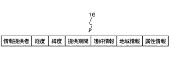
図4は、経緯度対応テーブル15を示している。経緯度対応テーブル15は、第1情報提供者端末1の住所と電話番号と経度と緯度とを1対1対1対1に対応させる表である。位置情報変換器8で変換された位置情報の経緯度情報は、位置情報変換器8から情報提供サーバ5に戻され、情報提供サーバ5は、図5に示されるように、ビジネス情報テーブル16を作成して、地域情報と他の属性情報とともに経緯度情報を情報管理データベース7に登録する。ビジネス情報テーブル16は、情報提供者1と経度と緯度と提供期間と嗜好情報と地域情報と属性情報とを対応つける表である。
【0021】
図6は、ユーザーUが情報を検索するフローを示している。ユーザーUは、携帯端末17を用いて地域情報を取得することができる。GPS衛星18は、図1に示されるように、携帯端末17と第2情報提供者端末2に接続している。第2情報提供者端末2と携帯端末17とは、GPS衛星18から受信する位置割出し信号19に基づいて自己の経緯度情報を知ることができる。携帯端末17は、図6に示されるように、位置割出し信号19を受信する(ステップB1)。ユーザーUは、自己の携帯端末17を動作せて、ログイン画面21を表示し、個別に割り当てられているユーザー側ID・パスワードをログイン画面21に入力することにより、システムに対してログインする(ステップB2)。
【0022】
ユーザーUが携帯電話又はPDAのような移動端末を用いて、公式コンテンツでサービスを受ける場合であり、各キャリアから提供されるユーザーIDを使用することができる場合には、そのログイン入力を省略することができる。iアプリケーションのような携帯電話に組み込んだJAVA(登録商標)プログラムから情報収集する場合には、公式コンテンツでユーザー特定が可能であるから、このような場合にも、そのログイン入力を省略することができる。ユーザー特定が不可能である場合には、本システムに特有であるID・パスワードが必要である。
【0023】
情報提供サーバ5は、ユーザーUのIDを確認し、その確認の成功又は失敗を携帯端末17に返答する。確認成功の返答を受けたユーザーUは、地方情報条件を入力する情報提供検索画面22にログイン画面21を遷移させる。情報提供サーバ5は、ID確認ができない場合には、ログインしないでエラーメッセージを携帯端末17に送信し、又は、紹介ページに遷移させる。
【0024】
ユーザーUは、固定情報としてユーザー属性を登録しておく。図7は、ユーザー属性テーブル23を示している。ユーザー属性テーブル23は、ユーザーIDとパスワードと属性(例示:性別、年齢)とを1対1対1に対応させる表である。公式コンテンツに関しては、パスワードは空欄であることが可能である。ユーザー認証は、ユーザ管理データベース6でID・パスワードにより実行される(ステップB3,4)。
【0025】
ログインが成功的に完了すれば、ユーザーUは、希望条件を情報提供検索画面22に入力する。希望条件の入力は、選択的に実行され得る。指定される希望条件は、下記に例示される。
(1)自己を中心とする円形範囲(半径)
距離mの指定は、記入入力又はプルダウン式選択により行われる。
(2)自己の空間的位置
円形範囲の中心である自己の座標である経緯度は、GPS衛星18の送信電波に基づいて取得することができる。
(3)嗜好条件
レストラン、遊園地、ゲームセンタ、イベントその他の嗜好項目が、チェックボックス形式で選択され得る。その選択は、情報検索ボタン又はリンクの押し下げにより行われ得る。
【0026】
このような希望条件24は、図1に示されるように、携帯端末17から基地局25と携帯電話網4とインタネット3とを介して、情報提供サーバ5に送信される(ステップB5)。情報提供サーバ5は、希望条件24を取得した取得時刻を記録する(ステップB6)。情報提供サーバ5は、自己の時計に基づいて取得時刻をリアルタイム時刻としてユーザー情報に加える。
【0027】
情報提供サーバ5は、ユーザーIDを読出し、ユーザ管理データベース6にアクセスして、ユーザ管理データベース6のユーザー属性テーブル23により検索のために必要である性別を検索し(ステップB7)、性別判定結果をユーザ管理データベース6から受取る(ステップB8)。情報提供サーバ5は、地域情報範囲演算処理を実行して(ステップB9)、位置情報を抽出する地域範囲(例示:円形範囲)の経緯度を演算する。情報提供サーバ5は、その地域範囲と希望条件24を情報管理データベース7に伝達して、その範囲と希望条件24に基づく地域情報検索を情報管理データベース7に指示する(ステップB10)。
【0028】
ビジネス情報テーブル16を保持している情報管理データベース7は、地域範囲と嗜好条件とから形成される希望条件と、ユーザーIDと、取得時刻(時間条件)と、性別(属性条件)とに適合する適合地域情報26を抽出する。このように抽出された適合地域情報26は、情報管理データベース7から情報提供サーバ5に送信される。情報提供サーバ5は、適合地域情報26を加工することによりユーザーUが見やすく理解しやすい画面情報に変換してページを作成し(ステップB12)、画面化適合地域情報27を携帯端末17に提供する(ステップB12)。
【0029】
画面化適合地域情報27は、ジャンル別に階層化され、情報量が1頁のサイズを越える場合には、次頁に続けるリンクをつける。iアプリケーションのプログラムからのアクセスの場合、移動端末側のプログラム処理によりその情報を見せることになるので、この場合には、頁の編集を行わずに、抽出された適合地域情報26をそのままに携帯端末17に送信することができる。
【0030】
図8は、本発明による移動体向け情報提供システムの実施の他の形態を示している。実施の本形態は、ユーザーUの移動速度が考慮される。携帯端末17は、時々刻々にGPS衛星18から送信されて来る位置割出し信号19に基づいて割り出した位置履歴をプログラム起動時に消去する。携帯端末17は、新たに位置情報を取得し、その位置情報を位置情報取得時刻に対応させて記録する。その場合、携帯端末17の位置情報取得プログラム28は、位置情報取得間隔を制御する。携帯端末17は、位置と時刻とに基づいて自己の移動速度を計算する。移動位置情報取得履歴間隔は、ユーザーUの移動速度に対応して制御される(例示:徒歩移動の場合には1分間隔、自動車移動の場合に6秒)。
【0031】
ユーザーのIDと位置情報履歴と時刻履歴とから構成されるユーザー対応移動履歴29が、携帯端末17から情報提供サーバ5に送信される(ステップC1)。情報提供サーバ5はそのIDを確認するためにそのIDをユーザ管理データベース6に伝達し、認証結果を受け取る(ステップC2)。情報提供サーバ5は、その認証に失敗すれば、その失敗結果を携帯端末17に送信してその失敗を携帯端末17のエラー表示画面31に表示させ(ステップC3)、情報提供サーバ5は、その認証に成功すれば、その携帯端末17に情報提供検索画面22に表示させる(ステップC4)。情報提供サーバ5は、ユーザーUの移動履歴に基づいて、ユーザーの最新の存在位置とその最新の時刻から一定時間(徒歩移動と自動車移動では異なる)の後の存在推定範囲を計算して割り出す。存在推定範囲は、一定時間後の移動推定距離と推定角度範囲とから形成されている。その存在推定範囲は、携帯端末17の運動属性としてユーザ管理データベース6の属性記録部位32に記録される(ステップC5)。
【0032】
図6で示されるステップB8,B9,B10,B11,B12に対応する複数のステップでは、ユーザーUの存在推定範囲が考慮され、その存在推定範囲内の地域情報が作成されて携帯端末17に送信される。
【0033】
ある時刻にある地点にいるユーザーが徒歩で移動していて、ユーザーの希望条件が郵便局の紹介・探索であり、情報提供サーバ5がユーザーの現在位置から20mの範囲に存在する郵便局を探知した場合、情報提供サーバ5は、ユーザーの現在位置からその郵便局までの地図(途中の店舗の店舗名を含む)を作成して携帯端末17に送信する。図9は、ユーザーIDと性別と移動推定距離(有効距離)との対応を示すテーブル33であり、ユーザ管理データベース6の中にその都度に形成される。
【0034】
【発明の効果】
本発明による移動体向け情報提供システム、及び、移動体向け情報提供方法は、自己の存在地点の周囲の地域情報を自己の状況に適合させて取得することができる。特には、自己の最新時刻から移動する推定移動範囲が考慮されことは重要である。ユーザーはダイナミックに近辺の地域情報を的確に入手することができる。
【図面の簡単な説明】
【図1】図1は、本発明による移動体向け情報提供システムの実施の形態を示すシステムブロック図である。
【図2】図2は、本発明による移動体向け情報提供方法の実施の形態を示すシステムフロー図である。
【図3】図3は、テーブルを示す表である。
【図4】図4は、他のテーブルを示す表である。
【図5】図5は、更に他のテーブルを示す表である。
【図6】図6は、本発明による移動体向け情報提供方法の実施の他の形態を示すシステムフロー図である。
【図7】図7は、更に他のテーブルを示す表である。
【図8】図8は、本発明による移動体向け情報提供方法の実施の更に他の形態を示すシステムフロー図である。
【図9】図9は、更に他のテーブルを示す表である。
【符号の説明】
3…通信回線
5…情報提供サーバー
7…情報管理データベース
11,15,16…テーブル
17…移動端末
26…適合地域情報[0001]
BACKGROUND OF THE INVENTION
The present invention relates to a mobile information providing system and a mobile information providing method, and more particularly, to a mobile information providing system and a mobile information providing method for providing regional information to a mobile terminal.
[0002]
[Prior art]
Information provision (distribution) based on location information of mobile terminals is being provided. On the earth such as private houses, service shops (example: bookstores, restaurants, post offices), service institutions (example: telephone offices, central post offices), event venues (examples: expositions, movie theaters, museums, theaters) The positions of these significant objects are specified by two-dimensional geometric information formed from longitude and latitude. The accuracy of specifying the position of the mobile terminal in units of several centimeters is realized at a low cost by interlocking the gyro and GPS. The two-dimensional and three-dimensional relative positions between the mobile terminal and the fixed object are specified in units of several centimeters.
[0003]
Based on such relative position information, as shown in Japanese Patent Laid-Open No. 2001-318845, the user can obtain useful information corresponding to an arbitrary position within a movable range. Since any booth is specified by 2D location information at the International Trade Fair, visitors can plan multiple booths that are necessary for them by associating maps and exhibition contents on the display surface of their mobile terminals. The shortest course can be observed in a short time.
[0004]
When going to an unspecified place like a trip, a moving means is often not specified. It is desired to provide an information providing method that can use a variety of moving means such as walking, bicycles, taxis, trains, trains, and local jet passenger planes so that the most useful places can be visited. Providing regional information that fits the scope of action is desired. It is desirable to provide local information dynamically to mobile users.
[0005]
[Problems to be solved by the invention]
The subject of this invention is providing the information provision system for mobile bodies which can deliver the regional information suitable for a user's action range, and the information provision method for mobile bodies.
Another object of the present invention is to provide a mobile information providing system and a mobile information providing method capable of dynamically providing local information to a mobile person.
[0006]
[Means for Solving the Problems]
Means for solving the problem is expressed as follows. Technical matters appearing in the expression are appended with numbers, symbols, etc. in parentheses (). The numbers, symbols, and the like are technical matters constituting at least one embodiment or a plurality of embodiments of the present invention or a plurality of embodiments, in particular, the embodiments or examples. This corresponds to the reference numbers, reference symbols, and the like attached to the technical matters expressed in the drawings corresponding to. Such reference numbers and reference symbols clarify the correspondence and bridging between the technical matters described in the claims and the technical matters of the embodiments or examples. Such correspondence and bridging does not mean that the technical matters described in the claims are interpreted as being limited to the technical matters of the embodiments or examples.
[0007]
The mobile information providing system according to the present invention includes an information providing server (5) connected to a communication line (3) and an information management database (7) belonging to the information providing server (5). The information providing server (5) registers in the information management database (7) the conformity area information (26) that matches the spatial position information received from the user's mobile terminal (17), the spatial range desired condition, and the content desired condition. The relevant area information (26) is distributed to the mobile terminal (7). The user can instantly obtain appropriate regional information dynamically.
[0008]
The appropriate range of information search is defined based on the location where the user exists, based on the spatial position information and the desired spatial range condition. The spatial position information is obtained by calculation by the mobile terminal based on the positioning data received from the GPS by the mobile terminal (17). The mobile terminal (17) can automatically transmit the spatial position information to the information providing server (5) by its own program, and no user transmission operation is required. Spatial position information is expressed as longitude and latitude on the earth coordinate system.
[0009]
As the spatially compatible area range, a circular area centered on a point defined by longitude and latitude is preferably exemplified, but the user can designate a general direction as a desired condition. The user does not need to specify the range specifically, and if the actionable radius corresponding to the user's moving means is specified, the information providing server (5) spatially adapts based on the spatial position information and spatial desired conditions. The area range is calculated, and the compatible area information is extracted from the spatially compatible area range.
[0010]
The regional information is a set of information transmitted from a plurality of information providers to the information providing server (5), and information that the information provider desires to provide is collected in the information providing server (5) for a long time. Alternatively, the information is collected in the information providing server (5) for a limited time or from time to time. Since the information providing server (5) extracts the suitable area information from the information based on the time when the position information is received from the mobile terminal (7), the information providing server (5) provides the spatially adapted area information to the user in a timely manner, and uses unnecessary information. There is no provision.
[0011]
The time is real time based on a clock unique to the information providing server (5). It can be considered that the time obtained by calculating the spatial position information and the clock are substantially the same time from the viewpoint of the accuracy of the user's position. The information management database (7) includes a table (16) for associating the information provider ID with the information provider location information of the information provider. The information management database (7) further includes a table (11) for associating user IDs with user attributes. The information management database (7) further includes a table (15) for associating the fixed telephone number of the information provider with the longitude and latitude.
[0012]
The information providing server (5) further receives the temporal desired condition, and the spatial range desired condition is calculated from the speed information calculated from the time information corresponding to the spatial position information and the temporal desired condition.
[0013]
The information providing method for a mobile object according to the present invention includes the information providing server (5), the user's mobile terminal (7) to the mobile terminal (7) spatial location information, the user's spatial range desired condition, and the user's content desired condition. A step of receiving information, a step of extracting regional information matching the content desired condition based on the spatial position information and the spatial range desired condition by the information providing server, and the region providing the regional information by the information providing server (5) (7) and transmitting. The information providing server (5) calculates the spatial conforming area range based on the spatial position information and the desired spatial conditions, and the information providing server (5) extracts the conforming area information in the spatial conforming area range. Step to be added effectively. The step of determining the fixed information provider position of the information provider from the information provider terminal of the information provider by the information provider server (5) is further effectively added. The step of receiving position information propagation received from the positioning satellite by the mobile terminal (7), the step of calculating the spatial position information by the mobile terminal (7), and the speed of the mobile terminal (7) by the time corresponding to the spatial position information. The calculating step is further effectively added. The spatial range desired condition can be calculated by the speed and the temporal desired condition.
[0014]
DETAILED DESCRIPTION OF THE INVENTION
Corresponding to the figure, in the embodiment of the information providing system for a mobile unit according to the present invention, the information provider terminal is provided with both the information providing server and the system administrator terminal. The first information provider terminal 1 and the second information provider terminal 2 are connected to the
[0015]
The
[0016]
The information provider M uses the first information provider terminal 1 or the second information provider terminal 2 to access the
[0017]
As shown in FIG. 2, the information provider M ID and
[0018]
The information provider M uses the first information provider terminal 1 to transmit and register business information corresponding to its own attribute to the information providing server 5 (step A4). Such business information includes regional information, location information, preference information, and optimization information. Examples of the regional information include store information, time sale information, purchase information, a screen that is discounted if shown, event information, facility information, and company information. Examples of the position information include longitude / latitude, address, and fixed telephone number. Examples of preference information include restaurants, snacks, and bazaars. As the optimization information, the sex and age of the business object are exemplified.
[0019]
The
[0020]
FIG. 4 shows the longitude / latitude correspondence table 15. The longitude and latitude correspondence table 15 is a table in which the address, telephone number, longitude, and latitude of the first information provider terminal 1 are associated with each other on a one-to-one basis. The longitude / latitude information of the position information converted by the position information converter 8 is returned from the position information converter 8 to the
[0021]
FIG. 6 shows a flow in which the user U searches for information. The user U can acquire area information using the
[0022]
When the user U receives a service with official content using a mobile terminal such as a mobile phone or PDA, and can use the user ID provided by each carrier, the login input is omitted. be able to. When collecting information from a JAVA (registered trademark) program embedded in a mobile phone such as an i-application, it is possible to specify the user with official content. In such a case, the login input may be omitted. it can. If the user cannot be specified, an ID / password unique to this system is required.
[0023]
The
[0024]
The user U registers user attributes as fixed information. FIG. 7 shows the user attribute table 23. The user attribute table 23 is a table in which a user ID, a password, and an attribute (example: gender, age) are associated on a one-to-one basis. For official content, the password can be blank. User authentication is executed by the ID / password in the user management database 6 (steps B3 and B4).
[0025]
If the login is completed successfully, the user U inputs the desired conditions on the information
(1) Circular range (radius) centered on self
The designation of the distance m is performed by entry or pull-down selection.
(2) Self Spatial Position The longitude and latitude that are the coordinates of the self, which is the center of the circular range, can be acquired based on the transmission radio wave of the
(3) Preference conditions Restaurants, amusement parks, game centers, events and other preference items can be selected in a check box format. The selection can be made by depressing an information search button or link.
[0026]
As shown in FIG. 1, the desired
[0027]
The
[0028]
The
[0029]
The screen
[0030]
FIG. 8 shows another embodiment of the information providing system for mobile objects according to the present invention. In the present embodiment, the moving speed of the user U is considered. The
[0031]
A user-corresponding
[0032]
In a plurality of steps corresponding to steps B 8,
[0033]
A user at a certain point in time is moving on foot, the user's desired condition is introduction / search for a post office, and the
[0034]
【The invention's effect】
The information providing system for a mobile unit and the information providing method for a mobile unit according to the present invention can acquire area information around the location of the mobile unit in accordance with the situation of the mobile unit. In particular, it is important that the estimated movement range moving from the latest time of the self is taken into consideration. The user can dynamically obtain the local information accurately in the vicinity.
[Brief description of the drawings]
FIG. 1 is a system block diagram showing an embodiment of an information providing system for a moving body according to the present invention.
FIG. 2 is a system flow diagram showing an embodiment of an information providing method for a mobile object according to the present invention.
FIG. 3 is a table showing a table.
FIG. 4 is a table showing another table.
FIG. 5 is a table showing still another table.
FIG. 6 is a system flow diagram showing another embodiment of the method for providing information for a moving body according to the present invention.
FIG. 7 is a table showing still another table.
FIG. 8 is a system flow diagram showing still another embodiment of the method for providing information for mobile objects according to the present invention.
FIG. 9 is a table showing still another table.
[Explanation of symbols]
3 ...
Claims (19)
前記移動端末から取得した前記空間的位置情報及び前記位置情報取得時間に基づいて前記移動端末の移動速度及び移動方向を推定し、一定時間後の前記移動端末の存在推定範囲を割り出し、前記存在推定範囲、空間的範囲希望条件、及びユーザの配信希望条件に適合する適合地域情報を前記移動端末に配信する情報提供サーバーと、 Estimating the moving speed and moving direction of the mobile terminal based on the spatial position information acquired from the mobile terminal and the position information acquisition time, determining the presence estimation range of the mobile terminal after a certain time, and the presence estimation An information providing server that distributes to the mobile terminal compatible area information that conforms to a range, a spatial range desired condition, and a user's desired distribution condition;
前記適合地域情報を前記情報提供サーバーに提供する情報管理データベースと An information management database for providing the relevant area information to the information providing server;
を具備するWith
移動体向け情報提供システム。 Information provision system for mobiles.
請求項1の移動体向け情報提供システム。The information providing system for a mobile object according to claim 1, wherein the spatial position information is automatically transmitted from the mobile terminal to the information providing server.
請求項1の移動体向け情報提供システム。The information providing system for a moving body according to claim 1, wherein the spatial position information is longitude and latitude.
請求項3の移動体向け情報提供システム。The mobile provision information providing system according to claim 3, wherein the spatial range desired condition is a circle region centered on a point defined by the longitude and latitude.
請求項1〜4から選択される1請求項の移動体向け情報提供システム。The information providing server calculates a spatial compatible area range based on the spatial position information and the spatial range desired condition, and extracts the compatible area information in the spatial compatible area range. The mobile information providing system according to claim 1, wherein the information providing system is selected from four.
請求項1〜5から選択される1請求項の移動体向け情報提供システム。The mobile region information providing system according to claim 1, wherein the regional information is a set of information transmitted from a plurality of information providers to the information providing server.
請求項1〜6から選択される1請求項の移動体向け情報提供システム。The said information provision server extracts the said applicable area information from the said information based on the time which receives the said positional information from the said mobile terminal, The information provision system for mobile bodies of 1 selected from Claims 1-6.
請求項7の移動体向け情報提供システム。The information providing system for a mobile unit according to claim 7, wherein the time is real time based on a clock unique to the information providing server.
請求項1〜8から選択される1請求項の移動体向け情報提供システム。The information management system according to claim 1, wherein the information management database includes a table that associates the information provider ID with information provider location information of the information provider.
請求項9の移動体向け情報提供システム。The mobile information providing system according to claim 9, wherein the information management database includes a table that associates the ID of the user with the attribute of the user.
請求項1〜10から選択される1請求項の移動体向け情報提供システム。The said information management database is provided with the table which matches a fixed telephone number and longitude and latitude of an information provider, The information provision system for mobile bodies of Claim 1 selected from Claims 1-10.
前記空間的範囲希望条件は、前記空間的位置情報に対応する時刻情報により算出される速度情報と前記時間的希望条件とにより算出される
請求項1〜11から選択される1請求項の移動体向け情報提供システム。The information providing server further receives a desired time condition,
The mobile object according to claim 1, wherein the desired spatial range condition is calculated from speed information calculated from time information corresponding to the spatial position information and the desired temporal condition. Information provision system for
情報提供サーバーが、前記移動端末から前記移動端末の空間的位置情報、前記空間的位 An information providing server, the mobile terminal from the mobile terminal spatial location information, the spatial location 置情報の取得時間、前記ユーザーの空間的範囲希望条件、及び前記ユーザーの配信希望条件を受け付けるステップと、Receiving the location information acquisition time, the user's desired spatial range condition, and the user's desired delivery condition;
前記情報提供サーバーが、前記空間的位置情報及び前記取得時間に基づいて前記移動端末の移動速度及び移動方向を推定し、一定時間後の前記移動端末の存在推定範囲を割り出し、前記存在推定範囲と前記空間的範囲希望条件と前記配信希望条件とに適合する地域情報を抽出するステップと、 The information providing server estimates a moving speed and a moving direction of the mobile terminal based on the spatial position information and the acquisition time, calculates a presence estimation range of the mobile terminal after a predetermined time, and Extracting regional information that matches the spatial range desired condition and the delivery desired condition;
前記情報提供サーバーが、前記地域情報を前記移動端末に送信するステップと The information providing server transmitting the regional information to the mobile terminal;
を具備するWith
移動体向け情報提供方法。 Information provision method for mobiles.
請求項13の移動体向け情報提供方法。The information providing method for a mobile object according to claim 13, wherein the spatial position information is automatically transmitted from the mobile terminal to the information providing server.
前記情報提供サーバーにより前記空間的適合地域範囲の中で前記適合地域情報を抽出するステップ
とを更に具える請求項13の移動体向け情報提供方法。Calculating a spatially relevant area range based on the spatial location information and the spatial desired condition by the information providing server;
The method for providing information for a mobile unit according to claim 13, further comprising: extracting the relevant area information from the spatially relevant area range by the information providing server.
請求項15の移動体向け情報提供方法。The method for providing information for a moving object according to claim 15, wherein the spatially applicable area range is a circle centered on a point position as the spatial position information and having the desired spatial condition as a radius.
を更に具える請求項15又は16の移動体向け情報提供方法。The method for providing information to a mobile unit according to claim 15 or 16, further comprising the step of determining a fixed information provider position of the information provider from an information provider terminal of the information provider by the information provider server.
前記移動端末により前記空間的位置情報を計算するステップ
とを更に具える請求項17の移動体向け情報提供方法。Receiving position information propagation received from a positioning satellite by the mobile terminal;
The mobile terminal information providing method according to claim 17, further comprising: calculating the spatial position information by the mobile terminal.
前記空間的範囲希望条件は、前記速度と前記時間的希望条件とにより算出される
請求項14〜18から選択される1請求項の移動体向け情報提供方法。Calculating the speed of the mobile terminal according to the time corresponding to the spatial position information;
The mobile spatial information providing method according to claim 14, wherein the spatial range desired condition is calculated based on the speed and the temporal desired condition.
Priority Applications (1)
| Application Number | Priority Date | Filing Date | Title |
|---|---|---|---|
| JP2002120166A JP3801089B2 (en) | 2002-04-23 | 2002-04-23 | Information providing system for moving body and information providing method for moving body |
Applications Claiming Priority (1)
| Application Number | Priority Date | Filing Date | Title |
|---|---|---|---|
| JP2002120166A JP3801089B2 (en) | 2002-04-23 | 2002-04-23 | Information providing system for moving body and information providing method for moving body |
Publications (2)
| Publication Number | Publication Date |
|---|---|
| JP2003319428A JP2003319428A (en) | 2003-11-07 |
| JP3801089B2 true JP3801089B2 (en) | 2006-07-26 |
Family
ID=29536464
Family Applications (1)
| Application Number | Title | Priority Date | Filing Date |
|---|---|---|---|
| JP2002120166A Expired - Lifetime JP3801089B2 (en) | 2002-04-23 | 2002-04-23 | Information providing system for moving body and information providing method for moving body |
Country Status (1)
| Country | Link |
|---|---|
| JP (1) | JP3801089B2 (en) |
Families Citing this family (4)
| Publication number | Priority date | Publication date | Assignee | Title |
|---|---|---|---|---|
| JP2005165731A (en) * | 2003-12-03 | 2005-06-23 | Nissan Motor Co Ltd | Information providing system and mobile information terminal and center server system |
| JP3628685B1 (en) * | 2003-12-26 | 2005-03-16 | 株式会社ドワンゴ | Service providing system and control method thereof, content server and control program thereof |
| JP4633593B2 (en) | 2005-09-29 | 2011-02-16 | 株式会社エヌ・ティ・ティ・ドコモ | Information providing system and information providing method |
| JP2010252016A (en) * | 2009-04-15 | 2010-11-04 | Inoue Denki Kk | Information providing system using celularphone |
-
2002
- 2002-04-23 JP JP2002120166A patent/JP3801089B2/en not_active Expired - Lifetime
Also Published As
| Publication number | Publication date |
|---|---|
| JP2003319428A (en) | 2003-11-07 |
Similar Documents
| Publication | Publication Date | Title |
|---|---|---|
| CN107852571B (en) | Identification, location and authentication system and method | |
| JP3721001B2 (en) | Mobile object discovery / guidance information provision system, mobile object discovery / guidance information provision method, mobile object discovery / guidance information provision system management center and mobile terminal, and program recording medium thereof | |
| US6446004B1 (en) | System and method for implementing proximity or location driven activities | |
| CN103548401B (en) | Use the service enhancement of near-field communication | |
| US6944679B2 (en) | Context-aware systems and methods, location-aware systems and methods, context-aware vehicles and methods of operating the same, and location-aware vehicles and methods of operating the same | |
| EP2060981B1 (en) | Environment-interactive context-aware devices and methods | |
| CN101883992B (en) | Method for wlan localization and location based service supply | |
| CN101321321B (en) | System serving a remotely accessible page and method for requesting navigation related information | |
| CN104951891A (en) | Tour guide system and method | |
| CN104951892A (en) | Tour guide management background system | |
| KR101206577B1 (en) | Expert system based on social network service | |
| JP2012032927A (en) | Position information processing system and method | |
| JP2003099350A (en) | Method for providing location information-related service | |
| WO2008064535A1 (en) | A system and method for intelligent indoor positioning with received signal strength | |
| CN107534849A (en) | System and method for personalized common equipment | |
| JP3801089B2 (en) | Information providing system for moving body and information providing method for moving body | |
| JP2002359877A (en) | System for providing location-related information, information-providing server, communications equipment and information transmitting medium | |
| JP2001217789A (en) | System for distributing information to portable terminal device | |
| JP5213067B2 (en) | Information providing system, information providing server, information providing method and program | |
| JP2005234918A (en) | Traffic means information providing system | |
| EP1222648B1 (en) | Location determination system | |
| WO2014162612A1 (en) | Information provision system, terminal, information provision method, and information provision program | |
| JP5408752B2 (en) | Information providing system, information providing server, information providing method and program | |
| JP4680323B1 (en) | Position information processing system and method | |
| Kim et al. | PROFILE MANAGEMENT FOR MOVING OBJECTS |
Legal Events
| Date | Code | Title | Description |
|---|---|---|---|
| A621 | Written request for application examination |
Free format text: JAPANESE INTERMEDIATE CODE: A621 Effective date: 20040426 |
|
| A977 | Report on retrieval |
Free format text: JAPANESE INTERMEDIATE CODE: A971007 Effective date: 20051026 |
|
| A131 | Notification of reasons for refusal |
Free format text: JAPANESE INTERMEDIATE CODE: A131 Effective date: 20060105 |
|
| A521 | Request for written amendment filed |
Free format text: JAPANESE INTERMEDIATE CODE: A523 Effective date: 20060306 |
|
| TRDD | Decision of grant or rejection written | ||
| A01 | Written decision to grant a patent or to grant a registration (utility model) |
Free format text: JAPANESE INTERMEDIATE CODE: A01 Effective date: 20060411 |
|
| A61 | First payment of annual fees (during grant procedure) |
Free format text: JAPANESE INTERMEDIATE CODE: A61 Effective date: 20060424 |
|
| R150 | Certificate of patent or registration of utility model |
Free format text: JAPANESE INTERMEDIATE CODE: R150 Ref document number: 3801089 Country of ref document: JP Free format text: JAPANESE INTERMEDIATE CODE: R150 |
|
| S111 | Request for change of ownership or part of ownership |
Free format text: JAPANESE INTERMEDIATE CODE: R313111 |
|
| R350 | Written notification of registration of transfer |
Free format text: JAPANESE INTERMEDIATE CODE: R350 |
|
| FPAY | Renewal fee payment (event date is renewal date of database) |
Free format text: PAYMENT UNTIL: 20090512 Year of fee payment: 3 |
|
| FPAY | Renewal fee payment (event date is renewal date of database) |
Free format text: PAYMENT UNTIL: 20100512 Year of fee payment: 4 |
|
| R250 | Receipt of annual fees |
Free format text: JAPANESE INTERMEDIATE CODE: R250 |
|
| FPAY | Renewal fee payment (event date is renewal date of database) |
Free format text: PAYMENT UNTIL: 20110512 Year of fee payment: 5 |
|
| FPAY | Renewal fee payment (event date is renewal date of database) |
Free format text: PAYMENT UNTIL: 20110512 Year of fee payment: 5 |
|
| FPAY | Renewal fee payment (event date is renewal date of database) |
Free format text: PAYMENT UNTIL: 20120512 Year of fee payment: 6 |
|
| FPAY | Renewal fee payment (event date is renewal date of database) |
Free format text: PAYMENT UNTIL: 20120512 Year of fee payment: 6 |
|
| FPAY | Renewal fee payment (event date is renewal date of database) |
Free format text: PAYMENT UNTIL: 20130512 Year of fee payment: 7 |
|
| FPAY | Renewal fee payment (event date is renewal date of database) |
Free format text: PAYMENT UNTIL: 20140512 Year of fee payment: 8 |
|
| R250 | Receipt of annual fees |
Free format text: JAPANESE INTERMEDIATE CODE: R250 |
|
| S111 | Request for change of ownership or part of ownership |
Free format text: JAPANESE INTERMEDIATE CODE: R313111 |
|
| R350 | Written notification of registration of transfer |
Free format text: JAPANESE INTERMEDIATE CODE: R350 |
|
| R250 | Receipt of annual fees |
Free format text: JAPANESE INTERMEDIATE CODE: R250 |
|
| S531 | Written request for registration of change of domicile |
Free format text: JAPANESE INTERMEDIATE CODE: R313531 |
|
| R350 | Written notification of registration of transfer |
Free format text: JAPANESE INTERMEDIATE CODE: R350 |
|
| R250 | Receipt of annual fees |
Free format text: JAPANESE INTERMEDIATE CODE: R250 |
|
| R250 | Receipt of annual fees |
Free format text: JAPANESE INTERMEDIATE CODE: R250 |
|
| S802 | Written request for registration of partial abandonment of right |
Free format text: JAPANESE INTERMEDIATE CODE: R311802 |
|
| R350 | Written notification of registration of transfer |
Free format text: JAPANESE INTERMEDIATE CODE: R350 |
|
| R250 | Receipt of annual fees |
Free format text: JAPANESE INTERMEDIATE CODE: R250 |
|
| R250 | Receipt of annual fees |
Free format text: JAPANESE INTERMEDIATE CODE: R250 |
|
| R250 | Receipt of annual fees |
Free format text: JAPANESE INTERMEDIATE CODE: R250 |
|
| R250 | Receipt of annual fees |
Free format text: JAPANESE INTERMEDIATE CODE: R250 |
|
| EXPY | Cancellation because of completion of term |