JP3678639B2 - Route selection method and system - Google Patents
Route selection method and system Download PDFInfo
- Publication number
- JP3678639B2 JP3678639B2 JP2000294889A JP2000294889A JP3678639B2 JP 3678639 B2 JP3678639 B2 JP 3678639B2 JP 2000294889 A JP2000294889 A JP 2000294889A JP 2000294889 A JP2000294889 A JP 2000294889A JP 3678639 B2 JP3678639 B2 JP 3678639B2
- Authority
- JP
- Japan
- Prior art keywords
- intersection
- route
- cost
- traffic
- traffic light
- Prior art date
- Legal status (The legal status is an assumption and is not a legal conclusion. Google has not performed a legal analysis and makes no representation as to the accuracy of the status listed.)
- Expired - Fee Related
Links
Images


Description
【0001】
【発明の属する技術分野】
本発明は、経路選出システムに関し、より特定的には、指定された出発地と目的地との間の最適経路を地図上で自動的に選出するシステムに関する。
【0002】
【従来の技術】
近年、電子技術の発展に伴い、車両の誘導および案内を行うためのナビゲーションシステムが急速に普及している。従来のナビゲーションシステムの中には、出発地から目的地までの最適経路(例えば、最短距離到達経路または最小時間到達経路)を自動的に選出するための経路選出システムを備えているものがある。
【0003】
従来の経路選出システムにおいて、車両を誘導し案内するための最適経路を求める方法としては、例えば特開昭59−105113号公報に開示された車両の自動誘導方法がある。この方法は、道路の接続状況を表すデータから、最適経路決定法の1つであるダイクストラ法などを用いて、出発地と目的地との間の最適経路を求めるものである。なお、ダイクストラ法の理論については、例えば、A.V.エイホ等が著作し、大野義夫が日本語に翻訳した「データ構造とアルゴリズム」(株式会社培風館,1990年発行)の179〜183頁に示されている。
【0004】
また、別の最適経路を求める方法としては、例えば特願平2−338001号公報(特開平4−204881号公報)に開示された経路探索方法がある。この方法では、出発地を起点とする出発地側探索と、目的地を起点とする目的地側探索との2つを同時に実行して、最適経路が探索される。かかる双方向からの探索により、探索時間を削減している。
【0005】
さらに別の最適経路を求める方法としては、例えば特願平3−151416号公報(特開平4−372985号公報)に開示された推奨経路案内装置がある。この公報には、交差点における右折や左折を、最適経路を求める際に使用される評価値に加えることが述べられている。
【0006】
【発明が解決しようとする課題】
ところで、上記のいずれかの方法で求められた最適経路を車両が実際に走行する場合、当該車両の旅行時間に大きな影響を与えるのは、信号待ちに起因する停止および加減速である。しかしながら、従来の方法では、信号待ちの影響を考慮することなく、道路網データ上で最適経路が探索されていた。その結果、従来の方法で求められた最適経路を車両が実際に走行した場合、信号待ちに起因する停止等の影響で、予想された時間では目的地に到着できないという問題点があった。
【0007】
それゆえに、本発明の目的は、信号待ちの影響を考慮して、最適経路を探索する経路選出方法およびシステムを提供することである。
【0008】
【課題を解決するための手段および発明の効果】
本発明の第1の局面は、地図上で最適経路を選出するための方法に向けられており、予め、交差点および道路を表した道路網データと、当該各交差点に信号機が有るか無いかを示す信号機フラグと、各道路の道幅を特定する幅員情報とを含む経路選出用データが記憶されている。このような場合において、方法は、経路選出用データを基に、指示された出発地と目的地との間の最適経路を探索する経路探索処理が実行中に、当該経路選出データに含まれる信号機フラグに基づいて、探索対象の交差点に信号機が有るか無いかを判断する第1のステップと、第1のステップにおいて、探索対象の交差点に信号機があると判断された場合、当該信号機での待ち時間に関連するコストを、当該交差点を構成する道路の 幅員情報に基づいて算出し、算出された信号機コストに基づいて、探索対象の交差点を通過する際の通過コストを算出する第2のステップとを備える。ここで、第2のステップで算出された通過コストに基づいて、最適経路が選出される。
【0009】
また、本発明の第2の局面は、地図上で最適経路を選出するための方法に向けられており、予め、交差点および道路を表した道路網データと、当該各交差点に信号機が有るか無いかを示す信号機フラグと、各道路の車線数を特定する車線数情報とを含む経路選出用データが記憶されている。このような場合、方法は、経路選出用データを基に、指示された出発地と目的地との間の最適経路を探索する経路探索処理が実行中に、当該経路選出データに含まれる信号機フラグに基づいて、探索対象の交差点に信号機が有るか無いかを判断する第1のステップと、第1のステップにおいて、探索対象の交差点に信号機があると判断された場合、当該信号機での待ち時間に関連するコストを、当該交差点を構成する道路の車線数情報に基づいて算出し、算出された信号機コストに基づいて、探索対象の交差点を通過する際の通過コストを算出する第2のステップとを備える。ここで、第2のステップで算出された通過コストに基づいて、最適経路が選出される。
【0010】
第1または第2の局面では、交差点での信号機の有無を示す信号機フラグを含む経路選出用データが予め記憶されている。第2のステップでは、経路選出用データに基づいて経路探索処理が実行されている最中に、信号機の有無に基づいて、探索対象の交差点を通過する際の通過コストを算出する。したがって、第2のステップは、交差点での信号機の有無に応じて異なる通過コストを算出することができる。これによって、信号機に起因する待ち時間または加減速の影響を含めた最適経路を求めることができる。
【0011】
さらに、第1または第2の局面では、交差点を構成する道路の幅員または車線数に基づいて、信号機コストが算出される。したがって、交差点に進入する道路が優先道路か否かに応じて異なる信号機コストを算出することができる。また、第1または第2の発明では、交差点を構成する道路同士で幅員の差または車線数の差を求めて、交差点に進入する道路の優先度に応じて異なる信号機コストを算出することができる。これによって、経路探索処理において、信号機に起因する待ち時間等の影響を、より正確に反映させた最適経路を求めることができる。
【0012】
また、本発明の第3の局面は、地図上で最適経路を選出するための方法に向けられており、予め、交差点および道路を表した道路網データと、当該各交差点に信号機が有るか無いかを示す信号機フラグとを含む経路選出用データが記憶されている。ここで、経路選出用データはさらに、所定の基準待ち時間コストと、信号機が有る交差点に進入する道路の内、一部の道路について、当該基準待ち時間コストに対する信号待ち時間の比率とを含む。このような場合において、方法は、経路選出用データを基に、指示された出発地と目的地との間の最適経路を探索する経路探索処理が実行中に、当該経路選出データに含まれる信号機フラグに基づいて、探索対象の交差点に信号機が有るか無いかを判断する第1のステップと、第1のステップにおいて、探索対象の交差点に信号機があると判断された場合、当該信号機での待ち時間に関連する信号機コストを、基準待ち時間コストと、当該交差点に進入する道路における、信号待ち時間の比率とに基づいて算出し、算出された信号機コストに基づいて、探索対象の交差点を通過する際の通過コストを算出する第2のステップとを備える。また、第2のステップは、探索対象の交差点に進入する道路での信号待ち時間の比率が存在しない場合であっても、当該交差点での信号機コストを、当該交差点に進入する他の道路の信号待ち時間の比率に基づいて算出し、第2のステップで算出された通過コストに基づいて、最適経路が選出される。
【0013】
ところで、信号機が有る大抵の交差点に進入する道路は複数ある。第3の局面では、経路選出用データは、かかる進入道路のすべてについて、信号待ち時間の比率を持たずに、 一部の進入道路について信号待ち時間の比率を持っている。したがって、経路選出用データのサイズを小さくすることができる。これによって、車載用等、記憶装置の容量に制限が有る用途にとって、好ましい経路選出用データを作成することができる。
【0014】
また、本発明の第4の局面は、地図上で最適経路を選出するための方法に向けられており、予め、交差点および道路を表した道路網データと、当該各交差点に信号機が有るか無いかを示す信号機フラグとを含む経路選出用データが記憶されている。道路網データでは、ノードおよびリンクの組み合わせにより道路網が表されており、一部の交差点が、複数のノードと、少なくとも1つのリンクとにより表されており、経路選出用データはさらに、道路網データを表す各リンクが、交差点の内部に存在するか、外部に存在するかを示す交差点フラグを含む。方法は、経路選出用データを基に、指示された出発地と目的地との間の最適経路を探索する経路探索処理が実行中に、当該経路選出データに含まれる信号機フラグに基づいて、探索対象の交差点に信号機が有るか無いかを判断する第1のステップと、第1のステップにおいて、探索対象の交差点に信号機があると判断された場合、当該交差点の信号機での待ち時間に関連する信号機コストを、交差点フラグに基づいて算出し、算出された信号機コストに基づいて、探索対象の交差点を通過する際の通過コストを算出する第2のステップとを備える。ここで、第2のステップで算出された通過コストに基づいて、最適経路が選出される。
【0015】
上述の道路網データにおいては、一部の交差点が、複数のノードと少なくとも1つのリンクによって表されている。さらに、交差点フラグによって、道路網データを構成する各リンクは、交差点内に存在するものと、交差点外に存在するものとに分類される。第4の局面では、この交差点フラグを利用することにより、複数のノードにより構成される交差点で、当該信号機コストを複数回算出することをなくすことができる。
【0016】
また、第4の局面において、第2のステップは、探索対象の交差点に進入する道路を表すリンクが、当該交差点の内部に存在するか、外部に存在するかを、交差点フラグに基づいて判断し、探索対象の交差点に進入する道路を表すリンクが、当該交差点の外部に存在すると判断した場合に限り、当該交差点の信号機での信号機コストを算出する。
【0017】
また、第4の局面において、第2のステップは、探索対象の交差点を構成するノードに接続された未探索のリンクが、当該交差点の内部に存在するか、外部に存在するかを、交差点フラグに基づいて判断し、未探索のリンクが、当該交差点の外部に存在すると判断した場合に限り、当該交差点の信号機での信号機コストを算出する。
【0018】
以上のような2通りの第2のステップにより、探索対象の交差点への進入リンクの交差点フラグが、当該交差点の外部または内部を示している場合に限り、信号機コストを算出する。これによって、複数のノードにより構成される交差点で、当該信号機コストを複数回算出することをなくすことができる。
【0019】
また、第4の局面において、経路探索処理として、指示された出発地を起点として経路探索を広げる出発地側探索処理と、指示された目的地を起点として経路探索を広げる目的地側探索処理とが実行されている場合において、第2のステップは、目的地側探索処理において、探索対象の交差点を構成するノードに接続された未探索のリンクが、当該交差点の内部に存在するか、外部に存在するかを、交差点フラグに基づいて判断し、未探索のリンクが、当該交差点の外部に存在すると判断した場合に限り、当該交差点の信号機での信号機コストを算出する。
【0020】
また、第4の局面において、経路探索処理として、指示された出発地を起点として経路探索を広げる出発地側探索処理と、指示された目的地を起点として経路探索を広げる目的 地側探索処理とが実行されている場合において、第2のステップは、目的地側探索処理において、探索対象の交差点を構成するノードに到達したリンクが、当該交差点の内部に存在するか、外部に存在するかを、交差点フラグに基づいて判断し、到達したリンクが、当該交差点の外部に存在すると判断した場合に限り、当該交差点の信号機での信号機コストを算出する。
【0021】
上述のような出発地側探索および目的地側探索において、未探索のリンクが、当該交差点の外部または内部に存在すると判断した場合に限り、当該交差点の信号機での信号機コストを算出する。これによって、複数のノードにより構成される交差点において、信号機コストは、1回だけ算出される。つまり、かかる交差点において、信号機コストが重複算出されたり、信号機コストが1度も算出されなかったりすることがなくなる。さらに、以上の信号機コストの算出方法によって、出発地側探索および目的地側探索において、複数のノードから構成される交差点での信号機コストを算出する場合に、互いに同じノードで信号機コストを算出することができる。これによって、正確な通過コストを算出することができる。
【0022】
また、第5の局面は、地図上で最適経路を選出するための方法であって、予め、交差点および道路を表した道路網データと、当該各交差点に信号機が有るか無いかを示す信号機フラグと、互いに連動する信号機が有る複数の交差点の組み合わせを系統として記録した系統テーブルとを含む経路選出用データが記憶されており、方法は、経路選出用データを基に、指示された出発地と目的地との間の最適経路を探索する経路探索処理が実行中に、当該経路選出データに含まれる信号機フラグに基づいて、探索対象の交差点に信号機が有るか無いかを判断する第1のステップと、第1のステップにおいて、探索対象の交差点に信号機があると判断された場合、系統テーブルに基づいて、過去に通過した交差点の系統と、当該探索対象の交差点の系統とを、系統テーブルに基づいて比較し、比較の結果に基づいて、探索対象の交差点に有る当該信号機での待ち時間に関連する信号機コストを算出し、算出された信号機コストに基づいて、探索対象の交差点を通過する際の通過コストを算出する第2のステップとを備える。ここで、第2のステップで算出された通過コストに基づいて、最適経路が選出される。
【0023】
今、信号機が連動して点灯する道路状況を想定する。かかる道路状況では、最初の信号機が青を点灯した後、それ以降のいくつかの信号機で車両は停止することなくスムーズに走行できる。したがって、互いに連動する信号機が有る複数の交差点を車両が通過する場合、それぞれの交差点で信号機コストを算出することは実状にそぐわない。そこで、第5の局面では、系統テーブルには、互いに連動する信号機がある複数の交差点の組み合わせが記録されている。かかる系統テーブルを基に、第2のステップは、各交差点での信号機コストを算出する。その結果、信号機の連動に応じた、より好ましい信号機コストを算出することができる。これによって、信号機が連動している区間では、最初の信号機がある交差点を通過するときのみ信号機コストを算出する等、実際の道路状況に即した最適経路を求めることができる。
【0024】
また、第5の局面において、第2のステップは、探索対象の交差点に信号機があると判断された場合、1つ前に通過した交差点と、当該探索対象の交差点とが同一系統に属しているか否かを、系統テーブルに基づいて判断し、1つ前の交差点の系統と、探索対象と交差点の系統とが異なる場合に、当該交差点の信号機での待ち時間に関連する信号機コストを算出し、算出された信号機コストに基づいて、探索対象の交差点の通過コストを算出する。
【0025】
以上の第2のステップによれば、過去(1つ前)に通過した交差点の系統と、探索対象の交差点の系統とが同一か否かが判断される。この判断結果に基づいて、信号機コストは 算出される。これによって、信号機の連動に応じた、より好ましい信号機コストを算出することができる。
【0026】
また、第5の局面において、第2のステップは、探索対象の交差点に信号機があると判断された場合、2つ前に通過した交差点と、当該探索対象の交差点とが同一系統に属しているか否かを、系統テーブルに基づいて判断し、2つ前の交差点の系統と、探索対象の交差点の系統とが異なる場合に、当該交差点の信号機での待ち時間に関連する信号機コストを算出し、算出された信号機コストに基づいて、探索対象の交差点の通過コストを算出する。
【0027】
以上の第2のステップによれば、過去(2つ前)に通過した交差点の系統と、探索対象の交差点の系統とが同一か否かが判断される。この判断結果に基づいて、信号機コストは算出される。これによって、信号機の連動に応じた、より好ましい信号機コストを算出することができる。
【0028】
ところで、車両が信号機の連動する系統に、ある道路から右折して進入する状況を想定する。かかる状況では、右折直後の最初の交差点では、信号機が赤を点灯している場合が良くある。そこで、上記第2のステップでは、2つ前の交差点の系統と、探索対象の交差点の系統とが同一か否かを判断する。この判断結果に基づいて、信号機コストは算出される。これによって、実際の道路における信号機の点灯タイミングに応じた、さらに好ましい信号機コストを算出することができる。
【0029】
また、第5の局面において、第2のステップは、探索対象の交差点に信号機があると判断された場合、過去に通過した交差点と、当該探索対象の交差点とが同一系統に属しているか否かを、系統テーブルに基づいて判断し、予め定められた回数だけ連続して同一系統に属していると判断した直後に、探索対象の交差点に有る信号機での待ち時間に関連する信号機コストを算出し、算出された信号機コストに基づいて、探索対象の交差点の通過コストを算出する。
【0030】
車両は、連動する信号機が設置された区間を、一回も信号待ちすることなく通過することは難しい。そこで、上記第2のステップでは、予め定められた回数だけ連続して同一系統に属していると判断した直後の、当該探索対象の交差点では、信号機コストを算出する。したがって、たとえ、連動する信号機が有る区間を、車両が走行する場合であっても、当該区間をある程度走行した後には、信号機コストが算出される。これによって、実際の信号機の点灯タイミングに応じた、さらに好ましい信号機コストを算出することができる。
【0031】
また、第5の局面において、第2のステップは、探索対象の交差点に信号機があると判断された場合、過去に通過した交差点と、探索対象の交差点とが同一系統に属しているか否かを、系統テーブルに基づいて判断し、予め定められた時間だけ連続して同一系統に属していると判断した直後に、探索対象の交差点の信号機での待ち時間に関連する信号機コストを算出し、算出された信号機コストに基づいて、探索対象の交差点の通過コストを算出する。
【0032】
車両は、連動する信号機が設置された区間を、一回も信号待ちすることなく通過することは難しい。そこで、上記第2のステップでは、予め定められた時間だけ連続して同一系統に属していると判断した直後の、当該探索対象の交差点では、信号機コストを算出する。したがって、たとえ、連動する信号機が有る区間を、車両が走行する場合であっても、当該区間をある程度走行した後には、信号機コストが算出される。これによって、実際の信号機の点灯タイミングに応じた、さらに好ましい信号機コストを算出することができる 。
【0033】
また、第6の局面は、地図上で最適経路を選出するための方法であって、予め、交差点および道路を表した道路網データと、当該各交差点に信号機が有るか無いかを示す信号機フラグと、互いに連動する信号機が有る複数の交差点の組み合わせを系統として記録した系統テーブルとを含む経路選出用データが記憶されている。系統テーブルにはさらに、時間帯毎に、互いに連動する信号機がある複数の交差点の組み合わせが系統として記録されている。このような場合において、方法は、経路選出用データを基に、指示された出発地と目的地との間の最適経路を探索する経路探索処理が実行中に、当該経路選出データに含まれる信号機フラグに基づいて、探索対象の交差点に信号機が有るか無いかを判断する第1のステップと、第1のステップにおいて、探索対象の交差点に信号機があると判断された場合、当該探索対象の交差点を通過する時間を予測し、系統テーブルに基づいて、予測した時間に探索対象の交差点がどの系統に属しているかを判定し、判定された探索対象の交差点の系統と、過去に通過した交差点の系統とを比較し、当該比較の結果に基づいて、当該信号機での待ち時間に関連する信号機コストを算出し、算出された信号機コストに基づいて、探索対象の交差点の通過コストを算出する第2のステップとを備える。第2のステップで算出された通過コストに基づいて、最適経路が選出される。
【0034】
実際の道路網において、複数の信号機が連動する組み合わせは時間帯に応じて変わる場合が有る。そこで、第6の局面では、系統テーブルには、時間帯毎に、互いに連動する信号機がある複数の交差点の組み合わせが記録される。第2のステップは、かかる系統テーブルを参照して信号機コストを算出する。これによって、実際の状況に応じた、より好ましい信号機コストを算出することができる。
【0035】
また、第7の局面は、地図上で最適経路を選出するためのシステムに向けられており、システムは、交差点および道路を表した道路網データと、当該各交差点に信号機が有るか無いかを示す信号機フラグと、各道路の道幅を特定する幅員情報とを含む経路選出用データを記憶する経路選出用データ記憶装置と、経路選出用データ記憶装置に記憶された経路選出用データを基に、指示された出発地と目的地との間の最適経路を探索する経路探索処理を実行する最適経路探索装置と、最適経路探索装置が最適経路を探索している時に動作する信号機コスト算出装置とを備える。最適経路探索装置は、経路探索処理において、探索対象の交差点に信号機が有るか無いかを、経路選出用データ記憶装置内の経路選出データに含まれる信号機フラグに基づいて判断し、信号機コスト算出装置は、最適経路探索装置によって探索対象の交差点に信号機があると判断された場合、当該信号機での待ち時間に関連する信号機コストを、当該交差点を構成する道路の幅員情報に基づいて算出し、最適経路探索装置は、信号機コスト算出装置により算出された信号機コストに基づいて、探索対象の交差点を通過する時間に関連する通過コストを算出する。
【0036】
また、第8の局面は、地図上で最適経路を選出するためのシステムに向けられており、システムは、交差点および道路を表した道路網データと、当該各交差点に信号機が有るか無いかを示す信号機フラグと、各道路の車線数を特定する車線数情報とを含む経路選出用データを記憶する経路選出用データ記憶装置と、経路選出用データ記憶装置に記憶された経路選出用データを基に、指示された出発地と目的地との間の最適経路を探索する経路探索処理を実行する最適経路探索装置と、最適経路探索装置が最適経路を探索している時に動作する信号機コスト算出装置とを備える。最適経路探索装置は、経路探索処理において、探索対象の交差点に信号機が有るか無いかを、経路選出用データ記憶装置内の経路選出データに含まれる信号機フラグに基づいて判断し、信号機コスト算出装置は、最適経路探索装置によって探索対象の交差点に信号機があると判断された場合、当該信号機での待ち時間に関連するコストを、当該交差点を構成する道路の車線数情報に基づいて算出し、最適経路探索装置は、信号機コスト算出装置により算出された信号機コストに基づいて、探 索対象の交差点を通過する時間に関連する通過コストを算出する。
【0037】
第9の局面は、地図上で最適経路を選出するためのシステムに向けられており、システムは、交差点および道路を表した道路網データと、当該各交差点に信号機が有るか無いかを示す信号機フラグとを含む経路選出用データを記憶する経路選出用データ記憶装置を備える。経路選出用データはさらに、所定の基準待ち時間コストと、信号機が有る交差点に進入する道路の内、一部の道路について、当該基準待ち時間コストに対する信号待ち時間の比率とを含む。システムはさらに、経路選出用データ記憶装置に記憶された経路選出用データを基に、指示された出発地と目的地との間の最適経路を探索する経路探索処理を実行する最適経路探索装置と、最適経路探索装置が最適経路を探索している時に動作する信号機コスト算出装置とを備える。最適経路探索装置は、経路探索処理において、探索対象の交差点に信号機が有るか無いかを、経路選出用データ記憶装置内の経路選出データに含まれる信号機フラグに基づいて判断し、信号機コスト算出装置は、最適経路探索装置によって探索対象の交差点に信号機があると判断された場合、当該信号機での待ち時間に関連する信号機コストを、基準待ち時間コストと、当該交差点に進入する道路における、信号待ち時間の比率とに基づいて算出し、さらに、探索対象の交差点に進入する道路での信号待ち時間の比率が存在しない場合であっても、当該交差点での信号機コストを、当該交差点に進入する他の道路の信号待ち時間の比率に基づいて算出し、最適経路探索装置は、信号機コスト算出装置により算出された信号機コストに基づいて、探索対象の交差点を通過する時間に関連する通過コストを算出する。
【0038】
第10の局面は、地図上で最適経路を選出するためのシステムに向けられており、システムは、交差点および道路を表した道路網データと、当該各交差点に信号機が有るか無いかを示す信号機フラグとを含む経路選出用データを記憶する経路選出用データ記憶装置を備える。道路網データでは、ノードおよびリンクの組み合わせにより道路網が表されており、一部の交差点が、複数のノードと、少なくとも1つのリンクとにより表されている。経路選出用データはさらに、道路網データを表す各リンクが、交差点の内部に存在するか、外部に存在するかを示す交差点フラグを含む。システムは、経路選出用データ記憶装置に記憶された経路選出用データを基に、指示された出発地と目的地との間の最適経路を探索する経路探索処理を実行する最適経路探索装置と、最適経路探索装置が最適経路を探索している時に動作する信号機コスト算出装置とを備える。最適経路探索装置は、経路探索処理において、探索対象の交差点に信号機が有るか無いかを、経路選出用データ記憶装置内の経路選出データに含まれる信号機フラグに基づいて判断し、信号機コスト算出装置は、最適経路探索装置によって探索対象の交差点に信号機があると判断された場合、当該交差点の信号機での待ち時間に関連する信号機コストを、交差点フラグに基づいて算出し、最適経路探索装置は、信号機コスト算出装置により算出された信号機コストに基づいて、探索対象の交差点を通過する時間に関連する通過コストを算出する。
【0039】
第11の局面は、地図上で最適経路を選出するためのシステムに向けられており、システムは、交差点および道路を表した道路網データと、当該各交差点に信号機が有るか無いかを示す信号機フラグと、互いに連動する信号機が有る複数の交差点の組み合わせを系統として記録した系統テーブルとを含む経路選出用データを記憶する経路選出用データ記憶装置と、経路選出用データ記憶装置に記憶された経路選出用データを基に、指示された出発地と目的地との間の最適経路を探索する経路探索処理を実行する最適経路探索装置と、最適経路探索装置が最適経路を探索している時に動作する信号機コスト算出装置とを備える。最適経路探索装置は、経路探索処理において、探索対象の交差点に信号機が有るか無いかを、経路選出用データ記憶装置内の経路選出データに含まれる信号機フラグに基づいて判断し、信号機コスト算出装置は、最適経路探索装置によって探索対象の交差点に信号機があると判断された場合、系統テーブルに基づいて、過去に通過した交差点の系統と、当該探索対象の交差点の系統とを、系統テーブルに基づいて比較し、比較の結果に基づい て、探索対象の交差点に有る当該信号機での待ち時間に関連する信号機コストを算出し、最適経路探索装置は、信号機コスト算出装置により算出された信号機コストに基づいて、探索対象の交差点を通過する時間に関連する通過コストを算出する。
【0040】
第12の局面は、地図上で最適経路を選出するためのシステムに向けられており、システムは、交差点および道路を表した道路網データと、当該各交差点に信号機が有るか無いかを示す信号機フラグと、互いに連動する信号機が有る複数の交差点の組み合わせを系統として記録した系統テーブルとを含む経路選出用データを記憶する経路選出用データ記憶装置を備える。系統テーブルにはさらに、時間帯毎に、互いに連動する信号機がある複数の交差点の組み合わせが系統として記録されている。システムは、経路選出用データ記憶装置に記憶された経路選出用データを基に、指示された出発地と目的地との間の最適経路を探索する経路探索処理を実行すうr最適経路探索装置と、最適経路探索装置が最適経路を探索している時に動作する信号機コスト算出装置とをさらに備える。最適経路探索装置は、経路探索処理において、探索対象の交差点に信号機が有るか無いかを、経路選出用データ記憶装置内の経路選出データに含まれる信号機フラグに基づいて判断し、信号機コスト算出装置は、最適経路探索装置によって探索対象の交差点に信号機があると判断された場合、当該探索対象の交差点を通過する時間を予測し、系統テーブルに基づいて、予測した時間に探索対象の交差点がどの系統に属しているかを判定し、判定された探索対象の交差点の系統と、過去に通過した交差点の系統とを比較し、当該比較の結果に基づいて、当該信号機での待ち時間に関連する信号機コストを算出し、最適経路探索装置は、信号機コスト算出装置により算出された信号機コストに基づいて、探索対象の交差点の通過コストを算出する。
【0041】
第13の局面は、地図上で最適経路を選出するための環境をコンピュータ装置上で実現するプログラムを記録した記録媒体に向けられており、コンピュータ装置は、交差点および道路を表した道路網データと、当該各交差点に信号機が有るか無いかを示す信号機フラグと、各道路の道幅を特定する幅員情報とを含む経路選出用データを記憶する。プログラムは、経路選出用データを基に、指示された出発地と目的地との間の最適経路を探索する経路探索処理が実行中に、当該経路選出データに含まれる信号機フラグに基づいて、探索対象の交差点に信号機が有るか無いかを判断する第1のステップと、第1のステップにおいて、探索対象の交差点に信号機があると判断された場合、当該信号機での待ち時間に関連するコストを、当該交差点を構成する道路の幅員情報に基づいて算出し、算出された信号機コストに基づいて、探索対象の交差点を通過する際の通過コストを算出する第2のステップとを備える。第2のステップで算出された通過コストに基づいて、最適経路が選出される。
【0042】
第14の局面は、地図上で最適経路を選出するための環境をコンピュータ装置上で実現するプログラムを記録した記録媒体に向けられており、コンピュータ装置は、交差点および道路を表した道路網データと、当該各交差点に信号機が有るか無いかを示す信号機フラグと、各道路の車線数を特定する車線数情報とを含む経路選出用データを記憶する。プログラムは、経路選出用データを基に、指示された出発地と目的地との間の最適経路を探索する経路探索処理が実行中に、当該経路選出データに含まれる信号機フラグに基づいて、探索対象の交差点に信号機が有るか無いかを判断する第1のステップと、第1のステップにおいて、探索対象の交差点に信号機があると判断された場合、当該信号機での待ち時間に関連するコストを、当該交差点を構成する道路の車線数情報に基づいて算出し、算出された信号機コストに基づいて、探索対象の交差点を通過する際の通過コストを算出する第2のステップとを備える。第2のステップで算出された通過コストに基づいて、最適経路が選出される。
【0043】
第15の局面は、地図上で最適経路を選出するための環境をコンピュータ装置上で実現 するプログラムを記録した記録媒体であって、コンピュータ装置は、交差点および道路を表した道路網データと、当該各交差点に信号機が有るか無いかを示す信号機フラグとを含む経路選出用データを記憶する。経路選出用データはさらに、所定の基準待ち時間コストと、信号機が有る交差点に進入する道路の内、一部の道路について、当該基準待ち時間コストに対する信号待ち時間の比率とを含む。プログラムは、経路選出用データを基に、指示された出発地と目的地との間の最適経路を探索する経路探索処理が実行中に、当該経路選出データに含まれる信号機フラグに基づいて、探索対象の交差点に信号機が有るか無いかを判断する第1のステップと、第1のステップにおいて、探索対象の交差点に信号機があると判断された場合、当該信号機での待ち時間に関連する信号機コストを、基準待ち時間コストと、当該交差点に進入する道路における、信号待ち時間の比率とに基づいて算出し、算出された信号機コストに基づいて、探索対象の交差点を通過する際の通過コストを算出する第2のステップとを備える。第2のステップは、探索対象の交差点に進入する道路での信号待ち時間の比率が存在しない場合であっても、当該交差点での信号機コストを、当該交差点に進入する他の道路の信号待ち時間の比率に基づいて算出し、第2のステップで算出された通過コストに基づいて、最適経路が選出される。
【0044】
第16の局面は、地図上で最適経路を選出するための環境をコンピュータ装置上で実現するプログラムを記録した記録媒体に向けられており、コンピュータ装置は、交差点および道路を表した道路網データと、当該各交差点に信号機が有るか無いかを示す信号機フラグとを含む経路選出用データを記憶する。道路網データでは、ノードおよびリンクの組み合わせにより道路網が表されており、一部の交差点が、複数のノードと、少なくとも1つのリンクとにより表されている。経路選出用データはさらに、道路網データを表す各リンクが、交差点の内部に存在するか、外部に存在するかを示す交差点フラグを含む。プログラムは、経路選出用データを基に、指示された出発地と目的地との間の最適経路を探索する経路探索処理が実行中に、当該経路選出データに含まれる信号機フラグに基づいて、探索対象の交差点に信号機が有るか無いかを判断する第1のステップと、第1のステップにおいて、探索対象の交差点に信号機があると判断された場合、当該交差点の信号機での待ち時間に関連する信号機コストを、交差点フラグに基づいて算出し、算出された信号機コストに基づいて、探索対象の交差点を通過する際の通過コストを算出する第2のステップとを備える。第2のステップで算出された通過コストに基づいて、最適経路が選出される。
【0045】
第17の局面は、地図上で最適経路を選出するための環境をコンピュータ装置上で実現するプログラムを記録した記録媒体であって、コンピュータ装置は、交差点および道路を表した道路網データと、当該各交差点に信号機が有るか無いかを示す信号機フラグと、互いに連動する信号機が有る複数の交差点の組み合わせを系統として記録した系統テーブルとを含む経路選出用データを記憶しており、プログラムは、経路選出用データを基に、指示された出発地と目的地との間の最適経路を探索する経路探索処理が実行中に、当該経路選出データに含まれる信号機フラグに基づいて、探索対象の交差点に信号機が有るか無いかを判断する第1のステップと、第1のステップにおいて、探索対象の交差点に信号機があると判断された場合、系統テーブルに基づいて、過去に通過した交差点の系統と、当該探索対象の交差点の系統とを、系統テーブルに基づいて比較し、比較の結果に基づいて、探索対象の交差点に有る当該信号機での待ち時間に関連する信号機コストを算出し、算出された信号機コストに基づいて、探索対象の交差点を通過する際の通過コストを算出する第2のステップとを備える。第2のステップで算出された通過コストに基づいて、最適経路が選出される。
【0046】
第18の局面は、地図上で最適経路を選出するための環境をコンピュータ装置上で実現するプログラムを記録した記録媒体に向けられており、コンピュータ装置は、交差点および道路を表した道路網データと、当該各交差点に信号機が有るか無いかを示す信号機フラ グと、互いに連動する信号機が有る複数の交差点の組み合わせを系統として記録した系統テーブルとを含む経路選出用データを記憶する。系統テーブルにはさらに、時間帯毎に、互いに連動する信号機がある複数の交差点の組み合わせが系統として記録されている。プログラムは、経路選出用データを基に、指示された出発地と目的地との間の最適経路を探索する経路探索処理が実行中に、当該経路選出データに含まれる信号機フラグに基づいて、探索対象の交差点に信号機が有るか無いかを判断する第1のステップと、第1のステップにおいて、探索対象の交差点に信号機があると判断された場合、当該探索対象の交差点を通過する時間を予測し、系統テーブルに基づいて、予測した時間に探索対象の交差点がどの系統に属しているかを判定し、判定された探索対象の交差点の系統と、過去に通過した交差点の系統とを比較し、当該比較の結果に基づいて、当該信号機での待ち時間に関連する信号機コストを算出し、算出された信号機コストに基づいて、探索対象の交差点の通過コストを算出する第2のステップとを備える。第2のステップで算出された通過コストに基づいて、最適経路が選出される。
【0047】
【発明の実施の形態】
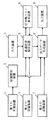
図1は、本発明の一実施例に係る経路選出システムのブロック図である。図1において、経路選出システムは、第1の記憶装置1と、位置検出装置2と、入力装置3と、クレームにおける経路選出用データ記憶装置に相当する第2の記憶装置4と、最適経路探索装置5と、信号機コスト算出装置6と、第3の記憶装置7と、出力データ生成装置8と、出力装置9とを備えている。
【0048】
第1の記憶装置1は、CD−ROMに代表される記録媒体を含み、車両の現在位置を検出するために使用する詳細な道路網を記述した位置検出用データを、当該記録媒体に記憶している。
【0049】
位置検出装置2は、車両の速度や転回した角度、および/または衛星からの電波(GPS)を用いて、車両のおおよその位置および軌跡を求める。さらに、位置検出装置2は、第1の記憶装置1に記憶された位置検出用データを参照して、正確な車両の現在位置を求める。
【0050】
入力装置3は、使用者の操作に応答して動作し、目的地を最適経路探索装置5に入力する(必要であれば、出発地も入力する。また、必要であれば、現在時刻、または出発および到着予定時刻も入力する)。
【0051】
第2の記憶装置4は、CD−ROMに代表される記録媒体を含み、最適経路を選出するために用いる経路選出用データを、当該記録媒体に記憶している。
【0052】
最適経路探索装置5は、第2の記憶装置4に記憶された経路選出用データを用いて、出発地から目的地への最適経路を求める。なお、出発地としては、位置検出装置2により検出された車両の現在位置、または入力装置3により入力される出発地の情報が用いられる。また、目的地としては、入力装置3により入力される目的地の情報が用いられる。また、最適経路探索装置5には、必要に応じて、現在時刻、または使用者が出発(または到着)を予定している時刻が入力装置3により入力される。さらに、最適経路探索装置5は、最適経路を探索中には、信号機コスト算出装置6に、各交差点を通過する時の通過コストを算出する際に必要となる信号機コストを算出させる。なお、通過コストおよび信号機コストの詳細については、後述されるので、ここではそれぞれの説明を省略する。
【0053】
信号機コスト算出装置6は、最適経路探索装置5が最適経路を探索している最中に、信号機コストを算出する。この算出のために必要な情報(信号機有無などの情報)は、最適経路探索装置5により与えられる。信号機コスト算出装置6は、与えられた情報を基に、信号機コストを算出して、算出したコストを最適経路探索装置5へ出力する。
【0054】
第3の記憶装置7は、CD−ROMに代表される記録媒体を含み、地図上に表すべき道路、土地、港、川および公園の形状等を含む地図表示用データを記憶している。出力データ生成装置8は、第3の記憶装置7に記憶された地図表示用データを使って、位置検出装置2で求めた車両の現在位置と、当該現在位置周辺の地図、または使用者が希望した範囲の地図とを表示するための画像データを生成する。
【0055】
出力データ生成装置8は、表示する範囲内に最適経路探索装置5で求めた最適経路が含まれていれば、当該最適経路を示す画像データを生成する。さらに、出力データ生成装置8は、車両の現在位置と求められた最適経路とに基づいて、車両を誘導および案内するためのガイダンス情報(例えば、「100m先の交差点で右折して下さい」といった音声情報および/または文字情報)を生成する。
【0056】
出力装置9は、ディスプレイおよび/またはスピーカ等を含み、出力データ生成装置8により生成された画像データおよびガイダンス情報を外部に出力して、使用者に提示する。より具体的には、ディスプレイは、画像データ、およびガイダンス情報に含まれる文字情報を表示し、スピーカは、ガイダンス情報に含まれる音声情報を音声出力する。
【0057】
次に、図1の第2の記憶装置4内の経路選出用データについて、図2および図3を参照して説明する。
【0058】
図2において、経路選出用データは、道路網の接続状況を表現した道路網データを含む。道路網データは、実際の道路形状(例えば、図2(A)参照)を忠実に表現するのではなく、データ量の削減のため、実際の道路の中心線を基準として、1本の線にベクトル化されたデータである(図2(B)参照)。複数のベクトルが交差する個所は、道路網に存在する交差点を表し、一般的に、ノードと呼ばれる。さらに、各ノードには、それぞれを一意に特定するためのノード識別子が割り当てられる。また、2つのノードの内の一方を始点として、他方を終点とするベクトルは、ある交差点から、次の交差点までに至るまでの道路を表し、一般的に、リンクと呼ばれる。さらに、各リンクには、それぞれを一意に特定するためのリンク識別子が割り当てられる。
【0059】
経路選出用データは、さらに、図2(C)に示す様なノードテーブルを含む。ノードテーブルには、ノード識別子毎に、信号機の有無を示す信号機フラグが設定される。これによって、各ノードが表す実際の交差点に信号機が設置されているか否かを判断することが可能となる。
【0060】
ところで、道路の中には、進行方向の違いで各々が独立している道路がある。かかる道路の一例には、図3(A)に示す様な中央分離帯(ドットを付した部分参照)により上下線が分けられたものがある。また、他の一例としては、高架道路の側道のように、上下線が少し離れた位置にあるものがある。このような道路の上下線は、図3(B)に示すように、それぞれ別のリンクで表される。図3(A)の中央分離帯で分離された道路同士の交差点は、図3(B)の様に、上下線を表すそれぞれのベクトルが略#型形状に交わった形で表される。その結果、元々は一つであった交差点が、図3(B)の様に、複数のノード(M1、M2、M3、M4)に分割されて表される。そのため、複数ノードにより表現される1交差点周辺のリンクは、交差点内リンクと、交差点外リンクとに分類される。交差点内リンクは、複数ノードにより表現される1交差点の内部に形成されるリンクを意味する。図3(B)では、リンクL2(太い実線部分参照)が交差点内リンクの例である。また、交差点外リンクは、複数ノードにより表現される1交差点の外部に形成されるリンクを意味する。
【0061】
経路選出用データは、1交差点が複数ノードにより表される場合のために、図3(C)の様に、ノードテーブルと、リンクテーブルとを含む。ノードテーブルについては、図2(C)を参照して説明した通りであるため、その詳細な説明を省略する。リンクテーブルには、リンク識別子毎に、リンクが交差点内にあるか交差点外にあるか示す交差点フラグが設定される。これによって、各リンクが、交差点内リンクであるか、交差点外リンクであるかを判断することが可能となる。
【0062】
以下、上述の経路選出用データを用いた場合に、通過コストの算出方法について説明する。本実施例では、通過コストとは、車両が交差点を通過する際に必要となる時間を表す評価値を意味し、大略的には、進入/脱出コストと信号機コストとの加算値である。ここで、進入/脱出コストとは、ノードを直進する場合、または当該ノードで右左折する際に、当該ノードに進入してから脱出するまでの、車両の走行時間を示す評価値である。かかる進入/脱出コストについては、周知技術であるため(特開平4−372985号公報等を参照)、詳細な説明を省略する。
【0063】
また、信号機コストは、交差点に設置された信号機での待ち時間を表す評価値であって、本願の特徴の一つである。そのため、以下には、信号機コストの算出方法について、図4〜図8を参照して詳細に説明する。
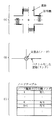
【0064】
まず、図4(A)は、経路選出用データに含まれる道路網データの一部分を示す模式図である。図4(A)では、2個のノードNおよびMにより、2個の交差点が表されている。つまり、図4(A)では、1つのノードで1つの交差点が表されている。ノードNには、リンクL1、L2、R1およびR2の一方端が接続される。また、ノードMには、少なくとも、リンクL2の他方端と、リンクL3の一方端とが接続されている。図4(B)は、図4(A)に示す道路網データのノードテーブルおよびリンクテーブルを示している。図4(B)において、ノードテーブルには、ノード識別子毎に、信号機フラグおよび信号待ち比率が設定される。信号機フラグについては、図2(C)等を参照して説明した通りである。図4(B)のノードテーブルは、ノードNのみで表される交差点には信号機があることを示し、さらに、ノードMのみで表現される交差点には信号機がないことを示している。また、信号待ち時間の比率は、信号機フラグが「有り」に設定されているノード毎に設定される。
【0065】
以下、信号待ち時間の比率について詳細に説明する。まず、信号機の待ち時間は、車両と対向する信号機が赤色に点灯している時間を意味する。道路網に設置された各信号機毎で待ち時間はまちまちであるが、各信号機の待ち時間の平均値は実測等により得ることができる。本システムでは、この平均値が、基準待ち時間コストの好ましい一例として選ばれる。ただし、適切な値であれば、基準待ち時間コストをどのように選んでも構わない。基準待ち時間コストは、図4(B)に示す様に、経路選出用データの一部として、ノードテーブルおよびリンクテーブルと共に第2の記憶装置4に記憶される。信号待ち比率は、あるリンクからあるノードに進入した場合の信号待ち時間が、基準待ち時間コストに対してどの程度の比率であるかを示す値である。図4(B)には、ノードNの信号待ち時間の比率として0.7という数値が記載されている。このノードNの比率としての0.7は、リンクL1およびL2から当該ノードNに進入した場合の信号機コストが、基準待ち時間コストの7割の時間に相当することを示す。
【0066】
さて、図4(B)において、リンクテーブルは、リンク識別子毎に交差点フラグが設定される。リンクテーブルについては、図3(C)等を参照して説明した通りである。図4(B)のリンクテーブルにおいて、ノードNおよびMはそれぞれ別個の交差点を表すので、ノードNおよびMを一方端および他方端とするリンクL2の交差点フラグは、交差点外リンクであることを示す。また、図示された他のリンクの交差点フラグも、交差点外リンクであることを示す。
【0067】
ダイクストラ法に基づく経路探索の過程で、図4に示すノードNおよびMの通過コストの算出に必要となる信号機コストは、以下のように算出される。
【0068】
まず、図5(A)の白抜きの矢印で示すように、ノードNへリンクL1から進入した場合の信号機コスト、および同図の黒塗りの矢印で示すように、ノードNへリンクR1から進入した場合の信号機コストは、次式(1)により算出される。
【0069】
信号機コスト=基準待ち時間コスト×信号待ち時間の比率…(1)
今、ノードNへリンクL1から進入した場合、図4(B)のノードテーブルに記載された通り、信号待ち比率は0.7である。また、基準待ち時間コストをSとする。これらの数値を上式(1)に代入することにより、次式(2)で示される信号機コストを算出することができる。
【0070】
信号機コスト=0.7×S…(2)
また、ノードNへリンクR1から進入した場合、信号待ち比率は1.3となる。その理由を以下に説明する。図6(A)に示すように、2本の道路αおよびβの交差点に、信号機TS1およびTS2が設置されている状況を想定する。図6(B)および図6(C)は、信号機TS1およびTS2の点灯パターンを示す。図6(A)および(C)を参照すれば分かるように、信号機TS1が赤色を点灯するときには、信号機TS2は赤以外の色を点灯する。今、道路α側から交差点に進入した場合の信号機TS1の信号待ち比率が0.7と仮定する。信号待ち時間の比率としての0.7は、基準待ち時間コストSを1とした場合の比率である。そのため、比率の残差(=1−信号機TS1の信号待ち時間の比率)は、信号機TS2の信号待ち時間の比率に加算されることになる。したがって、道路β側から交差点に進入した場合の信号機TS2の信号待ち比率は、1+比率の残差(=1−信号機TS1の信号待ち時間の比率)=1.3となる。以上の説明から明らかなように、図5(A)のノードNへリンクR1から進入した場合、信号待ち比率は1.3となる。したがって、次式(3)により、ノードNへリンクR1から進入した場合の信号機コストを算出することができる。
【0071】
信号機コスト=(1+(1−0.7))×S=1.3×S…(3)
以上のことから、R1およびR2からノードNに進入する場合の信号待ち時間の比率は、L1およびL2からノードNに進入する場合の信号待ち時間の比率に基づいて算出することができる。言い換えれば、R1およびR2からノードNに進入する場合の信号待ち時間の比率は、図4(B)のノードテーブルに記載されなくとも良いことを意味する。これによって、図1の経路選出システムは、第2の記憶装置4が記憶するデータ量を少なくしつつ、信号機コストを算出することができるという技術的効果を奏する。より具体的には、経路選出システムは、典型的には車両という狭い空間に搭載される。そのため、各データ記憶装置1、4および7の記憶容量はおのずと制限される。かかる制限がある経路選出システムにとって、記憶するデータ量が少なくなることは、大きな利点になる。
【0072】
再度、図5を参照する。図5(B)の黒塗りの矢印で示すように、ノードMへリンクL2から進入した場合の信号機コストは、0である。なぜなら、図4(B)のノードテーブルにおいて、ノードMの信号機フラグは、信号機が無いことを示しているからである。
【0073】
以上の図4〜図6を参照して、1つの交差点が1つのノードで表現される場合の信号機コストの算出方法について説明した。ここで注意を要するのは、以上の信号機コストの算出では、リンクL1〜L3ならびにR1およびR2が全て交差点外リンクのため、信号機コストの算出時における交差点フラグの説明(詳しくは後述)は省略している点である。
【0074】
また、以上の信号機コストは、単に、基準待ち時間コストと信号待ち比率とに基づいて算出するとして説明した。しかし、例えばノードNにおいて、交差点を構成するリンク(L1,L2,R1,R2)の道路種別(国道、県道など)を経路探索中に調査して、主要な道路の方の信号機コストが小さくなる様に計算してもよい。また、交差点を構成するリンクの道幅を経路探索中に調査して、道幅の広い道路の信号機コストが小さくなるように計算してもよい。これによって、交差点に進入する道路が優先道路か否かに応じて異なる信号機コストを算出することができる。これによって、信号機に起因する待ち時間等の影響を、より正確に反映させた最適経路を求めることができる。
【0075】
また、交差点を構成するリンクの道幅を経路探索中に調査して、道幅の広い道路の方の信号機コストが小さくなるように計算してもよい。
【0076】
さらに、交差点を構成するリンクの道幅や車線数を経路探索中に調査して、それらの差が大きいほど、道幅が広い、または車線数が多い道路の方の信号機コストがより小さくなるように計算してもよい。
【0077】
さて、図7および図8は、1つの実際の交差点が複数のノードにより表される場合の信号機コストの算出方法を説明するための図である。まず、図7(A)は、経路選出用データに含まれる道路網データの一部分を示す模式図である。図7(A)では、4個のノードN1〜N4により、1つの実際の交差点が表現されている。ノードN1には、リンクL5、L6、R1およびR2の一方端が接続される。他のノードN2〜N4に関しても、図示した通りのリンクが接続されている。
【0078】
図7(B)は、図7(A)に示す道路網データの情報が記載されたノードテーブルおよびリンクテーブルを示している。図7(B)のノードテーブルには、ノード識別子毎に、信号機フラグおよび信号待ち時間の比率が設定される。図7(B)の場合、複数ノードで表現される1つの交差点には信号機があるため、ノードN1〜N4のそれぞれの信号機フラグは、「有り」に設定される。さらに、ノードN1については、リンクL5およびL6から当該ノードN1に進入した場合の信号待ち時間の比率として「0.8」が設定される。ここで、図7(A)に示すように車両はリンクL6からノードN1には進入することができないが、経路探索は、双方向探索探索(図9参照)において目的地側から実行することも可能であるので、ノードN1の信号待ち時間の比率はリンクL6からノードN1に進入する場合にも設定されている点には注意を要する。
【0079】
他のノードN2〜N4についても、同様に、信号待ち時間の比率が設定される。
【0080】
また、図7(B)に示すリンクテーブルには、リンク識別子毎に交差点フラグが設定される(詳細については、図3(C)の説明を参照)。図7(B)の場合、図7(A)に示されたリンクの内、リンクL2、L5、R2およびR5の交差点フラグのみが「内」に設定され、当該リンクL2、L5、R2およびR5は交差点内リンクであることが記載される。
【0081】
さて、ダイクストラ法に基づく経路探索の過程で、図7に示すノードN1〜N4で表現される1つの交差点での信号機コストを算出する際には、注意すべき点がある。図4および図5を基に説明したように、原則的に、信号機フラグが「有り」に設定されたノード毎に、信号機コストは算出される。しかしながら、1つの交差点が複数のノードで表現される場合、当該複数のノード毎に信号機コストが算出されてはならない。そこで、ダイクストラ法の基づく出発地を起点とした出発地側経路探索において、ノードN1〜N4のいずれかへの進入リンクが交差点外リンクの時のみ信号機コストを計算するというルールを規定する。かかるルールの下では、リンクL1で表される道路から、ノードN1〜N4で表される交差点に進入した場合の信号機コストは、以下のように算出される。
【0082】
まず、図8(A)に示すように、L1からノードN2を通過しリンクR3(左折)、またはリンクL2(左折以外)へ脱出する場合を想定する。ここで、進入リンクであるリンクL1は交差点外リンク(図7(B)参照)である。そのため、ノードN2では、信号機コスト(前式(1)参照)が算出される。ここで、基準待ち時間コストは、上述したようにSである。また、信号待ち比率は、リンクL1からノードN2に進入した場合、図7(B)に示すように「0.8」である。これらを前式(1)に代入することにより、L1からノードN2を通過しリンクR3、またはリンクL2へ脱出する場合の信号機コストは、次式(5)により算出できる。
【0083】
信号機コスト=0.8×S…(5)
次に左折以外の場合は、図8(B)に示すように、リンクL2を進入リンクとして、ノードN3を通過し、リンクL3に(直進)またはリンクR5(右折またはUターン)へ脱出する。このとき進入リンクL2は交差点内リンクとなるため、ノードN3を通過するときは信号機コストは算出されない(つまり、0である)。
【0084】
また、右折またはUターンの場合、図8(C)に示すように、リンクR5を進入リンクとして、ノードN4を通過し、リンクR6(右折)またはリンクL5(Uターン)へ脱出する。このときも、進入リンクR5は交差点内リンクのため、ノードN4を通過するときは信号機コストは算出されない(つまり、0である)。
【0085】
さらに、Uターンの場合、リンクL5を進入リンクとして、ノードN1を通過し、リンクL6へ脱出する。このときも、進入リンクL5は交差点内リンクのため、ノードN1を通過するときも信号機コストは算出されない(つまり、0である)。
【0086】
この結果、図8(D)に示す様に、リンクL1から進入したときには、一番最初のノードであるノードN2でのみ信号機コストが算出され、この複数のノードで表される交差点を脱出するまでは、他のノードでは信号機コストが算出されていない。よって、複数のノードで構成される交差点でも、信号機コストは1回しか算出されない。
【0087】
なお、複数のノードからなる交差点に対して、当該交差点から脱出する時に限り1回だけ信号機コストを算出する様にしてもよい。そのためには、例えば出発地を起点とした出発地側経路探索において、脱出リンクが交差点外リンクのときのみ信号機コストを算出するというルールを規定する。このルールの下では、リンクL1から進入した場合は、左折の時にはノードN2で、直進の時にはノードN3で、右折の時にはノードN4で、Uターンの時にはノードN1で、信号機コストが算出される。
【0088】
ここで、注意を要するのは、本願の一つの特徴は、複数のノードで表現される交差点の通過コストを算出する場合に、信号機コストが1回だけ算出される点である。この点を具体的にするために、上述では、ダイクストラ法の基づく出発地を起点とした経路探索において、ノードN1〜N4のいずれかへの進入リンクが交差点外リンクの時のみ信号機コストを計算するというルールと、脱出リンクが交差点外リンクのときのみ信号機コストを算出するというルールとについて説明した。しかし、信号機コストが1回だけ算出されるのであれば、これら2つのルール以外の方法であってもよい。
【0089】
次に出発地を経路探索の起点とするだけでなく、目的地も経路探索の起点とする、双方向探索時における信号機コストの算出について、説明する。図9は、双方向探索の概念図である。図9に示す様に、双方向探索では、出発地SPを起点とした経路探索(以下、出発地側探索と称する)、および目的地DPを起点とした経路探索(以下、目的地側探索と称する)の二つの方向で経路探索が行われ、その探索範囲の接続部分を通る経路が最適経路として求められる。これによって、探索範囲が出発地側のみの1方向の経路探索より約半分になるため、探索時間を削減するための方法として従来から知られている(特開平4−204881号公報等を参照)。
【0090】
しかし、複数のノードにより表現される交差点が存在する場合であって、かつ信号機コストを算出する位置が、出発地側探索および目的地側探索において互いに異なっている場合、当該交差点において、信号機コストが1回も算出されないか、信号機コストが2回算出されるという不都合が発生する。その結果、出発地側探索と目的地側探索の接続地点では、正しい通過コストが算出されずに、最適経路が選ばれなくなる可能性がでてくる。
【0091】
そこで、以上の双方向探索において、目的地側探索を行ったときに、図7(A)に示した交差点での信号機コストを算出する方法について、図10を参照して説明する。
【0092】
出発地側探索において、図7(A)の交差点にリンクL1から進入してくる経路では、図8(A)に示した様に、ノードN2で信号機コストが算出されていた。しかし、目的地側探索では、図10において矢印で示すように、探索の広がる方向が出発地側探索とは逆になるため、脱出リンクの方から進入リンクの方へ探索が広がる。そのため、目的地側探索において、例えばリンクL1からL3への経路を探索するときに、出発地側探索の場合と同じノードN2で信号機コストを算出するためには、次に探索されるリンクが交差点外リンクで有った場合に信号機コストを算出する(図10(A)参照)。
【0093】
次に、双方向探索によりリンクL1からL3への経路を探索するときの信号機コストのより詳細な算出方法を図10(B)および(C)を参照して説明する。まず、図10(B)において、リンクL3が探索され、探索範囲がノードN3に及ぶ。次に、リンクL3を脱出リンクとし、ノードN3を通過し、さらにリンクL2を進入リンクとするパターンについて、信号機コストを算出するかしないかの判断が行われる。この判断において、リンクL3は探索済みのリンクであり、リンクL2は未探索のリンクであり、さらに当該リンクL2は交差点内リンクである。よって、ノードN3では、信号機コストは加算されない。次に、図10(C)において、ノードN2を通過する場合、リンクL2が探索済みリンク、リンクL1が未探索リンクになる。ここで、リンクL1は交差点外リンクであるため、信号機コストが算出される。これによって、図10(A)の様に、出発地側探索と同じノードで信号機コストを算出することができる。
【0094】
なお、出発地側探索で、交差点を脱出する時に信号機コストを算出していた場合は、例えば、探索済みリンクが交差点外リンクであるときのみ、信号機コストを算出するようにすればよい。
【0095】
さて、複数の信号機が連動して点灯する場合がある。具体例としては、走行すべき経路上の最初の信号機と次の信号機とが同時に青を点灯する場合や、当該最初の信号機が青を点灯した後一定時間が経過すると、次の信号が青を点灯する場合がある。複数の信号機が連動する場合、車両が道路上をスムーズに走行できるので、当該複数の信号機のそれぞれについて信号機コストを算出しない方が、より正確な通過コストを算出することができる。そこで、本経路選出システムでは、以下のようにして、連動する複数の信号機の信号機コストが算出される。
【0096】
図11(A)は、複数の信号機が連動している道路網(系統)を表した道路網データを示す模式図である。また、図11(B)は、図11(A)の道路網データに付随するノードテーブルおよび系統テーブルを示す図である。
【0097】
図11(A)では、7個のノードN1〜N6およびM1により、7個の交差点が表現されている。ノードN1〜N6およびM1は、図示した通りのリンクにより接続される。なお、図11(A)では、説明を簡単にするために、すべての交差点は1つのノードにより表現される。その結果、リンクL1〜L7ならびにリンクR1およびR2は、交差点外リンクである。
【0098】
また、図11(B)において、ノードテーブルについては、既に詳細に説明されているため、ここではその説明を省略する。このノードテーブルから分かるように、図11(A)のノードN1〜N6およびM1のそれぞれには信号機が設置されている。また、系統テーブルには、系統番号毎に、時間帯情報およびノード識別子が設定される。まず、本実施例において、系統とは、点灯タイミングが連動している複数の信号機が設置された経路を意味する。また、系統番号とは、各系統を一意に特定するための番号である。また、時間帯情報は、同一系統の信号機が連動する時間帯を示す情報である。さらに、系統テーブル内のノード識別子は、同一系統に属するノードの組み合わせを特定するための情報である。以上の情報が設定される系統テーブルを参照すると、例えば、2番の系統に属するノードN1〜N6にある信号機は、朝の5時から夜の11時までの間、連動している。また、例えば、1番の系統に属するノードN1およびM1は、夜の0時から朝の5時までの間、連動する。以上の2つの例から分かるように、系統テーブルには、各系統に設置された複数の信号機が連動して点灯する時間帯と、当該系統に属するノードとがまとめて記録される。
【0099】
連動する複数の信号機の信号機コストを算出する場合、経路選出用データは、図11に示す道路網データ、ノードテーブルおよび系統テーブルとから構成される。ただし、1つの交差点が複数のノードにより表現される場合もあるので、リンクテーブルも必要となる場合も有る。
【0100】
次に、図11の経路選出用データに基づいて、探索された経路の信号機コストを算出する手順の一例を説明する。今、車両が、昼の12時頃に、図11(A)に示す道路網を通過することが予測されているときに、リンクR1からリンクL7へ至る経路の信号機コストは、図12に示す手順で算出される。ただし、以下の算出方法の説明では、便宜上、前述の出発地側探索の場合に限定する。
【0101】
図12において、まず、リンクR1を進入リンクとして、ノードM1を通過し、リンクR2へ脱出する場合、2つ前に探索されたノードが属する系統、および1つ前に探索されたノードが属する系統が0番であったとする。以下には、過去の系統[x1 ,x2 ]という表記が使用されるが、x1 は1つ前のノードの系統番号を示し、x2 は2つ前のノードの系統番号を示す。例えば、2つ前および1つ前のノードが属する系統の番号がそれぞれ0番である場合、過去の系統[0,0]と表記される。
【0102】
今、昼の12時頃では、今回の探索対象であるノードM1は、4番の系統に属していることが、系統テーブル(図11(B)参照)から判る。ノードM1の系統番号である「4」は、2つ前の系統番号としての「0」と比較し異なっているため、ノードM1では信号機コストが算出される。
【0103】
次に、リンクR2を進入リンクとし、ノードN1を通過して、リンクL2へと脱出する場合、過去の系統は[4,0]である。今回の探索対象としてのノードN1は、2番の系統に属している。今回の系統番号である「2」は、2つ前の系統番号である「0」とは異なるため、ノードN1でも信号機コストが算出される。
【0104】
次に、リンクL2を進入リンクとし、ノードN2を通過して、リンクL3へと脱出する場合、過去の系統は[2,4]である。今回の探索対象であるノードN2は、昼の12時頃では、2番の系統に属している。しかし、今回の系統番号である「2」は、2つ前の系統番号である「4」とは異なるため、ノードN2でも信号機コストが算出される。
【0105】
ここで、リンクL3を進入リンクとし、ノードN3を通過して、リンクL4へと脱出する場合、過去の系統は[2,2]になっている。今、ノードN3は2番の系統に属しており、2つ前の系統も2番である。このように、今回の系統と2つ前の系統とが同じ場合、信号機コストを算出しないと判断される。以降、ノードN4、N5およびN6を探索対象とする場合にも、ノードN3の場合と同様になるため、それぞれ信号機コストは算出されない。以上から明らかなように、探索対象のノードが過去に通過したノードと同一系統に属する場合には、当該探索対象のノードでは信号機コストが算出されない。したがって、信号機が連動する経路を通過する際には、信号機の待ち時間が反映されず、車両が当該経路をスムーズに進行することを表すことができる。これによって、実際の交通状況に即した正確な経路探索を実行することができる。
【0106】
なお、以上の説明では、探索対象となるノードの系統番号と、2つ前のノードの系統番号とが比較されていた。しかし、1つ前のノードの系統番号のみを記憶して、探索対象となるノードの系統番号と、当該1つ前のノードの系統番号とが比較されてもよい。ただし、1つ前の系統番号との比較するだけでは、車両が右折して異なる系統に入った直後の最初の信号において、信号待ちが発生するといった状態を表現することはできない。つまり、信号待ちが発生すべきノードにおいて、信号機コストが算出されないという不都合が発生する。
【0107】
また、信号機コスト算出装置6は、同一系統のノードを何個通過したかをカウントし、カウント値が、予め定められたノードの個数(例えば5個)に達する毎に、信号機コストを算出するようにしてもよい。これによって、ある程度の距離を車両が走れば、同一系統を走行中であっても信号待ちが発生することを表現することができる。また、信号機コスト算出装置6は、予め定められた個数のノードを通過した場合ではなく、同一系統の経路上を、予め定められた旅行時間だけ走行する毎に、信号機コストを算出してもよい。以上の予め定められたノードの個数および旅行時間は、通過する時間帯によって変更してもよい。
【0108】
図13〜図18は、図1に示す経路選出システムの動作を示すフローチャートである。以下、図13〜図18を参照して、図1の経路選出システムにおける経路選出動作を説明する。なお、以下には、車両の現在位置から使用者が入力した目的地までの最短旅行時間となる経路を、出発地を起点とした探索のみで、かつ複数ノードで構成される交差点では最初のノードで信号機コストが算出される場合の動作を説明する。なお、以下、車両の現在位置から目的地までの最短旅行時間となる経路を、最適経路と称する。
【0109】
まず、最適経路探索装置5は、使用者の操作に応答して、入力装置3から出力される目的地の位置座標(経度、緯度)を示す情報を取得する(図13;ステップS101)。また、同時に、最適経路探索装置5は、目的地へと出発する時刻情報も取得する。次に、最適経路探索装置5は、車両の現在位置の座標(経度、緯度)および車両の進行方向を示す情報を、位置検出装置2から取得する(ステップS102)。次に、最適経路探索装置5は、最適経路を道路網データ上で探索し選出する経路選出処理を実行する(ステップS103〜S104)。
【0110】
上記経路選出処理において、最適経路探索装置5は、最適経路が通過する可能性がある範囲(通常、出発地と目的地を含む長方形の範囲)を表した道路網データを、第2の記憶装置4から読み出して、図示しない内部メモリに格納する(ステップS103)。ここで、注意を要するのは、出発地と目的地を含む長方形の範囲は非常に広い。そのため、通常、ステップS103では、相対的に小さな範囲を表す道路網データが複数個読み出され、当該複数個の道路網データにより、出発地と目的地を含む長方形の範囲の地図が構成される。
【0111】
次に、最適経路探索装置5は、現在位置の座標および進行方向に基づいて、内部メモリに格納された道路網データから、車両が現在走行しているリンクを調査し特定する。最適経路探索装置5は、特定したリンクを、経路探索処理の開始点にして、目的地の座標付近のノードまでの旅行時間が最短になる経路を探索する(ステップS104)。このステップS104の経路探索処理は、従来から知られているダイクストラ法等の最短経路探索方法を用いて実行され、その詳細な処理手順は、図14および図15のフローチャートに示されている。
【0112】
図14において、最適経路探索装置5は、まず初期設定を行う(ステップS201)。すなわち、出発地を基準ノード(基準ノードは、請求項における探索対象の交差点に相当する)として設定し、目的地を目的ノードとして設定し、基準ノードへの到達リンクが存在しないと設定する。次に、最適経路探索装置5は、基準ノードが目的ノードか否かを判断する(ステップS202)。最初は、出発地が基準ノードであるため、基準ノードが目的ノードではあり得ない。そのため、最適経路探索装置5は、出発地から進行可能なリンクを調査し、そのいずれか1つを選択する(ステップS203)。次に、最適経路探索装置5は、ステップS203で選択したリンクの先端に位置するノード(以下、到達ノードと称する)について、出発地からの到達コストを計算する(ステップS204)。なお、ステップS204の詳細な処理手順の説明は後述する。
【0113】
次に、最適経路探索装置5は、ステップS204で計算された到達コストが、現在記録されている最小の到達コストよりも小さいか否かを判断する(ステップS205)。より詳しく説明すると、出発地から到達ノードに至るまでの経路は何通りかあるので、最適経路探索装置5は、ステップS205の時点で、出発地から、ある経路を通過して、現在設定されている到達ノードに至るまでの到達コストを何通りも計算している場合がある。計算された到達コストの内、最小のものが、後述するステップS206において内部メモリに記録される。ステップS205では、かかる最小の到達コストと、ステップS204で計算された到達コストとの大小が比較される。ここで、注意を要するのは、経路探索処理の開始直後、各到達ノードへの到達コストは、初めて計算されるため、ステップS205の判断は、当然、YESとなる。そのため、最適経路探索装置5は、ステップS204で計算された到達ノードへの到達コストを、現在最小のものとして、内部メモリに記録して、最小の到達コストを書き換える。さらに、最適経路探索装置5は、出発地から到達ノードへのリンク(到達リンク)を、内部メモリに記録する(ステップS206)。
【0114】
次に、最適経路探索装置5は、基準ノード(現時点では出発地)から進行可能なリンクの内、ステップS203で選択されていないリンクが残っているか否かを判断する(図15;ステップS207)。選択されていないリンクが残っている場合、最適経路探索装置5は、再びステップS203の動作に戻る。すなわち、最適経路探索装置5は、未選択のリンクの中からいずれか1つを選択し、到達コストを計算し、さらに、必要に応じて記録処理を実行する(ステップS203〜S207)。
【0115】
最適経路探索装置5は、上記ステップS203〜S207の処理を繰り返し、出発地から進行可能なリンクを全て選択し、各到達ノードへの到達コストの計算が終了すると、ステップS207で、Noと判断する。次に、最適経路探索装置5は、次の基準ノードを探索し設定する(ステップS208)。ここで、次の基準ノードとは、未だ基準ノードとして設定されておらず、かつ既に到達コストが計算されたノードの内、最小の到達コストを有するノードを意味する。経路探索処理の開始直後では、出発地から進行可能な各リンクの先端に位置する到達ノードが選択の候補となるため、これら到達ノードの中から最小の到達コストを有するノードが、次の基準ノードとして設定される。次に、最適経路探索装置5は、上記ステップS208で基準ノードが設定されたか否かを判断する(ステップS209)。何らかの事情で基準ノードが設定されなかった場合、最適経路探索装置5は、経路の探索に失敗したと判断し(ステップS210)、図13のメインルーチンに戻る。その後、最適経路探索装置5は、出力データ生成装置8を介して、出力装置9に経路探索に失敗した旨を表示し(ステップS105)、その動作を終了する。
【0116】
一方、ステップS209で基準ノードが設定されている場合、最適経路探索装置5は、ステップS202の動作に戻り、新たに設定された基準ノードを探索対象として、上記ステップS203〜S209の処理を実行する。以下、出発地と目的地との間に位置する任意のノードが基準ノードとして設定された場合の動作をより詳細に説明する。
【0117】
まず、現在の基準ノードが目的ノードでないと判断され(ステップS202)、当該基準ノードの到達リンクから当該基準ノードを通って進行できるリンクが調査され、そのいずれか1つが選択される(ステップS203)。ここで、道路網データ上に存在する各ノードは、出発地からそのノードへの最短経路が決まったときに、基準ノードとして設定される。そして、基準ノードの到達リンクとは、出発地から当該基準ノードへの最短経路上に位置し、かつ当該基準ノードへ直接接続されているリンクを意味する。言い換えれば、到達リンクは、基準ノードへの進入リンクである。次に、最適経路探索装置5は、上記ステップS203で選択された到達リンクの先端に位置する到達ノードへの到達コストを計算する(ステップS204)。このステップS204のコスト計算処理の詳細な処理手順は、図16のフローチャートに示されている。
【0118】
図16において、まず、最適経路探索装置5は、信号機コスト算出装置6を使って信号機コストの決定を行う(ステップS301)。ステップS301において、最適経路探索装置5は、信号機コストの算出に必要となる各情報を、内部メモリに展開されている経路選出用データから取り出して、信号機コスト算出装置6に与える。このステップS301の信号機コスト決定処理の詳細な処理手順は、図17および図18のフローチャートに示されている。
【0119】
図17において、信号機コスト算出装置6は、まず基準ノードに信号機があるかどうかを、当該基準ノードについて設定されている信号機フラグを基に調査する(ステップS401)。信号機コスト算出装置6は、基準ノードに信号機が無いと判断した場合、信号機コスト=0として(ステップS402)、ステップS301を終える。また、基準ノードに信号機が有ると判断した場合、信号機コスト算出装置6は、次に、到達リンクが交差点内リンクかどうかを、到達リンクについて設定されている交差点フラグを基に判断する(ステップS403)。もし到達リンクが交差点内リンクであった場合は、ステップS402で信号機コスト=0として、ステップS301を終える。
【0120】
ステップS403で、到達リンクが交差点外リンクであった場合、信号機コスト算出装置6は、その基準ノードへ到着すると予想される時刻を基に、予想時刻では、基準ノードがどの系統に属しているかを、系統テーブルを基に調査する。さらに、信号機コスト算出装置6は、基準ノードが属する系統を基準系統とする(ステップS404)。そして、基準系統が基準ノードへ到達するまでの経路が通過してきた2つ前の系統とを比較して、同じであるかどうかを判断する(図18;ステップS405)。2つ前の系統と基準ノードの系統が同じであった場合、信号機コスト=0として(ステップS406)、ステップS409へ移る。また、2つ前の系統と基準ノードの系統が異なる場合、信号機コスト算出装置6は、到達リンクでの信号待ち時間の比率をノードテーブルから取得し、さらに基準待ち時間コストを経路選出用データから取得する(ステップS407)(図4および図5を用いて既に説明済み)、取得した信号待ち時間の比率と基準待ち時間コストとに基づいて、基準ノードにおける信号機コストを算出する(ステップS408)。
【0121】
ステップS409では、1つ前の系統番号を、2つ前の系統にセットし、また現在の基準ノードの系統番号を、1つ前の系統にセットする。そして、ステップS301の信号機コスト決定処理を終了して、図16のコスト計算処理へ戻る。
【0122】
再度図16を参照する。信号機コスト算出装置6がステップS301で信号機コストを求めた後、最適経路探索装置5は、基準ノードから進行リンク(基準ノードから到達ノードへのリンク)へ移るための右左折や直進に必要となる進入/脱出コストを取得する(ステップS302)。次に、最適経路探索装置5は、出発地から現在の基準ノードへの最小到達コスト(既に計算されて内部メモリに記録されている)と、当該基準ノードの進入/脱出コスト(上記ステップS302で求められたもの)と、当該基準ノードでの信号機コスト(上記ステップS301で求められたもの)と、進行リンクの通過コストとを加算し、到達ノードへの到達コストを演算する(ステップS303)。ここで、進入/脱出コストと信号機コストとの加算値が請求項における通過コストに相当する。ただし、注意を要するのは、本願の特徴は、基準ノードの通過コストに、信号機コストが含まれる点であって、通過コストが進入/脱出コストと信号機コストとの加算値である点が特徴ではない点である。以上のステップS303の後、最適経路探索装置5は、図14の経路探索処理に戻る。
【0123】
再び図14を参照する。最適経路探索装置5は、上記ステップS204で計算された到達コストが、現在記録されている到達コストの最小値よりも小さいか否かを判断する(ステップS205)。計算された到達コストが今までの最小コストの場合、最適経路探索装置5は、内部メモリに格納されているその到達ノードへの到達コストを、ステップS204で計算された到達コストとして書き換える。さらに、最適経路探索装置5は、その到達ノードへの到達リンクを、現在の基準ノードからその到達ノードへ至るリンクに書き換える(ステップS206)。一方、計算された到達コストが今までの最小コストでない場合、最適経路探索装置5は、到達ノードの到達コストおよび到達リンクの書き換えを行わずに、図15のステップS207の処理に直接進む。
【0124】
次に、最適経路探索装置5は、現在の基準ノードから進行可能なリンクの内、選択されていないリンクが残っているか否かを判断し(図15;ステップS207)、選択されていないリンクが残っている場合、残りのリンクについて、再びステップS203〜S207の処理を繰り返す。全てのリンクについて、各到達ノードへの到達コストの計算が終了すると、最適経路探索装置5は、基準ノードにはなっていないが既に到達コストが計算されたノードの内、最小の到達コストを有するノードを、次の基準ノードとして設定する(ステップS208)。次に、最適経路探索装置5は、上記ステップS208で基準ノードが設定されたか否かを判断し(ステップS209)、設定されている場合は、ステップS202の動作に戻り、新たに設定された基準ノードを対象として、上記ステップS203〜S209の処理を実行する。
【0125】
新たに設定された基準ノードが目的ノードの場合、最適経路探索装置5は、ステップS211において経路構成処理を実行する。この経路構成処理は、目的地側からさかのぼって、出発地から目的地に至る最短経路を確定する処理である。その後、最適経路探索装置5は、図13のメインルーチンに戻り、出力データ生成装置8を介して、出力装置9に構成した最短経路探を表示し(ステップS105)、その動作を終了する。
【0126】
なお、上記実施例では、最適経路探索装置5において、ダイクストラ法を使用すると記載したが、その他の経路探索方法を使用しても良い。また、ノードを基準として探索しているが、特開平4−372985号公報に開示されているように、リンクを基準とした探索を行ってもよい。また、探索を行う前に第2の記憶装置4から経路選出用データを読み込んだが、探索しながら読み込んだり、予め範囲を限定しないで探索しても構わない。
【0127】
また、以上の処理手順はプログラムによって実現されても構わない。かかるプログラムをCD−ROMに代表される記録媒体に記録して配布することにより、独立した他のコンピュータ装置で容易に実施することができる。ここで、コンピュータ装置としては、携帯電話、情報携帯端末(いわゆるPDA)、携帯型ナビゲーション装置等がある。それゆえ、上記実施形態では、最適経路探索装置5は、車両の最適経路だけでなく、各コンピュータ装置のユーザの最適経路を探索することができる。
【0128】
なお、プログラムを記録する記録媒体としては、CD−ROMに限らず、磁気ディスク、光磁気ディスクまたは光ディスクが典型的である。
【図面の簡単な説明】
【図1】本発明の一実施例に経路選出システムのブロック図である。
【図2】図1の第2の記憶装置4内の経路選出用データにおける、一般的な道路網の表現形態の一例を説明するための図である。
【図3】図1の第2の記憶装置4内の経路選出用データにおける、上下線が離れている道路網の表現形態の一例を説明するための図である。
【図4】図2の様に1ノードで表現されるある交差点を通過する場合に、信号機コストをどのように算出するかを説明するための図である。
【図5】図2の様に1ノードで表現されるある交差点を通過する場合に、信号機コストをどのように算出するかを説明するための図である。
【図6】信号待ち時間の比率がノードテーブルに設定されていない進入リンクの算出方法を説明するための図である。
【図7】図3の様な複数ノードで表現されるある交差点を通過する場合に、信号機コストをどのように算出するかを説明するための図である。
【図8】図3のように複数ノードで表現される他の交差点を通過する場合に、信号機コストをどのように算出するかを説明するための図である。
【図9】周知技術である双方向探索の概要を説明するための図である。
【図10】図9に示す双方向探索の、目的地を起点とした目的地側探索時に、信号機コストの有無をどのように判断するかを説明するための図である。
【図11】複数の信号機が連動している道路網(系統)を通過する場合に、信号機コストの有無をどのように判断するかを説明するための図である。
【図12】図11の様な系統を通過する場合に、信号機コストをどのように算出するかを説明するための図である。
【図13】図1の経路選出システムの動作を示すフローチャートである。
【図14】図13のサブルーチンステップS104の詳細な動作を示すフローチャートの前半部分である。
【図15】図13のサブルーチンステップS104の詳細な動作を示すフローチャートの後半部分である。
【図16】図14のサブルーチンステップS204の詳細な動作を示すフローチャートである。
【図17】図16のサブルーチンステップS301の詳細な動作を示すフローチャートの前半部分である。
【図18】図16のサブルーチンステップS301の詳細な動作を示すフローチャートの後半部分である。
【符号の説明】
1 第1の記憶装置
2 位置検出装置
3 入力装置
4 第2の記憶装置
5 最適経路探索装置
6 信号機コスト算出装置
7 第3の記憶装置
8 出力データ生成装置
9 出力装置[0001]
BACKGROUND OF THE INVENTION
The present invention relates to a route selection system, and more particularly, to a system that automatically selects an optimal route between a specified departure place and destination on a map.
[0002]
[Prior art]
In recent years, with the development of electronic technology, navigation systems for guiding and guiding vehicles are rapidly spreading. Some conventional navigation systems include a route selection system for automatically selecting an optimum route (for example, a shortest distance arrival route or a minimum time arrival route) from a departure point to a destination.
[0003]
In a conventional route selection system, as a method for obtaining an optimum route for guiding and guiding a vehicle, there is an automatic vehicle guidance method disclosed in, for example, Japanese Patent Application Laid-Open No. 59-105113. In this method, an optimum route between a departure point and a destination is obtained from data representing road connection conditions using a Dijkstra method, which is one of optimum route determination methods. For the theory of Dijkstra method, see, for example, A.I. V. It is shown on pages 179-183 of “Data Structure and Algorithm” (Baifukan Co., Ltd., published in 1990) written by Aiho et al. And translated into Japanese by Yoshio Ohno.
[0004]
As another method for obtaining an optimum route, for example, there is a route search method disclosed in Japanese Patent Application No. 2-333801 (Japanese Patent Laid-Open No. 4-204881). In this method, an optimum route is searched by simultaneously executing two searches, ie, a departure side search starting from the departure point and a destination side search starting from the destination. The search time is reduced by such a bidirectional search.
[0005]
As another method for obtaining an optimum route, for example, there is a recommended route guidance device disclosed in Japanese Patent Application No. 3-151416 (JP-A-4-372985). This publication states that a right turn or a left turn at an intersection is added to an evaluation value used when obtaining an optimum route.
[0006]
[Problems to be solved by the invention]
By the way, when a vehicle actually travels on the optimum route obtained by any one of the methods described above, it is the stop and acceleration / deceleration caused by waiting for a signal that have a great influence on the travel time of the vehicle. However, in the conventional method, the optimum route is searched on the road network data without considering the influence of signal waiting. As a result, when the vehicle actually travels on the optimum route obtained by the conventional method, there is a problem that the destination cannot be reached in the expected time due to the stop caused by the signal waiting.
[0007]
Therefore, an object of the present invention is to provide a route selection method and system for searching for an optimum route in consideration of the influence of signal waiting.
[0008]
[Means for Solving the Problems and Effects of the Invention]
The first aspect of the present invention is directed to a method for selecting an optimal route on a map. In advance, road network data representing intersections and roads, and whether or not there are traffic lights at each intersection. The route selection data including the traffic signal flag shown and the width information for specifying the width of each road is stored. In such a case, the method is based on the traffic signal included in the route selection data while the route search process for searching for the optimum route between the instructed starting point and the destination is being executed based on the route selection data. Based on the flag, the first step of determining whether there is a traffic signal at the intersection to be searched, and if it is determined in the first step that there is a traffic signal at the intersection of the search target, The cost associated with time is calculated for the roads that make up the intersection. A second step of calculating based on the width information, and calculating a passing cost when passing through the intersection to be searched based on the calculated traffic light cost. Here, the optimum route is selected based on the passage cost calculated in the second step.
[0009]
In addition, the second aspect of the present invention is directed to a method for selecting an optimum route on a map, and road network data representing intersections and roads in advance and whether or not there are traffic lights at each intersection. The route selection data including the traffic signal flag indicating the lane number and the lane number information for specifying the lane number of each road is stored. In such a case, the method uses the traffic signal flag included in the route selection data while the route search process for searching for the optimum route between the designated departure point and destination is being executed based on the route selection data. Based on the first step of determining whether or not there is a traffic signal at the intersection to be searched, and when it is determined in the first step that there is a traffic signal at the intersection to be searched, the waiting time at the traffic signal A second step of calculating a cost related to the vehicle based on the information on the number of lanes of the road constituting the intersection, and calculating a passing cost when passing the intersection to be searched based on the calculated traffic light cost; Is provided. Here, the optimum route is selected based on the passage cost calculated in the second step.
[0010]
In the first or second aspect, route selection data including a traffic signal flag indicating the presence or absence of a traffic signal at an intersection is stored in advance. In the second step, while the route search process is being executed based on the route selection data, the passage cost for passing through the intersection to be searched is calculated based on the presence or absence of a traffic light. Therefore, the second step can calculate different passage costs depending on the presence or absence of traffic lights at the intersection. As a result, it is possible to obtain an optimum path including the influence of waiting time or acceleration / deceleration caused by a traffic light.
[0011]
Further, in the first or second aspect, the traffic light cost is calculated based on the width of the road or the number of lanes constituting the intersection. Therefore, different traffic light costs can be calculated depending on whether or not the road entering the intersection is a priority road. In the first or second invention, a difference in width or a difference in the number of lanes between roads constituting the intersection can be obtained, and different traffic light costs can be calculated according to the priority of the road entering the intersection. . As a result, in the route search process, it is possible to obtain an optimum route that more accurately reflects the influence of the waiting time or the like caused by the traffic light.
[0012]
Further, the third aspect of the present invention is directed to a method for selecting an optimum route on a map, and road network data representing intersections and roads in advance and whether or not there are traffic lights at each intersection. The route selection data including the traffic signal flag indicating that is stored. Here, the route selection data further includes a predetermined reference waiting time cost and a ratio of the signal waiting time to the reference waiting time cost for a part of the roads entering the intersection where the traffic signal is present. In such a case, the method is based on the traffic signal included in the route selection data while the route search process for searching for the optimum route between the instructed starting point and the destination is being executed based on the route selection data. Based on the flag, the first step of determining whether there is a traffic signal at the intersection to be searched, and if it is determined in the first step that there is a traffic signal at the intersection of the search target, The traffic cost related to time is calculated based on the reference waiting time cost and the ratio of the signal waiting time on the road entering the intersection, and passes through the intersection to be searched based on the calculated traffic cost. And a second step of calculating a passing cost. Further, the second step is to calculate the traffic light cost at the intersection as a signal of other roads entering the intersection even when there is no signal waiting time ratio on the road entering the intersection to be searched. An optimal route is selected based on the passage cost calculated in the second step.
[0013]
By the way, there are multiple roads that enter most intersections with traffic lights. In the third aspect, the route selection data does not have a signal waiting time ratio for all such approach roads, There is a signal waiting time ratio for some approach roads. Therefore, the size of the route selection data can be reduced. As a result, it is possible to create preferable route selection data for applications where the capacity of the storage device is limited, such as in-vehicle use.
[0014]
Further, the fourth aspect of the present invention is directed to a method for selecting an optimum route on a map, and road network data representing intersections and roads in advance and whether or not there are traffic lights at each intersection. The route selection data including the traffic signal flag indicating that is stored. In the road network data, the road network is represented by a combination of nodes and links, some intersections are represented by a plurality of nodes and at least one link, and the route selection data is further represented by the road network. Each link representing data includes an intersection flag indicating whether the link exists inside or outside the intersection. The method is based on the traffic signal flag included in the route selection data while the route search process for searching for the optimum route between the designated departure point and destination is being executed based on the route selection data. In the first step of determining whether or not there is a traffic light at the target intersection, and in the first step, when it is determined that there is a traffic signal at the intersection of the search target, it relates to the waiting time at the traffic signal of the intersection A traffic light cost is calculated based on the intersection flag, and a second cost is calculated based on the calculated traffic light cost to calculate a passing cost when passing the intersection to be searched. Here, the optimum route is selected based on the passage cost calculated in the second step.
[0015]
In the road network data described above, some intersections are represented by a plurality of nodes and at least one link. Further, the links constituting the road network data are classified according to the intersection flag into those existing within the intersection and those existing outside the intersection. In the fourth aspect, by using this intersection flag, it is possible to eliminate the calculation of the traffic light cost a plurality of times at an intersection constituted by a plurality of nodes.
[0016]
In the fourth aspect, the second step determines, based on the intersection flag, whether a link representing a road entering the intersection to be searched exists inside or outside the intersection. Only when it is determined that a link representing a road entering the intersection to be searched exists outside the intersection, the traffic light cost at the traffic signal at the intersection is calculated.
[0017]
In the fourth aspect, the second step determines whether an unsearched link connected to a node constituting the intersection to be searched exists inside or outside the intersection. Only when it is determined that an unsearched link exists outside the intersection, the traffic light cost at the traffic light at the intersection is calculated.
[0018]
The traffic light cost is calculated by the two second steps as described above only when the intersection flag of the approach link to the intersection to be searched indicates the outside or the inside of the intersection. Thereby, it is possible to eliminate the calculation of the traffic light cost a plurality of times at an intersection constituted by a plurality of nodes.
[0019]
Further, in the fourth aspect, as the route search process, a departure side search process for expanding the route search from the instructed departure point, and a destination side search process for expanding the route search from the instructed destination In the second step, in the destination side search process, an unsearched link connected to the node constituting the intersection to be searched exists inside the intersection or Whether or not it exists is determined based on the intersection flag, and only when it is determined that an unsearched link exists outside the intersection, the traffic light cost at the traffic light at the intersection is calculated.
[0020]
Further, in the fourth aspect, as route search processing, a departure side search processing for expanding the route search starting from the designated departure point, and a purpose for expanding the route search starting from the designated destination In the case where the ground side search process is executed, the second step is to determine whether the link that has reached the node constituting the intersection to be searched exists in the intersection or the external side in the destination side search process. The traffic light cost at the traffic light at the intersection is calculated only when it is determined that the arrived link exists outside the intersection.
[0021]
In the departure side search and destination side search as described above, the traffic light cost at the traffic light at the intersection is calculated only when it is determined that an unsearched link exists outside or inside the intersection. As a result, the traffic light cost is calculated only once at the intersection constituted by a plurality of nodes. In other words, the traffic light cost is not calculated at the intersection, and the traffic light cost is never calculated. Furthermore, when calculating the traffic light cost at the intersection composed of a plurality of nodes in the departure side search and the destination side search, the traffic cost is calculated at the same node. Can do. Thereby, an accurate passage cost can be calculated.
[0022]
A fifth aspect is a method for selecting an optimum route on a map, and road network data representing intersections and roads in advance and a traffic signal flag indicating whether or not there is a traffic signal at each intersection. And route selection data including a system table that records a combination of a plurality of intersections having traffic signals interlocking with each other as a system, and the method is based on the designated departure place based on the route selection data. First step of determining whether or not there is a traffic signal at an intersection to be searched based on a traffic signal flag included in the route selection data while a route search process for searching for an optimal route to the destination is being executed In the first step, if it is determined that there is a traffic light at the intersection to be searched, based on the system table, the system of the intersection that has passed in the past and the system of the intersection to be searched Based on the system table, and on the basis of the comparison result, the traffic cost related to the waiting time at the traffic signal at the intersection to be searched is calculated, and the search target is calculated based on the calculated traffic signal cost. And a second step of calculating a passing cost when passing through the intersection. Here, the optimum route is selected based on the passage cost calculated in the second step.
[0023]
Now assume a road situation where the traffic lights are lit in conjunction. In such a road situation, after the first traffic light is lit blue, the vehicle can travel smoothly without stopping at several traffic lights thereafter. Therefore, when a vehicle passes through a plurality of intersections having traffic signals interlocking with each other, it is not practical to calculate the traffic light cost at each intersection. Therefore, in the fifth aspect, combinations of a plurality of intersections having traffic signals interlocking with each other are recorded in the system table. Based on the system table, the second step calculates the traffic light cost at each intersection. As a result, a more preferable traffic light cost can be calculated according to the interlocking of the traffic light. As a result, in the section in which the traffic lights are interlocked, it is possible to obtain an optimum route in accordance with the actual road conditions, such as calculating the traffic light cost only when the first traffic light passes an intersection.
[0024]
In the fifth aspect, in the second step, when it is determined that there is a traffic light at the intersection to be searched, whether the intersection that has passed one before and the intersection to be searched belong to the same system Whether or not based on the system table, if the system of the previous intersection and the search target and the system of the intersection are different, calculate the traffic light cost related to the waiting time at the traffic light of the intersection, Based on the calculated traffic light cost, the passing cost of the intersection to be searched is calculated.
[0025]
According to the second step described above, it is determined whether or not the intersection system that has passed in the past (the previous one) and the intersection system to be searched are the same. Based on this judgment result, the traffic light cost is Calculated. Thereby, a more preferable traffic light cost according to the interlocking of the traffic light can be calculated.
[0026]
Further, in the fifth aspect, in the second step, when it is determined that there is a traffic signal at the intersection to be searched, whether the intersection that has passed two previous times and the intersection to be searched belong to the same system Whether or not based on the system table, if the system of the previous intersection is different from the system of the intersection of the search target, to calculate the traffic cost related to the waiting time at the traffic signal of the intersection, Based on the calculated traffic light cost, the passing cost of the intersection to be searched is calculated.
[0027]
According to the second step described above, it is determined whether or not the intersection system that has passed in the past (two previous) and the intersection system to be searched are the same. Based on this determination result, the traffic light cost is calculated. Thereby, a more preferable traffic light cost according to the interlocking of the traffic light can be calculated.
[0028]
By the way, a situation is assumed in which a vehicle makes a right turn from a certain road into a system linked with a traffic light. In such a situation, the traffic light is often lit red at the first intersection immediately after a right turn. Therefore, in the second step, it is determined whether or not the system of the previous intersection and the system of the intersection to be searched are the same. Based on this determination result, the traffic light cost is calculated. As a result, a more preferable traffic light cost can be calculated according to the lighting timing of the traffic light on the actual road.
[0029]
In the fifth aspect, when it is determined that there is a traffic light at the intersection to be searched, the second step is whether or not the intersection that has passed in the past and the intersection to be searched belong to the same system. Immediately after determining that it belongs to the same system continuously for a predetermined number of times, the traffic light cost related to the waiting time at the traffic light at the intersection to be searched is calculated. Based on the calculated traffic light cost, the passing cost of the intersection to be searched is calculated.
[0030]
It is difficult for the vehicle to pass through the section where the interlocking traffic signal is installed without waiting for the signal once. Therefore, in the second step, the traffic light cost is calculated at the intersection to be searched immediately after it is determined that it belongs to the same system continuously for a predetermined number of times. Therefore, even if the vehicle travels in a section where there are interlocking traffic lights, the traffic light cost is calculated after traveling to some extent in the section. Thereby, a more preferable traffic light cost can be calculated according to the actual lighting timing of the traffic light.
[0031]
Further, in the fifth aspect, when it is determined that there is a traffic light at the intersection to be searched, the second step determines whether or not the intersection that has passed in the past and the intersection to be searched belong to the same system. Immediately after determining based on the system table and determining that it belongs to the same system continuously for a predetermined time, the traffic cost related to the waiting time at the traffic signal at the intersection to be searched is calculated and calculated. Based on the traffic signal cost, the passing cost of the intersection to be searched is calculated.
[0032]
It is difficult for the vehicle to pass through the section where the interlocking traffic signal is installed without waiting for the signal once. Therefore, in the second step, the traffic light cost is calculated at the intersection to be searched immediately after it is determined that it belongs to the same system continuously for a predetermined time. Therefore, even if the vehicle travels in a section where there are interlocking traffic lights, the traffic light cost is calculated after traveling to some extent in the section. As a result, a more preferable traffic light cost can be calculated according to the actual lighting timing of the traffic light. .
[0033]
A sixth aspect is a method for selecting an optimum route on a map, and road network data representing intersections and roads in advance and a traffic signal flag indicating whether or not there is a traffic signal at each intersection And route selection data including a system table in which a combination of a plurality of intersections having traffic signals interlocking with each other is recorded as a system. In the system table, a combination of a plurality of intersections having traffic signals interlocking with each other is recorded as a system for each time zone. In such a case, the method is based on the traffic signal included in the route selection data while the route search process for searching for the optimum route between the instructed starting point and the destination is being executed based on the route selection data. Based on the flag, the first step of determining whether or not there is a traffic signal at the intersection to be searched, and if it is determined in the first step that there is a traffic signal at the intersection to be searched, the intersection of the search target The time to pass through is predicted, and based on the system table, it is determined which system the intersection of the search target belongs to at the predicted time, and the system of the determined intersection of the search target and the intersection of the intersection that has passed in the past The traffic cost related to the waiting time at the traffic light is calculated based on the comparison result, and the passing cost of the intersection to be searched is calculated based on the calculated traffic light cost. And a second step of calculating a. Based on the passage cost calculated in the second step, the optimum route is selected.
[0034]
In an actual road network, a combination in which a plurality of traffic lights are linked may vary depending on a time zone. Therefore, in the sixth aspect, combinations of a plurality of intersections having traffic signals interlocking with each other are recorded in the system table for each time zone. In the second step, the traffic light cost is calculated with reference to the system table. Thereby, a more preferable traffic light cost according to the actual situation can be calculated.
[0035]
The seventh aspect is directed to a system for selecting an optimum route on a map. The system determines whether there is a traffic signal at each intersection and road network data representing the intersections and roads. Based on the route selection data stored in the route selection data storage device, and the route selection data storage device that stores the route selection data including the traffic signal flag and the width information that specifies the width of each road, An optimal route search device that executes a route search process for searching for an optimal route between an instructed departure point and a destination, and a traffic light cost calculation device that operates when the optimal route search device searches for an optimal route. Prepare. In the route search processing, the optimum route search device determines whether or not there is a traffic signal at the intersection to be searched based on the traffic signal flag included in the route selection data in the route selection data storage device, and the traffic light cost calculation device If the optimum route search device determines that there is a traffic signal at the intersection to be searched, the traffic cost related to the waiting time at the traffic signal is calculated based on the width information of the roads that constitute the intersection, and the optimal The route search device calculates a passing cost related to the time for passing through the intersection to be searched based on the traffic light cost calculated by the traffic light cost calculating device.
[0036]
Further, the eighth aspect is directed to a system for selecting an optimum route on a map, and the system determines whether there is a traffic signal at each intersection and road network data representing the intersections and roads. A route selection data storage device for storing route selection data including a traffic signal flag indicating the number of lanes on each road, and route selection data stored in the route selection data storage device. In addition, an optimum route search device that executes route search processing for searching for an optimum route between the designated starting point and destination, and a traffic light cost calculation device that operates when the optimum route search device is searching for an optimum route. With. In the route search processing, the optimum route search device determines whether or not there is a traffic signal at the intersection to be searched based on the traffic signal flag included in the route selection data in the route selection data storage device, and the traffic light cost calculation device If the optimal route search device determines that there is a traffic light at the intersection to be searched, the cost associated with the waiting time at the traffic signal is calculated based on the number of lanes of the roads constituting the intersection, and the optimal The route search device searches based on the traffic light cost calculated by the traffic light cost calculation device. Calculate the passage cost related to the time to pass the intersection to be searched.
[0037]
The ninth aspect is directed to a system for selecting an optimum route on a map, and the system is a traffic signal indicating whether or not there is a traffic signal at each intersection and road network data representing the intersection and the road. A route selection data storage device for storing route selection data including a flag is provided. The route selection data further includes a predetermined reference waiting time cost and a ratio of the signal waiting time with respect to the reference waiting time cost for some roads entering the intersection where the traffic signal is present. The system further includes an optimum route search device for executing route search processing for searching for an optimum route between the designated departure place and destination based on the route selection data stored in the route selection data storage device. And a traffic light cost calculation device that operates when the optimum route searching device searches for the optimum route. In the route search processing, the optimum route search device determines whether or not there is a traffic signal at the intersection to be searched based on the traffic signal flag included in the route selection data in the route selection data storage device, and the traffic light cost calculation device When the optimum route search device determines that there is a traffic signal at the intersection to be searched, the traffic cost related to the waiting time at the traffic signal is determined as the reference waiting time cost and the signal waiting time on the road entering the intersection. Calculated based on the time ratio, and even if there is no signal waiting time ratio on the road entering the intersection to be searched, the traffic cost at the intersection The optimal route search device is calculated based on the traffic light cost calculated by the traffic light cost calculation device. It calculates a passage cost relevant to a time passing through the intersection of the search target.
[0038]
The tenth aspect is directed to a system for selecting an optimum route on a map. The system is a traffic signal indicating whether or not there is a traffic signal at each intersection and road network data representing the intersection and the road. A route selection data storage device for storing route selection data including a flag is provided. In the road network data, a road network is represented by a combination of nodes and links, and some intersections are represented by a plurality of nodes and at least one link. The route selection data further includes an intersection flag indicating whether each link representing the road network data exists inside or outside the intersection. The system includes an optimum route search device that executes route search processing for searching for an optimum route between the designated departure point and destination based on route selection data stored in the route selection data storage device; A traffic light cost calculation device that operates when the optimal route search device searches for an optimal route. In the route search processing, the optimum route search device determines whether or not there is a traffic signal at the intersection to be searched based on the traffic signal flag included in the route selection data in the route selection data storage device, and the traffic light cost calculation device When the optimum route search device determines that there is a traffic signal at the intersection to be searched, the traffic cost related to the waiting time at the traffic signal at the intersection is calculated based on the intersection flag. Based on the traffic light cost calculated by the traffic light cost calculation device, a passing cost related to the time for passing the intersection to be searched is calculated.
[0039]
The eleventh aspect is directed to a system for selecting an optimum route on a map, and the system is a traffic signal indicating whether there is a traffic signal at each intersection and road network data representing the intersection and the road. A route selection data storage device that stores a route selection data including a flag and a system table that records a combination of a plurality of intersections having signals interlocking with each other as a system, and a route stored in the route selection data storage device Operates when the optimal route search device searches for the optimal route, and the optimal route search device that executes the route search processing for searching for the optimal route between the designated departure point and destination based on the selection data A traffic light cost calculating device. In the route search processing, the optimum route search device determines whether or not there is a traffic signal at the intersection to be searched based on the traffic signal flag included in the route selection data in the route selection data storage device, and the traffic light cost calculation device When the optimum route search device determines that there is a traffic signal at the intersection to be searched, based on the system table, the system of the intersection that has passed in the past and the system of the intersection of the search target are based on the system table. And based on the results of the comparison The traffic cost related to the waiting time at the traffic signal at the intersection to be searched is calculated, and the optimum route search device passes through the intersection to be searched based on the traffic light cost calculated by the traffic light cost calculation device. Calculate the passage cost related to time.
[0040]
The twelfth aspect is directed to a system for selecting an optimum route on a map. The system is a traffic signal indicating whether or not there is a traffic signal at each intersection and road network data representing the intersection and the road. There is provided a route selection data storage device for storing route selection data including a flag and a system table in which a combination of a plurality of intersections having signals interlocking with each other is recorded as a system. In the system table, a combination of a plurality of intersections having traffic signals interlocking with each other is recorded as a system for each time zone. The system includes: an r optimum route search device that executes route search processing for searching for an optimum route between the instructed departure point and destination based on route selection data stored in the route selection data storage device; And a traffic light cost calculating device that operates when the optimum route searching device searches for the optimum route. In the route search processing, the optimum route search device determines whether or not there is a traffic signal at the intersection to be searched based on the traffic signal flag included in the route selection data in the route selection data storage device, and the traffic light cost calculation device If the optimum route search device determines that there is a traffic light at the intersection to be searched, the time to pass through the intersection to be searched is predicted, and based on the system table, which intersection is to be searched at the predicted time It is determined whether it belongs to the system, and the system of the determined intersection of the search target is compared with the system of the intersection that has passed in the past. The cost is calculated, and the optimum route search device calculates the passing cost of the intersection to be searched based on the traffic light cost calculated by the traffic light cost calculation device.
[0041]
A thirteenth aspect is directed to a recording medium that records a program for realizing an environment for selecting an optimum route on a map on a computer device. The computer device includes road network data representing intersections and roads, In addition, route selection data including a traffic signal flag indicating whether or not there is a traffic signal at each intersection and width information specifying the road width of each road is stored. Based on the traffic signal flag included in the route selection data, the program searches for the optimum route between the instructed departure point and destination based on the route selection data. In the first step for determining whether or not there is a traffic signal at the target intersection, and in the first step, if it is determined that there is a traffic signal at the intersection to be searched, the cost related to the waiting time at the traffic signal is calculated. A second step of calculating based on the width information of the road constituting the intersection, and calculating a passing cost when passing the intersection to be searched based on the calculated traffic light cost. Based on the passage cost calculated in the second step, the optimum route is selected.
[0042]
A fourteenth aspect is directed to a recording medium that records a program for realizing an environment for selecting an optimum route on a map on a computer device. The computer device includes road network data representing intersections and roads, Further, route selection data including a traffic signal flag indicating whether or not there is a traffic signal at each intersection and lane number information specifying the number of lanes on each road is stored. Based on the traffic signal flag included in the route selection data, the program searches for the optimum route between the instructed departure point and destination based on the route selection data. In the first step for determining whether or not there is a traffic signal at the target intersection, and in the first step, if it is determined that there is a traffic signal at the intersection to be searched, the cost related to the waiting time at the traffic signal is calculated. A second step of calculating on the basis of the information on the number of lanes of the roads constituting the intersection, and calculating a passing cost when passing through the intersection to be searched based on the calculated traffic light cost. Based on the passage cost calculated in the second step, the optimum route is selected.
[0043]
The fifteenth aspect realizes an environment for selecting an optimum route on a map on a computer device The computer device stores road selection data including road network data representing intersections and roads, and a traffic signal flag indicating whether or not there is a traffic signal at each intersection. . The route selection data further includes a predetermined reference waiting time cost and a ratio of the signal waiting time with respect to the reference waiting time cost for some roads entering the intersection where the traffic signal is present. Based on the traffic signal flag included in the route selection data, the program searches for the optimum route between the instructed departure point and destination based on the route selection data. In the first step of determining whether or not there is a traffic signal at the target intersection, and in the first step, if it is determined that there is a traffic signal at the intersection to be searched, the traffic cost related to the waiting time at the traffic signal Is calculated based on the standard waiting time cost and the ratio of the signal waiting time on the road entering the intersection, and the passing cost when passing the intersection to be searched is calculated based on the calculated traffic light cost. And a second step. In the second step, even if there is no ratio of signal waiting time on the road entering the intersection to be searched, the traffic cost at the intersection is calculated as the signal waiting time of the other road entering the intersection. The optimal route is selected based on the passage cost calculated in the second step.
[0044]
A sixteenth aspect is directed to a recording medium that records a program for realizing an environment for selecting an optimum route on a map on a computer device. The computer device includes road network data representing intersections and roads, The route selection data including a traffic signal flag indicating whether or not there is a traffic signal at each intersection is stored. In the road network data, a road network is represented by a combination of nodes and links, and some intersections are represented by a plurality of nodes and at least one link. The route selection data further includes an intersection flag indicating whether each link representing the road network data exists inside or outside the intersection. Based on the traffic signal flag included in the route selection data, the program searches for the optimum route between the instructed departure point and destination based on the route selection data. In the first step of determining whether or not there is a traffic light at the target intersection, and in the first step, when it is determined that there is a traffic signal at the intersection of the search target, it relates to the waiting time at the traffic signal of the intersection A traffic light cost is calculated based on the intersection flag, and a second cost is calculated based on the calculated traffic light cost to calculate a passing cost when passing the intersection to be searched. Based on the passage cost calculated in the second step, the optimum route is selected.
[0045]
A seventeenth aspect is a recording medium that records a program for realizing an environment for selecting an optimum route on a map on a computer device, the computer device comprising road network data representing intersections and roads, Stores route selection data including a traffic signal flag indicating whether or not there is a traffic signal at each intersection, and a system table in which a combination of a plurality of intersections having traffic signals linked to each other is recorded as a system. Based on the traffic signal flag included in the route selection data during the route search process to search for the optimum route between the designated departure point and destination based on the selection data, In the first step for determining whether or not there is a traffic signal, and in the first step, if it is determined that there is a traffic signal at the intersection to be searched, The system of the intersection that has passed in the past and the system of the intersection of the search target are compared based on the system table based on the system table, and based on the comparison result, the waiting at the traffic signal at the intersection of the search target A second step of calculating a traffic cost related to time, and calculating a passing cost when passing through the intersection to be searched based on the calculated traffic light cost. Based on the passage cost calculated in the second step, the optimum route is selected.
[0046]
An eighteenth aspect is directed to a recording medium that records a program for realizing an environment for selecting an optimum route on a map on a computer device. The computer device includes road network data representing intersections and roads. A traffic light flag indicating whether or not there is a traffic light at each intersection And route selection data including a system table in which combinations of a plurality of intersections having traffic signals interlocking with each other are recorded as a system. In the system table, a combination of a plurality of intersections having traffic signals interlocking with each other is recorded as a system for each time zone. Based on the traffic signal flag included in the route selection data, the program searches for the optimum route between the instructed departure point and destination based on the route selection data. First step for determining whether or not there is a traffic signal at the target intersection, and when it is determined in the first step that there is a traffic signal at the intersection to be searched, the time for passing through the intersection for the search target is predicted Then, based on the system table, determine which system the intersection of the search target belongs to at the predicted time, compare the system of the determined intersection of the search target with the system of the intersection that has passed in the past, Based on the result of the comparison, a traffic light cost related to the waiting time at the traffic light is calculated, and a passing cost of the intersection to be searched is calculated based on the calculated traffic light cost. And a step. Based on the passage cost calculated in the second step, the optimum route is selected.
[0047]
DETAILED DESCRIPTION OF THE INVENTION
FIG. 1 is a block diagram of a route selection system according to an embodiment of the present invention. In FIG. 1, the route selection system includes a
[0048]
The
[0049]
The
[0050]
The
[0051]
The
[0052]
The optimum
[0053]
The traffic light cost calculation device 6 calculates the traffic light cost while the optimal
[0054]
The
[0055]
If the optimum route obtained by the optimum
[0056]
The
[0057]
Next, the route selection data in the
[0058]
In FIG. 2, the route selection data includes road network data expressing the connection status of the road network. The road network data does not faithfully represent the actual road shape (for example, see FIG. 2 (A)), but is reduced to a single line based on the center line of the actual road to reduce the amount of data. This is vectorized data (see FIG. 2B). A location where a plurality of vectors intersect represents an intersection existing in the road network and is generally called a node. Further, each node is assigned a node identifier for uniquely identifying each node. A vector having one of the two nodes as a start point and the other as an end point represents a road from one intersection to the next intersection, and is generally called a link. Further, each link is assigned a link identifier for uniquely identifying each link.
[0059]
The route selection data further includes a node table as shown in FIG. In the node table, a traffic signal flag indicating the presence or absence of a traffic signal is set for each node identifier. This makes it possible to determine whether or not a traffic light is installed at the actual intersection represented by each node.
[0060]
By the way, among roads, there are roads that are independent of each other depending on the direction of travel. An example of such a road is one in which the upper and lower lines are separated by a central separator (see the part with dots) as shown in FIG. In addition, as another example, there is one in which the vertical line is a little apart like a side road of an elevated road. Such vertical lines of the road are represented by different links as shown in FIG. As shown in FIG. 3B, the intersections of the roads separated by the central band shown in FIG. 3A are represented by a shape in which the respective vectors representing the vertical lines intersect in a substantially # shape. As a result, the intersection which was originally one is represented by being divided into a plurality of nodes (M1, M2, M3, M4) as shown in FIG. Therefore, links around one intersection expressed by a plurality of nodes are classified into links within the intersection and links outside the intersection. The intra-intersection link means a link formed inside one intersection represented by a plurality of nodes. In FIG. 3B, a link L2 (refer to the thick solid line portion) is an example of an intra-intersection link. The link outside the intersection means a link formed outside one intersection expressed by a plurality of nodes.
[0061]
The route selection data includes a node table and a link table as shown in FIG. 3C for a case where one intersection is represented by a plurality of nodes. Since the node table is as described with reference to FIG. 2C, detailed description thereof is omitted. In the link table, for each link identifier, an intersection flag indicating whether the link is inside or outside the intersection is set. This makes it possible to determine whether each link is an intra-intersection link or an off-intersection link.
[0062]
Hereinafter, a method for calculating the passage cost when the above-described route selection data is used will be described. In the present embodiment, the passing cost means an evaluation value representing the time required when the vehicle passes the intersection, and is roughly an added value of the approach / exit cost and the traffic light cost. Here, the entry / exit cost is an evaluation value indicating the travel time of the vehicle from the time of entering the node to the time of exiting when going straight through the node or when turning right or left at the node. Since the approach / escape cost is a well-known technique (see Japanese Patent Laid-Open No. 4-372985), detailed description thereof is omitted.
[0063]
The traffic light cost is an evaluation value that represents a waiting time at a traffic light installed at an intersection, and is one of the features of the present application. Therefore, in the following, a method for calculating the traffic light cost will be described in detail with reference to FIGS.
[0064]
First, FIG. 4A is a schematic diagram showing a part of road network data included in route selection data. In FIG. 4A, two intersections are represented by two nodes N and M. That is, in FIG. 4A, one intersection is represented by one node. One end of the links L1, L2, R1, and R2 is connected to the node N. Further, at least the other end of the link L2 and one end of the link L3 are connected to the node M. FIG. 4B shows a node table and a link table of the road network data shown in FIG. In FIG. 4B, a traffic signal flag and a signal waiting ratio are set for each node identifier in the node table. The traffic light flag is as described with reference to FIG. The node table in FIG. 4B indicates that there is a traffic light at the intersection represented only by the node N, and further indicates that there is no traffic light at the intersection represented only by the node M. The ratio of the signal waiting time is set for each node for which the traffic signal flag is set to “present”.
[0065]
Hereinafter, the ratio of the signal waiting time will be described in detail. First, the waiting time of the traffic light means the time during which the traffic light facing the vehicle is lit in red. The waiting time varies for each traffic signal installed on the road network, but the average waiting time of each traffic signal can be obtained by actual measurement or the like. In the present system, this average value is selected as a preferable example of the reference waiting time cost. However, as long as the value is appropriate, the reference waiting time cost may be selected in any way. As shown in FIG. 4B, the reference waiting time cost is stored in the
[0066]
In FIG. 4B, an intersection flag is set for each link identifier in the link table. The link table is as described with reference to FIG. In the link table of FIG. 4B, since the nodes N and M represent separate intersections, the intersection flag of the link L2 having the nodes N and M as one end and the other end indicates that the link is an off-intersection link. . Further, the intersection flag of the other link shown in the figure also indicates that the link is an off-intersection link.
[0067]
In the course of the route search based on the Dijkstra method, the traffic light cost necessary for calculating the passing costs of the nodes N and M shown in FIG. 4 is calculated as follows.
[0068]
First, as shown by the white arrow in FIG. 5A, the traffic cost when entering from the link L1 to the node N, and from the link R1 to the node N as shown by the black arrow in the figure. In this case, the traffic light cost is calculated by the following equation (1).
[0069]
Traffic light cost = reference waiting time cost x signal waiting time ratio (1)
Now, when entering the node N from the link L1, the signal waiting ratio is 0.7 as described in the node table of FIG. The reference waiting time cost is S. By substituting these numerical values into the above equation (1), the traffic light cost represented by the following equation (2) can be calculated.
[0070]
Traffic light cost = 0.7 × S (2)
When entering the node N from the link R1, the signal waiting ratio is 1.3. The reason will be described below. As shown in FIG. 6A, a situation is assumed in which traffic lights TS1 and TS2 are installed at the intersection of two roads α and β. FIG. 6B and FIG. 6C show lighting patterns of the traffic lights TS1 and TS2. As can be seen from FIGS. 6A and 6C, when the traffic light TS1 lights red, the traffic light TS2 lights a color other than red. Assume that the signal waiting ratio of the traffic light TS1 when entering the intersection from the road α side is 0.7. The signal waiting time ratio of 0.7 is a ratio when the reference waiting time cost S is 1. Therefore, the ratio residual (= 1-signal waiting time ratio of the traffic light TS1) is added to the signal waiting time ratio of the traffic light TS2. Therefore, the signal waiting ratio of the traffic light TS2 when entering the intersection from the road β side is 1 + ratio residual (= 1−signal waiting time ratio of the traffic light TS1) = 1.3. As is clear from the above description, when entering from the link R1 to the node N in FIG. 5A, the signal waiting ratio is 1.3. Therefore, the traffic light cost when entering the node N from the link R1 can be calculated by the following equation (3).
[0071]
Traffic light cost = (1+ (1-0.7)) × S = 1.3 × S (3)
From the above, the ratio of signal waiting time when entering node N from R1 and R2 can be calculated based on the ratio of signal waiting time when entering node N from L1 and L2. In other words, the ratio of the signal waiting time when entering the node N from R1 and R2 does not have to be described in the node table of FIG. Accordingly, the route selection system of FIG. 1 has the technical effect that the traffic light cost can be calculated while reducing the amount of data stored in the
[0072]
Reference is again made to FIG. As indicated by the solid arrows in FIG. 5B, the traffic light cost when entering the node M from the link L2 is zero. This is because in the node table of FIG. 4B, the traffic signal flag of node M indicates that there is no traffic signal.
[0073]
With reference to FIG. 4 to FIG. 6 described above, the method for calculating the traffic light cost when one intersection is expressed by one node has been described. It should be noted that in the above calculation of the traffic light cost, the links L1 to L3 and R1 and R2 are all off-intersection links, so description of the intersection flag at the time of calculating the traffic light cost (details will be described later) is omitted. It is a point.
[0074]
Further, the above traffic signal cost has been described as simply calculated based on the reference waiting time cost and the signal waiting ratio. However, at the node N, for example, the road type (national road, prefectural road, etc.) of the links (L1, L2, R1, R2) constituting the intersection is investigated during the route search, and the traffic light cost on the main road becomes smaller. You may calculate like this. Further, the road width of the links constituting the intersection may be investigated during the route search, and the calculation may be performed so that the traffic light cost of the wide road is reduced. Thereby, different traffic light costs can be calculated depending on whether the road entering the intersection is a priority road or not. As a result, it is possible to obtain an optimum route that more accurately reflects the influence of the waiting time or the like caused by the traffic light.
[0075]
Further, the road width of the links constituting the intersection may be investigated during the route search, and the calculation may be performed so that the traffic light cost of the road with a wider road becomes smaller.
[0076]
Furthermore, the road width and the number of lanes of the links that make up the intersection are investigated during route search, and the larger the difference between them, the smaller the traffic light cost for roads with wider roads or more lanes. May be.
[0077]
FIG. 7 and FIG. 8 are diagrams for explaining a method for calculating the traffic light cost when one actual intersection is represented by a plurality of nodes. First, FIG. 7A is a schematic diagram showing a part of road network data included in route selection data. In FIG. 7A, one actual intersection is represented by four nodes N1 to N4. One end of links L5, L6, R1 and R2 is connected to the node N1. The other nodes N2 to N4 are also connected with links as illustrated.
[0078]
FIG. 7B shows a node table and a link table in which information of the road network data shown in FIG. In the node table of FIG. 7B, a traffic signal flag and a signal waiting time ratio are set for each node identifier. In the case of FIG. 7B, since there is a traffic signal at one intersection represented by a plurality of nodes, the traffic signal flags of the nodes N1 to N4 are set to “present”. Furthermore, for the node N1, “0.8” is set as the ratio of the signal waiting time when entering the node N1 from the links L5 and L6. Here, as shown in FIG. 7A, the vehicle cannot enter the node N1 from the link L6, but the route search may be executed from the destination side in the bidirectional search search (see FIG. 9). Since it is possible, it should be noted that the ratio of the signal waiting time of the node N1 is also set when entering the node N1 from the link L6.
[0079]
Similarly, the ratio of the signal waiting time is set for the other nodes N2 to N4.
[0080]
In the link table shown in FIG. 7B, an intersection flag is set for each link identifier (for details, see the description of FIG. 3C). In the case of FIG. 7B, among the links shown in FIG. 7A, only the intersection flags of the links L2, L5, R2, and R5 are set to “in”, and the links L2, L5, R2, and R5 are concerned. Is described as an intra-intersection link.
[0081]
In the course of the route search based on the Dijkstra method, there are points to be noted when calculating the traffic light cost at one intersection represented by the nodes N1 to N4 shown in FIG. As described with reference to FIGS. 4 and 5, in principle, the traffic cost is calculated for each node for which the traffic signal flag is set to “present”. However, when one intersection is expressed by a plurality of nodes, the traffic light cost must not be calculated for each of the plurality of nodes. Therefore, in the route search for the departure point side starting from the departure point based on the Dijkstra method, a rule is defined that the traffic light cost is calculated only when the approach link to any of the nodes N1 to N4 is a link outside the intersection. Under such rules, the traffic light cost when entering the intersection represented by the nodes N1 to N4 from the road represented by the link L1 is calculated as follows.
[0082]
First, as shown in FIG. 8A, it is assumed that the vehicle passes from the node L1 through the node N2 and escapes to the link R3 (left turn) or the link L2 (other than left turn). Here, the link L1 which is an approach link is an off-intersection link (see FIG. 7B). Therefore, at the node N2, the traffic light cost (see the previous equation (1)) is calculated. Here, the reference waiting time cost is S as described above. Further, when entering the node N2 from the link L1, the signal waiting ratio is “0.8” as shown in FIG. 7B. By substituting these into the previous equation (1), the traffic cost when passing from L1 through the node N2 to the link R3 or the link L2 can be calculated by the following equation (5).
[0083]
Traffic light cost = 0.8 x S (5)
Next, in a case other than a left turn, as shown in FIG. 8B, the link L2 is used as an incoming link, the vehicle passes through the node N3, and exits to the link L3 (go straight) or to the link R5 (right turn or U turn). At this time, since the incoming link L2 is an intra-intersection link, the traffic light cost is not calculated (that is, 0) when passing through the node N3.
[0084]
In the case of a right turn or a U turn, as shown in FIG. 8C, the link R5 is used as an ingress link, the vehicle passes through the node N4, and exits to the link R6 (right turn) or the link L5 (U turn). Also at this time, since the incoming link R5 is an intra-intersection link, the traffic light cost is not calculated when passing through the node N4 (that is, 0).
[0085]
Further, in the case of a U-turn, the link L5 is used as an entry link, the node N1 is passed, and the link L6 is escaped. Also at this time, since the incoming link L5 is an intra-intersection link, the traffic light cost is not calculated even when passing through the node N1 (that is, 0).
[0086]
As a result, as shown in FIG. 8D, when entering from the link L1, the traffic light cost is calculated only at the node N2, which is the first node, until the intersection represented by the plurality of nodes is escaped. In other nodes, the traffic light cost is not calculated. Therefore, the traffic light cost is calculated only once even at an intersection composed of a plurality of nodes.
[0087]
It should be noted that the traffic light cost may be calculated only once for an intersection composed of a plurality of nodes only when exiting from the intersection. For that purpose, for example, a rule that the traffic light cost is calculated only when the departure link is an off-intersection link in the departure point side route search starting from the departure point. Under this rule, when entering from the link L1, the traffic light cost is calculated at the node N2 when turning left, at the node N3 when going straight, at the node N4 when turning right, and at the node N1 when making a U-turn.
[0088]
Here, it should be noted that one feature of the present application is that the traffic light cost is calculated only once when calculating the passing cost of an intersection represented by a plurality of nodes. In order to make this point concrete, in the above description, in the route search starting from the departure point based on the Dijkstra method, the traffic light cost is calculated only when the approach link to any of the nodes N1 to N4 is an off-intersection link. And the rule that the traffic light cost is calculated only when the exit link is an off-intersection link. However, as long as the traffic light cost is calculated only once, a method other than these two rules may be used.
[0089]
Next, the calculation of the traffic light cost during the bidirectional search in which not only the starting point is the starting point of the route search but also the destination is the starting point of the route search will be described. FIG. 9 is a conceptual diagram of bidirectional search. As shown in FIG. 9, in the bidirectional search, a route search starting from the departure point SP (hereinafter referred to as a departure side search) and a route search starting from the destination DP (hereinafter referred to as a destination side search). The route search is performed in two directions, and the route passing through the connected portion of the search range is obtained as the optimum route. As a result, the search range is about half that of the one-way route search on the departure side only, and thus a method for reducing the search time is conventionally known (see Japanese Patent Laid-Open No. 4-204881). .
[0090]
However, if there is an intersection represented by a plurality of nodes, and the position where the traffic light cost is calculated is different from each other in the departure side search and the destination side search, the traffic light cost at the intersection is There is a disadvantage that it is not calculated once or the traffic light cost is calculated twice. As a result, there is a possibility that the optimum route is not selected at the connection point between the departure point side search and the destination side search without calculating the correct passage cost.
[0091]
Therefore, a method for calculating the traffic light cost at the intersection shown in FIG. 7A when the destination side search is performed in the above bidirectional search will be described with reference to FIG.
[0092]
In the departure side search, on the route entering the intersection of FIG. 7A from the link L1, the traffic light cost is calculated at the node N2, as shown in FIG. 8A. However, in the destination side search, as indicated by an arrow in FIG. 10, the direction in which the search spreads is opposite to the departure side side search, so the search spreads from the exit link toward the ingress link. Therefore, in the destination side search, for example, when searching for a route from the link L1 to L3, in order to calculate the traffic light cost at the same node N2 as in the case of the departure side search, the next searched link is an intersection. When there is an outside link, the traffic light cost is calculated (see FIG. 10A).
[0093]
Next, a more detailed calculation method of the traffic light cost when searching for a route from the link L1 to the link L3 by bidirectional search will be described with reference to FIGS. 10B and 10C. First, in FIG. 10B, the link L3 is searched, and the search range extends to the node N3. Next, it is determined whether or not to calculate the traffic light cost for a pattern in which the link L3 is an exit link, passes through the node N3, and the link L2 is an ingress link. In this determination, the link L3 is a searched link, the link L2 is an unsearched link, and the link L2 is an intra-intersection link. Therefore, the traffic light cost is not added at the node N3. Next, in FIG. 10C, when passing through the node N2, the link L2 becomes a searched link and the link L1 becomes an unsearched link. Here, since the link L1 is an off-intersection link, the traffic light cost is calculated. As a result, as shown in FIG. 10 (A), the traffic light cost can be calculated at the same node as the departure point side search.
[0094]
If the traffic cost is calculated when exiting the intersection in the departure side search, for example, the traffic cost may be calculated only when the searched link is an off-intersection link.
[0095]
Now, there are cases where a plurality of traffic lights are lit in conjunction. As a specific example, when the first traffic light and the next traffic light on the route to be lit turn on blue at the same time, or when a certain time has passed after the first traffic light turns on blue, the next traffic light turns blue. May light up. When a plurality of traffic lights are interlocked, the vehicle can travel smoothly on the road. Therefore, it is possible to calculate a more accurate passing cost if the traffic light costs are not calculated for each of the traffic lights. Therefore, in this route selection system, the traffic signal costs of a plurality of interlocking traffic signals are calculated as follows.
[0096]
FIG. 11A is a schematic diagram showing road network data representing a road network (system) in which a plurality of traffic lights are linked. FIG. 11B is a diagram showing a node table and a system table associated with the road network data of FIG.
[0097]
In FIG. 11A, seven intersections are represented by seven nodes N1 to N6 and M1. Nodes N1-N6 and M1 are connected by a link as shown. In FIG. 11A, all the intersections are represented by one node in order to simplify the description. As a result, the links L1 to L7 and the links R1 and R2 are off-intersection links.
[0098]
In FIG. 11B, the node table has already been described in detail, and the description thereof is omitted here. As can be seen from this node table, traffic lights are installed in each of the nodes N1 to N6 and M1 in FIG. In the system table, time zone information and a node identifier are set for each system number. First, in the present embodiment, the system means a route on which a plurality of traffic lights whose lighting timings are linked are installed. The system number is a number for uniquely identifying each system. Moreover, time zone information is information which shows the time zone which the signal apparatus of the same system | strain works. Furthermore, the node identifier in the system table is information for specifying a combination of nodes belonging to the same system. Referring to the system table in which the above information is set, for example, the traffic lights in the nodes N1 to N6 belonging to the second system are interlocked from 5:00 in the morning to 11:00 in the evening. Further, for example, the nodes N1 and M1 belonging to the No. 1 system are linked from midnight to 5:00 in the morning. As can be seen from the above two examples, in the system table, a time zone in which a plurality of traffic lights installed in each system are turned on in conjunction with nodes belonging to the system are recorded together.
[0099]
When calculating the traffic light cost of a plurality of interlocking traffic lights, the route selection data is composed of the road network data, the node table, and the system table shown in FIG. However, since one intersection may be represented by a plurality of nodes, a link table may be required.
[0100]
Next, an example of a procedure for calculating the traffic light cost of the searched route based on the route selection data in FIG. 11 will be described. Now, when it is predicted that the vehicle will pass the road network shown in FIG. 11A at around 12:00 noon, the traffic signal cost of the route from the link R1 to the link L7 is shown in FIG. Calculated by procedure. However, in the following description of the calculation method, for the sake of convenience, it is limited to the above-described departure place side search.
[0101]
In FIG. 12, first, when the link R1 is used as an ingress link, the node M1 is passed, and the link R2 is exited, the system to which the previously searched node belongs and the system to which the previously searched node belongs Is 0. In the following, the notation of the past system [x1, x2] is used, where x1 indicates the system number of the previous node and x2 indicates the system number of the previous node. For example, when the number of the system to which the previous and second nodes belong is 0, it is represented as the past system [0, 0].
[0102]
Now, at around 12:00 noon, it can be seen from the system table (see FIG. 11B) that the node M1, which is the current search target, belongs to the 4th system. Since the node number “4” as the system number of the node M1 is different from the previous system number “0”, the traffic cost is calculated at the node M1.
[0103]
Next, when the link R2 is an ingress link, the node N1 is passed, and the link L2 exits, the past system is [4, 0]. The node N1 as the search target this time belongs to the second system. Since the current system number “2” is different from the previous system number “0”, the traffic cost is also calculated at the node N1.
[0104]
Next, in the case where the link L2 is an ingress link, the node N2 is passed, and the link L3 is exited, the past system is [2, 4]. The node N2, which is the search target this time, belongs to the second system around 12:00 noon. However, since the current system number “2” is different from the previous system number “4”, the traffic light cost is also calculated at the node N2.
[0105]
Here, when the link L3 is an ingress link, the node N3 is passed, and the link L4 exits, the past system is [2, 2]. Now, the node N3 belongs to the second system, and the previous system is also the second system. Thus, when the current system and the previous system are the same, it is determined that the traffic light cost is not calculated. Thereafter, even when the nodes N4, N5, and N6 are set as search targets, the traffic cost is not calculated for each of the nodes N3 because it is the same as that of the node N3. As is clear from the above, when the search target node belongs to the same system as the node that has passed in the past, the traffic cost is not calculated at the search target node. Therefore, when passing through a route in which the traffic light is interlocked, the waiting time of the traffic light is not reflected, and it can be expressed that the vehicle travels smoothly along the route. This makes it possible to execute an accurate route search that matches actual traffic conditions.
[0106]
In the above description, the system number of the node to be searched is compared with the system number of the previous node. However, only the system number of the previous node may be stored, and the system number of the node to be searched may be compared with the system number of the previous node. However, it is not possible to express a state in which a signal waiting occurs in the first signal immediately after the vehicle turns right and enters a different system simply by comparing with the previous system number. That is, there is an inconvenience that the traffic light cost is not calculated at the node where signal waiting should occur.
[0107]
The traffic light cost calculation device 6 counts how many nodes of the same system have passed, and calculates the traffic light cost every time the count value reaches a predetermined number of nodes (for example, 5). It may be. As a result, it can be expressed that if the vehicle travels a certain distance, a signal waiting occurs even when the vehicle is traveling in the same system. Further, the traffic light cost calculation device 6 may calculate the traffic light cost each time the vehicle travels for a predetermined travel time on the same system route, not when a predetermined number of nodes are passed. . The above-mentioned predetermined number of nodes and travel time may be changed according to a passing time zone.
[0108]
13 to 18 are flowcharts showing the operation of the route selection system shown in FIG. Hereinafter, the route selection operation in the route selection system of FIG. 1 will be described with reference to FIGS. In the following, the first node at the intersection consisting of a plurality of nodes is only searched for the route that is the shortest travel time from the current position of the vehicle to the destination input by the user. The operation when the traffic light cost is calculated will be described. Hereinafter, the route that takes the shortest travel time from the current position of the vehicle to the destination is referred to as the optimum route.
[0109]
First, the optimum
[0110]
In the route selection process, the optimum
[0111]
Next, the optimum
[0112]
In FIG. 14, the optimal
[0113]
Next, the optimum
[0114]
Next, the optimum
[0115]
The optimum
[0116]
On the other hand, when the reference node is set in step S209, the optimum
[0117]
First, it is determined that the current reference node is not the target node (step S202), and a link that can travel through the reference node from the arrival link of the reference node is investigated, and any one of them is selected (step S203). . Here, each node existing on the road network data is set as a reference node when the shortest route from the departure place to the node is determined. The reaching link of the reference node means a link that is located on the shortest path from the departure place to the reference node and is directly connected to the reference node. In other words, the reaching link is an approach link to the reference node. Next, the optimum
[0118]
In FIG. 16, first, the optimum
[0119]
In FIG. 17, the traffic light cost calculation device 6 first checks whether there is a traffic light at the reference node based on the traffic light flag set for the reference node (step S401). When the traffic light cost calculation device 6 determines that there is no traffic light at the reference node, the traffic light cost = 0 is set (step S402), and step S301 is ended. If it is determined that there is a traffic light at the reference node, the traffic light cost calculation device 6 next determines whether the reaching link is an intra-intersection link based on the intersection flag set for the reaching link (step S403). ). If the reaching link is an intra-intersection link, the traffic cost is set to 0 in step S402, and step S301 is ended.
[0120]
If the arrival link is an off-intersection link in step S403, the traffic light cost calculation device 6 determines which system the reference node belongs to at the expected time based on the expected time of arrival at the reference node.,Investigate based on the system table. Furthermore, the traffic light cost calculation apparatus 6 sets the system to which the reference node belongs as the reference system (step S404). Then, it is compared with the two previous systems through which the route until the reference system reaches the reference node, and it is determined whether or not they are the same (FIG. 18; step S405). If the two previous systems and the system of the reference node are the same, the traffic light cost = 0 is set (step S406), and the process proceeds to step S409. Further, when the two previous systems and the reference node system are different, the traffic light cost calculation device 6 acquires the ratio of the signal waiting time in the arrival link from the node table, and further calculates the reference waiting time cost from the route selection data. Obtaining (step S407) (already described with reference to FIGS. 4 and 5), the traffic light cost at the reference node is calculated based on the ratio of the obtained signal waiting time and the reference waiting time cost (step S408).
[0121]
In step S409, the previous system number is set to the previous system, and the system number of the current reference node is set to the previous system. Then, the traffic light cost determination process in step S301 is terminated, and the process returns to the cost calculation process in FIG.
[0122]
Refer to FIG. 16 again. After the traffic light cost calculation device 6 obtains the traffic light cost in step S301, the optimum
[0123]
Refer to FIG. 14 again. The optimum
[0124]
Next, the optimum
[0125]
If the newly set reference node is the target node, the optimum
[0126]
In the above embodiment, the optimal
[0127]
Further, the above processing procedure may be realized by a program. By recording and distributing such a program on a recording medium represented by a CD-ROM, the program can be easily executed by another independent computer apparatus. Here, examples of the computer device include a mobile phone, a portable information terminal (so-called PDA), and a portable navigation device. Therefore, in the said embodiment, the optimal
[0128]
The recording medium for recording the program is not limited to a CD-ROM, and a magnetic disk, a magneto-optical disk or an optical disk is typical.
[Brief description of the drawings]
FIG. 1 is a block diagram of a route selection system according to an embodiment of the present invention.
FIG. 2 is a diagram for explaining an example of a general road network expression form in the route selection data in the
FIG. 3 is a diagram for explaining an example of an expression form of a road network in which vertical lines are separated in the route selection data in the
4 is a diagram for explaining how to calculate a traffic light cost when passing through a certain intersection represented by one node as shown in FIG. 2; FIG.
FIG. 5 is a diagram for explaining how to calculate a traffic light cost when passing through a certain intersection represented by one node as shown in FIG. 2;
FIG. 6 is a diagram for explaining a method of calculating an incoming link in which the ratio of the signal waiting time is not set in the node table.
7 is a diagram for explaining how to calculate a traffic light cost when passing through a certain intersection represented by a plurality of nodes as shown in FIG. 3; FIG.
FIG. 8 is a diagram for explaining how to calculate the traffic light cost when passing through another intersection represented by a plurality of nodes as shown in FIG. 3;
FIG. 9 is a diagram for explaining an outline of a bidirectional search that is a well-known technique;
10 is a diagram for explaining how to determine the presence / absence of a traffic light cost during a destination side search starting from the destination in the bidirectional search shown in FIG. 9;
FIG. 11 is a diagram for explaining how to determine the presence / absence of a traffic light cost when passing through a road network (system) in which a plurality of traffic lights are linked.
12 is a diagram for explaining how to calculate the traffic light cost when passing through the system as shown in FIG. 11; FIG.
13 is a flowchart showing the operation of the route selection system of FIG.
14 is the first half of a flowchart showing the detailed operation of subroutine step S104 of FIG.
FIG. 15 is the latter half of the flowchart showing the detailed operation of the subroutine step S104 of FIG.
FIG. 16 is a flowchart showing a detailed operation of subroutine step S204 of FIG.
FIG. 17 is the first half of a flowchart showing the detailed operation of subroutine step S301 of FIG.
18 is the latter half of the flowchart showing the detailed operation of subroutine step S301 of FIG.
[Explanation of symbols]
1 First storage device
2 Position detection device
3 Input devices
4 Second storage device
5 Optimal route search device
6 Traffic light cost calculation device
7 Third storage device
8 Output data generator
9 Output device
Claims (26)
予め、交差点および道路を表した道路網データと、当該各交差点に信号機が有るか無いかを示す信号機フラグと、各道路の道幅を特定する幅員情報とを含む経路選出用データが記憶されており、
前記方法は、
前記経路選出用データを基に、指示された出発地と目的地との間の最適経路を探索する経路探索処理が実行中に、当該経路選出データに含まれる信号機フラグに基づいて、探索対象の交差点に信号機が有るか無いかを判断する第1のステップと、
前記第1のステップにおいて、前記探索対象の交差点に信号機があると判断された場合、当該信号機での待ち時間に関連するコストを、当該交差点を構成する道路の幅員情報に基づいて算出し、算出された信号機コストに基づいて、前記探索対象の交差点を通過する際の通過コストを算出する第2のステップとを備え、
前記第2のステップで算出された通過コストに基づいて、最適経路が選出される、経路選出方法。A method for selecting an optimal route on a map,
Route selection data including road network data representing intersections and roads, a traffic signal flag indicating whether or not there are traffic lights at each intersection, and width information for specifying the road width of each road are stored in advance. ,
The method
Based on the prior SL route selecting data, in the path search processing for searching an optimal route between a designated starting point and the destination is running, on the basis of the traffic signal flag included in the route selecting data, the search target A first step of determining whether there is a traffic light at the intersection of
Prior Symbol first step, when it is determined that there is traffic at an intersection of the search target, the costs associated with latency in the traffic signal, calculated based on the width information of roads constituting the intersection, A second step of calculating a passing cost when passing through the intersection to be searched based on the calculated traffic light cost ,
A route selection method in which an optimum route is selected based on the passage cost calculated in the second step.
予め、交差点および道路を表した道路網データと、当該各交差点に信号機が有るか無いかを示す信号機フラグと、各道路の車線数を特定する車線数情報とを含む経路選出用データが記憶されており、
前記方法は、
前記経路選出用データを基に、指示された出発地と目的地との間の最適経路を探索する経路探索処理が実行中に、当該経路選出データに含まれる信号機フラグに基づいて、探索対象の交差点に信号機が有るか無いかを判断する第1のステップと、
前記第1のステップにおいて、前記探索対象の交差点に信号機があると判断された場合、当該信号機での待ち時間に関連するコストを、当該交差点を構成する道路の車線数情報に基づいて算出し、算出された信号機コストに基づいて、前記探索対象の交差点を通過する際の通過コストを算出する第2のステップとを備え、
前記第2のステップで算出された通過コストに基づいて、最適経路が選出される、経路選出方法。 A method for selecting an optimal route on a map,
Route selection data including road network data representing intersections and roads, a traffic signal flag indicating whether or not there is a traffic signal at each intersection, and lane number information specifying the number of lanes on each road are stored in advance. And
The method
Based on the traffic signal flag included in the route selection data while the route search process for searching for the optimum route between the instructed departure point and the destination is being executed based on the route selection data, A first step of determining whether there is a traffic light at the intersection;
In the first step, when it is determined that there is a traffic signal at the intersection to be searched, a cost related to the waiting time at the traffic signal is calculated based on the number of lane information of the roads constituting the intersection, A second step of calculating a passing cost when passing through the intersection to be searched based on the calculated traffic light cost,
A route selection method in which an optimum route is selected based on the passage cost calculated in the second step .
予め、交差点および道路を表した道路網データと、当該各交差点に信号機が有るか無いかを示す信号機フラグとを含む経路選出用データが記憶されており、
前記経路選出用データはさらに、所定の基準待ち時間コストと、信号機が有る交差点に進入する道路の内、一部の道路について、当該基準待ち時間コストに対する信号待ち時間の比率とを含み、
前記方法は、
前記経路選出用データを基に、指示された出発地と目的地との間の最適経路を探索する経路探索処理が実行中に、当該経路選出データに含まれる信号機フラグに基づいて、探索対象の交差点に信号機が有るか無いかを判断する第1のステップと、
前記第1のステップにおいて、前記探索対象の交差点に信号機があると判断された場合、当該信号機での待ち時間に関連する信号機コストを、前記基準待ち時間コストと、当該交差点に進入する道路における、信号待ち時間の比率とに基づいて算出し、算出された信号機コストに基づいて、前記探索対象の交差点を通過する際の通過コストを算出する第2のステップとを備え、
前記第2のステップは、前記探索対象の交差点に進入する道路での信号待ち時間の比率が存在しない場合であっても、当該交差点での信号機コストを、当該交差点に進入する他の道路の信号待ち時間の比率に基づいて算出し、
前記第2のステップで算出された通過コストに基づいて、最適経路が選出される、経路選出方法。 A method for selecting an optimal route on a map,
Route selection data including road network data representing intersections and roads and a traffic signal flag indicating whether or not there is a traffic signal at each intersection is stored in advance.
The route selection data further includes a predetermined reference waiting time cost and a ratio of the signal waiting time to the reference waiting time cost for a part of roads entering the intersection where the traffic signal is present,
The method
Based on the traffic signal flag included in the route selection data while the route search process for searching for the optimum route between the instructed departure point and the destination is being executed based on the route selection data, A first step of determining whether there is a traffic light at the intersection;
In the first step, when it is determined that there is a traffic light at the intersection to be searched, the traffic cost related to the waiting time at the traffic light is set to the reference waiting time cost and the road entering the intersection. And a second step of calculating a passing cost when passing through the intersection to be searched based on the calculated traffic light cost,
In the second step, even if there is no signal waiting time ratio on the road entering the intersection to be searched, the traffic cost at the intersection is calculated as the signal of the other road entering the intersection. Calculated based on the latency ratio,
A route selection method in which an optimum route is selected based on the passage cost calculated in the second step .
予め、交差点および道路を表した道路網データと、当該各交差点に信号機が有るか無いかを示す信号機フラグとを含む経路選出用データが記憶されており、
前記道路網データでは、ノードおよびリンクの組み合わせにより道路網が表されており、一部の交差点が、複数のノードと、少なくとも1つのリンクとにより表されており、
前記経路選出用データはさらに、前記道路網データを表す各リンクが、交差点の内部に存在するか、外部に存在するかを示す交差点フラグを含み、
前記方法は、
前記経路選出用データを基に、指示された出発地と目的地との間の最適経路を探索する経路探索処理が実行中に、当該経路選出データに含まれる信号機フラグに基づいて、探索対象の交差点に信号機が有るか無いかを判断する第1のステップと、
前記第1のステップにおいて、前記探索対象の交差点に信号機があると判断された場合、当該交差点の信号機での待ち時間に関連する信号機コストを、前記交差点フラグに基づいて算出し、算出された信号機コストに基づいて、前記探索対象の交差点を通過する際の通過コストを算出する第2のステップとを備え、
前記第2のステップで算出された通過コストに基づいて、最適経路が選出される、経路選出方法。 A method for selecting an optimal route on a map,
Route selection data including road network data representing intersections and roads and a traffic signal flag indicating whether or not there is a traffic signal at each intersection is stored in advance.
In the road network data, a road network is represented by a combination of nodes and links, and some intersections are represented by a plurality of nodes and at least one link.
The route selection data further includes an intersection flag indicating whether each link representing the road network data exists inside or outside the intersection,
The method
Based on the traffic signal flag included in the route selection data while the route search process for searching for the optimum route between the instructed departure point and the destination is being executed based on the route selection data, A first step of determining whether there is a traffic light at the intersection;
In the first step, when it is determined that there is a traffic signal at the intersection to be searched, the traffic cost related to the waiting time at the traffic signal at the intersection is calculated based on the intersection flag, and the calculated traffic signal A second step of calculating a passing cost when passing the intersection to be searched based on the cost,
A route selection method in which an optimum route is selected based on the passage cost calculated in the second step .
前記探索対象の交差点に進入する道路を表すリンクが、当該交差点の内部に存在するか、外部に存在するかを、前記交差点フラグに基づいて判断し、
前記探索対象の交差点に進入する道路を表すリンクが、当該交差点の外部に存在すると判断した場合に限り、当該交差点の信号機での信号機コストを算出する、請求項4に記載の経路選出方法。The second step includes
Based on the intersection flag, it is determined whether a link representing a road entering the intersection to be searched exists inside or outside the intersection,
The route selection method according to claim 4 , wherein the traffic cost at the traffic light at the intersection is calculated only when it is determined that a link representing the road entering the intersection to be searched exists outside the intersection.
前記探索対象の交差点を構成するノードに接続された未探索のリンクが、当該交差点の内部に存在するか、外部に存在するかを、前記交差点フラグに基づいて判断し、
前記未探索のリンクが、当該交差点の外部に存在すると判断した場合に限り、当該交差点の信号機での信号機コストを算出する、請求項4に記載の経路選出方法。The second step includes
Based on the intersection flag, it is determined whether an unsearched link connected to a node constituting the intersection to be searched exists inside or outside the intersection,
The route selection method according to claim 4 , wherein the traffic light cost at the traffic light at the intersection is calculated only when it is determined that the unsearched link exists outside the intersection.
前記第2のステップは、
前記目的地側探索処理において、前記探索対象の交差点を構成するノードに接続された未探索のリンクが、当該交差点の内部に存在するか、外部に存在するかを、前記交差点フラグに基づいて判断し、
前記未探索のリンクが、当該交差点の外部に存在すると判断した場合に限り、当該交差点の信号機での信号機コストを算出する、請求項4に記載の経路選出方法。As the route search process, a departure side search process for expanding the route search starting from the instructed departure point and a destination side search process for expanding the route search starting from the instructed destination are executed. In case
The second step includes
In the destination side search process, it is determined based on the intersection flag whether an unsearched link connected to a node constituting the intersection to be searched exists inside or outside the intersection. And
The route selection method according to claim 4 , wherein the traffic light cost at the traffic light at the intersection is calculated only when it is determined that the unsearched link exists outside the intersection.
前記第2のステップは、
前記目的地側探索処理において、前記探索対象の交差点を構成するノードに到達したリンクが、当該交差点の内部に存在するか、外部に存在するかを、前記交差点フラグに基づいて判断し、
前記到達したリンクが、当該交差点の外部に存在すると判断した場合に限り、当該交差点の信号機での信号機コストを算出する、請求項4に記載の経路選出方法。As the route search process, a departure side search process for expanding the route search starting from the instructed departure point and a destination side search process for expanding the route search starting from the instructed destination are executed. In case
The second step includes
In the destination side search process, it is determined based on the intersection flag whether the link that has reached the node that constitutes the intersection of the search target exists inside or outside the intersection,
The route selection method according to claim 4 , wherein the traffic light cost at the traffic light at the intersection is calculated only when it is determined that the reached link exists outside the intersection.
予め、交差点および道路を表した道路網データと、当該各交差点に信号機が有るか無いかを示す信号機フラグと、互いに連動する信号機が有る複数の交差点の組み合わせを系統として記録した系統テーブルとを含む経路選出用データが記憶されており、
前記方法は、
前記経路選出用データを基に、指示された出発地と目的地との間の最適経路を探索する経路探索処理が実行中に、当該経路選出データに含まれる信号機フラグに基づいて、探索対象の交差点に信号機が有るか無いかを判断する第1のステップと、
前記第1のステップにおいて、前記探索対象の交差点に信号機があると判断された場合、前記系統テーブルに基づいて、過去に通過した交差点の系統と、当該探索対象の交差点の系統とを、前記系統テーブルに基づいて比較し、比較の結果に基づいて、前記探索対象の交差点に有る当該信号機での待ち時間に関連する信号機コストを算出し、算出された信号機コストに基づいて、前記探索対象の交差点を通過する際の通過コストを算出する第2のステップとを備え、
前記第2のステップで算出された通過コストに基づいて、最適経路が選出される、経路選出方法。 A method for selecting an optimal route on a map,
Preliminarily includes road network data representing intersections and roads, a traffic signal flag indicating whether or not each intersection has a traffic signal, and a system table in which a combination of a plurality of intersections having traffic signals linked to each other is recorded as a system. The route selection data is stored,
The method
Based on the traffic signal flag included in the route selection data while the route search process for searching for the optimum route between the instructed departure point and the destination is being executed based on the route selection data, A first step of determining whether there is a traffic light at the intersection;
In the first step, when it is determined that there is a traffic signal at the intersection to be searched, based on the system table, the system of the intersection that has passed in the past and the system of the intersection to be searched are Comparing based on the table, based on the result of the comparison, calculating a traffic light cost related to the waiting time at the traffic signal at the intersection of the search target, and based on the calculated traffic light cost, the intersection of the search target A second step of calculating a passing cost when passing through
A route selection method in which an optimum route is selected based on the passage cost calculated in the second step .
前記探索対象の交差点に信号機があると判断された場合、1つ前に通過した交差点と、当該探索対象の交差点とが同一系統に属しているか否かを、前記系統テーブルに基づいて判断し、
前記1つ前の交差点の系統と、前記探索対象と交差点の系統とが異なる場合に、当該交差点の信号機での待ち時間に関連する信号機コストを算出し、
算出された信号機コストに基づいて、前記探索対象の交差点の通過コストを算出する、請求項9に記載の経路選出方法。The second step includes
When it is determined that there is a traffic signal at the intersection to be searched, it is determined based on the system table whether or not the intersection that has passed one previous time and the intersection to be searched belong to the same system,
When the system of the previous intersection is different from the system of the search target and the intersection, the traffic cost related to the waiting time at the traffic signal of the intersection is calculated,
The route selection method according to claim 9 , wherein a passing cost of the intersection to be searched is calculated based on the calculated traffic light cost.
前記探索対象の交差点に信号機があると判断された場合、2つ前に通過した交差点と、当該探索対象の交差点とが同一系統に属しているか否かを、前記系統テーブルに基づいて判断し、
前記2つ前の交差点の系統と、前記探索対象の交差点の系統とが異なる場合に、当該交差点の信号機での待ち時間に関連する信号機コストを算出し、
算出された信号機コストに基づいて、前記探索対象の交差点の通過コストを算出する、請求項9に記載の経路選出方法。The second step includes
When it is determined that there is a traffic signal at the intersection to be searched, it is determined based on the system table whether or not the intersection that has passed two previous times and the intersection to be searched belong to the same system,
When the system of the previous intersection is different from the system of the intersection to be searched, the traffic cost related to the waiting time at the traffic signal of the intersection is calculated,
The route selection method according to claim 9 , wherein a passing cost of the intersection to be searched is calculated based on the calculated traffic light cost.
前記探索対象の交差点に信号機があると判断された場合、前記過去に通過した交差点と、当該探索対象の交差点とが同一系統に属しているか否かを、前記系統テーブルに基づいて判断し、
予め定められた回数だけ連続して同一系統に属していると判断した直後に、前記探索対象の交差点に有る信号機での待ち時間に関連する信号機コストを算出し、
算出された信号機コストに基づいて、前記探索対象の交差点の通過コストを算出する、請求項9に記載の経路選出方法。The second step includes
When it is determined that there is a traffic light at the intersection to be searched, whether the intersection that has passed in the past and the intersection to be searched belong to the same system, based on the system table,
Immediately after determining that it belongs to the same system continuously for a predetermined number of times, calculate the traffic light cost related to the waiting time at the traffic light at the intersection to be searched,
The route selection method according to claim 9 , wherein a passing cost of the intersection to be searched is calculated based on the calculated traffic light cost.
前記探索対象の交差点に信号機があると判断された場合、前記過去に通過した交差点と、前記探索対象の交差点とが同一系統に属しているか否かを、前記系統テーブルに基づいて判断し、
予め定められた時間だけ連続して同一系統に属していると判断した直後に、前記探索対象の交差点の信号機での待ち時間に関連する信号機コストを算出し、
算出された信号機コストに基づいて、前記探索対象の交差点の通過コストを算出する、請求項9に記載の経路選出方法。The second step includes
When it is determined that there is a traffic signal at the intersection to be searched, whether the intersection that has passed in the past and the intersection to be searched belong to the same system, based on the system table,
Immediately after determining that it belongs to the same system continuously for a predetermined time, calculate the traffic cost related to the waiting time at the traffic signal of the intersection to be searched,
The route selection method according to claim 9 , wherein a passing cost of the intersection to be searched is calculated based on the calculated traffic light cost.
予め、交差点および道路を表した道路網データと、当該各交差点に信号機が有るか無いかを示す信号機フラグと、互いに連動する信号機が有る複数の交差点の組み合わせを系統として記録した系統テーブルとを含む経路選出用データが記憶されており、Preliminarily includes road network data representing intersections and roads, a traffic signal flag indicating whether or not each intersection has a traffic signal, and a system table that records a combination of a plurality of intersections having traffic signals linked to each other as a system. The route selection data is stored,
前記系統テーブルにはさらに、時間帯毎に、互いに連動する信号機がある複数の交差点の組み合わせが系統として記録されており、In the system table, a combination of a plurality of intersections having traffic signals interlocking with each other is recorded as a system for each time zone,
前記方法は、The method
前記経路選出用データを基に、指示された出発地と目的地との間の最適経路を探索する経路探索処理が実行中に、当該経路選出データに含まれる信号機フラグに基づいて、探索対象の交差点に信号機が有るか無いかを判断する第1のステップと、Based on the traffic signal flag included in the route selection data during the route search processing for searching for the optimum route between the designated departure point and destination based on the route selection data, A first step of determining whether there is a traffic light at the intersection;
前記第1のステップにおいて、前記探索対象の交差点に信号機があると判断された場合、当該探索対象の交差点を通過する時間を予測し、前記系統テーブルに基づいて、前記予測した時間に前記探索対象の交差点がどの系統に属しているかを判定し、判定された前記探索対象の交差点の系統と、前記過去に通過した交差点の系統とを比較し、当該比較の結果に基づいて、当該信号機での待ち時間に関連する信号機コストを算出し、算出された信号機コストに基づいて、前記探索対象の交差点の通過コストを算出する第2のステップとを備え、In the first step, when it is determined that there is a traffic signal at the intersection of the search target, a time for passing through the intersection of the search target is predicted, and the search target is calculated at the predicted time based on the system table. The intersection of the intersection to be searched is compared with the intersection system of the intersection that has passed in the past, and based on the result of the comparison, Calculating a traffic light cost related to the waiting time, and calculating a passing cost of the intersection to be searched based on the calculated traffic light cost,
前記第2のステップで算出された通過コストに基づいて、最適経路が選出される、経路選出方法。A route selection method in which an optimum route is selected based on the passage cost calculated in the second step.
前記システムは、The system
交差点および道路を表した道路網データと、当該各交差点に信号機が有るか無いかを示す信号機フラグと、各道路の道幅を特定する幅員情報とを含む経路選出用データを記憶する経路選出用データ記憶装置と、Route selection data for storing route selection data including road network data representing intersections and roads, a traffic light flag indicating whether or not there is a traffic light at each intersection, and width information for specifying the road width of each road A storage device;
前記経路選出用データ記憶装置に記憶された経路選出用データを基に、指示された出発地と目的地との間の最適経路を探索する経路探索処理を実行する最適経路探索装置と、An optimum route search device for executing route search processing for searching for an optimum route between the designated departure point and destination based on the route selection data stored in the route selection data storage device;
前記最適経路探索装置が最適経路を探索している時に動作する信号機コスト算出装置とを備え、A traffic light cost calculation device that operates when the optimum route search device is searching for an optimum route,
前記最適経路探索装置は、前記経路探索処理において、探索対象の交差点に信号機が有るか無いかを、前記経路選出用データ記憶装置内の経路選出データに含まれる信号機フラグに基づいて判断し、In the route search process, the optimum route search device determines whether or not there is a traffic signal at the intersection to be searched based on a traffic signal flag included in the route selection data in the route selection data storage device,
前記信号機コスト算出装置は、前記最適経路探索装置によって前記探索対象の交差点に信号機があると判断された場合、当該信号機での待ち時間に関連する信号機コストを、当該交差点を構成する道路の幅員情報に基づいて算出し、When the traffic light cost calculation device determines that there is a traffic light at the intersection to be searched by the optimum route search device, the traffic light cost related to the waiting time at the traffic light is calculated as the width information of the roads constituting the traffic intersection Based on
前記最適経路探索装置は、前記信号機コスト算出装置により算出された信号機コストに基づいて、前記探索対象の交差点を通過する時間に関連する通過コストを算出する、経路選出システム。 The route selection system, wherein the optimum route search device calculates a passage cost related to a time for passing the intersection to be searched based on the traffic light cost calculated by the traffic light cost calculation device.
前記システムは、The system
交差点および道路を表した道路網データと、当該各交差点に信号機が有るか無いかを示す信号機フラグと、各道路の車線数を特定する車線数情報とを含む経路選出用データを記憶する経路選出用データ記憶装置と、Route selection storing route selection data including road network data representing intersections and roads, traffic signal flags indicating whether or not there are traffic lights at each intersection, and lane number information for identifying the number of lanes on each road Data storage device,
前記経路選出用データ記憶装置に記憶された経路選出用データを基に、指示された出発地と目的地との間の最適経路を探索する経路探索処理を実行する最適経路探索装置と、An optimum route search device for executing route search processing for searching for an optimum route between the designated departure point and destination based on the route selection data stored in the route selection data storage device;
前記最適経路探索装置が最適経路を探索している時に動作する信号機コスト算出装置とを備え、A traffic light cost calculation device that operates when the optimum route search device is searching for an optimum route,
前記最適経路探索装置は、前記経路探索処理において、探索対象の交差点に信号機が有るか無いかを、前記経路選出用データ記憶装置内の経路選出データに含まれる信号機フラグに基づいて判断し、In the route search process, the optimum route search device determines whether or not there is a traffic signal at the intersection to be searched based on a traffic signal flag included in the route selection data in the route selection data storage device,
前記信号機コスト算出装置は、前記最適経路探索装置によって前記探索対象の交差点に信号機があると判断された場合、当該信号機での待ち時間に関連するコストを、当該交差点を構成する道路の車線数情報に基づいて算出し、In the traffic light cost calculation device, when the optimum route search device determines that there is a traffic light at the intersection to be searched, the traffic cost information relating to the waiting time at the traffic light is the number of lanes of the roads constituting the traffic intersection Based on
前記最適経路探索装置は、前記信号機コスト算出装置により算出された信号機コストに基づいて、前記探索対象の交差点を通過する時間に関連する通過コストを算出する、経路選出システム。 The route selection system, wherein the optimum route search device calculates a passage cost related to a time for passing the intersection to be searched based on the traffic light cost calculated by the traffic light cost calculation device.
前記システムは、交差点および道路を表した道路網データと、当該各交差点に信号機がThe system includes road network data representing intersections and roads, and traffic lights at each intersection. 有るか無いかを示す信号機フラグとを含む経路選出用データを記憶する経路選出用データ記憶装置を備え、A route selection data storage device for storing route selection data including a traffic signal flag indicating whether or not there is,
前記経路選出用データはさらに、所定の基準待ち時間コストと、信号機が有る交差点に進入する道路の内、一部の道路について、当該基準待ち時間コストに対する信号待ち時間の比率とを含み、The route selection data further includes a predetermined reference waiting time cost and a ratio of the signal waiting time to the reference waiting time cost for a part of roads entering the intersection where the traffic signal is present,
前記システムはさらに、The system further includes:
前記経路選出用データ記憶装置に記憶された経路選出用データを基に、指示された出発地と目的地との間の最適経路を探索する経路探索処理を実行する最適経路探索装置と、An optimum route search device for executing route search processing for searching for an optimum route between the designated departure point and destination based on the route selection data stored in the route selection data storage device;
前記最適経路探索装置が最適経路を探索している時に動作する信号機コスト算出装置とを備え、A traffic light cost calculation device that operates when the optimum route search device is searching for an optimum route,
前記最適経路探索装置は、前記経路探索処理において、探索対象の交差点に信号機が有るか無いかを、前記経路選出用データ記憶装置内の経路選出データに含まれる信号機フラグに基づいて判断し、In the route search process, the optimum route search device determines whether or not there is a traffic signal at the intersection to be searched based on a traffic signal flag included in the route selection data in the route selection data storage device,
前記信号機コスト算出装置は、The traffic light cost calculation device
前記最適経路探索装置によって前記探索対象の交差点に信号機があると判断された場合、当該信号機での待ち時間に関連する信号機コストを、前記基準待ち時間コストと、当該交差点に進入する道路における、信号待ち時間の比率とに基づいて算出し、さらに、When it is determined by the optimum route search device that there is a traffic light at the intersection to be searched, the traffic light cost related to the waiting time at the traffic light is the signal on the road entering the intersection with the reference waiting time cost. Calculated based on the waiting time ratio,
前記探索対象の交差点に進入する道路での信号待ち時間の比率が存在しない場合であっても、当該交差点での信号機コストを、当該交差点に進入する他の道路の信号待ち時間の比率に基づいて算出し、Even if there is no signal waiting time ratio on the road entering the intersection to be searched, the traffic light cost at the intersection is based on the signal waiting time ratio of other roads entering the intersection. Calculate
前記最適経路探索装置は、前記信号機コスト算出装置により算出された信号機コストに基づいて、前記探索対象の交差点を通過する時間に関連する通過コストを算出する、経路選出システム。The route selection system, wherein the optimum route search device calculates a passage cost related to a time for passing the intersection to be searched based on the traffic light cost calculated by the traffic light cost calculation device.
前記システムは、交差点および道路を表した道路網データと、当該各交差点に信号機が有るか無いかを示す信号機フラグとを含む経路選出用データを記憶する経路選出用データ記憶装置を備え、The system includes a route selection data storage device for storing route selection data including road network data representing intersections and roads, and a traffic signal flag indicating whether or not each intersection has a traffic signal.
前記道路網データでは、ノードおよびリンクの組み合わせにより道路網が表されており、一部の交差点が、複数のノードと、少なくとも1つのリンクとにより表されており、In the road network data, a road network is represented by a combination of nodes and links, and some intersections are represented by a plurality of nodes and at least one link,
前記経路選出用データはさらに、前記道路網データを表す各リンクが、交差点の内部に存在するか、外部に存在するかを示す交差点フラグを含み、The route selection data further includes an intersection flag indicating whether each link representing the road network data exists inside or outside the intersection,
前記システムは、The system
前記経路選出用データ記憶装置に記憶された経路選出用データを基に、指示された出発地と目的地との間の最適経路を探索する経路探索処理を実行する最適経路探索装置と、An optimum route search device for executing route search processing for searching for an optimum route between the designated departure point and destination based on the route selection data stored in the route selection data storage device;
前記最適経路探索装置が最適経路を探索している時に動作する信号機コスト算出装置とを備え、A traffic light cost calculation device that operates when the optimum route search device is searching for an optimum route,
前記最適経路探索装置は、前記経路探索処理において、探索対象の交差点に信号機が有るか無いかを、前記経路選出用データ記憶装置内の経路選出データに含まれる信号機フラグに基づいて判断し、In the route search process, the optimum route search device determines whether or not there is a traffic signal at the intersection to be searched based on a traffic signal flag included in the route selection data in the route selection data storage device,
前記信号機コスト算出装置は、前記最適経路探索装置によって前記探索対象の交差点に信号機があると判断された場合、当該交差点の信号機での待ち時間に関連する信号機コストを、前記交差点フラグに基づいて算出し、The traffic light cost calculation device calculates a traffic light cost related to a waiting time at a traffic light at the intersection based on the intersection flag when the optimum route search device determines that there is a traffic light at the intersection to be searched. And
前記最適経路探索装置は、前記信号機コスト算出装置により算出された信号機コストに基づいて、前記探索対象の交差点を通過する時間に関連する通過コストを算出する、経路選出システム。The route selection system, wherein the optimum route search device calculates a passage cost related to a time for passing the intersection to be searched based on the traffic light cost calculated by the traffic light cost calculation device.
前記システムは、The system
交差点および道路を表した道路網データと、当該各交差点に信号機が有るか無いかを示す信号機フラグと、互いに連動する信号機が有る複数の交差点の組み合わせを系統として記録した系統テーブルとを含む経路選出用データを記憶する経路選出用データ記憶装置Route selection including road network data representing intersections and roads, a traffic signal flag indicating whether or not there is a traffic signal at each intersection, and a system table recording a combination of a plurality of intersections having traffic signals linked to each other as a system Data storage device for route selection that stores data と、When,
前記経路選出用データ記憶装置に記憶された経路選出用データを基に、指示された出発地と目的地との間の最適経路を探索する経路探索処理を実行する最適経路探索装置と、An optimum route search device for executing route search processing for searching for an optimum route between the designated departure point and destination based on the route selection data stored in the route selection data storage device;
前記最適経路探索装置が最適経路を探索している時に動作する信号機コスト算出装置とを備え、A traffic light cost calculation device that operates when the optimum route search device is searching for an optimum route,
前記最適経路探索装置は、前記経路探索処理において、探索対象の交差点に信号機が有るか無いかを、前記経路選出用データ記憶装置内の経路選出データに含まれる信号機フラグに基づいて判断し、In the route search process, the optimum route search device determines whether or not there is a traffic signal at the intersection to be searched based on a traffic signal flag included in the route selection data in the route selection data storage device,
前記信号機コスト算出装置は、前記最適経路探索装置によって前記探索対象の交差点に信号機があると判断された場合、前記系統テーブルに基づいて、過去に通過した交差点の系統と、当該探索対象の交差点の系統とを、前記系統テーブルに基づいて比較し、比較の結果に基づいて、前記探索対象の交差点に有る当該信号機での待ち時間に関連する信号機コストを算出し、When the traffic light cost calculation device determines that there is a traffic light at the search target intersection by the optimum route search device, based on the system table, the system of the intersections that have passed in the past and the intersection of the search target intersection Compare the system based on the system table, based on the result of the comparison, calculate the traffic cost related to the waiting time at the traffic signal at the intersection to be searched,
前記最適経路探索装置は、前記信号機コスト算出装置により算出された信号機コストに基づいて、前記探索対象の交差点を通過する時間に関連する通過コストを算出する、経路選出システム。The route selection system, wherein the optimum route search device calculates a passage cost related to a time for passing the intersection to be searched based on the traffic light cost calculated by the traffic light cost calculation device.
前記システムは、The system
交差点および道路を表した道路網データと、当該各交差点に信号機が有るか無いかを示す信号機フラグと、互いに連動する信号機が有る複数の交差点の組み合わせを系統として記録した系統テーブルとを含む経路選出用データを記憶する経路選出用データ記憶装置を備え、Route selection including road network data representing intersections and roads, a traffic signal flag indicating whether or not there is a traffic signal at each intersection, and a system table recording a combination of a plurality of intersections having traffic signals linked to each other as a system A data storage device for route selection that stores data for
前記系統テーブルにはさらに、時間帯毎に、互いに連動する信号機がある複数の交差点の組み合わせが系統として記録されており、In the system table, a combination of a plurality of intersections having traffic signals interlocking with each other is recorded as a system for each time zone,
前記システムは、The system
前記経路選出用データ記憶装置に記憶された経路選出用データを基に、指示された出発地と目的地との間の最適経路を探索する経路探索処理を実行する最適経路探索装置と、An optimum route search device for executing route search processing for searching for an optimum route between the designated departure point and destination based on the route selection data stored in the route selection data storage device;
前記最適経路探索装置が最適経路を探索している時に動作する信号機コスト算出装置とをさらに備え、A traffic light cost calculation device that operates when the optimal route search device is searching for an optimal route;
前記最適経路探索装置は、前記経路探索処理において、探索対象の交差点に信号機が有るか無いかを、前記経路選出用データ記憶装置内の経路選出データに含まれる信号機フラグに基づいて判断し、In the route search process, the optimum route search device determines whether or not there is a traffic signal at the intersection to be searched based on a traffic signal flag included in the route selection data in the route selection data storage device,
前記信号機コスト算出装置は、前記最適経路探索装置によって前記探索対象の交差点に信号機があると判断された場合、当該探索対象の交差点を通過する時間を予測し、前記系統テーブルに基づいて、前記予測した時間に前記探索対象の交差点がどの系統に属しているかを判定し、判定された前記探索対象の交差点の系統と、前記過去に通過した交差点の系統とを比較し、当該比較の結果に基づいて、当該信号機での待ち時間に関連する信号機コストを算出し、The traffic light cost calculation device predicts a time for passing through the search target intersection when the optimal route search device determines that there is a traffic signal at the search target intersection, and based on the system table, the prediction And determine which system the intersection of the search target belongs to at the determined time, compare the system of the determined intersection of the search target with the system of the intersection that has passed in the past, and based on the result of the comparison And calculate the traffic light cost related to the waiting time at the traffic light,
前記最適経路探索装置は、前記信号機コスト算出装置により算出された信号機コストに基づいて、前記探索対象の交差点の通過コストを算出する、経路選出システム。The optimal route search device is a route selection system that calculates a passing cost of the intersection to be searched based on the traffic light cost calculated by the traffic light cost calculation device.
前記コンピュータ装置は、交差点および道路を表した道路網データと、当該各交差点に信号機が有るか無いかを示す信号機フラグと、各道路の道幅を特定する幅員情報とを含む経路選出用データを記憶しており、The computer device stores road selection data including road network data representing intersections and roads, a traffic light flag indicating whether or not there is a traffic light at each intersection, and width information for specifying the road width of each road. And
前記プログラムは、The program is
前記経路選出用データを基に、指示された出発地と目的地との間の最適経路を探索する経路探索処理が実行中に、当該経路選出データに含まれる信号機フラグに基づいて、探索対象の交差点に信号機が有るか無いかを判断する第1のステップと、Based on the traffic signal flag included in the route selection data during the route search processing for searching for the optimum route between the designated departure point and destination based on the route selection data, A first step of determining whether there is a traffic light at the intersection;
前記第1のステップにおいて、前記探索対象の交差点に信号機があると判断された場In the first step, if it is determined that there is a traffic light at the intersection to be searched 合、当該信号機での待ち時間に関連するコストを、当該交差点を構成する道路の幅員情報に基づいて算出し、算出された信号機コストに基づいて、前記探索対象の交差点を通過する際の通過コストを算出する第2のステップとを備え、In this case, the cost related to the waiting time at the traffic light is calculated based on the width information of the roads constituting the intersection, and the passing cost when passing through the intersection to be searched based on the calculated traffic light cost A second step of calculating
前記第2のステップで算出された通過コストに基づいて、最適経路が選出される、プログラムを記録した記録媒体。A recording medium on which a program is recorded, wherein an optimum route is selected based on the passage cost calculated in the second step.
前記コンピュータ装置は、交差点および道路を表した道路網データと、当該各交差点に信号機が有るか無いかを示す信号機フラグと、各道路の車線数を特定する車線数情報とを含む経路選出用データを記憶し、The computer apparatus includes road network data representing intersections and roads, a traffic signal flag indicating whether or not there is a traffic signal at each intersection, and lane number information specifying the number of lanes on each road. Remember
前記プログラムは、The program is
前記経路選出用データを基に、指示された出発地と目的地との間の最適経路を探索する経路探索処理が実行中に、当該経路選出データに含まれる信号機フラグに基づいて、探索対象の交差点に信号機が有るか無いかを判断する第1のステップと、Based on the traffic signal flag included in the route selection data during the route search processing for searching for the optimum route between the designated departure point and destination based on the route selection data, A first step of determining whether there is a traffic light at the intersection;
前記第1のステップにおいて、前記探索対象の交差点に信号機があると判断された場合、当該信号機での待ち時間に関連するコストを、当該交差点を構成する道路の車線数情報に基づいて算出し、算出された信号機コストに基づいて、前記探索対象の交差点を通過する際の通過コストを算出する第2のステップとを備え、In the first step, when it is determined that there is a traffic signal at the intersection to be searched, a cost related to the waiting time at the traffic signal is calculated based on the lane number information of the roads constituting the intersection, A second step of calculating a passing cost when passing through the intersection to be searched based on the calculated traffic light cost,
前記第2のステップで算出された通過コストに基づいて、最適経路が選出される、プログラムを記録した記録媒体。A recording medium on which a program is recorded, wherein an optimum route is selected based on the passage cost calculated in the second step.
前記コンピュータ装置は、交差点および道路を表した道路網データと、当該各交差点に信号機が有るか無いかを示す信号機フラグとを含む経路選出用データを記憶しており、The computer device stores road selection data including road network data representing intersections and roads, and a traffic signal flag indicating whether or not each intersection has a traffic signal,
前記経路選出用データはさらに、所定の基準待ち時間コストと、信号機が有る交差点に進入する道路の内、一部の道路について、当該基準待ち時間コストに対する信号待ち時間の比率とを含み、The route selection data further includes a predetermined reference waiting time cost and a ratio of the signal waiting time to the reference waiting time cost for a part of roads entering the intersection where the traffic signal is present,
前記プログラムは、The program is
前記経路選出用データを基に、指示された出発地と目的地との間の最適経路を探索する経路探索処理が実行中に、当該経路選出データに含まれる信号機フラグに基づいて、探索対象の交差点に信号機が有るか無いかを判断する第1のステップと、Based on the traffic signal flag included in the route selection data during the route search processing for searching for the optimum route between the designated departure point and destination based on the route selection data, A first step of determining whether there is a traffic light at the intersection;
前記第1のステップにおいて、前記探索対象の交差点に信号機があると判断された場合、当該信号機での待ち時間に関連する信号機コストを、前記基準待ち時間コストと、当該交差点に進入する道路における、信号待ち時間の比率とに基づいて算出し、算出された信号機コストに基づいて、前記探索対象の交差点を通過する際の通過コストを算出する第2のステップとを備え、In the first step, when it is determined that there is a traffic light at the intersection to be searched, the traffic cost related to the waiting time at the traffic light is set to the reference waiting time cost and the road entering the intersection. And a second step of calculating a passing cost when passing through the intersection to be searched based on the calculated traffic light cost, based on the signal waiting time ratio,
前記第2のステップは、前記探索対象の交差点に進入する道路での信号待ち時間の比率が存在しない場合であっても、当該交差点での信号機コストを、当該交差点に進入する他の道路の信号待ち時間の比率に基づいて算出し、In the second step, even if there is no signal waiting time ratio on the road entering the intersection to be searched, the traffic cost at the intersection is calculated as the signal of the other road entering the intersection. Calculated based on the waiting time ratio,
前記第2のステップで算出された通過コストに基づいて、最適経路が選出される、プログラムを記録した記録媒体。A recording medium on which a program is recorded, wherein an optimum route is selected based on the passage cost calculated in the second step.
前記コンピュータ装置は、交差点および道路を表した道路網データと、当該各交差点に信号機が有るか無いかを示す信号機フラグとを含む経路選出用データを記憶しており、The computer device stores road selection data including road network data representing intersections and roads, and a traffic signal flag indicating whether or not there is a traffic signal at each intersection,
前記道路網データでは、ノードおよびリンクの組み合わせにより道路網が表されており、一部の交差点が、複数のノードと、少なくとも1つのリンクとにより表されており、In the road network data, a road network is represented by a combination of nodes and links, and some intersections are represented by a plurality of nodes and at least one link.
前記経路選出用データはさらに、前記道路網データを表す各リンクが、交差点の内部に存在するか、外部に存在するかを示す交差点フラグを含み、The route selection data further includes an intersection flag indicating whether each link representing the road network data exists inside or outside the intersection,
前記プログラムは、The program is
前記経路選出用データを基に、指示された出発地と目的地との間の最適経路を探索する経路探索処理が実行中に、当該経路選出データに含まれる信号機フラグに基づいて、探索対象の交差点に信号機が有るか無いかを判断する第1のステップと、Based on the traffic signal flag included in the route selection data during the route search processing for searching for the optimum route between the designated departure point and destination based on the route selection data, A first step of determining whether there is a traffic light at the intersection;
前記第1のステップにおいて、前記探索対象の交差点に信号機があると判断された場合、当該交差点の信号機での待ち時間に関連する信号機コストを、前記交差点フラグに基づいて算出し、算出された信号機コストに基づいて、前記探索対象の交差点を通過する際の通過コストを算出する第2のステップとを備え、In the first step, when it is determined that there is a traffic signal at the intersection to be searched, the traffic cost related to the waiting time at the traffic signal at the intersection is calculated based on the intersection flag, and the calculated traffic signal A second step of calculating a passing cost when passing the intersection to be searched based on the cost,
前記第2のステップで算出された通過コストに基づいて、最適経路が選出される、プログラムを記録した記録媒体。 A recording medium on which a program is recorded, wherein an optimum route is selected based on the passage cost calculated in the second step.
前記コンピュータ装置は、交差点および道路を表した道路網データと、当該各交差点に信号機が有るか無いかを示す信号機フラグと、互いに連動する信号機が有る複数の交差点の組み合わせを系統として記録した系統テーブルとを含む経路選出用データを記憶しており、The computer apparatus records a road network data representing intersections and roads, a traffic signal flag indicating whether or not each intersection has a traffic signal, and a combination of a plurality of intersections having traffic signals linked to each other as a system. Stores route selection data including
前記プログラムは、The program is
前記経路選出用データを基に、指示された出発地と目的地との間の最適経路を探索する経路探索処理が実行中に、当該経路選出データに含まれる信号機フラグに基づいて、探索対象の交差点に信号機が有るか無いかを判断する第1のステップと、Based on the traffic signal flag included in the route selection data during the route search processing for searching for the optimum route between the designated departure point and destination based on the route selection data, A first step of determining whether there is a traffic light at the intersection;
前記第1のステップにおいて、前記探索対象の交差点に信号機があると判断された場合、前記系統テーブルに基づいて、過去に通過した交差点の系統と、当該探索対象の交差点の系統とを、前記系統テーブルに基づいて比較し、比較の結果に基づいて、前記探索対象の交差点に有る当該信号機での待ち時間に関連する信号機コストを算出し、算出された信号機コストに基づいて、前記探索対象の交差点を通過する際の通過コストを算出する第2のステップとを備え、In the first step, when it is determined that there is a traffic light at the intersection to be searched, based on the system table, the system of the intersection that has passed in the past and the system of the intersection to be searched are Comparing based on the table, based on the result of the comparison, calculating a traffic light cost related to the waiting time at the traffic signal at the intersection to be searched, and based on the calculated traffic light cost, the intersection to be searched A second step of calculating a passing cost when passing through
前記第2のステップで算出された通過コストに基づいて、最適経路が選出される、プログラムを記録した記録媒体。A recording medium on which a program is recorded, wherein an optimum route is selected based on the passage cost calculated in the second step.
前記コンピュータ装置は、交差点および道路を表した道路網データと、当該各交差点に信号機が有るか無いかを示す信号機フラグと、互いに連動する信号機が有る複数の交差点の組み合わせを系統として記録した系統テーブルとを含む経路選出用データを記憶しており、The computer apparatus records a road network data representing intersections and roads, a traffic signal flag indicating whether or not each intersection has a traffic signal, and a combination of a plurality of intersections having traffic signals linked to each other as a system. Stores route selection data including
前記系統テーブルにはさらに、時間帯毎に、互いに連動する信号機がある複数の交差点の組み合わせが系統として記録されており、In the system table, a combination of a plurality of intersections having traffic signals interlocking with each other is recorded as a system for each time zone,
前記プログラムは、The program is
前記経路選出用データを基に、指示された出発地と目的地との間の最適経路を探索する経路探索処理が実行中に、当該経路選出データに含まれる信号機フラグに基づいて、探索対象の交差点に信号機が有るか無いかを判断する第1のステップと、Based on the traffic signal flag included in the route selection data during the route search processing for searching for the optimum route between the designated departure point and destination based on the route selection data, A first step of determining whether there is a traffic light at the intersection;
前記第1のステップにおいて、前記探索対象の交差点に信号機があると判断された場合、当該探索対象の交差点を通過する時間を予測し、前記系統テーブルに基づいて、前記予測した時間に前記探索対象の交差点がどの系統に属しているかを判定し、判定された前記探索対象の交差点の系統と、前記過去に通過した交差点の系統とを比較し、当該比較の結果に基づいて、当該信号機での待ち時間に関連する信号機コストを算出し、算出された信号機コストに基づいて、前記探索対象の交差点の通過コストを算出する第2のステップとを備え、In the first step, when it is determined that there is a traffic signal at the intersection of the search target, a time for passing through the intersection of the search target is predicted, and the search target is calculated at the predicted time based on the system table. The intersection of the intersection to be searched is compared with the intersection system of the intersection that has passed in the past, and based on the result of the comparison, Calculating a traffic light cost related to the waiting time, and calculating a passing cost of the search target intersection based on the calculated traffic light cost,
前記第2のステップで算出された通過コストに基づいて、最適経路が選出される、プログラムを記録した記録媒体。A recording medium on which a program is recorded, wherein an optimum route is selected based on the passage cost calculated in the second step.
Priority Applications (1)
| Application Number | Priority Date | Filing Date | Title |
|---|---|---|---|
| JP2000294889A JP3678639B2 (en) | 1999-09-29 | 2000-09-27 | Route selection method and system |
Applications Claiming Priority (3)
| Application Number | Priority Date | Filing Date | Title |
|---|---|---|---|
| JP11-276553 | 1999-09-29 | ||
| JP27655399 | 1999-09-29 | ||
| JP2000294889A JP3678639B2 (en) | 1999-09-29 | 2000-09-27 | Route selection method and system |
Publications (3)
| Publication Number | Publication Date |
|---|---|
| JP2001165684A JP2001165684A (en) | 2001-06-22 |
| JP2001165684A5 JP2001165684A5 (en) | 2005-06-30 |
| JP3678639B2 true JP3678639B2 (en) | 2005-08-03 |
Family
ID=26551972
Family Applications (1)
| Application Number | Title | Priority Date | Filing Date |
|---|---|---|---|
| JP2000294889A Expired - Fee Related JP3678639B2 (en) | 1999-09-29 | 2000-09-27 | Route selection method and system |
Country Status (1)
| Country | Link |
|---|---|
| JP (1) | JP3678639B2 (en) |
Families Citing this family (13)
| Publication number | Priority date | Publication date | Assignee | Title |
|---|---|---|---|---|
| KR100518851B1 (en) * | 2003-05-28 | 2005-09-30 | 엘지전자 주식회사 | System and Method for presumption of drive necessary time using of road traffic condition information |
| JP5164028B2 (en) * | 2007-10-24 | 2013-03-13 | 日本電気株式会社 | Route search method and route search device |
| JP5125574B2 (en) * | 2008-02-13 | 2013-01-23 | 住友電気工業株式会社 | Route search apparatus, computer program, and route search method |
| WO2009118987A1 (en) | 2008-03-27 | 2009-10-01 | Aisin Aw Co., Ltd. | Travel pattern information obtaining device, travel pattern information obtaining method, and travel pattern information obtaining program |
| JP4816670B2 (en) * | 2008-03-31 | 2011-11-16 | アイシン・エィ・ダブリュ株式会社 | Navigation device, navigation method, and navigation program |
| JP5066006B2 (en) * | 2008-06-06 | 2012-11-07 | 株式会社ゼンリン | Route search device, route search method, route search program, and map data |
| GB0822893D0 (en) * | 2008-12-16 | 2009-01-21 | Tele Atlas Bv | Advanced speed profiles - Further updates |
| JP5994375B2 (en) * | 2012-05-09 | 2016-09-21 | 住友電気工業株式会社 | TRAVEL TIME CALCULATION DEVICE AND METHOD, COMPUTER PROGRAM |
| JP5892425B2 (en) * | 2012-08-09 | 2016-03-23 | アイシン・エィ・ダブリュ株式会社 | Cost calculation device, cost calculation program, and navigation device |
| JP5962569B2 (en) * | 2013-04-12 | 2016-08-03 | 株式会社デンソー | Navigation device |
| JP6334194B2 (en) * | 2014-02-21 | 2018-05-30 | 株式会社ゼンリン | Route search device, route search method, and computer program |
| KR102024166B1 (en) * | 2018-01-08 | 2019-09-23 | 선문대학교 산학협력단 | Method for providing a exit route indoors in disaster |
| WO2023095408A1 (en) * | 2021-11-29 | 2023-06-01 | 住友電気工業株式会社 | Information generation system, information generation method, and computer program |
-
2000
- 2000-09-27 JP JP2000294889A patent/JP3678639B2/en not_active Expired - Fee Related
Also Published As
| Publication number | Publication date |
|---|---|
| JP2001165684A (en) | 2001-06-22 |
Similar Documents
| Publication | Publication Date | Title |
|---|---|---|
| EP1092949B1 (en) | Route selection method and system | |
| US8145414B2 (en) | Method of estimation of traffic information, device of estimation of traffic information and car navigation device | |
| JP3719640B2 (en) | Route selection method and system, and recording medium | |
| US5513110A (en) | Navigation system and path search method using hierarchized road data | |
| JP3678639B2 (en) | Route selection method and system | |
| JPH09184734A (en) | Path selection method and system | |
| KR20050016136A (en) | Method for processing digital map data | |
| WO2018151005A1 (en) | Driving support device and computer program | |
| JP4773385B2 (en) | Navigation device, navigation system, and route display method. | |
| JP3546537B2 (en) | In-vehicle navigation system | |
| EP0706031A1 (en) | Navigation system and path search method | |
| JP6633372B2 (en) | Route search device and route search method | |
| JP4998379B2 (en) | Navigation device and program for navigation device | |
| JP4078364B2 (en) | Route selection method and system, and recording medium | |
| JP2018063658A (en) | Travel plan generating apparatus and computer program | |
| JP3193479B2 (en) | Route guidance method | |
| JP4756999B2 (en) | Navigation device | |
| JP2007218636A (en) | Navigation system | |
| JPH09133540A (en) | Method for acquiring a plurality of routes and car navigation system employing it | |
| JP4501879B2 (en) | Route selection device and route selection program | |
| KR101007016B1 (en) | Navigation and Method for Creation Coordinates Guide | |
| JPH09127865A (en) | Map data base apparatus | |
| JP4677767B2 (en) | Navigation device and information presentation method | |
| JP7261201B2 (en) | Route guidance device and program | |
| EP4283259A1 (en) | Map display system |
Legal Events
| Date | Code | Title | Description |
|---|---|---|---|
| A521 | Written amendment |
Free format text: JAPANESE INTERMEDIATE CODE: A523 Effective date: 20041021 |
|
| A621 | Written request for application examination |
Free format text: JAPANESE INTERMEDIATE CODE: A621 Effective date: 20041021 |
|
| A871 | Explanation of circumstances concerning accelerated examination |
Free format text: JAPANESE INTERMEDIATE CODE: A871 Effective date: 20041029 |
|
| A975 | Report on accelerated examination |
Free format text: JAPANESE INTERMEDIATE CODE: A971005 Effective date: 20041129 |
|
| A131 | Notification of reasons for refusal |
Free format text: JAPANESE INTERMEDIATE CODE: A131 Effective date: 20041227 |
|
| A521 | Written amendment |
Free format text: JAPANESE INTERMEDIATE CODE: A523 Effective date: 20050210 |
|
| TRDD | Decision of grant or rejection written | ||
| A01 | Written decision to grant a patent or to grant a registration (utility model) |
Free format text: JAPANESE INTERMEDIATE CODE: A01 Effective date: 20050510 |
|
| A61 | First payment of annual fees (during grant procedure) |
Free format text: JAPANESE INTERMEDIATE CODE: A61 Effective date: 20050510 |
|
| R150 | Certificate of patent or registration of utility model |
Free format text: JAPANESE INTERMEDIATE CODE: R150 |
|
| FPAY | Renewal fee payment (event date is renewal date of database) |
Free format text: PAYMENT UNTIL: 20090520 Year of fee payment: 4 |
|
| LAPS | Cancellation because of no payment of annual fees |