JP2020052905A - Difficulty estimating apparatus, difficulty estimating method, and computer program - Google Patents
Difficulty estimating apparatus, difficulty estimating method, and computer program Download PDFInfo
- Publication number
- JP2020052905A JP2020052905A JP2018183914A JP2018183914A JP2020052905A JP 2020052905 A JP2020052905 A JP 2020052905A JP 2018183914 A JP2018183914 A JP 2018183914A JP 2018183914 A JP2018183914 A JP 2018183914A JP 2020052905 A JP2020052905 A JP 2020052905A
- Authority
- JP
- Japan
- Prior art keywords
- road
- information
- difficulty
- vehicle
- unit
- Prior art date
- Legal status (The legal status is an assumption and is not a legal conclusion. Google has not performed a legal analysis and makes no representation as to the accuracy of the status listed.)
- Granted
Links
- 238000000034 method Methods 0.000 title claims description 28
- 238000004590 computer program Methods 0.000 title claims description 5
- 238000011156 evaluation Methods 0.000 claims description 37
- 238000004364 calculation method Methods 0.000 claims description 19
- 238000000491 multivariate analysis Methods 0.000 claims description 7
- 230000001133 acceleration Effects 0.000 description 23
- 230000008569 process Effects 0.000 description 18
- 230000003068 static effect Effects 0.000 description 17
- 230000008859 change Effects 0.000 description 11
- 241000287107 Passer Species 0.000 description 4
- 238000010586 diagram Methods 0.000 description 3
- 238000012423 maintenance Methods 0.000 description 3
- 238000004458 analytical method Methods 0.000 description 2
- 238000004891 communication Methods 0.000 description 2
- 238000000611 regression analysis Methods 0.000 description 2
- 239000000523 sample Substances 0.000 description 2
- 206010039203 Road traffic accident Diseases 0.000 description 1
- 238000009825 accumulation Methods 0.000 description 1
- 238000007621 cluster analysis Methods 0.000 description 1
- 230000000994 depressogenic effect Effects 0.000 description 1
- 230000000694 effects Effects 0.000 description 1
- 238000000556 factor analysis Methods 0.000 description 1
- 238000010191 image analysis Methods 0.000 description 1
- 238000012880 independent component analysis Methods 0.000 description 1
- 230000009191 jumping Effects 0.000 description 1
- 238000005259 measurement Methods 0.000 description 1
- 238000012986 modification Methods 0.000 description 1
- 230000004048 modification Effects 0.000 description 1
- 238000000513 principal component analysis Methods 0.000 description 1
- 230000004044 response Effects 0.000 description 1
- 230000000717 retained effect Effects 0.000 description 1
- 239000004065 semiconductor Substances 0.000 description 1
- 230000002123 temporal effect Effects 0.000 description 1
- 238000012360 testing method Methods 0.000 description 1
Images
Abstract
Description
本発明は、難易度推定装置、難易度推定方法及びコンピュータプログラムに関する。 The present invention relates to a difficulty level estimation device, a difficulty level estimation method, and a computer program.
現代では、乗用車等の車両が日常生活や経済活動を営む上で欠かせないものとなっているため、自動車保険の運用に使用される装置やシステムが益々重要なものとなっている。例えば、特許文献1には、出発地点から到着地点までの走行ルートを探索し、その走行距離や運転時間等に基づいて、走行ルートを走行する場合の自動車保険料を設定する設定装置が開示されている。 In the modern era, vehicles and other vehicles are indispensable in conducting daily life and economic activities, and devices and systems used for operating automobile insurance are becoming increasingly important. For example, Patent Literature 1 discloses a setting device that searches for a traveling route from a departure point to an arrival point, and sets an automobile insurance premium when traveling on the traveling route based on the traveling distance, driving time, and the like. ing.
しかし、上述した設定装置は、車両や歩行者による道路の利用状況を把握し、道路における運転の難易度を踏まえて保険料を設定しないため、適切な保険料を設定することができないことがあった。 However, since the setting device described above grasps the use situation of the road by vehicles and pedestrians and does not set an insurance premium based on the difficulty of driving on the road, it may not be possible to set an appropriate insurance premium. Was.
本発明は、このような事情を考慮してなされたものであり、道路における運転の難易度を推定することができる難易度推定装置、難易度推定方法及びコンピュータプログラムを提供することを課題とする。 The present invention has been made in view of such circumstances, and it is an object of the present invention to provide a difficulty level estimating apparatus, a difficulty level estimating method, and a computer program capable of estimating a level of driving difficulty on a road. .
(1)本発明の一態様は、携帯端末の移動履歴を含む携帯端末移動情報を取得する携帯端末移動情報取得部と、前記携帯端末移動情報に基づいて、道路が利用される傾向を示す道路利用傾向情報を生成する道路利用傾向情報生成部と、前記道路利用傾向情報に基づいて、前記道路における運転の難易度を推定する運転難易度推定部と、を備える難易度推定装置である。 (1) One embodiment of the present invention is a portable terminal movement information acquisition unit that acquires portable terminal movement information including a movement history of a portable terminal, and a road indicating a tendency to use a road based on the portable terminal movement information. A difficulty level estimating apparatus comprising: a road usage tendency information generating unit that generates usage trend information; and a driving difficulty level estimating unit that estimates a driving difficulty level on the road based on the road usage trend information.
(2)本発明の一態様は、前記携帯端末のユーザ情報を取得するユーザ情報取得部を更に備え、前記道路利用傾向情報生成部は、前記携帯端末移動情報に加え、前記ユーザ情報に基づいて、前記道路利用傾向情報を生成する上記(1)の難易度推定装置である。 (2) One aspect of the present invention further includes a user information acquisition unit that acquires user information of the mobile terminal, wherein the road use tendency information generation unit is configured to perform a process based on the user information in addition to the mobile terminal movement information. The difficulty estimating apparatus according to the above (1), which generates the road use tendency information.
(3)本発明の一態様は、ユーザ情報提供車両から前記ユーザ情報提供車両の車両状態を示す情報を取得する車両状態取得部を更に備え、前記運転難易度推定部は、前記道路利用傾向情報に加え、前記車両状態を示す情報に基づいて、前記難易度を推定する、上記(1)又は(2)の難易度推定装置である。 (3) One aspect of the present invention further includes a vehicle state acquiring unit that acquires information indicating a vehicle state of the user information providing vehicle from the user information providing vehicle, wherein the driving difficulty estimating unit includes the road use tendency information. In addition, in the difficulty estimating apparatus according to (1) or (2), the difficulty is estimated based on information indicating the vehicle state.
(4)本発明の一態様は、前記運転難易度推定部は、前記ユーザ情報提供車両の前記車両状態と前記道路において前記ユーザ情報提供車両が遭遇する状況の要因とを対応付けた要因別の車両状態を示す情報に基づいて、前記運転難易度推定部を推定する、上記(3)の難易度推定装置である。 (4) In one aspect of the present invention, the driving difficulty estimating unit may be configured to associate the vehicle state of the user information providing vehicle with a factor of a situation encountered by the user information providing vehicle on the road by a factor. The difficulty estimating device according to (3) above, wherein the driving difficulty estimating unit is estimated based on information indicating a vehicle state.
(5)本発明の一態様は、前記運転難易度推定部は、前記道路利用傾向情報に多変量解析を適用して前記難易度を推定する、上記(1)から(4)のいずれか一つの難易度推定装置である。 (5) In one aspect of the present invention, the driving difficulty estimating unit estimates the difficulty by applying a multivariate analysis to the road use tendency information. Three difficulty level estimation devices.
(6)本発明の一態様は、前記難易度に基づいて、前記ユーザ情報提供車両が出発地から目的地まで移動する移動経路の候補の評価値を算出する評価値算出部と、前記移動経路の候補のうち、前記評価値が所定の条件を満たす前記移動経路を示す経路情報を前記ユーザ情報提供車両に配信する経路情報配信部と、を更に備える、上記(1)から(5)のいずれか一つの難易度推定装置である。 (6) One aspect of the present invention is an evaluation value calculation unit that calculates an evaluation value of a candidate of a travel route on which the user information providing vehicle moves from a departure place to a destination based on the difficulty level. Any of the above (1) to (5), further comprising: a route information distribution unit that distributes, to the user information providing vehicle, route information indicating the travel route whose evaluation value satisfies a predetermined condition among the candidates. One of the difficulty level estimating devices.
(7)本発明の一態様は、前記難易度推定装置に対して前記車両状態を提供しないユーザ情報非提供車両について、当該ユーザ情報非提供車両の出発地から目的地まで移動する移動経路の候補の評価値を前記難易度に基づいて算出する評価値算出部と、前記移動経路の候補のうち、前記評価値が所定の条件を満たす前記移動経路を示す経路情報を前記ユーザ情報非提供車両に配信する経路情報配信部と、を更に備える、上記(1)から(5)のいずれか一つの難易度推定装置である。 (7) One aspect of the present invention is that, for a vehicle that does not provide the vehicle state to the difficulty estimating device, the vehicle does not provide the user information, the candidate of the movement route that moves from the departure point to the destination of the vehicle that does not provide the user information. An evaluation value calculation unit that calculates an evaluation value of the travel route based on the degree of difficulty, and among the travel route candidates, route information indicating the travel route whose evaluation value satisfies a predetermined condition is provided to the user information non-providing vehicle. And a route information distribution unit for distributing the information. The apparatus according to any one of (1) to (5), further comprising:
(8)本発明の一態様は、携帯端末の移動履歴を含む携帯端末移動情報を取得する携帯端末移動情報取得ステップと、前記携帯端末移動情報に基づいて、道路が利用される傾向を示す道路利用傾向情報を生成する道路利用傾向情報生成ステップと、前記道路利用傾向情報に基づいて、前記道路における運転の難易度を推定する運転難易度推定ステップと、を含む難易度推定方法である。 (8) One aspect of the present invention is a mobile terminal movement information obtaining step of obtaining mobile terminal movement information including a movement history of a mobile terminal, and a road indicating a tendency to use a road based on the mobile terminal movement information. A difficulty estimating method including a road use tendency information generating step of generating use tendency information, and a driving difficulty estimation step of estimating a driving difficulty of the road based on the road use tendency information.
(9)本発明の一態様は、コンピュータに、携帯端末の移動履歴を含む携帯端末移動情報を取得する携帯端末移動情報取得機能と、前記携帯端末移動情報に基づいて、道路が利用される傾向を示す道路利用傾向情報を生成する道路利用傾向情報生成機能と、前記道路利用傾向情報に基づいて、前記道路における運転の難易度を推定する運転難易度推定機能と、を実現させるためのコンピュータプログラムである。 (9) One embodiment of the present invention provides a computer with a mobile terminal movement information acquisition function of acquiring mobile terminal movement information including a movement history of a mobile terminal, and a tendency to use a road based on the mobile terminal movement information. Computer program for realizing a road use tendency information generating function of generating road use tendency information indicating the following, and a driving difficulty estimation function of estimating a driving difficulty on the road based on the road use tendency information. It is.
本発明によれば、道路における運転の難易度を推定することができる。 According to the present invention, it is possible to estimate the difficulty of driving on a road.
[実施形態]
図1及び図2を参照しながら、実施形態に係る難易度推定システムについて説明する。
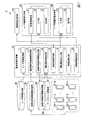
図1は、本発明の実施形態に係る難易度推定システムの機能構成の一例を示す図である。
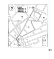
図2は、本発明の実施形態において、評価値が所定の条件を満たす移動経路の表示態様の一例を示す図である。
まず、難易度推定システム1が提供する機能の概要について説明する。
[Embodiment]
The difficulty level estimation system according to the embodiment will be described with reference to FIGS.
FIG. 1 is a diagram illustrating an example of a functional configuration of a difficulty level estimation system according to an embodiment of the present invention.
FIG. 2 is a diagram illustrating an example of a display mode of a moving route whose evaluation value satisfies a predetermined condition in the embodiment of the present invention.
First, an outline of the functions provided by the difficulty level estimation system 1 will be described.
[(機能1)道路の運転難易度の推定]
難易度推定システム1は、道路の運転難易度を推定する。ここで運転難易度とは、道路を走行する車両の運転のしにくさ(又は運転のしやすさ)を示す指標である。例えば、道路に陥没が生じている場所や、歩行者が飛び出し易い場所であると運転難易度が高い(運転が難しい)。運転難易度は、道路の構造等に起因する静的要因と、道路を利用する利用者の状況に起因する動的要因とによって変化する。一例として、静的要因には、道路の構造、道路に関する地物、白線の整備状況、路面の傾斜などが含まれる。動的要因には、車両や歩行者の急な飛び出し、先行車の急ブレーキ、道路上での遊戯などが含まれる。この一例において、動的要因は、曜日や時間帯などの時間的な要素によって発生頻度が変化する性質を有する。
難易度推定システム1は、道路を走行する車両、当該車両の運転者、道路を歩行する歩行者などから種々の情報を収集し、収集した情報に基づいて道路の運転難易度を推定する。また、難易度推定システム1は、運転難易度の要因を分析して、道路の運転難易度を推定する。
なお、難易度推定システム1は、道路の運転難易度を、それぞれの道路について、曜日や時間帯ごとに区分して推定してもよい。
[(Function 1) Estimation of driving difficulty of road]
The difficulty level estimation system 1 estimates a road driving difficulty level. Here, the driving difficulty is an index indicating the difficulty (or ease of driving) of a vehicle traveling on a road. For example, driving difficulty is high (driving is difficult) in a place where a road is depressed or in a place where pedestrians easily jump out. The driving difficulty changes depending on static factors caused by the structure of the road and the like and dynamic factors caused by the situation of the user using the road. As an example, the static factors include a road structure, a feature related to the road, a maintenance state of a white line, a slope of a road surface, and the like. The dynamic factors include a sudden jump of a vehicle or a pedestrian, a sudden braking of a preceding vehicle, a game on a road, and the like. In this example, the dynamic factor has a property that its occurrence frequency changes depending on a temporal element such as a day of the week or a time zone.
The difficulty level estimation system 1 collects various information from a vehicle running on a road, a driver of the vehicle, a pedestrian walking on the road, and the like, and estimates a driving difficulty level of the road based on the collected information. The difficulty level estimation system 1 analyzes the factors of the driving difficulty level and estimates the driving difficulty level of the road.
Note that the difficulty level estimation system 1 may estimate the driving difficulty level of the road by classifying each road by day of the week or time zone.
[(機能1−1)車両の運転状態に基づく道路の運転難易度の推定]
難易度推定システム1は、道路の利用者が所持する携帯端末の位置情報と、当該携帯端末に紐づけられた利用者の属性情報(ユーザ情報)とに基づいて、道路ごと・時間帯ごとの道路利用傾向を算出する。また、難易度推定システム1は、ユーザ情報提供車両50をプローブカーとして利用し、道路の危険要因を取得する。
難易度推定システム1は、算出された道路利用傾向と、ユーザ情報提供車両50から得られた道路の危険要因とを照合して、危険要因が発生した道路ごと・時間帯ごとに、道路の通行者数や通行者の属性分布を抽出する。
難易度推定システム1は、上述のようにして抽出した道路ごと・時間帯ごとの、道路の通行者数や通行者の属性分布をデータセットとして蓄積する。
難易度推定システム1は、これら道路ごと・時間帯ごとに蓄積されたデータセットと、携帯端末の位置情報及び利用者の属性情報とに基づいて、道路の危険度(すなわち、運転難易度)を推定する。
[(Function 1-1) Estimation of Road Driving Difficulty Based on Vehicle Driving State]
The difficulty level estimating system 1 is based on the position information of the mobile terminal possessed by the user of the road and the attribute information (user information) of the user associated with the mobile terminal, for each road and for each time zone. Calculate road usage trends. In addition, the difficulty level estimation system 1 uses the user
The difficulty level estimating system 1 compares the calculated road usage tendency with the risk factor of the road obtained from the user
The difficulty level estimation system 1 accumulates, as a data set, the number of passers-by and the attribute distribution of passers-by for each road and each time zone extracted as described above.
The difficulty level estimation system 1 calculates the danger level of the road (that is, the driving difficulty level) based on the data set accumulated for each road and each time zone, the position information of the mobile terminal, and the attribute information of the user. presume.
[(機能1−2)道路利用者の属性に基づく道路の運転難易度の推定]
難易度推定システム1は、道路の利用者が所持する携帯端末の位置情報と、当該携帯端末に紐づけられた利用者の属性情報(ユーザ情報)とに基づいて、道路ごと・時間帯ごとに算出される道路利用傾向に基づいて、道路の危険度(すなわち、運転難易度)を推定する。
[(Function 1-2) Estimation of Road Driving Difficulty Based on Road User Attributes]
The difficulty level estimating system 1 is provided for each road and for each time zone based on the position information of the portable terminal possessed by the user of the road and the attribute information (user information) of the user associated with the portable terminal. The degree of danger of the road (that is, the degree of difficulty of driving) is estimated based on the calculated road use tendency.
[(機能2)事故リスクが低い移動経路の提示]
難易度推定システム1は、車両の現在地及び目的地に基づいて算出される移動経路候補が複数ある場合に、事故リスクがより低い移動経路を車両の運転者に提示する。
より具体的には、難易度推定システム1は、上述のようにして推定した道路の運転難易度と、車両の現在地及び目的地から算出される複数の移動経路候補とに基づいて、運転難易度を移動経路候補ごとに評価する。難易度推定システム1は、この評価結果に基づいて事故リスクがより低い移動経路を選択し、選択した移動経路を車両の運転者に提示する。
[(Function 2) Presentation of travel route with low accident risk]
When there are a plurality of travel route candidates calculated based on the current location and destination of the vehicle, the difficulty level estimation system 1 presents a travel route with a lower accident risk to the driver of the vehicle.
More specifically, the difficulty estimation system 1 calculates the driving difficulty based on the driving difficulty of the road estimated as described above and a plurality of travel route candidates calculated from the current position and the destination of the vehicle. Is evaluated for each travel route candidate. The difficulty level estimation system 1 selects a traveling route with a lower accident risk based on the evaluation result, and presents the selected traveling route to the driver of the vehicle.
[(機能3)走行経路に基づく保険料の算出]
難易度推定システム1は、車両の移動経路と、道路の運転難易度とに基づいて、道路の運転難易度に応じた保険料を算出する。一例として、難易度推定システム1は、運転難易度が高い(難しい)道路を車両が走行した場合には保険料を高く算出し、運転難易度が低い(易しい)道路を車両が走行した場合には保険料を低く算出する。
[(Function 3) Calculation of insurance premium based on travel route]
The difficulty level estimation system 1 calculates an insurance premium according to the road driving difficulty level based on the vehicle moving route and the road driving difficulty level. As an example, the difficulty level estimation system 1 calculates a high insurance premium when the vehicle travels on a road with a high (difficult) driving difficulty, and calculates a high insurance premium when the vehicle runs on a low (easy) road with a driving difficulty. Calculates the insurance premium low.
[難易度推定システム1の機能構成]
上述した各機能を実現するための難易度推定システム1の機能構成の一例について、以下説明する。
図1に示すように、難易度推定システム1は、難易度推定装置10と、ユーザ情報記憶部20(例えば、個人情報データベース)と、携帯端末移動情報記憶部30(例えば、位置情報データベース)と、道路利用傾向情報記憶部40と、ユーザ情報提供車両50と、ユーザ情報非提供車両60と、保険料算出装置70と、データセット記憶部80とを備える。
[Functional Configuration of Difficulty Estimation System 1]
An example of a functional configuration of the difficulty level estimating system 1 for realizing the above-described functions will be described below.
As shown in FIG. 1, the difficulty level estimation system 1 includes a difficulty
難易度推定装置10は、ユーザ情報取得部11と、携帯端末移動情報取得部12と、道路利用傾向情報生成部13と、運転難易度推定部14と、車両状態取得部15と、運転難易度出力部16と、評価値算出部17と、経路情報配信部18とを備える。
The
[(機能1)道路の運転難易度の推定]
道路の運転難易度の推定機能について説明する。まず、車両の運転状態に基づく道路の運転難易度の推定機能について説明し、次に、道路利用者の属性に基づく道路の運転難易度の推定機能について説明する。
[(Function 1) Estimation of driving difficulty of road]
The function of estimating the degree of difficulty of driving a road will be described. First, the function of estimating the degree of difficulty of driving the road based on the driving state of the vehicle will be described, and then the function of estimating the degree of difficulty of driving the road based on the attributes of the road user will be described.
[(機能1−1)車両の運転状態に基づく道路の運転難易度の推定]
本実施形態の車両の種類には、ユーザ情報提供車両50と、ユーザ情報非提供車両60とがある。ユーザ情報提供車両50とは、難易度推定システム1に対して情報を提供するとともに、難易度推定システム1から情報を取得する車両である。ユーザ情報非提供車両60とは、難易度推定システム1に対して情報を提供することなく、難易度推定システム1から情報を取得する車両である。本機能においては、ユーザ情報提供車両50から提供される情報に基づいて、道路の運転難易度が推定される。
[(Function 1-1) Estimation of Road Driving Difficulty Based on Vehicle Driving State]
The types of vehicles according to the present embodiment include a user
難易度推定システム1は、携帯端末の位置情報及び携帯端末利用者の属性情報に基づいて道路ごと・時間帯ごとの道路利用傾向を算出するとともに、ユーザ情報提供車両50をプローブカーとして利用して道路の危険要因を取得する。
難易度推定システム1は、携帯端末の位置情報及び属性情報から算出された道路利用傾向と、ユーザ情報提供車両50から得られた道路の危険要因とを照合して、危険要因が発生した道路ごと・時間帯ごとに、道路の利用傾向(例えば、通行者数や通行者の属性分布)を算出する。
難易度推定システム1は、上述のようにして算出した道路ごと・時間帯ごとの、道路の通行者数や通行者の属性分布をデータセットとして蓄積する。
難易度推定システム1は、これら道路ごと・時間帯ごとに蓄積されたデータセットと、携帯端末の位置情報及び利用者の属性情報とに基づいて、道路の危険度(すなわち、運転難易度)を推定する。
以下、難易度推定システム1による車両の運転状態に基づく道路の運転難易度の推定機能の詳細について説明する。
The difficulty level estimation system 1 calculates a road use tendency for each road and for each time zone based on the position information of the mobile terminal and the attribute information of the mobile terminal user, and uses the user
The difficulty level estimation system 1 compares the road use tendency calculated from the position information and the attribute information of the portable terminal with the risk factor of the road obtained from the user
The difficulty level estimation system 1 accumulates, as a data set, the number of road passers and the attribute distribution of passers for each road and each time zone calculated as described above.
The difficulty level estimation system 1 calculates the danger level of the road (that is, the driving difficulty level) based on the data set accumulated for each road and each time zone, the position information of the mobile terminal, and the attribute information of the user. presume.
Hereinafter, the details of the function of estimating the driving difficulty of the road based on the driving state of the vehicle by the difficulty estimation system 1 will be described.
[携帯端末移動情報の取得]
携帯端末移動情報記憶部30(位置情報データベース)には、携帯端末(一例として、携帯端末31−1、31−2、…、31−m、32−1、32−2、…、32−n)の位置の移動履歴を示す携帯端末移動情報が記憶される。
具体的には、携帯端末は、GPS等によって得られた自端末の位置を示す位置情報を、所定のタイミングで携帯端末移動情報記憶部30に送信する。この結果、携帯端末移動情報記憶部30には、携帯端末各々の位置情報の時系列データが携帯端末移動情報として記憶される。
なお、携帯端末31−1、31−2、…、31−mは、車両の運転者が携帯しており車両と共に移動する携帯端末の一例である。また、携帯端末32−1、32−2、…、32−nは、歩行者が携帯している携帯端末の一例である。
[Acquisition of mobile terminal movement information]
The portable terminal (for example, portable terminals 31-1, 31-2, ..., 31-m, 32-1, 32-2, ..., 32-n) is stored in the portable terminal movement information storage unit 30 (position information database). The mobile terminal movement information indicating the movement history of the position of ()) is stored.
Specifically, the mobile terminal transmits position information indicating the position of the terminal itself obtained by GPS or the like to the mobile terminal movement
The portable terminals 31-1, 31-2,..., 31-m are examples of portable terminals that are carried by the driver of the vehicle and move with the vehicle. The portable terminals 32-1, 32-2,..., 32-n are examples of portable terminals carried by pedestrians.
携帯端末移動情報取得部12は、各携帯端末についての携帯端末移動情報を携帯端末移動情報記憶部30から取得する。携帯端末移動情報取得部12は、取得した携帯端末移動情報を、道路利用傾向情報生成部13に出力する。
道路利用傾向情報生成部13は、携帯端末の位置に対応する道路(利用道路)を推定する利用道路推定機能と、道路の利用傾向を把握する道路利用傾向把握機能とを有する。
The mobile terminal movement
The road use tendency
[利用道路の推定]
道路利用傾向情報生成部13は、携帯端末移動情報記憶部30に記憶されている携帯端末移動情報と、予め記憶されている地図情報とに基づいて、携帯端末の位置がどの道路に対応しているのかを(すなわち、利用道路を)推定する。
[Estimation of use road]
The road use tendency
具体的には、道路利用傾向情報生成部13は、予め記憶されている地図情報と、携帯端末の移動履歴とを比較するマップマッチングを行い、携帯端末の道路上の位置を携帯端末ごとに推定する。
Specifically, the road use tendency
なお、道路利用傾向情報生成部13は、例えば、単位時間当たりの移動距離が所定の閾値以下である携帯端末については、上述した道路の利用判定の対象から除外してもよい。この場合、道路利用傾向情報生成部13は、例えば、単位時間当たりの移動距離が所定の閾値以下である携帯端末のユーザが道路を利用していないと判定する。
The road usage tendency
また、道路利用傾向情報生成部13は、携帯端末の移動履歴に基づいて、携帯端末の移動速度を算出することにより、携帯端末のユーザの移動手段を判定してもよい。例えば、携帯端末の移動速度が比較的速い場合には、道路利用傾向情報生成部13は、携帯端末が移動中の車両に持ち込まれていると判定する。また例えば、携帯端末の移動速度が比較的遅い場合には、道路利用傾向情報生成部13は、携帯端末が歩行中のユーザに携帯されていると判定する。
Further, the road usage tendency
[道路利用傾向の把握]
道路利用傾向情報生成部13は、上述のようにして推定した携帯端末のユーザの利用道路と、当該携帯端末のユーザ情報とに基づいて道路利用傾向を把握することにより、道路の利用傾向を示す道路利用傾向情報を生成する。
[Understanding road usage trends]
The road use tendency
具体的には、ユーザ情報記憶部20には、携帯端末のユーザの契約情報を含む種々のユーザ情報が記憶されている。ここで、ユーザ情報とは、これらの携帯端末のユーザに関する情報である。ユーザ情報には、例えば、携帯端末のユーザの年齢、性別、携帯端末の契約年数、携帯端末の通信料金の支払状況などが含まれる。
なお、ユーザ情報には、携帯端末の契約情報に関連しない情報が含まれていてもよい。例えば、ユーザ情報には、携帯端末にインストールされているアプリケーションの種類、運転免許の保持年数、運転免許の更新履歴、交通違反や交通事故の履歴、運転免許取得時等に行なわれる性格検査の結果などが含まれていてもよい。また、ユーザ情報には、これらの情報から推測されるユーザの行動特性、運転スキルのレベル、交通マナーのレベルなどが含まれていてもよい。
Specifically, the user
The user information may include information that is not related to the contract information of the mobile terminal. For example, the user information includes the type of application installed on the mobile terminal, the number of years a driver's license has been retained, the history of driver's license updates, the history of traffic violations and traffic accidents, and the results of personality tests performed when a driver's license is obtained. Etc. may be included. Further, the user information may include a behavior characteristic of the user, a driving skill level, a traffic manner level, and the like estimated from the information.
道路利用傾向情報生成部13は、上述のようにして利用道路を推定した携帯端末について、当該携帯端末のユーザ情報を、ユーザ情報取得部11を介してユーザ情報記憶部20から取得する。道路利用傾向情報生成部13は、推定した利用道路と、取得したユーザ情報とを紐づける。道路利用傾向情報生成部13は、複数の携帯端末について、推定した利用道路と、取得したユーザ情報とを紐づけた結果を統計処理することにより、道路におけるユーザの傾向(すなわち、道路利用傾向)を示す道路利用傾向情報を生成する。
The road usage tendency
例えば、道路利用傾向情報には、道路を利用する利用者の時間帯ごとの利用者数が含まれていてもよい。具体的には、道路利用傾向情報生成部13は、携帯端末(例えば、携帯端末31−1、31−2、…、31−m、32−1、32−2、…、32−n)の携帯端末移動情報に基づいて、道路ごと・時間帯ごとの利用者数を道路利用傾向情報として生成する。
For example, the road use tendency information may include the number of users who use the road for each time zone. Specifically, the road use tendency
また、例えば、道路利用傾向情報には、道路を利用する利用者の性別や年代別の利用者数の時間帯ごとの情報が含まれていてもよい。具体的には、道路利用傾向情報生成部13は、携帯端末の携帯端末移動情報に加え、これらの携帯端末のユーザ情報に基づいて、道路利用傾向情報を生成する。この場合、道路利用傾向情報生成部13は、例えば、道路各々の各時間帯における利用者数を男女別、年代別又は行動特性のタイプ別に計数した計数結果を道路利用傾向情報として生成する。
Further, for example, the road usage tendency information may include information on the number of users by gender and age of users who use the road for each time zone. Specifically, the road usage tendency
道路利用傾向情報生成部13は、生成した道路利用傾向情報を道路利用傾向情報記憶部40に記憶させる。
The road use tendency
[車両による道路の危険要因の取得]
次に、ユーザ情報提供車両50による道路の危険要因の取得機能について説明する。
ユーザ情報提供車両50は、車両搭載装置51を備えている。この車両搭載装置51には、例えば加速度センサと、ドライブレコーダとが含まれる。
車両搭載装置51は、加速度センサにより、急ハンドル、急ブレーキ又は路面からの振動などによる車両の加速度の急激な変化を検出する。
車両搭載装置51は、車両の加速度の急激な変化を検出した場合には、ドライブレコーダによる車内外の画像や音声などの情報に基づいて、加速度の急激な変化の要因を判定する。
[Acquisition of road hazards by vehicle]
Next, the function of acquiring the danger factors of the road by the user
The user
The vehicle-mounted
When detecting a rapid change in the acceleration of the vehicle, the vehicle-mounted
車両の加速度の急激な変化の要因には、道路の構造等に起因する静的要因と、道路を利用する利用者の状況に起因する動的要因とがある。上述したように、静的要因には、道路の構造、道路に関する地物、白線の整備状況、路面の傾斜などが含まれる。動的要因には、車両や歩行者の急な飛び出し、先行車の急ブレーキ、道路上での遊戯などが含まれる。
車両搭載装置51は、ドライブレコーダによる車内外の画像や音声などの情報に基づいて、加速度の急激な変化が静的要因によるものか、動的要因によるものかを判定する。例えば、ドライブレコーダによる車外の画像に、道路舗装の亀裂が撮影されている場合には、車両搭載装置51は、加速度の急激な変化が静的要因によると判定する。また、ライブレコーダによる車外の画像に、歩行者の急な飛び出しが撮影されている場合には、車両搭載装置51は、加速度の急激な変化が動的要因によると判定する。
加速度の急激な変化が静的要因による場合には、車両搭載装置51は、加速度の急激な変化が発生した道路上の位置と、危険要因の種類(静的要因)とを紐づけた車両状態情報を生成する。また、加速度の急激な変化が動的要因による場合には、車両搭載装置51は、加速度の急激な変化が発生した道路上の位置と、危険要因の発生時刻と、危険要因の種類(動的要因)とを紐づけた車両状態情報を生成する。
車両搭載装置51は、生成した車両状態情報を難易度推定装置10に対して送信する。
The factors of the rapid change in the acceleration of the vehicle include static factors caused by the structure of the road and the like, and dynamic factors caused by the situation of the user using the road. As described above, the static factors include the structure of the road, features on the road, the maintenance status of the white line, the inclination of the road surface, and the like. The dynamic factors include a sudden jump of a vehicle or a pedestrian, a sudden braking of a preceding vehicle, a game on a road, and the like.
The on-
If the rapid change in acceleration is due to a static factor, the vehicle-mounted
The vehicle-mounted
なお、この一例では、車両搭載装置51は、危険要因の発生を車両の加速度に基づいて判定するものとして説明するが、これに限られない。車両搭載装置51は、車両の速度、エンジン回転数、ブレーキ踏圧、傾斜角度、又はドライブレコーダなどによる車内外の画像の明るさや音声の大きさなどに基づいて危険要因の発生を判定してもよい。
In this example, the vehicle-mounted
[データセットの蓄積]
難易度推定装置10の車両状態取得部15は、ユーザ情報提供車両50の車両搭載装置51が送信する車両状態情報を取得する。車両状態取得部15は、複数のユーザ情報提供車両50のそれぞれから車両状態情報を取得し、取得した車両状態情報に基づいてデータセットを生成する。
車両状態取得部15は、取得した車両状態情報が「静的要因」である場合には、静的要因の発生回数を道路ごとに集計し、集計した結果をデータセットとしてデータセット記憶部80に記憶させる。
車両状態取得部15は、取得した車両状態情報が「動的要因」である場合には、動的要因の発生した道路上の位置と発生時刻とを検索キーにして、道路利用傾向情報記憶部40に記憶されている道路利用傾向情報を検索する。車両状態取得部15は、検索の結果として得られる道路利用傾向情報が示す道路利用者の数(例えば、道路を通行する通行人の数)や、道路利用者の属性(例えば、性別、年代又は行動特性のタイプ)と、車両状態情報が示す道路・時間帯とを対応付けて、データセットとしてデータセット記憶部80に記憶させる。これにより、データセット記憶部80には、危険要因が発生した道路ごと・時間帯ごとの道路利用者の数の分布や道路利用者の属性の分布が蓄積される。
[Dataset accumulation]
The vehicle
When the acquired vehicle state information is “static factors”, the vehicle
When the acquired vehicle state information is a “dynamic factor”, the vehicle
[運転難易度の推定]
運転難易度推定部14は、データセット記憶部80に記憶されているデータセットに基づいて、道路利用傾向情報が示す道路の利用状況における道路の運転難易度を推定する。
上述したように、データセット記憶部80に記憶されているデータセットには、「静的要因」についての集計結果と、「動的要因」についての集計結果とが記憶されている。
[Estimation of driving difficulty]
The driving
As described above, the data set stored in the data
運転難易度推定部14は、「静的要因」のデータセットについては、静的要因の発生回数に基づいて、道路の運転難易度を算出する。
また、運転難易度推定部14は、「動的要因」のデータセットについては、重回帰分析などの多変量解析手法を適用して、道路の運転難易度を算出する。
道路利用傾向情報の一例としては、道路各々の各時間帯における利用者数をユーザの年代別に計測した情報である。ユーザ情報提供車両50の走行がなく、一部の時間帯もしくは全ての時間帯のデータが存在しない道路でも、多変量解析を適用してデータが存在しない部分の危険要因が発生した回数を推定し、難易度を推定する。
次に、運転難易度推定部14が多変量解析を適用して難易度を推定する具体例について説明する。
The driving
The driving
An example of the road use tendency information is information obtained by measuring the number of users in each time zone of each road according to the age of the user. Even on a road where the user
Next, a specific example in which the driving
運転難易度推定部14は、道路利用傾向情報生成部13から、年代別の歩行者数及び運転者年代別の車両数を取得する。
75歳以上の歩行者数をx1、75歳以上が運転する車両数をx2、65歳以上75歳未満の歩行者数をx3、65歳以上75歳未満が運転する車両数をx4、10歳未満の歩行者数をx5とする。x1、x2、x3、x4及びx5は、説明変数である。また、動的な危険要因が発生した回数をyとする。このyは、目的変数である。運転難易度推定部14は、これらを解き、重回帰式「y=b0+b1x1+b2x2+b3x3+b4x4+b5x5」を導出する。運転難易度推定部14は、この重回帰式に道路の任意の時間帯におけるx1〜x5の値を代入することにより、当該道路の所定の時間帯における危険要因発生のデータ計測が欠けている場合でも、当該道路における運転の難易度を推定することができる。
また、難易度y3は、静的な危険要因による難易度y1、動的な危険要因による難易度y2を使用した式「y3=c1y1+c2y2」により表現される。ここで、c1、c2は、重みであり、一律に1と設定されても、危険要因の発生確率等により適宜調整されてもよい。
なお、運転難易度推定部14は、難易度を、道路の単位長さによって正規化した値として推定してもよい。
また、多変量解析としては、例示した重回帰分析の他に、主成分分析、独立成分分析、因子分析、判別分析、クラスター分析、コンジョイント分析、多次元尺度構成法が適用されてもよい。
The driving
The number of pedestrians aged 75 and over is x1, the number of vehicles driven by aged 75 and over is x2, the number of pedestrians aged 65 and under is x3, and the number of vehicles driven by a person over 65 and under x4 is 10 Let the number of pedestrians less than x5 be x5. x1, x2, x3, x4 and x5 are explanatory variables. The number of occurrences of a dynamic risk factor is defined as y. This y is an objective variable. The driving
Further, the difficulty y3 is expressed by an expression “y3 = c1y1 + c2y2” using the difficulty y1 due to a static risk factor and the difficulty y2 due to a dynamic risk factor. Here, c1 and c2 are weights, and may be uniformly set to 1, or may be appropriately adjusted according to the probability of occurrence of a risk factor.
Note that the driving
As the multivariate analysis, in addition to the multiple regression analysis illustrated above, a principal component analysis, an independent component analysis, a factor analysis, a discriminant analysis, a cluster analysis, a conjoint analysis, or a multidimensional scaling method may be applied.
[(機能1−2)道路利用者の属性に基づく道路の運転難易度の推定]
次に、道路利用者の属性に基づく道路の運転難易度の推定について説明する。上述したように、難易度推定システム1は、道路の利用者が所持する携帯端末の位置情報と、当該携帯端末に紐づけられた利用者の属性情報(ユーザ情報)とに基づいて、道路の運転難易度を推定する。以下、具体的な一例について説明する。
[(Function 1-2) Estimation of Road Driving Difficulty Based on Road User Attributes]
Next, estimation of the driving difficulty of the road based on the attribute of the road user will be described. As described above, the difficulty level estimating system 1 uses the road information based on the location information of the mobile terminal possessed by the user of the road and the attribute information (user information) of the user associated with the mobile terminal. Estimate the driving difficulty. Hereinafter, a specific example will be described.
運転難易度推定部14は、道路利用傾向情報生成部13が生成する道路利用傾向情報に基づいて、道路における運転の難易度を推定する。
例えば、小学校の下校の時間帯において6歳から12歳の年代の人が歩行中に車道に飛び出す頻度が高いという統計結果が得られている場合がある。
この場合、近隣に小学校がある道路において、15時から17時の間に、6歳から12歳の人が、30人、当該道路を利用していることが道路利用傾向情報により示されている場合には、この道路は他の道路に比べて危険度(すなわち、運転難易度)が高いと考えられる。この場合、運転難易度推定部14は、道路利用傾向情報に基づいて、当該道路の運転の難易度を「高」と推定する。
The driving
For example, in some cases, a statistical result is obtained in which a person aged 6 to 12 years old frequently jumps out of a roadway while walking during elementary school lower school hours.
In this case, between 15 and 17 o'clock on a road where an elementary school is nearby, 30 people between the ages of 6 and 12 use the road usage tendency information and indicate that 30 people are using the road. It is considered that this road has a higher degree of danger (that is, driving difficulty) than other roads. In this case, the driving
また、例えば、繁華街の夜間の時間帯において30歳から39歳の年代の人が車道にまではみ出して歩行するなどの交通マナーに反する行動をとる頻度が高いという統計結果が得られている場合がある。
この場合、繁華街において、22時から24時の間に、30歳から39歳の人が、100人、当該道路を利用していることが道路利用傾向情報により示されている場合には、この道路は、危険度が高いと考えられる。また、この道路の危険度は、上述した学校帰りの子どもの飛び出し等の発生頻度が高い道路の危険度に比べると低いと考えられる。この場合、運転難易度推定部14は、道路利用傾向情報に基づいて、当該道路の運転の難易度を「中」と推定する。
Also, for example, in a case where a statistical result is obtained that, during the nighttime of a downtown area, a person aged between 30 and 39 years old frequently acts against traffic manners such as protruding into a roadway and walking. There is.
In this case, in the downtown area, between 22:00 and 24:00, 100 people aged 30 to 39 use the road. Is considered to be highly dangerous. In addition, the risk of this road is considered to be lower than the risk of a road in which the frequency of occurrence of jumping out of a child returning from school is high. In this case, the driving
また、例えば、昼間の時間帯において40歳から49歳の年代の人が交通マナーに反する行動をとる頻度が低いという統計結果が得られている場合がある。
この場合、12時から13時の間に、40歳から49歳の人が、50人、当該道路を利用していることが道路利用傾向情報により示されている場合には、この道路は、他の道路に比べて危険度が低いと考えられる。この場合、運転難易度推定部14は、道路利用傾向情報に基づいて、当該道路の運転の難易度を「低」と推定する。
In addition, for example, in the daytime, a statistical result may be obtained in which people aged between 40 and 49 are less likely to take actions that violate traffic manners.
In this case, between 12 o'clock and 13 o'clock, if the road usage tendency information indicates that 50 people aged 40 to 49 are using the road, this road is not used for other roads. It is considered that the degree of risk is lower than that of roads. In this case, the driving
なお、運転の難易度は、「高」、「中」及び「低」の三段階だけではなく、二段階又は四以上の段階に分けられていてもよいし、連続的な数値で表されていてもよい。 The driving difficulty is not limited to three stages of “high”, “medium” and “low”, but may be divided into two stages or four or more stages, and is represented by a continuous numerical value. You may.
運転難易度推定部14は、上述のようにして推定した運転の難易度を運転難易度出力部16に出力する。
運転難易度出力部16は、運転難易度推定部14が推定した運転の難易度をユーザ情報提供車両50、ユーザ情報非提供車両60、又は保険料算出装置70に出力する。
The driving
The driving difficulty
[(機能2)事故リスクが低い移動経路の提示]
次に、事故リスクが低い移動経路の提示機能について説明する。
ユーザ情報提供車両50及びユーザ情報非提供車両60は、それぞれ入力部(入力部52、入力部62)と、表示部(表示部53、表示部63)とを備えている。なお、本機能の説明において、ユーザ情報非提供車両60の入力部62及び表示部63は、ユーザ情報提供車両50の入力部52及び表示部53と同一の機能を有しているため、入力部52及び表示部53についてのみ説明し、入力部62及び表示部63の説明は省略する。
[(Function 2) Presentation of travel route with low accident risk]
Next, the function of presenting a traveling route with a low accident risk will be described.
The user
ユーザ情報提供車両50は、入力部52と、表示部53とを備える。
表示部53は、この一例では、ユーザ情報提供車両50が備えるカーナビゲーションシステム(不図示)のディスプレイであり、ユーザ情報提供車両50が走行する経路の候補等を表示する。
入力部52は、この一例では、カーナビゲーションシステム(不図示)への指示を示す情報を入力するために使用されるボタン、タッチパネルを備える。この一例では、入力部52には、車両の移動の目的地を示す目的情報が入力される。
入力部52は、入力された目的地情報をカーナビゲーションシステム(不図示)に出力する。
カーナビゲーションシステム(不図示)は、目的地情報が示す目的地Gと、車両の現在位置(出発地S)とに基づいて、出発地Sから目的地Gまでの移動経路の候補を複数算出し、算出した移動経路の複数の候補を表示部53に表示させる。また、カーナビゲーションシステム(不図示)は、算出した移動経路の複数の候補を、評価値算出部17に出力する。
算出された移動経路の複数の候補の一例を図2に示す。なお、移動経路の候補は、図2に示した移動経路R1、R2及びR3以外の候補を含んでいてもよい。
The user
In this example, the
In this example, the
The
The car navigation system (not shown) calculates a plurality of travel route candidates from the departure point S to the destination G based on the destination G indicated by the destination information and the current position (departure point S) of the vehicle. The
FIG. 2 shows an example of a plurality of calculated travel route candidates. It should be noted that the candidates for the travel route may include candidates other than the travel routes R1, R2, and R3 shown in FIG.
評価値算出部17は、移動経路の候補に含まれるそれぞれの道路について、当該道路の運転難易度を、道路ごとに運転難易度推定部14に推定させる。
評価値算出部17は、運転難易度推定部14が推定した道路ごとの運転の難易度に基づいて、カーナビゲーションシステム(不図示)が算出した移動経路の複数の候補それぞれの評価値を算出する。評価値算出部17が算出する評価値は、時間帯、曜日又はユーザの属性情報ごとに算出されてもよく、移動経路の全行程における運転の難易度を総合的に考慮して算出される。例えば、評価値は、移動経路の全行程に亘って移動経路の単位長さ当たり又は所定区間ごとの難易度を合計した値とされてもよい。
The evaluation
The evaluation
経路情報配信部18は、移動経路の候補のうち、評価値が所定の条件を満たす移動経路を示す経路情報をユーザ情報提供車両50に配信する。これを受けて、表示部53は、例えば、図2に示すように、地図と合わせて移動経路R1、R2及びR3それぞれを一点鎖線、破線及び実線で表示し、移動経路R1、R2及びR3それぞれの評価値「20」、「15」及び「10」を表示する。
The route
なお、評価値算出部17は、難易度に基づいて、車両搭載装置51が搭載されているユーザ情報提供車両50だけではなく、車両搭載装置51が搭載されないユーザ情報非提供車両60が出発地Sから目的地Gまで移動する移動経路の候補の評価値を算出してもよい。ここで、ユーザ情報非提供車両60は、難易度推定装置10に自身の車両の状態を示す情報を送信しない車両であり、入力部62と、表示部63とを備える。入力部62及び表示部63は、ユーザ情報提供車両50が備える入力部52及び表示部53と同様である。この場合、経路情報配信部18は、移動経路の候補のうち、評価値が所定の条件を満たす移動経路を示す経路情報をユーザ情報非提供車両60に配信する。なお、この場合における目的地Gの入力方法、評価値の算出方法は、ユーザ情報提供車両50の場合と同様である。
The evaluation
[(機能3)走行経路に基づく保険料の算出]
次に、走行経路に基づく保険料の算出機能について説明する。
保険料算出装置70は、ユーザ情報提供車両50及びユーザ情報非提供車両60が出発地Sから目的地Gまで実際に走行した移動経路の評価値に基づいて保険料を算出する。例えば、移動経路における運転が困難である程、評価値が大きくなる場合、保険料算出装置70は、評価値が大きな移動経路を走行する程、高額な保険料を算出する。
[(Function 3) Calculation of insurance premium based on travel route]
Next, the function of calculating the insurance premium based on the travel route will be described.
The insurance
[難易度推定システムの動作]
次に、図3及び図4を参照しながら実施形態に係る難易度推定システムの動作の一例を説明する。
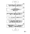
図3は、本発明の実施形態に係る難易度推定装置が実行する処理の一例を示すフローチャートである。
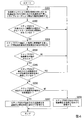
図4は、本発明の実施形態に係る車両状態取得部が車両搭載装置からユーザ情報提供車両の状態を示す情報を取得する処理の一例を示すフローチャートである。また、次に説明する例では、道路利用者情報は、予め取得されているビッグデータであると想定する。
[Operation of the difficulty level estimation system]
Next, an example of the operation of the difficulty level estimation system according to the embodiment will be described with reference to FIGS.
FIG. 3 is a flowchart illustrating an example of a process executed by the difficulty level estimation device according to the embodiment of the present invention.
FIG. 4 is a flowchart illustrating an example of a process in which the vehicle state acquisition unit according to the embodiment of the present invention acquires information indicating the state of the user information providing vehicle from the on-board device. In the example described below, it is assumed that the road user information is big data acquired in advance.
ステップS10において、道路利用傾向情報生成部13は、複数の携帯端末から取得された道路利用者情報に基づいて、道路が利用される傾向を示す道路利用傾向情報を生成する。
In step S10, the road use tendency
ステップS20において、難易度推定システム1は、ユーザ情報提供車両からユーザ情報提供車両の状態を示す情報を取得する。例えば、難易度推定システム1は、ステップS20において図4に示した方法を実行する。 In step S20, the difficulty level estimation system 1 acquires information indicating the state of the user information providing vehicle from the user information providing vehicle. For example, the difficulty level estimation system 1 executes the method shown in FIG. 4 in step S20.
ステップS201において、ユーザ情報提供車両50は、加速度センサにより車両の前後方向における加速度及び左右方向における加速度を計測し、ドライブレコーダにより周辺の動画を撮影する。
In step S201, the user
ステップS202において、車両状態取得部15は、ステップS201で計測された二種類の加速度の少なくとも一方が所定の閾値を超えているか否かを判定する。この閾値は、例えば、潜在的な危険事象であるヒヤリハットを指標としており、前後方向における加速度について0.3Gが設定され、左右方向における加速度について0.22Gが設定される。車両状態取得部15は、ステップS201で計測された二種類の加速度の少なくとも一方が所定の閾値を超えていると判定した場合(ステップS202:Yes)、処理をステップS203に進め、ステップS201で計測された二種類の加速度がいずれも所定の閾値を超えていないと判定した場合(ステップS202:No)、処理をステップS201に戻す。
In step S202, the vehicle
ステップS203において、車両状態取得部15は、ステップS201で撮影した動画に画像解析を施し、ユーザ情報提供車両50の危険要因の抽出を試みる。
In step S203, the vehicle
ステップS204において、車両状態取得部15は、ステップS203において危険要因が抽出された否かを判定する。車両状態取得部15は、ステップS203において危険要因が抽出されたと判定した場合(ステップS204:Yes)、処理をステップS205に進め、ステップS203において危険要因が抽出されていないと判定した場合(ステップS204:No)、処理をステップS201に戻す。
In step S204, the vehicle
ステップS205において、車両状態取得部15は、ステップS203で抽出された危険要因がユーザ情報提供車両自身に起因しているか否かを判定する。ここで、ユーザ情報提供車両50自身に起因している危険要因とは、例えば、乱暴に運転していることに起因している危険要因、加速度センサの外れ値に起因するため実質的には危険要因といえない事象である。車両状態取得部15は、ステップS203で抽出された危険要因がユーザ情報提供車両自身に起因していると判定した場合(ステップS205:Yes)、処理をステップS201に戻し、ステップS203で抽出された危険要因がユーザ情報提供車両自身に起因していないと判定した場合(ステップS205:No)、処理をステップS206に進める。
In step S205, the vehicle
ステップS206において、車両状態取得部15は、ステップS203で抽出された危険要因が動的な危険要因であるか否かを判定する。車両状態取得部15は、ステップS203で抽出された危険要因が動的な危険要因(つまり、動的要因)であると判定した場合(ステップS206:Yes)、処理をステップS207に進め、ステップS203で抽出された危険要因が動的な危険要因でない(つまり、静的要因である)と判定した場合(ステップS206:No)、処理をステップS208に進める。
In step S206, the vehicle
ステップS207において、車両状態取得部15は、ステップS203で抽出された危険要因(動的要因)を道路及び発生時刻と紐付けて取得し、処理を図3に示したステップS30に進める。
In step S207, the vehicle
ステップS208において、車両状態取得部15は、ステップS203で抽出された危険要因(静的要因)を道路と紐付けて取得し、処理を図3に示したステップS30に進める。
In step S208, the vehicle
図3に戻って、ステップS30において、運転難易度推定部14は、道路利用傾向情報及び車両の状態を示す情報に基づいて、道路における運転の難易度を推定する。
Returning to FIG. 3, in step S30, the driving
ステップS40において、運転難易度出力部16は、ステップS30で推定された難易度を評価値算出部17に出力する。
In step S40, the driving difficulty
ステップS50において、評価値算出部17は、ステップS30で推定された難易度に基づいて、ユーザ情報提供車両が出発地から目的地まで移動する経路の候補の評価値を算出する。
In step S50, the evaluation
ステップS60において、経路情報配信部18は、移動経路の候補のうち、ステップS50で算出された評価値が所定の条件を満たす移動経路を示す経路情報をユーザ情報提供車両に配信する。
In step S60, the route
以上、実施形態に係る難易度推定システム1について説明した。難易度推定装置10は、複数の携帯端末から取得された道路利用者情報に基づいて、道路が利用される傾向を示す道路利用傾向情報を生成し、道路利用傾向情報に基づいて、道路における運転の難易度を推定する。これにより、難易度推定装置10は、車両保険の加入者が車両を運転する道路における運転の難易度を把握することができる。
The difficulty level estimation system 1 according to the embodiment has been described above. The difficulty
また、難易度推定装置10は、ユーザ情報提供車両50からユーザ情報提供車両50の車両の状態を示す情報を取得し、道路利用傾向情報に加え、車両の状態を示す情報に基づいて難易度を推定する。これにより、難易度推定装置10は、車両の状態を踏まえて更に正確に難易度を推定することができる。
Further, the difficulty
また、難易度推定装置10は、ユーザ情報提供車両50の車両の状態と道路においてユーザ情報提供車両50が遭遇する危険要因とを対応付けた危険要因別車両状態データに基づいて、危険要因が道路に存在する車両又は歩行者に起因するものであるか否かを示す情報を取得し、これに基づいて難易度を推定する。これにより、難易度推定装置10は、道路の勾配、道路の整備状況、道路標識の視認性等の静的な危険要因のみを取得して難易度を推定する場合に比べ、道路に存在する車両及び歩行者の時間帯及び属性情報ごとの数等の動的な危険要因を考慮する分、より正確に難易度を推定することができる。
Further, the difficulty
また、難易度推定装置10は、道路利用傾向情報に多変量解析を適用することにより、道路利用傾向情報の一部の計数値が少ない又は情報が存在しない場合でも、計数値が少ない部分又は計数値が存在しない部分の携帯端末移動情報を推定し、難易度を推定することができる。
Further, the
また、難易度推定装置10は、難易度に基づいて、ユーザ情報提供車両50が出発地Sから目的地Gまで移動する移動経路の候補の評価値を算出し、移動経路の候補のうち、評価値が所定の条件を満たす移動経路R1、R2及びR3を示す経路情報をユーザ情報提供車両50に配信する。これにより、難易度推定装置10は、ユーザ情報提供車両50の運転者に複数のルート及び各ルートの評価値を提示することができる。さらに、これらは、ユーザ情報非提供車両60についても同様である。
Further, the difficulty
また、上述した各装置は、内部にコンピュータを有している。そして、上述した各処理の過程は、プログラム形式でコンピュータにより読み取り可能な記録媒体に記憶されており、このプログラムをコンピュータが読み出して実行することにより実行される。ここでコンピュータにより読み取り可能な記録媒体は、例えば、磁気ディスク、光磁気ディスク、CD−ROM、DVD−ROM、半導体メモリである。また、通信回線を経由してこのプログラムをコンピュータに配信し、コンピュータにこのプログラムを実行させてもよい。 Each of the above-described devices has a computer inside. The processes of the above-described processes are stored in a computer-readable recording medium in the form of a program, and are executed when the computer reads and executes the program. Here, the recording medium readable by the computer is, for example, a magnetic disk, a magneto-optical disk, a CD-ROM, a DVD-ROM, or a semiconductor memory. Alternatively, the program may be distributed to a computer via a communication line, and the computer may execute the program.
また、上述したプログラムは、上述した機能の一部を実現するためのものであってもよい。さらに、上述した機能をコンピュータシステムに予め記録されているプログラムとの組み合わせで実現できるもの、いわゆる差分プログラムであってもよい。 Further, the above-described program may be for realizing a part of the above-described functions. Furthermore, a program that can realize the above-described functions in combination with a program recorded in a computer system in advance, that is, a so-called difference program may be used.
以上、本発明の実施形態を説明したが、実施形態は、あくまで例示であり、発明の範囲を限定することを意図するものではない。本実施形態は、その他の様々な形態で実施されることが可能であり、発明の要旨を逸脱しない範囲で、種々の省略、置き換え、変更を行うことができる。これら実施形態やその変形は、発明の範囲や要旨に含まれると同時に、特許請求の範囲に記載された発明とその均等の範囲に含まれるものである。 The embodiment of the present invention has been described above, but the embodiment is merely an example and is not intended to limit the scope of the invention. The present embodiment can be implemented in other various forms, and various omissions, replacements, and changes can be made without departing from the spirit of the invention. These embodiments and their modifications are included in the scope and gist of the invention, and are also included in the invention described in the claims and their equivalents.
1…難易度推定システム、10…難易度推定装置、11…ユーザ情報取得部、12…携帯端末移動情報取得部、13…道路利用傾向情報生成部、14…運転難易度推定部、15…車両状態取得部、16…運転難易度出力部、17…評価値算出部、18…経路情報配信部、20…ユーザ情報記憶部、30…携帯端末移動情報記憶部、31−1,31−2,…,31−m,32−1,32−2,…,32−n…携帯端末、40…道路利用傾向情報記憶部、50…ユーザ情報提供車両、51…車両搭載装置、52…入力部、53…表示部、60…ユーザ情報非提供車両、62…入力部、63…表示部、70…保険料算出装置、C…シンボル、G…目的地、R1,R2,R3…移動経路、S…出発地 DESCRIPTION OF SYMBOLS 1 ... Difficulty estimation system, 10 ... Difficulty estimation apparatus, 11 ... User information acquisition part, 12 ... Mobile terminal movement information acquisition part, 13 ... Road use tendency information generation part, 14 ... Driving difficulty estimation part, 15 ... Vehicle State acquisition unit, 16: driving difficulty output unit, 17: evaluation value calculation unit, 18: route information distribution unit, 20: user information storage unit, 30: mobile terminal movement information storage unit, 31-1, 31-2, ..., 31-m, 32-1, 32-2, ..., 32-n ... portable terminal, 40 ... road use tendency information storage unit, 50 ... user information providing vehicle, 51 ... vehicle mounted device, 52 ... input unit, 53 display unit, 60 user information non-providing vehicle, 62 input unit, 63 display unit, 70 insurance premium calculation device, C symbol, G destination, R1, R2, R3 travel route, S Point of departure
Claims (9)
前記携帯端末移動情報に基づいて、道路が利用される傾向を示す道路利用傾向情報を生成する道路利用傾向情報生成部と、
前記道路利用傾向情報に基づいて、前記道路における運転の難易度を推定する運転難易度推定部と、
を備える難易度推定装置。 A mobile terminal movement information obtaining unit that obtains mobile terminal movement information including a mobile terminal movement history;
Based on the mobile terminal movement information, a road use tendency information generation unit that generates road use tendency information indicating a tendency of road use,
A driving difficulty estimating unit that estimates a driving difficulty of the road based on the road use tendency information;
A difficulty level estimating device comprising:
前記道路利用傾向情報生成部は、前記携帯端末移動情報に加え、前記ユーザ情報に基づいて、前記道路利用傾向情報を生成する、
請求項1に記載の難易度推定装置。 Further comprising a user information acquisition unit for acquiring user information of the mobile terminal,
The road use tendency information generating unit generates the road use tendency information based on the user information, in addition to the mobile terminal movement information,
The difficulty level estimation device according to claim 1.
前記運転難易度推定部は、前記道路利用傾向情報に加え、前記車両状態を示す情報に基づいて、前記難易度を推定する、
請求項1又は請求項2に記載の難易度推定装置。 The apparatus further includes a vehicle state obtaining unit that obtains information indicating a vehicle state of the user information providing vehicle from the user information providing vehicle,
The driving difficulty estimation unit estimates the difficulty based on information indicating the vehicle state, in addition to the road use tendency information,
The difficulty level estimation device according to claim 1 or 2.
請求項3に記載の難易度推定装置。 The driving difficulty estimating unit, based on the information indicating the vehicle state of each factor associated with the vehicle state of the user information providing vehicle and the factor of the situation encountered by the user information providing vehicle on the road, Estimating the driving difficulty estimating unit,
The difficulty level estimation device according to claim 3.
請求項1から請求項4のいずれか一項に記載の難易度推定装置。 The driving difficulty estimation unit estimates the difficulty by applying a multivariate analysis to the road use tendency information,
The difficulty level estimating device according to any one of claims 1 to 4.
前記移動経路の候補のうち、前記評価値が所定の条件を満たす前記移動経路を示す経路情報を前記ユーザ情報提供車両に配信する経路情報配信部と、
を更に備える請求項1から請求項5のいずれか一項に記載の難易度推定装置。 An evaluation value calculation unit configured to calculate an evaluation value of a candidate of a movement route on which the user information providing vehicle moves from a departure place to a destination based on the difficulty level;
A route information distribution unit that distributes, to the user information providing vehicle, route information indicating the travel route that satisfies a predetermined condition, among the travel route candidates;
The difficulty estimation device according to any one of claims 1 to 5, further comprising:
前記移動経路の候補のうち、前記評価値が所定の条件を満たす前記移動経路を示す経路情報を前記ユーザ情報非提供車両に配信する経路情報配信部と、
を更に備える請求項1から請求項5のいずれか一項に記載の難易度推定装置。 For a user information non-providing vehicle that does not provide the vehicle state to the difficulty estimating device, an evaluation value of a candidate for a movement route that moves from the departure point to the destination of the user information non-providing vehicle is determined based on the difficulty level. An evaluation value calculation unit to calculate;
A route information distribution unit that distributes route information indicating the travel route that satisfies a predetermined condition to the user information non-providing vehicle, among the travel route candidates,
The difficulty estimation device according to any one of claims 1 to 5, further comprising:
前記携帯端末移動情報に基づいて、道路が利用される傾向を示す道路利用傾向情報を生成する道路利用傾向情報生成ステップと、
前記道路利用傾向情報に基づいて、前記道路における運転の難易度を推定する運転難易度推定ステップと、
を含む難易度推定方法。 A mobile terminal movement information obtaining step of obtaining mobile terminal movement information including a mobile terminal movement history;
A road use tendency information generating step of generating road use tendency information indicating a tendency to use a road based on the mobile terminal movement information;
A driving difficulty estimation step of estimating a driving difficulty on the road based on the road use tendency information;
Difficulty level estimation method.
携帯端末の移動履歴を含む携帯端末移動情報を取得する携帯端末移動情報取得機能と、
前記携帯端末移動情報に基づいて、道路が利用される傾向を示す道路利用傾向情報を生成する道路利用傾向情報生成機能と、
前記道路利用傾向情報に基づいて、前記道路における運転の難易度を推定する運転難易度推定機能と、
を実現させるためのコンピュータプログラム。 On the computer,
A mobile device movement information acquisition function for obtaining mobile device movement information including a movement history of the mobile device;
A road use tendency information generating function of generating road use tendency information indicating a tendency of road use based on the mobile terminal movement information;
A driving difficulty estimation function for estimating a driving difficulty on the road based on the road use tendency information;
A computer program for realizing.
Priority Applications (1)
| Application Number | Priority Date | Filing Date | Title |
|---|---|---|---|
| JP2018183914A JP6949799B2 (en) | 2018-09-28 | 2018-09-28 | Difficulty estimation device, difficulty estimation method and computer program |
Applications Claiming Priority (1)
| Application Number | Priority Date | Filing Date | Title |
|---|---|---|---|
| JP2018183914A JP6949799B2 (en) | 2018-09-28 | 2018-09-28 | Difficulty estimation device, difficulty estimation method and computer program |
Publications (2)
| Publication Number | Publication Date |
|---|---|
| JP2020052905A true JP2020052905A (en) | 2020-04-02 |
| JP6949799B2 JP6949799B2 (en) | 2021-10-13 |
Family
ID=69997375
Family Applications (1)
| Application Number | Title | Priority Date | Filing Date |
|---|---|---|---|
| JP2018183914A Active JP6949799B2 (en) | 2018-09-28 | 2018-09-28 | Difficulty estimation device, difficulty estimation method and computer program |
Country Status (1)
| Country | Link |
|---|---|
| JP (1) | JP6949799B2 (en) |
Cited By (2)
| Publication number | Priority date | Publication date | Assignee | Title |
|---|---|---|---|---|
| CN114495549A (en) * | 2020-10-23 | 2022-05-13 | 丰田自动车株式会社 | Information processing device, information processing method, and vehicle |
| JPWO2022123777A1 (en) * | 2020-12-11 | 2022-06-16 |
Citations (6)
| Publication number | Priority date | Publication date | Assignee | Title |
|---|---|---|---|---|
| JP2011081608A (en) * | 2009-10-07 | 2011-04-21 | Ntt Docomo Inc | Device and method for estimating dangerous place |
| JP2012117829A (en) * | 2010-11-29 | 2012-06-21 | Denso Corp | Prediction device |
| JP2014154004A (en) * | 2013-02-12 | 2014-08-25 | Fujifilm Corp | Danger information processing method, device and system, and program |
| JP2015076079A (en) * | 2013-10-11 | 2015-04-20 | パイオニア株式会社 | Use purpose estimation system, terminal equipment, use purpose estimation method, and program |
| JP2015219155A (en) * | 2014-05-19 | 2015-12-07 | 日産自動車株式会社 | Detour information providing device |
| JP2016192119A (en) * | 2015-03-31 | 2016-11-10 | パイオニア株式会社 | Information processing apparatus, moving body device, information processing method, information processing system and program for information processing, and recording medium |
-
2018
- 2018-09-28 JP JP2018183914A patent/JP6949799B2/en active Active
Patent Citations (6)
| Publication number | Priority date | Publication date | Assignee | Title |
|---|---|---|---|---|
| JP2011081608A (en) * | 2009-10-07 | 2011-04-21 | Ntt Docomo Inc | Device and method for estimating dangerous place |
| JP2012117829A (en) * | 2010-11-29 | 2012-06-21 | Denso Corp | Prediction device |
| JP2014154004A (en) * | 2013-02-12 | 2014-08-25 | Fujifilm Corp | Danger information processing method, device and system, and program |
| JP2015076079A (en) * | 2013-10-11 | 2015-04-20 | パイオニア株式会社 | Use purpose estimation system, terminal equipment, use purpose estimation method, and program |
| JP2015219155A (en) * | 2014-05-19 | 2015-12-07 | 日産自動車株式会社 | Detour information providing device |
| JP2016192119A (en) * | 2015-03-31 | 2016-11-10 | パイオニア株式会社 | Information processing apparatus, moving body device, information processing method, information processing system and program for information processing, and recording medium |
Cited By (3)
| Publication number | Priority date | Publication date | Assignee | Title |
|---|---|---|---|---|
| CN114495549A (en) * | 2020-10-23 | 2022-05-13 | 丰田自动车株式会社 | Information processing device, information processing method, and vehicle |
| JPWO2022123777A1 (en) * | 2020-12-11 | 2022-06-16 | ||
| WO2022123777A1 (en) * | 2020-12-11 | 2022-06-16 | 日本電気株式会社 | Driver evaluation device, insurance fee calculation system, method, and computer-readable medium |
Also Published As
| Publication number | Publication date |
|---|---|
| JP6949799B2 (en) | 2021-10-13 |
Similar Documents
| Publication | Publication Date | Title |
|---|---|---|
| JP7295036B2 (en) | Use of telematics data to identify trip types | |
| US11175152B2 (en) | Method and system for risk determination of a route | |
| JP5900454B2 (en) | Vehicle lane guidance system and vehicle lane guidance method | |
| JP4437556B2 (en) | Feature information collecting apparatus and feature information collecting method | |
| US10883850B2 (en) | Additional security information for navigation systems | |
| US20200286183A1 (en) | Information processing apparatus, and information processing method, and program | |
| US10967872B2 (en) | Methods and systems for presenting collected driving data | |
| JP7413503B2 (en) | Evaluating vehicle safety performance | |
| JP2008242674A (en) | Traffic information system | |
| JP2009031046A (en) | Fuel consumption estimation system of automobile, route searching system, and driving guiding system | |
| JP2016057836A (en) | Mobile object analysis system and mobile object directional axis estimation method | |
| JP6949799B2 (en) | Difficulty estimation device, difficulty estimation method and computer program | |
| Jones et al. | Parkus 2.0: Automated cruise detection for parking availability inference | |
| JP2020008436A (en) | Route information assistance device and route information assistance system | |
| JP2014066655A (en) | Route search device and route search method | |
| JP6303795B2 (en) | Route search system and route search method | |
| Ustun et al. | Speed estimation using smartphone accelerometer data | |
| JP5919614B2 (en) | Information processing apparatus and computer program for electric vehicle | |
| JP6447269B2 (en) | Trigger condition determining program, trigger condition determining method, and trigger condition determining apparatus | |
| JP6678476B2 (en) | Travel route estimation device and travel route estimation method | |
| JP6504031B2 (en) | Risk information storage device | |
| JP7391550B2 (en) | Information processing device, information processing method and program | |
| JP2006023886A (en) | Traffic information system | |
| JP6306631B2 (en) | Information processing device, information processing system, server, information processing method, information processing program, and terminal device | |
| JP6554999B2 (en) | Traveling section evaluation method, traveling section evaluation program, and traveling section evaluation device |
Legal Events
| Date | Code | Title | Description |
|---|---|---|---|
| A621 | Written request for application examination |
Free format text: JAPANESE INTERMEDIATE CODE: A621 Effective date: 20200629 |
|
| A977 | Report on retrieval |
Free format text: JAPANESE INTERMEDIATE CODE: A971007 Effective date: 20210528 |
|
| A131 | Notification of reasons for refusal |
Free format text: JAPANESE INTERMEDIATE CODE: A131 Effective date: 20210706 |
|
| A521 | Request for written amendment filed |
Free format text: JAPANESE INTERMEDIATE CODE: A523 Effective date: 20210817 |
|
| TRDD | Decision of grant or rejection written | ||
| A01 | Written decision to grant a patent or to grant a registration (utility model) |
Free format text: JAPANESE INTERMEDIATE CODE: A01 Effective date: 20210907 |
|
| A61 | First payment of annual fees (during grant procedure) |
Free format text: JAPANESE INTERMEDIATE CODE: A61 Effective date: 20210922 |
|
| R150 | Certificate of patent or registration of utility model |
Ref document number: 6949799 Country of ref document: JP Free format text: JAPANESE INTERMEDIATE CODE: R150 |