JP2020009447A - Method and device for augmenting reality - Google Patents
Method and device for augmenting reality Download PDFInfo
- Publication number
- JP2020009447A JP2020009447A JP2019126867A JP2019126867A JP2020009447A JP 2020009447 A JP2020009447 A JP 2020009447A JP 2019126867 A JP2019126867 A JP 2019126867A JP 2019126867 A JP2019126867 A JP 2019126867A JP 2020009447 A JP2020009447 A JP 2020009447A
- Authority
- JP
- Japan
- Prior art keywords
- building
- closest
- target
- buildings
- annotation information
- Prior art date
- Legal status (The legal status is an assumption and is not a legal conclusion. Google has not performed a legal analysis and makes no representation as to the accuracy of the status listed.)
- Granted
Links
Images


Classifications
-
- G—PHYSICS
- G06—COMPUTING; CALCULATING OR COUNTING
- G06V—IMAGE OR VIDEO RECOGNITION OR UNDERSTANDING
- G06V20/00—Scenes; Scene-specific elements
- G06V20/20—Scenes; Scene-specific elements in augmented reality scenes
-
- G—PHYSICS
- G06—COMPUTING; CALCULATING OR COUNTING
- G06T—IMAGE DATA PROCESSING OR GENERATION, IN GENERAL
- G06T19/00—Manipulating 3D models or images for computer graphics
- G06T19/006—Mixed reality
-
- G—PHYSICS
- G06—COMPUTING; CALCULATING OR COUNTING
- G06T—IMAGE DATA PROCESSING OR GENERATION, IN GENERAL
- G06T19/00—Manipulating 3D models or images for computer graphics
- G06T19/003—Navigation within 3D models or images
-
- G—PHYSICS
- G06—COMPUTING; CALCULATING OR COUNTING
- G06T—IMAGE DATA PROCESSING OR GENERATION, IN GENERAL
- G06T19/00—Manipulating 3D models or images for computer graphics
- G06T19/20—Editing of 3D images, e.g. changing shapes or colours, aligning objects or positioning parts
-
- G—PHYSICS
- G06—COMPUTING; CALCULATING OR COUNTING
- G06T—IMAGE DATA PROCESSING OR GENERATION, IN GENERAL
- G06T7/00—Image analysis
- G06T7/10—Segmentation; Edge detection
- G06T7/11—Region-based segmentation
-
- G—PHYSICS
- G06—COMPUTING; CALCULATING OR COUNTING
- G06T—IMAGE DATA PROCESSING OR GENERATION, IN GENERAL
- G06T7/00—Image analysis
- G06T7/70—Determining position or orientation of objects or cameras
- G06T7/73—Determining position or orientation of objects or cameras using feature-based methods
-
- G—PHYSICS
- G06—COMPUTING; CALCULATING OR COUNTING
- G06T—IMAGE DATA PROCESSING OR GENERATION, IN GENERAL
- G06T2219/00—Indexing scheme for manipulating 3D models or images for computer graphics
- G06T2219/004—Annotating, labelling
-
- G—PHYSICS
- G06—COMPUTING; CALCULATING OR COUNTING
- G06V—IMAGE OR VIDEO RECOGNITION OR UNDERSTANDING
- G06V2201/00—Indexing scheme relating to image or video recognition or understanding
- G06V2201/12—Acquisition of 3D measurements of objects
Landscapes
- Engineering & Computer Science (AREA)
- Physics & Mathematics (AREA)
- General Physics & Mathematics (AREA)
- Theoretical Computer Science (AREA)
- Software Systems (AREA)
- Computer Graphics (AREA)
- Computer Hardware Design (AREA)
- General Engineering & Computer Science (AREA)
- Computer Vision & Pattern Recognition (AREA)
- Architecture (AREA)
- Multimedia (AREA)
- Radar, Positioning & Navigation (AREA)
- Remote Sensing (AREA)
- Processing Or Creating Images (AREA)
- User Interface Of Digital Computer (AREA)
Abstract
Description
本発明は、コンピュータ分野に関し、具体的には拡張現実分野、特に拡張現実方法及び装置に関する。 The present invention relates to the field of computers, and in particular, to the field of augmented reality, and more particularly to augmented reality methods and apparatus.
現在、いくつかのナビゲーションアプリケーションにおいて、ユーザが撮影した建物の一部にアノテーション情報を表示する機能を提供している。従来の表示方法は、アノテーション情報を建物上の重畳位置に予め手動で設定し、アノテーション情報の建物における重畳位置がユーザの端末のカメラの画角範囲内に位置していなければ、アノテーション情報を表示できない。例えば、よく現われた、ユーザの位置で大型の建物の一部しか撮影できなくて、予め設定された重畳位置が撮影された部分に含まれていない場合に、アノテーション情報をユーザに表示することができないとともに、予め設定された複数の建物のアノテーション情報が重なってしまい、アノテーション情報を明確に表示できない課題が存在している。 At present, some navigation applications provide a function of displaying annotation information on a part of a building photographed by a user. In the conventional display method, the annotation information is manually set in advance at the superimposed position on the building, and the annotation information is displayed if the superimposed position of the annotation information on the building is not located within the angle of view of the camera of the user terminal. Can not. For example, annotation information may be displayed to the user when only a part of a large building that often appears can be photographed at the user's position, and a preset overlapping position is not included in the photographed part. In addition to this, there is a problem that the annotation information of a plurality of buildings set in advance overlaps, and the annotation information cannot be clearly displayed.
本発明の実施例は、拡張現実方法及び装置を提供している。 Embodiments of the present invention provide an augmented reality method and apparatus.
第1態様において、本発明の実施例は、拡張現実方法を提供し、該方法は、予め設定された選択条件を満たす複数の建物の、三次元空間における建物の輪郭を記述するための輪郭データを取得するステップと、複数の建物のそれぞれの投影線分に基づいて、参照情報を生成するステップであって、建物の投影線分が建物の三次元空間における輪郭をユーザの端末の画面の位置する平面にマッピングすることによって得られ、参照情報は、水平方向において複数の建物のそれぞれに遮蔽が存在するか否か及び遮蔽が存在する場合の遮蔽状況を記述するために用いられるステップと、参照情報に基づいて、複数の建物のうちの対象建物と、対象建物のアノテーション情報とのユーザの端末で取り込まれた画像における重畳領域を決定するステップと、対象建物のアノテーション情報を、決定された重畳領域に重畳して、拡張現実画像を得るステップとを備える。 In a first aspect, an embodiment of the present invention provides an augmented reality method, the method comprising: contour data for describing a contour of a building in a three-dimensional space of a plurality of buildings satisfying a preset selection condition. And generating reference information based on each projected line segment of the plurality of buildings, wherein the projected line segments of the building represent the outline of the building in the three-dimensional space on the screen of the user terminal. The reference information is obtained by mapping to a plane to be used, the reference information is used to describe whether or not there is a shield in each of the plurality of buildings in the horizontal direction and the shielding situation when the shield is present, Determining a superimposed region in an image captured by a user terminal of a target building of the plurality of buildings and annotation information of the target building based on the information The annotation information of the target building, by superimposing the determined overlapping area, and a step of obtaining an augmented reality image.
第2態様において、本発明の実施例は、拡張現実装置を提供し、該装置は、予め設定された選択条件を満たす複数の建物の、三次元空間における建物の輪郭を記述するための輪郭データを取得するように配置される取得ユニットと、複数の建物のそれぞれの投影線分に基づいて、参照情報を生成するように配置される生成ユニットであって、建物の投影線分が建物の三次元空間における輪郭をユーザの端末の画面の位置する平面にマッピングすることによって得られ、参照情報は、水平方向において複数の建物のそれぞれに遮蔽が存在するか否か及び遮蔽が存在する場合の遮蔽状況を記述するために用いられる生成ユニットと、参照情報に基づいて、複数の建物のうちの対象建物と、対象建物のアノテーション情報とのユーザの端末で取り込まれた画像における重畳領域を決定するように配置される決定ユニットと、対象建物のアノテーション情報を、決定された重畳領域に重畳して、拡張現実画像を得るように配置される表示ユニットとを備える。 In a second aspect, an embodiment of the present invention provides an augmented reality device, comprising: contour data for describing a contour of a building in a three-dimensional space of a plurality of buildings satisfying a preset selection condition. And a generation unit arranged to generate reference information based on each projection line segment of the plurality of buildings, wherein the building projection line segment is a cubic of the building. It is obtained by mapping the contour in the original space to the plane where the screen of the user's terminal is located, and the reference information indicates whether or not there is a shield in each of the plurality of buildings in the horizontal direction, and whether or not the shield exists. Based on the generation unit used to describe the situation and the reference information, the target terminal of the plurality of buildings and the annotation information of the target building are captured by the user terminal. And a display unit arranged to obtain an augmented reality image by superimposing the annotation information of the target building on the determined superimposition region. .
本発明の実施例に係る拡張現実方法及び装置は、予め設定された選択条件を満たす複数の建物の、三次元空間における建物の輪郭を記述するための輪郭データを取得するステップと、複数の建物のそれぞれの投影線分に基づいて、参照情報を生成するステップであって、建物の投影線分が建物の三次元空間における輪郭をユーザの端末の画面の位置する平面にマッピングすることによって得られ、参照情報は、水平方向において複数の建物のそれぞれに遮蔽が存在するか否か及び遮蔽が存在する場合の遮蔽状況を記述するために用いられるステップと、参照情報に基づいて、複数の建物のうちの対象建物と、対象建物のアノテーション情報とのユーザの端末で取り込まれた画像における重畳領域を決定し、対象建物のアノテーション情報を、決定された重畳領域に重畳して、拡張現実画像を得るステップとによって、ユーザの端末のカメラによって様々な画角から建物又は建物の一部のみが撮影された場合にしても、建物のアノテーション情報を、撮影された画像に表示して拡張現実を達成することができ、しかも複数の建物のアノテーション情報が重ならずに明確に表示できるようになった。 An augmented reality method and apparatus according to an embodiment of the present invention includes: acquiring contour data for describing a contour of a building in a three-dimensional space of a plurality of buildings satisfying a preset selection condition; Generating reference information based on each of the projected line segments, wherein the projected line segments of the building are obtained by mapping a contour in three-dimensional space of the building to a plane on a screen of a user terminal. The reference information is a step used to describe whether or not a shield exists in each of a plurality of buildings in the horizontal direction and a shielding situation when the shield exists. The target building and the annotation information of the target building are determined in a superimposed region in an image captured by a user terminal, and the annotation information of the target building is determined by: By superimposing on the set superimposition region and obtaining an augmented reality image, even if only a building or a part of the building is photographed from various angles of view by the camera of the user terminal, the annotation information of the building Can be displayed on a captured image to achieve augmented reality, and the annotation information of a plurality of buildings can be clearly displayed without overlapping.
本発明の他の特徴、目的及び利点は、以下の図面を参照してなされる非限定的な実施例に係る詳細な説明を読むことにより、より明らかになるであろう。 Other features, objects and advantages of the present invention will emerge more clearly from a reading of the following detailed description of non-limiting embodiments, made with reference to the drawings, in which:
以下、添付図面及び実施例を参照しながら、本発明をより詳細に説明する。ここで説明する具体的な実施例は、関連する発明を説明するためのものに過ぎず、当該発明を限定するものではないことを理解されたい。また、説明の便宜上、図面には発明に関連する部分のみが示されていることに留意されたい。 Hereinafter, the present invention will be described in more detail with reference to the accompanying drawings and examples. It should be understood that the specific embodiments described herein are merely illustrative of the related invention and do not limit the invention. Also, it should be noted that, for convenience of explanation, only parts relevant to the invention are shown in the drawings.
なお、本発明の実施例及び実施例における特徴は、矛盾を生じない限り、相互に組み合わせることができる。以下、添付図面及び実施例を参照しながら、本発明を詳細に説明する。 The embodiments of the present invention and the features in the embodiments can be combined with each other as long as no contradiction arises. Hereinafter, the present invention will be described in detail with reference to the accompanying drawings and examples.
本発明の実施例を実現するために適用される例示的システムアーキテクチャを示す図1を参照する。 Reference is made to FIG. 1, which illustrates an exemplary system architecture applied to implement an embodiment of the present invention.
図1に示すように、システムアーキテクチャは端末101、ネットワーク102及びサーバ103を備える。ネットワーク102は有線通信網又は無線通信網であってもよい。
As shown in FIG. 1, the system architecture includes a
サーバ103は電子地図サービスを提供するサーバであってもよい。サーバ103には複数の建物の輪郭データが予め対応して格納されている。建物の輪郭データが建物の地平面における輪郭データであってもよい。端末101はサーバ103から端末101のユーザ近傍の複数の建物の輪郭データを取得することができる。
The
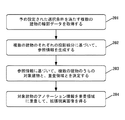
本発明に係る拡張現実方法の一実施例のフローチャートを示す図2を参照する。本発明の実施例に係る拡張現実方法は、端末(例えば、図1における端末101)により実行されてもよい。該方法は次のステップを備える。
Please refer to FIG. 2 which shows a flowchart of one embodiment of the augmented reality method according to the present invention. The augmented reality method according to the embodiment of the present invention may be executed by a terminal (for example, the
ステップ201において、予め設定された選択条件を満たす複数の建物の輪郭データを取得する。
In
本実施例において、建物はオフィスビル、ショッピングモール、住宅などであってもよい。ユーザの端末におけるカメラがオンにされて、ユーザがユーザの端末のカメラで取り込まれた画像においていくつかの建物のアノテーション情報が拡張表示される機能を使用する場合に、まず選択条件が予め設定された複数の建物の輪郭データを取得することができる。予め設定された選択条件は、少なくとも一部がユーザの端末のカメラの画角範囲内に位置するとともに、ユーザからの距離が近い順で順序付けした後、その順序が予め設定された順序よりも小さい大型建物を含んでもよい。言い換えれば、少なくとも一部がユーザの端末のカメラの画角範囲内に位置するユーザからの距離が最も近い複数の大型建物の輪郭データを取得する。複数の建物のそれぞれはいずれも少なくとも一部がユーザの端末のカメラで取り込まれた画像内に位置する。 In this embodiment, the building may be an office building, a shopping mall, a house, or the like. When the camera at the user's terminal is turned on and the user uses a function in which the annotation information of some buildings is extendedly displayed in the image captured by the camera of the user's terminal, the selection condition is first set in advance. It is possible to acquire contour data of a plurality of buildings. The preset selection condition is that at least a part is located within the angle-of-view range of the camera of the user's terminal, and the order is smaller than the preset order after the order is set in ascending order from the user. It may include large buildings. In other words, the contour data of a plurality of large buildings that are at least partially located within the range of the angle of view of the camera of the user terminal and closest to the user are acquired. Each of the plurality of buildings is at least partially located in an image captured by a camera of a user terminal.
ユーザの端末はユーザの位置及びユーザの端末のカメラの撮影角度を、電子地図サービスを提供するサーバに送信することができ、電子地図サービスを提供するサーバには、大量の建物の輪郭データ、大量の建物の電子地図における輪郭が予め格納されている。電子地図サービスを提供するサーバは、ユーザの位置及びユーザの端末のカメラの撮影角度に基づいて、少なくとも一部がユーザの端末のカメラの画角範囲内に位置するとともに、ユーザからの距離が近い順で順序付けした後にその順序が予め設定された順序よりも小さい大型建物を検索し、さらに検索された大型建物の輪郭データを取得することができる。建物の輪郭データが建物の三次元空間における地平面上の輪郭を記述する。 The terminal of the user can transmit the position of the user and the shooting angle of the camera of the terminal of the user to a server that provides an electronic map service. The outline of the building in the electronic map is stored in advance. The server that provides the electronic map service, based on the position of the user and the shooting angle of the camera of the user terminal, is at least partially located within the range of the angle of view of the camera of the user terminal, and the distance from the user is short After ordering in order, it is possible to search for a large building whose order is smaller than the preset order, and further obtain contour data of the searched large building. The building outline data describes the outline of the building on the ground plane in the three-dimensional space.
本実施例において、建物のアノテーション情報は、吹き出しと、吹き出し内にある建物の名称、建物とユーザの距離を含んでもよい。吹き出しの形状が矩形、気泡形状などであってもよい。 In the present embodiment, the annotation information of the building may include a balloon, a name of the building in the balloon, and a distance between the building and the user. The shape of the balloon may be a rectangle, a bubble, or the like.
ステップ202において、複数の建物のそれぞれの投影線分に基づいて、参照情報を生成する。
In
本実施例において、予め設定された選択条件を満たす複数の建物の輪郭データを取得した後に、複数の建物の三次元空間における輪郭を決定することができる。まず、複数の建物のそれぞれに対して、建物毎の三次元空間における輪郭をユーザの端末の画面の位置する平面にそれぞれマッピングして、建物毎に対応する線分をそれぞれ得ることができる。建物毎に対応する線分の長さが三次元空間における実長であり、建物毎のユーザの端末の画面における投影線分をそれぞれ得るために、その実長をユーザの端末の画面における長さに変換する必要がある。言い換えれば、建物の三次元空間における輪郭をユーザの端末の画面にマッピングして、建物毎の投影線分を得ることに相当する。 In the present embodiment, after acquiring outline data of a plurality of buildings satisfying a preset selection condition, the outline of the plurality of buildings in a three-dimensional space can be determined. First, for each of a plurality of buildings, a contour in a three-dimensional space of each building is mapped to a plane where a screen of a user terminal is located, and a line segment corresponding to each building can be obtained. The length of the line segment corresponding to each building is the actual length in the three-dimensional space, and in order to obtain each projection line segment on the screen of the user's terminal for each building, the actual length is calculated as the length on the screen of the user's terminal. Need to convert. In other words, this corresponds to mapping the contour of the building in the three-dimensional space on the screen of the user terminal to obtain a projection line segment for each building.
本実施例において、建物の三次元空間における輪郭をユーザの端末の画面にマッピングする場合に、建物の三次元空間における輪郭上の三次元点のワールド座標系における三次元座標を、ユーザの端末の画面に対応する二次元座標系における二次元座標に変換することにより、建物の三次元空間における輪郭上の三次元点の、ユーザの端末の画面に対応する二次元点を決定し、全ての三次元点に対応する二次元点がいずれも同一水平線上に位置し、水平方向においてユーザの端末の画面の両端から最も近い二次元点をそれぞれ投影線分の一端の端点とし、さらに建物の投影線分を構成する。 In this embodiment, when mapping the outline of the building in the three-dimensional space on the screen of the user terminal, the three-dimensional coordinates of the three-dimensional points on the outline in the three-dimensional space of the building in the world coordinate system are determined by the user terminal. By converting to two-dimensional coordinates in the two-dimensional coordinate system corresponding to the screen, the two-dimensional points corresponding to the screen of the user terminal of the three-dimensional points on the contour in the three-dimensional space of the building are determined, and all three-dimensional points are determined. The two-dimensional points corresponding to the original points are all located on the same horizontal line, and the two-dimensional points closest to both ends of the screen of the user's terminal in the horizontal direction are respectively set as the end points of one end of the projection line, and the projection line of the building Make up minutes.
例えば、建物の三次元空間における輪郭をユーザの端末の画面にマッピングする場合に、OpenGL(オープンジーエル、Open Graphics Library)によって提供されるMVP(Model View Projection)投影アルゴリズムを用いて、建物の三次元空間における輪郭上の三次元点のワールド座標系における三次元座標を、ユーザの端末の画面に対応する二次元座標系における二次元座標に変換することにより、さらに建物の三次元空間における輪郭をユーザの端末の画面にマッピングして、建物の投影線分を得ることができる。 For example, when mapping a contour of a building in a three-dimensional space onto a screen of a user terminal, the three-dimensional building is projected using an MVP (Model View Projection) algorithm provided by OpenGL (Open Graphics Library). By converting the three-dimensional coordinates in the world coordinate system of the three-dimensional points on the contour in space into the two-dimensional coordinates in the two-dimensional coordinate system corresponding to the screen of the user terminal, the contour of the building in the three-dimensional space can be further converted by the user. Of the building can be obtained by mapping to the screen of the terminal.
本実施例において、建物毎に対して、建物の三次元空間における輪郭をユーザの端末の画面にマッピングする場合に、三次元空間における同一高さにおいて建物毎の三次元空間における輪郭をユーザの端末の画面の位置する平面にそれぞれマッピングして、建物毎に対応する線分を得ることができ、その後、ユーザの端末の画面における長さに変換し、建物毎のユーザの端末上の画面における投影線分を得る。したがって、建物毎のユーザの端末上の画面における投影線分が同一水平線上に位置する。 In this embodiment, for each building, when mapping the contour of the building in the three-dimensional space on the screen of the user terminal, the contour of the building in the three-dimensional space at the same height in the three-dimensional space is converted to the terminal of the user. Can be mapped to the plane where the screen is located to obtain a line segment corresponding to each building, and then converted into the length on the screen of the user's terminal, and the projection of each building on the screen on the user's terminal is obtained. Get a line segment. Therefore, the projection line segment on the screen of the user terminal for each building is located on the same horizontal line.
本実施例において、複数の異なる画面の幅を有する端末で同一建物を撮影する場合に、該建物の水平方向における最大実長と画面における該建物の水平方向における最大長さを予め決定することができる。水平方向の最大実長は、建物の三次元空間における輪郭上に横座標の最も小さい点と横座標の最も大きい点との間の距離である。画面における該建物の水平方向における最大長さは、画像における建物の輪郭上に横座標の最も小さい画素ドットと横座標の最も大きい画素ドットとの間の距離である。各幅の画面に対して、画面における該建物の水平方向における最大長さを、該建物の水平方向における最大実長で除算して得られた割合を、画面に対応する割合とすることができる。建物の三次元空間における輪郭をユーザの端末の画面の位置する平面にマッピングして、該建物に対応する線分を得た後、該建物に対応する線分の三次元空間における実長を、該端末の画面に対応する割合に乗じて、該建物の投影線分の長さを得ることができる。 In the present embodiment, when photographing the same building with a terminal having a plurality of different screen widths, the maximum actual length in the horizontal direction of the building and the maximum length in the horizontal direction of the building on the screen may be determined in advance. it can. The maximum actual length in the horizontal direction is the distance between the point with the smallest abscissa and the point with the largest abscissa on the contour of the building in the three-dimensional space. The maximum length of the building in the horizontal direction on the screen is the distance between the pixel dot with the smallest abscissa and the pixel dot with the largest abscissa on the contour of the building in the image. For a screen of each width, a ratio obtained by dividing the maximum length of the building in the horizontal direction on the screen by the maximum actual length of the building in the horizontal direction can be a ratio corresponding to the screen. . After mapping the outline in the three-dimensional space of the building to the plane where the screen of the user's terminal is located, and obtaining a line segment corresponding to the building, the actual length of the line segment corresponding to the building in the three-dimensional space is: By multiplying the ratio corresponding to the screen of the terminal, the length of the projection line segment of the building can be obtained.
本実施例において、複数の建物のそれぞれの投影線分に基づいて、参照情報を生成することができる。参照情報は、各建物が水平方向において他の建物で遮蔽されたか否か及び遮蔽された場合の遮蔽状況を記述することができ、遮蔽状況が部分遮蔽、完全遮蔽であってもよい。 In the present embodiment, reference information can be generated based on the projected line segments of a plurality of buildings. The reference information can describe whether each building is shielded by another building in the horizontal direction, and the shielding situation when the building is shielded, and the shielding situation may be partial shielding or complete shielding.
本実施例において、建物が他の建物で遮蔽されたか否かとは、該建物が、ユーザからの距離が該建物のユーザからの距離よりも小さい他の建物で遮蔽されたか否かということを指す。言い換えれば、建物が他の建物で遮蔽されたか否かとは、該建物が、その前に位置する他の建物で遮蔽されたか否かということを指す。 In this embodiment, whether or not a building is shielded by another building indicates whether or not the building is shielded by another building whose distance from the user is smaller than the distance from the user of the building. . In other words, whether or not a building is shielded by another building indicates whether or not the building is shielded by another building located before the building.
本実施例において、複数の建物のそれぞれの三次元空間における輪郭をユーザの端末の画面にマッピングして、建物毎の投影線分が得られた後に、建物毎の投影線分に基づいて、各建物がその前に位置する他の建物で遮蔽されたか否かを判断し、遮蔽されたと判断した場合にさらに遮蔽状況が部分遮蔽であるかそれとも完全遮蔽であるかを判断する。 In the present embodiment, the contour of each of the plurality of buildings in the three-dimensional space is mapped on the screen of the user's terminal, and after the projection line segment for each building is obtained, each It is determined whether or not the building is shielded by another building located in front of the building. If it is determined that the building is shielded, it is further determined whether the shielding situation is partial shielding or complete shielding.
本実施例において、複数の建物のそれぞれの投影線分に基づいて、各建物がその前に位置する他の建物で遮蔽されたか否かを判断し、遮蔽されたと判断した場合に、さらに遮蔽状況が部分遮蔽であるかそれとも完全遮蔽であるかを判断し、複数の建物のそれぞれがその前に位置する他の建物で遮蔽されたか否か及び遮蔽された場合の遮蔽状況を記述する参照情報を生成することができる。 In the present embodiment, it is determined whether or not each building is shielded by another building located in front of the plurality of buildings based on the projected line segments of the plurality of buildings. Judge whether the building is partially or completely occluded, and reference information describing whether each of the multiple buildings was occluded by other buildings located in front of it and the occlusion situation when occluded. Can be generated.
本実施例において、複数の建物のそれぞれに対して、該建物の投影線分及び該建物の前に位置する他の建物の投影線分に基づいて、水平方向において該建物が該他の建物で遮蔽されたか否かを判断し、遮蔽された場合の遮蔽状況を判断することができる。該建物の投影線分と該他の建物の投影線分とが同一水平線にある場合に、該建物の投影線分と該他の建物の投影線分とは同じサブ線分がない場合に、該建物が該他の建物で遮蔽されていない。該建物の投影線分と該他の建物の投影線分とが同一水平線にある場合に、該建物の投影線分と該他の建物の投影線分とは同じサブ線分を有するとともに、該建物の投影線分が該他の建物の有しないサブ線分を有する場合に、該建物が該他の建物で部分的に遮蔽されている。該建物の投影線分と該他の建物の投影線分とが同一水平線にある場合に、該建物の投影線分が該他の建物の投影線分のサブ線分となる場合に、該建物が該他の建物で完全遮蔽されている。 In this embodiment, for each of a plurality of buildings, based on the projection line segment of the building and the projection line segment of another building located in front of the building, the building is replaced with the other building in the horizontal direction. It is possible to determine whether or not the light is shielded, and to determine the light shielding state when the light is shielded. When the projection line segment of the building and the projection line segment of the other building are on the same horizontal line, when the projection line segment of the building and the projection line segment of the other building do not have the same sub-line segment, The building is not shielded by the other building. When the projection line segment of the building and the projection line segment of the other building are on the same horizontal line, the projection line segment of the building and the projection line segment of the other building have the same sub-line segment, and The building is partially shielded by the other building when the projected line segment of the building has a sub-line segment that the other building does not have. When the projection line segment of the building and the projection line segment of the other building are on the same horizontal line, and the projection line segment of the building is a sub-line segment of the projection line of the other building, the building Is completely shielded by the other building.
ステップ203において、参照情報に基づいて、複数の建物のうちの対象建物と、重畳領域とを決定する。
In
本実施例において、ユーザの端末で取り込まれた画像にアノテーション情報が表示されるべき建物が対象建物である。まず、複数の建物のうち少なくとも1つの建物で完全遮蔽された建物を決定することができ、その後、複数の建物のうち少なくとも1つの建物で完全遮蔽された建物を除いた建物、即ち建物のいずれかで完全遮蔽されていない建物を対象建物とする。ユーザからの距離が最も近い建物が建物のいずれかで完全遮蔽されていなければ、ユーザからの距離が最も近い建物を対象建物とする。言い換えれば、ユーザに表示するアノテーション情報は、各対象建物、即ち建物のいずれかで完全遮蔽されていない建物のアノテーション情報を備える。 In the present embodiment, the target building is a building where the annotation information is to be displayed on the image captured by the user's terminal. First, a building completely shielded by at least one building of the plurality of buildings can be determined, and then, a building excluding a building completely shielded by at least one building of the plurality of buildings, that is, any of the buildings The building that is not completely shielded is the target building. If the building closest to the user is not completely shielded by any of the buildings, the building closest to the user is set as the target building. In other words, the annotation information displayed to the user includes the annotation information of each target building, that is, the building that is not completely covered by any of the buildings.
本実施例において、建物のアノテーション情報は吹き出しと、吹き出し内にある建物の名称とを備える。吹き出しの形状が矩形、気泡形状などであってもよい。建物毎の吹き出しの形状及び面積がいずれも同じである。 In this embodiment, the annotation information of a building includes a balloon and a name of a building in the balloon. The shape of the balloon may be a rectangle, a bubble, or the like. The shape and area of the balloon for each building are the same.
本実施例において、建物の名称及びユーザからの距離が建物のアノテーション情報における吹き出しでユーザに表示されるので、建物のアノテーション情報のユーザの端末で取り込まれた画像における重畳領域が、建物のアノテーション情報における吹き出しのユーザの端末で取り込まれた画像に占める領域に相当することができる。建物のアノテーション情報のユーザの端末で取り込まれた画像における重畳領域を決定することは、建物のアノテーション情報における吹き出しのユーザの端末で取り込まれた画像に占める領域を決定することに相当する。対象建物毎のアノテーション情報の重畳領域の中心点が、対象建物毎のアノテーション情報における吹き出しの中心点に相当することができる。 In the present embodiment, since the name of the building and the distance from the user are displayed to the user in a balloon in the annotation information of the building, the superimposed area in the image captured by the user terminal of the annotation information of the building is the annotation information of the building. Can be equivalent to the area occupied by the balloon in the image captured by the user terminal. Determining the superimposition region of the annotation information of the building in the image captured by the user terminal corresponds to determining the region of the balloon in the annotation information of the building in the image captured by the user terminal. The center point of the superimposition region of the annotation information for each target building can correspond to the center point of the balloon in the annotation information for each target building.
まず、対象建物毎のアノテーション情報における吹き出しの中心点の横座標値を決定することができる。横座標値がユーザの端末の画面の1つのコーナー点、例えば左下コーナーを座標系の原点とする座標系における横座標値であってもよい。対象建物毎のアノテーション情報の吹き出しの中心点の横座標値は、全ての対象建物のうちいずれか2つの対象建物のアノテーション情報における吹き出しが水平方向に重ならないようにするべきである。いずれか2つの対象建物のアノテーション情報における吹き出しが水平方向において重ならないようにすることは、いずれか2つの対象建物のアノテーション情報における吹き出しの中心点が同一水平線に位置する場合に、いずれか2つの対象建物のアノテーション情報における吹き出しが水平方向に重ならないことに相当する。 First, the horizontal coordinate value of the center point of the balloon in the annotation information for each target building can be determined. The abscissa value may be an abscissa value in a coordinate system where one corner point of the screen of the user terminal, for example, the lower left corner is the origin of the coordinate system. The abscissa value of the center point of the balloon of the annotation information for each target building should be such that the balloons in the annotation information of any two of the target buildings do not overlap in the horizontal direction. Preventing the balloons in the annotation information of any two target buildings from overlapping in the horizontal direction is performed when the center points of the balloons in the annotation information of any two target buildings are located on the same horizontal line. This corresponds to balloons in the annotation information of the target building not overlapping in the horizontal direction.
対象建物毎のアノテーション情報の吹き出しの中心点の横座標値が決定された後に、対象建物毎のアノテーション情報の吹き出しの中心点の縦座標を決定することができる。対象建物毎のアノテーション情報の吹き出しの中心点の縦座標は、全ての対象建物のうちいずれか2つの対象建物の吹き出しが垂直方向に重ならないようにするべきである。いずれか2つの対象建物のアノテーション情報における吹き出しが垂直方向に重ならないようにすることは、いずれか2つの対象建物のアノテーション情報における吹き出しの中心点が同一垂直線に位置する場合に、いずれか2つの対象建物のアノテーション情報における吹き出しが垂直方向に重ならないことに相当する。 After the horizontal coordinate value of the center point of the balloon of the annotation information for each target building is determined, the ordinate of the center point of the balloon of the annotation information for each target building can be determined. The ordinate of the center point of the balloon of the annotation information for each target building should be such that the balloons of any two of the target buildings do not overlap in the vertical direction. Preventing the balloons in the annotation information of any two target buildings from overlapping in the vertical direction can be achieved by setting the center of the balloon in the annotation information of any two target buildings to the same vertical line. This corresponds to balloons in the annotation information of one target building not overlapping in the vertical direction.
対象建物毎のアノテーション情報の吹き出しの中心点の横座標及び縦座標が決定された後に、対象建物毎のアノテーション情報の吹き出しの中心点の位置を得ることができる。さらに形状及び面積がいずれも同じである対象建物毎のアノテーション情報の吹き出しの、ユーザの端末で取り込まれた画像に占める領域をそれぞれ決定することにより、対象建物毎のアノテーション情報のユーザの端末で取り込まれた画像における重畳領域を決定することができる。 After the horizontal and vertical coordinates of the center point of the balloon of the annotation information for each target building are determined, the position of the center point of the balloon of the annotation information for each target building can be obtained. Furthermore, by determining the area of the balloon of the annotation information for each target building having the same shape and area in the image captured by the user terminal, respectively, the annotation information for each target building is captured by the user terminal. It is possible to determine a superimposed region in the obtained image.
本実施例のいくつかの任意選択実施形態において、複数の建物のうちユーザからの距離が最も近い建物が他の全ての建物を完全遮蔽した場合に、ユーザからの距離が最も近い建物の投影線分の長さが画面の幅よりも大きいことに基づいて、複数の建物のうちユーザからの距離が最も近い建物が他の全ての建物を完全遮蔽することを判定することができ、水平方向において複数の建物のうちユーザからの距離が最も近い建物が他の全ての建物を完全遮蔽することを示す指示情報を生成することができる。従って、参照情報は、水平方向において複数の建物のうちユーザからの距離が最も近い建物が他の全ての建物を完全遮蔽することを示す指示情報を備える。複数の建物のうちの対象建物を決定して、対象建物のアノテーション情報のユーザの端末で取り込まれた画像における重畳領域を決定する場合に、ユーザからの距離が最も近い建物を対象建物とすることができる。言い換えれば、ユーザからの距離が最も近い建物のアノテーション情報だけをユーザに表示する。ユーザからの距離が最も近い建物の投影線分の中心点の横座標を、ユーザからの距離が最も近い建物のアノテーション情報の画像における重畳領域の中心点の横座標とすることができる。その後、ユーザからの距離が最も近い建物のアノテーション情報の画像における重畳領域の中心点の縦座標を決定することができ、ユーザからの距離が最も近い建物のアノテーション情報における吹き出しの中心点の位置を決定することができる。 In some optional embodiments of this example, the projection line of the building closest to the user when the building closest to the user among the plurality of buildings completely shields all other buildings. Based on the fact that the length of the minutes is greater than the width of the screen, it can be determined that the building closest to the user among the plurality of buildings completely blocks all other buildings, It is possible to generate instruction information indicating that the building closest to the user among the plurality of buildings completely blocks all other buildings. Therefore, the reference information includes instruction information indicating that the building closest to the user among the plurality of buildings in the horizontal direction completely blocks all other buildings. When determining a target building among a plurality of buildings and determining a superimposition region in an image captured by a user terminal of annotation information of the target building, a building closest to the user is set as a target building. Can be. In other words, only the annotation information of the building closest to the user is displayed to the user. The abscissa of the center point of the projection line segment of the building closest to the user can be used as the abscissa of the center point of the superimposition region in the image of the annotation information of the building closest to the user. Thereafter, the ordinate of the center point of the superimposition area in the image of the annotation information of the building closest to the user can be determined, and the position of the center point of the speech balloon in the annotation information of the building closest to the user can be determined. Can be determined.
本実施例のいくつかの任意選択実施形態において、複数の建物には水平方向に少なくとも1つの建物で完全遮蔽される建物及び建物のいずれかで完全遮蔽されていない建物が含まれる場合に、建物毎の投影線分に基づいて、複数の建物には水平方向に少なくとも1つの建物で完全遮蔽される建物及び建物のいずれかで完全遮蔽されていない建物が含まれることを決定することができる。生成される参照情報はさらに、複数の建物のうち水平方向に少なくとも1つの建物で完全遮蔽される建物のタグと、複数の建物のうち建物のいずれかで完全遮蔽されていない建物のタグとを備える。 In some optional embodiments of this embodiment, the plurality of buildings includes a building that is completely shielded horizontally by at least one building and a building that is not completely shielded by any of the buildings. Based on each projection line segment, it can be determined that the plurality of buildings includes buildings that are completely covered by at least one building in the horizontal direction and buildings that are not completely covered by any of the buildings. The generated reference information further includes a tag of a building that is completely shielded by at least one building in the horizontal direction and a tag of a building that is not completely shielded by one of the buildings in the plurality of buildings. Prepare.
参照情報に基づいて、表示すべきアノテーション情報と、表示すべきアノテーション情報のユーザの端末で取り込まれた画像における重畳領域とを決定する場合に、参照情報における水平方向に少なくとも1つの建物で完全遮蔽される建物のタグと、建物のいずれかで完全遮蔽されていない建物のタグとに基づいて、複数の建物のうち少なくとも1つの建物で完全遮蔽される建物と、建物のいずれかで完全遮蔽されていない建物とを決定することができる。その後、水平方向に建物のいずれかで完全遮蔽されていない建物を対象建物とすることができる。対象建物の数が複数であってもよい。 When determining the annotation information to be displayed and the superimposed area of the annotation information to be displayed in the image captured by the user terminal based on the reference information, complete occlusion with at least one building in the horizontal direction in the reference information A building that is completely shielded by at least one of the buildings and a building that is completely shielded by one of the buildings based on the tag of the building to be installed and the tag of the building that is not completely shielded by one of the buildings. Not a building and can be determined. Thereafter, a building that is not completely shielded by any of the buildings in the horizontal direction can be set as a target building. The number of target buildings may be plural.
まず、対象建物のうち最も近い建物と対象建物のうち2番目に近い建物との間の第1遮蔽関連状況に基づいて、最も近い建物と2番目に近い建物のアノテーション情報のユーザの端末で取り込まれた画像における重畳領域を決定することができる。最も近い建物は全ての対象建物のうちユーザからの距離が最も近い対象建物であり、2番目に近い建物は全ての対象建物のうちユーザからの距離が2番目に近い対象建物である。第1遮蔽関連状況は、2番目に近い建物が最も近い建物で遮蔽されていないこと、2番目に近い建物が最も近い建物で部分的に遮蔽されて2番目に近い建物の最も近い建物で遮蔽されていない部分が最も近い建物の片側に位置すること、2番目に近い建物が最も近い建物で部分的に遮蔽されて2番目に近い建物の最も近い建物で遮蔽されていない部分が最も近い建物の両側に配置されることであってもよい。 First, based on the first shielding-related situation between the closest building of the target building and the second closest building of the target building, the annotation information of the closest building and the second closest building is captured by the user terminal. It is possible to determine a superimposed region in the obtained image. The closest building is the target building closest to the user among all the target buildings, and the second closest building is the target building closest to the user among all the target buildings. The first shielding-related situation is that the second closest building is not shielded by the closest building, the second closest building is partially shielded by the closest building, and the second closest building is shielded by the closest building of the second closest building. The unoccupied part is located on one side of the closest building, the second closest building is partially shielded by the closest building, and the closest building of the second closest building is the closest unshielded building. May be arranged on both sides of the.
最も近い建物の投影線分と2番目に近い建物の投影線分とが同一水平線にある場合に、2番目に近い建物の投影線分と最も近い建物の投影線分とは同じサブ線分がない場合に、2番目に近い建物が最も近い建物で遮蔽されていない。最も近い建物の投影線分と2番目に近い建物の投影線分とが同一水平線にある場合に、2番目に近い建物の投影線分上の最も近い建物の投影線分に属しないサブ線分が最も近い建物の投影線分の片側、即ち左側又は右側に位置する場合に、2番目に近い建物が最も近い建物で部分的に遮蔽されて2番目に近い建物の最も近い建物で遮蔽されていない部分が最も近い建物の片側に位置する。最も近い建物の投影線分と2番目に近い建物の投影線分とが同一水平線にある場合に、最も近い建物の投影線分の両側に2番目に近い建物の投影線分上の最も近い建物の投影線分に属しないサブ線分を有する場合に、2番目に近い建物が最も近い建物で部分的に遮蔽されて2番目に近い建物の最も近い建物で遮蔽されていない部分が最も近い建物の両側に配置される。 If the projected line of the closest building and the projected line of the second closest building are on the same horizontal line, the projected line of the second closest building and the projected line of the closest building have the same sub-line. If not, the second closest building is not covered by the closest building. If the projected line of the closest building and the projected line of the second closest building are on the same horizontal line, a sub-line segment not belonging to the projected line of the closest building on the projected line of the second closest building Is located on one side of the projected line of the closest building, that is, on the left or right side, the second closest building is partially shielded by the closest building and is shielded by the closest building of the second closest building. The missing part is located on one side of the nearest building. When the projection line of the closest building and the projection line of the second closest building are on the same horizontal line, the closest building on the projection line of the second closest building on both sides of the projection line of the closest building The second closest building is partially occluded by the closest building, and the closest unoccupied part of the second closest building is the closest building Are arranged on both sides.
第1遮蔽関連状況は、最も近い建物が2番目に近い建物で遮蔽されていないことである場合に、2番目に近い建物の投影線分の中心点の横座標を、2番目に近い建物のアノテーション情報における吹き出しの中心点の横座標とし、同時に、最も近い建物の投影線分の中心点の横座標を、最も近い建物のアノテーション情報における吹き出しの中心点の横座標とすることができる。 If the first shielding-related situation is that the closest building is not shielded by the second closest building, the abscissa of the center point of the projected line of the second closest building is set to The abscissa of the center point of the balloon in the annotation information and the abscissa of the center point of the projection line of the closest building can be used as the abscissa of the center point of the balloon in the annotation information of the closest building.
第1遮蔽関連状況は、2番目に近い建物が最も近い建物で部分的に遮蔽されて遮蔽されていない部分が2番目に近い建物の片側にあるか又は最も近い建物が2番目に近い建物で部分的に遮蔽されて遮蔽されていない部分が最も近い建物の両側に配置されることである場合に、2番目に近い建物の投影線分と最も近い建物の投影線分とが同一水平線にある場合に、2番目に近い建物の投影線分上の、最も近い建物の投影線分に属しないサブ線分の中心点を2番目に近い建物のアノテーション情報における吹き出しの中心点とすることができる。同時に、最も近い建物の投影線分の中心点の横座標を、最も近い建物のアノテーション情報における吹き出しの中心点の横座標とする。 The first shielding-related situation is that the building closest to the second is partially closed at the nearest building and the unshielded part is on one side of the building closest to the second, or the closest building is the building closest to the second. The projection line of the second closest building and the projection line of the closest building are on the same horizontal line if the partially occluded part is to be located on both sides of the closest building In this case, the center point of the sub-line segment that does not belong to the projection line segment of the closest building on the projection line segment of the second closest building can be set as the center point of the balloon in the annotation information of the second closest building. . At the same time, the abscissa of the center point of the projection line of the closest building is set as the abscissa of the center point of the balloon in the annotation information of the closest building.
2番目に近い建物及び最も近い建物のアノテーション情報における吹き出しの中心点の横座標が決定された後に、2番目に近い建物及び最も近い建物のアノテーション情報における吹き出しの中心点の縦座標を決定することができ、2番目に近い建物及び最も近い建物のアノテーション情報における吹き出しの中心点の縦座標は、垂直方向において2番目に近い建物のアノテーション情報における吹き出しと、最も近い建物のアノテーション情報における吹き出しとが重ならないようにすることができる。最も近い建物及び2番目に近い建物のアノテーション情報における吹き出しの中心点の横座標及び縦座標が決定された後に、最も近い建物及び2番目に近い建物のアノテーション情報における吹き出しの中心点の位置を同時に決定することができ、従って、最も近い建物及び2番目に近い建物のアノテーション情報における吹き出しのユーザの端末で撮影された画像に占める領域を決定することができ、即ち最も近い建物及び2番目に近い建物のアノテーション情報のユーザの端末で撮影された画像における重畳領域を決定することができる。 After the abscissa of the speech bubble center point in the annotation information of the second closest building and the closest building is determined, the ordinate of the speech bubble center point in the annotation information of the second closest building and the closest building is determined. The ordinate of the center point of the balloon in the annotation information of the second closest building and the nearest building is the balloon in the annotation information of the second closest building in the vertical direction and the balloon in the annotation information of the closest building. It can be prevented from overlapping. After the horizontal and vertical coordinates of the center point of the balloon in the annotation information of the closest building and the second closest building are determined, the positions of the center points of the balloons in the annotation information of the closest building and the second closest building are simultaneously determined. It is possible to determine the area occupied in the image taken by the user terminal of the balloon in the annotation information of the closest building and the second closest building, ie, the closest building and the second closest building It is possible to determine a superimposed region of the annotation information of the building in the image captured by the user terminal.
対象建物のうち最も近い建物及び2番目に近い建物を除く対象建物毎に対して、それぞれ対象建物と対象建物の前にある対象建物との間の第2遮蔽関連状況に基づいて、対象建物のアノテーション情報のユーザの端末で取り込まれた画像における重畳領域を決定し、即ち対象建物のアノテーション情報における吹き出しのユーザの端末で取り込まれた画像に占める領域を決定する。最も近い建物及び2番目に近い建物を除く対象建物の前にある対象建物とは、ユーザからの距離が該対象建物のユーザからの距離よりも小さい、最も近い建物及び2番目に近い建物を除くその他の対象建物のうち、ユーザからの距離が最も大きい対象建物のことを指す。 For each target building excluding the closest building and the second closest building from the target building, based on the second shielding-related situation between the target building and the target building in front of the target building, The superimposition area of the annotation information in the image captured by the user terminal is determined, that is, the area of the balloon in the annotation information of the target building in the image captured by the user terminal is determined. The target building in front of the target building excluding the closest building and the second closest building is the one excluding the closest building and the second closest building whose distance from the user is smaller than the distance of the target building from the user. Among other target buildings, this refers to the target building that is the longest distance from the user.
最も近い建物及び2番目に近い建物を除く対象建物とその前の対象建物との第2遮蔽関連状況は、該対象建物がその前の対象建物で遮蔽されていないこと、該対象建物がその前の対象建物で部分的に遮蔽されて該対象建物の、その前の対象建物で遮蔽されていない部分がその前の対象建物の片側に位置すること、該対象建物がその前の対象建物で部分的に遮蔽されて該対象建物の、その前の対象建物で遮蔽されていない部分がその前の対象建物の両側に配置されることであってもよい。 The second shielding-related situation between the target building excluding the nearest building and the second closest building and the target building in front of the target building is that the target building is not shielded by the preceding target building, and that the target building is That the part of the target building that is partially shielded by the target building and that is not shielded by the target building in front of it is located on one side of the target building in front of the target building; A part of the target building which is not covered by the target building in front of the target building may be arranged on both sides of the target building in front of the target building.
最も近い建物及び2番目に近い建物を除く対象建物のそれぞれに対して、ユーザからの距離の近い順に基づいて、対象建物毎のアノテーション情報における吹き出しの中心点の位置を順次決定する。 For each of the target buildings except for the closest building and the second closest building, the position of the center point of the balloon in the annotation information for each target building is sequentially determined based on the order of the distance from the user.
最も近い建物及び2番目に近い建物を除く対象建物のアノテーション情報における吹き出しの中心点の位置を決定する場合に、該対象建物の前にある対象建物のアノテーション情報における吹き出しの中心点の位置が既に決定され、決定後の前にある建物のアノテーション情報における吹き出しの中心点がそのままに保持される。該対象建物とその前の対象建物との第2遮蔽関連状況は、該対象建物が該その前の建物で遮蔽されていないことである場合に、該対象建物の投影線分の中心点の横座標を、該対象建物のアノテーション情報における吹き出しの中心点の横座標とすることができる。該対象建物とその前の対象建物との第2遮蔽関連状況は、該対象建物が該その前の対象建物で部分的に遮蔽されて、遮蔽されていない部分が該その前の対象建物の片側にあるか又は該その前の対象建物の両側に配置されることである場合に、該対象建物と該その前の対象建物とが同一水平線にある場合において、該対象建物上の該その前の対象建物の投影線分に属しないサブ線分の中心点を、該対象建物のアノテーション情報における吹き出しの中心点とすることができる。該対象建物のアノテーション情報における吹き出しの中心点の横座標が決定された後に、該対象建物のアノテーション情報における吹き出しの中心点の縦座標を決定することができる。該対象建物のアノテーション情報における吹き出しの中心点の縦座標は、垂直方向において該対象建物のアノテーション情報における吹き出しと該その前の対象建物のアノテーション情報における吹き出しとが重ならないようにすることができる。 When determining the position of the center point of the balloon in the annotation information of the target building excluding the closest building and the second closest building, the position of the center point of the balloon in the annotation information of the target building in front of the target building is already determined. It is determined, and the center point of the balloon in the annotation information of the building before the determination is kept as it is. The second shielding-related situation between the target building and the preceding target building is a state in which the target building is not shielded by the preceding building, and is located next to the center point of the projection line of the target building. The coordinates may be the horizontal coordinates of the center point of the balloon in the annotation information of the target building. The second shielding-related situation between the target building and the preceding target building is that the target building is partially shielded by the preceding target building, and the unshielded portion is one side of the preceding target building. Or if it is to be located on both sides of the preceding target building, and the target building and the preceding target building are on the same horizontal line, The center point of the sub-line segment that does not belong to the projection line segment of the target building can be set as the center point of the balloon in the annotation information of the target building. After the abscissa of the center point of the balloon in the annotation information of the target building is determined, the ordinate of the center point of the balloon in the annotation information of the target building can be determined. The ordinate of the center point of the balloon in the annotation information of the target building may be such that the balloon in the annotation information of the target building and the balloon in the annotation information of the preceding target building do not overlap in the vertical direction.
本実施例のいくつかの任意選択実施形態において、最も近い建物と2番目に近い建物との間の第1遮蔽関連状況は、最も近い建物が2番目に近い建物で遮蔽されていないか又は最も近い建物が2番目に近い建物で部分的に遮蔽されて、遮蔽されていない部分が最も近い建物の両側に配置されることである場合に、2番目に近い建物の投影線分の中心点の横座標を2番目に近い建物のアノテーション情報における吹き出しの中心点の横座標とし、同時に、最も近い建物の投影線分の中心点の横座標を最も近い建物のアノテーション情報における吹き出しの中心点の横座標とすることができる。 In some optional embodiments of this example, the first shielding-related situation between the closest building and the second closest building is that the closest building is unshielded by the second closest building or the most If the nearby building is partially occluded by the second closest building and the unobstructed part is to be placed on both sides of the closest building, the center point of the projected line of the second closest building The abscissa is the abscissa of the center point of the balloon in the annotation information of the second closest building, and at the same time, the abscissa of the center point of the projection line of the closest building is the abscissa of the center point of the balloon in the annotation information of the closest building. Can be coordinates.
最も近い建物と2番目に近い建物との間の第1遮蔽関連状況は、2番目に近い建物が最も近い建物で部分的に遮蔽されて、遮蔽されていない部分が2番目に近い建物の片側にあることである場合に、2番目に近い建物の投影線分と最も近い建物の投影線分とが同一水平線にある場合において、最も近い建物で遮蔽されていない部分に対応するサブ線分即ち2番目に近い建物の投影線分上の最も近い建物の投影線分に属しないサブ線分の中心点を、2番目に近い建物のアノテーション情報における吹き出しの中心点とすることができる。同時に、最も近い建物の投影線分の中心点の横座標を、最も近い建物のアノテーション情報における吹き出しの中心点の横座標とする。 The first shielding-related situation between the closest building and the second closest building is that the second closest building is partially shielded by the closest building and the unshielded part is one side of the second closest building. In the case where the projection line segment of the second closest building and the projection line segment of the closest building are on the same horizontal line, a sub-line segment corresponding to a part not shielded by the closest building, that is, The center point of the sub-line segment that does not belong to the projection line segment of the closest building on the projection line segment of the second closest building can be the center point of the balloon in the annotation information of the second closest building. At the same time, the abscissa of the center point of the projection line of the closest building is set as the abscissa of the center point of the balloon in the annotation information of the closest building.
本実施例のいくつかの任意選択実施形態において、対象建物毎のアノテーション情報の前記画像における重畳領域の中心点の縦座標が決定された場合に、ユーザからの距離に基づいて全ての対象建物を順序付けし、順序付け後の対象建物毎の順序に基づいて、対象建物毎のアノテーション情報のユーザの端末で取り込まれた画像における重畳領域の中心点の縦座標を決定し、即ち対象建物毎のアノテーション情報における吹き出しを決定することができる。 In some optional embodiments of the present example, if the ordinate of the center point of the superimposition region in the image of the annotation information for each target building is determined, all target buildings are determined based on the distance from the user. Ordering, based on the order of each target building after the ordering, determine the ordinate of the center point of the superimposition region in the image captured by the user terminal of the annotation information for each target building, that is, the annotation information for each target building Can be determined.
ユーザからの距離が近い順で対象建物を順序付けすることができ、対象建物の順序が遠いほど、縦座標の数値が大きい。言い換えれば、対象建物の順序が遠いほど、該対象建物のアノテーション情報における吹き出しのユーザの端末の画面における位置が高い。対象建物毎のアノテーション情報のユーザの端末で取り込まれた画像における重畳領域の中心点の縦座標は、いずれか2つの対象建物のアノテーション情報における吹き出しが垂直方向において重ならないようにすることができる。 The target buildings can be ordered in ascending order of distance from the user, and the farther the target buildings are, the greater the numerical value of the ordinate. In other words, the farther the order of the target building is, the higher the position of the balloon in the annotation information of the target building on the screen of the user's terminal is. The ordinate of the center point of the superimposition area in the image of the annotation information for each target building captured by the user's terminal can prevent the balloons in the annotation information of any two target buildings from overlapping in the vertical direction.
建物の輪郭、建物の他の特徴などに応じて、ユーザの端末で取り込まれた画像における各対象建物の画像における高さをおおざっぱに決定することができ、さらに対象建物のアノテーション情報における吹き出しの縦座標の最大値を決定することができ、決定された対象建物のアノテーション情報における吹き出しの中心点の縦座標が、縦座標の最大値よりも小さくすべきである。言い換えれば、決定された対象建物のアノテーション情報における吹き出しの中心点の縦座標が縦座標の最大値よりも大きい場合に、対象建物のアノテーション情報における吹き出しの部分が画像において対象建物の画像における最高高さを超える可能性がある。 According to the outline of the building, other characteristics of the building, etc., it is possible to roughly determine the height of the image of each target building in the image captured by the user's terminal, and furthermore, the vertical length of the balloon in the annotation information of the target building. The maximum value of the coordinates can be determined, and the ordinate of the center point of the balloon in the determined annotation information of the target building should be smaller than the maximum value of the ordinate. In other words, when the ordinate of the center point of the balloon in the determined annotation information of the target building is larger than the maximum value of the ordinate, the balloon portion in the annotation information of the target building has the highest height in the image of the target building in the image. Could exceed.
ステップ204において、対象建物のアノテーション情報を重畳領域に重畳して、拡張現実画像を得る。
In
本実施例において、対象建物毎のユーザの端末で取り込まれた画像における重畳領域が決定された後、即ち対象建物毎のアノテーション情報における吹き出しのユーザの端末で取り込まれた画像に占める領域が決定された後に、対象建物のアノテーション情報を、決定された重畳領域に重畳することができる。言い換えれば、対象建物毎のアノテーション情報における吹き出しを、決定された吹き出しのユーザの端末で取り込まれた画像に占める領域に設定する。対象建物毎の少なくとも一部がユーザの端末で取り込まれた画像内に位置し、対象建物毎の吹き出しの少なくとも一部がユーザの端末で取り込まれた画像における所属する対象建物のある領域にある。従って、ユーザの端末で取り込まれた画像には対象建物毎のアノテーション情報における吹き出し内に位置する対象建物の名称及び対象建物のユーザからの距離が含まれ、拡張現実画像が得られる。いずれか2つの対象建物のアノテーション情報における吹き出しが水平方向に重ならなく、いずれか2つの対象建物のアノテーション情報における吹き出しが垂直方向に重ならないことが決定されたため、従って、ユーザに表示する際に、拡張現実画像におけるいずれか2つの対象建物の吹き出し内に位置する対象建物の名称及び対象建物のユーザからの距離も重なることはない。 In the present embodiment, after the superimposition area in the image captured by the user terminal of each target building is determined, that is, the area of the balloon in the annotation information of each target building in the image captured by the user terminal is determined. After that, the annotation information of the target building can be superimposed on the determined superimposition area. In other words, the speech balloon in the annotation information for each target building is set to an area occupied by the determined speech balloon in the image captured by the user terminal. At least a part of each of the target buildings is located in the image captured by the user's terminal, and at least a part of the balloon of each of the target buildings is in an area where the target building belongs in the image captured by the user's terminal. Therefore, the image captured by the user terminal includes the name of the target building located in the balloon in the annotation information for each target building and the distance of the target building from the user, and an augmented reality image is obtained. Since it has been determined that the balloons in the annotation information of any two target buildings do not overlap in the horizontal direction and the balloons in the annotation information of any two target buildings do not overlap in the vertical direction, therefore, when displaying to the user, Also, the names of the target buildings located in the balloons of any two target buildings in the augmented reality image and the distance of the target buildings from the user do not overlap.
図3を参照すると、上記の各図面に示された方法の実施態様として、本発明は、装置の一実施例を提供し、該装置の実施例は、図2に示された方法の実施例に対応している。 Referring to FIG. 3, as an embodiment of the method shown in the above figures, the present invention provides an embodiment of the apparatus, which is an embodiment of the method shown in FIG. It corresponds to.
図3に示すように、本実施例の装置は、取得ユニット301と、生成ユニット302と、決定ユニット303と、表示ユニット304とを備える。取得ユニット301は予め設定された選択条件を満たす複数の建物の輪郭データを取得するように配置され、前記輪郭データが建物の三次元空間における輪郭を記述するために用いられ、生成ユニット302は複数の建物のそれぞれの投影線分に基づいて、参照情報を生成するように配置され、建物の投影線分が建物の三次元空間における輪郭をユーザの端末の画面の所在平面にマッピングすることによって得られ、参照情報は、水平方向において複数の建物のうち建物の間に遮蔽が存在するか否か及び遮蔽が存在する場合の遮蔽状況を記述するために用いられ、決定ユニット303は参照情報に基づいて、複数の建物のうち対象建物と、対象建物のアノテーション情報のユーザの端末で取り込まれた画像における重畳領域とを決定するように配置され、表示ユニット304は対象建物のアノテーション情報を、決定された重畳領域に重畳して、拡張現実画像を得るように配置される。
As shown in FIG. 3, the device of the present embodiment includes an
本実施例のいくつかの任意選択実施形態において、決定ユニットは第1対象建物・重畳領域決定サブユニットを備え、該第1対象建物・重畳領域決定サブユニットは、参照情報が水平方向において複数の建物のうちユーザからの距離が最も近い建物が他の全ての建物を完全遮蔽することを示す指示情報を備える場合に、複数の建物のうちユーザからの距離が最も近い建物を対象建物とし、前記ユーザからの距離が最も近い建物の投影線分の中心点に基づいて、前記ユーザからの距離が最も近い建物の前記画像における重畳領域の中心点を決定するように配置される。 In some optional embodiments of the present example, the determining unit comprises a first target building / overlapping area determination subunit, wherein the first target building / overlapping area determination subunit has a plurality of reference information in the horizontal direction. When the building closest to the user among the buildings includes instruction information indicating that all other buildings completely shield all other buildings, the building closest to the user among a plurality of buildings is set as a target building, Based on the center point of the projection line segment of the building closest to the user, the center of the superimposed area in the image of the building closest to the user is determined.
本実施例のいくつかの任意選択実施形態において、決定ユニットは第2対象建物・重畳領域決定サブユニットを備え、該第2対象建物・重畳領域決定サブユニットは、参照情報が水平方向において複数の建物のうち少なくとも1つの建物で完全遮蔽される建物のタグと、建物のいずれかで完全遮蔽されていない建物のタグとを備える場合に、水平方向に建物のいずれかで完全遮蔽されていない建物を対象建物に決定し、最も近い建物と2番目に近い建物との間の第1遮蔽関連状況に基づいて、最も近い建物のアノテーション情報の前記画像における重畳領域と、2番目に近い建物のアノテーション情報の前記画像における重畳領域とを決定し、ここでは最も近い建物は全ての対象建物のうちユーザからの距離が最も近い対象建物であり、2番目に近い建物は全ての対象建物のうちユーザからの距離が2番目に近い対象建物であり、全ての対象建物のうち最も近い建物及び2番目に近い建物を除く対象建物のそれぞれに対して、対象建物と前記対象建物の前にある対象建物との間の第2遮蔽関連状況に基づいて、前記対象建物のアノテーション情報の前記画像における重畳領域を決定するように配置される。 In some optional embodiments of this example, the determining unit comprises a second target building / overlapping area determination subunit, wherein the second target building / overlapping area determination subunit has a plurality of reference information in the horizontal direction. A building that is not completely shielded by any of the buildings in the horizontal direction, provided that it has a tag of a building completely shielded by at least one of the buildings and a tag of a building that is not completely shielded by any of the buildings Is determined as the target building, and based on the first shielding-related situation between the closest building and the second closest building, the superimposed area in the image of the annotation information of the closest building and the annotation of the second closest building A superimposed area in the image of the information is determined. Here, the closest building is the target building closest to the user among all the target buildings. Is the target building that is the second closest to the user among all the target buildings, and the target building except for the closest building and the second closest building among all the target buildings is the target building. It is arranged to determine a superimposed region in the image of the annotation information of the target building based on a second shielding-related situation between the building and the target building in front of the target building.
本実施例のいくつかの任意選択実施形態において、第2対象建物・重畳領域決定サブユニットは、さらに、最も近い建物の投影線分の中心点の横座標を、最も近い建物のアノテーション情報の前記画像における重畳領域の中心点の横座標とし、第1遮蔽関連状況が予め設定された遮蔽関連状況である場合に、2番目に近い建物の投影線分の、最も近い建物で遮蔽されていない部分に対応するサブ線分の中心点の横座標を、2番目に近い建物のアノテーション情報の前記画像における重畳領域の中心点の横座標とし、予め設定された遮蔽関連状況は、2番目に近い建物が最も近い建物で部分的に遮蔽されて、2番目に近い建物の最も近い建物で遮蔽されていない部分が最も近い建物の片側に位置することを備え、第1遮蔽関連状況が予め設定された遮蔽関連状況ではない場合に、2番目に近い建物の投影線分の中心点の横座標を、2番目に近い建物のアノテーション情報の前記画像における重畳領域の中心点の横座標とするように配置される。 In some optional embodiments of the present example, the second target building / superimposition region determination subunit further comprises: determining an abscissa of a center point of a projection line segment of the closest building; The abscissa of the center point of the superimposition region in the image, where the first occlusion-related situation is a preset occlusion-related situation, the portion of the projection line of the second closest building that is not occluded by the closest building The abscissa of the center point of the sub-line segment corresponding to is the abscissa of the center point of the superimposition area in the image of the annotation information of the second closest building, and the preset shielding-related situation is the second closest building Is partially shielded by the closest building, the unshielded part of the closest building of the second closest building is located on one side of the closest building, and the first shielding-related situation is preset. When the situation is not the occlusion-related situation, the abscissa of the center point of the projection line of the second closest building is set as the abscissa of the center point of the superimposition region in the image of the annotation information of the second closest building. Be placed.
本実施例のいくつかの任意選択実施形態において、拡張現実装置は、ユーザからの距離によって全ての対象建物を順序付けし、順序付け後の対象建物それぞれの順序に基づいて、対象建物毎のアノテーション情報の前記画像における重畳領域の中心点の縦座標を決定するように配置される縦座標決定ユニットをさらに備える。 In some optional embodiments of the present example, the augmented reality device orders all target buildings by distance from the user and, based on the order of each of the ordered target buildings, generates annotation information for each target building. The image processing apparatus further includes an ordinate determination unit arranged to determine an ordinate of a center point of a superimposition region in the image.
図4は、本発明の実施例を実現するためのサーバに適用されるコンピュータシステムを示す構造概略図である。 FIG. 4 is a schematic structural diagram showing a computer system applied to a server for realizing an embodiment of the present invention.
図4に示すように、コンピュータシステムは、読み出し専用メモリ(ROM)402に格納されているプログラム又は記憶部408からランダムアクセスメモリ(RAM)403にロードされたプログラムによって様々で、適当な動作及び処理を実行することができる中央処理装置(CPU)401を備える。RAM403には、コンピュータシステムの操作に必要な様々なプログラム及びデータがさらに格納されている。CPU401、ROM402及びRAM403がバス404を介して互いに接続されている。入力/出力(I/O)インターフェース405もバス404に接続されている。
As shown in FIG. 4, the computer system can perform various and appropriate operations and processes depending on programs stored in a read-only memory (ROM) 402 or programs loaded from a
入力部406、出力部407、ハードディスクなどを備える記憶部408、並びにLANカード、モデムなどを備えるネットワークインターフェースカードの通信部409は、I/Oインターフェース405に接続されている。通信部409は、例えばインターネットのようなネットワークを介して通信処理を実行する。ドライバ410も必要に応じてI/Oインターフェース405に接続されている。リムーバブルメディア411は、例えば、マグネチックディスク、光ディスク、光磁気ディスク、半導体メモリなどが挙げられ、必要に応じてドライバ410に取り付けられることによって、リムーバブルメディアから読み出されたコンピュータプログラムが所望により記憶部408にインストールされる。
The input unit 406, the output unit 407, the
特に、本発明の実施例に記載されたプロセスは、コンピュータプログラムとして実現されてもよい。例えば、本発明の実施例は、コンピュータ可読媒体に担持されるコンピュータプログラムを備えるコンピュータプログラム製品を備え、該コンピュータプログラムは、フローチャートで示される方法を実行するための命令を備える。該コンピュータプログラムは、通信部409を介してネットワークからダウンロードされてインストールされてもよく、及び/又はリムーバブルメディア411からインストールされてもよい。該コンピュータプログラムが中央処理装置(CPU)401によって実行される場合に、本発明の方法で限定された上記の機能を実行する。 In particular, the processes described in the embodiments of the present invention may be realized as a computer program. For example, an embodiment of the present invention comprises a computer program product comprising a computer program embodied on a computer readable medium, the computer program comprising instructions for performing the method shown in the flowchart. The computer program may be downloaded and installed from a network via the communication unit 409, and / or may be installed from the removable medium 411. When the computer program is executed by a central processing unit (CPU) 401, it performs the above-mentioned functions limited by the method of the present invention.
本発明はさらに、端末を提供しており、該端末には、1つ又は複数のプロセッサと、前記実施例に記載された操作を実行するための命令が含まれる1つ又は複数のプログラムを格納するためのメモリとが配置されてもよい。1つ又は複数のプログラムが1つ又は複数のプロセッサで実行される場合に、1つ又は複数のプロセッサが上記の実施例に記載された操作を実行する。 The present invention further provides a terminal storing one or more processors and one or more programs including instructions for performing the operations described in the preceding embodiments. May be provided. When one or more programs are executed on one or more processors, one or more processors perform the operations described in the above embodiments.
本発明はさらに、コンピュータ可読媒体を提供しており、該コンピュータ可読媒体は、端末に含まれるものであってもよく、独立に存在して端末に組み立てられていないものであってもよい。前記コンピュータ可読媒体には1つ又は複数のプログラムが担持され、1つ又は複数のプログラムがサーバで実行される場合に、端末は、予め設定された選択条件を満たす複数の建物の輪郭データを取得し、前記輪郭データが建物の三次元空間における輪郭を記述するために用いられ、複数の建物のそれぞれの投影線分に基づいて、参照情報を生成し、建物の投影線分が建物の三次元空間における輪郭をユーザの端末の画面の所在平面にマッピングすることによって得られ、参照情報は、水平方向において複数の建物のそれぞれの間に遮蔽が存在するか否か及び遮蔽が存在する場合の遮蔽状況を記述するために用いられ、参照情報に基づいて、複数の建物のうち対象建物と、対象建物のアノテーション情報のユーザの端末で取り込まれた画像における重畳領域とを決定し、対象建物のアノテーション情報を、決定された重畳領域に重畳して、拡張現実画像を得る。 The present invention further provides a computer readable medium, which may be included in a terminal or may be independently present and not assembled on a terminal. One or more programs are carried on the computer-readable medium, and when one or more programs are executed by the server, the terminal acquires contour data of a plurality of buildings satisfying a preset selection condition. The contour data is used to describe a contour of a building in a three-dimensional space, and reference information is generated based on each of the projected line segments of the plurality of buildings. It is obtained by mapping the contour in space to the location plane of the screen of the user's terminal, and the reference information indicates whether or not there is a shield between each of the plurality of buildings in the horizontal direction, and whether or not the shield exists. Used to describe the situation, based on the reference information, the target building of the multiple buildings and the image captured by the user terminal of the annotation information of the target building Determining a definitive overlapping region, the annotation information of the target building, by superimposing the determined overlapping region, to obtain an augmented reality image.
注意すべきなのは、本発明に記載したコンピュータ可読媒体は、コンピュータ可読信号媒体又はコンピュータ可読記憶媒体、又はこれらの任意の組み合わせであってもよい。コンピュータ可読記憶媒体は、例えば、電子、磁気、光学、電磁気、赤外線、又は半導体のシステム、装置若しくはデバイス、又はこれらの任意の組み合わせを含むことができるが、これらに限定されない。コンピュータ可読記憶媒体のより具体的な例としては、1本又は複数の導線を有する電気的接続、ポータブルコンピュータディスク、ハードディスク、ランダムアクセスメモリ(RAM)、読み出し専用メモリ(ROM)、消去可能プログラマブル読み出し専用メモリ(EPROM若しくはフラッシュメモリ)、光ファイバ、ポータブルコンパクトディスク読み出し専用メモリ(CD−ROM)、光メモリ、磁気メモリ、又はこれらの任意の適切な組み合わせを含むことができるが、これらに限定されない。本発明において、コンピュータ可読記憶媒体は、命令実行システム、装置若しくはデバイスで使用可能な、又はそれらに組み込まれて使用可能なプログラムを包含又は格納する任意の有形の媒体であってもよい。本発明において、コンピュータ可読信号媒体は、ベースバンド内で、又はキャリアの一部として伝送される、コンピュータ可読プログラムコードが担持されたデータ信号を含んでもよい。このような伝送されたデータ信号は、様々な形態をとることができ、電磁信号、光信号、又はこれらの任意の適切な組み合わせを含むことができるが、これらに限定されない。コンピュータ可読信号媒体は、さらにコンピュータ可読記憶媒体以外の任意のコンピュータ可読媒体であってもよい。該コンピュータ可読媒体は、命令実行システム、装置若しくはデバイスによって使用されるか、又はそれらに組み込まれて使用されるプログラムを、送信、伝送又は転送することができる。コンピュータ可読媒体に含まれるプログラムコードは任意の適切な媒体で伝送することができ、無線、有線、光ケーブル、RFなど、又はこれらの任意の適切な組み合わせを含むが、これらに限定されない。 It should be noted that the computer readable medium described in the present invention may be a computer readable signal medium or a computer readable storage medium, or any combination thereof. The computer-readable storage medium may include, but is not limited to, for example, an electronic, magnetic, optical, electromagnetic, infrared, or semiconductor system, apparatus or device, or any combination thereof. More specific examples of computer readable storage media include electrical connections having one or more wires, portable computer disks, hard disks, random access memory (RAM), read only memory (ROM), erasable programmable read only. It may include, but is not limited to, memory (EPROM or flash memory), optical fiber, portable compact disk read only memory (CD-ROM), optical memory, magnetic memory, or any suitable combination thereof. In the present invention, a computer-readable storage medium may be any tangible medium that contains or stores a program that can be used in, or incorporated in, an instruction execution system, apparatus, or device. In the present invention, a computer readable signal medium may include a data signal carrying computer readable program code transmitted in baseband or as part of a carrier. Such transmitted data signals may take various forms, including but not limited to electromagnetic signals, optical signals, or any suitable combination thereof. The computer readable signal medium may further be any computer readable medium other than a computer readable storage medium. The computer readable medium is capable of transmitting, transmitting, or transferring programs used by, or incorporated in, an instruction execution system, apparatus, or device. The program code contained on the computer readable medium can be transmitted on any suitable medium, including but not limited to wireless, wired, optical cable, RF, etc., or any suitable combination thereof.
図面におけるフローチャート及びブロック図は、本発明の各実施例に係るシステム、方法及びコンピュータプログラム製品により実現可能なシステムアーキテクチャ、機能及び操作を示す。ここで、フローチャート又はブロック図における各ブロックは、モジュール、プログラムセグメント若しくはコードの一部を表してもよく、該モジュール、プログラムセグメント、又はコードの一部は、規定されたロジック機能を達成するための1つ以上の実行可能な命令を含む。なお、いくつかの代替実施態様において、ブロック内に示された機能は、図面に示された順番とは異なるもので実行されてもよい。例えば、連続して示された2つのブロックは、実際には関連する機能に応じて、ほぼ並行に実行されてもよく、逆の順番で実行されてもよい。なお、ブロック図及び/又はフローチャートにおける各ブロック、並びに、ブロック図及び/又はフローチャートにおけるブロックの組み合わせは、規定された機能若しくは操作を実行する、ハードウェアに基づく専用システムで実現されてもよいか、又は専用ハードウェアとコンピュータ命令との組み合わせで実行されてもよい。 The flowcharts and block diagrams in the drawings show the system architecture, functions, and operations that can be realized by the systems, methods, and computer program products according to the embodiments of the present invention. Here, each block in the flowchart or the block diagram may represent a module, a program segment, or a part of a code, and the module, the program segment, or the part of the code is used to achieve a specified logic function. Includes one or more executable instructions. It should be noted that in some alternative implementations, the functions noted in the block may occur out of the order noted in the figures. For example, two blocks shown in succession may, in fact, be performed substantially in parallel or in reverse order, depending on the functions involved. Note that each block in the block diagram and / or flowchart, and a combination of blocks in the block diagram and / or flowchart may be realized by a hardware-based dedicated system that executes a specified function or operation, Alternatively, it may be executed by a combination of dedicated hardware and computer instructions.
以上の記載は、本発明の好ましい実施例、及び使用される技術的原理に関する説明に過ぎない。本発明に係る発明の範囲が、上記の技術的特徴の特定の組み合わせからなる技術案に限定されるものではなく、上記の本発明の趣旨を逸脱しない範囲で、上記の技術的特徴又はそれらの同等の特徴を任意に組み合わせてなる他の技術案も含むべきであることを、当業者に理解されたい。例えば、上記の特徴と、本発明に開示された類似の機能を持っている技術的特徴(これらに限定されていない)とを互いに置き換えてなる技術案が挙げられる。 The foregoing is only illustrative of the preferred embodiment of the present invention and the technical principles used. The scope of the invention according to the present invention is not limited to the technical solution composed of the specific combination of the technical features described above, and the technical features described above or a combination thereof without departing from the gist of the present invention. It should be understood by those skilled in the art that other technical solutions including any combination of equivalent features should be included. For example, there is a technical solution in which the above features and the technical features having similar functions disclosed in the present invention (but not limited thereto) are mutually replaced.
Claims (12)
予め設定された選択条件を満たす複数の建物の、三次元空間における建物の輪郭を記述するための輪郭データを取得するステップと、
複数の建物のそれぞれの投影線分に基づいて、参照情報を生成するステップであって、建物の投影線分が建物の三次元空間における輪郭をユーザの端末の画面の所在平面にマッピングすることによって得られ、参照情報は、水平方向において複数の建物のそれぞれに遮蔽が存在するか否か及び遮蔽が存在する場合の遮蔽状況を記述するために用いられるステップと、
参照情報に基づいて、複数の建物のうちの対象建物と、対象建物のアノテーション情報とのユーザの端末で取り込まれた画像における重畳領域を決定するステップと、
対象建物のアノテーション情報を、決定された重畳領域に重畳して、拡張現実画像を得るステップとを備える拡張現実方法。 An augmented reality method,
A step of obtaining contour data for describing a contour of a building in a three-dimensional space of a plurality of buildings satisfying a preset selection condition;
Generating reference information based on each projected line segment of the plurality of buildings, wherein the projected line segments of the building map a contour in a three-dimensional space of the building to a location plane of a screen of a user terminal. Obtained, the reference information is used to describe whether or not a shield exists in each of the plurality of buildings in the horizontal direction and a shield situation when the shield exists,
Based on the reference information, a target building of the plurality of buildings, a step of determining a superimposed region in an image captured by a user terminal with the annotation information of the target building,
Superimposing the annotation information of the target building on the determined superimposition region to obtain an augmented reality image.
前記参照情報に基づいて、複数の建物のうちの対象建物と、対象建物のアノテーション情報とのユーザの端末で取り込まれた画像における重畳領域を決定するステップは、
複数の建物のうちユーザからの距離が最も近い建物を対象建物とすることと、
前記ユーザからの距離が最も近い建物の投影線分の中心点に基づいて、前記ユーザからの距離が最も近い建物の前記画像における重畳領域の中心点を決定することとを備える請求項1に記載の方法。 The reference information includes instruction information indicating that the building closest to the user among the plurality of buildings in the horizontal direction completely shields all other buildings,
Based on the reference information, the target building of the plurality of buildings, the step of determining a superimposed region in the image captured by the user terminal of the annotation information of the target building,
The building closest to the user among the plurality of buildings is set as a target building;
2. The method according to claim 1, further comprising: determining a center point of a superimposition region in the image of the building closest to the user based on a center point of a projection line segment of the building closest to the user. 3. the method of.
前記参照情報に基づいて、複数の建物のうちの対象建物と、対象建物のアノテーション情報とのユーザの端末で取り込まれた画像における重畳領域を決定するステップは、
水平方向において建物のいずれかで完全遮蔽されていない建物を対象建物とすることと、
最も近い建物と2番目に近い建物との間の第1遮蔽関連状況に基づいて、最も近い建物のアノテーション情報の前記画像における重畳領域と、2番目に近い建物のアノテーション情報の前記画像における重畳領域とを決定することであって、最も近い建物は全ての対象建物のうちユーザからの距離が最も近い対象建物であり、2番目に近い建物は全ての対象建物のうちユーザからの距離が2番目に近い対象建物であることと、
全ての対象建物のうち、最も近い建物及び2番目に近い建物を除いた対象建物のそれぞれに対して、対象建物と前記対象建物の前の対象建物との間の第2遮蔽関連状況に基づいて、前記対象建物のアノテーション情報の前記画像における重畳領域を決定することとを備える請求項1に記載の方法。 The reference information includes a tag of a building completely shielded by at least one of the plurality of buildings in the horizontal direction, and a tag of a building that is not completely shielded by any of the buildings,
Based on the reference information, the target building of the plurality of buildings, the step of determining a superimposed region in the image captured by the user terminal of the annotation information of the target building,
A building that is not completely shielded by any of the buildings in the horizontal direction is a target building;
A superimposed area of the annotation information of the closest building in the image and a superimposed area of the annotation information of the second closest building in the image based on the first shielding-related situation between the closest building and the second closest building. The closest building is the target building closest to the user among all the target buildings, and the second closest building is the second closest building to the user among all the target buildings. The target building is close to
For each of the target buildings, excluding the closest building and the second closest building, of all the target buildings, based on the second shielding-related situation between the target building and the target building in front of the target building. Determining a superimposed region in the image of the target building annotation information.
最も近い建物の投影線分の中心点の横座標を、最も近い建物のアノテーション情報の前記画像における重畳領域の中心点の横座標とすることと、
第1遮蔽関連状況が予め設定された遮蔽関連状況である場合に、2番目に近い建物の投影線分のうち、最も近い建物で遮蔽されていない部分に対応するサブ線分の中心点の横座標を、2番目に近い建物のアノテーション情報の前記画像における重畳領域の中心点の横座標とすることであって、予め設定された遮蔽関連状況は、2番目に近い建物が最も近い建物で部分的に遮蔽されて、2番目に近い建物の最も近い建物で遮蔽されていない部分が最も近い建物の片側に位置することと、
第1遮蔽関連状況が予め設定された遮蔽関連状況ではない場合に、2番目に近い建物の投影線分の中心点の横座標を、2番目に近い建物のアノテーション情報の前記画像における重畳領域の中心点の横座標とすることと、を備える請求項3に記載の方法。 A superimposition area of the annotation information of the closest building in the image and a superimposition area of the annotation information of the second closest building in the image based on the first shielding-related situation between the closest building and the second closest building. Determining the area
The abscissa of the center point of the projection line segment of the closest building, as the abscissa of the center point of the superimposition region in the image of the annotation information of the closest building,
In the case where the first shielding-related situation is a preset shielding-related situation, of the projection line segments of the second closest building, the side of the center point of the sub-line segment corresponding to the portion not shielded by the closest building. The coordinates are the horizontal coordinates of the center point of the superimposition area in the image of the annotation information of the second closest building, and the preset shielding-related situation is that the building closest to the second building is a part of the closest building. Part of the closest building that is partially shielded and the unshielded part of the closest building is located on one side of the closest building;
When the first occlusion-related situation is not a preset occlusion-related situation, the abscissa of the center point of the projection line of the second closest building is changed to the superimposition area of the annotation information of the second closest building in the image. 4. The method of claim 3, comprising abscissa of a center point.
ユーザからの距離によって全ての対象建物を順序付けするステップと、
順序付け後の対象建物それぞれの順序に基づいて、対象建物毎のアノテーション情報の前記画像における重畳領域の中心点の縦座標を決定するステップと、を備える請求項4に記載の方法。 The method further comprises:
Ordering all target buildings by distance from the user;
5. The method according to claim 4, further comprising: determining an ordinate of a center point of a superimposed region in the image of the annotation information for each target building based on an order of the target buildings after the ordering.
予め設定された選択条件を満たす複数の建物の、三次元空間における建物の輪郭を記述するための輪郭データを取得するように配置される取得ユニットと、
複数の建物のそれぞれの投影線分に基づいて、参照情報を生成するように配置される生成ユニットであって、建物の投影線分が建物の三次元空間における輪郭をユーザの端末の画面の所在平面にマッピングすることによって得られ、参照情報は、水平方向において複数の建物のそれぞれに遮蔽が存在するか否か及び遮蔽が存在する場合の遮蔽状況を記述するために用いられる生成ユニットと、
参照情報に基づいて、複数の建物のうちの対象建物と、対象建物のアノテーション情報とのユーザの端末で取り込まれた画像における重畳領域を決定するように配置される決定ユニットと、
対象建物のアノテーション情報を、決定された重畳領域に重畳して、拡張現実画像を得るように配置される表示ユニットとを備える拡張現実装置。 An augmented reality device,
An acquisition unit arranged to acquire contour data for describing a contour of a building in a three-dimensional space, for a plurality of buildings satisfying a preset selection condition,
A generation unit arranged to generate reference information based on each projection line segment of a plurality of buildings, wherein the projection line segment of the building represents a contour of the building in a three-dimensional space on a screen of a user terminal. A reference unit is obtained by mapping to a plane, the reference information is a generation unit used to describe whether or not there is a shield in each of the plurality of buildings in the horizontal direction and a shield situation when the shield is present,
Based on the reference information, a target building of the plurality of buildings, a determination unit arranged to determine a superimposed region in an image captured by a user terminal with the annotation information of the target building,
A display unit arranged to superimpose the annotation information of the target building on the determined superimposition region to obtain an augmented reality image.
参照情報が水平方向において複数の建物のうち、ユーザからの距離が最も近い建物が他の全ての建物を完全遮蔽することを示す指示情報を備える場合に、複数の建物のうちユーザからの距離が最も近い建物を対象建物とし、前記ユーザからの距離が最も近い建物の投影線分の中心点に基づいて、前記ユーザからの距離が最も近い建物の前記画像における重畳領域の中心点を決定するように配置される第1対象建物・重畳領域決定サブユニットを備える請求項6に記載の装置。 The decision unit is
When the reference information includes instruction information indicating that the building closest to the user among the plurality of buildings in the horizontal direction completely shields all other buildings, the distance from the user among the plurality of buildings is The closest building is set as the target building, and the center point of the superimposition region in the image of the building closest to the user is determined based on the center point of the projected line of the building closest to the user. The apparatus according to claim 6, further comprising a first target building / overlapping area determination subunit arranged in the first target building.
参照情報が水平方向において複数の建物のうち、少なくとも1つの建物で完全遮蔽された建物のタグと、建物のいずれかで完全遮蔽されていない建物のタグとを備える場合に、水平方向において建物のいずれかで完全遮蔽されていない建物を対象建物とし、最も近い建物と2番目に近い建物との間の第1遮蔽関連状況に基づいて、最も近い建物のアノテーション情報の前記画像における重畳領域と、2番目に近い建物のアノテーション情報の前記画像における重畳領域とを決定し、ここでは、最も近い建物は全ての対象建物のうちユーザからの距離が最も近い対象建物であり、2番目に近い建物は全ての対象建物のうちユーザからの距離が2番目に近い対象建物であり、全ての対象建物のうち、最も近い建物及び2番目に近い建物を除いた対象建物のそれぞれに対して、対象建物と前記対象建物の前の対象建物との間の第2遮蔽関連状況に基づいて、前記対象建物のアノテーション情報の前記画像における重畳領域を決定するように配置される第2対象建物・重畳領域決定サブユニットを備える請求項6に記載の装置。 The decision unit is
When the reference information includes a tag of a building completely shielded by at least one of a plurality of buildings in a horizontal direction and a tag of a building not completely shielded by any of the buildings, the building information of the building in the horizontal direction is provided. A target building is a building that is not completely shielded by any one, and based on the first shielding-related situation between the closest building and the second closest building, a superimposition area in the image of the annotation information of the closest building, A superimposition area in the image of the annotation information of the second closest building is determined. Here, the closest building is the target building closest to the user among all the target buildings, and the second closest building is the target building. A target building that is the second closest to the user among all the target buildings, and a pair of the target buildings excluding the closest building and the second closest building. For each of the buildings, it is arranged to determine a superimposed area in the image of the annotation information of the target building based on a second shielding-related situation between the target building and the target building in front of the target building. The apparatus according to claim 6, further comprising a second target building / overlapping area determination subunit.
ユーザからの距離によって全ての対象建物を順序付けし、順序付け後の対象建物それぞれの順序に基づいて、対象建物毎のアノテーション情報の前記画像における重畳領域の中心点の縦座標を決定するように配置される縦座標決定ユニットをさらに備える請求項9に記載の装置。 The device comprises:
All target buildings are ordered according to the distance from the user, and based on the order of the ordered target buildings, the ordinate of the center point of the superimposition region in the image of the annotation information for each target building is arranged so as to be determined. 10. The apparatus of claim 9, further comprising a ordinate determination unit.
1つ又は複数のプロセッサと、
1つ又は複数のプログラムを格納するためのメモリとを備え、
前記1つ又は複数のプログラムが前記1つ又は複数のプロセッサで実行される場合に、前記1つ又は複数のプロセッサに請求項1〜5のいずれか一項に記載の方法を実現させることを特徴とする端末。 A terminal,
One or more processors;
A memory for storing one or more programs,
The method according to claim 1, wherein when the one or more programs are executed by the one or more processors, the one or more processors implement the method according to claim 1. Terminal.
Applications Claiming Priority (2)
| Application Number | Priority Date | Filing Date | Title |
|---|---|---|---|
| CN201810743420.7 | 2018-07-09 | ||
| CN201810743420.7A CN108898678B (en) | 2018-07-09 | 2018-07-09 | Augmented reality method and apparatus |
Publications (2)
| Publication Number | Publication Date |
|---|---|
| JP2020009447A true JP2020009447A (en) | 2020-01-16 |
| JP6768123B2 JP6768123B2 (en) | 2020-10-14 |
Family
ID=64348160
Family Applications (1)
| Application Number | Title | Priority Date | Filing Date |
|---|---|---|---|
| JP2019126867A Active JP6768123B2 (en) | 2018-07-09 | 2019-07-08 | Augmented reality methods and equipment |
Country Status (5)
| Country | Link |
|---|---|
| US (1) | US10783373B2 (en) |
| EP (1) | EP3594907B1 (en) |
| JP (1) | JP6768123B2 (en) |
| KR (1) | KR102219966B1 (en) |
| CN (1) | CN108898678B (en) |
Families Citing this family (4)
| Publication number | Priority date | Publication date | Assignee | Title |
|---|---|---|---|---|
| JP7265822B2 (en) * | 2018-08-27 | 2023-04-27 | キヤノン株式会社 | Display control device, display control method, and program |
| CN111382225B (en) * | 2020-03-18 | 2023-08-04 | 北京山维科技股份有限公司 | Method and system for storing building planning measurement result data |
| CN111325984B (en) * | 2020-03-18 | 2023-05-05 | 阿波罗智能技术(北京)有限公司 | Sample data acquisition method and device and electronic equipment |
| CN111737392B (en) * | 2020-06-22 | 2024-04-02 | 北京百度网讯科技有限公司 | Method, device, equipment and storage medium for merging building data |
Family Cites Families (10)
| Publication number | Priority date | Publication date | Assignee | Title |
|---|---|---|---|---|
| US20060034535A1 (en) * | 2004-08-10 | 2006-02-16 | Koch Roger D | Method and apparatus for enhancing visibility to a machine operator |
| US20110161875A1 (en) * | 2009-12-29 | 2011-06-30 | Nokia Corporation | Method and apparatus for decluttering a mapping display |
| KR101329882B1 (en) * | 2010-08-12 | 2013-11-15 | 주식회사 팬택 | Apparatus and Method for Displaying Augmented Reality Window |
| JP5955662B2 (en) * | 2012-06-25 | 2016-07-20 | アルパイン株式会社 | Augmented reality system |
| US9378591B2 (en) * | 2012-07-27 | 2016-06-28 | Nokia Technologies Oy | Method and apparatus for detecting occlusion in an augmented reality display |
| CN110084878B (en) * | 2012-12-21 | 2023-07-07 | 苹果公司 | Method for representing virtual information in a real environment |
| CN104102678B (en) * | 2013-04-15 | 2018-06-05 | 腾讯科技(深圳)有限公司 | The implementation method and realization device of augmented reality |
| EP3742405A3 (en) * | 2013-09-24 | 2021-01-13 | Apple Inc. | Method for representing points of interest in a view of a real environment on a mobile device and mobile device therefor |
| CN104596523B (en) * | 2014-06-05 | 2019-05-07 | 腾讯科技(深圳)有限公司 | A kind of streetscape destination bootstrap technique and equipment |
| CN107622241A (en) * | 2017-09-21 | 2018-01-23 | 百度在线网络技术(北京)有限公司 | Display methods and device for mobile device |
-
2018
- 2018-07-09 CN CN201810743420.7A patent/CN108898678B/en active Active
-
2019
- 2019-07-04 KR KR1020190080585A patent/KR102219966B1/en active IP Right Grant
- 2019-07-08 JP JP2019126867A patent/JP6768123B2/en active Active
- 2019-07-08 EP EP19185039.5A patent/EP3594907B1/en active Active
- 2019-07-08 US US16/505,268 patent/US10783373B2/en active Active
Also Published As
| Publication number | Publication date |
|---|---|
| US20200012857A1 (en) | 2020-01-09 |
| KR20200006001A (en) | 2020-01-17 |
| US10783373B2 (en) | 2020-09-22 |
| CN108898678A (en) | 2018-11-27 |
| EP3594907A1 (en) | 2020-01-15 |
| CN108898678B (en) | 2020-02-21 |
| EP3594907B1 (en) | 2021-04-28 |
| JP6768123B2 (en) | 2020-10-14 |
| KR102219966B1 (en) | 2021-02-24 |
Similar Documents
| Publication | Publication Date | Title |
|---|---|---|
| JP2020009447A (en) | Method and device for augmenting reality | |
| CN107945112B (en) | Panoramic image splicing method and device | |
| US8970586B2 (en) | Building controllable clairvoyance device in virtual world | |
| CN110062176B (en) | Method and device for generating video, electronic equipment and computer readable storage medium | |
| US9361731B2 (en) | Method and apparatus for displaying video on 3D map | |
| CN113256742B (en) | Interface display method and device, electronic equipment and computer readable medium | |
| CN112529097B (en) | Sample image generation method and device and electronic equipment | |
| US20200380729A1 (en) | Camera parameter estimation device, method and program | |
| CN108495113A (en) | control method and device for binocular vision system | |
| CN113724391A (en) | Three-dimensional model construction method and device, electronic equipment and computer readable medium | |
| JP2021192244A (en) | Positional information generating method, related apparatus, and computer program product | |
| CN110378948B (en) | 3D model reconstruction method and device and electronic equipment | |
| US10664948B2 (en) | Method and apparatus for processing omni-directional image | |
| US10635925B2 (en) | Method and system for display the data from the video camera | |
| US20130120373A1 (en) | Object distribution range setting device and object distribution range setting method | |
| CN114089836B (en) | Labeling method, terminal, server and storage medium | |
| CN115393423A (en) | Target detection method and device | |
| CN110390717B (en) | 3D model reconstruction method and device and electronic equipment | |
| CN112465692A (en) | Image processing method, device, equipment and storage medium | |
| CN116188668B (en) | Shadow rendering method, medium and electronic device based on IOS platform | |
| KR102534449B1 (en) | Image processing method, device, electronic device and computer readable storage medium | |
| CN117274558B (en) | AR navigation method, device and equipment for visual positioning and storage medium | |
| US20230316574A1 (en) | Matching objects in images | |
| CN112270242B (en) | Track display method and device, readable medium and electronic equipment | |
| CN110781888B (en) | Method and device for returning to screen in video picture, readable medium and electronic equipment |
Legal Events
| Date | Code | Title | Description |
|---|---|---|---|
| A521 | Request for written amendment filed |
Free format text: JAPANESE INTERMEDIATE CODE: A523 Effective date: 20190711 |
|
| A621 | Written request for application examination |
Free format text: JAPANESE INTERMEDIATE CODE: A621 Effective date: 20190711 |
|
| A977 | Report on retrieval |
Free format text: JAPANESE INTERMEDIATE CODE: A971007 Effective date: 20200819 |
|
| TRDD | Decision of grant or rejection written | ||
| A01 | Written decision to grant a patent or to grant a registration (utility model) |
Free format text: JAPANESE INTERMEDIATE CODE: A01 Effective date: 20200915 |
|
| A61 | First payment of annual fees (during grant procedure) |
Free format text: JAPANESE INTERMEDIATE CODE: A61 Effective date: 20200918 |
|
| R150 | Certificate of patent or registration of utility model |
Ref document number: 6768123 Country of ref document: JP Free format text: JAPANESE INTERMEDIATE CODE: R150 |
|
| R250 | Receipt of annual fees |
Free format text: JAPANESE INTERMEDIATE CODE: R250 |