JP2012164352A - Apparatus and method for use in location determination - Google Patents
Apparatus and method for use in location determination Download PDFInfo
- Publication number
- JP2012164352A JP2012164352A JP2012105899A JP2012105899A JP2012164352A JP 2012164352 A JP2012164352 A JP 2012164352A JP 2012105899 A JP2012105899 A JP 2012105899A JP 2012105899 A JP2012105899 A JP 2012105899A JP 2012164352 A JP2012164352 A JP 2012164352A
- Authority
- JP
- Japan
- Prior art keywords
- circuit
- connection point
- identification data
- point identification
- remote
- Prior art date
- Legal status (The legal status is an assumption and is not a legal conclusion. Google has not performed a legal analysis and makes no representation as to the accuracy of the status listed.)
- Granted
Links
- 238000000034 method Methods 0.000 title claims abstract description 37
- 238000004891 communication Methods 0.000 claims abstract description 80
- 238000005259 measurement Methods 0.000 claims description 45
- 230000001413 cellular effect Effects 0.000 claims description 22
- 230000033001 locomotion Effects 0.000 claims description 9
- 238000012545 processing Methods 0.000 claims description 9
- 230000003252 repetitive effect Effects 0.000 claims description 3
- 230000003068 static effect Effects 0.000 claims description 2
- 230000006870 function Effects 0.000 description 12
- 238000007726 management method Methods 0.000 description 8
- 238000010586 diagram Methods 0.000 description 6
- 238000012795 verification Methods 0.000 description 5
- 239000000969 carrier Substances 0.000 description 2
- 238000004590 computer program Methods 0.000 description 2
- 238000012544 monitoring process Methods 0.000 description 2
- 230000003287 optical effect Effects 0.000 description 2
- 230000004044 response Effects 0.000 description 2
- 238000010200 validation analysis Methods 0.000 description 2
- 210000003423 ankle Anatomy 0.000 description 1
- 230000005540 biological transmission Effects 0.000 description 1
- 238000004364 calculation method Methods 0.000 description 1
- 238000013480 data collection Methods 0.000 description 1
- 238000013461 design Methods 0.000 description 1
- 238000012986 modification Methods 0.000 description 1
- 230000004048 modification Effects 0.000 description 1
- 238000005192 partition Methods 0.000 description 1
- 238000012805 post-processing Methods 0.000 description 1
- 230000000135 prohibitive effect Effects 0.000 description 1
- 239000007787 solid Substances 0.000 description 1
- 238000006467 substitution reaction Methods 0.000 description 1
- 230000029305 taxis Effects 0.000 description 1
Images


Classifications
-
- H—ELECTRICITY
- H04—ELECTRIC COMMUNICATION TECHNIQUE
- H04W—WIRELESS COMMUNICATION NETWORKS
- H04W24/00—Supervisory, monitoring or testing arrangements
-
- G—PHYSICS
- G01—MEASURING; TESTING
- G01S—RADIO DIRECTION-FINDING; RADIO NAVIGATION; DETERMINING DISTANCE OR VELOCITY BY USE OF RADIO WAVES; LOCATING OR PRESENCE-DETECTING BY USE OF THE REFLECTION OR RERADIATION OF RADIO WAVES; ANALOGOUS ARRANGEMENTS USING OTHER WAVES
- G01S19/00—Satellite radio beacon positioning systems; Determining position, velocity or attitude using signals transmitted by such systems
- G01S19/01—Satellite radio beacon positioning systems transmitting time-stamped messages, e.g. GPS [Global Positioning System], GLONASS [Global Orbiting Navigation Satellite System] or GALILEO
- G01S19/13—Receivers
- G01S19/21—Interference related issues ; Issues related to cross-correlation, spoofing or other methods of denial of service
-
- G—PHYSICS
- G01—MEASURING; TESTING
- G01S—RADIO DIRECTION-FINDING; RADIO NAVIGATION; DETERMINING DISTANCE OR VELOCITY BY USE OF RADIO WAVES; LOCATING OR PRESENCE-DETECTING BY USE OF THE REFLECTION OR RERADIATION OF RADIO WAVES; ANALOGOUS ARRANGEMENTS USING OTHER WAVES
- G01S19/00—Satellite radio beacon positioning systems; Determining position, velocity or attitude using signals transmitted by such systems
- G01S19/38—Determining a navigation solution using signals transmitted by a satellite radio beacon positioning system
- G01S19/39—Determining a navigation solution using signals transmitted by a satellite radio beacon positioning system the satellite radio beacon positioning system transmitting time-stamped messages, e.g. GPS [Global Positioning System], GLONASS [Global Orbiting Navigation Satellite System] or GALILEO
- G01S19/42—Determining position
- G01S19/45—Determining position by combining measurements of signals from the satellite radio beacon positioning system with a supplementary measurement
-
- G—PHYSICS
- G07—CHECKING-DEVICES
- G07B—TICKET-ISSUING APPARATUS; FARE-REGISTERING APPARATUS; FRANKING APPARATUS
- G07B15/00—Arrangements or apparatus for collecting fares, tolls or entrance fees at one or more control points
- G07B15/06—Arrangements for road pricing or congestion charging of vehicles or vehicle users, e.g. automatic toll systems
- G07B15/063—Arrangements for road pricing or congestion charging of vehicles or vehicle users, e.g. automatic toll systems using wireless information transmission between the vehicle and a fixed station
Abstract
Description
本発明は,位置測定に用いる装置及び方法,並びに関連する該装置の組立て方法に関する。 The present invention relates to an apparatus and method used for position measurement, and an associated method of assembling the apparatus.
高速道路上のトラック,乗用車,オートバイ,その他の車両に正確な課金をするために,通行料金徴収システムはいくつかの方法の組合せを用いている。 In order to accurately charge trucks, passenger cars, motorcycles and other vehicles on the highway, the toll collection system uses a combination of several methods.
トラック運転手は,高速道路通行に対して種々の支払方法を選択できる。彼はGPS及びGPRSを備えた車載装置を備えてもよく,その装置はトラックの位置及び経路(trajectory)を自動的に検出し,課金のためにこの情報をトラックの識別データと共に通行料金徴収サーバへ送信する。別の選択肢は,高速道路に入る前及び/又は出たときに料金所でトラックを手動で登録することである。 Truck drivers can choose various payment methods for highway traffic. He may have an in-vehicle device equipped with GPS and GPRS, which automatically detects the location and trajectory of the truck and uses this information along with the truck identification data for billing Send to. Another option is to manually register the truck at the toll booth before entering and / or leaving the highway.
すべての管理手段は物理的証拠を根拠としている。すなわち,それらの手段は高速道路上のトラックを検出し,通行料金徴収サーバと通信して,そのトラックが発見された高速道路区間に対して料金を支払ったかどうかを検査する。 All management measures are based on physical evidence. That is, these means detect the truck on the highway and communicate with the toll collection server to check whether the highway section where the truck was found paid.
次の三つの管理方法がある。すなわち,自動課金管理,料金所(stationary)管理手段,及び移動チームである。 There are the following three management methods. Automatic billing management, tollary management means, and mobile teams.
自動課金管理において,自動管理ブリッジは専用短距離通信(DSRC)及びカメラ物体認識の組合せによってトラックを検知する。管理ブリッジは,当該ブリッジの前にいるトラックへ短距離通信を設定しようとする。トラックに車載装置が備わっているとき,該装置が応答してトラックの識別情報を与える。管理ブリッジは通行料金徴収サーバに対してクロスチェックを行い,当該トラックの通行料金残高が適正かどうかを判定する。車載装置が見付からないときは,カメラがトラックの写真を撮ってその自動車登録番号標(licence plate)を検出する。この自動車登録番号標を用いて,当該車両が当該高速道路で正しく登録されているかどうかが通行料金徴収サーバ上で検査される。 In automatic charging management, the automatic management bridge detects a track by a combination of dedicated short-range communication (DSRC) and camera object recognition. The management bridge attempts to set up short-range communication to the truck in front of the bridge. When the truck is equipped with a vehicle-mounted device, the device responds and provides track identification information. The management bridge performs a cross check on the toll collection server to determine whether the toll balance of the truck is appropriate. When the in-vehicle device cannot be found, the camera takes a picture of the truck and detects its car registration number (licence plate). Using this car registration number mark, it is checked on the toll collection server whether the vehicle is correctly registered on the expressway.
料金所管理手段では,通行料金徴収員が駐車場において手動で通行料金残高を検査する。 In the toll gate management means, the toll collector collects the toll balance manually in the parking lot.
更に,移動チームは道路上を走行してトラックを検査する。 In addition, the mobile team runs on the road and inspects the truck.
GPS測位システムは正確な位置を出力するが,詐称(spoof)に対しては無防備である。例えば上記の通行料金徴収システムにおいては,安価な送信器をトラックに装着することによって,正当なGPS信号を偽の位置を示す詐称信号で置き換えることができる。例えば,その偽の位置はトラックが基地としている配送センタであってもよいし,無料道路であってもよい。 The GPS positioning system outputs an accurate position, but is vulnerable to spoof. For example, in the toll collection system described above, a legitimate GPS signal can be replaced with a spoof signal indicating a false position by mounting an inexpensive transmitter on a truck. For example, the fake position may be a distribution center on which a truck is based, or a free road.
本願明細書における先公開文書のリスト又は説明は,当該文書が最新技術又は周知の知識であることを必ずしも認めるものではない。 The listing or explanation of a pre-published document in this specification does not necessarily admit that the document is state-of-the-art or known knowledge.
第1態様によれば,装置であって,
該装置の地理的位置情報(geographic location)を取得する位置測定回路と,
接続点識別データの受信回路であって,該接続点識別データは,接続点となる遠隔回路への無線通信経路を設定する際に用いられ,該遠隔回路の地理的位置情報と関連するものである回路と,
上記位置測定回路が出力する上記装置の地理的位置情報の1又は複数の実現値(instance)と,上記接続点識別データの対応する実現値とを関係付けるように構成した回路と,
を備える装置が提供される。
According to a first aspect, an apparatus comprising:
A position measurement circuit for obtaining a geographical location of the device;
A connection point identification data receiving circuit, which is used when setting a wireless communication path to a remote circuit as a connection point, and is related to geographical position information of the remote circuit. A circuit,
A circuit configured to relate one or more instances of the geographical location information of the device output by the location measurement circuit to corresponding implementation values of the connection point identification data;
An apparatus comprising:
上記の地理的位置情報は,空間内の点,空間内の面,又は空間内の立体をなす。地理的位置情報は,1次元,2次元又は3次元の座標を用いて表すことができる。 The geographical position information is a point in space, a surface in space, or a solid in space. The geographical position information can be expressed using one-dimensional, two-dimensional or three-dimensional coordinates.
実現値の関係付けは,位置測定回路が地理的位置情報を受信した時刻と,接続点識別データ受信回路が接続点データを受信した時刻と,の間に合理的相関があるように行われる。そうでないときは,上記装置が位置測定回路の出力した当初受信した地理的位置情報に関係付けられた位置とは異なる位置にいるかもしれないので,その接続点データは受信した地理的位置情報を検証するために信頼して使用することができないかもしれない。 The realization values are related so that there is a reasonable correlation between the time when the position measurement circuit receives the geographical position information and the time when the connection point identification data reception circuit receives the connection point data. Otherwise, since the device may be in a position different from the position associated with the initially received geographical position information output by the position measurement circuit, the connection point data is obtained from the received geographical position information. It may not be used reliably to verify.
あるいくつかの実施例においては,接続点識別データ及び接続点を用いて遠隔回路への無線通信経路を設定することができるかもしれないが,いくつかの実施例においては,遠隔回路への無線通信経路を設定できないかもしれない。例えば,接続点識別データが隣接セルリストによって提供された情報に関係しているとき,その隣接セルが接続点として用いられるとは限らない。 In some embodiments, the wireless communication path to the remote circuit may be established using the connection point identification data and the connection point, but in some embodiments, the wireless communication to the remote circuit may be established. You may not be able to set up a communication path. For example, when the connection point identification data relates to information provided by the adjacent cell list, the adjacent cell is not always used as a connection point.
あるいくつかの実施例において,上記遠隔回路は,1又は複数の継続(onward)通信経路を提供するために用いてもよい。上記接続点識別データの受信回路は,1又は複数の継続通信経路を提供するために,上記遠隔回路への無線通信を提供する回路を備えてもよい。 In some embodiments, the remote circuit may be used to provide one or more onward communication paths. The connection point identification data receiving circuit may include a circuit for providing wireless communication to the remote circuit in order to provide one or more continuous communication paths.
上記装置は,受信機だけを備えてもよいし,送受信器を備えてもよい。受信の場合,上記装置が選択された通信帯域内を所望の間隔で,又は標準に従って走査し,選択可能な接続データを記録するようにしてもよい。 The device may include only a receiver or a transmitter / receiver. In the case of reception, the apparatus may scan the selected communication band at a desired interval or in accordance with a standard and record selectable connection data.
このようにして上記装置は,選択可能な接続点についてのデータを収集し,仮想足跡又は一連の仮想足跡を作成することができる。仮想足跡は,選択可能な接続点データ及び同時に利用可能な隣接セルリストの内容のような任意の追加データも用いて,面として位置を規定する。更に,収集したデータを即座に用いないときは,そのようなデータが収集された特定の時点をタイムスタンプによって接続点時間に対する予測オフセットと結合し,実際に受信した時刻より後に記録されたデータを用いて時間シフトすることを防ぐため,接続点時間に対する予測オフセットとクロスチェックしてもよい。 In this way, the device can collect data about selectable connection points and create a virtual footprint or a series of virtual footprints. The virtual footprint defines the location as a plane using any additional data, such as selectable connection point data and simultaneously available neighbor cell list contents. In addition, when the collected data is not used immediately, the specific time when such data was collected is combined with the predicted offset to the connection point time by a time stamp, and the data recorded after the actual reception time is In order to prevent time shift by using, it is possible to cross check with the predicted offset with respect to the connection point time.
上記関係付け回路は,位置測定回路が出力した装置の地理的位置情報の1又は複数の実現値と,接続点識別データの対応する実現値との関係を記憶する記憶回路を備えてもよい。 The association circuit may include a storage circuit that stores a relationship between one or a plurality of realized values of the geographical position information of the device output from the position measurement circuit and corresponding realized values of the connection point identification data.
上記関係付け回路は,位置測定回路が出力した装置の地理的位置情報の1又は複数の実現値と,接続点識別データの対応する実現値とを関係付けるために,(例えば有線/無線の回路を介して)上記地理的位置情報を遠隔記憶回路に送信するようにした遠隔記憶接続回路を備えてもよい。 The correlating circuit is configured to correlate one or a plurality of actual values of the geographical position information of the device output from the position measuring circuit and corresponding actual values of the connection point identification data (for example, wired / wireless circuit) A remote storage connection circuit adapted to transmit the geographical location information to the remote storage circuit.
上記関係付け回路は,位置測定回路が出力した装置の地理的位置情報の1又は複数の実現値と,接続点識別データの対応する実現値との関係を取得するために,(例えば有線/無線の回路を介して)遠隔記憶回路に接続するようにした遠隔記憶接続回路を備えてもよい。 The correlating circuit obtains a relationship between one or more realization values of the geographical position information of the device output from the position measurement circuit and corresponding realization values of the connection point identification data (for example, wired / wireless). A remote storage connection circuit may be provided which is connected to the remote storage circuit (via the above circuit).
上記の選択可能な継続通信経路は,音響データ通信経路及び映像データ通信経路のうち一つ又は双方を含んでもよい。 The selectable continuous communication path may include one or both of an audio data communication path and a video data communication path.
遠隔回路は,セルラ網要素を含んでもよい。接続点識別データは,セルラ網要素のセルIDであってもよく,セルIDは,無線通信回路が活性な呼を扱っていないときであっても参照できる接続属性である。完全セルIDは,セル大域識別情報(CGI),移動体国番号(MCC),移動体網番号(MNC),市外局番(LCC),及びセルID(CI)自身,を含むことが多い。セルIDは,住所,郵便番号,最寄り鉄道駅,最寄り地下鉄駅,最寄り高速道路出口,GPS位置詳細,緯度,経度を含むほかの要素を含んでもよい。 The remote circuit may include a cellular network element. The connection point identification data may be a cell ID of a cellular network element, and the cell ID is a connection attribute that can be referred to even when the wireless communication circuit is not handling an active call. The complete cell ID often includes cell global identification information (CGI), mobile country code (MCC), mobile network number (MNC), area code (LCC), and cell ID (CI) itself. The cell ID may include other elements including address, postal code, nearest railway station, nearest subway station, nearest expressway exit, GPS location details, latitude, and longitude.
遠隔回路は,WLANアクセスポイントを含んでもよく,接続点識別データは,WLANアクセスポイントのIPアドレス及びMACアドレスのうち一つ又は双方を含む。 The remote circuit may include a WLAN access point, and the connection point identification data includes one or both of the IP address and MAC address of the WLAN access point.
上記装置は,クロスチェックのために,上記位置測定回路が出力する上記装置の地理的位置情報と,上記接続点識別データが示す上記地理的位置情報の対応する実現値とを比較するように動作する処理回路を備えてもよい。上記装置は,クロスチェックを実時間で行ってもよいし,後で検証するためにデータを記憶装置に記録してもよい。 The device operates to compare the geographical position information of the device output by the position measurement circuit with a corresponding realization value of the geographical position information indicated by the connection point identification data for cross check. A processing circuit may be provided. The device may perform the cross check in real time or may record data in a storage device for later verification.
このようにして上記装置は,本質的に自由に利用できる選択可能な接続データを妥当性検査に利用するように構成される。上記装置が接続を行う際に利用するのは,利用者の加入している通信事業者だけである必要はなく,その時点で当該装置が利用できる,装置の現在の実際の位置におけるすべての利用可能な接続点が提供するデータであってもよい。装置が利用可能な固有データは,利用者には分からないことが多く,装置の回路が利用可能なものである。ほとんどのデバイスでは,利用者は市外局番のようなデータのサブセットだけが分かり,完全データから,当該市外局番に対応するクラスタ内の特定セルのより正確な位置が分かる。例えば,各セルはその位置及びその電力による最大サービス半径を有し,それらは局所的な地形的態様による地理的変動があるとしても,よい指針となる。 In this way, the device is configured to use selectable connection data that is essentially freely available for validation. The device does not need to be used only by the telecommunications carrier to which the user is subscribed, but all uses at the current actual location of the device that the device can use at that time. It may be data provided by a possible connection point. The unique data that can be used by the device is often unknown to the user and can be used by the circuit of the device. For most devices, the user knows only a subset of the data, such as the area code, and the complete data gives a more accurate location of a particular cell in the cluster corresponding to the area code. For example, each cell has a maximum service radius depending on its location and its power, which can be a good guide even if there are geographical variations due to local topographical features.
クロスチェックは,遠隔回路の一つの実現値(例えばセルラ網の場合の基地局)に関して行ってもよいし,近隣のいくつかの遠隔装置又はすべての遠隔装置に関して行ってもよい。より多くの又はより少ないデータを含める機能は,利用者選択可能であってよい。 The cross check may be performed on one realization value of the remote circuit (for example, a base station in the case of a cellular network), or may be performed on several remote devices or all remote devices in the vicinity. The ability to include more or less data may be user selectable.
上記処理装置は,上記クロスチェックのために,上記位置測定回路が出力する上記装置の地理的位置情報が,上記接続点識別データが示す上記遠隔回路の地理的位置情報の所定較差内にあるかどうかを判定するように構成してもよい。 For the cross check, the processing device determines whether the geographical position information of the device output from the position measurement circuit is within a predetermined range of the geographical position information of the remote circuit indicated by the connection point identification data. It may be configured to determine whether or not.
上記所定の範囲は,遠隔回路の最大通信範囲を含んでもよく,この最大通信範囲は,装置が無線通信回路を用いて無線インタフェースで遠隔回路と通信できる最大範囲である。 The predetermined range may include the maximum communication range of the remote circuit, which is the maximum range in which the device can communicate with the remote circuit over a wireless interface using the wireless communication circuit.
上記位置測定回路は,装置の地理的位置情報を取得するために衛星情報源(例えば,GPS,ガリレオ,等)を用いるように構成してもよい。 The position measurement circuit may be configured to use a satellite information source (eg, GPS, Galileo, etc.) to obtain the geographical position information of the device.
上記位置測定回路は,装置の地理的位置情報を取得するために地上情報源を用いるように構成してもよい。 The position measurement circuit may be configured to use a terrestrial information source to obtain the geographical position information of the device.
上記地上情報源は,セルラ電気通信網,WLAN,Bluetooth(登録商標)網,無線周波識別(RFID)タグ読取器のうち1又は複数を含んでもよい。 The terrestrial information source may include one or more of a cellular telecommunication network, WLAN, Bluetooth® network, and radio frequency identification (RFID) tag reader.
地上情報源及び衛星情報源を共に用いて,装置の地理的位置情報を提供してもよい(例えば,支援付きGPS)。 Both terrestrial and satellite information sources may be used to provide geographical location information for the device (eg, assisted GPS).
上記位置測定回路は,装置の地理的位置情報を取得するために推測回路を構成してもよい。 The position measurement circuit may constitute an inference circuit to obtain the geographical position information of the device.
遠隔回路は,セルラ電気通信網,WLAN,Bluetooth(登録商標)網,無線周波識別(RFID)タグ読取器のうち1又は複数を含んでもよい。 The remote circuit may include one or more of a cellular telecommunication network, WLAN, Bluetooth network, and radio frequency identification (RFID) tag reader.
上記位置測定回路は,外部情報源から地理的位置情報を受信することによって,装置の地理的位置情報を取得するように構成してもよい。この地理的位置情報は,その地理的位置情報自体又は装置の実際の地理的位置情報を(例えば,Bluetooth(登録商標)などの短距離無線リンクを介して)提供する隣接装置から得てもよい。 The position measuring circuit may be configured to acquire the geographical position information of the device by receiving the geographical position information from an external information source. This geographic location information may be obtained from neighboring devices that provide the geographic location information itself or the actual geographic location information of the device (eg, via a short-range wireless link such as Bluetooth®). .
装置は,1又は複数の反復時間間隔で地理的位置情報及び関係する接続点識別データを取得するように構成してもよい。更新頻度は選択可能であってよい。更新は,固定時間間隔,無作為,動的,又は利用者若しくはサービス提供事業者が所望したとき,のいずれかに行ってよい。 The apparatus may be configured to obtain geographic location information and associated connection point identification data at one or more repeating time intervals. The update frequency may be selectable. Updates may occur either at fixed time intervals, at random, dynamically, or when desired by the user or service provider.
装置は,上記地理的位置情報及び関係する接続点識別データを,装置内に記録するように構成してもよい。 The device may be configured to record the geographical location information and related connection point identification data in the device.
装置は,上記地理的位置情報及び関係する接続点識別データを,実時間で遠隔サーバへアップロードするように構成してもよい。 The device may be configured to upload the geographical location information and related connection point identification data to the remote server in real time.
装置は,上記地理的位置情報及び関係する接続点識別データを,非実時間で遠隔サーバへアップロードするように構成してもよい。 The device may be configured to upload the geographical location information and related connection point identification data to the remote server in non-real time.
装置は,上記位置測定回路が出力する装置の地理的位置情報の1又は複数の実現値と,上記接続点識別データの対応する実現値とを関連付ける際に,複数の接続点に関連して受信した接続点識別データを用いるように構成してもよい。これら複数の接続点は,(例えばセルラ網,WLANアクセスポイント,など)種々の種別の接続点であってよい。上記複数の受信した接続点の1又は複数は,(例えば直近に受信した接続点識別データ及び/又は最も正確な接続点識別データなど)最も信頼できる地理的位置情報を提供したと考えられる接続点から選択してもよい。あるいくつかの実施例においては,この選択は最も正確なものによらないで,可能なリスト内に含まれる大多数のデータが規定された位置内で選択可能かどうかを検査することによってもよい。例えば利用者が軟禁されているときなど,位置に関するいくつかの地理的制約があるときは,特定の接続点に制約してもよい。 When associating one or a plurality of actual values of the geographical position information of the device output by the position measurement circuit with the corresponding actual values of the connection point identification data, the device receives information related to the plurality of connection points. The connection point identification data may be used. These multiple connection points may be various types of connection points (eg, cellular network, WLAN access point, etc.). One or more of the plurality of received connection points may be considered to have provided the most reliable geographic location information (eg, most recently received connection point identification data and / or most accurate connection point identification data). You may choose from. In some embodiments, this selection may not depend on the most accurate one, but may check whether the majority of the data contained in the possible list is selectable within a specified location. . If there are some geographical constraints on location, for example when the user is locked up, you may want to constrain to a specific connection point.
第2態様によれば,装置であって,該装置の地理的位置情報を取得する手段と,接続点識別データの受信手段であって,該接続点識別データは,接続点を提供する提供手段への無線通信経路を設定する際に用いられ,該提供手段の地理的位置情報と関連するものである手段と,上記位置測定回路が出力する上記装置の地理的位置情報の1又は複数の実現値と,上記接続点識別データの対応する実現値とを関係付ける手段と,を備える装置が提供される。 According to the second aspect, there is provided a device for obtaining geographical position information of the device and a receiving means for receiving connection point identification data, wherein the connection point identification data is a providing means for providing a connection point. One or more implementations of means for establishing a wireless communication path to the device and relating to the geographical position information of the providing means, and the geographical position information of the device output by the position measurement circuit An apparatus is provided comprising means for associating a value with a corresponding realized value of the connection point identification data.
第2態様の装置は,第1態様の装置のどの特徴も備えてよい。 The device of the second aspect may comprise any feature of the device of the first aspect.
第3態様によれば,計算機実行可能コンポーネントを記憶した計算機可読媒体であって,装置の地理的位置情報を取得する第1コンポーネントと,接続点識別データを受信する第2コンポーネントであって,該接続点識別データは,接続点となる遠隔回路への無線通信経路を設定する際に用いられ,該遠隔回路の地理的位置情報と関連するものであるコンポーネントと,上記第1コンポーネントが出力する上記装置の地理的位置情報の1又は複数の実現値と,上記接続点識別データの対応する実現値とを関係付ける第3コンポーネントと,を有する計算機可読媒体が提供される。 According to a third aspect, there is a computer-readable medium storing a computer-executable component, a first component that acquires geographical location information of a device, and a second component that receives connection point identification data, The connection point identification data is used when setting a wireless communication path to a remote circuit serving as a connection point, the component that is related to the geographical position information of the remote circuit, and the first component that is output by the first component A computer readable medium is provided having a third component relating one or more realization values of the geographical location information of the device and corresponding realization values of the connection point identification data.
上記計算機実行可能コンポーネントは,クロスチェックのために,装置の地理的位置情報と,遠隔回路の地理的位置情報とを比較するようにした第4コンポーネントを含んでもよい。 The computer-executable component may include a fourth component adapted to compare the geographical position information of the device with the geographical position information of the remote circuit for cross check.
この第4コンポーネントは,上記のクロスチェックのために,装置の地理的位置情報が,接続点識別データが示す遠隔回路の地理的位置情報の所定較差内にあるかどうかを判定するように構成してもよい。 The fourth component is configured to determine whether the geographical position information of the device is within a predetermined range of the geographical position information of the remote circuit indicated by the connection point identification data for the above cross check. May be.
上記計算機実行可能コンポーネントは,1又は複数の反復時間間隔で上記地理的位置情報及び関係する接続点識別データを取得するように構成してもよい。 The computer executable component may be configured to obtain the geographic location information and associated connection point identification data at one or more repetitive time intervals.
上記計算機実行可能コンポーネントは,上記地理的位置情報及び関係する接続点識別データを記録するように構成してもよい。 The computer executable component may be configured to record the geographic location information and associated connection point identification data.
上記計算機実行可能コンポーネントは,上記地理的位置情報及び関係する接続点識別データを,実時間で遠隔サーバへアップロードするように構成してもよい。 The computer executable component may be configured to upload the geographical location information and associated connection point identification data to a remote server in real time.
上記計算機実行可能コンポーネントは,上記地理的位置情報及び関係する接続点識別データを,非実時間で遠隔サーバへアップロードするように構成してもよい。 The computer executable component may be configured to upload the geographic location information and associated connection point identification data to a remote server in non-real time.
第4態様によれば,装置の地理的位置情報の取得と,接続点識別データの受信であって,該接続点識別データは,接続点となる遠隔回路への無線通信経路を設定する際に用いられ,該遠隔回路の地理的位置情報と関連するものである受信と,上記装置の地理的位置情報の取得によって得られる上記装置の地理的位置情報の1又は複数の実現値と,上記接続点識別データの対応する実現値との関係付けと,を行う方法が提供される。 According to the fourth aspect, the acquisition of the geographical position information of the device and the reception of the connection point identification data are performed when the wireless communication path to the remote circuit serving as the connection point is set. One or more realization values of the device's geographical location information obtained by receiving, which is used and related to the geographical location information of the remote circuit, obtaining the geographical location information of the device, and the connection A method is provided for associating the point identification data with the corresponding realization value.
この方法は,装置の地理的位置情報の取得によって得られる装置の地理的位置情報の1又は複数の実現値と,接続点識別データの対応する実現値との関係を記憶するステップを有してもよい。 The method comprises the step of storing a relationship between one or more realization values of the device geographical position information obtained by obtaining the geographical location information of the device and the corresponding realization values of the connection point identification data. Also good.
この方法は,装置の地理的位置情報の取得によって得られる装置の地理的位置情報の1又は複数の実現値と,接続点識別データの対応する実現値との関係を取得するために遠隔記憶回路に接続するステップを有してもよい。 The method includes a remote storage circuit for obtaining a relationship between one or more realization values of the device geographical location information obtained by obtaining the geographical location information of the device and a corresponding realization value of the connection point identification data. There may be a step of connecting to.
この方法は,クロスチェックのために,各地理的位置情報を比較するステップを有してもよい。 The method may include comparing each geographical location information for cross check.
この方法は,クロスチェックのために,装置の地理的位置情報の取得によって得られる装置の地理的位置情報が,上記接続点識別データが示す地理的位置情報の所定較差内にあるかどうかを判定するステップを有してもよい。 This method determines whether the geographical location information of the device obtained by acquiring the geographical location information of the device is within a predetermined range of the geographical location information indicated by the connection point identification data for the cross check. You may have the step to do.
この方法は,装置の地理的位置情報を取得するために衛星情報源を用いるステップを有してもよい。 The method may include using a satellite information source to obtain the geographical location information of the device.
この方法は,装置の地理的位置情報を取得するために地上情報源を用いるステップを有してもよい。 The method may comprise using a terrestrial information source to obtain the geographical location information of the device.
この方法は,装置の地理的位置情報を取得するために推測回路を用いるステップを有してもよい。 The method may include using an inference circuit to obtain device geographical location information.
この方法は,外部情報源から地理的位置情報を受信することによって,装置の地理的位置情報を取得するステップを有してもよい。 The method may include obtaining the geographic location information of the device by receiving geographic location information from an external information source.
この方法は,地理的位置情報の測定値(reading)を取得することによって,装置の地理的位置情報を取得するステップを有してもよい。 The method may comprise obtaining the device's geographic location information by obtaining a reading of the geographic location information.
この方法は,1又は複数の反復時間間隔で地理的位置情報及び関係する接続点識別データを取得するステップを有してもよい。 The method may include obtaining geographical location information and associated connection point identification data at one or more repetitive time intervals.
この方法は,地理的位置情報及び関係する接続点識別データを,装置内に記録するステップを有してもよい。 The method may comprise recording the geographical location information and the associated connection point identification data in the device.
この方法は,地理的位置情報及び関係する接続点識別データを,実時間で遠隔サーバへアップロードするステップを有してもよい。 The method may include uploading the geographical location information and associated connection point identification data to the remote server in real time.
この方法は,地理的位置情報及び関係する接続点識別データを,非実時間で遠隔サーバへアップロードするステップを有してもよい。 The method may include uploading geographic location information and associated attachment point identification data to the remote server in non-real time.
第5態様によれば,装置の地理的位置情報を取得する取得ステップと,接続点識別データを受信するステップであって,該接続点識別データは,接続点となる遠隔回路への無線通信経路を設定する際に用いられ,該遠隔回路の地理的位置情報と関連するものであるステップと,上記取得ステップによって得られる上記装置の地理的位置情報の1又は複数の実現値と,上記接続点識別データの対応する実現値とを関係付けるステップと,を有する方法が提供される。 According to the fifth aspect, the acquisition step of acquiring the geographical position information of the device and the step of receiving the connection point identification data, wherein the connection point identification data is a wireless communication path to the remote circuit serving as the connection point A step associated with the geographical location information of the remote circuit, one or more realization values of the geographical location information of the device obtained by the obtaining step, and the connection point Correlating the corresponding realization value of the identification data.
第5態様の方法は,第4態様の方法のどの特徴も備えてよい。 The method of the fifth aspect may comprise any feature of the method of the fourth aspect.
第6態様によれば,プロセッサ上で動作し,第4及び第5態様の方法のどのステップも実行するように構成されたプログラムコード手段を有する計算機プログラムが提供される。 According to a sixth aspect, there is provided a computer program having program code means operating on a processor and configured to perform any step of the methods of the fourth and fifth aspects.
第7態様によれば,プロセッサ上で動作し,第4及び第5態様の方法のどのステップも実行するように構成されたプログラムコード手段が計算機可読媒体に記憶された計算機プログラム製品が提供される。 According to a seventh aspect, there is provided a computer program product in which program code means is stored on a computer readable medium for operating on a processor and configured to perform any of the steps of the methods of the fourth and fifth aspects. .
第8態様によれば,装置であって,該装置の地理的位置情報を取得する位置測定回路と,インタフェース回路であって,遠隔回路の接続点識別データを取得することによって,上記遠隔回路を用いて1又は複数の継続通信経路を提供するようになっている無線通信回路と通信するようになっており, 上記接続点識別データは上記遠隔回路の地理的位置情報に関係付けられており,上記インタフェース回路は上記無線通信回路から接続点識別データを取得するようになっている回路と,上記位置測定回路が出力する上記装置の地理的位置情報の1又は複数の実現値と上記接続点識別データの対応する実現値とを関係付けるように構成した回路と,を備える装置が提供される。 According to the eighth aspect, there is a device, a position measurement circuit for acquiring geographical position information of the device, and an interface circuit, wherein the remote circuit is obtained by acquiring connection point identification data of the remote circuit. Used to communicate with a wireless communication circuit adapted to provide one or more continuous communication paths, wherein the connection point identification data is related to the geographical location information of the remote circuit, The interface circuit is configured to obtain connection point identification data from the wireless communication circuit, one or more realization values of the geographical position information of the device output from the position measurement circuit, and the connection point identification. An apparatus is provided comprising a circuit configured to relate a corresponding realization value of data.
第8態様の装置は,第1態様の装置のどの特徴も含んでよい。 The device of the eighth aspect may include any feature of the device of the first aspect.
第9態様によれば,装置であって,該装置の地理的位置情報を取得する位置測定回路と,上記装置の動きを標示する回路と,上記の動き標示回路が上記装置の動きを標示したとき,上記位置測定回路が取得した上記装置の静的地理位置は偽であると判定する回路と,を備える装置が提供される。 According to the ninth aspect, there is provided a device, a position measuring circuit for acquiring geographical position information of the device, a circuit for indicating the motion of the device, and the motion indicating circuit indicating the motion of the device. A device is provided comprising: a circuit that determines that the static geolocation of the device acquired by the location measurement circuit is false.
上記位置測定回路は,第1態様の装置の対応する回路のどの特徴も含んでよい。 The position measuring circuit may include any feature of the corresponding circuit of the device of the first aspect.
上記動き標示回路は,例えば速度計,加速度計,又は速度計若しくは加速度計の出力を受信する回路を備えてもよい。 The motion indicator circuit may include, for example, a speedometer, an accelerometer, or a circuit that receives an output of the speedometer or the accelerometer.
どの回路も1又は複数のプロセッサと,メモリと,バスを含んでよい。説明した1又は複数の回路が,回路素子を共有してもよい。 Any circuit may include one or more processors, memory, and a bus. One or more described circuits may share circuit elements.
本願発明は,1又は複数の態様,実施例又は特徴の,単体若しくは組合せを含み,(特許請求の範囲を含み)特に組合せか単体かを述べたかどうかによらない。各装置の関連する組立て方法もまた本開示に含まれる。 The present invention includes one or more aspects, embodiments or features, alone or in combination, and does not depend on whether it is specifically described as a combination or unit (including claims). Associated assembly methods for each device are also included in this disclosure.
上述の概要は,単なる例示であって非制限的なものとする。 The above summary is illustrative only and not limiting.
以降,添付の図面を用いて本願発明を単に例示として説明する。 Hereinafter, the present invention will be described by way of example only with reference to the accompanying drawings.
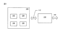
図1は,例えば車両の位置測定に用いられる装置100を示している。この装置は,位置測定が重要な移動する装置,人,アイテムの位置測定に用いることができる。この装置は,移動アイテムに組み込んでもよいし,それと別個であってもよい。
FIG. 1 shows an
装置100は,車両の地理的位置情報を追跡するためのデータ記録装置として機能する。記録は,例えば車両の道路税計算,通行料金徴収又は保険目的に用いてもよい。データ記録装置は,車両追跡のほかにも応用があってよい。更に,「データ記録装置」は後で検証するために地理的位置情報データを記録又は記憶してもよいし,及び/又は地理的位置情報データの即時検証を行ってもよい。
The
図1に示したとおり,装置100は位置測定用に構成された位置測定回路102と,無線通信用に構成された無線通信回路104と,関係付け用に構成された関係付け回路106と,処理回路108と,を備え,これらすべてについて次に説明する。
As shown in FIG. 1,
位置測定回路102は,装置100の地理的位置情報を取得するようになっている。本実施例において位置測定回路102は,装置100の地理的位置情報を取得するために,例えばGPS又はガリレオシステムなどの衛星情報源を用いるようになっている。別の実施例においては,位置測定回路102は,装置100の地理的位置情報を取得するために,例えばセルラ電気通信網,WLAN,Bluetooth(登録商標)網,及び無線周波識別(RFID)タグ読み取り器のうち1又は複数などの地上情報源を用いるようになっている。更に別の実施例においては,位置測定回路102は,装置の地理的位置情報を取得するために,推測回路118を用いるようになっている(図2参照)。本実施例において位置測定回路102は,地理的位置情報測定値それ自体を取得することによって,装置100の地理的位置情報を取得するようになっている。別の実施例においては,位置測定回路102は外部情報源から地理的位置情報を受信することによって,装置100の地理的位置情報を取得するようになっている。
The
無線通信回路104は,遠隔回路150を用いて選択可能な継続通信経路190を提供するために遠隔回路150と無線通信112を行うようになっている。本実施例において,継続通信経路190は,音響データ通信経路及び映像データ通信経路を含む。別の実施例においては,通信経路190は別のデータ(例えばGPRSデータ)を搬送してもよい。
The
継続通信経路190は,別の装置(図示していない)に対して継続の有線通信及び/又は無線通信を提供することができる。「別の装置」は,遠隔回路150と直接に(物理的/有線/光/無線の)通信してもよいし,中間網回路(図示していない)を介して遠隔回路150と(物理的/無線網コンポーネントを介して)接続されてもよい。無線通信回路104は,無線通信112の際に遠隔回路150の接続点識別データを取得する。この接続点識別データは,遠隔回路150の地理的位置情報と関係付けられている。更に回路104は,それと接続していない遠隔回路150’(図1には示していない)であって,装置100に継続通信経路190を提供するために利用できる遠隔回路の接続点識別データを取得するために無線通信を行うように構成してもよい。なぜならば,遠隔回路150’は装置100に自己の存在を積極的に通知できるからである。このような通知は緊急呼を設定するために行ってもよい。
The
本実施例において,遠隔回路150はセルラ網要素を含み,接続点識別データはセルラ網要素の完全セルIDを含む。別の実施例においては,接続点識別データは例えば市外局番(例えば地理的電話番号,例えばイギリスロンドンは0181)などの部分セルIDを含む。網要素は利用者が加入している通信事業者に属してもよいし,利用者が加入していない別の通信事業者に属してもよい。別の実施例において,遠隔回路150はWLANアクセスポイントを含み,接続点識別データはWLANアクセスポイントのIPアドレス及びMACアドレスを含む。ほかの実施例においては,遠隔回路150はBluetooth(登録商標)網要素又は無線周波識別(RFID)タグ読み取り器を含む。このような実施例においては,遠隔回路150の位置は固定している。
In this embodiment, the
関係付け回路106は,下記のとおりクロスチェックが実行できるように,装置100の地理的位置情報の1又は複数の実現値と,接続点識別データの対応する実現値との関係付けができる。装置の地理的位置情報の各実現値と,対応する接続点識別データの地理的位置情報の実現値とは,互いに所定の期間内に取得されることによって関係付けられる。
The correlating
本実施例において,関係付け回路106は,装置100の地理的位置情報の1又は複数の実現値と,接続点識別データの対応する実現値との関係を記憶するようになっている記憶回路110(図3参照)を備える。
In this embodiment, the associating
別の実施例においては,関係付け回路106は,装置100の地理的位置情報の1又は複数の実現値と,接続点識別データの対応する実現値との関係を取得するために,遠隔記憶回路116に接続するようになっている遠隔記憶接続回路114(図4参照)を備える。記憶回路110及び遠隔記憶回路116はまた,地理的位置情報の実現値が取得された時刻及び任意選択で日付も記憶する。このような実施例において,回路106は遠隔記憶回路116内での関係付けのために,回路102及び104から地理的位置情報を送信してもよい。
In another embodiment, the
処理回路108は,クロスチェックのために,装置100の地理的位置情報と,遠隔回路150の地理的位置情報(すなわち,装置100の地理的位置情報の近似)とを比較することができる。本実施例において処理回路108は,クロスチェックのために,装置100の地理的位置情報が遠隔回路150の地理的位置情報の所定較差内にあるかどうかを判定するようになっている。この所定較差は,遠隔回路150の最大通信範囲を含む。
The
このようにして,位置測定回路102がだまされていないかどうかを判定することができる。
In this way, it can be determined whether or not the
例えば回路102がGPSシステムを用いて装置100の地理的位置情報を取得する場合,車両所有者は正当なGPS信号を置き換える詐称信号を回路102に送信する詐称装置を当該車両に設置することによって,回路102が当該車両の位置を車両所有者の自宅として記録するようにだますことができる。車両所有者は,こうして道路税又は高速道路通行料金の支払を間逃れることを期待する。
For example, if the
しかし,回路102が取得した装置100の地理的位置情報と,遠隔回路150の地理的位置情報とを,装置100が通過した範囲でクロスチェックすることによって,回路102がだまされたかどうかを判定することができる。集中型システムにアップロードされた任意のデータに適用する後処理の一部として,装置100の各位置と,接続点識別データとを検証して,それらが適切な近さにあるかどうかを検査することができる。
However, it is determined whether the
本実施例において,装置100は装置100及び1又は複数の遠隔回路150双方の地理的位置情報を時間と共に反復して取得し,反復取得した地理的位置情報を記録するようになっている。本実施例において,装置100の地理的位置情報は指定の間隔で記録され,最後の期間に装置100が発見された接続点識別データの完全集合が,装置100の地理的位置情報に関係付けて記録される。別の実施例においては,装置100は1回限りモードで動作するように構成され,このモードでは接続点識別データが車両所有者の要求,又は所有者の特定動作(例えば所有者が地図サービスに接続して自分のGPS位置を地図上に表示させたとき)に応答して,若しくは無線通信回路104を介して受信した要求に応答して取得される。
In this embodiment, the
本実施例において,例えば要求時プルモード動作において,装置100は非実時間で反復取得した地理的位置情報を遠隔サーバ160へアップロードするようになっている。この方法は,例えば通信事業者が最繁時外の使用に低額料金を提供することに同意しているとき,低額の時間単価で行うことができる。別の実施例においては,装置100は実時間で反復取得した地理的位置情報を遠隔サーバ160へアップロードするようになっている。しかし,何百万もの車両又は個人のそのような活発な実時間追跡を行うには,網負荷が禁止的かもしれない。ほとんどの場合,データアップロードの際に接続されているセルは,車両所有者の自宅であろう。
In the present embodiment, for example, in the pull-on-demand operation, the
装置100は,最も単純な形態では設定された間隔でデータを記録する状態機械だけが必要なので,低価格にできる。
The
一例では,装置100はショッピングアーケード,すなわちモール内へ移動する人の位置追跡に用いられる。GPSデータは失われるかもしれないが,最後の位置は建物の端を示している。基地局セルIDは中継器のIDであってもよいので,したがって最適な位置情報は提供しない。接続点識別データは,WLAN,Blutooth(登録商標)又はほかの接続点のデータを含んでもよく,そのデータは利用者が建物内にいることを決定的に確証する。この場合,すべてのサービス(セルラ,WLAN,Bluetooth(登録商標))を用いて支援してもよい。各サービスは報知(advertise)を行い,装置100はどれを用いるか選択するようになっている。装置100は,例えばGSM,GPRS,3G,などの既定接続サービスを開始してもよい。
In one example, the
装置100の起動時に,無線通信回路104は選択可能な接続セルを走査して発見し,利用者の加入している通信事業者のセルに接続する。同一区画には別の通信事業者の別のセルが恐らく存在する。したがって装置100は選択したセルを登録して,発呼し,呼を受信することができる。装置100が移動したとき,装置100は同一通信事業者の隣接セルへハンドオーバする。装置100は隣接セルを検査し,この切替を行うために一連の信号品質を調べる。本質的に装置100は,どの接続点が近くにあるかを認識するために設定された期間を調べ,そして装置100はいくつかのセルを認識する。装置100はセルと選択した間隔でだけ通信することができ,装置が発呼することができ,システムは装置がどのセルに登録されているかを知っているので,同様に呼を受信できるように,装置は登録を維持する。装置100は利用者の加入している通信事業者のセルだけが分かるのではなく,同一周波数帯の,又は当該サービスにおいて利用可能な,すべてのセルが分かる。
When the
図9は,例示シナリオにおける装置100の動きを表す矢印Aを示している。装置100は,装置が移動するにつれて第1遠隔回路150a,第2遠隔回路150b,第3遠隔回路150c,の範囲を通過する。各遠隔回路の範囲はそれぞれ,重複する円152a,152b,152cで表されている。遠隔回路150a‐cは別々の通信事業者が所有していてもよく,異なった程度に重複した別々の範囲を有してもよい。
FIG. 9 shows an arrow A representing the movement of the
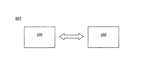
図6は,第1コンポーネント202と,第2コンポーネント204と,第3コンポーネント206と,第4コンポーネント208と,を含む計算機実行可能コンポーネントを有する計算機可読媒体200を示している。これらのコンポーネントの各機能を以降説明する。
FIG. 6 illustrates a computer
第1コンポーネント202は,装置100の地理的位置情報を受信するようになっている。
The
第2コンポーネント204は,装置100の無線通信回路104と,遠隔回路150との間の無線通信の際に取得された,遠隔回路150の接続点識別データを受信するようになっている。遠隔回路150との無線通信によって,遠隔回路150を用いる継続通信経路190を提供することができる。接続点識別データは,遠隔回路150の地理的位置情報と関係付けられている。
The
第3コンポーネント206は,装置100の地理的位置情報の1又は複数の実現値と,接続点識別データの対応する実現値と,を関係付けるようになっている。
The
第4コンポーネント208は,クロスチェックのために,装置100の地理的位置情報と,遠隔回路150の地理的位置情報と,を比較するようになっている。更に第4コンポーネント208は,上記クロスチェックのために,装置100の地理的位置情報が遠隔回路150の地理的位置情報の所定較差内にあるかどうかを判定するようになっている。
The
上記計算機実行可能コンポーネントは,装置100及び1又は複数の遠隔回路150双方の地理的位置情報を時間と共に反復取得し,反復取得した地理的位置情報を記録するようになっている。
The computer-executable component is adapted to repeatedly acquire geographical position information of both the
本実施例において,計算機実行可能コンポーネントは反復取得した地理的位置情報を遠隔サーバ160へ実時間でアップロードするようになっている。別の実施例では,計算機実行可能コンポーネントは反復取得した地理的位置情報を遠隔サーバ160へ非実時間でアップロードするようになっている。
In this embodiment, the computer executable component uploads the repeatedly acquired geographical location information to the
図7は,位置測定に用いる方法を示している。 FIG. 7 shows a method used for position measurement.
この方法は,装置100の地理的位置情報を取得するステップ1002と,遠隔回路150と無線通信を行い,上記遠隔回路150の接続点識別データを取得することによって,上記遠隔回路150を用いて1又は複数の選択可能な継続通信経路112を提供するステップであって,該接続点識別データは上記遠隔回路150の地理的位置情報と関連するものであるステップ1004と,上記装置100の地理的位置情報の1又は複数の実現値と,上記接続点識別データの対応する実現値とを関係付けるステップ1006と,を有する。ステップ1004は,ステップ1002の前に実行してもよいし,及び/又は双方を同時に実行してもよい。
This method includes
上述の実施例の変形として,例えばGPSなどの衛星システムから取得した地理的位置情報データを検証するために,装置は推測回路を含む。単純な形態では,例えば車両所有者の自宅などの静止した位置を表す信号によってGPSシステムがだまされていることを識別するために,0以上の車両速度が用いられる。 As a variation of the above-described embodiment, the apparatus includes an inference circuit to verify geographical location information data obtained from a satellite system such as GPS. In a simple form, a vehicle speed of zero or more is used to identify that the GPS system is being fooled by a signal representing a stationary position, such as the vehicle owner's home.
別の変形では,クロスチェックを集中的に行えるように,処理回路118が遠隔サーバ160の一部を形成する。このようにしてサービス提供事業者が検証した利用者の開始する選択機能が提供できる。
In another variation, the
別の変形では,無線通信回路104は装置の一部を形成しないで,別個の装置の一部を形成する。一例では,無線通信回路104は車両に設置された防犯警報装置の一部を形成し,ここで説明したものとは異なる理由で遠隔回路150と通信する。装置100は,通信中に取得した接続点識別データを受信し,上述の方法でこの接続点識別データを用いるようになっている。別の変形では,無線通信回路104は自動車電話機の一部を形成する。
In another variation, the
図8は,軟禁又は囚人の外出禁止時間を強制するために用いる装置300を示している。
FIG. 8 shows an
装置300は囚人の足首に固定されたタグの形態であり,特殊な工具でだけ取り外すことができる。このような装着物の詳細は当業において既知であり,本開示の範囲外である。
タグ300は,装置100と同一の位置測定回路102及び関係付け回路106を備える。
The
タグ300は更に,遠隔回路350と無線通信112を行うようにした無線通信回路304を備え,遠隔回路350を用いて選択可能な継続通信経路を提供する。本実施例において,継続通信経路190は,位置測定回路102が収集した地理的位置情報データを集中監視サーバ(図示していない)へ伝送する。継続通信経路190は,別の装置(図示していない)との有線及び/又は無線通信を提供することができる。「別の装置」は,遠隔回路350と直接に(物理的/有線/光/無線の)通信してもよいし,中間網回路(図示していない)を介して遠隔回路350と(物理的/無線網コンポーネントを介して)接続されてもよい。装置300は,無線通信112の際に遠隔回路350の接続点識別データを取得する。この接続点識別データは,遠隔回路350の地理的位置情報と関係付けられている。
The
本実施例において,遠隔回路350は囚人の自宅に設置された本体装置(home unit)を含む。接続点識別データは本体装置350のIPアドレス及びMACアドレスを含む。本体装置350は移動しないものとすると,本体装置350のIPアドレス/MACアドレスはまた,デバイス(例えばタグ300)と本体装置350とが接続されたとき,本体装置に接続されたデバイスの地理的位置情報も提供する。
In this embodiment, the
タグ300及び本体装置350の機能は,処理回路108が集中監視サーバの一部を形成すること以外は,装置100及び遠隔回路150の対応するコンポーネントに関して上述したとおりである。タグ300と本体装置350とは協働して容易に詐称されない囚人の地理的位置情報を提供する。
The functions of
囚人は,特定時間に本体装置350のところへ出頭するように指示されていることがある。本体装置350は,報告及びデータ収集を同時に処理するように構成してもよい。
The prisoner may be instructed to appear at the
本体装置350は,動作していないという言い訳ができないように責任が課せられることがある。
Responsibility may be imposed so that
一例示実施例において,装置100,300はGPS受信器及びセルラ回路を含む。セルラ網は粗い地理的位置情報を提供し,例えば10km較差内で正確である。GPS受信器はより正確な位置を提供し,例えば20m較差内で正確である。GPSが提供した正確な位置は,セルラ網が標示した10km較差内に入っているかどうかクロスチェックすることによって検証できる。セルラ回路は,(例えばGPRSによる)データ接続機能及び/又は音声電話/テレビ電話機能を提供するのに適している。
In one exemplary embodiment, the
別の例示実施例において,装置100,300はGPS受信機及びWLAN回路を含む。WLAN網は粗い地理的位置情報を提供し,例えば100m較差内で正確である。GPS受信器はより正確な位置を提供し,例えば20m較差内で正確である。GPSが提供した正確な位置は,WLAN網が標示した100m較差内におよそ入っているかどうかクロスチェックすることによって検証できる。
In another exemplary embodiment, the
別の例示実施例において,装置100,300はWLAN回路及びセルラ回路を含む。セルラ網は粗い地理的位置情報を提供し,例えば10km較差内で正確である。WLAN回路はより正確な位置を提供し,例えば100m較差内で正確である。WLAN回路が提供した正確な位置は,セルラ網が標示した10km較差内に入っているかどうかクロスチェックすることによって検証できる。
In another exemplary embodiment, the
一例では,接続点IDデータ及びGPSデータを,遠隔装置から受信した信号に従って互いに関係付けることができる。例えばデバイスが盗難にあった場合,遠隔装置からデバイスへ信号を送信して,GPSデータと接続点データ(例えばセルID)との関係付けを開始することができる。このようなデータを遠隔装置に送信して,盗まれたデバイスの実際の位置を正確に追跡することができる。 In one example, the connection point ID data and the GPS data can be related to each other according to a signal received from the remote device. For example, when a device is stolen, a signal can be transmitted from the remote device to the device to start associating GPS data with connection point data (for example, cell ID). Such data can be sent to the remote device to accurately track the actual location of the stolen device.
上述の回路は言及された機能に加えてほかの機能も有することができ,それらの機能は同一の回路で実行できることを認識されたい。 It will be appreciated that the circuits described above can have other functions in addition to the functions mentioned, and that these functions can be performed in the same circuit.
接続点について提供された1又は複数のデータ要素(すなわち,必ずしもすべての接続点データ要素ではない(例えばセルID要素のすべてではない))を用いて,上記の関係付け/検証を行うことができることを認識されたい。 The above association / verification can be performed using one or more data elements provided for the attachment point (ie not necessarily all attachment point data elements (eg not all of the cell ID elements)). I want to be recognized.
関係付けられた地理的データは,実時間で検証(例えば,どのデータが正しいかの検査/測定された地理的位置情報の矛盾の検査/想定されるスパムの検査)をする必要はなく,後刻検証してもよいことを認識されたい。後者においては,対応するデータは適切な記憶回路に単に記録される。 The associated geographic data does not need to be verified in real time (eg, which data is correct / inspected for inconsistencies in measured geolocation / inspected spam); It should be recognized that it may be verified. In the latter, the corresponding data is simply recorded in a suitable storage circuit.
検証は,特定のセルラ網要素の通信半径,及び/又は装置100が含まれる可能性のある半径を規定するために用いられる,網要素と装置100との間の送信電力,を根拠としてよい。更に,利用者が承認した通信事業者(すなわち,無線接続点提供事業者)の既知の分布を検査して,記録された接続データがあり得るかどうかを調べることができる。スパム/誤りは,1又は複数の誤りが検出された後で(又は装置100がいつも地理的位置情報データの近傍にある訳ではないときは,所定時間枠内のいくつかの誤りによって)検出できると考えられる。
The verification may be based on the communication radius of a particular cellular network element and / or the transmission power between the network element and the
関係付けに用いられる接続点データは,継続通信に用いられる網要素(例えばセル/基地局)から提供される必要はなく,ほかの選択可能な接続点であるほかの接続点から提供されることを認識されたい。更に,接続点自体が継続通信自体に使えない実施例もある(例えば,利用者がそれらを使うことが承認されていないとき(例えば利用者が使うことを承認されていない通信事業者のセルラ網要素,又は未知のセキュリティかぎを用いたときだけ接続が許可される隣人のWLANアクセスポイント))。いくつかのシステムの接続点データは,特定通信事業者の隣接接続点(例えばセル)属性について,追加の情報を有してもよい。これはいわゆる「隣接リスト」の形態であってよく,電話を発呼するときに任意選択で用いることができる隣接セルの接続点データを提供するために用いられる。 Connection point data used for association need not be provided by network elements (eg, cells / base stations) used for continuous communication, but should be provided by other selectable connection points. I want to be recognized. Further, there are embodiments in which the connection point itself cannot be used for continuous communication itself (for example, when a user is not authorized to use them (for example, a cellular network of a carrier that is not authorized to be used by a user) Neighbor WLAN access points that are allowed to connect only when using elements or unknown security keys)). Some system attachment point data may have additional information about neighboring attachment point (eg, cell) attributes of a particular carrier. This may be in the form of a so-called “neighbor list” and is used to provide neighbor cell connection point data that can optionally be used when placing a call.
接続点データは近隣のいくつかの選択な可能な接続点から取得してもよく,またこれら接続点の1又は複数から受信したデータを地理的位置情報データの検証に用いてもよいことを認識されたい。 Recognize that connection point data may be obtained from several possible nearby connection points, and that data received from one or more of these connection points may be used to validate geographic location data. I want to be.
このような接続点データは,接続点において利用可能な偶然のデータ又は通常は秘匿されているデータを含み,それは地理的位置情報データに時間スタンプ付きクロスチェック検証を行うために用いると有利である。 Such attachment point data includes accidental data that is available at the attachment point, or data that is normally concealed, which is advantageous for use in performing time-stamped cross-check validation on geographic location data. .
本実施例は無線通信回路104について説明したが,別の実施例においてはその回路104を1又は複数の接続点が送信した接続点データを走査する(及び/又は単に接続点データを受信する)ように構成してもよく,必ずしも対応する接続点との1又は複数の音響/映像/メッセージ(電子メール,SMS,MMS)/データ(例えばGPRS)/制御信号の通信接続に用いることができる訳ではない。このような場合,上記のような回路104を含む単純な形態の装置100は,例えば音声呼のために用いることはできない。
Although the present embodiment has been described with reference to the
本出願人はここに,本願において説明した個々の特徴を個別に及びそれら特徴の2以上の任意の組合せで,それら特徴又はその組合せが本願明細書に基づいて当業者の通常一般知識によって実現可能な程度に開示した。この開示は,それら特徴又はその組合せがここに開示したどの問題も解決するかどうかには係わらず,また本願特許請求の範囲に限定されない。本出願人は,本願発明の各態様がそのような個別の特徴又は各特徴の組合せからなることを示唆する。上述の記載によって,当業者には本発明の範囲内で種々の修正物が可能であることは明白であろう。 The Applicant here describes the individual features described in this application individually and in any combination of two or more of those features, which can be realized by the general general knowledge of those skilled in the art based on the present description. It was disclosed to a certain extent. This disclosure is not limited to the claims herein, regardless of whether those features or combinations thereof solve any of the problems disclosed herein. Applicants suggest that each aspect of the present invention consists of such individual features or combinations of features. In view of the foregoing description it will be evident to a person skilled in the art that various modifications may be made within the scope of the invention.
本願発明の基本的かつ新規な特徴をその好ましい実施例によって示し,説明し,指摘したが,当業者であれば本願発明の精神から逸脱することなく,説明した装置及び方法の形態及び詳細に,種々の省略と,置き換えと,変更とを行うことが可能であることを理解されたい。例えば,同一の結果を達成するために,実質的に同一の機能を実質的に同一の方法で実行するこれら要素及び/又は方法ステップのすべての組合せは,本発明の範囲内であるように意図されている。更に,本願発明のどの開示された形態又は実施例に関連して示され及び/又は説明された,構造及び/又は要素及び/又は方法ステップは,一般的設計事項として任意のほかの開示され,説明され,又は示唆された,形態又は実施例に組み込んでもよいことを理解されたい。したがって,本願発明は,本願の特許請求の範囲に示されたとおりに制限されるものとする。更に,請求項における手段+機能句は,列挙された機能を実行するものとしてここに記載された構造物及び構造的均等物だけでなく均等な構造物も含むものとする。したがって,木製部品をしっかりと結合させるために,ねじはらせん状表面を用い,くぎは円柱状表面を用いるという点で,くぎとねじは構造的均等物ではないが,木製部品を固定する環境において,くぎとねじは均等な構造物である。 While the basic and novel features of the present invention have been shown, described and pointed out by preferred embodiments thereof, those skilled in the art will understand the forms and details of the described apparatus and method without departing from the spirit of the present invention. It should be understood that various omissions, substitutions, and changes can be made. For example, all combinations of these elements and / or method steps that perform substantially the same function in substantially the same way to achieve the same result are intended to be within the scope of the invention. Has been. Further, the structures and / or elements and / or method steps shown and / or described in connection with any disclosed form or embodiment of the invention may be any other disclosed general design matter, It should be understood that the embodiments may be incorporated into the form or example described or suggested. Therefore, the present invention shall be limited as shown in the claims of the present application. Further, the means + function phrases in the claims shall include not only the structures and structural equivalents described herein as performing the recited functions, but also equivalent structures. Therefore, nails and screws are not structural equivalents in that the screws use a helical surface and the nails use a cylindrical surface to securely join the wooden parts. , Nails and screws are equal structures.
Claims (24)
該装置の地理的位置情報を取得する位置測定回路と,
接続点識別データの受信回路であって,該接続点識別データは,接続点となる遠隔回路への無線通信経路を設定する際に用いられ,該遠隔回路の地理的位置情報と関連するものである回路と,
前記位置測定回路が出力する前記装置の地理的位置情報の1又は複数の実現値と,前記接続点識別データの対応する実現値とを関係付ける回路と,
を備える装置。 A device,
A position measuring circuit for obtaining geographical position information of the device;
A connection point identification data receiving circuit, which is used when setting a wireless communication path to a remote circuit as a connection point, and is related to geographical position information of the remote circuit. A circuit,
A circuit associating one or more realization values of the geographical location information of the device output by the position measurement circuit with corresponding realization values of the connection point identification data;
A device comprising:
該装置の地理的位置情報を取得する取得手段と,
接続点識別データの受信手段であって,該接続点識別データは,接続点を提供する提供手段への無線通信経路を設定する際に用いられ,該提供手段の地理的位置情報と関連するものである手段と,
前記取得手段が出力する前記装置の地理的位置情報の1又は複数の実現値と,前記接続点識別データの対応する実現値とを関係付ける手段と,
を備える装置。 A device,
Obtaining means for obtaining geographical location information of the device;
Connection point identification data receiving means, which is used when establishing a wireless communication path to a providing means for providing a connection point, and is associated with geographical position information of the providing means And means that
Means for associating one or more realization values of the geographical location information of the device output by the acquisition means with corresponding realization values of the connection point identification data;
A device comprising:
装置の地理的位置情報を取得する第1コンポーネントと,
接続点識別データを受信する第2コンポーネントであって,該接続点識別データは,接続点となる遠隔回路への無線通信経路を設定する際に用いられ,該遠隔回路の地理的位置情報と関連するものであるコンポーネントと,
前記第1コンポーネントが出力する前記装置の地理的位置情報の1又は複数の実現値と,前記接続点識別データの対応する実現値とを関係付ける第3コンポーネントと,
を有する計算機可読媒体。 A computer readable medium having stored computer executable components,
A first component that obtains geographical location information of the device;
A second component that receives connection point identification data, the connection point identification data being used when establishing a wireless communication path to a remote circuit as a connection point, and associated with geographical location information of the remote circuit The component to be
A third component relating one or more realization values of the geographical location information of the device output by the first component to corresponding realization values of the connection point identification data;
A computer-readable medium having:
接続点識別データの受信であって,該接続点識別データは,接続点となる遠隔回路への無線通信経路を設定する際に用いられ,該遠隔回路の地理的位置情報と関連するものである受信と,
前記装置の地理的位置情報の取得によって得られる前記装置の地理的位置情報の1又は複数の実現値と,前記接続点識別データの対応する実現値との関係付けと,
を行う方法。 Obtaining the geographical location information of the device;
Receiving connection point identification data, the connection point identification data is used when setting a wireless communication path to a remote circuit as a connection point, and is related to geographical position information of the remote circuit Receiving,
Relationship between one or more realization values of the device geographical location information obtained by obtaining the geographical location information of the device and corresponding realization values of the connection point identification data;
How to do.
接続点識別データを受信するステップであって,該接続点識別データは,接続点となる遠隔回路への無線通信経路を設定する際に用いられ,該遠隔回路の地理的位置情報と関連するものであるステップと,
前記取得ステップによって得られる前記装置の地理的位置情報の1又は複数の実現値と,前記接続点識別データの対応する実現値とを関係付けるステップと,
を有する方法。 An acquisition step of acquiring geographical location information of the device;
A step of receiving connection point identification data, the connection point identification data being used when establishing a wireless communication path to a remote circuit as a connection point, and associated with geographical position information of the remote circuit A step that is
Associating one or more realization values of the geographical location information of the device obtained by the obtaining step with corresponding realization values of the connection point identification data;
Having a method.
該装置の地理的位置情報を取得する位置測定回路と,
インタフェース回路であって,遠隔回路の接続点識別データを取得することによって,前記遠隔回路を用いて1又は複数の継続通信経路を提供するようになっている無線通信回路と通信するようになっており, 前記接続点識別データは前記遠隔回路の地理的位置情報に関係付けられており,前記インタフェース回路は前記無線通信回路から接続点識別データを取得するようになっている回路と,
前記位置測定回路が出力する前記装置の地理的位置情報の1又は複数の実現値と,前記接続点識別データの対応する実現値とを関係付ける回路と,
を備える装置。 A device,
A position measuring circuit for obtaining geographical position information of the device;
An interface circuit that communicates with a wireless communication circuit adapted to provide one or more continuous communication paths using the remote circuit by acquiring connection identification data of the remote circuit. The connection point identification data is related to geographical location information of the remote circuit, and the interface circuit is adapted to obtain connection point identification data from the wireless communication circuit;
A circuit associating one or more realization values of the geographical location information of the device output by the position measurement circuit with corresponding realization values of the connection point identification data;
A device comprising:
該装置の地理的位置情報を取得する位置測定回路と,
前記装置の動きを標示する回路と,
前記の動き標示回路が前記装置の動きを標示したとき,前記位置測定回路が取得した前記装置の静的地理位置は偽であると判定する回路と,
を備える装置。 A device,
A position measuring circuit for obtaining geographical position information of the device;
A circuit for indicating the movement of the device;
A circuit for determining that the static geolocation of the device acquired by the position measurement circuit is false when the motion indicator circuit indicates the motion of the device;
A device comprising:
該装置の地理的位置情報を取得する位置測定回路と,
無線通信回路であって,遠隔回路の接続点識別データを取得することによって,前記遠隔回路を用いて1又は複数の継続通信経路を提供するために前記遠隔回路と無線通信を行うようになっており, 前記接続点識別データは前記遠隔回路の地理的位置情報に関係付けられている回路と,
前記位置測定回路が出力する前記装置の地理的位置情報の1又は複数の実現値と,前記接続点識別データの対応する実現値とを関係付ける関係付け回路と,
を備え,
前記位置測定回路と,前記無線通信回路と,前記関係付け回路と,を一つに組み立てるステップを有する方法。 A device assembly method, the device comprising:
A position measuring circuit for obtaining geographical position information of the device;
A wireless communication circuit that communicates with the remote circuit to provide one or more continuous communication paths using the remote circuit by obtaining connection point identification data of the remote circuit. The connection point identification data includes a circuit associated with geographical location information of the remote circuit;
An associating circuit for associating one or more realization values of the geographical position information of the device output by the position measurement circuit with corresponding realization values of the connection point identification data;
With
A method comprising assembling the position measurement circuit, the wireless communication circuit, and the association circuit together.
Applications Claiming Priority (2)
| Application Number | Priority Date | Filing Date | Title |
|---|---|---|---|
| US11/767,210 US8160617B2 (en) | 2007-06-22 | 2007-06-22 | Apparatus and method for use in location determination |
| US11/767,210 | 2007-06-22 |
Related Parent Applications (1)
| Application Number | Title | Priority Date | Filing Date |
|---|---|---|---|
| JP2010512600A Division JP5032658B2 (en) | 2007-06-22 | 2008-06-19 | Apparatus and method used for position measurement |
Publications (2)
| Publication Number | Publication Date |
|---|---|
| JP2012164352A true JP2012164352A (en) | 2012-08-30 |
| JP5379265B2 JP5379265B2 (en) | 2013-12-25 |
Family
ID=39720238
Family Applications (2)
| Application Number | Title | Priority Date | Filing Date |
|---|---|---|---|
| JP2010512600A Expired - Fee Related JP5032658B2 (en) | 2007-06-22 | 2008-06-19 | Apparatus and method used for position measurement |
| JP2012105899A Expired - Fee Related JP5379265B2 (en) | 2007-06-22 | 2012-05-07 | Apparatus and method used for position measurement |
Family Applications Before (1)
| Application Number | Title | Priority Date | Filing Date |
|---|---|---|---|
| JP2010512600A Expired - Fee Related JP5032658B2 (en) | 2007-06-22 | 2008-06-19 | Apparatus and method used for position measurement |
Country Status (11)
| Country | Link |
|---|---|
| US (3) | US8160617B2 (en) |
| EP (2) | EP2299293A1 (en) |
| JP (2) | JP5032658B2 (en) |
| CN (1) | CN101785034B (en) |
| AT (1) | ATE534105T1 (en) |
| AU (1) | AU2008267395B2 (en) |
| BR (1) | BRPI0813431A2 (en) |
| HK (1) | HK1142157A1 (en) |
| PT (1) | PT2168099E (en) |
| TW (1) | TWI420131B (en) |
| WO (1) | WO2009000457A2 (en) |
Cited By (1)
| Publication number | Priority date | Publication date | Assignee | Title |
|---|---|---|---|---|
| WO2015186966A1 (en) * | 2014-06-03 | 2015-12-10 | (주) 코콤 | Id kits for personal automation, and charging units therefor |
Families Citing this family (29)
| Publication number | Priority date | Publication date | Assignee | Title |
|---|---|---|---|---|
| US8160617B2 (en) | 2007-06-22 | 2012-04-17 | Nokia Corporation | Apparatus and method for use in location determination |
| WO2009046767A1 (en) * | 2007-10-12 | 2009-04-16 | Nokia Corporation | Determining whether a wireless communication node is stationary by evaluating changes in information about peer wireless communication nodes |
| US20100287038A1 (en) * | 2008-01-15 | 2010-11-11 | Nxp B.V. | Road toll system |
| EP2335088B1 (en) | 2008-10-07 | 2013-07-24 | Nokia Corporation | Upload and download of position reference data |
| KR101381477B1 (en) | 2008-10-07 | 2014-04-04 | 노키아 코포레이션 | Upload and download of position reference data |
| US20100179753A1 (en) * | 2009-01-15 | 2010-07-15 | Microsoft Corporation | Estimating Time Of Arrival |
| US8095656B2 (en) * | 2009-11-16 | 2012-01-10 | International Business Machines Corportion | Geo-positionally based data access security |
| JP5713645B2 (en) * | 2010-11-18 | 2015-05-07 | 三菱重工業株式会社 | OBE, toll collection system, and vehicle position estimation method |
| CN102568211B (en) * | 2010-12-09 | 2014-03-26 | 天津广行科技有限公司 | Accurate determination method of vehicle driving path in road network |
| CN102158801B (en) * | 2011-02-15 | 2012-07-11 | 广州市动景计算机科技有限公司 | Mobile terminal user-oriented accurate location based information service method and device |
| EP2854110A3 (en) * | 2011-03-11 | 2015-05-06 | Telit Automotive Solutions NV | Vehicle mountable unit and road toll system |
| FR2973518A1 (en) * | 2011-03-31 | 2012-10-05 | Thales Sa | POSITIONING SYSTEM WITH FRAUD DETECTION MECHANISM FOR CRITICAL APPLICATION |
| DE102011106591B4 (en) * | 2011-06-16 | 2015-05-13 | Astrium Gmbh | Method and system for determining the position of a GNSS receiver mounted in a motor vehicle |
| US9665991B2 (en) * | 2011-06-30 | 2017-05-30 | Accenture Global Services Limited | Tolling using mobile device |
| EP2549452B1 (en) | 2011-07-21 | 2019-09-25 | Nxp B.V. | Location-based tracking |
| EP2740030A2 (en) * | 2011-08-04 | 2014-06-11 | CONNORS, Robert W. | Content changeable smart phone application for navigable venues and multi-party navigational system |
| WO2013036060A1 (en) * | 2011-09-09 | 2013-03-14 | 엘지전자 주식회사 | Method and apparatus for detecting the locations of terminals in a multi-node system |
| DK2665044T3 (en) * | 2012-05-16 | 2015-03-02 | Kapsch Trafficcom Ag | PROCEDURE FOR MEASURING THE CAPACITY OF A ROADBY SYSTEM |
| US9191830B2 (en) | 2013-03-28 | 2015-11-17 | Telefonaktiebolaget L M Ericsson (Publ) | Local wireless connectivity for radio equipment of a base station in a cellular communications network |
| US9491162B2 (en) | 2013-03-28 | 2016-11-08 | Telefonaktiebolaget L M Ericsson (Publ) | Technique for controlling loss and theft of remote radio equipment in a cellular ad hoc network |
| US9055461B2 (en) | 2013-03-28 | 2015-06-09 | Telefonaktiebolaget L M Ericsson (Publ) | Technique for troubleshooting remote cellular base station radios from the network management platform using local wireless hotspot at the radio site |
| US9788163B2 (en) | 2013-07-02 | 2017-10-10 | Life360, Inc. | Apparatus and method for increasing accuracy of location determination of mobile devices within a location-based group |
| US9294876B2 (en) | 2013-09-10 | 2016-03-22 | Life360, Inc. | Apparatus and method for generating, displaying and implementing a geo-fence using location determination of mobile devices within a location-based group |
| SI2860703T1 (en) * | 2013-10-08 | 2016-10-28 | Kapsch Trafficcom Ag | Method for checking toll transactions and components therefor |
| WO2015058281A1 (en) * | 2013-10-24 | 2015-04-30 | Peck Tech Consulting Ltd. | Dead reckoning-augmented gps for tracked vehicles |
| CN105225512A (en) * | 2015-09-17 | 2016-01-06 | 浙江警察学院 | Based on bluetooth equipment running orbit follow-up mechanism and the method thereof of MAC Address |
| US9955450B2 (en) * | 2016-04-01 | 2018-04-24 | Guardhat, Inc. | Geo-localization assembly and methodology |
| EP3519845B1 (en) | 2016-09-28 | 2023-11-01 | Telefonaktiebolaget LM Ericsson (PUBL) | Validation of position indication |
| WO2018084568A1 (en) * | 2016-11-01 | 2018-05-11 | 엘지전자 주식회사 | Method and device for selecting resources and transmitting pssch in wireless communication system |
Citations (2)
| Publication number | Priority date | Publication date | Assignee | Title |
|---|---|---|---|---|
| US5490079A (en) * | 1994-08-19 | 1996-02-06 | Texas Instruments Incorporated | System for automated toll collection assisted by GPS technology |
| EP1197924A1 (en) * | 1999-04-28 | 2002-04-17 | Toyota Jidosha Kabushiki Kaisha | Accounting system |
Family Cites Families (44)
| Publication number | Priority date | Publication date | Assignee | Title |
|---|---|---|---|---|
| US21245A (en) * | 1858-08-24 | Apparatus for cooling and ventilating grain | ||
| US17977A (en) * | 1857-08-11 | Beefing topsails | ||
| WO1993004425A1 (en) * | 1991-08-13 | 1993-03-04 | Universal Photonix, Inc. | System for remotely validating the identity of indivuals and determining their locations |
| DE4310099C2 (en) | 1993-03-23 | 1997-09-04 | Mannesmann Ag | Path identification device |
| GB9508884D0 (en) * | 1995-05-02 | 1995-06-21 | Telecom Sec Cellular Radio Ltd | Cellular radio system |
| US5917434A (en) * | 1995-06-15 | 1999-06-29 | Trimble Navigation Limited | Integrated taximeter/GPS position tracking system |
| US6208290B1 (en) * | 1996-03-08 | 2001-03-27 | Snaptrack, Inc. | GPS receiver utilizing a communication link |
| US5841396A (en) * | 1996-03-08 | 1998-11-24 | Snaptrack, Inc. | GPS receiver utilizing a communication link |
| US5874914A (en) * | 1995-10-09 | 1999-02-23 | Snaptrack, Inc. | GPS receiver utilizing a communication link |
| US6369755B1 (en) * | 1995-10-23 | 2002-04-09 | Trimble Navigation Limited | Integrated SATPS total survey station |
| US5945944A (en) * | 1996-03-08 | 1999-08-31 | Snaptrack, Inc. | Method and apparatus for determining time for GPS receivers |
| US7358857B1 (en) * | 1996-03-27 | 2008-04-15 | Symbol Technologies, Inc. | Global positioning systems applications |
| US5812087A (en) * | 1997-02-03 | 1998-09-22 | Snaptrack, Inc. | Method and apparatus for satellite positioning system based time measurement |
| US6215442B1 (en) * | 1997-02-03 | 2001-04-10 | Snaptrack, Inc. | Method and apparatus for determining time in a satellite positioning system |
| US5999124A (en) * | 1998-04-22 | 1999-12-07 | Snaptrack, Inc, | Satellite positioning system augmentation with wireless communication signals |
| US6061018A (en) * | 1998-05-05 | 2000-05-09 | Snaptrack, Inc. | Method and system for using altitude information in a satellite positioning system |
| US6636740B1 (en) * | 1998-06-16 | 2003-10-21 | Ericsson Inc. | Apparatus and methods for position computation based on broadcast initialization data |
| US6232916B1 (en) * | 1999-08-31 | 2001-05-15 | Lucent Technologies, Inc. | GPS restraint system and method for confining a subject within a defined area |
| US6509830B1 (en) * | 2000-06-02 | 2003-01-21 | Bbnt Solutions Llc | Systems and methods for providing customizable geo-location tracking services |
| US6484096B2 (en) * | 2000-06-06 | 2002-11-19 | Satellite Devices Limited | Wireless vehicle monitoring system |
| US20020008661A1 (en) | 2000-07-20 | 2002-01-24 | Mccall Hiram | Micro integrated global positioning system/inertial measurement unit system |
| US20020017977A1 (en) | 2000-08-04 | 2002-02-14 | Wall Mark Emanuel | Method and apparatus for licensing and controlling access, use, and viability of product utilizing geographic position |
| US6799052B2 (en) * | 2001-02-08 | 2004-09-28 | Michael K. Agness | Hand-held cellular telephone system with location transmission inhibit |
| KR20020006015A (en) | 2001-12-19 | 2002-01-18 | 최명렬 | System for collecting a Toll using Mobile Network and Method therefor |
| US8972589B2 (en) * | 2002-03-01 | 2015-03-03 | Enterasys Networks, Inc. | Location-based access control in a data network |
| US6774797B2 (en) * | 2002-05-10 | 2004-08-10 | On Guard Plus Limited | Wireless tag and monitoring center system for tracking the activities of individuals |
| JP4073724B2 (en) * | 2002-07-09 | 2008-04-09 | アマノ株式会社 | Patrol recorder system |
| US7477920B2 (en) * | 2002-10-25 | 2009-01-13 | Intel Corporation | System and method for automatically configuring and integrating a radio base station into an existing wireless cellular communication network with full bi-directional roaming and handover capability |
| US7512403B2 (en) * | 2002-12-20 | 2009-03-31 | Samsung Electronics Co., Ltd. | Apparatus and method for performing an interfrequency handoff in a wireless network |
| CN1518255A (en) * | 2003-01-13 | 2004-08-04 | ��������ͨ�ż����о�����˾ | Method for moving UE in RRC connection mole |
| EP1469368B1 (en) * | 2003-04-17 | 2008-05-28 | Marshfield LLC | Security method and system with cross-checking based on geographic location data |
| US8971913B2 (en) * | 2003-06-27 | 2015-03-03 | Qualcomm Incorporated | Method and apparatus for wireless network hybrid positioning |
| US20050026626A1 (en) * | 2003-08-01 | 2005-02-03 | Siemens Information And Communication Mobile, Llc. | Wireless network with positioned mobile devices |
| US6934631B2 (en) * | 2003-08-13 | 2005-08-23 | Trimble Navigation Limited | Method for standard positioning service and precise positioning service cooperative operation |
| KR100518852B1 (en) * | 2003-08-25 | 2005-09-30 | 엘지전자 주식회사 | Method for dead reckoning for backward improvement of mobile |
| US7526380B2 (en) * | 2003-12-02 | 2009-04-28 | Gmv Aerospace And Defence, S.A. | Method and system to provide a global multiuser service of localization information with integrity as required under liability or commercial issues |
| US7251493B2 (en) | 2004-02-13 | 2007-07-31 | Sony Ericsson Mobile Communications Ab | Mobile terminals and methods for determining a location based on acceleration information |
| US20050285747A1 (en) * | 2004-06-24 | 2005-12-29 | Douglas Kozlay | Biometrically authenticated telecommunications system for probation release monitoring programs and other security-oriented applications |
| US7321305B2 (en) * | 2005-07-05 | 2008-01-22 | Pinc Solutions | Systems and methods for determining a location of an object |
| US7245215B2 (en) * | 2005-02-10 | 2007-07-17 | Pinc Solutions | Position-tracking device for position-tracking system |
| US7250903B1 (en) * | 2006-04-17 | 2007-07-31 | Rockwell Collins | GPS spoofer and repeater mitigation system using digital spatial nulling |
| US7925278B2 (en) * | 2006-06-27 | 2011-04-12 | Motorola Mobility, Inc. | Method and system for locating a wireless device in a wireless communication network |
| US8180339B2 (en) * | 2006-08-09 | 2012-05-15 | Cisco Technology, Inc. | Method and apparatus for transferring network management information to wireless nodes |
| US8160617B2 (en) | 2007-06-22 | 2012-04-17 | Nokia Corporation | Apparatus and method for use in location determination |
-
2007
- 2007-06-22 US US11/767,210 patent/US8160617B2/en not_active Expired - Fee Related
-
2008
- 2008-06-18 TW TW097122741A patent/TWI420131B/en not_active IP Right Cessation
- 2008-06-19 BR BRPI0813431-6A patent/BRPI0813431A2/en not_active Application Discontinuation
- 2008-06-19 AT AT08773521T patent/ATE534105T1/en active
- 2008-06-19 CN CN200880103697.8A patent/CN101785034B/en not_active Expired - Fee Related
- 2008-06-19 AU AU2008267395A patent/AU2008267395B2/en not_active Expired - Fee Related
- 2008-06-19 EP EP10075747A patent/EP2299293A1/en not_active Ceased
- 2008-06-19 JP JP2010512600A patent/JP5032658B2/en not_active Expired - Fee Related
- 2008-06-19 PT PT08773521T patent/PT2168099E/en unknown
- 2008-06-19 WO PCT/EP2008/004936 patent/WO2009000457A2/en active Application Filing
- 2008-06-19 EP EP08773521A patent/EP2168099B1/en not_active Not-in-force
-
2010
- 2010-09-08 HK HK10108505.9A patent/HK1142157A1/en not_active IP Right Cessation
-
2012
- 2012-03-09 US US13/416,761 patent/US20120173141A1/en not_active Abandoned
- 2012-05-07 JP JP2012105899A patent/JP5379265B2/en not_active Expired - Fee Related
- 2012-12-05 US US13/705,949 patent/US8504071B2/en not_active Expired - Fee Related
Patent Citations (2)
| Publication number | Priority date | Publication date | Assignee | Title |
|---|---|---|---|---|
| US5490079A (en) * | 1994-08-19 | 1996-02-06 | Texas Instruments Incorporated | System for automated toll collection assisted by GPS technology |
| EP1197924A1 (en) * | 1999-04-28 | 2002-04-17 | Toyota Jidosha Kabushiki Kaisha | Accounting system |
Cited By (4)
| Publication number | Priority date | Publication date | Assignee | Title |
|---|---|---|---|---|
| WO2015186966A1 (en) * | 2014-06-03 | 2015-12-10 | (주) 코콤 | Id kits for personal automation, and charging units therefor |
| KR20150139698A (en) * | 2014-06-03 | 2015-12-14 | (주) 코콤 | ID kit for personal automation and the charging unit |
| KR101682905B1 (en) * | 2014-06-03 | 2016-12-21 | (주) 코콤 | ID kit for personal automation and the charging unit |
| US10003950B2 (en) | 2014-06-03 | 2018-06-19 | Kocom Co., Ltd. | ID kits for personal automation, and charging units therefor |
Also Published As
| Publication number | Publication date |
|---|---|
| AU2008267395B2 (en) | 2012-02-02 |
| CN101785034A (en) | 2010-07-21 |
| BRPI0813431A2 (en) | 2015-06-16 |
| US8160617B2 (en) | 2012-04-17 |
| HK1142157A1 (en) | 2010-11-26 |
| PT2168099E (en) | 2011-12-30 |
| WO2009000457A2 (en) | 2008-12-31 |
| US20080316042A1 (en) | 2008-12-25 |
| WO2009000457A3 (en) | 2009-02-19 |
| EP2168099A2 (en) | 2010-03-31 |
| JP5379265B2 (en) | 2013-12-25 |
| ATE534105T1 (en) | 2011-12-15 |
| US8504071B2 (en) | 2013-08-06 |
| TWI420131B (en) | 2013-12-21 |
| JP2010532507A (en) | 2010-10-07 |
| TW200907390A (en) | 2009-02-16 |
| US20130095854A1 (en) | 2013-04-18 |
| US20120173141A1 (en) | 2012-07-05 |
| EP2168099B1 (en) | 2011-11-16 |
| EP2299293A1 (en) | 2011-03-23 |
| AU2008267395A1 (en) | 2008-12-31 |
| CN101785034B (en) | 2012-10-31 |
| JP5032658B2 (en) | 2012-09-26 |
Similar Documents
| Publication | Publication Date | Title |
|---|---|---|
| JP5032658B2 (en) | Apparatus and method used for position measurement | |
| US11335130B2 (en) | Method for checking toll transactions and components therefor | |
| US8754781B2 (en) | Control method for a road toll system | |
| US7876205B2 (en) | System and method for detecting use of a wireless device in a moving vehicle | |
| US20100144367A1 (en) | Method for location determination and a mobile device | |
| US8797181B2 (en) | Control devices and methods for a road toll system | |
| US7574606B1 (en) | Location authentication stamp attached to messages | |
| KR101508136B1 (en) | System for collecting of traffic information, revision device of valid sampling and method for revision of valid sampling | |
| Tadic et al. | GHOST: A novel approach to smart city infrastructures monitoring through GNSS precise positioning | |
| US9294879B2 (en) | Determining path traversed by a mobile communication device | |
| AU2012201889B2 (en) | An apparatus and method for use in location determination | |
| DK2665044T3 (en) | PROCEDURE FOR MEASURING THE CAPACITY OF A ROADBY SYSTEM | |
| US11907929B2 (en) | Method and system for detecting multiple users traveling together and charging a single toll among the users automatically | |
| CN112823348B (en) | System and method for on-board fraud detection in transportation services | |
| US11836569B1 (en) | Vehicle tracking system using smart-phone as active transponder | |
| US10715957B2 (en) | Identifying mobile radio nodes and determining use of public transport vehicle | |
| JP2012108039A (en) | In-vehicle unit, toll collection system, and vehicle position estimation method | |
| JP2004252645A (en) | Position notification system and server therefor | |
| JP2000311292A5 (en) |
Legal Events
| Date | Code | Title | Description |
|---|---|---|---|
| A521 | Request for written amendment filed |
Free format text: JAPANESE INTERMEDIATE CODE: A523 Effective date: 20120531 |
|
| A621 | Written request for application examination |
Free format text: JAPANESE INTERMEDIATE CODE: A621 Effective date: 20120531 |
|
| A131 | Notification of reasons for refusal |
Free format text: JAPANESE INTERMEDIATE CODE: A131 Effective date: 20130702 |
|
| A521 | Request for written amendment filed |
Free format text: JAPANESE INTERMEDIATE CODE: A523 Effective date: 20130809 |
|
| TRDD | Decision of grant or rejection written | ||
| A01 | Written decision to grant a patent or to grant a registration (utility model) |
Free format text: JAPANESE INTERMEDIATE CODE: A01 Effective date: 20130827 |
|
| A61 | First payment of annual fees (during grant procedure) |
Free format text: JAPANESE INTERMEDIATE CODE: A61 Effective date: 20130926 |
|
| R150 | Certificate of patent or registration of utility model |
Ref document number: 5379265 Country of ref document: JP Free format text: JAPANESE INTERMEDIATE CODE: R150 Free format text: JAPANESE INTERMEDIATE CODE: R150 |
|
| S531 | Written request for registration of change of domicile |
Free format text: JAPANESE INTERMEDIATE CODE: R313531 |
|
| R350 | Written notification of registration of transfer |
Free format text: JAPANESE INTERMEDIATE CODE: R350 |
|
| S111 | Request for change of ownership or part of ownership |
Free format text: JAPANESE INTERMEDIATE CODE: R313113 |
|
| R350 | Written notification of registration of transfer |
Free format text: JAPANESE INTERMEDIATE CODE: R350 |
|
| R250 | Receipt of annual fees |
Free format text: JAPANESE INTERMEDIATE CODE: R250 |
|
| R250 | Receipt of annual fees |
Free format text: JAPANESE INTERMEDIATE CODE: R250 |
|
| R250 | Receipt of annual fees |
Free format text: JAPANESE INTERMEDIATE CODE: R250 |
|
| LAPS | Cancellation because of no payment of annual fees |