JP2012150087A - Navigation device and method of cost calculation for roundabouts - Google Patents
Navigation device and method of cost calculation for roundabouts Download PDFInfo
- Publication number
- JP2012150087A JP2012150087A JP2011010910A JP2011010910A JP2012150087A JP 2012150087 A JP2012150087 A JP 2012150087A JP 2011010910 A JP2011010910 A JP 2011010910A JP 2011010910 A JP2011010910 A JP 2011010910A JP 2012150087 A JP2012150087 A JP 2012150087A
- Authority
- JP
- Japan
- Prior art keywords
- link
- road
- route
- links
- cost
- Prior art date
- Legal status (The legal status is an assumption and is not a legal conclusion. Google has not performed a legal analysis and makes no representation as to the accuracy of the status listed.)
- Granted
Links
Images


Abstract
Description
本発明はナビゲーション装置およびランダバウトでのコスト計算方法に関し、特に、誘導経路を探索する際のコスト計算方法に関するものである。 The present invention relates to a cost calculation method for a navigation apparatus and a landbout, and more particularly to a cost calculation method for searching for a guidance route.
一般に、車載用のナビゲーション装置では、自立航法センサやGPS(Global Positioning System)受信機などを用いて車両の現在位置を検出し、その近傍の地図データ(道路データや描画データなどを含む)を記録媒体から読み出して画面上に表示する。そして、画面上の所定箇所に自車位置を示す車両位置マークを重ね合わせて表示することにより、車両が現在どこを走行しているのかを一目で分かるようにしている。 In general, in-vehicle navigation devices detect the current position of a vehicle using a self-contained navigation sensor or GPS (Global Positioning System) receiver, and record nearby map data (including road data and drawing data). Read from media and display on screen. Then, a vehicle position mark indicating the vehicle position is superimposed and displayed at a predetermined location on the screen, so that it can be seen at a glance where the vehicle is currently traveling.
ナビゲーション装置は通常、出発地から目的地までの誘導経路を設定して案内する機能を備えている。この経路誘導機能では、地図データを用いて出発地から目的地までを結ぶ最もコストが小さな経路を探索し、その探索した経路を誘導経路として設定する。誘導経路の設定後は、車両の走行中に地図画像上で誘導経路を他の道路と識別可能なように色を変えて太く描画する。また、車両が誘導経路上の案内交差点から所定距離内に近づいたときに、交差点案内図を表示することにより、ドライバを目的地まで案内するようになっている。 A navigation device usually has a function of setting and guiding a guide route from a departure point to a destination. In this route guidance function, the route with the lowest cost connecting from the departure point to the destination is searched using the map data, and the searched route is set as the guidance route. After the guide route is set, the guide route is drawn thickly with a different color so that it can be distinguished from other roads on the map image while the vehicle is running. Further, when the vehicle approaches within a predetermined distance from the guidance intersection on the guidance route, the driver is guided to the destination by displaying the intersection guide map.
なお、コストとは、距離をもとに、道路幅員、道路種別、右折および左折、交通規制などに応じた所定の定数を乗じた値であり、誘導経路として適正の程度を数値化したものである。経路探索処理においては、交差点や分岐など複数の道路が交わる点をノード、隣接するノード間を結ぶベクトルをリンクとして、出発地から目的地に至る様々な経路上のコストを順次加算し、コストの合計が最も小さい経路を選択する。 Cost is a value obtained by multiplying a predetermined constant according to the road width, road type, right and left turns, traffic regulations, etc., based on the distance. is there. In the route search process, the cost of various routes from the departure point to the destination is sequentially added by using the points connecting multiple roads such as intersections and branches as nodes and vectors connecting adjacent nodes as links. Select the route with the smallest sum.
ところで、主に欧米でよく見かけられる道路システムの1つに、ランダバウト(Roundabout:ロータリやトラフィックサークルとも呼ばれる)が存在する。このランダバウトは、閉じた環状道路に対して進入路や退出路となる複数の直線道路が接続されて構成されている。 By the way, one of the road systems often found mainly in Europe and the United States is the roundabout (also called a roundabout or a traffic circle). This landbout is configured by connecting a plurality of straight roads that serve as approach roads and exit roads to a closed ring road.
ランダバウトの道路データは、図4(a)のように、環状道路と直線道路とが交わる点をノード、ノード間を結ぶ曲線をリンクとして、当該ノードおよびリンクの集合から構成される。または、図4(b)に示すように、環状道路が複数の直線状のリンクに分割され、複数のノードとそのノード間を直線で結ぶ複数のリンクとの集合からランダバウトの道路データが構成される場合もある。 As shown in FIG. 4 (a), the landabout road data is composed of a node and a set of links, where a point where a circular road and a straight road intersect is a node and a curve connecting the nodes is a link. Alternatively, as shown in FIG. 4B, the ring road is divided into a plurality of linear links, and the road data of the landbout is composed of a set of a plurality of nodes and a plurality of links connecting the nodes with straight lines. There is also a case.
ランダバウトは、十字路やT字路などの一般的な交差点と比較して構造が複雑であるため、従来のナビゲーション装置においても走行案内に様々な工夫がなされている(例えば、特許文献1,2参照)。特許文献1に記載の技術では、ランダバウト出口の退出路がランダバウトの内側の道路である場合は、ランダバウト案内表示を行わずに右左折分岐表示を行うことにより、ランダバウトの内側に向く退出路をドライバに正確に認識させることができるようにしている。特許文献2に記載の技術では、進入道路と進出道路との角度に基づいて角度係数を求め、当該角度係数を用いて交差点の通過予測時間を演算するようにしている。
Since the landabout is more complicated in structure than general intersections such as crossroads and T-junctions, various navigation devices have been used in conventional navigation devices (see, for example,
ランダバウトは、渋滞緩和を目的として作られた交差点であり、信号機が設けられていないのが普通である。そのため、ランダバウトを走行する際には、先行する車両の走行の流れに沿ってそのまま進入および退出するケースが多く、ドライバにとって右左折と感じることは少ない。また、ランダバウト内を走行しているときは、道路は実際にはカーブしているものの、ドライバは直進していると感じることが多い。 Landabout is an intersection made for the purpose of alleviating traffic congestion, and it is normal that no traffic lights are provided. For this reason, when traveling on a landbout, there are many cases where the vehicle enters and exits as it is along the traveling flow of the preceding vehicle, and the driver rarely feels a right or left turn. In addition, when driving in the Landabout, the driver often feels that the road is straight, although the road is actually curved.
しかしながら、従来のナビゲーション装置では、図4に示したランダバウトの道路データの構成上、誘導経路の探索時に、ランダバウトへの進入箇所やランダバウトからの退出箇所において右折コストが加算されてしまう可能性がある。また、図4(b)のようにランダバウト上のリンクが複数に分割されている場合には、リンク間に所定値以上の角度が発生するため、ノード毎に左折コストが更に加算されてしまう可能性がある。その結果、本当はランダバウトを通過した方が目的地に早く到達できるのに、ランダバウトを避ける遠回りルートが探索されてしまうケースが発生するという問題があった。 However, in the conventional navigation apparatus, there is a possibility that a right turn cost may be added at the place where the landabout is entered or exited when the guidance route is searched due to the structure of the road data of the landabout shown in FIG. . Further, when the link on the landbout is divided into a plurality of links as shown in FIG. 4B, an angle of a predetermined value or more is generated between the links, so that the left turn cost may be further added for each node. There is sex. As a result, there is a problem that a route that avoids the landabout may be searched although the destination can be reached earlier if the person passes the landabout.
本発明は、このような問題を解決するために成されたものであり、ランダバウトを無駄に避ける遠回りルートが探索されてしまう不都合を抑止できるようにすることを目的とする。 The present invention has been made to solve such a problem, and an object of the present invention is to be able to suppress inconvenience of searching for a roundabout route that avoids a useless landing.
上記した課題を解決するために、本発明では、少なくとも一方のリンクがランダバウトの構成道路となっているリンク間では右左折コストを加算せずに、誘導経路の探索を行うようにする。 In order to solve the above-described problem, in the present invention, a guidance route is searched without adding a right / left turn cost between links in which at least one link is a constituent road of a landbout.
上記のように構成した本発明によれば、誘導経路の探索を行う際に、ランダバウトのリンクにおいて無駄に右左折コストが加算されてしまうことがなくなる。これにより、本当はランダバウトを通過した方が目的地に早く到達できるのに、ランダバウトを避ける遠回りルートが探索されることを抑制することができる。 According to the present invention configured as described above, when searching for a guidance route, the right / left turn cost is not added unnecessarily at the link of the landabout. Accordingly, it is possible to suppress the search for a detour route that avoids the landbout even though the destination that has passed through the landbout can reach the destination earlier.
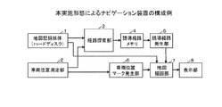
以下、本発明の一実施形態を図面に基づいて説明する。図1は、本実施形態によるナビゲーション装置の構成例を示す機能ブロック図である。図1に示すように、本実施形態のナビゲーション装置は、地図記録媒体1、車両位置測定部2、経路探索部3、誘導経路メモリ4、誘導経路発生部5、車両位置マーク発生部6、地図描画部7および表示部8を備えて構成されている。
Hereinafter, an embodiment of the present invention will be described with reference to the drawings. FIG. 1 is a functional block diagram illustrating a configuration example of the navigation device according to the present embodiment. As shown in FIG. 1, the navigation apparatus of this embodiment includes a
地図記録媒体1は、本発明の道路データ記憶部に相当するものであり、例えばハードディスクにより構成される。ハードディスク1には、地図表示や経路探索などに必要な各種の地図データが記憶されている。なお、ここでは地図データを記憶する記録媒体としてハードディスク1を用いているが、DVD、CD−ROM、不揮発性メモリなどの他の記録媒体を用いても良い。
The
ここで、ハードディスク1に記録された地図データの詳細について説明する。ハードディスク1に記録された地図データは、広い地域を一望するための上位レベルの地図から、狭い地域を詳細に記述した下位レベルの地図まで、レベルと呼ばれる単位に階層化して管理されている。各レベルは、所定の経度および緯度で区切られた区画と呼ばれる矩形領域を単位として分割されている。各区画の地図データは、区画番号を指定することにより特定することができる。
Here, the details of the map data recorded on the
区画ごとの地図データには、地図表示に必要な各種のデータから成る描画ユニットと、マップマッチングや経路探索、経路案内等の各種の処理に必要なデータから成る道路ユニット(本発明の道路データに相当する)と、交差点の詳細データから成る交差点ユニットとが含まれている。 The map data for each section includes a drawing unit composed of various data necessary for map display and a road unit composed of data necessary for various processes such as map matching, route search, route guidance (in the road data of the present invention). And an intersection unit made up of the detailed data of the intersection.
上述の道路ユニットは、道路や車線を複数に分割して設定したリンクに関するデータと、各リンクの両端に設定したノードに関するデータとを含んでいる。具体的にいうと、道路ユニットには、全ノードの詳細データを納めた接続ノードテーブルと、接続ノードテーブルの格納位置を示すノードテーブルと、隣接する2つのノードによって特定されるリンクの詳細データを納めたリンクレコードと、リンクレコードの格納位置を示すリンクテーブルとが含まれている。 The road unit described above includes data related to links set by dividing roads and lanes into multiple pieces, and data related to nodes set at both ends of each link. Specifically, the road unit includes a connection node table storing detailed data of all nodes, a node table indicating the storage position of the connection node table, and detailed data of links specified by two adjacent nodes. A stored link record and a link table indicating the storage position of the link record are included.
図2は、道路ユニットに含まれる各種テーブルの詳細な内容を示す図である。なお、ここでは本実施形態に特に関係するデータのみを示している。また、ランダバウト付近のノードおよびリンクのイメージ例を併せて示している。 FIG. 2 is a diagram showing detailed contents of various tables included in the road unit. Here, only data particularly related to the present embodiment is shown. Moreover, the example of the image of the node near a landbout and a link is shown collectively.
図2に示すように、ノードテーブルは、全てのノードに対応したノードレコード#0,#1,#2,・・・・を格納している。各ノードレコードには、その並び順に#0から昇順のノード番号が与えられており、このノード番号が各ノードに対応する接続ノードテーブルの格納位置を示している。 As shown in FIG. 2, the node table stores node records # 0, # 1, # 2,... Corresponding to all nodes. Each node record is given a node number in ascending order from # 0 in the order of arrangement, and this node number indicates the storage position of the connection node table corresponding to each node.
また、接続ノードテーブルは、存在するノードのそれぞれ毎に、接続リンク番号レコード#0,#1,#2,・・・・を格納している。この接続リンク番号レコードは、そのノードが一端となっている各リンクのリンク番号を、接続しているリンク数分だけ示している。 The connection node table stores connection link number records # 0, # 1, # 2,... For each existing node. This connection link number record indicates the link number of each link whose node is one end as many as the number of connected links.
また、リンクテーブルは、全てのリンクに対応したリンクレコード#0,#1,#2,・・・・を格納している。各リンクレコードには、その並び順に#0から昇順のリンク番号が与えられており、このリンク番号が各リンクに対応するリンクレコードの格納位置を示している。 The link table stores link records # 0, # 1, # 2,... Corresponding to all links. Each link record is given an ascending link number from # 0 in the arrangement order, and this link number indicates the storage position of the link record corresponding to each link.
また、リンクレコードは、リンクID、ノード番号1,2、リンクの距離、リンクコスト、道路種別、道路属性、交通規制等の情報を格納している。リンクIDは、主に経路表示用に各リンクに付されたコードを示す。ノード番号1,2は、リンクの両端に位置する2つのノードを特定する番号を示し、リンクの方向を表現するときにこれを用いる。リンクの距離は、そのリンクに対応した実際の道路や車線の実距離を示す。
The link record stores information such as link ID,
リンクコストは、そのリンクに対応する道路や車線の距離をもとに、誘導経路として適正の程度を数値化したものである。道路種別は、そのリンクに対応する道路が一般道路か高速道路かといった種別を示すものである。道路属性は、そのリンクに関する各種の属性を示す。例えば、道路属性は、そのリンクに対応する道路や車線の幅員、そのリンクがランダバウトの構成道路に対応するものか否かなどを示す情報である。交通規制は、一方通行や右左折禁止などの各種交通規制を示す情報である。 The link cost is obtained by quantifying the appropriate degree as a guide route based on the distance of the road or lane corresponding to the link. The road type indicates a type such as whether the road corresponding to the link is a general road or a highway. The road attribute indicates various attributes related to the link. For example, the road attribute is information indicating the width of the road or lane corresponding to the link, whether or not the link corresponds to a constituent road of the landabout. The traffic regulation is information indicating various traffic regulations such as one-way traffic and right / left turn prohibition.
車両位置測定部2は、自車両の現在位置を測定するものであり、自立航法センサやGPS受信機を備えて構成されている。なお、自立航法センサやGPS受信機を用いて自車位置を測定する仕組みは公知なので、ここでは詳細な説明を割愛する。 The vehicle position measurement unit 2 measures the current position of the host vehicle, and includes a self-contained navigation sensor and a GPS receiver. In addition, since the mechanism which measures a self-vehicle position using a self-contained navigation sensor or a GPS receiver is well-known, detailed description is omitted here.
経路探索部3は、ハードディスク1に記憶された地図データ(道路データ)に基づいて、出発地から目的地までを結ぶ最もコストが小さな誘導経路の探索を行う。すなわち、経路探索部3は、出発地から目的地に至る様々な経路に沿って探索枝(探索リンク)を順次延ばしながら、各探索枝のリンクコストを順次加算し、コストの合計が最も小さい経路を選択する。
Based on the map data (road data) stored in the
このとき経路探索部3は、道路幅員、道路種別、右折および左折、交通規制などに応じた所定の定数をリンクコストに乗じ、乗じた値を順次加算していく。なお、所定の定数は、リンクレコード内に格納されたリンクコストとは別に、テーブル情報(図示せず)により地図データの一部としてハードディスク1に記憶されている。
At this time, the route search unit 3 multiplies the link cost by a predetermined constant according to the road width, road type, right and left turns, traffic regulations, and the like, and sequentially adds the multiplied values. The predetermined constant is stored in the
本実施形態では、経路探索部3は、誘導経路の探索枝となる2つのリンクの接続関係(あるリンクから次のリンクへの接続関係)が右折または左折の何れに該当するかに応じてリンクコストに対して所定の定数を乗じるとき(すなわち、右左折コストを加算するとき)に、少なくとも一方のリンクが道路属性によりランダバウトであることが示されているか否かを判定する。そして、少なくとも一方のリンクがランダバウトであることが示されているリンク間では右左折コストを加算せずに、誘導経路の探索を行う。 In the present embodiment, the route search unit 3 links depending on whether the connection relationship (connection relationship from one link to the next link) of the two links serving as the search branch of the guidance route corresponds to a right turn or a left turn. When the cost is multiplied by a predetermined constant (that is, when the right / left turn cost is added), it is determined whether or not at least one of the links is indicated as a landabout by the road attribute. Then, the search for the guidance route is performed without adding the right / left turn cost between the links in which at least one of the links is shown to be a landabout.
図2の例でいうと、リンク1からリンク2へは右折の関係になるが、リンク2については道路属性によりランダバウトであることが示されているので、このリンク1,2間に右折コストは加算しない。リンク4からリンク8へも右折の関係になるが、リンク4については道路属性によりランダバウトであることが示されているので、このリンク4,8間にも右折コストは加算しない。
In the example of FIG. 2, the
また、リンク2からリンク3、リンク3からリンク4へはそれぞれ左折の関係になるが、リンク2〜4については道路属性によりランダバウトであることが示されているので、リンク2,3間およびリンク3,4間に左折コストは加算しない。 In addition, links 2 to 3 and links 3 to 4 have a left turn relationship, but links 2 to 4 indicate that they are landabout by road attributes. No left turn cost is added between 3 and 4.
誘導経路メモリ4は、経路探索部3により探索された誘導経路のデータを記憶する。誘導経路のデータは、出発地から目的地まで至る各ノードに対応させて、各ノードの位置と、各ノードが交差点か否かを表す交差点識別フラグとを記憶したものである。
The
誘導経路発生部5は、誘導経路メモリ4に記憶された誘導経路のデータを用いて、地図画像に重ねて他の道路と異なる所定色で太く強調した誘導経路の描画データを発生する。車両位置マーク発生部6は、車両位置測定部2から車両現在位置情報を入力して、自車位置に表示する車両位置マークを発生する。
The guide
地図描画部7は、ハードディスク1に記憶された地図データと、誘導経路発生部5により発生された誘導経路の描画データと、車両位置マーク発生部6により発生された車両位置マーク等とに基づいて、車両位置周辺の地図を車両位置マークや誘導経路等と共に表示部8に表示させるのに必要な地図画像データを生成する。表示部8は、例えば液晶ディスプレイなどにより構成され、地図描画部7により描画された地図画像データに基づいて、地図画像を表示する。
The
次に、上記のように構成したナビゲーション装置の動作を説明する。図3は、道路データに基づいてナビゲーション装置が誘導経路の探索を行う際におけるコスト計算方法の処理手順を示すフローチャートである。図3に示すフローチャートは、ナビゲーション装置に目的地が設定され、経路探索の指示が出されたときに開始する。 Next, the operation of the navigation device configured as described above will be described. FIG. 3 is a flowchart showing a processing procedure of a cost calculation method when the navigation device searches for a guidance route based on road data. The flowchart shown in FIG. 3 starts when a destination is set in the navigation device and a route search instruction is issued.
図3において、経路探索部3は、探索枝を1つ先のリンクに延ばす(ステップS1)。なお、経路探索処理の開始直後は、出発地(現在地)のノードに繋がるリンクを次に延びる探索枝として選択する。その後は、現時点で探索枝の末端となっているノードに繋がるリンクを次に延びる探索枝として選択する。 In FIG. 3, the route search unit 3 extends the search branch to the next link (step S1). Note that immediately after the start of the route search process, a link connected to the node of the departure place (current location) is selected as a search branch extending next. After that, the link connected to the node which is the end of the search branch at the present time is selected as the search branch extending next.
次に、経路探索部3は、ステップS1で新たに選択した探索枝とその直前の探索枝とからなる2つのリンクの接続関係が、右折または左折の何れかの関係に該当するか否かを判定する(ステップS2)。この判定は、例えば、2つのリンクが成す角度を求めることによって行うことができる。例えば、リンク間の角度が反時計回りを正方向として0度より大きく170度より小さいときは右折、190度より大きく360度より小さいときは左折と判断する。なお、右左折の判定方法はこれに限らず、他の公知の手法を用いてもよい。 Next, the route search unit 3 determines whether or not the connection relationship between the two links formed by the search branch newly selected in step S1 and the search branch immediately before it corresponds to a right turn or left turn relationship. Determine (step S2). This determination can be performed, for example, by obtaining an angle formed by two links. For example, when the angle between the links is counterclockwise and the forward direction is greater than 0 degrees and smaller than 170 degrees, it is determined that the turn is right, and when it is greater than 190 degrees and smaller than 360 degrees, it is determined that the turn is left. Note that the right / left determination method is not limited to this, and other known methods may be used.
経路探索部3は、リンク間の接続関係が右折または左折の関係に該当すると判定した場合に、2つのリンクの少なくとも一方が、道路属性によりランダバウトであることが示されているか否かを判定する(ステップS3)。そして、経路探索部3は、2つのリンクが何れもランダバウトのリンクでないと判定した場合、図示しないテーブル情報を参照して右折または左折に応じた所定の定数を得て、ステップS1で選択された探索枝のリンクコスト(リンクレコードの格納値)に当該所定の定数を乗じることによって、所定の右左折コストを加算する(ステップS4)。 When it is determined that the connection relationship between the links corresponds to a right turn or left turn relationship, the route search unit 3 determines whether or not at least one of the two links is a landabout by the road attribute. (Step S3). If the route search unit 3 determines that neither of the two links is a landbout link, the route search unit 3 refers to table information (not shown), obtains a predetermined constant corresponding to a right turn or a left turn, and is selected in step S1. A predetermined right / left turn cost is added by multiplying the link cost (stored value of the link record) of the search branch by the predetermined constant (step S4).
さらに、経路探索部3は、道路幅員、道路種別、交通規制などに対応する所定の定数を必要に応じてリンクコストに乗じることにより、ステップS1で選択された探索枝のリンクコストに対して右左折コスト以外の他のコストを加算する(ステップS5)。 Further, the route search unit 3 multiplies the link cost by a predetermined constant corresponding to the road width, road type, traffic regulation, etc., as necessary, to the right with respect to the link cost of the search branch selected in step S1. Costs other than the left turn cost are added (step S5).
なお、ステップS2においてリンク間の接続関係が右折または左折の関係の何れにも該当しないと判定した場合、およびステップS3において少なくとも一方のリンクがランダバウトのリンクであると判定した場合には、ステップS4で右左折コストを加算する処理は行わず、ステップS5で他のコストを必要に応じて加算する処理だけを行う。 If it is determined in step S2 that the connection relationship between the links does not correspond to either a right turn or a left turn relationship, and if it is determined in step S3 that at least one of the links is a landabout link, step S4 is performed. In step S5, only the process of adding other costs as necessary is performed.
そして、経路探索部3は、ステップS1で選択された探索枝について計算したコストを、その直前の探索枝まで計算されたコストの累算値に加算することによって累算値を更新する(ステップS6)。その後、経路探索部3は、経路探索が終了したか否かを判定し(ステップS7)、終了していない場合はステップS1に戻り、探索枝を更に先に1つ延ばす。一方、探索枝が目的地まで延びて経路探索が終了したと判断した場合は、図3に示す処理を終了する。 Then, the route search unit 3 updates the accumulated value by adding the cost calculated for the search branch selected in step S1 to the accumulated value of the cost calculated up to the immediately preceding search branch (step S6). ). Thereafter, the route search unit 3 determines whether or not the route search has ended (step S7). If it has not ended, the route search unit 3 returns to step S1 and further extends the search branch by one. On the other hand, if it is determined that the search branch has been extended to the destination and the route search has been completed, the processing shown in FIG. 3 is terminated.
以上詳しく説明したように、本実施形態では、誘導経路の探索を行う際に、少なくとも一方のリンクがランダバウトの構成道路となっているリンク間では右左折コストを加算しないようにしている。そのため、ランダバウトのリンクにおいて無駄に右左折コストが加算されてしまうことがなくなる。これにより、本当はランダバウトを通過した方が目的地に早く到達できるのに、ランダバウトを避ける遠回りルートが探索されることを抑制することができる。 As described above in detail, in the present embodiment, when searching for a guidance route, right and left turn costs are not added between links in which at least one of the links is a constituent road of a landabout. Therefore, the right / left turn cost is not added unnecessarily at the link of the landabout. Accordingly, it is possible to suppress the search for a detour route that avoids the landbout even though the destination that has passed through the landbout can reach the destination earlier.
なお、上記実施形態は、何れも本発明を実施するにあたっての具体化の一例を示したものに過ぎず、これによって本発明の技術的範囲が限定的に解釈されてはならないものである。すなわち、本発明はその要旨、またはその主要な特徴から逸脱することなく、様々な形で実施することができる。 The above-described embodiments are merely examples of implementation in carrying out the present invention, and the technical scope of the present invention should not be interpreted in a limited manner. That is, the present invention can be implemented in various forms without departing from the gist or the main features thereof.
1 地図記録媒体(道路データ記憶部)
3 経路探索部
1 Map recording medium (road data storage unit)
3 Route search part
Claims (2)
上記道路データ記憶部に記憶された道路データに基づいて誘導経路の探索を行う経路探索部とを備え、
上記経路探索部は、少なくとも一方のリンクが上記道路属性情報により上記ランダバウトであることが示されているリンク間では右左折コストを加算せずに上記誘導経路の探索を行うことを特徴とするナビゲーション装置。 A road data storage unit that stores road data including road attribute information indicating whether or not the link corresponds to a constituent road of a landbout;
A route search unit that searches for a guide route based on the road data stored in the road data storage unit,
The route search unit searches for the guidance route without adding a right / left turn cost between links where at least one link is indicated by the road attribute information as the landabout. apparatus.
上記ナビゲーション装置が、上記誘導経路の探索枝となる2つのリンクの接続関係が右折または左折の何れかの関係に該当するか否かを判定する右左折判定ステップと、
上記ナビゲーション装置が、上記右折または左折の関係に該当すると判定された場合に、上記2つのリンクの少なくとも一方が、上記道路属性情報により上記ランダバウトであることが示されているリンクであるか否かを判定するランダバウト判定ステップと、
上記右折または左折の関係に該当すると判定され、かつ、上記2つのリンクが何れも上記ランダバウトのリンクでないと判定された場合に限り、所定の右左折コストを加算するコスト加算ステップとを有することを特徴とするランダバウトでのコスト計算方法。 A cost calculation method when a navigation device searches for a guidance route based on road data including road attribute information indicating whether a link corresponds to a constituent road of a landbout,
A right / left turn determination step in which the navigation device determines whether the connection relationship between the two links serving as the search branches of the guidance route corresponds to either a right turn or a left turn;
Whether or not at least one of the two links is a link indicated by the road attribute information as the landabout when it is determined that the navigation device corresponds to the right turn or left turn relationship. A landabout determination step for determining
And a cost addition step of adding a predetermined right / left turn cost only when it is determined that the relationship of the right turn or the left turn is satisfied, and it is determined that neither of the two links is the link of the landbout. A cost calculation method at the characteristic roundabout.
Priority Applications (1)
| Application Number | Priority Date | Filing Date | Title |
|---|---|---|---|
| JP2011010910A JP5595293B2 (en) | 2011-01-21 | 2011-01-21 | Navigation device and cost calculation method in landabout |
Applications Claiming Priority (1)
| Application Number | Priority Date | Filing Date | Title |
|---|---|---|---|
| JP2011010910A JP5595293B2 (en) | 2011-01-21 | 2011-01-21 | Navigation device and cost calculation method in landabout |
Publications (2)
| Publication Number | Publication Date |
|---|---|
| JP2012150087A true JP2012150087A (en) | 2012-08-09 |
| JP5595293B2 JP5595293B2 (en) | 2014-09-24 |
Family
ID=46792450
Family Applications (1)
| Application Number | Title | Priority Date | Filing Date |
|---|---|---|---|
| JP2011010910A Active JP5595293B2 (en) | 2011-01-21 | 2011-01-21 | Navigation device and cost calculation method in landabout |
Country Status (1)
| Country | Link |
|---|---|
| JP (1) | JP5595293B2 (en) |
Cited By (2)
| Publication number | Priority date | Publication date | Assignee | Title |
|---|---|---|---|---|
| JP2016180667A (en) * | 2015-03-24 | 2016-10-13 | パイオニア株式会社 | Navigation device |
| JP2019194626A (en) * | 2019-08-01 | 2019-11-07 | パイオニア株式会社 | Navigation device |
Citations (3)
| Publication number | Priority date | Publication date | Assignee | Title |
|---|---|---|---|---|
| JP2004138421A (en) * | 2002-10-16 | 2004-05-13 | Alpine Electronics Inc | Vehicle-mounted navigation device |
| JP2008101919A (en) * | 2006-10-17 | 2008-05-01 | Alpine Electronics Inc | Map data creation method, guidance route searching method and inboard navigation device |
| JP2009041927A (en) * | 2007-08-06 | 2009-02-26 | Alpine Electronics Inc | Navigation apparatus |
-
2011
- 2011-01-21 JP JP2011010910A patent/JP5595293B2/en active Active
Patent Citations (3)
| Publication number | Priority date | Publication date | Assignee | Title |
|---|---|---|---|---|
| JP2004138421A (en) * | 2002-10-16 | 2004-05-13 | Alpine Electronics Inc | Vehicle-mounted navigation device |
| JP2008101919A (en) * | 2006-10-17 | 2008-05-01 | Alpine Electronics Inc | Map data creation method, guidance route searching method and inboard navigation device |
| JP2009041927A (en) * | 2007-08-06 | 2009-02-26 | Alpine Electronics Inc | Navigation apparatus |
Cited By (3)
| Publication number | Priority date | Publication date | Assignee | Title |
|---|---|---|---|---|
| JP2016180667A (en) * | 2015-03-24 | 2016-10-13 | パイオニア株式会社 | Navigation device |
| JP2019194626A (en) * | 2019-08-01 | 2019-11-07 | パイオニア株式会社 | Navigation device |
| JP2021165751A (en) * | 2019-08-01 | 2021-10-14 | パイオニア株式会社 | Navigation device |
Also Published As
| Publication number | Publication date |
|---|---|
| JP5595293B2 (en) | 2014-09-24 |
Similar Documents
| Publication | Publication Date | Title |
|---|---|---|
| US10012516B1 (en) | Navigation lane guidance | |
| JP3967061B2 (en) | Navigation device | |
| US7702456B2 (en) | System and method for presenting a computed route | |
| CN102037324B (en) | Method and system for point-of-interest search along a route | |
| US20120191344A1 (en) | Method and apparatus for displaying lane complexity information for navigation system | |
| JP2007132735A (en) | Car navigation device | |
| JP2006258656A (en) | Navigation device for vehicle | |
| JP2006267079A (en) | Navigation apparatus | |
| JP4651511B2 (en) | Navigation device and vehicle position determination method | |
| JP2007272276A (en) | Parking support system | |
| JP2013096713A (en) | Navigation device | |
| JP2011027610A (en) | Navigation device and guide route searching method | |
| JP2008139174A (en) | Route search device | |
| JP2008002819A (en) | Navigation device and navigation method for vehicle | |
| JP4707516B2 (en) | Navigation device and route guidance method | |
| JP2004093240A (en) | Navigation device | |
| JP2010032243A (en) | Navigation apparatus | |
| JP4372526B2 (en) | Navigation device and guidance method for surrounding facilities | |
| JP5595293B2 (en) | Navigation device and cost calculation method in landabout | |
| US20100030468A1 (en) | Method of generating navigation message and system thereof | |
| JP2013167452A (en) | Navigation system | |
| JP2016109493A (en) | Navigation system and navigation program | |
| JP2006250662A (en) | Navigation system and method of searching guidance route | |
| JP2016145839A (en) | Navigation system | |
| JP5345374B2 (en) | Navigation device and route information presentation method |
Legal Events
| Date | Code | Title | Description |
|---|---|---|---|
| A621 | Written request for application examination |
Free format text: JAPANESE INTERMEDIATE CODE: A621 Effective date: 20130821 |
|
| A131 | Notification of reasons for refusal |
Free format text: JAPANESE INTERMEDIATE CODE: A131 Effective date: 20140415 |
|
| A977 | Report on retrieval |
Free format text: JAPANESE INTERMEDIATE CODE: A971007 Effective date: 20140416 |
|
| A521 | Written amendment |
Free format text: JAPANESE INTERMEDIATE CODE: A523 Effective date: 20140526 |
|
| TRDD | Decision of grant or rejection written | ||
| A01 | Written decision to grant a patent or to grant a registration (utility model) |
Free format text: JAPANESE INTERMEDIATE CODE: A01 Effective date: 20140805 |
|
| A61 | First payment of annual fees (during grant procedure) |
Free format text: JAPANESE INTERMEDIATE CODE: A61 Effective date: 20140805 |
|
| R150 | Certificate of patent or registration of utility model |
Ref document number: 5595293 Country of ref document: JP Free format text: JAPANESE INTERMEDIATE CODE: R150 |