JP2010127770A - Navigation device and navigation method - Google Patents
Navigation device and navigation method Download PDFInfo
- Publication number
- JP2010127770A JP2010127770A JP2008302854A JP2008302854A JP2010127770A JP 2010127770 A JP2010127770 A JP 2010127770A JP 2008302854 A JP2008302854 A JP 2008302854A JP 2008302854 A JP2008302854 A JP 2008302854A JP 2010127770 A JP2010127770 A JP 2010127770A
- Authority
- JP
- Japan
- Prior art keywords
- street
- keyword
- specifying
- point
- current location
- Prior art date
- Legal status (The legal status is an assumption and is not a legal conclusion. Google has not performed a legal analysis and makes no representation as to the accuracy of the status listed.)
- Pending
Links
- 238000000034 method Methods 0.000 title claims abstract description 47
- 238000012545 processing Methods 0.000 description 30
- 238000010586 diagram Methods 0.000 description 16
- 230000007704 transition Effects 0.000 description 3
- 238000004891 communication Methods 0.000 description 1
- 238000001514 detection method Methods 0.000 description 1
- 238000011982 device technology Methods 0.000 description 1
- 239000000284 extract Substances 0.000 description 1
- 239000004973 liquid crystal related substance Substances 0.000 description 1
- 238000012986 modification Methods 0.000 description 1
- 230000004048 modification Effects 0.000 description 1
- 230000003287 optical effect Effects 0.000 description 1
- 239000013307 optical fiber Substances 0.000 description 1
- 230000001105 regulatory effect Effects 0.000 description 1
- 230000005236 sound signal Effects 0.000 description 1
Images
Classifications
-
- G—PHYSICS
- G09—EDUCATION; CRYPTOGRAPHY; DISPLAY; ADVERTISING; SEALS
- G09B—EDUCATIONAL OR DEMONSTRATION APPLIANCES; APPLIANCES FOR TEACHING, OR COMMUNICATING WITH, THE BLIND, DEAF OR MUTE; MODELS; PLANETARIA; GLOBES; MAPS; DIAGRAMS
- G09B29/00—Maps; Plans; Charts; Diagrams, e.g. route diagram
- G09B29/10—Map spot or coordinate position indicators; Map reading aids
-
- G—PHYSICS
- G01—MEASURING; TESTING
- G01C—MEASURING DISTANCES, LEVELS OR BEARINGS; SURVEYING; NAVIGATION; GYROSCOPIC INSTRUMENTS; PHOTOGRAMMETRY OR VIDEOGRAMMETRY
- G01C21/00—Navigation; Navigational instruments not provided for in groups G01C1/00 - G01C19/00
- G01C21/26—Navigation; Navigational instruments not provided for in groups G01C1/00 - G01C19/00 specially adapted for navigation in a road network
- G01C21/34—Route searching; Route guidance
- G01C21/36—Input/output arrangements for on-board computers
- G01C21/3605—Destination input or retrieval
- G01C21/3608—Destination input or retrieval using speech input, e.g. using speech recognition
-
- G—PHYSICS
- G10—MUSICAL INSTRUMENTS; ACOUSTICS
- G10L—SPEECH ANALYSIS TECHNIQUES OR SPEECH SYNTHESIS; SPEECH RECOGNITION; SPEECH OR VOICE PROCESSING TECHNIQUES; SPEECH OR AUDIO CODING OR DECODING
- G10L15/00—Speech recognition
- G10L15/26—Speech to text systems
Landscapes
- Engineering & Computer Science (AREA)
- Physics & Mathematics (AREA)
- Remote Sensing (AREA)
- Radar, Positioning & Navigation (AREA)
- Health & Medical Sciences (AREA)
- Audiology, Speech & Language Pathology (AREA)
- Human Computer Interaction (AREA)
- Acoustics & Sound (AREA)
- General Physics & Mathematics (AREA)
- Theoretical Computer Science (AREA)
- Business, Economics & Management (AREA)
- Educational Administration (AREA)
- Educational Technology (AREA)
- Mathematical Physics (AREA)
- Artificial Intelligence (AREA)
- General Health & Medical Sciences (AREA)
- Multimedia (AREA)
- Computational Linguistics (AREA)
- Automation & Control Theory (AREA)
- Navigation (AREA)
- Traffic Control Systems (AREA)
- Instructional Devices (AREA)
Abstract
Description
本発明は、ナビゲーション装置の技術に関するものである。 The present invention relates to a navigation device technology.
従来、ナビゲーション装置において、第一のストリート名の入力を受け付け、それによって検索された第2のストリートの一つを選択入力することで、検索用データ(分岐点や分岐領域)を特定する技術がある。 2. Description of the Related Art Conventionally, a navigation device accepts input of a first street name, and selects and inputs one of second streets searched thereby, thereby identifying search data (branch point or branch area). is there.
特許文献1には、このようなナビゲーション装置についての技術が記載されている。 Patent Document 1 describes a technique regarding such a navigation device.
しかし、上記のようなナビゲーション装置では、入力するストリートの名称は完全な名称でなければならず、不完全な名称を用いるとストリートの特定ができない。 However, in the navigation device as described above, the name of the street to be input must be a complete name, and if an incomplete name is used, the street cannot be specified.
通常、ナビの操作者は検索するべき地域の地理に詳しくないことが少なくないため、ストリートの名称を完全に指定できる場合はあまり無いと考えられる。すなわち、上記のようなナビゲーション装置には、不便があるといえる。 Normally, the navigation operator is often not familiar with the geography of the area to be searched, so it is unlikely that the name of the street can be completely specified. That is, it can be said that the navigation device as described above is inconvenient.
本発明の目的は、ナビゲーション装置において、不完全なストリートの名称の指定で交差点等を特定する技術を提供することにある。 An object of the present invention is to provide a technique for specifying an intersection or the like by specifying an incomplete street name in a navigation device.
上記課題を解決すべく、本発明のナビゲーション装置は、ストリートごとに、ストリートの名称と、接続するストリートと、接続する地点と、を対応付けた情報を記憶した記憶手段と、ストリート名称の一部を構成する第一のキーワードの入力を受け付ける第一の入力受付手段と、ストリート名称の一部を構成する第二のキーワードの入力を受け付ける第二の入力受付手段と、前記第一のキーワードを含むストリート名称を有するストリートを第一のストリートとして特定する手段と、前記第二のキーワードを含むストリート名称を有するストリートを第二のストリートとして特定する手段と、前記第一のストリートと第二のストリートとが接続する地点を特定する接続点特定手段と、を備えることを特徴とする。 In order to solve the above-mentioned problem, the navigation device of the present invention includes, for each street, a storage unit that stores information in which a street name, a connected street, and a connecting point are associated with each other, and a part of the street name. Including first input receiving means for receiving input of a first keyword constituting the first input receiving means, second input receiving means for accepting input of a second keyword constituting a part of the street name, and the first keyword Means for identifying a street having a street name as a first street, means for identifying a street having a street name including the second keyword as a second street, the first street and the second street, And a connection point specifying means for specifying a point to be connected.
また例えば、ナビゲーション装置のナビゲーション方法であって、前記ナビゲーション装置は、ストリートごとに、ストリートの名称と、接続するストリートと、接続する地点と、を対応付けた情報を記憶した記憶手段を備え、ストリート名称の一部を構成する第一のキーワードの入力を受け付ける第一の入力受付ステップと、ストリート名称の一部を構成する第二のキーワードの入力を受け付ける第二の入力受付ステップと、前記第一のキーワードを含むストリート名称を有するストリートを第一のストリートとして特定するステップと、前記第二のキーワードを含むストリート名称を有するストリートを第二のストリートとして特定するステップと、前記第一のストリートと第二のストリートとが接続する地点を特定する接続点特定ステップと、を実行することを特徴とする。 Further, for example, in the navigation method of the navigation device, the navigation device includes a storage unit that stores information in which a street name, a connected street, and a connected point are associated with each street. A first input receiving step for receiving an input of a first keyword constituting a part of the name, a second input receiving step for accepting an input of a second keyword constituting a part of the street name, and the first Identifying a street having a street name including the keyword as a first street, identifying a street having a street name including the second keyword as a second street, the first street and the first street Connection point identification step that identifies the point where the second street connects. And executes the up and.
以下に、本発明の一実施形態が適用されたナビゲーション装置100について、図面を参照して説明する。
Hereinafter, a
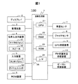
図1は、本発明が適用された車載用ナビゲーション装置100の概略構成図である。図示するように、車載用ナビゲーション装置100は、演算処理部1と、ディスプレイ2と、記憶装置3と、音声入出力装置4(音声入力装置としてマイクロフォン41、音声出力装置としてスピーカ42)と、入力装置5と、ROM装置6と、車速センサ7と、ジャイロセンサ8と、GPS(Global Positioning System)受信装置9と、FM多重放送受信装置10と、ビーコン受信装置11と、を備えている。
FIG. 1 is a schematic configuration diagram of an in-
演算処理部1は、様々な処理を行う中心的ユニットである。例えば各種センサ7,8やGPS受信装置9、FM多重放送受信装置10、またはビーコン受信装置11から出力される情報を基にして現在地を検出する。また、得られた現在地情報に基づいて、表示に必要な地図データを記憶装置3あるいはROM装置6から読み出す。また、読み出した地図データをグラフィックス展開し、そこに現在地を示すマークを重ねてディスプレイ2へ表示する。また、記憶装置3あるいはROM装置6に記憶されている地図データ等を用いて、ユーザから指示された出発地(現在地)と目的地とを結ぶ最適な経路(推奨経路)を探索する。また、スピーカ42やディスプレイ2を用いてユーザを誘導する。
The arithmetic processing unit 1 is a central unit that performs various processes. For example, the current location is detected based on information output from the
演算装置1は、各デバイス間をバス25で接続した構成である。演算処理部1は、数値演算及び各デバイスを制御するといった様々な処理を実行するCPU(Central Processing Unit)21と、記憶装置3から読み出した地図データ、演算データなどを格納するRAM(Random Access Memory)22と、プログラムやデータを格納するROM(Read Only Memory)23と、各種ハードウェアを演算装置1に接続するインターフェイスであるI/F24と、を有する。
The arithmetic device 1 has a configuration in which devices are connected by a
ディスプレイ2は、演算処理部1で生成されたグラフィックス情報を表示するユニットである。ディスプレイ2は、液晶ディスプレイ、有機ELディスプレイなどで構成される。
The
記憶装置3は、HDD(Hard Disk Drive)や不揮発性メモリカードといった、少なくとも読み書きが可能な記憶媒体で構成される。
The
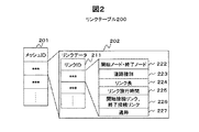
この記憶媒体には、通常の経路探索装置に必要な地図データ(地図上の道路を構成するリンクのリンクデータを含む)であるリンクテーブル200と、ストリート情報テーブル300と、が記憶されている。 In this storage medium, a link table 200 that is map data (including link data of links constituting roads on a map) necessary for a normal route search device, and a street information table 300 are stored.
図2は、リンクテーブル200の構成を示す図である。リンクテーブル200は、地図上の区画された領域であるメッシュの識別コード(メッシュID)201ごとに、そのメッシュ領域に含まれる道路を構成する各リンクのリンクデータ202を含んでいる。
FIG. 2 is a diagram showing the configuration of the link table 200. The link table 200 includes, for each mesh identification code (mesh ID) 201, which is a partitioned area on the map,
リンクデータ202は、リンクの識別子であるリンクID211ごとに、リンクを構成する2つのノード(開始ノード、終了ノード)の座標情報222、リンクを含む道路の種別を示す道路種別223、リンクの距離を示すリンク長224、リンク旅行時間225、リンクを構成する2つのノードにそれぞれ接続するリンクのリンクID(接続リンクID)である開始接続リンク、終了接続リンク226、リンクを含む道路の通称(例えば、「MAIN」等)を示す通称227、等を含んでいる。
For each link ID 211 that is a link identifier, the
なお、ここでは、リンクを構成する2つのノードについて開始ノードと終了ノードとを区別することで、同じ道路の上り方向と下り方向とを、それぞれ別のリンクとして管理するようにしている。なお、リンク旅行時間225は、日時、天気などの条件ごとに対応付けられたリンク旅行時間であってもよい。
Here, by distinguishing the start node and the end node for the two nodes constituting the link, the upward direction and the downward direction of the same road are managed as different links. The
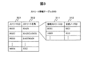
図3は、ストリート情報テーブル300の構成を示す図である。ストリート情報テーブル300は、道路を示すストリートごとに、接続するストリートと、接続するストリートと接続する地点(交差点またはラウンドアバウト等)と、が対応づけられて記憶されるテーブルである。 FIG. 3 is a diagram showing the configuration of the street information table 300. The street information table 300 is a table in which, for each street indicating a road, a connected street and a point connected to the connected street (intersection or roundabout) are stored in association with each other.
ストリート情報テーブル300には、ストリートを識別するストリートID301と、そのストリート名称302と、が対応付けられて記憶され、ストリートID301ごとに、接続するストリートを識別する接続ストリートID311と、接続するストリートとの接続地点を識別する交差ノードID312と、を含んでいる。
In the street information table 300, a
具体的には、ストリートID301は、「00001」、「00002」等の、ストリートを識別する情報である。
Specifically, the
ストリート名称302は、ストリートID301により特定されるストリートの名称に関する情報である。例えば、「MAIN」や「EASTMAIN」等の名称である。
The
なお、ストリート名称302は、ストリートID301に対応付けられて記憶されるが、別名等がある場合にはストリートID301に複数のストリート名称が対応付けられるものであってもよい。
The
接続ストリートID311は、ストリートID301により識別されるストリートと接続する(交差点による交差や、ラウンドアバウト等による接続を含む)ストリートを識別する情報である。
The connected
なお、一つのストリートに接続するストリートが複数存在する場合、接続ストリートID311は接続するストリートの数だけ対応付けられる。
When there are a plurality of streets connected to one street, the connected
交差ノードID312は、ストリートID301により識別されるストリートと、接続ストリートID312により識別されるストリートと、が接続する箇所(ノード)を識別する情報である。
The
図1に戻って説明する。音声入出力装置4は、音声入力装置としてマイクロフォン41と、音声出力装置としてスピーカ42と、を備える。マイクロフォン41は、使用者やその他の搭乗者が発した声などの車載用ナビゲーション装置100の外部の音声を取得する。
Returning to FIG. The voice input /
スピーカ42は、演算処理部1で生成された使用者へのメッセージを音声信号として出力する。マイクロフォン41とスピーカ42は、車両の所定の部位に、別個に配されている。ただし、一体の筐体に収納されていても良い。車載用ナビゲーション装置100は、マイクロフォン41及びスピーカ42を、それぞれ複数備えることができる。
The
入力装置5は、使用者からの指示を使用者による操作を介して受け付ける装置である。入力装置5は、タッチパネル51と、ダイヤルスイッチ52と、その他のハードスイッチ(図示しない)であるスクロールキー、縮尺変更キーなどで構成される。
The
タッチパネル51は、ディスプレイ2の表示面側に搭載され、表示画面を透視可能である。タッチパネル51は、ディスプレイ2に表示された画像のXY座標と対応したタッチ位置を特定し、タッチ位置を座標に変換して出力する。タッチパネル51は、感圧式または静電式の入力検出素子などにより構成される。
The
ダイヤルスイッチ52は、時計回り及び反時計回りに回転可能に構成され、所定の角度の回転ごとにパルス信号を発生し、演算処理部1に出力する。演算処理部1では、パルス信号の数から、回転角度を求める。
The
ROM装置6は、CD-ROMやDVDなどのROM(Read Only Memory)やIC(Integrated Circuit)カードといった、少なくとも読み取りが可能な記憶媒体で構成されている。この記憶媒体には、例えば、動画データや、音声データなどが記憶されている。
The
車速センサ7,ジャイロセンサ8およびGPS受信装置9は、車載用ナビゲーション装置100において現在地(自車位置)を検出するために使用されるものである。
The vehicle speed sensor 7, the
車速センサ7は、車速を算出するのに用いる値を出力するセンサである。ジャイロセンサ8は、光ファイバジャイロや振動ジャイロ等で構成され、移動体の回転による角速度を検出するものである。GPS受信装置9は、GPS衛星からの信号を受信し移動体とGPS衛星間の距離と距離の変化率を3個以上の衛星に対して測定することで移動体の現在位置、進行速度および進行方位を測定し、演算処理部1に送信するものである。
The vehicle speed sensor 7 is a sensor that outputs a value used to calculate the vehicle speed. The
FM多重放送受信装置10は、FM多重放送局から送られてくるFM多重放送信号を受信する。FM多重放送には、VICS(Vehicle Information Communication System:登録商標)情報の概略現況交通情報、規制情報、SA/PA(サービスエリア/パーキングエリア)情報、駐車場情報、天気情報などやFM多重一般情報としてラジオ局が提供する文字情報などがある。
The FM
ビーコン受信装置11は、光ビーコン、電波ビーコン等の信号を受信する。ビーコン等の信号には、VICS情報の概略現況交通情報、規制情報、SA/PA(サービスエリア/パーキングエリア)情報、駐車場情報などがある。 The beacon receiving device 11 receives signals such as an optical beacon and a radio beacon. Signals such as a beacon include rough current traffic information of VICS information, regulation information, SA / PA (service area / parking area) information, parking lot information, and the like.
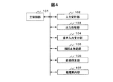
図4は、演算処理部1の機能ブロック図である。 FIG. 4 is a functional block diagram of the arithmetic processing unit 1.
図示するように、演算処理部1は、主制御部101と、入力受付部102と、出力処理部103と、音声入力受付部104と、接続点特定部105と、経路探索部106と、経路案内部107と、を有する。
As illustrated, the arithmetic processing unit 1 includes a
主制御部101は、様々な処理を行う中心的な機能部であり、処理内容に応じて、他の処理部を制御する。また、主制御部101は、車載用ナビゲーション装置100の基本動作であるナビゲーション処理(例えば、交通情報の表示、現在位置の表示等)を実施する。
The
入力受付部102は、タッチパネル51およびダイヤルスイッチ52を介して、使用者からの指示入力を受け付け、これを各処理部に受け渡す処理部である。
The input accepting unit 102 is a processing unit that accepts an instruction input from the user via the
出力処理部103は、画面出力をディスプレイ2に表示させる機能部である。ディスプレイ2への表示が要求される画面データと表示候補を受け取り、指定された描画方式で、道路、その他の地図構成物や、現在地、目的地、推奨経路、メッセージ情報のためのダイアログなどを描画するように画面描画コマンドを生成する。そして、生成したコマンドを、ディスプレイ2に送信する。
The
音声入力受付部104は、マイクロフォン41を介して、使用者からの指示入力を受け付け、これを各処理部に受け渡す処理部である。
The voice
接続点特定部105は、第一のストリートを指定する入力情報を受け付け、第二のストリートを指定する入力情報を受け付け、第一のストリートと第二のストリートとが接続する交差ノードを特定する。
The connection
経路探索部106は、ダイクストラ法等を用いて、指定された2地点(現在位置、目的地または立ち寄り地点)間を結ぶ経路のコスト(例えば、距離や旅行時間)が最少となる経路を探索する。なお、経路とは、道路を示す位置に配置された点である複数のノードと、2つのノード間を結ぶリンクと、を連続的に順に結ぶことで特定される。また、経路探索部106は、その経路に含まれる各ノード、各リンクに予め与えられたコストを合算することで経路全体のコストを求める。そして、経路探索部106は、その経路を通って目的地または立ち寄り地点に到達するまでに必要となる時間を算出し、その経路を特定するための経路情報をRAM22または記憶装置3の所定の領域に記憶させる。
The
経路案内部107は、経路探索部106により探索した結果得られた経路の経路情報に従って経路を特定し、使用者に対して走行経路を案内する。
The
例えば、経路情報と、現在位置の情報とを比較し、交差点等を通過する前に直進すべきか否か、右左折すべきか否か、をスピーカ42を用いて音声で使用者に知らせる。
For example, the route information is compared with the information on the current position, and the user is informed by voice using the
また、経路案内部107は、ディスプレイ2に表示された地図上に進行すべき方向を表示して、使用者に推奨経路を通知する。
In addition, the
なお、主制御部101、入力受付部102、出力処理部103、音声入力受付部104、接続点特定部105、経路探索部106、経路案内部107は、CPU21がRAM22やROM23にロードしたプログラムを実行することにより実現される。
The
[動作の説明]次に、上記構成の車載用ナビゲーション装置100の動作について説明する。
[Description of Operation] Next, the operation of the in-
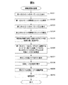
図5は、接続点案内処理の流れを示すフロー図である。 FIG. 5 is a flowchart showing the flow of the connection point guidance process.
主制御部101は、ナビゲーション装置100の使用者からの指示を受け付けると、本フローを開始する。
When the
入力受付部102は、第一のストリートを特定するためのキーワードの入力を受け付ける(ステップS001)。 The input receiving unit 102 receives an input of a keyword for specifying the first street (step S001).
具体的には、入力受付部102は、ストリートの名称に含まれるキーワードの指定を受け付ける。その際、入力受付部102は、ストリートの名称の一部または全部にあたるキーワードを受け付ける。使用者は、正確なストリート名称を指定する必要はない。 Specifically, the input reception unit 102 receives specification of a keyword included in a street name. At that time, the input receiving unit 102 receives a keyword corresponding to a part or all of the street name. The user need not specify an exact street name.
このキーワードの指定においては、入力受付部102は、アルファベットなどの表記文字単位で入力を受け付ける。 In specifying this keyword, the input receiving unit 102 receives input in units of written characters such as alphabets.
なお、音声による入力を受け付ける場合には、音声入力受付部104が、ストリートの名称に含まれるキーワードの指定を受け付ける。その際、音声入力受付部104は、キーワードを特定する音声を、単語等を発声したものとして受け付ける。しかし、音声入力受付部104は、これに限らず、アルファベットなどの表記文字を逐一発音したものとして受け付けることにしてもよい。
In addition, when receiving the input by voice, the voice
次に、接続点特定部105は、第一のストリートの候補となるストリートを特定し、そのストリートIDを特定する(ステップS002)。
Next, the connection
具体的には、接続点特定部105は、ステップS001にて受け付けたキーワードをストリート名称302に含むストリートをストリート情報テーブル300から特定し、そのストリートID301を読み出す。
Specifically, the connection
その際、接続点特定部105は、キーワードを含むストリートが複数存在する場合には、キーワードを含むストリートの全てをストリート情報テーブル300から特定し、特定したストリートのストリートID301を全て読み出す。
At that time, when there are a plurality of streets including the keyword, the connection
次に、入力受付部102は、第二のストリートを特定するためのキーワードの入力を受け付ける(ステップS003)。 Next, the input receiving unit 102 receives an input of a keyword for specifying the second street (step S003).
具体的には、入力受付部102は、ストリートの名称に含まれるキーワードの指定を受け付ける。その際、入力受付部102は、ストリートの名称の一部または全部にあたるキーワードを受け付ける。使用者は、正確なストリート名称を指定する必要はない。 Specifically, the input reception unit 102 receives specification of a keyword included in a street name. At that time, the input receiving unit 102 receives a keyword corresponding to a part or all of the street name. The user need not specify an exact street name.
このキーワードの指定においては、入力受付部102は、アルファベットなどの表記文字単位で入力を受け付ける。 In specifying this keyword, the input receiving unit 102 receives input in units of written characters such as alphabets.
なお、音声による入力を受け付ける場合には、音声入力受付部104が、ストリートの名称に含まれるキーワードの指定を受け付ける。その際、音声入力受付部104は、キーワードを特定する音声を、単語等を発声したものとして受け付ける。しかし、音声入力受付部104は、これに限らず、アルファベットなどの表記文字を逐一発音したものとして受け付けることにしてもよい。
In addition, when receiving the input by voice, the voice
次に、接続点特定部105は、第二のストリートの候補となるストリートを特定し、そのストリートIDを特定する(ステップS004)。
Next, the connection
具体的には、接続点特定部105は、ステップS003にて受け付けたキーワードをストリート名称302に含むストリートをストリート情報テーブル300から特定し、そのストリートID301を読み出す。
Specifically, the connection
その際、接続点特定部105は、キーワードを含むストリートが複数存在する場合には、キーワードを含むストリートの全てをストリート情報テーブル300から特定し、特定したストリートのストリートID301を全て読み出す。
At that time, when there are a plurality of streets including the keyword, the connection
次に、接続点特定部105は、ナビゲーション装置100が搭載された車両の現在地を特定し、現在地が属する州に含まれるストリートを検索対象として設定する(S005)。
Next, the connection
具体的には、接続点特定部105は、主制御部101に対して、現在地を特定する座標を要求し、その座標により示される位置が含まれる行政区画(例えば州)を特定する。
Specifically, the connection
そして、接続点特定部105は、特定した行政区画内に一部が含まれるストリートを特定して、当該ストリートをストリート情報テーブル300から抽出して検索対象とする。
And the connection point specific |
なお、行政区画に含まれるストリートを検索対象に限るわけではなく、例えば現在地周辺のストリートを検索対象とするようにしてもよい。具体的には、現在地から所定の距離内に一部が含まれるストリートを検索対象とするようにしても良い。または、現在地が属するメッシュ内のノードに直接接続するリンクを一部に含むストリートを検索対象とするようにしても良い。 Note that the streets included in the administrative district are not limited to search targets, and for example, streets around the current location may be set as search targets. Specifically, a street that is partially included within a predetermined distance from the current location may be set as a search target. Alternatively, a search target may be a street partially including a link directly connected to a node in the mesh to which the current location belongs.
次に、接続点特定部105は、ステップS002で特定した第一のストリートIDのいずれかに合致するストリートに属する交差ノードのうち、第二のストリートIDのいずれかと合致するストリートとの接続点を示す交差ノードのIDを特定する(ステップS006)。
Next, the connection
具体的には、接続点特定部105は、ステップS002にて特定した第一のストリートのIDと、ストリートID301とが合致するレコードを、ステップS005にて設定した検索対象から特定する。そして、接続点特定部105は、特定したレコードからさらに、ステップS004にて特定した第二のストリートのIDと接続ストリートID311とが合致するレコードを特定し、その交差ノードID312を特定する。
Specifically, the connection
次に、出力処理部103は、ステップS006にて特定した交差ノード312をディスプレイ2にリスト表示させる(ステップS007)。
Next, the
具体的には、出力処理部103は、ステップS006にて特定した交差ノード312を構成する第一のストリート名と、第二のストリート名と、を対応させて表示することで交差ノード312を特定する情報をリスト表示させる。
Specifically, the
次に、入力受付部102は、ステップS007にて表示させた交差ノード312のリストから一つの交差ノードの指定を受け付ける(ステップS008)。
Next, the input reception unit 102 receives the designation of one intersection node from the list of
具体的には、入力受付部102は、ステップS007にて表示されたリストのうち、第一のストリート名と、第二のストリート名との組み合わせを特定する指定入力を受け付ける。 Specifically, the input receiving unit 102 receives a designation input that specifies a combination of the first street name and the second street name in the list displayed in step S007.
次に、経路探索部106は、ナビゲーション装置100が搭載された車両の現在地から、ステップS008にて指定を受け付けた交差ノードへ到る経路の探索を行う(ステップS009)。
Next, the
次に、経路案内部107は、ステップS009にて探索した経路の案内を開始する(ステップS010)。
Next, the
以上が、接続点案内処理のフローである。 The above is the flow of the connection point guidance process.
次に、接続点案内処理にて表示される画面表示の例を、図6を用いて説明する。 Next, an example of a screen display displayed in the connection point guidance process will be described with reference to FIG.
図6(a)は、接続点案内処理のステップS001にて表示される画面表示の例(音声入力の場合)を示す図である。 FIG. 6A is a diagram showing an example of a screen display (in the case of voice input) displayed in step S001 of the connection point guidance process.
図6(a)には、画面400と、画面400内に示されるメッセージ表示領域401と、が示されている。メッセージ表示領域401には、第一のストリート名を特定するためのキーワードの入力を促すメッセージ、例えば「第一のストリート名のキーワードを発話してください」等のメッセージが表示される。
FIG. 6A shows a
なお、当該画面400は、ステップS002の処理が終わると、次画面410へ遷移する。
Note that the
図6(b)は、接続点案内処理のステップS003にて表示される画面表示の例(音声入力の場合)を示す図である。 FIG. 6B is a diagram illustrating an example of a screen display (in the case of voice input) displayed in step S003 of the connection point guidance process.
図6(b)には、画面410と、画面410内に示されるメッセージ表示領域411と、が示されている。メッセージ表示領域411には、第二のストリート名を特定するためのキーワードの入力を促すメッセージ、例えば「第二のストリート名のキーワードを発話してください」等のメッセージが表示される。
FIG. 6B shows a
なお、当該画面400は、ステップS006の処理が終わると、次画面420へ遷移する。
Note that the
図6(c)は、接続点案内処理のステップS007にて表示される画面表示の例を示す図である。 FIG. 6C is a diagram illustrating an example of a screen display displayed in step S007 of the connection point guidance process.
図6(c)には、画面420と、画面420内に示されるメッセージ表示領域421と、接続点リスト表示領域422と、が示されている。
FIG. 6C shows a
メッセージ表示領域421には、交差点ノードの選択入力を促すメッセージ、例えば「複数の接続点が候補にあがりました。どれか一つを選択してください。」等のメッセージが表示される。
In the
接続点リスト表示領域422には、接続点を特定する情報である、第一のストリート名と第二のストリート名との組み合わせを表示するリストが表示される。
In the connection point
なお、当該画面422は、ステップS008の処理が終わると、経路を案内するための画面へ遷移する。
Note that the
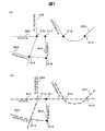
次に、接続点案内処理の具体例を、図7を用いて説明する。 Next, a specific example of the connection point guidance process will be described with reference to FIG.
図7(a)は、接続点案内処理の対象となる範囲に含まれる道路の例を模式的に示す図である。図7(a)では、「MAIN」ストリート501と、「WESTFIRST」ストリート502とが接続する接続点510と、「MAIN」ストリート501と「HARBOR」ストリート503とが接続する接続点511と、「MAIN」ストリート501と「EASTFIRST」ストリート504とが接続する西側の接続点512と、東側の接続点513と、「MAINTAIN」ストリート505と「WESTFIRST」ストリート502とが接続する接続点514と、「MAINTAIN」ストリート505と「HARBOR」ストリート503とが接続する接続点515と、の位置関係が表示されている。
FIG. 7A is a diagram schematically illustrating an example of roads included in a range to be subjected to the connection point guidance process. In FIG. 7A, a
ここで、接続点案内処理のステップS001にてキーワードを「MAIN」と指定すると、ステップS002において、「MAIN」というキーワードを含む名称を有するストリート、すなわち「MAIN」ストリート501と、「MAINTAIN」ストリート505とが候補のストリートとして確定される。
Here, when the keyword is designated as “MAIN” in step S001 of the connection point guidance process, in step S002, streets having names including the keyword “MAIN”, that is, “MAIN”
さらに、ステップS003にてキーワードを「FIRST」と指定すると、ステップS004において、「FIRST」というキーワードを含む名称を有するストリート、すなわち「WESTFIRST」ストリート502と、「EASTFIRST」ストリート504と、が候補のストリートとして確定される。
Furthermore, if the keyword is designated as “FIRST” in step S003, streets having names including the keyword “FIRST”, that is, “WESTFIRST”
この場合において、ステップS006では、接続点特定部105により、「MAIN」ストリート501と「WESTFIRST」ストリート502との接続点510と、「MAIN」ストリート501と「EASTFIRST」ストリート504との西側の接続点512、東側の接続点513と、「MAINTAIN」ストリート505と「WESTFIRST」ストリート502との接続点514とが、交差ノードとして特定される。
In this case, in step S006, the connection
そして、ステップS007では、出力処理部103は、「MAIN」ストリート501と「WESTFIRST」ストリート502との接続点510を一件目のレコードとして、「MAIN」ストリート501と「EASTFIRST」ストリート504との西側の接続点512を二件目のレコードとして、「MAIN」ストリート501と「EASTFIRST」ストリート504との東側の接続点513を三件目のレコードとして、「MAINTAIN」ストリート505と「WESTFIRST」ストリート502との接続点514を四件目のレコードとして、リスト表示する。
In step S007, the
以上、本発明の一実施形態を説明した。 The embodiment of the present invention has been described above.
本発明の上記実施形態によれば、車載用ナビゲーション装置100は、ストリートの名称のキーワードからストリートを特定し、特定した2本のストリートが接続する交差点等を特定して経路案内を行うことができる。これは、例えば、ストリート名を主として住所を特定する地域等において、不慣れな地においても、キーワードのみから目的地を設定できる有効な目的地特定方法となる。
According to the embodiment of the present invention, the in-
本発明は、上記実施形態に制限されない。上記実施形態は、本発明の技術的思想の範囲内で様々な変形が可能である。 The present invention is not limited to the above embodiment. The above embodiment can be variously modified within the scope of the technical idea of the present invention.
例えば、上記実施形態では、接続点案内処理は、上述のようにステップS001〜ステップS010の順に処理が流れるが、これに限られない。 For example, in the above embodiment, the connection point guidance process flows in the order of steps S001 to S010 as described above, but is not limited thereto.
すなわち、第一のストリートのキーワード入力を受け付け、第二のストリートのキーワード入力を受け付けた後、第一のストリートの候補のストリートIDを確定し、第二のストリートの候補のストリートIDを確定してもよい。 That is, after accepting the keyword input of the first street, accepting the keyword input of the second street, confirm the street ID of the candidate of the first street, confirm the street ID of the candidate of the second street Also good.
または、ステップS005において検索対象を設定しているが、ステップS001よりも前に設定処理を実施してからステップS001を実施するようにしてもよい。 Alternatively, although the search target is set in step S005, step S001 may be performed after setting processing is performed before step S001.
また、上記実施形態では、接続点案内処理において、ステップS006において交差ノードを特定するとステップS007において特定した交差ノードを全てリスト表示しているが、これに限られない。 In the above embodiment, when the intersection node is specified in step S006 in the connection point guidance process, all the intersection nodes specified in step S007 are displayed in a list, but the present invention is not limited to this.
すなわち、ステップS006において特定された交差ノードが所定の数(例えば50件)を越えて特定された場合には、検索するキーワードの追加、検索対象となる範囲(例えば市)の特定等による絞込み検索を行うようにしてもよい。 That is, when the number of intersecting nodes specified in step S006 is specified exceeding a predetermined number (for example, 50), a refined search by adding a keyword to be searched, specifying a search target range (for example, a city), or the like. May be performed.
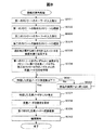
具体的には、図8に示す処理を実施するようにしてもよい。 Specifically, the process shown in FIG. 8 may be performed.
図8は、接続点案内処理を変形させたフローを示す図である。 FIG. 8 is a diagram illustrating a flow in which the connection point guide process is modified.
図8に示すように、ステップS006とステップS007との間に、特定した交差ノードが所定数以下であるか否かを接続点特定部105が判定する(ステップS021)。交差ノードが所定数以下でない場合(ステップS021にて「No」の場合)には、上記したような絞込み検索により交差ノードを絞込み、ステップS021に制御を戻す(ステップS022)。交差ノードが所定数以下であれば(ステップS021にて「Yes」の場合)、ステップS007へ制御を移す。
As illustrated in FIG. 8, the connection
上記のように接続点案内処理を変形してもよい。上記のように変形することで、ナビゲーション装置100は、過度に交差ノードの件数が表示されてしまうことで使用者が指定不能になってしまうことを回避することができる。
The connection point guidance process may be modified as described above. By deforming as described above, the
また、接続点案内処理のステップS007において、ステップS006にて特定した交差ノード312をディスプレイ2にリスト表示させる際に、あわせて交差ノードを示す交差点の名称を示すようにしてもよい。
In addition, when the
このようにすることで、使用者は、交差ノードを認識するための情報を多く受け取ることができ、交差ノードの指定を行いやすくなる。 By doing so, the user can receive a lot of information for recognizing the intersection node, and it is easy to specify the intersection node.
なお、上記の実施形態では、本発明を車載用ナビゲーション装置に適用した例について説明したが、本発明は車載用以外のナビゲーション装置にも適用することができる。 In the above embodiment, an example in which the present invention is applied to a vehicle-mounted navigation device has been described. However, the present invention can also be applied to a navigation device other than a vehicle-mounted navigation device.
1:演算処理部、2:ディスプレイ、3:記憶装置、4:音声出入力装置、5:入力装置、6:ROM装置、7:車速センサ、8:ジャイロセンサ、9:GPS受信機、10:FM多重放送受信装置、11:ビーコン受信装置、21:CPU、22:RAM、23:ROM、24:I/F、25:バス、41:マイクロフォン、42:スピーカ、51:タッチパネル、52:ダイヤルスイッチ、100:ナビゲーション装置、101:主制御部、102:入力受付部、103:出力処理部、104:音声入力受付部、105:接続点特定部、106:経路探索部、107:経路案内部、200:リンクテーブル、300:ストリート情報テーブル 1: arithmetic processing unit, 2: display, 3: storage device, 4: voice input / output device, 5: input device, 6: ROM device, 7: vehicle speed sensor, 8: gyro sensor, 9: GPS receiver, 10: FM multiplex broadcast receiver, 11: beacon receiver, 21: CPU, 22: RAM, 23: ROM, 24: I / F, 25: bus, 41: microphone, 42: speaker, 51: touch panel, 52: dial switch , 100: navigation device, 101: main control unit, 102: input receiving unit, 103: output processing unit, 104: voice input receiving unit, 105: connection point specifying unit, 106: route searching unit, 107: route guiding unit, 200: Link table, 300: Street information table
Claims (16)
第一のキーワードおよび第二のキーワードの入力を受け付けるとともに、前記ストリート名称情報を用いて、前記第一のキーワードを少なくとも一部に含むストリート名称を有する第一のストリートと、前記第二のキーワードを少なくとも一部に含むストリート名称を有する第二のストリートとを特定するストリート特定手段と、
前記接続情報を用いて、前記第一のストリートと第二のストリートとの接続点を特定する接続点特定手段と、
を備えることを特徴とする地点検索装置。 Storage means for storing street name information and street connection information;
While receiving the input of the first keyword and the second keyword, using the street name information, the first street having a street name including at least a part of the first keyword, and the second keyword A street identifying means for identifying a second street having a street name included in at least a part thereof;
Using the connection information, a connection point specifying means for specifying a connection point between the first street and the second street,
The point search device characterized by comprising.
前記接続点特定手段により特定された地点が複数存在する場合に、一つの地点の指定を受け付ける接続点指定受付手段、
を備えたことを特徴とする地点検索装置。 The point search device according to claim 1, further comprising:
A connection point designation accepting means for accepting designation of one point when there are a plurality of points identified by the connection point identifying means;
The point search device characterized by comprising.
前記接続点特定手段により特定された接続点が所定数以上存在する場合に、絞込みを行う条件を特定する情報を受け付ける絞込み条件受付手段と、
前記接続点を、前記絞込み条件受付手段により受け付けた条件に合致する範囲に属する接続点に絞り込む接続点絞込み手段と、
を備えることを特徴とする地点検索装置。 The point search device according to claim 1 or 2,
Narrowing condition receiving means for receiving information for specifying conditions for narrowing down when there are a predetermined number or more of the connection points specified by the connection point specifying means;
Connection point narrowing means for narrowing down the connection points to connection points belonging to a range that matches the condition received by the narrowing condition receiving means;
The point search device characterized by comprising.
前記ストリート特定手段は、前記第一のキーワードおよび第二のキーワードの入力を音声により受け付ける、
ことを特徴とする地点検索装置。 The point search device according to any one of claims 1 to 3,
The street specifying means accepts input of the first keyword and the second keyword by voice,
The point search device characterized by this.
現在地を特定する現在地特定手段を備え、
前記ストリート特定手段は、前記第一のストリートと第二のストリートとを特定する処理において、前記現在地特定手段によって現在地を特定し、特定した現在地が属する地域に含まれるストリートから前記第一のストリートと第二のストリートを特定する、
ことを特徴とする地点検索装置。 The point search device according to any one of claims 1 to 4, further comprising:
It has a current location identification means to identify your current location,
In the process of specifying the first street and the second street, the street specifying means specifies the current location by the current location specifying means, and from the streets included in the area to which the specified current location belongs, Identify the second street,
The point search device characterized by this.
第一のキーワードおよび第二のキーワードの入力を受け付けるとともに、前記ストリート名称情報を用いて、前記第一のキーワードを少なくとも一部に含むストリート名称を有する第一のストリートと、前記第二のキーワードを少なくとも一部に含むストリート名称を有する第二のストリートとを特定するストリート特定手段と、
前記接続情報を用いて、前記第一のストリートと第二のストリートとの接続点を特定する接続点特定手段と、
現在地特定手段と、
前記現在地特定手段により特定した現在地から、前記第一のストリートと第二のストリートとの接続点に到る経路を探索する経路探索手段と、
前記探索した経路を案内する経路案内手段と、
を備えたことを特徴とするナビゲーション装置。 Storage means for storing street name information and street connection information;
While receiving the input of the first keyword and the second keyword, using the street name information, the first street having a street name including at least a part of the first keyword, and the second keyword A street identifying means for identifying a second street having a street name included in at least a part thereof;
Using the connection information, a connection point specifying means for specifying a connection point between the first street and the second street,
Current location identification means,
Route search means for searching for a route from the current location specified by the current location specifying means to a connection point between the first street and the second street;
Route guidance means for guiding the searched route;
A navigation device characterized by comprising:
前記接続点特定手段により特定された地点が複数存在する場合に、一つの地点の指定を受け付ける接続点指定受付手段、
を備えたことを特徴とするナビゲーション装置。 The navigation device according to claim 6, further comprising:
A connection point designation accepting means for accepting designation of one point when there are a plurality of points identified by the connection point identifying means;
A navigation device characterized by comprising:
前記接続点特定手段により特定された接続点が所定数以上存在する場合に、絞込みを行う条件を特定する情報を受け付ける絞込み条件受付手段と、
前記接続点を、前記絞込み条件受付手段により受け付けた条件に合致する範囲に属する接続点に絞り込む接続点絞込み手段と、
を備えることを特徴とするナビゲーション装置。 The navigation device according to claim 6 or 7, wherein
Narrowing condition receiving means for receiving information for specifying conditions for narrowing down when there are a predetermined number or more of the connection points specified by the connection point specifying means;
Connection point narrowing means for narrowing down the connection points to connection points belonging to a range that matches the condition received by the narrowing condition receiving means;
A navigation device comprising:
前記ストリート特定手段は、前記第一のキーワードおよび第二のキーワードの入力を音声により受け付ける、
ことを特徴とするナビゲーション装置。 The navigation device according to any one of claims 6 to 8,
The street specifying means accepts input of the first keyword and the second keyword by voice,
A navigation device characterized by that.
前記ストリート特定手段は、前記第一のストリートと第二のストリートとを特定する処理において、前記現在地特定手段によって現在地を特定し、特定した現在地が属する地域に含まれるストリートから前記第一のストリートと第二のストリートを特定する、
ことを特徴とするナビゲーション装置。 The navigation device according to any one of claims 6 to 9,
In the process of specifying the first street and the second street, the street specifying means specifies the current location by the current location specifying means, and from the streets included in the area to which the specified current location belongs, Identify the second street,
A navigation device characterized by that.
前記地点検索装置は、
ストリート名称情報とストリート同士の接続情報とを記憶する記憶手段を備え、
第一のキーワードおよび第二のキーワードの入力を受け付けるとともに、前記ストリート名称情報を用いて、前記第一のキーワードを少なくとも一部に含むストリート名称を有する第一のストリートと、前記第二のキーワードを少なくとも一部に含むストリート名称を有する第二のストリートとを特定するストリート特定ステップと、
前記接続情報を用いて、前記第一のストリートと第二のストリートとの接続点を特定する接続点特定ステップと、
を実行することを特徴とする地点検索方法。 A point search method for a point search device,
The point search device includes:
Storage means for storing street name information and street connection information;
While receiving the input of the first keyword and the second keyword, using the street name information, the first street having a street name including at least a part of the first keyword, and the second keyword A street identification step for identifying a second street having at least a portion of the street name;
Using the connection information, a connection point specifying step for specifying a connection point between the first street and the second street;
The point search method characterized by performing.
前記接続点特定ステップにより特定された地点が複数存在する場合に、一つの地点の指定を受け付ける接続点指定受付ステップ、
を実行することを特徴とする地点検索方法。 The point search method according to claim 11, further comprising:
A connection point designation accepting step for accepting designation of one point when there are a plurality of points identified by the connection point identifying step;
The point search method characterized by performing.
前記接続点特定ステップにより特定された接続点が所定数以上存在する場合に、絞込みを行う条件を特定する情報を受け付ける絞込み条件受付ステップと、
前記接続点を、前記絞込み条件受付ステップにより受け付けた条件に合致する範囲に属する接続点に絞り込む接続点絞込みステップと、
を実行することを特徴とする地点検索方法。 The point search method according to claim 11 or 12,
A narrowing condition receiving step for receiving information for specifying conditions for narrowing down when there are a predetermined number or more of the connecting points specified in the connecting point specifying step;
A connection point narrowing step for narrowing the connection points to connection points belonging to a range that matches the condition received by the narrowing condition reception step;
The point search method characterized by performing.
前記ストリート特定ステップにおいては、前記第一のキーワードおよび第二のキーワードの入力を音声により受け付ける、
ことを特徴とする地点検索方法。 It is a point search method as described in any one of Claims 11-13,
In the street specifying step, the input of the first keyword and the second keyword is received by voice.
The point search method characterized by this.
前記地点検索装置は、
現在地を特定する現在地特定手段を備え、
前記ストリート特定ステップにおいて、前記第一のストリートと第二のストリートを特定する際に、前記現在地特定手段によって現在地を特定し、特定した現在地が属する地域に含まれるストリートから前記第一のストリートと第二のストリートを特定する、
ことを特徴とする地点検索方法。 The point search method according to any one of claims 11 to 14, further comprising:
The point search device includes:
It has a current location identification means to identify your current location,
In the street specifying step, when specifying the first street and the second street, the current location is specified by the current location specifying means, and the first street and the second street are selected from the streets included in the area to which the specified current location belongs. Identify the second street,
The point search method characterized by this.
前記ナビゲーション装置は、
ストリート名称情報とストリート同士の接続情報とを記憶する記憶手段と、現在地特定手段と、を備え、
第一のキーワードおよび第二のキーワードの入力を受け付けるとともに、前記ストリート名称情報を用いて、前記第一のキーワードを少なくとも一部に含むストリート名称を有する第一のストリートと、前記第二のキーワードを少なくとも一部に含むストリート名称を有する第二のストリートとを特定するストリート特定ステップと、
前記接続情報を用いて、前記第一のストリートと第二のストリートとの接続点を特定する接続点特定ステップと、
前記現在地特定手段を用いて現在値を特定する現在地特定ステップと、
前記現在地特定ステップにより特定した現在地から、前記第一のストリートと第二のストリートとの接続点に到る経路を探索する経路探索ステップと、
前記探索した経路を案内する経路案内ステップと、
を実行することを特徴とするナビゲーション方法。 A navigation method for a navigation device, comprising:
The navigation device
Storage means for storing street name information and street connection information, and current location specifying means,
While receiving the input of the first keyword and the second keyword, using the street name information, the first street having a street name including at least a part of the first keyword, and the second keyword A street identification step for identifying a second street having at least a portion of the street name;
Using the connection information, a connection point specifying step for specifying a connection point between the first street and the second street;
A current location identifying step of identifying a current value using the current location identifying means;
A route search step for searching for a route from the current location specified in the current location specifying step to a connection point between the first street and the second street;
A route guidance step for guiding the searched route;
The navigation method characterized by performing.
Priority Applications (2)
| Application Number | Priority Date | Filing Date | Title |
|---|---|---|---|
| JP2008302854A JP2010127770A (en) | 2008-11-27 | 2008-11-27 | Navigation device and navigation method |
| US12/626,015 US8560226B2 (en) | 2008-11-27 | 2009-11-25 | Navigation device and navigation method |
Applications Claiming Priority (1)
| Application Number | Priority Date | Filing Date | Title |
|---|---|---|---|
| JP2008302854A JP2010127770A (en) | 2008-11-27 | 2008-11-27 | Navigation device and navigation method |
Publications (1)
| Publication Number | Publication Date |
|---|---|
| JP2010127770A true JP2010127770A (en) | 2010-06-10 |
Family
ID=42223584
Family Applications (1)
| Application Number | Title | Priority Date | Filing Date |
|---|---|---|---|
| JP2008302854A Pending JP2010127770A (en) | 2008-11-27 | 2008-11-27 | Navigation device and navigation method |
Country Status (2)
| Country | Link |
|---|---|
| US (1) | US8560226B2 (en) |
| JP (1) | JP2010127770A (en) |
Cited By (2)
| Publication number | Priority date | Publication date | Assignee | Title |
|---|---|---|---|---|
| JP2012098065A (en) * | 2010-10-29 | 2012-05-24 | Alpine Electronics Inc | Navigation device |
| JP2012117925A (en) * | 2010-12-01 | 2012-06-21 | Clarion Co Ltd | In-vehicle apparatus, control method for in-vehicle apparatus, and program |
Families Citing this family (1)
| Publication number | Priority date | Publication date | Assignee | Title |
|---|---|---|---|---|
| US10520322B2 (en) * | 2017-06-15 | 2019-12-31 | Verizon Patent And Licensing Inc. | Predictive intersection search |
Citations (11)
| Publication number | Priority date | Publication date | Assignee | Title |
|---|---|---|---|---|
| JPH10282987A (en) * | 1997-04-04 | 1998-10-23 | Hitachi Ltd | Speech recognition system and method |
| JP2000205879A (en) * | 1999-01-14 | 2000-07-28 | Equos Research Co Ltd | Destination setting device |
| JP2001022375A (en) * | 1999-07-06 | 2001-01-26 | Matsushita Electric Ind Co Ltd | Speech recognition synthesizer |
| JP2001027536A (en) * | 1999-07-13 | 2001-01-30 | Alpine Electronics Inc | Navigation system |
| JP2003005783A (en) * | 2001-06-26 | 2003-01-08 | Alpine Electronics Inc | Navigation system and its destination input method |
| JP2004245648A (en) * | 2003-02-12 | 2004-09-02 | Denso Corp | Map display apparatus |
| JP2005004143A (en) * | 2003-06-16 | 2005-01-06 | Toyota Central Res & Dev Lab Inc | Voice recognition apparatus, program, and vehicle navigation system |
| JP2007279004A (en) * | 2006-04-12 | 2007-10-25 | Denso Corp | Device and method for retrieving intersection |
| US20080077319A1 (en) * | 2006-09-27 | 2008-03-27 | Xanavi Informatics Corporation | Navigation System Using Intersection Information |
| JP2008076359A (en) * | 2006-09-25 | 2008-04-03 | Alpine Electronics Inc | On-vehicle navigation system, preparation method for searching data, and search method for guide route |
| JP2008139252A (en) * | 2006-12-05 | 2008-06-19 | Denso Corp | Navigation device for vehicle |
Family Cites Families (5)
| Publication number | Priority date | Publication date | Assignee | Title |
|---|---|---|---|---|
| KR970002797A (en) * | 1995-11-30 | 1997-01-28 | 모리 하루오 | Navigation device |
| US6115669A (en) * | 1996-02-01 | 2000-09-05 | Aisin Aw Co., Ltd. | Navigation system for vehicles and waypoint entering and storage method |
| US20040260464A1 (en) * | 2003-06-23 | 2004-12-23 | Winnie Wong | Point of interest (POI) search method and apparatus for navigation system |
| US7664597B2 (en) * | 2005-03-31 | 2010-02-16 | Alpine Electronics, Inc. | Address input method and apparatus for navigation system |
| JP5298452B2 (en) | 2007-04-04 | 2013-09-25 | 株式会社豊田自動織機 | Motor inverter control device and motor control method |
-
2008
- 2008-11-27 JP JP2008302854A patent/JP2010127770A/en active Pending
-
2009
- 2009-11-25 US US12/626,015 patent/US8560226B2/en active Active
Patent Citations (11)
| Publication number | Priority date | Publication date | Assignee | Title |
|---|---|---|---|---|
| JPH10282987A (en) * | 1997-04-04 | 1998-10-23 | Hitachi Ltd | Speech recognition system and method |
| JP2000205879A (en) * | 1999-01-14 | 2000-07-28 | Equos Research Co Ltd | Destination setting device |
| JP2001022375A (en) * | 1999-07-06 | 2001-01-26 | Matsushita Electric Ind Co Ltd | Speech recognition synthesizer |
| JP2001027536A (en) * | 1999-07-13 | 2001-01-30 | Alpine Electronics Inc | Navigation system |
| JP2003005783A (en) * | 2001-06-26 | 2003-01-08 | Alpine Electronics Inc | Navigation system and its destination input method |
| JP2004245648A (en) * | 2003-02-12 | 2004-09-02 | Denso Corp | Map display apparatus |
| JP2005004143A (en) * | 2003-06-16 | 2005-01-06 | Toyota Central Res & Dev Lab Inc | Voice recognition apparatus, program, and vehicle navigation system |
| JP2007279004A (en) * | 2006-04-12 | 2007-10-25 | Denso Corp | Device and method for retrieving intersection |
| JP2008076359A (en) * | 2006-09-25 | 2008-04-03 | Alpine Electronics Inc | On-vehicle navigation system, preparation method for searching data, and search method for guide route |
| US20080077319A1 (en) * | 2006-09-27 | 2008-03-27 | Xanavi Informatics Corporation | Navigation System Using Intersection Information |
| JP2008139252A (en) * | 2006-12-05 | 2008-06-19 | Denso Corp | Navigation device for vehicle |
Cited By (2)
| Publication number | Priority date | Publication date | Assignee | Title |
|---|---|---|---|---|
| JP2012098065A (en) * | 2010-10-29 | 2012-05-24 | Alpine Electronics Inc | Navigation device |
| JP2012117925A (en) * | 2010-12-01 | 2012-06-21 | Clarion Co Ltd | In-vehicle apparatus, control method for in-vehicle apparatus, and program |
Also Published As
| Publication number | Publication date |
|---|---|
| US20100138150A1 (en) | 2010-06-03 |
| US8560226B2 (en) | 2013-10-15 |
Similar Documents
| Publication | Publication Date | Title |
|---|---|---|
| EP2442073B1 (en) | Route search device and route search method | |
| JP2010197211A (en) | Server apparatus, navigation apparatus, route information presentation system and route information presentation method | |
| JP5056784B2 (en) | Speech recognition system | |
| JP2016218361A (en) | Speech recognition system, in-vehicle device, and server device | |
| JP5865668B2 (en) | Information terminal, program, and search method | |
| JP2010127770A (en) | Navigation device and navigation method | |
| JP4513814B2 (en) | Vehicle navigation device | |
| JP2012037402A (en) | Route output device and output method thereof | |
| JP2011058946A (en) | Navigation device, server device, navigation system and navigation method | |
| JP2010243670A (en) | Map display, map image display method of map display | |
| JP5492455B2 (en) | Navigation device | |
| JP2013156216A (en) | Navigation device, software update program, and update method | |
| JP2011163840A (en) | Navigation device and method of navigation thereof | |
| JP2007033209A (en) | Navigation system | |
| JP2017194317A (en) | Information display device and information display method | |
| JP5005515B2 (en) | Navigation device and guidance method thereof | |
| JP2013137271A (en) | Information terminal, program and driving support method | |
| JP5296593B2 (en) | Facility information display device and computer program capable of receiving POI information. | |
| JP5345801B2 (en) | Navigation device and guidance method thereof | |
| JP2013160529A (en) | Information terminal, program and map display method | |
| JP2006349520A (en) | Facility retrieval system | |
| JP2011237188A (en) | Navigation device and navigation method thereof | |
| JP2010139259A (en) | Navigation apparatus and method for displaying map in navigation apparatus | |
| JP2011106824A (en) | Navigation system and display method therefor | |
| JP2010038795A (en) | Navigation system and method for presenting traffic information |
Legal Events
| Date | Code | Title | Description |
|---|---|---|---|
| A621 | Written request for application examination |
Free format text: JAPANESE INTERMEDIATE CODE: A621 Effective date: 20111110 |
|
| A977 | Report on retrieval |
Free format text: JAPANESE INTERMEDIATE CODE: A971007 Effective date: 20121226 |
|
| A131 | Notification of reasons for refusal |
Free format text: JAPANESE INTERMEDIATE CODE: A131 Effective date: 20130108 |
|
| A521 | Written amendment |
Free format text: JAPANESE INTERMEDIATE CODE: A523 Effective date: 20130311 |
|
| A131 | Notification of reasons for refusal |
Free format text: JAPANESE INTERMEDIATE CODE: A131 Effective date: 20130514 |
|
| A521 | Written amendment |
Free format text: JAPANESE INTERMEDIATE CODE: A523 Effective date: 20130711 |
|
| A02 | Decision of refusal |
Free format text: JAPANESE INTERMEDIATE CODE: A02 Effective date: 20131105 |