JP2008513852A - Method and system for identifying object in photograph, and program, recording medium, terminal and server for realizing the system - Google Patents
Method and system for identifying object in photograph, and program, recording medium, terminal and server for realizing the system Download PDFInfo
- Publication number
- JP2008513852A JP2008513852A JP2007530746A JP2007530746A JP2008513852A JP 2008513852 A JP2008513852 A JP 2008513852A JP 2007530746 A JP2007530746 A JP 2007530746A JP 2007530746 A JP2007530746 A JP 2007530746A JP 2008513852 A JP2008513852 A JP 2008513852A
- Authority
- JP
- Japan
- Prior art keywords
- module
- photograph
- selecting
- extracted
- lens
- Prior art date
- Legal status (The legal status is an assumption and is not a legal conclusion. Google has not performed a legal analysis and makes no representation as to the accuracy of the status listed.)
- Pending
Links
- 238000000034 method Methods 0.000 title claims abstract description 25
- 238000004590 computer program Methods 0.000 claims description 5
- 238000003384 imaging method Methods 0.000 claims description 2
- 230000005540 biological transmission Effects 0.000 description 2
- 238000010586 diagram Methods 0.000 description 2
- 239000000284 extract Substances 0.000 description 2
- 230000000153 supplemental effect Effects 0.000 description 2
- 230000004048 modification Effects 0.000 description 1
- 238000012986 modification Methods 0.000 description 1
- 230000003287 optical effect Effects 0.000 description 1
- 238000010187 selection method Methods 0.000 description 1
Images


Classifications
-
- G—PHYSICS
- G06—COMPUTING; CALCULATING OR COUNTING
- G06F—ELECTRIC DIGITAL DATA PROCESSING
- G06F16/00—Information retrieval; Database structures therefor; File system structures therefor
- G06F16/20—Information retrieval; Database structures therefor; File system structures therefor of structured data, e.g. relational data
- G06F16/29—Geographical information databases
-
- G—PHYSICS
- G06—COMPUTING; CALCULATING OR COUNTING
- G06F—ELECTRIC DIGITAL DATA PROCESSING
- G06F16/00—Information retrieval; Database structures therefor; File system structures therefor
- G06F16/50—Information retrieval; Database structures therefor; File system structures therefor of still image data
- G06F16/58—Retrieval characterised by using metadata, e.g. metadata not derived from the content or metadata generated manually
-
- G—PHYSICS
- G01—MEASURING; TESTING
- G01C—MEASURING DISTANCES, LEVELS OR BEARINGS; SURVEYING; NAVIGATION; GYROSCOPIC INSTRUMENTS; PHOTOGRAMMETRY OR VIDEOGRAMMETRY
- G01C25/00—Manufacturing, calibrating, cleaning, or repairing instruments or devices referred to in the other groups of this subclass
Abstract
本発明は,写真中の対象体を自動的に識別する方法に関し,写真に関連付けられたデータから対物レンズの地理的位置及び撮影方向を抽出するステップ(ステップ214)と,抽出した撮影方向の有向直線を決定するステップ(ステップ234)と,地理的位置と有向直線との間の計算した距離に基づいて,少なくとも1つの対象体を地図データベースから選択するステップ(ステップ236)と,選択した1又は複数の対象体に関するデータを表示するステップ(ステップ242)とを有する。 The present invention relates to a method for automatically identifying an object in a photograph, and includes a step (step 214) of extracting a geographical position and a photographing direction of an objective lens from data associated with the photograph, and existence of the extracted photographing direction. Selecting a direction line (step 234), selecting at least one object from a map database based on the calculated distance between the geographical location and the directed line (step 236), and selecting Displaying data relating to one or more objects (step 242).
Description
本発明は,写真中の対象体を識別する方法及びシステム,並びにそのシステムを実現するためのプログラム,記録媒体,端末及びサーバに関する。 The present invention relates to a method and system for identifying an object in a photograph, and a program, a recording medium, a terminal, and a server for realizing the system.
今ではユーザが,計算機を用いて非常に多くの風景を写した写真をダウンロードすることができる。残念なことには,この方法で,例えばインターネットからダウンロードされた写真のほとんどは説明文がなく,そのため撮影された風景の中の対象体の1つを識別することは困難である。 Now, users can download photographs of a large number of landscapes using a computer. Unfortunately, with this method, for example, most of the pictures downloaded from the Internet have no descriptive text, so it is difficult to identify one of the objects in the photographed landscape.
本発明は,自動的に写真中の対象体を識別する方法を提案することによって,この欠点を改善しようとするものである。 The present invention seeks to remedy this drawback by proposing a method for automatically identifying objects in a photograph.
したがって本発明の目的は,レンズを備えるカメラから撮影された写真中の対象体を自動的に識別する方法であって,次のステップを有する。 Accordingly, an object of the present invention is a method for automatically identifying an object in a photograph taken from a camera equipped with a lens, and includes the following steps.
‐写真に関連付けられたデータに基づいてレンズの地理的位置及び撮影方向を抽出するステップ。 Extracting a lens's geographical position and shooting direction based on data associated with the photograph;
‐前記の抽出した撮影方向によって,前記の抽出した地理的位置と識別すべき前記写真中の対象体に対応する地理的位置とを通る有向直線を決定するステップ。 Determining a directed straight line passing through the extracted geographical position and the geographical position corresponding to the object in the picture to be identified according to the extracted shooting direction;
‐各対象体と地理的位置とを関連付ける地図データベースから,少なくとも1つの対象体を,その地理的位置と前記の決定した有向直線との間の計算した距離によって選択するステップ。 -Selecting at least one object from the map database associating each object with a geographical position according to the calculated distance between that geographical position and said determined directional line;
‐1又は複数の選択した各オブジェクトに関する情報を表示するステップ。 -Displaying information about each selected object or objects.
上述の方法は,写真中の少なくとも1つの対象体を自動的に識別できるようにする。このため本方法は,レンズの地理的位置及び撮影方向が分かると,地図データベースからこれらの写真のうち1つに対応する,少なくとも1つの対象体を選択することができるという事実を利用する。次に選択した対象体に関する情報を用いて,この写真中の対象体を識別することができる。 The method described above makes it possible to automatically identify at least one object in a photograph. Thus, the method takes advantage of the fact that once the lens's geographical location and shooting direction are known, it can select at least one object corresponding to one of these photographs from the map database. The information about the selected object can then be used to identify the object in this photo.
本方法の実施例は,次に掲げる1以上の特徴を有することができる。 Embodiments of the method can have one or more of the following features.
‐前記写真上の点の座標値を取得するステップと,前記の取得した前記カメラのレンズの座標値及び視野角によって,前記抽出した撮影方向を修正するステップと,前記修正した方向を用いて前記有向直線を決定する決定ステップ。 -Acquiring the coordinate value of the point on the photograph; correcting the extracted shooting direction according to the acquired coordinate value and viewing angle of the lens of the camera; and using the corrected direction, A determination step for determining a directed straight line.
‐前記の選択ステップはまた,前記の決定した有向直線に最も近いものとして選択した対象体の中から,前記抽出した地理的位置に最も近い対象体だけを選択するステップである。 The selecting step is also a step of selecting only the objects closest to the extracted geographical position from the objects selected as being closest to the determined directed straight line;
‐前記の選択ステップはまた,前記レンズの視野角によって前記各対象体を選択するステップである。 The selecting step is also a step of selecting each object according to the viewing angle of the lens;
本発明のもう1つの課題は,上述の識別方法において用いるのに適した参照処理及び選択処理である。 Another subject of the present invention is a reference process and a selection process suitable for use in the identification method described above.
本発明のもう1つの課題は,電子計算機によって実行したとき,上述のような識別方法,参照処理又は選択処理を実行する命令を含む,計算機プログラム及び情報記憶媒体である。 Another object of the present invention is a computer program and an information storage medium including instructions for executing the identification method, the reference process or the selection process as described above when executed by an electronic computer.
本発明のもう1つの課題は,レンズを備えるカメラから撮影した写真中の対象体を自動的に識別するシステムであって,次に掲げるものを備える。 Another object of the present invention is a system for automatically identifying an object in a photograph taken from a camera equipped with a lens, and includes the following.
‐写真に関連付けられたデータに基づいてレンズの地理的位置及び撮影方向を抽出するモジュール。 A module that extracts the geographical position and the shooting direction of the lens based on the data associated with the photograph;
‐前記の抽出した撮影方向によって,前記の抽出した地理的位置と識別すべき前記写真中の対象体に対応する地理的位置とを通る有向直線を決定するモジュール。 A module for determining a directed straight line passing through the extracted geographical position and the geographical position corresponding to the object in the photograph to be identified according to the extracted shooting direction;
‐各対象体と地理的位置とを関連付ける地図データベースから,少なくとも1つの対象体を,その地理的位置と前記の決定した有向直線との間の計算した距離によって選択するモジュール。 A module for selecting at least one object from the map database associating each object with a geographical position according to a calculated distance between the geographical position and the determined directed line;
‐1又は複数の選択した各オブジェクトに関する情報を表示するユニット。 A unit that displays information about each selected object or objects.
本システムの実施例は,次に掲げる特徴のうち1以上を含むことができる。 Embodiments of the system can include one or more of the following features.
‐前記写真上の点の座標値を取得するモジュールと,前記の取得した前記カメラの座標値及び視野角によって,前記抽出した撮影方向を修正するモジュールと,前記修正した方向を用いて前記有向直線を決定する前記の決定モジュール。 A module for acquiring the coordinate value of the point on the photograph, a module for correcting the extracted shooting direction according to the acquired coordinate value and viewing angle of the camera, and the direction using the corrected direction. Said determination module for determining a straight line.
‐前記の選択モジュールはまた,前記の決定した有向直線に最も近いものとして選択した対象体の中から,前記抽出した地理的位置に最も近い対象体だけを選択することができる。 The selection module can also select only the objects closest to the extracted geographical location from those selected as being closest to the determined directed line;
‐前記の選択モジュールはまた,前記レンズの視野角によって1又は複数の対象体を選択することができる。 The selection module can also select one or more objects according to the viewing angle of the lens;
本発明のもう1つの課題は,上述のシステムにおいて用いるように設計された参照端末及び計算機サーバである。 Another subject of the present invention is a reference terminal and a computer server designed for use in the system described above.
以降に述べる純粋に例として示す説明を添付の図面を参照しながら読むことによって,本発明をより良く理解できるであろう。 The invention will be better understood by reading the description given below purely by way of example with reference to the accompanying drawings, in which:
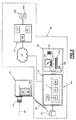
図1は,写真中に見える対象体を識別する,総括参照符号40によって指定されるシステムを表す図である。
FIG. 1 is a diagram representing a system designated by a
ここで各写真は,例えば格納形式EXIF(交換可能画像ファイル)で見られるような,以降「メタデータ」と呼ぶデータが関連付けられている。このメタデータは特に次のデータを有する。
‐写真が撮影されたときに,撮影のために用いたカメラのレンズの地理的位置
‐写真が撮影されたときのレンズの撮影方向
‐レンズの視野角又はレンズの焦点距離の値,及び写真の形式
Here, each photograph is associated with data called “metadata” as seen in, for example, the storage format EXIF (exchangeable image file). This metadata specifically includes the following data:
-The geographical location of the lens of the camera used to take the picture when it was taken-the direction of the lens when the picture was taken-the value of the lens viewing angle or lens focal length, and format
この願書を通して「地理的位置」という表現は,3次元参照フレーム内の座標値を意味し,これら座標値は,位置の緯度と,経度と,高度とを表す。 Throughout this application, the expression “geographical position” means coordinate values within a three-dimensional reference frame, and these coordinate values represent the latitude, longitude, and altitude of the position.
例えばレンズの地理的位置及び撮影方向は,写真が撮影されたときに測定され,写真と関連付けられたメタデータ内に格納される。次に類似して視野角又は焦点距離,及び写真の形式が,写真と関連付けられたメタデータ内に格納される。 For example, the geographical position and shooting direction of a lens are measured when a photo is taken and stored in metadata associated with the photo. Similarly, the viewing angle or focal length, and the type of photo are stored in the metadata associated with the photo.
図1において,メタデータ及び写真はメモリ42内に記憶される。
In FIG. 1, metadata and photos are stored in the
システム40は,メモリ42に記憶されたメタデータを処理するためのユニット44を備える。
The
メタデータを処理するためユニット44は,メモリ42内に記憶されたメタデータから,レンズの地理的位置と,レンズの撮影方向と,レンズの視野角とを抽出するモジュール48を備える。
The
ここでまたユニット44は,写真中の位置の座標値を取得するためのモジュール50,及びモジュール48が抽出した方向を修正するためのモジュール52も備える。
Here, the
モジュール50は,二次元正規直交系参照フレームにおける写真中の位置の座標値を取得することができ,参照フレームの原点は例えば,写真の中心に合致させられる。このモジュールは,取得した座標値をモジュール52に送信するため,モジュール52に接続された出力を備える。
The
モジュール52は,座標値が取得された撮影点の地理的位置と,写真の点に対応する地理的位置とを通る修正された方向を得るために,モジュール48が抽出した方向を修正することができる。この目的のためにモジュール52は,カメラの視野角を用いる。視野角のデータは,メモリ42内に格納されたメタデータから抽出される。ここで「視野角」という用語は,カメラのレンズを通して見える光景の限界をいう。
またユニット44は,モジュール48が抽出した位置及び修正された方向を送信するために,データベースエンジン60に接続された2つの出力を備える。エンジン60は,メモリ64に記憶された地図データベース62内の対象体を選択するのに適している。データベース62は,それぞれ識別子と関連付けられた多数の対象体の地理的位置を含む。例えばこれらの対象体は,歴史的記念物,山,地名である。ここでこれら対象体はそれぞれ,人間が目で見て識別できそうなものである。
The
抽出された位置及び修正された方向によって少なくとも1つの対象体をデータベース62から選択するために,エンジン60は有向直線を決定するモジュール66と,決定された直線に近い対象体を選択するモジュール68と,を備える。例えばモジュール66は,抽出された地理的位置を通り,モジュール52が修正した方向を有する直線の式を決定する。
In order to select at least one object from the
モジュール68は,データベース62から写真中に見えておりモジュール66が決定した直線に最も近い1又は複数の対象体を選択することができる。
モジュール68については,図3に関連してより詳細に説明される。
エンジン60は,モジュール68が選択した対象体の識別子を送信する出力を備える。この出力はユニット70に接続され,選択された対象体に関する情報が表示される。
The
エンジン60は,電子計算機が実行したときに,図3に関連して説明される選択方法を実行する命令を含む計算機プログラムの形態で作られることが好ましい。
The
ユニット70は,メモリ76に記憶されているデータベース74に含まれる追加情報から説明文を生成するモジュール72を備える。データベース74は各対象体識別子を,例えば対象体の名称,その固有の特性,その歴史のような追加情報と関連付ける。この情報は,参照するのに適した形式で記憶される。例えばこの場合,対象体の歴史はオーディオファイルの形態で記憶される一方で,対象体の名称は英数字文字列の形態で記憶される。
The
またユニット70はマンマシンインタフェース78を備える。ここでマンマシンインタフェース78は,ユーザにオーディオファイルを再生するのに適したスピーカ80と,例えばモジュール72が生成した説明文が組み込まれているカメラによって撮影された写真を表示するのに適したスクリーン82と,を備えている。
The
図2はこのシステム40の特定の例示実施例を表している。図1に関連して既に説明した要素には,図2においても同一の参照符号が付与されている。
FIG. 2 represents a specific exemplary embodiment of the
一般にこのシステム40は,情報伝送ネットワーク84を介して写真を参照するための端末88に接続された計算機サーバ86を備える。
In general, the
また図2はレンズ92を備えたカメラ90を示す。レンズ92は,このレンズの光学中心線に対応する撮影方向94を有する。
FIG. 2 shows a camera 90 having a
このカメラ90は,各写真及びそれらに対応する,特にこれらの写真それぞれの地理的位置と,撮影方向と,視野角とを含むメタデータをシステム40内のメモリ42に記憶することができる。この目的のためにカメラ90は,レンズ92の地理的位置及び撮影方向を測定するユニット96を備える。例えばこのユニット96は,地理的位置センサ97及び方角センサ98を用いて実現される。センサ97は例えばGPS(全地球測位システム)センサであり,センサ98は例えば互いに垂直に配置された3つのジャイロスコープを用いて実現される。またユニット96は,レンズの視野角と,日付と,時刻と,明るさと,のようなカメラ90の設定を記録することができる。
The camera 90 can store in the
カメラ90は,例えば無線リンクのような情報伝送リンク99を介して,写真及び対応するメタデータをメモリ42内に記憶するのに適している。
The camera 90 is suitable for storing photographs and corresponding metadata in the
カメラ90は,例えばデジタルカメラであり,又はカメラを備えた携帯電話機であってもよい。 The camera 90 is, for example, a digital camera or a mobile phone equipped with a camera.
サーバ86は,ネットワーク84を介して端末88と情報を交換するモデム100を備える。データベースエンジン60及び説明文を生成するモジュール72は,サーバ86内に置かれる。
The
この実施例においてシステム40のデータベース62及び74は,サーバ86に関連付けられたメモリ105に記憶された単一かつ同一のデータベース104に統合されている。このようにしてデータベース104は,各対象体と,その識別子と,その地理的位置と,それに関連する追加情報と,を統合する。またメモリ105は,例えばエンジン60及びモジュール72に対応する計算機プログラムの命令を含み,サーバ86はこれらの命令を実行するのに適した電子計算機の役割を果たす。
In this embodiment,
端末88は,例えば中央処理ユニット110及びマンマシンインタフェース78を備えた通常の計算機で実現される。
The terminal 88 is realized by, for example, a normal computer including the
ユニット110は,ネットワーク84を介してサーバ86と情報を交換するためのモデム112を備える。
The
モジュール48と,50と,52とは,中央処理ユニット110内に置かれる。この中央処理ユニット110は,写真及びメタデータを含むメモリ42と関連付けられている。
この実施例においてメモリ46は,モジュール48と,50と,52とに対応する計算機プログラムの命令を含み,それで中央処理ユニット110は,これらの命令を実行するのに適した電子計算機として動作する。
In this embodiment, memory 46 includes computer program instructions corresponding to
ここで計算機のスクリーン及びスピーカはそれぞれ,インタフェース78のスクリーン82及びスピーカ80に対応する。またこのインタフェース78は,本実施例においてはマウス120及びキーボード122も備える。
Here, the screen and the speaker of the computer correspond to the
ここで図3の方法に関して,システム40の動作を説明する。
The operation of the
はじめにステップ140でカメラ90のユーザが写真を撮影する。
First, at
次にステップ144で今撮影された写真に関連するメタデータが生成される。より特定すれば動作146において,センサ97がカメラ90の位置を測定し,センサ98が水平及び磁北に対する方角94を測定する。また水平に対するカメラ90の傾きもこの動作146において測定され,水平に対する写真の傾きが判定される。
Next, at
またステップ144においてユニット96は,動作152において写真を撮影するのに用いられたカメラの設定を記録する。特にこの動作152においてカメラ90は,写真が撮影された瞬間のレンズの視野角を記録する。例えば日付と,時刻と,明るさと,シャッタ開放時間ともこの動作152において記録される。
Also in
メタデータが生成されると,ステップ154において,ステップ140で撮影された写真と関連付けられる。例えばステップ154において,写真及びメタデータがEXIF形式で記憶される。
Once the metadata is generated, in
次にメタデータ及び写真がリンク99を介して送信され,次いでステップ156においてメモリ42内に記憶される。
The metadata and photo are then transmitted over link 99 and then stored in
その後端末88のユーザは,所望であればフェーズ162に進み,メモリ42内に記憶された写真のうち1つに対して自動的に説明文が生成される。このフェーズ162において端末88は,ステップ164においてメモリ42内に記憶された写真のうち1つに関連する地理的位置と,撮影方向と,視野角とをエンジン60に送信する。エンジン60はステップ164において送信されたデータを受信する。
Thereafter, the user of
次にエンジン60は受信したデータによって,ステップ166においてデータベース104内の少なくとも1つの対象体を選択する。より特定すればステップ166において,モジュール66が動作168において,受信した地理的位置を通り,受信した撮影方向を向いた有向直線を決定する。次に動作170においてモジュール68が,動作168において決定された有向直線に最も近い地理的位置の1又は複数の対象体をデータベース104から選択する。例えばこのためにモジュール68は,有向直線から各対象体までの最短距離を計算し,有向直線からの距離がしきい値よりも短い1又は複数の対象体だけを選択する。このしきい値は,写真中に見えていない対象体をすべて除くように,受信した視野角の値によってモジュール68が確立する。更にこのしきい値は,受信した方向にある対象体だけを選択するように決定される。
The
次にステップ180においてモジュール72が,エンジン60の選択した対象体と関連付けられた補足情報によって写真の説明文を生成する。例えば,「2月14日,日曜日,8時48分,”plan de Grace”の時計塔(北東)に向かって撮影した写真」のような説明文を生成する。
Next, in
この例としての説明文は,視野方向にある対象体の情報と,写真に関連付けられたメタデータから抽出された日付及び時刻とを用いて作成される。 The explanatory text as this example is created using the information of the object in the viewing direction and the date and time extracted from the metadata associated with the photograph.
次に生成された説明文はステップ182において端末88に送信され,この写真に関連付けられたメタデータ内に格納される。
The generated description is then sent to terminal 88 at
またユーザはフェーズ200に進み,端末88上で写真を参照することができる。このフェーズ200は,ステップ202におけるスクリーン82上への地図の表示で始まり,写真と関連付けられたメタデータ内に格納されている各地理的位置を表す各撮影点が,スクリーン上に示される。
The user can also proceed to phase 200 and refer to the photograph on the terminal 88. This
ステップ204において,ユーザはマウス120を用いてこれらの撮影点のうち1つを選択する。するとステップ206において端末88は,自動的にこの撮影点から撮影された写真をスクリーン82上に表示する。この写真について説明文が既に生成されているときは,スクリーン82上に表示された写真が,モジュール72の生成した説明文をその中に含むことが好ましい。
In step 204, the user uses the
次にユーザはステップ208に進み,写真中に見える対象体を識別する。このためにユーザは,例えばマウスを用いて識別すべき対象体に対応する写真の特定の点を選択する。動作210においてモジュール50は,写真の中心にリンクした参照系におけるユーザが選択した点の座標値を取得する。これらの座標値を,(a,b)とする。次に動作214においてモジュール48が,撮影点の地理的位置及び撮影方向をメモリ46内に記憶されたメタデータから抽出する。
The user then proceeds to step 208 and identifies the objects that are visible in the photograph. For this purpose, the user selects a specific point of the photograph corresponding to the object to be identified using, for example, a mouse. In
次に動作216においてモジュール52が,メタデータから抽出した方向を修正し,修正した方向を推測する。修正した方向は,抽出した地理的位置と,写真中の選択した点に対応する対象体の地理的位置と,を通る直線の方向に一致する。このためモジュール52は,写真に関連付けられたメタデータ中に格納された視野角αを用いる。この視野角αは図4に示されている。同じ図4において,撮影点の位置は点218で表されている。角xは,方向94と,矢印220が示す磁北方向との間の角を表す。説明を単純にするため,角xの修正はここでは,水平に対する写真又はカメラ90の傾きを考慮する必要がないように,水平に撮影された写真222の特定の場合について説明する。ユーザが選択した点の位置は十字224で表され,一方写真にリンクした参照系の中心は十字226が表す。これら2つの十字224及び226の間の距離は,横座標”a”の値に対応する。ここで写真の水平端の既知の長さをdで表す。これらの条件において,方向94に対する修正した方向がなす角βは,次の関係を用いて計算できる。
Next, in operation 216, the

角βが計算されると,後者が角xに加算される。このようにして磁北に対して修正された方向がなす角x’が得られる。類似の操作を行うことによって,モジュール52が水平に対して修正された方向がなす角y’も計算する。
When the angle β is calculated, the latter is added to the angle x. In this way, the angle x 'formed by the corrected direction with respect to magnetic north is obtained. By performing a similar operation, the
次にステップ230において,メタデータから抽出した位置及び修正された方向がネットワーク84を介してエンジン60へ送信される。ステップ232においてエンジン60は,受信したデータによって,抽出した位置を通り修正された方向を持つ有向直線に近い1又は複数の対象体を選択する。このステップ232は,ちょうど動作168のように有向直線を決定する動作234と,その有向直線に最も近い各対象体を選択する動作236と,を含む。
Next, at
この動作236においてエンジン60は,データベース104から次に掲げる対象体を選択する。
‐有向直線に近い
‐写真の画枠に含まれる
‐撮影点の地理的位置に最も近い
In this
-Close to the directed line-Included in the picture frame-Closest to the geographical location of the shooting point
最後の条件によって,写真中に見える対象体だけを選択することができる。動作236において,例えば対象体のこの直線からの最短距離が事前に確立されたしきい値よりも短いとき,その対象体は有向直線に近いものと考える。
Depending on the last condition, only the objects visible in the picture can be selected. In
エンジン60が修正された方向にある可視対象体を選択すると,ステップ240においてこの対象体の識別子と,それに関連付けられた補足情報とが端末88へ送信される。
When the
ステップ242において,ユニット78はユーザに受信した情報を提示する。例えばスクリーン82にはこの情報のいくつかが表示され,スピーカ80からオーディオファイルが再生される。
In
次にユーザは写真のもう1つの点を選択することができ,ステップ208から240が反復される。 The user can then select another point on the photo and steps 208-240 are repeated.
ここでメタデータはEXIF形式を用いて写真と関係付けられる。変形物として,EXIFがMPEG−7形式に置き換えられる。 Here, the metadata is related to the photograph using the EXIF format. As a variant, EXIF is replaced with the MPEG-7 format.
システム40には多くのほかの実施例が可能である。例えばシステム40の要素を一方では1又は複数の局所参照端末に,他方では計算機サーバに分割する代わりに,システム40のすべての要素を参照ワークステーション内におくことができる。反対に処理ユニット44を遠隔計算機サーバに置き,それをメモリ42と関連付けることもできる。後者の実施例においては,参照ワークステーションも情報表示ユニットを備える。
Many other embodiments of the
変形物として,説明文を生成するモジュール72及びフェーズ162を削除する。この変形物においては,表示ユニットはマンマシンインタフェースに整理される。
As a modification, the
簡略化した実施例においては,動作210及び216が削除される。したがってシステムは,写真の中心にあり,撮影方向の線上にある対象体だけを識別することができる。
In the simplified embodiment,
Claims (12)
写真に関連付けられたデータに基づいてレンズの地理的位置及び撮影方向を抽出するステップ(ステップ214)と,
前記の抽出した撮影方向によって,前記の抽出した地理的位置と識別すべき前記写真中の対象体に対応する地理的位置とを通る有向直線を決定するステップ(ステップ234)と,
各対象体と地理的位置とを関連付ける地図データベースから,少なくとも1つの対象体を,その地理的位置と前記の決定した有向直線との間の計算した距離によって選択するステップ(ステップ236)と,
1又は複数の選択した対象体に関する情報を表示するステップ(ステップ242)と,を有することを特徴とし,また
前記写真上の点の座標値を取得するステップ(ステップ210)と,
前記の取得した前記カメラのレンズの座標値及び視野角によって,前記抽出した撮影方向を修正するステップ(ステップ216)と,
を有し,前記の決定ステップは前記修正した方向を用いて前記有向直線を決定することを特徴とする方法。 A method for automatically identifying an object in a photograph taken from a camera equipped with a lens,
Extracting a lens's geographical position and shooting direction based on data associated with the photograph (step 214);
Determining a directed straight line that passes through the extracted geographic location and the geographic location corresponding to the object in the photograph to be identified according to the extracted imaging direction (step 234);
Selecting (at step 236) at least one object from the map database associating each object with a geographic location by a calculated distance between the geographic location and the determined directed line;
Displaying information about one or more selected objects (step 242), and obtaining coordinate values of points on the photograph (step 210),
Correcting the extracted shooting direction according to the acquired coordinate value and viewing angle of the lens of the camera (step 216);
And the determining step determines the directed straight line using the corrected direction.
写真に関連付けられたデータに基づいてレンズの地理的位置及び撮影方向を抽出するモジュール(48)と,
前記の抽出した撮影方向によって,前記の抽出した地理的位置と識別すべき前記写真中の対象体に対応する地理的位置とを通る有向直線を決定するモジュール(66)と,
各対象体と地理的位置とを関連付ける地図データベースから,少なくとも1つの対象体を,その地理的位置と前記の決定した有向直線との間の計算した距離によって選択するモジュール(68)と,
1又は複数の選択した各オブジェクトに関する情報を表示するユニット(70)と,
を有することを特徴とし,また
前記写真上の点の座標値を取得するモジュール(50)と,
前記の取得した前記カメラの座標値及び視野角によって,前記抽出した撮影方向を修正するモジュール(52)と,
を備え,前記の決定モジュールは前記修正した方向を用いて前記有向直線を決定することを特徴とするシステム。 A system for automatically identifying an object in a photograph taken from a camera equipped with a lens,
A module (48) for extracting a lens's geographical position and photographing direction based on data associated with the photograph;
A module (66) for determining a directed straight line that passes through the extracted geographical position and the geographical position corresponding to the object in the photograph to be identified according to the extracted photographing direction;
A module (68) for selecting at least one object from a map database associating each object with a geographic location according to a calculated distance between the geographic location and the determined directed line;
A unit (70) for displaying information about each one or more selected objects;
A module (50) for obtaining the coordinate value of the point on the photograph;
A module (52) for correcting the extracted photographing direction according to the acquired coordinate value and viewing angle of the camera;
The determination module determines the directed straight line using the corrected direction.
Applications Claiming Priority (2)
| Application Number | Priority Date | Filing Date | Title |
|---|---|---|---|
| FR0409769A FR2875320A1 (en) | 2004-09-15 | 2004-09-15 | METHOD AND SYSTEM FOR IDENTIFYING AN OBJECT IN A PHOTO, PROGRAM, RECORDING MEDIUM, TERMINAL AND SERVER FOR IMPLEMENTING THE SYSTEM |
| PCT/FR2005/002280 WO2006030133A1 (en) | 2004-09-15 | 2005-09-14 | Method and system for identifying an object in a photograph, programme, recording medium, terminal and server for implementing said system |
Publications (2)
| Publication Number | Publication Date |
|---|---|
| JP2008513852A true JP2008513852A (en) | 2008-05-01 |
| JP2008513852A5 JP2008513852A5 (en) | 2008-10-30 |
Family
ID=34952202
Family Applications (1)
| Application Number | Title | Priority Date | Filing Date |
|---|---|---|---|
| JP2007530746A Pending JP2008513852A (en) | 2004-09-15 | 2005-09-14 | Method and system for identifying object in photograph, and program, recording medium, terminal and server for realizing the system |
Country Status (6)
| Country | Link |
|---|---|
| US (1) | US20080140638A1 (en) |
| EP (1) | EP1828928A1 (en) |
| JP (1) | JP2008513852A (en) |
| KR (1) | KR20070055533A (en) |
| FR (1) | FR2875320A1 (en) |
| WO (1) | WO2006030133A1 (en) |
Cited By (2)
| Publication number | Priority date | Publication date | Assignee | Title |
|---|---|---|---|---|
| JP2012141467A (en) * | 2010-12-29 | 2012-07-26 | Nikon Corp | Photographing direction calculation program, storage medium in which photographing direction calculation program is recorded, photographing direction calculation device |
| JP2013142956A (en) * | 2012-01-10 | 2013-07-22 | Pasuko:Kk | Photographing object retrieval system |
Families Citing this family (10)
| Publication number | Priority date | Publication date | Assignee | Title |
|---|---|---|---|---|
| US9104694B2 (en) | 2008-01-10 | 2015-08-11 | Koninklijke Philips N.V. | Method of searching in a collection of data items |
| US8611592B2 (en) * | 2009-08-26 | 2013-12-17 | Apple Inc. | Landmark identification using metadata |
| JP2011055250A (en) * | 2009-09-02 | 2011-03-17 | Sony Corp | Information providing method and apparatus, information display method and mobile terminal, program, and information providing system |
| US20110109747A1 (en) * | 2009-11-12 | 2011-05-12 | Siemens Industry, Inc. | System and method for annotating video with geospatially referenced data |
| US20110137561A1 (en) * | 2009-12-04 | 2011-06-09 | Nokia Corporation | Method and apparatus for measuring geographic coordinates of a point of interest in an image |
| KR100975128B1 (en) * | 2010-01-11 | 2010-08-11 | (주)올라웍스 | Method, system and computer-readable recording medium for providing information of object using viewing frustum |
| US20130129192A1 (en) * | 2011-11-17 | 2013-05-23 | Sen Wang | Range map determination for a video frame |
| US8611642B2 (en) | 2011-11-17 | 2013-12-17 | Apple Inc. | Forming a steroscopic image using range map |
| US9041819B2 (en) | 2011-11-17 | 2015-05-26 | Apple Inc. | Method for stabilizing a digital video |
| KR101942288B1 (en) * | 2012-04-23 | 2019-01-25 | 한국전자통신연구원 | Apparatus and method for correcting information of position |
Citations (4)
| Publication number | Priority date | Publication date | Assignee | Title |
|---|---|---|---|---|
| JPH0981361A (en) * | 1995-09-12 | 1997-03-28 | Toshiba Corp | Image display method, data collection method and object specifying method |
| JPH1166350A (en) * | 1997-08-12 | 1999-03-09 | Nippon Telegr & Teleph Corp <Ntt> | Retrieval type scene labeling device and system |
| JP2000013722A (en) * | 1998-06-22 | 2000-01-14 | Hitachi Ltd | Image recorder |
| JP2003323440A (en) * | 2002-04-30 | 2003-11-14 | Japan Research Institute Ltd | Photographed image information providing system using portable terminal, photographed image information providing method, and program for executing method in computer |
Family Cites Families (10)
| Publication number | Priority date | Publication date | Assignee | Title |
|---|---|---|---|---|
| JP2811501B2 (en) * | 1990-08-30 | 1998-10-15 | インターナショナル・ビジネス・マシーンズ・コーポレーション | Cursor movement control method and apparatus |
| US5913078A (en) * | 1994-11-01 | 1999-06-15 | Konica Corporation | Camera utilizing a satellite positioning system |
| US6208353B1 (en) * | 1997-09-05 | 2001-03-27 | ECOLE POLYTECHNIQUE FEDéRALE DE LAUSANNE | Automated cartographic annotation of digital images |
| JP4216917B2 (en) * | 1997-11-21 | 2009-01-28 | Tdk株式会社 | Chip bead element and manufacturing method thereof |
| US6690883B2 (en) * | 2001-12-14 | 2004-02-10 | Koninklijke Philips Electronics N.V. | Self-annotating camera |
| US6885371B2 (en) * | 2002-04-30 | 2005-04-26 | Hewlett-Packard Development Company, L.P. | System and method of identifying a selected image object in a three-dimensional graphical environment |
| US20040021780A1 (en) * | 2002-07-31 | 2004-02-05 | Intel Corporation | Method and apparatus for automatic photograph annotation with contents of a camera's field of view |
| US7234106B2 (en) * | 2002-09-10 | 2007-06-19 | Simske Steven J | System for and method of generating image annotation information |
| US20040114042A1 (en) * | 2002-12-12 | 2004-06-17 | International Business Machines Corporation | Systems and methods for annotating digital images |
| JP3984155B2 (en) * | 2002-12-27 | 2007-10-03 | 富士フイルム株式会社 | Subject estimation method, apparatus, and program |
-
2004
- 2004-09-15 FR FR0409769A patent/FR2875320A1/en active Pending
-
2005
- 2005-09-14 WO PCT/FR2005/002280 patent/WO2006030133A1/en active Application Filing
- 2005-09-14 JP JP2007530746A patent/JP2008513852A/en active Pending
- 2005-09-14 US US11/662,470 patent/US20080140638A1/en not_active Abandoned
- 2005-09-14 KR KR1020077005846A patent/KR20070055533A/en not_active Application Discontinuation
- 2005-09-14 EP EP05802703A patent/EP1828928A1/en not_active Ceased
Patent Citations (4)
| Publication number | Priority date | Publication date | Assignee | Title |
|---|---|---|---|---|
| JPH0981361A (en) * | 1995-09-12 | 1997-03-28 | Toshiba Corp | Image display method, data collection method and object specifying method |
| JPH1166350A (en) * | 1997-08-12 | 1999-03-09 | Nippon Telegr & Teleph Corp <Ntt> | Retrieval type scene labeling device and system |
| JP2000013722A (en) * | 1998-06-22 | 2000-01-14 | Hitachi Ltd | Image recorder |
| JP2003323440A (en) * | 2002-04-30 | 2003-11-14 | Japan Research Institute Ltd | Photographed image information providing system using portable terminal, photographed image information providing method, and program for executing method in computer |
Cited By (2)
| Publication number | Priority date | Publication date | Assignee | Title |
|---|---|---|---|---|
| JP2012141467A (en) * | 2010-12-29 | 2012-07-26 | Nikon Corp | Photographing direction calculation program, storage medium in which photographing direction calculation program is recorded, photographing direction calculation device |
| JP2013142956A (en) * | 2012-01-10 | 2013-07-22 | Pasuko:Kk | Photographing object retrieval system |
Also Published As
| Publication number | Publication date |
|---|---|
| FR2875320A1 (en) | 2006-03-17 |
| US20080140638A1 (en) | 2008-06-12 |
| EP1828928A1 (en) | 2007-09-05 |
| WO2006030133A1 (en) | 2006-03-23 |
| KR20070055533A (en) | 2007-05-30 |
Similar Documents
| Publication | Publication Date | Title |
|---|---|---|
| JP2008513852A (en) | Method and system for identifying object in photograph, and program, recording medium, terminal and server for realizing the system | |
| US7518640B2 (en) | Method, apparatus, and recording medium for generating album | |
| US8103126B2 (en) | Information presentation apparatus, information presentation method, imaging apparatus, and computer program | |
| TWI450111B (en) | Method, computer useable medium, and device for guided photography based on image capturing device rendered user recommendations | |
| CN105005960B (en) | Method, device and system for acquiring watermark photo | |
| US20050046706A1 (en) | Image data capture method and apparatus | |
| US20050104976A1 (en) | System and method for applying inference information to digital camera metadata to identify digital picture content | |
| JP5229791B2 (en) | PHOTO MAPPING METHOD AND SYSTEM, PROGRAM, AND STORAGE MEDIUM | |
| JP2009239397A (en) | Imaging apparatus, imaging system, control method of imaging apparatus, and control program | |
| KR20090019184A (en) | Image reproducing apparatus which uses the image files comprised in the electronic map, image reproducing method for the same, and recording medium which records the program for carrying the same method | |
| KR20100003898A (en) | Method of controlling image processing apparatus, image processing apparatus and image file | |
| JP2011018303A (en) | Farm work management device, farm work management method and farm work management system | |
| US20140247342A1 (en) | Photographer's Tour Guidance Systems | |
| TW200928311A (en) | Satellite navigation method and system | |
| JP2002077805A (en) | Camera with photographing memo function | |
| JP3984155B2 (en) | Subject estimation method, apparatus, and program | |
| JP2007086546A (en) | Advertisement printing device, advertisement printing method, and advertisement printing program | |
| JP4007586B2 (en) | Image display device | |
| JP2011119832A (en) | Image display device and image display method | |
| WO2018006534A1 (en) | Place recommendation method, device, and computer storage medium | |
| JP2001275031A (en) | Method and device for image processing, camera, and photography system | |
| JP2003244488A (en) | Image information adding apparatus and system | |
| JP2013214158A (en) | Display image retrieval device, display control system, display control method, and program | |
| JP5458411B2 (en) | Photographed image display device, photographed image display method, and electronic map output by photographed image display method | |
| KR102445296B1 (en) | management systems of image by drone |
Legal Events
| Date | Code | Title | Description |
|---|---|---|---|
| A521 | Request for written amendment filed |
Free format text: JAPANESE INTERMEDIATE CODE: A523 Effective date: 20080911 |
|
| A621 | Written request for application examination |
Free format text: JAPANESE INTERMEDIATE CODE: A621 Effective date: 20080911 |
|
| A131 | Notification of reasons for refusal |
Free format text: JAPANESE INTERMEDIATE CODE: A131 Effective date: 20101130 |
|
| A601 | Written request for extension of time |
Free format text: JAPANESE INTERMEDIATE CODE: A601 Effective date: 20110224 |
|
| A602 | Written permission of extension of time |
Free format text: JAPANESE INTERMEDIATE CODE: A602 Effective date: 20110303 Free format text: JAPANESE INTERMEDIATE CODE: A602 Effective date: 20110303 |
|
| A02 | Decision of refusal |
Free format text: JAPANESE INTERMEDIATE CODE: A02 Effective date: 20110816 Free format text: JAPANESE INTERMEDIATE CODE: A02 Effective date: 20110816 |