JP2006323096A - Map display device - Google Patents
Map display device Download PDFInfo
- Publication number
- JP2006323096A JP2006323096A JP2005145707A JP2005145707A JP2006323096A JP 2006323096 A JP2006323096 A JP 2006323096A JP 2005145707 A JP2005145707 A JP 2005145707A JP 2005145707 A JP2005145707 A JP 2005145707A JP 2006323096 A JP2006323096 A JP 2006323096A
- Authority
- JP
- Japan
- Prior art keywords
- administrative division
- map
- name
- display device
- screen
- Prior art date
- Legal status (The legal status is an assumption and is not a legal conclusion. Google has not performed a legal analysis and makes no representation as to the accuracy of the status listed.)
- Withdrawn
Links
Images


Abstract
Description
本発明は地図表示装置に関し、特に、市区町村の合併等によりその行政区分の名称が変更された場合の地図表示に対応するのに有用な技術に関する。本発明に係る地図表示装置は、例えば、車載用ナビゲーション装置に適用され得る。 The present invention relates to a map display device, and more particularly to a technique useful for dealing with a map display when the name of an administrative division is changed due to merger of municipalities. The map display device according to the present invention can be applied to, for example, an in-vehicle navigation device.
典型的な車載用ナビゲーション装置においては、ナビゲーションに係る一切の処理を制御するCPU、地図データを格納したCD−ROMやDVD−ROM等の記憶装置、ディスプレイ装置、自車の現在位置を検出するためのGPS(Global Positioning System )受信機、自車の進行方位や走行速度等を検出するためのジャイロや車速センサ等が設けられている。そして、CPUにより、自車の現在位置を含む地図データを記憶装置から読み出し、この地図データに基づいて自車位置の周囲の地図画像をディスプレイ装置の画面に描画すると共に、自車の現在位置を指示する自車位置マークを画面上に重ね合わせて表示し、自車の移動に応じて地図画像をスクロール表示したり、地図画像を画面に固定して自車位置マークを移動させたりして、自車が現在何処を走行しているのかを一目で判るようにしている。 In a typical in-vehicle navigation device, a CPU for controlling all processing related to navigation, a storage device such as a CD-ROM or DVD-ROM storing map data, a display device, and a current position of the vehicle A GPS (Global Positioning System) receiver, a gyro, a vehicle speed sensor, and the like for detecting the traveling direction and traveling speed of the vehicle are provided. Then, the CPU reads out map data including the current position of the own vehicle from the storage device, draws a map image around the own vehicle position on the screen of the display device based on the map data, and determines the current position of the own vehicle. The vehicle position mark to be indicated is displayed superimposed on the screen, the map image is scrolled according to the movement of the vehicle, the map image is fixed on the screen and the vehicle position mark is moved, You can see at a glance where your car is currently driving.
また、車載用ナビゲーション装置には、通常、ユーザが目的地に向けて道路を間違うことなく容易に走行できるように案内する機能(経路誘導機能)が搭載されている。この経路誘導機能によれば、CPUにより、地図データを用いて出発地(典型的には自車の現在位置)から目的地までを結ぶ最適な経路を、横型探索法やダイクストラ法等のシミュレーション計算を行って探索し、その探索した経路を誘導経路として記憶しておき、走行中、地図画像上にその誘導経路を他の道路とは識別可能に(例えば、色を変えたり、線幅を太くして)表示したり、また誘導経路上で接近中の交差点まで所定距離に達したとき、地図画像上にその交差点の案内図(交差点拡大図、該交差点での進行方向を示す矢印、該交差点までの距離、交差点名など)を表示したりすることで、いずれの道路を走行すればよいか、また交差点でどの方向に進んだらよいかをユーザが把握できるようになっている。 In-vehicle navigation devices are usually equipped with a function (route guidance function) that guides a user so that the user can easily travel on the road without making a mistake. According to this route guidance function, the CPU calculates the optimal route from the departure point (typically the current position of the vehicle) to the destination using map data, such as a horizontal search method or a Dijkstra method. The route searched is stored as a guide route, and the route can be distinguished from other roads on the map image while traveling (for example, the color is changed or the line width is increased). When a predetermined distance is reached to the approaching intersection on the guidance route, a guide map of the intersection (an enlarged view of the intersection, an arrow indicating the direction of travel at the intersection, the intersection) on the map image By displaying the distance to the intersection, the name of the intersection, etc., the user can grasp which road should be traveled and in which direction the intersection should be traveled.
このように車載の地図データベースに基づいて経路探索及び経路誘導を行うナビゲーション装置では、道路情報やPOI(Point Of Interest )情報等に関して確度の高い情報案内を行うためには、地図データベースに格納されている地図データは、出来るだけ最新の情報を反映したデータであるのが望ましい。 Thus, in a navigation device that performs route search and route guidance based on an in-vehicle map database, in order to provide highly accurate information guidance on road information, POI (Point Of Interest) information, etc., it is stored in a map database. It is desirable that the map data that reflects the latest information as much as possible.
その一方で、最近では行政指導の影響もあって全国各地で市区町村の合併が行われており、それに伴い行政区分名が変更される場合が生じている。このような状況に対して、従来のナビゲーション装置では、地図データベースとしてHDD等の書き換え可能な記憶媒体を搭載したタイプのものについては、地図データの更新(バージョンアップ)を行うことができるので特に不都合は生じないが、DVD−ROM等の読み出し専用の記憶媒体を搭載したタイプのものについては、地図データの更新は行われないため、市区町村名が変更されていてもその変更後の新しい行政区分名で地図表示を行うことができない。 On the other hand, municipalities have recently been merged around the country due to the influence of administrative guidance, and administrative division names have sometimes been changed accordingly. In such a situation, the conventional navigation apparatus is particularly inconvenient because the map data can be updated (version up) for a type equipped with a rewritable storage medium such as an HDD as a map database. However, since the map data is not updated for a type equipped with a read-only storage medium such as a DVD-ROM, the new administrative district after the change is changed even if the city name is changed. The map cannot be displayed by name.
これに対応するには、最新の地図情報を格納したDVD−ROM等の地図記憶媒体に買い換えればよいが、相当のコストを要するため、積極的に買い換えを行う気になれない。また、買い換えた場合に最新の地図を確認できることによる便利さと、あえて買い換えを行わなかった場合に覚える不便さとを比較考量したときに、必ずしもコストをかけてまで最新の地図記憶媒体に買い換える必要があるかどうかは疑問である。例えば、地図データに含まれる情報のなかでも道路や交差点、建物や施設等の名称や住所等に関する情報については、変化があっても内容的にそれほど大きく変わることはなく、概して少しずつ変化しているのが現状であり、最新の地図情報に頼らなくてもさほどの不便さを覚えることはない。実際、このような場合にナビゲーション用のDVD−ROM等を頻繁に買い換えるユーザは少ない。 In order to cope with this, it is sufficient to replace with a map storage medium such as a DVD-ROM storing the latest map information. However, since a considerable cost is required, it does not seem to be actively replaced. In addition, when comparing the convenience of being able to check the latest map when it is replaced and the inconvenience that is remembered when it is not replaced, it is necessary to replace it with the latest map storage medium until it is costly. It is doubtful. For example, the information about the names and addresses of roads, intersections, buildings, facilities, etc. in the information contained in the map data does not change so much in content even if there is a change, and generally changes little by little. There is no current inconvenience even if you do not rely on the latest map information. In fact, there are few users who frequently purchase navigation DVD-ROMs in such cases.
かかるナビゲーション装置に関連する技術としては、例えば、特許文献1に記載されるように、データベースとして道路地図以外に、住所、建物、施設の名称等を示す住宅地図を備え、当該車両の位置と目的地の位置の間の距離を計算して所定距離よりも大きいか小さいかを判断し、当該距離が所定距離よりも大きい場合には道路地図に当該車両の位置を表示し、当該距離が所定距離よりも小さい場合には住宅地図に当該車両の位置を表示するように地図表示の切り換えを行うようにした技術がある。
上述したように地図データベースとしてDVD−ROM等の読み出し専用の記憶媒体を搭載した従来の車載用ナビゲーション装置では、地図データの更新は行われないため、地図データに含まれる情報の内容に変更があった場合、建物や施設等の名称や住所など内容的にそれほど大きく変化しない情報については、最新の地図情報に頼らなくてもさほどの不便さを覚えることはない。 As described above, since the map data is not updated in the conventional in-vehicle navigation device equipped with a read-only storage medium such as a DVD-ROM as the map database, the content of information included in the map data has changed. In the case of information that does not change so much in terms of contents such as names and addresses of buildings, facilities, etc., there is no much inconvenience without relying on the latest map information.
しかしながら、市区町村合併など内容的に大きく情報が変わってしまう場合には、保有している地図データベース(旧い地図情報)では不都合が生じる。特に、市区町村の合併が行われると、その行政区分の名称のみならず行政区分エリアも変更されるのが一般的であり、このような場合でも旧市区町村名での地図表示しか行えず、変更後の新しい行政区分名及びエリアで地図表示を行うことができないのは、やはり不便である。 However, if the information changes greatly in terms of content, such as a merger of cities, towns and towns, inconvenience occurs in the map database (old map information). In particular, when a municipality is merged, not only the name of the administrative division but also the administrative division area is generally changed. Even in such a case, only the map display with the old municipality name can be performed. It is also inconvenient that the map cannot be displayed with the new administrative division name and area after the change.
また、ナビゲーション装置には、地図表示を行う際にユーザが視認し易いように各行政区分エリア毎に色分けして表示を行う機能を搭載したものもあるが、DVD−ROM等の読み出し専用の記憶媒体を搭載したタイプのものについては、市区町村合併等により行政区分エリアが変更されてもその変更に対応できないため、ユーザにとって便利な機能であるはずのエリア毎の色分け表示が役に立たないといった不都合もあった。 In addition, some navigation devices have a function of performing color-coded display for each administrative division area so that the user can easily see when displaying a map, but a read-only memory such as a DVD-ROM is provided. As for the type equipped with media, even if the administrative division area is changed due to merger of municipalities, etc., it can not cope with the change, so the color-coded display for each area which should be a convenient function for the user is not useful There was also.
上記の課題は、車載用ナビゲーション装置に特有のものではなく、既に保有しているDVD−ROM等の地図データベースから住所検索等を行うことができる環境下にあれば、例えば、家庭用のパーソナルコンピュータ(PC)においても同様に起こり得る。 The above-mentioned problem is not unique to the vehicle-mounted navigation device. For example, if it is in an environment where address search or the like can be performed from a map database such as a DVD-ROM already possessed, for example, a personal computer for home use It can happen in (PC) as well.
本発明は、かかる従来技術における課題に鑑み創作されたもので、既に保有している地図データベースを用いて、市区町村合併等により変更された行政区分名を画面上で表示修正することができる地図表示装置を提供することを目的とする。 The present invention was created in view of the problems in the prior art, and the administrative division name changed due to the merger of cities, towns and villages can be displayed and corrected on the screen using the map database already possessed. An object is to provide a map display device.
さらに本発明は、上記の行政区分名の変更に伴う行政区分エリアの色分け表示の修正に対応することができる地図表示装置を提供することを目的とする。 A further object of the present invention is to provide a map display device that can cope with correction of the color-coded display of the administrative division area accompanying the change of the administrative division name.
本発明では、ユーザが、ニュースや新聞、インターネット等の情報伝達媒体を介して市区町村合併等による行政区分名の変更に関する情報を知得しているか、あるいは、車載用ナビゲーション装置に適用した場合において当該車両がある行政区分エリアに入ったときに路肩の標識や案内表示板等からその行政区分の名称が変更されていることを知得したことを前提としている。 In the present invention, when the user knows information related to the change of the administrative division name due to the merger of municipalities, etc. via an information transmission medium such as news, newspapers, the Internet, or when applied to an in-vehicle navigation device It is assumed that the name of the administrative division has been changed from a roadside sign or a guidance display board when the vehicle enters the administrative division area.
この前提に基づき、本発明の基本形態によれば、地図データを格納した記憶手段と、画面を備えた表示手段と、ユーザ指示を入力する入力手段と、前記記憶手段、表示手段及び入力手段に動作可能に接続された制御手段とを具備し、前記制御手段は、前記地図データを参照して前記表示手段の画面に前記入力手段からのユーザ指示に基づいた地図画像を表示させている状態で、該地図画像に含まれるいずれかの行政区分エリアが選択され、かつ変更後の新行政区分名が入力されたときに、該入力された新行政区分名を当該行政区分エリアに表示させることを特徴とする地図表示装置が提供される。 Based on this premise, according to the basic form of the present invention, the storage means storing map data, the display means provided with a screen, the input means for inputting user instructions, the storage means, the display means and the input means Operably connected control means, wherein the control means is configured to display a map image based on a user instruction from the input means on the screen of the display means with reference to the map data. When any administrative division area included in the map image is selected and a new administrative division name after change is input, the inputted new administrative division name is displayed in the administrative division area. A featured map display device is provided.
この基本形態に係る地図表示装置によれば、例えば、車載用ナビゲーション装置に適用した場合において当該車両がある行政区分エリアに入ったときに、ユーザ指示に基づいて表示手段の画面に表示された地図画像から当該行政区分エリアが選択され、さらに変更後の新行政区分名が入力されると、制御手段からの制御に基づき、その入力された新行政区分名が地図画像上の当該行政区分エリアに表示されるようになっている。 According to the map display device according to this basic form, for example, when applied to an in-vehicle navigation device, when the vehicle enters a certain administrative division area, the map displayed on the screen of the display means based on a user instruction When the administrative division area is selected from the image and the new administrative division name after the change is input, the input new administrative division name is added to the administrative division area on the map image based on the control from the control means. It is displayed.
つまり、記憶手段に格納されている地図データ(既に保有している地図データベース)を用いて、市区町村合併等により変更された行政区分名の表示(修正)を画面上で行うようにしている。これにより、わざわざコストをかけて最新の地図記憶媒体に買い換えを行わなくても、変更後の新しい行政区分名で地図表示を行うことができるので、従来技術に見られたような不都合や不便さを大いに減少させることができる。 In other words, using the map data stored in the storage means (already owned map database), the administrative division name changed by the merger of municipalities, etc. is displayed (corrected) on the screen. . This makes it possible to display the map with the new administrative division name after the change without costly replacement for the latest map storage medium, which is inconvenient and inconvenient as seen in the prior art. Can be greatly reduced.
また、本発明の他の形態によれば、上記の形態に係る地図表示装置において、前記制御手段が、前記入力された新行政区分名を前記表示手段の画面上の当該行政区分エリアに表示させている状態で、さらに当該新行政区分名と同じ名称に変更されている他の行政区分エリアが選択されたときに、該選択された他の行政区分エリアに当該新行政区分名を表示させると共に、当該新行政区分名に対応する各行政区分エリアを同じ色で表示させることを特徴とする地図表示装置が提供される。 According to another aspect of the present invention, in the map display device according to the above aspect, the control means causes the inputted new administrative division name to be displayed in the administrative division area on the screen of the display means. When another administrative division area that has been changed to the same name as the new administrative division name is selected, the new administrative division name is displayed in the selected other administrative division area. A map display device is provided that displays each administrative division area corresponding to the new administrative division name in the same color.
この形態に係る地図表示装置によれば、変更後の新行政区分名が当該行政区分エリアに表示されている状態で、さらに当該新行政区分名と同じ名称に変更されている他の行政区分エリアが選択されると、制御手段からの制御に基づき、その選択された他の行政区分エリアに当該新行政区分名が表示されると共に、当該新行政区分名に対応する各行政区分エリアが同じ色で表示されるようになっている。つまり、行政区分エリア毎に色分けして表示を行うにあたり、行政区分名の変更に伴い当該行政区分エリアが変更されている場合でも、その変更(当該行政区分エリアの色分け表示の修正)に対応することができる。 According to the map display device according to this embodiment, the new administrative division name after the change is displayed in the administrative division area, and the administrative division area is changed to the same name as the new administrative division name. Is selected, the new administrative division name is displayed in the selected other administrative division area based on the control from the control means, and each administrative division area corresponding to the new administrative division name has the same color. Is displayed. In other words, when displaying by color-coded for each administrative division area, even if the administrative division area is changed with the change of administrative division name, it corresponds to the change (correction of color-coded display of the administrative division area) be able to.
以下、本発明の実施の形態について、添付の図面を参照しながら説明する。 Hereinafter, embodiments of the present invention will be described with reference to the accompanying drawings.
図1は本発明に係る地図表示装置を車載用ナビゲーション装置に適用した場合の一実施形態に係る構成をブロック図の形態で示したものである。 FIG. 1 is a block diagram showing a configuration according to an embodiment when a map display device according to the present invention is applied to an in-vehicle navigation device.
図示の構成(地図表示装置20)において、1はDVDドライブを示し、このDVDドライブ1によって駆動されるディスク1aには、各縮尺レベル(1/12500、1/25000、1/50000等)に応じて適当な大きさの経度幅及び緯度幅に区切られた地図データが格納されている。この地図データには、地図上に存在する建物や施設(コンビニエンスストア、スーパー・ディスカウントショップ、ガソリンスタンド等)に関するデータ(名称、位置、住所、電話番号、ジャンル等の情報)の他に、経路探索やマップマッチング等の処理を行うのに必要な道路データ及び交差点データが含まれている。道路データは、交差点や分岐等複数の道路が交わる点に対応するノード(経緯度で表現された点)と、各ノード間を結ぶ道路や車線等に対応するリンクにより構成されている。さらに地図データには、本発明に関連する情報として、各行政区分エリアに対応してそれぞれ市区町村名(行政区分名)を指示する情報も含まれている。DVDドライブ1は、ディスク1aと共にDVD−ROM(読み出し専用メモリ)を構成する。本実施形態では、地図データを格納する記憶媒体としてDVD−ROMを使用しているが、これに代えて、HDD等の書き換え可能な記憶媒体を使用してもよい。
In the illustrated configuration (map display device 20), 1 indicates a DVD drive, and the
また、2は後述するナビゲーション装置本体を操作するための操作部を示し、本実施形態では「タッチパネル」の形態を有している。特に図示はしないが、このタッチパネルは後述するディスプレイ装置の表示面に設けられた透明電極からなり、抵抗感圧方式、静電容量結合方式など現状の技術のものが用いられる。このタッチパネル(操作部2)は、車室内の運転席と助手席の中間のセンターコンソール(図示せず)上に配置されており、少なくとも運転者がディスプレイ画面を視認でき、かつ、タッチパネルに対して操作を行えるようになっている。本実施形態では、操作部2の形態としてタッチパネルを使用しているが、これに代えて、リモートコントローラ(リモコン)式の送信機及び受信機を使用してもよい。この場合、リモコン送信機には「メニュー」ボタン、「決定」ボタン、ジョイスティック等の各種操作ボタンが設けられ、これら各種操作ボタンを操作することで、ディスプレイ装置の画面上に各種メニューや各種項目等(操作画面)が表示されたり、いずれかのメニューもしくは項目が選択されたり、選択されたメニューもしくは項目に係る処理が実行される。
また、3は外部と通信するための携帯電話機や車載電話機等の通信機、4はGPS衛星から送られてくるGPS信号を受信して自車の現在位置の経度及び緯度を検出するGPS受信機、5は自車の進行方位を検出するためのジャイロ等の角度センサや、一定の走行距離毎にパルスを発生する距離センサ等を備えた自立航法センサを示す。
Further, 3 is a communication device such as a mobile phone or an in-vehicle phone for communicating with the outside, and 4 is a GPS receiver that receives a GPS signal sent from a GPS satellite and detects the longitude and latitude of the current position of the vehicle.
また、6はLCD等のディスプレイ装置を示し、基本的には、後述するナビゲーション装置本体からの制御に基づいてナビゲーションに係る案内情報(自車の現在位置の周囲の地図、出発地から目的地までの誘導経路、自車の現在位置(自車位置マーク)など)を画面を通してユーザに提供し、さらに、後述するように本装置20が行う市区町村合併等に係る地図表示のための操作に係る案内情報を画面に表示するものである。7はスピーカを示し、上記のナビゲーションに係る案内情報を音声によりユーザに提供し、さらに必要に応じて、上記の市区町村合併等に係る地図表示のための操作に係る案内情報を音声出力するものである。
また、ナビゲーション装置本体10において、11はDVDドライブ1を介してディスク1aから読み出された地図データを一時的に格納するバッファメモリ、12はマイクロコンピュータ等により構成された制御部を示す。この制御部12は、基本的には、GPS受信機4から出力される信号に基づいて自車の現在位置を検出したり、自立航法センサ5から出力される信号に基づいて自車の走行速度を算出したり、DVDドライブ1を制御して表示させたい地図のデータをディスク1aからバッファメモリ11に読み出したり、バッファメモリ11に読み出された地図データを用いて設定された探索条件で出発地(自車の現在位置)から目的地までの誘導経路を探索するなど、ナビゲーションに係る種々の処理を実行する。さらに制御部12は、後述するように本装置20が行う市区町村合併等に係る地図表示のための操作に係る処理を制御する機能を有している。
In the
また、13はバッファメモリ11に読み出された地図データを用いて地図画像の描画処理を行う地図描画部を示し、本実施形態では、後述するように制御部12からの制御に基づいて、地図画像に含まれる各行政区分エリア毎に(市区町村別に)色分けして描画処理を行う。このエリア毎の色分け表示に際し、隣接する行政区分エリアが互いに異なる色となるように選択して表示を行い、さらに、市区町村合併による変更後の新行政区分名を表示するに際し、その新行政区分名に対応する全ての行政区分エリアを同じ色で表示する。14は制御部12からの制御に基づき動作状況に応じて各種メニューや各種項目等を表示した操作画面及び自車位置マーク、カーソル等の各種マークを生成する操作画面・マーク発生部、15は制御部12によって探索された誘導経路の出発地から目的地までの全てのノード(経緯度で表現された点の座標)に関するデータを格納しておくための誘導経路記憶部、16は制御部12からの制御に基づいて誘導経路記憶部15から誘導経路のデータを読み出し、当該誘導経路を他の道路とは異なる表示態様(例えば、色を変える、線幅を太くするなど)で描画する誘導経路描画部を示す。
また、17は制御部12からの制御に基づいて行政区分名を登録しておくための行政区分名登録部を示す。この行政区分名登録部17には、後述するようにユーザによる操作部2からの入力指示に基づいてディスプレイ装置6の画面上に表示された新行政区分名(合併後の新しい市区町村名)の情報が、当該行政区分エリアに対応する旧行政区分名(地図データベース1,1aに格納されている合併前の旧い市区町村名)の情報とリンクされて登録されている。図2は行政区分名登録部17に登録された情報の一例を示しており、図示の例では、「○○県」という行政自治体において「△△郡AA村」と「△△郡BB町」と「CC市」の3つの行政区分(旧行政区分)が合併して「XX市」という新行政区分に変更された場合の例を示している。
また、18は画像合成部を示し、制御部12からの制御に基づいて、地図描画部13で描画された地図画像(各行政区分エリア毎に、隣接するエリアとは異なる色で色分け表示された地図画像)に、誘導経路描画部16で描画された誘導経路、操作画面・マーク発生部14で生成された操作画面及び各種マーク等を重ね合わせて、ディスプレイ装置6の画面に表示させる機能を有している。さらに画像合成部18は、後述するように本装置20が行う市区町村合併等に係る地図表示のための操作に係る案内情報をディスプレイ装置6の画面に表示させる機能も有している。19は音声出力部を示し、制御部12からの制御に基づいて音声信号(ナビゲーションに係る案内情報、さらに必要に応じて、市区町村合併等に係る地図表示のための操作に係る案内情報)をスピーカ7に出力する。
以上のように構成された地図表示装置(車載用ナビゲーション装置)20において、DVDドライブ1(ディスク1aを含む)は「記憶手段」に、操作部2は「入力手段」に、ディスプレイ装置6は「表示手段」に、制御部12は「制御手段」に、行政区分名登録部17は「修正情報登録手段」に、それぞれ対応している。
In the map display device (vehicle-mounted navigation device) 20 configured as described above, the DVD drive 1 (including the
以下、本実施形態に係る地図表示装置(車載用ナビゲーション装置)20において市区町村合併等に係る地図表示を行うための処理について、図3〜図6を参照しながら説明する。なお、図3及び図4は当該地図表示を行うための処理の一例を操作画面の遷移順に従って示したものであり、図3(d)と図4(a)は同じ画面表示を示している。同様に、図5及び図6は当該地図表示を行うための処理の他の例を操作画面の遷移順に従って示したものであり、図5(d)と図6(a)は同じ画面表示を示している。 Hereinafter, processing for performing map display related to merger of cities, towns and villages in the map display device (vehicle-mounted navigation device) 20 according to the present embodiment will be described with reference to FIGS. 3 and 4 show an example of processing for performing the map display according to the transition order of the operation screens, and FIG. 3D and FIG. 4A show the same screen display. . Similarly, FIGS. 5 and 6 show other examples of processing for performing the map display in accordance with the transition order of the operation screens. FIGS. 5 (d) and 6 (a) show the same screen display. Show.
<第1の処理例:図3、図4参照>
先ず、前提条件として、本装置20を搭載した車両が目的地に向けて経路誘導されており、その途中である行政区分エリアに入ったときに、ユーザ(少なくとも運転者)が、路肩の標識や案内表示板等からそのエリアの行政区分名が変更されていることを知得したものとする。
<First Processing Example: See FIGS. 3 and 4>
First, as a precondition, when a vehicle equipped with the
そして、車両を停止させた状態で、最初のステップでは(図3(a)参照)、操作部2からのユーザ指示に基づき制御部12及び操作画面・マーク発生部14を介してディスプレイ装置6の画面に、図示のように操作画面(メニュー画面)30を表示する。このメニュー画面30には、選択項目として「住所名表示変更」41が表示されている。ユーザがこの「住所名表示変更」41にタッチすると、制御部12からの制御に基づきディスプレイ装置6の画面が次の操作画面31(図3(b)参照)に遷移する。この操作画面31には、選択項目として「住所から選んで変更」42と、「地図から選んで変更」43が表示されている。
Then, with the vehicle stopped, in the first step (see FIG. 3A), based on the user instruction from the
ユーザが「住所から選んで変更」42にタッチすると、制御部12からの制御に基づきディスプレイ装置6の画面が次の操作画面32(図3(c)参照)に遷移する。この操作画面32には、選択項目として旧住所(旧い市区町村名)を指示する情報44(図示の例では「AA村」、「BB町」、「CC市」)と、ユーザに情報入力を促すための案内情報51(図示の例では、「旧住所を選択してください。」)が表示されている。ユーザがこの案内情報51に従って旧住所の選択項目44(図示の例では、「AA村」)にタッチすると、制御部12からの制御に基づきディスプレイ装置6の画面が次の操作画面33(図3(d)参照)に遷移する。図3(c)に示す処理例では、ユーザに情報入力を促すための案内情報51を画面32に表示しているが、この画面表示の代わりに、制御部12からの制御に基づいて当該案内情報をスピーカ7から音声出力させるようにしてもよい。
When the user touches “Change from address” 42, the screen of the
一方、操作画面31において「地図から選んで変更」43にタッチすると、制御部12からの制御に基づきディスプレイ装置6の画面が次の操作画面33(図3(d)参照)に遷移する。
On the other hand, when “Select from map and change” 43 is touched on the
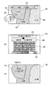
この操作画面33には、操作画面32において選択された旧住所を含む地図画像、もしくは操作画面31において「地図から選んで変更」43の選択に基づき制御部12により抽出された自車位置周辺の地図画像が表示されている。さらに操作画面33には、ユーザに情報入力を促すための案内情報52(図示の例では、「変更したい地図エリアを選択してください。」)も表示されている。地図画像の表示に際しては、制御部12からの制御に基づき地図描画部13を介して、当該地図画像に含まれる各行政区分エリア(図示の例では「AA村」R1、「BB町」R2、「CC市」R3)は、互いに隣合うエリアが異なる色となるように選択されて色分け表示される。図中、各エリアR1,R2,R3に付されているハッチングの向き及び線間隔の違いは、各エリア毎に表示色が異なっている状態を表している。
The
なお、図3(d)の表示例(=図4(a)の表示例)では、図示の簡単化のため、自車が走行中の誘導経路や自車位置マーク等の表示は省略している。 In the display example of FIG. 3 (d) (= display example of FIG. 4 (a)), for the sake of simplification of illustration, the display of the guidance route, the vehicle position mark, and the like while the vehicle is traveling is omitted. Yes.
ユーザが操作画面33に表示されている案内情報52に従っていずれかの行政区分エリア(図示の例では、「AA村」R1)にタッチすると、制御部12からの制御に基づきディスプレイ装置6の画面が次の操作画面34(図4(b)参照)に遷移する。図4(a)に示す処理例では、画面33(タッチパネル)上の当該部分を指でタッチして行政区分エリア(「AA村」R1)を選択しているが、このタッチパネルの代わりにリモコン送信機を用いて当該エリアを選択するようにしてもよい。この場合、リモコン送信機に設けられているジョイスティックを操作して画面33上の当該地図エリア(「AA村」R1内の地点)にカーソルを合わせ、「決定」ボタンを操作して当該エリアを選択する。また、案内情報52を画面33に表示する代わりに、制御部12からの制御に基づいて当該案内情報をスピーカ7から音声出力させるようにしてもよい。
When the user touches any administrative division area (“AA village” R1 in the illustrated example) according to the
操作画面34(図4(b))には、図示のように「50音入力」キー45や「完了」キー46等の各種操作ボタンと、操作画面33において選択されたエリアの旧行政区分名の情報G1(図示の例では、「○○県△△郡AA村」)と、ユーザが「50音入力」キー45にタッチして入力した新行政区分名の情報G0(図示の例では、「○○県XX市」)が表示されている。入力した新行政区分名(G0)を確認すると、「完了」キー46にタッチして確定させる。
On the operation screen 34 (FIG. 4B), as shown in the figure, various operation buttons such as the “50-sound input” key 45 and the “complete” key 46 and the old administrative division name of the area selected on the
このようにして市区町村合併等による変更後の市区町村名(新行政区分名)が入力されると、制御部12からの制御に基づきディスプレイ装置6の画面が次の操作画面35(図4(c)参照)に遷移する。この画面35には、制御部12からの制御に基づいて、入力された新行政区分名(この場合、「XX市」)の情報G0が当該行政区分エリアR1に表示される。この際、地図データベース(DVD−ROM1,1a)を参照して、当該行政区分エリアR1に対応する旧行政区分名(この場合、「△△郡AA村」)の情報G1も併せて表示される。
When the municipality name (new administrative division name) after the change due to merger of municipalities is input in this way, the screen of the
さらに、画面35に表示された新行政区分名(「XX市」)の情報G0は、制御部12により行政区分名登録部17に、図2に例示したようなテーブルの態様で登録される。すなわち、地図データベース1,1aを参照して、当該行政区分エリアR1に対応する旧行政区分名(「△△郡AA村」)を特定し、その旧行政区分名の情報G1とリンクさせて当該新行政区分名の情報G0を記憶する。
Further, the information G0 of the new administrative division name (“XX city”) displayed on the
<第2の処理例:図5、図6参照>
この第2の処理例では、上述した第1の処理例(図3、図4)と同じ前提条件で、かつ第1の処理が既に行われているものとする。
<Second Processing Example: See FIGS. 5 and 6>
In this second processing example, it is assumed that the first processing has already been performed under the same preconditions as in the first processing example (FIGS. 3 and 4) described above.
上述した図3(a)、(b)で行った処理と同様にして図5(a)、(b)のステップを経た後、ユーザが案内情報51(図5(c))に従って旧住所の選択項目44(図示の例では、「BB町」)にタッチし、もしくは操作画面31(図5(b))において「地図から選んで変更」43にタッチすると、制御部12からの制御に基づきディスプレイ装置6の画面が次の操作画面36(図5(d)=図6(a))に遷移する。
After the steps of FIGS. 5 (a) and 5 (b) in the same manner as the processing performed in FIGS. 3 (a) and 3 (b), the user can change the old address according to the guidance information 51 (FIG. 5 (c)). When the selection item 44 (in the illustrated example, “BB town”) is touched or “selection from the map and change” 43 is touched on the operation screen 31 (FIG. 5B), the
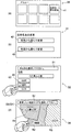
この操作画面36には、上述した操作画面33(図3(d)=図4(a))の場合と同様に隣合う行政区分エリアが異なる色となるような表示態様で、選択された旧住所(この場合、「BB町」)を含む自車位置周辺の地図画像が表示され、さらに案内情報52も表示されている。但し、上述した操作画面33の場合とは違い、この操作画面36に表示されている地図画像に含まれる行政区分エリアの一部(図示の例では、「△△郡AA村」R1)については、制御部12により行政区分名登録部17に登録されているテーブル(図2)を参照して、当該行政区分エリアR1に対応する旧行政区分名(「△△郡AA村」)の情報G1と共に、新行政区分名(「XX市」)の情報G0も表示されている。
In this
このように新行政区分名(「XX市」)の情報G0が当該行政区分エリアR1に表示されている状態で、さらにユーザ指示(タッチ操作)に基づいて当該新行政区分名と同じ名称に変更されている他の行政区分エリア(図示の例では、「BB町」R2)が選択されると、制御部12からの制御に基づきディスプレイ装置6の画面が次の操作画面37(図6(b)参照)に遷移する。この操作画面37には、上述した操作画面34(図4(b))の場合と同様に、「50音入力」キー45や「完了」キー46等の各種操作ボタンと、操作画面36において選択されたエリアの旧行政区分名の情報G2(図示の例では、「○○県△△郡BB町」)と、「50音入力」キー45にタッチして入力した新行政区分名の情報G0(この場合、「○○県XX市」)が表示されている。同様に、入力した新行政区分名(G0)を確認すると、「完了」キー46にタッチして確定させる。
In this way, the information G0 of the new administrative division name (“XX city”) is displayed in the administrative division area R1, and the name is changed to the same name as the new administrative division name based on a user instruction (touch operation). When the other administrative division area ("BB town" R2 in the illustrated example) is selected, the screen of the
このようにして新行政区分名(「○○県XX市」)が入力されると、制御部12からの制御に基づきディスプレイ装置6の画面が次の操作画面38(図6(c)参照)に遷移する。この画面38には、制御部12からの制御に基づき、既に登録されている新行政区分名(「XX市」)と同じ名称の行政区分名が入力された旨を案内する情報53(図示の例では、「同じ名称の市町村名があります。同じ市町村として表示しますか?」)が表示されている。さらに画面38には、この案内情報53に対してユーザが選択すべき「はい」又は「いいえ」の選択項目47が表示されている。ユーザが「はい」にタッチすると、制御部12からの制御に基づきディスプレイ装置6の画面が次の操作画面39(図6(d)参照)に遷移する。
When the new administrative division name (“XX prefecture XX city”) is input in this way, the screen of the
この画面39には、制御部12からの制御に基づいて、旧行政区分エリア(図示の例では、「△△郡AA村」)の新名称として既に登録されている新行政区分名(「XX市」)と同じ名称に変更されている他の行政区分エリア(この場合、「△△郡BB町」)に、当該新行政区分名(「XX市」)の情報G0が表示される。この際、地図データベース(DVD−ROM1,1a)を参照して、当該他の行政区分エリアに対応する旧行政区分名の情報G2も併せて表示される。表示に際しては、制御部12からの制御に基づき地図描画部13を介して、当該新行政区分名(「XX市」)に対応する各行政区分エリア(「△△郡AA村」及び「△△郡BB町」)を同じ色で表示する。さらに、制御部12からの制御に基づいて行政区分名登録部17に、新行政区分名(「XX市」)の情報G0を旧行政区分名(この場合、「△△郡BB町」)の情報G2とリンクさせて登録する(図2)。
On this
以上説明したように、本実施形態に係る地図表示装置20によれば、本装置を搭載した車両が目的地に向けて経路誘導されている途中である行政区分エリアに入ったときに、ユーザ指示に基づいてディスプレイ装置6の画面33(図4(a))に表示された地図画像から当該行政区分エリアR1が選択され、さらに新行政区分名G0(図4(b))が入力されると、制御部12からの制御に基づきディスプレイ装置6の画面35(図4(c))に、その入力された新行政区分名G0が当該行政区分エリアR1に表示されると共に、当該エリアR1に対応する旧行政区分名G1も併せて表示されるようになっている。
As described above, according to the
つまり、DVD−ROM1,1aに格納されている地図データ(既に保有している地図データベース)を用いて、市区町村合併等により変更された行政区分名の表示(修正)を画面上で行うようにしている。これにより、わざわざコストをかけて最新の地図記憶媒体に買い換えを行わなくても、変更後の新しい行政区分名で地図表示を行うことができるので、従来技術に見られたような不都合や不便さを大いに減少させることができる。
In other words, using the map data stored on the DVD-
また、ディスプレイ装置6の画面36(図6(a))上で新行政区分名G0が当該行政区分エリアR1に表示されている状態で、さらにユーザ指示に基づいて当該新行政区分名G0と同じ名称に変更されている他の行政区分エリアR2が選択されると、制御部12からの制御に基づきディスプレイ装置6の画面39(図6(d))に、その選択された他の行政区分エリアR2に新行政区分名G0が表示されると共に、その新行政区分名G0に対応する各行政区分エリアR1,R2が同じ色で表示されるようになっている。つまり、行政区分エリア毎に色分けして表示を行うにあたり、行政区分名の変更に伴い当該行政区分エリアが変更されている場合でも、その変更(当該行政区分エリアの色分け表示の修正)に対応することが可能となる。
Further, in the state where the new administrative division name G0 is displayed in the administrative division area R1 on the
上述した実施形態では、本発明に係る地図表示装置を車載用ナビゲーション装置20に適用した場合を例にとって説明したが、本発明は、その要旨構成(既に保有しているDVD−ROM等の地図データベースを用いて、市区町村合併等により変更された行政区分名の表示(修正)及びそれに伴う行政区分エリアの色分け表示(修正)を行うこと)からも明らかなように、ナビゲーション用の地図表示に限定されないことはもちろんである。例えば、家庭用のパーソナルコンピュータ(PC)を用いて地図データベース(PCに接続可能な記憶媒体)から住所検索等を行う場合においても、本発明は同様に適用することが可能である。
In the above-described embodiment, the case where the map display device according to the present invention is applied to the in-
また、上述した実施形態では、市区町村合併等により生じる行政区分名の変更及びそれに伴うエリアの色分け表示を行う場合を例にとって説明したが、これとは逆に、いったん市区町村合併を行ったがその後住民不満の増大などにより合併が解消された場合にも、本発明は同様に適用することが可能である。 In the above-described embodiment, the example of changing the administrative division name caused by the merger of municipalities and the color-coded display of the area associated therewith has been described as an example, but conversely, the municipal merger is once performed. However, the present invention can also be applied to the case where the merger is canceled due to an increase in dissatisfaction with the residents.
この場合、上述した実施形態に係る各処理例(図3〜図6)に準じて、既に保有している地図データベース(DVD−ROM1,1a)と、行政区分名登録部17に登録されている情報(合併前の旧い市区町村名と合併時の新名称とをリンクさせて登録した情報)を参照することで、上述した実施形態と同様に合併解消後の行政区分名の表示修正及びそれに伴う行政区分エリアの色分け表示の修正を行うことができる。
In this case, in accordance with each processing example (FIGS. 3 to 6) according to the above-described embodiment, the map database (DVD-ROM1, 1a) already held and the administrative division
また、上述した実施形態では、市区町村の合併等による行政区分名の変更に関する情報を、本装置20を搭載した車両が当該行政区分エリアに入ったときに知得した場合を例にとって説明したが、本発明の要旨からも明らかなように、当該情報を知得するタイミングがこれに限定されないことはもちろんである。例えば、ニュースや新聞、インターネット等により当該情報を既に知得している場合には、車両の走行に先立って、上記の行政区分名の表示(修正)及びそれに伴う行政区分エリアの色分け表示(修正)を行うことも可能である。
Further, in the above-described embodiment, the case where the information about the change of the administrative division name due to the merger of the municipalities is acquired when the vehicle equipped with the
1…DVDドライブ(DVD−ROM/記憶手段)、
2…操作部(入力手段)、
6…ディスプレイ装置(表示手段)、
12…制御部(制御手段)、
13…地図描画部、
17…行政区分名登録部(修正情報登録手段)、
20…車載用ナビゲーション装置(地図表示装置)、
30〜39…表示画面、
41〜44,47…選択項目、
45,46…操作ボタン、
51〜53…案内情報、
G0…新行政区分名の情報、
G1,G2…旧行政区分名の情報、
R1,R2,R3…行政区分エリア。
1 ... DVD drive (DVD-ROM / storage means),
2 ... operation part (input means),
6 ... Display device (display means),
12 ... Control part (control means),
13 ... Map drawing part,
17 ... Administrative division name registration section (correction information registration means),
20 ... In-vehicle navigation device (map display device),
30-39 ... display screen,
41-44, 47 ... selection items,
45, 46 ... operation buttons,
51-53 ... Guidance information,
G0 ... New administrative division name information,
G1, G2 ... Information on old administrative division names,
R1, R2, R3 ... Administrative division area.
Claims (8)
画面を備えた表示手段と、
ユーザ指示を入力する入力手段と、
前記記憶手段、表示手段及び入力手段に動作可能に接続された制御手段とを具備し、
前記制御手段は、前記地図データを参照して前記表示手段の画面に前記入力手段からのユーザ指示に基づいた地図画像を表示させている状態で、該地図画像に含まれるいずれかの行政区分エリアが選択され、かつ変更後の新行政区分名が入力されたときに、該入力された新行政区分名を当該行政区分エリアに表示させることを特徴とする地図表示装置。 Storage means storing map data;
Display means with a screen;
Input means for inputting user instructions;
Control means operably connected to the storage means, display means and input means,
The control means refers to any administrative division area included in the map image in a state in which a map image based on a user instruction from the input means is displayed on the screen of the display means with reference to the map data. A map display apparatus that displays the input new administrative division name in the administrative division area when the new administrative division name after change is input.
Priority Applications (1)
| Application Number | Priority Date | Filing Date | Title |
|---|---|---|---|
| JP2005145707A JP2006323096A (en) | 2005-05-18 | 2005-05-18 | Map display device |
Applications Claiming Priority (1)
| Application Number | Priority Date | Filing Date | Title |
|---|---|---|---|
| JP2005145707A JP2006323096A (en) | 2005-05-18 | 2005-05-18 | Map display device |
Publications (1)
| Publication Number | Publication Date |
|---|---|
| JP2006323096A true JP2006323096A (en) | 2006-11-30 |
Family
ID=37542835
Family Applications (1)
| Application Number | Title | Priority Date | Filing Date |
|---|---|---|---|
| JP2005145707A Withdrawn JP2006323096A (en) | 2005-05-18 | 2005-05-18 | Map display device |
Country Status (1)
| Country | Link |
|---|---|
| JP (1) | JP2006323096A (en) |
Cited By (2)
| Publication number | Priority date | Publication date | Assignee | Title |
|---|---|---|---|---|
| JP2008158292A (en) * | 2006-12-25 | 2008-07-10 | Xanavi Informatics Corp | Map display device |
| CN113609206A (en) * | 2021-07-21 | 2021-11-05 | 车主邦(北京)科技有限公司 | Map display method and device for assisting energy conservation and emission reduction and electronic equipment |
-
2005
- 2005-05-18 JP JP2005145707A patent/JP2006323096A/en not_active Withdrawn
Cited By (2)
| Publication number | Priority date | Publication date | Assignee | Title |
|---|---|---|---|---|
| JP2008158292A (en) * | 2006-12-25 | 2008-07-10 | Xanavi Informatics Corp | Map display device |
| CN113609206A (en) * | 2021-07-21 | 2021-11-05 | 车主邦(北京)科技有限公司 | Map display method and device for assisting energy conservation and emission reduction and electronic equipment |
Similar Documents
| Publication | Publication Date | Title |
|---|---|---|
| JP5428189B2 (en) | Navigation device | |
| US6836723B2 (en) | Navigation method and system | |
| JP4626607B2 (en) | Vehicle navigation device | |
| JPWO2008075492A1 (en) | Map display device | |
| JP3970661B2 (en) | Car navigation system | |
| JP4789827B2 (en) | Navigation device and freeway search method | |
| JP2007205894A (en) | Onboard navigation device and displaying method for retrieved facility | |
| JP3831555B2 (en) | Detour route search method for navigation device | |
| JP4308679B2 (en) | Navigation device | |
| US7499800B2 (en) | Vehicle navigation apparatus | |
| JP2004354149A (en) | Map data delivery method | |
| JP4937871B2 (en) | In-vehicle navigation device, map data update method, and route search method | |
| JP2004132749A (en) | Navigation device | |
| JP2007315989A (en) | On-vehicle navigation device and route search method | |
| JP2006323096A (en) | Map display device | |
| JP2018100982A (en) | Route display device and program | |
| JP2006214939A (en) | Vehicle-borne navigation device | |
| JP4472510B2 (en) | Car navigation system | |
| JP4763526B2 (en) | Map display device | |
| JP5104348B2 (en) | Map display device | |
| JP2006330020A (en) | Map retrieval device | |
| JP2005300944A (en) | Map display device | |
| JP4472641B2 (en) | Navigation device and guide route updating method | |
| JP2009270887A (en) | Map display device | |
| JP3953729B2 (en) | Navigation device |
Legal Events
| Date | Code | Title | Description |
|---|---|---|---|
| A300 | Withdrawal of application because of no request for examination |
Free format text: JAPANESE INTERMEDIATE CODE: A300 Effective date: 20080805 |