JP2005292064A - Navigation device, data processing method, and computer program - Google Patents
Navigation device, data processing method, and computer program Download PDFInfo
- Publication number
- JP2005292064A JP2005292064A JP2004110659A JP2004110659A JP2005292064A JP 2005292064 A JP2005292064 A JP 2005292064A JP 2004110659 A JP2004110659 A JP 2004110659A JP 2004110659 A JP2004110659 A JP 2004110659A JP 2005292064 A JP2005292064 A JP 2005292064A
- Authority
- JP
- Japan
- Prior art keywords
- data
- link
- display
- dimensional
- point
- Prior art date
- Legal status (The legal status is an assumption and is not a legal conclusion. Google has not performed a legal analysis and makes no representation as to the accuracy of the status listed.)
- Pending
Links
Images
Classifications
-
- G—PHYSICS
- G01—MEASURING; TESTING
- G01C—MEASURING DISTANCES, LEVELS OR BEARINGS; SURVEYING; NAVIGATION; GYROSCOPIC INSTRUMENTS; PHOTOGRAMMETRY OR VIDEOGRAMMETRY
- G01C21/00—Navigation; Navigational instruments not provided for in groups G01C1/00 - G01C19/00
- G01C21/26—Navigation; Navigational instruments not provided for in groups G01C1/00 - G01C19/00 specially adapted for navigation in a road network
- G01C21/34—Route searching; Route guidance
- G01C21/36—Input/output arrangements for on-board computers
- G01C21/3626—Details of the output of route guidance instructions
- G01C21/3635—Guidance using 3D or perspective road maps
- G01C21/3638—Guidance using 3D or perspective road maps including 3D objects and buildings
Landscapes
- Engineering & Computer Science (AREA)
- Radar, Positioning & Navigation (AREA)
- Remote Sensing (AREA)
- Automation & Control Theory (AREA)
- Physics & Mathematics (AREA)
- General Physics & Mathematics (AREA)
- Instructional Devices (AREA)
- Navigation (AREA)
- Traffic Control Systems (AREA)
Abstract
【課題】 ルートの状況に応じて2次元地図と3次元表示データとを自動的に切り替えて出力するナビゲーション装置、および方法を提供する。
【解決手段】 記憶部に2次元地図データと、3次元グラフィックデータ、および3次元表示不可ポイントデータを格納し、3次元表示不可ポイントデータに基づいて3次元データ表示を行なうか2次元地図情報の表示を行なうかを決定し、決定に従ったデータを選択して表示する。例えば、立体交差などの複雑な道路構成を持つ地点や、電車軌道などの高架橋や歩道橋など視界を遮る構造物などがある地点などのポイントを3次元表示不可ポイントとして設定し、このようなポイントでは、3次元データ表示を停止し、2次元地図情報に切り換えて表示する。この構成により、ユーザの誘導をより正確に実行することが可能となる。
【選択図】 図7
PROBLEM TO BE SOLVED: To provide a navigation device and a method for automatically switching and outputting a two-dimensional map and three-dimensional display data according to a route situation.
Two-dimensional map data, three-dimensional graphic data, and three-dimensional display disabled point data are stored in a storage unit, and three-dimensional data display is performed based on the three-dimensional display disabled point data. Decide whether to display, select the data according to the determination, and display. For example, points such as points with complicated road structures such as three-dimensional intersections or points with structures that obstruct visibility such as viaducts such as train tracks and pedestrian bridges are set as three-dimensional display impossible points. Stops the 3D data display and switches to 2D map information for display. With this configuration, it is possible to perform user guidance more accurately.
[Selection] Figure 7
Description
本発明は、ユーザに進路や目的地などへの誘導情報を提示するナビゲーション装置、およびデータ処理方法、並びにコンピュータ・プログラムに関する。 The present invention relates to a navigation apparatus, a data processing method, and a computer program for presenting guidance information to a user on a course or a destination.
さらに詳しくは、本発明は、3次元グラフィックスデータを適用したナビゲーション・システムにおいて、例えば立体交差などの複雑な道路構成を持つ地点や、電車軌道などの高架橋や歩道橋など視界を遮る構造物などがある地点など、3次元表示情報を提示することが、かえってユーザを混乱させると判断される場合に、3次元データの表示を停止し2次元データの提示に切り換える構成とすることで確実なユーザの誘導を実現するナビゲーション装置、およびデータ処理方法、並びにコンピュータ・プログラムに関する。 More specifically, the present invention relates to a navigation system using three-dimensional graphics data, such as a point having a complicated road structure such as a three-dimensional intersection, a structure that blocks visibility such as a viaduct such as a train track, and a pedestrian bridge. When it is judged that the presentation of 3D display information, such as a certain point, would rather confuse the user, the configuration of stopping the display of the 3D data and switching to the presentation of the 2D data will ensure a reliable user's The present invention relates to a navigation apparatus, a data processing method, and a computer program for realizing guidance.
ナビゲーション・システムは、比較的広範囲の地図情報をあらかじめ蓄積しておき、GPS(Global Positioning System)やその他の位置検出装置から得られる現在位置情報に基づいて該当する地図情報を読み出し、誘導情報としてユーザに提示する。 The navigation system accumulates a relatively wide range of map information in advance, reads out the corresponding map information based on the current position information obtained from GPS (Global Positioning System) and other position detection devices, and guides the user as guidance information. To present.
多くのナビゲーション・システムは、車両用に開発され、車載型として利用に供されている。この場合、時々刻々と変わる現在位置に応じて画面に表示される誘導情報は逐次、更新される。また、ユーザ(運転者)から入力された目的地やその他の運転情報に応じて、目的地までの進路に従った地図情報の表示を行なう。 Many navigation systems have been developed for vehicles and are available as in-vehicle types. In this case, the guidance information displayed on the screen is sequentially updated according to the current position that changes every moment. Moreover, according to the destination inputted from the user (driver) and other driving information, the map information according to the route to the destination is displayed.
さらに最近では、ナビゲーション・システムに3Dコンピュータ・グラフィックス技術を融合することにより、建物や道路などの構造物の3次元イメージをレンダリングして地図上の該当場所に配置し、3次元地図として誘導情報を提示するシステムも広く普及している。 More recently, by integrating 3D computer graphics technology into the navigation system, 3D images of structures such as buildings and roads are rendered and placed at the appropriate locations on the map to guide information as a 3D map. A system for presenting a message is also widely used.
さらに、目的地に至るルート情報を、3次元イメージデータ上にアニメーション表示したり、自車の位置情報をマーカーとして示す自車シンボルを表示したりする構成も提案されている。 Further, a configuration has been proposed in which route information to a destination is displayed as an animation on three-dimensional image data, or a vehicle symbol indicating the vehicle position information as a marker is displayed.
また、ディスプレイに表示する3次元イメージデータの表示態様をドライバーの視線位置に設定したり、あるいはバードビューポジションといわれる高い位置からのイメージデータとするなどのモード設定を可能とし、3次元イメージデータの撮影カメラ位置であるカメラ視点を変更可能としたシステムも提案されている。カメラ視点位置の変更構成を開示した従来技術として例えば特許文献1がある。
It is also possible to set the display mode of the 3D image data displayed on the display to the driver's line-of-sight position, or to set the image data from a high position called a bird view position. There has also been proposed a system that can change the camera viewpoint, which is the shooting camera position. For example,
しかしながら、例えば立体交差などの複雑な道路構成を持つ地点や、歩道橋など視界を遮る構造物などがある地点などでは、3次元表示情報を提示することが、かえってユーザを混乱させる場合がある。このような地点では、ユーザは、ディスプレイに表示される3次元表示情報を見ても、実際の道路状況との対応を把握することができず、誤った判断をしてしまう場合が少なくない。
本発明は、上述の問題点に鑑みてなされたものであり、3次元グラフィックスデータを適用したナビゲーション・システムにおいて、例えば立体交差などの複雑な道路構成を持つ地点や、電車軌道などの高架橋や歩道橋など視界を遮る構造物などがある地点など3次元表示情報を提示することが、かえってユーザを混乱させると判断される地点のデータを保持し、このデータに基づいて、これらの地点については自動的に2次元地図情報に切り換えて表示する構成としてユーザの誘導をより正確に実行することを可能としたナビゲーション装置、およびデータ処理方法、並びにコンピュータ・プログラムを提供することを目的とするものである。 The present invention has been made in view of the above-described problems. In a navigation system to which three-dimensional graphics data is applied, for example, a point having a complicated road configuration such as a three-dimensional intersection, a viaduct such as a train track, Presenting 3D display information such as points with structures that obstruct the field of view such as footbridges, etc. holds data that is determined to confuse the user, and based on this data, these points are automatically It is an object of the present invention to provide a navigation device, a data processing method, and a computer program that can more accurately execute a user's guidance as a configuration for switching to and displaying two-dimensional map information. .
本発明の第1の側面は、
地図情報に基づくナビゲーション情報を生成し提示するナビゲーション装置であり、
位置情報の取得処理を実行する位置情報取得手段と、
2次元地図データと、3次元グラフィックデータ、および3次元表示不可ポイントデータを格納した記憶手段と、
前記3次元表示不可ポイントデータに基づいて、ガイドポイントについての3次元データ表示を行なうか2次元地図情報の表示を行なうかを決定し、該決定に従ったデータを選択して表示手段に出力するデータ処理部と、
前記データ処理部からの出力データを表示する表示手段と、
を有することを特徴とするナビゲーション装置にある。
The first aspect of the present invention is:
A navigation device that generates and presents navigation information based on map information,
Position information acquisition means for executing position information acquisition processing;
Storage means for storing 2D map data, 3D graphic data, and 3D display impossible point data;
Based on the three-dimensional display impossible point data, it is determined whether to display three-dimensional data or two-dimensional map information for the guide point, and select and output the data according to the determination to the display means. A data processing unit;
Display means for displaying output data from the data processing unit;
There exists in the navigation apparatus characterized by having.
さらに、本発明のナビゲーション装置の一実施態様において、前記3次元表示不可ポイントデータは、経路構成単位としてのリンク各々のリンク識別子と、該リンク識別子の対応データとして設定したリンク種別を含むデータであり、前記データ処理部は、目的地に至るルートに存在するリンクの識別情報からなるリンクシーケンスデータを取得し、該リンクシーケンスデータに含まれるリンク識別子に基づいて、前記3次元表示不可ポイントデータから対応リンクのリンク種別を取得し、該リンク種別に基づいて、ガイドポイントについて3次元データ表示を行なうか2次元地図情報の表示を行なうかを決定する構成であることを特徴とする。 Furthermore, in one embodiment of the navigation device of the present invention, the three-dimensional display impossible point data is data including a link identifier of each link as a route constituent unit and a link type set as corresponding data of the link identifier. The data processing unit acquires link sequence data including identification information of a link existing in a route to the destination, and responds from the 3D display impossible point data based on the link identifier included in the link sequence data. The link type of the link is acquired, and based on the link type, whether to display 3D data or 2D map information for the guide point is determined.
さらに、本発明のナビゲーション装置の一実施態様において、前記リンク種別は、ガイドポイントを通過するルートの区別なく該ガイドポイントを3次元表示不可ポイントとして設定したリンク種別と、ガイドポイントを通過するルート中、特定のリンクの進入進出路のみを限定して該ガイドポイントを3次元表示不可ポイントとして設定したリンク種別とを識別可能な種別データであり、前記データ処理部は、前記リンクシーケンスデータに含まれるリンク識別子に対応するリンクのリンク種別に基づいて、進行ルートに応じた表示情報決定処理を実行する構成であることを特徴とする。 Furthermore, in an embodiment of the navigation device of the present invention, the link type includes a link type in which the guide point is set as a three-dimensional display impossible point without distinction of a route passing through the guide point, and a route passing through the guide point. Class data that can identify only the link type in which the guide point is set as a three-dimensional display-impossible point by limiting only the approach and advance path of a specific link, and the data processing unit is included in the link sequence data The display information determination process according to the travel route is executed based on the link type of the link corresponding to the link identifier.
さらに、本発明のナビゲーション装置の一実施態様において、前記ガイドポイントは、複数のリンクの連結された交差点であり、前記データ処理部は、前記リンクシーケンスデータに含まれるリンク識別子に対応するリンクのリンク種別に基づいて、交差点を通過する進行ルートに応じた表示情報決定処理を実行する構成であることを特徴とする。 Furthermore, in one embodiment of the navigation device of the present invention, the guide point is an intersection where a plurality of links are connected, and the data processing unit is a link of a link corresponding to a link identifier included in the link sequence data. Based on the type, the display information determination process according to the traveling route passing through the intersection is executed.
さらに、本発明の第2の側面は、
地図情報に基づくナビゲーション情報を生成し提示するデータ処理方法であり、
位置情報の取得処理を実行する位置情報取得ステップと、
前記位置情報取得ステップにおいて取得した位置情報を入力し、さらに記憶手段に格納された3次元表示不可ポイントデータに基づいて、ガイドポイントについての3次元データ表示を行なうか2次元地図情報の表示を行なうかを決定し、該決定に従ったデータを選択して表示手段に出力するデータ処理ステップと、
前記データ処理ステップにおける出力データを表示する表示ステップと、
を有することを特徴とするデータ処理方法にある。
Furthermore, the second aspect of the present invention provides
A data processing method for generating and presenting navigation information based on map information.
A location information acquisition step for executing location information acquisition processing;
The position information acquired in the position information acquisition step is input, and based on the 3D display impossible point data stored in the storage means, 3D data display for guide points or 2D map information is displayed. And a data processing step of selecting data according to the determination and outputting the selected data to the display means;
A display step for displaying output data in the data processing step;
A data processing method characterized by comprising:
さらに、本発明のデータ処理方法の一実施態様において、前記3次元表示不可ポイントデータは、経路構成単位としてのリンク各々のリンク識別子と、該リンク識別子の対応データとして設定したリンク種別を含むデータであり、前記データ処理ステップにおいては、目的地に至るルートに存在するリンクの識別情報からなるリンクシーケンスデータを取得し、該リンクシーケンスデータに含まれるリンク識別子に基づいて、前記3次元表示不可ポイントデータから対応リンクのリンク種別を取得し、該リンク種別に基づいて、ガイドポイントについて3次元データ表示を行なうか2次元地図情報の表示を行なうかを決定することを特徴とする。 Furthermore, in one embodiment of the data processing method of the present invention, the three-dimensional display impossible point data is data including a link identifier of each link as a path configuration unit and a link type set as corresponding data of the link identifier. Yes, in the data processing step, link sequence data consisting of identification information of links existing in the route to the destination is acquired, and the three-dimensional display impossible point data based on the link identifier included in the link sequence data The link type of the corresponding link is acquired from the above, and based on the link type, whether to display 3D data or 2D map information for the guide point is determined.
さらに、本発明のデータ処理方法の一実施態様において、前記リンク種別は、ガイドポイントを通過するルートの区別なく該ガイドポイントを3次元表示不可ポイントとして設定したリンク種別と、ガイドポイントを通過するルート中、特定のリンクの進入進出路のみを限定して該ガイドポイントを3次元表示不可ポイントとして設定したリンク種別とを識別可能な種別データであり、前記データ処理ステップにおいては、前記リンクシーケンスデータに含まれるリンク識別子に対応するリンクのリンク種別に基づいて、進行ルートに応じた表示情報決定処理を実行することを特徴とする。 Furthermore, in one embodiment of the data processing method of the present invention, the link type includes a link type in which the guide point is set as a three-dimensional display impossible point without distinguishing a route passing through the guide point, and a route passing through the guide point. Medium type data that can identify the link type set as a three-dimensional display impossible point by limiting only the approach and advancing road of a specific link, and in the data processing step, the link sequence data Based on the link type of the link corresponding to the included link identifier, display information determination processing corresponding to the traveling route is executed.
さらに、本発明のデータ処理方法の一実施態様において、前記ガイドポイントは、複数のリンクの連結された交差点であり、前記データ処理ステップにおいては、前記リンクシーケンスデータに含まれるリンク識別子に対応するリンクのリンク種別に基づいて、交差点を通過する進行ルートに応じた表示情報決定処理を実行することを特徴とする。 Furthermore, in one embodiment of the data processing method of the present invention, the guide point is an intersection where a plurality of links are connected, and in the data processing step, a link corresponding to a link identifier included in the link sequence data. Based on the link type, display information determination processing corresponding to the traveling route passing through the intersection is executed.
さらに、本発明の第3の側面は、
地図情報に基づくナビゲーション情報を生成し提示する処理を実行するコンピュータ・プログラムであり、
位置情報の取得処理を実行する位置情報取得ステップと、
前記位置情報取得ステップにおいて取得した位置情報を入力し、さらに記憶手段に格納された3次元表示不可ポイントデータに基づいて、ガイドポイントについての3次元データ表示を行なうか2次元地図情報の表示を行なうかを決定し、該決定に従ったデータを選択して表示手段に出力するデータ処理ステップと、
前記データ処理ステップにおける出力データを表示する表示ステップと、
を有することを特徴とするコンピュータ・プログラムにある。
Furthermore, the third aspect of the present invention provides
A computer program that executes a process for generating and presenting navigation information based on map information,
A location information acquisition step for executing location information acquisition processing;
The position information acquired in the position information acquisition step is input, and based on the 3D display impossible point data stored in the storage means, 3D data display for guide points or 2D map information is displayed. And a data processing step of selecting data according to the determination and outputting the selected data to the display means;
A display step for displaying output data in the data processing step;
There is a computer program characterized by comprising:
なお、本発明のコンピュータ・プログラムは、例えば、様々なプログラム・コードを実行可能なコンピュータ・システムに対して、コンピュータ可読な形式で提供する記憶媒体、通信媒体、例えば、CDやFD、MOなどの記録媒体、あるいは、ネットワークなどの通信媒体によって提供可能なコンピュータ・プログラムである。このようなプログラムをコンピュータ可読な形式で提供することにより、コンピュータ・システム上でプログラムに応じた処理が実現される。 The computer program of the present invention is, for example, a storage medium or communication medium provided in a computer-readable format to a computer system capable of executing various program codes, such as a CD, FD, or MO. It is a computer program that can be provided by a recording medium or a communication medium such as a network. By providing such a program in a computer-readable format, processing corresponding to the program is realized on the computer system.
本発明のさらに他の目的、特徴や利点は、後述する本発明の実施例や添付する図面に基づくより詳細な説明によって明らかになるであろう。なお、本明細書においてシステムとは、複数の装置の論理的集合構成であり、各構成の装置が同一筐体内にあるものには限らない。 Other objects, features, and advantages of the present invention will become apparent from a more detailed description based on embodiments of the present invention described later and the accompanying drawings. In this specification, the system is a logical set configuration of a plurality of devices, and is not limited to one in which the devices of each configuration are in the same casing.
本発明の構成によれば、例えば車や歩行者のナビゲーションを実行するナビゲーション装置において、記憶部に2次元地図データと、3次元グラフィックデータ、および3次元表示不可ポイントデータを格納し、3次元表示不可ポイントデータに基づいて、ガイドポイントについての3次元データ表示を行なうか2次元地図情報の表示を行なうかを決定し、決定に従ったデータを選択して表示手段に出力する構成とした。例えば、立体交差などの複雑な道路構成を持つ地点や、電車軌道などの高架橋や歩道橋など視界を遮る構造物などがある地点など3次元表示情報を提示することが、かえってユーザを混乱させると判断されるガイドポイントでは、3次元データ表示を停止し、2次元地図情報に切り換えて表示する。この構成により、ユーザの誘導をより正確に実行することが可能となる。 According to the configuration of the present invention, for example, in a navigation device that performs navigation of a car or a pedestrian, 2D map data, 3D graphic data, and 3D display impossible point data are stored in the storage unit, and 3D display is performed. Based on the impossibility point data, it is determined whether to display the three-dimensional data or the two-dimensional map information about the guide point, and selects the data according to the determination and outputs it to the display means. For example, it is determined that presenting 3D display information such as points with complicated road structures such as three-dimensional intersections, points with structures that obstruct visibility such as viaducts and pedestrian bridges such as train tracks, will rather confuse users. At the guide point, the 3D data display is stopped, and the display is switched to the 2D map information. With this configuration, it is possible to perform user guidance more accurately.
さらに、本発明の構成によれば、3次元表示不可ポイントデータを、経路構成単位としてのリンク各々のリンク識別子と、該リンク識別子の対応データとして設定したリンク種別によって構成し、さらに、リンク種別を、例えば交差点のようなガイドポイントにおいて通過ルートの区別なく3次元表示不可ポイントとするリンク種別と、ガイドポイントを通過するルート中、特定のリンクの進入進出路のみを限定して3次元表示不可ポイントとするリンク種別とを識別可能な設定としたので、ユーザの進行ルートに応じた最適なデータ選択が可能となる。 Furthermore, according to the configuration of the present invention, the three-dimensional display impossible point data is configured by the link identifier of each link as a route constituent unit and the link type set as the corresponding data of the link identifier, and the link type is For example, a guide point such as an intersection, which is a link type that cannot be displayed as a 3D display point regardless of the route that passes through it, and a 3D display point that is limited to only the advancing path of a specific link in the route passing through the guide point. Therefore, the optimum data can be selected according to the user's travel route.
以下、図面を参照しながら本発明のナビゲーション装置、およびデータ処理方法、並びにコンピュータ・プログラムの詳細について説明する。 Hereinafter, the navigation apparatus, data processing method, and computer program of the present invention will be described in detail with reference to the drawings.
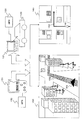
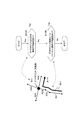
まず、図1を参照して本発明のナビゲーション装置の概要について説明する。本発明のナビゲーション装置は、例えば自動車120に搭載したカーナビゲーション装置121として適用可能であり、また、PDAや携帯電話、携帯PCなどの携帯端末131において実現可能である。
First, the outline of the navigation apparatus of the present invention will be described with reference to FIG. The navigation device of the present invention can be applied as, for example, a
カーナビゲーション装置121、携帯端末131には、位置情報取得手段としてのGPS(Global Positioning System)122,132が構成され、外部からの入力情報に基づいて位置情報を取得する。
The
カーナビゲーション装置121、携帯端末131のディスプレイには、図1に示す3次元表示情報150と2次元地図情報160とを状況に応じて適宜切り替えて表示する。
On the displays of the
図1に示す3次元表示情報150と2次元地図情報160は、本発明のナビゲーション装置を搭載した自動車が、ある交差点に向かう際の表示データ例を示したものである。
The three-
ディスプレイに3次元表示情報150を提示する場合には、交差点近辺のビル群などが3次元表示情報として表示されるとともに、自車の位置を示す自己のシンボルデータ、すなわち自車シンボル151がアニメーション表示され、さらに、予めユーザが入力した目的地情報に従って生成されたルート情報152が道路に沿って表示される。なお、ここでは、自動車のカーナビゲーション装置を例にして説明するが、歩行者の持つ携帯端末においても、本発明は適用可能であり、この場合、自車シンボル151は、携帯端末131を保持するユーザの位置情報としてのユーザシンボルとして設定される。
When the three-
また、例えば立体交差などの複雑な道路構成を持つ地点や、電車軌道などの高架橋や歩道橋など視界を遮る構造物などがある地点など3次元表示情報を提示することが、かえってユーザを混乱させると判断される場合、これらの地点については自動的に2次元地図情報160に切り替えてユーザに提示する。2次元地図情報160にも、自車の位置を示す自己のシンボルデータ、すなわち自車シンボル161がアニメーション表示され、さらに、予めユーザが入力した目的地情報に従って生成されたルート情報162が道路に沿って表示される。
In addition, when presenting 3D display information such as a point having a complicated road structure such as a three-dimensional intersection or a point where there is a structure that obstructs visibility such as a viaduct or a pedestrian bridge such as a train track, the user is confused. If determined, these points are automatically switched to the two-
自動車やユーザの位置情報は、例えばGPS(Global Positioning System)情報などによって外部入力する3次元位置情報を適用して取得する。ディスプレイにアニメーション表示される自己のシンボルデータとしての自車シンボル151,161は、この取得情報に基づいて表示される。さらに、その自車シンボルを起点として目的地に至るルートを算出して、ルート情報152,162が表示される。
The position information of the car and the user is acquired by applying, for example, three-dimensional position information input externally by GPS (Global Positioning System) information. The
なお、図1に示す3次元表示情報150は、あるカメラ視点から見たイメージを3次元データとして表示しているが、カメラ視点は、例えばドライバーの位置に対応する視点であるドライバー視点や、上空からの視点に対応するバードビュー視点など、複数の視点位置に切り替え可能であり、設定された視点位置からみた3次元イメージデータが表示されることになる。
The three-
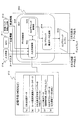
次に、図2を参照して本発明のナビゲーション装置のハードウェア構成について説明する。本発明のナビゲーション装置は、GPS211、車速パルス情報入力部212、データ処理部200、記憶手段213、入力手段214、表示デバイス221を有する。
Next, the hardware configuration of the navigation device of the present invention will be described with reference to FIG. The navigation apparatus of the present invention includes a
データ処理部200は、3Dグラフィック描画エンジン201、RAM(Random Access Memory)202、ROM(Read Only Memory)203、CPU(Central Processing Unit)204、インターフェース205を含む。
The
GPS211は、現在位置情報を取得し、取得情報をデータ処理部200に入力する。車速パルス情報入力部212は車速を算出し、車速パルス情報をデータ処理部200に入力する。
The
データ処理部200は、これらの情報をインタフェース205を介して入力し、記憶手段213に格納された各種情報、および入力手段214を介して例えばユーザの入力した目的地情報などに基づいてデータ処理を実行し、表示データを生成する。
The
なお、記憶手段213には、例えば立体交差などの複雑な道路構成を持つ地点や、電車軌道などの高架橋や歩道橋など視界を遮る構造物などがある地点など3次元表示情報を提示することが、かえってユーザを混乱させると判断される地点に関する情報(3次元表示不可ポイントデータ(NGリンクファイル))が格納され、データ処理部は、現在位置情報とこの格納情報に基づいて、表示デバイス221に出力するデータを3次元表示情報とするか2次元地図情報とするかを決定し、決定したデータを出力する制御を行う。これらの処理の詳細については後述する。
It should be noted that the storage means 213 presents three-dimensional display information such as a point having a complicated road configuration such as a three-dimensional intersection or a point where there is a structure that blocks visibility such as a viaduct such as a train track or a pedestrian bridge, Instead, information about a point that is determined to confuse the user (3D display impossible point data (NG link file)) is stored, and the data processing unit outputs to the
データ処理部200は、装置全体の動作を統括的に制御するCPU(Central Processing Unit)204と、RAM(Random Access Memory)202と、ROM(Read Only Memory)203と、3Dグラフィック描画エンジン201と、外部デバイスとのインターフェース205とで構成される。
The
CPU204は、オペレーティング・システムが提供する実行環境下で、ナビゲーション・プログラムやその他のコンピュータ・プログラムを実行する。CPU204は、インターフェース205経由でGPS211から位置情報を取得し、車速パルス情報入力部212から車速パルス情報を取得し、さらに記憶手段213から地図情報や構造物の3次元幾何情報を読み出し、入力手段214を介したユーザ入力を取得し、これらの取得データに基づくデータ処理を実行する。
The
RAM202は、書き込み可能な半導体メモリ装置であり、CPU204の実行プログラム・コードをロードしたり、実行プログラムの作業データを一時格納したりするために使用される。ROM203は、読み出し専用の半導体メモリ装置であり、始動時プログラムや各ハードウェア操作用プログラム、製造情報などを恒久的に格納する。
A
3Dグラフィック描画エンジン201は、CPU204からの指示に従って、地図情報並びに構造物の3次元幾何情報を基に、レンダリングやその他の3次元グラフィック処理を行ない、生成された描画情報を表示デバイス221で画面出力するようになっている。
The 3D
データ処理部200は、GPS211からの信号により、現在位置の緯度経度を把握し、その位置、あるいは進行方向のガイド領域に対応する地図情報、3次元グラフィックデータなどを記憶手段213から取得する。ユーザは入力手段214を介して描画モードなどのモード指定情報や、目的地情報などを指定する。データ処理部200は、地図情報などの各種情報を、一旦インターフェース205を介してRAM202に格納し、CPU204の実行するプログラムに従って、3次元データ表示に必要な各種のデータを生成し、この生成情報を3Dグラフィック描画エンジン201に送って描画させ、その結果が表示デバイス212に出力される。
The
CPU204の制御の下に生成されるデータは、図1を参照して説明したルート情報や自車シンボルの位置情報、さらにカメラの視点位置情報も含む。
The data generated under the control of the
次に、図3を参照して記憶手段に格納される情報の詳細について説明する。図3に示すように、例えばHDDなどによって構成される記憶手段213に格納される情報には、下記情報が含まれる。すなわち、
(a)2次元地図データ
(b)ルート探索用道路ネットワークデータ
(c)3次元表示不可ポイントデータ(NGリンクファイル)
(d)ルート案内データ(道路案内板、お店アイコンなど)
(e)3次元グラフィックデータ(ビル壁面データを含む)
の各データが格納される。
Next, details of the information stored in the storage means will be described with reference to FIG. As shown in FIG. 3, the information stored in the
(A) 2D map data (b) Route network data for route search (c) Point data that cannot be displayed in 3D (NG link file)
(D) Route guidance data (road information board, shop icon, etc.)
(E) 3D graphic data (including building wall surface data)
Each data is stored.
(a)2次元地図データは、図に示すように一般的な2次元地図データ301であり、例えば地図製作会社の製作した地図情報である。
(b)ルート探索用道路ネットワークデータは、図に示すネットワークデータ302のように、道路の2次元形状のみからなるデータである。各ルート(道路)は、それぞれ識別子(リンクID)の設定された所定単位のリンクによって構成される。1つのリンクは例えば交差点と交差点との間を1つのリンクとして設定したり、あるいは、道路の直線部分を1つのリンクとして設定するなど、様々な設定が可能である。
(A) Two-dimensional map data is general two-
(B) The road network data for route search is data consisting only of the two-dimensional shape of the road, like the
(c)3次元表示不可ポイントデータ(NGリンクファイル)は、例えば立体交差などの複雑な道路構成を持つ地点や、電車軌道などの高架橋や歩道橋など視界を遮る構造物などがある地点など3次元表示情報を提示することが、かえってユーザを混乱させると判断される地点に関するデータである。このデータの詳細については図4以下を参照して後段で説明する。 (C) The point data (NG link file) that cannot be displayed in 3D is 3D such as a point with a complicated road structure such as a three-dimensional intersection or a point where there is a structure that obstructs the field of view such as a viaduct such as a train track or a footbridge. Presenting the display information is data regarding a point that is determined to confuse the user. Details of this data will be described later with reference to FIG.
(d)ルート案内データは、例えば道路案内板、標識、お店アイコンなどのデータである。 (D) The route guidance data is data such as road guidance boards, signs, shop icons, and the like.
(e)3次元グラフィックデータは、ビルの形状、ビルの壁面情報などを含む3次元情報を持つ3次元グラフィックデータであり、図に示すような3次元グラフィクデータ303を描画するために使用される。
(E) The 3D graphic data is 3D graphic data having 3D information including the shape of the building, the wall surface information of the building, and the like, and is used to draw the 3D
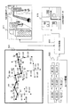
次に、(c)3次元表示不可ポイントデータ(NGリンクファイル)の詳細について、図4、図5を参照して説明する。 Next, details of (c) three-dimensional display impossible point data (NG link file) will be described with reference to FIGS.
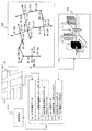
図4のNGリンクファイル351が、本発明のナビゲーション装置の記憶手段213に格納される3次元表示不可ポイントデータ(NGリンクファイル)の具体的なデータ構成を示している。
The
ネットワークデータ352は、NGリンクファイル351に対応するネットワークデータを示している。ネットワークデータ352は、図3を参照して説明した(b)ルート探索用道路ネットワークデータに対応するものであり、道路に対応するリンクによって構成され、それぞれのリンク(=道路)には識別子としてのリンクIDが設定されている。
NGリンクファイル351は、各リンクの種別を定義したファイルである。NGリンクファイル351には、ファィルバージョンを示すバージョン情報と、ファイルに設定されているリンクの数を示すレコード数と、各リンク個々に対応するリンク種別を記録した構成を持つ。
The
種別は、3次元グラフィック表示を実行してよいか、あるいは2次元地図情報に切り替えるべきかを判断する指標として利用される。図2を参照して説明したデータ処理部200では、GPS211から入力する情報と、目的地に至るルート情報と、このNGリンクファイル351とに基づいて3次元グラフィック表示を実行するか、2次元地図情報を表示するかを判定する。
The type is used as an index for determining whether to perform 3D graphic display or to switch to 2D map information. The
NGリンクファイル351に設定されるリンク種別の詳細について、図5を参照して説明する。図5に示すリンク種別一覧表371に示すように、リンク種別には、以下の0〜5の種別がある。3次元グラフィック表示が適当でない場合があると判定されたポイントに連結する各リンクには、いずれかの種別が対応付けられる。
種別0:双方向リンク(自動)
種別1:双方向リンク(エディタ)
種別2:交差点リンク
種別3:交差点リンクの続き
種別4:コンビ進入リンク
種別5:コンビ進出リンク
Details of the link type set in the
Type 0: Bidirectional link (automatic)
Type 1: Bidirectional link (editor)
Type 2: Intersection link Type 3: Continuation of intersection link Type 4: Combination entry link Type 5: Combination advancement link
各種別の詳細について、図5の下段に示す(a)〜(f)のリンク設定例を参照して説明する。図5の下段に示す(a)〜(f)中の数字1〜5がリンク種別を示している。
Details of each type will be described with reference to link setting examples (a) to (f) shown in the lower part of FIG.
図5(a)は、種別0:双方向リンク(自動)を説明する図である。図5(a)に示すID:104のリンクが種別=0である。図5(a)に示すID:103,ID:104,ID:105の各ラインは道路に対応するリンクを示しており、図4に示すネットワークデータ352に示すリンクID103〜105に対応している。
FIG. 5A is a diagram for explaining type 0: bidirectional link (automatic). The link of ID: 104 shown in FIG. Each line of ID: 103, ID: 104, and ID: 105 shown in FIG. 5A indicates a link corresponding to a road, and corresponds to link
(a)種別0:双方向リンク(自動)は、ナビゲーション装置を持つユーザ(車)が種別=0に設定されたリンクをいずれの方向(図5(a)中のP,Q)に進む場合にも、3次元表示情報の提示を行なわない設定リンクであることを意味する。 (A) Type 0: Bidirectional link (automatic) is a case where a user (vehicle) having a navigation device travels in any direction (P, Q in FIG. 5A) on a link with type = 0. In addition, it means a setting link that does not present the three-dimensional display information.
例えば図5(a)中に示すポイントXやポイントYに対応する3次元グラフィックデータが記憶手段213に格納されている場合であっても、種別0の設定されたリンク(ID=104)を通過してPまたはQの方向に進む際には、ポイントXやポイントYに対応する領域、あるいはポイントXとポイントY間の領域についての3次元表示情報を表示デバイス221に出力せず、2次元地図の表示処理を行なう。
For example, even when the three-dimensional graphic data corresponding to the point X or the point Y shown in FIG. 5A is stored in the
図5(b)は、種別1:双方向リンク(エディタ)を説明する図である。種別1:双方向リンク(エディタ)は、種別0:双方向リンク(自動)と同様、種別1の設定されたリンクをいずれの方向に進む場合であっても、リンクの端部X,Yに対応する3次元表示情報を表示デバイス221に出力せず、2次元地図の表示処理を行なう。
FIG. 5B is a diagram for explaining type 1: bidirectional link (editor). Type 1: Bidirectional link (editor) is the same as Type 0: Bidirectional link (automatic), regardless of which direction the
種別=0と種別=1は、データ処理部200における処理としては同一である。種別=0は、特定の条件、例えば3次元グラフィックデータが存在しないなどの場合に自動的に設定する種別であり、種別=1は、エディタの判断によって設定した種別である。具体的には、図5(b)のポイントX,Yの3次元データは存在するが、例えば交差点Xが複雑な形状を持つ立体交差であり、複雑な形状を持っており、またY方向にも電車の高架橋があって3次元データを表示すると前方が見えにくくなるなどの状況がある場合にエディタの判断で、そのリンクに種別=1を設定する。
Type = 0 and type = 1 are the same in the
図5(c)は、種別2:交差点リンクと、種別3:交差点リンクの続きの2つの種別について説明する図である。種別2と種別3は、交差点Xに向かう場合に、交差点Xの3次元データ表示をやめて2次元地図の表示処理を行なう設定であることを示している。交差点を3次元表示不可ポイント(NG)にする場合、種別2で交差点に進入する1本のリンクを指定し、その後に連続するレコードで交差点に進入する残りのリンクを種別3で指定する。
FIG. 5C is a diagram for explaining the two types of type 2: intersection link and type 3: intersection link.
種別2、種別3いずれかの設定のリンクを経由して交差点Xに向かう場合交差点Xの3次元データ表示をやめて2次元地図の表示処理を行なう。これけは、交差点Xが例えば複雑な立体交差など、3次元表示に不適当(NG)である場合の設定である。
When going to the intersection X via a link of either
交差点Xが3次元表示に不適当(NG)である場合、その交差点に接続した1つのみのリンクを種別=2として、その他のリンクは種別=3として設定する。例えば、図4に示すネットワークデータ352に示すリンクID101〜103において、図4に示すNGリンクファィル351に示すように、
リンクID:102=種別2
リンクID:101=種別3
リンクID:103=種別3
であり、これは、ネットワークデータ352に示されるA交差点が3次元表示に不適当(NG)であることを意味しているものである。
When the intersection X is unsuitable for three-dimensional display (NG), only one link connected to the intersection is set as type = 2, and the other links are set as type = 3. For example, in the
Link ID: 102 =
Link ID: 101 =
Link ID: 103 =
This means that the A intersection indicated in the
図5(d)、(e)、(f)は、種別4:コンビ進入リンクと、種別5:コンビ進出リンクの2つの種別について説明する図である。あるガイドポイント、例えば交差点Xに入るリンクがコンビ進入リンクであり、あるポイント、例えば交差点Xから出るリンクがコンビ進出リンクである。 FIGS. 5D, 5E, and 5F are diagrams for explaining two types of type 4: combination entry link and type 5: combination entry link. A link that enters a certain guide point, such as the intersection X, is a combination approach link, and a link that exits from a certain point, such as the intersection X, is a combination advance link.
ガイドポイント、例えば交差点Xに進入する1つのリンクを限定してガイドポイントを3次元表示不可(NG)にする場合、種別4で交差点に進入するリンクを指定し、その後に連続するレコードで交差点から進出するすべてのリンクを種別5で指定する。これは、例えば、図4に示すネットワークデータ352の[C進入NG]に対応し、NGリンクファイル351のリンクID:113〜108に対応する。
When restricting a guide point, for example, one link that enters the intersection X and making the guide point non-three-dimensional display (NG), specify the link that enters the intersection with
また、ガイドポイント、例えば交差点Xから進出する1本のリンクを限定して、そのガイドポイントを3次元表示不可(NG)とする場合、連続するレコードで交差点に進入するすべてのリンクを種別4で指定し、その後に続く1つのレコードで交差点から進出するリンクを種別5で指定する。これは、例えば、図4に示すネットワークデータ352の[D進出NG]に対応し、NGリンクファイル351のリンクID:115〜117に対応する。
In addition, when a guide point, for example, one link that advances from the intersection X is limited and the guide point is not three-dimensionally displayed (NG), all links that enter the intersection with consecutive records are classified as
前述の種別2、種別3では、交差点Xが3次元表示に不適当(NG)であり、どの方向から交差点に進入する場合も交差点Xの3次元データ表示をやめて2次元地図の表示処理を行なう設定であったが、種別4:コンビ進入リンクと種別5:コンビ進出リンクは、交差点Xに対して特定のリンクから進入する場合と、交差点X特定のリンクへ進出する場合のみを交差点Xの3次元表示を不適当(NG)とする設定である。
In the
図5(d)において交差点Xに接続するリンクは4つあるが、この4つのリンク中、種別4の設定されたリンクから種別5の設定されたリンクへ進行する場合にのみ、交差点Xの3次元表示が不適当(NG)であり、このルートを経由する場合にのみ、交差点Xの3次元データ表示をやめて2次元地図の表示処理を行なう。その他のルートの場合には、交差点Xの3次元データ表示を行なう。すなわち、種別4の設定リンクを経由して交差点Xに進入する場合、いずれのリンクにルートが設定されている場合であっても、交差点Xの3次元データ表示をやめて2次元地図の表示処理を行なう。種別の設定されていないリンクおよび種別5の設定されているリンクから交差点Xに進入する場合には、交差点Xの3次元データ表示を実行する。
In FIG. 5 (d), there are four links connected to the intersection X. Of these four links, 3 of the intersection X is set only when traveling from the link set with the
図5(e)は、交差点Xに接続するリンクが4つあり、その1つが、種別4:コンビ進入リンクであり、その他の3つのリンクがすべて種別5の設定されたリンクである。この場合は、種別4の設定リンクを経由して交差点Xに進入する場合、いずれのリンクにルートが設定されている場合であっても、交差点Xの3次元データ表示をやめて2次元地図の表示処理を行なう。種別の設定されていないリンクおよび種別5の設定されているリンクから交差点Xに進入する場合には、交差点Xの3次元データ表示を実行する。
In FIG. 5 (e), there are four links connected to the intersection X, one of which is a type 4: combination approach link, and the other three links are all links of
図5(f)は、交差点Xに接続するリンクが4つあり、その中の3つが、種別4:コンビ進入リンクであり、その他の1つのリンクが種別5の設定されたリンクである。この場合は、交差点Xを経由して種別5の設定されているリンクへ出る場合には、すべて交差点Xの3次元データ表示をやめて2次元地図の表示処理を行なう。種別の設定されていないリンクおよび種別5の設定されているリンクから交差点Xに進入する場合には、交差点Xの3次元データ表示を実行する。
In FIG. 5 (f), there are four links connected to the intersection X, three of which are type 4: combination entry links, and the other one link is a
このように、交差点などあるポイントに接続したリンクであり、該リンクを通過するルートを経由する場合、該ポイントが3次元表示を避けるポイントである場合には、そのリンクには、その態様に応じた種別0〜5のいずれかが設定される。種別の設定されていないリンクは、いずれの方向に進む場合にも、3次元データ表示が許容され実行されることになる。
In this way, when a link is connected to a certain point such as an intersection and passes through a route passing through the link, when the point is a point that avoids a three-dimensional display, the link is in accordance with its mode. Any one of the
図4のネットワークデータ352には、A〜Gの様々な3次元表示不可ポイントの態様を示してある。
A交差点は、NGリンクファイル351の設定データとして、
リンクID102=種別2
リンクID101=種別3
リンクID103=種別3
が設定されている。これはA交差点自体が3次元表示の不適ポイント(P1)として設定されていることを示している。この場合、進入リンク、進出リンクの区別なく、A交差点(P1)を通過する場合には、どの経路であってもポイントP1の3次元表示を実行することなくポイントP1の2次元地図データを表示する。
In the
The A intersection is the setting data of the
Is set. This indicates that the A intersection itself is set as an inappropriate point (P1) for three-dimensional display. In this case, when passing through the A intersection (P1) without distinguishing between the approach link and the advance link, the two-dimensional map data of the point P1 is displayed without executing the three-dimensional display of the point P1 in any route. To do.
B進入出コンビは、NGリンクファイル351の設定データとして、
リンクID110=種別4
リンクID109=種別5
リンクID111=種別設定なし
が設定されている。この設定においては、リンクID110のリンクからリンクID109のリンクへ進行ルートが設定されている場合にのみ、ポイントP2の3次元表示を実行することなくポイントP2の2次元地図データを表示する。その他のルートが設定されている場合、例えばリンクID109のリンクからリンクID110のリンクや、リンクID110のリンクからリンクID111のリンクへ進行ルートがある場合にはポイントP2の3次元表示を実行する。
B entry / exit combination is the setting data of
C進入NGは、NGリンクファイル351の設定データとして、
リンクID113=種別4
リンクID114=種別5
リンクID112=種別5
リンクID108=種別5
が設定されている。この設定においては、リンクID113のリンクからリンクID114,112,108のいずれかのリンクへ進行ルートが設定されている場合のみ、ポイントP3の3次元表示を実行することなくポイントP3の2次元地図データを表示する。その他のルートが設定されている場合にはポイントP3の3次元表示を実行する。
The C approach NG is the setting data of the
Is set. In this setting, the two-dimensional map data of the point P3 is displayed without executing the three-dimensional display of the point P3 only when the traveling route is set from the link of the
D進出NGは、NGリンクファイル351の設定データとして、
リンクID115=種別4
リンクID118=種別4
リンクID116=種別4
リンクID117=種別5
が設定されている。この設定においては、リンクID115,118,116のいずれかのリンクからリンクID117のリンクへ進行ルートが設定されている場合のみ、ポイントP4の3次元表示を実行することなくポイントP4の2次元地図データを表示する。その他のルートが設定されている場合にはポイントP4の3次元表示を実行する。
D advance NG is the setting data of
Is set. In this setting, the two-dimensional map data of the point P4 is executed without executing the three-dimensional display of the point P4 only when the traveling route is set from any one of the
E双方向NGは、NGリンクファイル351の設定データとして、
リンクID104=種別0
が設定されている。この設定においては、リンクID104を経由する進行ルートが設定されている場合、リンクID104のリンクからポイントP5、P6へ向かう場合、ポイントP5、P6の3次元表示を実行することなくポイントP5、P6の2次元地図データを表示する。
E Bidirectional NG is the setting data of
Is set. In this setting, when a travel route via the
なお、ID103のリンクは、
リンクID103=種別3であり、
種別3のリンクを経由するルートにおいては、種別3のリンクを経由して種別2のリンクに接続されたポイント、すなわちポイントP1の3次元表示が中止されるのみであり、図においてリンクID103からリンクID104へ向かっている場合は、ポイントP5の3次元表示を実行する。
The link with
In the route via the
同様に、リンクID105のリンクには種別が設定されていないので、リンクID105からリンクID104へ向かうルートが設定されている場合にもポイントP6の3次元表示を実行する。
Similarly, since no type is set for the link with the
F交差点NGは、NGリンクファイル351の設定データとして、
リンクID120=種別2
リンクID119=種別3
リンクID121=種別3
リンクID122=種別3
が設定されている。これはA交差点と同様の設定であり、F交差点自体が3次元表示の不適ポイント(P7)として設定されていることを示している。この場合、進入リンク、進出リンクの区別なく、F交差点(P7)を通過する場合には、どの経路であってもポイントP7の3次元表示を実行することなくポイントP7の2次元地図データを表示する。
The F intersection NG is set as the setting data of the
Is set. This is the same setting as the A intersection, and indicates that the F intersection itself is set as an inappropriate point (P7) for three-dimensional display. In this case, when passing through the F intersection (P7) without distinguishing between the approach link and the advance link, the 2D map data of the point P7 is displayed without executing the 3D display of the point P7 in any route. To do.
G双方向NGは、NGリンクファイル351の設定データとして、
リンクID123=種別1
が設定されている。この設定は、種別=0の設定されたリンクID104(E双方向NG)と同様であり、リンクID123を経由する進行ルートが設定されている場合、リンクID123のリンクからポイントP8、P9へ向かう場合、ポイントP8、P9の3次元表示を実行することなくポイントP8、P9の2次元地図データを表示する。
G bidirectional NG is the setting data of
Is set. This setting is the same as the link ID 104 (E bidirectional NG) in which the type = 0 is set, and when a travel route via the
次に、図6以下を参照して、ナビゲーション装置の実行する表示データ生成処理の詳細について説明する。 Next, the details of the display data generation process executed by the navigation device will be described with reference to FIG.
図6は、本発明のナビゲーション装置の記憶手段213の格納データと、データ処理部200におけるデータ処理を説明する図である。
FIG. 6 is a diagram for explaining data stored in the
データ処理部200は、記憶手段213の格納データを必要に応じて入力し、さらにGPS211から入力される位置情報、車速パルス情報入力部212から入力される車速情報、入力手段214から入力される目的地情報などのユーザ入力情報に基づくデータ処理を実行して表示データ生成処理を行なう。
The
データ処理部200は、位置情報取得手段としてのGPS211の取得した位置情報を入力するとともに、入力位置情報に基づいて記憶手段から必要データを取得し、ガイド領域の3次元表示情報を生成してディスプレイに出力する。データ処理部200は、例えば記憶手段213の格納データであるノード対応高度データに基づいてルートの各ポイントの高度を算出し、算出した高度データをパラメータとして設定した3次元ルート情報を生成してディスプレイに出力する。
The
さらに、データ処理部200は、GPS211の取得した位置情報と、ノード対応高度データとに基づいて、ナビゲーション装置またはナビゲーション装置を搭載した車の高さを算出し、該算出した高さ情報を3次元表示情報のパラメータとして設定した自己のシンボルデータである自車シンボルを生成してディスプレイに出力する処理を実行する。さらに、データ処理部200は、ナビゲーション装置を搭載した車の高さ以上の高度をカメラ視点の設定許容位置とし、その設定許容位置内に設定したカメラ視点から観察した3次元データを生成してディスプレイに出力する処理を実行する。
Further, the
図6は、データ処理部200のCPU204の実行する処理を機能毎に区分して示してある。CPU204は、データ制御部501と、3Dグラフィック構成データ生成部504を有し、入出力制御部502において、記憶手段213の格納データ、GPS211からの位置情報、車速パルス情報入力部212からの車速情報、入力手段214からのユーザ入力情報を受領し、これらのデータを3Dグラフィック制御部503を介して3Dグラフィック構成データ生成部504に入力し、3Dグラフィック構成データ生成部504において3Dグラフィック構成データが生成される。さらに、このデータは3Dグラフィックエンジン505に出力されて、3次元データの描画処理がなされディスプレイに出力される。
FIG. 6 shows the processing executed by the
データ処理部200は、GPS211からの信号により、現在位置の緯度経度を把握し、その位置を含む各種のデータ、すなわち、
(a)2次元地図データ
(b)ルート探索用道路ネットワークデータ
(c)3次元表示不可ポイントデータ(NGリンクファイル)
(d)ルート案内データ
(e)3次元グラフィックデータ
を記憶手段213から取得し、車速パルス情報入力部212からの車速情報、入力手段214からのユーザ入力情報に基づいて目的地に至るルートを算出する。
The
(A) 2D map data (b) Route network data for route search (c) Point data that cannot be displayed in 3D (NG link file)
(D) Route guidance data (e) 3D graphic data is acquired from the storage means 213, and a route to the destination is calculated based on vehicle speed information from the vehicle speed pulse
データ処理部200は、算出したルートに対応して設定されたリンクの種別情報を、3次元表示不可ポイントデータ(NGリンクファイル)から取得し、リンクの種別情報に基づいて、出力情報を3次元データとするか2次元地図情報とするかを決定し、出力情報を3次元データとした場合には、記憶手段213から取得した3次元グラフィックデータ等を3Dグラフィック構成データ生成部504に出力する。
The
3Dグラフィック構成データ生成部504は、データ制御部501から受領したデータに基づいて、描画処理に必要なデータ、すなわち3Dグラフィック構成データを生成する。この生成データには、先に図1を参照して説明したカメラの視点位置情報、ルート情報、自車シンボル情報が含まれる。
Based on the data received from the
一方、3次元表示不可ポイントデータ(NGリンクファイル)に基づいて、出力情報を3次元データではなく2次元地図情報とすると決定した場合には、記憶手段213から取得した2次元地図データを出力する。
On the other hand, when it is determined that the output information is not the three-dimensional data but the two-dimensional map information based on the three-dimensional display impossible point data (NG link file), the two-dimensional map data acquired from the
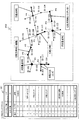
図7を参照して、3次元表示不可ポイントデータ(NGリンクファイル)に基づいてデータ処理部200において実行する出力データの選択処理の詳細について説明する。
With reference to FIG. 7, the details of the output data selection process executed in the
データ処理部200は記憶手段213から取得した3次元表示不可ポイントデータ(NGリンクファイル)と、ユーザの入力情報によって決定したルート情報とに基づいて出力データを3次元表示情報とするか2次元地図とするか選択処理を実行する。
The
図7には、理解を容易にするため、3次元表示不可ポイントデータ(NGリンクファイル)に基づいて各リンクの種別を記載したネットワークデータ521を示している。ネットワークデータ521は、ユーザの入力情報によって決定したルート情報522対応するルートを太線で示し、そのルート上の各リンクに設定されたリンク種別を数字0〜5で示してある。
FIG. 7 shows
ユーザの入力情報によって決定したルート情報522は、図に示すように、リンクIDのシーケンスとして設定され、[ID:101]→[ID:103]→[ID:104]→[ID:105]→[ID:108]→[ID:114]→[ID:115]→[ID:117]である。
As shown in the figure, the
このリンクシーケンスに対応する種別は、図4を参照して説明した3次元表示不可ポイントデータ(NGリンクファイル)例において、
[ID:101]=種別3
[ID:103]=種別3
[ID:104]=種別0
[ID:105]=種別なし
[ID:108]=種別5
[ID:114]=種別5
[ID:115]=種別4
[ID:117]=種別5
として設定されている。
The type corresponding to this link sequence is the three-dimensional display impossible point data (NG link file) example described with reference to FIG.
[ID: 101] =
[ID: 103] =
[ID: 104] =
[ID: 105] = no type [ID: 108] =
[ID: 114] =
[ID: 115] =
[ID: 117] =
Is set as
データ処理部200は、これらのルート対応リンクの種別に基づいて、出力データを3次元表示情報とするか2次元地図とするか選択処理を実行する。なお、データ処理部200は、ルート情報522に加え、GPSを介して位置情報を取得しており、位置情報に基づいて表示対象領域を決定する。なお、ユーザの指定情報に基づいて表示対象領域を決定してもよい。
The
ルート情報522に含まれるリンク識別子からなるリンクシーケンスに基づく表示情報の選択処理の具体例について説明する。
A specific example of display information selection processing based on a link sequence including link identifiers included in
例えば、図7のネットワークデータ521において、ID101のリンクを進行し、ポイントQ1の表示態様を決定する際には、リンクID101の種別=3に基づいて、進行方向のポイントQ1が3次元表示の不適当な交差点であると判断し、ポイントQ1については2次元地図データの表示を行なう。次に、リンクID103の種別=3に基づいて、進行方向のポイントQ2は、3次元表示を実行しても問題ないポイントであると判断し、ポイントQ2については3次元グラフッィクデータの表示を行なう。
For example, in the
以下、同様に、ルート情報として設定されたリンクIDシーケンスに従って、リンクIDを取得し、取得したリンクIDに対応するリンク種別情報を、3次元表示不可ポイントデータ(NGリンクファイル)から取得して、リンク上あるいはリンク端部の各ガイドポイントについて、出力データを3次元表示情報とするか2次元地図とするかの選択を実行し、選択したデータを生成また記憶手段から取得して表示デバイスに出力する。 Hereinafter, similarly, according to the link ID sequence set as route information, the link ID is acquired, the link type information corresponding to the acquired link ID is acquired from the three-dimensional display impossible point data (NG link file), For each guide point on the link or link end, the output data is selected as 3D display information or 2D map, and the selected data is generated or acquired from the storage means and output to the display device. To do.
結果として、図7に示すように、3次元表示情報571、あるいは2次元地図データ572が適宜切り替えられて出力、表示される。
As a result, as shown in FIG. 7, the three-
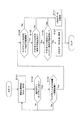
次に、図8に示すフローチャートを参照して本発明のナビゲーション装置の実行する処理シーケンスについて説明する。 Next, a processing sequence executed by the navigation device of the present invention will be described with reference to a flowchart shown in FIG.
図8のフローは、すでにユーザにより目的地情報が入力され、定期的な車速情報の入力、GPS情報の入力があるナビゲーション装置において実行するデータ処理フローを示すものである。 The flow of FIG. 8 shows a data processing flow executed in a navigation apparatus in which destination information has already been input by a user, and periodic vehicle speed information and GPS information are input.
まず、ステップS101で、GPSからの現在位置情報を取得する。ステップS102では、車の進行方向にガイドポイントがあるか否かを判定する。ここでガイドポイントとは、ディスプレイに新たに表示すべきデータが対応付けられた地図上の特定地点であり、例えば交差点などである。車の進行方向にガイドポイントがない場合は、ステップS101に戻り現在位置情報の取得を継続する。 First, in step S101, current position information from the GPS is acquired. In step S102, it is determined whether there is a guide point in the traveling direction of the vehicle. Here, the guide point is a specific point on the map associated with data to be newly displayed on the display, such as an intersection. If there is no guide point in the traveling direction of the car, the process returns to step S101 and the acquisition of the current position information is continued.
車の進行方向にガイドポイントがあると判定すると、ステップS103に進み、ガイドポイント(例えば交差点)までの距離が予め設定された閾値距離以下となったか否かを判定する。これは、車の現在位置から閾値距離、例えば前方300mにガイドポイント(例えば交差点)が近づいたか否かを判定する処理である。閾値以下にガイドポイントが近づいていない場合は、ステップS101に戻り現在位置情報の取得を継続する。 If it is determined that there is a guide point in the traveling direction of the vehicle, the process proceeds to step S103, and it is determined whether or not the distance to the guide point (for example, an intersection) is equal to or less than a preset threshold distance. This is a process of determining whether or not a guide point (for example, an intersection) has approached a threshold distance from the current position of the vehicle, for example, 300 m ahead. If the guide point is not approaching the threshold value or less, the process returns to step S101 and the acquisition of the current position information is continued.
ガイドポイントが閾値以下になったと判定すると、ステップS104に進み、ガイドポイントが3次元データ表示可能領域であるか否かを判定する。すなわち、3次元グラフィックデータが記憶部に格納されているガイドポイントであるか否かを判定する。 If it is determined that the guide point is equal to or less than the threshold value, the process proceeds to step S104, and it is determined whether or not the guide point is a three-dimensional data displayable area. That is, it is determined whether or not the 3D graphic data is a guide point stored in the storage unit.
ガイドポイントが3次元データ表示可能領域でない場合には、ステップS111に進み、記憶手段に格納されている2次元データをディスプレイに表示する。 If the guide point is not in the 3D data displayable area, the process proceeds to step S111, and the 2D data stored in the storage means is displayed on the display.
ガイドポイントが3次元データ表示可能領域である場合には、ステップS105、ステップS106において、交差点などのガイドポイント、またはガイドポイントの経由ルート(リンク)が3次元表示不可として設定されているポイントあるいはルートであるか否かを判定する。この判定処理は、前述したように、図4、図5を参照して説明した3次元表示不可ポイントデータ(NGリンクファイル)に基づいて実行される。 If the guide point is a 3D data displayable area, in step S105 and step S106, a guide point such as an intersection or a route or link via the guide point is set as a 3D display disabled point or route. It is determined whether or not. As described above, this determination process is executed based on the 3D display disabled point data (NG link file) described with reference to FIGS.
この処理について、図9を参照して詳細に説明する。ユーザの目的地の入力によって決定されたルートが図9に示すルート601であるとすると、データ処理部200の検証するリンクの種別は、リンク621,622,623,624の各リンクの種別である。
This process will be described in detail with reference to FIG. If the route determined by the user's destination input is the
この場合、ガイドポイントとしての交差点611自体が3次元表示不可として設定されている場合と、交差点611自体が3次元表示不可として設定されはいないが、リンク623からリンク624は進行するルートが3次元表示不可として設定されている場合がある。
In this case, the
具体的には、
リンク623=種別2
リンク624,625,626=種別3
の設定である場合には、交差点611自体が3次元表示不可として設定されていることを示し、また、
リンク623=種別4
リンク624=種別5
の設定である場合には、交差点611を経由して、リンク623からリンク625に至るルート設定の場合にのみ、交差点611が3次元表示不可とされることを示す。
In particular,
Is set to indicate that the
Link 624 =
In the case of this setting, it is indicated that the
従って、ステップS105、ステップS106の処理のように、交差点などのガイドポイント、またはガイドポイントの経由ルート(リンク)が3次元表示不可として設定されているポイントあるいはルートであるか否かを判定する。この判定処理は、前述したように、図4、図5を参照して説明した3次元表示不可ポイントデータ(NGリンクファイル)に基づいて実行される。 Therefore, it is determined whether or not a guide point such as an intersection or a route (link) through the guide point is a point or route that is set so that three-dimensional display is not possible, as in the processes of steps S105 and S106. As described above, this determination process is executed based on the 3D display disabled point data (NG link file) described with reference to FIGS.
ステップS105、S106において、ガイドポイント、またはガイドポイントの経由ルート(リンク)が3次元表示不可として設定されているポイントあるいはルートであると判定した場合には、ステップS111に進みガイドポイントに対応する領域の2次元地図データを記憶手段から取得して表示デバイス221に出力する。
In Steps S105 and S106, if it is determined that the guide point or the route (link) of the guide point is a point or route that is set not to be three-dimensionally displayed, the process proceeds to Step S111 and corresponds to the guide point. Are obtained from the storage means and output to the
一方、ステップS105、S106において、ガイドポイント、またはガイドポイントの経由ルート(リンク)が3次元表示不可として設定されているポイントあるいはルートでないと判定した場合には、ステップS107に進み、ガイドポイント対応の3次元データの生成を実行し、生成した3次元グラフッィクデータを表示デバイス221に出力する。
On the other hand, if it is determined in steps S105 and S106 that the guide point or the route through which the guide point is routed (link) is not a point or route that is set not to be three-dimensionally displayed, the process proceeds to step S107, and the guide point correspondence. The generation of the three-dimensional data is executed, and the generated three-dimensional graphic data is output to the
上述した処理によって、例えば図10(a)に示す2次元地図データ、あるいは(b)3次元表示情報のいずれかが選択されて表示デバイス221に提示されることになる。なお、2次元地図データ、3次元表示情報のいずれにおいても目的地までの経路を示すルート情報711,721と自車位置を示す自車シンボル情報712,722とがアニメーション表示される。
Through the processing described above, for example, either the two-dimensional map data shown in FIG. 10A or (b) three-dimensional display information is selected and presented to the
以上、特定の実施例を参照しながら、本発明について詳解してきた。しかしながら、本発明の要旨を逸脱しない範囲で当業者が該実施例の修正や代用を成し得ることは自明である。すなわち、例示という形態で本発明を開示してきたのであり、限定的に解釈されるべきではない。本発明の要旨を判断するためには、冒頭に記載した特許請求の範囲の欄を参酌すべきである。 The present invention has been described in detail above with reference to specific embodiments. However, it is obvious that those skilled in the art can make modifications and substitutions of the embodiments without departing from the gist of the present invention. In other words, the present invention has been disclosed in the form of exemplification, and should not be interpreted in a limited manner. In order to determine the gist of the present invention, the claims section described at the beginning should be considered.
なお、明細書中において説明した一連の処理はハードウェア、またはソフトウェア、あるいは両者の複合構成によって実行することが可能である。ソフトウェアによる処理を実行する場合は、処理シーケンスを記録したプログラムを、専用のハードウェアに組み込まれたコンピュータ内のメモリにインストールして実行させるか、あるいは、各種処理が実行可能な汎用コンピュータにプログラムをインストールして実行させることが可能である。 The series of processes described in the specification can be executed by hardware, software, or a combined configuration of both. When executing processing by software, the program recording the processing sequence is installed in a memory in a computer incorporated in dedicated hardware and executed, or the program is executed on a general-purpose computer capable of executing various processing. It can be installed and run.
例えば、プログラムは記録媒体としてのハードディスクやROM(Read Only Memory)に予め記録しておくことができる。あるいは、プログラムはフレキシブルディスク、CD−ROM(Compact Disc Read Only Memory),MO(Magneto optical)ディスク,DVD(Digital Versatile Disc)、磁気ディスク、半導体メモリなどのリムーバブル記録媒体に、一時的あるいは永続的に格納(記録)しておくことができる。このようなリムーバブル記録媒体は、いわゆるパッケージソフトウエアとして提供することができる。 For example, the program can be recorded in advance on a hard disk or ROM (Read Only Memory) as a recording medium. Alternatively, the program is temporarily or permanently stored on a removable recording medium such as a flexible disk, a CD-ROM (Compact Disc Read Only Memory), an MO (Magneto optical) disk, a DVD (Digital Versatile Disc), a magnetic disk, or a semiconductor memory. It can be stored (recorded). Such a removable recording medium can be provided as so-called package software.
なお、プログラムは、上述したようなリムーバブル記録媒体からコンピュータにインストールする他、ダウンロードサイトから、コンピュータに無線転送したり、LAN(Local Area Network)、インターネットといったネットワークを介して、コンピュータに有線で転送し、コンピュータでは、そのようにして転送されてくるプログラムを受信し、内蔵するハードディスク等の記録媒体にインストールすることができる。 The program is installed on the computer from the removable recording medium as described above, or is wirelessly transferred from the download site to the computer, or is wired to the computer via a network such as a LAN (Local Area Network) or the Internet. The computer can receive the program transferred in this manner and install it on a recording medium such as a built-in hard disk.
なお、明細書に記載された各種の処理は、記載に従って時系列に実行されるのみならず、処理を実行する装置の処理能力あるいは必要に応じて並列的にあるいは個別に実行されてもよい。また、本明細書においてシステムとは、複数の装置の論理的集合構成であり、各構成の装置が同一筐体内にあるものには限らない。 Note that the various processes described in the specification are not only executed in time series according to the description, but may be executed in parallel or individually according to the processing capability of the apparatus that executes the processes or as necessary. Further, in this specification, the system is a logical set configuration of a plurality of devices, and the devices of each configuration are not limited to being in the same casing.
以上、説明したように、本発明の構成によれば、例えば車や歩行者のナビゲーションを実行するナビゲーション装置において、記憶部に2次元地図データと、3次元グラフィックデータ、および3次元表示不可ポイントデータを格納し、3次元表示不可ポイントデータに基づいて、ガイドポイントについての3次元データ表示を行なうか2次元地図情報の表示を行なうかを決定し、決定に従ったデータを選択して表示手段に出力する構成とした。例えば、立体交差などの複雑な道路構成を持つ地点や、電車軌道などの高架橋や歩道橋など視界を遮る構造物などがある地点など3次元表示情報を提示することが、かえってユーザを混乱させると判断されるガイドポイントでは、3次元データ表示を停止し、2次元地図情報に切り換えて表示する。この構成により、ユーザの誘導をより正確に実行することが可能となる。 As described above, according to the configuration of the present invention, for example, in a navigation device that executes navigation of a car or a pedestrian, 2D map data, 3D graphic data, and 3D display disabled point data are stored in the storage unit. , And whether to display 3D data or 2D map information about the guide point is determined based on the 3D display impossible point data, and data according to the determination is selected and displayed on the display means. It was set as the structure to output. For example, it is determined that presenting 3D display information such as points with complicated road structures such as three-dimensional intersections, points with structures that obstruct visibility such as viaducts such as train tracks, and pedestrian bridges, would rather confuse users. At the guide point, the 3D data display is stopped, and the display is switched to the 2D map information. With this configuration, it is possible to perform user guidance more accurately.
さらに、本発明の構成によれば、3次元表示不可ポイントデータを、経路構成単位としてのリンク各々のリンク識別子と、該リンク識別子の対応データとして設定したリンク種別によって構成し、さらに、リンク種別を、例えば交差点のようなガイドポイントにおいて通過ルートの区別なく3次元表示不可ポイントとするリンク種別と、ガイドポイントを通過するルート中、特定のリンクの進入進出路のみを限定して3次元表示不可ポイントとするリンク種別とを識別可能な設定としたので、ユーザの進行ルートに応じた最適なデータ選択が可能となる。 Furthermore, according to the configuration of the present invention, the three-dimensional display impossible point data is configured by the link identifier of each link as a route constituent unit and the link type set as the corresponding data of the link identifier, and the link type is For example, a guide point such as an intersection, which is a link type that cannot be displayed as a 3D display point regardless of the route that passes through it, and a 3D display point that is limited to only the advancing path of a specific link in the route passing through the guide point. Therefore, the optimum data can be selected according to the user's travel route.
120 自動車
121 カーナビゲーション装置
122 GPS
131 携帯端末
132 GPS
150 3次元表示情報
151 自車シンボル
152 ルート情報
160 2次元地図情報
161 自車シンボル
162 ルート情報
200 データ処理部
201 3Dグラフィック描画エンジン
202 RAM(Random Access Memory)
203 ROM(Read Only Memory)
204 CPU(Central Processing Unit)
205 インターフェース
211 GPS
212 車速パルス情報入力部
213 記憶手段
214 入力手段
221 表示デバイス
301 2次元地図データ
302 ルート探索用道路ネットワークデータ
303 3次元表示情報
351 3次元表示不可ポイントデータ(NGリンクファイル)
352 ネットワークデータ
371 リンク種別一覧表
501 データ制御部
502 入出力制御部
503 3Dグラフィック制御部
504 3Dグラフィック構成データ生成部
505 3Dグラフィックエンジン
521 ネットワークデータ
522 ルート情報
571 3次元表示情報
572 2次元地図データ
601 ルート
611 ガイドポイント(交差点)
621〜626 リンク
711,721 ルート情報
712,722 自車シンボル
120
131
150 Three-
203 ROM (Read Only Memory)
204 CPU (Central Processing Unit)
205
212 Vehicle speed pulse
352
621-626 Link 711,721 Route information 712,722 Own car symbol
Claims (9)
位置情報の取得処理を実行する位置情報取得手段と、
2次元地図データと、3次元グラフィックデータ、および3次元表示不可ポイントデータを格納した記憶手段と、
前記3次元表示不可ポイントデータに基づいて、ガイドポイントについての3次元データ表示を行なうか2次元地図情報の表示を行なうかを決定し、該決定に従ったデータを選択して表示手段に出力するデータ処理部と、
前記データ処理部からの出力データを表示する表示手段と、
を有することを特徴とするナビゲーション装置。 A navigation device that generates and presents navigation information based on map information,
Position information acquisition means for executing position information acquisition processing;
Storage means for storing 2D map data, 3D graphic data, and 3D display impossible point data;
Based on the three-dimensional display impossible point data, it is determined whether to display three-dimensional data or two-dimensional map information for the guide point, and select and output the data according to the determination to the display means. A data processing unit;
Display means for displaying output data from the data processing unit;
A navigation device comprising:
経路構成単位としてのリンク各々のリンク識別子と、該リンク識別子の対応データとして設定したリンク種別を含むデータであり、
前記データ処理部は、
目的地に至るルートに存在するリンクの識別情報からなるリンクシーケンスデータを取得し、該リンクシーケンスデータに含まれるリンク識別子に基づいて、前記3次元表示不可ポイントデータから対応リンクのリンク種別を取得し、該リンク種別に基づいて、ガイドポイントについて3次元データ表示を行なうか2次元地図情報の表示を行なうかを決定する構成であることを特徴とする請求項1に記載のナビゲーション装置。 The three-dimensional display impossible point data is
It is data including the link identifier of each link as a route constituent unit and the link type set as the corresponding data of the link identifier,
The data processing unit
Obtain link sequence data consisting of identification information of links existing in the route to the destination, and obtain the link type of the corresponding link from the three-dimensional display impossible point data based on the link identifier included in the link sequence data. The navigation device according to claim 1, wherein the navigation device is configured to determine whether to display 3D data or 2D map information for a guide point based on the link type.
ガイドポイントを通過するルートの区別なく該ガイドポイントを3次元表示不可ポイントとして設定したリンク種別と、
ガイドポイントを通過するルート中、特定のリンクの進入進出路のみを限定して該ガイドポイントを3次元表示不可ポイントとして設定したリンク種別とを識別可能な種別データであり、
前記データ処理部は、
前記リンクシーケンスデータに含まれるリンク識別子に対応するリンクのリンク種別に基づいて、進行ルートに応じた表示情報決定処理を実行する構成であることを特徴とする請求項2に記載のナビゲーション装置。 The link type is
A link type in which the guide point is set as a three-dimensional display-impossible point regardless of the route passing through the guide point,
In the route that passes through the guide point, it is type data that can identify the link type in which the guide point is set as a three-dimensional display-impossible point by limiting only the approach and advance route of a specific link,
The data processing unit
The navigation apparatus according to claim 2, wherein the display information determination process according to a travel route is executed based on a link type of a link corresponding to a link identifier included in the link sequence data.
複数のリンクの連結された交差点であり、
前記データ処理部は、
前記リンクシーケンスデータに含まれるリンク識別子に対応するリンクのリンク種別に基づいて、交差点を通過する進行ルートに応じた表示情報決定処理を実行する構成であることを特徴とする請求項3に記載のナビゲーション装置。 The guide point is
An intersection of multiple links,
The data processing unit
4. The display information determination process according to claim 3, wherein display information determination processing is performed according to a traveling route passing through an intersection based on a link type of a link corresponding to a link identifier included in the link sequence data. Navigation device.
位置情報の取得処理を実行する位置情報取得ステップと、
前記位置情報取得ステップにおいて取得した位置情報を入力し、さらに記憶手段に格納された3次元表示不可ポイントデータに基づいて、ガイドポイントについての3次元データ表示を行なうか2次元地図情報の表示を行なうかを決定し、該決定に従ったデータを選択して表示手段に出力するデータ処理ステップと、
前記データ処理ステップにおける出力データを表示する表示ステップと、
を有することを特徴とするデータ処理方法。 A data processing method for generating and presenting navigation information based on map information.
A location information acquisition step for executing location information acquisition processing;
The position information acquired in the position information acquisition step is input, and based on the 3D display impossible point data stored in the storage means, 3D data display for guide points or 2D map information is displayed. And a data processing step of selecting data according to the determination and outputting the selected data to the display means;
A display step for displaying output data in the data processing step;
A data processing method characterized by comprising:
経路構成単位としてのリンク各々のリンク識別子と、該リンク識別子の対応データとして設定したリンク種別を含むデータであり、
前記データ処理ステップにおいては、
目的地に至るルートに存在するリンクの識別情報からなるリンクシーケンスデータを取得し、該リンクシーケンスデータに含まれるリンク識別子に基づいて、前記3次元表示不可ポイントデータから対応リンクのリンク種別を取得し、該リンク種別に基づいて、ガイドポイントについて3次元データ表示を行なうか2次元地図情報の表示を行なうかを決定することを特徴とする請求項5に記載のデータ処理方法。 The three-dimensional display impossible point data is
It is data including the link identifier of each link as a route constituent unit and the link type set as the corresponding data of the link identifier,
In the data processing step,
Obtain link sequence data consisting of identification information of links existing in the route to the destination, and obtain the link type of the corresponding link from the three-dimensional display impossible point data based on the link identifier included in the link sequence data. 6. The data processing method according to claim 5, wherein whether to display three-dimensional data or two-dimensional map information for a guide point is determined based on the link type.
ガイドポイントを通過するルートの区別なく該ガイドポイントを3次元表示不可ポイントとして設定したリンク種別と、
ガイドポイントを通過するルート中、特定のリンクの進入進出路のみを限定して該ガイドポイントを3次元表示不可ポイントとして設定したリンク種別とを識別可能な種別データであり、
前記データ処理ステップにおいては、
前記リンクシーケンスデータに含まれるリンク識別子に対応するリンクのリンク種別に基づいて、進行ルートに応じた表示情報決定処理を実行することを特徴とする請求項6に記載のデータ処理方法。 The link type is
A link type in which the guide point is set as a three-dimensional display-impossible point regardless of the route passing through the guide point,
In the route that passes through the guide point, it is type data that can identify the link type in which the guide point is set as a three-dimensional display-impossible point by limiting only the approach and advance route of a specific link,
In the data processing step,
The data processing method according to claim 6, wherein display information determination processing according to a traveling route is executed based on a link type of a link corresponding to a link identifier included in the link sequence data.
複数のリンクの連結された交差点であり、
前記データ処理ステップにおいては、
前記リンクシーケンスデータに含まれるリンク識別子に対応するリンクのリンク種別に基づいて、交差点を通過する進行ルートに応じた表示情報決定処理を実行することを特徴とする請求項7に記載のデータ処理方法。 The guide point is
An intersection of multiple links,
In the data processing step,
8. The data processing method according to claim 7, wherein display information determination processing according to a traveling route passing through an intersection is executed based on a link type of a link corresponding to a link identifier included in the link sequence data. .
位置情報の取得処理を実行する位置情報取得ステップと、
前記位置情報取得ステップにおいて取得した位置情報を入力し、さらに記憶手段に格納された3次元表示不可ポイントデータに基づいて、ガイドポイントについての3次元データ表示を行なうか2次元地図情報の表示を行なうかを決定し、該決定に従ったデータを選択して表示手段に出力するデータ処理ステップと、
前記データ処理ステップにおける出力データを表示する表示ステップと、
を有することを特徴とするコンピュータ・プログラム。 A computer program that executes a process for generating and presenting navigation information based on map information,
A location information acquisition step for executing location information acquisition processing;
The position information acquired in the position information acquisition step is input, and based on the 3D display impossible point data stored in the storage means, 3D data display for guide points or 2D map information is displayed. And a data processing step of selecting data according to the determination and outputting the selected data to the display means;
A display step for displaying output data in the data processing step;
A computer program characterized by comprising:
Priority Applications (1)
| Application Number | Priority Date | Filing Date | Title |
|---|---|---|---|
| JP2004110659A JP2005292064A (en) | 2004-04-05 | 2004-04-05 | Navigation device, data processing method, and computer program |
Applications Claiming Priority (1)
| Application Number | Priority Date | Filing Date | Title |
|---|---|---|---|
| JP2004110659A JP2005292064A (en) | 2004-04-05 | 2004-04-05 | Navigation device, data processing method, and computer program |
Publications (1)
| Publication Number | Publication Date |
|---|---|
| JP2005292064A true JP2005292064A (en) | 2005-10-20 |
Family
ID=35325141
Family Applications (1)
| Application Number | Title | Priority Date | Filing Date |
|---|---|---|---|
| JP2004110659A Pending JP2005292064A (en) | 2004-04-05 | 2004-04-05 | Navigation device, data processing method, and computer program |
Country Status (1)
| Country | Link |
|---|---|
| JP (1) | JP2005292064A (en) |
Cited By (12)
| Publication number | Priority date | Publication date | Assignee | Title |
|---|---|---|---|---|
| JP2007256027A (en) * | 2006-03-22 | 2007-10-04 | Navitime Japan Co Ltd | Navigation system, route search server, terminal unit, and map display method |
| JP2009264819A (en) * | 2008-04-23 | 2009-11-12 | Nissan Motor Co Ltd | Navigation apparatus, and method of presenting guidance information |
| CN101936740A (en) * | 2010-08-24 | 2011-01-05 | 深圳市凯立德欣软件技术有限公司 | Navigation method of three-dimensional electronic map and device thereof |
| WO2012084362A1 (en) | 2010-12-21 | 2012-06-28 | Ecole polytechnique fédérale de Lausanne (EPFL) | Computerized method and device for annotating at least one feature of an image of a view |
| WO2014159253A1 (en) * | 2013-03-14 | 2014-10-02 | Robert Bosch Gmbh | System and method for context dependent level of detail adjustment for navigation maps and systems |
| WO2016106358A1 (en) * | 2014-12-22 | 2016-06-30 | Robert Bosch Gmbh | System and methods for interactive hybrid-dimension map visualization |
| WO2018083999A1 (en) * | 2016-11-01 | 2018-05-11 | パナソニック インテレクチュアル プロパティ コーポレーション オブ アメリカ | Display method and display device |
| CN109089224A (en) * | 2018-08-27 | 2018-12-25 | 深圳市烽焌信息科技有限公司 | Automobile navigation method and Related product |
| CN110871685A (en) * | 2018-09-04 | 2020-03-10 | 现代自动车株式会社 | Display device, vehicle having the same, and control method thereof |
| WO2020195166A1 (en) * | 2019-03-22 | 2020-10-01 | 日立オートモティブシステムズ株式会社 | Environment recognition device |
| CN111912424A (en) * | 2019-05-09 | 2020-11-10 | 上海博泰悦臻电子设备制造有限公司 | Method for switching navigation visual angle, navigation device and vehicle |
| CN115435807A (en) * | 2022-10-21 | 2022-12-06 | 维沃移动通信有限公司 | Map navigation method and device |
-
2004
- 2004-04-05 JP JP2004110659A patent/JP2005292064A/en active Pending
Cited By (23)
| Publication number | Priority date | Publication date | Assignee | Title |
|---|---|---|---|---|
| JP2007256027A (en) * | 2006-03-22 | 2007-10-04 | Navitime Japan Co Ltd | Navigation system, route search server, terminal unit, and map display method |
| JP2009264819A (en) * | 2008-04-23 | 2009-11-12 | Nissan Motor Co Ltd | Navigation apparatus, and method of presenting guidance information |
| CN101936740A (en) * | 2010-08-24 | 2011-01-05 | 深圳市凯立德欣软件技术有限公司 | Navigation method of three-dimensional electronic map and device thereof |
| WO2012084362A1 (en) | 2010-12-21 | 2012-06-28 | Ecole polytechnique fédérale de Lausanne (EPFL) | Computerized method and device for annotating at least one feature of an image of a view |
| EP3678035A1 (en) | 2010-12-21 | 2020-07-08 | QUALCOMM Incorporated | Computerized method and device for annotating at least one feature of an image of a view |
| US9959644B2 (en) | 2010-12-21 | 2018-05-01 | Qualcomm Incorporated | Computerized method and device for annotating at least one feature of an image of a view |
| WO2014159253A1 (en) * | 2013-03-14 | 2014-10-02 | Robert Bosch Gmbh | System and method for context dependent level of detail adjustment for navigation maps and systems |
| US10553021B2 (en) | 2014-12-22 | 2020-02-04 | Robert Bosch Gmbh | System and methods for interactive hybrid-dimension map visualization |
| WO2016106358A1 (en) * | 2014-12-22 | 2016-06-30 | Robert Bosch Gmbh | System and methods for interactive hybrid-dimension map visualization |
| US11748947B2 (en) | 2016-11-01 | 2023-09-05 | Panasonic Intellectual Property Corporation Of America | Display method and display device for providing surrounding information based on driving condition |
| JPWO2018083999A1 (en) * | 2016-11-01 | 2019-09-19 | パナソニック インテレクチュアル プロパティ コーポレーション オブ アメリカPanasonic Intellectual Property Corporation of America | Display method and display device |
| WO2018083999A1 (en) * | 2016-11-01 | 2018-05-11 | パナソニック インテレクチュアル プロパティ コーポレーション オブ アメリカ | Display method and display device |
| US10719984B2 (en) | 2016-11-01 | 2020-07-21 | Panasonic Intellectual Property Corporation Of America | Display method and display device for providing surrounding information based on driving condition |
| US12229888B2 (en) | 2016-11-01 | 2025-02-18 | Panasonic Intellectual Property Corporation Of America | Display method and display device for providing surrounding information based on driving condition |
| CN113008263B (en) * | 2016-11-01 | 2024-04-30 | 松下电器(美国)知识产权公司 | Data generation method and data generation device |
| CN113008263A (en) * | 2016-11-01 | 2021-06-22 | 松下电器(美国)知识产权公司 | Data generation method and data generation device |
| US11238648B2 (en) | 2016-11-01 | 2022-02-01 | Panasonic Intellectual Property Corporation Of America | Display method and display device for providing surrounding information based on driving condition |
| JP7061964B2 (en) | 2016-11-01 | 2022-05-02 | パナソニック インテレクチュアル プロパティ コーポレーション オブ アメリカ | Data generation method and data generation device |
| CN109089224A (en) * | 2018-08-27 | 2018-12-25 | 深圳市烽焌信息科技有限公司 | Automobile navigation method and Related product |
| CN110871685A (en) * | 2018-09-04 | 2020-03-10 | 现代自动车株式会社 | Display device, vehicle having the same, and control method thereof |
| WO2020195166A1 (en) * | 2019-03-22 | 2020-10-01 | 日立オートモティブシステムズ株式会社 | Environment recognition device |
| CN111912424A (en) * | 2019-05-09 | 2020-11-10 | 上海博泰悦臻电子设备制造有限公司 | Method for switching navigation visual angle, navigation device and vehicle |
| CN115435807A (en) * | 2022-10-21 | 2022-12-06 | 维沃移动通信有限公司 | Map navigation method and device |
Similar Documents
| Publication | Publication Date | Title |
|---|---|---|
| JP4423114B2 (en) | Navigation device and its intersection guidance method | |
| US6388582B2 (en) | Lane guidance display method, and navigation device and recording medium for realizing the method | |
| JP4676684B2 (en) | In-vehicle information terminal | |
| JP5105902B2 (en) | Navigation device and route guidance method thereof | |
| JP2009042219A (en) | Navigation device and navigation program | |
| CN102047301B (en) | Method for providing lane information and apparatus for executing the method | |
| JP2004212255A (en) | Navigation device | |
| JP2005207943A (en) | On-vehicle navigation system, and three-dimensional (3d) map display method therefor | |
| JP2005292064A (en) | Navigation device, data processing method, and computer program | |
| JP4516853B2 (en) | Navigation device | |
| JPWO2008059586A1 (en) | Navigation device, map display method, and map display program | |
| JP2004286496A (en) | Travel track display method of vehicle-mounted navigation system | |
| JP2009009219A (en) | Moving body information device and moving body information program | |
| JP2011107025A (en) | Navigation system | |
| JP2005283395A (en) | On-vehicle navigation device, navigation system | |
| JP2008045967A (en) | Navigation device | |
| JP4293893B2 (en) | Navigation device and landmark display method | |
| JP4758157B2 (en) | Navigation device | |
| JP2008256623A (en) | Navigation device | |
| JP2005077187A (en) | In-vehicle navigation device and route guiding method | |
| JP2006138798A (en) | On-vehicle navigation device and route guidance method | |
| JP2003279367A (en) | Navigation apparatus and method, and program for navigation | |
| JP4986156B2 (en) | Navigation device | |
| JP5276970B2 (en) | Navigation device | |
| JP4818943B2 (en) | Navigation device |
Legal Events
| Date | Code | Title | Description |
|---|---|---|---|
| A621 | Written request for application examination |
Effective date: 20070402 Free format text: JAPANESE INTERMEDIATE CODE: A621 |
|
| A977 | Report on retrieval |
Free format text: JAPANESE INTERMEDIATE CODE: A971007 Effective date: 20090625 |
|
| A131 | Notification of reasons for refusal |
Effective date: 20090714 Free format text: JAPANESE INTERMEDIATE CODE: A131 |
|
| A02 | Decision of refusal |
Free format text: JAPANESE INTERMEDIATE CODE: A02 Effective date: 20091110 |