JP2004170202A - Weather prediction server, portable electronic equipment, and program - Google Patents
Weather prediction server, portable electronic equipment, and program Download PDFInfo
- Publication number
- JP2004170202A JP2004170202A JP2002335404A JP2002335404A JP2004170202A JP 2004170202 A JP2004170202 A JP 2004170202A JP 2002335404 A JP2002335404 A JP 2002335404A JP 2002335404 A JP2002335404 A JP 2002335404A JP 2004170202 A JP2004170202 A JP 2004170202A
- Authority
- JP
- Japan
- Prior art keywords
- weather
- information
- cloud
- weather forecast
- data
- Prior art date
- Legal status (The legal status is an assumption and is not a legal conclusion. Google has not performed a legal analysis and makes no representation as to the accuracy of the status listed.)
- Pending
Links
Images


Abstract
Description
【0001】
【発明の属する技術分野】
本発明は、気象情報を収集、分析し、これらの情報から気象予測を行う気象予測サーバ、携帯電子機器及びプログラムに関する。
【0002】
【従来の技術】
従来、気象衛星(ひまわり)画像により1時間毎に撮影され、配信されている可視画像、赤外画像並びに、気象庁配信の数値予報のデータを用いて、雲の動きを予測し、気象予測を行うものがある。(例えば、特許文献1参照。)。
この特許文献1によれば、天空の高度を3層(上層、中層、下層)に分類し、同一層の異なる時間に観測した複数の雲画像から、雲画像の濃淡値の変化を流体方程式に当てはめて計算することで予測画像を生成し、この予測画像に基づいて雲の動きを予測し、気象予測が行われる。
【0003】
【特許文献1】
特開2001−324576号公報
【0004】
【発明が解決しようとする課題】
しかしながら、特許文献1においては、雲画像を気象衛星で撮像していることから、比較的広い区域で雲をとらえて気象予測を行うことになるため、気象予測の精度の向上にも限界があった。従って、例えば、台風などの災害時において、災害地域の局所的な気象予測を高精度で行うことは困難であった。
【0005】
そこで、本発明の課題は、局地的な気象予測をより高精度で、且つより簡易に行うことができる気象予測サーバ、携帯電子機器及びプログラムを提供することである。
【0006】
【課題を解決するための手段】
上記課題を解決するため、請求項1に記載の発明は、ネットワークを介して携帯電子機器(例えば、図1の携帯電話機2)が接続された気象予測サーバにおいて、前記携帯電子機器から天空の雲を撮像した雲画像データと前記携帯電子機器が計測した気象情報とを受信する受信手段(例えば、図2のCPU10、通信制御部16、図3の気象時間情報受信プログラム12b、図6のステップS2)と、前記携帯電子機器に前記ネットワークを介して接続された基地局から、前記携帯電子機器の位置情報を受信する位置情報受信手段(例えば、図2のCPU10、通信制御部16、図3の位置情報受信プログラム12c、図6のステップS3)と、前記受信手段によって受信された雲画像データに基づいて、雲の種類を特定し、この特定された雲の種類と前記携帯電子機器が計測した気象情報と、前記位置情報受信手段により受信した当該気象情報を送信した携帯電子機器の位置情報とを対応づけて記憶する記憶手段(例えば、図2の記憶部13、図4の気象情報エリア13a、雲の種類情報エリア13b、位置情報エリア13c、時間情報エリア13d、図6のステップS8)と、前記記憶手段に記憶された雲の種類、気象情報、位置情報とに基づいて、雲の配置データ及び気圧配置データを含む気象予測基礎データを作成する気象予測基礎データ作成手段(例えば、図2のCPU10、図3の気象予測基礎データ作成プログラム12i、図9のステップS33、ステップS34)と、前記気象予測基礎データ作成手段により作成された気象予測基礎データを記憶する気象予測基礎データ記憶手段(例えば、図2の記憶部13、図4の気象予測基礎データエリア13e、図9のステップS33、ステップS34)と、気象予測情報を必要とする場所の位置情報と前記気象予測基礎データ記憶手段に記憶された気象予測基礎データとから当該位置の気象予測を行う気象予測手段(例えば、図2のCPU10、図3の気象予測プログラム12n、図10のステップS47)と、を備えたことを特徴とする。
【0007】
請求項1に記載の発明によれば、受信手段が雲画像データと携帯電子機器が計測した気象情報を受信し、位置情報受信手段が基地局から携帯電子機器の位置情報を受信する。そして、記憶手段が、雲画像データに基づいて、雲の種類を特定し、特定された雲の種類と携帯電子機器が計測した気象情報と、気象情報を送信した携帯電子機器の位置情報とを対応づけて記憶する。そして、気象予測基礎データ作成手段が、記憶手段に記憶された雲の種類、気象情報、位置情報とに基づいて、雲の配置データ及び気圧配置データを含む気象予測基礎データを作成し、気象予測基礎データ記憶手段が気象予測基礎データを記憶する。更に、気象予測手段が気象予測情報を必要とする場所の位置情報と気象予測基礎データとから、その位置の気象予測を行う。
よって、気象予測は、携帯電子機器で撮像した雲画像データ、気圧データを用いて行われているので、より局所的な雲画像データ、気圧データを用いて気象予測が行われることとなって、従来の気象予測に比べてより精度よく気象予測を行うことができる。従って、例えば、台風などの災害時において、災害地域の局所的な気象予測を高精度で行うことができる。また、雲画像データを撮像するに際し、気象衛星のような大がかりな設備を必要とせず、簡単に気象予測を行うことができる。
【0008】
請求項2に記載の発明は、前記受信手段によって受信された雲画像データと気圧データとを含む気象情報と、当該気象情報を観測した時間情報とについて気象予測に使用可能か否かの信頼性を評価する信頼性評価手段(例えば、図2のCPU10、図3の信頼性評価プログラム12d、図7のステップS11〜S15)を備えたことを特徴とする。
【0009】
請求項2に記載の発明によれば、信頼性評価手段は、受信手段によって受信された雲画像データと気圧データを含む気象情報と、この気象情報を観測した時間情報について気象予測に使用可能か否かの信頼性を評価する。
よって、信頼性評価手段によって気象予測に使用可能であると評価された気象情報だけが気象予測に用いられるので、より高精度な気象予測を行うことができる。
【0010】
請求項3に記載の発明は、前記信頼性評価手段は、前記雲画像データの色調を判別する色調判別手段(例えば、図2のCPU10、図3の色調判別プログラム12e、図7のステップS12)と、前記色調判別手段により判別された前記雲画像データの色調に基づいて、気象予測に使用可能か否かを判断する判断手段(例えば、図2のCPU10、図3の使用判断プログラム12f、図7のステップS14)と、を備えたことを特徴とする。
【0011】
請求項3に記載の発明によれば、色調判別手段が雲画像データの色調を判別し、判断手段が色調判別手段により判別された雲画像データの色調に基づいて、気象予測に使用可能か否かを判断する。
よって、雲画像データの色調を判別することで使用の有無が判断されるので、気象予測に使用可能な雲画像データだけを確実に選別して気象予測を行うことができ、高精度な気象予測を行うことができる。
【0012】
請求項4に記載の発明は、雲特徴データを記憶している雲特徴データ記憶手段(例えば、図2の記憶部13、図4の雲特徴データエリア13f)と、前記雲画像データの特徴を抽出する特徴抽出手段(例えば、図2のCPU10、図3の特徴抽出プログラム12g、図8のステップS24)と、前記特徴抽出手段により抽出された雲画像データの特徴と、前記雲特徴データ記憶手段に記憶されている雲特徴データとを比較することにより、雲の種類を特定する雲特定手段(例えば、図2のCPU10、図3の雲特定プログラム12h、図8のステップS25)と、を備えたことを特徴とする。
【0013】
請求項4に記載の発明によれば、特徴抽出手段が雲画像データの特徴を抽出し、雲特定手段が特徴抽出手段により抽出された雲画像データの特徴と、雲特徴データ記憶手段に記憶されている雲特徴データとを比較することにより、雲の種類を特定する。
よって、雲画像データの特徴を抽出することによって雲の種類が特定されるので、ユーザの目視による観測に頼ることなく、一定の基準のもと自動的に雲の種類を特定することができる。これにより、雲の種類を知らない携帯電子機器の所有者でも気軽に気象情報を提供することができることとなって、気象情報の取得がしやすく、より多くの気象情報に基づいて正確な気象予測を行うことができる。
【0014】
請求項5に記載の発明は、端末装置(例えば、図1の携帯電話機2)とネットワークを介して接続され、前記気象予測手段は、前記端末装置から気象予測情報を必要とする場所の位置情報を受信する予測位置情報受信手段(例えば、図2のCPU10、通信制御部16、図3の予測位置情報受信プログラム12j、図10のステップS43)と、前記予測位置情報受信手段により受信した位置情報に基づいて、該当する位置の雲の種類を前記気象予測基礎データ記憶手段に記憶された雲の配置データから検索する雲種類検索手段(例えば、図2のCPU10、図3の雲種類検索プログラム12k、図10のステップS45)と、前記予測位置情報受信手段により受信した端末装置の位置情報に基づいて、該当する位置の気圧を前記気象予測基礎データ記憶手段に記憶された気圧配置データから検索する気圧検索手段(例えば、図2のCPU10、図3の気圧検索プログラム12m、図10のステップS46)と、前記雲種類検索手段により検索された雲の種類と、前記気圧検索手段により検索された気圧に基づいて気象予測を行い、この気象予測により得られた気象予測情報を前記端末装置に送信する気象予測情報送信手段(例えば、図2のCPU10、通信制御部16、図3の気象予測情報送信プログラム12p、図10のステップS48)と、を備えたことを特徴とする。
【0015】
請求項5に記載の発明によれば、予測位置情報受信手段が端末装置から気象予測情報を必要とする場所の位置情報を受信し、雲種類検索手段が、受信した位置情報に基づいて、該当する位置の雲の種類を気象予測基礎データ記憶手段に記憶された雲の配置データから検索する。そして、気圧検索手段が、受信した位置情報に基づいて、該当する位置の気圧を気象予測基礎データ記憶手段に記憶された気圧配置データから検索する。更に、気象予測情報送信手段が、雲種類検索手段により検索された雲の種類と、気圧検索手段により検索された気圧に基づいて気象予測を行い、この気象予測により得られた気象予測情報を端末装置に送信する。
よって、端末装置から気象予測情報を必要とする場所の位置情報を受信するだけで、雲の配置データと気圧配置データとに基づいて気象予測を行って、端末装置に送信することができるので、ユーザが手軽に気象情報の提供を受けることができる。
【0016】
請求項6に記載の発明は、観測した気象情報に基づいて気象予測情報を算出する気象予測サーバにネットワークを介して接続された携帯電子機器において、気象情報を計測する気象情報計測手段(例えば、図5の気象データ計測部23、図11のステップS55)と、天空の雲を撮像する撮像手段(例えば、図5の気象データ計測部23、図11のステップS57)と、前記気象情報計測手段により気象情報を計測した時間と、前記撮像手段により天空の雲を撮像した時間とを計時する計時手段(例えば、図5の計時回路部27、図11のステップS58)と、前記気象情報計測手段によって計測された気象情報と、前記撮像手段によって撮像された雲の撮像データと、前記計時手段により計時された時間情報と、を前記携帯電子機器にネットワークを介して接続された前記気象予測サーバに送信するデータ送信手段(例えば、図5のCPU20、通信制御部28、図11のステップS59)と、を備えたことを特徴とする。
【0017】
請求項6に記載の発明によれば、気象情報計測手段が気象情報を計測し、撮像手段が天空の雲を撮像し、計時手段が、気象情報を計測した時間と天空の雲を撮像した時間とを計時する。そして、データ送信手段が、計測された気象情報と撮像された雲の撮像データと計時された時間情報とを携帯電子機器にネットワークを介して接続された気象予測サーバに送信する。
よって、携帯電子機器は、気象情報と雲の撮像データと時間情報を計測して気象予測サーバに送信するだけでよいので、ユーザが手軽に各データを提供することができる。
【0018】
請求項7に記載の発明は、プログラムであって、携帯電子機器(例えば、図1の携帯電話機2)にネットワークを介して接続され、記憶手段(例えば、図2の記憶部13)を備えるコンピュータに、前記携帯電子機器から天空の雲を撮像した雲画像データと前記携帯電子機器が計測した気象情報を受信する受信機能(例えば、図3の気象時間情報受信プログラム12b、図6のステップS2)と、前記携帯電子機器に前記ネットワークを介して接続された基地局から、前記携帯電子機器の位置情報を受信する位置情報受信機能(例えば、図3の位置情報受信プログラム12c、図6のステップS3)と、前記受信機能によって受信された雲画像データに基づいて、雲の種類を特定し、この特定された雲の種類と前記携帯電子機器が計測した気象情報と、前記位置情報受信機能により受信した当該気象情報を送信した携帯電子機器の位置情報とを対応づけて記憶する記憶機能(例えば、図6のステップS8)と、前記記憶機能に記憶された雲の種類、気象情報、位置情報に基づいて、雲の配置データ及び気圧配置データを含む気象予測基礎データを作成する気象予測基礎データ作成機能(例えば、図3の気象予測基礎データ作成プログラム12i、図9のステップS33、S34)と、前記気象予測基礎データ作成機能により作成された気象予測基礎データを記憶する気象予測基礎データ記憶機能(例えば、図9のステップS33、S34)と、気象予測情報を必要とする場所の位置情報と前記気象予測基礎データ記憶機能に記憶された気象予測基礎データとから当該位置の気象予測を行う気象予測機能(例えば、図3の気象予測プログラム12n、図10のステップS47)と、を実現させることを特徴とする。
【0019】
請求項7に記載の発明によれば、コンピュータに組み込まれることにより、受信機能が雲画像データと携帯電子機器が計測した気象情報を受信し、位置情報受信機能が基地局から携帯電子機器の位置情報を受信する。そして、記憶機能が、雲画像データに基づいて、雲の種類を特定し、特定された雲の種類と携帯電子機器が計測した気象情報と、気象情報を送信した携帯電子機器の位置情報とを対応づけて記憶する。更に、気象予測基礎データ作成機能が、記憶手段に記憶された雲の種類、気象情報、位置情報とに基づいて、雲の配置データ及び気圧配置データを含む気象予測基礎データを作成し、気象予測基礎データ記憶機能が、気象予測基礎データを記憶する。更に、気象予測機能が気象予測情報を必要とする場所の位置情報と気象予測基礎データとから、その位置の気象予測を行う。
よって、気象予測は、携帯電子機器で撮像した雲画像データを用いて行われているので、より局所的な雲画像データを用いて気象予測が行われることとなって、従来の気象予測に比べてより精度よく気象予測を行うことができる。従って、例えば、台風などの災害時において、災害地域の局所的な気象予測を高精度で行うことことができる。また、雲画像データを撮像するに際し、気象衛星のような大がかりな設備を必要とせず、簡単に気象予測を行うことができる。
【0020】
【発明の実施の形態】
以下、本発明に係る気象予測サーバ、携帯電子機器及びプログラムについて詳細に説明する。なお、本実施の形態においては、携帯電子機器の一例として携帯電話機を挙げて説明する。
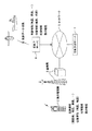
図1に示すように、気象予測サーバ1は、気象衛星や各観測所等から気象情報を受信する気象庁サーバ4とネットワーク5を介して接続されており、気象庁サーバ4から気象情報や、当該気象情報を観測した位置情報、時間情報を得ることができるようになっている。気象庁サーバ4から受信した気象情報等は、気象予測サーバ1内に記憶され、気象予測に用いられる。
ここで、気象情報は、例えば、気温、湿度、気圧、雲量、天気等の観測値である。また、位置情報とは、気象情報を観測した緯度及び経度である。また、時間情報とは、気象情報を観測した日時である。
【0021】
また、気象予測サーバ1は、携帯電話機2に通信回線を提供する電話局の基地局3とネットワーク5を介して接続されており、携帯電話機2から気象情報や、当該気象情報を観測した位置情報、時間情報、雲画像データを得ることができるようになっている。
【0022】
具体的に、例えば、図14に示すように、気象予測サーバ1は、観測地P1〜P13及び気象庁ごとに観測した気象情報、雲画像データ、位置情報、時間情報を携帯電話機2や気象庁サーバ4から受信する。そして、気象予測サーバ1は、受信した雲画像データの特徴を抽出し、図15に示すような雲特徴データと比較し、観測地ごとに雲の種類を特定する。
そして、気象予測サーバ1は、受信した気象情報等と特定した雲の種類に基づいて、図17、図18に示すように、気象予測サーバ1に記憶された地図上に気圧配置データ、雲の配置データを作成するとともに、図16に示すような気象予測情報基礎データを作成する。更に、気象予測サーバ1は、携帯電話機2等から要求された位置の気象予測を気象予測情報基礎データに基づいて行い、予測した気象情報を要求した携帯電話機2に提供する。
【0023】
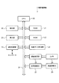
図2に示すように、気象予測サーバ1は、各部を制御するCPU10、CPU10のワークエリア等として使用されるRAM11、CPU10が各部を制御するのに必要なシステムプログラム等が記憶されたROM12、特定された雲の種類と気圧データとを含む気象情報と、気象情報を観測した時間情報と、気象情報を送信した携帯電話機2の位置情報とを対応づけて記憶する記憶手段としての記憶部13と、発振回路部14から発振される所定周波数のクロック信号を分周して年月日及び時刻を計時し、CPU10に出力する計時回路部15、基地局3との通信を制御する通信制御部16、基地局3等との通信状況等を表示する表示部17、各情報の整理や保存等の操作を行う操作部18等を備えて構成されている。また、各部はバスライン19によって接続されている。
ここで、気象情報は、気圧、照度、雲画像等を観測したデータである。また、位置情報とは、気象情報を観測した緯度及び経度である。また、時間情報とは、気象情報を観測した日時である。
【0024】
CPU10は、ROM12内に格納されたプログラムを読み出してRAM11内に展開し、当該プログラムに基づいて各部への指示やデータの送受信等を制御する。
具体的に、CPU10は、通信制御部16を介して受信した雲画像データと気圧データとを含む気象情報、この気象情報を観測した時間情報について気象予測に使用可能か否かの信頼性を評価する信頼性評価手段として機能する。また、CPU10は、この信頼性評価において、雲画像データの色調を判別する色調判別手段として機能するとともに、判別された雲画像データの色調に基づいて、気象予測に使用可能か否かを判断する判断手段として機能する。
また、CPU10は、雲画像データの特徴を抽出する特徴抽出手段として機能するとともに、抽出された雲画像データの特徴と予め記憶部13に記憶されている雲特徴データとを比較することにより、雲の種類を特定する雲特定手段として機能する。
【0025】
また、CPU10は、この特定された雲の種類と、気圧データを含む気象情報と、当該気象情報を観測した時間情報と、通信制御部16により受信した当該気象情報を送信した携帯電話機2の位置情報とを対応づけて記憶部13に記憶させるとともに、当該気象情報を送信した携帯電話機2にポイント加算情報を通知する機能を有する。
ここで、ポイント加算情報とは、例えば、気象予測サーバ1を所有する業者等からのサービスを受けるために必要な情報であり、貯めたポイントによって様々なサービスを受けることができるようになっている。これにより、ユーザに積極的に気象情報を送信させることができ、気象予測の精度や信頼性を高めることができるようになっている。
【0026】
また、CPU10は、記憶部13に記憶された雲の種類、気象情報、位置情報とに基づいて、雲の配置データ及び気圧配置データを含む気象予測基礎データを作成する気象予測基礎データ作成手段として機能する。
また、CPU10は、携帯電話機2から受信した気象予測情報を必要とする場所の位置情報に基づいて、該当する位置の雲の種類を記憶部13に記憶された雲の配置データから検索する雲種類検索手段として機能するとともに、当該位置情報に基づいて、該当する位置の気圧を記憶部13に記憶された気圧配置データから検索する気圧検索手段として機能する。
【0027】
更に、CPU10は、気象予測情報を必要とする場所の位置情報と記憶部13に記憶された気象予測基礎データとから当該位置の気象予測を行う気象予測手段として機能する。
【0028】
RAM11は、CPU10のワークエリアを形成するとともに、CPU10の制御の下、処理データを一時的に記憶するメモリエリアを有する。
【0029】
ROM12には、CPU10が各種機能を実行するためのプログラムが格納されている。
具体的には、ROM12は、図3に示すように、携帯電話機2から気象情報を提供したい旨の提供希望信号を受信する機能を実現させる提供希望信号受信プログラム12a、気象情報の提供希望信号を送信した携帯電話機2から雲画像データと気圧データを含む気象情報と、この気象情報を観測した時間情報とを受信する機能を実現させる気象時間情報受信プログラム12b、当該気象情報及び当該時間情報を送信した携帯電話機2の位置情報を受信する機能を実現させる位置情報受信プログラム12cを有する。
【0030】
また、ROM12は、受信した雲画像データと気圧データを含む気象情報、この気象情報を観測した時間情報について気象予測に使用可能か否かの信頼性を評価する機能を実現させる信頼性評価プログラム12dを有する。この信頼性評価プログラム12dは、雲画像データの色調を判別する機能を実現させる色調判別プログラム12e、判別された雲画像データの色調に基づいて、気象予測に使用可能か否かを判断する機能を実現させる使用判断プログラム12fを有する。
【0031】
また、ROM12は、雲画像データの特徴を抽出する機能を実現させる特徴抽出プログラム12g、雲画像データの特徴と雲特徴データとを比較して、雲の種類を特定する機能を実現させる雲特定プログラム12h、雲の種類と気象情報と位置情報と時間情報とに基づいて、雲の配置データ及び気圧配置データを含む気象予測基礎データを作成する機能を実現させる気象予測基礎データ作成プログラム12iを有する。
【0032】
また、ROM12は、携帯電話機2から気象予測情報を必要とする場所の位置情報を受信する機能を実現させる予測位置情報受信プログラム12j、気象予測情報を必要とする場所の位置情報に基づいて、該当する位置の雲の種類を記憶部13に記憶された雲の配置データから検索する機能を実現させる雲種類検索プログラム12k、気象予測情報を必要とする場所の位置情報に基づいて、該当する位置の気圧を記憶部13に記憶された気圧配置データから検索する機能を実現させる気圧検索プログラム12mを有する。
【0033】
更に、CPU10は、気象予測情報を必要とする場所の位置情報と作成された気象予測基礎データとから当該位置の気象予測を行う機能を実現させる気象予測プログラム12n、気象予測により作成された気象予測情報を携帯電話機2に送信する機能を実現させる気象予測情報送信プログラム12pを有する。
【0034】
記憶部13は、気象情報と、気象情報を観測した時間情報と、気象情報を送信した携帯電話機2の位置情報と、を対応づけて記憶する記憶手段として機能する。また、記憶部13は、雲特徴データを記憶する雲特徴データ記憶手段として機能する。また、記憶部13は、作成された気象予測基礎データを記憶する気象予測基礎データ記憶手段として機能する。
【0035】
記憶部13には、図4に示すように、複数のメモリエリアが設けられている。
具体的には、受信した気象情報を記憶する気象情報エリア13a、特定された雲の種類及び雲のマークを記憶する雲の種類情報エリア13b、位置情報を記憶する位置情報エリア13c、時間情報を記憶する時間情報エリア13d、気象予測基礎データを記憶する気象予測基礎データエリア13e、雲特徴データを記憶する雲特徴データエリア13f、気象予測情報を記憶する気象予測情報エリア13g等が設けられている。
【0036】
ここで、雲特徴データは、図15に示すように、雲の種類、その雲の地図上でのマーク、その雲の種類を表す記号、雲の特徴としての色調データ、形状データ、雲の高度、天気等が各雲に対応付けられている。例えば、雲の種類が「巻雲」であれば、記号は「Ci1」、高度は「上層」、天気は「比較的良い」等の特徴がわかるようになっている。
【0037】
気象情報エリア13aには、更に、複数のメモリエリアが設けられ、携帯電話機2が観測した気圧情報を記憶する気圧データエリア13v、携帯電話機2が撮像した雲画像情報を記憶する雲画像データエリア13wが設けられている。
また、気象予測基礎データエリア13eには、更に、複数のメモリエリアが設けられ、作成された気圧配置データを記憶する気圧配置データエリア13y、作成された雲の配置データを記憶する雲の配置データエリア13zが設けられている。
【0038】
計時回路部15は、発振回路部14から入力されるクロック信号を計数して、現在時刻データ等を得る。そして、現在時刻データをCPU10に出力する。発振回路部14は、常時一定周波数のクロック信号を出力するようになっている。
【0039】
通信制御部16は、ネットワーク5に接続され、抽出された気象予測情報を携帯電話機2に送信する気象予測情報送信手段としての機能、携帯電話機2から天空の雲を撮像した雲画像データと気圧データを含む気象情報、当該気象情報を観測した時間情報を受信する受信手段としての機能、携帯電話機2にネットワーク5を介して接続された基地局3から、携帯電話機2の位置情報を受信する位置情報受信手段としての機能、携帯電話機2から気象予測情報を必要とする場所の位置情報を受信する予測位置情報受信手段としての機能、気象予測を行った結果を携帯電話機2に送信する気象予測情報送信手段としての機能を有する。
【0040】
表示部17は、気象予測サーバ1に接続され、基地局3等との通信状況等を表示するモニタ等から構成される。
【0041】
操作部18は、気象予測サーバ1に接続され、各情報の整理や保存等の操作を行うキーボード等から構成される。
【0042】
次に、携帯電話機2の構成について説明する。
図5に示すように、携帯電話機2は、各部を制御するCPU20、CPU20のワークエリア等として使用されるRAM21、CPU20が各部を制御するのに必要なシステムプログラム等が記憶されたROM22、気圧や照度等の気象情報を計測する気象データ計測部23、カメラ24で撮像した天空の雲画像データの画像処理を行う画像処理部25、発振回路部26から発振される所定周波数のクロック信号を分周して年月日及び時刻を計時し、CPU20に出力する計時回路部27、基地局3との通信を制御する通信制御部28、基地局3等との通信状況等を表示する表示部29、各種処理を実行させるための操作を行う操作部30等を備えて構成されている。また、各部はバスライン31によって接続されている。
【0043】
CPU20は、ROM22内に格納されたプログラムを読み出してRAM21内に展開し、当該プログラムに基づいて各部への指示やデータの送受信等の制御を行う。
具体的には、CPU20は、気象予測サーバ1に気象情報の提供希望信号を送信するように通信制御部28を制御し、時間情報を抽出するように計時回路部27を制御し、気象予測サーバ1に気象情報と時間情報を送信するように通信制御部28を制御し、気象予測サーバ1からポイント加算情報を受信するように通信制御部28を制御する。
【0044】
また、CPU20は、気象予測情報の提供要求信号、気象予測情報を必要とする場所の位置情報を気象予測サーバ1に送信するように通信制御部28を制御し、気象予測サーバ1から気象予測情報を受信するように通信制御部28を制御し、受信した気象予測情報を出力する。
【0045】
RAM21は、CPU20のワークエリアを形成するとともに、CPU20の制御の下、処理データを一時的に記憶するメモリエリアを有する。
【0046】
ROM22には、CPU20が各種機能を実行するためのプログラムが格納されている。
具体的には、ROM22は、気象予測サーバ1に気象情報の提供希望信号を送信する機能を実現させるプログラム、時間情報を抽出する機能を実現させるプログラム、気象予測サーバ1に気象情報と時間情報を送信する機能を実現させるプログラム、気象予測サーバ1からポイント加算情報を受信する機能を実現させるプログラムを有する。
【0047】
また、ROM22は、気象予測情報の提供要求信号、気象予測情報を必要とする場所の位置情報を気象予測サーバ1に送信する機能を実現させるプログラム、気象予測サーバ1から気象予測情報を受信する機能を実現させるプログラム、受信した気象予測情報を出力する機能を実現させるプログラムを有する。
【0048】
気象データ計測部23は、気圧を計測する気圧計測手段としての気圧計、照度を計測する照度計等を備えている。これらは、携帯電話機2に内蔵されるものであってもよいし、外部に取り付けるものであってもよい。
【0049】
画像処理部25は、天空の雲を撮像する撮像手段としてのカメラ24から雲画像データを取り込み、色調を判別したり、特徴を抽出したりするための画像処理を行う。
【0050】
計時回路部27は、発振回路部26から入力されるクロック信号を計数して、現在時刻データ等を得る計時手段としての機能を有する。そして、現在時刻データをCPU20に出力する。発振回路部26は、常時一定周波数のクロック信号を出力するようになっている。
【0051】
通信制御部28は、計測された気圧データと撮像された雲画像データと計時された時間情報とを携帯電話機2にネットワーク5を介して接続された気象予測サーバ1に送信するデータ送信手段としての機能を有する。
【0052】
表示部29は、観測したデータ等を表示するLCD(Liquid Crystal Display)等から構成される。
【0053】
操作部30は、各情報の整理や保存等の操作を行う入力キー等から構成される。
【0054】
気象庁サーバ4は、気象衛星や各観測所等から気象情報を受信したり、受信した気象情報を気象予測サーバ1に定期的に送信する機能を備えている。
【0055】
次に、上記構成を有する気象予測サーバ1及び携帯電話機2による各種処理について、図6〜図14を用いて説明する。
まず、気象予測サーバ1における気象情報の受信処理について、図6〜図8を用いて説明する。
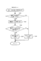
図6に示すように、CPU10が提供希望信号受信プログラム12aを実行することにより、通信制御部16がネットワーク5を介して携帯電話機2から気象情報を提供したい旨の提供希望信号を受信すると(ステップS1;YES)、CPU10が気象時間情報受信プログラム12bを実行することにより、通信制御部16は、その携帯電話機2から気象情報と時間情報を受信し、RAM11に記憶させる(ステップS2)。
【0056】
具体的に、気象予測サーバ1は、図14に示すように、各観測地P1〜P13及び気象庁Wの気象情報(気圧データ、照度データ)、雲画像データ、位置情報(緯度、経度)、時間情報(時間、日)を携帯電話機2から受信する。
【0057】
ここで、通信制御部16が提供希望信号を受信しなければ(ステップS1;NO)、通信制御部16が提供希望信号を受信するまで同ステップが繰り返して行われる。
【0058】
次いで、CPU10は、位置情報受信プログラム12cを実行することにより、携帯電話機2にネットワーク5を介して接続された基地局3から携帯電話機2の位置情報を受信し、RAM11に記憶させる(ステップS3)。
次いで、CPU10は、信頼性評価プログラム12dを実行することにより、受信した気象情報と時間情報について気象予測に使用可能か否かの信頼性を評価する(ステップS4)。
【0059】
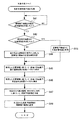
ここで、ステップS4における受信した気象情報と時間情報の信頼性評価処理について、図7を用いて説明する。
図7に示すように、CPU10は、受信した気象情報が周囲の気象情報からかけ離れているか否かを判断する(ステップS11)。ここで、CPU10が、受信した気象情報が周囲の気象情報からかけ離れていると判断した場合(ステップS11;YES)、受信した気象情報は「使用不可」の旨をRAM11に記憶させ(ステップS13)、図6のステップS5に移行する。一方、CPU10が、受信した気象情報が周囲の気象情報からかけ離れていないと判断した場合(ステップS11;NO)、信頼性評価プログラム12dに格納された色調判別プログラム12eを実行することにより、雲画像データの色調を判別し(ステップS12)、判別した雲画像の色調をRAM11に記憶させる。
ここで、「受信した気象情報が周囲の気象情報からかけ離れている場合」とは、気象現象の連続性の観点から不自然な場合をいい、例えば、周囲の照度データが「昼」に相当するにもかかわらず、「夜」に相当する照度データとなっている場合等をいうが、その判別方法は任意に定めて良い。なお、上記判断は、気圧データや時間データに関して行っても良い。
【0060】
次いで、CPU10が、信頼性評価プログラム12dに格納された使用判断プログラム12fを実行することにより、雲画像データに白系又はグレー系又は青系以外の色調があるか否かを判断する(ステップS14)。ここで、CPU10が、雲画像データに白系又はグレー系又は青系以外の色調があると判断した場合(ステップS14;YES)、受信した気象情報は「使用不可の旨」をRAM11に記憶させ(ステップS13)、図6のステップS5に移行する。一方、CPU10が、雲画像データに白系又はグレー系又は青系以外の色調がないと判断した場合(ステップS14;NO)、受信した気象情報は「使用可能の旨」をRAM11に記憶させ(ステップS15)、図6のステップS5に移行する。
ここで、ステップS14における判断は、天空の色は、晴れている部分であれば「青系色」であり、曇りの部分であれば「白系色」或いは「グレー系色」となるので、他の色調が存在する場合は、天空の画像でないと判断するものである。
【0061】
上記信頼性評価処理が終わると、再び、図6のフローチャートに戻って、CPU10は、RAM11の「使用不可の旨」「使用可能の旨」を読み出し、受信した気象情報は気象予測に使用可能か否かを判断する(ステップS5)。ここで、CPU10が「使用不可の旨」を読み出した場合(ステップS5;NO)、通信制御部16は、携帯電話機2に受信した気象情報は気象予測に使用できないことを通知し(ステップS7)、これをもって本処理を終了する。一方、CPU10が「使用可能の旨」を読み出した場合(ステップS5;YES)、特徴抽出プログラム12g及び雲特定プログラム12hを実行することにより、受信した雲画像データから雲の種類を特定する(ステップS6)。
【0062】
ここで、ステップS6における雲の種類の特定処理について、図8を用いて説明する。
図8に示すように、CPU10は、RAM11の雲画像データの色調を読み出し(ステップS21)、読み出した雲画像データに白系又はグレー系の色調があるか否かを判断する(ステップS22)。ここで、CPU10が、雲画像データに白系又はグレー系の色調がないと判断した場合(ステップS22;NO)、雲画像データには青系の色調しか存在しないことになるので、「快晴の旨」をRAM11に記憶させ(ステップS23)、図6のステップS8に移行する。一方、雲画像データに白系又はグレー系の色調があると判断した場合(ステップS22;YES)、雲画像データには雲が撮像されていることになるので、特徴抽出プログラム12gを実行することにより、雲画像データの特徴として雲の形状を抽出する(ステップS24)。
【0063】
具体的に、雲の形状は、例えば、雲画像の不連続部分をエッジとしてエッジ抽出し、このエッジを天空と雲の境界線として雲の形状を抽出する方法や、雲画像を連結領域に分割して、領域として抽出する方法や、雲画像からテクスチャ自身の持つ固有の特徴を抽出してモデル化を行い、画像パターンの同定を行う方法によって抽出される。なお、雲の形状の抽出はこれに限られるものではない。
【0064】
次いで、CPU10は、雲特定プログラム12hを実行することにより、雲の色調及び雲の形状と、雲特徴データエリア13fに記憶されている雲特徴データ(雲の色調及び雲の形状)とを比較して、雲画像データの雲の種類を特定する(ステップS25)。
【0065】
具体的に、雲の種類の特定は、例えば、図14に示すように、観測地P1で撮像された雲画像データkm.1の雲の色調を判別するとともに、雲の形状を抽出し、図15に示す雲特徴データに記憶されている色調データ及び形状データと比較する。そして、最も近い色調及び形状を有する雲の種類を、撮像された雲の種類であると特定する。
【0066】
次いで、CPU10は、特定された雲の種類をRAM11に記憶させる(ステップS26)。
【0067】
上記雲の種類の特定処理が終わると、再び、図6のフローチャートに戻って、CPU10は、RAM11から気象情報、雲の種類、位置情報、時間情報を読み出し、気象情報を気象情報エリア13aに記憶させ、雲の種類及び雲のマークを雲の種類情報エリア13bに記憶させ、位置情報を位置情報エリア13cに記憶させ、時間情報を時間情報エリア13dに記憶させる(ステップS8)。
【0068】
具体的に、上記の各データは、図16に示すように、気圧データを気圧データエリア13vに、雲の種類及び雲のマークを雲の種類情報エリア13bに、緯度及び経度を位置情報エリア13cに、時間及び日を時間情報エリア13dに、それぞれ対応付けて記憶される。
【0069】
次いで、CPU10は、気象情報を送信した携帯電話機2にポイント加算情報を通知し(ステップS9)、これをもって本処理を終了する。
【0070】
次に、気象予測サーバ1における気象予測基礎データの作成処理について、図9を用いて説明する。
まず、CPU10は、気象予測基礎データを作成する時間となったか否かを判断する(ステップS31)。ここで、CPU10が、作成処理を行う時間になったと判断すると(ステップS31;YES)、気象庁サーバ4から気象情報、位置情報、時間情報及び雲の配置図データ、気圧配置図データを取得し、記憶部13に記憶させる(ステップS32)。
【0071】
次いで、CPU10は、気象予測基礎データ作成プログラム12iを実行することにより、気象庁サーバ4から取得した雲の配置図データに、特定された雲の種類を配置した雲の配置データを作成し、気象予測基礎データエリア13e内の雲の配置データエリア13zに記憶させる(ステップS33)。また、CPU10は、気象予測基礎データ作成プログラム12iを実行することにより、気象庁サーバ4から取得した気圧配置図データに、気圧データエリア13vに記憶された気圧データに基づいて気圧配置データを作成し、気象予測基礎データエリア13e内の気圧配置データエリア13yに記憶させ(ステップS34)、これをもって本処理を終了する。
【0072】
具体的に、気象予測基礎データの作成は、例えば、図17に示すように、気象庁サーバ4から気圧配置図データを受信したとすると、CPU10は、記憶部13から気圧データ、位置情報を読み出し、気圧配置図データ上の当該位置情報に対応する位置に気圧データを配置して、気圧配置データを作成する。図17中の観測地P1〜P13と気象庁Wが配置された気圧データである。
また、気象庁サーバ4から、図18に示すような雲の配置図データを受信したとすると、CPU10は、記憶部13から雲の種類データ、位置情報を読み出し、雲の配置図データ上の当該位置情報に対応する位置に雲の種類データを配置して、雲の配置データを作成する。図18中のP1〜P13とWが配置された雲の種類である。
【0073】
これによって、等圧線の間の局所的な気圧を取得でき、気圧配置データは、気象庁サーバ4から受信した気圧配置図データに比べてより高精度な気圧配置図を作成することができるので、気象予測の精度をより向上させることができる。また、雲画像データの中の局所的な雲の種類を取得でき、雲の配置データは、気象庁サーバ4から受信した雲の配置図データに比べてより高精度な雲の配置図を作成することができるので、気象予測の精度をより向上させることができる。
【0074】
次に、気象予測サーバ1における気象予測情報の提供処理について、図10を用いて説明する。
まず、CPU10は、携帯電話機2から気象予測情報の提供要求信号を受信したか否かを判断する(ステップS41)ここで、CPU10が、提供要求信号を受信したと判断した場合(ステップS41;YES)、携帯電話機2から気象予測情報を必要とする場所の位置情報を受信したか否かを判断する(ステップS42)。一方、CPU10が、提供要求信号を受信していないと判断した場合(ステップS41;NO)、当該提供要求信号を受信するまで同ステップを繰り返して行う。
【0075】
ステップS42において、CPU10が、予測位置情報受信プログラム12jを実行することにより、携帯電話機2から気象予測情報を必要とする場所の位置情報を受信したと判断した場合(ステップS42;YES)、通信制御部16は、携帯電話機2から予測位置情報を受信し(ステップS43)、更に、CPU10が、雲種類検索プログラム12kを実行することにより、受信した予測位置情報に基づく位置における雲の種類を雲の配置データエリア13zから検索し、検索された雲の種類をRAM11に記憶させる(ステップS45)。一方、CPU10が、予測位置情報受信プログラム12jを実行することにより、携帯電話機2から気象予測情報を必要とする場所の位置情報を受信していないと判断した場合(ステップS42;NO)、通信制御部16は、基地局3から提供要求信号を送信した携帯電話機2の位置情報を受信し(ステップS44)、更に、CPU10が、雲種類検索プログラム12kを実行することにより、受信した位置情報に基づく位置における雲の種類を雲の配置データエリア13zから検索し、RAM11に記憶させる(ステップS45)。
【0076】
次いで、CPU10は、気圧検索プログラム12mを実行することにより、受信した予測位置情報又は位置情報に基づく位置における気圧を気圧配置データエリア13yから検索し、RAM11に記憶させる(ステップS46)。
【0077】
次いで、CPU10は、気象予測プログラム12nを実行することにより、検索された雲の種類と気圧とに基づいて、気象予測情報を作成し、RAM11に記憶させる(ステップS47)。なお、気象予測情報は、図4に示す気象予測情報エリア13gに記憶してもよい。
【0078】
次いで、CPU10は、気象予測情報送信プログラム12pを実行することにより、作成された気象予測情報を、通信制御部16を介して携帯電話機2に送信し(ステップS48)、これをもって本処理を終了する。
【0079】
次に、携帯電話機2における気象情報の送信処理について、図11を用いて説明する。
まず、CPU20は、ユーザが通話を開始したか否かを判断する(ステップS51)。ここで、CPU20が、通話を開始したと判断した場合(ステップS51;YES)、通話を終了したかを判断する(ステップS52)。一方、CPU20が、通話を開始していないと判断した場合(ステップS51;NO)、気象情報の計測指示がなされているか否かを判断する(ステップS53)。
【0080】
ステップS52において、CPU20が、通話を終了したと判断した場合(ステップS52;YES)、通信制御部28が、気象予測サーバ1に気象情報の提供希望信号を送信する(ステップS54)。一方、CPU20が、通話を終了していないと判断した場合(ステップS52;NO)、通話が終了するまで処理は進行しない。
【0081】
ステップS53において、CPU20が、気象情報の計測指示がなされたと判断した場合(ステップS53;YES)、通信制御部28が、気象予測サーバ1に気象情報の提供希望信号を送信する(ステップS54)。一方、CPU20が、気象情報の計測指示がなされていないと判断した場合(ステップS53;NO)、再度、ステップS51に戻る。
【0082】
次いで、CPU20は、ユーザからの計測指示に基づいて、気圧計測の制御を行い(ステップS55)、照度計測の制御を行い(ステップS56)、雲画像データの撮像の制御を行う(ステップS57)。更に、CPU20は、計時回路部27より気象情報を計測した時間情報を抽出する(ステップS58)。なお、CPU20は、これらの気象情報、時間情報を全てRAM21に記憶させる。
【0083】
次いで、CPU20は、気圧データ、照度データ、雲画像データ、時間情報を通信制御部28を介して気象予測サーバ1に送信する(ステップS59)。
【0084】
次いで、CPU20は、気象情報、時間情報を受信した気象予測サーバ1からポイント加算情報を受信し(ステップS60)、これをもって本処理を終了する。
【0085】
次に、携帯電話機2における気象予測情報の提供要求処理について、図12、図13を用いて説明する。
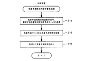
まず、携帯電話機2のユーザが気象予測情報を必要とする場所を指定した場合について、図12を用いて説明する。
まず、通信制御部28は、気象予測情報の提供要求信号、気象予測情報を必要とする場所の予測位置情報を気象予測サーバ1に送信する(ステップS71)。
次いで、通信制御部28は、気象予測サーバ1から気象予測情報を受信し、RAM21に記憶させる(ステップS72)。
次いで、ユーザが操作部30を操作することにより、CPU20は、受信した気象予測情報を携帯電話機2の表示部29に表示し(ステップS73)、これをもって本処理を終了する。
【0086】
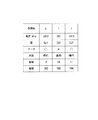
具体的に、気象予測サーバ1が、携帯電話機2から気象予測情報の提供要求信号、予測位置情報を受信し、例えば、図17、図18に示すように、予測地がa、i、rの三点であったとすると、予測地aは、観測地P1の近くに位置し、予測値iは、観測地P7の近くに位置し、予測値rは、観測地P11の近くに位置している。
【0087】
従って、予測地aには、図16に示す観測地P1の気圧1012hPa、雲の種類Cc1及び雲のマーク(○)があてがわれる。また、予測地iには、観測地P7の気圧990hPa、雲の種類Cb1及び雲のマーク(×)があてがわれる。また、予測地rには、観測地P11の気圧1010hPa、雲の種類Cc1及び雲のマーク(○)があてがわれる。
そして、予測地aの雲の種類がCc1であることから、図15の雲特徴データと比較すると、巻積雲であることがわかり、天気が良いと予測できる。また、予測地iの雲の種類がCb1であることから、図15の雲特徴データと比較すると、積乱雲であることがわかり、天気が夕立や雷と予測できる。また、予測地rの雲の種類がCc1であることから、図15の雲特徴データと比較すると、巻積雲であることがわかり、天気が良いと予測できる。
更に、予測された天気、気圧、雲の種類が、図19に示すように、気象予測情報として作成され、提供要求信号を送信した携帯電話機2に送信される。
【0088】
次に、携帯電話機2のユーザが気象予測情報を必要とする場所を指定しない場合について、図13を用いて説明する。
まず、通信制御部28は、気象予測情報の提供要求信号を気象予測サーバ1に送信する(ステップS81)。
次いで、通信制御部28は、気象予測サーバ1から気象予測情報を受信し、RAM21に記憶させる(ステップS82)。
次いで、ユーザが操作部30を操作することにより、CPU20は、受信した気象予測情報を携帯電話機2の表示部29に表示し(ステップS83)、これをもって本処理を終了する。
【0089】
本実施の形態の気象予測サーバ1及び携帯電話機2によれば、通信制御部16が雲画像データと気圧データを含む気象情報、時間情報を受信し、更に、通信制御部16が基地局3から携帯電話機2の位置情報を受信する。そして、雲画像データに基づいて、雲の種類が特定され、特定された雲の種類と気圧データを含む気象情報と、気象情報を観測した時間情報と、気象情報を送信した携帯電話機2の位置情報とが対応づけられて記憶部13に記憶される。そして、記憶部13に記憶された雲の種類、気象情報、位置情報とに基づいて、雲の配置データ及び気圧配置データを含む気象予測基礎データが作成され、気象予測基礎データが気象予測基礎データエリア13eに記憶される。更に、気象予測情報を必要とする場所の位置情報と気象予測基礎データとから、その位置の気象予測情報が求められる。
従って、気象予測は、携帯電話機2で撮像した雲画像データ、気圧データを用いて行われているので、より局所的な雲画像データ、気圧データを用いて気象予測が行われることとなって、従来の気象予測に比べてより精度よく気象予測を行うことができる。よって、例えば、台風などの災害時において、災害地域の局所的な気象予測を高精度で行うことができる。また、雲画像データを撮像するに際し、気象衛星のような大がかりな設備を必要とせず、簡単に気象予測を行うことができる。
【0090】
また、受信された雲画像データと気圧データを含む気象情報と、この気象情報を観測した時間情報について気象予測に使用可能か否かの信頼性が評価される。
従って、気象予測に使用可能であると評価された気象情報だけが気象予測に用いられるので、より高精度な気象予測を行うことができる。
【0091】
更に、雲画像データは、色調が判別され、判別された雲画像データの色調に基づいて、気象予測に使用可能か否かが判断される。
従って、雲画像データの色調を判別することで使用の有無が判断されるので、気象予測に使用可能な雲画像データだけを確実に選別して気象予測を行うことができ、高精度な気象予測を行うことができる。
【0092】
また、雲画像データの特徴が抽出され、抽出された雲画像データの特徴と、雲特徴データエリア13fに記憶されている雲特徴データとを比較することにより、雲の種類が特定される。
従って、雲画像データの特徴を抽出することによって雲の種類が特定されるので、ユーザの目視による観測に頼ることなく、一定の基準のもと自動的に雲の種類を特定することができる。これにより、雲の種類を知らない携帯電話機2のユーザでも気軽に気象情報を提供することができることとなって、気象情報の取得がしやすく、より多くの気象情報に基づいて正確な気象予測を行うことができる。
【0093】
更に、携帯電話機2から気象予測情報を必要とする場所の位置情報を受信し、受信した位置情報に基づいて、該当する位置の雲の種類が気象予測基礎データエリア13eに記憶された雲の配置データから検索される。そして、受信した位置情報に基づいて、該当する位置の気圧が気象予測基礎データエリア13eに記憶された気圧配置データから検索される。そして、検索された雲の種類と、検索された気圧とに基づいて気象予測が行われ、この気象予測により得られた気象予測情報が携帯電話機2に送信される。
従って、携帯電話機2から気象予測情報を必要とする場所の位置情報を受信するだけで、雲の配置データと気圧配置データとに基づいて気象予測を行って、携帯電話機2に送信することができるので、ユーザが手軽に気象情報の提供を受けることができる。
【0094】
また、気圧が計測され、天空の雲が撮像され、気圧を計測した時間と天空の雲を撮像した時間とが計時される。そして、計測された気圧データと撮像された雲画像データと計時された時間情報とが携帯電話機2にネットワーク5を介して接続された気象予測サーバ1に送信される。
従って、携帯電話機2は、気圧と雲の撮像データと時間情報を計測して気象予測サーバ1に送信するだけでよいので、ユーザが手軽に気象情報を提供することができる。
【0095】
なお、本発明は上記実施の形態に限定されるものではない。例えば、携帯電子機器は携帯電話機2に限らず、PDA等を用いてもよい。また、時間情報の取得は、携帯電話機2からに限らず、気象予測サーバ1からでもよい。また、気象情報は携帯電話機2で計測するものに限らず、気象庁サーバ4から受信した気象情報を用いてもよい。また、気象予測の開始時刻は任意であって、気象予測サーバ1の管理者が決定してもよいし、気象庁の気象予測に合わせてもよい。また、気象情報として気圧と照度を計測したが、気温や湿度を計測して気象予測に反映させてもよい。また、ROM12内には複数のプログラムが格納されているが、各機能を一つのプログラムで処理するようにしてもよい。
その他、発明の要旨を逸脱しない範囲内で変更が可能である。
【0096】
【発明の効果】
請求項1、7に記載の発明によれば、気象予測は、携帯電子機器で撮像した雲画像データ、気圧データを用いて行われているので、より局所的な雲画像データ、気圧データを用いて気象予測が行われることとなって、従来の気象予測に比べてより精度よく気象予測を行うことができる。従って、例えば、台風などの災害時において、災害地域の局所的な気象予測を高精度で行うことができる。また、雲画像データを撮像するに際し、気象衛星のような大がかりな設備を必要とせず、簡単に気象予測を行うことができる。
【0097】
請求項2に記載の発明によれば、信頼性評価手段は、受信手段によって受信された雲画像データと気圧データを含む気象情報と、この気象情報を観測した時間情報について気象予測に使用可能か否かの信頼性を評価する。
よって、信頼性評価手段によって気象予測に使用可能であると評価された気象情報だけが気象予測に用いられるので、より高精度な気象予測を行うことができる。
【0098】
請求項3に記載の発明によれば、色調判別手段が雲画像データの色調を判別し、判断手段が色調判別手段により判別された雲画像データの色調に基づいて、気象予測に使用可能か否かを判断する。
よって、雲画像データの色調を判別することで使用の有無が判断されるので、気象予測に使用可能な雲画像データだけを確実に選別して気象予測を行うことができ、高精度な気象予測を行うことができる。
【0099】
請求項4に記載の発明によれば、雲画像データの特徴を抽出することによって雲の種類が特定されるので、ユーザの目視による観測に頼ることなく、一定の基準のもと自動的に雲の種類を特定することができる。これにより、雲の種類を知らない携帯電子機器の所有者でも気軽に気象情報を提供することができることとなって、気象情報の取得がしやすく、より多くの気象情報に基づいて正確な気象予測を行うことができる。
【0100】
請求項5に記載の発明によれば、端末装置から気象予測情報を必要とする場所の位置情報を受信するだけで、雲の配置データと気圧配置データとに基づいて気象予測を行って、端末装置に送信することができるので、ユーザが手軽に気象情報の提供を受けることができる。
【0101】
請求項6に記載の発明によれば、気象情報計測手段が気象情報を計測し、撮像手段が天空の雲を撮像し、計時手段が、気象情報を計測した時間と天空の雲を撮像した時間とを計時する。そして、データ送信手段が、計測された気象情報と撮像された雲の撮像データと計時された時間情報とを携帯電子機器にネットワークを介して接続された気象予測サーバに送信する。
よって、携帯電子機器は、気象情報と雲の撮像データと時間情報を計測して気象予測サーバに送信するだけでよいので、ユーザが手軽に各データを提供することができる。
【図面の簡単な説明】
【図1】本発明の実施の形態における気象予測サーバ、携帯電話機の概要図である。
【図2】本発明の実施の形態における気象予測サーバのブロック図である。
【図3】本発明の実施の形態のROM内の構成の説明図である。
【図4】本発明の実施の形態の記憶部内の構成の説明図である。
【図5】本発明の実施の形態における携帯電話機のブロック図である。
【図6】本発明の実施の形態における気象情報の受信処理を説明するためのフローチャートである。
【図7】本発明の実施の形態における受信した気象情報、時間情報の信頼性評価処理を説明するためのフローチャートである。
【図8】本発明の実施の形態における雲の種類の特定処理を説明するためのフローチャートである。
【図9】本発明の実施の形態における気象予測基礎データの作成処理を説明するためのフローチャートである。
【図10】本発明の実施の形態における気象予測情報の提供処理を説明するためのフローチャートである。
【図11】本発明の実施の形態における気象情報の送信処理を説明するためのフローチャートである。
【図12】本発明の実施の形態における気象予測情報を要求する位置を指定した場合の気象予測情報の提供要求処理を説明するためのフローチャートである。
【図13】本発明の実施の形態における現在位置の気象予測情報の提供要求処理を説明するためのフローチャートである。
【図14】本発明の実施の形態における携帯電話機から受信した雲画像データを含む気象情報、位置情報、時間情報を示す図である。
【図15】本発明の実施の形態における雲特徴データを示す図である。
【図16】本発明の実施の形態における気象予測基礎データを示す図である。
【図17】本発明の実施の形態における気圧配置図データに気圧データを配置した気圧配置データを示す図である。
【図18】本発明の実施の形態における雲の配置図データに雲の種類を配置した雲の配置データを示す図である。
【図19】本発明の実施の形態における気象予測情報を示す図である。
【符号の説明】
1 気象予測サーバ
2 携帯電話機(携帯電子機器、端末装置)
10 CPU(気象予測基礎データ作成手段、気象予測手段、信頼性評価手段、色調判別手段、判断手段、特徴抽出手段、雲特定手段、雲種類検索手段、気圧検索手段)
11 RAM
12 ROM
13 記憶部(記憶手段、気象予測基礎データ記憶手段、雲特徴データ記憶手段)
16 通信制御部(受信手段、位置情報受信手段、予測位置情報受信手段、気象予測情報送信手段)
23 気象データ計測部(気圧計測手段)
24 カメラ(撮像手段)
27 計時回路部(計時手段)
28 通信制御部(データ送信手段)[0001]
TECHNICAL FIELD OF THE INVENTION
The present invention relates to a weather forecast server, a portable electronic device, and a program for collecting and analyzing weather information and performing weather forecast from the information.
[0002]
[Prior art]
2. Description of the Related Art Conventionally, using a visible image, an infrared image, and a numerical forecast data distributed by the Japan Meteorological Agency, which are photographed every hour by a meteorological satellite (sunflower) image and distributed, and predict a cloud movement, a weather prediction is performed. There is something. (For example, refer to Patent Document 1).
According to this
[0003]
[Patent Document 1]
JP 2001-324576 A
[0004]
[Problems to be solved by the invention]
However, in
[0005]
Therefore, an object of the present invention is to provide a weather forecast server, a portable electronic device, and a program that can perform local weather forecast with higher accuracy and more easily.
[0006]
[Means for Solving the Problems]
In order to solve the above-mentioned problem, the invention according to
[0007]
According to the first aspect of the invention, the receiving unit receives the cloud image data and the weather information measured by the portable electronic device, and the position information receiving unit receives the position information of the portable electronic device from the base station. Then, the storage unit specifies the type of cloud based on the cloud image data, and stores the specified type of cloud, weather information measured by the mobile electronic device, and position information of the mobile electronic device that transmitted the weather information. Store them in association with each other. Then, the weather forecast basic data creating means creates weather forecast basic data including cloud location data and atmospheric pressure location data based on the type of cloud, weather information, and location information stored in the storage means, Basic data storage means stores weather forecast basic data. Further, the weather forecasting means performs weather forecast at the location based on the location information of the place requiring the weather forecast information and the weather forecast basic data.
Therefore, since the weather forecast is performed using the cloud image data and the atmospheric pressure data captured by the portable electronic device, the weather forecast is performed using the more local cloud image data and the atmospheric pressure data. Weather forecast can be performed more accurately than conventional weather forecast. Therefore, for example, in the event of a disaster such as a typhoon, local weather prediction in a disaster area can be performed with high accuracy. In addition, when capturing cloud image data, weather forecast can be easily performed without requiring large-scale facilities such as weather satellites.
[0008]
According to a second aspect of the present invention, the reliability of whether or not weather information including cloud image data and pressure data received by the receiving means and time information when the weather information is observed can be used for weather prediction. (For example, the
[0009]
According to the second aspect of the present invention, the reliability evaluation means can use the weather information including the cloud image data and the atmospheric pressure data received by the receiving means and the time information at which the weather information was observed for weather prediction. Evaluate the reliability of no.
Therefore, only the weather information evaluated as being usable for the weather forecast by the reliability evaluation means is used for the weather forecast, so that a more accurate weather forecast can be performed.
[0010]
According to a third aspect of the present invention, the reliability evaluation unit determines a color tone of the cloud image data (for example, the
[0011]
According to the invention described in
Therefore, since the use of the cloud image data is determined by determining the color tone of the cloud image data, it is possible to reliably select only the cloud image data that can be used for the weather forecast and perform the weather forecast. It can be performed.
[0012]
According to a fourth aspect of the present invention, the cloud feature data storage means (for example, the
[0013]
According to the invention described in
Therefore, the type of the cloud is specified by extracting the features of the cloud image data, so that the type of the cloud can be automatically specified based on a certain standard without relying on the visual observation of the user. As a result, even owners of portable electronic devices that do not know the type of cloud can easily provide weather information, making it easy to obtain weather information, and accurate weather prediction based on more weather information It can be performed.
[0014]
The invention according to
[0015]
According to the invention as set forth in
Therefore, it is possible to perform weather prediction based on the cloud arrangement data and the atmospheric pressure arrangement data and transmit the information to the terminal apparatus only by receiving the position information of the place requiring the weather prediction information from the terminal apparatus. The user can easily receive the weather information.
[0016]
According to a sixth aspect of the present invention, in a portable electronic device connected via a network to a weather forecast server that calculates weather forecast information based on observed weather information, a weather information measuring unit that measures weather information (for example, The weather
[0017]
According to the invention as set forth in
Therefore, since the portable electronic device only needs to measure the weather information, the image data of the cloud, and the time information and transmit them to the weather prediction server, the user can easily provide each data.
[0018]
A computer-readable storage medium (for example, the
[0019]
According to the invention described in
Therefore, weather forecasting is performed using cloud image data captured by a portable electronic device, so weather forecasting is performed using more local cloud image data, which is compared to conventional weather forecasting. Weather forecast can be made more accurately. Therefore, for example, at the time of a disaster such as a typhoon, local weather prediction in a disaster area can be performed with high accuracy. In addition, when capturing cloud image data, weather forecast can be easily performed without requiring large-scale facilities such as weather satellites.
[0020]
BEST MODE FOR CARRYING OUT THE INVENTION
Hereinafter, a weather forecast server, a portable electronic device, and a program according to the present invention will be described in detail. In the present embodiment, a mobile phone will be described as an example of a mobile electronic device.
As shown in FIG. 1, the
Here, the weather information is, for example, observed values such as temperature, humidity, air pressure, cloudiness, and weather. The position information is the latitude and longitude at which the weather information was observed. The time information is the date and time when the weather information was observed.
[0021]
The
[0022]
More specifically, for example, as shown in FIG. 14, the
Then, based on the received weather information and the type of the identified cloud, the
[0023]
As shown in FIG. 2, the
Here, the weather information is data obtained by observing the atmospheric pressure, the illuminance, the cloud image, and the like. The position information is the latitude and longitude at which the weather information was observed. The time information is the date and time when the weather information was observed.
[0024]
The
Specifically, the
In addition, the
[0025]
The
Here, the point addition information is, for example, information necessary for receiving a service from a company or the like who owns the
[0026]
Further, the
In addition, the
[0027]
Further, the
[0028]
The
[0029]
The
Specifically, as shown in FIG. 3, the
[0030]
In addition, the
[0031]
The
[0032]
In addition, the
[0033]
The
[0034]
The
[0035]
The
More specifically, a
[0036]
Here, as shown in FIG. 15, the cloud feature data includes a cloud type, a mark of the cloud on a map, a symbol indicating the cloud type, color data as cloud characteristics, shape data, and cloud altitude. , Weather, and the like are associated with each cloud. For example, if the type of cloud is “cirrus”, the symbol is “Ci1”, the altitude is “upper”, and the weather is “relatively good”.
[0037]
The
Further, the weather forecast
[0038]
The
[0039]
The
[0040]
The display unit 17 is connected to the
[0041]
The
[0042]
Next, the configuration of the
As shown in FIG. 5, the
[0043]
The
Specifically, the
[0044]
Further, the
[0045]
The
[0046]
The
Specifically, the
[0047]
In addition, the
[0048]
The weather
[0049]
The
[0050]
The
[0051]
The
[0052]
The
[0053]
The
[0054]
The
[0055]
Next, various processes performed by the
First, a process of receiving weather information in the
As shown in FIG. 6, when the
[0056]
More specifically, as shown in FIG. 14, the
[0057]
Here, if the
[0058]
Next, the
Next, the
[0059]
Here, the reliability evaluation processing of the received weather information and time information in step S4 will be described with reference to FIG.
As shown in FIG. 7, the
Here, “when the received weather information is far from the surrounding weather information” means a case where it is unnatural from the viewpoint of the continuity of the weather phenomenon, for example, the surrounding illuminance data corresponds to “day” Nevertheless, this means a case where the illuminance data is equivalent to “night”, but the determination method may be arbitrarily determined. The above determination may be made with respect to the atmospheric pressure data and the time data.
[0060]
Next, the
Here, the judgment in step S14 is that the color of the sky is “blue” if it is a sunny part, and “white” or “gray” if it is cloudy. In the case where the color tone is present, it is determined that the image is not an image of the sky.
[0061]
When the above reliability evaluation processing is completed, returning to the flowchart of FIG. 6 again, the
[0062]
Here, the process of specifying the type of cloud in step S6 will be described with reference to FIG.
As shown in FIG. 8, the
[0063]
Specifically, for example, a method of extracting the edge of a cloud image as an edge using a discontinuous portion of the cloud image as an edge and extracting the edge of the cloud as a boundary between the sky and the cloud, or dividing the cloud image into connected regions Then, it is extracted by a method of extracting as a region or a method of extracting a unique feature of the texture itself from a cloud image, performing modeling, and identifying an image pattern. The extraction of the cloud shape is not limited to this.
[0064]
Next, the
[0065]
Specifically, the type of cloud is specified, for example, as shown in FIG. 14, by using cloud image data km. In addition to determining the color tone of the cloud, the cloud shape is extracted and compared with the color tone data and shape data stored in the cloud feature data shown in FIG. Then, the type of the cloud having the closest color tone and shape is specified as the type of the captured cloud.
[0066]
Next, the
[0067]
When the above-described process of specifying the type of cloud is completed, the process returns to the flowchart of FIG. 6 again, and the
[0068]
Specifically, as shown in FIG. 16, the above-mentioned data includes pressure data in a
[0069]
Next, the
[0070]
Next, a process of creating weather forecast basic data in the
First, the
[0071]
Next, by executing the weather forecast basic data creation program 12i, the
[0072]
Specifically, for example, as shown in FIG. 17, assuming that atmospheric pressure map data is received from the
Also, assuming that the cloud layout map data as shown in FIG. 18 is received from the
[0073]
As a result, the local atmospheric pressure between the isobars can be obtained, and the atmospheric pressure distribution data can create a more accurate atmospheric pressure distribution map than the atmospheric pressure distribution map data received from the
[0074]
Next, a process of providing weather forecast information in the
First, the
[0075]
In step S42, when the
[0076]
Next, by executing the atmospheric
[0077]
Next, by executing the
[0078]
Next, the
[0079]
Next, a process of transmitting weather information in the
First, the
[0080]
In step S52, when the
[0081]
In step S53, when the
[0082]
Next, based on the measurement instruction from the user, the
[0083]
Next, the
[0084]
Next, the
[0085]
Next, a process of requesting provision of weather forecast information in the
First, a case where the user of the
First, the
Next, the
Next, when the user operates the
[0086]
Specifically, the
[0087]
Therefore, the predicted location a is assigned the
Then, since the type of the cloud at the predicted location a is Cc1, it can be seen that it is a cirrocumulus cloud when compared with the cloud feature data of FIG. 15, and it can be predicted that the weather is good. In addition, since the type of the cloud at the predicted location i is Cb1, it is known that the cloud is a cumulonimbus when compared with the cloud feature data in FIG. 15, and the weather can be predicted to be shower or lightning. Further, since the type of the cloud at the predicted location r is Cc1, it is known that the cloud is a cirrocumulus cloud when compared with the cloud feature data in FIG. 15, and it can be predicted that the weather is good.
Further, as shown in FIG. 19, the predicted weather, atmospheric pressure, and cloud type are created as weather forecast information and transmitted to the
[0088]
Next, a case where the user of the
First, the
Next, the
Next, when the user operates the
[0089]
According to the
Therefore, since the weather forecast is performed using the cloud image data and the atmospheric pressure data captured by the
[0090]
In addition, the reliability of whether or not the received weather information including the cloud image data and the atmospheric pressure data and the time information when the weather information is observed can be used for weather prediction is evaluated.
Therefore, only the weather information evaluated to be usable for the weather forecast is used for the weather forecast, so that a more accurate weather forecast can be performed.
[0091]
Further, the color tone of the cloud image data is determined, and whether or not the cloud image data can be used for weather prediction is determined based on the determined color tone of the cloud image data.
Therefore, the use of the cloud image data is determined by judging the color tone of the cloud image data, so that only the cloud image data that can be used for weather prediction can be reliably selected and the weather prediction can be performed. It can be performed.
[0092]
The feature of the cloud image data is extracted, and the type of the cloud is specified by comparing the feature of the extracted cloud image data with the cloud feature data stored in the cloud
Therefore, the type of the cloud is specified by extracting the feature of the cloud image data, so that the type of the cloud can be automatically specified based on a certain reference without relying on the visual observation of the user. As a result, even the user of the
[0093]
Further, position information of a place where the weather forecast information is required is received from the
Therefore, it is possible to make a weather forecast based on the cloud arrangement data and the atmospheric pressure arrangement data and transmit it to the
[0094]
The atmospheric pressure is measured, the sky clouds are imaged, and the time when the atmospheric pressure is measured and the time when the sky clouds are imaged are measured. Then, the measured atmospheric pressure data, the captured cloud image data, and the measured time information are transmitted to the
Therefore, since the
[0095]
Note that the present invention is not limited to the above embodiment. For example, the portable electronic device is not limited to the
In addition, changes can be made without departing from the spirit of the invention.
[0096]
【The invention's effect】
According to the first and seventh aspects of the present invention, the weather forecast is performed using the cloud image data and the atmospheric pressure data captured by the portable electronic device, so that more local cloud image data and the atmospheric pressure data are used. As a result, the weather forecast is performed, and the weather forecast can be performed more accurately than in the conventional weather forecast. Therefore, for example, in the event of a disaster such as a typhoon, local weather prediction in a disaster area can be performed with high accuracy. In addition, when capturing cloud image data, weather forecast can be easily performed without requiring large-scale facilities such as weather satellites.
[0097]
According to the second aspect of the present invention, the reliability evaluation means can use the weather information including the cloud image data and the atmospheric pressure data received by the receiving means and the time information at which the weather information was observed for weather prediction. Evaluate the reliability of no.
Therefore, only the weather information evaluated as being usable for the weather forecast by the reliability evaluation means is used for the weather forecast, so that a more accurate weather forecast can be performed.
[0098]
According to the invention described in
Therefore, since the use of the cloud image data is determined by determining the color tone of the cloud image data, it is possible to reliably select only the cloud image data that can be used for the weather forecast and perform the weather forecast. It can be performed.
[0099]
According to the fourth aspect of the present invention, the type of the cloud is specified by extracting the features of the cloud image data. Therefore, the cloud type is automatically determined based on a predetermined standard without relying on the visual observation of the user. Can be specified. As a result, even owners of portable electronic devices that do not know the type of cloud can easily provide weather information, making it easy to obtain weather information, and accurate weather prediction based on more weather information It can be performed.
[0100]
According to the fifth aspect of the present invention, the weather prediction is performed based on the cloud arrangement data and the atmospheric pressure arrangement data only by receiving the position information of the place requiring the weather forecast information from the terminal device. Since the information can be transmitted to the device, the user can easily receive the weather information.
[0101]
According to the invention as set forth in
Therefore, since the portable electronic device only needs to measure the weather information, the image data of the cloud, and the time information and transmit them to the weather prediction server, the user can easily provide each data.
[Brief description of the drawings]
FIG. 1 is a schematic diagram of a weather forecast server and a mobile phone according to an embodiment of the present invention.
FIG. 2 is a block diagram of a weather forecast server according to the embodiment of the present invention.
FIG. 3 is an explanatory diagram of a configuration in a ROM according to the embodiment of the present invention.
FIG. 4 is an explanatory diagram of a configuration in a storage unit according to the embodiment of the present invention.
FIG. 5 is a block diagram of the mobile phone according to the embodiment of the present invention.
FIG. 6 is a flowchart illustrating a process of receiving weather information according to the embodiment of the present invention.
FIG. 7 is a flowchart for explaining reliability evaluation processing of received weather information and time information in the embodiment of the present invention.
FIG. 8 is a flowchart illustrating a process of specifying a cloud type according to the embodiment of the present invention.
FIG. 9 is a flowchart illustrating a process of creating weather forecast basic data according to the embodiment of the present invention.
FIG. 10 is a flowchart illustrating a process of providing weather forecast information according to the embodiment of the present invention.
FIG. 11 is a flowchart for explaining a process of transmitting weather information according to the embodiment of the present invention.
FIG. 12 is a flowchart illustrating a process of requesting provision of weather forecast information when a position requesting weather forecast information is specified according to the embodiment of the present invention.
FIG. 13 is a flowchart illustrating a process of requesting provision of weather forecast information at a current position according to the embodiment of the present invention.
FIG. 14 is a diagram showing weather information, position information, and time information including cloud image data received from the mobile phone according to the embodiment of the present invention.
FIG. 15 is a diagram showing cloud feature data according to the embodiment of the present invention.
FIG. 16 is a diagram showing weather forecast basic data according to the embodiment of the present invention.
FIG. 17 is a diagram showing atmospheric pressure arrangement data in which atmospheric pressure data is arranged in the atmospheric pressure arrangement map data according to the embodiment of the present invention.
FIG. 18 is a diagram showing cloud arrangement data in which a cloud type is arranged in the cloud arrangement diagram data according to the embodiment of the present invention.
FIG. 19 is a diagram showing weather forecast information in the embodiment of the present invention.
[Explanation of symbols]
1 weather forecast server
2 Mobile phones (mobile electronic devices, terminal devices)
10 CPU (weather forecast basic data creation means, weather forecast means, reliability evaluation means, color tone discrimination means, judgment means, feature extraction means, cloud identification means, cloud type search means, atmospheric pressure search means)
11 RAM
12 ROM
13 storage unit (storage means, weather forecast basic data storage means, cloud feature data storage means)
16 communication control unit (receiving means, position information receiving means, predicted position information receiving means, weather forecast information transmitting means)
23 Meteorological data measuring unit (barometric pressure measuring means)
24 camera (imaging means)
27 Timekeeping circuit (timekeeping means)
28 Communication control unit (data transmission means)
Claims (7)
前記携帯電子機器から天空の雲を撮像した雲画像データと前記携帯電子機器が計測した気象情報とを受信する受信手段と、
前記携帯電子機器に前記ネットワークを介して接続された基地局から、前記携帯電子機器の位置情報を受信する位置情報受信手段と、
前記受信手段によって受信された雲画像データに基づいて、雲の種類を特定し、この特定された雲の種類と前記携帯電子機器が計測した気象情報と、前記位置情報受信手段により受信した当該気象情報を送信した携帯電子機器の位置情報とを対応づけて記憶する記憶手段と、
前記記憶手段に記憶された雲の種類、気象情報、位置情報とに基づいて、雲の配置データ及び気圧配置データを含む気象予測基礎データを作成する気象予測基礎データ作成手段と、
前記気象予測基礎データ作成手段により作成された気象予測基礎データを記憶する気象予測基礎データ記憶手段と、
気象予測情報を必要とする場所の位置情報と前記気象予測基礎データ記憶手段に記憶された気象予測基礎データとから当該位置の気象予測を行う気象予測手段と、
を備えたことを特徴とする気象予測サーバ。In a weather forecast server to which a portable electronic device is connected via a network,
Receiving means for receiving cloud image data obtained by capturing images of clouds in the sky from the portable electronic device and weather information measured by the portable electronic device,
From a base station connected to the portable electronic device via the network, position information receiving means for receiving position information of the portable electronic device,
Based on the cloud image data received by the receiving means, the type of cloud is specified, the specified cloud type and weather information measured by the portable electronic device, and the weather information received by the position information receiving means. Storage means for storing the positional information of the portable electronic device that transmitted the information in association with the information,
Weather forecast basic data creating means for creating weather forecast basic data including cloud location data and atmospheric pressure location data based on the type of cloud, weather information, and location information stored in the storage means;
Weather forecast basic data storage means for storing weather forecast basic data created by the weather forecast basic data creation means,
Weather forecasting means for performing weather forecasting of the position from the location information of the place requiring the weather forecasting information and the weather forecasting basic data stored in the weather forecasting basic data storage means,
A weather forecast server comprising:
前記雲画像データの色調を判別する色調判別手段と、
前記色調判別手段により判別された前記雲画像データの色調に基づいて、気象予測に使用可能か否かを判断する判断手段と、
を備えたことを特徴とする請求項2に記載の気象予測サーバ。The reliability evaluation means,
Color tone determining means for determining the color tone of the cloud image data,
Based on the color tone of the cloud image data determined by the color tone determination means, a determination unit that determines whether it can be used for weather prediction,
The weather forecast server according to claim 2, comprising:
前記雲画像データの特徴を抽出する特徴抽出手段と、
前記特徴抽出手段により抽出された雲画像データの特徴と、前記雲特徴データ記憶手段に記憶されている雲特徴データとを比較することにより、雲の種類を特定する雲特定手段と、
を備えたことを特徴とする請求項1〜3の何れか一項に記載の気象予測サーバ。Cloud feature data storage means for storing cloud feature data;
Feature extraction means for extracting features of the cloud image data;
Cloud identification means for identifying the type of cloud by comparing the feature of the cloud image data extracted by the feature extraction means with the cloud feature data stored in the cloud feature data storage means,
The weather forecast server according to any one of claims 1 to 3, further comprising:
前記気象予測手段は、
前記端末装置から気象予測情報を必要とする場所の位置情報を受信する予測位置情報受信手段と、
前記予測位置情報受信手段により受信した位置情報に基づいて、該当する位置の雲の種類を前記気象予測基礎データ記憶手段に記憶された雲の配置データから検索する雲種類検索手段と、
前記予測位置情報受信手段により受信した端末装置の位置情報に基づいて、該当する位置の気圧を前記気象予測基礎データ記憶手段に記憶された気圧配置データから検索する気圧検索手段と、
前記雲種類検索手段により検索された雲の種類と、前記気圧検索手段により検索された気圧に基づいて気象予測を行い、この気象予測により得られた気象予測情報を前記端末装置に送信する気象予測情報送信手段と、
を備えたことを特徴とする請求項1〜4の何れか一項に記載の気象予測サーバ。Connected to a terminal device via a network,
The weather forecasting means,
Predicted position information receiving means for receiving position information of a place requiring weather forecast information from the terminal device,
Cloud type search means for searching the type of cloud at the corresponding position from the cloud arrangement data stored in the weather forecast basic data storage means, based on the position information received by the predicted position information receiving means,
Based on the position information of the terminal device received by the predicted position information receiving means, based on the atmospheric pressure at the corresponding position from the atmospheric pressure arrangement data stored in the weather forecast basic data storage means, pressure search means,
A weather forecast that performs weather forecast based on the type of cloud searched by the cloud type search means and the atmospheric pressure searched by the air pressure search means, and transmits weather forecast information obtained by the weather forecast to the terminal device. Information transmission means;
The weather prediction server according to any one of claims 1 to 4, further comprising:
気象情報を計測する気象情報計測手段と、
天空の雲を撮像する撮像手段と、
前記気象情報計測手段により気象情報を計測した時間と前記撮像手段により天空の雲を撮像した時間とを計時する計時手段と、
前記気象情報計測手段によって計測された気象情報と、前記撮像手段によって撮像された雲の撮像データと、前記計時手段により計時された時間情報と、を前記携帯電子機器にネットワークを介して接続された前記気象予測サーバに送信するデータ送信手段と、
を備えたことを特徴とする携帯電子機器。In a portable electronic device connected via a network to a weather forecast server that calculates weather forecast information based on observed weather information,
Weather information measuring means for measuring weather information;
Imaging means for imaging clouds in the sky;
Clocking means for measuring the time when weather information is measured by the weather information measuring means and the time when the sky clouds are imaged by the imaging means,
The weather information measured by the weather information measurement unit, the image data of the cloud imaged by the imaging unit, and the time information measured by the time measurement unit were connected to the portable electronic device via a network. Data transmission means for transmitting to the weather forecast server;
A portable electronic device comprising:
前記携帯電子機器から天空の雲を撮像した雲画像データと前記携帯電子機器が計測した気象情報を受信する受信機能と、
前記携帯電子機器に前記ネットワークを介して接続された基地局から、前記携帯電子機器の位置情報を受信する位置情報受信機能と、
前記受信機能によって受信された雲画像データに基づいて、雲の種類を特定し、この特定された雲の種類と前記携帯電子機器が計測した気象情報と、前記位置情報受信機能により受信した当該気象情報を送信した携帯電子機器の位置情報とを対応づけて記憶する記憶機能と、
前記記憶機能に記憶された雲の種類、気象情報、位置情報に基づいて、雲の配置データ及び気圧配置データを含む気象予測基礎データを作成する気象予測基礎データ作成機能と、
前記気象予測基礎データ作成機能により作成された気象予測基礎データを記憶する気象予測基礎データ記憶機能と、
気象予測情報を必要とする場所の位置情報と前記気象予測基礎データ記憶機能に記憶された気象予測基礎データとから当該位置の気象予測を行う気象予測機能と、
を実現させるためのプログラム。A computer connected to the portable electronic device via a network and including a storage unit,
A receiving function of receiving cloud image data obtained by capturing images of clouds in the sky from the portable electronic device and weather information measured by the portable electronic device,
From a base station connected to the portable electronic device via the network, a position information receiving function of receiving position information of the portable electronic device,
Based on the cloud image data received by the receiving function, the type of cloud is specified, the specified cloud type and weather information measured by the portable electronic device, and the weather information received by the position information receiving function. A storage function for storing the location information of the portable electronic device that transmitted the information in association with the location information,
A weather forecast basic data creation function for creating weather forecast basic data including cloud location data and atmospheric pressure location data based on the type of cloud, weather information, and location information stored in the storage function,
A weather forecast basic data storage function for storing weather forecast basic data created by the weather forecast basic data creation function,
A weather prediction function of performing a weather forecast of the position from the location information of the place requiring the weather forecast information and the weather forecast basic data stored in the weather forecast basic data storage function,
The program to realize.
Priority Applications (1)
| Application Number | Priority Date | Filing Date | Title |
|---|---|---|---|
| JP2002335404A JP2004170202A (en) | 2002-11-19 | 2002-11-19 | Weather prediction server, portable electronic equipment, and program |
Applications Claiming Priority (1)
| Application Number | Priority Date | Filing Date | Title |
|---|---|---|---|
| JP2002335404A JP2004170202A (en) | 2002-11-19 | 2002-11-19 | Weather prediction server, portable electronic equipment, and program |
Publications (1)
| Publication Number | Publication Date |
|---|---|
| JP2004170202A true JP2004170202A (en) | 2004-06-17 |
Family
ID=32699544
Family Applications (1)
| Application Number | Title | Priority Date | Filing Date |
|---|---|---|---|
| JP2002335404A Pending JP2004170202A (en) | 2002-11-19 | 2002-11-19 | Weather prediction server, portable electronic equipment, and program |
Country Status (1)
| Country | Link |
|---|---|
| JP (1) | JP2004170202A (en) |
Cited By (11)
| Publication number | Priority date | Publication date | Assignee | Title |
|---|---|---|---|---|
| KR100920821B1 (en) | 2008-11-11 | 2009-10-08 | (주) 애니트론 | System for collecting and presupposing information of local enviroment |
| JP2010128711A (en) * | 2008-11-26 | 2010-06-10 | Nippon Telegr & Teleph Corp <Ntt> | Weather change detection device, weather change detection method and weather change detection program |
| JP2010204852A (en) * | 2009-03-02 | 2010-09-16 | Nippon Telegr & Teleph Corp <Ntt> | Device and method for providing weather information and weather information provision processing program |
| JP2011137612A (en) * | 2009-12-28 | 2011-07-14 | Toshiba Corp | Device for calculating solar radiation and air conditioning control system |
| JP2014038051A (en) * | 2012-08-17 | 2014-02-27 | Dainippon Printing Co Ltd | Meteorology information generation apparatus, program, and communication system |
| JP2014048131A (en) * | 2012-08-30 | 2014-03-17 | Toshiba Corp | Image processing device, method, and program |
| JP2015021884A (en) * | 2013-07-22 | 2015-02-02 | 沖電気工業株式会社 | Information processing system, information processing apparatus, and information processing method |
| JP2015021882A (en) * | 2013-07-22 | 2015-02-02 | 株式会社ソーキ | Sky status observation device |
| KR20150138363A (en) * | 2013-04-04 | 2015-12-09 | 스카이 모션 리서치, 유엘씨 | Method and system for refining weather forecasts using point observations |
| JP2016042033A (en) * | 2014-08-14 | 2016-03-31 | 日本電信電話株式会社 | Solar radiation amount estimation and prediction device, and method therefor |
| WO2023119352A1 (en) * | 2021-12-20 | 2023-06-29 | 日本電信電話株式会社 | Control device, control method, and control program |
-
2002
- 2002-11-19 JP JP2002335404A patent/JP2004170202A/en active Pending
Cited By (13)
| Publication number | Priority date | Publication date | Assignee | Title |
|---|---|---|---|---|
| KR100920821B1 (en) | 2008-11-11 | 2009-10-08 | (주) 애니트론 | System for collecting and presupposing information of local enviroment |
| JP2010128711A (en) * | 2008-11-26 | 2010-06-10 | Nippon Telegr & Teleph Corp <Ntt> | Weather change detection device, weather change detection method and weather change detection program |
| JP4722178B2 (en) * | 2008-11-26 | 2011-07-13 | 日本電信電話株式会社 | Weather change detection device, weather change detection method, and weather change detection program |
| JP2010204852A (en) * | 2009-03-02 | 2010-09-16 | Nippon Telegr & Teleph Corp <Ntt> | Device and method for providing weather information and weather information provision processing program |
| JP2011137612A (en) * | 2009-12-28 | 2011-07-14 | Toshiba Corp | Device for calculating solar radiation and air conditioning control system |
| JP2014038051A (en) * | 2012-08-17 | 2014-02-27 | Dainippon Printing Co Ltd | Meteorology information generation apparatus, program, and communication system |
| JP2014048131A (en) * | 2012-08-30 | 2014-03-17 | Toshiba Corp | Image processing device, method, and program |
| KR20150138363A (en) * | 2013-04-04 | 2015-12-09 | 스카이 모션 리서치, 유엘씨 | Method and system for refining weather forecasts using point observations |
| KR102168482B1 (en) * | 2013-04-04 | 2020-10-21 | 스카이 모션 리서치, 유엘씨 | Method and system for refining weather forecasts using point observations |
| JP2015021884A (en) * | 2013-07-22 | 2015-02-02 | 沖電気工業株式会社 | Information processing system, information processing apparatus, and information processing method |
| JP2015021882A (en) * | 2013-07-22 | 2015-02-02 | 株式会社ソーキ | Sky status observation device |
| JP2016042033A (en) * | 2014-08-14 | 2016-03-31 | 日本電信電話株式会社 | Solar radiation amount estimation and prediction device, and method therefor |
| WO2023119352A1 (en) * | 2021-12-20 | 2023-06-29 | 日本電信電話株式会社 | Control device, control method, and control program |
Similar Documents
| Publication | Publication Date | Title |
|---|---|---|
| CN110147705B (en) | Vehicle positioning method based on visual perception and electronic equipment | |
| KR100703277B1 (en) | Mobile terminal for storing picture and positioning information of the picture and method for providing service using therof | |
| US7158149B2 (en) | Map data transmitting method, map data transmitting apparatus, information device and map data transmitting system | |
| EP1441320A1 (en) | INFORMATION PROCESSOR&comma; SENSOR NETWORK SYSTEM&comma; INFORMATION PROCESSING PROGRAM&comma; COMPUTER&minus;READABLE RECORDED MEDIUM ON WHICH INFORMATION PROCESSING PROGRAM IS RECORDED&comma; AND INFORMATION PROCESSING METHOD FOR SENSOR NETWORK SYSTEM | |
| JP6035995B2 (en) | Weather information generating apparatus, program, and communication system | |
| CN103064980A (en) | Method and system for inquiring information of scenic spots on basis of mobile terminal and GPS (global positioning system) | |
| JP2004170202A (en) | Weather prediction server, portable electronic equipment, and program | |
| US20200226695A1 (en) | Electronic business card exchange system and method using mobile terminal | |
| KR100682727B1 (en) | Method for managing image file in mobile phone and mobile phone thereof | |
| CN109997159A (en) | Measurement period determines that equipment, measurement period determine program and its method | |
| US20210067740A1 (en) | Camera system | |
| JP5170108B2 (en) | Complaint information management system, complaint information management method, program, and computer-readable recording medium | |
| JP2009181186A (en) | Information providing server, information display terminal, information providing system, information providing program, information display program, information providing method and information display method | |
| JP2004170201A (en) | Weather prediction server, portable electronic equipment, and program | |
| CN112969204B (en) | Cell data transmission method and device and electronic equipment | |
| KR100548426B1 (en) | Method for displaying positioning information of mobile communication terminal | |
| JP2012242088A (en) | Weather prediction system and weather prediction portable terminal | |
| CN105491631B (en) | A kind of mobile terminal locating method, device and mobile terminal | |
| WO2018134943A1 (en) | Discriminating device, discriminating system, discriminating method, and program | |
| CN110503685B (en) | Data processing method and equipment | |
| JP6867940B2 (en) | Management equipment, management methods, management programs and communication systems | |
| KR102366773B1 (en) | Electronic business card exchanging system using mobile terminal and method thereof | |
| JP2004170203A (en) | Weather prediction server, portable electronic equipment, and program | |
| EP2189756A1 (en) | Map data management using road ghosting characteristics | |
| CN113704944A (en) | Design method based on mobile terminal power transmission line |