EP4470862A1 - Control system using road surface recognition of traveling vehicle, and method therefor - Google Patents
Control system using road surface recognition of traveling vehicle, and method therefor Download PDFInfo
- Publication number
- EP4470862A1 EP4470862A1 EP23707248.3A EP23707248A EP4470862A1 EP 4470862 A1 EP4470862 A1 EP 4470862A1 EP 23707248 A EP23707248 A EP 23707248A EP 4470862 A1 EP4470862 A1 EP 4470862A1
- Authority
- EP
- European Patent Office
- Prior art keywords
- road surface
- information
- vehicle
- real
- surface condition
- Prior art date
- Legal status (The legal status is an assumption and is not a legal conclusion. Google has not performed a legal analysis and makes no representation as to the accuracy of the status listed.)
- Pending
Links
Images





Classifications
-
- G—PHYSICS
- G08—SIGNALLING
- G08G—TRAFFIC CONTROL SYSTEMS
- G08G1/00—Traffic control systems for road vehicles
- G08G1/01—Detecting movement of traffic to be counted or controlled
- G08G1/0104—Measuring and analyzing of parameters relative to traffic conditions
- G08G1/0108—Measuring and analyzing of parameters relative to traffic conditions based on the source of data
- G08G1/0112—Measuring and analyzing of parameters relative to traffic conditions based on the source of data from the vehicle, e.g. floating car data [FCD]
-
- B—PERFORMING OPERATIONS; TRANSPORTING
- B60—VEHICLES IN GENERAL
- B60K—ARRANGEMENT OR MOUNTING OF PROPULSION UNITS OR OF TRANSMISSIONS IN VEHICLES; ARRANGEMENT OR MOUNTING OF PLURAL DIVERSE PRIME-MOVERS IN VEHICLES; AUXILIARY DRIVES FOR VEHICLES; INSTRUMENTATION OR DASHBOARDS FOR VEHICLES; ARRANGEMENTS IN CONNECTION WITH COOLING, AIR INTAKE, GAS EXHAUST OR FUEL SUPPLY OF PROPULSION UNITS IN VEHICLES
- B60K35/00—Instruments specially adapted for vehicles; Arrangement of instruments in or on vehicles
- B60K35/20—Output arrangements, i.e. from vehicle to user, associated with vehicle functions or specially adapted therefor
- B60K35/21—Output arrangements, i.e. from vehicle to user, associated with vehicle functions or specially adapted therefor using visual output, e.g. blinking lights or matrix displays
- B60K35/22—Display screens
-
- B—PERFORMING OPERATIONS; TRANSPORTING
- B60—VEHICLES IN GENERAL
- B60W—CONJOINT CONTROL OF VEHICLE SUB-UNITS OF DIFFERENT TYPE OR DIFFERENT FUNCTION; CONTROL SYSTEMS SPECIALLY ADAPTED FOR HYBRID VEHICLES; ROAD VEHICLE DRIVE CONTROL SYSTEMS FOR PURPOSES NOT RELATED TO THE CONTROL OF A PARTICULAR SUB-UNIT
- B60W30/00—Purposes of road vehicle drive control systems not related to the control of a particular sub-unit, e.g. of systems using conjoint control of vehicle sub-units
- B60W30/14—Adaptive cruise control
- B60W30/143—Speed control
-
- G—PHYSICS
- G06—COMPUTING OR CALCULATING; COUNTING
- G06V—IMAGE OR VIDEO RECOGNITION OR UNDERSTANDING
- G06V20/00—Scenes; Scene-specific elements
- G06V20/50—Context or environment of the image
- G06V20/56—Context or environment of the image exterior to a vehicle by using sensors mounted on the vehicle
-
- G—PHYSICS
- G06—COMPUTING OR CALCULATING; COUNTING
- G06V—IMAGE OR VIDEO RECOGNITION OR UNDERSTANDING
- G06V20/00—Scenes; Scene-specific elements
- G06V20/50—Context or environment of the image
- G06V20/56—Context or environment of the image exterior to a vehicle by using sensors mounted on the vehicle
- G06V20/588—Recognition of the road, e.g. of lane markings; Recognition of the vehicle driving pattern in relation to the road
-
- G—PHYSICS
- G08—SIGNALLING
- G08G—TRAFFIC CONTROL SYSTEMS
- G08G1/00—Traffic control systems for road vehicles
- G08G1/01—Detecting movement of traffic to be counted or controlled
- G08G1/0104—Measuring and analyzing of parameters relative to traffic conditions
- G08G1/0125—Traffic data processing
- G08G1/0133—Traffic data processing for classifying traffic situation
-
- G—PHYSICS
- G08—SIGNALLING
- G08G—TRAFFIC CONTROL SYSTEMS
- G08G1/00—Traffic control systems for road vehicles
- G08G1/01—Detecting movement of traffic to be counted or controlled
- G08G1/0104—Measuring and analyzing of parameters relative to traffic conditions
- G08G1/0137—Measuring and analyzing of parameters relative to traffic conditions for specific applications
- G08G1/0141—Measuring and analyzing of parameters relative to traffic conditions for specific applications for traffic information dissemination
-
- G—PHYSICS
- G08—SIGNALLING
- G08G—TRAFFIC CONTROL SYSTEMS
- G08G1/00—Traffic control systems for road vehicles
- G08G1/09—Arrangements for giving variable traffic instructions
- G08G1/0962—Arrangements for giving variable traffic instructions having an indicator mounted inside the vehicle, e.g. giving voice messages
- G08G1/0967—Systems involving transmission of highway information, e.g. weather, speed limits
- G08G1/096708—Systems involving transmission of highway information, e.g. weather, speed limits where the received information might be used to generate an automatic action on the vehicle control
- G08G1/096716—Systems involving transmission of highway information, e.g. weather, speed limits where the received information might be used to generate an automatic action on the vehicle control where the received information does not generate an automatic action on the vehicle control
-
- G—PHYSICS
- G08—SIGNALLING
- G08G—TRAFFIC CONTROL SYSTEMS
- G08G1/00—Traffic control systems for road vehicles
- G08G1/09—Arrangements for giving variable traffic instructions
- G08G1/0962—Arrangements for giving variable traffic instructions having an indicator mounted inside the vehicle, e.g. giving voice messages
- G08G1/0967—Systems involving transmission of highway information, e.g. weather, speed limits
- G08G1/096733—Systems involving transmission of highway information, e.g. weather, speed limits where a selection of the information might take place
- G08G1/096741—Systems involving transmission of highway information, e.g. weather, speed limits where a selection of the information might take place where the source of the transmitted information selects which information to transmit to each vehicle
-
- G—PHYSICS
- G08—SIGNALLING
- G08G—TRAFFIC CONTROL SYSTEMS
- G08G1/00—Traffic control systems for road vehicles
- G08G1/09—Arrangements for giving variable traffic instructions
- G08G1/0962—Arrangements for giving variable traffic instructions having an indicator mounted inside the vehicle, e.g. giving voice messages
- G08G1/0967—Systems involving transmission of highway information, e.g. weather, speed limits
- G08G1/096766—Systems involving transmission of highway information, e.g. weather, speed limits where the system is characterised by the origin of the information transmission
- G08G1/096775—Systems involving transmission of highway information, e.g. weather, speed limits where the system is characterised by the origin of the information transmission where the origin of the information is a central station
-
- B—PERFORMING OPERATIONS; TRANSPORTING
- B60—VEHICLES IN GENERAL
- B60W—CONJOINT CONTROL OF VEHICLE SUB-UNITS OF DIFFERENT TYPE OR DIFFERENT FUNCTION; CONTROL SYSTEMS SPECIALLY ADAPTED FOR HYBRID VEHICLES; ROAD VEHICLE DRIVE CONTROL SYSTEMS FOR PURPOSES NOT RELATED TO THE CONTROL OF A PARTICULAR SUB-UNIT
- B60W2552/00—Input parameters relating to infrastructure
- B60W2552/40—Coefficient of friction
-
- B—PERFORMING OPERATIONS; TRANSPORTING
- B60—VEHICLES IN GENERAL
- B60W—CONJOINT CONTROL OF VEHICLE SUB-UNITS OF DIFFERENT TYPE OR DIFFERENT FUNCTION; CONTROL SYSTEMS SPECIALLY ADAPTED FOR HYBRID VEHICLES; ROAD VEHICLE DRIVE CONTROL SYSTEMS FOR PURPOSES NOT RELATED TO THE CONTROL OF A PARTICULAR SUB-UNIT
- B60W2555/00—Input parameters relating to exterior conditions, not covered by groups B60W2552/00, B60W2554/00
- B60W2555/20—Ambient conditions, e.g. wind or rain
-
- B—PERFORMING OPERATIONS; TRANSPORTING
- B60—VEHICLES IN GENERAL
- B60W—CONJOINT CONTROL OF VEHICLE SUB-UNITS OF DIFFERENT TYPE OR DIFFERENT FUNCTION; CONTROL SYSTEMS SPECIALLY ADAPTED FOR HYBRID VEHICLES; ROAD VEHICLE DRIVE CONTROL SYSTEMS FOR PURPOSES NOT RELATED TO THE CONTROL OF A PARTICULAR SUB-UNIT
- B60W2556/00—Input parameters relating to data
- B60W2556/45—External transmission of data to or from the vehicle
-
- B—PERFORMING OPERATIONS; TRANSPORTING
- B60—VEHICLES IN GENERAL
- B60W—CONJOINT CONTROL OF VEHICLE SUB-UNITS OF DIFFERENT TYPE OR DIFFERENT FUNCTION; CONTROL SYSTEMS SPECIALLY ADAPTED FOR HYBRID VEHICLES; ROAD VEHICLE DRIVE CONTROL SYSTEMS FOR PURPOSES NOT RELATED TO THE CONTROL OF A PARTICULAR SUB-UNIT
- B60W2756/00—Output or target parameters relating to data
- B60W2756/10—Involving external transmission of data to or from the vehicle
Definitions
- the present disclosure relates to a control system using road surface recognition (e.g., recognition of hydroplaning or black ice) of a driving vehicle and a method using the same, and more particularly, to a control system using road surface recognition of a driving vehicle, in which a vehicle-attached device transmits, to a central management server, road surface information including the real-time location information and road surface image information of the driving vehicle, and the central management server determines a road surface condition in real time to transmit road surface condition information to the vehicle-attached device, and a method using the same.
- road surface recognition e.g., recognition of hydroplaning or black ice
- a driver may predict weather based on a regional weather forecast and prepare for driving safety.
- extreme weather events such as heavy guerrilla rains in summer and increased frequency of localized heavy snowfalls in winter in certain areas have appeared one after another in recent years due to a rapid change in a meteorological condition caused by global warming.
- Heavy rain or heavy snow caused by the extreme weather event may form a water film or cause freezing on a road surface to significantly reduce slip resistance of a tire, thus increasing a risk of a vehicle accident.
- fog or dew condensation may occur depending on a temperature near the road surface when water vapor in the air is condensed due to a rapid temperature drop. Fog may not only threaten the driving safety by covering the driver's eyes, but also wet the road surface, and condensed moisture may threaten the driving safety by causing freezing as the temperature drops.
- a difference of 4°C between an air temperature and a road surface temperature may occur in sections such as tunnel entrance and exit, a bridge section, a shade section, an accident-prone area, a connection road (e.g., interchange (IC), junction (JCT), service area) and a boundary section between branches. Therefore, many difficulties may arise in predicting a local road surface condition.
- sections such as tunnel entrance and exit, a bridge section, a shade section, an accident-prone area, a connection road (e.g., interchange (IC), junction (JCT), service area) and a boundary section between branches. Therefore, many difficulties may arise in predicting a local road surface condition.
- VMS variable message signs
- Korean Patent Laid-Open Publication No. 10-2009-0022127 (published on March 4, 2009 , hereinafter referred to as 'Related art document 1') discloses "System and method for road health monitoring using mobile communication and wireless communication.”
- the related art document 2 is proposed to determine a state of an object, including a road surface, by emitting incident light of a specific wavelength range to a driving vehicle and analyzing a wavelength of reflected light reflected or scattered from the object.
- a road surface condition is recognized using the specific driving vehicle, an excessive error may be caused in the identification of the road surface condition depending on a condition of a camera or an irradiation angle of the incident light, and road surface condition information may not be shared in real time with another driving vehicle.
- the driver may not immediately recognize the road surface condition, and even though the driver recognizes the condition, a safety accident may still occur due to driver negligence or a change in a local road surface condition.
- An object of the present disclosure is to provide a control system using road surface recognition (e.g., recognition of hydroplaning or black ice) of a driving vehicle, which may accurately determine a road surface condition by using multiple road surface information provided in real time from the plurality of driving vehicles, alert a driver by displaying road surface condition information, including hydroplaning or black ice, as voice information or visual information, and allow the vehicle to control driving information on its own even with the driver's negligence, and a method using the same.
- road surface recognition e.g., recognition of hydroplaning or black ice
- a the control system CS using road surface recognition (e.g., recognition of hydroplaning or black ice) of a driving vehicle may include: a vehicle-attached device 100 transmitting, to a central management server 200, road surface information "d" including the real-time location information and road surface image information of a driving vehicle "A"; and the central management server 200 determining a road surface condition in real time based on the road surface information "d" received from the vehicle-attached device 100 and transmitting road surface condition information to the vehicle-attached device 100.
- road surface recognition e.g., recognition of hydroplaning or black ice
- the vehicle-attached device 100 may include an image capture unit 110 attached to the driving vehicle "A" and continuously capturing the road surface image information; a global positioning system (GPS) unit 120 recognizing location information of a road surface captured by the image capture unit 110 in real time; a data packaging unit 130 packaging the real-time location information and road surface image information of the driving vehicle "A”; a data transmission/reception unit 140 transmitting the packaged road surface information "d" to the central management server 200 and receiving the real-time road surface condition information from the central management server 200; and a display unit 150 visually outputting the real-time road surface condition information.
- GPS global positioning system
- the vehicle-attached device 100 may include a drive control unit 160 controlling driving information of the vehicle "A" based on the real-time location information, based on the road surface condition information received from the central management server 200.
- the central management server 200 may include a feature vector extraction unit 210 extracting a feature vector based on the transmitted real-time road surface information "d," a road surface condition determination unit 220 determining the road surface condition by extracting the real-time feature vector extracted by the feature vector extraction unit 210 and a feature vector of a dry road surface, a wet road surface, an iced road surface, or a snowy road surface, stored in a database "D,” and calculating similarity between the feature vectors, and a communication unit 240 transmitting the determined real-time road surface condition information to the vehicle "A" and receiving the road surface information "d" from the driving vehicle "A.”
- a feature vector extraction unit 210 extracting a feature vector based on the transmitted real-time road surface information "d”
- a road surface condition determination unit 220 determining the road surface condition by extracting the real-time feature vector extracted by the feature vector extraction unit 210 and a feature vector of a dry road surface, a wet road surface, an iced road surface, or
- the road surface condition determination unit 220 may determine the road surface condition based on a predetermined length L by determining a local road surface condition in units of 1 m or less, and verifying validity of the accumulated local road surface conditions for the predetermined length L.
- the road surface condition determination unit 220 may verify the validity based on reliability of the road surface information "d" received from the plurality of vehicles "A.”
- the central management server 200 may further include an image conversion unit 230 converting the determined real-time road surface condition information to be displayed as image information on a driving route map.
- a control method using road surface recognition of a driving vehicle may include: transmitting road surface information (S10) of transmitting, by a vehicle-attached device 100, road surface information "d" including the real-time location information and road surface image information of a driving vehicle "A" to a central management server 200; determining a road surface condition (S20) of determining, by the central management server 200, the road surface condition in real time based on the road surface information "d"; transmitting the road surface condition (S30) of transmitting, by the central management server 200, the determined road surface condition information to the vehicle-attached device 100.
- the transmitting of the road surface information (S10) may include continuously capturing, by the vehicle-attached device 100, the road surface image information and recognizing the location information (S11), and packaging, by the vehicle-attached device 100, the real-time location information and road surface image information of the driving vehicle "A” (S12), and transmitting, by the vehicle-attached device 100, the packaged road surface information "d" to the central management server 200 (S13).
- the determining of the road surface condition (S20) may include extracting, by the central management server 200, a feature vector based on the received real-time road surface information "d" (S21), determining, by the central management server 200, the road surface condition by calculating similarity between the extracted real-time feature vector and a feature vector of a dry road surface, a wet road surface, a iced road surface, or a snowy road surface, stored in a database "D" (S22), and converting, by the central management server 200, the determined real-time road surface condition information to be displayed as image information on a driving route map (S24).
- the method may further include controlling driving (S40) of controlling, by the vehicle-attached device 100, driving information of the vehicle "A" based on the real-time location information, based on the received road surface condition information after the transmitting of the road surface condition (S30).
- the vehicle-attached device attached to the driving vehicle may transmit the road surface information including the real-time location information and the road surface image information to the central management server, and the central management server may thus accurately determine the road surface condition by using the multiple road surface information provided in real time.
- the road surface condition determination unit may reduce possibility of error in determining the road surface condition by verifying the validity of the local road surface condition based on the reliability of the road surface information received from the plurality of vehicles.
- the image conversion unit may convert the determined real-time road surface condition information to be displayed as the image information on the driving route map and visually provide the road surface condition information to the driver, thereby arousing the driver alertness, and provide the voice information if necessary.
- the drive control unit may control the driving information such as the vehicle speed, gear ratio, and driving mode on its own based on the real-time location information, based on the transmitted road surface condition information. Accordingly, the improved driving safety may be expected.
- the road surface condition verification unit may significantly reduce the possibility of error by comprehensively considering the temperature/humidity information and the road surface image information, and the more accurate road surface condition determination may be expected.
- a control system CS using road surface recognition (e.g., recognition of hydroplaning or black ice) of a driving vehicle may determine a road surface condition by using road surface information "d" including real-time location information and road surface image information obtained from a driving vehicle "A,” and then transmit determined road surface condition information back to the driving vehicle "A.”
- the control system CS may receive the road surface information "d” from the plurality of vehicles "A” and determine the road surface condition. Accordingly, the road surface condition may be accurately determined, and the plurality of driving vehicles "A" may share the road surface condition information with each other.
- control system CS using road surface recognition may include a vehicle-attached device 100 and a central management server 200.
- the control system CS may include a database "D" including road surface image information of each accumulated location received from the plurality of vehicles "A" and a corresponding feature vector, and the database "D" may include accumulated air temperature/humidity information for each location according to an embodiment.
- the database “D,” the vehicle-attached device 100, and the central management server 200 may transmit and receive information with one another through a communication network, and the communication network for connecting the devices with one another may use an internal network, a wired/wireless internet, long term evolution (LTE), long range radio (LoRa) communication using a sensor node, or the like.
- the vehicle-attached device 100 may be attached to the vehicle “A” and moved in real time, and it is thus preferable that the vehicle-attached device 100 and the central management device 200 transmit and receive the information through a mobile communication network.
- control system CS uses road surface recognition (e.g., recognition of hydroplaning or black ice) of a driving vehicle according to the present disclosure.
- road surface recognition e.g., recognition of hydroplaning or black ice
- the vehicle-attached device 100 may be a device transmitting, to the central management server 200, road surface information "d" including real-time location information and road surface image information of the driving vehicle "A,” and include an image capture unit 110, a global positioning system (GPS) unit 120, a data packaging unit 130, a data transmission/reception unit 140, and a display unit 150, as shown in FIG. 3 .
- the vehicle-attached device 100 may be mounted in a vehicle as a separate component, and may communicate with the central management server 200 by being linked with a driver's portable terminal.
- the vehicle-attached device 100 described in the specification of the present disclosure has a central processing unit and a memory, and the described ' ⁇ unit' indicates 'a block configured to change or plug in a hardware or software system,' that is, a unit or block that performs a specific function in hardware or software.
- the image capture unit 110 may be attached to the driving vehicle "A" and continuously capture the road surface image information along a driving route, and preferably set to capture a specific area hardly affected by direct sunlight or reflected light.
- the road surface condition determination unit 220 may use the luminance component distribution to predict the road surface condition information, and an external factor affecting color and brightness values may thus need to be excluded to obtain the pure road surface image information. Therefore, the image capture unit 110 may need to be installed in a place where interference caused by reflection or the like of a nearby object on a road is minimized. In addition, the image capture unit 110 may need to have no light interference or shading from the outside, and encounter no direct sunlight.
- the image capture unit 110 may include a sunshade 113 so that ventilation is as good as possible, and a lot of sunlight is absorbed while the direct sunlight is blocked. It is preferable that the sunshade 113 covers three sides of front and left and right camera lenses 111 of the vehicle so that the direct sunlight is blocked regardless of a direction of the driving vehicle "A.”
- the reflected light or shadows may occur by light, and unlike the original color, brightness, and shape, the color, brightness, or shape may be differently recognized due to distortion.
- road surface condition recognition may be interfered with not only cloudy days, but also clouds on a sunny day in addition to various other factors such as light reflection, vehicle lights at night, and refraction. Therefore, various distortions due to the reflection or refraction may occur on a wet road, an iced road, a snowy road, and the like, and a polarization filter 112 may thus be used in a front side of the lens 111 to suppress these errors.
- the polarization filter 112 is a horizontal polarization filter, and reflected light having a polarization component in a vertical direction may be removed from light passing through the horizontal polarization filter, thereby suppressing a glaring problem and increasing contrast of objects.
- the polarization filter 112 may be used to make the object clear by removing unnecessary external reflected light or to remove reflected light from a glossy surface.
- the polarization filter 112 may be positioned only on one front side of the lens 111 of the image capture unit 110 in the present disclosure.
- the image capture unit 110 may simultaneously capture road surface image information that is polarized by the polarization filter 112 and non-polarized original road surface image information.
- the present disclosure may simultaneously secure the polarized road surface image information and the non-polarized original road surface image information based on the polarization filter 112 installed in the front side of the camera lens 111 to suppress the distortion and interference of the image information that is caused by an external environment, and the road surface condition determination unit 220 described below may determine the road surface condition information by comparing the luminance component distributions of the respective information or by comparing moment components through multi-dimensional small field segmentation.
- the GPS unit 120 may recognize real-time GPS location information of the driving vehicle "A," and continuously recognize the location information of the road surface captured by the image capture unit 110 in real time.
- a geographic information system GIS that converts location coordinates received from satellites into a place name by using a global positioning system (GPS) and transmits the same may be required to provide the location information of the individual vehicle "A.”
- GPS global positioning system
- the data packaging unit 130 may co-package the real-time location information of the driving vehicle "A" that is recognized by the GPS unit 120 and the road surface image information captured by the image capture unit 110.
- the data transmission/reception unit 140 may then transmit the packaged road surface information "d" to the central management server 200 and receive the real-time road surface condition information from the central management server 200. As described above, the data transmission/reception unit 140 may exchange the information in real time by using the mobile communication network despite a continuous location change of the vehicle "A," and may be the portable terminal of the driver.
- the display unit 150 may visually output the real-time road surface condition information.
- the display unit 150 may be implemented to display a 'snowy road surface', an 'iced road surface', a 'wet road surface' or a 'dry road surface' in a specific color on a driving route map based on the road surface condition information determined in real time.
- the display unit 150 may call the driver's attention by providing road condition information as voice information together with or separately from visual information.
- the central management server 200 may determine the road surface condition in real time based on the road surface information "d" received from the vehicle-attached device 100, and transmit the road surface condition information to vehicle-attached device 100.
- the central management server 200 may include a feature vector extraction unit 210, a road surface condition determination unit 220, an image conversion unit 230, and a communication unit 240.
- the central management server 200 may be positioned in a central control station C to monitor and manage the road surface condition information in real time.
- the feature vector extraction unit 210 may extract a feature vector based on the transmitted real-time road surface information "d.”
- the road surface condition determination unit 220 may determine the road surface condition by extracting the real-time feature vector extracted by the feature vector extraction unit 210 and a feature vector of the dry road surface, the wet road surface, the iced road surface, or the snowy road surface, stored in the database "D,” and calculating similarity between the feature vectors.
- the feature vectors of the road surface image information that the road surface condition determination unit 220 compares may be based on the luminance component distributions in the road surface image information that pass through the polarization filter 112 and the multi-dimensional small field segmentation for analyzing a texture in the road surface image information.
- FIG. 6 is a conceptual diagram for explaining a probabilistic distribution of luminance components (or luminance component distribution) used by the road surface condition determination unit according to an embodiment of the present disclosure.
- a road surface image is analyzed on the premise of an environment in which the image distortion such as the light reflection or shadow is low, probabilistic distribution of the road surface luminance components under the same road surface condition may not be widely dispersed as shown in FIG. 6A .
- the road surface condition may be determined using the luminance component as a feature vector by using this property. More precisely, the minimum commonality between the luminance component distribution of the obtained road surface image information and the luminance component distributions stored in the database "D" may be defined as the feature vector and extracted to obtain similarity in the luminance component distributions.
- the feature vector extraction unit 210 may extract an average value of the feature vectors for each wavelength range to prevent an error from occurring due to a foreign material or contamination of the local road surface, and the road surface condition determination unit 220 may also calculate the average value of the feature vector for each wavelength range and the similarity with the feature vector stored in the database "D.”
- the feature vector extraction unit 210 may extract a statistical moment vector of the luminance component distribution in the road surface image information, and additionally extract, as the feature vector, i.e. the feature vector for each wavelength, a moment vector h u h ⁇ LL h ⁇ h ⁇ LH h ⁇ h ⁇ HL h ⁇ h ⁇ HH of a low-pass area or a high-pass area based on the multi-dimensional small field segmentation for the luminance component distribution.
- the moment vector may be represented by m ( LL n , LH n , HL n , HH n ) (here, "n" is the order of a wavelet transform step).
- the feature vector extraction unit 210 may subdivide image information in block units, divide areas of the image information into M ⁇ M block units based on a Daubechies wavelet filter, and locally perform wavelet transform. Assuming that an n-th step wavelet transform is performed in each block B, an angular moment for a sub-band direction may be calculated as follows and normalized to a representative value of an entire space to be calculated as a feature vector value of a total wavelet moment for a sample.
- the road surface condition determination unit 220 may provide more accurate road surface condition information by additionally calculating the similarity between the divided moment vector and the moment feature vector stored in the database "D.” It is preferable to calculate the feature vectors obtained in an embodiment as the absolute sum of L2 distance functions for the respective components and compare the similarity between the feature vectors.
- the polarized road surface image information and the original road surface image information may show different aspects with respect to the nearby light reflections or the like.
- a weight to the 'iced road surface' or the 'wet road surface' may be increased when the mean square error MSE is calculated for the two image information and a difference in the luminance component distribution is relatively large based on this calculation.
- M 1 and M 2 are defined as the average brightness values of the respective areas, a degree of an error occurring in these two areas that is caused by the light reflection or the like may be calculated as 10log 10 ( M 1 M 2 / MSE ).
- the calculated value exceeds a predetermined specific value compared to an average value for a corresponding road surface group, this value may be recognized as the error, and the road surface condition determination unit 220 may withhold the determination.
- the road surface condition determination unit 220 may determine the road surface condition based on a predetermined length L by determining a local road surface condition in units of 1 m or less, and verifying validity of the accumulated local road surface conditions for the predetermined length L.
- the road surface condition determination unit 220 may analyze the original road surface image information and the polarized road surface image information to determine whether the error occurs, as described above, and derive the road surface condition in units of the predetermined length L based on the continuity and quantification of local image information of 1 m or less for which the validity is recognized.
- the road surface condition determination unit 220 may verify the validity based on reliability of the road surface information "d" received from the plurality of vehicles "A.” For example, the road surface condition determination unit 220 may process the corresponding location information as the valid road surface condition information by recognizing the reliability when the image information corresponding to the location information less than a certain distance is accumulated N times or more within a set time based on the road surface information "d" in which the location information and the image information are packaged.
- the image conversion unit 230 may convert the real-time road surface condition information determined by the road surface condition determination unit 220 to be displayed as the image information on the driving route map, and visually output the real-time road surface condition information to the driver through the display unit or a navigation device, integrally formed in the vehicle "A," or a display unit 150 of another portable terminal.
- the 'snowy road surface', the 'iced road surface', the 'wet road surface' or the 'dry road' may be displayed in the specific color on the driving route map based on the road surface condition information determined in real time.
- the communication unit 240 may transmit the determined real-time road surface condition information to the vehicle "A” and receive the road surface information "d” from the driving vehicle “A,” and transmit and receive the road surface condition information and the road surface information "d” via a base station for implementing long-distance communication.
- the vehicle-attached device 100 may include a drive control unit 160 controlling driving information of the vehicle "A" based on the real-time location information, based on the road surface condition information received from the central management server 200.
- the drive control unit 160 may be an electronic control unit (ECU) or a micro controller unit (MCU), positioned in the vehicle "A,” and control the vehicle speed, gear ratio, driving mode, or the like on its own as the driving information of the vehicle "A" based on the road surface condition information received from the central management server 200. Accordingly, improved driving safety may be expected.
- ECU electronice control unit
- MCU micro controller unit
- the drive control unit 160 may secure the driving safety even with the driver's momentary negligence by maintaining the driving speed set by the driver in the case of the 'dry road surface', and automatically controlling the driving speed to a predetermined driving speed for each road surface condition in the case of the 'snowy road surface', the 'iced road surface' or the 'wet road surface'.
- the central management server 200 may further include a road surface condition verification unit 250.
- the road surface condition verification unit 250 may additionally verify the road surface condition information determined by comprehensively considering the temperature/humidity information and the road surface image information.
- the road surface condition verification unit 250 may additionally verify the road surface condition information determined by the road surface condition determination unit 220 by including the real-time temperature/humidity information provided by the driving vehicle "A" in the temperature/humidity information in the road surface information "d” based on the temperature/humidity information, the location information, and the road surface image information, received from the vehicle-attached device 100.
- Main factors of road surface freezing in winter may be the condensed moisture and temperature of the road surface.
- the road surface condition verification unit 250 may thus additionally verify the road surface condition information by estimating a dew point temperature based on the temperature/humidity information received from each driving vehicle "A" and comparing the real-time temperature with the dew point temperature.
- the description describes the control method "M” using road surface recognition (e.g., recognition of hydroplaning or black ice) of a driving vehicle according to the present disclosure.
- the control method "M” using road surface recognition of a driving vehicle according to the present disclosure is to determine a road surface condition by using road surface information "d” including real-time location information and road surface image information, obtained from a driving vehicle "A,” and then transmit the determined road surface condition information back to the driving vehicle "A.”
- the method may include transmitting road surface information (S10), determining the road surface condition (S20), and transmitting the road surface condition (S30).
- the transmitting of the road surface information (S10) is a step of transmitting, by a vehicle-attached device 100, the road surface information "d" including the real-time location information and road surface image information of the driving vehicle "A" to a central management server 200.
- an image capture unit 110 of the vehicle-attached device 100 may continuously capture the road surface image information from the driving vehicle "A," and simultaneously, a global positioning system (GPS) unit 120 may recognize the location information of the captured road surface (S11).
- GPS global positioning system
- a packaging unit 130 of the vehicle-attached device 100 may then package the real-time location information and road surface image information of the driving vehicle "A" to match each other (S12), and a data transmission/reception unit 140 of the vehicle-attached device 100 may transmit the packaged road surface information "d" to the central management server 200 (S13).
- the determining of the road surface condition (S20) is a step of determining, by the central management server 200, the road surface condition in real time based on the road surface recognition (d).
- a feature vector extraction unit 210 of the central management server 200 may extract a feature vector based on the real-time road surface information "d" received from the vehicle-attached device 100 (S21).
- a road surface condition determination unit 220 of the central management server 200 may determine the road surface condition by extracting the extracted real-time feature vector and a feature vector of a dry road surface, a wet road surface, a iced road surface, or a snowy road surface, stored in a database "D,” and calculating similarity between the feature vectors (S22).
- a road surface condition verification unit 250 of the central management server 200 may additionally verify the road surface condition information determined by comprehensively considering temperature/humidity information and the road surface image information (S23).
- the road surface condition verification unit 250 may additionally verify the road surface condition information determined by the road surface condition determination unit 220 by including the real-time temperature/humidity information provided by the driving vehicle "A" in the temperature/humidity information in the road surface information "d” based on the temperature/humidity information, the location information, and the road surface image information, received from the vehicle-attached device 100.
- an image conversion unit 230 of the central management server 200 may convert the determined real-time road surface condition information to be displayed as image information on a driving route map through a display unit attached to the driving vehicle "A" (S24).
- the transmitting of the road surface condition (S30) is a step of transmitting, by a communication unit 240 of the central management server 200, the determined road surface condition information to the vehicle-attached device 100, wherein the display unit 150 of the vehicle-attached device 100 outputs the road surface condition information transmitted in real time as visual information or voice information.
- the display unit 150 may be implemented to display a 'snowy road surface', an 'iced road surface', a 'wet road surface' or a 'dry road surface' in a specific color on the driving route map based on the road surface condition information determined in real time, or call a driver's attention by providing the road condition information as the voice information.
- the method may further include controlling driving (S40) of controlling, by the vehicle-attached device 100, driving information of the vehicle "A" based on the real-time location information, based on the received road surface condition information after the transmitting of the road surface condition (S30).
- a drive control unit 160 of the vehicle-attached device 100 may be an electronic control unit (ECU) or a micro controller unit (MCU), positioned in the vehicle “A,” and control the vehicle speed, gear ratio, driving mode, or the like on its own as the driving information of the vehicle "A" based on the road surface condition information received from the central management server 200.
- the drive control unit 160 may implement cruise control to control the speed.
Landscapes
- Engineering & Computer Science (AREA)
- Physics & Mathematics (AREA)
- General Physics & Mathematics (AREA)
- Chemical & Material Sciences (AREA)
- Multimedia (AREA)
- Theoretical Computer Science (AREA)
- Life Sciences & Earth Sciences (AREA)
- Atmospheric Sciences (AREA)
- Analytical Chemistry (AREA)
- Mechanical Engineering (AREA)
- Transportation (AREA)
- Automation & Control Theory (AREA)
- Combustion & Propulsion (AREA)
- Traffic Control Systems (AREA)
- Mathematical Physics (AREA)
- Investigating Or Analysing Materials By Optical Means (AREA)
- Control Of Driving Devices And Active Controlling Of Vehicle (AREA)
- Image Analysis (AREA)
- Computer Networks & Wireless Communication (AREA)
- Human Computer Interaction (AREA)
Abstract
Description
- The present disclosure relates to a control system using road surface recognition (e.g., recognition of hydroplaning or black ice) of a driving vehicle and a method using the same, and more particularly, to a control system using road surface recognition of a driving vehicle, in which a vehicle-attached device transmits, to a central management server, road surface information including the real-time location information and road surface image information of the driving vehicle, and the central management server determines a road surface condition in real time to transmit road surface condition information to the vehicle-attached device, and a method using the same.
- In general, a driver may predict weather based on a regional weather forecast and prepare for driving safety. However, extreme weather events such as heavy guerrilla rains in summer and increased frequency of localized heavy snowfalls in winter in certain areas have appeared one after another in recent years due to a rapid change in a meteorological condition caused by global warming. Heavy rain or heavy snow caused by the extreme weather event may form a water film or cause freezing on a road surface to significantly reduce slip resistance of a tire, thus increasing a risk of a vehicle accident.
- In addition, fog or dew condensation may occur depending on a temperature near the road surface when water vapor in the air is condensed due to a rapid temperature drop. Fog may not only threaten the driving safety by covering the driver's eyes, but also wet the road surface, and condensed moisture may threaten the driving safety by causing freezing as the temperature drops.
- In particular, a difference of 4°C between an air temperature and a road surface temperature may occur in sections such as tunnel entrance and exit, a bridge section, a shade section, an accident-prone area, a connection road (e.g., interchange (IC), junction (JCT), service area) and a boundary section between branches. Therefore, many difficulties may arise in predicting a local road surface condition.
- For this reason, public institutions, local governments, and related private organizations are making great efforts to build a safe road environment that may respond to unexpected weather conditions. For example, these organizations set a habitual freezing section to a salt water injection section to operate an injection device, or build variable message signs (VMS) displaying a road surface condition of a road on the road to transmit the road surface condition depending on a weather condition in real time.
- However, more habitual freezing sections may exist in mountainous or suburban areas than in urban areas, and the drive may thus mostly go through an unfamiliar road. For this reason, the driver may completely rely on a vehicle navigator while driving. Therefore, the driver may have no choice but to drive the vehicle while having lower concentration on a safety sign or the variable message signs existing on the road. Accordingly, a case where the driver fails to cope with a change in a rapid curve of the road may be directly related to a big accident due to vehicle slippage in connection with the road surface condition.
- Meanwhile,
Korean Patent Laid-Open Publication No. 10-2009-0022127 (published on March 4, 2009 - Related art document 1 suggests that a driver is provided with measured road condition data by using mobile communication and wireless communication by measuring a road condition by using an economical and inexpensive sensor. However, it is impossible to install the sensors in all areas of a road, and the sensors may thus only selectively measure some dangerous sections. In addition, the sensor is intended to measure a weather condition, and it is thus difficult to accurately predict a road surface condition which has a significant error from an air temperature.
- On the other hand, proposed is
Japanese Patent Laid-Open Publication No. 2018-025528 (published on February 15, 2018 - The related art document 2 is proposed to determine a state of an object, including a road surface, by emitting incident light of a specific wavelength range to a driving vehicle and analyzing a wavelength of reflected light reflected or scattered from the object. However, as a road surface condition is recognized using the specific driving vehicle, an excessive error may be caused in the identification of the road surface condition depending on a condition of a camera or an irradiation angle of the incident light, and road surface condition information may not be shared in real time with another driving vehicle.
- Furthermore, in the related art document, the driver may not immediately recognize the road surface condition, and even though the driver recognizes the condition, a safety accident may still occur due to driver negligence or a change in a local road surface condition.
- An object of the present disclosure is to provide a control system using road surface recognition (e.g., recognition of hydroplaning or black ice) of a driving vehicle, which may accurately determine a road surface condition by using multiple road surface information provided in real time from the plurality of driving vehicles, alert a driver by displaying road surface condition information, including hydroplaning or black ice, as voice information or visual information, and allow the vehicle to control driving information on its own even with the driver's negligence, and a method using the same.
- According to an embodiment of the present disclosure, a the control system CS using road surface recognition (e.g., recognition of hydroplaning or black ice) of a driving vehicle may include: a vehicle-attached
device 100 transmitting, to acentral management server 200, road surface information "d" including the real-time location information and road surface image information of a driving vehicle "A"; and thecentral management server 200 determining a road surface condition in real time based on the road surface information "d" received from the vehicle-attacheddevice 100 and transmitting road surface condition information to the vehicle-attacheddevice 100. - In addition, the vehicle-attached
device 100 may include animage capture unit 110 attached to the driving vehicle "A" and continuously capturing the road surface image information; a global positioning system (GPS)unit 120 recognizing location information of a road surface captured by theimage capture unit 110 in real time; adata packaging unit 130 packaging the real-time location information and road surface image information of the driving vehicle "A"; a data transmission/reception unit 140 transmitting the packaged road surface information "d" to thecentral management server 200 and receiving the real-time road surface condition information from thecentral management server 200; and adisplay unit 150 visually outputting the real-time road surface condition information. - In addition, the vehicle-attached
device 100 may include adrive control unit 160 controlling driving information of the vehicle "A" based on the real-time location information, based on the road surface condition information received from thecentral management server 200. - In addition, the
central management server 200 may include a featurevector extraction unit 210 extracting a feature vector based on the transmitted real-time road surface information "d," a road surfacecondition determination unit 220 determining the road surface condition by extracting the real-time feature vector extracted by the featurevector extraction unit 210 and a feature vector of a dry road surface, a wet road surface, an iced road surface, or a snowy road surface, stored in a database "D," and calculating similarity between the feature vectors, and a communication unit 240 transmitting the determined real-time road surface condition information to the vehicle "A" and receiving the road surface information "d" from the driving vehicle "A." - In addition, the road surface
condition determination unit 220 may determine the road surface condition based on a predetermined length L by determining a local road surface condition in units of 1 m or less, and verifying validity of the accumulated local road surface conditions for the predetermined length L. - In addition, the road surface
condition determination unit 220 may verify the validity based on reliability of the road surface information "d" received from the plurality of vehicles "A." - In addition, the
central management server 200 may further include animage conversion unit 230 converting the determined real-time road surface condition information to be displayed as image information on a driving route map. - According to another embodiment of the present disclosure, a control method using road surface recognition of a driving vehicle may include: transmitting road surface information (S10) of transmitting, by a vehicle-attached
device 100, road surface information "d" including the real-time location information and road surface image information of a driving vehicle "A" to acentral management server 200; determining a road surface condition (S20) of determining, by thecentral management server 200, the road surface condition in real time based on the road surface information "d"; transmitting the road surface condition (S30) of transmitting, by thecentral management server 200, the determined road surface condition information to the vehicle-attacheddevice 100. - In addition, the transmitting of the road surface information (S10) may include continuously capturing, by the vehicle-attached
device 100, the road surface image information and recognizing the location information (S11), and packaging, by the vehicle-attacheddevice 100, the real-time location information and road surface image information of the driving vehicle "A" (S12), and transmitting, by the vehicle-attacheddevice 100, the packaged road surface information "d" to the central management server 200 (S13). - In addition, the determining of the road surface condition (S20) may include extracting, by the
central management server 200, a feature vector based on the received real-time road surface information "d" (S21), determining, by thecentral management server 200, the road surface condition by calculating similarity between the extracted real-time feature vector and a feature vector of a dry road surface, a wet road surface, a iced road surface, or a snowy road surface, stored in a database "D" (S22), and converting, by thecentral management server 200, the determined real-time road surface condition information to be displayed as image information on a driving route map (S24). - In addition, the method may further include controlling driving (S40) of controlling, by the vehicle-attached
device 100, driving information of the vehicle "A" based on the real-time location information, based on the received road surface condition information after the transmitting of the road surface condition (S30). - As set forth above, in the control system CS using the road surface recognition (e.g., recognition of the hydroplaning or black ice) of a driving vehicle and the method "M" using the same according to the present disclosure, the vehicle-attached device attached to the driving vehicle may transmit the road surface information including the real-time location information and the road surface image information to the central management server, and the central management server may thus accurately determine the road surface condition by using the multiple road surface information provided in real time.
- It is also possible to accurately recognize the road surface condition for each location without any error by packaging the real-time location information and road surface image information of the driving vehicle.
- Further, the road surface condition determination unit may reduce possibility of error in determining the road surface condition by verifying the validity of the local road surface condition based on the reliability of the road surface information received from the plurality of vehicles.
- In addition, the image conversion unit may convert the determined real-time road surface condition information to be displayed as the image information on the driving route map and visually provide the road surface condition information to the driver, thereby arousing the driver alertness, and provide the voice information if necessary.
- In addition, the drive control unit may control the driving information such as the vehicle speed, gear ratio, and driving mode on its own based on the real-time location information, based on the transmitted road surface condition information. Accordingly, the improved driving safety may be expected.
- In the embodiments, the road surface condition verification unit may significantly reduce the possibility of error by comprehensively considering the temperature/humidity information and the road surface image information, and the more accurate road surface condition determination may be expected.
-
-
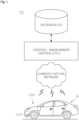
FIGS. 1 and2 are block diagrams each showing an overall configuration of a control system using road surface recognition of a driving vehicle according to an embodiment of the present disclosure. -
FIG. 3 is a conceptual diagram for explaining a configuration of a vehicle-attached device according to an embodiment of the present disclosure. -
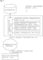
FIG. 4 is a conceptual diagram for explaining an overall configuration of a central management server according to an embodiment of the present disclosure. -
FIGS. 5A and 5B are a conceptual diagram showing an image capture unit and image information thereof according to an embodiment of the present disclosure. -
FIG. 6 is a conceptual diagram for explaining a probabilistic distribution of luminance components used by a road surface condition determination unit according to an embodiment of the present disclosure. -
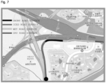
FIG. 7 is an image displaying road surface condition information on a driving route map according to an embodiment of the present disclosure. -
FIG. 8 is a block diagram time-sequentially showing a control method using road surface recognition of a driving vehicle according to another embodiment of the present disclosure. - Hereinafter, embodiments of the present disclosure are described in more detail with reference to the accompanying drawings. The embodiments of the present disclosure may be variously modified, and the scope of the present disclosure should not be construed as being limited to the following embodiments. The embodiments are provided to more fully explain the present disclosure to those skilled in the art.
- As shown in
FIG. 1 , a control system CS using road surface recognition (e.g., recognition of hydroplaning or black ice) of a driving vehicle according to the present disclosure may determine a road surface condition by using road surface information "d" including real-time location information and road surface image information obtained from a driving vehicle "A," and then transmit determined road surface condition information back to the driving vehicle "A." As shown inFIG. 2 , the control system CS may receive the road surface information "d" from the plurality of vehicles "A" and determine the road surface condition. Accordingly, the road surface condition may be accurately determined, and the plurality of driving vehicles "A" may share the road surface condition information with each other. - To this end, the control system CS using road surface recognition (e.g., recognition of hydroplaning or black ice) of a driving vehicle according to the present disclosure may include a vehicle-attached
device 100 and acentral management server 200. In addition, the control system CS may include a database "D" including road surface image information of each accumulated location received from the plurality of vehicles "A" and a corresponding feature vector, and the database "D" may include accumulated air temperature/humidity information for each location according to an embodiment. - Here, the database "D," the vehicle-attached
device 100, and thecentral management server 200 may transmit and receive information with one another through a communication network, and the communication network for connecting the devices with one another may use an internal network, a wired/wireless internet, long term evolution (LTE), long range radio (LoRa) communication using a sensor node, or the like. However, the vehicle-attacheddevice 100 may be attached to the vehicle "A" and moved in real time, and it is thus preferable that the vehicle-attacheddevice 100 and thecentral management device 200 transmit and receive the information through a mobile communication network. - Hereinafter, the description describes in detail each component included in the control system CS using road surface recognition (e.g., recognition of hydroplaning or black ice) of a driving vehicle according to the present disclosure.
- The vehicle-attached
device 100 may be a device transmitting, to thecentral management server 200, road surface information "d" including real-time location information and road surface image information of the driving vehicle "A," and include animage capture unit 110, a global positioning system (GPS)unit 120, adata packaging unit 130, a data transmission/reception unit 140, and adisplay unit 150, as shown inFIG. 3 . The vehicle-attacheddevice 100 may be mounted in a vehicle as a separate component, and may communicate with thecentral management server 200 by being linked with a driver's portable terminal. - Here, it is assumed that the vehicle-attached
device 100 described in the specification of the present disclosure has a central processing unit and a memory, and the described '~unit' indicates 'a block configured to change or plug in a hardware or software system,' that is, a unit or block that performs a specific function in hardware or software. - The
image capture unit 110 may be attached to the driving vehicle "A" and continuously capture the road surface image information along a driving route, and preferably set to capture a specific area hardly affected by direct sunlight or reflected light. - Meanwhile, according to a preferred embodiment of the road surface
condition determination unit 220 described below, the road surfacecondition determination unit 220 may use the luminance component distribution to predict the road surface condition information, and an external factor affecting color and brightness values may thus need to be excluded to obtain the pure road surface image information. Therefore, theimage capture unit 110 may need to be installed in a place where interference caused by reflection or the like of a nearby object on a road is minimized. In addition, theimage capture unit 110 may need to have no light interference or shading from the outside, and encounter no direct sunlight. - For this reason, as shown in
FIG. 5A , theimage capture unit 110 may include asunshade 113 so that ventilation is as good as possible, and a lot of sunlight is absorbed while the direct sunlight is blocked. It is preferable that thesunshade 113 covers three sides of front and left andright camera lenses 111 of the vehicle so that the direct sunlight is blocked regardless of a direction of the driving vehicle "A." - Meanwhile, in the road surface image information captured by the
image capture unit 110, the reflected light or shadows may occur by light, and unlike the original color, brightness, and shape, the color, brightness, or shape may be differently recognized due to distortion. For example, road surface condition recognition may be interfered with not only cloudy days, but also clouds on a sunny day in addition to various other factors such as light reflection, vehicle lights at night, and refraction. Therefore, various distortions due to the reflection or refraction may occur on a wet road, an iced road, a snowy road, and the like, and apolarization filter 112 may thus be used in a front side of thelens 111 to suppress these errors. - It is preferable that the
polarization filter 112 is a horizontal polarization filter, and reflected light having a polarization component in a vertical direction may be removed from light passing through the horizontal polarization filter, thereby suppressing a glaring problem and increasing contrast of objects. As such, thepolarization filter 112 may be used to make the object clear by removing unnecessary external reflected light or to remove reflected light from a glossy surface. - However, as shown in
FIG. 5A , thepolarization filter 112 may be positioned only on one front side of thelens 111 of theimage capture unit 110 in the present disclosure. According to the above-described embodiment, as shown inFIG. 5B , theimage capture unit 110 may simultaneously capture road surface image information that is polarized by thepolarization filter 112 and non-polarized original road surface image information. - During daytime, the light reflection may increase brightness of a road surface, and in rainy weather, the brightness of the road surface may be lower than its actual brightness due to reflected light of a nearby dark object. Accordingly, the present disclosure may simultaneously secure the polarized road surface image information and the non-polarized original road surface image information based on the
polarization filter 112 installed in the front side of thecamera lens 111 to suppress the distortion and interference of the image information that is caused by an external environment, and the road surfacecondition determination unit 220 described below may determine the road surface condition information by comparing the luminance component distributions of the respective information or by comparing moment components through multi-dimensional small field segmentation. - Meanwhile, the
GPS unit 120 may recognize real-time GPS location information of the driving vehicle "A," and continuously recognize the location information of the road surface captured by theimage capture unit 110 in real time. As shown inFIG. 2 , a geographic information system GIS that converts location coordinates received from satellites into a place name by using a global positioning system (GPS) and transmits the same may be required to provide the location information of the individual vehicle "A." - Here, as the road surface information "d," the
data packaging unit 130 may co-package the real-time location information of the driving vehicle "A" that is recognized by theGPS unit 120 and the road surface image information captured by theimage capture unit 110. - The data transmission/
reception unit 140 may then transmit the packaged road surface information "d" to thecentral management server 200 and receive the real-time road surface condition information from thecentral management server 200. As described above, the data transmission/reception unit 140 may exchange the information in real time by using the mobile communication network despite a continuous location change of the vehicle "A," and may be the portable terminal of the driver. - In addition, the
display unit 150 may visually output the real-time road surface condition information. According to an embodiment, as shown inFIG. 7 , thedisplay unit 150 may be implemented to display a 'snowy road surface', an 'iced road surface', a 'wet road surface' or a 'dry road surface' in a specific color on a driving route map based on the road surface condition information determined in real time. In addition, thedisplay unit 150 may call the driver's attention by providing road condition information as voice information together with or separately from visual information. - Meanwhile, the
central management server 200 may determine the road surface condition in real time based on the road surface information "d" received from the vehicle-attacheddevice 100, and transmit the road surface condition information to vehicle-attacheddevice 100. As shown inFIG. 4 , thecentral management server 200 may include a featurevector extraction unit 210, a road surfacecondition determination unit 220, animage conversion unit 230, and a communication unit 240. In addition, as shown inFIG. 2 , thecentral management server 200 may be positioned in a central control station C to monitor and manage the road surface condition information in real time. - The feature
vector extraction unit 210 may extract a feature vector based on the transmitted real-time road surface information "d." In addition, the road surfacecondition determination unit 220 may determine the road surface condition by extracting the real-time feature vector extracted by the featurevector extraction unit 210 and a feature vector of the dry road surface, the wet road surface, the iced road surface, or the snowy road surface, stored in the database "D," and calculating similarity between the feature vectors. - In more detail, the feature vectors of the road surface image information that the road surface
condition determination unit 220 compares may be based on the luminance component distributions in the road surface image information that pass through thepolarization filter 112 and the multi-dimensional small field segmentation for analyzing a texture in the road surface image information. -
FIG. 6 is a conceptual diagram for explaining a probabilistic distribution of luminance components (or luminance component distribution) used by the road surface condition determination unit according to an embodiment of the present disclosure. When a road surface image is analyzed on the premise of an environment in which the image distortion such as the light reflection or shadow is low, probabilistic distribution of the road surface luminance components under the same road surface condition may not be widely dispersed as shown inFIG. 6A . - On the other hand, when comparing the probabilistic distributions of the luminance components in different road surface conditions with each other, a horizontal shift in the distribution occurs as shown in
FIG. 6B . The road surface condition may be determined using the luminance component as a feature vector by using this property. More precisely, the minimum commonality between the luminance component distribution of the obtained road surface image information and the luminance component distributions stored in the database "D" may be defined as the feature vector and extracted to obtain similarity in the luminance component distributions. - Meanwhile, in an embodiment, the feature
vector extraction unit 210 may extract an average value of the feature vectors for each wavelength range to prevent an error from occurring due to a foreign material or contamination of the local road surface, and the road surfacecondition determination unit 220 may also calculate the average value of the feature vector for each wavelength range and the similarity with the feature vector stored in the database "D." - The feature
vector extraction unit 210 may extract a statistical moment vector of the luminance component distribution in the road surface image information, and additionally extract, as the feature vector, i.e. the feature vector for each wavelength, a moment vector
- In an embodiment, the feature
vector extraction unit 210 may subdivide image information in block units, divide areas of the image information into M×M block units based on a Daubechies wavelet filter, and locally perform wavelet transform. Assuming that an n-th step wavelet transform is performed in each block B, an angular moment for a sub-band direction may be calculated as follows and normalized to a representative value of an entire space to be calculated as a feature vector value of a total wavelet moment for a sample.

- In addition, the road surface
condition determination unit 220 may provide more accurate road surface condition information by additionally calculating the similarity between the divided moment vector and the moment feature vector stored in the database "D." It is preferable to calculate the feature vectors obtained in an embodiment as the absolute sum of L2 distance functions for the respective components and compare the similarity between the feature vectors. - Meanwhile, more reflections may occur on the 'wet road surface' or the 'iced road surface' than on the 'dry road surface' during the daytime, while on the other hand, more reflection may occur on the 'dry road surface' at nighttime. Therefore, the polarized road surface image information and the original road surface image information may show different aspects with respect to the nearby light reflections or the like.
- Accordingly, as shown in
FIG. 5 , in an embodiment in which theimage capture unit 110 simultaneously captures the polarized road surface image information and the non-polarized original road surface image information, a weight to the 'iced road surface' or the 'wet road surface' may be increased when the mean square error MSE is calculated for the two image information and a difference in the luminance component distribution is relatively large based on this calculation. - In an embodiment, the MSE may be calculated as

condition determination unit 220 may withhold the determination. - Meanwhile, the road surface
condition determination unit 220 may determine the road surface condition based on a predetermined length L by determining a local road surface condition in units of 1 m or less, and verifying validity of the accumulated local road surface conditions for the predetermined length L. Here, in verifying the validity, the road surfacecondition determination unit 220 may analyze the original road surface image information and the polarized road surface image information to determine whether the error occurs, as described above, and derive the road surface condition in units of the predetermined length L based on the continuity and quantification of local image information of 1 m or less for which the validity is recognized. - The road surface
condition determination unit 220 may verify the validity based on reliability of the road surface information "d" received from the plurality of vehicles "A." For example, the road surfacecondition determination unit 220 may process the corresponding location information as the valid road surface condition information by recognizing the reliability when the image information corresponding to the location information less than a certain distance is accumulated N times or more within a set time based on the road surface information "d" in which the location information and the image information are packaged. - Meanwhile, the
image conversion unit 230 may convert the real-time road surface condition information determined by the road surfacecondition determination unit 220 to be displayed as the image information on the driving route map, and visually output the real-time road surface condition information to the driver through the display unit or a navigation device, integrally formed in the vehicle "A," or adisplay unit 150 of another portable terminal. According to an embodiment, as shown inFIG. 7 , the 'snowy road surface', the 'iced road surface', the 'wet road surface' or the 'dry road' may be displayed in the specific color on the driving route map based on the road surface condition information determined in real time. - In addition, the communication unit 240 may transmit the determined real-time road surface condition information to the vehicle "A" and receive the road surface information "d" from the driving vehicle "A," and transmit and receive the road surface condition information and the road surface information "d" via a base station for implementing long-distance communication.
- Meanwhile, in an embodiment of the present disclosure, the vehicle-attached
device 100 may include adrive control unit 160 controlling driving information of the vehicle "A" based on the real-time location information, based on the road surface condition information received from thecentral management server 200. - The
drive control unit 160 may be an electronic control unit (ECU) or a micro controller unit (MCU), positioned in the vehicle "A," and control the vehicle speed, gear ratio, driving mode, or the like on its own as the driving information of the vehicle "A" based on the road surface condition information received from thecentral management server 200. Accordingly, improved driving safety may be expected. - In an embodiment, in implementing a cruise control, the
drive control unit 160 may secure the driving safety even with the driver's momentary negligence by maintaining the driving speed set by the driver in the case of the 'dry road surface', and automatically controlling the driving speed to a predetermined driving speed for each road surface condition in the case of the 'snowy road surface', the 'iced road surface' or the 'wet road surface'. - Meanwhile, the
central management server 200 according to the present disclosure may further include a road surfacecondition verification unit 250. The road surfacecondition verification unit 250 may additionally verify the road surface condition information determined by comprehensively considering the temperature/humidity information and the road surface image information. - The road surface
condition verification unit 250 may additionally verify the road surface condition information determined by the road surfacecondition determination unit 220 by including the real-time temperature/humidity information provided by the driving vehicle "A" in the temperature/humidity information in the road surface information "d" based on the temperature/humidity information, the location information, and the road surface image information, received from the vehicle-attacheddevice 100. - Main factors of road surface freezing in winter may be the condensed moisture and temperature of the road surface. The road surface
condition verification unit 250 may thus additionally verify the road surface condition information by estimating a dew point temperature based on the temperature/humidity information received from each driving vehicle "A" and comparing the real-time temperature with the dew point temperature. - Hereinafter, the description describes the control method "M" using road surface recognition (e.g., recognition of hydroplaning or black ice) of a driving vehicle according to the present disclosure. As shown in
FIG. 8 , the control method "M" using road surface recognition of a driving vehicle according to the present disclosure is to determine a road surface condition by using road surface information "d" including real-time location information and road surface image information, obtained from a driving vehicle "A," and then transmit the determined road surface condition information back to the driving vehicle "A." The method may include transmitting road surface information (S10), determining the road surface condition (S20), and transmitting the road surface condition (S30). - The transmitting of the road surface information (S10) is a step of transmitting, by a vehicle-attached
device 100, the road surface information "d" including the real-time location information and road surface image information of the driving vehicle "A" to acentral management server 200. - In detail, an
image capture unit 110 of the vehicle-attacheddevice 100 may continuously capture the road surface image information from the driving vehicle "A," and simultaneously, a global positioning system (GPS)unit 120 may recognize the location information of the captured road surface (S11). - A
packaging unit 130 of the vehicle-attacheddevice 100 may then package the real-time location information and road surface image information of the driving vehicle "A" to match each other (S12), and a data transmission/reception unit 140 of the vehicle-attacheddevice 100 may transmit the packaged road surface information "d" to the central management server 200 (S13). - Meanwhile, the determining of the road surface condition (S20) is a step of determining, by the
central management server 200, the road surface condition in real time based on the road surface recognition (d). - In more detail, a feature
vector extraction unit 210 of thecentral management server 200 may extract a feature vector based on the real-time road surface information "d" received from the vehicle-attached device 100 (S21). A road surfacecondition determination unit 220 of thecentral management server 200 may determine the road surface condition by extracting the extracted real-time feature vector and a feature vector of a dry road surface, a wet road surface, a iced road surface, or a snowy road surface, stored in a database "D," and calculating similarity between the feature vectors (S22). - In another embodiment, a road surface
condition verification unit 250 of thecentral management server 200 may additionally verify the road surface condition information determined by comprehensively considering temperature/humidity information and the road surface image information (S23). - The road surface
condition verification unit 250 may additionally verify the road surface condition information determined by the road surfacecondition determination unit 220 by including the real-time temperature/humidity information provided by the driving vehicle "A" in the temperature/humidity information in the road surface information "d" based on the temperature/humidity information, the location information, and the road surface image information, received from the vehicle-attacheddevice 100. - In addition, an
image conversion unit 230 of thecentral management server 200 may convert the determined real-time road surface condition information to be displayed as image information on a driving route map through a display unit attached to the driving vehicle "A" (S24). - The transmitting of the road surface condition (S30) is a step of transmitting, by a communication unit 240 of the
central management server 200, the determined road surface condition information to the vehicle-attacheddevice 100, wherein thedisplay unit 150 of the vehicle-attacheddevice 100 outputs the road surface condition information transmitted in real time as visual information or voice information. - As shown in
FIG. 7 , thedisplay unit 150 may be implemented to display a 'snowy road surface', an 'iced road surface', a 'wet road surface' or a 'dry road surface' in a specific color on the driving route map based on the road surface condition information determined in real time, or call a driver's attention by providing the road condition information as the voice information. - In addition, in another embodiment, the method may further include controlling driving (S40) of controlling, by the vehicle-attached
device 100, driving information of the vehicle "A" based on the real-time location information, based on the received road surface condition information after the transmitting of the road surface condition (S30). - A
drive control unit 160 of the vehicle-attacheddevice 100 may be an electronic control unit (ECU) or a micro controller unit (MCU), positioned in the vehicle "A," and control the vehicle speed, gear ratio, driving mode, or the like on its own as the driving information of the vehicle "A" based on the road surface condition information received from thecentral management server 200. Thedrive control unit 160 may implement cruise control to control the speed. - Technical contents have been illustrated and described hereinabove with a focus on the embodiments of the present disclosure that relate to the control system (CS) using the road surface recognition (e.g., recognition of hydroplaning or black ice) of the driving vehicle and the method "M" using the same. However, the present disclosure may be variously modified or altered by those skilled in the art to which the present disclosure pertains by adding, changing, deleting, or supplementing the components without departing from the scope and spirit of the present disclosure as disclosed in the accompanying claims. These modifications should also be understood to fall within the scope of the present disclosure.
- Further, in describing the embodiments of the present disclosure, omitted is a detailed description of a case where it is decided that the detailed description for the known functions or configurations related to the present disclosure may unnecessarily obscure the gist of the present disclosure. Furthermore, the terms used herein are defined in consideration of the functions in the embodiments of the present disclosure, and may be construed in different ways by intentions of users or operators, practices, or the like. Therefore, the terms should be defined on the basis of the contents throughout the specification. Therefore, the detailed description of the present disclosure described above is not intended to limit the present disclosure to the disclosed embodiments, and the appended claims should be construed to include other embodiments as well.
Claims (11)
- A control system using road surface recognition of a driving vehicle, the system comprising:a vehicle-attached device 100 transmitting, to a central management server 200, road surface information "d" including the real-time location information and road surface image information of a driving vehicle "A"; andthe central management server 200 determining a road surface condition in real time based on the road surface information "d" received from the vehicle-attached device 100 and transmitting road surface condition information to the vehicle-attached device 100.
- The system of claim 1, wherein the vehicle-attached device 100 includesan image capture unit 110 attached to the driving vehicle "A" and continuously capturing the road surface image information;a global positioning system (GPS) unit 120 recognizing location information of a road surface captured by the image capture unit 110 in real time;a data packaging unit 130 packaging the real-time location information and road surface image information of the driving vehicle "A";a data transmission/reception unit 140 transmitting the packaged road surface information "d" to the central management server 200 and receiving the real-time road surface condition information from the central management server 200; anda display unit 150 visually outputting the real-time road surface condition information.
- The system of claim 1, wherein the vehicle-attached device 100 includes a drive control unit 160 controlling driving information of the vehicle "A" based on the real-time location information, based on the road surface condition information received from the central management server 200.
- The system of claim 1, wherein the central management server 200 includesa feature vector extraction unit 210 extracting a feature vector based on the transmitted real-time road surface information "d,"a road surface condition determination unit 220 determining the road surface condition by extracting the real-time feature vector extracted by the feature vector extraction unit 210 and a feature vector of a dry road surface, a wet road surface, an iced road surface, or a snowy road surface, stored in a database "D," and calculating similarity between the feature vectors, anda communication unit 240 transmitting the determined real-time road surface condition information to the vehicle "A" and receiving the road surface information "d" from the driving vehicle "A."
- The system of claim 4, wherein the road surface condition determination unit 220 determines the road surface condition based on a predetermined length L by determining a local road surface condition in units of 1 m or less, and verifying validity of the accumulated local road surface conditions for the predetermined length L.
- The system of claim 5, wherein the road surface condition determination unit 220 verifies the validity based on reliability of the road surface information "d" received from the plurality of vehicles "A."
- The system of claim 4, wherein the central management server 200 further includes an image conversion unit 230 converting the determined real-time road surface condition information to be displayed as image information on a driving route map.
- A control method using road surface recognition of a driving vehicle, the method comprising:transmitting road surface information (S10) of transmitting, by a vehicle-attached device 100, road surface information "d" including the real-time location information and road surface image information of a driving vehicle "A" to a central management server 200;determining a road surface condition (S20) of determining, by the central management server 200, the road surface condition in real time based on the road surface information "d";transmitting the road surface condition (S30) of transmitting, by the central management server 200, the determined road surface condition information to the vehicle-attached device 100.
- The method of claim 8, wherein the transmitting of the road surface information (S10) includescontinuously capturing, by the vehicle-attached device 100, the road surface image information and recognizing the location information (S11), andpackaging, by the vehicle-attached device 100, the real-time location information and road surface image information of the driving vehicle "A" (S12), andtransmitting, by the vehicle-attached device 100, the packaged road surface information "d" to the central management server 200 (S13).
- The method of claim 8, wherein the determining of the road surface condition (S20) includesextracting, by the central management server 200, a feature vector based on the received real-time road surface information "d" (S21),determining, by the central management server 200, the road surface condition by calculating similarity between the extracted real-time feature vector and a feature vector of a dry road surface, a wet road surface, a iced road surface, or a snowy road surface, stored in a database "D" (S22), andconverting, by the central management server 200, the determined real-time road surface condition information to be displayed as image information on a driving route map (S24).
- The method of claim 8, further comprising comprising controlling driving (S40) of controlling, by the vehicle-attached device 100, driving information of the vehicle "A" based on the real-time location information, based on the received road surface condition information after the transmitting of the road surface condition (S30).
Applications Claiming Priority (2)
| Application Number | Priority Date | Filing Date | Title |
|---|---|---|---|
| KR1020220006964A KR102414233B1 (en) | 2022-01-18 | 2022-01-18 | Control System based on Road Surface Recognition of Driving Vehicle and Method therefor |
| PCT/KR2023/000732 WO2023140579A1 (en) | 2022-01-18 | 2023-01-16 | Control system using road surface recognition of traveling vehicle, and method therefor |
Publications (2)
| Publication Number | Publication Date |
|---|---|
| EP4470862A1 true EP4470862A1 (en) | 2024-12-04 |
| EP4470862A4 EP4470862A4 (en) | 2025-11-26 |
Family
ID=82270313
Family Applications (1)
| Application Number | Title | Priority Date | Filing Date |
|---|---|---|---|
| EP23707248.3A Pending EP4470862A4 (en) | 2022-01-18 | 2023-01-16 | CONTROL SYSTEM WITH ROAD SURFACE DETECTION OF A MOVING VEHICLE AND METHOD FOR THIS |
Country Status (6)
| Country | Link |
|---|---|
| US (1) | US20250029399A1 (en) |
| EP (1) | EP4470862A4 (en) |
| JP (1) | JP7583478B2 (en) |
| KR (1) | KR102414233B1 (en) |
| CN (1) | CN116802099A (en) |
| WO (1) | WO2023140579A1 (en) |
Families Citing this family (6)
| Publication number | Priority date | Publication date | Assignee | Title |
|---|---|---|---|---|
| KR102414233B1 (en) * | 2022-01-18 | 2022-06-29 | (주)에스알디코리아 | Control System based on Road Surface Recognition of Driving Vehicle and Method therefor |
| KR102449392B1 (en) * | 2022-07-05 | 2022-10-07 | 전해석 | Vehicle ECU optimization and control system to ensure driving safety based on road surface conditions and a vehicle ECU optimization and control method using the same |
| KR20240133906A (en) * | 2023-02-28 | 2024-09-05 | 에스케이플래닛 주식회사 | Adaptive operation Method based on information of road surface, system and device supporting the same |
| KR20240169154A (en) * | 2023-05-22 | 2024-12-03 | 주식회사 에이치엘클레무브 | Method for controlling entry of driving vehicles into intersections according to shaded area setting at non-traffic light intersections, and apparatus thereof |
| WO2025150384A1 (en) * | 2024-01-10 | 2025-07-17 | 株式会社ニコン・エシロール | Ophthalmic lens and ophthmalic transmission-type optical orthosis |
| KR102768522B1 (en) * | 2024-03-21 | 2025-02-17 | (주)에스알디코리아 | System and method for recognizing road surface by acquiring images based on deep learning |
Family Cites Families (30)
| Publication number | Priority date | Publication date | Assignee | Title |
|---|---|---|---|---|
| US6456288B1 (en) * | 1998-03-31 | 2002-09-24 | Computer Associates Think, Inc. | Method and apparatus for building a real time graphic scene database having increased resolution and improved rendering speed |
| JP2002310896A (en) * | 2001-04-19 | 2002-10-23 | Mitsubishi Heavy Ind Ltd | Road surface condition discriminating device and road surface condition discriminating method |
| JP2006024104A (en) * | 2004-07-09 | 2006-01-26 | Honda Motor Co Ltd | Vehicle road adaptive travel control device |
| KR20090022127A (en) * | 2007-08-29 | 2009-03-04 | 에스케이 텔레콤주식회사 | Road condition management system and method using wireless communication and mobile communication network |
| KR101834014B1 (en) * | 2011-06-13 | 2018-04-13 | 현대모비스 주식회사 | System for offering vehicle information and control method thereof |
| US20150178572A1 (en) * | 2012-05-23 | 2015-06-25 | Raqib Omer | Road surface condition classification method and system |
| US9863928B1 (en) * | 2013-03-20 | 2018-01-09 | United Parcel Service Of America, Inc. | Road condition detection system |
| KR20140119471A (en) * | 2013-04-01 | 2014-10-10 | 현대엠엔소프트 주식회사 | System for correcting and providing real-time dangerous road-section information based on device in the car and its method |
| KR101618551B1 (en) * | 2014-07-02 | 2016-05-09 | 엘지전자 주식회사 | Driver assistance apparatus and Vehicle including the same |
| JP6408852B2 (en) * | 2014-10-06 | 2018-10-17 | 株式会社ブリヂストン | Road surface classification system |
| KR101789774B1 (en) * | 2015-06-09 | 2017-10-25 | 주식회사 환경과학기술 | road status monitoring analysis appratus and method by smartphone navigation and motion sensor |
| JP6776513B2 (en) * | 2015-08-19 | 2020-10-28 | ソニー株式会社 | Vehicle control device, vehicle control method, information processing device, and traffic information provision system |
| JP6775195B2 (en) | 2016-04-06 | 2020-10-28 | パナソニックIpマネジメント株式会社 | Detection device, detection method and detection program |
| KR101682940B1 (en) * | 2016-05-03 | 2016-12-07 | 한국씨티에스주식회사 | Total management system for removing snow and ice on road and method for processing thereof |
| CN108734955B (en) * | 2017-04-14 | 2021-06-11 | 腾讯科技(深圳)有限公司 | Method and device for predicting road condition state |
| KR101936769B1 (en) * | 2017-07-13 | 2019-01-11 | 한국건설기술연구원 | System for detecting road surface condition using vehicle data and image data, and method for the same |
| JP6766798B2 (en) * | 2017-12-15 | 2020-10-14 | 株式会社デンソー | Road map generation system and road map generation method |
| US10576986B2 (en) * | 2017-12-19 | 2020-03-03 | Intel Corporation | Road surface friction based predictive driving for computer assisted or autonomous driving vehicles |
| DE102018203807A1 (en) * | 2018-03-13 | 2019-09-19 | Continental Teves Ag & Co. Ohg | Method and device for detecting and evaluating road conditions and weather-related environmental influences |
| KR102129127B1 (en) * | 2018-10-29 | 2020-07-02 | 한국건설기술연구원 | System for providing slip information of road surface using vehicle sensor data |
| JP7103201B2 (en) * | 2018-12-20 | 2022-07-20 | トヨタ自動車株式会社 | Information processing systems, programs, and information processing methods |
| WO2020241303A1 (en) * | 2019-05-27 | 2020-12-03 | ソニー株式会社 | Autonomous travel control device, autonomous travel control system, and autonomous travel control method |
| CN110569739B (en) * | 2019-08-15 | 2022-07-05 | 上海工程技术大学 | A car assistance system and method based on deep learning and tire noise spectrogram |
| CN111667706A (en) * | 2020-06-05 | 2020-09-15 | 百度在线网络技术(北京)有限公司 | Lane-level road surface condition recognition method, road condition prompting method and device |
| KR102396146B1 (en) * | 2020-09-02 | 2022-05-11 | 한국항공우주연구원 | A Road Surface Surveillance System and Monitoring Method There Of |
| US11708066B2 (en) * | 2021-01-21 | 2023-07-25 | Motional Ad Llc | Road surface condition guided decision making and prediction |
| KR102261164B1 (en) * | 2021-02-26 | 2021-06-07 | (주)에스알디코리아 | AI Display-Board System using Road-Ice Determination Algorithm |
| CN117098893A (en) * | 2021-04-07 | 2023-11-21 | 三菱电机株式会社 | Road surface information collection device, road surface deterioration detection system and road surface information collection method |
| JP7308900B2 (en) * | 2021-10-27 | 2023-07-14 | 三菱電機株式会社 | Vehicle cruise control processing system |
| KR102414233B1 (en) * | 2022-01-18 | 2022-06-29 | (주)에스알디코리아 | Control System based on Road Surface Recognition of Driving Vehicle and Method therefor |
-
2022
- 2022-01-18 KR KR1020220006964A patent/KR102414233B1/en active Active
-
2023
- 2023-01-16 US US18/024,428 patent/US20250029399A1/en active Pending
- 2023-01-16 CN CN202380007859.2A patent/CN116802099A/en active Pending
- 2023-01-16 EP EP23707248.3A patent/EP4470862A4/en active Pending
- 2023-01-16 WO PCT/KR2023/000732 patent/WO2023140579A1/en not_active Ceased
- 2023-01-16 JP JP2023518505A patent/JP7583478B2/en active Active
Also Published As
| Publication number | Publication date |
|---|---|
| CN116802099A (en) | 2023-09-22 |
| EP4470862A4 (en) | 2025-11-26 |
| US20250029399A1 (en) | 2025-01-23 |
| KR102414233B1 (en) | 2022-06-29 |
| JP2024516471A (en) | 2024-04-16 |
| WO2023140579A1 (en) | 2023-07-27 |
| JP7583478B2 (en) | 2024-11-14 |
Similar Documents
| Publication | Publication Date | Title |
|---|---|---|
| US20250029399A1 (en) | Control system using road surface recognition of driving vehicle and method using the same | |
| US11989949B1 (en) | Systems for detecting vehicle following distance | |
| KR101602171B1 (en) | Mobile system for gathering and transmitting road weather information and the method thereof | |
| CN110406544A (en) | Vehicle sensory perceptual system and method under misty rain scene | |
| US11615551B2 (en) | Assessing visibility of a target object with autonomous vehicle fleet | |
| CN104851295A (en) | Method and system for acquiring road condition information | |
| CN110163074A (en) | It provides for the method based on image scene and the enhancing pavement behavior detection of environment light analysis | |
| KR102257078B1 (en) | Fog detection device using coordinate system and method thereof | |
| Liu et al. | Real-time multi-task environmental perception system for traffic safety empowered by edge artificial intelligence | |
| US20240331175A1 (en) | Systems for determining and reporting vehicle following distance | |
| US20240149899A1 (en) | Risk of occurrence calculating apparatus, risk of occurrence displaying system, and risk of occurrence calculating method | |
| Vaibhav et al. | Real-time fog visibility range estimation for autonomous driving applications | |
| US20240346819A1 (en) | Disaster investigation assistance device, disaster investigation assistance method, and recording medium | |
| KR102317633B1 (en) | System for detecting black ice in real time at roads based on multiple road image and method thereof | |
| CN119274517B (en) | A method, device, equipment and medium for adjusting brightness of an on-vehicle electronic display screen | |
| CN103149603B (en) | Road weather detection method based on video | |
| KR101180421B1 (en) | Automatic detecting method of road surface condition using polarized light filter and sensors | |
| Linton et al. | Winter road surface condition monitoring: field evaluation of a smartphone-based system | |
| KR102420854B1 (en) | System and method for providing mobile disaster prevention services | |
| Bogaerts et al. | Enhancement of road weather services using vehicle sensor data | |
| US12586230B2 (en) | Systems and methods for training a model for determining vehicle following distance | |
| US20240331398A1 (en) | Methods for creating training data for determining vehicle following distance | |
| US20240331399A1 (en) | Systems and methods for identifying tailgating | |
| Kim et al. | A study on development of mobile road surface condition detection system utilizing probe car | |
| CN116824398A (en) | Country park management methods and systems based on visual and meteorological monitoring |
Legal Events
| Date | Code | Title | Description |
|---|---|---|---|
| STAA | Information on the status of an ep patent application or granted ep patent |
Free format text: STATUS: UNKNOWN |
|
| STAA | Information on the status of an ep patent application or granted ep patent |
Free format text: STATUS: THE INTERNATIONAL PUBLICATION HAS BEEN MADE |
|
| PUAI | Public reference made under article 153(3) epc to a published international application that has entered the european phase |
Free format text: ORIGINAL CODE: 0009012 |
|
| STAA | Information on the status of an ep patent application or granted ep patent |
Free format text: STATUS: REQUEST FOR EXAMINATION WAS MADE |
|
| 17P | Request for examination filed |
Effective date: 20230307 |
|
| AK | Designated contracting states |
Kind code of ref document: A1 Designated state(s): AL AT BE BG CH CY CZ DE DK EE ES FI FR GB GR HR HU IE IS IT LI LT LU LV MC ME MK MT NL NO PL PT RO RS SE SI SK SM TR |
|
| DAV | Request for validation of the european patent (deleted) | ||
| DAX | Request for extension of the european patent (deleted) | ||
| A4 | Supplementary search report drawn up and despatched |
Effective date: 20251027 |
|
| RIC1 | Information provided on ipc code assigned before grant |
Ipc: B60W 40/06 20120101AFI20251021BHEP Ipc: B60W 40/10 20120101ALI20251021BHEP Ipc: B60W 50/14 20200101ALI20251021BHEP Ipc: G06V 20/56 20220101ALI20251021BHEP Ipc: B60R 11/04 20060101ALI20251021BHEP Ipc: G08C 17/02 20060101ALI20251021BHEP Ipc: G08G 1/0967 20060101ALI20251021BHEP Ipc: B60W 50/00 20060101ALI20251021BHEP |