EP4428646A1 - Self-position estimation device, autonomous driving vehicle, and self-position estimation method - Google Patents
Self-position estimation device, autonomous driving vehicle, and self-position estimation method Download PDFInfo
- Publication number
- EP4428646A1 EP4428646A1 EP22889882.1A EP22889882A EP4428646A1 EP 4428646 A1 EP4428646 A1 EP 4428646A1 EP 22889882 A EP22889882 A EP 22889882A EP 4428646 A1 EP4428646 A1 EP 4428646A1
- Authority
- EP
- European Patent Office
- Prior art keywords
- information
- self
- container
- map
- location
- Prior art date
- Legal status (The legal status is an assumption and is not a legal conclusion. Google has not performed a legal analysis and makes no representation as to the accuracy of the status listed.)
- Pending
Links
Images



Classifications
-
- G—PHYSICS
- G05—CONTROLLING; REGULATING
- G05D—SYSTEMS FOR CONTROLLING OR REGULATING NON-ELECTRIC VARIABLES
- G05D1/00—Control of position, course, altitude or attitude of land, water, air or space vehicles, e.g. using automatic pilots
- G05D1/20—Control system inputs
- G05D1/24—Arrangements for determining position or orientation
- G05D1/246—Arrangements for determining position or orientation using environment maps, e.g. simultaneous localisation and mapping [SLAM]
-
- B—PERFORMING OPERATIONS; TRANSPORTING
- B65—CONVEYING; PACKING; STORING; HANDLING THIN OR FILAMENTARY MATERIAL
- B65G—TRANSPORT OR STORAGE DEVICES, e.g. CONVEYORS FOR LOADING OR TIPPING, SHOP CONVEYOR SYSTEMS OR PNEUMATIC TUBE CONVEYORS
- B65G1/00—Storing articles, individually or in orderly arrangement, in warehouses or magazines
-
- G—PHYSICS
- G01—MEASURING; TESTING
- G01C—MEASURING DISTANCES, LEVELS OR BEARINGS; SURVEYING; NAVIGATION; GYROSCOPIC INSTRUMENTS; PHOTOGRAMMETRY OR VIDEOGRAMMETRY
- G01C21/00—Navigation; Navigational instruments not provided for in groups G01C1/00 - G01C19/00
- G01C21/005—Navigation; Navigational instruments not provided for in groups G01C1/00 - G01C19/00 with correlation of navigation data from several sources, e.g. map or contour matching
-
- G—PHYSICS
- G01—MEASURING; TESTING
- G01C—MEASURING DISTANCES, LEVELS OR BEARINGS; SURVEYING; NAVIGATION; GYROSCOPIC INSTRUMENTS; PHOTOGRAMMETRY OR VIDEOGRAMMETRY
- G01C21/00—Navigation; Navigational instruments not provided for in groups G01C1/00 - G01C19/00
- G01C21/38—Electronic maps specially adapted for navigation; Updating thereof
- G01C21/3804—Creation or updating of map data
- G01C21/3807—Creation or updating of map data characterised by the type of data
-
- G—PHYSICS
- G01—MEASURING; TESTING
- G01C—MEASURING DISTANCES, LEVELS OR BEARINGS; SURVEYING; NAVIGATION; GYROSCOPIC INSTRUMENTS; PHOTOGRAMMETRY OR VIDEOGRAMMETRY
- G01C21/00—Navigation; Navigational instruments not provided for in groups G01C1/00 - G01C19/00
- G01C21/38—Electronic maps specially adapted for navigation; Updating thereof
- G01C21/3804—Creation or updating of map data
- G01C21/3833—Creation or updating of map data characterised by the source of data
-
- G—PHYSICS
- G01—MEASURING; TESTING
- G01C—MEASURING DISTANCES, LEVELS OR BEARINGS; SURVEYING; NAVIGATION; GYROSCOPIC INSTRUMENTS; PHOTOGRAMMETRY OR VIDEOGRAMMETRY
- G01C21/00—Navigation; Navigational instruments not provided for in groups G01C1/00 - G01C19/00
- G01C21/38—Electronic maps specially adapted for navigation; Updating thereof
- G01C21/3863—Structures of map data
- G01C21/3867—Geometry of map features, e.g. shape points, polygons or for simplified maps
-
- G—PHYSICS
- G05—CONTROLLING; REGULATING
- G05D—SYSTEMS FOR CONTROLLING OR REGULATING NON-ELECTRIC VARIABLES
- G05D1/00—Control of position, course, altitude or attitude of land, water, air or space vehicles, e.g. using automatic pilots
- G05D1/20—Control system inputs
- G05D1/24—Arrangements for determining position or orientation
- G05D1/242—Means based on the reflection of waves generated by the vehicle
-
- G—PHYSICS
- G05—CONTROLLING; REGULATING
- G05D—SYSTEMS FOR CONTROLLING OR REGULATING NON-ELECTRIC VARIABLES
- G05D1/00—Control of position, course, altitude or attitude of land, water, air or space vehicles, e.g. using automatic pilots
- G05D1/60—Intended control result
- G05D1/646—Following a predefined trajectory, e.g. a line marked on the floor or a flight path
-
- G—PHYSICS
- G05—CONTROLLING; REGULATING
- G05D—SYSTEMS FOR CONTROLLING OR REGULATING NON-ELECTRIC VARIABLES
- G05D1/00—Control of position, course, altitude or attitude of land, water, air or space vehicles, e.g. using automatic pilots
- G05D1/60—Intended control result
- G05D1/69—Coordinated control of the position or course of two or more vehicles
- G05D1/692—Coordinated control of the position or course of two or more vehicles involving a plurality of disparate vehicles
-
- G—PHYSICS
- G05—CONTROLLING; REGULATING
- G05D—SYSTEMS FOR CONTROLLING OR REGULATING NON-ELECTRIC VARIABLES
- G05D1/00—Control of position, course, altitude or attitude of land, water, air or space vehicles, e.g. using automatic pilots
- G05D1/60—Intended control result
- G05D1/69—Coordinated control of the position or course of two or more vehicles
- G05D1/698—Control allocation
- G05D1/6987—Control allocation by centralised control off-board any of the vehicles
-
- G—PHYSICS
- G06—COMPUTING OR CALCULATING; COUNTING
- G06Q—INFORMATION AND COMMUNICATION TECHNOLOGY [ICT] SPECIALLY ADAPTED FOR ADMINISTRATIVE, COMMERCIAL, FINANCIAL, MANAGERIAL OR SUPERVISORY PURPOSES; SYSTEMS OR METHODS SPECIALLY ADAPTED FOR ADMINISTRATIVE, COMMERCIAL, FINANCIAL, MANAGERIAL OR SUPERVISORY PURPOSES, NOT OTHERWISE PROVIDED FOR
- G06Q10/00—Administration; Management
- G06Q10/08—Logistics, e.g. warehousing, loading or distribution; Inventory or stock management
- G06Q10/087—Inventory or stock management, e.g. order filling, procurement or balancing against orders
-
- G—PHYSICS
- G05—CONTROLLING; REGULATING
- G05D—SYSTEMS FOR CONTROLLING OR REGULATING NON-ELECTRIC VARIABLES
- G05D2105/00—Specific applications of the controlled vehicles
- G05D2105/20—Specific applications of the controlled vehicles for transportation
- G05D2105/28—Specific applications of the controlled vehicles for transportation of freight
-
- G—PHYSICS
- G05—CONTROLLING; REGULATING
- G05D—SYSTEMS FOR CONTROLLING OR REGULATING NON-ELECTRIC VARIABLES
- G05D2107/00—Specific environments of the controlled vehicles
- G05D2107/70—Industrial sites, e.g. warehouses or factories
-
- G—PHYSICS
- G05—CONTROLLING; REGULATING
- G05D—SYSTEMS FOR CONTROLLING OR REGULATING NON-ELECTRIC VARIABLES
- G05D2107/00—Specific environments of the controlled vehicles
- G05D2107/80—Transportation hubs
- G05D2107/84—Harbours
-
- G—PHYSICS
- G05—CONTROLLING; REGULATING
- G05D—SYSTEMS FOR CONTROLLING OR REGULATING NON-ELECTRIC VARIABLES
- G05D2109/00—Types of controlled vehicles
- G05D2109/10—Land vehicles
-
- G—PHYSICS
- G05—CONTROLLING; REGULATING
- G05D—SYSTEMS FOR CONTROLLING OR REGULATING NON-ELECTRIC VARIABLES
- G05D2111/00—Details of signals used for control of position, course, altitude or attitude of land, water, air or space vehicles
- G05D2111/10—Optical signals
- G05D2111/17—Coherent light, e.g. laser signals
Definitions
- the present disclosure relates to a self-location estimation device, an autonomous driving vehicle, and a self-location estimation method.
- an automatic guided vehicle has been frequently used to transport loads and the like in large facilities.
- An example of a facility using an AGV is a container terminal, which is a port facility. Inside the container terminal, an AGV transports containers that are temporarily stored for marine transports.
- an AGV used in a container terminal transmits a radio wave from a radio wave transmitter provided in its own device, and estimates its self-location by a transponder system using a response from a radio wave responder previously embedded in a prescribed position on the ground.
- a radio wave responder is installed in a prescribed position in container terminal premises in advance, and the installation takes time and effort to construct a facility.
- an AGV can estimate its self-location by a simple process using map information in the facility generated in advance and environmental information of surroundings acquired by Light Detection and Ranging (LiDAR).
- the AGV can travel to a prescribed destination based on the estimated self-location information.
- Patent Literature 1 Japanese Unexamined Patent Application Publication No. 2009-169845
- Each container is temporary stored in the premises of a container terminal, and the container storage situation in the premises changes from hour to hour. Therefore, in order to perform a self-location estimation process using map information and environmental information in the premises of a container terminal as described above, the AGV updates the map information to be used in accordance with changes in the container storage situation in the premises.
- SLAM Simultaneous Localization and Mapping
- the AGV may not be able to correctly determine whether to update the map information or correct the self-location estimation when it detects this change using SLAM technology. Therefore, accurate self-location estimation cannot be performed, and the AGV may not be able to travel properly if it corrects the self-location estimation even though the container storage situation has changed.
- a self-location estimation device in accordance with an embodiment of the present disclosure includes: a map information acquisition unit configured to acquire map information in a storage facility generated based on shape information of an object and storage status information of the object in the storage facility; an environmental information acquisition unit configured to acquire environmental information of surroundings; and a self-location estimation unit configured to estimate a self-location based on the map information acquired by the map information acquisition unit and the environmental information acquired by the environmental information acquisition unit.
- the self-location estimation device may be communicatively connected to a storage facility management device that manages the shape information of the object and the storage status information of the object in the storage facility and may be installed on a mobile body movable in the storage facility; based on the shape information of the object managed by the storage facility management device and the storage status information in the storage facility; the map information acquisition unit may be configured to acquire the map information generated by the storage facility management device, the mobile body, or a map information generation device communicatively connected to the storage facility management device and the self-location estimation device; the environmental information acquisition unit may be configured to acquire the environmental information of surroundings of the mobile body; and the self-location estimation unit may be configured to estimate a location of the mobile body as the self-location.
- the storage facility may have storage spaces for storing the object, and the storage status information of the object may include location information of each of the storage spaces and information on a number of the object stored in each of the storage spaces.
- An autonomous driving vehicle in accordance with an embodiment of the present disclosure includes: the aforementioned self-location estimation device; a movement mechanism configured to move the autonomous driving vehicle; and a travel controller configured to control the movement mechanism so that the autonomous driving vehicle moves on a prescribed path based on the self-location estimated by the self-location estimation device.
- a self-location estimation method in accordance with an embodiment of the present disclosure includes: acquiring map information in a storage facility generated based on shape information of an object and storage status information of the object in the storage facility; acquiring environmental information of surroundings; and estimating a self-location based on the acquired map information and the acquired environmental information.
- a container management system for managing the operation of an automatic guided vehicle (AGV), which is an autonomous driving vehicle (mobile body) equipped with a self-location estimation device according to the present disclosure, in container terminal (storage facility) premises is described below with reference to the drawings.
- a container terminal is a facility for temporarily storing containers (objects) that are carried in.
- a container management system 1A manages a storage status of containers in premises of a container terminal 10 and an operation of AGVs and crane devices installed in the premises of the container Terminal 10.
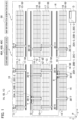
- FIG. 1 is a top view of the premises of the container terminal 10.
- the container terminal 10 has a plurality of preset container storage areas 11 to 18.
- Each container storage area 11 to 18 has, for example, 50 storage spaces (11-1 to 11-50, 12-1 to 12-50... 18-1 to 18-50) set with 10 horizontal rows by 5 vertical columns.
- the container management system 1A includes 3 AGVs 20A-1 to 20A-3 traveling in the premises of the container terminal 10, crane devices 30-1 to 30-12 installed in the premises of the container terminal 10, and a container management device 40A.
- the number of AGVs used in the container management system 1A is not limited to three, but may be smaller or larger.
- the AGV is stated as AGV 20A if any of AGVs 20A-1 to 20A-3 is not specified.
- Each of the crane devices 30-1 to 30-12 is installed in one of the container storage areas 11 to 18 to be laterally movable.
- the crane devices 30-1 and 30-2 are installed in the container storage area 11.
- the crane devices 30-3 and 30-4 are installed in the container storage area 12.
- the crane devices 30-5 and 30-6 are installed in the container storage area 13.
- the crane devices 30-7 and 30-8 are installed in the container storage area 14.
- the crane device 30-9 is installed in the container storage area 15.
- the crane device 30-10 is installed in the container storage area 16.
- the crane device 30-11 is installed in the container storage area 17.
- the crane device 30-12 is installed in the container storage area 18.
- the number of crane devices installed in the premises of the container terminal 10 is not limited to twelve, but may be smaller or larger.
- the crane device is stated as the crane device 30 if any of the crane devices 30-1 to 30-12 in the container terminal 10 is not specified.
- the container management device 40A has a memory 41A, an instruction input part 42, a first radio communication unit 43, and a first CPU 44A.
- the memory 41A has a container information memory 411, a crane information memory 412, and a first map information memory 413.
- the container information memory 411 stores storage status information including shape information and storage location information of each container stored in premises of the container terminal 10.
- the crane information memory 412 stores shape information and location information of each of the crane devices 30-1 to 30-12 installed in the premises of the container terminal 10.
- the first map information memory 413 stores generated and updated map information of the premises in the container terminal 10 as described later.
- the instruction input part 42 inputs a container carry-in instruction and a carry-out instruction by an operator's operation and the like.
- the first radio communication unit 43 performs a radio communication with the AGVs 20A-1 to 20A-3 and the crane devices 30-1 to 30-12.
- the first CPU 44A has a transport instruction processor 441, a first map-information generator 442, and an information updating unit 443.
- the transport instruction processor 441 transmits the container carry-in or carry-out instruction input by the instruction input unit 42 to the corresponding crane device 30 and the AGV 20A via the first radio communication unit 43.
- the first map-information generator 442 generates map information on premises of the container terminal 10 based on the information stored in the container information memory 411 and the information stored in the crane information memory 412, and stores it in the first map-information memory 413.
- the first map-information generator 442 updates the map information stored in the first map-information memory 413 based on the updated information when the information stored in the container information memory 411 is updated.
- the first map-information generator 442 transmits the generated or updated map information to the AGVs 20A-1 to 20 A-3 through the first radio communication unit 43.
- the information updating unit 443 updates container information and crane information stored in the memory 41A when operations executed by the AGV 20A and the crane device 30 are completed based on the carry-in instruction or carry-out instruction acquired from the transport instruction processor 441.
- the AGV 20A-1 includes a laser range finder (LRF) sensor 21-1, a second radio communication unit 22-1, a second map-information memory 23-1, a movement mechanism 24-1, and a second CPU 25A-1.
- the LRF sensor 21-1 measures a distance to surrounding objects.
- the second radio communication unit 22-1 performs radio communication with the container management device 40A.
- the second map information memory 23-1 stores map information on the premises in the container terminal 10 acquired from the container management device 40 A.
- the movement mechanism 24-1 is a mechanism for a movement of the AGV 20A-1.
- the second CPU 25 A-1 has a self-location estimation device 200A-1 and a travel controller 251-1.
- the self-location estimation device 200A-1 has an environmental information acquisition unit 201-1, a map information acquisition unit 202-1, and a self-location estimation unit 203-1.
- the environmental information acquisition unit 201-1 acquires information measured by the LRF sensor 21-1 as environmental information of surroundings.
- the map information acquisition unit 202-1 acquires map information on the premises in the container terminal 10 from the container management device 40A through the second radio communication unit 22-1, the relevant map information is stored in the second map information memory 23-1.
- the map information acquisition unit 202-1 reads out the map information on the premises in the container terminal 10 stored in the second map information memory 23-1.
- the self-location estimation unit 203-1 estimates the self-location based on the environmental information of surroundings acquired by the environmental information acquisition unit 201-1 and the map information on the premises in the container terminal 10 read out by the map information acquisition unit 202-1.
- the travel control unit 251-1 controls the movement mechanism unit 24-1 so that the AGV 20A-1 moves on a prescribed path R base on the self-location estimated by the self-location estimation unit 203-1.
- the crane device 30-1 has a third radio communication unit 31-1, a transport mechanism 32-1, and a third CPU 33-1.
- the third radio communication unit 31-1 performs radio communication with the container management device 40A.
- the transport mechanism 32-1 is a mechanism for transporting containers between the AGV 20A and a corresponding storage space.
- the third CPU 33-1 has an operation controller 331-1 for controlling the transport mechanism 32-1 based on a container carry-in or carry-out instruction acquired through the third radio communication unit 31-1.
- FIGS. 3A and 3B show an example of information stored in the container information memory 411 of the container management device 40A in the first embodiment.
- FIG. 3A shows coordinate information for each storage space in the premises of the container terminal 10.
- the coordinate information is a positional coordinate of one point in the container terminal 10, for example, a prescribed point in each storage space when the origin is a point P which is a corner of a rectangular container terminal 10 as shown in FIG. 1 , the horizontal direction is an x-axis, and the vertical direction indicating a depth is a y-axis.
- FIG. 3B shows the type and number of pieces of containers currently stored for each storage space in the premises of the container terminal 10.
- the container information memory 411 stores shape information based on 3D point cloud data previously generated by LiDAR measurement or LiDAR simulation for the 20 ft container and the 40 ft container.
- FIG. 3C shows coordinate information of each crane device 30-1 to 30-12 in the premises of the container terminal 10. This coordinate information is the position coordinates for a prescribed single point in each crane device 30-1 to 30-12 when the point P in the premises of the container terminal 10 is the origin, the horizontal direction is the x-axis, and the vertical direction indicating the depth is the y-axis.
- the crane information memory 412 of the container management device 40A stores shape information based on 3D point cloud data previously acquired by LiDAR simulation and the like for each crane device 30-1 to 30-12.
- the first map-information generator 442 of the container management device 40A generates map information in the premises of the container terminal 10 composed of 3D point cloud data, based on the information stored in the container information memory 411 and the information stored in the crane information memory 412. At that time, since information on the type and number of pieces of containers stored for each storage space are stored the container information memory 411, the first map-information generator 442 can recognize the shape information of the entire container for each storage space using the information. The first map-information generator 442 can generate the corresponding map information by rotating the recognized shape information of the entire container for each storage space and the stored shape information of the crane device 30 at a prescribed azimuth angle and translating them to the corresponding positions.
- the first map-information generator 442 adds identification information of the relevant container to the 3D point cloud data corresponding to each container when generating the relevant map information.
- the first map-information generator 442 stores the generated map information on the premises of the container terminal 10 in the first map information memory 413. Further, the first map-information generator 442 transmits the generated map information on the premises of the container terminal 10 to the AGVs 20A-1 to 20A-3 through the first radio communication unit 43 (S1).
- the AGVs 20A-1 to 20A-3 respectively acquire the map information on the premises of the container terminal 10 transmitted from the container management device 40A by the map information acquisition units 202-1 to 202-3 through the second radio communication units 22-1 to 22-3.
- the map information acquisition units 202-1 to 202-3 store the acquired map information on the premises of the container terminal 10 in the second map-information memories 23-1 to 23-3 (S2), respectively.
- the transport instruction processor 441 determines the crane device 30 and the AGV 20A to execute a process based on the relevant instruction when the carry-in or carry-out instruction of a prescribed container is input by the instruction input unit 42 of the container management device 40A. Then, the transport instruction processor 441 transmits information on the relevant instruction to the corresponding crane device 30 and the AGV 20A through the first radio communication unit 43 (S3).
- an instruction to carry the container X out of the storage space 14-8 of the container storage area 14 and an instruction to carry the container Y into the storage space 12-3 of the container storage area 12 are inputted by the instruction input unit 42.
- the transport instruction processor 441 first determines that a carry-in process of the container X is executed by the crane device 30-8 and the AGV 20A-1. Then, the transport instruction processor 441 transmits information on the carry-out instruction of the container X to the crane device 30-8 and the AGV 20A-1 through the first radio communication section 43.
- the transport instruction processor 441 determines that a carry-in process of the container Y is executed by the crane device 30-3 and the AGV 20A-2.
- the transport instruction processor 441 transmits information on the transport instruction of the container Y to the crane device 30-3 and the AGV20A-2 via the first radio communication section 43.
- the environmental information acquisition unit 201-1 of the self-location estimation device 200A-1 acquires information on a distance to a surrounding object measured by the LRF sensor 21-1. Based on the acquired information, the environmental information acquisition unit 201-1 generates surrounding shape information showing the shape of the surrounding object by 3D point cloud data.
- the map information acquisition unit 202-1 reads out the map information on the premises of the container terminal 10 stored in the second map information memory 23-1. Then, the self-location estimation unit 203-1 estimates the self-location by performing a matching process between the 3D point cloud data indicating the surrounding shape information generated by the environmental information acquisition unit 201-1 and the 3D point cloud data indicating the map information read out by the map information acquisition unit 202-1 (S4). For this matching process of the 3D point cloud data, a known technique such as normal distributions transform (NDT) scan matching can be used.
- NDT normal distributions transform
- the travel controller 251-1 controls the movement mechanism 24-1 so that the AGV 20A-1 moves on the path R based on the self-location estimated by the self-location estimation unit 203-1.
- the crane device 30-8 When the AGV 20A-1 arrives at the position close to the storage space 14-8 and stops, the crane device 30-8 performs an operation to carry out the container X based on the instruction information acquired from the container management device 40A (S6).
- the operation to carry out the container X by the crane device 30-8 is an operation to lift the container X stored in the storage space 14-8 and load it on the AGV 20A-1.
- the crane device 30-8 transmits an operation completion notice concerning the carrying out of the container X to the container management device 40A through the third radio communication unit 31-8 (S7).
- the operation completion notice includes location information of the crane device 30-8 after the relevant operation is completed.
- the information updating unit 443 updates the container information stored in the container information memory 411 and the crane information stored in the crane information memory 412 based on the relevant notice. Specifically, the number of pieces of containers stored in the storage space 14-8 in the container information is reduced by one, and the location information of the crane device 30-8 is updated to the information contained in the operation completion notice.
- the first map-information generator 442 updates the map information stored in the first map-information memory 413 based on the updated information.
- the first map-information generator 442 updates the map information, it deletes the 3D point cloud data corresponding to the container X in the storage space 14-8 in the map information.
- the first map-information generator 442 stores the updated map information in the first map-information memory 413 and transmits it to the AGV 20A-1 through the first radio communication section 43 (S8).
- the map information acquisition unit 202-1 updates the information stored in the second map-information memory 23-1 with the relevant map information (S9). Further, in the AGV 20A-1, the self-location estimation unit 203-1 estimates the self-location using the updated map information, and based on the estimated self-location, the travel controller 251-1 controls the movement mechanism 24-1 so that the AGV 20A-1 travels to the standby area D (S10). The AGV 20A-1 waits in the standby area D until it receives the next carry-in or carry-out instruction.
- the AGV 20A-2 which has acquired the carry-in instruction in step S3, loads the container Y to be carried in at the standby area D, and the self-location estimation device 200 A-2 estimates the self-location in the same manner as the AGV 20A-1 (S4). Then, the AGV 20A-2 travels on the path R to a position close to the storage space 12-3 based on the estimated self-location (S5).
- the AGV 20A-2 arrives at a position close to the storage space 12-3 and stops, and the crane device 30-3 lifts the container Y loaded on the AGV 20A-2 and stores it in the storage space 12-3 to perform a carry-in operation of the container Y (S6).
- the information updating unit 443 updates the container information stored in the container information memory 411 and the crane information stored in the crane information memory 412 based on the relevant notice. Specifically, the number of containers stored in the storage space 12-3 in the container information is increased by 1, and the position information of the crane device 30-3 is updated to the information contained in the operation completion notice.
- the first map-information generator 442 updates the map information stored in the first map-information memory 413 based on the updated information.
- the first map-information generator 442 stores the updated map information in the first map-information memory 413 and transmits it to the AGV 20A-2 through the first radio communication unit 43 (S8).
- the map information acquisition unit 202-2 updates the information stored in the second map-information memory 23-2 with the relevant map information (S9). Then, in the AGV 20A-2, the self-location estimation unit 203-2 estimates the self-location using the updated map information, and the travel controller 251-2 controls the movement mechanism 24-2 based on the estimated self-location so that the AGV20A-2 travels to the standby area D (S10). The AGV 20A-2 waits at the standby area D until it receives the next carry-in or carry-out instruction.
- the AGV 20A can easily and accurately estimate a self-location using the map information on the premises generated based on the shape information and the location information of the container and the crane device 30 on the premises of the container terminal 10. Further, the AGV 20A can travel on a prescribed path in the premises of the container terminal 10 as appropriate using the estimated information of the self-location.
- the container management device 40A generates map information on the premises of the container terminal 10 and supplies it to a plurality of AGVs 20A, so that each AGV 20A can efficiently execute the self-location estimation process with a small processing load.
- the shapes of containers stored in the premises are limited to a few patterns, and the location of the storage space where containers are stored is set in advance. Therefore, the container management device 40A can easily generate map information on premises of the container terminal 10 by using location information for each storage space and stored information on the shape and number of pieces of containers.
- a configuration of a container management system 1B according to the second embodiment will be described with reference to FIGS. 1 and 5 .
- a first CPU 44B of a container management device 40B has a first management information transmission controller 444 in place of the first map information generator 442 described in the first embodiment.
- a memory 41B of the container management device 40B does not have the first map information memory 413 described in the first embodiment.
- the self-location estimation devices 200B-1 to 200B-3 of AGVs 20B-1 to 20B-3 have second map-information generators 204-1 to 204-3 as a map information acquisition unit. Since the configuration of the container management system 1B other than these is similar to the configuration of the container management system 1A described in the first embodiment, the detailed description of the parts having the same functions will be omitted.
- the first management information transmission controller 444 of the container management device 40B transmits information stored in the container information memory 411 and information stored in the crane information memory 412 to the AGVs 20B-1 to 20B-3 through the first radio communication unit 43.
- the second map-information generators 204-1 to 204-3 of the AGVs 20B-1 to 20B-3 generates map information on the premises of the container terminal 10 based on the information acquired from the container management device 40B through the second radio communication units 22-1 to 22-3 and stores it in the second map information memory 23-1 to 23-3.
- the first management information transmission controller 444 of the container management device 40B transmits the container information stored in the container information memory 411 and the crane information stored in the crane information memory 412 to the AGVs 20B-1 to 20B-3 through the first radio communication unit 43 (S 11).
- the second map-information generators 204-1 to 204-3 when the container information and the crane information transmitted from the container management device 40B are acquired through the second radio communication units 22-1 to 22-3, the second map-information generators 204-1 to 204-3 generate map information on the premises of the container terminal 10 composed of 3D point group data based on the acquired information.
- the second map-information generators 204-1 to 204-3 store the generated map information in the second map-information memories 23-1 to 23-3 (S12), respectively.
- steps S13 to S17 executed when carry-in or carry-out instruction for a prescribed container is inputted at the instruction input unit 42 of the container management device 40B is similar to the processes of steps S3 to S7 described in the first embodiment, and therefore, the detailed description thereof is omitted.
- An operation completion notice concerning the relevant process is transmitted from the crane device 30 to the container management device 40B through the third radio communication units 31-1 to 31-12 (S17) when the carry-in process or carry-out process of the container is completed.
- the information updating unit 443 updates the container information and the crane information stored in the memory 41B based on the relevant notice.
- the first management information transmission controller 444 transmits the updated container information and crane information to the AGVs 20B-1 to 20B-3 through the first radio communication unit 43 (S18).
- the second map-information generators 204-1 to 204-3 of the AGVs 20B-1 to 20B-3 acquire the updated container information and crane information transmitted from the container management unit 40B through the second radio communication units 22-1 to 22-3.
- the second map-information generators 204-1 to 204-3 update and store the map information stored in the second map information memories 23-1 to 23-3 (S19) based on the acquired information.
- the self-location estimation units 203-1 to 203-3 of the AGVs 20B-1 to 20B-3 that have performed the carry-in process or carry-out process estimates the self-location using the updated map information, and the travel controllers 251-1 to 251-3 control the travel mechanisms 24-1 to 24-3 based on the estimated self-location so that the AGVs 20B-1 to 20B-3 to the standby area D (S20).
- the AGVs 20B-1 to 20B-3 wait at the standby area D until they receive the next carry-in or carry-out instruction.
- the AGVs 20B-1 to 20B-3 traveling in the premises of the container terminal 10 can easily and accurately estimate a self-location using the map information of the premises generated based on the shape information and position information of the container and the crane device 30 in the premises.
- each AGV 20B-1 to 20B-3 generates the map information on the premises of the container terminal 10, so that each AGV 20B-1 to 20B-3 can generate the map information of the required position according to traveling routes.
- the container management system 1C according to the first embodiment further includes a map-information generation device 50 in the configuration of container management device 1A described in the first embodiment.
- the first CPU 44C of the container management device 40C includes a second management information transmission controller 445 in place of the first map-information generator 442 described in the first embodiment.
- the memory 41C of the container management device 40C does not include the first map information memory 413 described in the first embodiment. Since other configuration of the container management device 1C is the same as that of the container management device 1A described in the first embodiment, a detailed description of the parts having the same functions will be omitted.
- the second management information transmission controller 445 of the container management device 40C transmits the information stored in the container information memory 411 and the information stored in the crane information memory 412 to the map-information generation device 50.
- the map-information generation device 50 includes a management information acquisition unit 51, a fourth radio communication unit 52, a third map-information generator 53, and a third map-information memory 54.
- the management information acquisition unit 51 acquires information transmitted from the container management device 40C.
- the fourth radio communication unit 52 performs a radio communication with the AGVs 20C-1 to 20C-3.
- the third map-information generator 53 generates and updates map information on the premises of the container terminal 10 based on the information acquired from the container management device 40C, and transmits it to the AGVs 20C-1 to 20C-3 through the fourth radio communication unit 52.
- the third map information memory 54 stores map information on the premises of the container terminal 10 generated and updated by the third map-information generator 53.
- the map information acquisition units 202-1 to 202-3 of the AGVs 20C-1 to 20C-3 acquire the map information on the premises of the container terminal 10 from the map information generation device 50 through the second radio communication unit 22-1, the relevant map information is stored in the second map information memory 23-1.
- the second management information transmission controller 445 of the container management device 40C transmits the container information stored in the container information memory 411 and the crane information stored in the crane information memory 412 to the map-information generation device 50 (S21).
- the management information acquisition unit 51 acquires the container information and crane information transmitted from the container management device 40C, and the third map-information generator 53 generates the map information on the premises of the container terminal 10 based on the acquired information.
- the third map-information generator 53 stores the generated map information of the premises of the container terminal 10 in the third map information memory 54 and transmits it to the AGVs 20C-1 to 20C-3 through the fourth radio communication unit 52 (S22).
- the map information acquisition units 202-1 to 202-3 acquire the map information of the premises of the container terminal 10 transmitted from the map-information generation device 50 through the second radio communication units 22-1 to 22-3.
- Each of the map information acquisition units 202-1 to 202-3 store the acquired map information of the container terminal 10 in the second map information memories 23-1 to 23-3 (S23).
- steps S24 to S28 executed when a prescribed container carry-in or carry-out instruction is inputted at the instruction input unit 42 of the container management device 40C is the same as the processes of steps S3 to S7 described in the first embodiment, and therefore, the detailed description thereof is omitted.
- an operation completion notice concerning the relevant process is transmitted from the crane device 30 to the container management device 40C through the third radio communication units 31-1 to 31-12 (S28).
- the information updating unit 443 updates the container information and the crane information stored in the memory 41C based on the relevant notice.
- the second management information transmission controller 445 transmits the updated container information and crane information to the map-information generation device 50 (S29).
- the third map information generator 53 acquires the updated container information and crane information transmitted from the container management device 40C.
- the third map information generator 53 updates the map information stored in the third map-information memory 54 based on the acquired information.
- the third map-information generator 53 stores the updated map information in the third map-information memory 54 and transmits it to the AGVs 20C-1 to 20C-3 through the fourth radio communication unit 52 (S30).
- the map information acquisition units 202-1 to 202-3 update the information stored in the second map information memories 23-1 to 23-3 with the relevant map information (S31). Then, in the AGVs 20C-1 to 20C-3 that have performed a carry-out or carry-in process, the self-location estimation units 203-1 to 203-3 estimate the self-location using the updated map information, and the travel controllers 251-1 to 251-3 control the travel mechanisms 24-1 to 24-3 based on the estimated self-location to drive the AGVs 20C-1 to 20C-3 to the standby area D (S32). AGVs 20C-1 to 20C-3 wait in the standby area D until it receives the next carry-in or carry-out instruction.
- the AGVs 20C-1 to 20C-3 travelling in the premises of the container terminal 10 can easily and accurately estimate a self-location using the map information of the premises generated based on the shape information and position information of the container and the crane device 30 in the premises.
- the map information generation device 50 connected to the container management device 40C generates the map information on the premises of the container terminal 10 and supplies it to the plurality of AGVs 20C-1 to 20C-3.
- the processing load of the container management device 40C and each AGVs 20C-1 to 20C-3 can be reduced, and the self-location estimation process can be efficiently executed.
- GNSS Global Navigation Satellite System
- GPS Global Positioning System
Landscapes
- Engineering & Computer Science (AREA)
- Radar, Positioning & Navigation (AREA)
- Remote Sensing (AREA)
- Physics & Mathematics (AREA)
- General Physics & Mathematics (AREA)
- Automation & Control Theory (AREA)
- Business, Economics & Management (AREA)
- Aviation & Aerospace Engineering (AREA)
- Economics (AREA)
- Development Economics (AREA)
- Strategic Management (AREA)
- Finance (AREA)
- Theoretical Computer Science (AREA)
- General Business, Economics & Management (AREA)
- Entrepreneurship & Innovation (AREA)
- Human Resources & Organizations (AREA)
- Marketing (AREA)
- Operations Research (AREA)
- Quality & Reliability (AREA)
- Accounting & Taxation (AREA)
- Tourism & Hospitality (AREA)
- Geometry (AREA)
- Mechanical Engineering (AREA)
- Control Of Position, Course, Altitude, Or Attitude Of Moving Bodies (AREA)
- Warehouses Or Storage Devices (AREA)
Abstract
Description
- The present disclosure relates to a self-location estimation device, an autonomous driving vehicle, and a self-location estimation method.
- In recent years, an automatic guided vehicle (AGV) has been frequently used to transport loads and the like in large facilities. An example of a facility using an AGV is a container terminal, which is a port facility. Inside the container terminal, an AGV transports containers that are temporarily stored for marine transports.
- Generally, an AGV used in a container terminal transmits a radio wave from a radio wave transmitter provided in its own device, and estimates its self-location by a transponder system using a response from a radio wave responder previously embedded in a prescribed position on the ground. In order to use a transponder system technology for an AGV, a radio wave responder is installed in a prescribed position in container terminal premises in advance, and the installation takes time and effort to construct a facility.
- On the other hand, an AGV can estimate its self-location by a simple process using map information in the facility generated in advance and environmental information of surroundings acquired by Light Detection and Ranging (LiDAR). The AGV can travel to a prescribed destination based on the estimated self-location information.
- Patent Literature 1:
Japanese Unexamined Patent Application Publication No. 2009-169845 - Each container is temporary stored in the premises of a container terminal, and the container storage situation in the premises changes from hour to hour. Therefore, in order to perform a self-location estimation process using map information and environmental information in the premises of a container terminal as described above, the AGV updates the map information to be used in accordance with changes in the container storage situation in the premises.
- As a technology to cope with this, there is Simultaneous Localization and Mapping (SLAM) in which a mobile body simultaneously performs self-location estimation and generation of map information. By using SLAM technology, the AGV can perform self-location estimation and generation of map information of the surroundings while traveling.
- However, since the container storage situation changes frequently in the container terminal premises as described above, the AGV may not be able to correctly determine whether to update the map information or correct the self-location estimation when it detects this change using SLAM technology. Therefore, accurate self-location estimation cannot be performed, and the AGV may not be able to travel properly if it corrects the self-location estimation even though the container storage situation has changed.
- It is an object of the present disclosure to provide a self-location estimation device, an autonomous driving vehicle, and a self-location estimation method capable of easily and accurately estimating a self-location in a facility where an object of a prescribed shape is stored.
- A self-location estimation device in accordance with an embodiment of the present disclosure includes: a map information acquisition unit configured to acquire map information in a storage facility generated based on shape information of an object and storage status information of the object in the storage facility; an environmental information acquisition unit configured to acquire environmental information of surroundings; and a self-location estimation unit configured to estimate a self-location based on the map information acquired by the map information acquisition unit and the environmental information acquired by the environmental information acquisition unit.
- The self-location estimation device may be communicatively connected to a storage facility management device that manages the shape information of the object and the storage status information of the object in the storage facility and may be installed on a mobile body movable in the storage facility; based on the shape information of the object managed by the storage facility management device and the storage status information in the storage facility; the map information acquisition unit may be configured to acquire the map information generated by the storage facility management device, the mobile body, or a map information generation device communicatively connected to the storage facility management device and the self-location estimation device; the environmental information acquisition unit may be configured to acquire the environmental information of surroundings of the mobile body; and the self-location estimation unit may be configured to estimate a location of the mobile body as the self-location.
- The storage facility may have storage spaces for storing the object, and the storage status information of the object may include location information of each of the storage spaces and information on a number of the object stored in each of the storage spaces.
- An autonomous driving vehicle in accordance with an embodiment of the present disclosure includes: the aforementioned self-location estimation device; a movement mechanism configured to move the autonomous driving vehicle; and a travel controller configured to control the movement mechanism so that the autonomous driving vehicle moves on a prescribed path based on the self-location estimated by the self-location estimation device.
- A self-location estimation method in accordance with an embodiment of the present disclosure includes: acquiring map information in a storage facility generated based on shape information of an object and storage status information of the object in the storage facility; acquiring environmental information of surroundings; and estimating a self-location based on the acquired map information and the acquired environmental information.
- According to the present disclosure, it is possible to easily and accurately estimate the self-location in a facility where an object of a prescribed shape is stored.
-
- [
FIG. 1] FIG. 1 is an overall view showing a configuration of a container management system using a self-location estimation device according to the first to third embodiments. - [
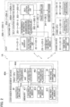
FIG. 2] FIG. 2 is a block diagram showing a configuration of a container management system using a self-location estimation device according to the first embodiment. - [
FIG. 3A] FIG. 3A is an example of coordinate information for each storage space in container terminal premises stored in a container management device connected to the self-location estimation device according to the first embodiment. - [
FIG. 3B] FIG. 3B is an example of type and number of containers currently stored in each storage space in container terminal premises stored in a container management device connected to the self-location estimation device according to the first embodiment. - [
FIG. 3C] FIG. 3C is an example of coordinate information of each crane device in container terminal premises stored in a container management device connected to the self-location estimation device according to the first embodiment. - [
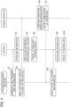
FIG. 4] FIG. 4 is a sequence diagram showing the operation of a container management system using the self-location estimation device according to the first embodiment. - [
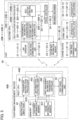
FIG. 5] FIG. 5 is a block diagram showing the configuration of a container management system using the self-location estimation device according to the second embodiment. - [
FIG. 6] FIG. 6 is a sequence diagram showing the operation of a container management system using the self-location estimation device according to the second embodiment. - [
FIG. 7] FIG. 7 is a block diagram showing the configuration of a container management system using the self-location estimation device according to the third embodiment. - [
FIG. 8] FIG. 8 is a sequence diagram showing the operation of a container management system using the self-location estimation device according to the third embodiment. - A container management system (storage facility management system) for managing the operation of an automatic guided vehicle (AGV), which is an autonomous driving vehicle (mobile body) equipped with a self-location estimation device according to the present disclosure, in container terminal (storage facility) premises is described below with reference to the drawings. A container terminal is a facility for temporarily storing containers (objects) that are carried in.
- A configuration of a
container management system 1A according to the first embodiment will be described with reference toFIGS. 1 and2 . In this embodiment, acontainer management system 1A manages a storage status of containers in premises of acontainer terminal 10 and an operation of AGVs and crane devices installed in the premises of thecontainer Terminal 10. -
FIG. 1 is a top view of the premises of thecontainer terminal 10. As shown inFIG. 1 , thecontainer terminal 10 has a plurality of presetcontainer storage areas 11 to 18. Eachcontainer storage area 11 to 18 has, for example, 50 storage spaces (11-1 to 11-50, 12-1 to 12-50... 18-1 to 18-50) set with 10 horizontal rows by 5 vertical columns. - The
container management system 1A includes 3AGVs 20A-1 to 20A-3 traveling in the premises of thecontainer terminal 10, crane devices 30-1 to 30-12 installed in the premises of thecontainer terminal 10, and acontainer management device 40A. The number of AGVs used in thecontainer management system 1A is not limited to three, but may be smaller or larger. Hereinafter, the AGV is stated as AGV 20A if any ofAGVs 20A-1 to 20A-3 is not specified. - Each of the crane devices 30-1 to 30-12 is installed in one of the
container storage areas 11 to 18 to be laterally movable. Specifically, the crane devices 30-1 and 30-2 are installed in thecontainer storage area 11. The crane devices 30-3 and 30-4 are installed in thecontainer storage area 12. The crane devices 30-5 and 30-6 are installed in thecontainer storage area 13. The crane devices 30-7 and 30-8 are installed in thecontainer storage area 14. The crane device 30-9 is installed in thecontainer storage area 15. The crane device 30-10 is installed in thecontainer storage area 16. The crane device 30-11 is installed in thecontainer storage area 17. The crane device 30-12 is installed in thecontainer storage area 18. - The number of crane devices installed in the premises of the
container terminal 10 is not limited to twelve, but may be smaller or larger. Hereinafter, the crane device is stated as thecrane device 30 if any of the crane devices 30-1 to 30-12 in thecontainer terminal 10 is not specified. - As shown in
FIG. 2 , thecontainer management device 40A has amemory 41A, aninstruction input part 42, a firstradio communication unit 43, and afirst CPU 44A. Thememory 41A has acontainer information memory 411, acrane information memory 412, and a firstmap information memory 413. Thecontainer information memory 411 stores storage status information including shape information and storage location information of each container stored in premises of thecontainer terminal 10. Thecrane information memory 412 stores shape information and location information of each of the crane devices 30-1 to 30-12 installed in the premises of thecontainer terminal 10. The firstmap information memory 413 stores generated and updated map information of the premises in thecontainer terminal 10 as described later. - The
instruction input part 42 inputs a container carry-in instruction and a carry-out instruction by an operator's operation and the like. The firstradio communication unit 43 performs a radio communication with theAGVs 20A-1 to 20A-3 and the crane devices 30-1 to 30-12. - The
first CPU 44A has atransport instruction processor 441, a first map-information generator 442, and aninformation updating unit 443. Thetransport instruction processor 441 transmits the container carry-in or carry-out instruction input by theinstruction input unit 42 to thecorresponding crane device 30 and theAGV 20A via the firstradio communication unit 43. - The first map-
information generator 442 generates map information on premises of thecontainer terminal 10 based on the information stored in thecontainer information memory 411 and the information stored in thecrane information memory 412, and stores it in the first map-information memory 413. The first map-information generator 442 updates the map information stored in the first map-information memory 413 based on the updated information when the information stored in thecontainer information memory 411 is updated. The first map-information generator 442 transmits the generated or updated map information to theAGVs 20A-1 to 20 A-3 through the firstradio communication unit 43. - The
information updating unit 443 updates container information and crane information stored in thememory 41A when operations executed by theAGV 20A and thecrane device 30 are completed based on the carry-in instruction or carry-out instruction acquired from thetransport instruction processor 441. - The
AGV 20A-1 includes a laser range finder (LRF) sensor 21-1, a second radio communication unit 22-1, a second map-information memory 23-1, a movement mechanism 24-1, and asecond CPU 25A-1. The LRF sensor 21-1 measures a distance to surrounding objects. The second radio communication unit 22-1 performs radio communication with thecontainer management device 40A. The second map information memory 23-1 stores map information on the premises in thecontainer terminal 10 acquired from thecontainer management device 40 A. The movement mechanism 24-1 is a mechanism for a movement of theAGV 20A-1. - The
second CPU 25 A-1 has a self-location estimation device 200A-1 and a travel controller 251-1. The self-location estimation device 200A-1 has an environmental information acquisition unit 201-1, a map information acquisition unit 202-1, and a self-location estimation unit 203-1. - The environmental information acquisition unit 201-1 acquires information measured by the LRF sensor 21-1 as environmental information of surroundings. When the map information acquisition unit 202-1 acquires map information on the premises in the
container terminal 10 from thecontainer management device 40A through the second radio communication unit 22-1, the relevant map information is stored in the second map information memory 23-1. When the carry-in or carry-out instruction of a container is acquired from thecontainer management device 40A, the map information acquisition unit 202-1 reads out the map information on the premises in thecontainer terminal 10 stored in the second map information memory 23-1. - The self-location estimation unit 203-1 estimates the self-location based on the environmental information of surroundings acquired by the environmental information acquisition unit 201-1 and the map information on the premises in the
container terminal 10 read out by the map information acquisition unit 202-1. The travel control unit 251-1 controls the movement mechanism unit 24-1 so that theAGV 20A-1 moves on a prescribed path R base on the self-location estimated by the self-location estimation unit 203-1. - Since the configuration of the
AGVs 20A-2 and 20A-3 are the same as that of the AGV20A-1, a detailed description thereof will be omitted. - The crane device 30-1 has a third radio communication unit 31-1, a transport mechanism 32-1, and a third CPU 33-1. The third radio communication unit 31-1 performs radio communication with the
container management device 40A. The transport mechanism 32-1 is a mechanism for transporting containers between theAGV 20A and a corresponding storage space. The third CPU 33-1 has an operation controller 331-1 for controlling the transport mechanism 32-1 based on a container carry-in or carry-out instruction acquired through the third radio communication unit 31-1. - Since the configuration of the crane devices 30-2 to 30-12 is the same as that of the crane device 30-1, a detailed description thereof is omitted.
- An operation of the
container management system 1A according to the first embodiment will be described below.FIGS. 3A and 3B show an example of information stored in thecontainer information memory 411 of thecontainer management device 40A in the first embodiment. -
FIG. 3A shows coordinate information for each storage space in the premises of thecontainer terminal 10. The coordinate information is a positional coordinate of one point in thecontainer terminal 10, for example, a prescribed point in each storage space when the origin is a point P which is a corner of arectangular container terminal 10 as shown inFIG. 1 , the horizontal direction is an x-axis, and the vertical direction indicating a depth is a y-axis. -
FIG. 3B shows the type and number of pieces of containers currently stored for each storage space in the premises of thecontainer terminal 10. In this embodiment, there are two types of containers stored in the premises of the container terminal 10: for example, a 20 ft container having a length of 6,058 mm× a width of 2,438 mm× a height of 2,591 mm, and a 40 ft container having a length of 12,192 mm× a width of 2,438 mm× a height of 2,591. - As shape information for each container type, the
container information memory 411 stores shape information based on 3D point cloud data previously generated by LiDAR measurement or LiDAR simulation for the 20 ft container and the 40 ft container. - An example of information stored in the
crane information memory 412 of thecontainer management device 40A is shown inFIG. 3C. FIG. 3C shows coordinate information of each crane device 30-1 to 30-12 in the premises of thecontainer terminal 10. This coordinate information is the position coordinates for a prescribed single point in each crane device 30-1 to 30-12 when the point P in the premises of thecontainer terminal 10 is the origin, the horizontal direction is the x-axis, and the vertical direction indicating the depth is the y-axis. - The
crane information memory 412 of thecontainer management device 40A stores shape information based on 3D point cloud data previously acquired by LiDAR simulation and the like for each crane device 30-1 to 30-12. - Processes performed by each device when the
container management system 1A starts operating with these information stored in thecontainer information memory 411 and thecrane information memory 412 are explained with reference to a sequence diagram inFIG. 4 . TheAGVs 20A-1, 20A-2, and 20A-3 are stopped in a prescribed standby area D in the premises of thecontainer terminal 10 when the operation of thecontainer management system 1A starts. - First, the first map-
information generator 442 of thecontainer management device 40A generates map information in the premises of thecontainer terminal 10 composed of 3D point cloud data, based on the information stored in thecontainer information memory 411 and the information stored in thecrane information memory 412. At that time, since information on the type and number of pieces of containers stored for each storage space are stored thecontainer information memory 411, the first map-information generator 442 can recognize the shape information of the entire container for each storage space using the information. The first map-information generator 442 can generate the corresponding map information by rotating the recognized shape information of the entire container for each storage space and the stored shape information of thecrane device 30 at a prescribed azimuth angle and translating them to the corresponding positions. - The first map-
information generator 442 adds identification information of the relevant container to the 3D point cloud data corresponding to each container when generating the relevant map information. The first map-information generator 442 stores the generated map information on the premises of thecontainer terminal 10 in the firstmap information memory 413. Further, the first map-information generator 442 transmits the generated map information on the premises of thecontainer terminal 10 to theAGVs 20A-1 to 20A-3 through the first radio communication unit 43 (S1). - The
AGVs 20A-1 to 20A-3 respectively acquire the map information on the premises of thecontainer terminal 10 transmitted from thecontainer management device 40A by the map information acquisition units 202-1 to 202-3 through the second radio communication units 22-1 to 22-3. The map information acquisition units 202-1 to 202-3 store the acquired map information on the premises of thecontainer terminal 10 in the second map-information memories 23-1 to 23-3 (S2), respectively. - After that, the
transport instruction processor 441 determines thecrane device 30 and theAGV 20A to execute a process based on the relevant instruction when the carry-in or carry-out instruction of a prescribed container is input by theinstruction input unit 42 of thecontainer management device 40A. Then, thetransport instruction processor 441 transmits information on the relevant instruction to thecorresponding crane device 30 and theAGV 20A through the first radio communication unit 43 (S3). - As an example, an instruction to carry the container X out of the storage space 14-8 of the
container storage area 14 and an instruction to carry the container Y into the storage space 12-3 of thecontainer storage area 12 are inputted by theinstruction input unit 42. When these instructions are inputted, thetransport instruction processor 441 first determines that a carry-in process of the container X is executed by the crane device 30-8 and theAGV 20A-1. Then, thetransport instruction processor 441 transmits information on the carry-out instruction of the container X to the crane device 30-8 and theAGV 20A-1 through the firstradio communication section 43. - Further, the
transport instruction processor 441 determines that a carry-in process of the container Y is executed by the crane device 30-3 and theAGV 20A-2. Thetransport instruction processor 441 transmits information on the transport instruction of the container Y to the crane device 30-3 and the AGV20A-2 via the firstradio communication section 43. - In the
AGV 20A-1, when the information on the transport instruction transmitted from thecontainer management device 40A is acquired through the second radio communication unit 22-1, the environmental information acquisition unit 201-1 of the self-location estimation device 200A-1 acquires information on a distance to a surrounding object measured by the LRF sensor 21-1. Based on the acquired information, the environmental information acquisition unit 201-1 generates surrounding shape information showing the shape of the surrounding object by 3D point cloud data. - Furthermore, in the
AGV 20A-1, when the information of the carry-out instruction transmitted from thecontainer management apparatus 40A is acquired through the second radio communication section 22-1, the map information acquisition unit 202-1 reads out the map information on the premises of thecontainer terminal 10 stored in the second map information memory 23-1. Then, the self-location estimation unit 203-1 estimates the self-location by performing a matching process between the 3D point cloud data indicating the surrounding shape information generated by the environmental information acquisition unit 201-1 and the 3D point cloud data indicating the map information read out by the map information acquisition unit 202-1 (S4). For this matching process of the 3D point cloud data, a known technique such as normal distributions transform (NDT) scan matching can be used. - Then, the travel controller 251-1 controls the movement mechanism 24-1 so that the
AGV 20A-1 moves on the path R based on the self-location estimated by the self-location estimation unit 203-1. The movement mechanism 24-1, controlled by the travel control unit 251-1, moves theAGV 20A-1 on the path R within the premises of thecontainer terminal 10 to a position close to the storage space 14-8 (S5). - When the
AGV 20A-1 arrives at the position close to the storage space 14-8 and stops, the crane device 30-8 performs an operation to carry out the container X based on the instruction information acquired from thecontainer management device 40A (S6). The operation to carry out the container X by the crane device 30-8 is an operation to lift the container X stored in the storage space 14-8 and load it on theAGV 20A-1. - When the operation of the crane device 30-8 is completed and the container X is loaded on the
AGV 20A-1, the crane device 30-8 transmits an operation completion notice concerning the carrying out of the container X to thecontainer management device 40A through the third radio communication unit 31-8 (S7). The operation completion notice includes location information of the crane device 30-8 after the relevant operation is completed. In thecontainer management device 40A, when an operation completion notice concerning carrying-out of the container X is acquired from the crane device 30-8 through the firstradio communication part 43, theinformation updating unit 443 updates the container information stored in thecontainer information memory 411 and the crane information stored in thecrane information memory 412 based on the relevant notice. Specifically, the number of pieces of containers stored in the storage space 14-8 in the container information is reduced by one, and the location information of the crane device 30-8 is updated to the information contained in the operation completion notice. - When the container information in the
container information memory 411 and the crane information in thecrane information memory 412 are updated, the first map-information generator 442 updates the map information stored in the first map-information memory 413 based on the updated information. When the first map-information generator 442 updates the map information, it deletes the 3D point cloud data corresponding to the container X in the storage space 14-8 in the map information. The first map-information generator 442 stores the updated map information in the first map-information memory 413 and transmits it to theAGV 20A-1 through the first radio communication section 43 (S8). - In the
AGV 20A-1, when the updated map information transmitted from thecontainer management device 40A is acquired through the second radio communication section 22-1, the map information acquisition unit 202-1 updates the information stored in the second map-information memory 23-1 with the relevant map information (S9). Further, in theAGV 20A-1, the self-location estimation unit 203-1 estimates the self-location using the updated map information, and based on the estimated self-location, the travel controller 251-1 controls the movement mechanism 24-1 so that theAGV 20A-1 travels to the standby area D (S10). TheAGV 20A-1 waits in the standby area D until it receives the next carry-in or carry-out instruction. - Furthermore, the
AGV 20A-2, which has acquired the carry-in instruction in step S3, loads the container Y to be carried in at the standby area D, and the self-location estimation device 200 A-2 estimates the self-location in the same manner as theAGV 20A-1 (S4). Then, theAGV 20A-2 travels on the path R to a position close to the storage space 12-3 based on the estimated self-location (S5). - Then, the
AGV 20A-2 arrives at a position close to the storage space 12-3 and stops, and the crane device 30-3 lifts the container Y loaded on theAGV 20A-2 and stores it in the storage space 12-3 to perform a carry-in operation of the container Y (S6). When the carry-in operation of the container Y is completed and the crane device 30-3 transmits an operation completion notice concerning the carry-in operation of the container Y to thecontainer management device 40A through the third radio communication unit 31-3 (S7), theinformation updating unit 443 updates the container information stored in thecontainer information memory 411 and the crane information stored in thecrane information memory 412 based on the relevant notice. Specifically, the number of containers stored in the storage space 12-3 in the container information is increased by 1, and the position information of the crane device 30-3 is updated to the information contained in the operation completion notice. - When the container information in the
container information memory 411 and the crane information in thecrane information memory 412 are updated, the first map-information generator 442 updates the map information stored in the first map-information memory 413 based on the updated information. The first map-information generator 442 stores the updated map information in the first map-information memory 413 and transmits it to theAGV 20A-2 through the first radio communication unit 43 (S8). - In the
AGV 20A-2, when the updated map information transmitted from thecontainer management device 40A is acquired through the second radio communication unit 22-2, the map information acquisition unit 202-2 updates the information stored in the second map-information memory 23-2 with the relevant map information (S9). Then, in theAGV 20A-2, the self-location estimation unit 203-2 estimates the self-location using the updated map information, and the travel controller 251-2 controls the movement mechanism 24-2 based on the estimated self-location so that the AGV20A-2 travels to the standby area D (S10). TheAGV 20A-2 waits at the standby area D until it receives the next carry-in or carry-out instruction. - According to the first embodiment, the
AGV 20A can easily and accurately estimate a self-location using the map information on the premises generated based on the shape information and the location information of the container and thecrane device 30 on the premises of thecontainer terminal 10. Further, theAGV 20A can travel on a prescribed path in the premises of thecontainer terminal 10 as appropriate using the estimated information of the self-location. At that time, thecontainer management device 40A generates map information on the premises of thecontainer terminal 10 and supplies it to a plurality ofAGVs 20A, so that eachAGV 20A can efficiently execute the self-location estimation process with a small processing load. Furthermore, in thecontainer terminal 10, the shapes of containers stored in the premises are limited to a few patterns, and the location of the storage space where containers are stored is set in advance. Therefore, thecontainer management device 40A can easily generate map information on premises of thecontainer terminal 10 by using location information for each storage space and stored information on the shape and number of pieces of containers. - A configuration of a
container management system 1B according to the second embodiment will be described with reference toFIGS. 1 and5 . In thecontainer management system 1B according to the embodiment, afirst CPU 44B of acontainer management device 40B has a first managementinformation transmission controller 444 in place of the firstmap information generator 442 described in the first embodiment. Further, amemory 41B of thecontainer management device 40B does not have the firstmap information memory 413 described in the first embodiment. Furthermore, the self-location estimation devices 200B-1 to 200B-3 ofAGVs 20B-1 to 20B-3 have second map-information generators 204-1 to 204-3 as a map information acquisition unit. Since the configuration of thecontainer management system 1B other than these is similar to the configuration of thecontainer management system 1A described in the first embodiment, the detailed description of the parts having the same functions will be omitted. - In this embodiment, the first management
information transmission controller 444 of thecontainer management device 40B transmits information stored in thecontainer information memory 411 and information stored in thecrane information memory 412 to theAGVs 20B-1 to 20B-3 through the firstradio communication unit 43. The second map-information generators 204-1 to 204-3 of theAGVs 20B-1 to 20B-3 generates map information on the premises of thecontainer terminal 10 based on the information acquired from thecontainer management device 40B through the second radio communication units 22-1 to 22-3 and stores it in the second map information memory 23-1 to 23-3. - The operation of the
container management system 1B according to the present embodiment will be described with reference to a sequence diagram shown inFIG. 6 . First, the first managementinformation transmission controller 444 of thecontainer management device 40B transmits the container information stored in thecontainer information memory 411 and the crane information stored in thecrane information memory 412 to theAGVs 20B-1 to 20B-3 through the first radio communication unit 43 (S 11). - In the
AGVs 20B-1 to 20B-3, when the container information and the crane information transmitted from thecontainer management device 40B are acquired through the second radio communication units 22-1 to 22-3, the second map-information generators 204-1 to 204-3 generate map information on the premises of thecontainer terminal 10 composed of 3D point group data based on the acquired information. The second map-information generators 204-1 to 204-3 store the generated map information in the second map-information memories 23-1 to 23-3 (S12), respectively. - Thereafter, processes of steps S13 to S17 executed when carry-in or carry-out instruction for a prescribed container is inputted at the
instruction input unit 42 of thecontainer management device 40B is similar to the processes of steps S3 to S7 described in the first embodiment, and therefore, the detailed description thereof is omitted. - An operation completion notice concerning the relevant process is transmitted from the
crane device 30 to thecontainer management device 40B through the third radio communication units 31-1 to 31-12 (S17) when the carry-in process or carry-out process of the container is completed. In thecontainer management device 40B, when the operation completion notice is acquired through the firstradio communication unit 43, theinformation updating unit 443 updates the container information and the crane information stored in thememory 41B based on the relevant notice. Then, the first managementinformation transmission controller 444 transmits the updated container information and crane information to theAGVs 20B-1 to 20B-3 through the first radio communication unit 43 (S18). - The second map-information generators 204-1 to 204-3 of the
AGVs 20B-1 to 20B-3 acquire the updated container information and crane information transmitted from thecontainer management unit 40B through the second radio communication units 22-1 to 22-3. The second map-information generators 204-1 to 204-3 update and store the map information stored in the second map information memories 23-1 to 23-3 (S19) based on the acquired information. - Then, the self-location estimation units 203-1 to 203-3 of the
AGVs 20B-1 to 20B-3 that have performed the carry-in process or carry-out process estimates the self-location using the updated map information, and the travel controllers 251-1 to 251-3 control the travel mechanisms 24-1 to 24-3 based on the estimated self-location so that theAGVs 20B-1 to 20B-3 to the standby area D (S20). TheAGVs 20B-1 to 20B-3 wait at the standby area D until they receive the next carry-in or carry-out instruction. - According to the second embodiment described above, the
AGVs 20B-1 to 20B-3 traveling in the premises of thecontainer terminal 10 can easily and accurately estimate a self-location using the map information of the premises generated based on the shape information and position information of the container and thecrane device 30 in the premises. In this case, eachAGV 20B-1 to 20B-3 generates the map information on the premises of thecontainer terminal 10, so that eachAGV 20B-1 to 20B-3 can generate the map information of the required position according to traveling routes. - A configuration of a
container management device 1C according to the third embodiment will be described with reference toFIGS. 1 and7 . Thecontainer management system 1C according to the first embodiment further includes a map-information generation device 50 in the configuration ofcontainer management device 1A described in the first embodiment. Furthermore, thefirst CPU 44C of thecontainer management device 40C includes a second managementinformation transmission controller 445 in place of the first map-information generator 442 described in the first embodiment. Moreover, thememory 41C of thecontainer management device 40C does not include the firstmap information memory 413 described in the first embodiment. Since other configuration of thecontainer management device 1C is the same as that of thecontainer management device 1A described in the first embodiment, a detailed description of the parts having the same functions will be omitted. - In this embodiment, the second management
information transmission controller 445 of thecontainer management device 40C transmits the information stored in thecontainer information memory 411 and the information stored in thecrane information memory 412 to the map-information generation device 50. - The map-
information generation device 50 includes a managementinformation acquisition unit 51, a fourthradio communication unit 52, a third map-information generator 53, and a third map-information memory 54. The managementinformation acquisition unit 51 acquires information transmitted from thecontainer management device 40C. The fourthradio communication unit 52 performs a radio communication with theAGVs 20C-1 to 20C-3. The third map-information generator 53 generates and updates map information on the premises of thecontainer terminal 10 based on the information acquired from thecontainer management device 40C, and transmits it to theAGVs 20C-1 to 20C-3 through the fourthradio communication unit 52. The thirdmap information memory 54 stores map information on the premises of thecontainer terminal 10 generated and updated by the third map-information generator 53. - When the map information acquisition units 202-1 to 202-3 of the
AGVs 20C-1 to 20C-3 acquire the map information on the premises of thecontainer terminal 10 from the mapinformation generation device 50 through the second radio communication unit 22-1, the relevant map information is stored in the second map information memory 23-1. - An operation of a
container management system 1C according to the present embodiment will be described with reference to a sequence diagram shown inFIG. 8 . First, the second managementinformation transmission controller 445 of thecontainer management device 40C transmits the container information stored in thecontainer information memory 411 and the crane information stored in thecrane information memory 412 to the map-information generation device 50 (S21). - In the map-
information generation device 50, the managementinformation acquisition unit 51 acquires the container information and crane information transmitted from thecontainer management device 40C, and the third map-information generator 53 generates the map information on the premises of thecontainer terminal 10 based on the acquired information. The third map-information generator 53 stores the generated map information of the premises of thecontainer terminal 10 in the thirdmap information memory 54 and transmits it to theAGVs 20C-1 to 20C-3 through the fourth radio communication unit 52 (S22). - In the
AGVs 20C-1 to 20C-3, the map information acquisition units 202-1 to 202-3 acquire the map information of the premises of thecontainer terminal 10 transmitted from the map-information generation device 50 through the second radio communication units 22-1 to 22-3. Each of the map information acquisition units 202-1 to 202-3 store the acquired map information of thecontainer terminal 10 in the second map information memories 23-1 to 23-3 (S23). - Thereafter, processes of steps S24 to S28 executed when a prescribed container carry-in or carry-out instruction is inputted at the
instruction input unit 42 of thecontainer management device 40C is the same as the processes of steps S3 to S7 described in the first embodiment, and therefore, the detailed description thereof is omitted. - When the container carry-in or carry-out process is completed, an operation completion notice concerning the relevant process is transmitted from the
crane device 30 to thecontainer management device 40C through the third radio communication units 31-1 to 31-12 (S28). In thecontainer management device 40C, when the operation completion notice is acquired via the firstradio communication unit 43, theinformation updating unit 443 updates the container information and the crane information stored in thememory 41C based on the relevant notice. Then, the second managementinformation transmission controller 445 transmits the updated container information and crane information to the map-information generation device 50 (S29). - In the map-
information generation device 50, the thirdmap information generator 53 acquires the updated container information and crane information transmitted from thecontainer management device 40C. The thirdmap information generator 53 updates the map information stored in the third map-information memory 54 based on the acquired information. The third map-information generator 53 stores the updated map information in the third map-information memory 54 and transmits it to theAGVs 20C-1 to 20C-3 through the fourth radio communication unit 52 (S30). - In the
AGVs 20C-1 to 20C-3, when the updated map information transmitted from the map-information generation device 50 is acquired through the second radio communication units 22-1 to 22-3, the map information acquisition units 202-1 to 202-3 update the information stored in the second map information memories 23-1 to 23-3 with the relevant map information (S31). Then, in theAGVs 20C-1 to 20C-3 that have performed a carry-out or carry-in process, the self-location estimation units 203-1 to 203-3 estimate the self-location using the updated map information, and the travel controllers 251-1 to 251-3 control the travel mechanisms 24-1 to 24-3 based on the estimated self-location to drive theAGVs 20C-1 to 20C-3 to the standby area D (S32).AGVs 20C-1 to 20C-3 wait in the standby area D until it receives the next carry-in or carry-out instruction. - According to the third embodiment described above, the
AGVs 20C-1 to 20C-3 travelling in the premises of thecontainer terminal 10 can easily and accurately estimate a self-location using the map information of the premises generated based on the shape information and position information of the container and thecrane device 30 in the premises. At this time, the mapinformation generation device 50 connected to thecontainer management device 40C generates the map information on the premises of thecontainer terminal 10 and supplies it to the plurality ofAGVs 20C-1 to 20C-3. With this configuration, the processing load of thecontainer management device 40C and eachAGVs 20C-1 to 20C-3 can be reduced, and the self-location estimation process can be efficiently executed. - In the first to third embodiments described above, the case in which 3D information is used as the shape information of the container, the shape information of the
crane device 30, and the map information has been described, but 2D information viewed from the upward direction may be used as the information. In the case on which 2D information is used, updating of the map information is unnecessary when the carry-in or carry-out processes of containers on a second or higher shelves are performed for a prescribed storage space. - Further, in the first to third embodiments described above, when there is an area in the premises of the
container terminal 10 where for the Global Navigation Satellite System (GNSS), GNSS signals from multiple satellites can be received, the AGV 20 may be switched to acquire self-location information by receiving GNSS signals and calculating location information in the relevant area. GNSS is, for example, a Global Positioning System (GPS). - Although some embodiments have been described, it is possible to modify or vary the embodiments based on the above disclosure. All components of the above embodiments and all features described in the scope of claims may be individually extracted and combined as long as they do not contradict each other.
- The entire contents of
Japanese Patent Application No. 2021-180096 (filing date: November 4, 2021 -
- 10 container terminal (storage facility)
- 11-1 to 11-50, 12-1 to 12-50, 13-1 to 13-50, 14-1 to 14-50, 15-1 to 15-50, 16-1 to 16-50,
- 17-1 to 17-50, 18-1 to 18-50 storage space
- 20, 20A-1 to 20 A-3, 20B-1 to 20B-3, 20C-1 to 20C-3 AGV (mobile body)
- 24-1 to 24-3 movement mechanism
- 40A, 40B, 40C container management device (storage facility management device)
- 50 map information generation device
- 200A-1 to 200A-3, 200B-1 to 200B-3, 200C-1 to 200 C-3 (200) self-location estimation device
- 201-1 to 201-3 (201) environmental information acquisition unit
- 202-1 to 202-3 (202) map information acquisition unit
- 203-1 to 203-3 (203) self-location estimation unit
- 204-1 to 204-3 (204) second map information generator
- 251-1 to 251-3 travel controller
- X, Y container (object)
Claims (6)
- A self-location estimation device comprising:a map information acquisition unit configured to acquire map information in a storage facility generated based on shape information of an object and storage status information of the object in the storage facility;an environmental information acquisition unit configured to acquire environmental information of surroundings; anda self-location estimation unit configured to estimate a self-location based on the map information acquired by the map information acquisition unit and the environmental information acquired by the environmental information acquisition unit.
- The self-location estimation device according to claim 1, whereinthe self-location estimation device is communicatively connected to a storage facility management device that manages the shape information of the object and the storage status information of the object in the storage facility, and is installed on a mobile body movable in the storage facility,based on the shape information of the object managed by the storage facility management device and the storage status information in the storage facility, the map information acquisition unit is configured to acquire the map information generated by the storage facility management device, the mobile body, or a map information generation device communicatively connected to the storage facility management device and the self-location estimation device,the environmental information acquisition unit is configured to acquire the environmental information of surroundings of the mobile body, andthe self-location estimation unit is configured to estimate a location of the mobile body as the self-location.
- The self-location estimation device according to claim 1, whereinthe storage facility has storage spaces for storing the object, andthe storage status information of the object includes location information of each of the storage spaces and information on a number of the object stored in each of the storage spaces.
- The self-location estimation device according to claim 2, whereinthe storage facility has storage spaces for storing the object, andthe storage status information of the object includes location information of each of the storage spaces and information on a number of the object stored in each of the storage spaces.
- An autonomous driving vehicle, comprising:a self-location estimation device according to any one of claims 1 to 4;a movement mechanism configured to move the autonomous driving vehicle; anda travel controller configured to control the movement mechanism so that the autonomous driving vehicle moves on a prescribed path based on the self-location estimated by the self-location estimation device.
- A self-location estimation method comprising:acquiring map information in a storage facility generated based on shape information of an object and storage status information of the object in the storage facility;acquiring environmental information of surroundings; andestimating a self-location based on the acquired map information and the acquired environmental information.
Applications Claiming Priority (2)
| Application Number | Priority Date | Filing Date | Title |
|---|---|---|---|
| JP2021180096 | 2021-11-04 | ||
| PCT/JP2022/040246 WO2023080062A1 (en) | 2021-11-04 | 2022-10-27 | Self-position estimation device, autonomous driving vehicle, and self-position estimation method |
Publications (2)
| Publication Number | Publication Date |
|---|---|
| EP4428646A1 true EP4428646A1 (en) | 2024-09-11 |
| EP4428646A4 EP4428646A4 (en) | 2025-04-09 |
Family
ID=86241146
Family Applications (1)
| Application Number | Title | Priority Date | Filing Date |
|---|---|---|---|
| EP22889882.1A Pending EP4428646A4 (en) | 2021-11-04 | 2022-10-27 | SELF-POSITION ESTIMATION DEVICE, AUTONOMOUSLY DRIVING VEHICLE AND SELF-POSITION ESTIMATION METHOD |
Country Status (5)
| Country | Link |
|---|---|
| US (1) | US20240272642A1 (en) |
| EP (1) | EP4428646A4 (en) |
| JP (1) | JP7732517B2 (en) |
| CN (1) | CN118103789A (en) |
| WO (1) | WO2023080062A1 (en) |
Family Cites Families (13)
| Publication number | Priority date | Publication date | Assignee | Title |
|---|---|---|---|---|
| JP2005001832A (en) * | 2003-06-12 | 2005-01-06 | Matsushita Electric Ind Co Ltd | Warehouse status management apparatus and method |
| JP2006282386A (en) * | 2005-03-31 | 2006-10-19 | Mitsui Eng & Shipbuild Co Ltd | Equipment layout in container yard |
| JP2009169845A (en) | 2008-01-18 | 2009-07-30 | Toyota Motor Corp | Autonomous mobile robot and map updating method |
| JP5259286B2 (en) * | 2008-07-16 | 2013-08-07 | 株式会社日立製作所 | 3D object recognition system and inventory system using the same |
| JP6141782B2 (en) * | 2014-03-12 | 2017-06-07 | 株式会社豊田自動織機 | Method for updating map information in a linked system of automated guided vehicle and inventory management system |
| JP6247796B2 (en) * | 2015-11-25 | 2017-12-13 | 株式会社日立製作所 | Shelf placement system, transfer robot, and shelf placement method |
| JP6751603B2 (en) * | 2016-06-24 | 2020-09-09 | 株式会社Ihiエアロスペース | Container terminal system |
| WO2019154443A2 (en) * | 2019-04-04 | 2019-08-15 | 上海快仓智能科技有限公司 | Navigation control method, smart warehousing system, and automated guided vehicle |
| CN110189068B (en) * | 2019-04-14 | 2023-11-03 | 炬星科技(深圳)有限公司 | A warehouse rapid configuration method, equipment and storage medium |
| JP7302291B2 (en) * | 2019-05-27 | 2023-07-04 | 中国電力株式会社 | Goods management system |
| DE102019207870A1 (en) * | 2019-05-29 | 2020-12-03 | Robert Bosch Gmbh | Method for creating an environment map for use in the autonomous navigation of a mobile robot |
| JP7350671B2 (en) * | 2020-02-25 | 2023-09-26 | 三菱重工業株式会社 | Position estimation device, control device, industrial vehicle, logistics support system, position estimation method and program |
| JP2021180096A (en) | 2020-05-13 | 2021-11-18 | 株式会社ダイセル | Separator for secondary battery |
-
2022
- 2022-10-27 JP JP2023557992A patent/JP7732517B2/en active Active
- 2022-10-27 CN CN202280069892.3A patent/CN118103789A/en active Pending
- 2022-10-27 EP EP22889882.1A patent/EP4428646A4/en active Pending
- 2022-10-27 WO PCT/JP2022/040246 patent/WO2023080062A1/en not_active Ceased
-
2024
- 2024-04-23 US US18/643,238 patent/US20240272642A1/en active Pending
Also Published As
| Publication number | Publication date |
|---|---|
| CN118103789A (en) | 2024-05-28 |
| JPWO2023080062A1 (en) | 2023-05-11 |
| EP4428646A4 (en) | 2025-04-09 |
| JP7732517B2 (en) | 2025-09-02 |
| US20240272642A1 (en) | 2024-08-15 |
| WO2023080062A1 (en) | 2023-05-11 |
Similar Documents
| Publication | Publication Date | Title |
|---|---|---|
| US8880340B2 (en) | Augmented mobile platform localization | |
| EP3371670B1 (en) | Device and method for autonomous localisation | |
| EP2450763B1 (en) | Global position and orientation estimation system for a vehicle in a passageway environment | |
| EP4089367B1 (en) | Hybrid sky and ground navigation for machine employing satellite positioning | |
| EP3905213B1 (en) | Positioning apparatus and moving body | |
| EP3904992A1 (en) | Positioning device and mobile body | |
| EP3460779A1 (en) | Information output device, terminal device, control method, program, and storage medium | |
| JP6751603B2 (en) | Container terminal system | |
| Morales et al. | Collaborative autonomous vehicles with signals of opportunity aided inertial navigation systems | |
| JP2021160931A (en) | Cargo handling system | |
| US20200208987A1 (en) | Indoor positioning method and apparatuses for performing the same | |
| JP7732517B2 (en) | Self-location estimation device, autonomous driving vehicle, and self-location estimation method | |
| JP7649955B2 (en) | Map generation method, program, map generation system, and mobile robot equipped with the same | |
| EP4019897B1 (en) | Autonomous travel system | |
| JP2020160018A (en) | Quantity inspection system for cargo on ships | |
| CN117250950A (en) | Vehicle alignment method, system, equipment and storage medium based on odometer | |
| US12506538B2 (en) | Free-space optical communication control system, free-space optical communication control apparatus, and free-space optical communication control method | |
| KR102939681B1 (en) | Positioning and Location Control System for Heterogeneous Robot Swarms Based on UWB Communication in Non-GPS Environments | |
| JP2025170522A (en) | Guidance method and guidance device for transport vehicle | |
| Ivarsen et al. | Autonomous navigation for inspection and maintenance ground robotics | |
| WO2025253779A1 (en) | Assistance system, control system, conveyance system, and assistance method | |
| CN120191849A (en) | Vehicle alignment method and straddle carrier | |
| JP2023101086A (en) | cargo handling system | |
| Tennstedt et al. | An Autonomous Transportation Vehicle For Algorithm And Sensor Testing | |
| CN113391337A (en) | Handling equipment positioning system and method |
Legal Events
| Date | Code | Title | Description |
|---|---|---|---|
| STAA | Information on the status of an ep patent application or granted ep patent |
Free format text: STATUS: THE INTERNATIONAL PUBLICATION HAS BEEN MADE |
|
| PUAI | Public reference made under article 153(3) epc to a published international application that has entered the european phase |
Free format text: ORIGINAL CODE: 0009012 |
|
| STAA | Information on the status of an ep patent application or granted ep patent |
Free format text: STATUS: REQUEST FOR EXAMINATION WAS MADE |
|
| 17P | Request for examination filed |
Effective date: 20240426 |
|
| AK | Designated contracting states |
Kind code of ref document: A1 Designated state(s): AL AT BE BG CH CY CZ DE DK EE ES FI FR GB GR HR HU IE IS IT LI LT LU LV MC ME MK MT NL NO PL PT RO RS SE SI SK SM TR |
|
| DAV | Request for validation of the european patent (deleted) | ||
| DAX | Request for extension of the european patent (deleted) | ||
| REG | Reference to a national code |
Ref country code: DE Ref legal event code: R079 Free format text: PREVIOUS MAIN CLASS: G05D0001020000 Ipc: G05D0001242000 |
|
| A4 | Supplementary search report drawn up and despatched |
Effective date: 20250307 |
|
| RIC1 | Information provided on ipc code assigned before grant |
Ipc: B65G 1/00 20060101ALI20250303BHEP Ipc: G05D 1/698 20240101ALI20250303BHEP Ipc: G05D 1/692 20240101ALI20250303BHEP Ipc: G05D 1/246 20240101ALI20250303BHEP Ipc: G05D 1/242 20240101AFI20250303BHEP |
|
| STAA | Information on the status of an ep patent application or granted ep patent |
Free format text: STATUS: EXAMINATION IS IN PROGRESS |
|
| 17Q | First examination report despatched |
Effective date: 20251008 |
|
| GRAP | Despatch of communication of intention to grant a patent |
Free format text: ORIGINAL CODE: EPIDOSNIGR1 |
|
| STAA | Information on the status of an ep patent application or granted ep patent |
Free format text: STATUS: GRANT OF PATENT IS INTENDED |
|
| RIC1 | Information provided on ipc code assigned before grant |
Ipc: G05D 1/242 20240101AFI20260121BHEP Ipc: G05D 1/246 20240101ALI20260121BHEP Ipc: G05D 1/692 20240101ALI20260121BHEP Ipc: G05D 1/698 20240101ALI20260121BHEP Ipc: B65G 1/00 20060101ALI20260121BHEP Ipc: G01C 21/00 20060101ALI20260121BHEP |
|
| INTG | Intention to grant announced |
Effective date: 20260213 |