EP4425291A1 - Verfahren zur konstruktion einer virtuellen grenze, autonome mobile mähvorrichtung und benutzerendgerät - Google Patents
Verfahren zur konstruktion einer virtuellen grenze, autonome mobile mähvorrichtung und benutzerendgerät Download PDFInfo
- Publication number
- EP4425291A1 EP4425291A1 EP23189122.7A EP23189122A EP4425291A1 EP 4425291 A1 EP4425291 A1 EP 4425291A1 EP 23189122 A EP23189122 A EP 23189122A EP 4425291 A1 EP4425291 A1 EP 4425291A1
- Authority
- EP
- European Patent Office
- Prior art keywords
- boundary
- autonomous mobile
- mowing apparatus
- mobile mowing
- threshold
- Prior art date
- Legal status (The legal status is an assumption and is not a legal conclusion. Google has not performed a legal analysis and makes no representation as to the accuracy of the status listed.)
- Granted
Links
Images


Classifications
-
- G—PHYSICS
- G05—CONTROLLING; REGULATING
- G05D—SYSTEMS FOR CONTROLLING OR REGULATING NON-ELECTRIC VARIABLES
- G05D1/00—Control of position, course, altitude or attitude of land, water, air or space vehicles, e.g. using automatic pilots
- G05D1/02—Control of position or course in two dimensions
- G05D1/021—Control of position or course in two dimensions specially adapted to land vehicles
- G05D1/0212—Control of position or course in two dimensions specially adapted to land vehicles with means for defining a desired trajectory
- G05D1/0219—Control of position or course in two dimensions specially adapted to land vehicles with means for defining a desired trajectory ensuring the processing of the whole working surface
-
- A—HUMAN NECESSITIES
- A01—AGRICULTURE; FORESTRY; ANIMAL HUSBANDRY; HUNTING; TRAPPING; FISHING
- A01D—HARVESTING; MOWING
- A01D34/00—Mowers; Mowing apparatus of harvesters
- A01D34/006—Control or measuring arrangements
- A01D34/008—Control or measuring arrangements for automated or remotely controlled operation
-
- G—PHYSICS
- G05—CONTROLLING; REGULATING
- G05D—SYSTEMS FOR CONTROLLING OR REGULATING NON-ELECTRIC VARIABLES
- G05D1/00—Control of position, course, altitude or attitude of land, water, air or space vehicles, e.g. using automatic pilots
- G05D1/0011—Control of position, course, altitude or attitude of land, water, air or space vehicles, e.g. using automatic pilots associated with a remote control arrangement
- G05D1/0016—Control of position, course, altitude or attitude of land, water, air or space vehicles, e.g. using automatic pilots associated with a remote control arrangement characterised by the operator's input device
-
- G—PHYSICS
- G05—CONTROLLING; REGULATING
- G05D—SYSTEMS FOR CONTROLLING OR REGULATING NON-ELECTRIC VARIABLES
- G05D1/00—Control of position, course, altitude or attitude of land, water, air or space vehicles, e.g. using automatic pilots
- G05D1/0011—Control of position, course, altitude or attitude of land, water, air or space vehicles, e.g. using automatic pilots associated with a remote control arrangement
- G05D1/0044—Control of position, course, altitude or attitude of land, water, air or space vehicles, e.g. using automatic pilots associated with a remote control arrangement by providing the operator with a computer generated representation of the environment of the vehicle, e.g. virtual reality, maps
-
- G—PHYSICS
- G05—CONTROLLING; REGULATING
- G05D—SYSTEMS FOR CONTROLLING OR REGULATING NON-ELECTRIC VARIABLES
- G05D1/00—Control of position, course, altitude or attitude of land, water, air or space vehicles, e.g. using automatic pilots
- G05D1/02—Control of position or course in two dimensions
- G05D1/021—Control of position or course in two dimensions specially adapted to land vehicles
- G05D1/0212—Control of position or course in two dimensions specially adapted to land vehicles with means for defining a desired trajectory
- G05D1/0221—Control of position or course in two dimensions specially adapted to land vehicles with means for defining a desired trajectory involving a learning process
-
- G—PHYSICS
- G05—CONTROLLING; REGULATING
- G05D—SYSTEMS FOR CONTROLLING OR REGULATING NON-ELECTRIC VARIABLES
- G05D1/00—Control of position, course, altitude or attitude of land, water, air or space vehicles, e.g. using automatic pilots
- G05D1/02—Control of position or course in two dimensions
- G05D1/021—Control of position or course in two dimensions specially adapted to land vehicles
- G05D1/0268—Control of position or course in two dimensions specially adapted to land vehicles using internal positioning means
- G05D1/0274—Control of position or course in two dimensions specially adapted to land vehicles using internal positioning means using mapping information stored in a memory device
-
- A—HUMAN NECESSITIES
- A01—AGRICULTURE; FORESTRY; ANIMAL HUSBANDRY; HUNTING; TRAPPING; FISHING
- A01D—HARVESTING; MOWING
- A01D2101/00—Lawn-mowers
Definitions
- Embodiments of the present disclosure relate to the technical field of artificial intelligence, and in particular to, a method for constructing a virtual boundary, an autonomous mobile mowing apparatus, and a user terminal.
- an autonomous mobile mowing apparatus As a fully automatic mechanic tool for trimming grass and vegetation, an autonomous mobile mowing apparatus is widely used in occasions, such as landscaping, trimming, household, and public lawn trimming.
- Such a traditional autonomous mobile mowing robot is controlled to establish a virtual boundary mostly relying on remote control.
- operation requirements of the user are increased. Therefore, it is necessary to smartly establish a traveling boundary of the autonomous mobile mowing apparatus.
- a smart autonomous mobile mowing apparatus based on a satellite navigation technology only needs to guide the autonomous mobile mowing apparatus to travel around a lawn boundary, and positioning coordinate data of the boundary can be recorded. Similarly, data may be collected and annotated in this way to record an obstacle or a channel, thereby reducing operation requirements for the user.
- the autonomous mobile mowing apparatus since the autonomous mobile mowing apparatus is manually guided to travel around the lawn boundary, when the virtual boundary is closed, the autonomous mobile mowing apparatus may need to perform position adjustment many times before the boundary can be closed when different users have different operation skills and different proficiency degrees, thereby resulting in a low efficiency of boundary closure. Moreover, in a process of adjusting the autonomous mobile mowing apparatus, the autonomous mobile mowing apparatus will repeatedly roll a lawn near the autonomous mobile mowing apparatus, thus damaging the lawn to a certain extent.
- embodiments of the present disclosure are presented to provide a method for constructing a virtual boundary, an autonomous mobile mowing apparatus, and a user terminal, to at least solve a problem that existing boundary closure is less accurate.
- One or more embodiments of the present disclosure provide a method for constructing a virtual boundary, including: controlling an autonomous mobile mowing apparatus to travel within a to-be-processed region from a starting point for map construction, and recording a position of the autonomous mobile mowing apparatus; and outputting a virtual boundary map when a boundary closing condition is satisfied, where the boundary closing condition includes a distance between a current position of the autonomous mobile mowing apparatus and a position of the starting point for map construction being less than or equal to a first threshold, a length of a minimal bounding rectangle of a closed region being greater than or equal to a second threshold, and a width of the minimal bounding rectangle being greater than or equal to a third threshold, where the closed region is a region surrounded by a connecting line between the current position and the starting point for map construction and a historical traveling path, and the first threshold is greater than a positioning accuracy of a sensor in the autonomous mobile mowing apparatus.
- a user terminal including: a processing unit and a display interface; where the processing unit is configured to display a boundary closure prompt message through the display interface after an autonomous mobile mowing apparatus satisfies a boundary closing condition, and output a virtual boundary map after receiving a boundary closure confirmation message inputted for the boundary closure prompt message, where the boundary closing condition includes a distance between a current position of the autonomous mobile mowing apparatus and a starting point for map construction of the autonomous mobile mowing apparatus being less than or equal to a first threshold, a length of a minimal bounding rectangle of a closed region being greater than or equal to a second threshold, and a width of the minimal bounding rectangle being greater than or equal to a third threshold, where the closed region is a region surrounded by a connecting line between the current position and the starting point for map construction and a historical traveling path, and the first threshold is greater than a positioning accuracy of a sensor in the autonomous mobile mowing apparatus.
- an electronic device including: a processor, a memory, a communication interface, and a communication bus, where the processor, the memory, and the communication interface complete communication with each other through the communication bus; and the memory is configured to store at least one executable instruction, where the executable instruction, when executed by the processor, causes the processor to perform the method for constructing a virtual boundary according to the first aspect of the present disclosure.
- a non-transitory computer-readable storage medium storing computer instructions, where the computer instructions are used for causing a computer to perform the method for constructing a virtual boundary according to the first aspect of the present disclosure.
- a boundary closing condition is set to replace manual guidance of the autonomous mobile mowing apparatus to perform boundary closure, and a virtual boundary map is output when the boundary closing condition is satisfied, thereby preventing the autonomous mobile mowing apparatus from repeated position adjustment and repeated crushing of a nearby lawn for boundary closure, reducing the damage of the autonomous mobile mowing apparatus to the lawn, and improving the efficiency of virtual boundary closure.
- a first threshold is set to be greater than a positioning accuracy of a sensor in the autonomous mobile mowing apparatus, thereby avoiding a problem of a low boundary closure efficiency caused by insufficient positioning accuracy in the boundary closure of the autonomous mobile mowing apparatus, and further improving the efficiency of virtual boundary closure.
- the autonomous mobile mowing apparatus may be an automatic mower.
- the automatic mower may be configured to trim a lawn to guarantee that grass height in the lawn satisfies requirements.
- the automatic mower mainly includes a housing; and a driving wheel assembly, a mowing knife assembly, a controller, a communication module, a sensor, and the like provided on the housing.
- the driving wheel assembly can drive the housing and components thereon to move.
- the mowing knife assembly is used for cutting grass.
- the controller is connected with electric signals of, e.g., the driving wheel assembly, the mowing knife assembly, the communication module, and the sensor, respectively, to control and position the automatic mower.
- the communication module may be a module capable of implementing wireless communication, such as WIFI, Bluetooth, or cellular data network, and may be used to perform data communication between the automatic mower and an external device.
- wireless communication such as WIFI, Bluetooth, or cellular data network
- the sensor can detect data of the automatic mower, thereby positioning the automatic mower.
- the sensor on the automatic mower may include, but is not limited to, a built-in IMU (inertial navigation unit), a GPS (global positioning system), a magnetometer, a barometer, etc.
- FIG. 1 is a schematic flowchart of steps of a method for constructing a virtual boundary provided in Embodiment I of the present disclosure. As shown in FIG. 1 , a schematic flowchart of steps of a method for constructing a virtual boundary is shown. In the present embodiment, the method includes steps of: Step 101: controlling an autonomous mobile mowing apparatus to travel from a starting point for map construction within a to-be-processed region, and recording a position of the autonomous mobile mowing apparatus.
- the autonomous mobile mowing apparatus is first controlled to travel from the starting point for map construction within the to-be-processed region, and record the position of the autonomous mobile mowing apparatus during the travelling.
- the position of the autonomous mobile mowing apparatus may be recorded by sending position information through a sensor of the autonomous mobile mowing apparatus and recording the position information, or may be recorded by satellite positioning, which is not limited here.
- Step 102 outputting a virtual boundary map when a boundary closing condition is satisfied.
- the boundary closing condition includes a distance between a current position of the autonomous mobile mowing apparatus and a position of the starting point for map construction being less than or equal to a first threshold, where the first threshold is greater than a positioning accuracy of the sensor in the autonomous mobile mowing apparatus.
- the boundary closing condition includes the distance between the current position of the autonomous mobile mowing apparatus and the starting point for map construction of the autonomous mobile mowing apparatus being less than or equal to the first threshold, where the first threshold is greater than the positioning accuracy of the sensor in the autonomous mobile mowing apparatus.
- the first threshold may be a numerical value, for example, 0.5 m.
- a boundary closure prompt message is outputted.
- the first threshold is required to be greater than the positioning accuracy of the sensor in the autonomous mobile mowing apparatus.
- the positioning accuracy of the sensor is associated with a type of the sensor itself, and the positioning accuracy of different sensors is different.
- An accuracy of positioning by RTK is generally between 0.02 m and 0.03 m. If the first threshold is set to be less than the positioning accuracy of the sensor, it will cause difficulties for the autonomous mobile mowing apparatus to ascertain whether to perform boundary closure, because the sensor fails to ascertain a distance less than its own accuracy, and then the autonomous mobile mowing apparatus fails to obtain a corresponding numerical value for ascertaining whether the boundary closing condition is satisfied. In this case, the autonomous mobile mowing apparatus may perform position adjustment many times in order to perform boundary closure, and repeatedly crush a lawn near the autonomous mobile mowing apparatus, thus damaging the lawn to a certain extent. Therefore, the first threshold is set to be greater than the positioning accuracy of the sensor in the autonomous mobile mowing apparatus, thereby avoiding occurrence of the above phenomenon.
- the virtual boundary map indicates a moving boundary of the autonomous mobile mowing apparatus when mowing grass, where the moving boundary corresponds to the virtual boundary.
- a boundary closing condition is set to replace manually guiding the autonomous mobile mowing apparatus to perform boundary closure, and output the virtual boundary map when the boundary closing condition is satisfied, thereby preventing the autonomous mobile mowing apparatus from repeated position adjustment and repeated rolling of the nearby lawn for boundary closure, reducing the damage of the autonomous mobile mowing apparatus to the lawn, and improving the efficiency of virtual boundary closure.
- the first threshold is set to be greater than the positioning accuracy of the sensor in the autonomous mobile mowing apparatus, thereby avoiding a problem of a low boundary closure efficiency caused by insufficient positioning accuracy in the boundary closure of the autonomous mobile mowing apparatus, and further improving the efficiency of virtual boundary closure.
- the boundary closing condition may further include: a length of a minimal bounding rectangle of a closed region being greater than or equal to a second threshold, and a width of the minimal bounding rectangle being greater than or equal to a third threshold, where the closed region is a region surrounded by a connecting line between the current position and the starting point for map construction and a historical traveling path.
- One of the boundary closing conditions may be ascertaining a size of the region surrounded by the historical traveling path of the autonomous mobile mowing apparatus in the process of constructing the virtual boundary and the connecting line between the current position and the starting point for map construction by first determining the closed region surrounded by the connecting line between the current position and the starting point for map construction and the historical traveling path, and then obtaining the minimal bounding rectangle of the closed region. This condition is satisfied when the length of the minimal bounding rectangle is greater than or equal to the second threshold and the width of the minimal bounding rectangle is greater than or equal to the third threshold.
- the minimal bounding rectangle is established for the closed region to facilitate computing the length and the width of the closed region.
- the distance between the current position and the starting point for map construction is ascertained to replace manual ascertainment, thereby improving the efficiency and accuracy of boundary closure.
- the thresholds of the length and the width of the minimal bounding rectangle of the closed region are set to eliminate a phenomenon that the mower travels in a straight line without forming an effective mowing region.
- the mower constructs the virtual boundary map according to the collected position.
- a region surrounded by the virtual boundary map is a target mowing region.
- the whole mower needs to travel within the virtual boundary map, so that the thresholds set for the length and the width of the minimal bounding rectangle are associated with the length and the width of the mower. If the phenomenon that the mower travels in a straight line without forming an effective mowing region is not eliminated at the map construction stage, it is impossible to ensure that the whole mower travels within the virtual boundary map, and it is impossible to ensure that the mower travels safely at work.
- the boundary closing condition may further include: a leading edge of the autonomous mobile mowing apparatus facing the starting point for map construction.
- One of the boundary closing conditions may be ascertaining a leading edge orientation of the autonomous mobile mowing apparatus at the current position, and this condition is satisfied when the leading edge of the autonomous mobile mowing apparatus faces the starting point for map construction in the process of constructing the virtual boundary.
- the leading edge orientation of the autonomous mobile mowing apparatus at the current position is ascertained to determine a subsequent moving direction of the autonomous mobile mowing apparatus, and then determine that the autonomous mobile mowing apparatus is approaching the starting point for map construction, thereby preventing the autonomous mobile mowing apparatus from entering a boundary closure state when the moving direction is away from the starting point for map construction, and further improving the efficiency of boundary closure.
- the leading edge of the autonomous mobile mowing apparatus facing the starting point for map construction includes: an angle between a moving direction of the autonomous mobile mowing apparatus at the current position and the connecting line between the current position and the starting point for map construction being less than a fourth threshold.
- the ascertaining the leading edge orientation of the autonomous mobile mowing apparatus may be ascertaining the moving direction of the autonomous mobile mowing apparatus at the current position, and this condition is satisfied when the angle between the moving direction of the autonomous mobile mowing apparatus and the connecting line between the current position of the autonomous mobile mowing apparatus and the starting point for map construction in the process of constructing the virtual boundary is less than the fourth threshold.
- the moving direction of the autonomous mobile mowing apparatus can be reported by the autonomous mobile mowing apparatus, and or may be determined by, e.g., satellite positioning, which is not limited here.
- the angle between the moving direction of the autonomous mobile mowing apparatus and the connecting line between the current position of the autonomous mobile mowing apparatus and the starting point for map construction in the process of constructing the virtual boundary is computed to determine the moving direction of the autonomous mobile mowing apparatus, thereby preventing the autonomous mobile mowing apparatus from entering the boundary closure state when the moving direction is away from the starting point for map construction, and further improving the efficiency of boundary closure.
- the boundary closing condition may further include: a distance between a farthest point in the historical traveling path of the autonomous mobile mowing apparatus and the starting point for map construction being greater than a fifth threshold.
- the fifth threshold may be 1 m, and one of the boundary closing conditions may be the distance between the farthest point in the historical traveling path of the autonomous mobile mowing apparatus and the starting point for map construction being greater than 1 m.
- the historical traveling path is a traveling path of the autonomous mobile mowing apparatus when traveling from the starting point for map construction to the current position, and the historical traveling path may be a path in any form except for a straight line, such as a polyline path or a curve path. Because a plane where the autonomous mobile mowing apparatus travels is not necessarily a flat plane, the historical traveling path may be a three-dimensional path, and only a projection part of the three-dimensional path on a horizontal plane is computed when the condition is ascertained.
- the distance between the farthest point in the historical traveling path of the autonomous mobile mowing apparatus and the starting point for map construction is set to be greater than the fifth threshold, thereby preventing the autonomous mobile mowing apparatus from incorrect boundary closure when travelling a short path, and improving the accuracy of boundary closure.
- the first threshold is greater than or equal to a horizontal length between a center point of the autonomous mobile mowing apparatus and the leading edge of the autonomous mobile mowing apparatus.
- the horizontal length between the center point of the autonomous mobile mowing apparatus and the leading edge of the autonomous mobile mowing apparatus is 0.4 m
- the first threshold is set to be greater than or equal to 0.4 m, e.g., 0.5 m.
- a space for direction adjustment of the autonomous mobile mowing apparatus becomes smaller, and in order to approach the starting point for map construction, the autonomous mobile mowing apparatus will repeatedly crush grass around the starting point for map construction in a small spatial range during the adjustment, thereby resulting in ruts, and improving the accuracy of boundary closure.
- the first threshold is from 0.5 m to 1 m.
- the first threshold is set to be between 0.5 m and 1 m, thereby ensuring that the autonomous mobile mowing apparatus neither will be inconvenient to adjust the direction due to too small distance during closure, nor will perform incorrect closure due to too large distance, thus improving the accuracy of boundary closure.
- the second threshold is from 0.5 m to 1 m
- the third threshold is from 1 m to 1.5 m.
- the second threshold is set to be from 0.5 m to 1 m
- the third threshold is set to be from 1 m to 1.5 m, thereby minimizing the size of the region surrounded by the historical traveling path of the autonomous mobile mowing apparatus in the process of constructing the virtual boundary, and improving the accuracy of boundary closure.
- the fourth threshold is from 91° to 179°.
- the fourth threshold is set to be from 91° to 179°, thereby ensuring that the moving direction of the autonomous mobile mowing apparatus after entering the boundary closure state is approaching the starting point for map construction in the process of constructing the virtual boundary.
- the fifth threshold is from 0.5 m to 1 m.
- the fifth threshold is to be from 0.5 to 1 m, thereby preventing the autonomous mobile mowing apparatus from incorrect boundary closure when travelling a short path, and preventing the autonomous mobile mowing apparatus from missing a best opportunity for boundary closure when travelling a too long path, thus improving the accuracy of boundary closure.
- the method for constructing a virtual boundary may further include: receiving operating data from the autonomous mobile mowing apparatus, where the operating data includes the historical traveling path, the current position, the starting point for map construction, and the moving direction, and then ascertaining whether the autonomous mobile mowing apparatus satisfies the boundary closing condition according to the operating data.
- the historical traveling path is a traveling path of the autonomous mobile mowing apparatus when traveling from the starting point for map construction to the current position, and the historical traveling path may be a path in any form except for a straight line, such as a polyline path or a curve path. Because a plane where the autonomous mobile mowing apparatus travels is not necessarily a flat plane, the historical traveling path may be a three-dimensional path, and only a projection part of the three-dimensional path on a horizontal plane is computed when the condition is ascertained.
- the starting point for map construction of the autonomous mobile mowing apparatus is a point from which the autonomous mobile mowing apparatus travels in the process of constructing the virtual boundary.
- a boundary line may be determined based on at least one image collected by the autonomous mobile mowing apparatus through a carried apparatus such as a camera, or may be determined by a user terminal according to at least one image sent from the autonomous mobile mowing apparatus.
- a movement speed of the autonomous mobile mowing apparatus in the process of constructing the virtual boundary may be controlled by the user terminal, or may be autonomously controlled according to a preset speed threshold, which is not limited here.
- Whether the autonomous mobile mowing apparatus satisfies the boundary closing condition is ascertained based on the historical traveling path, the current position, the starting point for map construction, and the moving direction included in the operating data.
- the autonomous mobile mowing apparatus will incorrectly perform virtual boundary closure when a distance between the current position and an initial position is less than the first threshold and there is an approaching direction, in order to avoid an obstacle, thus forming an incorrect virtual boundary. Therefore, the historical traveling path in the boundary closing condition is ascertained to avoid occurrence of the above phenomenon, thereby improving the accuracy of virtual boundary closure.
- the user can be prompted through the boundary closure prompt message to confirm to perform boundary closure after receiving the boundary closure confirmation message, so that the user can further control the opportunity for boundary closure, thereby further improving the accuracy of boundary closure.
- the method for constructing a virtual boundary may further include: receiving state indication information from the autonomous mobile mowing apparatus, where the state indication information is used for indicating that the autonomous mobile mowing apparatus satisfies the boundary closing condition.
- the state indication information may be further received from the autonomous mobile mowing apparatus, and after the state indication information is received, it is determined that the autonomous mobile mowing apparatus satisfies the boundary closing condition.
- the state indication information is received from the autonomous mobile mowing apparatus to determine that the autonomous mobile mowing apparatus satisfies the boundary closing condition, thereby improving the efficiency of boundary closure.
- FIG. 2 shows a schematic diagram of an example system adapted for the method for constructing a virtual boundary in an embodiment of the present disclosure.
- the example system 20 may include a user terminal 201 and an autonomous mobile mowing apparatus 202.
- the user terminal 201 may be a mobile device, a tablet computer, a laptop computer, a desktop computer, a wearable computer, and/or any other suitable type of user device.
- a communication network 203 may be any suitable combination of one or more wired and/or wireless networks.
- the communication network 203 may include any one or more of: Internet, intranet, wide area network (WAN), local area network (LAN), wireless network, Bluetooth, digital subscriber line (DSL) network, frame relay network, asynchronous transfer mode (ATM) network, virtual private network (VPN), and/or any other suitable communication network.
- the autonomous mobile mowing apparatus 202 can be connected to the communication network 203 through one or more communication links (e.g., a communication link 205), and the communication network 203 can be linked to the user terminal 201 via one or more communication links (e.g., a communication link 204).
- the communication link may be any communication link suitable for transmitting data between the user terminal 201 and the autonomous mobile mowing apparatus 202, such as a network link, a dial-up link, a wireless link, a hard-wired link, any other suitable communication link, or any suitable combination of such links.
- the autonomous mobile mowing apparatus 202 may be an automatic mower mainly including a housing, and components such as a driving wheel set, a mowing knife set, a controller, a communication module and a sensor provided on the housing.
- an embodiment of the present disclosure provides a method for constructing a virtual boundary, which will be described below with reference to a plurality of embodiments.
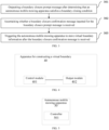
- Step 301 outputting a boundary closure prompt message after determining that an autonomous mobile mowing apparatus satisfies a boundary closing condition.
- the autonomous mobile mowing apparatus In a process of constructing the virtual boundary, the autonomous mobile mowing apparatus first moves from a starting point for map construction along a boundary line. A user terminal outputs the boundary closure prompt message after determining that the autonomous mobile mowing apparatus satisfies the boundary closing condition.
- the movement mode of the autonomous mobile mowing apparatus may be automatic movement, or may be movement remotely controlled by a user through the user terminal, or may be manually dragged movement.
- the boundary closing condition may be determined based on the historical traveling path of the autonomous mobile mowing apparatus in the process of constructing the virtual boundary, a current position and the starting point for map construction of the autonomous mobile mowing apparatus, and a moving direction of the autonomous mobile mowing apparatus at the current position.
- the boundary closure prompt message may be a button image for display, or may be a piece of audio for playing.
- the historical traveling path is a traveling path of the autonomous mobile mowing apparatus when traveling from the starting point for map construction to the current position
- the historical traveling path may be a path in any form except for a straight line, such as a polyline path or a curve path.
- a plane where the autonomous mobile mowing apparatus travels is not necessarily a flat plane
- the historical traveling path may be a three-dimensional path, and only a projection part of the three-dimensional path on a horizontal plane is computed when the condition is ascertained.
- the starting point for map construction of the autonomous mobile mowing apparatus is a point from which the autonomous mobile mowing apparatus travels in the process of constructing the virtual boundary.
- the boundary line may be determined based on at least one image collected by the autonomous mobile mowing apparatus through a carried apparatus such as a camera, or may be determined by a user terminal according to at least one image sent from the autonomous mobile mowing apparatus.
- a movement speed of the autonomous mobile mowing apparatus in the process of constructing the virtual boundary may be controlled by the user terminal, or may be autonomously controlled according to a preset speed threshold, which is not limited here.
- Step 302 ascertaining whether a boundary closure confirmation message inputted for the boundary closure prompt message is received.
- the user terminal may ascertain whether the boundary closure confirmation message inputted for the boundary closure prompt message is received.
- the boundary closure confirmation message may be sent by triggering the user terminal by the user, where the user terminal may be triggered specifically by clicking the button image displayed on the user terminal according to the boundary closure prompt message, or by inputting a specific audio to the user terminal, which is not limited here.
- Step 303 triggering the autonomous mobile mowing apparatus to store virtual boundary information after the boundary closure confirmation message is received.
- the user terminal When the user terminal receives the boundary closure confirmation message inputted for the boundary closure prompt message, it means that the user confirms that the virtual boundary of the autonomous mobile mowing apparatus can be generated, and then virtual boundary information for indicating the virtual boundary can be generated by the user terminal or the autonomous mobile mowing apparatus.
- the virtual boundary is used for defining a boundary line of a moving region of the autonomous mobile mowing device. Then, the autonomous mobile mowing apparatus is triggered to store the virtual boundary information.
- the autonomous mobile mowing apparatus will incorrectly perform virtual boundary closure when a distance between the current position and an initial position is less than the first threshold and there is an approaching direction, in order to avoid an obstacle, thus forming an incorrect virtual boundary. Therefore, the historical traveling path in the boundary closing condition is ascertained to avoid occurrence of the above phenomenon, thereby improving the accuracy of virtual boundary closure.
- the user can be prompted through the boundary closure prompt message to confirm to perform boundary closure after receiving the boundary closure confirmation message, so that the user can further control the opportunity for boundary closure, thereby further improving the accuracy of boundary closure.
- the boundary closing condition may include three conditions as follows:
- One of the boundary closing conditions may be ascertaining the moving direction of the autonomous mobile mowing apparatus at the current position, and this condition is satisfied when the angle between the moving direction of the autonomous mobile mowing apparatus and the connecting line between the current position of the autonomous mobile mowing apparatus and the starting point for map construction in the process of constructing the virtual boundary is less than the fourth threshold.
- the moving direction of the autonomous mobile mowing apparatus can be reported by the autonomous mobile mowing apparatus, and or may be determined by, e.g., satellite positioning, which is not limited here.
- the minimal bounding rectangle is established for the closed region to facilitate computing the length and the width of the closed region.
- the distance between the current position and the starting point for map construction is ascertained to replace manual ascertainment, thereby improving the efficiency and accuracy of boundary closure.
- the angle between the moving direction of the autonomous mobile mowing apparatus and the connecting line between the current position of the autonomous mobile mowing apparatus and the starting point for map construction in the process of constructing the virtual boundary is computed to determine the moving direction of the autonomous mobile mowing apparatus, thereby preventing the autonomous mobile mowing apparatus from entering a boundary closure state when the moving direction is away from the starting point for map construction, and further improving the efficiency of boundary closure.
- the second threshold is 0.5 m
- the third threshold is 0.5 m
- the first threshold is 1 m
- the fourth threshold is 90°.
- the boundary closing condition may be: the length of the minimal bounding rectangle of the region surrounded by the historical traveling path of the autonomous mobile mowing apparatus in the process of constructing the virtual boundary being greater than or equal to 0.5 m, the width of the minimal bounding rectangle being greater than or equal to 0.5 m, the distance between the current position of the autonomous mobile mowing apparatus and the starting point for map construction in the process of constructing the virtual boundary being less than or equal to 1 m, and the angle between the moving direction of the autonomous mobile mowing apparatus and the connecting line between the current position of the autonomous mobile mowing apparatus and the starting point for map construction in the process of constructing the virtual boundary being less than 90°.
- the second threshold and the third threshold are set to be 0.5 m, thereby minimizing the size of the region surrounded by the historical traveling path of the autonomous mobile mowing apparatus in the process of constructing the virtual boundary.
- the first threshold is set to be 1 m, so that the autonomous mobile mowing apparatus can enter the boundary closure state as early as possible in the case of maximizing a boundary closure accuracy.
- the fourth threshold is set to be 90°, thereby ensuring that the moving direction of the autonomous mobile mowing apparatus after entering the boundary closure state is approaching the starting point for map construction in the process of constructing the virtual boundary.
- the user terminal may receive operating data from the autonomous mobile mowing apparatus, and then ascertain whether the autonomous mobile mowing apparatus satisfies the boundary closing condition according to the operating data.
- Whether the boundary closing condition is satisfied may be ascertained by the user terminal. After receiving the operating data from the autonomous mobile mowing apparatus, the user terminal ascertains whether the autonomous mobile mowing apparatus satisfies the boundary closing condition according to the operating data.
- the operating data includes the historical traveling path of the autonomous mobile mowing apparatus in the process of constructing the virtual boundary, the current position of the autonomous mobile mowing apparatus, the starting point for map construction of the autonomous mobile mowing apparatus in the process of constructing the virtual boundary, and the moving direction of the autonomous mobile mowing apparatus at the current position.
- the user terminal ascertains the boundary closing condition, thereby providing possibilities for visualization and operability of the ascertainment process, and improving user experience.
- whether the boundary closing condition is satisfied may be ascertained by the autonomous mobile mowing apparatus.
- the autonomous mobile mowing apparatus sends state indication information indicating that the boundary closing condition is satisfied to the user terminal, and the user terminal receives the state indication information from the autonomous mobile mowing apparatus to determine that the autonomous mobile mowing apparatus satisfies the boundary closing condition.
- whether the boundary closing condition is satisfied is ascertained by the autonomous mobile mowing apparatus, and the user terminal only needs to receive the state indication information, thus improving the automation degree in the ascertainment process.
- the virtual boundary information in a process of triggering the autonomous mobile mowing apparatus to store the virtual boundary information, may be generated according to boundary point information, and then the virtual boundary information may be sent to the autonomous mobile mowing apparatus, so that the autonomous mobile mowing apparatus stores the virtual boundary information.
- the process of triggering the autonomous mobile mowing apparatus to store the virtual boundary information may be performed by the user terminal, so that the user terminal generates the virtual boundary information according to the boundary point information, and then sends the virtual boundary information to the autonomous mobile mowing apparatus for storage.
- the user terminal triggers the autonomous mobile mowing apparatus to store the virtual boundary information, thereby reducing information processing complexity of the autonomous mobile mowing apparatus, reducing requirements for built-in apparatuses of the autonomous mobile mowing apparatus, and reducing production costs of the autonomous mobile mowing apparatus.
- a boundary generation instruction may be sent to the autonomous mobile mowing apparatus, so that the autonomous mobile mowing apparatus generates the virtual boundary information according to the boundary point information, and stores the virtual boundary information.
- the autonomous mobile mowing apparatus can autonomously trigger the process of storing the virtual boundary information. After the autonomous mobile mowing apparatus receives the boundary generation instruction from the user terminal, the autonomous mobile mowing apparatus generates the virtual boundary information according to the boundary point information, and autonomously triggers the storage function to store the virtual boundary information.
- the autonomous mobile mowing apparatus autonomously triggers the process of storing the virtual boundary information, so that the user terminal only needs to send the boundary generation instruction without other operations, thereby reducing operation complexity of the user, and improving the user experience.
- the apparatus 40 for constructing a virtual boundary includes: a control module 401 configured to control the autonomous mobile mowing apparatus to travel within a to-be-processed region from a starting point for map construction, and record a position of the autonomous mobile mowing apparatus.
- the autonomous mobile mowing apparatus is first controlled to travel from the starting point for map construction within the to-be-processed region, and record the position of the autonomous mobile mowing apparatus during the travelling.
- the position of the autonomous mobile mowing apparatus may be recorded by sending position information through a sensor of the autonomous mobile mowing apparatus and recording the position information, or may be recorded by satellite positioning, which is not limited here.
- the movement mode of the autonomous mobile mowing apparatus may be automatic movement, or may be movement remotely controlled by a user through the user terminal, or may be manually dragged movement.
- the boundary closing condition may be determined based on the historical traveling path of the autonomous mobile mowing apparatus in the process of constructing the virtual boundary, a current position and the starting point for map construction of the autonomous mobile mowing apparatus, and a moving direction of the autonomous mobile mowing apparatus at the current position.
- the boundary closure prompt message may be a button image for display, or may be a piece of audio for playing.
- the historical traveling path is a traveling path of the autonomous mobile mowing apparatus when traveling from the starting point for map construction to the current position
- the historical traveling path may be a path in any form except for a straight line, such as a polyline path or a curve path.
- a plane where the autonomous mobile mowing apparatus travels is not necessarily a flat plane
- the historical traveling path may be a three-dimensional path, and only a projection part of the three-dimensional path on a horizontal plane is computed when the condition is ascertained.
- the starting point for map construction of the autonomous mobile mowing apparatus is a point from which the autonomous mobile mowing apparatus travels in the process of constructing the virtual boundary.
- a boundary line may be determined based on at least one image collected by the autonomous mobile mowing apparatus through a carried apparatus such as a camera, or may be determined by a user terminal according to at least one image sent from the autonomous mobile mowing apparatus.
- a movement speed of the autonomous mobile mowing apparatus in the process of constructing the virtual boundary may be controlled by the user terminal, or may be autonomously controlled according to a preset speed threshold, which is not limited here.
- an output module 402 configured to output a virtual boundary map when a boundary closing condition is satisfied, where the boundary closing condition includes a distance between a current position of the autonomous mobile mowing apparatus and a position of the starting point for map construction of the autonomous mobile mowing apparatus being less than or equal to a first threshold, where the first threshold is greater than a positioning accuracy of a sensor in the autonomous mobile mowing apparatus.
- the boundary closing condition includes a distance between a current position of the autonomous mobile mowing apparatus and a position of the starting point for map construction being less than or equal to a first threshold, where the first threshold is greater than a positioning accuracy of the sensor in the autonomous mobile mowing apparatus.
- the boundary closing condition includes the distance between the current position of the autonomous mobile mowing apparatus and the starting point for map construction of the autonomous mobile mowing apparatus being less than or equal to the first threshold, where the first threshold is greater than the positioning accuracy of the sensor in the autonomous mobile mowing apparatus.
- the first threshold may be a numerical value, for example, 0.5 m.
- a boundary closure prompt message is outputted.
- the first threshold is required to be greater than the positioning accuracy of the sensor in the autonomous mobile mowing apparatus.
- the positioning accuracy of the sensor is associated with a type of the sensor itself, and the positioning accuracy of different sensors is different.
- An accuracy of positioning by RTK is generally between 0.02 m and 0.03 m. If the first threshold is set to be less than the positioning accuracy of the sensor, it will cause difficulties for the autonomous mobile mowing apparatus to ascertain whether to perform boundary closure, because the sensor fails to ascertain a distance less than its own accuracy, and then the autonomous mobile mowing apparatus fails to obtain a corresponding numerical value for ascertaining whether the boundary closing condition is satisfied. In this case, the autonomous mobile mowing apparatus may adjust its position many times in order to perform boundary closure, and repeatedly crush a lawn near the autonomous mobile mowing apparatus, thus damaging the lawn to a certain extent. Therefore, the first threshold is required to be set to be greater than the positioning accuracy of the sensor in the autonomous mobile mowing apparatus.
- the virtual boundary map indicates a moving boundary of the autonomous mobile mowing apparatus when mowing grass, where the moving boundary corresponds to the virtual boundary.
- a boundary closing condition is set to replace manually guiding the autonomous mobile mowing apparatus to perform boundary closure, and output the virtual boundary map when the boundary closing condition is satisfied, thereby preventing the autonomous mobile mowing apparatus from repeated position adjustment and repeated rolling of the nearby lawn for boundary closure, reducing the damage of the autonomous mobile mowing apparatus to the lawn, and improving the efficiency of virtual boundary closure.
- the first threshold is set to be greater than the positioning accuracy of the sensor in the autonomous mobile mowing apparatus, thereby avoiding a problem of a low boundary closure efficiency caused by insufficient positioning accuracy in the boundary closure of the autonomous mobile mowing apparatus, and further improving the efficiency of virtual boundary closure.
- an autonomous mobile mowing apparatus 50 is provided. As shown in FIG. 5 , the autonomous mobile mowing apparatus 50 includes a controller 501.
- the controller 501 is configured to collect boundary point information in a process of constructing a virtual boundary, and then send the boundary point information to a user terminal. After inputting a boundary closure confirmation message for a boundary closure prompt message, the user terminal determines a virtual boundary map based on the boundary point information, and then sends the virtual boundary map to the controller 501. Finally, the controller 501 stores the virtual boundary map.
- the boundary closure prompt message is outputted from the user terminal after the autonomous mobile mowing apparatus satisfies a boundary closing condition.
- the boundary closing condition includes a distance between a current position of the autonomous mobile mowing apparatus and a starting point for map construction of the autonomous mobile mowing apparatus being less than or equal to a first threshold, where the first threshold is greater than a positioning accuracy of a sensor in the autonomous mobile mowing apparatus.
- a fixed interval may be set, for example, as 0.1 m, and whenever moving 0.1 m, the autonomous mobile mowing apparatus 50 collects information of a boundary point by the controller 501; or fixed time may be set, for example, as every 1 s, and whenever moving for 1 s, the autonomous mobile mowing apparatus 50 collects information of a boundary point by the controller 501. Information of all collected boundary points are integrated into the boundary point information.
- the autonomous mobile mowing apparatus 50 collects the boundary point information by the controller 501 during travelling, so that the user terminal determines virtual boundary information based on the boundary point information, thereby improving an accuracy of a virtual boundary indicated by the determined virtual boundary information.
- a user terminal 60 is provided. As shown in FIG. 6 , the user terminal 60 includes: a processing unit 601 and a display interface 602.
- the processing unit 501 is configured to display a boundary closure prompt message through the display interface 602 after determining that the autonomous mobile mowing apparatus satisfies a boundary closing condition, and output a virtual boundary map after the processing unit 501 receives a boundary closure confirmation message inputted for the boundary closure prompt message.
- the boundary closing condition includes the distance between the current position of the autonomous mobile mowing apparatus and the starting point for map construction of the autonomous mobile mowing apparatus being less than or equal to the first threshold, where the first threshold is greater than the positioning accuracy of the sensor in the autonomous mobile mowing apparatus.
- the boundary closure prompt message may be a button image, and the display interface 602 may display the button image.
- the boundary closure prompt message may be displayed through the display interface 602, and can indicate the boundary closure confirmation message inputted by a user, thereby improving user experience.
- the processing unit 601 may be further configured to hide a virtual button for controlling the autonomous mobile mowing apparatus to travel in the display interface 602 after receiving the boundary closure confirmation message.
- the display interface 602 may be provided with the virtual button configured to control the autonomous mobile mowing apparatus to travel, where the virtual button may be a left-turn virtual button, a right-turn virtual button, a forward virtual button, and a backward virtual button, or may be, e.g., a left/right-turn virtual rocker, and a forward/backward virtual rocker.
- the virtual button may be a left-turn virtual button, a right-turn virtual button, a forward virtual button, and a backward virtual button, or may be, e.g., a left/right-turn virtual rocker, and a forward/backward virtual rocker.
- the processing unit 601 hides the virtual button in the display interface 502 after receiving the boundary closure confirmation message, thereby preventing the user from misoperation caused by mistouch when no operation is required, and ensuring an accuracy of virtual boundary construction.
- the present embodiment provides an electronic device 70.
- the electronic device 70 may include: a processor 71, a communication interface 72, a memory 73, and a communication bus 74, where:
- the processor 71 is configured to perform a program 75, and specifically may perform relevant steps of the method for constructing a virtual boundary in the above embodiments.
- the program 75 may include a program code.
- the program code includes computer operation instructions.
- the processor 71 may be a CPU, or an Application Specific Integrated Circuit (ASIC), or one or more integrated circuits configured to implement embodiments of the present disclosure.
- ASIC Application Specific Integrated Circuit
- One or more processors included in a smart device may be processors of a same type, e.g., one or more CPUs; or may be processors of different types, e.g., one or more CPUs and one or more ASICs.
- the memory 73 is configured to store the program 75.
- the memory 73 may include a high-speed RAM memory, and may further include a non-volatile memory, e.g., at least one disk memory.
- the program 75 may specifically be used for causing the processor 71 to perform the method for constructing a virtual boundary in the above embodiments.
- a boundary closing condition is set for an electronic device in an embodiment of the present disclosure to replace manually guiding the autonomous mobile mowing apparatus to perform boundary closure, and output the virtual boundary map when the boundary closing condition is satisfied, thereby preventing the autonomous mobile mowing apparatus from repeated position adjustment and repeated crushing of a nearby lawn for boundary closure, reducing the damage of the autonomous mobile mowing apparatus to the lawn, and improving the efficiency of virtual boundary closure.
- a first threshold is set to be greater than a positioning accuracy of a sensor in the autonomous mobile mowing apparatus, thereby avoiding a problem of a low boundary closure efficiency caused by insufficient positioning accuracy in the boundary closure of the autonomous mobile mowing apparatus, and further improving the efficiency of virtual boundary closure.
- the present embodiment provides a non-transitory computer-readable storage medium storing computer instructions for causing a machine to perform the method for constructing a virtual boundary as described herein.
- a system or apparatus equipped with a storage medium may be provided, where the storage medium stores a software program code for implementing the functions of any one embodiment among the above embodiments, and makes a computer (or CPU or MPU) of the system or apparatus read and perform the program code stored in the storage medium.
- the program code read from the storage medium itself can implement the functions of any one embodiment among the above embodiments, and thus the program code and the storage medium storing the program code constitute a part of the present disclosure.
- Examples of storage mediums for providing the program code include a floppy disk, a hard disk, a magneto-optical disk, an optical disk (e.g., CD-ROM, CD-R, CD-RW, DVD-ROM, DVD-RAM, DVD-RW, or DVD+RW), a magnetic tape, a non-volatile memory card, and a ROM.
- the program code may be downloaded from a server computer through a communication network.
- the components/steps described in the embodiments of the present disclosure may be split into more components/steps, or two or more components/steps or partial operations of the components/steps may be combined into novel components/steps to achieve the goal of the embodiments of the present disclosure.
- the above method according to the embodiments of the present disclosure may be implemented in hardware or firmware, or be implemented as software or a computer code storable in a recording medium (such as a CD ROM, a RAM, a floppy disk, a hard disk, or a magneto-optical disk), or be implemented as a computer code that is downloaded from a network, is originally stored in a remote recording medium or a non-transitory machine-readable medium, and will be stored in a local recording medium, such that the method described herein may be processed by such software stored on a recording medium using a general-purpose computer, a special-purpose processor, or programmable or dedicated hardware (such as an ASIC or FPGA).
- a recording medium such as a CD ROM, a RAM, a floppy disk, a hard disk, or a magneto-optical disk
- a computer code that is downloaded from a network is originally stored in a remote recording medium or a non-transitory machine-readable medium, and will be stored in a
- a computer, a processor, a microprocessor controller, or programmable hardware includes a storage component (e.g., a RAM, a ROM, or a flash memory) that can store or receive software or a computer code.
- a storage component e.g., a RAM, a ROM, or a flash memory
- the method described herein is implemented when the software or the computer code is accessed and executed by the computer, the processor, or the hardware.
- a general-purpose computer accesses the code for implementing the method shown herein, the execution of the code converts the general-purpose computer to a special-purpose computer configured to perform the method shown herein.
- first and second are only used for ease of description of different components or names, and cannot be understood as indicating or implying sequential relationship and relative importance or implicitly indicating the number of indicated technical features.
- a feature defined with “first” or “second” may explicitly or implicitly include at least one of the feature.
Landscapes
- Engineering & Computer Science (AREA)
- Radar, Positioning & Navigation (AREA)
- Remote Sensing (AREA)
- Physics & Mathematics (AREA)
- Aviation & Aerospace Engineering (AREA)
- General Physics & Mathematics (AREA)
- Automation & Control Theory (AREA)
- General Engineering & Computer Science (AREA)
- Environmental Sciences (AREA)
- Life Sciences & Earth Sciences (AREA)
- Mathematical Physics (AREA)
- Theoretical Computer Science (AREA)
- Computing Systems (AREA)
- Control Of Position, Course, Altitude, Or Attitude Of Moving Bodies (AREA)
- Guiding Agricultural Machines (AREA)
- Harvester Elements (AREA)
Priority Applications (1)
| Application Number | Priority Date | Filing Date | Title |
|---|---|---|---|
| EP25199886.0A EP4636523A3 (de) | 2023-02-28 | 2023-08-02 | Verfahren zur konstruktion einer virtuellen grenze, autonome mobile mähvorrichtung und benutzerendgerät |
Applications Claiming Priority (1)
| Application Number | Priority Date | Filing Date | Title |
|---|---|---|---|
| CN202310214083.3A CN116339323A (zh) | 2023-02-28 | 2023-02-28 | 虚拟边界构建方法、装置、自移动割草装置和用户端 |
Related Child Applications (2)
| Application Number | Title | Priority Date | Filing Date |
|---|---|---|---|
| EP25199886.0A Division-Into EP4636523A3 (de) | 2023-02-28 | 2023-08-02 | Verfahren zur konstruktion einer virtuellen grenze, autonome mobile mähvorrichtung und benutzerendgerät |
| EP25199886.0A Division EP4636523A3 (de) | 2023-02-28 | 2023-08-02 | Verfahren zur konstruktion einer virtuellen grenze, autonome mobile mähvorrichtung und benutzerendgerät |
Publications (2)
| Publication Number | Publication Date |
|---|---|
| EP4425291A1 true EP4425291A1 (de) | 2024-09-04 |
| EP4425291B1 EP4425291B1 (de) | 2025-11-26 |
Family
ID=86883259
Family Applications (2)
| Application Number | Title | Priority Date | Filing Date |
|---|---|---|---|
| EP23189122.7A Active EP4425291B1 (de) | 2023-02-28 | 2023-08-02 | Verfahren zur konstruktion einer virtuellen grenze, autonome mobile mähvorrichtung und benutzerendgerät |
| EP25199886.0A Pending EP4636523A3 (de) | 2023-02-28 | 2023-08-02 | Verfahren zur konstruktion einer virtuellen grenze, autonome mobile mähvorrichtung und benutzerendgerät |
Family Applications After (1)
| Application Number | Title | Priority Date | Filing Date |
|---|---|---|---|
| EP25199886.0A Pending EP4636523A3 (de) | 2023-02-28 | 2023-08-02 | Verfahren zur konstruktion einer virtuellen grenze, autonome mobile mähvorrichtung und benutzerendgerät |
Country Status (5)
| Country | Link |
|---|---|
| US (1) | US20240284822A1 (de) |
| EP (2) | EP4425291B1 (de) |
| CN (1) | CN116339323A (de) |
| AU (1) | AU2023210657B2 (de) |
| CA (1) | CA3207973A1 (de) |
Families Citing this family (2)
| Publication number | Priority date | Publication date | Assignee | Title |
|---|---|---|---|---|
| CN117044478B (zh) * | 2023-08-31 | 2024-03-19 | 未岚大陆(北京)科技有限公司 | 割草机控制方法、装置、割草机、电子设备及存储介质 |
| CN117516552B (zh) * | 2024-01-08 | 2024-09-13 | 锐驰激光(深圳)有限公司 | 智能割草机的交叉路径规划方法、装置、设备及存储介质 |
Citations (2)
| Publication number | Priority date | Publication date | Assignee | Title |
|---|---|---|---|---|
| WO2003039314A2 (en) * | 2001-11-03 | 2003-05-15 | Dyson Ltd | An autonomous machine |
| US20200154632A1 (en) * | 2019-01-22 | 2020-05-21 | Chongqing Rato Intelligent Equipment Co., LTD. | Automatic boundary closing system and method for intelligent lawn mower |
Family Cites Families (13)
| Publication number | Priority date | Publication date | Assignee | Title |
|---|---|---|---|---|
| WO2002083480A1 (en) * | 2001-04-12 | 2002-10-24 | Mtd Products Inc | Four-wheel steering system |
| ES2600352T3 (es) * | 2001-06-12 | 2017-02-08 | Irobot Corporation | Robot móvil |
| SE538868C2 (en) * | 2015-05-04 | 2017-01-17 | Husqvarna Ab | Improved error detection and resetting of a robotic work tool |
| DE102015222414A1 (de) * | 2015-11-13 | 2017-05-18 | Robert Bosch Gmbh | Autonomes Arbeitsgerät |
| CN110168466B (zh) * | 2017-11-16 | 2022-05-24 | 南京泉峰科技有限公司 | 智能割草系统 |
| CN111743450B (zh) * | 2019-03-26 | 2021-06-08 | 速感科技(北京)有限公司 | 可移动装置的回充方法及可移动装置 |
| CN113115621B (zh) * | 2019-12-30 | 2023-05-12 | 南京泉峰科技有限公司 | 智能割草系统及其自主建图方法 |
| CN113128747B (zh) * | 2019-12-30 | 2024-03-19 | 南京泉峰科技有限公司 | 智能割草系统及其自主建图方法 |
| EP4386508B1 (de) * | 2020-07-09 | 2025-11-05 | The Toro Company | Autonome maschinennavigation unter verwendung von reflexionen von unterirdischen objekten |
| CN115705046A (zh) * | 2021-08-03 | 2023-02-17 | 创科无线普通合伙 | 割草机器人及其控制方法 |
| CN113762140B (zh) * | 2021-09-03 | 2024-06-07 | 上海擎朗智能科技有限公司 | 一种基于机器人的建图方法、电子设备及存储介质 |
| CN115309167B (zh) * | 2022-09-16 | 2023-08-01 | 未岚大陆(北京)科技有限公司 | 自主移动设备及其控制方法和计算机可读存储介质 |
| CN118426452A (zh) * | 2023-01-30 | 2024-08-02 | 浙江白马科技有限公司 | 一种自主作业设备的信息交互方法及自主作业设备 |
-
2023
- 2023-02-28 CN CN202310214083.3A patent/CN116339323A/zh active Pending
- 2023-07-28 US US18/360,890 patent/US20240284822A1/en active Pending
- 2023-07-31 CA CA3207973A patent/CA3207973A1/en active Pending
- 2023-08-02 EP EP23189122.7A patent/EP4425291B1/de active Active
- 2023-08-02 EP EP25199886.0A patent/EP4636523A3/de active Pending
- 2023-08-04 AU AU2023210657A patent/AU2023210657B2/en active Active
Patent Citations (2)
| Publication number | Priority date | Publication date | Assignee | Title |
|---|---|---|---|---|
| WO2003039314A2 (en) * | 2001-11-03 | 2003-05-15 | Dyson Ltd | An autonomous machine |
| US20200154632A1 (en) * | 2019-01-22 | 2020-05-21 | Chongqing Rato Intelligent Equipment Co., LTD. | Automatic boundary closing system and method for intelligent lawn mower |
Non-Patent Citations (1)
| Title |
|---|
| ROTTMANN NILS ET AL: "Loop Closure Detection in Closed Environments", 2019 EUROPEAN CONFERENCE ON MOBILE ROBOTS (ECMR), IEEE, 4 September 2019 (2019-09-04), pages 1 - 8, XP033635189, DOI: 10.1109/ECMR.2019.8870938 * |
Also Published As
| Publication number | Publication date |
|---|---|
| CN116339323A (zh) | 2023-06-27 |
| US20240284822A1 (en) | 2024-08-29 |
| AU2023210657B2 (en) | 2025-05-15 |
| CA3207973A1 (en) | 2025-07-07 |
| EP4425291B1 (de) | 2025-11-26 |
| EP4636523A3 (de) | 2025-11-12 |
| AU2023210657A1 (en) | 2024-09-12 |
| EP4636523A2 (de) | 2025-10-22 |
Similar Documents
| Publication | Publication Date | Title |
|---|---|---|
| EP4425291A1 (de) | Verfahren zur konstruktion einer virtuellen grenze, autonome mobile mähvorrichtung und benutzerendgerät | |
| US12153440B2 (en) | Map building method, self-moving device, and automatic working system | |
| EP3699715B1 (de) | Intelligentes rasenmähsystem | |
| EP4070165B1 (de) | Robotisches arbeitswerkzeugsystem und verfahren zur definition des arbeitsbereichsumfangs | |
| EP4115256B1 (de) | Roboterarbeitswerkzeusystem und verfahren zur definition eines fernbleibebereichs in einem arbeitsbereich | |
| WO2018209864A1 (zh) | 移动控制方法、装置、机器人及存储介质 | |
| US20260041033A1 (en) | Method for determining information, remote terminal, and mower | |
| JPWO2019187122A1 (ja) | 自律走行作業機、及び制御システム | |
| US11940809B2 (en) | Movement control method, electronic device, and computer storage medium | |
| CN115933674A (zh) | 一种机器人的绕障方法,绕障装置以及存储介质 | |
| WO2021093469A1 (zh) | 自动行走区域路径规划方法及自动行走设备 | |
| JP6924326B2 (ja) | 設置位置通知システム | |
| CN119072668A (zh) | 一种控制方法、控制装置、存储介质及自移动设备 | |
| US20250389547A1 (en) | Method for generating working map, operation method, control method, and related apparatuses | |
| US20250021096A1 (en) | Method for generating transfer path, and electronic device | |
| CN119847166A (zh) | 作业机器及其作业区边界生成方法、设备、介质、产品 | |
| EP4667871A1 (de) | Kartenmodifikationsverfahren und -vorrichtung, elektronische vorrichtung, speichermedium und programmprodukt | |
| WO2024250215A1 (zh) | 建图修正方法及相关装置 | |
| JP2022181736A (ja) | 情報処理装置、移動装置及びコンピュータプログラム | |
| US20250093883A1 (en) | Work region setting device, work region setting system, work region setting method, and storage medium | |
| CN118525660A (zh) | 一种割草机器人导航方法、装置、设备及存储介质 | |
| CN116339338A (zh) | 自移动设备的返航方法及自移动设备 | |
| CN117826792A (zh) | 路径跟踪方法和自移动设备 | |
| CN118605488A (zh) | 一种建图控制方法、建图方法、装置和移动设备 |
Legal Events
| Date | Code | Title | Description |
|---|---|---|---|
| PUAI | Public reference made under article 153(3) epc to a published international application that has entered the european phase |
Free format text: ORIGINAL CODE: 0009012 |
|
| STAA | Information on the status of an ep patent application or granted ep patent |
Free format text: STATUS: REQUEST FOR EXAMINATION WAS MADE |
|
| 17P | Request for examination filed |
Effective date: 20230802 |
|
| AK | Designated contracting states |
Kind code of ref document: A1 Designated state(s): AL AT BE BG CH CY CZ DE DK EE ES FI FR GB GR HR HU IE IS IT LI LT LU LV MC ME MK MT NL NO PL PT RO RS SE SI SK SM TR |
|
| GRAP | Despatch of communication of intention to grant a patent |
Free format text: ORIGINAL CODE: EPIDOSNIGR1 |
|
| STAA | Information on the status of an ep patent application or granted ep patent |
Free format text: STATUS: GRANT OF PATENT IS INTENDED |
|
| INTG | Intention to grant announced |
Effective date: 20250425 |
|
| GRAJ | Information related to disapproval of communication of intention to grant by the applicant or resumption of examination proceedings by the epo deleted |
Free format text: ORIGINAL CODE: EPIDOSDIGR1 |
|
| STAA | Information on the status of an ep patent application or granted ep patent |
Free format text: STATUS: REQUEST FOR EXAMINATION WAS MADE |
|
| GRAS | Grant fee paid |
Free format text: ORIGINAL CODE: EPIDOSNIGR3 |
|
| STAA | Information on the status of an ep patent application or granted ep patent |
Free format text: STATUS: GRANT OF PATENT IS INTENDED |
|
| GRAP | Despatch of communication of intention to grant a patent |
Free format text: ORIGINAL CODE: EPIDOSNIGR1 |
|
| INTC | Intention to grant announced (deleted) | ||
| GRAA | (expected) grant |
Free format text: ORIGINAL CODE: 0009210 |
|
| STAA | Information on the status of an ep patent application or granted ep patent |
Free format text: STATUS: THE PATENT HAS BEEN GRANTED |
|
| INTG | Intention to grant announced |
Effective date: 20251001 |
|
| AK | Designated contracting states |
Kind code of ref document: B1 Designated state(s): AL AT BE BG CH CY CZ DE DK EE ES FI FR GB GR HR HU IE IS IT LI LT LU LV MC ME MK MT NL NO PL PT RO RS SE SI SK SM TR |
|
| REG | Reference to a national code |
Ref country code: CH Ref legal event code: F10 Free format text: ST27 STATUS EVENT CODE: U-0-0-F10-F00 (AS PROVIDED BY THE NATIONAL OFFICE) Effective date: 20251126 Ref country code: GB Ref legal event code: FG4D |
|
| REG | Reference to a national code |
Ref country code: DE Ref legal event code: R096 Ref document number: 602023008936 Country of ref document: DE |
|
| REG | Reference to a national code |
Ref country code: IE Ref legal event code: FG4D |