EP4386501A1 - Arrangement and method for determining parameters of a roadway in front of a vehicle - Google Patents
Arrangement and method for determining parameters of a roadway in front of a vehicle Download PDFInfo
- Publication number
- EP4386501A1 EP4386501A1 EP22212854.8A EP22212854A EP4386501A1 EP 4386501 A1 EP4386501 A1 EP 4386501A1 EP 22212854 A EP22212854 A EP 22212854A EP 4386501 A1 EP4386501 A1 EP 4386501A1
- Authority
- EP
- European Patent Office
- Prior art keywords
- vehicle
- drone
- control
- road
- parameters
- Prior art date
- Legal status (The legal status is an assumption and is not a legal conclusion. Google has not performed a legal analysis and makes no representation as to the accuracy of the status listed.)
- Pending
Links
- 238000000034 method Methods 0.000 title claims abstract description 16
- 230000033001 locomotion Effects 0.000 claims description 29
- 238000004891 communication Methods 0.000 claims description 14
- 230000005540 biological transmission Effects 0.000 claims description 9
- 238000001514 detection method Methods 0.000 claims description 9
- 238000012545 processing Methods 0.000 claims description 8
- 238000012805 post-processing Methods 0.000 claims description 7
- 239000003550 marker Substances 0.000 claims description 5
- 238000005259 measurement Methods 0.000 claims description 5
- 239000000725 suspension Substances 0.000 claims description 5
- 230000003213 activating effect Effects 0.000 claims description 2
- 230000006978 adaptation Effects 0.000 claims description 2
- 238000012937 correction Methods 0.000 claims description 2
- 238000007405 data analysis Methods 0.000 claims description 2
- 230000003746 surface roughness Effects 0.000 claims 2
- 230000007613 environmental effect Effects 0.000 description 3
- 230000006870 function Effects 0.000 description 3
- 230000008569 process Effects 0.000 description 3
- 230000008901 benefit Effects 0.000 description 2
- 238000004364 calculation method Methods 0.000 description 2
- 238000005457 optimization Methods 0.000 description 2
- 230000003044 adaptive effect Effects 0.000 description 1
- 238000013459 approach Methods 0.000 description 1
- 238000002485 combustion reaction Methods 0.000 description 1
- 238000011217 control strategy Methods 0.000 description 1
- 238000013135 deep learning Methods 0.000 description 1
- 230000002349 favourable effect Effects 0.000 description 1
- 239000012634 fragment Substances 0.000 description 1
- 238000012423 maintenance Methods 0.000 description 1
- 238000001556 precipitation Methods 0.000 description 1
- 230000004044 response Effects 0.000 description 1
- 230000000630 rising effect Effects 0.000 description 1
Images

Classifications
-
- G—PHYSICS
- G05—CONTROLLING; REGULATING
- G05D—SYSTEMS FOR CONTROLLING OR REGULATING NON-ELECTRIC VARIABLES
- G05D1/00—Control of position, course, altitude or attitude of land, water, air or space vehicles, e.g. using automatic pilots
- G05D1/20—Control system inputs
- G05D1/24—Arrangements for determining position or orientation
- G05D1/246—Arrangements for determining position or orientation using environment maps, e.g. simultaneous localisation and mapping [SLAM]
-
- B—PERFORMING OPERATIONS; TRANSPORTING
- B60—VEHICLES IN GENERAL
- B60W—CONJOINT CONTROL OF VEHICLE SUB-UNITS OF DIFFERENT TYPE OR DIFFERENT FUNCTION; CONTROL SYSTEMS SPECIALLY ADAPTED FOR HYBRID VEHICLES; ROAD VEHICLE DRIVE CONTROL SYSTEMS FOR PURPOSES NOT RELATED TO THE CONTROL OF A PARTICULAR SUB-UNIT
- B60W40/00—Estimation or calculation of non-directly measurable driving parameters for road vehicle drive control systems not related to the control of a particular sub unit, e.g. by using mathematical models
- B60W40/02—Estimation or calculation of non-directly measurable driving parameters for road vehicle drive control systems not related to the control of a particular sub unit, e.g. by using mathematical models related to ambient conditions
- B60W40/06—Road conditions
-
- G—PHYSICS
- G05—CONTROLLING; REGULATING
- G05D—SYSTEMS FOR CONTROLLING OR REGULATING NON-ELECTRIC VARIABLES
- G05D1/00—Control of position, course, altitude or attitude of land, water, air or space vehicles, e.g. using automatic pilots
- G05D1/20—Control system inputs
- G05D1/24—Arrangements for determining position or orientation
- G05D1/247—Arrangements for determining position or orientation using signals provided by artificial sources external to the vehicle, e.g. navigation beacons
- G05D1/249—Arrangements for determining position or orientation using signals provided by artificial sources external to the vehicle, e.g. navigation beacons from positioning sensors located off-board the vehicle, e.g. from cameras
-
- G—PHYSICS
- G05—CONTROLLING; REGULATING
- G05D—SYSTEMS FOR CONTROLLING OR REGULATING NON-ELECTRIC VARIABLES
- G05D1/00—Control of position, course, altitude or attitude of land, water, air or space vehicles, e.g. using automatic pilots
- G05D1/60—Intended control result
- G05D1/656—Interaction with payloads or external entities
- G05D1/689—Pointing payloads towards fixed or moving targets
-
- G—PHYSICS
- G05—CONTROLLING; REGULATING
- G05D—SYSTEMS FOR CONTROLLING OR REGULATING NON-ELECTRIC VARIABLES
- G05D1/00—Control of position, course, altitude or attitude of land, water, air or space vehicles, e.g. using automatic pilots
- G05D1/60—Intended control result
- G05D1/69—Coordinated control of the position or course of two or more vehicles
- G05D1/692—Coordinated control of the position or course of two or more vehicles involving a plurality of disparate vehicles
-
- B—PERFORMING OPERATIONS; TRANSPORTING
- B60—VEHICLES IN GENERAL
- B60W—CONJOINT CONTROL OF VEHICLE SUB-UNITS OF DIFFERENT TYPE OR DIFFERENT FUNCTION; CONTROL SYSTEMS SPECIALLY ADAPTED FOR HYBRID VEHICLES; ROAD VEHICLE DRIVE CONTROL SYSTEMS FOR PURPOSES NOT RELATED TO THE CONTROL OF A PARTICULAR SUB-UNIT
- B60W2556/00—Input parameters relating to data
- B60W2556/45—External transmission of data to or from the vehicle
- B60W2556/50—External transmission of data to or from the vehicle of positioning data, e.g. GPS [Global Positioning System] data
-
- G—PHYSICS
- G05—CONTROLLING; REGULATING
- G05D—SYSTEMS FOR CONTROLLING OR REGULATING NON-ELECTRIC VARIABLES
- G05D2107/00—Specific environments of the controlled vehicles
- G05D2107/10—Outdoor regulated spaces
- G05D2107/13—Spaces reserved for vehicle traffic, e.g. roads, regulated airspace or regulated waters
-
- G—PHYSICS
- G05—CONTROLLING; REGULATING
- G05D—SYSTEMS FOR CONTROLLING OR REGULATING NON-ELECTRIC VARIABLES
- G05D2109/00—Types of controlled vehicles
- G05D2109/10—Land vehicles
-
- G—PHYSICS
- G05—CONTROLLING; REGULATING
- G05D—SYSTEMS FOR CONTROLLING OR REGULATING NON-ELECTRIC VARIABLES
- G05D2109/00—Types of controlled vehicles
- G05D2109/20—Aircraft, e.g. drones
- G05D2109/25—Rotorcrafts
- G05D2109/254—Flying platforms, e.g. multicopters
-
- G—PHYSICS
- G05—CONTROLLING; REGULATING
- G05D—SYSTEMS FOR CONTROLLING OR REGULATING NON-ELECTRIC VARIABLES
- G05D2111/00—Details of signals used for control of position, course, altitude or attitude of land, water, air or space vehicles
- G05D2111/10—Optical signals
Definitions
- the invention relates to an arrangement and a method for determining parameters of a roadway in front of a vehicle, in particular for determining the roadway parameters for supporting the driving dynamics control of a moving vehicle, for example on damaged roads and paths as well as off-road.
- a vehicle dynamics control system such as the anti-lock braking system, the traction control system, the electronic stability program and the torque distribution system, in most cases requires reference parameters, such as the vehicle speed, in order to follow a safe trajectory.
- CN110595495A discloses the use of a drone to determine the route of a vehicle by means of a connection between the vehicle and a satellite based on collected data.
- the disadvantage of this technical solution is that no information is available about the road surface (e.g. bumps that affect the vehicle movement), the road gradient, the The friction coefficient of the road surface and environmental conditions influencing the road surface (e.g. objects on the road surface) are determined and processed.
- US 7 590 481 B2 e.g. an integrated control unit that receives and processes input data from a block of sensors.
- the sensor system includes an occupant sensor group, an environmental sensor group, an impact sensor group, an actuator-specific sensor group and a motion sensor group.
- the disadvantage of this technical solution is that the sensors do not have an environmental sensor group for parameters such as temperature, precipitation, road conditions, region and position, and not all of these parameters can be easily measured by vehicle-mounted sensors, so that the lack of knowledge of these external parameters in advance does not allow support of the system operation in the integrated control unit.
- US 9 506 774 B2 teaches to select the trajectory of a trailer based on satellite images. In this way, the driver or the autonomous vehicle knows how to plan its route correctly before navigation begins.
- US 10 611 366 B2 discloses a drone flying in front of a vehicle, which enables the control of the vehicle to prevent it from veering off the road.
- the proposed scheme requires information about the shape of the road in front of the vehicle as input data.
- the US 10 611 366 B2 that the required trajectory can be determined in advance based on the information about the route and the driver's driving style.
- the drone can act as a vehicle assistant and take on the task of defining the route in front of the vehicle.
- the invention is therefore based on the object of specifying an arrangement for determining parameters of a roadway in front of a vehicle for supporting the driving dynamics control of the vehicle, which avoids the aforementioned disadvantages of the prior art, in particular influencing the travel of the vehicle on the roadway, for example on damaged roads and paths and off-road, in a predictive manner, in that the roadway parameters, which cannot be detected directly in front of the vehicle with internal vehicle sensors, but are available for detection at a further distance in front of the vehicle of up to a thousand meters without them being detected by the internal vehicle sensors, can be used to control and regulate the driving dynamics of the vehicle drive.
- the present technical solution consists in shifting the observation point of the vehicle sensors from a vehicle to a drone that flies in front of the vehicle and determines a variety of road parameters in advance, using the information determined by the drone in the control and regulation of the vehicle-side systems.
- the drone which flies in front of a moving vehicle, advantageously measures various road parameters and records measurement data and information in real time.
- the further use of the measured information serves to adapt functions and algorithms of the vehicle's internal control systems in real time and to optimize vehicle movement.
- the wireless data and information-conducting connection is implemented on the one hand in the form of a data stream from the drone to the vehicle's internal control device and on the other hand in the form of a data channel from the vehicle to the drone, whereby the drone has a field of view which can be directed by the drone during its flight onto a roadway which is located in front of the vehicle and on which the vehicle is driving (the drone is semi-autonomous and controlled by means of the sensor data and the data running via the data channel from the vehicle to the drone) and whereby the data stream generated by the drone with its sensors leads to the vehicle's internal control device, which influences the vehicle's travel on the roadway so that the vehicle's driving dynamics can be controlled.
- the system moves along a specific route desired by the driver throughout the entire operating time of the drone, with the vehicle's position being determined in global coordinates using in-vehicle systems such as GPS.
- the arrangement and method for determining the road parameters of a road ahead of a vehicle determines which part of the road is to be monitored in order to support the vehicle's driving dynamics control.
- the drone moves in front of the vehicle and uses its (vehicle-external) sensors to determine information about the road.
- the vehicle's movement can be controlled by the vehicle dynamics control systems in order to pass this section of road more safely or comfortably.
- the flying drone is located in front of the vehicle in a very favorable position with a sufficiently large distance from the vehicle so that sufficient time is available to detect and measure the roadway at this position and to process the measured data of the roadway and transmit it to the vehicle before the vehicle reaches this position.
- the drone advantageously flies in a range of 5 to 1000 m, very advantageous in a range of 5 to 200 m, particularly advantageous in a range of 10 to 60 m in front of the vehicle. This also ensures that the data can be processed using complex calculation methods.
- the processing of the recorded information on the road parameters is carried out by a processing unit installed in the vehicle (in-vehicle control device).
- the reference longitudinal, transverse or vertical parameters of the vehicle dynamics are used as input data for the autopilot navigation control algorithm and the Road friction coefficients based on the lidar data and the image data analysis for forwarding the determined road friction coefficient to the vehicle, whereby this can also be done separately for the left and right lanes, and the use of the information on the determined road friction coefficient is used for wheel slip control.
- the road gradient is also determined and the determined road gradient is passed on to the vehicle.
- the information about the determined road gradient is used to adjust the braking control and/or the drive control settings of the vehicle.
- the road roughness is determined and the information about the determined road roughness is forwarded to the vehicle in order to generate an adjustment of the vertical motion control (vertical dynamics control) of the vehicle.
- vertical motion control vertical dynamics control
- the determination of the road curvature and the transmission of information about the determined road curvature to the vehicle is carried out in order to adapt the yaw motion control of the vehicle, whereby the determined road curvature is also used to calculate the trajectory that is realized by an autopilot in the case of automated driving.
- all information and recorded data collected by the preceding drone for the following vehicle are used via two-way communication to generate a predictive reference vehicle model using a control and regulation system in the form of an in-vehicle control device for the motion control (for the driving dynamics control) of the vehicle, whereby the in-vehicle control device is connected to the driving dynamics control system in a data and information-conducting manner.
- All communication for the exchange of all determined information and data in the proposed arrangement and method serves to determine the position of the vehicle in global coordinates, to determine the position of the Drone in global coordinates as well as the two-way communication described above, so that autonomous driving of the vehicle is also possible with this technical solution.
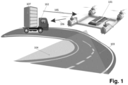
- the illustrated embodiment of an arrangement for determining the parameters of a roadway in front of a vehicle comprises a drone (101) with sensors and a vehicle (102) with an in-vehicle control device (107) which is connected to the drone (101) wirelessly and in a data and information-conducting manner.
- the drone ( 101) is provided with a power source and is semi-autonomous, controlled and capable of flying using the sensor data and the data transmitted from the vehicle (102) to the drone (101) via the data channel (105) .
- the data stream (106) generated by the drone (101) with its sensors leads to the vehicle's internal control device (107), which influences the movement of the vehicle (102) on the roadway (103) .
- the method for determining the roadway parameters of a roadway in front of a vehicle is carried out as follows: A vehicle (102) is driving on a roadway (103) and an unmanned drone (101) is flying in front of it, with the distance between them being, for example, 60 m.
- the drone (101) flies ahead of the vehicle (102) along the roadway (103) , it uses its sensors within its field of vision (104) to detect various information and parameters (so to speak, in a forward-looking manner) which cannot be detected by the driver of the vehicle (102) and the sensors permanently installed on the vehicle (102) according to the state of the art.
- the drone (101) uses its on-board sensor unit to collect information and data about the roadway (103) . After processing this information and data, the vehicle's internal control unit (107) forwards it to relevant vehicle dynamics control systems.
- the relevant vehicle dynamics control systems include driver assistance systems, comprising traction control and lane keeping systems, vehicle stability systems, comprising anti-lock braking systems (ABS), electronic stability programs (ESP), traction control, and torque distribution systems, drive management systems, comprising a control device that optimizes the power consumption of electric, hybrid or internal combustion engines depending on the road surface characteristics or the measured vehicle operating parameters, and adaptive chassis systems, comprising active suspension and active steering.
- the drone (101) In its flight, the drone (101) follows the course of the road (103) on which the vehicle (102) belonging to the drone (101 ) is traveling.
- the drone's own sensors make it possible to detect the fragment of the road (103) in front of the vehicle (102) following the drone (101) in the sensor field of view (104) , which is located in front of the drone (101) .
- the data thus collected are transmitted via the data stream (106) from the drone (101) to the vehicle-internal control device (107) .
- the vehicle-internal control device (107) controls the drone and regulates the driving dynamics of the vehicle (102).
- the data channel (105) from the vehicle (102) to the drone (101) is used to transmit the data for the future trajectory of the vehicle (102) to the drone (101) so that the drone (101) can follow this predetermined trajectory during its flight.
- the vehicle-internal control device (107) thus represents the interface for the drone (101) and the vehicle (102) in the control and regulation of these two components of the arrangement for determining the roadway parameters of a roadway (103) in front of a vehicle (102), in particular for determining the roadway parameters for supporting the driving dynamics control of a moving vehicle (102) .
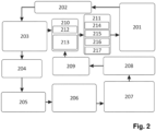
- Fig.2 shows a flow chart of a control and regulation system using the in-vehicle control device for a vehicle with drone flight escort according to the arrangement according to Fig.1 for vehicle dynamics control, which is provided with a vehicle dynamics control system (201) which conducts data and information connected to the on-board control unit and whose position in global coordinates using an appropriate global (not in Fig.2 shown) positioning system as a GPS sensor (202) .
- vehicle dynamics control system (201) which conducts data and information connected to the on-board control unit and whose position in global coordinates using an appropriate global (not in Fig.2 shown) positioning system as a GPS sensor (202) .
- an estimation block (203) of a computing unit can determine the vehicle trajectory and determine a reference position of the vehicle (102) on the roadway.
- the location accuracy of the estimation block (203) is sufficient to determine the positioning of the vehicle in a lane and the deviation during maneuvering.
- the future flight path of the drone (101) is precalculated/specified in a computing unit (204) .
- This can be done using various approaches, e.g. based on the road map for a motorway journey, according to a predefined destination point for city driving, using deep learning algorithms for an undefined case or using other prediction models.
- the calculated future vehicle trajectory is transmitted to the drone (101) via the communication channel as a reference path to be followed.
- This path can be followed, for example, by autopilot algorithms in order to control the flight of the drone (101) .
- the drone (101) is able to follow the roadway (103) and, using the sensors with which it is equipped, to detect the roadway (103) in its field of vision (104) .
- the drone (101) collects information about the condition of the road surface. This process takes place in a detection unit (206) , which is part of the drone (101) .
- a post-processing unit (207) performs the post-processing of the acquired sensor data in such a way that it creates a map of the roadway (103) and summarizes all information in a format suitable for further use by the vehicle dynamics control systems (201) of the vehicle (102) .
- the generated information is stored in a storage unit (208) and a dynamic map with vehicle-related parameters, ie a map with stored data sets of road-related data for each road position, is created. These generated data are forwarded via the communication channel (209) to a global control device (210) of the vehicle (102) .
- the global control device (210) of the vehicle (102) has subcomponents in the form of a higher-level vehicle dynamics controller (212) and a reference vehicle model (213), which is used as a reference generator for the relevant vehicle motion parameters in the vehicle motion controller (212) .
- the signal of the global control device (210) is forwarded to a subordinate driving dynamics controller (211) , which is divided into a vertical dynamics control unit (214), a longitudinal dynamics control unit (215) and a lateral dynamics control unit (216) as subcomponents and may optionally also include an autopilot (217) as a further component.
- the data of the global control device (210) are also the input data for the navigation control algorithm of the autopilot (217).
- the control signals generated by the subordinate vehicle dynamics controller (211) are finally implemented by the corresponding vehicle dynamics control system (201) .
- Fig.3 shows an example of a sensor unit of the embodiment of the arrangement according to Fig.1 with various sensors which are located on the drone (101) as part of the detection unit (206) and generate the field of view (104) of the drone (101) .
- the main task of this sensor unit is to hold the measuring equipment in a suitable position and to enable the drone to be maneuvered in the desired orientation.
- the camera (301), the distance sensor (302) (a lidar in the exemplary embodiment) and the camera lens (303 ) are designed as a single unit.
- the distance sensor (302) can also be designed as a radar or ultrasonic sensor.
- the camera (301) captures images of the road (103) in real time and transmits them to the detection unit (206).
- the lens (303) of the camera (301) allows the focal length to be adjusted to obtain the desired field of view (104) for better road detection.
- the Lidar (302) enables the calculation of object dimensions in the image and measures the road gradient and roughness.
- a provided three-axis gimbal frame (304) (in the example a gimbal) enables the maintenance of a horizontal position for all measuring devices and neglects distortions of the sensor data.
- a vibration plate (305) is provided to avoid vibrations and improve the quality of the acquired data by separating the gimbal (304) from the drone (101) (in Figure 3 not shown) is decoupled with respect to vibration.
- a provided electronic control component (306) serves to adjust the position of the camera (301) and to control the yaw position of the image to follow the roadway (103) .
- a communication device (307) receives all acquired data, which is transmitted to the acquisition unit (206) with subsequent post-processing unit (207) .
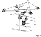
- Fig.4 shows a drone (101) of the embodiment of the arrangement according to Fig.1 , showing the minimum components required for operation.
- a telemetry device (404) provided enables communication with the vehicle (102).
- the data channel (105) and the data stream (106) are established via the telemetry device (404 ).
- the sensor (405) enables the determination of the global position of the drone (101). With the help of this sensor, the collected data is linked to the information about the position of the drone (101) and is recorded as a dynamic map.
- a drone frame (406) carries all components which are located on the drone (101) .
- Propulsion systems (407) provided for the drone (101) serve to generate and control the movement of the drone (101) in the air.
- the drone (101) is provided with at least one collision sensor (408) to prevent the collision of the drone (101) with other drones or objects in the flight path during the flight of the drone (101) .
- the drone frame (406) has two drone legs (409), which serve for ground contact / parking before taking off and when landing the drone (101) .
- the advantage of the technical solution provided here compared to the previously known state of the art is that the drone, while flying in front of the moving vehicle, measures various road parameters in real time and uses the measurement data and information collected in this way to adapt functions and algorithms of the vehicle's internal control systems in real time and to optimize the vehicle movement. serve, which leads to the vehicle's travel on the road being influenced in a predictive manner, in that the road parameters, which cannot be detected directly in front of the vehicle with on-board sensors, but are available for detection at a greater distance in front of the vehicle of up to one thousand meters without being detected by the on-board sensors, can be used to control the driving dynamics of the vehicle drive.
- a particular advantage of this technical solution compared to the previously known state of the art is that it is suitable for measuring road parameters of roads with any surface quality, any road course and any condition.
- These can be roads with a smooth surface as well as roads with uneven, damaged surfaces, e.g. damaged roads and paths with potholes and bumps, as well as off-road roads.
- the roads can have any incline, i.e. they can run horizontally, rising or falling.
- the road course can be straight or curved.
- the road surfaces can be in any condition, for example they can be dry, wet, snowy or icy.
- the roads can be divided into several lanes.
Landscapes
- Engineering & Computer Science (AREA)
- Physics & Mathematics (AREA)
- Automation & Control Theory (AREA)
- Aviation & Aerospace Engineering (AREA)
- Radar, Positioning & Navigation (AREA)
- Remote Sensing (AREA)
- General Physics & Mathematics (AREA)
- Mathematical Physics (AREA)
- Transportation (AREA)
- Mechanical Engineering (AREA)
- Control Of Position, Course, Altitude, Or Attitude Of Moving Bodies (AREA)
Abstract
Die Erfindung betrifft eine Anordnung und ein Verfahren zur Ermittlung von Parametern einer Fahrbahn vor einem Fahrzeug, insbesondere zur Ermittlung der Fahrbahnparameter für die Unterstützung der Fahrdynamikregelung eines fahrenden Fahrzeugs.Die Aufgabe der Erfindung, eine Anordnung und ein Verfahren zur Ermittlung der Parameter einer Fahrbahn vor einem Fahrzeug, insbesondere zur Ermittlung der Fahrbahnparameter für die Unterstützung der Fahrdynamikregelung eines fahrenden Fahrzeugs anzugeben, welche ein vorausschauende Fahrt des Fahrzeugs ermöglichen, wird dadurch gelöst, den Beobachtungspunkt der Fahrzeugsensoren von einem Fahrzeug (102) auf eine Drohne (101) zu verlagern, die in einem Bereich vor dem Fahrzeug (102) fliegt, welches auf der Fahrbahn (103) fährt, und dabei im Voraus eine Vielzahl von Fahrbahnparametern ermittelt, wobei die ermittelten Informationen der Drohnensensoren bei der Definition der Regeleingänge für die Regelgeräte der fahrzeugseitigen Systeme verwendet werden.The invention relates to an arrangement and a method for determining parameters of a roadway in front of a vehicle, in particular for determining the roadway parameters for supporting the driving dynamics control of a moving vehicle.The object of the invention to provide an arrangement and a method for determining the parameters of a roadway in front of a vehicle, in particular for determining the roadway parameters for supporting the driving dynamics control of a moving vehicle, which enable the vehicle to drive in a forward-looking manner, is achieved by shifting the observation point of the vehicle sensors from a vehicle (102) to a drone (101) which flies in an area in front of the vehicle (102) which is driving on the roadway (103) and in doing so determines a plurality of roadway parameters in advance, wherein the information determined by the drone sensors is used in defining the control inputs for the control devices of the vehicle-side systems.
Description
Die Erfindung betrifft eine Anordnung und ein Verfahren zur Ermittlung von Parametern einer Fahrbahn vor einem Fahrzeug, insbesondere zur Ermittlung der Fahrbahnparameter für die Unterstützung der Fahrdynamikregelung eines fahrenden Fahrzeugs, bspw. bei schadhaften Straßen und Wegen sowie im Gelände.The invention relates to an arrangement and a method for determining parameters of a roadway in front of a vehicle, in particular for determining the roadway parameters for supporting the driving dynamics control of a moving vehicle, for example on damaged roads and paths as well as off-road.
Bekannt ist, dass ein Fahrdynamikregelungssystem, wie bspw. das Antiblockiersystem, die Antriebsschlupfregelung, das elektronische Stabilitätsprogramm und das Drehmomentverteilungssystem in den meisten Fällen Referenzparameter, wie bspw. die Fahrzeuggeschwindigkeit, benötigt, um eine sichere Trajektorie zu verfolgen.It is known that a vehicle dynamics control system, such as the anti-lock braking system, the traction control system, the electronic stability program and the torque distribution system, in most cases requires reference parameters, such as the vehicle speed, in order to follow a safe trajectory.
Aufgrund der begrenzten Verfügbarkeit von am Fahrzeug verbauten Sensoren und deren Reichweite ist es jedoch oft nicht möglich, die Referenzparameter unter unsicheren Bedingungen genau und korrekt zu bestimmen.However, due to the limited availability of sensors installed on the vehicle and their range, it is often not possible to determine the reference parameters accurately and correctly under uncertain conditions.
Dieses Problem wird noch verschärft, wenn der Fahrer das Fahrzeug unter schwierigen Fahrverhältnissen, wie z.B. bei Nebel oder bei einer Bergfahrt, fährt.This problem is exacerbated when the driver drives the vehicle in difficult driving conditions, such as in fog or when driving uphill.
Einige Verbesserungen für das Fahren einer sicheren Trajektorie können erreicht werden, wenn der Fahrer Informationen aus verschiedenen Perspektiven erhält (wie von einem Navigator bei einem Rennen) oder wenn die Fahrzeugsensoren die Route im Voraus genau kennen (was bei unbemannten Fahrzeugen möglich ist). Beim herkömmlichen Fahren sind diese Optionen jedoch derzeit noch nicht möglich.Some improvements in driving a safe trajectory can be achieved if the driver receives information from different perspectives (such as from a navigator in a race) or if the vehicle sensors know the route precisely in advance (which is possible in unmanned vehicles). However, these options are currently not possible in conventional driving.
Der Nachteil dieser technischen Lösung besteht darin, dass keine Informationen über die Straßenoberfläche (bspw. Unebenheiten, die die Fahrzeugbewegung beeinflussen), die Straßenneigung, den Reibkoeffizient der Fahrbahn und fahrbahnbeeinflussende Umweltbedingungen (bspw. Gegenstände auf der Fahrbahn) ermittelt und verarbeitet werden.The disadvantage of this technical solution is that no information is available about the road surface (e.g. bumps that affect the vehicle movement), the road gradient, the The friction coefficient of the road surface and environmental conditions influencing the road surface (e.g. objects on the road surface) are determined and processed.
Derzeit sind bereits Lösungen bekannt, die es ermöglichen, die Qualität der Fahrdynamikregelung unter Berücksichtigung verschiedener Faktoren des Fahrzeugs zu verbessern.Solutions are already known that make it possible to improve the quality of driving dynamics control by taking into account various vehicle factors.
So offenbart
Der Nachteil dieser technischen Lösung besteht darin, dass die Sensoren keine Umweltsensorgruppe für Parameter, wie bspw. die Temperatur, den Niederschlag, die Straßenbedingungen, die Region und die Position aufweist, und auch nicht sämtliche dieser Parameter ohne weiteres von fahrzeugmontierten Sensoren gemessen werden können, so dass durch das Fehlen der Kenntnis dieser externen Parameter im Voraus keine Unterstützung des Systembetriebs im integrierten Steuergerät möglich ist.The disadvantage of this technical solution is that the sensors do not have an environmental sensor group for parameters such as temperature, precipitation, road conditions, region and position, and not all of these parameters can be easily measured by vehicle-mounted sensors, so that the lack of knowledge of these external parameters in advance does not allow support of the system operation in the integrated control unit.
Dazu lehrt die
Für den vorgenannten Stand der Technik lässt sich zusammenfassen, dass neben fahrzeuginternen Systemen bereits auch Systeme außerhalb von Fahrzeugen bekannt sind, welche das Fahrverhalten der Fahrzeuge direkt oder indirekt beeinflussen.The above-mentioned state of the art can be summarized as follows: in addition to systems inside vehicles, systems outside vehicles are also known which directly or indirectly influence the driving behavior of vehicles.
Der Nachteil all dieser bekannten technischen Lösungen ist jedoch, dass keine vorausschauende Ermittlung der Parameter einer Fahrbahn vor einem Fahrzeug im Bereich von bis zu achthundert Metern vor dem Fahrzeug für die Unterstützung der Fahrdynamikregelung des Fahrzeugs möglich ist, was die Sicherheit der Fahrt der Fahrzeuge erhöhen würde.However, the disadvantage of all these known technical solutions is that it is not possible to predictively determine the parameters of a road ahead of a vehicle in the range of up to eight hundred meters in front of the vehicle to support the vehicle's driving dynamics control, which would increase the safety of the vehicle's journey.
Der Erfindung liegt daher die Aufgabe zu Grunde, eine Anordnung zur Ermittlung von Parametern einer Fahrbahn vor einem Fahrzeug für die Unterstützung der Fahrdynamikregelung des Fahrzeugs anzugeben, welche die zuvorstehend genannten Nachteile des Standes der Technik vermeidet, insbesondere die Fahrt des Fahrzeugs auf der Fahrbahn, bspw. bei schadhaften Straßen und Wegen sowie im Gelände, in vorausschauender Art und Weise beeinflusst, indem die Fahrbahnparameter, welche nicht unmittelbar vor dem Fahrzeug mit fahrzeuginternen Sensoren erfassbar sind, sondern in einem weiteren Abstand vor dem Fahrzeug von bis zu tausend Metern zur Erfassung vorliegen, ohne dass sie schon mit den fahrzeuginternen Sensoren erfasst werden, zur Steuerung und Regelung der Fahrdynamik des Fahrzeugantriebs einsetzbar sind.The invention is therefore based on the object of specifying an arrangement for determining parameters of a roadway in front of a vehicle for supporting the driving dynamics control of the vehicle, which avoids the aforementioned disadvantages of the prior art, in particular influencing the travel of the vehicle on the roadway, for example on damaged roads and paths and off-road, in a predictive manner, in that the roadway parameters, which cannot be detected directly in front of the vehicle with internal vehicle sensors, but are available for detection at a further distance in front of the vehicle of up to a thousand meters without them being detected by the internal vehicle sensors, can be used to control and regulate the driving dynamics of the vehicle drive.
Erfindungsgemäß wird diese Aufgabe durch die Merkmale des 1. und 12. Patentanspruchs gelöst.According to the invention, this object is achieved by the features of the 1st and 12th patent claims.
Weitere günstige Ausgestaltungsmöglichkeiten der Erfindung sind in den nachgeordneten Patentansprüchen angegeben.Further advantageous embodiments of the invention are specified in the subordinate patent claims.
Die vorliegende technische Lösung besteht darin, den Beobachtungspunkt der Fahrzeugsensoren von einem Fahrzeug auf eine Drohne zu verlagern, die vor dem Fahrzeug fliegt und im Voraus eine Vielzahl von Fahrbahnparametern ermittelt, wobei die von der Drohne ermittelten Informationen bei der Steuerung und Regelung der fahrzeugseitigen Systeme verwendet werden.The present technical solution consists in shifting the observation point of the vehicle sensors from a vehicle to a drone that flies in front of the vehicle and determines a variety of road parameters in advance, using the information determined by the drone in the control and regulation of the vehicle-side systems.
Die Drohne, welche vor einem fahrenden Fahrzeug fliegt, misst dabei vorteilhaft verschiedene Fahrbahnparameter und erfasst Messdaten und Informationen in Echtzeit. Die weitere Verwendung der gemessenen Informationen dient der Echtzeitanpassung von Funktionen und Algorithmen der fahrzeuginternen Regelsysteme und der Optimierung der Fahrzeugbewegung.The drone, which flies in front of a moving vehicle, advantageously measures various road parameters and records measurement data and information in real time. The further use of the measured information serves to adapt functions and algorithms of the vehicle's internal control systems in real time and to optimize vehicle movement.
Dazu umfasst die Anordnung zur Ermittlung von Parametern einer Fahrbahn vor einem Fahrzeug (bspw. bei schadhaften Straßen und Wegen oder bei Fahrten im Gelände) für die Unterstützung der Fahrdynamikregelung des Fahrzeugs (mittels an sich bekannter Fahrdynamikregelungssysteme, wie bspw. dem Antiblockiersystem, der Antriebsschlupfregelung, dem elektronische Stabilitätsprogramm oder dem Drehmomentverteilungssystem) eine Drohne zum Fliegen über der Fahrbahn, ein globales Positionierungssystem und ein Fahrzeug zum Fahren auf der Fahrbahn, wobei die Drohne mit
- ▪ mindestens einem Antriebssystem für die Bewegung und Steuerung der Drohne,
- ▪ einem Sensorsystem zum Aufnehmen von Bildern der Fahrbahnoberfläche in Form einer Kamera, wobei die Kamera ein Objektiv zur Einstellung der Brennweite besitzt,
- ▪ einem Abstandssensor, der die Größe der Objekte auf der Fahrbahn, die Fahrbahnrauigkeit und die Fahrbahnneigung misst, wobei der Abstandssensor als Lidar, Radar oder Ultraschallsensor ausgeführt sein kann,
- ▪ einem dreiachsigen Kardanrahmen in Form eines Gimbals, der das Sensorsystem in Form der Kamera mit dem Objektiv und den Abstandssensor in Form des Lidar in einer horizontalen Position hält,
- ▪ elektronischen Steuerungskomponenten, die die Position des dreiachsigen Kardanrahmens steuern,
- ▪ einer Vibrationsplatte, welche die Vibrationen des Sensorsystems in Form der Kamera mit dem Objektiv und des Abstandsensors in Form des Lidars dämpft,
- ▪ einer Telemetrievorrichtung, die die Datenübertragung zwischen der Drohne und dem Fahrzeug sicherstellt,
- ▪ einem Sensor zur Bestimmung der globalen Position der Drohne,
- ▪ einem Sensor zum Erfassen von Objekten in der Bewegungsbahn der Drohne
- ▪ und einem Rahmen zum Tragen dieser Drohnen- Komponenten ausgestattet ist
- ▪ mindestens einem Fahrdynamikregelungssystem,
- ▪ einem Regelungssystem in Form eines fahrzeuginternen Regelgeräts, das die Fahrzeugbewegung durch die Regelung des Fahrdynamikregelungssystems bestimmt,
- ▪ einer Fahrzeugkomponente des Global Positioning System zur Bestimmung der Fahrzeugposition,
- ▪ einem Inertialsensor, einer Recheneinheit zur Verarbeitung der gemessenen Daten sowie einer digitalen Karte und
- ▪ einem Telemetriegerät, das eine kabellose daten- und informationsleitend Verbindung zwischen der Drohne und dem Fahrzeug generiert,
- ▪ at least one drive system for the movement and control of the drone,
- ▪ a sensor system for taking pictures of the road surface in the form of a camera, the camera having a lens for adjusting the focal length,
- ▪ a distance sensor that measures the size of the objects on the road, the road roughness and the road inclination, whereby the distance sensor can be designed as a lidar, radar or ultrasonic sensor,
- ▪ a three-axis gimbal frame that holds the sensor system in the form of the camera with the lens and the distance sensor in the form of the lidar in a horizontal position,
- ▪ electronic control components that control the position of the three-axis gimbal frame,
- ▪ a vibration plate, which dampens the vibrations of the sensor system in the form of the camera with the lens and the distance sensor in the form of the lidar,
- ▪ a telemetry device that ensures data transmission between the drone and the vehicle,
- ▪ a sensor to determine the global position of the drone,
- ▪ a sensor for detecting objects in the drone’s path
- ▪ and is equipped with a frame to carry these drone components
- ▪ at least one vehicle dynamics control system,
- ▪ a control system in the form of an in-vehicle control device that determines the vehicle movement by controlling the vehicle dynamics control system,
- ▪ a vehicle component of the Global Positioning System for determining the vehicle position,
- ▪ an inertial sensor, a computing unit for processing the measured data and a digital map and
- ▪ a telemetry device that generates a wireless data and information connection between the drone and the vehicle,
Die kabellose daten- und informationsleitend Verbindung ist dabei zum einen in Form eines Datenstroms von der Drohne zum fahrzeuginternen Regelgerät und zum anderen in Form eines Datenkanals vom Fahrzeug zur Drohne ausgeführt, wobei die Drohne ein Sichtfeld aufweist, welches von der Drohne bei ihrem Flug auf eine Fahrbahn gerichtet werden kann, die sich vor dem Fahrzeug befindet und auf welcher das Fahrzeug fährt (dabei ist die Drohne teilautonom sowie vermittels der Sensordaten sowie der über den Datenkanal vom Fahrzeug zur Drohne verlaufenden Daten gesteuert) und wobei der von der Drohne mit ihren Sensoren erzeugte Datenstrom zum fahrzeuginternen Regelgerät führt, welches die Fahrt des Fahrzeugs auf der Fahrbahn beeinflusst, so dass die Fahrdynamik des Fahrzeugs regelbar ist.The wireless data and information-conducting connection is implemented on the one hand in the form of a data stream from the drone to the vehicle's internal control device and on the other hand in the form of a data channel from the vehicle to the drone, whereby the drone has a field of view which can be directed by the drone during its flight onto a roadway which is located in front of the vehicle and on which the vehicle is driving (the drone is semi-autonomous and controlled by means of the sensor data and the data running via the data channel from the vehicle to the drone) and whereby the data stream generated by the drone with its sensors leads to the vehicle's internal control device, which influences the vehicle's travel on the roadway so that the vehicle's driving dynamics can be controlled.
Das System bewegt sich während der gesamten Betriebszeit der Drohne auf einer bestimmten, vom Fahrer gewünschten Strecke, wobei mit Hilfe von fahrzeuginternen Systemen, wie z.B. GPS, die Fahrzeugposition in globalen Koordinaten bestimmt wird.The system moves along a specific route desired by the driver throughout the entire operating time of the drone, with the vehicle's position being determined in global coordinates using in-vehicle systems such as GPS.
Mithilfe einer aus der Regelungstechnik bekannten Vorhersage- und Schätzungslogik legen die Anordnung und das Verfahren zur Ermittlung der Fahrbahnparameter einer Fahrbahn vor einem Fahrzeug für die Unterstützung der Fahrdynamikregelung des Fahrzeugs fest, welcher Teil der Fahrbahn überwacht werden soll.Using a prediction and estimation logic known from control engineering, the arrangement and method for determining the road parameters of a road ahead of a vehicle determines which part of the road is to be monitored in order to support the vehicle's driving dynamics control.
Die Drohne bewegt sich dabei vor dem Fahrzeug und bestimmt mit ihren (fahrzeugexternen) Sensoren Informationen über die Fahrbahn.The drone moves in front of the vehicle and uses its (vehicle-external) sensors to determine information about the road.
Anhand der gemessenen Daten kann die Bewegung des Fahrzeugs durch die Fahrdynamikregelungssysteme gesteuert werden, um diesen Fahrbahnabschnitt sicherer oder komfortabler zu passieren.Based on the measured data, the vehicle's movement can be controlled by the vehicle dynamics control systems in order to pass this section of road more safely or comfortably.
Mit einer solchen Systemkonfiguration lässt sich das Problem der Messung von Daten lösen, die für die bordeigenen Fahrzeugsensoren aufgrund des begrenzten Sichtfelds oder der langsamen Reaktionszeit nicht zugänglich sind. Die fliegende Drohne befindet sich vor dem Fahrzeug in einer sehr günstigen Position mit einem hinreichend großen Abstand zum Fahrzeug, so dass ausreichend Zeit verfügbar ist, um die Fahrbahn an dieser Position zu erfassen und zu vermessen sowie die gemessenen Daten der Fahrbahn zu verarbeiten und an das Fahrzeug zu übermitteln, bevor das Fahrzeug diese Position erreicht. Dazu fliegt die Drohne vorteilhaft in einem Bereich von 5 bis 1000 m, sehr vorteilhaft in einem Bereich von 5 bis 200 m, besonders vorteilhaft in einem Bereich von 10 bis 60 m vor dem Fahrzeug. Dies gewährleistet auch, dass die Daten mit komplexen Berechnungsmethoden verarbeitet werden können.Such a system configuration solves the problem of measuring data that is inaccessible to the vehicle's on-board sensors due to limited field of view or slow response time. The flying drone is located in front of the vehicle in a very favorable position with a sufficiently large distance from the vehicle so that sufficient time is available to detect and measure the roadway at this position and to process the measured data of the roadway and transmit it to the vehicle before the vehicle reaches this position. To do this, the drone advantageously flies in a range of 5 to 1000 m, very advantageous in a range of 5 to 200 m, particularly advantageous in a range of 10 to 60 m in front of the vehicle. This also ensures that the data can be processed using complex calculation methods.
Mit den von der Drohne gelieferten Daten können über das Regelungssystem in Form eines fahrzeuginternen Regelgeräts verschiedene Funktionen realisiert werden, wie bspw.
- eine Anpassung der aktiven Radaufhängung des Fahrzeugs an die Fahrbahnunebenheiten und das Fahrbahnprofil,
- eine Anpassung der Bremskraftverteilung zwischen Vorder- und Hinterachse des Fahrzeugs an die Fahrbahnneigung,
- eine Identifizierung der Fahrbahnbereiche mit geringen Reibungseigenschaften und entsprechende Anpassung der Bremsregelung (eine komplexere Version ist dabei möglich, indem die Variation der Reibungsbedingungen auf dem geplanten Fahrzeugweg ermittelt und bei der Anpassung der Bremsregelung berücksichtigt wird),
- die Ermittlung der Krümmung der Fahrbahn und Anpassung der optimalen Fahrbahnkurve bei Kurvenfahrten oder Manövern,
- die Bestimmung der Referenzgierrate für den Betrieb der Fahrzeugstabilitätskontrollsysteme, z. B. des elektronischen Stabilitätsprogramms, der Giermomentenkontrolle und des Drehmomentverteilungssystems (Torque Vectoring System).
- an adaptation of the vehicle’s active suspension to the unevenness of the road and the road profile,
- an adjustment of the braking force distribution between the front and rear axles of the vehicle to the road gradient,
- an identification of the road areas with low friction properties and corresponding adjustment of the braking control (a more complex version is possible by varying the friction conditions on the planned vehicle path is determined and taken into account when adjusting the braking control),
- determining the curvature of the road and adjusting the optimal road curve when cornering or manoeuvring,
- determining the reference yaw rate for the operation of vehicle stability control systems, such as the electronic stability program, the yaw moment control and the torque vectoring system.
Dazu umfasst das Verfahren folgende Schritte:
- eine Bestimmung der tatsächlichen und der vorhergesagten Trajektorie des Fahrzeugs sowie der Referenzposition des Fahrzeugs auf der Fahrbahn unter Verwendung des globalen Positionierungssystems, des Inertialsensors des Fahrzeugs und der digitalen Karte,
- eine Übermittlung der Informationen über die vorhergesagte Trajektorie des fahrenden Fahrzeugs an die fliegende Drohne,
- eine Festlegung des Referenzpfades des Fluges der Drohne, der mit der vorhergesagten Trajektorie des Fahrzeugs identisch ist,
- ein Aktivieren des Fluges der Drohne vor dem Fahrzeug entsprechend dem Referenzpfad, vorteilhaft in einem Bereich von 5 bis 1000 m vor dem Fahrzeug, sehr vorteilhaft in einem Bereich von 5 bis 200 m, besonders vorteilhaft in einem Bereich von 10 bis 60 m,
- eine kontinuierliche Erfassung der Informationen über die Fahrbahnparameter vermittels der auf der Drohne installierten Sensoren und Messgeräte,
- eine Markierung der erfassten Informationen über die Fahrbahnparameter mit den globalen Positionskoordinaten,
- eine Nachbearbeitung der markierten erfassten Informationen über die Fahrbahnparameter in einem für die Verwendung in den Fahrzeugbewegungssteuerungssystemen verständlichen Format,
- ein Speichern der erzeugten, nachbearbeiteten Informationen über die Fahrbahnparameter,
- eine Weiterleitung der erzeugten nachbearbeiteten Informationen über die Fahrbahnparameter an das globale Regelgerät des Fahrzeugs unter Verwendung eines Kommunikationskanals
und - eine Entscheidung durch des globalen Regelgeräts des Fahrzeugs auf der Grundlage der empfangenen Informationen über die Fahrbahnparameter und die bestimmte Referenzposition des Fahrzeugs, ob eine Abstimmung oder Optimierung der Fahrzeugbewegungssteuerung erforderlich ist,
- wobei, wenn die Korrektur der Fahrzeugbewegung erforderlich ist,
- ▪ das globale Regelgerät, welches einen übergeordneten Fahrdynamikregler umfasst, ein Referenzfahrzeugmodell verwendet, um die Referenzlängs-, - quer- oder - vertikalparameter der Fahrzeugdynamik zu generieren, die mit den Fahrdynamikregelungssystemen des Fahrzeugs realisiert werden,
- ▪ die erzeugten Referenzparameter in Form von Signalen an den untergeordneten Fahrdynamikregler übertragen werden, der sich in eine Vertikaldynamikregelungseinheit, eine Längsdynamikregelungseinheit sowie eine Querdynamikregelungseinheit aufteilt,
und - ▪ die Regelung der Fahrdynamikregelungssysteme durch den untergeordneten Fahrdynamikregler zur Korrektur der Fahrzeugbewegung erfolgt.
- a determination of the actual and predicted trajectory of the vehicle as well as the reference position of the vehicle on the road using the global positioning system, the vehicle's inertial sensor and the digital map,
- a transmission of information about the predicted trajectory of the moving vehicle to the flying drone,
- a determination of the reference path of the drone's flight, which is identical to the predicted trajectory of the vehicle,
- activating the flight of the drone in front of the vehicle according to the reference path, advantageous in a range of 5 to 1000 m in front of the vehicle, very advantageous in a range of 5 to 200 m, particularly advantageous in a range of 10 to 60 m,
- continuous collection of information on the road parameters using the sensors and measuring devices installed on the drone,
- a marking of the recorded information on the road parameters with the global position coordinates,
- post-processing of the marked recorded information on the road parameters in a format understandable for use in the vehicle motion control systems,
- storing the generated, post-processed information on the road parameters,
- forwarding the generated post-processed information on the road parameters to the vehicle's global control unit using a communication channel
and - a decision by the vehicle's global control unit based on the received information on the roadway parameters and the determined reference position of the vehicle as to whether tuning or optimization of the vehicle motion control is required,
- Wherein, if correction of the vehicle movement is required,
- ▪ the global control device, which includes a higher-level vehicle dynamics controller, uses a reference vehicle model to generate the reference longitudinal, transverse or vertical parameters of the vehicle dynamics, which are realized with the vehicle's vehicle dynamics control systems,
- ▪ the generated reference parameters are transmitted in the form of signals to the subordinate driving dynamics controller, which is divided into a vertical dynamics control unit, a longitudinal dynamics control unit and a lateral dynamics control unit,
and - ▪ the control of the vehicle dynamics control systems is carried out by the subordinate vehicle dynamics controller to correct the vehicle movement.
Die Verarbeitung der erfassten Informationen über die Fahrbahnparameter wird dabei durch eine im Fahrzeug installierte Verarbeitungseinheit (fahrzeuginternes Regelgerät) realisiert.The processing of the recorded information on the road parameters is carried out by a processing unit installed in the vehicle (in-vehicle control device).
Hierbei werden die Referenzlängs-, -quer- oder -vertikalparameter der Fahrzeugdynamik als Eingangsdaten für den Autopilot-Navigationssteuerungsalgorithmus verwendet und es erfolgt die Bestimmung des Fahrbahnreibungskoeffizienten auf Basis der Lidar-Daten und der Bilddatenanalyse für die Weiterleitung des bestimmten Fahrbahnreibungskoeffizienten an das Fahrzeug, wobei dies auch getrennt für die linke und rechte Fahrbahn erfolgen kann, und die Nutzung der Informationen über den bestimmten Fahrbahnreibungskoeffizienten zur Radschlupf- Regelung dient.The reference longitudinal, transverse or vertical parameters of the vehicle dynamics are used as input data for the autopilot navigation control algorithm and the Road friction coefficients based on the lidar data and the image data analysis for forwarding the determined road friction coefficient to the vehicle, whereby this can also be done separately for the left and right lanes, and the use of the information on the determined road friction coefficient is used for wheel slip control.
Ebenso erfolgen die Bestimmung der Fahrbahnneigung und die Weiterleitung der bestimmten Fahrbahnneigung an das Fahrzeug. Dabei werden die Information über die bestimmte Fahrbahnneigung verwendet, um die Bremsregelung und / oder die Einstellung der Antriebsregelung des Fahrzeugs anzupassen.The road gradient is also determined and the determined road gradient is passed on to the vehicle. The information about the determined road gradient is used to adjust the braking control and/or the drive control settings of the vehicle.
Des Weiteren erfolgen die Bestimmung der Fahrbahnrauigkeit und die Weiterleitung der Informationen über die bestimmten Fahrbahnrauigkeit an das Fahrzeug, um eine Anpassung der Vertikalbewegungsregelung (Vertikaldynamikregelung) des Fahrzeugs zu generieren.Furthermore, the road roughness is determined and the information about the determined road roughness is forwarded to the vehicle in order to generate an adjustment of the vertical motion control (vertical dynamics control) of the vehicle.
Die Bestimmung der Fahrbahnkrümmung und die Weitergabe der Information über die bestimmten Fahrbahnkrümmung an das Fahrzeug erfolgt zur Anpassung der Gierbewegungsregelung des Fahrzeugs, wobei die bestimmte Fahrbahnkrümmung auch dazu verwendet wird, die Trajektorie zu berechnen, die von einem Autopiloten im Falle eines automatisierten Fahrens realisiert wird.The determination of the road curvature and the transmission of information about the determined road curvature to the vehicle is carried out in order to adapt the yaw motion control of the vehicle, whereby the determined road curvature is also used to calculate the trajectory that is realized by an autopilot in the case of automated driving.
Somit werden sämtliche von der vorausfliegenden Drohne für das nachfolgende Fahrzeug erfassten Informationen und aufgezeichneten Daten über eine Zwei-Wege-Kommunikation dazu verwendet, ein vorausschauendes Referenzfahrzeugmodell unter Einsatz eines Steuer- und Regelsystems in Form eines fahrzeuginternen Regelgeräts für die Bewegungsregelung (für die Fahrdynamikregelung) des Fahrzeugs zu erzeugen, wobei das fahrzeuginterne Regelgerät mit dem Fahrdynamikregelungssystem daten- und informationsleitend verbunden ist.Thus, all information and recorded data collected by the preceding drone for the following vehicle are used via two-way communication to generate a predictive reference vehicle model using a control and regulation system in the form of an in-vehicle control device for the motion control (for the driving dynamics control) of the vehicle, whereby the in-vehicle control device is connected to the driving dynamics control system in a data and information-conducting manner.
Die gesamte Kommunikation zum Austausch sämtlicher ermittelter Informationen und Daten in der vorgeschlagenen Anordnung und bei dem vorgeschlagenen Verfahren dient zur Bestimmung der Position des Fahrzeugs in globalen Koordinaten, zur Bestimmung der Position der Drohne in globalen Koordinaten sowie der zuvorstehend beschriebenen Zwei-Wege-Kommunikation, so dass auch ein autonomes Fahren des Fahrzeugs mit dieser technischen Lösung grundsätzlich möglich ist.All communication for the exchange of all determined information and data in the proposed arrangement and method serves to determine the position of the vehicle in global coordinates, to determine the position of the Drone in global coordinates as well as the two-way communication described above, so that autonomous driving of the vehicle is also possible with this technical solution.
Die Erfindung wird nachstehend an Hand der schematischen Zeichnungen und des Ausführungsbeispiels näher erläutert, ohne auf dieses beschränkt zu werden. Es zeigen:
- Fig. 1:
- eine schematische Darstellung einer Ausführungsform der Anordnung für ein Verfahren zur Identifizierung der Fahrbahnoberfläche (Ermittlung der Fahrbahnparameter) vor einem Fahrzeug,
- Fig. 2:
- ein Schema der Fahrdynamikregelung eines Fahrzeugs unter Verwendung der Anordnung gemäß
Fig. 1 , - Fig. 3:
- eine schematische 3D- Übersichtsdarstellung einer, von der Drohne getragenen Sensoreinheit der Ausführungsform der Anordnung gemäß
Fig. 1 und - Fig. 4:
- eine schematische 3D- Übersichtsdarstellung einer Drohne der Ausführungsform der Anordnung gemäß
Fig. 1 .
- Fig.1:
- a schematic representation of an embodiment of the arrangement for a method for identifying the road surface (determining the road parameters) in front of a vehicle,
- Fig. 2:
- a scheme of the driving dynamics control of a vehicle using the arrangement according to
Fig.1 , - Fig. 3:
- a schematic 3D overview of a sensor unit carried by the drone of the embodiment of the arrangement according to
Fig.1 and - Fig.4:
- a schematic 3D overview of a drone of the embodiment of the arrangement according to
Fig.1 .
Die in der
- zum einen in Form eines Datenstroms (106) von der Drohne zum fahrzeuginternen Regelgerät (107) undfirstly in the form of a data stream (106) from the drone to the vehicle-internal control device (107) and
- zum anderen in Form eines Datenkanals (105) vom Fahrzeug (102) zur Drohne (101), wobei die Drohne (101) ein Sichtfeld (104) aufweist, welches von der Drohne (101) bei ihrem Flug auf eine Fahrbahn (103) gerichtet werden kann, die sich vor dem Fahrzeug (101) befindet und auf welcher das Fahrzeug (101) fährt.on the other hand in the form of a data channel (105) from the vehicle (102) to the drone (101), wherein the drone (101) has a field of view (104) which can be directed by the drone (101) during its flight onto a roadway (103) which is located in front of the vehicle (101) and on which the vehicle (101) is traveling.
Die Drohne (101) ist dabei mit einer Stromquelle versehen und teilautonom, vermittels der Sensordaten und der über den Datenkanal (105) vom Fahrzeug (102) zur Drohne (101) verlaufenden Daten gesteuert sowie flugfähig ausgestattet. Der von der Drohne (101) mit ihren Sensoren erzeugte Datenstrom (106) führt zum fahrzeuginternen Regelgerät (107), welches die Fahrt des Fahrzeugs (102) auf der Fahrbahn (103) beeinflusst.The drone ( 101) is provided with a power source and is semi-autonomous, controlled and capable of flying using the sensor data and the data transmitted from the vehicle (102) to the drone (101) via the data channel (105) . The data stream (106) generated by the drone (101) with its sensors leads to the vehicle's internal control device (107), which influences the movement of the vehicle (102) on the roadway (103) .
Das Verfahren zur Ermittlung der Fahrbahnparameter einer Fahrbahn vor einem Fahrzeug, insbesondere zur Ermittlung der Fahrbahnparameter für die Unterstützung der Fahrdynamikregelung eines fahrenden Fahrzeugs wird wie folgt durchgeführt:
Ein Fahrzeug (102) fährt auf einer Fahrbahn (103) und eine unbemannte Drohne (101) fliegt vor ihm her, wobei der Abstand zwischen ihnen bspw. 60 m beträgt.The method for determining the roadway parameters of a roadway in front of a vehicle, in particular for determining the roadway parameters for supporting the driving dynamics control of a moving vehicle, is carried out as follows:
A vehicle (102) is driving on a roadway (103) and an unmanned drone (101) is flying in front of it, with the distance between them being, for example, 60 m.
Indem die Drohne (101) dem Fahrzeug (102) entlang der Fahrbahn (103) vorausfliegt, erfasst sie mit ihren Sensoren innerhalb ihres Sichtfelds (104) verschiedene Informationen und Parameter (sozusagen vorausschauend), welche von dem Lenker des Fahrzeugs (102) und den am Fahrzeug (102) gemäß dem Stand der Technik fest verbauten Sensoren des nicht erfasst werden können.As the drone (101) flies ahead of the vehicle (102) along the roadway (103) , it uses its sensors within its field of vision (104) to detect various information and parameters (so to speak, in a forward-looking manner) which cannot be detected by the driver of the vehicle (102) and the sensors permanently installed on the vehicle (102) according to the state of the art.
Dabei verbleibt auf Grund des Abstandes zwischen der dem Fahrzeug (102) entlang der Fahrbahn (103) vorausfliegenden Drohne (101) und dem der Drohne (101) nachfolgend auf der Fahrbahn (103) fahrenden Fahrzeug (102) ein beträchtlicher zeitlicher Spielraum für die Übertragung von Informationen über den Datenstrom (106) und den Datenkanal (105), die Verarbeitung der Daten und ihre Verwendung zur Anpassung der Bewegungssteuerung des Fahrzeugs (102) und der Drohne (102) vermittels des fahrzeuginternen Regelgeräts (107). Due to the distance between the drone (101) flying ahead of the vehicle (102 ) along the roadway ( 103) and the vehicle (102) traveling behind the drone (101) on the roadway (103) , there remains a considerable amount of time for the transmission of information via the data stream (106) and the data channel (105), the processing of the data and their use for adapting the motion control of the vehicle (102) and the drone (102) by means of the vehicle-internal control device (107).
Die Drohne (101) nimmt dabei mit ihrer bordeigenen Sensoreinheit Informationen und Daten über die Fahrbahn (103) auf. Nach der Verarbeitung dieser aufgenommenen Informationen und Daten werden diese von dem fahrzeuginternen Regelgerät (107) an relevante Fahrdynamikregelungssysteme weitergeleitet. Zu den relevanten Fahrdynamikregelungssysteme gehören Fahrassistenzsysteme, umfassend Traktionskontrolle und Spurhaltesysteme, Fahrzeugstabilitätssysteme, umfassend Antiblockiersystem (ABS), elektronisches Stabilitätsprogramm (ESP), Antriebsschlupfregelung, und Drehmomentverteilungssystem, Antriebsmanagementsysteme, umfassend ein Regelgerät, das die Leistungsaufnahme von Elektro-, Hybrid- oder Verbrennungsmotoren in Abhängigkeit von den Fahrbahneigenschaften oder den gemessenen Fahrzeugbetriebsparametern optimiert, und adaptive Fahrwerkssysteme, umfassend aktive Federung und aktive Lenkung.The drone (101) uses its on-board sensor unit to collect information and data about the roadway (103) . After processing this information and data, the vehicle's internal control unit (107) forwards it to relevant vehicle dynamics control systems. The relevant vehicle dynamics control systems include driver assistance systems, comprising traction control and lane keeping systems, vehicle stability systems, comprising anti-lock braking systems (ABS), electronic stability programs (ESP), traction control, and torque distribution systems, drive management systems, comprising a control device that optimizes the power consumption of electric, hybrid or internal combustion engines depending on the road surface characteristics or the measured vehicle operating parameters, and adaptive chassis systems, comprising active suspension and active steering.
Die Drohne (101) folgt in ihrem Flug dem Verlauf der Fahrbahn (103), auf der das zur Drohne (101) gehörende Fahrzeug (102) fährt. Die Drohnen-eigenen Sensoren ermöglichen dabei, das Fragment der Fahrbahn (103) vor dem, der Drohne (101) nachfolgenden Fahrzeug (102) im Sensorsichtfeld (104) zu erfassen, welches sich vor der Drohne (101) befindet.In its flight, the drone (101) follows the course of the road (103) on which the vehicle (102) belonging to the drone (101 ) is traveling. The drone's own sensors make it possible to detect the fragment of the road (103) in front of the vehicle (102) following the drone (101) in the sensor field of view (104) , which is located in front of the drone (101) .
Die so erfassten Daten werden über den Datenstrom (106) von der Drohne (101) an das fahrzeuginterne Regelgerät (107) übertragen.The data thus collected are transmitted via the data stream (106) from the drone (101) to the vehicle-internal control device (107) .
Das fahrzeuginterne Regelgerät (107) steuert die Drohne und regelt die Fahrdynamik des Fahrzeugs (102). The vehicle-internal control device (107) controls the drone and regulates the driving dynamics of the vehicle (102).
Der Datenkanal (105) vom Fahrzeug (102) zur Drohne (101) wird genutzt, um die Daten für die künftige Trajektorie des Fahrzeugs (102) an die Drohne (101) zu übermitteln, damit die Drohne (101) dieser vorgegebenen Trajektorie bei ihrem Flug folgen kann.The data channel (105) from the vehicle (102) to the drone (101) is used to transmit the data for the future trajectory of the vehicle (102) to the drone (101) so that the drone (101) can follow this predetermined trajectory during its flight.
Das fahrzeuginterne Regelgerät (107) stellt somit die Schnittstelle für Drohne (101) und Fahrzeug (102) bei der Steuerung und Regelung dieser beiden Komponenten der Anordnung zur Ermittlung der Fahrbahnparameter einer Fahrbahn (103) vor einem Fahrzeug (102), insbesondere zur Ermittlung der Fahrbahnparameter für die Unterstützung der Fahrdynamikregelung eines fahrenden Fahrzeugs (102), dar.The vehicle-internal control device (107) thus represents the interface for the drone (101) and the vehicle (102) in the control and regulation of these two components of the arrangement for determining the roadway parameters of a roadway (103) in front of a vehicle (102), in particular for determining the roadway parameters for supporting the driving dynamics control of a moving vehicle (102) .
Anhand der globalen Position des Fahrzeugs (102) sowie der Daten des Inertialsensors und einer Karte des Gebiets kann ein Schätzblock (203) einer Recheneinheit die Fahrzeugtrajektorie bestimmen und eine Referenzposition des Fahrzeugs (102) auf der Fahrbahn ermitteln. Die Ortungsgenauigkeit des Schätzblocks (203) reicht aus, um die Positionierung des Fahrzeugs in einer Fahrspur und die Abweichung beim Manövrieren zu bestimmen.Based on the global position of the vehicle (102) as well as the data from the inertial sensor and a map of the area, an estimation block (203) of a computing unit can determine the vehicle trajectory and determine a reference position of the vehicle (102) on the roadway. The location accuracy of the estimation block (203) is sufficient to determine the positioning of the vehicle in a lane and the deviation during maneuvering.
Anhand der ermittelten Position und Trajektorie der Drohne (101) wird in einer Recheneinheit (204) die zukünftige Flugbahn der Drohne (101) vorberechnet / vorgegeben. Dies kann mit verschiedenen Ansätzen erfolgen, z. B. auf der Grundlage der Straßenkarte für eine Autobahnfahrt, entsprechend einem vordefinierten Zielpunkt für die Stadtfahrt, unter Verwendung von Deep-Learning-Algorithmen für einen nicht definierten Fall oder unter Verwendung anderer Vorhersagemodelle.Based on the determined position and trajectory of the drone (101), the future flight path of the drone (101) is precalculated/specified in a computing unit (204) . This can be done using various approaches, e.g. based on the road map for a motorway journey, according to a predefined destination point for city driving, using deep learning algorithms for an undefined case or using other prediction models.
Vermittels einer Übertragungseinheit (205) wird die berechnete künftige Fahrzeugtrajektorie als zu befolgender Referenzpfad über den Kommunikationskanal an die Drohne (101) übertragen. Diesem Pfad kann beispielsweise von Autopilot-Algorithmen gefolgt werden, um den Flug der Drohne (101) zu steuern.By means of a transmission unit (205), the calculated future vehicle trajectory is transmitted to the drone (101) via the communication channel as a reference path to be followed. This path can be followed, for example, by autopilot algorithms in order to control the flight of the drone (101) .
Durch die voranstehend beschriebenen Schritte ist die Drohne (101) in der Lage, der Fahrbahn (103) zu folgen und vermittels ihrer Sensoren, mit denen sie ausgestattet ist, die Fahrbahn (103) in ihrem Sichtfeld (104) zu erfassen. Mithilfe der bordeigenen Sensoren sammelt die Drohne (101) dabei Informationen über den Zustand der Fahrbahnoberfläche. Dieser Prozess findet in einer Erfassungseinheit (206) statt, welche Bestandteil der Drohne (101) ist.Through the steps described above, the drone (101) is able to follow the roadway (103) and, using the sensors with which it is equipped, to detect the roadway (103) in its field of vision (104) . Using the on-board sensors, the drone (101) collects information about the condition of the road surface. This process takes place in a detection unit (206) , which is part of the drone (101) .
Diese Erfassungseinheit (206) umfasst die folgenden Komponenten zur Erfassung der Fahrbahnparameter:
- den Abstandssensor der Drohne (101),
- die Kamera (301) oder das Bildaufnahmegerät zur Aufnahme von Bildern der Fahrbahnoberfläche und
- den digitalen Marker zur Kennzeichnung der erfassten Parameter mit globalen Positionskoordinaten.
- the drone’s distance sensor (101),
- the camera (301) or the image recording device for taking images of the road surface and
- the digital marker for marking the recorded parameters with global position coordinates.
Eine Nachbearbeitungseinheit (207) führt die Nachbearbeitung der erfassten Sensordaten in der Art und Weise durch, dass sie eine Karte der Fahrbahn (103) erstellt und alle Informationen in einem Format zusammenfasst, das für die weitere Verwendung durch die Fahrdynamikregelungssysteme (201) des Fahrzeugs (102) geeignet ist.A post-processing unit (207) performs the post-processing of the acquired sensor data in such a way that it creates a map of the roadway (103) and summarizes all information in a format suitable for further use by the vehicle dynamics control systems (201) of the vehicle (102) .
Ferner werden in einer Speichereinheit (208) die generierten Informationen gespeichert und eine dynamische Karte mit fahrzeugbezogenen Parametern, d.h. eine Karte mit gespeicherten Datensätzen fahrbahnbezogener Daten für jede Fahrbahnposition erstellt. Diese generierten Daten werden über den Kommunikationskanal (209) an ein globales Regelgerät (210) des Fahrzeugs (102) weitergeleitet.Furthermore, the generated information is stored in a storage unit (208) and a dynamic map with vehicle-related parameters, ie a map with stored data sets of road-related data for each road position, is created. These generated data are forwarded via the communication channel (209) to a global control device (210) of the vehicle (102) .
Das globale Regelgerät (210) des Fahrzeugs (102) berücksichtigt die Informationen der Speichereinheit (208) in Form der von der Drohne (101) aufgenommene und wie zuvorstehend beschrieben bearbeitete Daten (= dynamische Karte) und die geschätzte aktuelle Position des Fahrzeugs (102) auf der Fahrbahn (103), wodurch die vorausschauende Abstimmung oder Optimierung der Fahrdynamikregelungsstrategie durch das Fahrdynamikregelungssystem (201) realisiert wird, indem die Daten von diesem auf das fahrzeuginterne Regelgerät (107) übertragen werden.The global control device (210) of the vehicle (102) takes into account the information of the storage unit (208) in the form of the data recorded by the drone (101) and processed as described above (= dynamic map) and the estimated current position of the vehicle (102) on the roadway (103), whereby the predictive coordination or optimization of the vehicle dynamics control strategy is realized by the vehicle dynamics control system (201) by transferring the data from the latter to the vehicle-internal control device (107) .
Dabei können nach der Verarbeitung dieser aufgenommenen Informationen und Daten diese von dem fahrzeuginternen Regelgerät (107) an beliebige oben genannte relevante Fahrzeugdynamikregelungssysteme weitergeleitet werden.After processing this recorded information and data, it can be forwarded by the in-vehicle control device (107) to any of the relevant vehicle dynamics control systems mentioned above.
Das globale Regelgerät (210) des Fahrzeugs (102) verfügt über Unterkomponenten in Form eines übergeordneten Fahrdynamikreglers (212) und eines Referenzfahrzeugmodells (213), das als Referenzgenerator für die relevanten Fahrzeugbewegungsparameter im Fahrzeugbewegungsregler (212) verwendet wird.The global control device (210) of the vehicle (102) has subcomponents in the form of a higher-level vehicle dynamics controller (212) and a reference vehicle model (213), which is used as a reference generator for the relevant vehicle motion parameters in the vehicle motion controller (212) .
Das Signal des globalen Regelgeräts (210) wird einen untergeordneten Fahrdynamikregler (211) weitergeleitet, der in eine Vertikaldynamikregelungseinheit (214), eine Längsdynamikregelungseinheit (215) und eine Querdynamikregelungseinheit (216) als Unterkomponenten unterteilt ist und ggf. auch noch einen Autopiloten (217) als weitere Komponente umfassen kann.The signal of the global control device (210) is forwarded to a subordinate driving dynamics controller (211) , which is divided into a vertical dynamics control unit (214), a longitudinal dynamics control unit (215) and a lateral dynamics control unit (216) as subcomponents and may optionally also include an autopilot (217) as a further component.
Im Falle der Verwendung dieses zuvorstehend beschriebenen Steuer- und Regelsystems des fahrzeuginternen Regelgeräts für ein Fahrzeug mit Drohnenflugbegleitung in einem automatisierten Fahrzeug sind die Daten des globalen Regelgeräts (210) auch die Eingangsdaten für den Navigationssteuerungsalgorithmus des Autopiloten (217). In case of using this above-described control and regulation system of the in-vehicle control device for a vehicle with drone flight escort in an automated vehicle, the data of the global control device (210) are also the input data for the navigation control algorithm of the autopilot (217).
Die von dem untergeordneten Fahrdynamikregler (211) erzeugten Steuersignale werden schließlich von dem entsprechenden Fahrdynamikregelungssystem (201) umgesetzt.The control signals generated by the subordinate vehicle dynamics controller (211) are finally implemented by the corresponding vehicle dynamics control system (201) .
Diese Sensoreinheit umfasst die folgenden Komponenten:
- einen Abstandssensor (302),
- eine Kamera (301) mit Kameraobjektiv (303) oder ein Bildaufnahmegerät
- und einen digitalen Marker zur Kennzeichnung der erfassten Parameter mit globalen Positionskoordinaten.
- a distance sensor (302),
- a camera (301) with a camera lens (303) or an image recording device
- and a digital marker to mark the recorded parameters with global position coordinates.
Die Hauptaufgabe dieser Sensoreinheit besteht darin, die Messausrüstung in einer geeigneten Position zu halten und das Manövrieren der Drohne in der gewünschten Ausrichtung zu ermöglichen.The main task of this sensor unit is to hold the measuring equipment in a suitable position and to enable the drone to be maneuvered in the desired orientation.
Zu diesem Zweck sind die Kamera (301), der Abstandssensor (302) (im Ausführungsbeispiel ein Lidar) und das Kameraobjektiv (303) in einer Einheit ausgeführt. Der Abstandssensor (302) kann alternativ zum Lidar auch als Radar oder Ultraschallsensor ausgeführt sein.For this purpose, the camera (301), the distance sensor (302) (a lidar in the exemplary embodiment) and the camera lens (303 ) are designed as a single unit. As an alternative to the lidar, the distance sensor (302) can also be designed as a radar or ultrasonic sensor.
Die Kamera (301) nimmt Bilder der Fahrbahn (103) in Echtzeit auf und überträgt sie an die Erfassungseinheit (206). Das Objektiv (303) der Kamera (301) ermöglicht die Einstellung der Brennweite, um das gewünschte Sichtfeld (104) für eine bessere Fahrbahnerkennung zu erhalten.The camera (301) captures images of the road (103) in real time and transmits them to the detection unit (206). The lens (303) of the camera (301) allows the focal length to be adjusted to obtain the desired field of view (104) for better road detection.
Das Lidar (302) ermöglicht die Berechnung der Objektabmessungen auf dem Bild und misst die Fahrbahnneigung und -rauigkeit.The Lidar (302) enables the calculation of object dimensions in the image and measures the road gradient and roughness.
Ein vorgesehener dreiachsiger Kardanrahmen (304) (im Beispiel ein Gimbals) ermöglicht die Einhaltung einer horizontalen Position für alle Messgeräte und vernachlässigt Verzerrungen der Sensordaten.A provided three-axis gimbal frame (304) (in the example a gimbal) enables the maintenance of a horizontal position for all measuring devices and neglects distortions of the sensor data.
Eine vorgesehene Vibrationsplatte (305) ermöglicht es, Vibrationen zu vermeiden und die Qualität der erfassten Daten zu verbessern, indem der Kardanrahmen (304) von der Drohne (101) (in
Eine vorgesehene elektronische Steuerungskomponenten (306) dient der Einstellung der Position der Kamera (301) und der Steuerung der Gierposition des Bildes, um der Fahrbahn (103) zu folgen.A provided electronic control component (306) serves to adjust the position of the camera (301) and to control the yaw position of the image to follow the roadway (103) .
Eine Kommunikationseinrichtung (307) empfängt alle erfassten Daten, welche an die Erfassungseinheit (206) mit nachfolgender Nachbearbeitungseinheit (207) übertragen werden.A communication device (307) receives all acquired data, which is transmitted to the acquisition unit (206) with subsequent post-processing unit (207) .
Die Drohne (101) umfasst:
- eine Bildaufnahmevorrichtung (401), die aus den oben für
Fig. 3 beschriebenen Komponenten Kamera (301) und Lidar (302) besteht, und - eine kardanische Aufhängung (403), welche im Beispiel eine ein Gimbal ist, die aus den Komponenten Kardanrahmen (304), Vibrationsplatte (305) und elektronische Steuerungskomponenten (306) besteht und es ermöglicht, die horizontale Position der Sensoren während der Messung der Fahrbahn (103) beizubehalten.
- an image recording device (401) consisting of the above-mentioned
Fig.3 described components camera (301) and lidar (302) , and - a cardanic suspension (403), which in the example is a gimbal, consisting of the components gimbal frame (304), vibration plate (305) and electronic control components (306) and makes it possible to maintain the horizontal position of the sensors during the measurement of the road surface (103) .
Ein vorgesehenes Telemetriegerät (404) ermöglicht die Kommunikation mit dem Fahrzeug (102). Dabei werden über das Telemetriegerät (404) der Datenkanal (105) und der Datenstrom (106) aufgebaut.A telemetry device (404) provided enables communication with the vehicle (102). The data channel (105) and the data stream (106) are established via the telemetry device (404 ).
Der Sensor (405) ermöglicht die Bestimmung der globalen Position der Drohne (101). Mit Hilfe dieses Sensors werden die gesammelten Daten mit den Informationen über die Position der Drohne (101) verknüpft und werden als dynamische Karte aufgezeichnet.The sensor (405) enables the determination of the global position of the drone (101). With the help of this sensor, the collected data is linked to the information about the position of the drone (101) and is recorded as a dynamic map.
Ein Drohnenrahmen (406) trägt alle Komponenten welche sich an der Drohne (101) befinden.A drone frame (406) carries all components which are located on the drone (101) .
Vorgesehene Antriebssysteme (407) der Drohne (101) dienen dazu, die Bewegung der Drohne (101) in der Luft zu erzeugen und zu steuern.Propulsion systems (407) provided for the drone (101) serve to generate and control the movement of the drone (101) in the air.
Vorteilhaft ist die Drohne (101) mit mindestens einem Kollisionssensor (408) versehen, um die Kollision der Drohne (101) mit anderen Drohnen oder Objekten in der Flugbahn während des Fluges der Drohne (101) zu vermeiden.Advantageously, the drone (101) is provided with at least one collision sensor (408) to prevent the collision of the drone (101) with other drones or objects in the flight path during the flight of the drone (101) .
Vorteilhaft verfügt der Drohnenrahmen (406) über zwei Drohnenstandbeine (409), welche dem Bodenkontakt / dem Abstellen vor dem Starten und beim Landen der Drohne (101) dienen.Advantageously, the drone frame (406) has two drone legs (409), which serve for ground contact / parking before taking off and when landing the drone (101) .
Der Vorteil der hier bereitgestellten technischen Lösung gegenüber dem vorbekannten Stand der Technik besteht darin, dass die Drohne, während sie vor dem fahrenden Fahrzeug fliegt, in Echtzeit verschiedene Fahrbahnparameter misst und die dabei erfassten Messdaten sowie Informationen der Echtzeitanpassung von Funktionen und Algorithmen der fahrzeuginternen Regelsysteme und der Optimierung der Fahrzeugbewegung dienen, was dazu führt, dass die Fahrt des Fahrzeugs auf der Fahrbahn in vorausschauender Art und Weise beeinflusst wird, indem die Fahrbahnparameter, welche nicht unmittelbar vor dem Fahrzeug mit fahrzeuginternen Sensoren erfassbar sind, sondern in einem größeren Abstand vor dem Fahrzeug von bis zu eintausend Metern zur Erfassung vorliegen, ohne dass sie schon mit den fahrzeuginternen Sensoren erfasst werden, zur Fahrdynamikregelung des Fahrzeugantriebs einsetzbar sind.The advantage of the technical solution provided here compared to the previously known state of the art is that the drone, while flying in front of the moving vehicle, measures various road parameters in real time and uses the measurement data and information collected in this way to adapt functions and algorithms of the vehicle's internal control systems in real time and to optimize the vehicle movement. serve, which leads to the vehicle's travel on the road being influenced in a predictive manner, in that the road parameters, which cannot be detected directly in front of the vehicle with on-board sensors, but are available for detection at a greater distance in front of the vehicle of up to one thousand meters without being detected by the on-board sensors, can be used to control the driving dynamics of the vehicle drive.
Besonders vorteilhaft bei dieser technischen Lösung gegenüber dem vorbekannten Stand der Technik ist, dass sie zur Messung von Fahrbahnparametern von Fahrbahnen mit beliebiger Oberflächenqualität, beliebigem Fahrbahnverlauf und beliebigem Zustand geeignet ist. Es kann sich sowohl um Fahrbahnen mit glatter Oberfläche als auch um Fahrbahnen mit unebener, schadhafter Oberfläche, z. B. schadhafte Straßen und Wege, die Schlaglöcher und Höcker aufweisen, sowie auch um Fahrbahnen im Gelände (Off-road) handeln. Die Fahrbahnen können eine beliebige Neigung aufweisen, also horizontal, ansteigend oder abfallend verlaufen. Der Fahrbahnverlauf kann sowohl geradlinig als auch gekrümmt sein. Die Fahrbahnoberflächen können einen beliebigen Zustand aufweisen, beispielsweise können sie trocken, nass, verschneit oder vereist sein. Die Fahrbahnen können in mehrere Fahrspuren aufgeteilt sein.A particular advantage of this technical solution compared to the previously known state of the art is that it is suitable for measuring road parameters of roads with any surface quality, any road course and any condition. These can be roads with a smooth surface as well as roads with uneven, damaged surfaces, e.g. damaged roads and paths with potholes and bumps, as well as off-road roads. The roads can have any incline, i.e. they can run horizontally, rising or falling. The road course can be straight or curved. The road surfaces can be in any condition, for example they can be dry, wet, snowy or icy. The roads can be divided into several lanes.
Alle in der Beschreibung, den Ausführungsbeispielen und den nachfolgenden Ansprüchen dargestellten Merkmale können sowohl einzeln als auch in beliebiger Kombination miteinander erfindungswesentlich sein.All features presented in the description, the embodiments and the following claims can be essential to the invention both individually and in any combination with one another.
- 101 -101 -
- Drohnedrone
- 102 -102 -
- Fahrzeugvehicle
- 103 -103 -
- Fahrbahnroadway
- 104 -104 -
- Sichtfeld der DrohneDrone field of view
- 105 -105 -
- Datenkanal vom Fahrzeug zur DrohneData channel from vehicle to drone
- 106 -106 -
- Datenstrom von der Drohne an das fahrzeuginterne RegelgerätData stream from the drone to the vehicle’s internal control unit
- 107 -107 -
- fahrzeuginternes Regelgerätvehicle-internal control device
- 201 -201 -
- FahrdynamikregelungssystemVehicle dynamics control system
- 202 -202 -
- GPS-SensorGPS sensor
- 203 -203 -
- Schätzblock einer RecheneinheitEstimation block of a computing unit
- 204 -204 -
- Recheneinheit zur Vorgabe der zukünftigen Drohne-FlugbahnComputing unit for specifying the future drone flight path
- 205 -205 -
- Übertragungseinheit zur Übertragung der künftigen Fahrzeugtrajektorie als Referenzpfad für die DrohneTransmission unit for transmitting the future vehicle trajectory as a reference path for the drone
- 206 -206 -
- ErfassungseinheitRegistration unit
- 207 -207 -
- NachbearbeitungseinheitPost-processing unit
- 208 -208 -
- SpeichereinheitStorage unit
- 209 -209 -
- KommunikationskanalCommunication channel
- 210 -210 -
- globales Regelgerät des Fahrzeugsglobal control device of the vehicle
- 211 -211 -
- untergeordneter Fahrdynamikreglersubordinate driving dynamics controller
- 212 -212 -
- übergeordneter Fahrdynamikreglerhigher-level driving dynamics controller
- 213 -213 -
- ReferenzfahrzeugmodellReference vehicle model
- 214 -214 -
- VertikaldynamikregelungseinheitVertical dynamics control unit
- 215 -215 -
- LängsdynamikregelungseinheitLongitudinal dynamics control unit
- 216 -216 -
- QuerdynamikregelungseinheitLateral dynamics control unit
- 217 -217 -
- AutopilotAutopilot
- 301 -301 -
- Kameracamera
- 302 -302 -
- AbstandssensorDistance sensor
- 303 -303 -
- Objektivlens
- 304 -304 -
- KardanrahmenGimbal frame
- 305 -305 -
- VibrationsplatteVibration plate
- 306 -306 -
- elektronische Steuerungskomponentenelectronic control components
- 307 -307 -
- KommunikationseinrichtungCommunication facility
- 401 -401 -
- BildaufnahmevorrichtungImage capture device
- 402 -402 -
- LidarLidar
- 403 -403 -
- kardanische Aufhängunggimbal suspension
- 404 -404 -
- TelemetriegerätTelemetry device
- 405 -405 -
- Sensor zur Bestimmung der globalen Position der DrohneSensor to determine the global position of the drone
- 406 -406 -
- DrohnenrahmenDrone frame
- 407 -407 -
- AntriebssystemeDrive systems
- 408 -408 -
- KollisionssensorCollision sensor
- 409 -409 -
- DrohnenstandbeineDrone pillars
Claims (15)
und
and
und
und
und
and
and
and
und
and
und
and
und /oder
and or
Priority Applications (1)
| Application Number | Priority Date | Filing Date | Title |
|---|---|---|---|
| EP22212854.8A EP4386501A1 (en) | 2022-12-12 | 2022-12-12 | Arrangement and method for determining parameters of a roadway in front of a vehicle |
Applications Claiming Priority (1)
| Application Number | Priority Date | Filing Date | Title |
|---|---|---|---|
| EP22212854.8A EP4386501A1 (en) | 2022-12-12 | 2022-12-12 | Arrangement and method for determining parameters of a roadway in front of a vehicle |
Publications (1)
| Publication Number | Publication Date |
|---|---|
| EP4386501A1 true EP4386501A1 (en) | 2024-06-19 |
Family
ID=84488174
Family Applications (1)
| Application Number | Title | Priority Date | Filing Date |
|---|---|---|---|
| EP22212854.8A Pending EP4386501A1 (en) | 2022-12-12 | 2022-12-12 | Arrangement and method for determining parameters of a roadway in front of a vehicle |
Country Status (1)
| Country | Link |
|---|---|
| EP (1) | EP4386501A1 (en) |
Citations (7)
| Publication number | Priority date | Publication date | Assignee | Title |
|---|---|---|---|---|
| US7590481B2 (en) | 2005-09-19 | 2009-09-15 | Ford Global Technologies, Llc | Integrated vehicle control system using dynamically determined vehicle conditions |
| US9506774B2 (en) | 2011-04-19 | 2016-11-29 | Ford Global Technologies, Llc | Method of inputting a path for a vehicle and trailer |
| US20190227555A1 (en) * | 2018-01-22 | 2019-07-25 | GM Global Technology Operations LLC | Methods and systems for assisting operation of a road vehicle with an aerial drone |
| CN110595495A (en) | 2018-06-13 | 2019-12-20 | 宝马股份公司 | Method for automatically updating a vehicle route plan |
| US10611366B2 (en) | 2015-10-13 | 2020-04-07 | Knorr-Bremse Systeme Fuer Nutzfahrzeuge Gmbh | Method for predictive rollover prevention of a vehicle |
| US20200116195A1 (en) * | 2015-07-02 | 2020-04-16 | Sz Dji Osmo Technology Co., Ltd. | Gimbal for image capturing |
| US20210356279A1 (en) * | 2018-07-08 | 2021-11-18 | Nng Software Developing And Commercial Llc. | A Method and Apparatus for Optimal Navigation to Multiple Locations |
-
2022
- 2022-12-12 EP EP22212854.8A patent/EP4386501A1/en active Pending
Patent Citations (7)
| Publication number | Priority date | Publication date | Assignee | Title |
|---|---|---|---|---|
| US7590481B2 (en) | 2005-09-19 | 2009-09-15 | Ford Global Technologies, Llc | Integrated vehicle control system using dynamically determined vehicle conditions |
| US9506774B2 (en) | 2011-04-19 | 2016-11-29 | Ford Global Technologies, Llc | Method of inputting a path for a vehicle and trailer |
| US20200116195A1 (en) * | 2015-07-02 | 2020-04-16 | Sz Dji Osmo Technology Co., Ltd. | Gimbal for image capturing |
| US10611366B2 (en) | 2015-10-13 | 2020-04-07 | Knorr-Bremse Systeme Fuer Nutzfahrzeuge Gmbh | Method for predictive rollover prevention of a vehicle |
| US20190227555A1 (en) * | 2018-01-22 | 2019-07-25 | GM Global Technology Operations LLC | Methods and systems for assisting operation of a road vehicle with an aerial drone |
| CN110595495A (en) | 2018-06-13 | 2019-12-20 | 宝马股份公司 | Method for automatically updating a vehicle route plan |
| US20210356279A1 (en) * | 2018-07-08 | 2021-11-18 | Nng Software Developing And Commercial Llc. | A Method and Apparatus for Optimal Navigation to Multiple Locations |
Similar Documents
| Publication | Publication Date | Title |
|---|---|---|
| DE102018113927B4 (en) | System and method for lateral control of a vehicle at low speed | |
| DE102017103552B4 (en) | IMPROVED VEHICLE LATERAL GUIDANCE (LANE FOLLOWING/LANE KEEPING/LANE CHANGE CONTROL) FOR TRAILERS | |
| EP2771227B1 (en) | Method for guiding a vehicle, and driver assistance system | |
| DE102016104181B4 (en) | Ride control device for a vehicle | |
| DE112014006929B4 (en) | Autonomous driving management system, server and autonomous driving management method | |
| EP3177503B1 (en) | Method and apparatus to conduct a vehicle to a target position | |
| DE102018103710A1 (en) | CONTROL TO DRIVING A VEHICLE | |
| DE102017202556A1 (en) | SYSTEM AND METHOD FOR PROVIDING A CORRUGATED TRACKWAY THROUGH A TRAILER FOR TRAILER VEHICLES | |
| DE102017114471A1 (en) | Vehicle control device | |
| DE102017115752A1 (en) | Vehicle and method of controlling the same | |
| DE102017112024A1 (en) | Transmission necessity determination device and route planning system | |
| DE102015209955B4 (en) | Device and program for driver assistance in a vehicle | |
| DE102016203213A1 (en) | Vehicle control device | |
| DE102015114464A1 (en) | Uniform motion planner for an autonomous vehicle while avoiding a moving obstacle | |
| DE102015111535A1 (en) | Algorithm for accurate curvature estimation for the path planning of autonomous vehicles | |
| DE102018107740A1 (en) | Adjustment adjustments of off-road vehicles | |
| DE102018221265B4 (en) | Method and system for detecting wind acting on a vehicle | |
| DE102018100288B4 (en) | Vehicle control system | |
| DE102019123570A1 (en) | VEHICLE NAVIGATION AND CONTROL | |
| DE112019001078T5 (en) | METHOD AND DEVICE FOR VEHICLE CONTROL | |
| DE102011007608A1 (en) | Method for active chassis controlling of vehicle i.e. car, involves determining gear control information for regulating wheel suspension system, and performing active controlling of suspension system based on regulated control information | |
| DE102018124904A1 (en) | Methods and systems for setting active underbody surfaces | |
| DE102016214574A1 (en) | Method and device for estimating the coefficient of friction of a wheel of a vehicle relative to a ground | |
| DE102020129369A1 (en) | IMPROVED VEHICLE OPERATION | |
| DE102019206562A1 (en) | Method for determining a vehicle trajectory |
Legal Events
| Date | Code | Title | Description |
|---|---|---|---|
| PUAI | Public reference made under article 153(3) epc to a published international application that has entered the european phase |
Free format text: ORIGINAL CODE: 0009012 |
|
| STAA | Information on the status of an ep patent application or granted ep patent |
Free format text: STATUS: THE APPLICATION HAS BEEN PUBLISHED |
|
| AK | Designated contracting states |
Kind code of ref document: A1 Designated state(s): AL AT BE BG CH CY CZ DE DK EE ES FI FR GB GR HR HU IE IS IT LI LT LU LV MC ME MK MT NL NO PL PT RO RS SE SI SK SM TR |